Embed Size (px)
Citation preview
Contents The Garrison Study Unit ..................................................................................................... 1
Description of the Garrison Study Unit .......................................................................... 1 Physiography............................................................................................................... 1 Drainage ...................................................................................................................... 6 Climate ........................................................................................................................ 6 Flora and Fauna........................................................................................................... 7 Other Natural Resource Potential ............................................................................... 8
Overview of Previous Archeological Work .................................................................... 8 Inventory Projects ....................................................................................................... 8 Stone Circle and Cairn Sites ..................................................................................... 21 Major Excavation Projects ........................................................................................ 28 Other Work ............................................................................................................... 35
Cultural/Temporal Affiliation ....................................................................................... 36 Paleo-Indian Period ....................................................................................................... 37
Paleo-Environmental Modeling ................................................................................ 37 Settlement Behavior .................................................................................................. 37 Native Subsistence Practices..................................................................................... 38 Technologies ............................................................................................................. 38 Artifact Styles ........................................................................................................... 38 Regional Interaction .................................................................................................. 39 Historic Preservation Goals, Priorities, and Strategies ............................................. 39
Plains Archaic Period .................................................................................................... 39 Paleo-Environmental Modeling ................................................................................ 40 Cultural Chronology ................................................................................................. 40 Settlement Behavior .................................................................................................. 40 Native Subsistence Practices..................................................................................... 41 Technologies ............................................................................................................. 41 Artifact Styles ........................................................................................................... 41 Regional Interaction .................................................................................................. 42 Historic Preservation Goals, Priorities, and Strategies ............................................. 42
Plains Woodland Period ................................................................................................ 42 Paleo-Environmental Modeling ................................................................................ 43 Cultural Chronology ................................................................................................. 43 Native Subsistence Practices..................................................................................... 44 Technologies ............................................................................................................. 44 Regional Interaction .................................................................................................. 45
Plains Village Period..................................................................................................... 45 Paleo-Environmental Modeling ................................................................................ 46 Cultural Chronology ................................................................................................. 46 Settlement Behavior .................................................................................................. 47 Native Subsistence Practices..................................................................................... 47 Technologies ............................................................................................................. 48 Artifact Styles ........................................................................................................... 48 Regional Interaction .................................................................................................. 48 Historic Preservation Goals, Priorities, and Strategies ............................................. 48
Equestrian/Fur Trade Period ......................................................................................... 49 Paleo-Environmental Modeling ................................................................................ 49 Cultural Chronology ................................................................................................. 49 Settlement Behavior .................................................................................................. 50 Native Subsistence Practices..................................................................................... 50 Technologies ............................................................................................................. 50 Artifact Styles ........................................................................................................... 50 Regional Interaction .................................................................................................. 51 Historic Preservation Goals, Priorities, and Strategies ............................................. 51
6.1
The Garrison Study Unit
Michael L. Gregg and Amy C. Bleier 2016
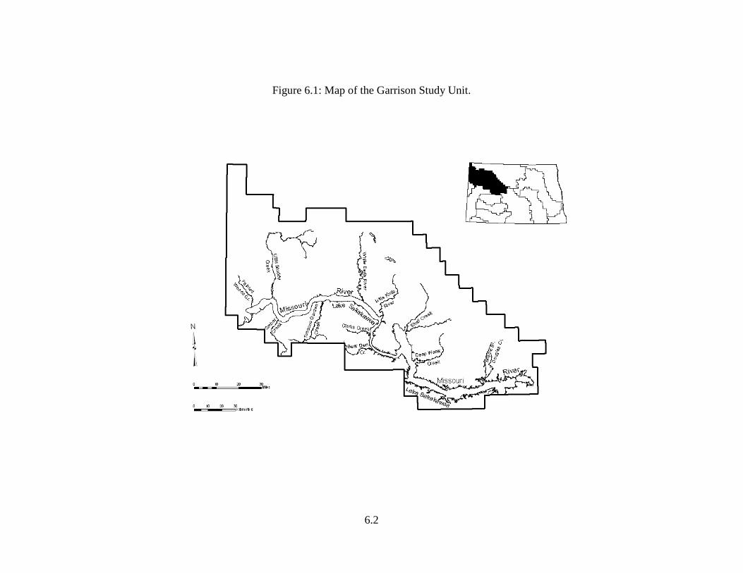
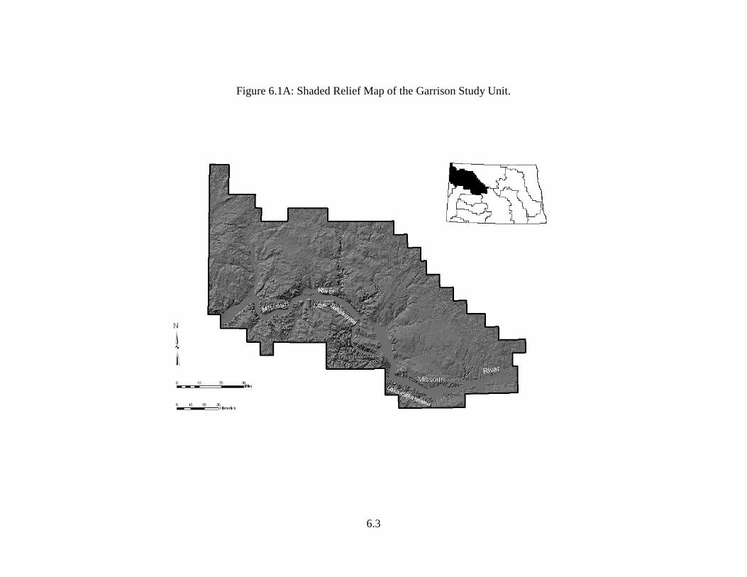
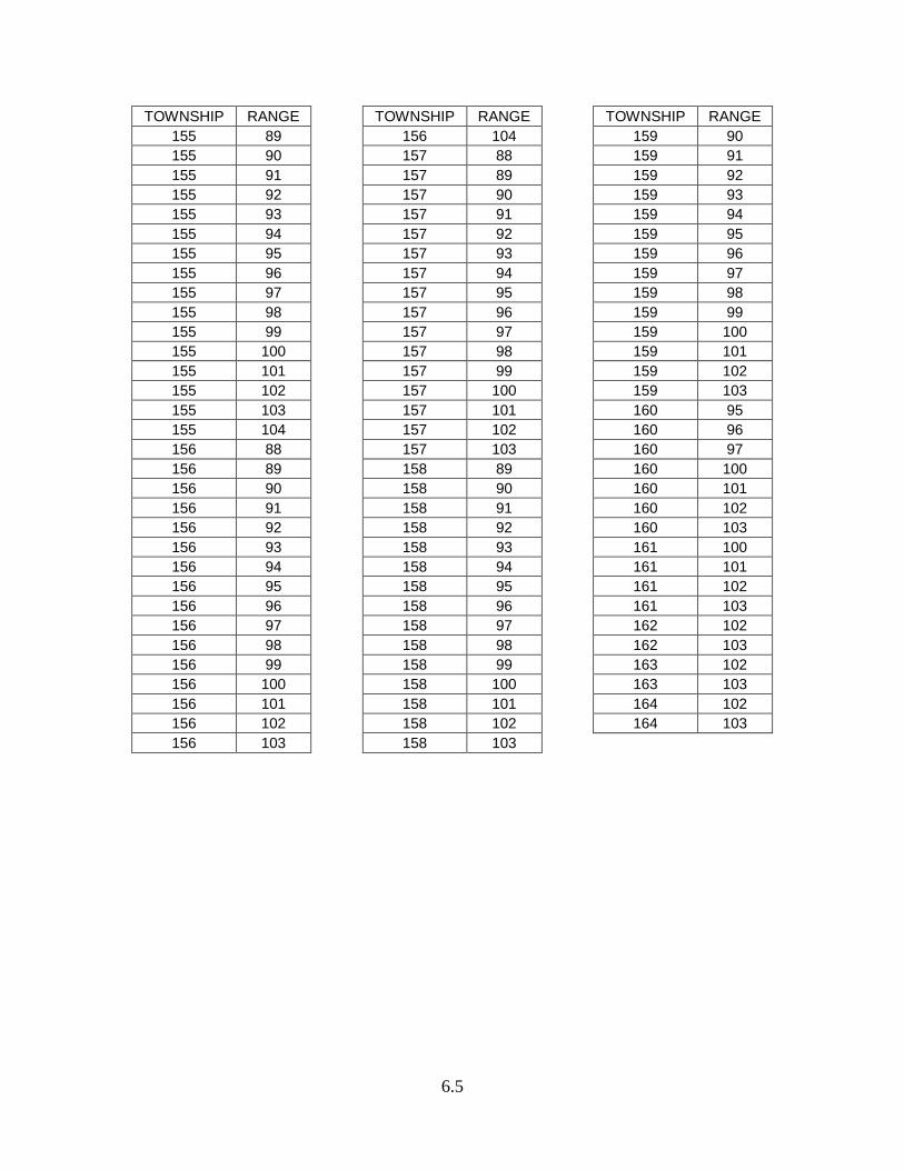
The Missouri valley in North Dakota upriver from Garrison dam to the Montana border has witnessed all of the state’s prehistory. Diagnostic artifacts are reported dating from Clovis times. The long east-west segment of the valley has vast areas of north-facing wooded slopes and draws which provide cover for an abundance of game animals and furbearers. This setting, including the river, tributary stream valleys, and upland grasslands, may have offered the most reliable resource base in the state for hunting and gathering peoples. Description of the Garrison Study Unit The Garrison Study Unit (GSU) is located in the northwestern part of North Dakota. Montana and Saskatchewan border it to the west and north. It covers of an area of 8,063 mi2, comprising all or parts of eight counties: Burke, Divide, Dunn, McKenzie, McLean, Mercer, Mountrail, Ward, and Williams. Figures 6.1 and 6.1A are maps illustrating the Study Unit (SU). A complete listing of townships included in the SU is presented in Table 6.1. Physiography The SU lies within the glaciated Missouri Plateau Subsection of the Missouri Plateau Section of the Great Plains Physiographic Province (Fenneman 1931; Hunt 1974). Missouri River valley portions of the SU are included in the Missouri River Trench District. But most of the SU is made up of Missouri Coteau and Coteau Slope terrain. Land outside of the Trench beyond the right bank of the river is part of an unnamed district of the Glaciated Missouri Plateau Subsection (Fenneman 1931; Wyckoff and Kuehn 1983:Figure 4.11). Topographically, the Coteau Slope is characterized by gently rolling hills dissected by numerous river and creeks which drain to the Missouri River (now referred to as Garrison Reservoir or Lake Sakakawea). Knob-and-kettle glaciated terrain with many sloughs and potholes and other glacial features are typical on the Missouri Coteau proper. These features were formed by stagnation moraines, end moraines, and ground moraines during glacial times.
6.2
Figure 6.1: Map of the Garrison Study Unit.
6.3
Figure 6.1A: Shaded Relief Map of the Garrison Study Unit.
6.4
Table 6.1: Townships in the Garrison Study Unit.
TOWNSHIP RANGE 146 86 146 87 146 88 146 89 146 90 147 82 147 83 147 84 147 85 147 86 147 87 147 88 147 89 147 90 147 91 148 82 148 83 148 84 148 85 148 86 148 87 148 88 148 89 148 90 148 91 149 82 149 83 149 84 149 85 149 86 149 87 149 88 149 89 149 90 149 91 149 92 149 93 149 94 149 95 150 81 150 82 150 83 150 84 150 85 150 86
TOWNSHIP RANGE 150 87 150 88 150 89 150 90 150 91 150 92 150 93 150 94 150 95 150 100 151 83 151 84 151 85 151 86 151 87 151 88 151 89 151 90 151 91 151 92 151 93 151 94 151 95 151 96 151 97 151 98 151 99 151 100 151 101 152 84 152 85 152 86 152 87 152 88 152 89 152 90 152 91 152 92 152 93 152 94 152 95 152 96 152 97 152 98 152 99
TOWNSHIP RANGE 152 100 152 101 152 102 152 103 153 85 153 86 153 87 153 88 153 89 153 90 153 91 153 92 153 93 153 94 153 95 153 96 153 97 153 98 153 99 153 100 153 101 153 102 153 103 153 104 154 86 154 87 154 88 154 89 154 90 154 91 154 92 154 93 154 94 154 95 154 96 154 97 154 98 154 99 154 100 154 101 154 102 154 103 154 104 155 87 155 88
6.5
TOWNSHIP RANGE 155 89 155 90 155 91 155 92 155 93 155 94 155 95 155 96 155 97 155 98 155 99 155 100 155 101 155 102 155 103 155 104 156 88 156 89 156 90 156 91 156 92 156 93 156 94 156 95 156 96 156 97 156 98 156 99 156 100 156 101 156 102 156 103
TOWNSHIP RANGE 156 104 157 88 157 89 157 90 157 91 157 92 157 93 157 94 157 95 157 96 157 97 157 98 157 99 157 100 157 101 157 102 157 103 158 89 158 90 158 91 158 92 158 93 158 94 158 95 158 96 158 97 158 98 158 99 158 100 158 101 158 102 158 103
TOWNSHIP RANGE 159 90 159 91 159 92 159 93 159 94 159 95 159 96 159 97 159 98 159 99 159 100 159 101 159 102 159 103 160 95 160 96 160 97 160 100 160 101 160 102 160 103 161 100 161 101 161 102 161 103 162 102 162 103 163 102 163 103 164 102 164 103
6.6
The Missouri River valley has been modified by the man-made impoundment of the waters of Lake Sakakawea behind Garrison Dam. Construction of the dam was completed in 1953. The Missouri River Trench once consisted of floodplain, older river terraces, breaks terrain, and uplands. These features can still be found today in the extreme western portion of the SU at the headwaters of the reservoir where low- lying alluvial landforms remain above pool level. However, in most parts of the valley along the Lake Sakakawea shoreline, only portions of the breaks and uplands have not been flooded (cf. Reid et al. 1988). Drainage The westernmost portion of the GSU is within the Big Muddy Creek basin (of Montana), but the Big Muddy drains southward to the Missouri, so, even though the Big Muddy basin may be somewhere near the size of basins such as the Knife which are considered individually as SU, only a small part of the Big Muddy basin is within North Dakota, and it is categorized as part of the GSU. Drainage along the northern edge of the GSU is demarcated a little to the south and west of the Missouri Escarpment in a zone which approximates the location of the subcontinental divide. All streams and creeks located south and west of this zone flow southward to the Missouri River and the Mississippi River system, ultimately draining to the Gulf of Mexico. Major named streams tributary to the left bank of the river, from west to east, include Painted Woods Creek, the Little Muddy River, White Earth River, Little Knife River, Shell Creek, Deepwater Creek, and the three main branches of Douglas Creek. This SU also has several significant named drainages lying south and west of the Missouri River that are tributary to its right bank. These include (from west to east) Timber Creek, Tobacco Garden Creek, Clear Creek, and Bear Den Creek. The Missouri Coteau portion of the SU is essentially “undrained” or “internally” drained. Water collects from rainfall, snowmelt, and ground water in the plentiful sloughs and potholes. Two of the larger named water bodies are White Lake and Powers Lake. Climate The present-day climate is of the northern continental type. Temperatures fluctuate extremely by season with warm summers and cold winters. Temperatures in Mercer County have reached 108°F during summer hot spells and have fallen to as low as -48° F during winter as the result of frigid Arctic air pushing southward over the region (cf. Jensen 1972). The average winter temperature is 12° F, while the summer mean hovers around 67° F. Precipitation averages about 16 inches annually, most of which falls as rain during the spring and summer (NDSPB 1939a). Prevailing winds are from the west-northwest throughout the year with the highest average readings around 13 mph. Brief periods of stronger winds and gusts to 35 or 40 mph are not uncommon. The frost-free growing season averages about 115 days.
6.7
Landforms and Soils The landforms in the SU consist of glaciated uplands, breaks terrain, valley wall sideslopes and footslopes, draws (or coulees), alluvial terraces, and floodplains in the bottomlands of the Missouri and some of the larger tributaries. Archeological sites are found on all of these landforms. Natural Resources Conservation Service (NRCS) official soil survey resources are available online (NRCS 2016a, b, c). The Web Soil Survey in particular may be useful, as it has replaced the traditional county soil survey books.
• Electronic Field Office Technical Guide: https://www.nrcs.usda.gov/wps/portal/nrcs/main/national/technical/fotg/
• Soil Data Mart: http://sdmdataaccess.nrcs.usda.gov/ • Web Soil Survey: http://websoilsurvey.sc.egov.usda.gov/App/HomePage.htm
Flora and Fauna Descriptions of the Missouri valley by early explorers such as Lewis and Clark, and later by Maximilian, provide first-hand accounts of the natural environment of the SU for times prior to the massive modifications caused by European immigrants. Detailed reconstructions of floral and faunal resource availability can be calculated by studying those sources in combination with the works of the ecological, botanical, and zoological specialists of the mid-1900s. The GSU lies within the Northern Temperate Grassland biome (Shelford 1963:329). The semiarid climate results in the development of a mixed grass prairie association here (Dodds 1979; Whitman and Wali 1975). The mixed grass prairie is dominated by blue grama grass, needle-and-thread grass, and western wheatgrass. This grassland provided good habitat for bison and pronghorns (Shelford 1963:344). Gallery forests grew along the Missouri River on the floodplain and provided habitat for white-tailed deer and small mammals such as otters and porcupines. Transition zones between the grasslands and floodplain forests offered additional habitat diversity. Hardwood draws, for example, provide conditions for the growth of bur oak, green ash, and juniper. This vegetation provides cover for a variety of game animals. Overstory vegetation on the floodplain was typically dominated by cottonwoods, box elder, elm, and willows in pioneer and early succession situations. Oak and ash would come to dominate mature stands on the floodplains and along the edges of terraces (Burgess et al. 1973:36). Understory vegetation included the food plants chokecherry, buffaloberry, gooseberry, and serviceberry. Johnson et al. (2012) provided an updated statement on vegetation change along the Missouri River. Overall, the faunal diversity in the GSU at contact time was as great as or greater than anywhere in the state. The reliability of the Missouri River as a water source combined with the floral diversity and cover of the gallery forests and breaks zones provided habitats for many kinds of animals. Creatures which could be hunted for meat,
6.8
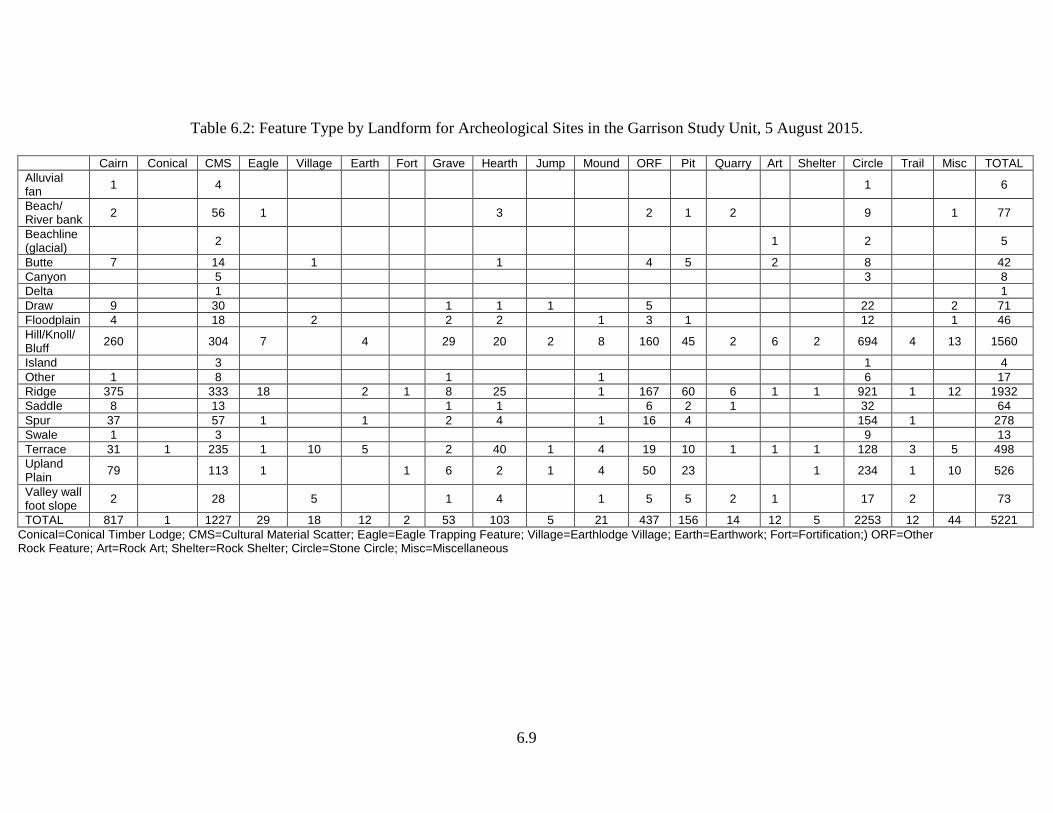
hides, feathers, teeth, bones, etc., included bison, elk, pronghorns, white-tailed deer, mule deer, grizzly bears, mountain lions, bighorn sheep, wolves, coyotes, foxes, bobcats, otters, badgers, porcupines, prairie dogs, weasels, mink, cottontail rabbits, jackrabbits, ground squirrels, golden eagles, bald eagles, hawks, owls, pelicans, magpies, prairie chickens, grouse, and a variety of waterfowl, fish, turtles, and mussels (cf. Brown et al. 1983). Other Natural Resource Potential Glacial fill and alluvially transported gravels abound in important stone resources at places within the GSU. Depending on the location, there can be Knife River flint (KRF), quartzites, jaspers and cherts, agatized woods, Yellowstone agate, porcellanite, basalt, granite, and even limestone. Bedrock materials such as pigment stones and sandstone are also found. A detailed description of the lithic resources of the Mondrian Tree site (32MZ58) locality in the western portion of the GSU can be found in Toom (1983c). Overview of Previous Archeological Work As of 5 August 2015, there were 4,156 archeological sites and 2,504 archeological site leads and isolated finds in the state computerized site data file for this SU. With its area of 8,063 mi2, there is one site recorded for every 1.9 mi2. The GSU ranks second, after the Knife River SU, out of all of the SU in site density. As of 5 August 2015, 2,698 Class III cultural resource inventories are in manuscript collection at the Archaeology and Historic Preservation Division of the State Historical Society of North Dakota (SHSND). (The total number of inventories was 902 in the 2008 version of the State Plan.) Inventory Projects Table 6.2 presents the recorded feature types by landform for the GSU. Stone circles, cairns and other rock features account for well over one-half of the site records. The diversity of sites here is as great as in any other SU. The low number of sites recorded in floodplain settings cannot be representative of the actual intensity of use of that landform in prehistory. The biased record can be accounted for by (1) destruction of floodplain sites by river meandering, (2) deep site burial in alluvial floodplain sediments, and (3) inundation of sites beneath the waters of Lake Sakakawea. The GSU has a long history of archeological investigation paralleling in many ways that of the Southern Missouri River SU. Among the first reports of archeological reconnaissance was the summary work of Will and Hecker (1944). Based on some 20 years of inquiry, their work provides initial descriptions of prominent earthlodge villages such as Midipadi Butte (32DU2) which were subsequently investigated in greater detail.
6.9
Table 6.2: Feature Type by Landform for Archeological Sites in the Garrison Study Unit, 5 August 2015.
Cairn Conical CMS Eagle Village Earth Fort Grave Hearth Jump Mound ORF Pit Quarry Art Shelter Circle Trail Misc TOTAL Alluvial fan 1 4 1 6
Beach/ River bank 2 56 1 3 2 1 2 9 1 77
Beachline (glacial) 2 1 2 5
Butte 7 14 1 1 4 5 2 8 42 Canyon 5 3 8 Delta 1 1 Draw 9 30 1 1 1 5 22 2 71 Floodplain 4 18 2 2 2 1 3 1 12 1 46 Hill/Knoll/ Bluff 260 304 7 4 29 20 2 8 160 45 2 6 2 694 4 13 1560
Island 3 1 4 Other 1 8 1 1 6 17 Ridge 375 333 18 2 1 8 25 1 167 60 6 1 1 921 1 12 1932 Saddle 8 13 1 1 6 2 1 32 64 Spur 37 57 1 1 2 4 1 16 4 154 1 278 Swale 1 3 9 13 Terrace 31 1 235 1 10 5 2 40 1 4 19 10 1 1 1 128 3 5 498 Upland Plain 79 113 1 1 6 2 1 4 50 23 1 234 1 10 526
Valley wall foot slope 2 28 5 1 4 1 5 5 2 1 17 2 73
TOTAL 817 1 1227 29 18 12 2 53 103 5 21 437 156 14 12 5 2253 12 44 5221 Conical=Conical Timber Lodge; CMS=Cultural Material Scatter; Eagle=Eagle Trapping Feature; Village=Earthlodge Village; Earth=Earthwork; Fort=Fortification;) ORF=Other Rock Feature; Art=Rock Art; Shelter=Rock Shelter; Circle=Stone Circle; Misc=Miscellaneous
6.10
Following World War II and the proposed construction of earthen dams along the Missouri River, there was resurgence in archeological activity. Kivett (1948) provided a preliminary statement concerning archeological and paleontological resources in the proposed Garrison Reservoir. A total of 70 archeological sites were reported. This initiated a long-term research program conducted by the Smithsonian Institution River Basin Surveys. Follow up studies by George Metcalf and others (Metcalf 1951; Metcalf et al. 1953) inventoried known cultural resources in the reservoir. A period of some two decades elapsed before the renewal of survey work in the SU. The next mention of inventory work is a brief citation credited to the St. Paul Science Museum (1969). During the mid-1970s, there was a resurgence of survey work along stretches of the eroding Garrison Reservoir shoreline. In the summer of 1974, 51 sites were found during shoreline survey work (Haberman and Schneider 1975). The following year additional survey work was completed at Lake Sakakawea. Gary Leaf (1976) reported on 15 new sites around the reservoir. Survey work conducted between 1979 and 1981 along the route of the Northern Border Pipeline resulted in the recording of eight previously unknown archeological sites and four find spots in McKenzie and Williams counties (Root 1983y:626). A ca. 20 km long segment of the pipeline transects the GSU. Results of the survey indicated, not surprisingly, that prehistoric use of the immediate Missouri River valley area was more intensive than areas away from the valley. “Permanent water supply, the gallery forests, hardwood draws in the river breaks, and abundant plant and animal resources are factors which led to the relatively extensive settlement in this region” (ibid.:657). The most important site found by this survey was the Mondrian Tree site (32MZ58) along the right bank of the river at a location where an ephemeral tributary stream valley enters the main valley (cf. Toom and Gregg 1983). In 1981, 24 prehistoric sites were recorded in 4,000 acres of recreation area land along the Garrison shoreline (Van Hoy et al. 1982). During 1983, Overland Associates recorded 22 archeological sites in some 16,000 acres along Lake Sakakawea shoreline in Williams and McKenzie counties (Noisat et al. 1986). The Bureau of Land Management’s (BLM) sampling survey of western North Dakota coal study areas (CSAs) covered 63 sampling units (each 160 acres in size) in the GSU within the Hanks and Sand Creek CSAs. The surveyed areas lie north of the Missouri River northwest of Williston, primarily in Williams County, but including two sample units in extreme southwestern Divide County (Metcalf et al. 1988:5). There were 100 sites recorded yielding a site density of one per 100 acres; 41 isolated artifacts were also recorded. In a 1987 intensive survey of the federal “take area” along the Lake Sakakawea shoreline in Mercer County, 154 sites were recorded in 9,200 acres yielding one site per
6.11
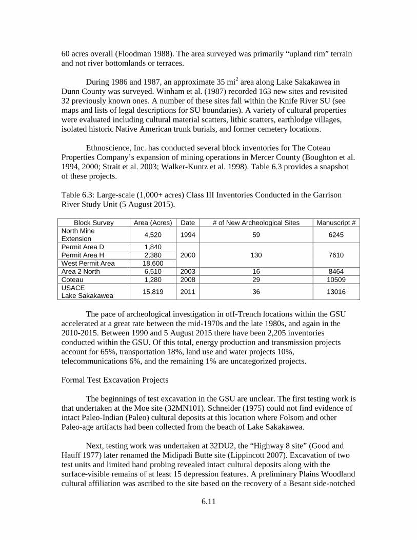
60 acres overall (Floodman 1988). The area surveyed was primarily “upland rim” terrain and not river bottomlands or terraces. During 1986 and 1987, an approximate 35 mi2 area along Lake Sakakawea in Dunn County was surveyed. Winham et al. (1987) recorded 163 new sites and revisited 32 previously known ones. A number of these sites fall within the Knife River SU (see maps and lists of legal descriptions for SU boundaries). A variety of cultural properties were evaluated including cultural material scatters, lithic scatters, earthlodge villages, isolated historic Native American trunk burials, and former cemetery locations. Ethnoscience, Inc. has conducted several block inventories for The Coteau Properties Company’s expansion of mining operations in Mercer County (Boughton et al. 1994, 2000; Strait et al. 2003; Walker-Kuntz et al. 1998). Table 6.3 provides a snapshot of these projects. Table 6.3: Large-scale (1,000+ acres) Class III Inventories Conducted in the Garrison River Study Unit (5 August 2015).
Block Survey Area (Acres) Date # of New Archeological Sites Manuscript # North Mine Extension 4,520 1994 59 6245
Permit Area D 1,840 2000 130 7610 Permit Area H 2,380
West Permit Area 18,600 Area 2 North 6,510 2003 16 8464 Coteau 1,280 2008 29 10509 USACE Lake Sakakawea 15,819 2011 36 13016
The pace of archeological investigation in off-Trench locations within the GSU accelerated at a great rate between the mid-1970s and the late 1980s, and again in the 2010-2015. Between 1990 and 5 August 2015 there have been 2,205 inventories conducted within the GSU. Of this total, energy production and transmission projects account for 65%, transportation 18%, land use and water projects 10%, telecommunications 6%, and the remaining 1% are uncategorized projects. Formal Test Excavation Projects The beginnings of test excavation in the GSU are unclear. The first testing work is that undertaken at the Moe site (32MN101). Schneider (1975) could not find evidence of intact Paleo-Indian (Paleo) cultural deposits at this location where Folsom and other Paleo-age artifacts had been collected from the beach of Lake Sakakawea. Next, testing work was undertaken at 32DU2, the “Highway 8 site” (Good and Hauff 1977) later renamed the Midipadi Butte site (Lippincott 2007). Excavation of two test units and limited hand probing revealed intact cultural deposits along with the surface-visible remains of at least 15 depression features. A preliminary Plains Woodland cultural affiliation was ascribed to the site based on the recovery of a Besant side-notched
6.12
point and thick cord roughened potsherds. Five years later, more in-depth testing was conducted. As a result of these investigations, Kuehn et al. (1982) renamed the site “Midipadi Butte” more in accord with its probable Hidatsa cultural affiliation (cf. Will and Hecker 1944:116). Cultural materials recovered included predominantly Knife River phase ceramics along with various chipped and groundstone tools, and metal and glass trade materials of Euro-American origin. Unfortunately, deep tests were not dug to bedrock to prospect for earlier Plains Archaic and Plains Woodland components. Incidentally, Midipadi Butte may have been the scene of some of the earliest testing work conducted in the GSU. Kuehn et al. (1982:11, citing Metcalf 1963:28-29) allude to vague descriptions of prior testing by SIRBS researchers. In 1979 and 1980, there was testing at the Mondrian Tree site (32MZ58) in an alluvial fan-Missouri River terrace setting near the Missouri-Yellowstone confluence along the proposed route of the Northern Border pipeline. Roberson (1980) reported shallowly buried cultural deposits of prehistoric and historic age. However, subsequent testing and major excavations revealed a complex, deeply stratified site containing Plains Archaic, Late Plains Woodland/Plains Village, and Euro-American components (see Major Excavation Projects section below). Testing was also undertaken at five additional sites along the route at the Northern Border pipeline in the GSU (Root 1983k, m, p, r, u). Preliminary cultural resource inventories along the Southwest Water Pipeline project were conducted for the State Water Commission and the Bureau of Reclamation. A number of sites were recorded along the segment of the pipeline right-of-way falling within the GSU. Testing was carried out at several of these including 32ME788. Artz (1986:63) suggests the site represents low-density cultural deposits associated with ephemeral camps. The most significant site tested along this pipeline route was the Boeckel-Renner site (32ME799) situated high atop the divide between the Missouri and Knife River basins (Artz 1989b). Site 32ME254 is situated on grassy uplands in the GSU and the Knife River SU and was tested in 1990. Five clusters of features cover the site. The clusters consist of 77 stone circles, one stone arc, seven cairns, and one petroform (Späth and Christensen 1991). Testing within and outside the features included auger probes and excavation of 10 formal test units. The site contains at least two components, Paleo and Besant, as represented by diagnostic chipped stone tools (ibid.). Boughton and Peterson (1994) report on survey and testing in the North Mine Extension Area for The Coteau Properties Company. Sixty-one prehistoric sites were investigated, including: two lithic scatters, 31 stone circle sites, 13 stone circle/cairn sites, 14 cairn sites, and one stone circle/cairn/alignment site (ibid.:Table 2). Testing consisted of 115 shovel probes and 36 test units. Twenty-three test units were within stone circles and 13 were within cairns. Fifteen sites were recommended eligible for the NRHP. Archeologists suggest that many of the sites recommended as not eligible might be viewed together as contributing elements to a larger district (ibid.).
6.13
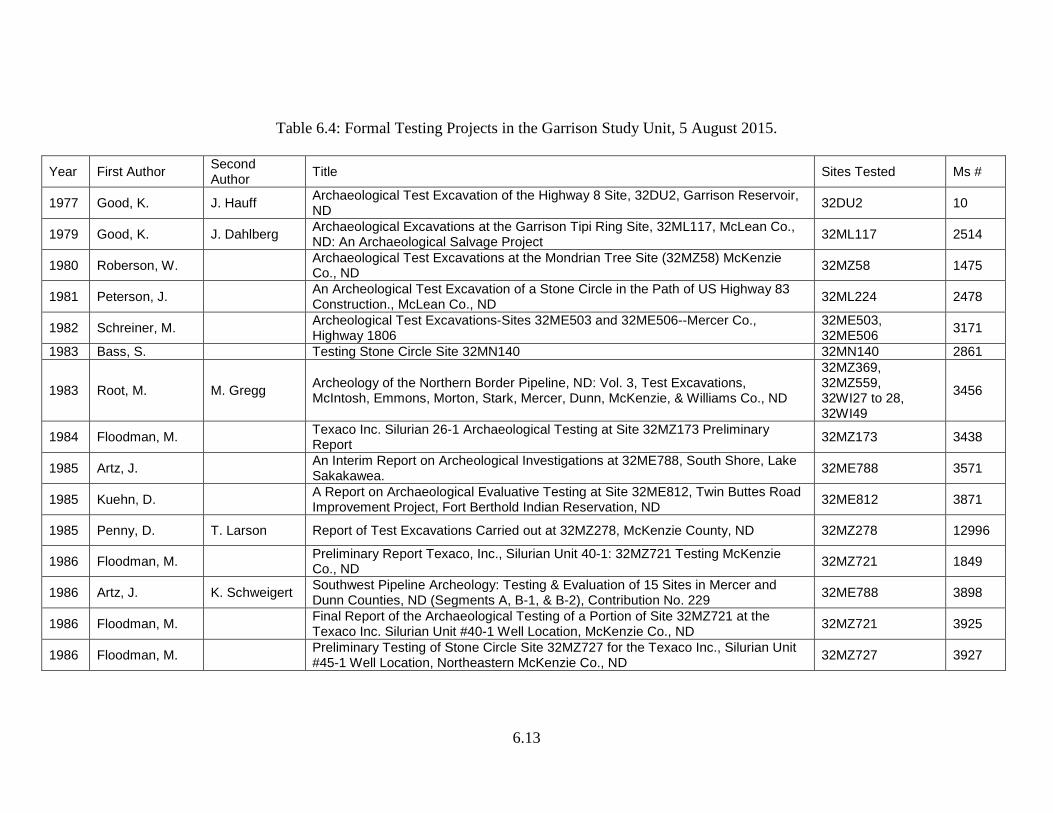
Table 6.4: Formal Testing Projects in the Garrison Study Unit, 5 August 2015.
Year First Author Second Author Title Sites Tested Ms #
1977 Good, K. J. Hauff Archaeological Test Excavation of the Highway 8 Site, 32DU2, Garrison Reservoir, ND 32DU2 10
1979 Good, K. J. Dahlberg Archaeological Excavations at the Garrison Tipi Ring Site, 32ML117, McLean Co., ND: An Archaeological Salvage Project 32ML117 2514
1980 Roberson, W. Archaeological Test Excavations at the Mondrian Tree Site (32MZ58) McKenzie Co., ND 32MZ58 1475
1981 Peterson, J. An Archeological Test Excavation of a Stone Circle in the Path of US Highway 83 Construction., McLean Co., ND 32ML224 2478
1982 Schreiner, M. Archeological Test Excavations-Sites 32ME503 and 32ME506--Mercer Co., Highway 1806
32ME503, 32ME506 3171
1983 Bass, S. Testing Stone Circle Site 32MN140 32MN140 2861
1983 Root, M. M. Gregg Archeology of the Northern Border Pipeline, ND: Vol. 3, Test Excavations, McIntosh, Emmons, Morton, Stark, Mercer, Dunn, McKenzie, & Williams Co., ND
32MZ369, 32MZ559, 32WI27 to 28, 32WI49
3456
1984 Floodman, M. Texaco Inc. Silurian 26-1 Archaeological Testing at Site 32MZ173 Preliminary Report 32MZ173 3438
1985 Artz, J. An Interim Report on Archeological Investigations at 32ME788, South Shore, Lake Sakakawea. 32ME788 3571
1985 Kuehn, D. A Report on Archaeological Evaluative Testing at Site 32ME812, Twin Buttes Road Improvement Project, Fort Berthold Indian Reservation, ND 32ME812 3871
1985 Penny, D. T. Larson Report of Test Excavations Carried out at 32MZ278, McKenzie County, ND 32MZ278 12996
1986 Floodman, M. Preliminary Report Texaco, Inc., Silurian Unit 40-1: 32MZ721 Testing McKenzie Co., ND 32MZ721 1849
1986 Artz, J. K. Schweigert Southwest Pipeline Archeology: Testing & Evaluation of 15 Sites in Mercer and Dunn Counties, ND (Segments A, B-1, & B-2), Contribution No. 229 32ME788 3898
1986 Floodman, M. Final Report of the Archaeological Testing of a Portion of Site 32MZ721 at the Texaco Inc. Silurian Unit #40-1 Well Location, McKenzie Co., ND 32MZ721 3925
1986 Floodman, M. Preliminary Testing of Stone Circle Site 32MZ727 for the Texaco Inc., Silurian Unit #45-1 Well Location, Northeastern McKenzie Co., ND 32MZ727 3927
6.14
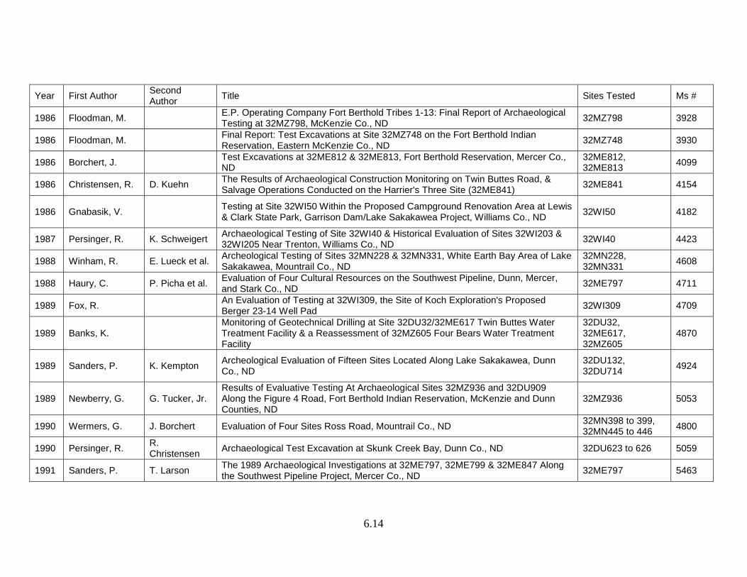
Year First Author Second Author Title Sites Tested Ms #
1986 Floodman, M. E.P. Operating Company Fort Berthold Tribes 1-13: Final Report of Archaeological Testing at 32MZ798, McKenzie Co., ND 32MZ798 3928
1986 Floodman, M. Final Report: Test Excavations at Site 32MZ748 on the Fort Berthold Indian Reservation, Eastern McKenzie Co., ND 32MZ748 3930
1986 Borchert, J. Test Excavations at 32ME812 & 32ME813, Fort Berthold Reservation, Mercer Co., ND
32ME812, 32ME813 4099
1986 Christensen, R. D. Kuehn The Results of Archaeological Construction Monitoring on Twin Buttes Road, & Salvage Operations Conducted on the Harrier's Three Site (32ME841) 32ME841 4154
1986 Gnabasik, V. Testing at Site 32WI50 Within the Proposed Campground Renovation Area at Lewis & Clark State Park, Garrison Dam/Lake Sakakawea Project, Williams Co., ND 32WI50 4182
1987 Persinger, R. K. Schweigert Archaeological Testing of Site 32WI40 & Historical Evaluation of Sites 32WI203 & 32WI205 Near Trenton, Williams Co., ND 32WI40 4423
1988 Winham, R. E. Lueck et al. Archeological Testing of Sites 32MN228 & 32MN331, White Earth Bay Area of Lake Sakakawea, Mountrail Co., ND
32MN228, 32MN331 4608
1988 Haury, C. P. Picha et al. Evaluation of Four Cultural Resources on the Southwest Pipeline, Dunn, Mercer, and Stark Co., ND 32ME797 4711
1989 Fox, R. An Evaluation of Testing at 32WI309, the Site of Koch Exploration's Proposed Berger 23-14 Well Pad 32WI309 4709
1989 Banks, K. Monitoring of Geotechnical Drilling at Site 32DU32/32ME617 Twin Buttes Water Treatment Facility & a Reassessment of 32MZ605 Four Bears Water Treatment Facility
32DU32, 32ME617, 32MZ605
4870
1989 Sanders, P. K. Kempton Archeological Evaluation of Fifteen Sites Located Along Lake Sakakawea, Dunn Co., ND
32DU132, 32DU714 4924
1989 Newberry, G. G. Tucker, Jr. Results of Evaluative Testing At Archaeological Sites 32MZ936 and 32DU909 Along the Figure 4 Road, Fort Berthold Indian Reservation, McKenzie and Dunn Counties, ND
32MZ936 5053
1990 Wermers, G. J. Borchert Evaluation of Four Sites Ross Road, Mountrail Co., ND 32MN398 to 399, 32MN445 to 446 4800
1990 Persinger, R. R. Christensen Archaeological Test Excavation at Skunk Creek Bay, Dunn Co., ND 32DU623 to 626 5059
1991 Sanders, P. T. Larson The 1989 Archaeological Investigations at 32ME797, 32ME799 & 32ME847 Along the Southwest Pipeline Project, Mercer Co., ND 32ME797 5463
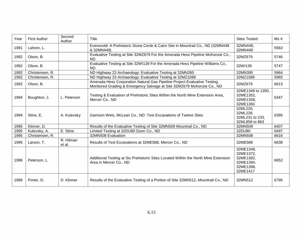
6.15
Year First Author Second Author Title Sites Tested Ms #
1991 Lahren, L. Evensvold: A Prehistoric Stone Circle & Cairn Site in Mountrail Co., ND (32MN448 & 32MN449)
32MN448, 32MN449 5563
1992 Olson, B. Evaluative Testing at Site 32MZ679 For the Amerada Hess Pipeline McKenzie Co., ND 32MZ679 5746
1992 Olson, B. Evaluative Testing at Site 32WI139 For the Amerada Hess Pipeline Williams Co., ND 32WI139 5747
1992 Christensen, R. ND Highway 23 Archaeology: Evaluative Testing at 32MN395 32MN395 5964 1992 Christensen, R. ND Highway 23 Archaeology: Evaluative Testing at 32MZ1089 32MZ1089 5965
1992 Olson, B. Amerada Hess Corporation Natural Gas Pipeline Project Evaluative Testing, Monitored Grading & Emergency Salvage at Site 32MZ679 McKenzie Co., ND 32MZ679 6613
1994 Boughton, J. L. Peterson Testing & Evaluation of Prehistoric Sites Within the North Mine Extension Area, Mercer Co., ND
32ME1349 to 1350, 32ME1352, 32ME1358, 32ME1360
6347
1994 Stine, E. A. Kulevsky Garrison Wets, McLean Co., ND: Test Excavations of Twelve Sites
32ML226, 32ML228, 32ML231 to 233, 32ML858 to 863
6395
1995 Klinner, D. Results of the Evaluative Testing of Site 32MN509 Mountrail Co., ND 32MN509 6407 1995 Kulevsky, A. E. Stine Limited Testing at 32DU80 Dunn Co., ND 32DU80 6497 1995 Christensen, R. 32MN508 Evaluation 32MN508 6616
1995 Larson, T. R. Hilman et al. Results of Test Excavations at 32ME588, Mercer Co., ND 32ME588 6638
1996 Peterson, L. Additional Testing at Six Prehistoric Sites Located Within the North Mine Extension Area in Mercer Co., ND
32ME1348, 32ME1372, 32ME1382, 32ME1394, 32ME1398, 32ME1417
6652
1996 Porter, D. D. Klinner Results of the Evaluative Testing of a Portion of Site 32MN512, Mountrail Co., ND 32MN512 6795
6.16
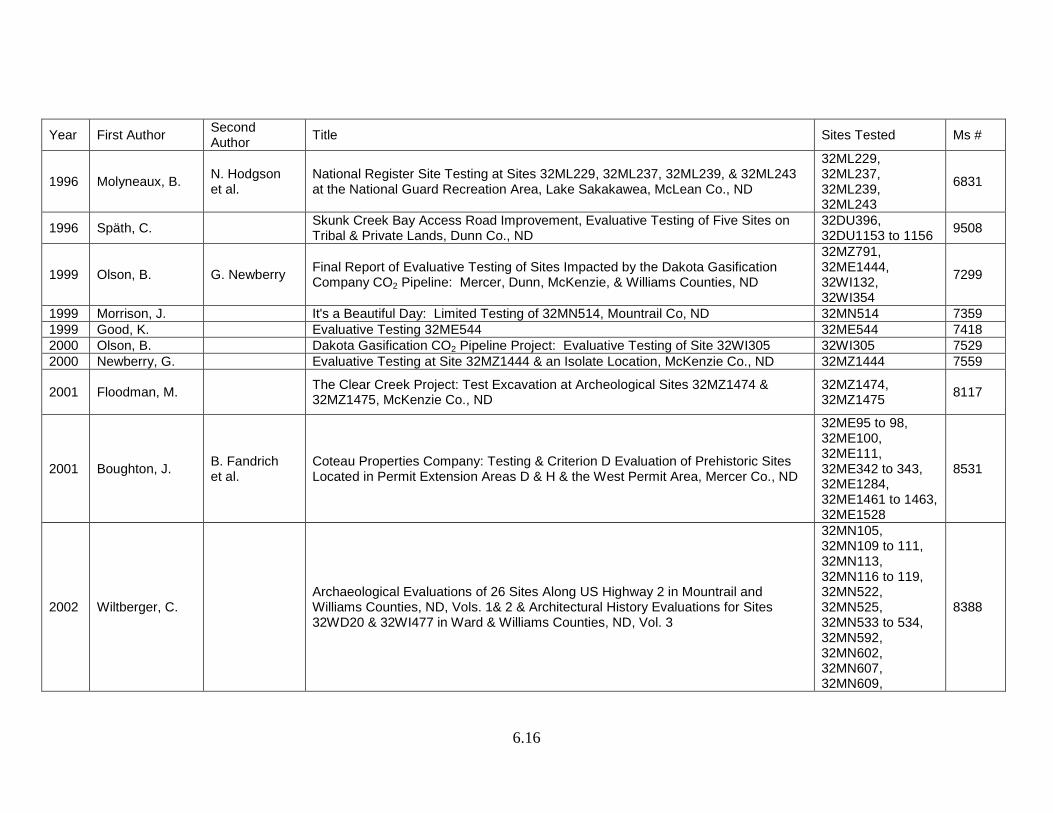
Year First Author Second Author Title Sites Tested Ms #
1996 Molyneaux, B. N. Hodgson et al.
National Register Site Testing at Sites 32ML229, 32ML237, 32ML239, & 32ML243 at the National Guard Recreation Area, Lake Sakakawea, McLean Co., ND
32ML229, 32ML237, 32ML239, 32ML243
6831
1996 Späth, C. Skunk Creek Bay Access Road Improvement, Evaluative Testing of Five Sites on Tribal & Private Lands, Dunn Co., ND
32DU396, 32DU1153 to 1156 9508
1999 Olson, B. G. Newberry Final Report of Evaluative Testing of Sites Impacted by the Dakota Gasification Company CO2 Pipeline: Mercer, Dunn, McKenzie, & Williams Counties, ND
32MZ791, 32ME1444, 32WI132, 32WI354
7299
1999 Morrison, J. It's a Beautiful Day: Limited Testing of 32MN514, Mountrail Co, ND 32MN514 7359 1999 Good, K. Evaluative Testing 32ME544 32ME544 7418 2000 Olson, B. Dakota Gasification CO2 Pipeline Project: Evaluative Testing of Site 32WI305 32WI305 7529 2000 Newberry, G. Evaluative Testing at Site 32MZ1444 & an Isolate Location, McKenzie Co., ND 32MZ1444 7559
2001 Floodman, M. The Clear Creek Project: Test Excavation at Archeological Sites 32MZ1474 & 32MZ1475, McKenzie Co., ND
32MZ1474, 32MZ1475 8117
2001 Boughton, J. B. Fandrich et al.
Coteau Properties Company: Testing & Criterion D Evaluation of Prehistoric Sites Located in Permit Extension Areas D & H & the West Permit Area, Mercer Co., ND
32ME95 to 98, 32ME100, 32ME111, 32ME342 to 343, 32ME1284, 32ME1461 to 1463, 32ME1528
8531
2002 Wiltberger, C. Archaeological Evaluations of 26 Sites Along US Highway 2 in Mountrail and Williams Counties, ND, Vols. 1& 2 & Architectural History Evaluations for Sites 32WD20 & 32WI477 in Ward & Williams Counties, ND, Vol. 3
32MN105, 32MN109 to 111, 32MN113, 32MN116 to 119, 32MN522, 32MN525, 32MN533 to 534, 32MN592, 32MN602, 32MN607, 32MN609,
8388
6.17
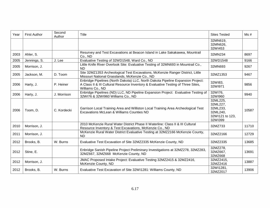
Year First Author Second Author Title Sites Tested Ms #
32MN619, 32MN626, 32WI453
2003 Ahler, S. Resurvey and Test Excavations at Beacon Island in Lake Sakakawea, Mountrail Co., ND 32MN234 8697
2005 Jennings, S. J. Lee Evaluative Testing of 32WD1548, Ward Co., ND 32WD1548 9166
2005 Morrison, J. Little Knife River Overlook Site: Evaluative Testing of 32MN693 in Mountrail Co., ND 32MN693 9267
2005 Jackson, M. D. Toom Site 32MZ1353 Archeological Test Excavations, McKenzie Ranger District, Little Missouri National Grasslands, McKenzie Co., ND 32MZ1353 9467
2006 Harty, J. P. Heiner Enbridge Pipelines (North Dakota) LLC, North Dakota Pipeline Expansion Project: A Class II & III Cultural Resource Inventory & Evaluative Testing of Three Sites, Williams Co., ND
32WI83, 32WI971 9856
2006 Harty, J. J. Morrison Enbridge Pipelines (ND) LLC, ND Pipeline Expansion Project: Evaluative Testing of 32WI76 & 32WI960 Williams Co., ND
32WI76, 32WI960 9940
2006 Toom, D. C. Kordecki Garrison Local Training Area and Williston Local Training Area Archeological Test Excavations McLean & Williams Counties ND
32ML225, 32ML227, 32ML233, 32ML240, 32WI121 to 123, 32WI399
10587
2010 Morrison, J. 2010 McKenzie Rural Water District Phase II Waterline: Class II & III Cultural Resource Inventory & Test Excavations, McKenzie Co., ND 32MZ733 11710
2011 Morrison, J. McKenzie Rural Water District Evaluative Testing at 32MZ2166 McKenzie County, ND 32MZ2166 12729
2012 Brooks, B. W. Burns Evaluative Test Excavation of Site 32MZ2335 McKenzie County, ND 32MZ2335 13685
2012 Stine, E. Enbridge Sanish Pipeline Project Preliminary Investigations at 32MZ278, 32MZ283, 32MZ667, 32MZ668 McKenzie County, ND
32MZ278, 32MZ667, 32MZ668
13691
2012 Morrison, J. JMAC Proposed Intake Project: Evaluative Testing 32MZ2415 & 32MZ2416, McKenzie County, ND
32MZ2415, 32MZ2416 13887
2012 Brooks, B. W. Burns Evaluative Test Excavation of Site 32WI1281: Williams County, ND 32WI1281, 32MZ2017 13906
6.18
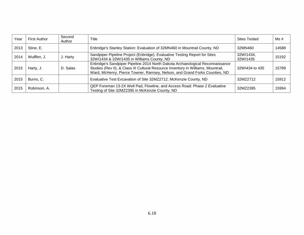
Year First Author Second Author Title Sites Tested Ms #
2013 Stine, E. Enbridge's Stanley Station: Evaluation of 32MN460 in Mountrail County, ND 32MN460 14588
2014 Wulffen, J. J. Harty Sandpiper Pipeline Project (Enbridge): Evaluative Testing Report for Sites 32WI1434 & 32WI1435 in Williams County, ND
32WI1434, 32WI1435 15192
2015 Harty, J. D. Salas Enbridge's Sandpiper Pipeline 2014 North Dakota Archaeological Reconnaissance Studies (Rev 0), & Class III Cultural Resource Inventory in Williams, Mountrail, Ward, McHenry, Pierce Towner, Ramsey, Nelson, and Grand Forks Counties, ND
32WI434 to 435 15789
2015 Burns, C. Evaluative Test Excavation of Site 32MZ2712, McKenzie County, ND 32MZ2712 15912
2015 Robinson, A. QEP Foreman 13-2X Well Pad, Flowline, and Access Road: Phase 2 Evaluative Testing of Site 32MZ2395 in McKenzie County, ND 32MZ2395 15994
6.19
Eleven archeological sites along a proposed pipeline corridor were tested for NRHP eligibility in 1998 (Olson and Newberry 1999). Project archeologists evaluated site eligibility base on (1) the presence of cultural deposits, (2) retention of site integrity, and (3) significant amounts of cultural material at a site (ibid.:1). Four of the sites are within the GSU. Site 32ME1444, a stone circle and cairn site, is located on an upland overlooking a drainage with natural springs to the west. Investigators suggest 32ME1444 is related to a turtle effigy site (32ME1270) 200 m southwest (ibid.:3). In addition to stone features, a lithic scatter covering approximately 1,000 m² is present (ibid.:9). The site has been recommended eligible for the NRHP based on its potential to expand archeological knowledge of KRF reduction activities in and out of stone circles. Site 32WI132 also was tested. It is on upland which slopes east to a south-southeast trending drainage north of the Missouri River trench. Site testing and evaluation confirmed the presence of eight stone circles and an abundance of lithic materials. The lithic assemblage included scrapers, retouched shatter, a preform, and debitage. The majority of the artifacts were grey porcellanite but red porcellanite, KRF, and Swan River chert also were present (ibid.:43). Two hearths were recorded at the site. Feature 4a contained debitage, calcined bone, a biface fragment, and charcoal. A charcoal sample was radiocarbon dated to the Middle Plains Woodland (ibid.:45). The site was recommended eligible for listing on the NRHP. The other two sites (32MZ791 and 32WI354) tested within the GSU were recommended not eligible for the NRHP due to the paucity of cultural material. Testing was undertaken at It’s a Beautiful Day site (32MN514) in 1998. The site, located on a ridge overlooking the White Earth River, consists of 27 stone circles and two cairns (Morrison 1999a). Seventy-two shovel test probes and five test units were excavated. A total of 141 artifacts were recovered, 60% from Rock Cairn 1. Lithic raw material types included quartzite, TRSS, chert, chalcedony, KRF, granite, and porcellanite (ibid.:15). A biface, scrapers, cores, and tested raw material, bone fragments, and a hearth with fire-cracked rock and burnt earth were recorded. A Prairie side-notched projectile point was found in the waterscreen sample of Rock Cairn 1. Based on artifactual evidence, the site has been dated to 1380-600 BP (ibid.:16). In 2000 a large test excavation project was undertaken to examine 179 previously unevaluated sites within three mining expansion areas in central Mercer County (Boughton et al. 2001). Testing involved the excavation of 403m² from test units, shovel tests, shove probes, and soil cores (ibid.). Thirty-five prehistoric sites were recommended eligible for listing on the NRHP. Further, archeologists suggest 13 sites have the potential to expound on research questions presented in the State Plan, particularly those concerning stone circles and prehistoric hunting strategies. The mine expansion areas are in the GSU and the Knife River SU. Within the GSU, the sites include 10 stone circle sites, four cairn sites, three stone circle/cairn sites, one stone circle/cairn/alignment site, and three lithic scatters (ibid.). Of the 21 sites in the GSU, two were recommended eligible for listing on the NRHP. Site 32ME1463, a lithic scatter, is located north of Lake Sakakawea and east of a major drainage. Archeologists noted that the lithic assemblage reveals the site’s potential to contain diagnostic artifacts
6.20
and/or datable deposits (ibid.:10.176). Site 32ME1528, a stone circle site, is located on a ridge above Beaver Creek Bay. A variety of artifacts were recovered, including: the basal portion of a KRF Plains side-notched projectile point, a KRF preform, bone fragments, and debitage (ibid.:10.262). The site was recommended as eligible for listing on the NRHP because of cultural/temporal context and the possibility for further research. Sites 32MZ1474 and 32MZ1475 were tested by the US Forest Service (Floodman 2001). Site 32MZ1474 consists of five stone circles located northwest of a meander in Clear Creek. Site 32MZ1475, a cultural material scatter, is across the creek to the southeast of 32MZ1474. Animal bone comprise the majority of cultural materials from the sites, however lithic artifacts and hearth features also were recorded. Interiors of stone circles at 32MZ1474 contained a fair amount of bone, leading Floodman (ibid.) to suggest bison bone processing activities occurred within the stone circles. Three side-notched arrow points, the total of the diagnostic artifacts, were recovered from Stone Circle #2 at 32MZ1474 (ibid.:20). The points’ style indicates an occupation dating to the Old Women’s complex of the Late Plains Woodland or the late Plains Village. Stone Circle #5 contained one modified bone digging tool (ibid.:26) and a hearth radiocarbon dated to AD 1720-1950 (ibid.:70). The cultural zone at 32MZ1474 extends to a depth of approximately 10 cm, indicating the presence of one component. Across the creek, 32MZ1475 contains a hearth eroding out of a cutbank. Tests on a charcoal sample from the hearth resulted in a date that corresponds to the Old Women’s complex, late Plains Village, or the Equestrian Nomadic (ibid.:59). The amount of fractured bison bone suggests this may have been a location of bison bone processing and grease manufacture (ibid.:38). In general, the faunal analysis suggests that the site was occupied from late autumn through early spring. This assumption is based on the large amount of fetal bone fragments and the large size of the hearth (ibid.:38). Seasonality of both sites is further supported by the arrangement of the stone circles with an apparent concern for wind patterns, and evidence of activities within the stone circles (ibid.:72). A single cultural component is present at each site. Floodman (ibid.) notes that it is not common to test single component sites within the Little Missouri National Grasslands. The two sites may be related remnants of one occupation (ibid.:72). Twenty-one archeological sites were evaluated along US Highway 2 in Mountrail and Williams counties for the North Dakota Department of Transportation in 2002. Six sites, all in Mountrail County, retain good integrity and have been recommended as eligible for listing on the NRHP. All six sites are located within the White Earth River valley, south of US Highway 2 (Wiltberger 2002). Five sites (32MN110, 32MN116, 32MN119, 32MN522, 32MN533) contain stone features with associated artifacts. Commonalities of the stone feature sites include small size and artifact assemblages comprising lithics, floral material, and fauna specimens. Hearths were uncovered at sites 32MN110 and 32MN119 dating to the Plains Equestrian Nomadic period and the Late Plains Archaic/Early Plains Woodland transition, respectively (ibid.:6-8,6-12). Additionally, a Plains Woodland projectile point base was recovered from 32MN522 (ibid.:6-13). Site 32MN525, located in the floodplain of the White Earth River, has two components. The surface component consists of a lithic scatter, age unknown.
6.21
The second component is located in buried alluvium atop a paleosol. Further, the top of a cairn was uncovered approximately 15 cm below surface (ibid.:6-13). Charcoal sampled from the base of the cairn dates to the Plains Woodland period (ibid.:6-14). Investigators propose these six sites could answer questions concerning prehistoric/protohistoric subsistence patterns and lithic technology. Stone Circle and Cairn Sites
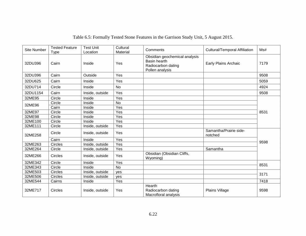
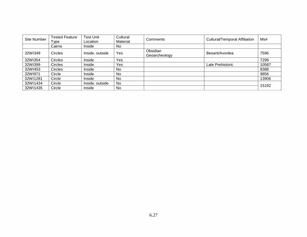
Over 2,200 stone circle sites have been identified during surveys (see Table 6.2) in this SU. Table 6.5 lists the stone ring sites that have been tested or excavated. For sites to be listed in this table there had to be formal testing (at least one 1-x-1-m unit) at the site. During mitigation entire stone circles were excavated at several sites enabling research on spatial use in domestic structures. These excavations provide a wealth of information regarding a common site type in North Dakota. Review of the literature reveals the changing research questions addressed over time for stone circles. Table 6.5 was developed so these data are readily available for researchers.
The monograph on stone circle sites in Plains Anthropologist Memoir 19 is a
valuable source of information (Davis 1983). Compilations of radiocarbon dates from sites in McLean, Mercer, and Oliver counties can be found in Strait and Peterson (2007:4.6-4.8), in Mclean County (Thomas and Peterson 2010:6.2-6.3) and from Besant/Sonota sites in Deaver and Deaver (1987). A useful discussion of single stone circle site function based on ethnographic accounts is available in Gregg et al. (1983:[3]864-869). An assessment of nomadic settlement-subsistence structure and bison ecology is discussed by Hanson (1983:1342-1417). Additional references for stone features sites can be found in the reference section of the Cultural Heritage Form.
Cairns are a common site type (n=800+) in the GSU (Table 6.2). Suggested uses
of cairns include markers for events and travel routes, bracing poles for a variety of camp structures, caches, drive lines, or covering a burial.
6.22
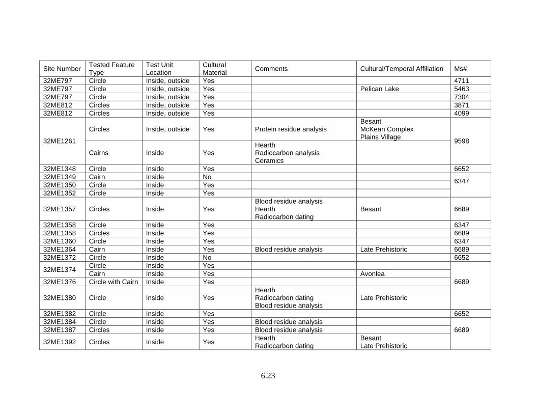
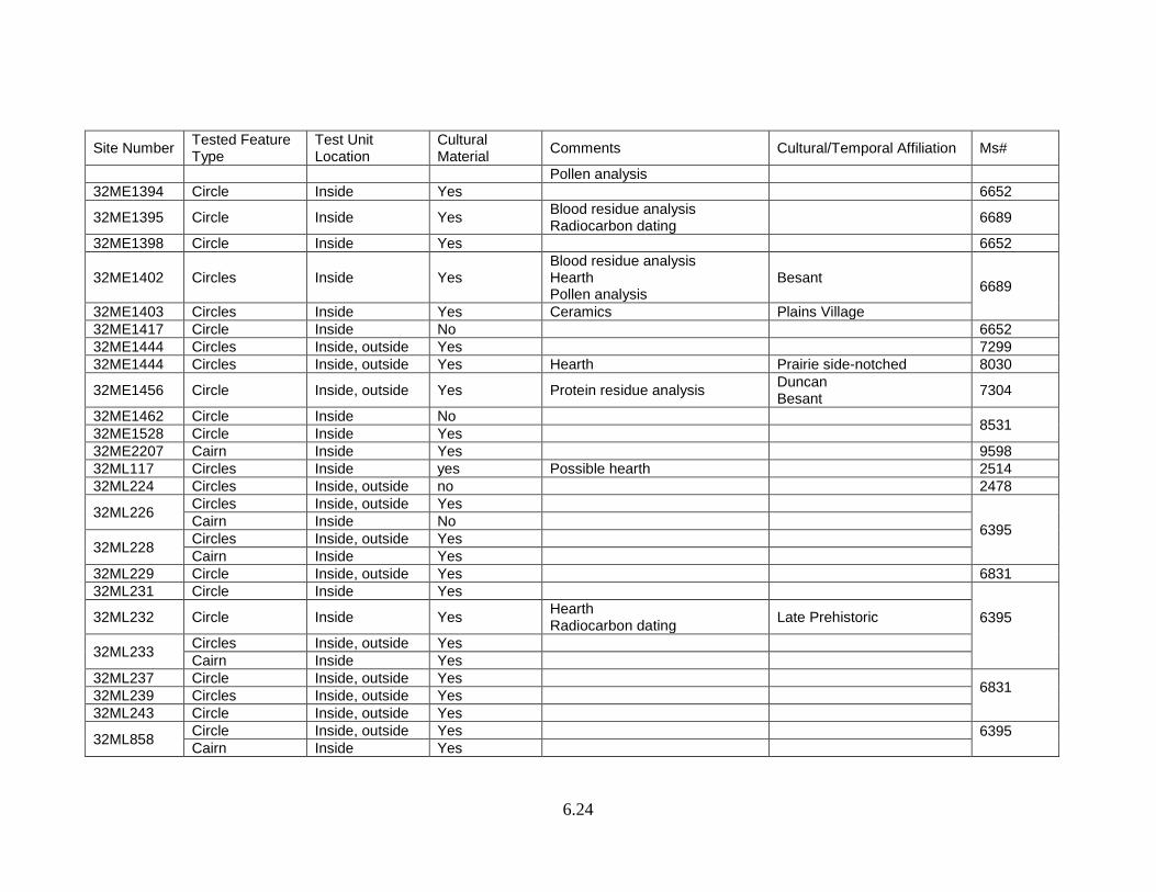
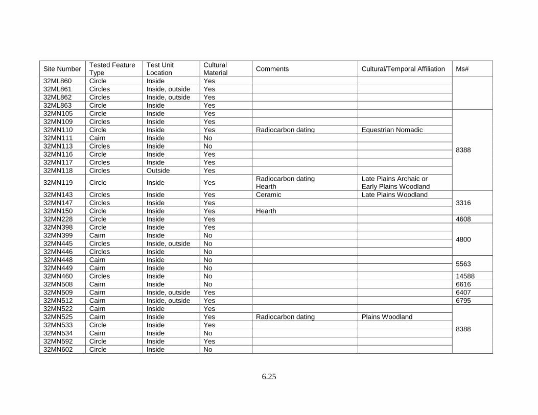
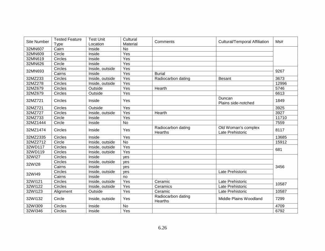
Table 6.5: Formally Tested Stone Features in the Garrison Study Unit, 5 August 2015.
Site Number Tested Feature Type
Test Unit Location
Cultural Material Comments Cultural/Temporal Affiliation Ms#
32DU396 Cairn Inside Yes
Obsidian geochemical analysis Basin hearth Radiocarbon dating Pollen analysis
Early Plains Archaic 7179
32DU396 Cairn Outside Yes 9508 32DU625 Cairn Inside Yes 5059 32DU714 Circle Inside No 4924 32DU1154 Cairn Inside, outside Yes 9508 32ME95 Circle Inside Yes
8531
32ME96 Circle Inside No Cairn Inside Yes
32ME97 Circle Inside Yes 32ME98 Circle Inside Yes 32ME100 Circle Inside Yes 32ME111 Circle Inside, outside Yes
32ME258 Circle Inside, outside Yes Samantha/Prairie side-notched
9598
Cairn Inside Yes 32ME263 Circles Inside, outside Yes 32ME264 Circle Inside, outside Yes Samantha
32ME266 Circles Inside, outside Yes Obsidian (Obsidian Cliffs, Wyoming)
32ME342 Circle Inside Yes 8531 32ME343 Circle Inside No 32ME503 Circles Inside, outside yes 3171 32ME506 Circles Inside, outside yes 32ME544 Cairns Inside Yes 7418
32ME717 Circles Inside, outside Yes Hearth Radiocarbon dating Macrofloral analysis
Plains Village 9598
6.23
Site Number Tested Feature Type
Test Unit Location
Cultural Material Comments Cultural/Temporal Affiliation Ms#
32ME797 Circle Inside, outside Yes 4711 32ME797 Circle Inside, outside Yes Pelican Lake 5463 32ME797 Circle Inside, outside Yes 7304 32ME812 Circles Inside, outside Yes 3871 32ME812 Circles Inside, outside Yes 4099
32ME1261
Circles Inside, outside Yes Protein residue analysis Besant McKean Complex Plains Village 9598
Cairns Inside Yes Hearth Radiocarbon analysis Ceramics
32ME1348 Circle Inside Yes 6652 32ME1349 Cairn Inside No 6347
32ME1350 Circle Inside Yes 32ME1352 Circle Inside Yes
32ME1357 Circles Inside Yes Blood residue analysis Hearth Radiocarbon dating
Besant 6689
32ME1358 Circle Inside Yes 6347 32ME1358 Circles Inside Yes 6689 32ME1360 Circle Inside Yes 6347 32ME1364 Cairn Inside Yes Blood residue analysis Late Prehistoric 6689 32ME1372 Circle Inside No 6652
32ME1374 Circle Inside Yes
6689
Cairn Inside Yes Avonlea 32ME1376 Circle with Cairn Inside Yes
32ME1380 Circle Inside Yes Hearth Radiocarbon dating Blood residue analysis
Late Prehistoric
32ME1382 Circle Inside Yes 6652 32ME1384 Circle Inside Yes Blood residue analysis
6689
32ME1387 Circles Inside Yes Blood residue analysis
32ME1392 Circles Inside Yes Hearth Radiocarbon dating
Besant Late Prehistoric
6.24
Site Number Tested Feature Type
Test Unit Location
Cultural Material Comments Cultural/Temporal Affiliation Ms#
Pollen analysis 32ME1394 Circle Inside Yes 6652
32ME1395 Circle Inside Yes Blood residue analysis Radiocarbon dating 6689
32ME1398 Circle Inside Yes 6652
32ME1402 Circles Inside Yes Blood residue analysis Hearth Pollen analysis
Besant 6689
32ME1403 Circles Inside Yes Ceramics Plains Village 32ME1417 Circle Inside No 6652 32ME1444 Circles Inside, outside Yes 7299 32ME1444 Circles Inside, outside Yes Hearth Prairie side-notched 8030
32ME1456 Circle Inside, outside Yes Protein residue analysis Duncan Besant 7304
32ME1462 Circle Inside No 8531 32ME1528 Circle Inside Yes 32ME2207 Cairn Inside Yes 9598 32ML117 Circles Inside yes Possible hearth 2514 32ML224 Circles Inside, outside no 2478
32ML226 Circles Inside, outside Yes
6395 Cairn Inside No
32ML228 Circles Inside, outside Yes Cairn Inside Yes
32ML229 Circle Inside, outside Yes 6831 32ML231 Circle Inside Yes
6395
32ML232 Circle Inside Yes Hearth Radiocarbon dating Late Prehistoric
32ML233 Circles Inside, outside Yes Cairn Inside Yes
32ML237 Circle Inside, outside Yes 6831 32ML239 Circles Inside, outside Yes
32ML243 Circle Inside, outside Yes
32ML858 Circle Inside, outside Yes 6395 Cairn Inside Yes
6.25
Site Number Tested Feature Type
Test Unit Location
Cultural Material Comments Cultural/Temporal Affiliation Ms#
32ML860 Circle Inside Yes 32ML861 Circles Inside, outside Yes 32ML862 Circles Inside, outside Yes 32ML863 Circle Inside Yes 32MN105 Circle Inside Yes
8388
32MN109 Circles Inside Yes 32MN110 Circle Inside Yes Radiocarbon dating Equestrian Nomadic 32MN111 Cairn Inside No 32MN113 Circles Inside No 32MN116 Circle Inside Yes 32MN117 Circles Inside Yes 32MN118 Circles Outside Yes
32MN119 Circle Inside Yes Radiocarbon dating Hearth
Late Plains Archaic or Early Plains Woodland
32MN143 Circles Inside Yes Ceramic Late Plains Woodland 3316 32MN147 Circles Inside Yes
32MN150 Circle Inside Yes Hearth 32MN228 Circle Inside Yes 4608 32MN398 Circle Inside Yes
4800 32MN399 Cairn Inside No 32MN445 Circles Inside, outside No 32MN446 Circles Inside No 32MN448 Cairn Inside No 5563 32MN449 Cairn Inside No 32MN460 Circles Inside No 14588 32MN508 Cairn Inside No 6616 32MN509 Cairn Inside, outside Yes 6407 32MN512 Cairn Inside, outside Yes 6795 32MN522 Cairn Inside Yes
8388
32MN525 Cairn Inside Yes Radiocarbon dating Plains Woodland 32MN533 Circle Inside Yes 32MN534 Cairn Inside No 32MN592 Circle Inside Yes 32MN602 Circle Inside No
6.26
Site Number Tested Feature Type
Test Unit Location
Cultural Material Comments Cultural/Temporal Affiliation Ms#
32MN607 Cairn Inside No 32MN609 Circle Inside Yes 32MN619 Circles Inside Yes 32MN626 Circle Inside Yes
32MN693 Circles Inside, outside Yes 9267 Cairns Inside Yes Burial 32MZ233 Circles Inside, outside Yes Radiocarbon dating Besant 3673 32MZ278 Circles Inside, outside Yes 12996 32MZ679 Circles Outside Yes Hearth 5746 32MZ679 Circles Outside Yes 6613
32MZ721 Circles Inside Yes Duncan Plains side-notched 1849
32MZ721 Circles Outside Yes 3925 32MZ727 Circles Inside, outside Yes Hearth 3927 32MZ733 Circle Inside Yes 11710 32MZ1444 Circle Inside No 7559
32MZ1474 Circles Inside Yes Radiocarbon dating Hearths
Old Woman’s complex Late Prehistoric 8117
32MZ2335 Circles Inside Yes 13685 32MZ2712 Circle Inside, outside No 15912 32WD117 Circles Inside, outside Yes 681 32WD119 Circles Inside, outside Yes 32WI27 Circles Inside yes
3456 32WI28 Circles Inside, outside yes Cairns Inside yes
32WI49 Circles Inside, outside yes Late Prehistoric Cairns Inside no
32WI121 Circles Inside, outside Yes Ceramic Late Prehistoric 10587 32WI122 Circles Inside, outside Yes Ceramics Late Prehistoric 32WI123 Alignment Outside Yes Ceramic Late Prehistoric 10587
32WI132 Circle Inside, outside Yes Radiocarbon dating Hearths Middle Plains Woodland 7299
32WI309 Circles Inside No 4709 32WI346 Circles Inside Yes 6792
6.27
Site Number Tested Feature Type
Test Unit Location
Cultural Material Comments Cultural/Temporal Affiliation Ms#
Cairns Inside No
32WI349 Circles Inside, outside Yes Obsidian Geoarcheology Besant/Avonlea 7596
32WI354 Circles Inside Yes 7299 32WI399 Circles Inside Yes Late Prehistoric 10587 32WI453 Circles Inside No 8388 32WI971 Circle Inside No 9856 32WI1281 Circle Inside No 13906 32WI1434 Circle Inside, outside No 15192 32WI1435 Circle Inside No
6.28
National Register of Historic Places Writing Rock (32DV4) is listed in the National Register of Historic Places (NRHP). This site was described by Will and Hecker (1944). It includes two large granite boulders covered with pecked glyphs plus three or more associated stone circle features. Joyes (1978) describes the thunderbird motif glyph on the rock. Also, the Evans site (cf. Schneider and Kinney 1978) is listed in the NRHP. The Beacon Island Agate Basin site (32MN234) and Midipadi Butte (32DU2) have had formal determinations of eligibility for the NRHP by the Keeper of the Register. The current list of archeological sites in North Dakota listed in the NRHP is available on the National Park Service website. The following links are useful (NPS 2016a, b):
• General information and links to specific information: https://www.nps.gov/nr/ • National Register Information System: https://www.nps.gov/nr/research/
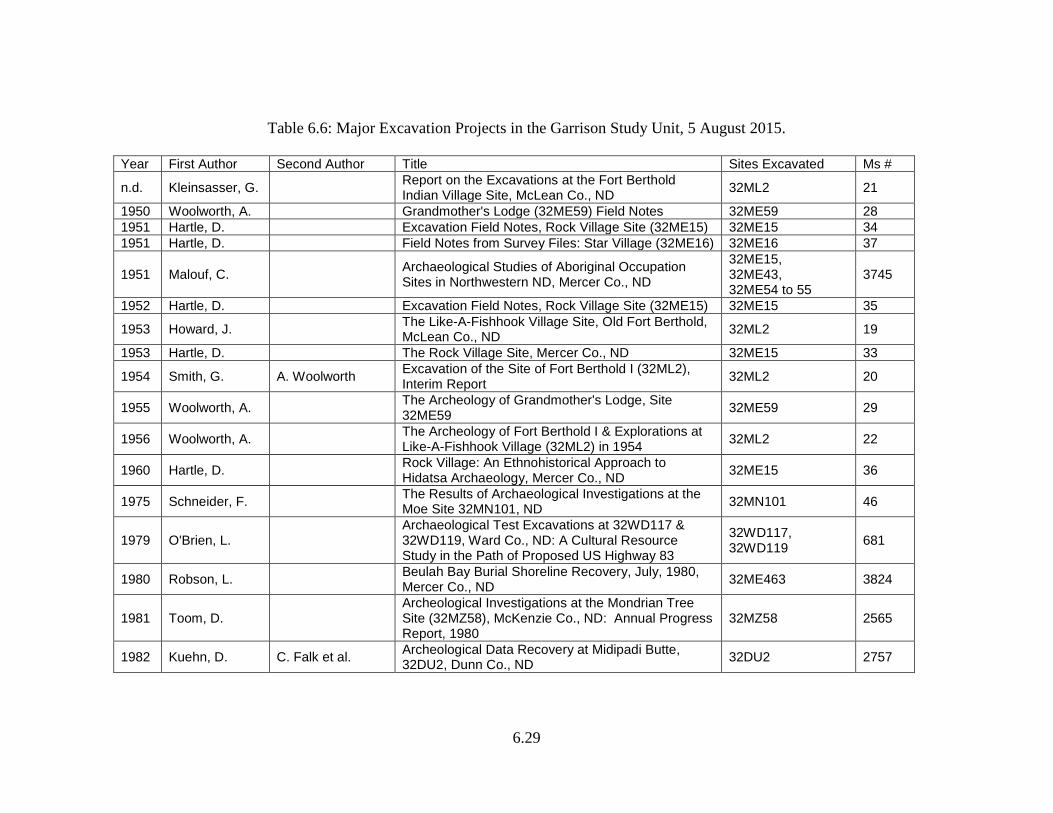
Major Excavation Projects Major excavation work can be divided into two periods of investigation: (1) SIRBS (and cooperating institutions), and (2) post-SIRBS. Prior to damming of the Missouri River, it was known that the construction of Garrison Project was going to affect a number of prominent earthlodge villages and other historic properties. Major salvage excavations were undertaken at a number of these sites by the SIRBS. Included were Star Village (Metcalf 1963), Rock Village (Hartle 1960; Lehmer et al. 1978), Night Walker’s Butte (Lehmer et al. 1978), Grandmother’s Lodge (Woolworth 1956), and Like-A-Fishhook Village (Smith 1972). With the exception of Grandmother’s Lodge, a prehistoric Plains Village site, all of the others are post-contact earthlodge villages. Salvage excavations were carried out at two historic sites: Kipp’s post, a fur trade post (Woolworth and Wood 1960, 1962), and Fort Stevenson, a military post (Smith 1960a). A period of nearly 25 years elapsed before the second round of major excavation commenced in the GSU. In 1979, 32ME117, a stone circle site was excavated (Good and Dahlberg 1979). The following year, major excavations were carried out at the multiple component Mondrian Tree site (Toom and Gregg 1983). Some 250 m3 of site matrix was processed by controlled hand excavation. Since 1991 reports of major excavation projects within the GSU have occurred at a fairly consistent rate (see Table 6.6). Downriver from the Mondrian Tree site (32MZ58) is 32MN395. Excavation at the latter revealed at least 12 cultural levels dating from the Early Plains Archaic through the Late Woodland period (Larson and Penny 1994, 1995). Investigators note, “The upper third of these deposits may be one of the best preserved examples of stratified Woodland occupation in the Garrison Study Unit…the presence of multiple Woodland components at the same site offers a unique opportunity to trace the development of the Plain [sic] Woodland through time and possibly link these changes to fluctuations in the
6.29
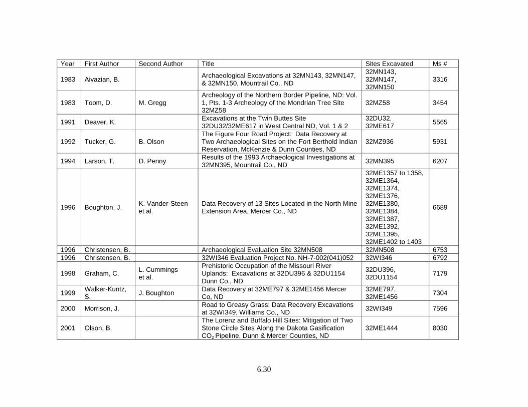
Table 6.6: Major Excavation Projects in the Garrison Study Unit, 5 August 2015.
Year First Author Second Author Title Sites Excavated Ms #
n.d. Kleinsasser, G. Report on the Excavations at the Fort Berthold Indian Village Site, McLean Co., ND 32ML2 21
1950 Woolworth, A. Grandmother's Lodge (32ME59) Field Notes 32ME59 28 1951 Hartle, D. Excavation Field Notes, Rock Village Site (32ME15) 32ME15 34 1951 Hartle, D. Field Notes from Survey Files: Star Village (32ME16) 32ME16 37
1951 Malouf, C. Archaeological Studies of Aboriginal Occupation Sites in Northwestern ND, Mercer Co., ND
32ME15, 32ME43, 32ME54 to 55
3745
1952 Hartle, D. Excavation Field Notes, Rock Village Site (32ME15) 32ME15 35
1953 Howard, J. The Like-A-Fishhook Village Site, Old Fort Berthold, McLean Co., ND 32ML2 19
1953 Hartle, D. The Rock Village Site, Mercer Co., ND 32ME15 33
1954 Smith, G. A. Woolworth Excavation of the Site of Fort Berthold I (32ML2), Interim Report 32ML2 20
1955 Woolworth, A. The Archeology of Grandmother's Lodge, Site 32ME59 32ME59 29
1956 Woolworth, A. The Archeology of Fort Berthold I & Explorations at Like-A-Fishhook Village (32ML2) in 1954 32ML2 22
1960 Hartle, D. Rock Village: An Ethnohistorical Approach to Hidatsa Archaeology, Mercer Co., ND 32ME15 36
1975 Schneider, F. The Results of Archaeological Investigations at the Moe Site 32MN101, ND 32MN101 46
1979 O'Brien, L. Archaeological Test Excavations at 32WD117 & 32WD119, Ward Co., ND: A Cultural Resource Study in the Path of Proposed US Highway 83
32WD117, 32WD119 681
1980 Robson, L. Beulah Bay Burial Shoreline Recovery, July, 1980, Mercer Co., ND 32ME463 3824
1981 Toom, D. Archeological Investigations at the Mondrian Tree Site (32MZ58), McKenzie Co., ND: Annual Progress Report, 1980
32MZ58 2565
1982 Kuehn, D. C. Falk et al. Archeological Data Recovery at Midipadi Butte, 32DU2, Dunn Co., ND 32DU2 2757
6.30
Year First Author Second Author Title Sites Excavated Ms #
1983 Aivazian, B. Archaeological Excavations at 32MN143, 32MN147, & 32MN150, Mountrail Co., ND
32MN143, 32MN147, 32MN150
3316
1983 Toom, D. M. Gregg Archeology of the Northern Border Pipeline, ND: Vol. 1, Pts. 1-3 Archeology of the Mondrian Tree Site 32MZ58
32MZ58 3454
1991 Deaver, K. Excavations at the Twin Buttes Site 32DU32/32ME617 in West Central ND, Vol. 1 & 2
32DU32, 32ME617 5565
1992 Tucker, G. B. Olson The Figure Four Road Project: Data Recovery at Two Archaeological Sites on the Fort Berthold Indian Reservation, McKenzie & Dunn Counties, ND
32MZ936 5931
1994 Larson, T. D. Penny Results of the 1993 Archaeological Investigations at 32MN395, Mountrail Co., ND 32MN395 6207
1996 Boughton, J. K. Vander-Steen et al.
Data Recovery of 13 Sites Located in the North Mine Extension Area, Mercer Co., ND
32ME1357 to 1358, 32ME1364, 32ME1374, 32ME1376, 32ME1380, 32ME1384, 32ME1387, 32ME1392, 32ME1395, 32ME1402 to 1403
6689
1996 Christensen, B. Archaeological Evaluation Site 32MN508 32MN508 6753 1996 Christensen, B. 32WI346 Evaluation Project No. NH-7-002(041)052 32WI346 6792
1998 Graham, C. L. Cummings et al.
Prehistoric Occupation of the Missouri River Uplands: Excavations at 32DU396 & 32DU1154 Dunn Co., ND
32DU396, 32DU1154 7179
1999 Walker-Kuntz, S. J. Boughton Data Recovery at 32ME797 & 32ME1456 Mercer
Co, ND 32ME797, 32ME1456 7304
2000 Morrison, J. Road to Greasy Grass: Data Recovery Excavations at 32WI349, Williams Co., ND 32WI349 7596
2001 Olson, B. The Lorenz and Buffalo Hill Sites: Mitigation of Two Stone Circle Sites Along the Dakota Gasification CO2 Pipeline, Dunn & Mercer Counties, ND
32ME1444 8030
6.31
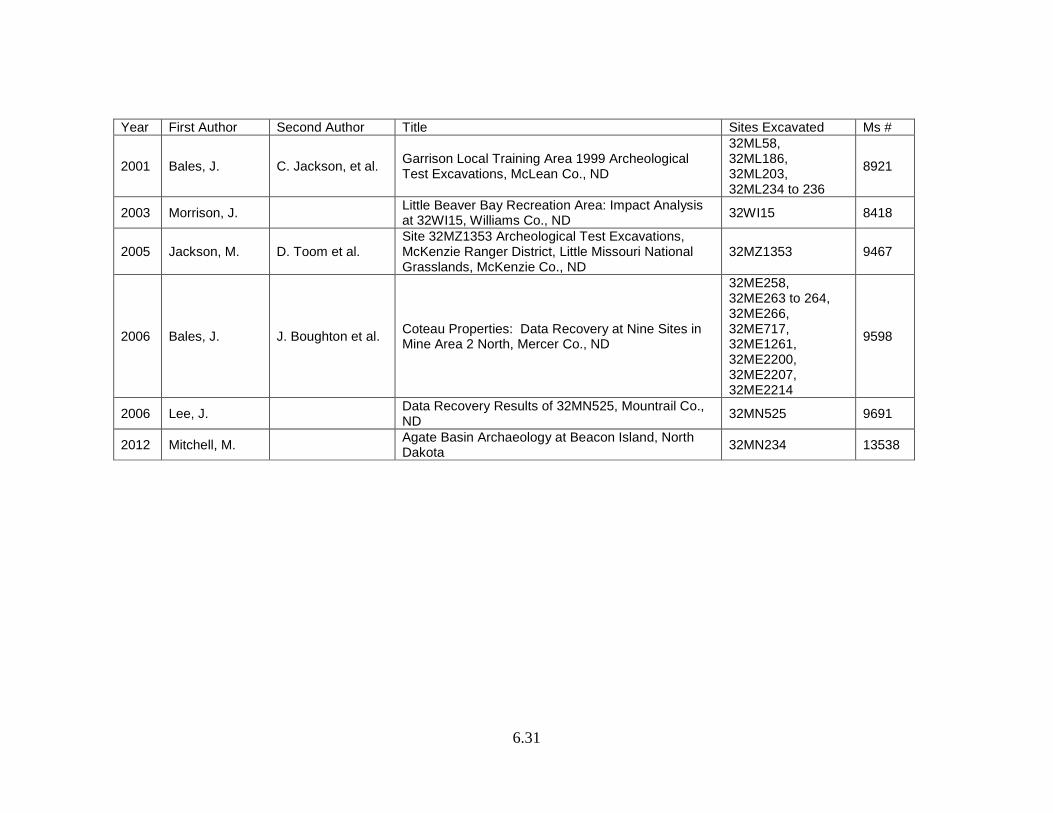
Year First Author Second Author Title Sites Excavated Ms #
2001 Bales, J. C. Jackson, et al. Garrison Local Training Area 1999 Archeological Test Excavations, McLean Co., ND
32ML58, 32ML186, 32ML203, 32ML234 to 236
8921
2003 Morrison, J. Little Beaver Bay Recreation Area: Impact Analysis at 32WI15, Williams Co., ND 32WI15 8418
2005 Jackson, M. D. Toom et al. Site 32MZ1353 Archeological Test Excavations, McKenzie Ranger District, Little Missouri National Grasslands, McKenzie Co., ND
32MZ1353 9467
2006 Bales, J. J. Boughton et al. Coteau Properties: Data Recovery at Nine Sites in Mine Area 2 North, Mercer Co., ND
32ME258, 32ME263 to 264, 32ME266, 32ME717, 32ME1261, 32ME2200, 32ME2207, 32ME2214
9598
2006 Lee, J. Data Recovery Results of 32MN525, Mountrail Co., ND 32MN525 9691
2012 Mitchell, M. Agate Basin Archaeology at Beacon Island, North Dakota 32MN234 13538
6.32
natural environment, technological changes, the presence of new cultural groups in the area, and pressures brought on by increases in population” (Larson and Penny 1994:111). Dates and paleoenvironmental data for the site result from the recovery of diagnostic materials, radiocarbon samples, geological studies, pollen analysis, phytolith analysis, and floral and faunal analyses (Larson and Penny 1994, 1995). Results of investigation at the Twin Buttes site (32DU32 / 32ME617) reveal the site was occupied at least twice. Absolute and relative techniques date the site to the Besant Phase (radiocarbon dates) and the Protohistoric period (a metal projectile point) (Deaver 1991). Based on the high density of unifaces, investigators suggest that primary site activities were bison processing and hide preparation (ibid.:i). Projectile point styles include nine Pelican Lake points, 56 Besant points, and one Samantha point (ibid.:110). Awls, gravers, bifaces, bone tools, and Besant-type ceramics account for other artifact classes (ibid.). Features encountered during excavation include 14 hearths, 11 stone boiling pits, seven toss-out scatters containing fire-cracked rock, 15 bone uprights, four cairns, two buried stone circles, and two or three exposed stone circles (ibid.:121-125). Investigators conclude that the site may have been a base camp related to smaller, outlying campsites in the area. During the field seasons of 1995 and 1996, excavations were conducted in the Little Missouri National Grasslands as part of the US Forest Service’s Passport in Time volunteer program (Floodman et al. 1997). The excavations occurred at the Boots site (32MZ732) located in the Missouri River breaks. Site occupation extends from the Early Plains Archaic through AD 1943. The various archeological materials recovered include a copper awl, Besant/Sonata complex and Plains Village ceramics, 30 projectile points, bifaces, scrapers, retouched flake tools, utilized flakes, cores, hammerstones, a mano, debitage, and faunal remains. The copper awl, the sole copper artifact documented and dated within the Little Missouri National Grasslands, dates to 770-375 BC (ibid.:119). Moreover, investigators note that “The dated copper awl from the Boots site is a rare occurrence for the region and a valuable contribution to the knowledge of the use and distribution of this rare resource type in western North Dakota” (ibid.). Diagnostic projectile points include a Duncan point base, an Archaic stemmed dart point, a Pelican Lake point, and a Besant dart point (ibid.:78). The site has been evaluated as eligible for listing on the NRHP under Criterion D. Mitigation was conducted at two sites along an access road to Lake Sakakawea (Graham et al. 1998). Sites 32DU396 and 32DU1154 were located on ridgetops overlooking the lake to the north. Both sites are thought to have been seasonal hunter-gatherer camps indicated by bison bone and macrofloral remains. The lithic assemblages suggest that tool production and maintenance also were important activities. A radiocarbon date of 6100±70 RYBP (Early Plains Archaic) was obtained for 32DU396 (ibid.:131). Additionally, projectile points recovered at that site are Late Archaic forms. Though 32DU1154 was deflated, cultural materials indicate that the site had a longer occupational history than 32DU396. Chipped stone tools recovered at the site included a Goshen spearpoint fragment, two Folsom point fragments, and an Avonlea point fragment (ibid.:132).
6.33
Since the early 1990s, a series of major excavation projects have been undertaken by Ethnoscience, Inc. to mitigate the effects of expanding coal strip mining operations by Coteau Properties Company in central Mercer County. The sites are within the Beulah Trench which is characterized by rolling grasslands with intermittent ridges and drainages. Stone feature and lithic scatters are common site types in the area. Primary research questions posed by investigators have focused on chronology, settlement and site function, diet and subsistence, lithic technology, and paleoenvironmental conditions (Boughton et al. 1994; Winzler et al. 1998). A brief summary of the projects follows.
Mitigative measures were undertaken in 1993 in the North Mine Extension Area. Within the GSU, 12 archeological sites were destroyed. The sites were located at the convergence of several ecozones. Eighteen stone circles, one stone circle with an associated cairn, and two cairns were investigated (Boughton et al. 1996:7.1). Materials recovered included over 10,000 pieces of debitage, projectile points, patterned and unpatterned tools, cores, bone fragments, ceramics, hearths, an ash lens, a charcoal concentration, fire-cracked rock, and a possible cache pit (ibid.). Traditional excavation techniques and laboratory procedures were supplemented by analyses of 14C samples, pollen, flotation, obsidian, and blood residue (ibid.). Though sampling bias is a possibility, investigators drew several conclusions regarding the research topics. First, five cultural components have been identified across the North Mine Extension Area, including the “Archaic Besant” (AD 330-890), the Besant complex, the Avonlea complex, the Late Prehistoric (AD 960-1390), and the Late Prehistoric/Plains Village (ibid.:7.2). Second, stone circle size and placement suggest length of stay and seasonality of occupations (ibid.:7.3). Third, subsistence strategies consisted of the exploitation of bison, smaller mammals, birds, and berries (ibid.:7.4). More mine expansion led to mitigation of 32ME254 in 1997. The 130-acre multi-component site consisted of 81 stone circles and seven cairns located in glaciated upland plains (Winzler et al. 1998:5.1). Eight stone circles, three cairns, and one possible petroform were excavated. Investigators identified five components at the site: Oxbow, McKean, Pelican Lake, Besant, and Plains Village or Late Prehistoric. Chronological indicators included two radiocarbon samples, two oxidizable carbon ratio (OCR) samples, and diagnostic artifacts. The radiocarbon dates are AD 695-995 for Feature 58A and AD 130-395 for Feature 87A (ibid.:6.1). The OCR results are AD 1529 (without deflation) and AD 525 (with deflation) for Feature 58A and AD 1726 (without deflation) and AD 1339 (with deflation) for Feature 87A (ibid.). The investigators note that the results of the two techniques do not correlate and conclude that “the assignment of dates based solely on the OCR method may prove unreliable” (ibid.). Identifiable projectile point styles from the site include Oxbow (n=3), McKean (n=3), Duncan (n=1), Hanna (n=1), Pelican Lake (n=1), Besant (n=10), and Late Prehistoric (n=5) (ibid.). The conclusions for this project reiterate those of Boughton et al. (1994; summarized above). In 1998, mitigation was conducted at 32ME797 and 32ME1456 in response to impacts of expansion in the North Mine Extension Area (Walker-Kuntz and Boughton 1999). A relatively small amount of cultural material was recovered from 32ME797. In addition to the stone circle and cairn present at the site, lithic debitage indicates reduction
6.34
activities occurred here (ibid.:7.3). One Pelican Lake projectile point provided cultural/temporal affiliation. No other conclusions were drawn about 32ME797. Similarly, 32ME1456 consisted of one stone circle and has been dated to the Besant complex based on the recovery of a Besant-type projectile point (ibid.:8.1). Blood residue analysis of stone tools indicates that bison and deer were part of the occupants’ subsistence strategy (ibid.). Investigators suggest that the site functioned as an outlier to a larger base camp. Data recovery was conducted at nine sites that were to be destroyed by proposed expansion in the Freedom Mine Area 2 North, Mercer County (Bales et al. 2006). Seven stone feature sites, one cairn, and one lithic scatter were excavated. Radiocarbon dating of 11 samples from across the sites indicates two Middle Plains Archaic occupations and nine Plains Woodland occupations (ibid.:6.4). This finding is consistent with other stone circle sites in the Beulah Trench (ibid.:6.6). Diagnostic artifacts were recovered from five sites. The styles include two McKean points, four Besant points, and nine Plains/Prairie side-notched points (ibid.). Ceramics recovered during excavation were typed to Plains Woodland and Plains Village. Several post-excavation observations made by investigators are worth noting. First, within the project area smaller stone circles tended to contain charcoal features and larger stone circles tended to contain diagnostic artifacts (ibid.:6.8). Second, during previous testing faunal remains were uncovered in two stone circles. Upon further investigation, neither of the stone circles contained diagnostic artifacts. The features were carbon dated using bone. Investigators suggest that the virtual absence of lithic material at a stone feature likely indicates that no tools will be recovered (ibid.:6.11). Third, based on a small sample size, it appears that there is not a correlation between rock density of a stone circle and the presence of centrally located hearths (ibid.). That is, the hearths located within the project area were excavated from stone circles with low rock densities. Finally, as stated after previous testing, the features that yielded the least amount of archeological information were those containing faunal remains (ibid.:6.13). The Beacon Island Agate Basin site (32MN234) is one of the most significant sites recorded within the GSU (Ahler 2003c; Mitchell 2012). The site is located on an island in Lake Sakakawea, presently managed by the US Army Corps of Engineers. Before construction of the Garrison Dam and Garrison Reservoir in 1967, the site was situated on a terrace overlooking the Missouri River valley to the southwest, the Little Knife River to the east, and the confluence of these rivers to the southeast (Ahler 2003c). Unfortunately fluctuating lake levels have caused rapid erosion, endangering the site. In the first decade of the 21st century more of the island was exposed due to low lake levels. Realizing the imminent fate of the site, archeologists have documented, surveyed, and excavated during multiple field seasons. Remote sensing techniques have been utilized (Spurr et al. 2007). The Beacon Island Agate Basin site has been determined eligible for nomination to the NRHP by the Keeper of the Register. Mitchell (2012) provides a detailed report of the archeological record at Beacon Island. The site was an Agate Basin-age bison kill and processing area along the

6.35
prehistoric Missouri River channel. There, hunters killed at least 29 Bison antiquus in early- to mid-winter (November to January) and the carcasses were moved a short distance for processing. The archeological record indicates the hunters butchered some of the animals on-site, preparing and packing a portion of meat for transport, breaking open log bones with cobble to extract marrow, and re-tooling for the next kill. It appears that the high-utility forelimbs and hind limbs of the bison were transported off-site. Absolute and relative dating techniques have been used to date the site. Four samples of identifiable bone (n=2) and charcoal (n=2) have been dated. The mean age of the samples is 10,326±28 radiocarbon years BP (ibid.:211). In addition to numerous Agate Basin projectile points, Clovis and Folsom points have been recovered (Ahler 2003c). One of the key elements of Agate Basin technology is the extensive reshaping or rejuvenation of broken point fragments. The toolkit the hunters brought to the Beacon Island site included projectile points, a selection of large flake tools needed for butchery, and cores needed for flake production. During processing, the group recovered and recycled serviceable point fragments, leaving behind segments deemed unsuitable for further use as weaponry and points or fragments lost in butchered carcasses. The toolkits of the hunters at this site indicated the focus was on the butchering and processing of the kill. Other Work Most of the other works relate to Lake Sakakawea inundation and shoreline erosion after the lake was filled. Exceptions to the work necessitated by site destruction include Joyes’ (1978) thunderbird glyph study and research conducted by the SHSND and the Mandan-Hidatsa-Arikara Nation at Grandmother’s Second Lodge (Reed and Grinnell 2004). For a synthesis of archeological investigations in the Dakota Prairie Grasslands, professional archeologists, researchers, and students may consult Prehistory on the Dakota Prairie Grasslands: An Overview by Mervin G. Floodman (2012). The Dakota Prairie Grasslands, managed by the U.S. Forest Service, comprises portions of the GSU, Yellowstone River SU, and the Little Missouri River SU. Floodman’s overview spans the Paleo period through the Equestrian/Fur Trade period (9500 BC - AD 1880), compiling data from pedestrian surveys, evaluative testing, and larger-scale excavation. For each time period, at least one site case study is provided, including: Pretty Butte (32SL100); Marsh Hawk (32BI317); Cinnamon Creek Ridge (complex of sites); Ice Box Canyon (32MZ38); Abraxas (32MZ333); Stone Circle (32MZ721); Magpie Road (32BI286); complex of Mandan-Hidatsa eagle trapping sites; Five Spades (32BI503); Fantail Creek (32BI423/32MZ729); and the Clear Creek project (32MZ1474 and 32MZ1475). Additionally, tables offer radiocarbon and obsidian hydration dates for the LMRSU and YRSU and radiocarbon dates for the GSU.
6.36
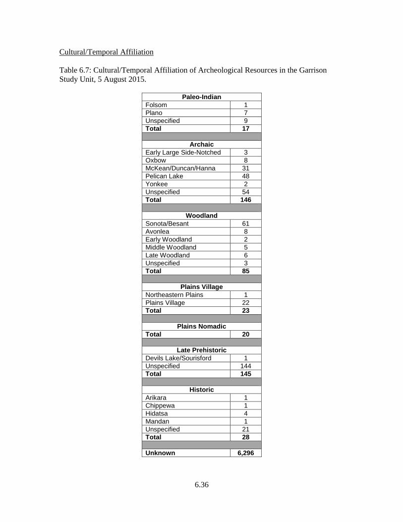
Cultural/Temporal Affiliation Table 6.7: Cultural/Temporal Affiliation of Archeological Resources in the Garrison Study Unit, 5 August 2015.
Paleo-Indian Folsom 1 Plano 7 Unspecified 9 Total 17
Archaic Early Large Side-Notched 3 Oxbow 8 McKean/Duncan/Hanna 31 Pelican Lake 48 Yonkee 2 Unspecified 54 Total 146
Woodland Sonota/Besant 61 Avonlea 8 Early Woodland 2 Middle Woodland 5 Late Woodland 6 Unspecified 3 Total 85
Plains Village Northeastern Plains 1 Plains Village 22 Total 23
Plains Nomadic Total 20
Late Prehistoric Devils Lake/Sourisford 1 Unspecified 144 Total 145
Historic Arikara 1 Chippewa 1 Hidatsa 4 Mandan 1 Unspecified 21 Total 28 Unknown 6,296
6.37
Paleo-Indian Period Surely, the upper Missouri River area was used by the earliest people to come to North Dakota. Many Paleo projectile point finds in the state have been at places near the river. Remains of terminal Pleistocene-early Holocene megafauna are found scattered throughout this SU. The Beacon Island site with its Bison antiquus skeletal remains and associated Agate Basin component (Ahler 2003c) indicates this property type is indeed represented in the SU. More components of this sort should be anticipated. Paleo-Environmental Modeling Due to the great amount of erosion and deposition that has taken place across the landscape since Paleo times it has proven challenging to locate intact components in this SU, as elsewhere in the state. Paleo-environmental modeling and Paleo archeology are intimately related research topics. Ancient cultural deposits hold a wealth of information concerning environmental conditions at the time of the occupation(s). But just as significantly, it is important to know something about the effects of environmental conditions subsequent to the time of ancient occupation in order to gain insights into where deposits of similar antiquity might be found. Based on the discovery of Folsom and later Paleo artifacts at the Moe site (32MN101) (Schneider 1975), it is known that such ancient deposits can be anticipated above today’s reservoir water level on some landforms within the Missouri valley. They can also be expected outside the valley, especially in areas which were once peripheral to playa lakes that are now dried up. Along the shoreline of Lake Sakakawea, properties such as the Moe site which have lain undisturbed for thousands of years are being lost to shoreline erosion (cf. Reid et al. 1988). The annual rate of bank recession ranges from 0-4.4 m per year and averages about 1.6 m (ibid.:187). There is a glaring absence of models that are useful for predicting Paleo site locations and the kinds of erosional settings along Lake Sakakawea where such exposures can be expected. How did the rate of flow of the Missouri River vary through the Paleo period, and could torrential meltwater flow have inhibited people from crossing the river? Settlement Behavior A KRF Clovis point base, with one face “totally patinated” is reported from 32ME946 (Floodman 1988:220). This site covers two hectares on the crest of a high ridge between Beaver Creek to the south and an unnamed tributary to the north (ibid.:108). The same project reported an isolated find of a KRF Agate Basin point with “about 20% patina” on each face. This isolated find location was on the beach along the lower reaches of present-day Lake Sakakawea near an intermittent tributary stream (Floodman 1988:201). This would probably have been an upland, valley rim or valley side slope overlook setting before the lake was there. What was the most favorable setting for residential base settlements in the upper Missouri valley in early Holocene times? Should a distinction between residential bases and field camps be expected for Paleo hunter-gatherers as for later Plains Archaic period peoples?
6.38
Native Subsistence Practices Beacon Island (32MN234) is the first Agate Basin site identified through controlled excavation in North Dakota (Ahler 2003c). The site contains intact, unmixed, and datable remains of Bison antiquus. What subsistence resources were available in the GSU, and how did that availability vary through the 4,000 years of the Paleo period? Dan Aird reported the discovery of mammoth skeletal remains unearthed in building construction in 1988 at a place near Powers Lake near the Burke-Mountrail county border (Dan Aird, personal communication to M. Gregg, December 1989). Although the find has not been radiocarbon dated, the shallowly buried context indicates a postglacial, Holocene age. Remnant Pleistocene megafauna should have been present throughout the SU during the early Holocene, at least during the early centuries of the Paleo period. Materials such as gastropods and pollen from early Holocene paleontological sites should be studied to generate information about climate and vegetation. Technologies Two lithic technological procedures prominently represented at sites in the GSU are Folsom fluting and blade production (cf. Ahler 2003c; Schneider 1982d:35-36, 1982c). There are better prospects for collecting information concerning these procedures from campsites outside the quarry area than from the quarry sites themselves where debris from advanced stages of toolmaking, if present, is typically mixed with debitage from raw material testing, bifacial reduction, core preparation, and other earlier stage procedures. Was blade core preparation characteristically carried out at the quarries with blade production carried out at residential sites outside the quarries? Ahler and Geib (2000) provide a well-developed explanation for Folsom point design and adaptation. They recommend the model be “tested and refined through studies of finished point and preform length, artefact proportions and fracture patterns, basal margin treatment, use-wear in archeological specimens and through actualistic studies of experimental point/haft arrangements” (ibid.:817). The collection of Agate Basin points from Beacon Island (32MN234) and other well-dated sites could provide an in-depth assessment of technological contrasts and similarities in the production, haft technology, and use of Agate Basin versus Folsom points and the culture-historic relationship between these two cultures (Ahler 2003c). Artifact Styles The Moe site (32MN101) near New Town has yielded eight Folsom points and Plainview (or Goshen; n=7), Agate Basin (n=7), Parallel-Oblique Flaked (n=1), Scottsbluff (n=1), and “numerous parallel and obliquely-flaked midsections” (Schneider 1982d:17). Winham et al. (1987:Figure 208) illustrate an Agate Basin point fragment from 32DU662. Metcalf et al. (1988:170) illustrate a probable Alberta point surface
6.39
collected from an isolated find spot near Scorio Creek close to the headwaters of the Little Muddy River basin. Is there anything about any of the Paleo point styles represented by finds from the GSU which differ from the Northern Plains norms? Stylistic attributes of mid-blade morphology should be identified to enable identification of Paleo point fragments. Regional Interaction The most productive areas for the discovery of Paleo artifacts have been in the KRF primary source area and in or near the Missouri River valley (cf. Root et al. 1986:466; Schneider 1982d:37). Knife River flint was a big attraction, sought by people throughout most of the Great Plains. Did some of the major travel routes to and from the KRF quarries cut through the GSU? Could such travel routes be reconstructed through analysis, such as GIS, of archeological sites and isolated finds? Some of the biface fragments from the Moe site near New Town in the Missouri valley are production failures and unfinished pieces (cf. Schneider 1982d:29). This is the sort of material that would be expected in the lithic assemblage at a campsite of people traveling away from the quarries with a supply of Stage 4 bifaces for making points. Historic Preservation Goals, Priorities, and Strategies During the summer of 1989, with the level of Lake Sakakawea at an all-time low due to drought, numerous Folsom and other Paleo period points were rumored to have been collected by nonprofessional, unpermitted individuals from sites exposed along the shorelines at the edge of the lake and on islands. These were very significant finds which may never become public knowledge because such collecting is illegal. Some sort of arrangement should be worked out with the US Army Corps of Engineers to document the finds and record the sites. The great number of Paleo point finds from the Garrison Reservoir shoreline which are rumored, combined with those which have been authenticated, clearly indicates that these specimens have eroded from sites within the big valley. Coring should be conducted upslope from these discovery locations in an attempt to identify the depositional contexts of the previously intact sites. Mitigative and research projects, like those at Beacon Island (32MN234), should be undertaken in order to salvage significant information prior to site destruction due to erosion and inundation. Plains Archaic Period The GSU vies with the Little Missouri River and Knife River SU in having large numbers of tested and dated Plains Archaic components. As elsewhere, however, it is only the post-Altithermal components which are well represented. The deeply stratified sequence at the Mondrian Tree site (32MZ58) provides a reference point for considerations of Middle and Late Plains Archaic cultural developments.
6.40
Paleo-Environmental Modeling Sites in alluvial fan and valley wall footslope contexts along the margins of the Missouri River valley have potential to provide a wealth of information concerning environmental conditions during the Archaic periods. As in similar settings in other parts of the state, Middle and Late Archaic deposits are found in relatively rapidly deposited sedimentary context in comparison with later Middle Woodland, Late Woodland, Plains Village, and Equestrian period components. Times of rapid deposition in such contexts correlate with erosion in the uplands resultant from drought. Studies of gastropod, rodent, and insectivore remains from dated Archaic contexts can provide environmental information for the site locality as well as the region [e.g., at the Mondrian Tree site, 32MZ58 (Brine et al. 1983)]. All intact Archaic deposits should be analyzed for paleo-environmental data as part of testing and major excavations. Cultural Chronology Excavations at the Moe site did not encounter Paleo period artifacts as hoped, but intact Archaic deposit samples yielded radiocarbon dates indicating occupations at ca. 4320 BC or 4045 BC (Schneider 1975:17, 25). Such dates would be reasonable for a Logan Creek/Mummy Cave component, but no diagnostic artifacts were recovered from this excavated sample of dated site matrix.
The most extensive battery of Archaic radiocarbon dates from any site in the state is from the Mondrian Tree site (32MZ58) where 24 samples were dated from seven cultural zones spanning the years from ca. 2200-200 BC (Toom and Gregg 1983:Chapter 8). Represented in the Mondrian Tree site (32MZ58) excavations were: (1) a Pelican Lake component with apparent relationships to Sonota/Besant, (2) an undetermined number of unclassified Middle-to-Late Plains Archaic components, and (3) an undetermined number of Middle Archaic components including one assigned to the Duncan complex (ibid.:8.72). Why is it so difficult to classify Late Archaic components in the GSU to the level of a cultural complex? Settlement Behavior Plains Archaic artifacts have been identified most often in elevated settings in the GSU (Table 6.2). Some have been identified in terrace and riverbank locations as well, but those sorts of locations near permanent water were surely occupied more often than indicated by the site file data. This is a reflection of the higher sedimentation rates and deeper burial of Archaic sites in the river bottomlands than in uplands. Many stone circle sites in the uplands are probably attributable to the Late Archaic period when settlement appears to have been fairly heavy here, as it was throughout most of the state. A corner-notched dart point found at 32WI270 indicates occupation at this stone circle site situated 10 miles north of the Missouri River (cf. Metcalf et al. 1988:132). How extensive were the core territories of Late Plains Archaic peoples who used the GSU, and how do the sizes of these territories compare with those of the Early and Middle Archaic periods?
6.41
Native Subsistence Practices The Middle and Late Archaic components at the Mondrian Tree site (32MZ58) yielded bone remains of canids (probably dogs), beaver, pronghorns, deer, elk, and bison (Falk 1983). The Middle/Late Archaic Cultural Zone 4 dated to the 1080-905 BC time range yielded a fragmentary sandstone grinding slab along with a quartzite mano or pestle. Associated with the grinding tools were a circular surface hearth, chipped stone flaking debris, a few chipped stone tools, and charred seeds of goosefoot, marsh elder, knotweed, dogbone, wild rose, wild grape, strawberry, hedge nettle, and mallow. The association of these remains indicates summertime collecting and processing of plant foods (Gregg 1983d:23.32). How much more fruitful is it to study subsistence practices based on remains from buried bottomland sites rather than upland sites? Technologies Initial Early Archaic chipped stone technologies should be expected to exhibit vestigial traits from Paleo times. At the Cherokee site in Iowa (Anderson 1980; Shutler et al. 1974), late Paleo and Early Archaic remains were essentially indistinguishable. Frison et al. (1976:55) said the points from the Hawken site near the Black Hills “could be regarded as nothing more than late, local Paleo styles such as Frederick and Lusk with added side notches.” A parallel flaked, side-notched point isolated find reported by Metcalf et al. (1988:173) from a location in the BLM’s Sand Creek Coal Study Area a few miles west of Williston fits in this mold. Other close similarities between late Paleo and pre-Oxbow Archaic chipped stone technological traits should be anticipated. With regard to Middle Archaic technologies, stratified sites with several Middle Archaic cultural zones are ideally suited for investigating differences in the chipped stone technologies of the McKean Lanceolate, Duncan, and Hanna complexes as suggested by the statewide chronological model. What differences are there in the lithic technologies represented in McKean Lanceolate, Duncan, and Hanna components, and do these differences support the proposition that this sequence of three complexes represents an evolutionary continuum? Artifact Styles There is a range of variation in side-notched dart points with incurvate bases which takes in the Early Archaic Oxbow style (cf. Dyck 1977:72-86) and Late Archaic Yonkee (cf. Bentzen 1962a) and Sandy Creek (cf. Wettlaufer 1955:Plate 10) styles. The outline morphologies of these three point types overlap, and although these three styles have been used as if they are diagnostic, this is not the case based on current type style descriptions. Points such as the one identified as Oxbow from 32DU769 (Winham et al. 1988:471) have provided the basis for identifying Early Archaic components when Late Archaic components may actually be represented. More rigid and non-overlapping type style definitions need to be formulated for the various diagnostic forms of Archaic side-notched, incurvate base, and chipped stone dart points. These definitions should be
6.42
formulated based on large samples from contexts with multiple unproblematic radiocarbon dates. Regional Interaction The copper artifact from a Late Archaic deposit at the Boots site contributes additional support to the proposition that inter-regional exchange rates were greatest during the Paleo, Late Archaic, and Plains Village periods. Groups with Pelican Lake material culture interacted with others whose archeological remains we identify as Besant/Sonota. These two archeological cultures were contemporary in North Dakota and other parts of the Northern Plains for several centuries. In fact, Plains Woodland cultures in North Dakota may have evolved from a Pelican Lake cultural base somewhere east of the Missouri River sometime around 500 BC (cf. Reeves 1983:149, 161, 185). After that time, people of the NAPIKWAN “cultural tradition” (Besant/Sonota-Old Women’s) were separate from those of the TUNAXA “cultural tradition” (Pelican Lake-Avonlea). Reeves suggests that after the inception of Besant/Sonota, there was little interaction between NAPIKWAN and TUNAXA peoples. However, finds of Pelican Lake points in Besant/Sonota components and Besant Side-Notched and Samantha points in Pelican Lake components evinces some degree of interaction. At what times in prehistory did the boundary between Pelican Lake and Besant/Sonota territories cut through the GSU? Historic Preservation Goals, Priorities, and Strategies As with the archeological records of most other times and places, it would benefit research as well as cultural resource management to know more about the landforms and at what depths components of the Early, Middle, and Late Plains Archaic periods are likely to be found. Secondly, the GSU rivals the Knife River SU in potential to yield information concerning Late Plains Archaic stylistic variation in projectile points. The sample of four straight-based, side-notched flake points from the ca. 1000 BC. Archaic deposit at the Mondrian Tree site (32MZ58) is a case in point (cf. Toom 1983b:10.104). Reeves (1983:50) suggested that there may be nearly 50 “lower order types” of the Pelican Lake corner-notched style. Many of the makers of these numerous types of points probably traversed the GSU en route to and from the KRF quarries. Plains Woodland Period Besant/Sonota components are very well represented in the GSU. In a Mercer County, Lake Sakakawea shoreline survey, sites of the Middle Plains Woodland period were found in greater numbers than those of any other period. Temporally diagnostic artifacts included Besant side-notched points, ceramics, and possibly one burial mound that was identified (Floodman 1988:314). Late Woodland cultures are represented by Avonlea and Mortlach. Numerous components attributable to the Old Women’s complex should be anticipated. Some of the components identified as Late Woodland in the site file database may be Old Women’s. If the Old Women’s complex evolved from
6.43
Besant/Sonota in the NAPIKWAN “cultural tradition” as hypothesized by Reeves (1983:45, 185), and Besant/Sonota is prominently represented in the GSU, then the culture into which it evolved should be represented. Paleo-Environmental Modeling Environmentally favorable conditions—those fostering the buildup of regional biomass—appear to have peaked twice during Plains Woodland times in the GSU. These favorable mesic times are represented in stratigraphic sequences by two prominent paleosols (cf. Clayton et al. 1976:11). The older paleosol is identified as the upper Thompson paleosol in the Lower Submember of the Riverdale Member of the Oahe Formation (ibid.). It correlates in time with the Sonota/Besant cultural climax of the Middle Woodland period. The more recent paleosol is in the Upper Submember of the Riverdale Member of the Oahe Formation. It correlates in time with the Neo-Atlantic climatic episode and a fluorescence of Plains Village cultures early in the Plains Village period. But this time of favorable climate began during the Late Woodland period. In stratified sequences spanning the Plains Woodland periods, these should be the two most prominent paleosols, and other thinner buried soils should be represented as well. Two questions regarding these paleosols and paleo-environmental conditions in the GSU are: (1) How accurately can the beginning and ending dates of these episodes of soil development be determined? and (2) Did mesic climatic conditions prevail uniformly over the entire GSU during these periods of soil development? Cultural Chronology Small corner-notched dart points such as the one from 32DU132 near the Lake Sakakawea shoreline are stylistically similar to, and perhaps contemporary with, small corner-notched points from the Early Woodland cultural zone at the Naze site (32SN246) in the James River SU (cf. Gregg 1987d:Figure 8.2c, d). Besant/Sonota Middle Woodland components are relatively common (cf. Artz 1989b:150; Good and Hauff 1977; Lehmer et al. 1978). Late Woodland components attributable to the Avonlea and Mortlach complexes are numerous (cf. Metcalf 1963; Schneider and Kinney 1978). Does the Late Woodland culture history of the GSU fit the statewide chronological model, or did Woodland lifeways persist and dominate in the GSU throughout much of the Plains Village period? Settlement Behavior People with Middle Woodland Sonota/Besant material culture had core territories within (or which included) the GSU. This is inferred from the presence of mortuary sites of apparent Sonota/Besant origin such as at the Boeckel-Renner site (32ME799; cf. Artz 1989b) combined with the large number of Sonota/Besant sites indicating a strong presence of the sort that would result from permanent occupation of a territory. Cold season residential bases with remains of lodges should be anticipated in south-facing wooded draw settings. Such settlements surely were numerous in floodplain forest locations as well.
6.44
Native Subsistence Practices Site 32ME947 is a stratified multiple component bison kill and processing location. The lower component in the bone bed, which is exposed in a cutbank, is identified as Middle Woodland, with the later component being Late Plains Woodland attributed to the Old Women’s complex (Floodman 1988:320). Continuity in the mere hunting of bison is a fact of Northern Plains prehistory, but use of the same kill spot by people with cultural complexes which have been hypothesized to be genetically related in the NAPIKWAN “cultural tradition” suggests the possibility of continuity in specific aspects of subsistence practices. Were there similarities in bison processing practices between Besant/Sonota components and Old Women’s components indicative of closer evolutionary relationships than would be expected for unrelated cultures? Subsistence remains from the Mortlach component at the Evans site (32MN301) include bison, swift fox, dog/coyote, deer, duck, and a charred plum seed (Schneider and Kinney 1978:31). Bison scapula digging tools were recovered, but not any remnants of garden crops. The diversity of subsistence remains, chipped stone artifacts, bone tools, and ceramics from the test excavation suggests some fairly settled type of encampment, perhaps on the order of a field camp. Seasonality data indicated occupation from late summer to early winter (ibid.). What should be expected in the way of subsistence remains at Mortlach sites that were occupied during different seasons of the year? Technologies Ceramic technologies were operative in the GSU from at least as early as the Middle Woodland period as represented at sites such as Nightwalker’s Butte (32ML39) (Lehmer et al. 1978:125; Wood and Johnson 1973:64). There are potsherd samples from later Woodland excavated contexts at the Evans site (32MN301) (Schneider and Kinney 1978) and the Mondrian Tree site (32MZ58) (Craig Johnson 1983). Such samples have been described with reference to larger collections from surrounding areas. For example, a Late Plains Woodland vessel from the Mondrian Tree site estimated to postdate AD 1200 was appraised by Craig Johnson to share closest affinities with Duck Bay materials found in southern Manitoba and Initial Middle Missouri ceramics from along the Missouri River in South Dakota (C. Johnson 1983:9.11) How do attributes of Plains Woodland ceramics in the GSU differ from those found in surrounding regions and subareas? Artifact Styles Prairie side-notched arrowpoints, a variety of untyped side- and corner-notched forms, and Avonlea arrowpoints were recovered in test excavations at the Evans site (32MN301) from a cultural zone dated to the AD 600-800 time range (Schneider and Kinney 1978:15). This discovery indicates quite a bit of arrowpoint stylistic variation early in the Late Woodland period. What is the meaning of great stylistic variation in a single component deposit, and what does such variation signify with respect to Late Woodland cultural developments in the GSU?
6.45
Mortlach ceramics display considerable variability in decorations as well as vessel forms (Johnson 1977b:41-48; Schneider and Kinney 1978; Syms 1977:125, 1980:376). Straight, excurvate, and S-shaped rims are known. Exterior surface treatment is variable: plain, cordmarked, fabric impressed, smoothed over fabric impressed, simple stamped, or check stamped. Decorative techniques include dentate stamping, oblique incising on the lip, cord impression on the lip, tool impressions, cord wrapped rod impressions, punctates, tool gouging, finger impressions, exterior lip notching, and trailing. Do these traits indicate closer ceramic affinities to the Heart River phase and Scattered Village complex than to Blackduck, Sandy Lake, or other contemporary Plains Woodland archeological cultures? Regional Interaction Obsidian of probable Sonota cultural affiliation was recovered from the Boeckel-Renner site (32ME799) high atop the Missouri-Knife divide with its astonishing view northward across the Missouri valley (Artz 1986, 1989b; Gregg et al. 1985). Two pieces of this obsidian were identified with a Meland, Idaho source. This southeastern Idaho source is not as well represented in North Dakota components as north-central Idaho sources (i.e., Camas Creek-Centennial Mountains and northwestern Wyoming Yellowstone Park) (cf. Baugh and Nelson 1988). Besant/Sonota sites along the Missouri River may have been situated directly upon a waterway travel route which was used to transport exotic stones eastward into the Hopewellian Interaction sphere. Were there “transaction sites,” “exchange centers,” or any other sorts of central communities in Sonota/Besant culture which functioned in Middle Plains Woodland exchange in any way analogous to similar specialized settlements in Midwestern Middle Woodland societies? Historic Preservation Goals, Priorities, and Strategies There is probably no North Dakota SU with greater potential for revealing significant correlations between Woodland archeological complexes and the named (and yet-to-be named) sedimentary strata of the Oahe Formation. As these associations are worked out, it may become possible to identify archeological deposits as dating to one of the three Woodland periods merely by properly determining its chronostratigraphic context. Working toward this goal will have the additional benefit of revealing more about places across the landscape which should be considered to possibly hold archeological deposits of Woodland period antiquity. Another priority in the GSU is to refine the chronology of Woodland cultural complexes represented in the archeological record. Specifically, what Late Woodland complexes are represented which might have provided a material cultural milieu out of which Village cultures might have evolved? Plains Village Period Prior to ca. AD 1780 when the villages in the southern half of the Knife-Heart region were abandoned, the GSU was mainly an area of hunting camps and other
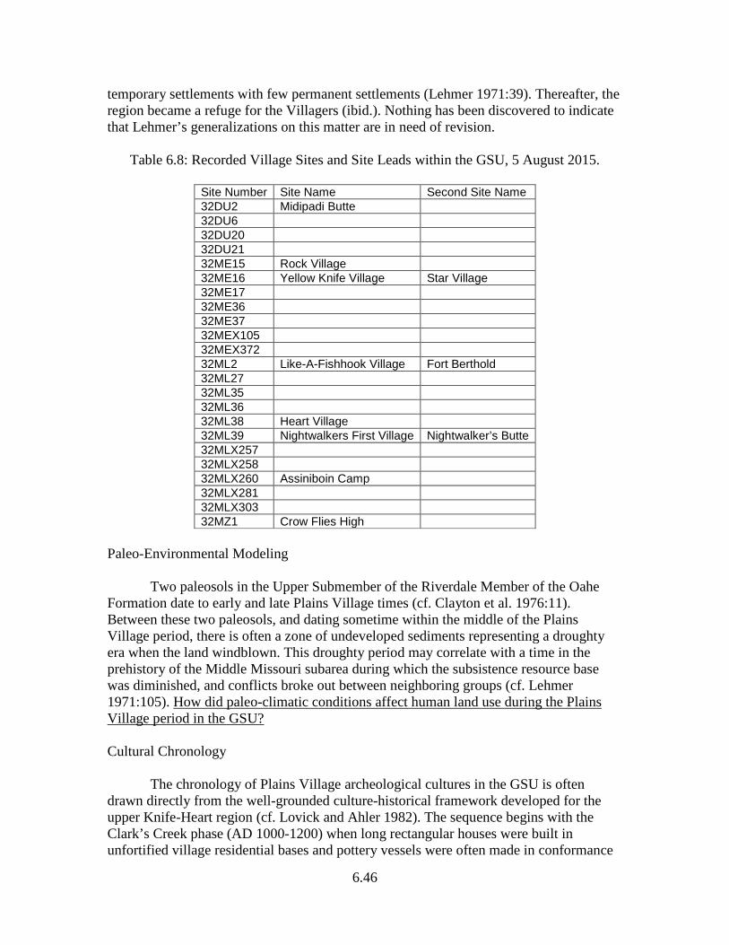
6.46
temporary settlements with few permanent settlements (Lehmer 1971:39). Thereafter, the region became a refuge for the Villagers (ibid.). Nothing has been discovered to indicate that Lehmer’s generalizations on this matter are in need of revision.
Table 6.8: Recorded Village Sites and Site Leads within the GSU, 5 August 2015.
Site Number Site Name Second Site Name 32DU2 Midipadi Butte 32DU6 32DU20 32DU21 32ME15 Rock Village 32ME16 Yellow Knife Village Star Village 32ME17 32ME36 32ME37 32MEX105 32MEX372 32ML2 Like-A-Fishhook Village Fort Berthold 32ML27 32ML35 32ML36 32ML38 Heart Village 32ML39 Nightwalkers First Village Nightwalker’s Butte 32MLX257 32MLX258 32MLX260 Assiniboin Camp 32MLX281 32MLX303 32MZ1 Crow Flies High
Paleo-Environmental Modeling Two paleosols in the Upper Submember of the Riverdale Member of the Oahe Formation date to early and late Plains Village times (cf. Clayton et al. 1976:11). Between these two paleosols, and dating sometime within the middle of the Plains Village period, there is often a zone of undeveloped sediments representing a droughty era when the land windblown. This droughty period may correlate with a time in the prehistory of the Middle Missouri subarea during which the subsistence resource base was diminished, and conflicts broke out between neighboring groups (cf. Lehmer 1971:105). How did paleo-climatic conditions affect human land use during the Plains Village period in the GSU? Cultural Chronology The chronology of Plains Village archeological cultures in the GSU is often drawn directly from the well-grounded culture-historical framework developed for the upper Knife-Heart region (cf. Lovick and Ahler 1982). The sequence begins with the Clark’s Creek phase (AD 1000-1200) when long rectangular houses were built in unfortified village residential bases and pottery vessels were often made in conformance
6.47
with Riggs ware and Fort Yates ware styles. Also dating to this phase are vessels such as one recovered from the Mondrian Tree site (32MZ58; C. Johnson 1983:9.11) which evince Initial Middle Missouri and Late Woodland influences in vessel form and surface treatment. This earliest portion of the Plains Village chronological sequence is not yet represented in the archeology of the GSU by any residential base settlements. Was any part of the GSU permanently occupied by Villagers during the early centuries of the Plains Village period? Settlement Behavior During prehistoric and early protohistoric times, the Villagers with core areas in the Knife-Heart and perhaps Cannonball regions used the territory of the GSU as a secondary area, one which they visited regularly for specific purposes and resources (cf. Syms 1977:5-6). Sites such as White Earth Creek (32MN2) with a fortification ditch, palisade wall with bastions, but lacking earthlodge depressions (cf. Muller 1968), may represent use of this secondary area by Villagers at a time when such use was contested by Woodland people who held it as a core area or who used it regularly as a secondary area. The range of Plains Village settlement types known in this unit needs to be spelled out. Aside from large fortified earthlodge village settlements, what other site types known in the core areas are not represented for prehistoric Plains Village times in this SU? Intensive site identification work in a restricted locality can result in the documentation of Plains Village components in a variety of settings indicative of varied activities. Such is the case at the Missouri River crossing of the Northern Border pipeline where Plains Village field camps were established in a sheltered tributary stream valley setting at the Mondrian Tree site (32MZ58) and special purpose activities went on in an adjacent open upland rim setting at the Edna Mae site (32MZ369) (Root 1983m). Localities such as this present an opportunity to explicate a range of settlement behavior if not commonplace activities. In Binfordian terms, how many different kinds of special purpose “locations” might reasonably be expected to be archeologically identifiable out afield in the GSU away from the earthlodge village residential bases? Native Subsistence Practices The Villagers living along the Missouri River (in the Southern Missouri River SU) who were visited by La Verendrye in AD 1738 grew corn, melons, pumpkins, and beans. In the late 1800s and early 1900s, after the survivors of the epidemics moved northwestward into the realm of the GSU, their crops included corn, beans, squash, sunflowers, and tobacco (Meyer 1977:63; Will and Hyde 1917; Wilson 1917). How were horticultural practices changed by the volatile cultural events spanning late prehistoric, protohistoric, and historic times? What sorts of archeological contexts must be sampled, and what sorts of recovery techniques must be employed to enable collecting data to answer such questions?
6.48
Technologies Sites that witnessed multiple occupations during this period, and where deposits from the multiple occupations are stratified, have potential to hold information concerning changes in technologies. This was the case at the Mondrian Tree site (32MZ58) where Plains Village remains attributed to the Scattered Village complex were recovered from the two uppermost excavation levels. Several temporal trends were noted in studying the ceramic bodysherd samples (cf. Johnson 1983). Through time, there was an increase in the percentage of sherds with smoothed exterior surfaces and a decrease in simple stamping. Body sherd thickness increased. Are these trends characteristic of middle-to-late Plains Village times throughout the GSU? Artifact Styles Ceramic vessel forms and kinds of decoration combine to yield “wares” which, next to radiocarbon dates, provide the most useful material for determining when sites were occupied. For example at Midipadi Butte (32DU2), all of the Plains Village pottery recovered by excavations was attributable to the Knife River phase (AD 1780 to 1845). Knife River ware made up 80%, Transitional S-Rim ware 10%, and Deapolis Collared ware 10% (Kuehn et al. 1982:48). These wares were defined from Knife River phase components in the lower GSU and upper Knife-Heart regions (Lehmer, Wood, and Dill 1978). Do Knife River phase ceramic vessel styles have a more limited distribution within the GSU than earlier Plains Village vessel styles? Regional Interaction Exotic nonlocal shell artifacts are often found in Plains Village sites where fine-mesh recovery procedures are employed during excavation. Dentalium and abalone shell decorative objects were found in association with Scattered Village ceramics at the Mondrian Tree site (32MZ58) (Brine et al. 1983). The cultural mechanisms by which Pacific Coast materials such as these were moved into the Northern Plains are discussed by Wood (1972, 1980). However, Pacific Coast shells are less common in prehistoric Plains Village contexts than historic (ibid.:18.7). At Like-a-Fishhook Village (32ML2), the final earthlodge village occupied by the Mandan, Hidatsa, and Arikara from AD 1845-1885, pendants and cut slabs of abalone plus “hundreds of fragments of Dentalium” were archeologically recovered from lodge floors and caches (Smith 1972:72). Were interactions between Plains Village groups and Pacific Coast peoples more intensive during late Plains Village times than during early and middle Plains Village times? Historic Preservation Goals, Priorities, and Strategies Most of the Plains Village residential sites in the GSU have been inundated by the waters of Garrison Reservoir. While the effects of inundation on these archeological deposits have been debated in the past, investigations during low water levels reveal site destruction due to inundation. In addition, there is no question that they suffer from pilferage and looting when reservoir levels drop. The community of concerned
6.49
archeologists should work with the Mandan-Hidatsa-Arikara Nation and the US Army Corps of Engineers to safeguard these archeological sites until they can be properly inventoried and evaluated for NRHP eligibility. Equestrian/Fur Trade Period The GSU is better known for Plains Village tradition sites dating to this period than it is for sites of the Equestrian tradition. The Mandan, Hidatsa, and Arikara moved to this area as a refuge from equestrian peoples during this period, and here the Fort Berthold Reservation was established for them in AD 1870 (Meyer 1977:112). The Equestrian tradition is well represented by archeological sites here, especially in the western portions of the unit in proximity to Fort Union Trading Post National Historic Site and Fort Buford State Historic Site. There is a rich ethnohistoric record for these contexts from explorers, traders, and military men. The ethnographic and oral historic record is plentiful as well (cf. Bowers 1948, 1950, 1965; Wilson 1910, 1916, 1917, 1924, 1928, 1934, 1971). Paleo-Environmental Modeling The records of early explorers and trading post journals provide eyewitness accounts of weather conditions which can be studied to fairly accurately model the climate changes of this period (cf. Ball 1984). Indians also took advantage of some environmental conditions to further their purposes. There is evidence of recurrent burning across the surface of the Mondrian Tree site (32MZ58) which may have been done intentionally in the fall of the year to promote a rapid “greening up” in the spring in order to attract grazing herds of bison to a particular location for hunting (Toom and Gregg 1983). Cultural Chronology Mandan and Hidatsa sites occupied between AD 1780 and 1845 in the Southern Missouri River and Garrison SU are assigned to the Knife River phase (Lehmer et al. 1978:419). No particular complex or phase name has been proposed for any of the Equestrian sites in the GSU. The beginning of the Knife River phase is placed at AD 1780 because that was the time of a smallpox epidemic which slashed the population of Mandan and Hidatsa by over 50% (ibid.:427). This precipitous population drop is thought to have been the reasons for a sudden change in technological and stylistic attributes of Plains Village ceramics (Hollenback 2012). Knife River phase pottery is the product of less adept potters than that of the preceding Heart River phase (ibid.:426). Some protohistoric sites of Villagers and Equestrian peoples predating AD 1780 are, by definition, assigned to the Plains Village period until the GSU chronology is refined. Some of these will be pre-horse and some post-horse. An example may be the Jim Harp site (32WI49), a stone circle site, yielded a tri-notched arrowpoint and a gunflint (Root 1983r). Should there be a special chronology for protohistoric times in the GSU?
6.50
Settlement Behavior Site 32WI178, in the BLM’s Sand Creek Coal Study Area, lies near Camp Creek, a tributary of the Little Muddy River (Metcalf et al. 1988:10, 115). This location is about nine miles north of the Missouri River. This is a stone circle site with one or more occupations dating to this period, as evidenced by the surface collection of metal arrowpoints. There are 10 stone circles and several dozen cairns which form an alignment across the site. Two aspects of the site which support its assignment to the Equestrian period are the large size of some of the stone circles (up to eight meters in diameter) and the total lack of chipped stone artifacts observed on the surface. Because of the GSU’s abundance of stone circle sites and sites with trade goods from exchange activities at the Fort Union and Fort Buford posts, this would be a good SU in which to test the proposition that domestic stone circles with diameters of six meters or greater were typically constructed only by equestrian groups who had horses to haul the long poles required to erect such large lodges. Native Subsistence Practices Hidatsa gardening and hunting practices and uses of wild plant resources in the GSU during the 1800s are chronicled in wonderful detail in the works of Alfred Bowers (1965) and Gilbert Wilson (1916, 1917, 1924, 1928). A great deal more has been documented by this ethnographic work than ever will be documented archeologically for this time and place. However, the challenge for Equestrian period archeology in the GSU presented by this ethnographic database is to confirm some of these documented practices archeologically. In this way, the interpretive power of Plains Village archeology may be improved for application to prehistoric deposits in the GSU. Looking to the adjacent Little Missouri River SU, Walt Allen (1982) used this sort of ethnoarcheological approach to identify complexes of sites and features which were archeological representations of ethnographically recorded eagle trapping practices. What sorts of archeological remains should be expected as indicators of ethnographically recorded subsistence practices of Equestrian period groups in the GSU? Technologies The material culture of Knife River phase Plains Village sites are described in great detail by Lehmer, Wood, and Dill (1978). Native technologies of both the Villagers and Equestrian peoples were in decline throughout the Equestrian period. Did the Villagers divest themselves of their traditional technologies at approximately the same rates through the Equestrian period? Artifact Styles A number of different classes of artifacts of both Native and Euro-American manufacture were made following styles which changed during the Equestrian period. Tri-notched arrowpoints which became prominent perhaps as early as the AD 1500s may have persisted into this period (cf. Reher and Frison 1980:25-28). Gunflints of different
6.51
styles and materials probably changed in availability during the first half of the period. Influxes of different kinds of glass trade beads changed leading to the dating of occupation episodes at sites such as Mondrian Tree (32MZ58). Styles of factory-made iron and brass arrowpoints changed although recovered samples are seldom big enough to enable dating a deposit by study of metal points only (cf. Kuehn et al. 1982, 1984). What stylistic attributes of archeologically recoverable material culture could possibly be used to identify ethnic or tribal affiliation of Equestrian period components in the GSU? Regional Interaction Intertribal trade that took place during the Equestrian period had its inception in prehistoric times (cf. Wood 1972, 1974). The Hidatsa traded with the Crow, Dakota, Cheyenne, and others to the south and southwest (Lehmer et al. 1978:5). Fur trading directly between Indians and non-Indians within the GSU began by at least AD 1826 when James Kipp of the Columbia Fur Company constructed a trading post in the White Earth Creek valley north of the Missouri River in western Mountrail County (Woolworth and Wood 1960). Fort Kipp was established for trade with the Assiniboine whose territory extended from this Upper Missouri county northward into Canada. Did the increased intensity of intertribal interactions during the course of the Equestrian period result in any loss of tribal identity for groups in the GSU? Is increased uniformity or similarity in assemblages of artifacts any indication of ethnic or tribal uniformity or cultural mixing? Historic Preservation Goals, Priorities, and Strategies People of the Mandan-Hidatsa-Arikara Nation (MHAN) now reside on the Fort Berthold Indian Reservation which is entirely within the GSU. During the Equestrian period, these people lived lifeways which combined Plains Village and Equestrian adaptive strategies. The MHAN was approved as a Tribal Historic Preservation Office (THPO) by the National Park Service in 2007. The THPO and the SHSND should continue the close cooperative relationship it has established.