Embed Size (px)
Citation preview
The Geology of the Sargasso Sea Alliance Study AreaPotential Non-Living Marine Resources and an Overview of the Current Territorial Claims and Coastal States InterestsLindsay Parson and Rosemary Edwards
Number 8 Sargasso Sea Alliance Science Report Series

When referenced this report should be referred to as:
Parson, L. and R. Edwards 2011. The Geology of the Sargasso Sea Alliance Study Area, Potential Non-Living Marine Resources and an Overview of the Current Territorial Claims and Coastal States Interests. Sargasso Sea Alliance Science Report Series, No 8, 17pp. ISBN 978-0-9847520-7-2.
The Sargasso Sea Alliance is led by the Bermuda Government and aims to promote international awareness of the importance of the Sargasso Sea and to mobilise support from a wide variety of national and international organisations, governments, donors and users for protection measures for the Sargasso Sea.
Further details:
Dr David Freestone, Executive Director, Sargasso Sea Alliance, Suite 300, 1630 Connecticut Avenue NW, Washington D.C., 20009, USA. Email: [email protected]
Kate K. Morrison, Deputy Director, at the same address. Email: [email protected]
The Secretariat of the Sargasso Sea Alliance is hosted by the Washington D.C. Office of the International Union for the Conservation of Nature (IUCN).
Website is www.sargassoalliance.org
This case is being produced with generous support of donors to the Sargasso Sea Alliance: Ricardo Cisneros, Erik H. Gordon, JM Kaplan Fund, Richard Rockefeller, David E. Shaw, and the Waitt Foundation. Additional support provided by: WWF Sweden and the Pew Environment Group.
COVER PHOTO: Deepsea coral (NOAA).
ISBN 978-0-9847520-7-2
The Geology of the Sargasso Sea Alliance Study AreaPotential Non-Living Marine Resources and an Overview of the Current Territorial Claims and Coastal States Interests
Lindsay Parson and Rosemary EdwardsMaritime Zone Solutions Ltd, UK
2Sargasso Sea All iance – The Geology of the Sargasso Sea
Foreword
B ETWEEN 2010 AND 2012 a large number of authors from seven different countries and
26 separate organisations developed a scientific case to establish the global importance
of the Sargasso Sea. A summary of this international study was published in 2012 as the
“Summary science and Supporting Evidence Case.” Nine reasons why the Sargasso Sea is
important are identified in the summary. Compiling the science and evidence for this case
was a significant undertaking and during that process a number of reports were specially
commissioned by the Sargasso Sea Alliance to summarise our knowledge of various aspects
of the Sargasso Sea.
This report is one of these commissioned reports. These are now being made available
in the Sargasso Sea Alliance Science Series to provide further details of the research and
evidence used in the compilation of the summary case. A full list of the reports in this series
can be found in the inside back cover of this report. All of them can be downloaded from
www.sargassoalliance.org.
Professor Howard Roe Science Advisory Committee Chair Sargasso Sea Alliance
Professor Dan Laffoley Science Coordinator Sargasso Sea Alliance
3Sargasso Sea All iance – The Geology of the Sargasso Sea
The Geology of the Sargasso Sea Alliance Study Area, Potential Non-Living Marine Resources and an Overview of the Current Territorial Claims and Coastal States Interests
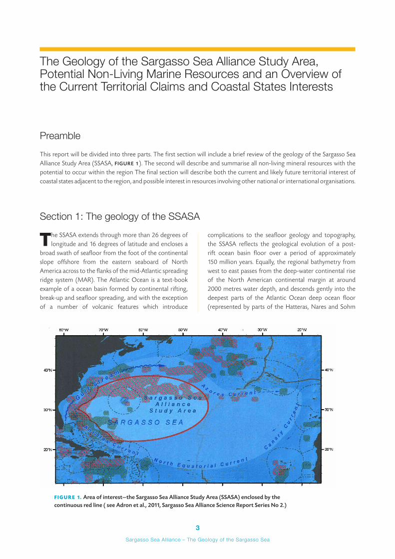
PreambleThis report will be divided into three parts. The first section will include a brief review of the geology of the Sargasso Sea Alliance Study Area (SSASA, FIGURE 1). The second will describe and summarise all non-living mineral resources with the potential to occur within the region The final section will describe both the current and likely future territorial interest of coastal states adjacent to the region, and possible interest in resources involving other national or international organisations.
Section 1: The geology of the SSASA
The SSASA extends through more than 26 degrees of longitude and 16 degrees of latitude and encloses a
broad swath of seafloor from the foot of the continental slope offshore from the eastern seaboard of North America across to the flanks of the mid-Atlantic spreading ridge system (MAR). The Atlantic Ocean is a text-book example of a ocean basin formed by continental rifting, break-up and seafloor spreading, and with the exception of a number of volcanic features which introduce
complications to the seafloor geology and topography, the SSASA reflects the geological evolution of a post-rift ocean basin floor over a period of approximately 150 million years. Equally, the regional bathymetry from west to east passes from the deep-water continental rise of the North American continental margin at around 2000 metres water depth, and descends gently into the deepest parts of the Atlantic Ocean deep ocean floor (represented by parts of the Hatteras, Nares and Sohm
FIGURE 1. Area of interest—the Sargasso Sea Alliance Study Area (SSASA) enclosed by the continuous red line ( see Adron et al., 2011, Sargasso Sea Alliance Science Report Series No 2.)
4Sargasso Sea All iance – The Geology of the Sargasso Sea
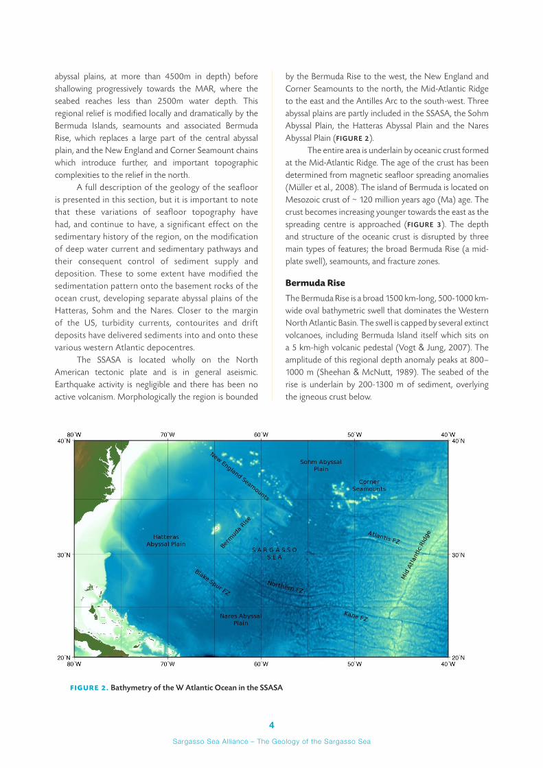
abyssal plains, at more than 4500m in depth) before shallowing progressively towards the MAR, where the seabed reaches less than 2500m water depth. This regional relief is modified locally and dramatically by the Bermuda Islands, seamounts and associated Bermuda Rise, which replaces a large part of the central abyssal plain, and the New England and Corner Seamount chains which introduce further, and important topographic complexities to the relief in the north.
A full description of the geology of the seafloor is presented in this section, but it is important to note that these variations of seafloor topography have had, and continue to have, a significant effect on the sedimentary history of the region, on the modification of deep water current and sedimentary pathways and their consequent control of sediment supply and deposition. These to some extent have modified the sedimentation pattern onto the basement rocks of the ocean crust, developing separate abyssal plains of the Hatteras, Sohm and the Nares. Closer to the margin of the US, turbidity currents, contourites and drift deposits have delivered sediments into and onto these various western Atlantic depocentres.
The SSASA is located wholly on the North American tectonic plate and is in general aseismic. Earthquake activity is negligible and there has been no active volcanism. Morphologically the region is bounded
by the Bermuda Rise to the west, the New England and Corner Seamounts to the north, the Mid-Atlantic Ridge to the east and the Antilles Arc to the south-west. Three abyssal plains are partly included in the SSASA, the Sohm Abyssal Plain, the Hatteras Abyssal Plain and the Nares Abyssal Plain (FIGURE 2).
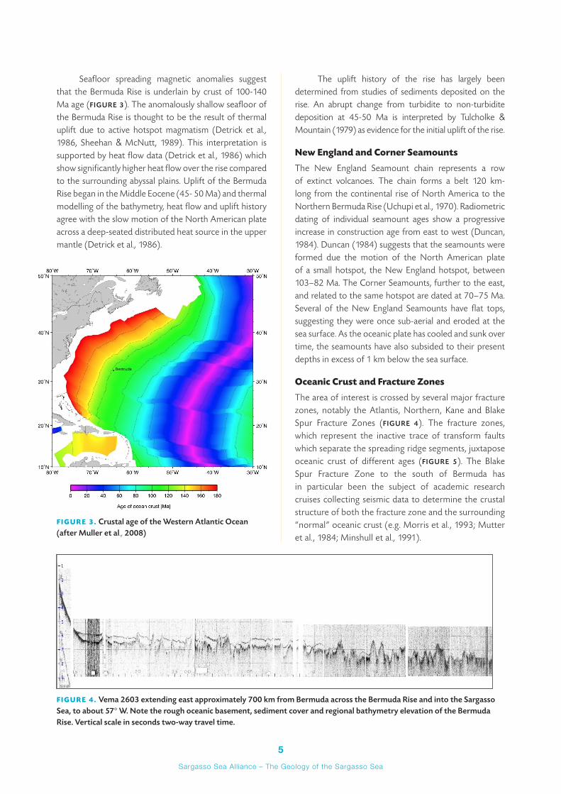
The entire area is underlain by oceanic crust formed at the Mid-Atlantic Ridge. The age of the crust has been determined from magnetic seafloor spreading anomalies (Müller et al., 2008). The island of Bermuda is located on Mesozoic crust of ~ 120 million years ago (Ma) age. The crust becomes increasing younger towards the east as the spreading centre is approached (FIGURE 3). The depth and structure of the oceanic crust is disrupted by three main types of features; the broad Bermuda Rise (a mid-plate swell), seamounts, and fracture zones.
Bermuda Rise
The Bermuda Rise is a broad 1500 km-long, 500-1000 km-wide oval bathymetric swell that dominates the Western North Atlantic Basin. The swell is capped by several extinct volcanoes, including Bermuda Island itself which sits on a 5 km-high volcanic pedestal (Vogt & Jung, 2007). The amplitude of this regional depth anomaly peaks at 800–1000 m (Sheehan & McNutt, 1989). The seabed of the rise is underlain by 200-1300 m of sediment, overlying the igneous crust below.
FIGURE 2. Bathymetry of the W Atlantic Ocean in the SSASA
5Sargasso Sea All iance – The Geology of the Sargasso Sea
Seafloor spreading magnetic anomalies suggest that the Bermuda Rise is underlain by crust of 100-140 Ma age (FIGURE 3). The anomalously shallow seafloor of the Bermuda Rise is thought to be the result of thermal uplift due to active hotspot magmatism (Detrick et al., 1986, Sheehan & McNutt, 1989). This interpretation is supported by heat flow data (Detrick et al., 1986) which show significantly higher heat flow over the rise compared to the surrounding abyssal plains. Uplift of the Bermuda Rise began in the Middle Eocene (45- 50 Ma) and thermal modelling of the bathymetry, heat flow and uplift history agree with the slow motion of the North American plate across a deep-seated distributed heat source in the upper mantle (Detrick et al., 1986).
The uplift history of the rise has largely been determined from studies of sediments deposited on the rise. An abrupt change from turbidite to non-turbidite deposition at 45-50 Ma is interpreted by Tulcholke & Mountain (1979) as evidence for the initial uplift of the rise.
New England and Corner Seamounts
The New England Seamount chain represents a row of extinct volcanoes. The chain forms a belt 120 km-long from the continental rise of North America to the Northern Bermuda Rise (Uchupi et al., 1970). Radiometric dating of individual seamount ages show a progressive increase in construction age from east to west (Duncan, 1984). Duncan (1984) suggests that the seamounts were formed due the motion of the North American plate of a small hotspot, the New England hotspot, between 103–82 Ma. The Corner Seamounts, further to the east, and related to the same hotspot are dated at 70–75 Ma. Several of the New England Seamounts have flat tops, suggesting they were once sub-aerial and eroded at the sea surface. As the oceanic plate has cooled and sunk over time, the seamounts have also subsided to their present depths in excess of 1 km below the sea surface.
Oceanic Crust and Fracture Zones
The area of interest is crossed by several major fracture zones, notably the Atlantis, Northern, Kane and Blake Spur Fracture Zones (FIGURE 4). The fracture zones, which represent the inactive trace of transform faults which separate the spreading ridge segments, juxtapose oceanic crust of different ages (FIGURE 5). The Blake Spur Fracture Zone to the south of Bermuda has in particular been the subject of academic research cruises collecting seismic data to determine the crustal structure of both the fracture zone and the surrounding “normal” oceanic crust (e.g. Morris et al., 1993; Mutter et al., 1984; Minshull et al., 1991).
FIGURE 4. Vema 2603 extending east approximately 700 km from Bermuda across the Bermuda Rise and into the Sargasso Sea, to about 57° W. Note the rough oceanic basement, sediment cover and regional bathymetry elevation of the Bermuda Rise. Vertical scale in seconds two-way travel time.
FIGURE 3. Crustal age of the Western Atlantic Ocean (after Muller et al., 2008)
6Sargasso Sea All iance – The Geology of the Sargasso Sea
The oceanic crust in the area away from fracture zones is relatively uniform in terms of its thickness and seismic velocity structure, although the crustal reflectivity varies quite widely (Morris et al., 1993). The thicknesses and velocities of oceanic layer 2 (upper crust basalts) and layer 3 (lower crust gabbros) are typical of those found for crust formed at a slow spreading ridge. Away from fracture zones the thickness of the igneous crust is between 7.0-8.0 km.
Fracture zones are characterised by anomalous crustal structures which can be extremely heterogeneous. Fracture zone crust is often anomalously thin (1–2 km thick) and characterised by low seismic velocities (Detrick et al., 1993). Fracture zones are narrow features, a zone 20–30 km wide contains the main crustal thinning, although there may be a more gradual thinning of the crust over a wide area, perhaps due to reduced magma supply at the end of spreading segments.
At the top of the igneous crust, fracture zones are typically characterised significant basement highs and troughs due to the age difference across the fracture zone trace. The basement trough may result in significant local increases in sediment thickness.
Post-rifting sedimentation on the SSASA
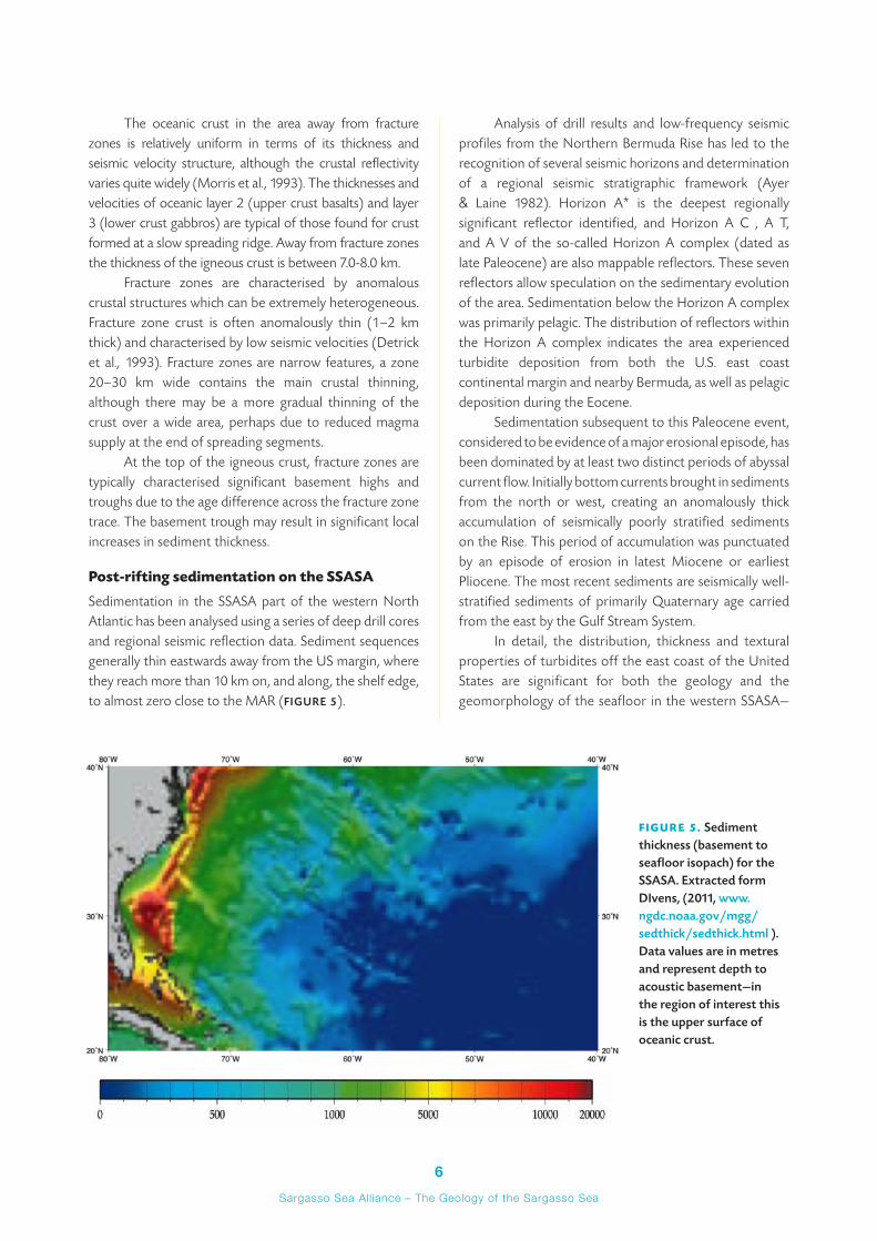
Sedimentation in the SSASA part of the western North Atlantic has been analysed using a series of deep drill cores and regional seismic reflection data. Sediment sequences generally thin eastwards away from the US margin, where they reach more than 10 km on, and along, the shelf edge, to almost zero close to the MAR (FIGURE 5).
Analysis of drill results and low-frequency seismic profiles from the Northern Bermuda Rise has led to the recognition of several seismic horizons and determination of a regional seismic stratigraphic framework (Ayer & Laine 1982). Horizon A* is the deepest regionally significant reflector identified, and Horizon A C , A T, and A V of the so-called Horizon A complex (dated as late Paleocene) are also mappable reflectors. These seven reflectors allow speculation on the sedimentary evolution of the area. Sedimentation below the Horizon A complex was primarily pelagic. The distribution of reflectors within the Horizon A complex indicates the area experienced turbidite deposition from both the U.S. east coast continental margin and nearby Bermuda, as well as pelagic deposition during the Eocene.
Sedimentation subsequent to this Paleocene event, considered to be evidence of a major erosional episode, has been dominated by at least two distinct periods of abyssal current flow. Initially bottom currents brought in sediments from the north or west, creating an anomalously thick accumulation of seismically poorly stratified sediments on the Rise. This period of accumulation was punctuated by an episode of erosion in latest Miocene or earliest Pliocene. The most recent sediments are seismically well-stratified sediments of primarily Quaternary age carried from the east by the Gulf Stream System.
In detail, the distribution, thickness and textural properties of turbidites off the east coast of the United States are significant for both the geology and the geomorphology of the seafloor in the western SSASA—
FIGURE 5. Sediment thickness (basement to seafloor isopach) for the SSASA. Extracted form DIvens, (2011, www.ngdc.noaa.gov/mgg/sedthick/sedthick.html ). Data values are in metres and represent depth to acoustic basement—in the region of interest this is the upper surface of oceanic crust.
7Sargasso Sea All iance – The Geology of the Sargasso Sea
which has been moderated by the variations in relief occurring in the basin (Horn et al., 1971). In the Hatteras Abyssal Plain, turbidity-current activity has been at a moderate level where there are no obstructions to flow, and sediment patterns are well-defined. The situation of the Sohm Abyssal Plain is different in that there has been an ample supply of sediment, more vigorous turbidity-current activity, seaward flow has been obstructed by many seamounts, and the overall result is a haphazard dispersal of sand by bottom-seeking flows. It would appear that that deep-sea sands and silts of the outer
continental rise and adjacent abyssal plains are emplaced by turbidity currents.
Beyond the abyssal plain, the sedimentation becomes dominated by pelagic material, and while integrated biomagnetostratigraphy results from deep drilling (ODP Leg 172)1 suggests a sedimentation rate of 200 m/m.y. adjacent to the Rise, deeper layers in the section are as little as 75 m/m.y. Locally, basement topography can be recognised to exert some control to sediment pathways, and fracture zone valleys are common sites for local depositional centres.
Section 2: Potential non-living resources of the SSASA
This section provides an introduction to the most significant mineral resources which either have been
sampled within, or that could occur in the SSASA, given the geological context of the region. Some comments are also offered regarding the likelihood of resource exploitation in the foreseeable future, although speculation on the economic factors which would undoubtedly influence this is beyond the scope of this report. The mineral resources described here are aggregates, phosphorite, polymetallic sulphides, polymetallic nodules, cobalt-rich ferromanganese crusts, hydrocarbons, and gas hydrates.
Aggregate
‘Aggregate’ refers to gravel, sand, clay, earth, shale, stone or coral, regardless of composition. For the SSASA, this aggregate is likely to occur near shore, and while accessible, will be of very limited and localized potential. Normally, only offshore aggregate resources of sand and gravel are considered as being of commercial interest, but for a smaller community such as Bermuda, coral and or basement rock could also be extracted locally for use in construction and civil engineering projects.
Sand and gravel deposits are accumulations of rock fragments and mineral grains, derived from the weathering and erosion of hard rocks by glacial and fluvial action. Water action is an effective mechanism for wearing away weaker particles, and separating different sized fractions. The properties of sand and gravel largely depend on those of the rocks from which they were derived. Most sand and gravel is composed of particles that are durable and rich in silica (quartz, quartzite and flint), but other rock types, such as limestone, may also occur, and include negative impurities such as lignite, mudstone, chalk and coal.
Sand and gravel resources are unevenly distributed on the continental shelf of coastal states, but are similar to their land-based equivalents, occurring as small patches separated or covered by extensive areas of uneconomic deposits. They vary in their thickness, composition and grading, and in their proximity to the shore. They are often of high volume, but generally of low value.
Most extraction of aggregate takes place by dredging, and normally occurs in coastal waters less than 25 km offshore and in water depths of between 18m and 35m. Current, large-scale dredging technology does not allow effective working in water depths in excess of 50m and so given the steep relief of the submarine flanks of Bermuda, it is therefore highly unlikely that exploitation would be anything but very near shore.
In summary, other than in exceptional circumstances, aggregates are not likely to be viable resources for exploitation in the SSASA other than on a very proximal, limited and local scale—and with a consequential limited impact on the environment.
Phosphorite deposits
Offshore phosphorite deposits are precipitated in abundance adjacent to either wide-margin coastal States, or on the flanks of open water seamounts or island groups, where they are affected by upwelling and displacement of deepwater current flow. Principal accumulation sites include the southern hemisphere margins of South America and Africa, and parts of Australasia and many of the western Pacific Island groups. In most cases, the deposits are almost wholly within coastal States’ Exclusive Economic Zones (EEZ), although occasionally they are found some distance from shore.
1 www-odp.tamu.edu/publications/172_IR/VOLUME/CHAPTERS/CHAP_06.PDF
8Sargasso Sea All iance – The Geology of the Sargasso Sea
World sub-sea resources of phosphorite are probably at least of the order of hundreds of billions of tonnes, and huge island industries have been established in the past to mine and export this resource (notably Nauru). Nonetheless, because of the prevailing downbeat economic conditions and the availability of phosphates from plentiful non-marine sources, no offshore mining is currently occurring or foreseen in the immediate future. Land deposits of phosphorite are large enough to meet world demands for the short and medium term, but sub-sea production may become economically viable in some local areas, especially those far removed from onshore deposits.
It has not been possible to locate publicly available resource estimates for phosphorite for the Bermuda or adjacent seamount group.
Polymetallic sulphides
In the submarine environment, polymetallic sulphides (PMS) form as remarkably pure and concentrated deposits along mid-ocean ridge systems (MOR)—active spreading centres, or plate boundaries—where superheated bottom water leaches minerals from newly formed ocean crust as it circulates through its fracture and fissure systems, and then re-deposits them when these concentrated fluids are vented at hydrothermal “black-smoker” sites along the ridge. While PMS are best known at their active locations along the MOR, and these sites are widely distributed throughout the ocean crust of most ocean basins, it is known that the active sites inevitably move away from the MOR as the tectonic plates migrate away from the spreading centre. Hydrothermal activity decreases and eventually ceases, as the plate motion carries any deposits laterally into the deep ocean on either side of the ridge. These older, cold sites, host mature deposits of high grade metal ores (as well as the technically more challenging high temperature active sites) are already becoming of considerable interest to prospectors for non-living seafloor minerals.
The majority of submarine polymetallic sulphides are massive ore bodies containing both high-temperature (ca. 350°C, or above) and low-temperature (<300°C) mineral assemblages. In varying proportions these comprise compounds, usually sulphides, of copper, iron, zinc in major amounts (such as pyrrhotite, pyrite/marcasite, sphalerite/wurtzite, chalcopyrite, bornite, isocubanite), barite, anhydrite, and amorphous silica, often with anhydrite (calcium sulphate). Some massive polymetallic sulphides at back-arc spreading centres also contain galena (lead sulphide), arsenic and antimony (in sulphosalts), and occasionally native gold. Other minor
sulphides of tin, cadmium, antimony and mercury also commonly occur in varying amounts at different localities.
The industry behind exploration and exploitation of PMS is well-established. Current exploration programmes for polymetallic sulphides within 200 miles (M) of coastal States (such as the Solwara offshore sites in the Papua New Guinea EEZ ) are reaching the extraction/exploitation phase in the Bismarck Sea.2 The world’s first seafloor copper/gold mine is planned for the region in 1,600m of water and within 50 kilometres of land, but there is potential to move into deeper water and further offshore as systems are tested and economic conditions allow.
In summary, there is no doubt that polymetallic sulphides represent one of the more promising mineral resources common to the deep sea floor, and are likely to occur within the oceanic crust underlying the SSASA. Naturally, as new ocean crust moves off-axis, open ocean sedimentation will gradually bury the crust—creating another barrier to exploration. This issue will delay full scale exploration as when they have ceased venting, potential mineral sites are not as easy to locate as when they are, almost literally, ‘sending out smoke-signals’. New technologies to find these ‘cold’ deposits are emerging, and as the demand rises, they may prove successful. These include geochemical prospecting in sediments which overly or are adjacent to PMS ore bodies—essentially identifying ‘gossan-like mineralisation’, and/or potential field geophysical mapping—such as deep-tow magnetic or resistivity surveying. The added difficulties of identifying and securing a deposit beneath a blanket of sediment will probably dictate that the earliest sites to be investigated will more likely be on the flanks of the MAR, and thus in the easternmost part of the SSASA.
In this context, it is timely to note that the Russian Federation submitted the first request for an exploration licence in respect of PMS in the Atlantic Ocean to the International Seabed Authority on the 24th December 2010. The areas which the Russian Federation are interested in are on the MAR itself, south of 10°S, but along with China Ocean Minerals Resources Research and Development Association (COMRA)’s parallel request for an exploration licence in the India Ocean MOR system, these pioneer licensees are signalling the growing interested in PMS as an economically viable ore deposit. This may be not so much for their common metal ore content, but their potential to supply the escalating needs for rare earth and trace metal deposits used in high performance computing, screens, mobile phones and other hi-tech demands.
2 see Nautilus Minerals information at www.nautilusminerals.com
9Sargasso Sea All iance – The Geology of the Sargasso Sea
Polymetallic manganese nodules and cobalt-rich ferromanganese crusts
Manganese nodules are micro- to potato-sized concentrations of iron and manganese oxides that can contain economically valuable concentrations of nickel, copper and cobalt (up to about 3 per cent, combined). They occur mainly on the deep sea floor, but have been reported throughout many of the ocean’s physiographic provinces, including the western North Atlantic. Apart from manganese and iron oxide, nickel, copper and cobalt, the nodules can include trace amounts of molybdenum, platinum and other metals.
Manganese nodules were first dredged during the HMS Challenger expedition to the Pacific Ocean in 1872-76. The current knowledge of manganese nodule and crust distribution is based on large amounts of information from sidescan sonar, drill cores, dredged samples, seafloor photographs, video records and direct observation from submersibles. This reveals that, while nodules occur in deep water throughout all major ocean basins, the highest abundance and most attractive grades are found in two areas. These are the Eastern Central Pacific Ocean between the Clarion and Clipperton Fracture Zones, and the Indian Ocean. This observation does not exclude the possibility that nodules recovered from the Atlantic may themselves represent a viable resource, depending on the economics of the mineral markets.
A similarly occurring deep-sea mineral deposit is that of cobalt-rich ferromanganese crusts, (commonly cobalt crusts), similar in composition to the nodules, and found in as coatings or encrustations on hard rock substances, on seamounts and the submerged portions of islands. They range in thickness from a few millimetres to layered crusts several centimetres thick. As much as 25 cm of crust has been reported on a number of occasions. The material is deposited on sand grains, pebbles, rock fragments and outcropping bedrock, or may blanket unconsolidated sediments and can contain up to 2 per cent in cobalt.
Manganese nodules and cobalt-rich manganese crusts are likely to be the most commonly occurring mineral resource in the SSASA. These deposits may be the most significant for coastal States in low latitudes, and due to their widespread occurrence, it is unlikely that configuration of the (geological) shelf moderates their distribution.
In summary, there is little doubt that manganese nodules and cobalt-rich crusts will occur in the SSASA. Their relatively low value, but high local abundance and grade, make these deposits a likely candidate for consideration as a resource in the long term.
Hydrocarbons
Oil and natural gas are hydrocarbon deposits that occur naturally within thick sedimentary sequences. While these are largely confined to the shallower parts of the continental shelves, continental slopes, continental rises and small ocean basins, deeper water deposits are not unknown, and will become increasingly important as technology allows exploitation at greater depths.
Generally, large quantities of hydrocarbons can only be formed in settings where appropriate source materials are available, and at depths normally greater than around 3,000m of sediment overburden. The thickest sediment sequences are in the extreme west part of the SSASA. The formation of exploitable reservoirs of hydrocarbons requires migration (from its source rocks) to geological traps comprised of a porous reservoir rock overlain by an impermeable horizon (or a ‘cap-rock’). Ideal environments for hydrocarbon formation and retention may be provided by sedimentary sequences in excess of 1,000m thickness, in areas of high-heat flow, and comprising organic-rich layers at depth overlain by porous rocks that are in turn overlain by impermeable, domed strata may provide ideal environments for hydrocarbon formation and retention.
There is little doubt that conventional hydrocarbons, both oil and gas, are the main focus of attention in terms of well documented resources on ‘wide’ continental margins with OCS potential. Largely due to the reluctance of oil companies and exploration companies to invest heavily in areas beyond 200M, as well as the absence of any licensing administration, these areas have seen little new surveying or sampling in recent years. The lack of data with which to evaluate frontier area capacity has severely hindered progress towards understanding the distribution and value of these deep water resources. However, there is an expectation that, once claims have been submitted under article 76, areas of OCS, will attract increased attention and exploration investment, and that their suitability for prospecting and resource potential will become better understood.
In summary, hydrocarbons represent the most mature and well understood mineral resources with any likelihood of occurring within the SSASA. Technologies exist or are in hand to deal with deposits in the ‘ultra’ deep water that would pertain, but technology has never been a barrier to exploitation in this industry—and the market is always hungry for new sources.
Gas hydrates
Gas hydrates are solid, ice-like compound substances formed of cubic crystalline lattices of water and gas. They
10Sargasso Sea All iance – The Geology of the Sargasso Sea
occur worldwide as layers or laminar units inter-bedded with sediments in the upper few hundred metres of core samples of drill sections taken on continental margins. They are formed by the natural process of organic decay in marine sediments, under a range of pressures (greater than 500m water depth) and temperatures (dependant on depth) that make the gas hydrate molecule stable. Methane is the main component of the gas, often present in excess of 99 per cent. When the host water is in its solid state (ice), its open molecular structure encages gas molecules with great efficiency, securing methane by up to 170 times the volume of the ice itself. This gas is released when the ice melts, but this is not considered to be the greatest of the properties of hydrate. Much more interesting is the fact that the ice layer can act as an impermeable cap, or ‘seal’ to hold in gaseous methane in huge volumes. As the technology delivering effective extraction of gas from beneath gas hydrate caps is still very much in its infancy, the resource potential of gas hydrates, while real, awaits investment and development.
Gas hydrates occur abundantly, at or just below the seafloor, or at depth in marine sediments widely throughout the world’s ocean. They have been sampled at various sites on the eastern North American shelf .3 They look very much like water ice. Methane hydrate is stable in
ocean floor sediments at water depths greater than 300m below the sea floor, where it is known to cement loose material in a layer several hundred meters thick.
Gas hydrates form and accumulate where marine sediments contain suitable and sufficient dissolved gas and where the geothermal (subsurface temperature gradient) conditions are within the stability field of the hydrate. The source of the dissolved gas is the breakdown of organic matter trapped within the sediment. Therefore, the un-oxidised organic carbon content of the sediment is a significant factor in determining the potential for gas generation.
Gas hydrate reservoirs of methane are identified as a potential future natural resource, possibly comprising up to ten times the fuel value of current conventional gas and oil resources.Thus, the distribution of gas hydrate deposits is of growing strategic importance.
In summary, gas hydrate is probably the widest distributed, yet so far least accessible mineral resource of the deep water parts of continental shelves. Technologies under development in Japan, India and the United States of America are all seeking to establish a working industry scale extraction system that is both cost effective and safe, but it is still a long way from being delivered.
Section 3: Current territorial claims and coastal states interests
The representative area of the SSA (FIGURE 1) has been drafted so that its outer limit lies beyond the
200M (EEZ) limits either claimed by, or (where these have not been declared) constructed hypothetically from the adjacent coastal states. These include the USA, the Commonwealth of Bahamas, the Turks and Caicos Islands, the Dominican Republic, Puerto Rica and the Virgin Islands of the USA, the British Virgin Islands and Anguilla. At its eastern edge, the SSASA falls some distance from any coastal state’s 200M limit. With the exception of Bermuda and its 200M limit, which lies wholly within the SSASA, there are no current issues of sovereignty over exploration and exploitation of marine resources. Pending and/or future claims to parts of the study area, however, are several and other resource-based interest in exploration and possible exploitation are very likely in due course.
Bermuda declared a 200M fishing zone in May 1977 (Proclamation No 202) and a 200M EEZ in June 1996 (Fisheries Amendment Act 1996:10). Under Part V
of the 1982 UNCLOS Convention, Bermuda is accorded responsibilities and rights (including exploitative) on all resources within its EEZ the area of which is in the order of 450,000 sq km. Bermuda has also recently examined the possibility of submitting a case to the Commission on the Limits of the Continental Shelf (CLCS) regarding possible continental shelf area beyond 200M, but concluded on the basis of a desk-top analysis that there was little possibility of developing a credible submission.
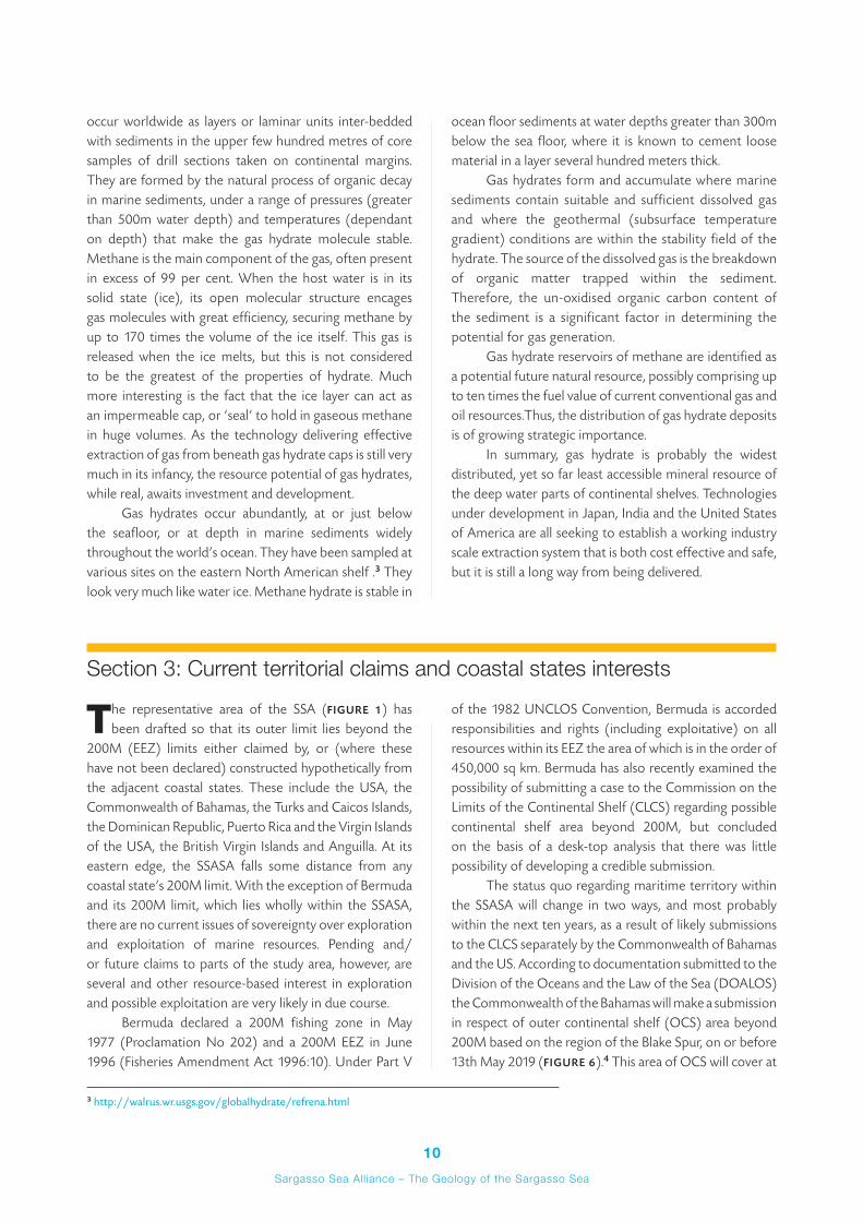
The status quo regarding maritime territory within the SSASA will change in two ways, and most probably within the next ten years, as a result of likely submissions to the CLCS separately by the Commonwealth of Bahamas and the US. According to documentation submitted to the Division of the Oceans and the Law of the Sea (DOALOS) the Commonwealth of the Bahamas will make a submission in respect of outer continental shelf (OCS) area beyond 200M based on the region of the Blake Spur, on or before 13th May 2019 (FIGURE 6).4 This area of OCS will cover at
3 http://walrus.wr.usgs.gov/globalhydrate/refrena.html
11Sargasso Sea All iance – The Geology of the Sargasso Sea
least 140,000 sq km of the westernmost SSASA, and could well be more. In addition, and despite the fact that US has yet to ratify the UNCLOS, it is widely expected to do so in the near future, and therefore also likely to make a submission in respect of shelf areas beyond 200M from its baselines along its eastern seaboard. With the knowledge that a great deal of preparatory work is already under way in terms of acquisition and analysis of data which could be used in support of US OCS submission(s), it would seem likely that these could be available soon after ratification, and would probably not take advantage of the full ten years grace granted under the Convention to a State post-ratification. In terms of the extent of the US OCS relative to the SSASA, it is only possible to speculate. It is clear, however, that in one sense it will almost certainly overlap 100% the Bahamas OCS—as the arguments by both States for identifying the Blake Bahama Ridge as a natural prolongation will be identical. More significantly, the US will also seek to extend the OCS away from its central shelf to bulge eastwards across the SSASA along and north and south of the 35°N latitude, probably as far as the Bermuda 200M limit.
Coastal states exercise over their continental shelf sovereign rights for the purpose of exploring and exploiting its natural resources in accordance with Article 77 of the 1982 Convention. The discussion in the previous section above highlights the range of non-living resources which could exist in the SSASA, and it is likely that several of these deposits - such as gas hydrates for instance - have a very high probability of occurring within the potential OCS areas of the Bahamas and US described here. Exploitation in these OCS areas by these States is clearly a strong possibility, and providing technological issues which still dog the efficient
extraction of viable gas resources from gas hydrate settings can be resolved, activity in respect of this resource seems likely within the foreseeable future.
In terms of non-living resources, beyond the 200M and the OCS limits (when established) the remainder of the SSASA will constitute an area beyond national jurisdiction (ABNJ), and therefore comprise part of the ‘Area’—that part of the worlds oceans governed under the auspices of the International Seabed Authority (ISA). This body provides the framework through which States Parties to the Convention shall, in accordance with the regime for the seabed and ocean floor and subsoil beyond the limits of national jurisdiction, organize and control activities in the Area, particularly with a view to administering its resources. The ISA has already issued exploration licences for polymetallic manganese nodules in both the Pacific and the Indian Oceans and most recently for polymetallic sulphides in the Atlantic and Indian Oceans. While unlikely in the near future, it is very possible that deep seabed mining (for polymetallic sulphides, PMS, see above) could be contemplated, in the eastern SSASA.
On a more general point of interest in deep sea exploration and exploitation, it is also interesting to note that in February 2011, the Seabed Disputes Chamber of the International Tribunal for the Law of the Sea (ITLOS) provided an Advisory Opinion in Responsibilities and Obligations of States Sponsoring Persons and Entities with respect to Activities in the Area. One of the consequences of this opinion is that it enables States to sponsor exploration licencing by the ISA, even where the State is acting on behalf of a third party. The above request for advisory opinion was triggered when Nautilus Minerals Inc. sought to develop a seabed exploration licence
FIGURE 6. Outline of the indicative outer limit to the Commonwealth of Bahamas continental shelf beyond 200 M (purple) as declared in their preliminary information to the CLCS dated 12th May 2009. Dashed purple line marks a possible further extension of the OCS, which needs verifying using additional data acquisition. Blue and red lines are Bahamas and US 200M limits, respectively. (Figure thanks to Alan Evans, Maritime Limits and Boundaries Services Ltd.)
4 www.un.org/depts/los/clcs_new/submissions_files/preliminary/bhs2009preliminaryinformation.pdf

12Sargasso Sea All iance – The Geology of the Sargasso Sea
in the Clarion-Clipperton Zone of the Eastern Pacific through the State of Nauru. The apparently favourable outcome could see a rise in the interest of commercial and corporate metal industrial organisation in deep-sea mining—possibly in the SSASA.
Paradoxically, while all States are required under Part Xll of UNCLOS to protect and preserve the marine environment, the ISA has no mandate to govern living resources in the ABNJ as it does for non-living resources, and so these are to all intents and purposes unregulated as
part of an international instrument. A great deal of interest has been shown by biomedical and pharmaceutical organisations seeking to develop ‘natural’ products with curative or prophylactic properties. Early research proved that certain sedentary biota could offer statin-like, or anti-carcinogenic products. While the early promise of a ‘deep-sea medicine chest’ has yet to be realised, these potential uses of deep sea fauna and flora sourced from ABNJ, may need to be considered when assessing potential interest in SSASA resources.
Summary A regional geological summary has been presented for the Sargasso Sea Alliance Study Area, which highlights the main crustal and sedimentological aspects of the evolution of the seafloor in the region. The Study Area comprises one of normal ocean basin development, following continental rifting, separation and seafloor spreading, resulting in a classic, non-volcanic rifted margin in the west, a central abyssal floor zone—albeit interrupted by the volcanic constructs of the Bermuda Island and seamount complexes, as well as other adjacent magmatic features, and an eastern sector characterised by the flanks of the active spreading system of the mid-Atlantic Ridge. This report also provides an overview of the potential occurrence of non-living marine resources for the study area as well as extant or pending territorial claims by coastal states or other interested international organisations. The resources in the study area may not be near market for the present day, but there seems little doubt that certain key deposit types, such as polymetallic sulphides and gas hydrates, in particular, will become important factors in assessment of the overall value of—and potential commercial interest in—the Sargasso Sea region.
GlossaryABNJ—Area beyond national jurisdiction
CLCS—Commission on the Limits of the Continental shelf. See www.un.org/depts/los/clcs_new/clcs_home.ht
DOALOS—Division of Oceans and the Law of the Sea. See www.un.org/depts/los/index.htm
DSDP—Deep Sea Drilling Project. Precursor to ODP. See www.deepseadrilling.org
EEZ—Exclusive Economic Zone (see UNCLOS)
ISA—International Seabed Authority. See www.isa.org.jm/en/home. 1, 2
ITLOS—International Tribunal on the Law of the Sea. See www.itlos.org
M—nautical mile (as in 200M - two hundred nautical miles)
MAR—Mid-Atlantic Ridge. (Hydrothermal vents in the North Atlantic can be found at www.interridge.org/irvents/category/region/n-mar )
MOR—Mid-ocean Ridge. See www.interridge.org
OCS—Outer Continental Shelf (i.e., continental shelf beyond 200 M)
ODP—Ocean Drilling Programme. Precursor to IODP, see www-odp.tamu.edu
PMS—Polymetallic sulphides
SSASA—Sargasso Sea Alliance Study Area. See www.sargassoalliance.org
UNCLOS—United Nations Convention on the Law of the Sea. See www.un.org/depts/los/convention_agreements/convention_overview_convention.htm
1 For current polymetallic nodule exploration areas, see www.isa.org.jm/en/scientific/exploration2 For recent application on PMS, see www.isa.org.jm/files/documents/EN/Press/Press11/SB-17-11.pdf

13Sargasso Sea All iance – The Geology of the Sargasso Sea
ReferencesAyer, E.A. & E.P. Laine 1982. Seismic stratigraphy of the northern Bermuda Rise, Marine Geology, 49, 169–186.
Detrick, R.S., R.P. Von Herzen, B. Parsons, D. Sandwell & M. Dougherty, 1986. Heat flow observations of the Bermuda Rise and thermal models of midplate swells, Journal of Geophysical Research, 91 (B3), 3701–3723.
Detrick, R.S., R.S. White & G.M. Purdy, 1993. Crustal structure of North Atlantic Fracture Zones, Reviews of Geophysics, 31 (4), 439–458.
Duncan, R.A., 1984. Age progressive volcanism in the New England Seamounts and the opening of the Central Atlantic Ocean, Journal of Geophysical Research, 89 (B12), 9980–9990.
Horn, D.R., M. Ewing, B.M. Horn & M.N. Delach 1971. Turbidites of the Hatteras and Sohm Abyssal Plains, Western North Atlantic, Marine Geology, 11, 287–323.
Minshull, T.A., R.S. White, J.C. Mutter, P. Buhl, R.S. Detrick, C.A. Williams & E. Morris, 1991. Crustal structure at the Blake Spur Fracture Zone from Expanding Spread Profiles, Journal of Geophysical Research, 96 (B6), 9955-9984.
Morris, E., R.S. Detrick, T.A. Minshull, J.C. Mutter, R.S. White, W. Su & P. Buhl, 1993. Seismic structure of oceanic crust in the western North Atlantic, journal of Geophysical Research, 98 (B8), 13,879–13,903.
Müller, R.D, M.Sdrolias, C. Gaina & W.R. Roest 2008. Age, spreading rates and spreading symmetry of the world’s ocean crust, Geochem. Geophys. Geosyst., 9, Q04006.
Mutter, J.C., R.S. Detrick & North Atlantic Transect Study Group, 1984. Multichannel seismic evidence for anomalously thin crust at Blake Spur fracture zone, Geology, 12, 534–537.
Sheehan, A.F. & M.K. McNutt 1989. Constraints on thermal and mechanical structure of the oceanic lithosphere at the Bermuda Rise from geoid height and depth anomalies, Earth and Planetary Science Letters, 93, 377–391.
Tucholke, B.E. & G.S. Mountain, 1979. Seismic stratigraphy, lithostratigraphy and paleosedimentation patterns in the North American Basin, in Deep Drilling Results in the Atlantic Ocean: Continental Margins and Paleoenvironment, Maurice Ewing Series, vol. 3, edited by M. Talwani, W. Hay & W.B.F. Ryan, pp. 58–86, AGU Washington D.C.
Uchupi, E., J.D. Phillips & K.E. Prada, 1970. Origin and structure of the New England Seamount Chain, Deep-Sea Research,17, 483–494.
Vogt, P.R, & W-Y. Jung, 2007. Origin of the Bermuda volcanoes and the Bermuda Rise: History, observations, models and puzzles, Geological Society of America Special Papers, 430, 553–591.
Sargasso Sea Alliance Science SeriesThe following is a list of the reports in the Sargasso Sea Alliance Science Series. All can be downloaded from www.sargassoalliance.org:
1
Angel, M.V. 2011. The pelagic ocean assemblages of the Sargasso Sea around Bermuda. Sargasso Sea Alliance Science Report Series, No 1, 25 pp.
2
Ardron, J., Halpin, P., Roberts, J., Cleary, J., Moffitt, M. and J. Donnelly 2011. Where is the Sargasso Sea? Sargasso Sea Alliance Science Report Series, No 2, 24 pp.
3
Gollock, M. 2011. European eel briefing note for Sargasso Sea Alliance. Sargasso Sea Alliance Science Report Series, No 3, 11 pp.
4
Hallett, J. 2011. The importance of the Sargasso Sea and the offshore waters of the Bermudian Exclusive Economic Zone to Bermuda and its people. Sargasso Sea Alliance Science Report Series, No 4, 18 pp.
5
Lomas, M.W., Bates, N.R., Buck, K.N. and A.H. Knap. (eds) 2011a. Oceanography of the Sargasso Sea: Overview of Scientific Studies. Sargasso Sea Alliance Science Report Series, No 5, 64 pp.
6
Lomas, M.W., Bates, N.R., Buck, K.N. and A.H. Knap. 2011b. Notes on “Microbial productivity of the Sargasso Sea and how it compares to elsewhere” and “The role of the Sargasso Sea in carbon sequestration—better than carbon neutral?” Sargasso Sea Alliance Science Report Series, No 6, 10 pp.
7
Miller, M.J. and R. Hanel. 2011. The Sargasso Sea subtropical gyre: the spawning and larval development area of both freshwater and marine eels. Sargasso Sea Alliance Science Report Series, No 7, 20 pp.
8
Parson, L. and R. Edwards 2011. The geology of the Sargasso Sea Alliance Study Area, potential non-living marine resources and an overview of the current territorial claims and coastal states interests. Sargasso Sea Alliance Science Report Series, No 8, 17 pp.
9
Roberts, J. 2011. Maritime Traffic in the Sargasso Sea: An Analysis of International Shipping Activities and their Potential Environmental Impacts. Sargasso Sea Alliance Science Report Series, No 9, 45 pp.
10
Siuda, A.N.S. 2011. Summary of Sea Education Association long-term Sargasso Sea surface net data. Sargasso Sea Alliance Science Report Series, No 10, 18 pp.
11
Stevenson, A. 2011. Humpback Whale Research Project, Bermuda. Sargasso Sea Alliance Science Report Series, No 11, 11 pp.
12
Sumaila, U. R., Vats, V., and W. Swartz. 2013. Values from the resources of the Sargasso Sea. Sargasso Sea Alliance Science Report Series, No 12, 24 pp.
Since the initial meetings the partnership around the Sargasso Sea Alliance has expanded.
Led by the Government of Bermuda, the Alliance now includes the following organisations.
PARTNER TYPE OF ORGANISATION
Department of Environmental Protection Government of Bermuda
Department of Conservation Services Government of Bermuda
Mission Blue / Sylvia Earle Alliance Non-Governmental Organisation
International Union for the Conservation of Nature (IUCN) and its World Commission on Protected Areas Multi-lateral Conservation Organisation
Marine Conservation Institute Non-Governmental Organisation
Woods Hole Oceanographic Institution Academic
Bermuda Institute for Ocean Sciences Academic
Bermuda Underwater Exploration Institute Non-Governmental Organisation
World Wildlife Fund International Non-Governmental Organisation
Atlantic Conservation Partnership Non-Governmental Organisation