Embed Size (px)
Citation preview
CONGRESS OF THE UNITED STATESCONGRESSIONAL BUDGET OFFICE
CBOThe Global
Positioning System for Military Users:
Current Modernization Plans
and Alternatives
OCTOBER 2011

Pub. No. 4192

A
S T U D Y
CBO
The Global Positioning System for Military Users: Current Modernization
Plans and Alternatives
October 2011
The Congress of the United States O Congressional Budget Office
CBO
Notes
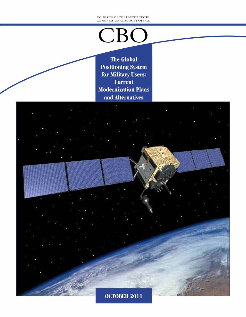
The cover image shows a Global Positioning System Block IIF satellite. The image was pro-vided courtesy of the Air Force.
Unless otherwise indicated, all years referred to in this study are fiscal years and all dollar amounts are in 2012 dollars.
Numbers in the text and tables may not add up to totals because of rounding.
Preface
The U.S. military has come to rely on the Global Positioning System (GPS) to conduct many of its operations, both during normal peacetime operations and wartime operations. The Department of Defense (DoD) is modernizing the system by purchasing new satellites and upgrading the systems that control the satellites.
This Congressional Budget Office (CBO) study, which was prepared at the request of the for-mer Chairman of the Defense Subcommittee of the House Committee on Appropriations, considers the implications of those programs for military users and assesses how those efforts are synchronized with DoD’s efforts to improve the capabilities of its GPS receivers. The study also examines three alternatives for improving the performance of the GPS for military users (primarily by improving the capabilities of military GPS receivers) and estimates the budgetary consequences of those options as well as their effect on the ability of the GPS to operate in an environment where an opponent is trying to block GPS signals. In keeping with CBO’s mandate to provide objective, impartial analysis, this study makes no recommenda-tions.
Frances M. Lussier and Christopher Murphy of CBO’s National Security Division prepared the study under the general supervision of David Mosher. Raymond Hall of CBO’s Budget Analysis Division produced the cost estimates under the general supervision of Sarah Jen-nings. Sheila Campbell and Daniel Frisk of CBO and Joseph Post of the Federal Aviation Administration provided helpful comments on the report. The assistance of external reviewers implies no responsibility for the final product, which rests solely with CBO.
Cynthia Cleveland prepared the manuscript. Christine Bogusz edited the study, and Kate Kelly proofread it. Maureen Costantino prepared the report for publication and designed the cover. Monte Ruffin printed the initial copies, Linda Schimmel coordinated the print distribution, and Simone Thomas prepared the electronic version for CBO’s Web site (www.cbo.gov).
Douglas W. ElmendorfDirector
October 2011
CBO

Contents
CBO
Summary ix
1 Introduction and Background 1
The Three GPS Segments 1How GPS Works 3Interference with GPS Signals 4Current Status of the System 5
2 DoD’s Plan for Modernizing GPS 9
Description and Cost of DoD’s Plan 9Increased Capabilities 13Concerns About the Plan 14
3 Alternatives for Modernizing GPS 17
Overview of the Options 17Option 1. Improve the Capabilities of Military GPS Receivers 18Option 2. Enhance GPS Using the Iridium Satellite System 25Option 3. Improve the Capabilities of Military GPS Receivers and
Enhance GPS Using the Iridium Satellite System 29
A History of the GPS Program 31
B Examples of Selected Military-Related GPS Components 37
VI THE GLOBAL POSITIONING SYSTEM FOR MILITARY USERS: CURRENT MODERNIZATION PLANS AND ALTERNATIVES
CBO
Tables
S-1.
Summary of DoD’s Plan for the Global Positioning System and Three Options xS-2.
Effect of DoD’s Plan and Three Options on GPS Performance Over Time xi1-1.
Signals Transmitted by Different Models of Current GPS Satellites 42-1.
Costs of DoD’s Plan to Modernize the GPS Satellites, Ground Control System, and Receivers 102-2.
Characteristics of Current and Planned GPS Satellites 112-3.
Estimated Impact of Planned GPS Improvements on the Effective Range of a Jammer 143-1.
Summary of DoD’s Plan for the Global Positioning System and Three Options 203-2.
GPS Modernization Costs in DoD’s Plan and Under Three Options 213-3.
Effect of DoD’s Plan and Three Options on GPS Performance Over Time 24A-1.
Expenditures and Purchases for the GPS Program, 1974 to 2011 32B-1.
Characteristics of GPS Receivers Used by the U.S. Military 38Figures
S-1.
Effect of DoD’s Plan and Three Options on the Effective Range of a 10-Watt Jammer xiii1-1.
The Three Segments of the Global Positioning System 22-1.
Effect of DoD’s Plan on the Effective Range of a 10-Watt Jammer 153-1.
Effect of DoD’s Plan and Three Options on the Effective Range of a 10-Watt Jammer 233-2.
GPS Augmentation with the iGPS Program 26A-1.
Structure of Signals Transmitted by GPS Satellites 34B-1.
The Manpack and the Precision Lightweight GPS Receiver 37B-2.
The Precision Lightweight GPS Receiver, Defense Advanced GPS Receiver, and MicroDAGR 39B-3.
The Miniature Airborne GPS Receiver and the 3S Shipboard Receiver 39B-4.
Remote Defense Advanced GPS Receiver Antenna and Mounting Strap 40B-5.
Controlled Reception Pattern Antennas (CRPAs) for Use on Military Aircraft 40B-6.
µCRPA 40B-7.
GAJT Antenna 41
CONTENTS THE GLOBAL POSITIONING SYSTEM FOR MILITARY USERS: CURRENT MODERNIZATION PLANS AND ALTERNATIVES VII
B-8.
Precision Lightweight GPS Receiver With and Without Antijam Antenna Retrofit 41B-9.
iGPS Module, Including DAGR 41B-10.
Examples of Notional GPS Jammers 42B-11.
Russian Commercial 4-Watt Jammer 42B-12.
Examples of GPS Jammers 43Boxes
1-1.
GPS Receivers in a Jamming Environment 63-1.
The Effect of CBO’s Options on Civilian GPS Users 19Figures (Continued)
CBO

Summary
As the Department of Defense’s (DoD’s) Global Positioning System (GPS) satellites reach the end of their service lives, the department plans to replace them with ones that can counter deliberate interference by generat-ing stronger signals. Analysis by the Congressional Budget Office (CBO) indicates that an alternative approach—namely, improving military receivers to retain the GPS signal even in the presence of such jamming—would be less expensive than DoD’s plan for upgrading its constellation of GPS satellites. Furthermore, the alter-native would yield benefits almost a decade earlier than DoD’s plan. However, the improvements to military receivers could make them larger and heavier (and thereby less useful to personnel operating on foot) until they could incorporate the substantial gains that have been achieved in miniaturization in other applications.
DoD’s PlanThe GPS uses a constellation of at least 24 satellites, each of which transmits precise data on the time and its loca-tion. Receivers—both military and civilian—use the data transmitted by the satellites to calculate their own posi-tion; information from a minimum of 4 satellites is required to determine a position accurately in three dimensions. Since 1995 (when GPS became fully opera-tional), the U.S. military has come to rely on it to pre-cisely locate both enemy and friendly forces. However, because the GPS signal from space is very weak by the time it reaches Earth (like the light from a 25-watt light-bulb shining 12,500 miles away), the system can easily be swamped by interference.
In 2000, DoD initiated plans to reduce the system’s sus-ceptibility to intentional interference. As a first step toward providing some protection against jamming, DoD decided that GPS satellites would transmit addi-tional signals, available only to military users, each of which covered a wider range of frequencies than those
already being transmitted. Those signals, called M-code signals, are more difficult for enemy jammers to over-whelm and can improve the ability of military receivers to operate in the presence of jammers. Ten satellites capable of transmitting M-code signals were already in orbit as of August 2011.
To maintain the constellation as existing and new satel-lites reach the end of their service lives, DoD plans to launch a total of 50 satellites through 2030 at an average rate of 2 to 3 satellites each year starting in 2012. The department has already purchased—but not yet launched—10 of those GPS satellites capable of transmit-ting M-code signals. DoD plans to acquire 40 more satel-lites—known as GPS III—that are capable of transmit-ting stronger M-code signals than existing satellites over the next 10 to 15 years.
DoD plans to develop and purchase the new satellites in three phases. In the first phase, DoD plans to acquire 8 GPS IIIA satellites capable of emitting M-code signals that are three times stronger than those transmitted by current GPS satellites. The first IIIA satellite is scheduled to be launched in 2014. In the second phase, DoD plans to acquire 16 GPS IIIB satellites with M-code signals that are five times stronger than those of current satellites. For the final phase, the department’s plan calls for an initial purchase of 8 GPS IIIC satellites, which will be equipped with a special antenna capable of focusing the M-code signals in a “spotbeam”; however, CBO assumes that the department would need to purchase an additional 8 IIIC satellites in order to have enough IIIC satellites in orbit to take advantage of the IIIC’s advanced capabilities. Those satellites will transmit signals with the same strength as IIIB satellites and will be able to use the spotbeam to illu-minate an area with a diameter of 600 miles on the Earth’s surface with signals 100 times stronger than those of current GPS satellites. In addition, IIIC satellites will be equipped with high-speed cross-links, which will allow
CBO
X THE GLOBAL POSITIONING SYSTEM FOR MILITARY USERS: CURRENT MODERNIZATION PLANS AND ALTERNATIVES
CBO
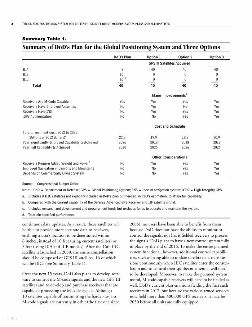
Summary Table 1.
Summary of DoD’s Plan for the Global Positioning System and Three Options
Source: Congressional Budget Office.
Note: DoD = Department of Defense; GPS = Global Positioning System; INS = inertial navigation system; iGPS = High Integrity GPS.
a. Includes 8 IIIC satellites not explicitly included in DoD’s plan but needed, in CBO’s estimation, to attain full capability.
b. Compared with the current capability of the Defense Advanced GPS Receiver and IIF satellite signal.
c. Includes research and development and procurement funds but excludes funds to operate and maintain the system.
d. To attain specified performance.
IIIA 8 40 40 40IIIB 16 0 0 0IIIC 16 a 0 0 0___ ___ ___ ___
Total 40 40 40 40
Receivers Are M-Code CapableReceivers Have Improved AntennasReceivers Have INS iGPS Augmentation
Total Investment Cost, 2012 to 2025 (Billions of 2012 dollars)c
Year Significantly Improved Capability Is AchievedYear Full Capability Is Achieved
Receivers Require Added Weight and Powerd
Improved Navigation in Canyons and MountainsDepends on Commercially Owned System
2030
YesYesYes
YesYesYes
NoNoNo
YesNoNo
2026
YesYesYesNo
YesNoYesYes
YesYesYesYes
2026
DoD's Plan Option 1 Option 2 Option 3
GPS III Satellites Acquired
Major Improvementsb
Cost and Schedule
Other Considerations
YesNoNoNo
2026 201822.2 19.9 18.9 20.9
20182026
2018
continuous data updates. As a result, those satellites will be able to provide more accurate data to receivers, enabling a user’s location to be determined within 6 inches, instead of 10 feet (using current satellites) or 3 feet (using IIIA and IIIB models). After the 16th IIIC satellite is launched in 2030, the entire constellation should be composed of GPS III satellites, 16 of which will be IIICs (see Summary Table 1).
Over the next 15 years, DoD also plans to develop soft-ware to control the M-code signals and the new GPS III satellites and to develop and purchase receivers that are capable of processing the M-code signals. Although 10 satellites capable of transmitting the harder-to-jam M-code signals are currently in orbit (the first one since
2005), no users have been able to benefit from them because DoD does not have the ability to monitor or control the signals, nor has it fielded receivers to process the signals. DoD plans to have a new control system fully in place by the end of 2016. To make the entire planned system functional, however, additional control capabili-ties, such as being able to update satellite data transmis-sions continuously when IIIC satellites enter the constel-lation and to control their spotbeam antenna, will need to be developed. Moreover, to make the planned system useful, M-code-capable receivers will need to be fielded as well. DoD’s current plan envisions fielding the first such receivers in 2017, but because the various armed services now field more than 400,000 GPS receivers, it may be 2030 before all units are fully equipped.
SUMMARY THE GLOBAL POSITIONING SYSTEM FOR MILITARY USERS: CURRENT MODERNIZATION PLANS AND ALTERNATIVES XI
Summary Table 2.
Effect of DoD’s Plan and Three Options on GPS Performance Over Time
Source: Congressional Budget Office.
Note: DoD = Department of Defense; GPS = Global Positioning System; iGPS = High Integrity GPS.
a. The range at which a 10-watt jammer can cause a handheld GPS receiver to lose track of the military signal.
b. Within the focused spotbeam that covers a 600-mile-diameter area from GPS IIIC satellites only.
c. Within the theaters of operation supported by the iGPS program.
d. The effective range for this option is slightly greater than 130 feet.
e. The values represent the strength of the M-code signal at the receiver.
DoD's Plan 55 55 2.5 b
55 1.8 0.455 0.6 0.14 c
55 0.1 0.02 c,d
DoD's Plan 1.6 1.6 160 b
1.6 1.6 51.6 1.6 51.6 1.6 5
DoD's Plan 10 10 0.510 10 310 0.7 c 0.7 c
10 0.7 c 0.7 c
Current Capability 2020 2030
Effective Range of a 10-Watt Jammera (Miles)
Signal Strength at Receivere (x 10-16 watts)
Option 1Option 2Option 3
Accuracy (Feet)
Option 1Option 2Option 3
Option 1Option 2Option 3
If the satellites and receivers perform as planned, the combination of all of the upgrades proposed by DoD would enable military receivers to operate in the presence of much stronger jamming signals than they can with-stand today. For example, the effective range of a 10-watt jammer trying to cause a military receiver within the spotbeam of a GPS IIIC satellite to lose the GPS signal would be reduced by 96 percent, shrinking from 55 miles to about 2 miles (see Summary Table 2).
Although the planned upgrades to GPS satellites will not increase the strength of civilian signals and will not improve the performance of civilian receivers in the pres-ence of interference, other planned improvements will benefit both military and civilian users. In particular, GPS IIIA satellites will transmit signals that will enable both types of users to determine their position to within 3 feet, compared with the 10 feet that is possible with signals from current satellites. And once enough IIIC sat-
ellites enter the constellation, positioning within 6 inches will be possible for all users, according to DoD.
CBO estimates that it will cost DoD roughly $22 billion from 2012 to 2025 to modernize the GPS. That total would include the cost from 2012 onward to develop and purchase the 40 GPS III satellites (including $3.6 billion for the additional 8 IIIC satellites), to develop the soft-ware and capability needed to control those satellites and their transmissions, and to develop and purchase hun-dreds of thousands of military receivers capable of receiv-ing and interpreting the M-code signals.
The Government Accountability Office and the Defense Science Board have reviewed DoD’s plan to modernize the GPS and raised several concerns, particularly regard-ing the plan’s focus on improving the satellites rather than the receivers and the plan’s lack of coordination in terms
CBO
XII THE GLOBAL POSITIONING SYSTEM FOR MILITARY USERS: CURRENT MODERNIZATION PLANS AND ALTERNATIVES
CBO
of the timing for various capabilities. CBO has developed options by which it explores those concerns.
OptionsCBO examined three options that would provide anti-jamming improvements to military users sooner and at a lower cost than DoD’s plan. Those options focus more on improving the performance of receivers in a jamming environment and less on strengthening the signal that the GPS satellites transmit. CBO focused on the handheld receivers used primarily by the Army and the Marines because they are the most widespread throughout the ser-vices. (Despite their designation, most such receivers are mounted, sometimes permanently, in various military vehicles.)
Option 1 would improve current military GPS receiv-ers by fitting them with better antennas and by adding inertial navigation systems.
Option 2 would capitalize on a DoD research and development program by enabling current GPS receivers to integrate information received via the Irid-ium commercial communications satellite network.
Option 3 would include the improvements of both Option 1 and Option 2.
Three items are common to all of the options. First, under each option, DoD would purchase 40 GPS III satellites (the same number as in DoD’s plan) but confine those purchases to the IIIA model. Second, under DoD’s plan as well as all the options, DoD would continue to develop the ground control system, enabling it to control current M-code-transmitting GPS satellites (IIR-M and IIF) as well as the newer GPS IIIA satellites. And third, DoD would develop and purchase M-code-capable receivers in the same numbers under its plan and all three options. By CBO’s estimates, the total cost for those three common items is $17.9 billion from 2012 through 2025—which is the amount to maintain, modernize, and control the GPS constellation through 2030 and to field military receivers that can take full advantage of the M-code signal.
All three options would cost less to carry out than DoD’s plan and would yield military receivers with greater anti-jamming capability earlier. CBO’s options would not yield similar benefits for civilian users as DoD’s plan, and
they would forgo some improvements in accuracy for all users offered by the GPS IIIC satellites. Because all three options would cancel the IIIB and IIIC portions of the GPS III program, they would save more than $4 billion on satellite and ground control costs from 2012 through 2025, CBO estimates. Those savings would be partly off-set by the cost to make improvements to the receivers under the three options, yielding net savings of approxi-mately $2 billion, $3 billion, and slightly more than $1 billion, respectively, for Options 1, 2, and 3.
Option 1. Improve the Capabilities of Military GPS ReceiversOption 1 would augment military receivers to provide users with a better ability to keep track of their location in jamming environments. The improvement would come from new antennas—capable of rejecting signals from jammers—and from the integration of very small inertial navigation systems, which would reduce location errors introduced by interference and enable users on the move to determine their position accurately even after losing the GPS signal entirely.
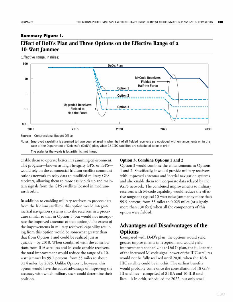
By increasing the level of noise that receivers could toler-ate and still be able to detect and process the GPS signal, those augmentations to receivers could reduce the effec-tive range of a wideband noise jammer by 97 percent. (The effective range of a 10-watt jammer would be decreased from 55 miles to about 2 miles, which means that the jammer would need to be within 2 miles of the receiver to have an effect.) Because the hardware for the improvements in this option has already been developed, modifications to existing receivers could begin almost immediately, and a significant number of improved receivers could be in the field by 2018. The additional signal power from the IIIA satellites and the antijamming capabilities of M-code receivers would further enhance the overall capability of military receivers to operate in the presence of jamming. By 2026 (the point at which about half the force could be equipped with M-code-capable receivers), the combined improvements under this option would reduce the range of a 10-watt jammer by 99.3 percent, to 0.4 miles (see Summary Figure 1).
Option 2. Enhance GPS Using the Iridium Satellite SystemOption 2 would capitalize on a DoD initiative to use an existing satellite constellation in low-earth orbit to pro-vide military GPS receivers with information that would
SUMMARY THE GLOBAL POSITIONING SYSTEM FOR MILITARY USERS: CURRENT MODERNIZATION PLANS AND ALTERNATIVES XIII
Summary Figure 1.
Effect of DoD’s Plan and Three Options on the Effective Range of a 10-Watt Jammer(Effective range, in miles)
Source: Congressional Budget Office.
Notes: Improved capability is assumed to have been phased in when half of all fielded receivers are equipped with enhancements or, in the case of the Department of Defense’s (DoD’s) plan, when 16 IIIC satellites are scheduled to be in orbit.
The scale for the y-axis is logarithmic, not linear.
2010 2015 2020 2025 2030
0.01
0.1
1
10
100
Upgraded ReceiversFielded to
Half the Force
M-Code ReceiversFielded to
Half the Force
DoD's Plan
Option 1
Option 2
Option 3
enable them to operate better in a jamming environment. The program—known as High Integrity GPS, or iGPS—would rely on the commercial Iridium satellite communi-cations network to relay data to modified military GPS receivers, allowing them to more easily pick up and main-tain signals from the GPS satellites located in medium-earth orbit.
In addition to enabling military receivers to process data from the Iridium satellites, this option would integrate inertial navigation systems into the receivers in a proce-dure similar to that in Option 1 (but would not incorpo-rate the improved antennas of that option). The extent of the improvements in military receivers’ capability result-ing from this option would be somewhat greater than that from Option 1 and could be realized just as quickly—by 2018. When combined with the contribu-tions from IIIA satellites and M-code-capable receivers, the total improvement would reduce the range of a 10-watt jammer by 99.7 percent, from 55 miles to about 0.14 miles, by 2026. Unlike Option 1, however, this option would have the added advantage of improving the accuracy with which military users could determine their position.
Option 3. Combine Options 1 and 2Option 3 would combine the enhancements in Options 1 and 2. Specifically, it would provide military receivers with improved antennas and inertial navigation systems and also enable them to incorporate data relayed by the iGPS network. The combined improvements to military receivers with M-code capability would reduce the effec-tive range of a typical 10-watt noise jammer by more than 99.9 percent, from 55 miles to 0.025 miles (or slightly more than 130 feet) when all the components of this option were fielded.
Advantages and Disadvantages of the OptionsCompared with DoD’s plan, the options would yield greater improvements in reception and would yield improvements sooner. Under DoD’s plan, the full benefit of the increased M-code signal power of the IIIC satellites would not be fully realized until 2030, when the 16th IIIC satellite could be in orbit. The earliest benefits would probably come once the constellation of 18 GPS III satellites—comprised of 8 IIIA and 10 IIIB satel-lites—is in orbit, scheduled for 2022, but only small
CBO
XIV THE GLOBAL POSITIONING SYSTEM FOR MILITARY USERS: CURRENT MODERNIZATION PLANS AND ALTERNATIVES
CBO
numbers of military receivers capable of processing the stronger M-code signals would be in the field then. While the IIIC satellites were being placed in orbit, the benefit of their stronger signals would be unavailable to users until sufficient numbers of M-code-capable receivers were fielded, possibly no earlier than 2026.
In contrast, the technologies included in CBO’s options—those for improved antennas for GPS receivers, small inertial navigation devices, and iGPS—have already been developed. The fielding of ancillary devices to aug-ment existing military GPS receivers could begin in a few years, with appreciable numbers of improved receivers in the field by 2018. Consequently, the options could increase the military’s antijamming capability eight years before large numbers of M-code receivers could be in the hands of military users under DoD’s plan.
Additional advantages of Options 2 and 3 come from augmenting the GPS constellation with the Iridium satel-lites in low-Earth orbit. That fuller coverage would virtu-ally ensure that receivers had a line of sight to at least one satellite, even in mountainous terrain and urban settings where tall buildings block the view of the sky. In addi-tion, because data can be received and updated fre-quently, receivers using iGPS can determine their posi-tion with almost the same accuracy as would be possible using data from IIIC satellites—but the receivers would have that ability several years earlier.
The options would have several disadvantages when com-pared with DoD’s plan, however. All of the options would require hardware additions to existing receivers: an improved antenna and integrated inertial navigation sys-tem for Option 1; a module to interpret data relayed from Iridium satellites and an inertial navigation system for Option 2; and all of the above for Option 3. Each of those hardware devices might not be much larger or heavier than a typical military handheld receiver, which is about six inches long and weighs about a pound, but when combined, they would add bulk and requirements for additional power. Although that added weight might not prove too onerous for military personnel in a vehicle, plane, or ship, it could prove troublesome for those on foot. The current trend in miniaturization has made it
possible to integrate such devices into military receivers designed specifically for use in munitions (such as cruise missiles or small guided bombs) or in the confined space of very small unmanned aerial vehicles. But, designing and integrating such miniaturized devices for and into existing receivers would take time and could entail costs not included in CBO’s estimates.
Another disadvantage common to the options is that they would forgo the improvements offered by the IIIC satel-lites, so military users would not benefit from the increased power of the M-code signals within the spot-beam. Those signals, which would be roughly 30 times stronger than those transmitted by IIIA satellites, could be advantageous for users who could not handle the added weight and power needed for improved antennas or who could not take advantage of the iGPS program. Forgoing the IIIC satellites would also mean the loss of the ability to determine position to within about 6 inches for civilian users under all of the options and for military users under Option 1. In those cases, GPS users would have to rely on the less accurate signals from the IIIA sat-ellites, allowing them to determine their position to within about 3 feet. The addition of iGPS in Options 2 and 3 would allow military—but not civilian—users to determine their position to within 8 inches—almost as accurately as would be the case under DoD’s plan. That increased accuracy might not be important for most applications, but it could be useful when items need to be located precisely, such as in the case of land mines or unexploded ordnance.
A final disadvantage shared by Options 2 and 3 is the dependence on the commercial Iridium satellite constel-lation and support network, which is not controlled by DoD. The future of the Iridium constellation cannot be guaranteed by the government, at least not without a cost that CBO has not included in its estimates. Although apparently financially healthy at the end of 2011, the Iridium communications system has had financial set-backs in the past. The risk that DoD might need to infuse funds into the system in the future is a disadvan-tage of relying on iGPS to enhance the ability of GPS receivers to operate in a jamming environment.
CH A P T E R
1Introduction and Background
The Global Positioning System (GPS) is a space-based system that provides positioning and timing data to users worldwide. The data that it provides have become essential to the conduct of military operations; they also contribute to transportation efficiency and safety in the civilian sector and to the timing and recording of finan-cial transactions. The system, which includes a constella-tion of satellites, was developed and is operated by the Department of Defense (DoD) in consultation with the Department of Transportation and several other federal agencies.1 The Air Force is responsible for the acquisition of GPS components and is in the process of modernizing the system to enhance its performance, particularly in the presence of deliberate and hostile interference or jamming.
In this study, the Congressional Budget Office (CBO) examines DoD’s plan to modernize GPS and assesses the cost of that plan and the benefits that the proposed improvements would yield to the system’s military users. (Although this analysis focuses on military users, it notes significant effects on civilian users as well.) CBO also examines several options that would improve GPS capa-bilities for military users at lower cost than would DoD’s plan, although those options have some disadvantages rel-ative to DoD’s plan as well.
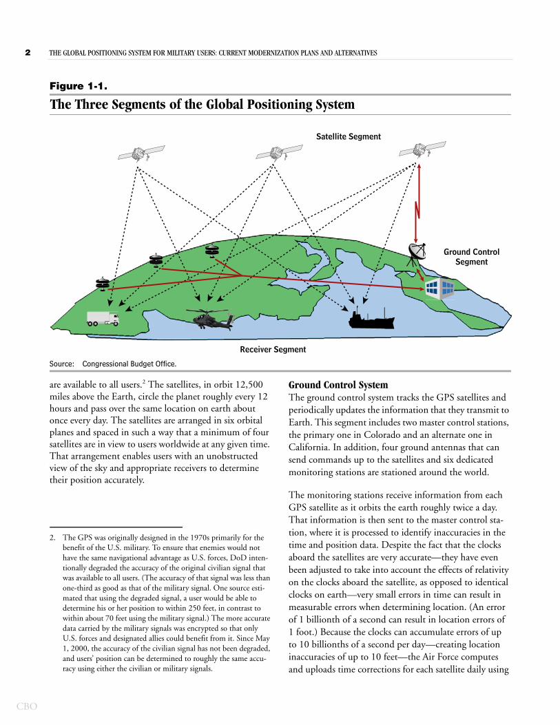
GPS is a global network composed of three segments: sat-ellites that transmit military and civilian GPS signals, sys-tems on the ground that control the satellites and support the signals (ground control systems), and receivers that
1. For additional information on the roles and responsibilities of the various federal agencies in supporting the GPS, see Department of Defense, Department of Homeland Security, and Department of Transportation, 2010 Federal Radionavigation Plan, DOT-VNTSC-RITA-08-02/DoD-4650.05 (Springfield, Va.: National Technical Information Service), Chapter 2.
make use of the broadcasted signals (see Figure 1-1). Each of those signals includes positioning and timing informa-tion that enables users with GPS receivers to determine their position and the exact time 24 hours a day, in all weather, worldwide.
GPS began operations with a full constellation of satel-lites in 1995. (See Appendix A for details of the system’s history.) In the years since then, GPS has become vital to military operations and is used by all branches of the armed services to guide troop movements, integrate logis-tics support, and synchronize communications networks. In addition, U.S. and allied forces use GPS signals to guide munitions to their targets and to locate military personnel in distress.
The Three GPS SegmentsAll three segments of the GPS are necessary to enable users to determine their location accurately without inter-ruption. Most GPS users are familiar with both the space segment—the constellation of satellites orbiting the earth—and the receivers that use the satellites’ signals to determine individual locations. The workings of the ground control system, which continuously monitors the health of the satellites and adjusts their signals to elimi-nate errors in time and position, are less well known but no less necessary for the proper operation of the overall system.
Satellites The GPS space segment is a constellation of at least 24 satellites that transmits signals with data on each satellite’s position and the time. The satellites transmit at least two types of signals with the same time and position informa-tion. One set of signals is encrypted and is available only to military users. The other, unencrypted civilian signals
CBO
2 THE GLOBAL POSITIONING SYSTEM FOR MILITARY USERS: CURRENT MODERNIZATION PLANS AND ALTERNATIVES
CBO
Figure 1-1.
The Three Segments of the Global Positioning System
Source: Congressional Budget Office.
Ground ControlSegment
Receiver Segment
Satellite Segment
are available to all users.2 The satellites, in orbit 12,500 miles above the Earth, circle the planet roughly every 12 hours and pass over the same location on earth about once every day. The satellites are arranged in six orbital planes and spaced in such a way that a minimum of four satellites are in view to users worldwide at any given time. That arrangement enables users with an unobstructed view of the sky and appropriate receivers to determine their position accurately.
2. The GPS was originally designed in the 1970s primarily for the benefit of the U.S. military. To ensure that enemies would not have the same navigational advantage as U.S. forces, DoD inten-tionally degraded the accuracy of the original civilian signal that was available to all users. (The accuracy of that signal was less than one-third as good as that of the military signal. One source esti-mated that using the degraded signal, a user would be able to determine his or her position to within 250 feet, in contrast to within about 70 feet using the military signal.) The more accurate data carried by the military signals was encrypted so that only U.S. forces and designated allies could benefit from it. Since May 1, 2000, the accuracy of the civilian signal has not been degraded, and users’ position can be determined to roughly the same accu-racy using either the civilian or military signals.
Ground Control System The ground control system tracks the GPS satellites and periodically updates the information that they transmit to Earth. This segment includes two master control stations, the primary one in Colorado and an alternate one in California. In addition, four ground antennas that can send commands up to the satellites and six dedicated monitoring stations are stationed around the world.
The monitoring stations receive information from each GPS satellite as it orbits the earth roughly twice a day. That information is then sent to the master control sta-tion, where it is processed to identify inaccuracies in the time and position data. Despite the fact that the clocks aboard the satellites are very accurate—they have even been adjusted to take into account the effects of relativity on the clocks aboard the satellite, as opposed to identical clocks on earth—very small errors in time can result in measurable errors when determining location. (An error of 1 billionth of a second can result in location errors of 1 foot.) Because the clocks can accumulate errors of up to 10 billionths of a second per day—creating location inaccuracies of up to 10 feet—the Air Force computes and uploads time corrections for each satellite daily using
CHAPTER ONE THE GLOBAL POSITIONING SYSTEM FOR MILITARY USERS: CURRENT MODERNIZATION PLANS AND ALTERNATIVES 3
the ground control system. In addition, satellites drift from their prescribed orbits and, as a result, their actual positions differ from predicted ones. Corrections that need to be made to an individual satellite’s transmitted position are also relayed back up to the satellites once per day via the ground antennas.
Receivers Military and commercial GPS receivers are installed on ships, aircraft, and vehicles and carried by individuals. Military GPS receivers are designed to use the encrypted GPS signals that are available only to authorized users, including military and allied forces and some civilian agencies.3 In contrast, commercial receivers use the civil-ian GPS signals, which are publicly available worldwide.
The military fields many types of GPS receivers that have been optimized for its use. (See Appendix B for descrip-tions and pictures of some military GPS receivers.) The most widespread receiver in the U.S. military is the hand-held version, most of which are mounted, sometimes per-manently, in military vehicles. The services field more than 350,000 handheld GPS receivers, most of which are fielded by the Army. In the past decade, as advances in technology have facilitated the development of smaller and lighter GPS receivers, it has become possible to embed them in precision-guided munitions, such as cruise missiles and guided artillery rounds, as well as in unmanned aerial vehicles. The latter applications, plus the receivers mounted in aircraft and aboard ships, bring the total to about 400,000.
How GPS WorksGPS works by timing how long it takes the radio signals from its satellites to reach a specific location on earth. Each satellite continuously broadcasts the time and its own position, and GPS receivers calculate the delay between the time when the signal left the satellite and when it reaches the receiver. That time delay, when multi-plied by the speed of light, determines the receiver’s dis-tance from the satellite.
A GPS receiver could, in theory, calculate its three-dimensional position by measuring its distance from three different satellites simultaneously. But, in practice,
3. Military receivers can, in general, also pick up the civilian signals that are transmitted on the same frequencies as the military signals.
by using the distance measured from a fourth satellite, a GPS receiver can calculate its position more accurately. Although the Air Force monitors the data that each satel-lite transmits to ensure its accuracy, errors in determining location can be introduced as the satellite’s signal travels through the atmosphere and because the clocks on the satellite and those in the receiver are not synchronized exactly. Satellite geometry is also important because a GPS receiver determines its position by triangulation; the more widely dispersed the satellites are, the more accu-rately a receiver will be able to determine its position.
Several points should be noted about how the system works. First, there is no interaction between the satellites and the receivers. That is, the satellites send out military and civilian signals that are available to all receivers that can decode them. The receivers merely process the infor-mation received from the satellites; they do not send sig-nals back to the satellites or to other systems. To process the data that the satellite or satellites are transmitting, a receiver must first “acquire” a signal from one or more GPS satellites in view.4 Once the receiver has acquired and identified signals from a GPS satellite, it can more easily continue to process the data from—or “track”—the signal.
Second, because the receivers determine a user’s location on the basis of triangulation, any errors introduced into the distances calculated from the satellites result in errors in determining the location of the receiver. Receivers can cancel out any errors introduced by atmospheric interfer-ence by using information from signals on two different frequencies transmitted by the same satellite.5 Such a capability has been available to military users from the system’s inception (because each GPS satellite has always transmitted military signals on two different frequencies), although not all military receivers were capable of
4. The data carried on the military signal are encrypted in a code that is a billion times longer than that associated with the civilian signal. Consequently, military GPS receivers often acquire the civilian signal from a satellite first and then use the information gleaned from the civilian code to acquire and track the military signal.
5. The effect of atmospheric anomalies, such as the presence of ions, on the speed of a GPS signal varies with the signal’s frequency. By comparing the difference in arrival time of two signals of different frequency from the same satellite, a GPS receiver can correct for the distortion introduced by the signal’s passage through the atmosphere.
CBO
4 THE GLOBAL POSITIONING SYSTEM FOR MILITARY USERS: CURRENT MODERNIZATION PLANS AND ALTERNATIVES
CBO
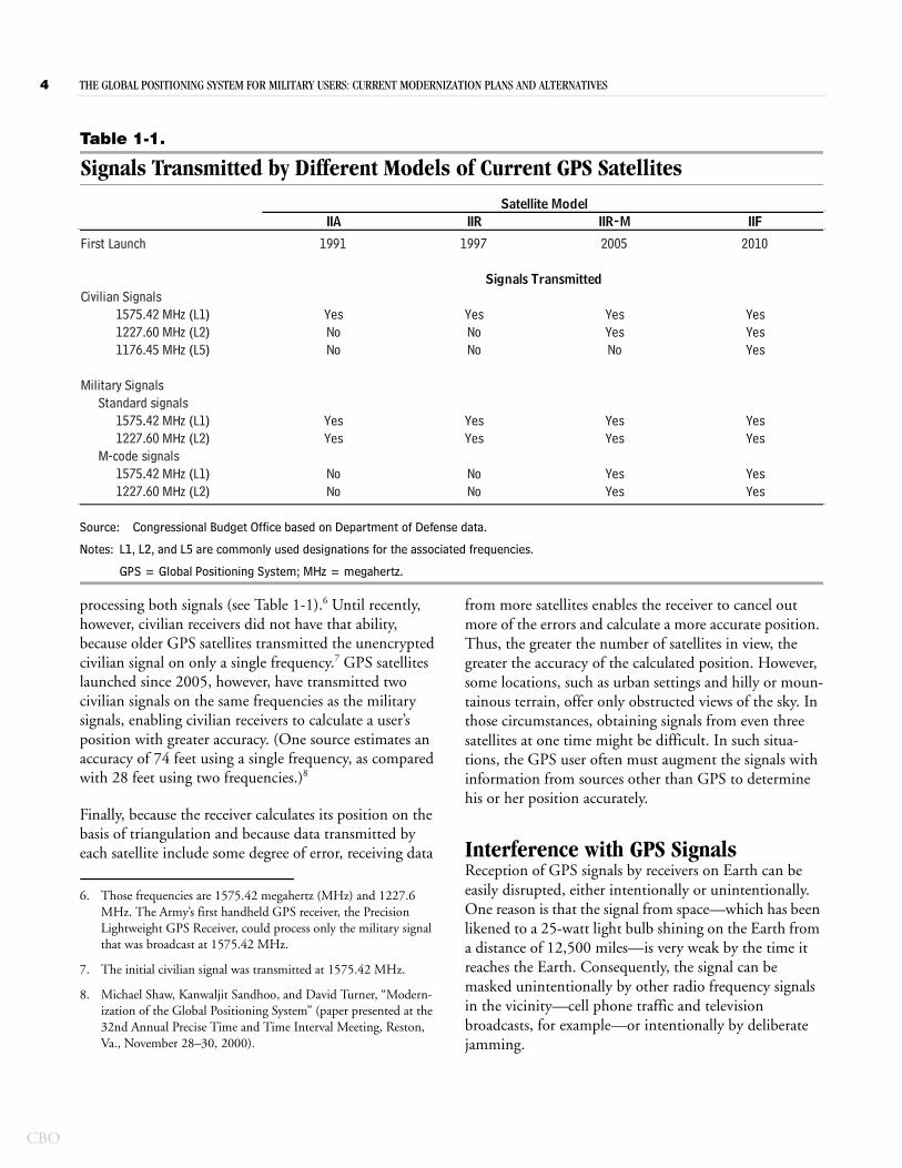
Table 1-1.
Signals Transmitted by Different Models of Current GPS Satellites
Source: Congressional Budget Office based on Department of Defense data.
Notes: L1, L2, and L5 are commonly used designations for the associated frequencies.
GPS = Global Positioning System; MHz = megahertz.
IIA IIR IIR-M IIF
First Launch 1991 1997 2005 2010
Civilian Signals1575.42 MHz (L1) Yes Yes Yes Yes1227.60 MHz (L2) No No Yes Yes1176.45 MHz (L5) No No No Yes
Military SignalsStandard signals
1575.42 MHz (L1) Yes Yes Yes Yes1227.60 MHz (L2) Yes Yes Yes Yes
M-code signals1575.42 MHz (L1) No No Yes Yes1227.60 MHz (L2) No No Yes Yes
Satellite Model
Signals Transmitted
processing both signals (see Table 1-1).6 Until recently, however, civilian receivers did not have that ability, because older GPS satellites transmitted the unencrypted civilian signal on only a single frequency.7 GPS satellites launched since 2005, however, have transmitted two civilian signals on the same frequencies as the military signals, enabling civilian receivers to calculate a user’s position with greater accuracy. (One source estimates an accuracy of 74 feet using a single frequency, as compared with 28 feet using two frequencies.)8
Finally, because the receiver calculates its position on the basis of triangulation and because data transmitted by each satellite include some degree of error, receiving data
6. Those frequencies are 1575.42 megahertz (MHz) and 1227.6 MHz. The Army’s first handheld GPS receiver, the Precision Lightweight GPS Receiver, could process only the military signal that was broadcast at 1575.42 MHz.
7. The initial civilian signal was transmitted at 1575.42 MHz.
8. Michael Shaw, Kanwaljit Sandhoo, and David Turner, “Modern-ization of the Global Positioning System” (paper presented at the 32nd Annual Precise Time and Time Interval Meeting, Reston, Va., November 28–30, 2000).
from more satellites enables the receiver to cancel out more of the errors and calculate a more accurate position. Thus, the greater the number of satellites in view, the greater the accuracy of the calculated position. However, some locations, such as urban settings and hilly or moun-tainous terrain, offer only obstructed views of the sky. In those circumstances, obtaining signals from even three satellites at one time might be difficult. In such situa-tions, the GPS user often must augment the signals with information from sources other than GPS to determine his or her position accurately.
Interference with GPS SignalsReception of GPS signals by receivers on Earth can be easily disrupted, either intentionally or unintentionally. One reason is that the signal from space—which has been likened to a 25-watt light bulb shining on the Earth from a distance of 12,500 miles—is very weak by the time it reaches the Earth. Consequently, the signal can be masked unintentionally by other radio frequency signals in the vicinity—cell phone traffic and television broadcasts, for example—or intentionally by deliberate jamming.
CHAPTER ONE THE GLOBAL POSITIONING SYSTEM FOR MILITARY USERS: CURRENT MODERNIZATION PLANS AND ALTERNATIVES 5
Jamming is accomplished by generating a signal with enough power to overwhelm a weaker signal, in much the same way that the headlights from an oncoming car make it difficult to see the light reflecting from the dividing line in the middle of the road at night. Although the military GPS signals are encrypted and are not easy to replicate, they can be masked by stronger signals of the appropriate frequency rather easily. As an example, a jammer broad-casting 1 watt of power at the appropriate frequencies could theoretically prevent a military receiver 40 miles away from locating and acquiring a GPS signal. Once the receiver has acquired and locked on to the military signal, the same 1-watt jammer would need to be within 18 miles to cause the receiver to lose track of the signal.9 Such a jammer could be as small as a 12-ounce soda can and easily be carried by an individual. (See Appendix B for pictures and diagrams of some typical jammers.) A larger, but still portable, 10-watt jammer could prevent the same receiver from acquiring a GPS signal at a dis-tance of 125 miles and could cause the receiver to lose track of the signal at 55 miles. (For additional discussion of jamming, see Box 1-1.)
9. Once a GPS receiver has found and locked on to a signal it can continue to track that signal in the presence of interference that is much stronger than the level of interference initially needed to keep the receiver from finding and acquiring the signal. As an example, the Defense Advanced GPS Receiver can maintain track of a GPS signal in the presence of jamming that is 10 times stron-ger than the level of interference that would prevent it from acquiring the signal in the first place.
Current Status of the SystemThirty working GPS satellites were in orbit at the end of August 2011. The satellites were purchased in groups known as “blocks”; satellites in the same block have iden-tical capabilities. Each block of satellites is slightly more capable than the preceding block. The blocks of existing satellites are known as IIA, IIR, IIR-M, and IIF.10
One of the major upgrades that DoD made to the satellites was enabling them to transmit new signals—designated M-code—for military use only. Those signals cover a wider frequency range and are separated from the civilian signals in order to make jamming more difficult. (See Appendix A for a discussion of M-code signal struc-ture.) Currently, 10 satellites in orbit have that capability (8 IIR-M and 2 IIF), slightly more than half of the 18 satellites that are needed to provide continuous world-wide coverage. DoD has purchased but not yet launched 10 additional IIF satellites with M-code capability; they are scheduled to be launched as existing satellites fail and need to be replaced. However, DoD has neither devel-oped nor fielded any receivers capable of receiving and deciphering the M-code signals.
As part of its plans for modernizing the system, DoD has also begun developing a new model of satellite, known as GPS III, which is being designed to transmit stronger M-code signals. The first two purchases of GPS III satel-lites are scheduled for 2012.
10. All satellites in the first block of operational GPS satellites, Block II, have been retired.
CBO
6 THE GLOBAL POSITIONING SYSTEM FOR MILITARY USERS: CURRENT MODERNIZATION PLANS AND ALTERNATIVES
CBO
Continued
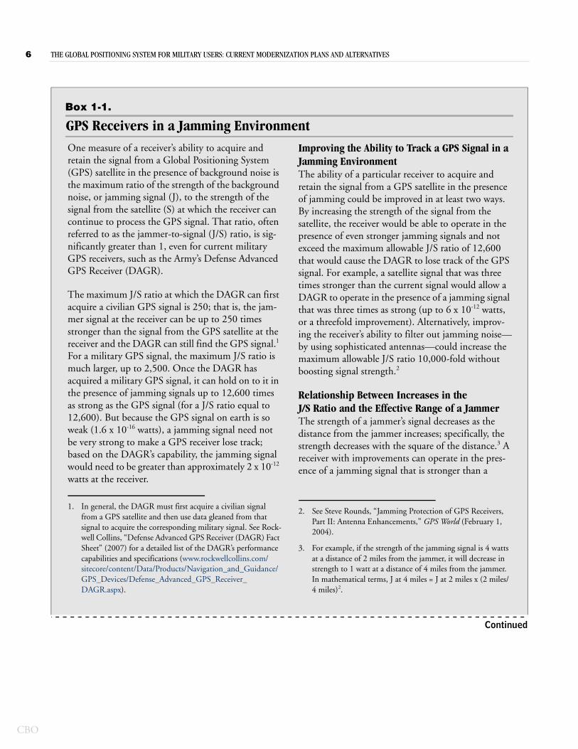
Box 1-1.
GPS Receivers in a Jamming EnvironmentOne measure of a receiver’s ability to acquire and retain the signal from a Global Positioning System (GPS) satellite in the presence of background noise is the maximum ratio of the strength of the background noise, or jamming signal (J), to the strength of the signal from the satellite (S) at which the receiver can continue to process the GPS signal. That ratio, often referred to as the jammer-to-signal (J/S) ratio, is sig-nificantly greater than 1, even for current military GPS receivers, such as the Army’s Defense Advanced GPS Receiver (DAGR).
The maximum J/S ratio at which the DAGR can first acquire a civilian GPS signal is 250; that is, the jam-mer signal at the receiver can be up to 250 times stronger than the signal from the GPS satellite at the receiver and the DAGR can still find the GPS signal.1 For a military GPS signal, the maximum J/S ratio is much larger, up to 2,500. Once the DAGR has acquired a military GPS signal, it can hold on to it in the presence of jamming signals up to 12,600 times as strong as the GPS signal (for a J/S ratio equal to 12,600). But because the GPS signal on earth is so weak (1.6 x 10⁻¹⁶ watts), a jamming signal need not be very strong to make a GPS receiver lose track; based on the DAGR’s capability, the jamming signal would need to be greater than approximately 2 x 10-12 watts at the receiver.
Improving the Ability to Track a GPS Signal in a Jamming EnvironmentThe ability of a particular receiver to acquire and retain the signal from a GPS satellite in the presence of jamming could be improved in at least two ways. By increasing the strength of the signal from the satellite, the receiver would be able to operate in the presence of even stronger jamming signals and not exceed the maximum allowable J/S ratio of 12,600 that would cause the DAGR to lose track of the GPS signal. For example, a satellite signal that was three times stronger than the current signal would allow a DAGR to operate in the presence of a jamming signal that was three times as strong (up to 6 x 10-12 watts, or a threefold improvement). Alternatively, improv-ing the receiver’s ability to filter out jamming noise—by using sophisticated antennas—could increase the maximum allowable J/S ratio 10,000-fold without boosting signal strength.2
Relationship Between Increases in the J/S Ratio and the Effective Range of a JammerThe strength of a jammer’s signal decreases as the distance from the jammer increases; specifically, the strength decreases with the square of the distance.3 A receiver with improvements can operate in the pres-ence of a jamming signal that is stronger than a
1. In general, the DAGR must first acquire a civilian signal from a GPS satellite and then use data gleaned from that signal to acquire the corresponding military signal. See Rock-well Collins, “Defense Advanced GPS Receiver (DAGR) Fact Sheet” (2007) for a detailed list of the DAGR’s performance capabilities and specifications (www.rockwellcollins.com/sitecore/content/Data/Products/Navigation_and_Guidance/GPS_Devices/Defense_Advanced_GPS_Receiver_ DAGR.aspx).
2. See Steve Rounds, “Jamming Protection of GPS Receivers, Part II: Antenna Enhancements,” GPS World (February 1, 2004).
3. For example, if the strength of the jamming signal is 4 watts at a distance of 2 miles from the jammer, it will decrease in strength to 1 watt at a distance of 4 miles from the jammer. In mathematical terms, J at 4 miles = J at 2 miles x (2 miles/4 miles)2.
CHAPTER ONE THE GLOBAL POSITIONING SYSTEM FOR MILITARY USERS: CURRENT MODERNIZATION PLANS AND ALTERNATIVES 7
Box 1-1. Continued
GPS Receivers in a Jamming Environment
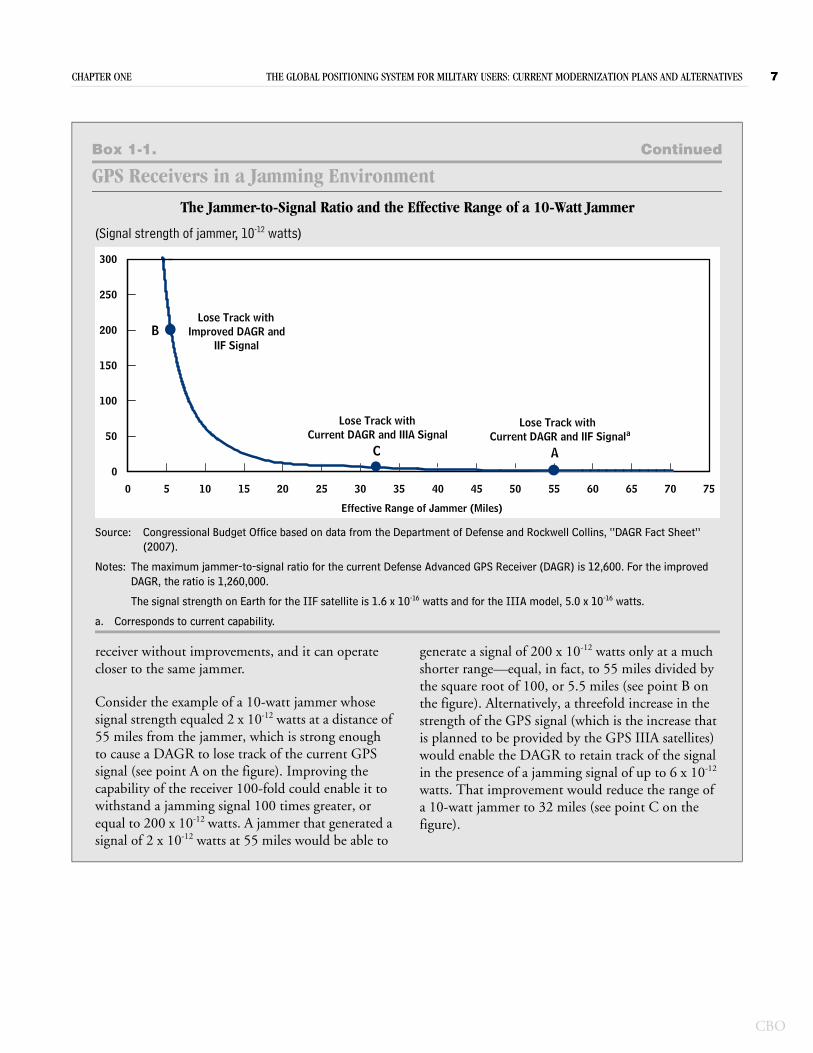
The Jammer-to-Signal Ratio and the Effective Range of a 10-Watt Jammer
(Signal strength of jammer, 10-12 watts)
Source: Congressional Budget Office based on data from the Department of Defense and Rockwell Collins, “DAGR Fact Sheet” (2007).
Notes: The maximum jammer-to-signal ratio for the current Defense Advanced GPS Receiver (DAGR) is 12,600. For the improved DAGR, the ratio is 1,260,000.
The signal strength on Earth for the IIF satellite is 1.6 x 10⁻¹⁶ watts and for the IIIA model, 5.0 x 10⁻¹⁶ watts.
a. Corresponds to current capability.
receiver without improvements, and it can operate closer to the same jammer.
Consider the example of a 10-watt jammer whose signal strength equaled 2 x 10-12 watts at a distance of 55 miles from the jammer, which is strong enough to cause a DAGR to lose track of the current GPS signal (see point A on the figure). Improving the capability of the receiver 100-fold could enable it to withstand a jamming signal 100 times greater, or equal to 200 x 10-12 watts. A jammer that generated a signal of 2 x 10-12 watts at 55 miles would be able to
generate a signal of 200 x 10-12 watts only at a much shorter range—equal, in fact, to 55 miles divided by the square root of 100, or 5.5 miles (see point B on the figure). Alternatively, a threefold increase in the strength of the GPS signal (which is the increase that is planned to be provided by the GPS IIIA satellites) would enable the DAGR to retain track of the signal in the presence of a jamming signal of up to 6 x 10-12 watts. That improvement would reduce the range of a 10-watt jammer to 32 miles (see point C on the figure).
0
50
100
150
200
250
300
0 5 10 15 20 25 30 35 40 45 50 55 60 65 70 75
Effective Range of Jammer (Miles)
B
C A
Lose Track withImproved DAGR and
IIF Signal
Lose Track withCurrent DAGR and IIIA Signal
Lose Track withCurrent DAGR and IIF Signala
CBO

CH A P T E R
2DoD’s Plan for Modernizing GPS
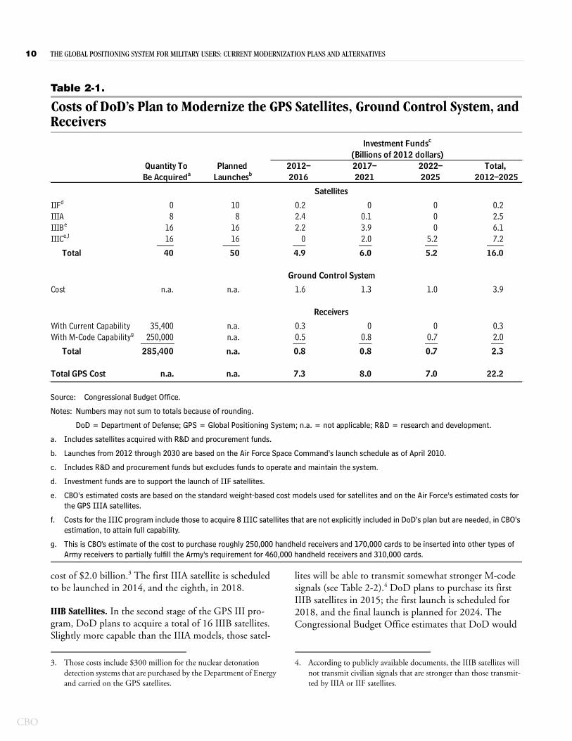
The Department of Defense plans to continue upgrading all three segments of the Global Positioning System, investing $7.3 billion from 2012 through 2016 and $15 billion over the subsequent nine years (see Table 2-1). When fielded, all of DoD’s fully modernized GPS components should improve the system’s ability to perform, even in a jamming environment. But fully implementing all of DoD’s plans could take until 2030.
Description and Cost of DoD’s PlanDuring the next decade, DoD plans to purchase enough of the next-generation GPS III satellites to eventually replace the entire constellation and to upgrade the ground control system so that it can fully control existing and future satellites. DoD also plans to develop military receivers that can decode the new M-code signals and to purchase and field those receivers to all military users.
Plans for SatellitesThe 2011 President’s Budget (submitted in February 2010) included a plan for modernizing the GPS. How-ever, the Air Force later outlined a less ambitious modern-ization program in a September 2010 Cost Analysis Requirements Document (CARD). Moreover, at the same time that the CARD was being prepared and pub-lished, the Air Force was also investigating alternative programs for GPS III satellites. The results of that analy-sis, which was expected to be completed in September 2011, were not available prior to the publication of this study.
DoD’s plans currently include launching the remaining 10 (out of 12 total) IIF satellites—the latest model of GPS II satellite—and deploying an entirely new genera-tion of GPS III satellites. As of February 2011, the Air Force expected to launch the last IIF satellite (which was purchased in 2006) in 2014. The GPS III satellites,
which are designed to have stronger military signals, are already under development, although the full rollout of that program will not be completed until 2030. Accord-ing to Air Force plans, the GPS III satellite program will be carried out in three stages, with each stage yielding sat-ellites of increasing capability.
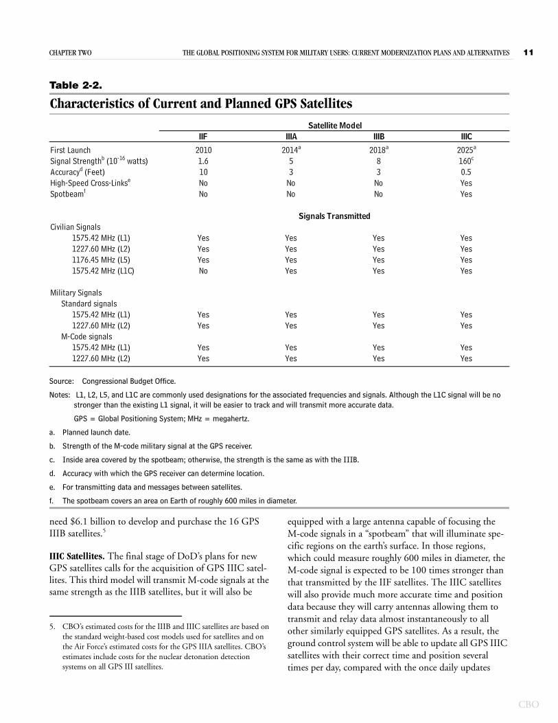
IIIA Satellites. In the first stage of the program, the Air Force will build 8 GPS IIIA satellites capable of transmitting military M-code signals at powers three times greater than those transmitted by the IIF satellites (see Table 2-2).1 GPS IIIA satellites will also transmit a new civilian signal (referred to as L1C) at 1575.42 mega-hertz, which will be compatible with signals from Galileo satellites that are part of the European navigation system under development. The new civilian signal will be no stronger than the existing L1 civilian signal at that fre-quency, but it will be easier to track and have greater accuracy because of additional data bits within the L1C navigation message.
The military and civilian signals that the GPS IIIA satel-lites transmit will allow users to determine their position more accurately than current signals allow—to within 3 feet instead of 10 feet. The first 2 IIIA satellites will be built during the development phase, which began in 2002 and is estimated to cost a total of $2.7 billion.2 Between 2010 and 2018, 6 production IIIA satellites will be purchased (2 each in 2012, 2013, and 2014), at a total
1. GPS IIIA satellites will transmit both the M-code and previous military signals so that receivers in the field that are incapable of interpreting M-code signals will still be operable.
2. Approximately $1.8 billion of the total research and development funds for the GPS IIIA satellite program were appropriated before 2012. In addition, DoD invested $1.3 billion prior to 2012 to develop the ground control system needed for the GPS III satellites.
CBO
10 THE GLOBAL POSITIONING SYSTEM FOR MILITARY USERS: CURRENT MODERNIZATION PLANS AND ALTERNATIVES
CBO
Table 2-1.
Costs of DoD’s Plan to Modernize the GPS Satellites, Ground Control System, and Receivers
Source: Congressional Budget Office.
Notes: Numbers may not sum to totals because of rounding.
DoD = Department of Defense; GPS = Global Positioning System; n.a. = not applicable; R&D = research and development.
a. Includes satellites acquired with R&D and procurement funds.
b. Launches from 2012 through 2030 are based on the Air Force Space Command’s launch schedule as of April 2010.
c. Includes R&D and procurement funds but excludes funds to operate and maintain the system.
d. Investment funds are to support the launch of IIF satellites.
e. CBO’s estimated costs are based on the standard weight-based cost models used for satellites and on the Air Force’s estimated costs for the GPS IIIA satellites.
f. Costs for the IIIC program include those to acquire 8 IIIC satellites that are not explicitly included in DoD’s plan but are needed, in CBO’s estimation, to attain full capability.
g. This is CBO's estimate of the cost to purchase roughly 250,000 handheld receivers and 170,000 cards to be inserted into other types of Army receivers to partially fulfill the Army's requirement for 460,000 handheld receivers and 310,000 cards.
IIFd 0 10 0.2 0 0 0.2IIIA 8 8 2.4 0.1 0 2.5IIIBe 16 16 2.2 3.9 0 6.1IIICe,f 16 16 0 2.0 5.2 7.2____ ____ ___ ___ ___ ____
Total 40 50 4.9 6.0 5.2 16.0
Cost n.a. n.a. 1.6 1.3 1.0 3.9
With Current Capability 35,400 n.a. 0.3 0 0 0.3With M-Code Capabilityg 250,000 n.a. 0.5 0.8 0.7 2.0________ ___ ___ ___ ___
Total 285,400 n.a. 0.8 0.8 0.7 2.3
Total GPS Cost n.a. n.a. 7.3 8.0 7.0 22.2
Be Acquireda Launchesb 2016 2021 2025 2012–2025
(Billions of 2012 dollars)Investment Fundsc
Receivers
Satellites
Ground Control System
Quantity To 2012– 2017– 2022– Total, Planned
cost of $2.0 billion.3 The first IIIA satellite is scheduled to be launched in 2014, and the eighth, in 2018.
IIIB Satellites. In the second stage of the GPS III pro-gram, DoD plans to acquire a total of 16 IIIB satellites. Slightly more capable than the IIIA models, those satel-
3. Those costs include $300 million for the nuclear detonation detection systems that are purchased by the Department of Energy and carried on the GPS satellites.
lites will be able to transmit somewhat stronger M-code signals (see Table 2-2).4 DoD plans to purchase its first IIIB satellites in 2015; the first launch is scheduled for 2018, and the final launch is planned for 2024. The Congressional Budget Office estimates that DoD would
4. According to publicly available documents, the IIIB satellites will not transmit civilian signals that are stronger than those transmit-ted by IIIA or IIF satellites.
CHAPTER TWO THE GLOBAL POSITIONING SYSTEM FOR MILITARY USERS: CURRENT MODERNIZATION PLANS AND ALTERNATIVES 11
Table 2-2.
Characteristics of Current and Planned GPS Satellites
Source: Congressional Budget Office.
Notes: L1, L2, L5, and L1C are commonly used designations for the associated frequencies and signals. Although the L1C signal will be no stronger than the existing L1 signal, it will be easier to track and will transmit more accurate data.
GPS = Global Positioning System; MHz = megahertz.
a. Planned launch date.
b. Strength of the M-code military signal at the GPS receiver.
c. Inside area covered by the spotbeam; otherwise, the strength is the same as with the IIIB.
d. Accuracy with which the GPS receiver can determine location.
e. For transmitting data and messages between satellites.
f. The spotbeam covers an area on Earth of roughly 600 miles in diameter.
IIF IIIA IIIB IIIC
First Launch 2010 2014a 2018a 2025a
Signal Strengthb (10-16 watts) 1.6 5 8 160c
Accuracyd (Feet) 10 3 3 0.5High-Speed Cross-Linkse No No No YesSpotbeamf No No No Yes
Civilian Signals1575.42 MHz (L1) Yes Yes Yes Yes1227.60 MHz (L2) Yes Yes Yes Yes1176.45 MHz (L5) Yes Yes Yes Yes1575.42 MHz (L1C) No Yes Yes Yes
Military SignalsStandard signals
1575.42 MHz (L1) Yes Yes Yes Yes1227.60 MHz (L2) Yes Yes Yes Yes
M-Code signals1575.42 MHz (L1) Yes Yes Yes Yes1227.60 MHz (L2) Yes Yes Yes Yes
Signals Transmitted
Satellite Model
need $6.1 billion to develop and purchase the 16 GPS IIIB satellites.5
IIIC Satellites. The final stage of DoD’s plans for new GPS satellites calls for the acquisition of GPS IIIC satel-lites. This third model will transmit M-code signals at the same strength as the IIIB satellites, but it will also be
5. CBO’s estimated costs for the IIIB and IIIC satellites are based on the standard weight-based cost models used for satellites and on the Air Force’s estimated costs for the GPS IIIA satellites. CBO’s estimates include costs for the nuclear detonation detection systems on all GPS III satellites.
equipped with a large antenna capable of focusing the M-code signals in a “spotbeam” that will illuminate spe-cific regions on the earth’s surface. In those regions, which could measure roughly 600 miles in diameter, the M-code signal is expected to be 100 times stronger than that transmitted by the IIF satellites. The IIIC satellites will also provide much more accurate time and position data because they will carry antennas allowing them to transmit and relay data almost instantaneously to all other similarly equipped GPS satellites. As a result, the ground control system will be able to update all GPS IIIC satellites with their correct time and position several times per day, compared with the once daily updates
CBO
12 THE GLOBAL POSITIONING SYSTEM FOR MILITARY USERS: CURRENT MODERNIZATION PLANS AND ALTERNATIVES
CBO
possible with the current system and IIIA and IIIB satel-lites. By transmitting data that are very accurate, IIIC sat-ellites will enable both civilian and military users to deter-mine their position within 6 inches, instead of the 3 feet that will be possible with GPS IIIA and IIIB satellites.
Although DoD’s plans as of September 2010 called for the purchase of 8 IIIC satellites, that number of IIIC sat-ellites would not be sufficient to ensure improved capa-bility. Indeed, it is hard to gauge what impact such a small number of satellites equipped with spotbeams would have worldwide. Although it is likely that, once all 8 IIIC satellites enter the constellation, most parts of the world would have 3 IIIC satellites in view at least 50 per-cent of the time and at least 1 IIIC satellite in view more than 95 percent of the time, it is unknown whether that limited capability would be sufficient to provide the full antijamming benefit of the strong focused spotbeam or the improved accuracy possible with continuous updates. Achieving the size constellation typically needed for worldwide coverage with at least 3 IIIC satellites in view almost all of the time would require a total of 16 IIIC sat-ellites.6 For that reason, CBO extended DoD’s plan to allow for the purchase of 16 IIIC satellites.
DoD has not published specific schedules for purchasing the IIIC satellites or estimates of their costs. CBO, how-ever, estimates that purchases would be made from 2020 through 2025 and that $7.2 billion would be needed through 2025 to develop and procure the IIIC satellites (see Table 2-1).7 (Of those funds, $3.6 billion would be needed to acquire the 8 IIIC satellites in DoD’s plan, and the remaining $3.6 billion would pay for the 8 IIIC satel-lites that CBO assumes would be needed to fill out the constellation.) The first IIIC satellite could be launched as early as 2025 and the last one in 2030.
6. The plan for the GPS III program outlined in Air Force docu-ments based on the 2011 President’s Budget included a total of 16 IIIC satellites.
7. DoD’s schedule for acquiring the 32 GPS III satellites in its plan purchases satellites at the rate of 3 per year. CBO extended the purchase of the GPS IIIC satellites at the same rate of 3 per year. Although Air Force estimates of the rate at which satellites might need to be launched over the next 20 years is less than 3 per year, DoD purchases satellites in advance of their anticipated need in order to purchase them in efficient quantities and to have extras on hand in the event of unexpected satellite failure or loss.
Plans for the Ground Control SystemMore-capable GPS satellites alone cannot provide the resistance to jamming that DoD requires. Improvements to the ground control system are needed to capitalize on the increased capabilities of the modernized satellites. The GPS III program will add many capabilities to the GPS constellation, including continuous updates and focused military signals. To accommodate and control those capabilities, DoD will need to upgrade the GPS ground control system.
According to the Air Force’s projections, it may be several years before the capabilities of the ground control system catch up with those of the satellites. The new control sys-tem that is needed to monitor the M-code signals trans-mitted by satellites that are already in orbit will not be fully in place until the end of 2016.8 Additional capabili-ties, such as those to update satellite data transmissions continuously and to control the spotbeam antenna on the IIIC satellites when they enter the constellation, will also need to be developed.
The cost to develop the initial capabilities needed to monitor the IIR-M, IIF, and IIIA satellites would be $1.6 billion from 2012 through 2016 (see Table 2-1). Upgrading the capabilities needed to control the IIIC satellites would cost an additional $1.3 billion from 2017 through 2021, CBO estimates, and $1.0 billion thereafter.
Plans for ReceiversAt the end of July 2011, the GPS constellation included 10 satellites capable of transmitting the new harder-to-jam M-code signals. However, the services do not have any receivers capable of interpreting those signals. To fix that situation, DoD plans to invest $500 million from 2012 through 2016 to begin full-scale development of M-code-capable receivers in 2013 and to begin testing modules in various platforms in 2016. DoD has directed the GPS program office to develop a common module that would receive and process the M-code signals and
8. Government Accountability Office, Global Positioning System: Challenges in Sustaining and Upgrading Capabilities Persist, GAO-10-636 (September 2010), p. 26.
CHAPTER TWO THE GLOBAL POSITIONING SYSTEM FOR MILITARY USERS: CURRENT MODERNIZATION PLANS AND ALTERNATIVES 13
that could be embedded in different models of receivers designed to meet the specific needs of each service.9
According to DoD, the Army could begin fielding the lead platform equipped with the modules—the Raven unmanned aerial vehicle—in 2017, and the first receivers specifically designed to be mounted in aircraft and ships sometime after 2019. Handheld receivers would be the last to be fielded, with production scheduled to begin in 2020. Because the various services now field more than 400,000 GPS receivers—three-quarters of which are the handheld variety—it could be 2030 before all U.S. mili-tary forces are fully equipped with receivers capable of interpreting the M-code signals.10
Total funding required from 2012 to 2025 to develop and purchase M-code-capable receivers would be $2 billion, CBO estimates (see Table 2-1). DoD has not publicly released estimates of the cost to develop the receivers after 2016 or the cost to purchase the receivers in sufficient numbers to replace those in the field. Because the Army fields more than 90 percent of the mil-itary’s receivers and because the Army’s requirements for replacement receivers are publicly available, CBO esti-mated the cost to replace the Army’s currently fielded receivers on the assumption that this would capture most of the cost.11 Assuming that half of those receivers would be replaced between 2017 and 2025 (with the remainder replaced thereafter), CBO estimates that the cost to the Army would be about $1.5 billion during that period.12
9. To demonstrate performance, the services have each designated one platform to receive the initial modules. As of February 2011, those platforms were the Army’s Raven unmanned aerial vehicle, the Air Force’s F-15E fighter aircraft, and the Navy’s Arleigh Burke class destroyer.
10. The Government Accountability Office predicted in 2009 that it could take until 2025 to fully equip the services with new receivers capable of interpreting the M-code signal. (See Government Accountability Office, Global Positioning System: Significant Chal-lenges in Sustaining and Upgrading Widely Used Capabilities, GAO-09-325, April 2009, p. 27.) Since that report was published, the schedule for fielding receivers capable of processing the M-code signal has been extended. In the case of handheld GPS receivers, the projected date to begin full-rate production has been delayed by five years, leading to a possible full fielding date of 2030.
11. Although the other services would incur costs to replace or upgrade their receivers, because the number of M-code-capable receivers needed for the other services is much smaller than the Army’s requirement, those costs should be much less than those needed to replace and augment the Army’s current receivers.
Increased CapabilitiesThe increased capabilities of GPS satellites and receivers under DoD’s plan would better enable military users to operate in the presence of radio frequency interference—the main goal of the plan. Likewise, improvements to the satellite and ground control capabilities that are included in that plan would allow military and civilian users to determine their position more accurately than they can today.
The planned improvements would enable military GPS receivers to pick up signals from satellites and to retain those signals in the presence of higher levels of electro-magnetic interference. One way to characterize the mag-nitude of the improvement is to estimate the reduction in one type of jammer’s effectiveness. For example, if a 10-watt jammer can cause a Defense Advanced GPS Receiver (DAGR) to lose a GPS signal that it was tracking from a IIR-M or IIF satellite at a range of 55 miles, how much would that range be diminished after DoD has fielded the improvements that it plans for GPS?
The combined effects of all of DoD’s planned improve-ments would be to reduce the effective range of noise jammers by an estimated 96 percent.13 Each component of the system would contribute to that overall improve-ment. A new receiver, for example, that was capable of processing the M-code signals from the older-model sat-ellites already in orbit would be able to maintain track of the GPS signals as close as 25 miles to the same 10-watt jammer (see Table 2-3).14 In other words, fielding receiv-ers capable of decoding the M-code signals would reduce the effective range of a noise jammer by an estimated 55 percent.
12. That would be the cost to purchase 250,000 new handheld receiv-ers and 170,000 M-code modules to be packaged with other devices such as radios and fire control systems, if the cost for each was roughly the same as for the current Defense Advanced GPS Receiver and Ground-Based GPS Receiver Application Module card, respectively. This would represent slightly more than half of the Army’s stated need for more than 460,000 handheld receivers and 310,000 M-code modules.
13. That includes fielding receivers able to use the M-code signals and increasing the strength of those signals 100-fold within the region-ally focused signal from the spotbeam antenna on the GPS IIIC satellite.
14. That corresponds to a fivefold (or 7 decibel) improvement in the ability to resist jamming.
CBO
14 THE GLOBAL POSITIONING SYSTEM FOR MILITARY USERS: CURRENT MODERNIZATION PLANS AND ALTERNATIVES
CBO
Table 2-3.
Estimated Impact of Planned GPS Improvements on the Effective Range of a Jammer
Source: Congressional Budget Office based on data from the Department of Defense.
Note: GPS = Global Positioning System; DAGR = Defense Advanced GPS Receiver.
a. The M-code-capable receiver is a DAGR-type receiver capable of receiving and processing M-code signals.
b. The maximum ratio of jammer signal strength to GPS satellite signal strength at which the receiver can maintain track of the GPS signal.
c. Within the 600-mile-diameter spotbeam.
d. The jammer signal strength that can cause a DAGR-type handheld receiver to lose track of the current military signal or an M-code signal.
e. The range at which a 10-watt noise jammer can cause a DAGR-type handheld receiver to lose track of the current military signal or an M-code signal.
Attribute
Maximum Jammer-to-Satellite Signal Ratiob (x 1,000) 12.6 63 63 63Military Signal Strength at Receiver (10-16 watts) 1.6 1.6 5 160 c
Maximum Jammer Signal Toleratedd (10-13 watts) 20 100 320 10,100 c
Maximum Effective Jammer Rangee (Miles) 55 25 14 2.5 c
Capablea
Satellite Model and Receiver
DAGRand Current
IIR-M, IIF,and M-Code
III-A and M-Code
CapableaCapablea
IIR-M, IIF, IIICand M-Code
The effective range of a 10-watt jammer would be dimin-ished even further—to 14 miles—once GPS IIIA satel-lites are added to the constellation. That is because those satellites will transmit M-code signals that are roughly three times stronger than those transmitted by IIR-M and IIF satellites (see Table 2-2).15 When GPS IIIC satellites are added, they will be capable of focusing the M-code signals on to a specific region on Earth, raising the strength of the signal within that region to 100 times that of the most modern GPS satellites now in orbit.16 By doing so, the range at which a 10-watt jammer could defeat an M-code-capable receiver would be reduced to an estimated 2.5 miles, less than 5 percent of its range against current receivers trying to track signals from cur-rent satellites (see Table 2-3).
Another improvement in the capability of GPS overall would result from the ability to continuously update data transmitted by the satellites with the fielding of GPS IIIC
15. The combined improvement in antijamming capability resulting from the M-code signal (a factor of 5) and the stronger signal from the IIIA satellite (a factor of 3.16) is equal to the product of the individual improvements, or 15.8.
16. GPS IIIB satellites are scheduled to transmit M-code signals that are five times the strength of those transmitted by IIF satellites and slightly stronger than those transmitted by IIIA satellites.
satellites. Once a sufficient number of satellites with high-speed cross-link antennas are in the constellation, the ground control system will be able to update hourly the time data broadcast by the satellites. That improve-ment would reduce time and position errors to such an extent that military and civilian GPS users would proba-bly be able to determine their location to within less than 6 inches.
Concerns About the Plan Researchers and others have raised three concerns about DoD’s plan. First, the fielding of the equipment to coun-ter jamming, including improved receivers and higher-power satellites, would take well into the next decade, leaving military GPS users vulnerable to interference for many years. Second, although DoD has not published a schedule or an estimated cost to complete any portion of the GPS program, the details that are known about the GPS III satellite program indicate that it is ambitious, which raises the risk of cost increases, delays in fielding, or both.17 And third, there is a lack of synchronization among the upgrades to the various segments of the program.
17. DoD has published the full schedule and cost of the GPS IIIA sat-ellite program, but that represents the cost for only 8 satellites.
CHAPTER TWO THE GLOBAL POSITIONING SYSTEM FOR MILITARY USERS: CURRENT MODERNIZATION PLANS AND ALTERNATIVES 15
Figure 2-1.
Effect of DoD’s Plan on the Effective Range of a 10-Watt Jammer(Effective range, in miles)
Source: Congressional Budget Office based on Department of Defense data.
Notes: Improved capability is assumed to have been phased in when 18 satellites of improved capability (or 16 IIIC satellites) are in orbit.
The scale for the y-axis is logarithmic, not linear.
DoD = Department of Defense.
a. Improved performance would be available only to the small number of M-code-capable receivers in the field.
b. Half of all fielded receivers would be equipped with M-code capability.
c. Within the 600-mile-diameter area covered by the satellite’s spotbeam.
2010 2015 2020 2025 2030
0.01
0.1
1
10
100Available to Most Users
Available to theSmall Number of
M-Code ReceiversFielded
IIIASatellites
IIIBSatellites
Significant Number ofM-Code Receivers
Fielded
IIICSatellites
b
aa
c
Timetable and Sufficiency of Full Antijam Capability DoD’s planned improvements in the ability of GPS to operate in a jamming environment rely heavily on new military signals from space. Those include the M-code signals, the more powerful M-code signals that will be transmitted by IIIA and IIIB satellites, and the focused M-code signals from IIIC satellites. The increased resis-tance to jamming provided by those improvements, although significant, will not be available for 10 to 20 years.
The antijamming improvements expected from the M-code signals will not be realized until sufficient numbers of M-code-capable receivers are in the field—probably no earlier than 2026.18 At that time, the effectiveness of enemy jammers could be lessened significantly (see Figure 2-1). Similarly, although the first IIIA satellite is scheduled to be launched in 2014, 1 satellite alone will
18. For its analysis, CBO assumes that replacing half of all military receivers will be sufficient to yield an appreciable increase in over-all capability.
not provide sufficient coverage to make a difference to GPS users. A minimum of 18 satellites need to be in the constellation to guarantee that at least 3 will be visible at all times. Thus, it could be 2022 before enough satel-lites—8 IIIA and 10 IIIB—are in the constellation to make it likely that strong signals from 3 satellites will be available at any given time (see Figure 2-1). And even then, only small numbers of M-code-capable receivers will have been fielded. Thus, the benefits of stronger sig-nals from the GPS III satellites will be available only to a small number of users in 2022. Finally, GPS IIIC satel-lites promise a 100-fold improvement in the strength of M-code signals compared with signals from today’s satel-lites. However, the stronger signals will not be available worldwide until 16 IIIC satellites are in the constellation, which is not likely to occur before 2030.
Even when all of the improvements included in DoD’s plan are in place, they might not be sufficient to counter the hostile environment that users might face. The Defense Science Board (DSB), in a 2005 report, recom-mended that antijamming improvements be made to
CBO
16 THE GLOBAL POSITIONING SYSTEM FOR MILITARY USERS: CURRENT MODERNIZATION PLANS AND ALTERNATIVES
CBO
achieve a GPS system that could withstand jamming lev-els that were 10,000 to 1 million times greater than cur-rent levels.19 DoD’s planned enhancements, combined, will improve performance in a jamming environment by at most a factor of 500, far short of the level of improve-ment recommended by the DSB.
Uncertainty in Costs and Schedules Developing the new satellites, control systems, and receivers carries some risks.20 The risks are relatively small for the IIIA satellites, because their planned capabilities are not that much greater than those of the IIF satellites. And the IIIB satellites in DoD’s plan represent only a small increase in capability over the IIIA model. Provid-ing the IIIC satellites with high-speed cross-links to com-municate with other GPS satellites, in contrast, requires new antennas and other hardware whose development could carry greater risk. In addition, GPS IIIC satellites, which will be capable of focusing the signal on to specific regions on Earth, will need to be equipped with a dedi-cated large and steerable antenna and the hardware needed to direct the antenna and signal to the desired spot on Earth as a satellite passes overhead. Those signifi-cant increases in capability require the development of new technologies needed to produce satellites to the desired specifications, ensure that they operate correctly, and control them from the Earth. In the past, when the GPS program tried to increase the capability of its satel-lites significantly (as was the case with the upgrade from the IIR to the IIF model) or its ground control system
19. Defense Science Board, The Future of the Global Positioning System (October 2005), p. 63.
20. Recent changes made in the GPS III satellite program are an indi-cation of those risks. The GPS program associated with the 2011 President’s Budget and documented in the spring of 2010 was more ambitious than the current plan. It included fewer IIIB satel-lites (8 instead of 16) but those IIIB satellites would have been equipped with high-speed cross-links, thus enabling the transmis-sion of more accurate data. Furthermore, the spring 2010 plan included a total of 16 IIIC satellites, half of the initial 32 GPS III satellite constellation. As a result, the constellation resulting from the earlier plan would have had more capability than that likely to result from the most recent plan described in the September 2010 CARD. One reason given in the press for deferring the high-speed cross-links to the IIIC rather than the IIIB model was to reduce risk and increase affordability. See “GPS IIIB Satellites to Add Critical New Capabilities,” GPS Daily (July 6, 2011), www.gps-daily.com/reports/GPS_IIIB_Satellites_to_Add_Critical_New_Capabilities_999.html.
(such as by adding the ability to manage the M-code sig-nals), the program experienced increases in costs and delays in the planned delivery of improved capabilities. As currently structured, the GPS program could realize the same problems, especially for those portions that would develop and procure the IIIC satellites.
CBO estimates that the investment needed to complete DoD’s planned modernization of the GPS satellites, con-trol system, and user equipment will be slightly greater than $22 billion. (DoD has not published those costs.) Most of the costs would be attributed to the satellite por-tion of the program, with investment requirements equal to or exceeding $1 billion per year through 2025.
Unsynchronized Improvements Another concern that has been highlighted by the Defense Science Board and the Government Account-ability Office is the lack of synchronization among the three segments of the GPS program.21 For example, although 10 GPS satellites transmitting M-code signals were in orbit at the end of July 2011, DoD has not devel-oped or fielded any receivers capable of processing those signals—and the initial fielding of the first common ground modules to demonstrate the capability to decode the signals is not scheduled until 2017. Because full pro-duction of the handheld receivers is not scheduled to begin until 2021, after one year of low-rate production, large numbers of M-code-capable receivers to replace the current DAGRs are not likely to be fielded before 2026. And even if some military receivers capable of processing the M-code signals could be fielded earlier, the ground control system would be incapable before the end of 2016 of ensuring that the satellites were transmitting the correct data on the M-code signal.22 Thus, although satel-lites with enhanced capabilities are being developed, pur-chased, and launched, no one will be able to take advan-tage of those improvements for at least five more years.
21. Defense Science Board, The Future of the Global Positioning Sys-tem, pp. 48, 49, 55, and 56; Government Accountability Office, Global Positioning System: Significant Challenges in Sustaining and Upgrading Widely Used Capabilities, pp. 26–29; and Government Accountability Office, Global Positioning System: Challenges in Sus-taining and Upgrading Capabilities Persist, pp. 25–29.
22. The Air Force projected in February 2011 that the control capa-bility for the M-code signal would not be available until Septem-ber 2016, nine years later than had originally been planned.
CH A P T E R
3Alternatives for Modernizing GPS
The Congressional Budget Office examined three alternatives to the Department of Defense’s plan that would modernize the Global Positioning System, improve the system’s performance in a jamming environ-ment, and address some of the concerns about DoD’s plan. The alternatives, or options, would reduce the cost of modernizing and controlling the GPS satellite constel-lation, as well as the risk of developing it, by canceling the IIIB and IIIC satellite portions of the program. The options would also make these changes:
Option 1 would improve current GPS receivers by fit-ting them with better antennas and by adding tightly integrated inertial navigation systems (INSs).
Option 2 would capitalize on a DoD research and development program known as iGPS, or High Integ-rity GPS, by enabling modified GPS receivers to use information received via the Iridium commercial com-munications satellite network to improve performance in the presence of jammers.
Option 3 would carry out the improvements included in both Option 1 and Option 2.
All three options would cost less to implement than DoD’s plan and would yield greater benefits for military users—in terms of antijamming capability—sooner. Each option, however, has some disadvantages, such as the potentially greater weight of more capable receivers, which would reduce their value to personnel operating on foot.
Overview of the OptionsIn contrast to DoD’s modernization plan, which reduces GPS’s vulnerability to jamming primarily by increasing the satellites’ capabilities, the options emphasize improv-ing the ability of military GPS receivers to operate in a hostile environment. That approach was recommended
by the Defense Science Board in its October 2005 report on the future of GPS. The DSB noted that improving GPS receivers is the quickest path to making the system as a whole less vulnerable to jamming.1 CBO focused on ways to enhance the capabilities of the military’s hand-held receivers, which are used primarily by the Army and the Marines but are widespread throughout all of the ser-vices. (Most of the military’s so-called handheld receivers are mounted, sometimes permanently, in various military vehicles.)
Although significant improvement would come from introducing receivers capable of processing M-code sig-nals earlier than DoD’s plan allows, the Government Accountability Office has reported that accelerating the fielding of such receivers through the infusion of addi-tional funds is not possible because of technical difficul-ties.2 Several different approaches that could yield improved receivers in the next 5 to 10 years are possible, however. Approaches recommended by the DSB include equipping receivers with antennas that block jamming signals and integrating miniature inertial navigation sys-tems into receivers to enhance their ability to process the GPS signal and to limit interference from jamming sig-nals. Another path to improving the capabilities of GPS receivers that DoD has been pursuing for several years would use the Iridium commercial low-Earth orbiting satellite constellation to provide data to military receivers that would enhance their ability to process the GPS signal in the presence of jamming.
1. Defense Science Board, The Future of the Global Positioning System (October 2005), p. 56.
2. Government Accountability Office, Global Positioning System: Sig-nificant Challenges in Sustaining and Upgrading Widely Used Capa-bilities, GAO-09-325 (April 2009), p. 31; and Government Accountability Office, Global Positioning System: Challenges in Sus-taining and Upgrading Capabilities Persist, GAO-10-636 (Septem-ber 2010), p. 28.
CBO
18 THE GLOBAL POSITIONING SYSTEM FOR MILITARY USERS: CURRENT MODERNIZATION PLANS AND ALTERNATIVES
CBO
All of the options would rely solely on IIIA satellites. Those satellites would transmit M-code signals at higher power than current satellites do and would emit a new civilian signal; otherwise, they do not include additional capabilities that would require significant developmental effort. Because the satellites in the GPS constellation must be replaced when they can no longer reliably per-form their mission (estimated to be after 8 to 12 years in orbit), CBO predicts—using Air Force planning fac-tors—that DoD will need to launch 50 or more satellites between 2012 and 2030. Because DoD has already acquired 10 GPS IIF satellites that it has not yet launched, CBO estimates that DoD will need to acquire 40 satellites in the GPS III program through 2030.3 Under the options, DoD would also acquire a total of 40 GPS satellites, but they would all be the IIIA model.
CBO did not analyze the effects of its options on civilian users of the system in quantitative detail. Because all of the options would retain GPS IIIA satellites but cancel the programs for IIIB and IIIC satellites, they would have the same general effect on civilian users. (See Box 3-1 for an expanded discussion.)
All three of the options that CBO analyzed have several features in common in addition to acquiring 40 GPS IIIA satellites and canceling the IIIB and IIIC programs (see Table 3-1). They would all continue to develop the GPS ground control system so that it would be able to control the GPS satellites now in orbit that are capable of trans-mitting M-code signals as well as the newer GPS IIIA sat-ellites. But the options would cancel those portions of the modernization program that would have developed con-trol software to support the high-speed cross-links and the spotbeam antenna introduced on the IIIC satellites. CBO estimates that those reductions in the scope of the GPS III satellite program and the improved ground con-trol system program would yield about $2.2 billion in savings from 2012 through 2021 and more than $4 bil-lion if the total cost of DoD’s plan through 2025 is taken into account.4 And finally, the options would develop and purchase the same number of M-code-capable receivers as
3. In the options, CBO assumes that DoD would purchase IIIA sat-ellites at a rate of 3 per year, matching the rate at which DoD plans to purchase IIIB and IIIC satellites.
4. CBO estimates that the procurement of 16 GPS IIIC satellites will not be complete until 2025.
would DoD’s plan and continue support of the IIF satellites.5
The features common to the three options—40 GPS IIIA satellites, selected improvements to the ground control system, M-code-capable receivers, and the cost to launch the remaining IIF satellites—are needed to maintain and control the GPS constellation and to take full advantage of the satellites (some of which are already in orbit) that are capable of emitting the harder-to-jam M-code signals. CBO estimates that those features would cost $17.9 bil-lion through 2025 (see Table 3-2). In addition, each of the three options would have other costs ranging from $1.0 billion (for the second option) to $3.0 billion (for the third option).
Option 1. Improve the Capabilities of Military GPS ReceiversOption 1 would improve the ability of military GPS receivers to provide accurate location data in a jamming environment by employing two techniques that, when combined, could reduce the effective range of noise jam-mers by 97 percent.6 Because the techniques have already been researched and developed, it should be possible to field large numbers of improved receivers by 2018, signif-icantly sooner than any improved systems acquired under DoD’s plan could be fielded. Furthermore, the overall cost to carry out this option would be slightly more than $2 billion less than the total cost through 2025 to imple-ment DoD’s plan.
Techniques for Improving the Capabilities of ReceiversThe ability of military receivers to process GPS signals could be improved in the next few years through antenna enhancements that limit the interference from jamming signals and through techniques that eliminate errors that are introduced during signal processing. This option would enhance receivers’ capabilities through a combina-
5. CBO’s estimate is based on the cost to purchase only the Army’s handheld GPS receivers and cards, which are far more numerous than those of the other services and account for more than 90 per-cent of all military receivers.
6. The basis for comparisons of improved capability resulting from implementing CBO’s three options is that of the Army’s current DAGR and the signal from the IIF satellite.
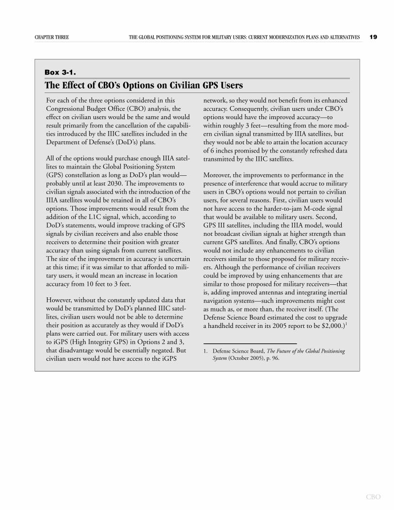
CHAPTER THREE THE GLOBAL POSITIONING SYSTEM FOR MILITARY USERS: CURRENT MODERNIZATION PLANS AND ALTERNATIVES 19
Box 3-1.
The Effect of CBO’s Options on Civilian GPS UsersFor each of the three options considered in this Congressional Budget Office (CBO) analysis, the effect on civilian users would be the same and would result primarily from the cancellation of the capabili-ties introduced by the IIIC satellites included in the Department of Defense’s (DoD’s) plans.
All of the options would purchase enough IIIA satel-lites to maintain the Global Positioning System (GPS) constellation as long as DoD’s plan would—probably until at least 2030. The improvements to civilian signals associated with the introduction of the IIIA satellites would be retained in all of CBO’s options. Those improvements would result from the addition of the L1C signal, which, according to DoD’s statements, would improve tracking of GPS signals by civilian receivers and also enable those receivers to determine their position with greater accuracy than using signals from current satellites. The size of the improvement in accuracy is uncertain at this time; if it was similar to that afforded to mili-tary users, it would mean an increase in location accuracy from 10 feet to 3 feet.
However, without the constantly updated data that would be transmitted by DoD’s planned IIIC satel-lites, civilian users would not be able to determine their position as accurately as they would if DoD’s plans were carried out. For military users with access to iGPS (High Integrity GPS) in Options 2 and 3, that disadvantage would be essentially negated. But civilian users would not have access to the iGPS
network, so they would not benefit from its enhanced accuracy. Consequently, civilian users under CBO’s options would have the improved accuracy—to within roughly 3 feet—resulting from the more mod-ern civilian signal transmitted by IIIA satellites, but they would not be able to attain the location accuracy of 6 inches promised by the constantly refreshed data transmitted by the IIIC satellites.
Moreover, the improvements to performance in the presence of interference that would accrue to military users in CBO’s options would not pertain to civilian users, for several reasons. First, civilian users would not have access to the harder-to-jam M-code signal that would be available to military users. Second, GPS III satellites, including the IIIA model, would not broadcast civilian signals at higher strength than current GPS satellites. And finally, CBO’s options would not include any enhancements to civilian receivers similar to those proposed for military receiv-ers. Although the performance of civilian receivers could be improved by using enhancements that are similar to those proposed for military receivers—that is, adding improved antennas and integrating inertial navigation systems—such improvements might cost as much as, or more than, the receiver itself. (The Defense Science Board estimated the cost to upgrade a handheld receiver in its 2005 report to be $2,000.)1
1. Defense Science Board, The Future of the Global Positioning System (October 2005), p. 96.
CBO
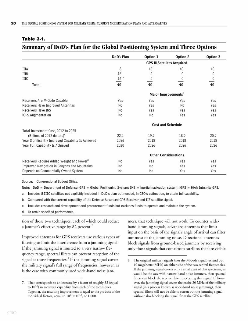
20 THE GLOBAL POSITIONING SYSTEM FOR MILITARY USERS: CURRENT MODERNIZATION PLANS AND ALTERNATIVES
CBO
Table 3-1.
Summary of DoD’s Plan for the Global Positioning System and Three Options
Source: Congressional Budget Office.
Note: DoD = Department of Defense; GPS = Global Positioning System; INS = inertial navigation system; iGPS = High Integrity GPS.
a. Includes 8 IIIC satellites not explicitly included in DoD’s plan but needed, in CBO’s estimation, to attain full capability.
b. Compared with the current capability of the Defense Advanced GPS Receiver and IIF satellite signal.
c. Includes research and development and procurement funds but excludes funds to operate and maintain the system.
d. To attain specified performance.
IIIA 8 40 40 40IIIB 16 0 0 0IIIC 16 a 0 0 0___ ___ ___ ___
Total 40 40 40 40
Receivers Are M-Code CapableReceivers Have Improved AntennasReceivers Have INS iGPS Augmentation
Total Investment Cost, 2012 to 2025 (Billions of 2012 dollars)c
Year Significantly Improved Capability Is AchievedYear Full Capability Is Achieved
Receivers Require Added Weight and Powerd
Improved Navigation in Canyons and MountainsDepends on Commercially Owned System
2030
YesYesYes
YesYesYes
NoNoNo
YesNoNo
2026
YesYesYesNo
YesNoYesYes
YesYesYesYes
2026
DoD's Plan Option 1 Option 2 Option 3
GPS III Satellites Acquired
Major Improvementsb
Cost and Schedule
Other Considerations
YesNoNoNo
2026 201822.2 19.9 18.9 20.9
20182026
2018
tion of those two techniques, each of which could reduce a jammer’s effective range by 82 percent.7
Improved antennas for GPS receivers use various types of filtering to limit the interference from a jamming signal. If the jamming signal is limited to a very narrow fre-quency range, spectral filters can prevent reception of the signal at those frequencies.8 If the jamming signal covers the military signal’s full range of frequencies, however, as is the case with commonly used wide-band noise jam-
7. That corresponds to an increase by a factor of roughly 32 (equal to 101.5) in receivers’ capability from each of the techniques. Together, the resulting improvement is equal to the product of the individual factors, equal to 101.5 x 101.5, or 1,000.
mers, that technique will not work. To counter wide-band jamming signals, advanced antennas that limit input on the basis of the signal’s angle of arrival can filter out most of the jamming noise. Directional antennas block signals from ground-based jammers by receiving only those signals that come from satellites that are visible
8. The original military signals (not the M-code signal) extend out 10 megahertz (MHz) on either side of the two central frequencies. If the jamming signal covers only a small part of that spectrum, as would be the case with narrow-band noise jammers, then spectral filters can block the receiver from processing that signal. If, how-ever, the jamming signal covers the entire 20 MHz of the military signal (in a process known as wide-band noise jamming), then spectral filters will not be able to screen out the jamming signal without also blocking the signal from the GPS satellite.
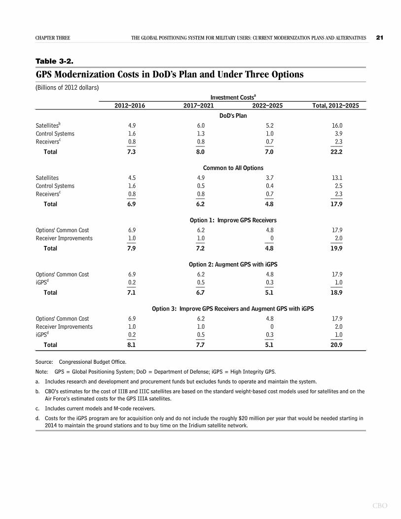
CHAPTER THREE THE GLOBAL POSITIONING SYSTEM FOR MILITARY USERS: CURRENT MODERNIZATION PLANS AND ALTERNATIVES 21
Table 3-2.
GPS Modernization Costs in DoD’s Plan and Under Three Options(Billions of 2012 dollars)
Source: Congressional Budget Office.
Note: GPS = Global Positioning System; DoD = Department of Defense; iGPS = High Integrity GPS.
a. Includes research and development and procurement funds but excludes funds to operate and maintain the system.
b. CBO’s estimates for the cost of IIIB and IIIC satellites are based on the standard weight-based cost models used for satellites and on the Air Force’s estimated costs for the GPS IIIA satellites.
c. Includes current models and M-code receivers.
d. Costs for the iGPS program are for acquisition only and do not include the roughly $20 million per year that would be needed starting in 2014 to maintain the ground stations and to buy time on the Iridium satellite network.
Satellitesb 4.9 6.0 5.2 16.0Control Systems 1.6 1.3 1.0 3.9Receiversc 0.8 0.8 0.7 2.3___ ___ ___ ____
Total 7.3 8.0 7.0 22.2
Satellites 4.5 4.9 3.7 13.1Control Systems 1.6 0.5 0.4 2.5Receiversc 0.8 0.8 0.7 2.3___ ___ ___ ____
Total 6.9 6.2 4.8 17.9
Options' Common Cost 6.9 6.2 4.8 17.9Receiver Improvements 1.0 1.0 0 2.0___ ___ ___ ____
Total 7.9 7.2 4.8 19.9
Options' Common Cost 6.9 6.2 4.8 17.9iGPSd 0.2 0.5 0.3 1.0___ ___ ___ ____
Total 7.1 6.7 5.1 18.9
Options' Common Cost 6.9 6.2 4.8 17.9Receiver Improvements 1.0 1.0 0 2.0iGPSd 0.2 0.5 0.3 1.0___ ___ ___ ____
Total 8.1 7.7 5.1 20.9
Option 3: Improve GPS Receivers and Augment GPS with iGPS
2012–2016 2017–2021 2022–2025 Total, 2012–2025 Investment Costsa
DoD's Plan
Common to All Options
Option 1: Improve GPS Receivers
Option 2: Augment GPS with iGPS
CBO
22 THE GLOBAL POSITIONING SYSTEM FOR MILITARY USERS: CURRENT MODERNIZATION PLANS AND ALTERNATIVES
CBO
at least 10 degrees above the horizon. The Army has developed that type of antenna for installation on some of its weapon systems.9
More sophisticated directional antennas that are com-posed of a number of separate elements use a technique called nulling to prevent the receiver from being over-whelmed by jamming noise. If one of the elements detects a jamming signal, that element is turned off, leav-ing the rest of the antenna to function normally and receive the GPS signal without interference. Those types of antennas can block signals from jammers located at several different positions around the receiver. DoD has developed several versions of those antennas and installed them on some military aircraft and ships; newer and smaller versions could also be mounted on vehicles or car-ried in a backpack. (See Appendix B for some examples of such antennas.) The use of improved antennas such as those described here could prevent 97 percent of jam-ming noise from reaching the receiver and reduce a jam-mer’s effective range by 82 percent.10
Even though improved antennas can filter out most of the noise and associated errors introduced by jamming signals, they would not be able to prevent the introduc-tion of all errors. Augmentations to receivers’ processing abilities and components could further improve their per-formance in hostile jamming environments. One improvement studied by DoD would couple a GPS receiver with an inertial navigation system, which can measure changes in location by accurately monitoring a user’s movements. Integrating information from the INS
9. One example is the GPS Antenna Masking Ring developed for use on some Army vehicles equipped with rocket launchers.
10. Such antennas could improve the performance of GPS receivers in a jamming environment by a factor of roughly 30 or more. See Lt. Col. Bill Hawken, Directorate of Joint Capability Production, Chief of Force Development, Canadian National Defense, “NAVWAR (Navigation Warfare): Electronic Warfare and the Global Positioning System” (presentation to the Ottawa, Ontario, chapter of the Armed Forces Communications and Electronics Association, March 2007, available at http://afceaottawa.ca/view_doc_by_id.php?edit=1&inpage=true&id=128); Office of the Program Manager, Communications Program Office, Pro-gram Executive Office, Command, Control, Communications, and Intelligence, “GPS Air Navigation Overview”(presentation to the Air Combat Electronics User’s Conference, Reno, Nev., March 2010); Chuck Andrews, Joint Navigation Warfare Center, “JNWC Mission Brief” (presentation to the Program Manager’s GPS Integration Conference, Sterling Heights, Mich., September 2009); Edwin Hogan, Research, Development, and Engineering Command, U.S. Army, “GPS Antenna Masking Ring (GAMR) Update” (September 2009); and Steve Rounds, “Jamming Protec-tion of GPS Receivers, Part II: Antenna Enhancements,” GPS World (February 1, 2004).
enhances a receiver’s ability to process the GPS signal and to filter out noise. Tightly integrating an INS with a GPS receiver could, by itself, also reduce the effective range of enemy jammers by 82 percent.11
Schedule and Cost for Purchasing and Fielding Improvements to ReceiversBecause the technologies for the improvements included in this option have already been developed, it should be possible to field receivers incorporating those technolo-gies relatively quickly. The services have already begun to develop, and in some cases, field, advanced antennas to be used on specific aircraft and weapon systems.12 Because such systems have been designed and tested, improved antennas and INSs could be purchased starting in 2013 and integrated into existing platforms thereafter.
CBO estimates that the total cost to purchase the needed hardware and to integrate it into existing or future GPS receivers would be $2 billion. Of that total, $1 billion would be needed before 2017 to purchase enough equip-ment to upgrade roughly half of the GPS receivers cur-rently fielded by the services. An additional $1 billion would be needed from 2017 through 2021 to purchase the remaining hardware (see Table 3-2 on page 21).
Effect of Option 1 on GPS Performance in a Jamming EnvironmentThe ability of military receivers to operate in a jamming environment would be significantly improved within just
11. Tightly integrating an INS unit with a GPS receiver improves the receiver’s ability to reject jamming noise. The combined system can navigate alone on the inertial measurement unit if the GPS signal is totally lost. For more information, see Hawken, “NAVWAR (Navigation Warfare): Electronic Warfare and the Global Positioning System”; Andrews, “JNWC Mission Brief ”; Steve Rounds, “Jamming Protection of GPS Receivers, Part I: Receiver Enhancements,” GPS World (January 1, 2004); and Brad Parkinson, “GPS ‘Big Five’ Contributions to Users’ Needs: Show-ing Dependence of User Measures of Effectiveness (MOE) on GPS System Design” (presentation to the National Space-Based PNT Advisory Board Meeting, Washington, D.C., March 27, 2008). Additional data were provided in a private communication to the Congressional Budget Office from the Office of the Secretary of Defense, Office of the Under Secretary of Defense (Acquisition, Technology, and Logistics), Office of the Director, Defense Research and Engineering, August 2010.
12. DoD has developed several types of antennas, for use on military aircraft, that are designed to negate jamming signals. The Navy is fielding them on its F-18, AV-8, and P-3 aircraft and on its MH-60, HH-60H, and MH-53 helicopters. The Army has tested in some of its vehicles directional antennas designed to negate signals from ground-based jammers.
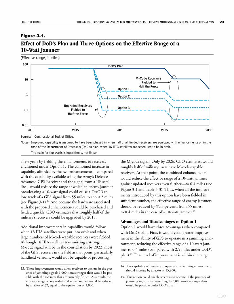
CHAPTER THREE THE GLOBAL POSITIONING SYSTEM FOR MILITARY USERS: CURRENT MODERNIZATION PLANS AND ALTERNATIVES 23
Figure 3-1.
Effect of DoD’s Plan and Three Options on the Effective Range of a 10-Watt Jammer(Effective range, in miles)
Source: Congressional Budget Office.
Notes: Improved capability is assumed to have been phased in when half of all fielded receivers are equipped with enhancements or, in the case of the Department of Defense’s (DoD’s) plan, when 16 IIIC satellites are scheduled to be in orbit.
The scale for the y-axis is logarithmic, not linear.
2010 2015 2020 2025 2030
0.01
0.1
1
10
100
Upgraded ReceiversFielded to
Half the Force
M-Code ReceiversFielded to
Half the Force
DoD's Plan
Option 1
Option 2
Option 3
a few years by fielding the enhancements to receivers envisioned under Option 1. The combined increase in capability afforded by the two enhancements—compared with the capability available using the Army’s Defense Advanced GPS Receiver and the signal from a IIF satel-lite—would reduce the range at which an enemy jammer broadcasting a 10-watt signal could cause a DAGR to lose track of a GPS signal from 55 miles to about 2 miles (see Figure 3-1).13 And because the hardware associated with the proposed enhancements could be purchased and fielded quickly, CBO estimates that roughly half of the military’s receivers could be upgraded by 2018.
Additional improvements in capability would follow when 18 IIIA satellites were put into orbit and when large numbers of M-code-capable receivers were fielded. Although 18 IIIA satellites transmitting a stronger M-code signal will be in the constellation by 2022, most of the GPS receivers in the field at that point, particularly handheld versions, would not be capable of processing
13. Those improvements would allow receivers to operate in the pres-ence of jamming signals 1,000 times stronger than would be pos-sible with the receivers that are currently fielded. As a result, the effective range of any wide-band noise jammer would be reduced by a factor of 32, equal to the square root of 1,000.
the M-code signal. Only by 2026, CBO estimates, would roughly half of military users have M-code-capable receivers. At that point, the combined enhancements would reduce the effective range of a 10-watt jammer against updated receivers even further—to 0.4 miles (see Figure 3-1 and Table 3-3). Thus, when all the improve-ments introduced by this option have been fielded in sufficient number, the effective range of enemy jammers should be reduced by 99.3 percent, from 55 miles to 0.4 miles in the case of a 10-watt jammer.14
Advantages and Disadvantages of Option 1Option 1 would have three advantages when compared with DoD’s plan. First, it would yield greater improve-ment in the ability of GPS to operate in a jamming envi-ronment, reducing the effective range of a 10-watt jam-mer to 0.4 miles (compared with 2.5 miles under DoD’s plan).15 That level of improvement is within the range
14. The capability of receivers to operate in a jamming environment should increase by a factor of 15,800.
15. This option could enable receivers to operate in the presence of jamming signals that were roughly 3,000 times stronger than would be possible under DoD’s plan.
CBO
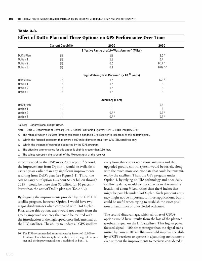
24 THE GLOBAL POSITIONING SYSTEM FOR MILITARY USERS: CURRENT MODERNIZATION PLANS AND ALTERNATIVES
CBO
Table 3-3.
Effect of DoD’s Plan and Three Options on GPS Performance Over Time
Source: Congressional Budget Office.
Note: DoD = Department of Defense; GPS = Global Positioning System; iGPS = High Integrity GPS.
a. The range at which a 10-watt jammer can cause a handheld GPS receiver to lose track of the military signal.
b. Within the focused spotbeam that covers a 600-mile-diameter area from GPS IIIC satellites only.
c. Within the theaters of operation supported by the iGPS program.
d. The effective jammer range for this option is slightly greater than 130 feet.
e. The values represent the strength of the M-code signal at the receiver.
16
DoD's Plan 55 55 2.5 b
55 1.8 0.455 0.6 0.14 c
55 0.1 0.02 c,d
DoD's Plan 1.6 1.6 160 b
1.6 1.6 51.6 1.6 51.6 1.6 5
DoD's Plan 10 10 0.510 10 310 0.7 c 0.7 c
10 0.7 c 0.7 c
Option 1Option 2Option 3
Accuracy (Feet)
Option 1Option 2Option 3
Option 1Option 2Option 3
Current Capability 2020 2030
Effective Range of a 10-Watt Jammera (Miles)
Signal Strength at Receivere (x 10-16 watts)
recommended by the DSB in its 2005 report. Second, the improvements from Option 1 would be available to users 8 years earlier than any significant improvements resulting from DoD’s plan (see Figure 3-1). Third, the cost to carry out Option 1—about $19.9 billion through 2025—would be more than $2 billion (or 10 percent) lower than the cost of DoD’s plan (see Table 3-2).
By forgoing the improvements provided by the GPS IIIC satellite program, however, Option 1 would have two major disadvantages when compared with DoD’s plan. First, under this option, users would not benefit from the greatly improved accuracy that could be realized with the introduction of the high-speed cross-link antennas on the IIIC satellites. The ability to update all GPS satellites
16. The DSB recommended improvements by factors of 10,000 to 1 million. The relationship between the effective range of the jam-mer and the improvement factor is explained in Box 1-1.
every hour that comes with those antennas and the upgraded ground control system would be forfeit, along with the much more accurate data that could be transmit-ted by the satellites. Thus, the GPS program under Option 1, by relying on IIIA technology and once-daily satellite updates, would yield accuracies in determining location of about 3 feet, rather than the 6 inches that might be possible under DoD’s plan. Such pinpoint accu-racy might not be important for most applications, but it could be useful when trying to establish the exact posi-tion of landmines or unexploded ordnance.
The second disadvantage, which all three of CBO’s options would have, results from the loss of the planned spotbeam signal on the IIIC satellites. That higher power focused signal—100 times stronger than the signal trans-mitted by current IIF satellites—would improve the abil-ity of GPS receivers to operate in a jamming environment even without the improvements to receivers considered in
CHAPTER THREE THE GLOBAL POSITIONING SYSTEM FOR MILITARY USERS: CURRENT MODERNIZATION PLANS AND ALTERNATIVES 25
this option. Thus, for receivers that cannot incorporate a larger antenna or an INS because they are limited by size or power constraints (such as those for use by personnel operating on foot or for use in small munitions or unmanned vehicles), the antijamming advantage pro-vided by the IIIC’s stronger signal would not be available. That drawback might be mitigated, however, by the widespread availability on the commercial market of small versions of improved antennas and inertial mea-surement units and navigation systems. One commercial vendor offers antijam antennas for the DAGR’s predeces-sor, the Precision Lightweight GPS Receiver, and another offers inertial measurement units small enough to fit in munitions.
Option 2. Enhance GPS Using the Iridium Satellite System The High Integrity GPS program seeks to improve the ability of GPS receivers to acquire and track GPS signals in a strong jamming environment by using the Iridium communications network. Funded by the Office of the Assistant Secretary of Defense for Research and Engineer-ing (OASD(R&E)) and managed primarily by the Office of Naval Research, the iGPS program is scheduled to complete development in 2011.17 Under this option, DoD would fully implement the concept developed in the iGPS program.
The ability of GPS receivers to operate in a jamming environment would be improved by using data transmit-ted by the strong signals from the commercial Iridium satellite network. Data relayed by the Iridium satellites would tell GPS receivers where in the sky to look for GPS satellites. The receivers’ ability to process information from the GPS signal would also be enhanced, and it would be augmented with an inertial navigation system similar to the one included in Option 1. This option would require some hardware and software additions to the Iridium satellite network and to GPS receivers. To reduce costs, this option would scale back the scope of the GPS III satellite program (as would Option 1), pur-chasing 40 IIIA satellites but no IIIB or IIIC satellites. As
17. A total of $232 million (in 2012 dollars) has been appropriated for research and development of the iGPS program. From 2007 through 2011, OASD(R&E) provided a total of $217 million for that program. In 2008 and 2009, iGPS also received funding of $15 million through Special Operations Technology Development.
in all of CBO’s options, this option would acquire GPS receivers capable of taking advantage of the M-code sig-nal. Compared with costs under DoD’s plan, Option 2 would save $1.5 billion from 2012 through 2021 and more than $3 billion from 2012 through 2025.
Improving the Capabilities of GPS Using the Iridium Network Iridium Communications Inc. is a mobile satellite com-munications company that operates a constellation of 66 active satellites and a number of in-orbit spares.18 The Iridium constellation operates from a low-Earth orbit at an altitude of 485 miles (in contrast with the GPS con-stellation, which operates at medium-Earth orbit at an altitude of about 12,500 miles). Satellite launches for the Iridium network began in 1997 and continued through 2002. Iridium has recently obtained financing to launch a replacement constellation called Iridium NEXT.19 A total of 72 Iridium NEXT satellites—enough to replace all 66 working satellites and some of the spares in the present constellation—will be launched starting in 2015, and the network will start operating by 2017.
The Iridium network provides a high-power signal that can help specially modified GPS receivers acquire and lock on to much weaker GPS signals. The Iridium satel-lites receive data regarding the location of GPS satellites within view of a receiver from an iGPS reference station located within 750 miles of the receiver. The Iridium sat-ellites can then relay that data to the GPS receiver, which uses the data to shorten the time it needs to locate the GPS satellites and lock on to their signals.
The iGPS program has four main components (see Figure 3-2):
The Iridium satellite network operations center in Leesburg, Virginia, which feeds Iridium data to the
18. In September 2009, the Iridium constellation included 7 in-orbit spares.
19. The overall cost of the project—not to be borne by DoD and in current-year dollars—is expected to be about $2.9 billion. That total includes $2.1 billion for Thales Alenia Space of France to build 81 satellites, and $492 million for SpaceX to launch 72 sat-ellites into orbit on its Falcon 9 rockets. Iridium has announced that funding for that project will come from a combination of internal cash and $1.8 billion in financing from a syndicate of nine banks.
CBO
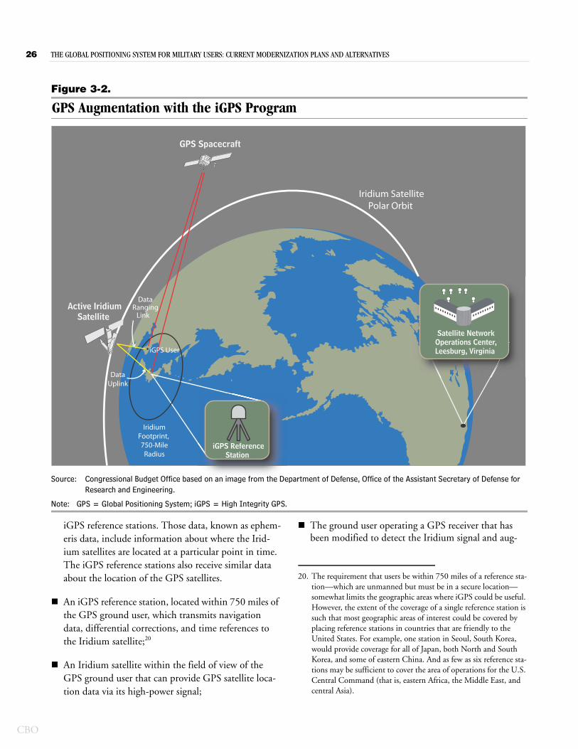
26 THE GLOBAL POSITIONING SYSTEM FOR MILITARY USERS: CURRENT MODERNIZATION PLANS AND ALTERNATIVES
CBO
Figure 3-2.
GPS Augmentation with the iGPS Program
Source: Congressional Budget Office based on an image from the Department of Defense, Office of the Assistant Secretary of Defense for Research and Engineering.
Note: GPS = Global Positioning System; iGPS = High Integrity GPS.
iGPS ReferenceStation
Satellite NetworkOperations Center,Leesburg, Virginia
Iridium SatellitePolar Orbit
IridiumFootprint, 750-Mile
Radius
Active IridiumSatellite
GPS Spacecraft
Data Uplink
DataRanging
Link
iGPS User
iGPS reference stations. Those data, known as ephem-eris data, include information about where the Irid-ium satellites are located at a particular point in time. The iGPS reference stations also receive similar data about the location of the GPS satellites.
An iGPS reference station, located within 750 miles of the GPS ground user, which transmits navigation data, differential corrections, and time references to the Iridium satellite;20
An Iridium satellite within the field of view of the GPS ground user that can provide GPS satellite loca-tion data via its high-power signal;
The ground user operating a GPS receiver that has been modified to detect the Iridium signal and aug-
20. The requirement that users be within 750 miles of a reference sta-tion—which are unmanned but must be in a secure location—somewhat limits the geographic areas where iGPS could be useful. However, the extent of the coverage of a single reference station is such that most geographic areas of interest could be covered by placing reference stations in countries that are friendly to the United States. For example, one station in Seoul, South Korea, would provide coverage for all of Japan, both North and South Korea, and some of eastern China. And as few as six reference sta-tions may be sufficient to cover the area of operations for the U.S. Central Command (that is, eastern Africa, the Middle East, and central Asia).
CHAPTER THREE THE GLOBAL POSITIONING SYSTEM FOR MILITARY USERS: CURRENT MODERNIZATION PLANS AND ALTERNATIVES 27
mented with a miniature INS module. For military users, the receiver would be a modified version of the DAGR, which would include the addition of an iGPS receiver, a closely integrated INS, and an iGPS antenna. (See Appendix B for a picture of the early-production version of the iGPS module.)
To operate, iGPS first establishes a one-way data link from the network of Iridium satellites to the iGPS ground user. The transmitted data provide initial geoloca-tion information to the iGPS user on the basis of the location of the nearest Iridium satellite. The satellite also transmits data to the iGPS user that aid in finding the best path to acquire the GPS signals. That information is then used to help the modified DAGR acquire and lock on to the GPS signals. Once that has happened, GPS tracking begins. Information transmitted by the Iridium satellite also helps the receiver to maintain that tracking in the presence of jamming by continuing to provide information about the location of GPS satellites in the receiver’s field of view.
Schedule and Cost for Fielding iGPSThe iGPS program has had several demonstrations of sig-nal acquisition and tracking by GPS receivers under jam-ming conditions. On the basis of those demonstrations, OASD(R&E) claims that iGPS capability will attain operational status during 2012. However, to provide that capability to military users, several components of iGPS—primarily the network of reference stations and modifications to Defense Advanced GPS Receivers—would have to be fielded. DoD has already purchased 55 reference stations—enough, according to OASD(R&E), to provide global coverage—and plans to begin deploying them worldwide in 2012.21 Although the reference sta-tions are unmanned, they must still be placed in secure locations and maintained. OASD(R&E) plans to develop the ability to cross-link the signals from the reference sta-tions in the future so as to reduce the overall number of stations required.
To receive the Iridium signal, DAGRs would need to be modified. Those modifications would require the addi-
21. This is based on OASD(R&E)’s expectation that operations will be possible with regional reference stations at distances of up to 750 miles from a receiver, despite the fact that most of the demon-strations of iGPS-enabled user equipment during development were carried out with reference stations located within 140 miles of the receiver.
tion of software and hardware, including an iGPS core module and an antenna to receive the Iridium signal and the GPS signals. OASD(R&E) had proposed that the modifications to DAGRs could be made when the upgrade to receive M-code signals occurred, but such an upgrade might not happen for 10 or more years, accord-ing to DoD’s current schedule. If iGPS capability is to be fielded in the next few years, then the necessary hardware needs to be produced and fielded before any planned M-code upgrades to current receivers are made. At present, OASD(R&E) estimates that approximately $3,000 would be needed to purchase one iGPS module and upgraded DAGR that could receive and process the Irid-ium signal. Because the current iGPS module is signifi-cantly larger than the DAGR itself, this option would limit the iGPS upgrades to the 200,000 or so DAGRs mounted in vehicles.
CBO estimates that the total investment cost to carry out Option 2 would be $18.9 billion from 2012 through 2025, a net savings of more than $3 billion compared with DoD’s plan. The acquisition costs to implement iGPS, which would pay for improvements to the GPS receivers, would be approximately $1 billion from 2012 through 2025. CBO’s estimate includes research and development funds needed to convert the prototype receivers into fieldable iGPS units as well as the cost to purchase 200,000 modified receivers so that they can take advantage of the signals from the Iridium satellites.
For iGPS to operate, the user must have access to the Iridium satellite network. At the end of September 2011, Iridium had more than 500,000 subscribers who pay var-ious rates for its communications service. The U.S. gov-ernment, including the Department of Defense, accounted for just under a quarter of Iridium’s revenues in calendar year 2010 from that service. For the iGPS program, payment for use would be on a per-minute basis, although the usage rate would not be based on a per-user fee. Rather, all iGPS users in a particular region of approximately 1,500 miles in diameter would receive the same iGPS signal and be covered by the blanket per-minute charge. Overall integration of iGPS would be managed through the Iridium ground-based controller. To achieve a center with continuous operation, OASD(R&E) estimates that a full-time staff of approxi-mately 10 people would be needed. Even though the ulti-mate objective is to have a fully automated system, per-sonnel would be needed to maintain and upgrade the system.
CBO
28 THE GLOBAL POSITIONING SYSTEM FOR MILITARY USERS: CURRENT MODERNIZATION PLANS AND ALTERNATIVES
CBO
CBO estimates that, starting in 2014, the costs for time on the Iridium satellite network would be between $5 million and $10 million per year, and the costs to operate and maintain the system would be $10 million per year. All told, such annual operating costs could total $240 million over the 2012–2025 period. However, in totaling the costs of this option and comparing the three options, CBO did not include the recurring operating costs.
Effect of Option 2 on GPS Performance in a Jamming EnvironmentDemonstrations of iGPS during the OASD(R&E) pro-gram have shown that it can reduce the effectiveness of jammers against the DAGR. Using an iGPS-augmented receiver, a user could lock on to and track a GPS signal in a jamming environment within approximately 120 sec-onds of turning on the receiver.22 Furthermore, according to data provided by the iGPS program office, integrating a DAGR with iGPS and an inertial navigation system would reduce the effectiveness of enemy jammers by 99 percent.23 That improvement in capability would mean that the range at which a 10-watt jammer could cause the iGPS-augmented DAGR to lose track of the signal would drop from 55 miles with current equipment to about 0.6 miles (see Figure 3-1).
Additional improvements in capability would follow when 18 IIIA satellites were put into orbit and when large numbers of M-code-capable receivers were fielded. By 2026, when CBO estimates that a full constellation of IIIA satellites would be in orbit and roughly half of mili-tary receivers would be M-code-capable (including those attached to iGPS modules), those enhancements would reduce the effective range of a 10-watt jammer even fur-ther—to 0.14 miles (see Figure 3-1 and Table 3-3). Thus, when all the improvements introduced by this option are in the field in sufficient number, the effective range of 10-watt enemy jammers should be reduced by 99.7 percent, from 55 miles to 0.14 miles.
22. For comparison, the average time from when the DAGR is first turned on in a nonjamming environment to when it is able to acquire the GPS signal and compute an initial position is less than 100 seconds.
23. That corresponds to an improvement in the receiver’s ability to maintain its track in the presence of jamming by a factor of 104, or 10,000.
Advantages and Disadvantages of Option 2Option 2 would have several advantages over DoD’s plan. One advantage is a greater improvement in the ability of GPS to operate in a jamming environment. Several other advantages stem from the capabilities of iGPS. First, iGPS can help navigate in locations where the direct line of sight to the GPS satellite is limited, such as in urban canyons and mountainous terrain. Because the Iridium satellites are operating at a lower orbit and thus move more quickly than GPS satellites across the sky, they are “seen” more often by modified GPS receivers. Second, because location data are received from both the Iridium and the GPS satellite systems, spoofing—intentionally transmitting false GPS data that appear authentic to the receiver—is much more difficult to achieve. Third, the iGPS program has the potential to provide greater accu-racy in determining the receiver’s position—on the order of about 8 inches—compared with the accuracy of approximately 10 feet achievable with today’s GPS receivers and satellites. That amount of improvement is comparable to the accuracy of 6 inches that might be achievable under DoD’s plan. Finally, the cost to carry out Option 2—$18.9 billion through 2025—would be more than $3 billion (or 15 percent) lower than that nec-essary to implement DoD’s plan.
Some considerations regarding iGPS could limit this option’s potential as an alternative to DoD’s plan, how-ever. Modifications to the DAGR to achieve iGPS capa-bility may add weight to the unit and require more power. The early-production iGPS module that is being used to augment the DAGR is 7 inches by 11 inches by 3.5 inches, weighs 4.5 pounds, and draws 25 watts (see Appendix B). Although the size, weight, and power requirements of the module could diminish appreciably in the next few years, the development efforts needed to achieve such reductions would have associated costs.
An additional drawback of Option 2 is that operation of iGPS requires the use of two separate satellite systems, GPS and Iridium, the latter of which is not owned by the U.S. government. Even though the Iridium satellite net-work has been operating for more than a decade and the next generation of satellites is scheduled to begin operat-ing in 2017, the company’s continued operation is not guaranteed. The company that launched the original Iridium constellation, Iridium LLC, went public in 1997 but declared bankruptcy two years later. As a result of the bankruptcy, there was discussion of destroying the Irid-ium satellite constellation by de-orbiting it. In 2001, the
CHAPTER THREE THE GLOBAL POSITIONING SYSTEM FOR MILITARY USERS: CURRENT MODERNIZATION PLANS AND ALTERNATIVES 29
company was acquired from bankruptcy, and that entity formed the foundation of the present Iridium Communi-cations Inc.
Shortly after Iridium emerged from bankruptcy, DoD announced a two-year $72 million contract for satellite phone service from Iridium (worth roughly $90 million in 2012 dollars), which at the time amounted to 40 per-cent of the cost to operate the Iridium network. At pres-ent, Iridium Communications Inc., with its core business of satellite phone communication, is profitable, and it has announced secured funding for its Iridium NEXT satel-lite constellation. If, however, Iridium runs into financial difficulty and stops operating its satellite network or is bought by a hostile party that could deny service to the U.S. government, iGPS would no longer function. Although DoD could avoid that situation by providing more financial support or buying out Iridium, doing so would increase the costs associated with this option.
Option 3. Improve the Capabilities of Military GPS Receivers and Enhance GPS Using the Iridium Satellite SystemThe third option would combine the improvements included in the two previous options. The resulting increase in the ability of GPS receivers to operate in a jamming environment would be significant, exceeding that recommended by the Defense Science Board in 2005 and reducing the effective range of enemy jammers by more than 99.9 percent.24 CBO estimates that this option would cost about $1.3 billion less than DoD’s plan. It would have the same disadvantages as Option 1 and Option 2, however, including additional weight and greater power requirements for receivers, the loss of the stronger and more accurate military signals transmitted by the canceled IIIB and IIIC satellites, and reliance on the commercial Iridium satellite system.
Description, Schedule, and CostOption 3 would make the improvements to the GPS included in both Option 1 and Option 2. Specifically, it would acquire and integrate improved antennas and iner-tial navigation systems into military GPS receivers, and it
24. The improvement from this option—roughly a factor of 5 million compared with current capability, or 10,000 times the improve-ment resulting from DoD’s plan—exceeds the 10,000 to 1 mil-lion–fold improvement recommended by the DSB in its October 2005 report.
would augment the current GPS receivers with informa-tion provided through the Iridium satellite network. This option would acquire sufficient hardware to ensure that all military GPS receivers from all services were integrated with improved antennas that could filter out jamming signals and with INSs to compensate for errors intro-duced by jammers. In addition, this option would fully integrate the Iridium satellite system with the GPS so that it could, when called upon, provide GPS users with additional data that would improve the performance of appropriately modified receivers in difficult environ-ments. To take advantage of the information transmitted by the Iridium satellites, this option would upgrade slightly more than 200,000 Army DAGRs so that they could receive and process the iGPS data; the remaining DAGRs would still benefit from improved antennas and inertial navigation systems.
The schedule for acquiring and fielding the hardware needed to carry out this option is the same as that out-lined in each of the previous options. If purchases of improved antennas and inertial navigation systems began in 2013, then half of the services’ receivers would be upgraded by 2018. Similarly, if upgrades to Army DAGRs to enable them to receive data from the Iridium satellites began in 2014, then roughly 100,000 units could be using iGPS data by 2018. The total cost for those improvements would be $3.0 billion from 2012 through 2025, CBO estimates, with almost all of the cost realized between 2012 and 2021 (see Table 3-2).25
Effect of Option 3 on GPS Performance in a Jamming EnvironmentThe combined effects of the various improvements and augmentations made to the Global Positioning System under Option 3 would greatly enhance the system’s abil-ity to perform in the presence of jammers. Excluding the contributions from M-code-capable receivers and stron-ger signals from IIIA satellites, the enhancements in this option—improved antennas, integrated INSs, and aug-mentation with iGPS—would reduce the effective range of enemy jammers by 99.8 percent.26 The effective range of a 10-watt jammer would decrease from 55 miles with
25. Those costs, and those in Table 3-2, do not include annual recur-ring costs of about $20 million needed to maintain the iGPS net-work after 2014.
26. That corresponds to a more than 300,000-fold improvement in the ability of receivers to operate in the presence of jammers.
CBO
30 THE GLOBAL POSITIONING SYSTEM FOR MILITARY USERS: CURRENT MODERNIZATION PLANS AND ALTERNATIVES
CBO
current DAGRs to slightly less than 0.1 mile. And because the hardware needed to make the improvements has already been developed, many receivers with enhanced performance could be in the field by 2018 (see Figure 3-1). Additional improvements in capability would be realized as IIIA satellites and M-code-capable receivers were fielded. All told, the effective range of enemy jammers could be reduced by 99.96 percent, exceeding the DSB’s recommendations for improve-ment.27 Ultimately, by 2026, when 28 IIIA satellites could be in orbit and large numbers of M-code-capable receivers fielded, the effective range of a jammer that today could cause a DAGR to lose track of a signal at 55 miles would be reduced to roughly 130 feet.
Advantages and Disadvantages of Option 3Of the three options that CBO considered, this one would yield the greatest improvement in GPS perfor-mance and do so at a lower cost than DoD’s plan. Com-pared with DoD’s plan, savings under Option 3 would total $1.3 billion (or slightly less than 6 percent) from 2012 through 2025. The improvement in performance in a jamming environment would be substantial relative to today’s capabilities, reducing the effective range of jam-mers to roughly 130 feet. As a result, jammers would be only 1 percent as effective under this option as they would be under DoD’s plan (see Table 3-3 and Figure 3-1).28 (Improvements in accuracy would be roughly equiv-
27. A military receiver’s capability would be improved by a factor of 5 million.
alent under both plans.) Another advantage of this option is that it would rely on several different methods to defeat an enemy’s jamming efforts. If one method should become unavailable—such as the signal from the Iridium satellites—then the antijamming capability provided by the upgraded GPS receivers would still yield improve-ments over today’s Global Positioning System and even that planned by DoD.
The disadvantages of adopting this option include those common to all of the options. Improvements to the receivers’ capabilities would require greater weight and power given current technology, which would make usage more difficult for personnel operating on foot. Although military suppliers are rapidly developing improved receiv-ers that are much smaller and require less power than the DAGR, it may be several years before such miniaturized models are widely available. In addition, canceling the IIIB and IIIC satellites forfeits planned improvements in signal strength that would be particularly beneficial in sit-uations where it was not feasible to increase the weight of and power available to the receivers. This option also shares with Option 2 the disadvantage of relying on the commercially owned Iridium satellite system. That reli-ance carries the risk that the service will not be there when needed or, alternatively, that DoD will have to bear most or all of the cost to support it.
28. The comparison is between an effective range for a 10-watt jam-mer of 0.025 miles under Option 3 and 2.5 miles under DoD’s plan.
A PP E N D IX
AHistory of the GPS Program
The Global Positioning System (GPS) program began development in 1974 and, even before it became fully operational in 1995, was providing navigation data to military users during the first Persian Gulf War in 1991. Since then, the system has become a mainstay for military navigation as both its satellites and receivers have become more capable and sophisticated. By 2011, the Department of Defense (DoD) had received a total of more than $24 billion to develop and purchase compo-nents of the GPS, including satellites, ground control systems, and receivers (see Table A-1).
1974 to 1999The first 25 years of the GPS program saw the rapid development and deployment of a system that has become worldwide in its applications. During that period, DoD developed and purchased the first GPS sat-ellites and receivers, investing $7.3 billion for satellites and associated ground control systems and $6.7 billion for receivers for all four branches of the armed services.1
GPS SatellitesAlthough the program officially began in 1974 (with the start of scientific and technical development), full-scale development did not begin until 1979. A production contract to build the first 28 satellites was signed in 1983, and the full GPS constellation of 24 satellites was declared fully operational in 1995. The cost to develop and purchase the initial GPS constellation of satellites (Blocks II and IIA), including 4 spare units, was $4.6 billion.
1. Because most of the funding for the development of ground con-trol systems through 2011 was included with the funding for the satellites, the Congressional Budget Office cannot easily identify spending devoted exclusively to the development of ground con-trol systems for that period.
Because all GPS satellites have lives of finite length, maintaining a constellation of fixed size requires the pur-chase and launch of replacement satellites. Two of the components that are necessary for the operation of GPS satellites and are likely to stop performing as required as the satellite ages are the electrical system—particularly the solar panels—and the atomic clocks. The ability of solar panels to produce electricity declines over time as the photoelectric cells are damaged by radiation and colli-sions with space particles. And, although the first GPS satellites each carried four atomic clocks as insurance against the failure of any one of them, each clock has a finite life and without a working clock a GPS satellite is worthless.2
Because many years elapse between when a satellite is ordered and when it is available to be launched, the Air Force, as DoD’s agent, purchases satellites long before it expects to need them to replace inoperable ones. The ini-tial GPS satellites were designed to last 7½ years in space. The first GPS satellite was launched in 1989, and in order to ensure that no satellites remained in orbit longer than 8 years, replacement satellites were planned to be launched beginning in 1997. After that, roughly 3 satel-lites were planned to be launched annually. In line with those planning factors, the Air Force began to purchase replacement satellites as soon as the first GPS satellite was launched. Between 1989 and 1999, the Air Force devel-oped and purchased 27 replacement satellites in two blocks at a total cost of $2.7 billion. The first 21 replace-ment satellites, known as Block IIR, were purchased from 1992 to 1996, and the first GPS IIR satellite was launched in 1997. A total of 6 satellites in the next block, IIF, were purchased in 1997 and 1998. Satellites in each block were slightly more capable than those in the pre-ceding block.
2. Atomic clocks have become more reliable since the program began, so modern GPS satellites carry only three of them.
CBO
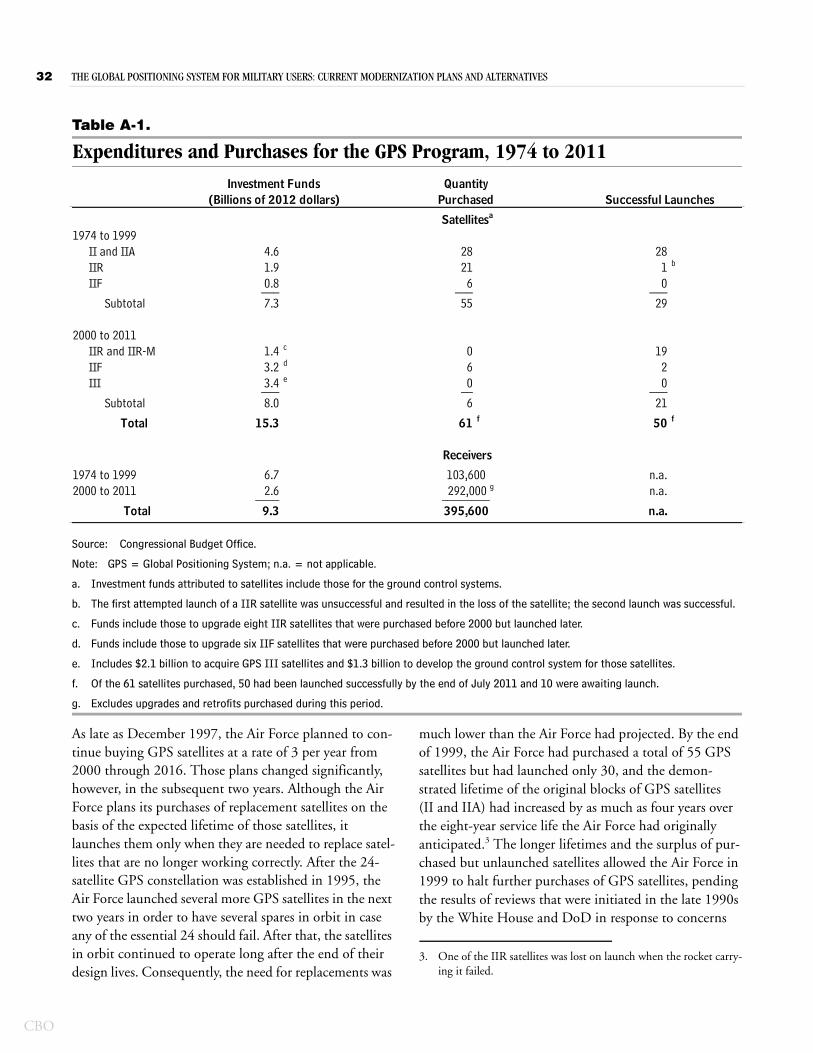
32 THE GLOBAL POSITIONING SYSTEM FOR MILITARY USERS: CURRENT MODERNIZATION PLANS AND ALTERNATIVES
CBO
Table A-1.
Expenditures and Purchases for the GPS Program, 1974 to 2011
Source: Congressional Budget Office.
Note: GPS = Global Positioning System; n.a. = not applicable.
a. Investment funds attributed to satellites include those for the ground control systems.
b. The first attempted launch of a IIR satellite was unsuccessful and resulted in the loss of the satellite; the second launch was successful.
c. Funds include those to upgrade eight IIR satellites that were purchased before 2000 but launched later.
d. Funds include those to upgrade six IIF satellites that were purchased before 2000 but launched later.
e. Includes $2.1 billion to acquire GPS III satellites and $1.3 billion to develop the ground control system for those satellites.
f. Of the 61 satellites purchased, 50 had been launched successfully by the end of July 2011 and 10 were awaiting launch.
g. Excludes upgrades and retrofits purchased during this period.
1974 to 1999II and IIA 4.6 28 28IIR 1.9 21 1 b
IIF 0.8 6 0___ ___ ___Subtotal 7.3 55 29
2000 to 2011IIR and IIR-M 1.4 c 0 19IIF 3.2 d 6 2III 3.4 e 0 0___ __ ___
Subtotal 8.0 6 21
Total 15.3 61 f 50 f
1974 to 1999 6.7 n.a.2000 to 2011 2.6 n.a.____
Total 9.3 n.a.
103,600 292,000 g
395,600________
Receivers
Satellitesa
Investment Funds(Billions of 2012 dollars)
QuantityPurchased Successful Launches
As late as December 1997, the Air Force planned to con-tinue buying GPS satellites at a rate of 3 per year from 2000 through 2016. Those plans changed significantly, however, in the subsequent two years. Although the Air Force plans its purchases of replacement satellites on the basis of the expected lifetime of those satellites, it launches them only when they are needed to replace satel-lites that are no longer working correctly. After the 24-satellite GPS constellation was established in 1995, the Air Force launched several more GPS satellites in the next two years in order to have several spares in orbit in case any of the essential 24 should fail. After that, the satellites in orbit continued to operate long after the end of their design lives. Consequently, the need for replacements was
much lower than the Air Force had projected. By the end of 1999, the Air Force had purchased a total of 55 GPS satellites but had launched only 30, and the demon-strated lifetime of the original blocks of GPS satellites (II and IIA) had increased by as much as four years over the eight-year service life the Air Force had originally anticipated.3 The longer lifetimes and the surplus of pur-chased but unlaunched satellites allowed the Air Force in 1999 to halt further purchases of GPS satellites, pending the results of reviews that were initiated in the late 1990s by the White House and DoD in response to concerns
3. One of the IIR satellites was lost on launch when the rocket carry-ing it failed.
APPENDIX A THE GLOBAL POSITIONING SYSTEM FOR MILITARY USERS: CURRENT MODERNIZATION PLANS AND ALTERNATIVES 33
about the safety of civilian aviation and the vulnerability of the GPS signal to interference. In response to those reviews, the GPS program was subsequently restructured.
GPS ReceiversDevelopment of GPS receivers also began in 1974, with efforts undertaken by all three military departments. A total of $2.7 billion was invested from 1974 to 1999 to develop an array of receivers that could be installed in air-planes, vehicles, and ships or carried by individuals. By 1999, another $4.0 billion had been invested in pur-chases of receivers, bringing the total to $6.7 billion. The roughly 103,600 receivers purchased with those funds were sufficient to equip all 435 of the Navy’s major ships and submarines, as well as more than two-thirds of the services’ aircraft and armored vehicles. The capabilities of GPS receivers were also part of DoD’s review of the pro-gram in the late 1990s and, as a consequence, additional large purchases of handheld receivers were suspended for several years after that.
Major Program Changes In response to changes in both civilian and military goals that resulted from several reviews of GPS performance conducted from 1997 through 1999, the GPS modern-ization program went through a major restructuring between December 1997 and February 2000.
Civilian ConcernsConcerns raised about the reliance of transportation systems—particularly aviation—on data from GPS led the Clinton Administration to initiate two changes to the civilian signals transmitted by GPS satellites.4 Then-Vice President Gore announced in March 1998 that, to make GPS more useful for civilian users worldwide, future GPS satellites would transmit a second civilian sig-nal at the same frequency as the second military signal.5 The addition of a signal at a second frequency would enable civilian receivers to make more effective correc-tions for the distorting effects of the Earth’s atmosphere on signals from GPS satellites. Less than a year later, the
4. White House Commission on Aviation Safety and Security, Final Report to President Clinton (February 12, 1997).
5. Office of the Vice President, “Vice President Gore Announces Enhancements to the Global Positioning System That Will Bene-fit Civilian Users Worldwide” (March 30, 1998).
White House announced that future GPS satellites would also be required to transmit a third civilian signal to meet critical “safety of life” issues associated with civil (nonmil-itary) aviation.6
Military ConcernsOn the basis of reviews conducted in the late 1990s, DoD decided to take several measures to make it harder for hostile forces to prevent military users from taking advantage of GPS signals in the future. Those measures included:
Enabling future GPS satellites to transmit new mili-tary signals (designated M-code) that would cover a wider frequency range and be separated in frequency from the civilian signals (see Figure A-1), and
Developing satellites capable of transmitting military signals at higher power.
The purpose of those measures was to make it more diffi-cult for hostile forces to use jammers capable of masking GPS signals from significant distances. The jammers work by broadcasting noise that covers the same fre-quency range as the signal from the satellite.7 To generate noise over a wider frequency spectrum, the enemy is forced to use more powerful jammers to attain the same effective range. Such jammers require larger and bulkier sources of electric power, which makes them larger and more expensive. (See Appendix B for descriptions and pictures of some typical jammers.) By transmitting a stronger and broader GPS signal from space, DoD hoped to force enemies intent on preventing reception of the GPS signal by U.S. forces to transmit stronger jamming signals, which would make them easier to locate and attack.
At the same time, DoD announced that it would improve the ability of military GPS receivers to take advantage of
6. Office of the Vice President, “Vice President Gore Announces New Global Positioning System Modernization Initiative” (Janu-ary 25, 1999). That third signal provides data for civil aviators at a frequency that is approved for use by civil aviation.
7. Although the jamming signal may not be structured in the same way as the signal from the satellite, it effectively masks the satel-lite’s signal because it is much stronger.
CBO
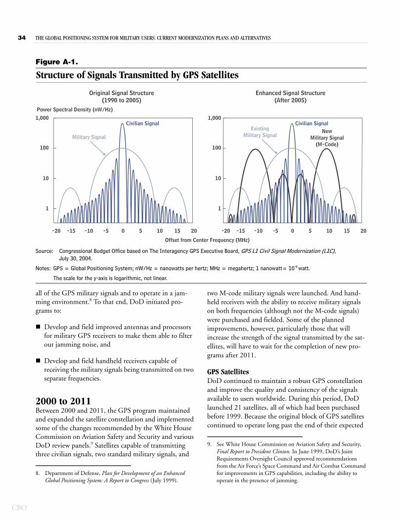
34 THE GLOBAL POSITIONING SYSTEM FOR MILITARY USERS: CURRENT MODERNIZATION PLANS AND ALTERNATIVES
CBO
Figure A-1.
Structure of Signals Transmitted by GPS Satellites
Source: Congressional Budget Office based on The Interagency GPS Executive Board, GPS L1 Civil Signal Modernization (L1C), July 30, 2004.
Notes: GPS = Global Positioning System; nW/Hz = nanowatts per hertz; MHz = megahertz; 1 nanowatt= 10-9 watt.
The scale for the y-axis is logarithmic, not linear.
1,000
100
10
1
-20 -15 -10 -5 0 205 10 15
Civilian SignalCivilian SignalExisting
Military SignalNew
Military Signal(M-Code)
Power Spectral Density (nW/Hz)
Offset from Center Frequency (MHz)
1,000
100
10
1
-20 -15 -10 -5 0 205 10 15
Original Signal Structure(1990 to 2005)
Enhanced Signal Structure(After 2005)
Military Signal
all of the GPS military signals and to operate in a jam-ming environment.8 To that end, DoD initiated pro-grams to:
Develop and field improved antennas and processors for military GPS receivers to make them able to filter out jamming noise, and
Develop and field handheld receivers capable of receiving the military signals being transmitted on two separate frequencies.
2000 to 2011Between 2000 and 2011, the GPS program maintained and expanded the satellite constellation and implemented some of the changes recommended by the White House Commission on Aviation Safety and Security and various DoD review panels.9 Satellites capable of transmitting three civilian signals, two standard military signals, and
8. Department of Defense, Plan for Development of an Enhanced Global Positioning System: A Report to Congress (July 1999).
two M-code military signals were launched. And hand-held receivers with the ability to receive military signals on both frequencies (although not the M-code signals) were purchased and fielded. Some of the planned improvements, however, particularly those that will increase the strength of the signal transmitted by the sat-ellites, will have to wait for the completion of new pro-grams after 2011.
GPS SatellitesDoD continued to maintain a robust GPS constellation and improve the quality and consistency of the signals available to users worldwide. During this period, DoD launched 21 satellites, all of which had been purchased before 1999. Because the original block of GPS satellites continued to operate long past the end of their expected
9. See White House Commission on Aviation Safety and Security, Final Report to President Clinton. In June 1999, DoD’s Joint Requirements Oversight Council approved recommendations from the Air Force’s Space Command and Air Combat Command for improvements in GPS capabilities, including the ability to operate in the presence of jamming.
APPENDIX A THE GLOBAL POSITIONING SYSTEM FOR MILITARY USERS: CURRENT MODERNIZATION PLANS AND ALTERNATIVES 35
lifetimes and even after replacements had been launched and were operating, the size of the constellation grew to include between 29 and 31 satellites by 2005. With so many satellites transmitting usable signals, the enlarged constellation meant that users often had more than four satellites in view, enabling them to calculate their position with increased accuracy.
To make at least some of the improvements deemed nec-essary in the late 1990s available as soon as possible, DoD and the Department of Transportation (DoT) decided to retrofit existing, but not yet launched, satellites with as many upgrades as feasible before they were needed to replace failing satellites.10 DoD had more than 20 unlaunched satellites on hand or on order by the end of 1999—in particular, IIR and IIF satellites that had been purchased in the 1990s but were not yet needed. In 2000, those circumstances led the Air Force to begin modifying IIR satellites by adding the ability to transmit a second civilian signal and the new M-code signals. (Upgraded IIR satellites were designated IIR-Ms.) The Air Force upgraded a total of 8 IIR satellites to the IIR-M configu-ration between 2000 and 2011. The Air Force also modi-fied the first 6 IIF satellites that had been purchased in 1997 and 1998 so that they could transmit a second and third civilian signal as well as the M-code signals and pur-chased an additional 6 IIF satellites in 2005 and 2006 with that upgraded capability. The cost to develop the capabilities needed to meet the revised requirements, to
10. DoD and DoT have been jointly responsible for developing plans for U.S. radionavigation, including GPS, since 1980. DoD is responsible for the overall development, acquisition, security, and continued modernization of GPS. The Secretary of Defense has designated the Air Force as the lead agency responsible for all aspects of acquisition, although other military departments and organizations within DoD are responsible for some aspects of developing receivers and for funding various parts of the program. DoT has the lead responsibility for coordinating civilian require-ments from all civilian departments and agencies. The Depart-ment of State leads negotiations with foreign governments and international organizations on GPS matters. In addition, the Coast Guard, which is now part of the Department of Homeland Security, operates the Navigation Center, which provides up-to-date GPS operations advisories, advisories to GPS users, and notices of potential interference with GPS reception from U.S. government testing, among other things. For additional informa-tion on the roles and responsibilities of the various agencies in matters pertaining to GPS, see Department of Defense, Depart-ment of Homeland Security, and Department of Transportation, 2010 Federal Radionavigation Plan, DOT-VNTSC-RITA-08-02/DoD-4650.05 (Springfield, Va.: National Technical Information Service), Chapter 2.
retrofit them to the IIR and IIF satellites already pur-chased, and to buy 6 new IIF satellites was $4.6 billion from 2000 to 2011—$1.4 billion for the IIR satellites and $3.2 billion for the IIF satellites (see Table A-1).
In addition, DoD began developing a new model of GPS satellite, known as GPS III, that would be able to trans-mit stronger M-code signals. Specifically, DoD invested $2.1 billion to develop and begin to purchase the new satellites and an additional $1.3 billion to develop a new ground control system to monitor and control the GPS III satellites and their signals, for a total cost of $3.4 bil-lion.11
GPS ReceiversDoD invested considerable funds from 2000 to 2011 to develop and buy improved GPS receivers. During that period, the Army purchased more than 260,000 improved handheld receivers—known as the Defense Advanced GPS Receiver (DAGR)—capable of receiving and decoding military signals on two frequencies. (See Appendix B for descriptions and pictures of the DAGR and its predecessor, the Precision Lightweight GPS Receiver.) That capability greatly improves the accuracy with which the receiver can compute position. The Air Force also invested funds to develop—but not purchase—receivers capable of decoding the military M-code signal as well as to improve the ability of its existing receivers to locate GPS signals in a jamming environment. All told, DoD invested $2.6 billion during that period to improve its receivers (see Table A-1).
Status at the End of 2011By the end of 2006, DoD had purchased several satellites with the improved capabilities that had been identified as critical, including 20 satellites capable of transmitting the new M-code signals. Only a limited amount of that capa-bility had actually made it into the field by the end of 2011, however. The first IIR-M satellite was launched in September 2005, and the last of 8 was launched in August 2009. The first 2 IIF satellites were launched in May 2010 and July 2011, but only 1 was fully opera-tional on October 1, 2011. Therefore, by the end of
11. The control system for the GPS III satellites is being developed under a contract separate from that for the development of the satellites. Therefore, its costs are separate from those of the satel-lites themselves and, unlike those for the ground control system for the GPS II satellites, easily identifiable.
CBO
36 THE GLOBAL POSITIONING SYSTEM FOR MILITARY USERS: CURRENT MODERNIZATION PLANS AND ALTERNATIVES
CBO
2011, only 10 GPS satellites capable of transmitting the harder-to-jam M-code signal were in orbit, and only 8 were fully operational, far short of the 18 needed to pro-vide continuous worldwide coverage.12 In addition, the upgrades to the ground control system needed to monitor and control the M-code signal were not complete by the end of 2011, and, according to DoD, will not be avail-able for several more years. Finally, the other satellite enhancements needed to meet the new military goals—
12. One IIR-M satellite, launched in March 2009, was never declared fully operational and was ultimately decommissioned in May 2011.
primarily the ability to transmit M-code signals at higher power—were deferred to be installed on a future model GPS satellite as part of the GPS III program.
Some of the improvements to GPS receivers that DoD had viewed as necessary in its report to the Congress in 1999 have been made. In particular, more than 250,000 Defense Advanced GPS Receivers were purchased from 2000 through 2010, and funds for an additional 13,000 receivers have been requested. However, no receivers capable of receiving and deciphering the M-code signals have been fielded, even though several satellites are in orbit transmitting that signal.
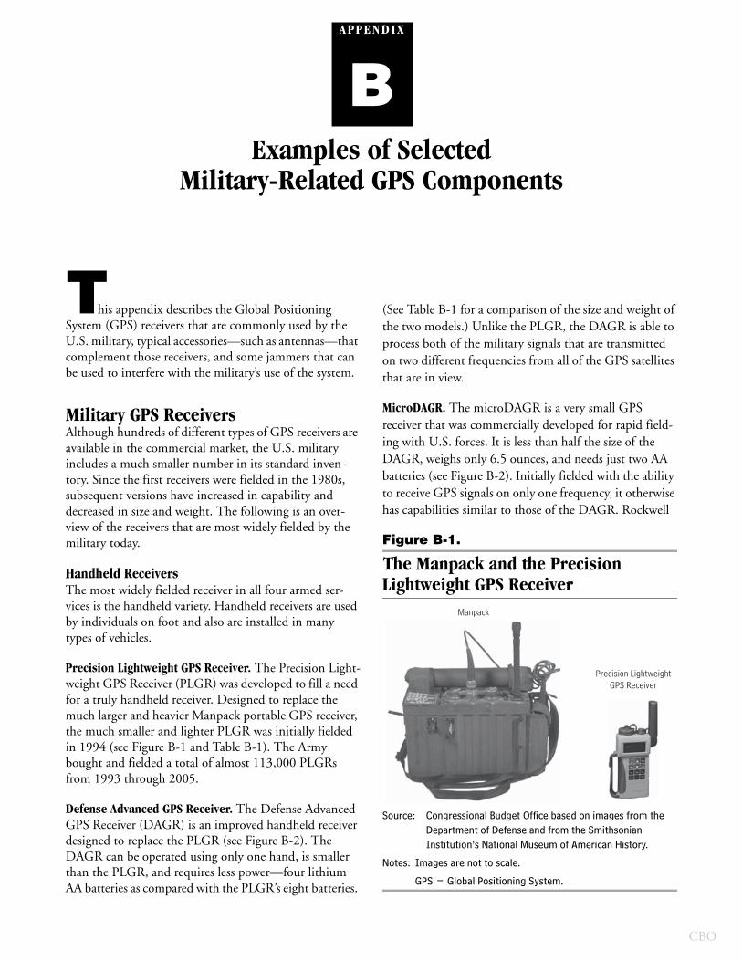
A PP E N D IX
BExamples of Selected
Military-Related GPS Components
This appendix describes the Global Positioning System (GPS) receivers that are commonly used by the U.S. military, typical accessories—such as antennas—that complement those receivers, and some jammers that can be used to interfere with the military’s use of the system.
Military GPS Receivers Although hundreds of different types of GPS receivers are available in the commercial market, the U.S. military includes a much smaller number in its standard inven-tory. Since the first receivers were fielded in the 1980s, subsequent versions have increased in capability and decreased in size and weight. The following is an over-view of the receivers that are most widely fielded by the military today.
Handheld ReceiversThe most widely fielded receiver in all four armed ser-vices is the handheld variety. Handheld receivers are used by individuals on foot and also are installed in many types of vehicles.
Precision Lightweight GPS Receiver. The Precision Light-weight GPS Receiver (PLGR) was developed to fill a need for a truly handheld receiver. Designed to replace the much larger and heavier Manpack portable GPS receiver, the much smaller and lighter PLGR was initially fielded in 1994 (see Figure B-1 and Table B-1). The Army bought and fielded a total of almost 113,000 PLGRs from 1993 through 2005.
Defense Advanced GPS Receiver. The Defense Advanced GPS Receiver (DAGR) is an improved handheld receiver designed to replace the PLGR (see Figure B-2). The DAGR can be operated using only one hand, is smaller than the PLGR, and requires less power—four lithium AA batteries as compared with the PLGR’s eight batteries.
(See Table B-1 for a comparison of the size and weight of the two models.) Unlike the PLGR, the DAGR is able to process both of the military signals that are transmitted on two different frequencies from all of the GPS satellites that are in view.
MicroDAGR. The microDAGR is a very small GPS receiver that was commercially developed for rapid field-ing with U.S. forces. It is less than half the size of the DAGR, weighs only 6.5 ounces, and needs just two AA batteries (see Figure B-2). Initially fielded with the ability to receive GPS signals on only one frequency, it otherwise has capabilities similar to those of the DAGR. Rockwell
Figure B-1.
The Manpack and the Precision Lightweight GPS Receiver
Source: Congressional Budget Office based on images from the Department of Defense and from the Smithsonian Institution’s National Museum of American History.
Notes: Images are not to scale.
GPS = Global Positioning System.
Manpack
Precision LightweightGPS Receiver
CBO
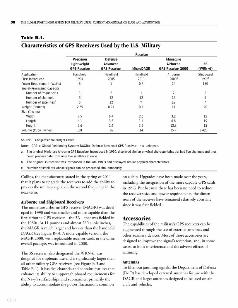
38 THE GLOBAL POSITIONING SYSTEM FOR MILITARY USERS: CURRENT MODERNIZATION PLANS AND ALTERNATIVES
CBO
Table B-1.
Characteristics of GPS Receivers Used by the U.S. Military
Source: Congressional Budget Office.
Note: GPS = Global Positioning System; DAGR= Defense Advanced GPS Receiver; * = unknown.
a. The original Miniature Airborne GPS Receiver, introduced in 1990, displayed similar physical characteristics but had five channels and thus could process data from only five satellites at once.
b. The original 3S receiver was introduced in the late 1980s and displayed similar physical characteristics.
c. Number of satellites whose signals can be processed simultaneously.
ApplicationFirst IntroducedPower Requirement (Watts)Signal-Processing Capacity
Number of frequenciesNumber of channelsNumber of satellitesc
Weight (Pounds)Size (Inches)
WidthLengthHeight
Volume (Cubic inches) 3,420
2.75*
70
121915
2.61.43.914
11
3.26.8
12.8279
0.4
9.54.12.6101
1
212
0.94
6.43.51.636
5
155 12
2011Airborne
2000a
*
Shipboard1996b
0.7
112
24
212
150
25
ReceiverPrecision Defense Miniature
(WRN-6) GPS ReceiverLightweight
GPS ReceiverAdvanced
MicroDAGRAirborne
GPS Receiver 20003S
Handheld1994
Handheld2005
Handheld
12
Collins, the manufacturer, stated in the spring of 2011 that it plans to upgrade the receivers to add the ability to process the military signal on the second frequency in the near term.
Airborne and Shipboard Receivers The miniature airborne GPS receiver (MAGR) was devel-oped in 1990 and was smaller and more capable than the first airborne GPS receiver—the 3A—that was fielded in the 1980s. At 11 pounds and almost 280 cubic inches, the MAGR is much larger and heavier than the handheld DAGR (see Figure B-3). A more capable version, the MAGR 2000, with replaceable receiver cards in the same overall package, was introduced in 2000.
The 3S receiver, also designated the WRN-6, was designed for shipboard use and is significantly larger than all other military GPS receivers (see Figure B-3 and Table B-1). It has five channels and contains features that enhance its ability to support shipboard requirements for the Navy’s surface ships and submarines, primarily the ability to accommodate the power fluctuations common
on a ship. Upgrades have been made over the years, including the integration of the more capable GPS cards in 1996. But because there has been no need to reduce the receiver’s size and power requirements, the dimen-sions of the receiver have remained relatively constant since it was first fielded.
Accessories The capabilities of the military’s GPS receivers can be augmented through the use of external antennas and other auxiliary devices. Most of those accessories are designed to improve the signal’s reception, and, in some cases, to limit interference and the adverse effects of jamming.
AntennasTo filter out jamming signals, the Department of Defense (DoD) has developed external antennas for use with the DAGR and larger antennas designed to be used on air-craft and vehicles.
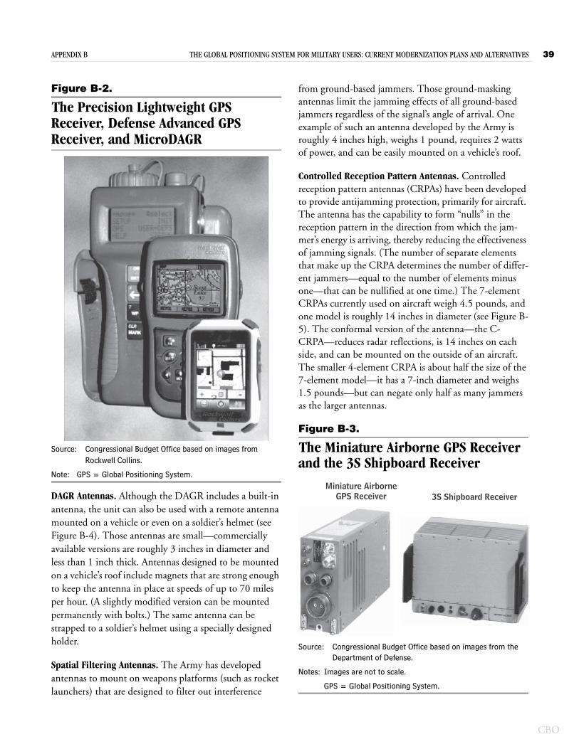
APPENDIX B THE GLOBAL POSITIONING SYSTEM FOR MILITARY USERS: CURRENT MODERNIZATION PLANS AND ALTERNATIVES 39
Figure B-2.
The Precision Lightweight GPS Receiver, Defense Advanced GPS Receiver, and MicroDAGR
Source: Congressional Budget Office based on images from Rockwell Collins.
Note: GPS = Global Positioning System.
DAGR Antennas. Although the DAGR includes a built-in antenna, the unit can also be used with a remote antenna mounted on a vehicle or even on a soldier’s helmet (see Figure B-4). Those antennas are small—commercially available versions are roughly 3 inches in diameter and less than 1 inch thick. Antennas designed to be mounted on a vehicle’s roof include magnets that are strong enough to keep the antenna in place at speeds of up to 70 miles per hour. (A slightly modified version can be mounted permanently with bolts.) The same antenna can be strapped to a soldier’s helmet using a specially designed holder.
Spatial Filtering Antennas. The Army has developed antennas to mount on weapons platforms (such as rocket launchers) that are designed to filter out interference
from ground-based jammers. Those ground-masking antennas limit the jamming effects of all ground-based jammers regardless of the signal’s angle of arrival. One example of such an antenna developed by the Army is roughly 4 inches high, weighs 1 pound, requires 2 watts of power, and can be easily mounted on a vehicle’s roof.
Controlled Reception Pattern Antennas. Controlled reception pattern antennas (CRPAs) have been developed to provide antijamming protection, primarily for aircraft. The antenna has the capability to form “nulls” in the reception pattern in the direction from which the jam-mer’s energy is arriving, thereby reducing the effectiveness of jamming signals. (The number of separate elements that make up the CRPA determines the number of differ-ent jammers—equal to the number of elements minus one—that can be nullified at one time.) The 7-element CRPAs currently used on aircraft weigh 4.5 pounds, and one model is roughly 14 inches in diameter (see Figure B-5). The conformal version of the antenna—the C-CRPA—reduces radar reflections, is 14 inches on each side, and can be mounted on the outside of an aircraft. The smaller 4-element CRPA is about half the size of the 7-element model—it has a 7-inch diameter and weighs 1.5 pounds—but can negate only half as many jammers as the larger antennas.
Figure B-3.
The Miniature Airborne GPS Receiver and the 3S Shipboard Receiver
Source: Congressional Budget Office based on images from the Department of Defense.
Notes: Images are not to scale.
GPS = Global Positioning System.
Miniature Airborne GPS Receiver 3S Shipboard Receiver
CBO
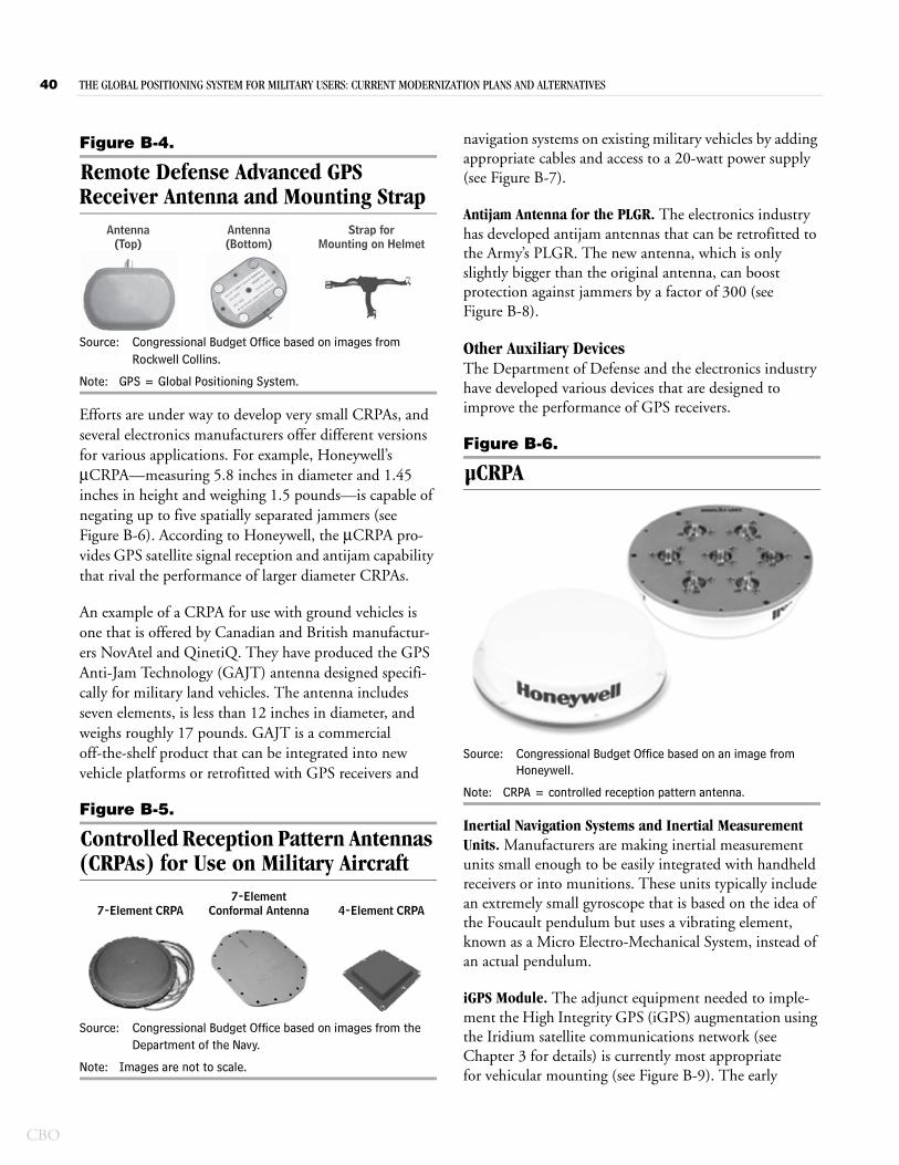
40 THE GLOBAL POSITIONING SYSTEM FOR MILITARY USERS: CURRENT MODERNIZATION PLANS AND ALTERNATIVES
CBO
Figure B-4.
Remote Defense Advanced GPS Receiver Antenna and Mounting Strap
Source: Congressional Budget Office based on images from Rockwell Collins.
Note: GPS = Global Positioning System.
Efforts are under way to develop very small CRPAs, and several electronics manufacturers offer different versions for various applications. For example, Honeywell’s μCRPA—measuring 5.8 inches in diameter and 1.45 inches in height and weighing 1.5 pounds—is capable of negating up to five spatially separated jammers (see Figure B-6). According to Honeywell, the μCRPA pro-vides GPS satellite signal reception and antijam capability that rival the performance of larger diameter CRPAs.
An example of a CRPA for use with ground vehicles is one that is offered by Canadian and British manufactur-ers NovAtel and QinetiQ. They have produced the GPS Anti-Jam Technology (GAJT) antenna designed specifi-cally for military land vehicles. The antenna includes seven elements, is less than 12 inches in diameter, and weighs roughly 17 pounds. GAJT is a commercial off-the-shelf product that can be integrated into new vehicle platforms or retrofitted with GPS receivers and
Figure B-5.
Controlled Reception Pattern Antennas (CRPAs) for Use on Military Aircraft
Source: Congressional Budget Office based on images from the Department of the Navy.
Note: Images are not to scale.
Antenna(Top)
Antenna(Bottom)
Strap forMounting on Helmet
7-Element CRPA7-Element
Conformal Antenna 4-Element CRPA
navigation systems on existing military vehicles by adding appropriate cables and access to a 20-watt power supply (see Figure B-7).
Antijam Antenna for the PLGR. The electronics industry has developed antijam antennas that can be retrofitted to the Army’s PLGR. The new antenna, which is only slightly bigger than the original antenna, can boost protection against jammers by a factor of 300 (see Figure B-8).
Other Auxiliary DevicesThe Department of Defense and the electronics industry have developed various devices that are designed to improve the performance of GPS receivers.
Figure B-6.
µCRPA
Source: Congressional Budget Office based on an image from Honeywell.
Note: CRPA = controlled reception pattern antenna.
Inertial Navigation Systems and Inertial Measurement Units. Manufacturers are making inertial measurement units small enough to be easily integrated with handheld receivers or into munitions. These units typically include an extremely small gyroscope that is based on the idea of the Foucault pendulum but uses a vibrating element, known as a Micro Electro-Mechanical System, instead of an actual pendulum.
iGPS Module. The adjunct equipment needed to imple-ment the High Integrity GPS (iGPS) augmentation using the Iridium satellite communications network (see Chapter 3 for details) is currently most appropriate for vehicular mounting (see Figure B-9). The early
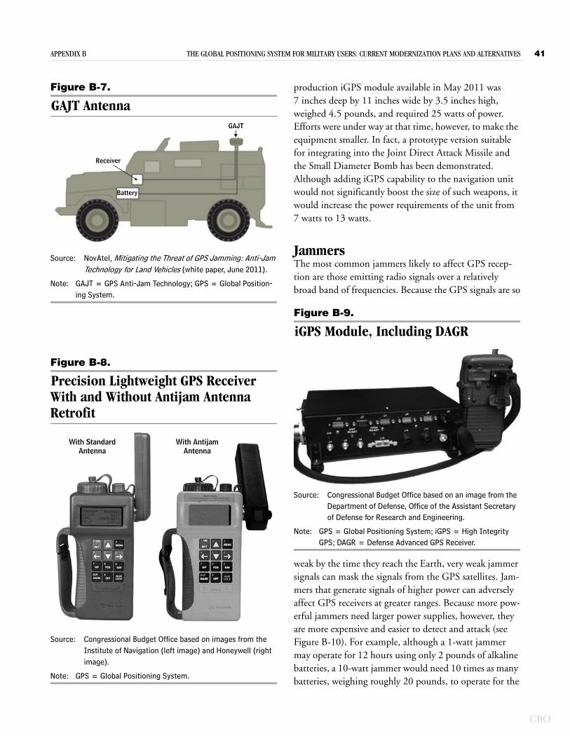
APPENDIX B THE GLOBAL POSITIONING SYSTEM FOR MILITARY USERS: CURRENT MODERNIZATION PLANS AND ALTERNATIVES 41
Figure B-7.
GAJT Antenna
Source: NovAtel, Mitigating the Threat of GPS Jamming: Anti-Jam Technology for Land Vehicles (white paper, June 2011).
Note: GAJT = GPS Anti-Jam Technology; GPS = Global Position-ing System.
Figure B-8.
Precision Lightweight GPS Receiver With and Without Antijam Antenna Retrofit
Source: Congressional Budget Office based on images from the Institute of Navigation (left image) and Honeywell (right image).
Note: GPS = Global Positioning System.
Receiver
Battery
GAJT
With StandardAntenna
With AntijamAntenna
production iGPS module available in May 2011 was 7 inches deep by 11 inches wide by 3.5 inches high, weighed 4.5 pounds, and required 25 watts of power. Efforts were under way at that time, however, to make the equipment smaller. In fact, a prototype version suitable for integrating into the Joint Direct Attack Missile and the Small Diameter Bomb has been demonstrated. Although adding iGPS capability to the navigation unit would not significantly boost the size of such weapons, it would increase the power requirements of the unit from 7 watts to 13 watts.
JammersThe most common jammers likely to affect GPS recep-tion are those emitting radio signals over a relatively broad band of frequencies. Because the GPS signals are so
Figure B-9.
iGPS Module, Including DAGR
Source: Congressional Budget Office based on an image from the Department of Defense, Office of the Assistant Secretary of Defense for Research and Engineering.
Note: GPS = Global Positioning System; iGPS = High Integrity GPS; DAGR = Defense Advanced GPS Receiver.
weak by the time they reach the Earth, very weak jammer signals can mask the signals from the GPS satellites. Jam-mers that generate signals of higher power can adversely affect GPS receivers at greater ranges. Because more pow-erful jammers need larger power supplies, however, they are more expensive and easier to detect and attack (see Figure B-10). For example, although a 1-watt jammer may operate for 12 hours using only 2 pounds of alkaline batteries, a 10-watt jammer would need 10 times as many batteries, weighing roughly 20 pounds, to operate for the
CBO
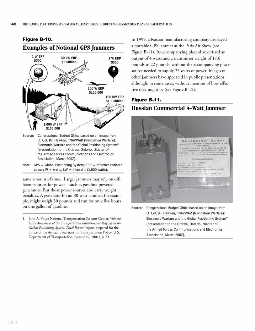
42 THE GLOBAL POSITIONING SYSTEM FOR MILITARY USERS: CURRENT MODERNIZATION PLANS AND ALTERNATIVES
CBO
Figure B-10.
Examples of Notional GPS Jammers
Source: Congressional Budget Office based on an image from Lt. Col. Bill Hawken, “NAVWAR (Navigation Warfare): Electronic Warfare and the Global Positioning System” (presentation to the Ottawa, Ontario, chapter of the Armed Forces Communications and Electronics Association, March 2007).
Note: GPS = Global Positioning System; ERP = effective radiated power; W = watts, kW = kilowatts (1,000 watts).
same amount of time.1 Larger jammers may rely on dif-ferent sources for power—such as gasoline-powered generators. But those power sources also carry weight penalties. A generator for an 80-watt jammer, for exam-ple, might weigh 30 pounds and run for only five hours on one gallon of gasoline.
1. John A. Volpe National Transportation Systems Center, Vulnera-bility Assessment of the Transportation Infrastructure Relying on the Global Positioning System: Final Report (report prepared for the Office of the Assistant Secretary for Transportation Policy, U.S. Department of Transportation, August 29, 2001), p. 31.
50 kW ERP$5 Million
1 W ERP$500
3"
100 W ERP$100,000
1 W ERP$500
1,000 W ERP$100,000
100 kW ERP$1.5 Million
In 1999, a Russian manufacturing company displayed a portable GPS jammer at the Paris Air Show (see Figure B-11). Its accompanying placard advertised an output of 4 watts and a transmitter weight of 17.6 pounds to 22 pounds, without the accompanying power source needed to supply 25 watts of power. Images of other jammers have appeared in public presentations, although, in some cases, without mention of how effec-tive they might be (see Figure B-12).
Figure B-11.
Russian Commercial 4-Watt Jammer
Source: Congressional Budget Office based on an image from Lt. Col. Bill Hawken, “NAVWAR (Navigation Warfare): Electronic Warfare and the Global Positioning System” (presentation to the Ottawa, Ontario, chapter of the Armed Forces Communications and Electronics Association, March 2007).
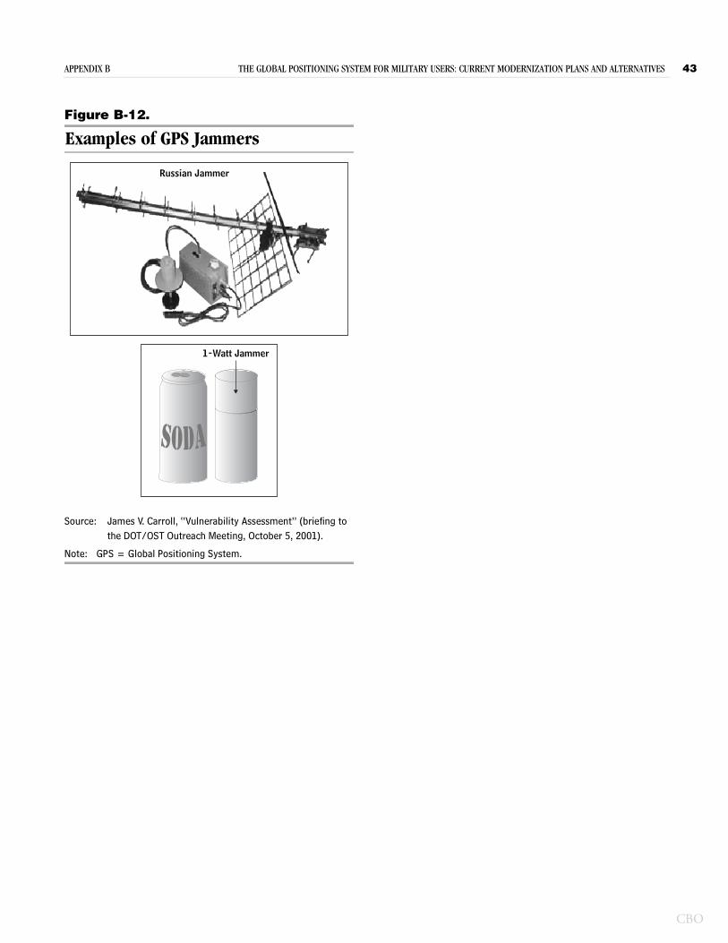
APPENDIX B THE GLOBAL POSITIONING SYSTEM FOR MILITARY USERS: CURRENT MODERNIZATION PLANS AND ALTERNATIVES 43
Figure B-12.
Examples of GPS Jammers
Source: James V. Carroll, “Vulnerability Assessment” (briefing to the DOT/OST Outreach Meeting, October 5, 2001).
Note: GPS = Global Positioning System.
Russian Jammer
1-Watt Jammer
CBO