Embed Size (px)
Citation preview

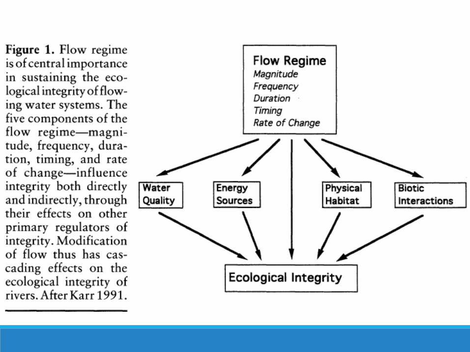
The Natural Flow Regime: A paradigm for river conservation
and restoration N. LEROY POFF, J. DAVID ALLAN, MARK B. BAIN, JAMES R. KARR, KAREN L. PRESTEGAARD, BRIAN D. RICHTER, RICHARD E. SPARKS, AND JULIE C. STROMBERG

• Take note of the different scales of variability (seasonal and inter-annual)
• Some rivers are naturally more flashy
• The dominant flow components and sources of runoff can be seen • CO- spring pulse
caused by snow melt • GA- rain fed, highly
variable • MI- spring fed? • OR- rain fed, but more
consistent

Runoff components • Overland flow • Shallow subsurface stormflow • Saturated overland flow • Groundwater flow Storm peaks in hydrograph = overland + shallow subsurface flows Baseflow = deeper groundwater pathways
Urban & agricultural LUs = surface flow • impermeable surfaces, vegetation cover, drainage systems • depth, water table, baseflow Levees & flood walls on main channel = loss of floodplain habitats • Floodplain habitats
• Side-channels, Wetlands, Episodically flooded lowlands Dams = downstream movement of water, Δ flow regime • Effects depend on type: run-of-river or storage


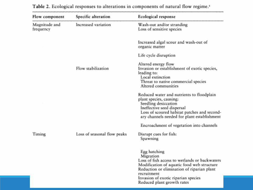
E) Rare large floods (centennial) Uproot mature riparian trees = creates high quality CWD habitat
D) Larger floods (decadal) Inundate aggraded floodplain terraces = prevent channel encroachment of later successional species)
C) Intermediate-size floods (annual to decadal) Inundate low-lying floodplains Deposit entrained sediment = pioneer species establishment Import organic matter into channel Help maintain form of active stream channel
B) Small floods (frequent, annual) Transport fine sediments = high benthic productivity maintained Create fish spawning habitat
A) Water tables Sustain riparian vegetation & delineate in-channel baseflow habitat Maintained by groundwater inflow & flood recharge


Poff, N.L., B.D. Richter, A.H. Arthington, S.E. Bunn, R.J. Naiman, E. Kendy, M. Acreman, C. Apse, B.P. Bledso, M.C. Freeman, J. Henriksen, R.B. Jacobson, J.G. Kennen, D.M. Merritt, J.H. O'Keeffe, J.D. Olden, K. Rogers, R.E. Tharme and A. Warner (2010). "The ecological limits of hydrologic alteration (ELOHA): a new framework for developing regional environmental flow standards." Freshwater Biology 55: 147-170.
Ecological Limits of Hydrologic Alteration (ELOHA)

SRBC and USACE (2012). Susquehanna River Basin Ecological Flow Management Study Phase I. Section 729 Watershed Assessment, Susquehanna River Basin Commission & U.S. Army Corps of Engineers.

Restoring native fish assemblages to a regulated California stream using the natural flow regime concept
JOSEPH KIERNAN, PETER MOYLE, PATRICK CRAIN

Study Area

Putah Creek Accord 1989: Putah Creek goes dry
1996: Court order to increase minimum release by 50%
2000: Signing of Putah Creek Accord
1) Native fish flows
2) Anadromous fish flows
3) Schedule for extended droughts
4) New forum for management
5) Restoration and monitoring funds
6) Landowner water rights

Release Schedule Feb 15-March 31: Three day pulse, followed by a month-long release of elevated flows
Fall: Supplemental pulse flows
November or December: Five day pulse for adult chinook migration
Year-round: Permanent stream flow from Putah Diversion Dam to I-80 at all times, even during drought years

Objectives Determine whether the more natural streamflow patterns put in place by the Putah Creek Accord would:
1) Reestablish native fishes
2) Reduce alien fish

IHA Model 1) Flow magnitude
2) Magnitude and duration of annual extreme conditions
3) Timing of annual extreme conditions
4) Frequency and duration of high and low pulses
5) Rate and frequency of changes

Streamflow Variations
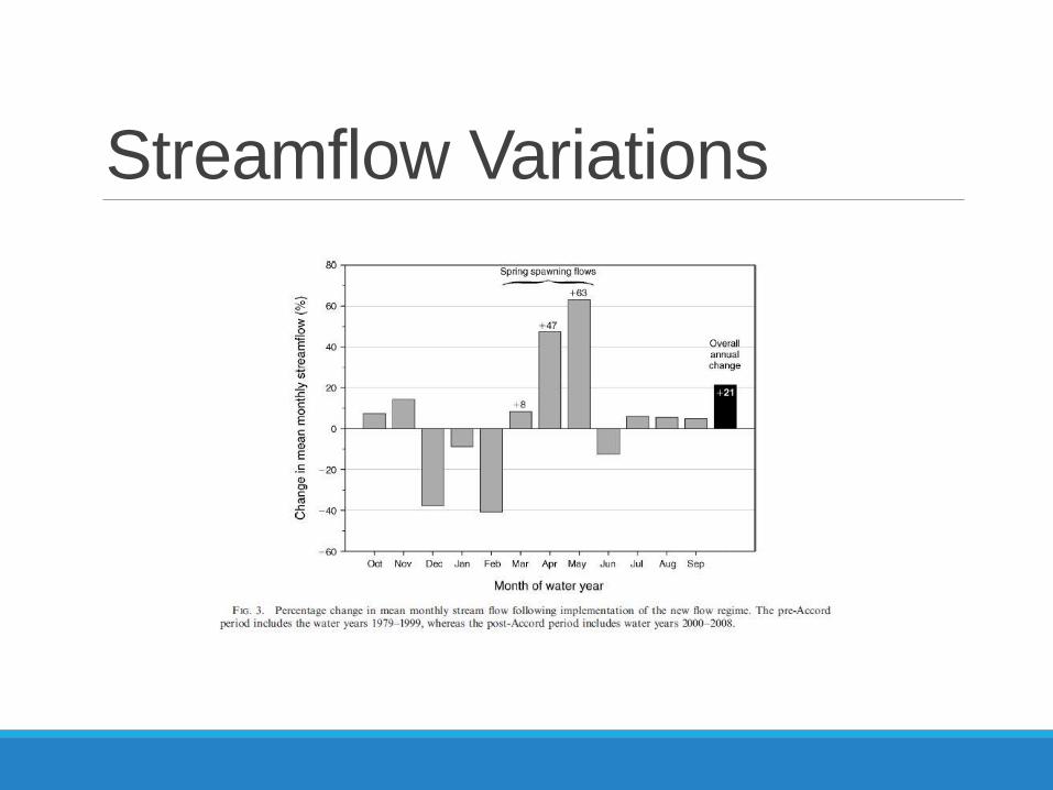
Streamflow Variations

Fish Assemblages
Questions Why no data collected on chemicals/food sources/geomorphology?
Is this an effective way to satisfy landowner and wildlife needs?