Embed Size (px)
Citation preview

Pergamon
PII: S1040-6182(97)00032-3
Quaternary International, Vol. 43144, pp. 161-172, 1997. Copyright 0 1997 INQUA/ Elsevier Science Ltd
Printed in Great Britain. All rights reserved. 104%6182/97 $32.00
THE ‘NATURAL’ VEGETATION OF THE MEXICAN BAJiO: ARCHIVAL DOCUMENTATION OF A 16TH-CENTURY SAVANNA ENVIRONMENT
Karl W. Butzer* and Elisabeth K. Butzert *Department of Geography, The University of Texas at Austin, Austin, TX 78712, U.S.A.
tlnstitute of Latin American Studies, The University of Texas at Austin, Austin, 7x 78712, U.S.A.
Neo-ecologists make assumptions about a ‘natural’ or potential vegetation when they argue whether a particular landscape is in secondary and degraded condition. Similarly, paleoecologists attempt to infer a three-dimensional biotic mosaic from a core taken in a low-lying wetland. Yet with millennia of human disturbance, climatic fluctuation, biotic response to long-term climatic trends or catastrophic ‘events’, and co- evolution between Holocene vegetation and human land-use, ‘natural ecosystems’ have not been in equilibrium. While past vegetation changes can be traced, efforts to reconstmct potential vegetation are probably unrealistic. This paper assembles 16th century landscape descriptions of the Bajio of Central Mexico from archival repositories, to characterise the landscape at the time of Spanish intrusion. Attention is focused on five major landscape elements: (1) Riparian woodlands of mesquite, bald cypress and willow, with reed stands; (2) Level, vertisolic plains, with a low-tree savanna (mesquite-acacia-grass); (3) Steeper Piedmont plains with stony substrates, prokjably favoring xeric, thorn-bush associations; (4) Rough uplands with a mix of mesquite-acacia woodland, scrub oak, and thorn bush; and (5) Mountains dominated by live and deciduous oak woodlands. The biotic mosaic of the 16th century appears similar to that of the modem spontaneous vegetation in physiognomic terms, despite changes in structure. Areas of older indigenous settlement were affected by local vegetation disturbance, with partial deforestation near lakes Cuitzeo and Yuriria. While Spanish-Criollo intrusion (154&1640) brought new, potentially destructive land- use methods, there is no evidence of additional landscape degradation in the Bajio until well into the 18th century. Dramatic changes in hydrology and riparian vegetation are quite recent. Archival documentation provides a complementary methodology to re-examine the interplay of edaphic variation, climate and cumulative land-use in understanding contemporary vegetation, and it can assist in converting proxy data into a three-dimensional landscape. 0 1997 INQUA/ Elsevier Science Ltd
THE PROBLEM OF ‘NATURAL’ ECOSYSTEMS
A fundamental problem for palynological interpreta- tion and other paleoenvironmental reconstruction in Mexico is the matter of ‘natural’ vegetation. To what degree is the physiognomic vegetation of non-agricultural lands an accurate reflection of ecological conditions prior to significant human disturbance? Is the floristic compo- sition of a tract of ‘spontaneous’ vegetation, including its structure of dominants and subdominants, representative of its pre-agricultural counterparts?
These once appeared to be reasonable questions, for which partial answer might be provided. More recent research suggests that such questions are simplistic. There is, for example, increasing evidence that pre-agricultural land use in Mesolithic Britain included deforestation, heath formation, and local soil deterioration. Even in marginal environments such as the Scottish Highlands, human ‘disturbance’ across the last 5000 years has been variable but sustained (Edwards, 1979; Simmons and Innes, 1996). The picture is little different in the Mediterranean Basin. In Greece, intense but short and localised episodes of deforestation and soil erosion are dated ca. 6500-3600 BP (5500-2000 B.C.), with subse- quent conversion of the coastal hill country to a cultural landscape of terraces, orchards, and cultivated fields (Van Andel ef al., 1990; Butzer, 1996). As the record of human impact is pushed further back, the notion of a pre- disturbance environment, relevant to the present, is
complicated by climatic signals a.nd incomplete, post- Pleistocene species migration and forest succession. Holocene vegetation and human land-use co-evolved (Birks et al., 1988), so that even the rank order of characteristic species cannot be predicted for a hypothe- tical ‘natural ecosystem’.
Such well-studied examples from the Old World suggest that caution is equally appropriate in regard to the New, where some idealists have been prone to believe that the environment was ‘pristine’ prior to 1492 (Butzer, 1992a). The seemingly primeval woodlands of the eastern United States in 1750 were the open and ecologically simplified landscapes of 1500, prior to indigenous population collapse (Denevan, 1992). Furthermore, nat- ural fires, storm catastrophes, and the selective effect of plant diseases have changed the rank order of dominant and subdominant forest species across millennia, whereas human ‘protection’ favors patterns of forest composition and structure different from any of those recorded palaeoecologically (Schoonmaker and Foster, 1991).
In Mesoamerica the picture is more dramatic still. The Pet& rainforest was totally cleared during the 1st millennium A.D. (Rice et al., 1985), suggesting that ‘primeval’ forests seen here by the firsts Spaniards can indeed regenerate within centuries, perhaps even on degraded soils. That raises doubts about some popular assumptions regarding biodiversity (Denevan, 1992). Pollen profiles from Honduras and several parts of central and eastern Mexico show periodic, high-intensity
161
162 Karl W. Butzer and Elisabeth K. Butzer
disturbance, trends documented in equal or greater detail by palaeolimnological studies sensitive to human impact on the landscape across much of the last 3500 years (Metcalfe ef al., 1989; O’Hara et al., 1993).
In this context, both the ecological history of Mexico and the interpretation of its contemporary biota will require careful re-examination of traditional assumptions, as well as a search for a more appropriate conceptual framework.
A little-used but important avenue for a better under- standing of the vegetation of Mexico is offered by direct observations found in travellers’ reports, in the officially- commissioned relaciones geogrrificas, and in the vast archival documentation of 16th century land grants and litigation records. Such 16th century observers were obviously not trained botanists, but they did have a grasp of physiognomic vegetation that, in the aggregate, sheds considerable light on landscape ecology. Whereas palynological and limnological records for the Colonial era provide indirect, proxy data that tend to be marginally preserved and poorly dated at the very top of a core, the sum total of written records represents a potential complementary resource with which to understand biotic distributions and environmental modification during the first century after Spanish intrusion. Ideally, it can elucidate the landscapes of central Mexico at the time of first contact, and clarify whether or not the initial introduction of the new agrosystem had deleterious landscape impacts. An appropriate, intermediate goal would be to reconstruct a reference datum, both with respect to Prehispanic impact and subsequent, late Colonial and post-Colonial change.
ENVIRONMENTAL INFORMATION IN HISTORICAL RECORDS
The earliest source with regional, environmental information for Mexico is the terse survey of tributary Indians and kinds of local tribute, implemented 1547-51 and known as the suma de visitus (Paso y Troncoso, 1905). Carried out by different government agents, the quality and consistency of the environmental data vary greatly and are best for the Gulf lowlands, where notations were made of the dominant vegetation and terrain types. The reluciones geogrdficus of 1577-85 (Acufia, 1984-88) are detailed reports in response to a set of specific questions, that included local physiography, climate, vegetation, economic or medicinal plants, and fauna. Although incomplete, they cover some 200 districts, many of them quite informative. The bishops of Mexico City and Puebla also requested reports from rural parishes in 157O- 7 1, but few include environmental descriptions.
Perhaps the most important travelogue of the 16th century is that of the secretary to a Franciscan inspector, who travelled widely through Mesoamerica during 1584- 89 (Ciudad Real, 1976). The itinerary includes good observations on montane forests, but its author was only familiar with European genera; notations on the lakes of western Mexico are also useful. The other key observer
was the bishop of Guadalajara, and later Puebla, who travelled throughout his dioceses ca. 1596-1623, and left incidental but useful notes on vegetation cover (Mota y Escobar, 1940, 1987). In combination with various official reports, the travellers’ diaries provide a macro- scale impression that oak-pine or pine forests were restricted to volcanic mountainsides, rising above the basin floors of central and western Mexico; at similar elevations as today, closed oak-pine woodland gave way to semitropical or tropical genera and an open scrub woodland; finally, the plains of Central Mexico and the Gulf Lowlands were partially open (savannas), in part wooded. The impression obtains, at least at this scale, that vegetation physiognomy was not substantially different from that of today.
Greater local specificity is provided by the archival repositories, now in the Archive General de la Nac%n, Mexico City. One of these, the tierras, consists of over 3700 volumes of litigation records, spanning the whole Colonial era. Most such disputes were over land, and they include descriptions of the tracts in question, with histories frequently spanning several generations and going back to an original land grant. These voluminous records have barely been explored, but the 2000 attached maps have been conveniently inventoried (Cat&logo, 1979, with full archival references), and many of the originals provide a splendid early pictorial record of Mexican countrysides. Until the 16OOs, most of these informal maps appear to have been drawn by Indian craftsmen, who knew their landscapes well. Those of the 18th century include elaborate landscape paintings by Criollo amateurs, or detailed plans by professional surveyors. Pertinent tierrus maps are referred to below.
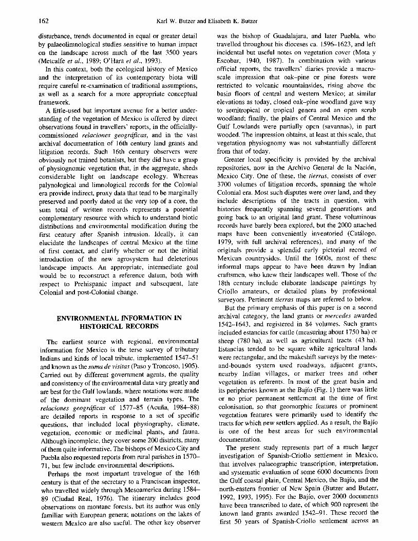
But the primary emphasis of this paper is on a second archival category, the land grants or mercedes awarded 1542-1643, and registered in 84 volumes. Such grants included estancias for cattle (measuring about 1750 ha) or sheep (780 ha), as well as agricultural tracts (43 ha). Estancias tended to be square while agricultural lands were rectangular, and the makeshift surveys by the metes- and-bounds system used roadways, adjacent grants, nearby Indian villages, or marker trees and other vegetation as referents. In most of the great basin and its peripheries known as the Bajio (Fig. 1) there was little or no prior permanent settlement al the time of first colonisation, so that geomorphic features or prominent vegetation features were primarily used to identify the tracts for which new settlers applied. As a result, the Bajio is one of the best areas for such environmental documentation.
The present study represents part of a much larger investigation of Spanish-Criollo settl.ement in Mexico, that involves palaeographic transcription, interpretation, and systematic evaluation of some 6000 documents from the Gulf coastal plain, Central Mexico, the Bajio, and the north-eastern frontier of New Spain (Butzer and Butzer, 1992, 1993, 1995). For the Bajio, over 2000 documents have been transcribed to date, of which 900 represent the known land grants awarded 1542-91. These record the first 50 years of Spanish-Criollo settlement across an

The ‘natural’ vegetation of the Mexican Bajio: archival documentation of a 16th-century savanna environment
SANDSCAPE MODEL FOR THE BAJiO
m Protohistoric, indigenous settlements
Eroded Composite
Volcano
Pyroclastic Uplands
1 2 3a 4 3b Riparian Mesqufte-Acacia- Thorn
Grass Savanna Bush Oak Woodland Broken Mesquite-Acacia
Woodland woodland or scrub oak, (seasonally wet) (xeric)
at higher elevations local thorn bush
.EGEND TO FIGURE 2 Ancillav Profile within 5km of Modern
Descriptions below each profile
transect Woodland quote 16th Century testimony
FIG. I. Location map of the Bajio and its peripheries, with generalised landscape elements and a key for the transects of Fig. 2.
expanse of 52,000 km2. Nominally, about 20% of this area had been converted into private property by mercedes until the beginning of 1592, although the preserved records are incomplete, by as much as 30%. The land grants were clustered, leaving large areas with little or no settlement. A total of 204 out these 900 early titles include useful environmental information, and can be identitied as to exact or approximate location (Butzer and Butzer, 1993). The great majority of these date to 1562-9 1, providing eyewitness testimony for local environments as seen by the second generation of Hispanic settlers, many of them probably of mixed blood
and already acculturated. In fact, after 1560, the percentage of references to uniquely New World genera by Caribbean or Nahuatl names increases exponentially to include 18 types, implying a new appreciation and perception of the landscape of Mexico by settlers more appropriately called Creoles or Criollos than Spaniards.
SAVANNA PLAINS AND IJPLAND FOREST
The Bajio, like other regions of the Mexican Mesa Central (West, 1964), is a volcanic basin, ringed or

164 Karl W. Butzer and Elisabeth K. Butzer
interspersed with volcanic cones, its floor mantled by alluvial or fluvio-lacustrine, pyroclastic derivatives. Late Tertiary and Quatemary faulting and vulcanism disrupted the original drainage, converting the area into endorrheic basins, parts of which were tapped by rivers cutting back from the coastal perimeter during the Quatemary. Even so, the drainage network is poorly organised, leaving many smaller segments with internal drainage or prone to seasonal flooding. The main river axes have had little erosional impact on the terrain, weaving opportunistically from one sub-basin to another, with little or no entrenchment. Consequently, the characteristic landscape is one of open plains, interrupted by mountains with an average relief of 500 m or more.
This geomorphologic pattern has significant implica- tions for meso-scale distributions of climate, soils, and vegetation. Rainfall, deriving its moisture from the Gulf or the tropical Pacific, is concentrated on the mountainous escarpment of the Mexican Plateau. Within the Mesa Central it favors the mountains, accentuates rainshadow effects and, in the Bajio, precipitation tends to decrease from south to north (800 to 500 mm). The basin floors, at 1800 to 2500 m elevation, are subhumid to semiarid in climatic terms, but poor seasonal drainage transforms them into somewhat wetter habitats. On the other hand, the mountainous terrain and sloping piedmonts, with rocky substrates, thin soils, and steep gradients tend to be more xeric than the precipitation would suggest. When the altitudinal range and the absence of transverse mountains (to block cold, winter air masses) are factored in, temperature and frost frequency (5-80 days annually) help to determine the transition between oak and pine (at higher elevations) versus acacia and other leguminosae below. The net results is a complex, three-dimensional mosaic of soils and vegetation, that partly masks the zonal effects of increasing aridity towards the north.
The resulting patterning of soils and vegetation can be categorised according to four main landscape elements (Fig. 1): (1) The riverine or riparian zone. As a result of recent
damming and groundwater abstraction, some high- order streams are now dry, while others carry little but sewage and industrial effluents. Dry channel sectors are entrenched and sandy or stony, their fringing vegetation reduced to a line of South American pepper trees (pirtil); however, mature stands of bald cypress (Taxodium mucronatum) persist along the Lerma river, upstream of the Laja confluence. In open sections of the basins, the old floodplain is comparatively broad and has dark, vertic soils.
(2) The level plains. A large part of the Bajio consists of extensive plains with minimal gradients, interrupted at considerable distances by gentle rises to hills and mesas of extrusive volcanic material. These vast surfaces are poorly drained during the rainy season and have deep vertisols and accumulations (l-5 m) of black, cracking clays. They rest on white, fluvio- lacustrine sediments derived from volcanic tuffs or, in some valleys or Piedmont zones, old fanglomerates.
Today most such heavy clay plains are cultivated, but there are patches of natural grassland or open parkland, with scattered acacias, tepegauje (LysiZo- ma), palo dulce (Eysenhardtia), arboriform mes- quites, casahuate (Zpomoea), and various cactaceae, sometimes forming copses in better drained areas. The characteristic, expandable clays presumably formed both authigenically and as a result of continuing sedimentation of suspended sediment, over very long periods of time’. They offer close analogues to savanna plains in Africa (Butzer, 1976, pp. 416-425), which are equally inimical to tree growth, as a result of repeated waterlogging followed by dehydration, that results in deep cracking and root exposure. Genera such as live oak and pine are almost never observed on such savanna plains of the Bajio.
(3) The piedmonts and rough uplands. Fanglomerates link the clay plains and the mountains while between volcanic cones there may be irregular uplands of pyroclastic rocks. Spiny shrubs or thickets favour porous substrates, giving way to acacia or live oak scrub on less permeable ignimbrites. Also noteworthy are tall and dense, mesic stands of acacia, other arboriform leguminosae, and copal (Bursera) at 2000 m elevation, west of Jerecuaro, representing deciduous tropical forest (Rzedowski and Calderon de Rzedowski, 1986). Surface waters that percolate into alluvial deposits reemerge as seeps or streams at the edge of the clay plains.
(4) Finally, the mountains represent volcanic cones of various ages and degrees of dissection; including the eroded lava cores of Mio-Pliocene craters and flows, or the fresh composite or cinder cones of Quatemary volcanoes. In the far southeast, around Jilotepec, these are mantled by pine forests that often abut directly on savanna plains at elevations as low as 2500 m; to the northwest, live or deciduous oak woodlands are found at the same altitudinal range as pine (2500-3000 m), as well as at lower elevations of 2000-2500 m, that are now more commonly domi- nated by matorral subtropical (Rzedowski, 1981, p. 203), i.e. an open formation of low trees and woody or thorny bush, mainly of the leguminosae and cactaceae families. Such altitudinal substitutions pose problems of interpretation, that can only be resolved after closer identification of the species of pine and oak, and their specific ecological preferences. In some cases, such as the loose, pyroclastic slopes of Culiacan or Cerro Grande, the matorral subtropical appears to be adapted to that particular substrate; on other mountain sides, the reduction of oak woodland to scrub or chaparral suggests an intermediate stage of degradation, perhaps prior to replacement by matorral subtropical. More light on this vexing problem is provided by the historical data.
‘West of Qu&taro, a caliche horizon at -2 m in a thick, vertic clay yielded a 14C age of 599041230 years BP (TX-&116), correCted for carbon isotope deviation.

The ‘natural’ vegetation of the Mexican Bajio: archival documentation of a 16th-century savanna environment 165
16TH CENTURY LANDSCAPE DESCRIPTIONS
Fig. 1 illustrates these landscape elements and identifies the transects of Fig. 2. The raw data of the 16th century assembled by Butzer and Butzer (1993) (Table 2) are organised chronologically for the same areas and provide full documentation. Table 1 and Fig. 2 convert this material into a single time frame, organised around the landscape elements of Fig. 1, as based on field examination. Santamaria (1978) is the indispensable source for Spanish, Caribbean, and Nahuatl terms. A glossary of terms is provided in Table 2.
The biophysical descriptions collated in Fig. 2 are remarkably rich and informative, giving first-hand information for specific landscape elements. These are analogous to panoramic photographs, but suffer from the same limitations - an emphasis on physiognomy rather than floristics, so that true biotic diversity is oversimplified. The archival sources also provide no information on ground cover, for example percentage cover, grass type, or the relative role of other kinds of ground cover, such as Compositae or Chenopodia- ceae-Amaranthaceae. Within these explicit constraints, this qualitative picture offers direct information for extensive areas that point-specific, proxy data (despite their greater objectivity and quantitative nature) cannot rival. This is then an important, complementary research mode.
VEGETATION INFERENCES
Several basic inferences can be drawn with the caveat that even good observers of the period referred to vegetation more in physiognomic than in floristic terms; thus arboriform leguminosae of some generic diversity were probably lumped as ‘mesquites’ in many cases. (1) The river-me zone typically had a riparian woodland,
frequently quite dense, dominated by mesquite; bald cypress groves or willow breaks were characteristic along some rivers, and reed stands were found locally. Arroyos commonly had marshy ponds, and in some cases included live oak woodlands, which does not suggest active gullying. The presence of thorn bush on a mid-channel island of the Laja River points to gravel bars and some river segments with braided channels. Lakeshores appear to have been fringed by tall mesquite woodlands, or wetlands with reed swamps and grassy flats.
(2) The level vertisolic plains were predominantly open, with scattered mesquites and acacia, or more probably groves, located on suitable substrates. Thorny succulents were present in the understorey, but apparently not common. More characteristic were seasonal marshes or lakes. A seasonally wet, mesquite-acacia-grass association, or low-to-medium tree savanna, seems to have been typical of this landscape element through much of the Bajio. It bears mention that the mesquite of the Bajio (Prosopis laevigaru) is taller, has shorter fronds, and represents
a more mesic form than the bushy P. glandulosa of the Mexico-USA borderlands.
(3) Other plains, with stronger gradients and coarser substrates were another matter. Our sample here is smaller, but at least some were bushy and thorny, while others are described as tunales. That term is hopelessly ambiguous, and can mean a field of ‘tended’ prickly pear, a simple thorn-bush associa- tion, or the more complex community of acacia, yucca palm (Yucca filifera), prickly pear, etc. as found in drier parts of the northern, Mexican plateau. The role of grasses is equally obscure. In any event, these edaphic-subclimax associations will have been xeric and highly variable.
(4) Rough hill country and uplands, normally formed by ignimbrites, tuffs with duricrusts, or lavas, appear to have had a medley of vegetation types, with scattered woodlands of mesquite or acacia, probably open. Scrub oak was also present in some areas, although there is only one mention of laurel. The significance of woody or thorny shrubs cannot be resolved.
(5) Mountains generally had woodlands of live and deciduous oaks, although there is next to no information as to how thick or tall such woodlands may have been. Pines are rarely mentioned. But caution is advised, because Culiacan, Cerro Grande, and particularly Cerro Jocoque (with a firm, rocky substrate) apparently had no oak woodland, while patches of mesic acacia-mesquite forest near Jere- cuaro remains in place even today. Although deciduous oaks have evidently fared poorly during the last 400 years, and have now become rare in much of their former range, it appears that degradation of oak forests has produced oak scrub, chaparral, or rough grassland, rather than matorral subtropical. Although reality may well be more complex, at least our case is not based on neo-ecological assumptions.
The archival information is biased by the informants and their particular goals. This can be confirmed by a semi-quantitative glance at the aggregate data, which amplifies the perspectives offered. The primary geo- morphic referents for the Criollo settler were wetland features (a total of 40, including cienegas [a seasonal marsh or shallow lake], lake or charco [an open pool], and spring), plains (20, including sabana or llano), mountains (14, including cerro, sierra, peria), hills (12, including cerrillo, loma, mesa) and arroyos or barrancas (8). These imply a marked settlement preference for lowlands and especially plains, that appear to have been well watered at the time.
The vegetation markers conform with that preference, namely mesquite or mesquitaE (mesquite woodland) (38), tuna or tunal (23), live oak trees or copses (20), willow (8), reeds (carrizal or tular, 5), and organ cactus (5). There are only three references each to pines and yucca palms, and one to laurel. Unlike the authors of the relaciones geogrhficas, applicants for mercedes did not distinguish between arboriform mesquite and bald cypress (sabino). Considering that sabana had specific connota- tion for relatively open vegetation, it is apparent that

166 Karl W. Butzer and Elisabeth K. Butzer
aims woodland 3arrancas wiul :harcxx and reeds Open oak woodland
groves. willows
Tunales, mesquite groves, isolated pines Read marsh (tular)
Empty plains, stony slopes with tunales and woody shrubs
i’ u CHAPA
JILOTEPEC
“4.. y;: SOYANIQUILPAN
0
ACAMBARO Grassy savanna with cienegas rail mesquites end
raxodium, magueyes
:Woodlands)
Grassy savanna
Flat open savanna
rVooded
Tall acacias
A. La Soledad
Dry arroyo tivl willows
Live oak scrub till some yucca palms Live oak woodlands Dry anoyo
Stony cliff with tall pines
:Acacias, tunas, zactaceae, woody shrubs)
Many woodlands with some copal
Tall mesquite and Taxodium thickets, oalo duke
ACAZUCHITLAN-
Mesquite wood- land, guarumo
Thorny succulents
D S. NICOLAS S. NICOLAS
i
PARANGUEO PARANGUEO
. . . C. La Mina C. La Mina ,,. ..’ 3 2030m 2030m
R. Laja
CELAYA l R. Honda
HUICHAPAN
Live oak forest
Hills with live and Cactaceae [Cardenchal)
flooded with yucca palm
Thick mesqurte forest on banks, thorny shrubs on sland
Plains with cienegas and isolatad stands of mesquite
Reed and willow breaks, poplar groves, mesquite woodland Pine groves, poplar
Bushy thorn thickets, cactaceae, cieneaa. deciduous oak woodland
$ C. Jocoque R. Laja
*.*:. CHAMACUERO .$ C.S. Pedro
,,P
Deep arroyo with charcos q
R. Guanajuato
SILAO 3
Large tuna1
>
” : C. El Pica&o ,,..h 2750lll
Arroyo with charcos
Valley within closed mesquite woodland
L ;:
..<
m TECOZAUTLA 5 ii GUANAJUATO
R. S. Francisco c
R. Moctezuma : Lake
*.
l -... ,;, (C. La Margar;
,.f LD 2660m
,,s
Deciduous oak forest
mesquite woodland $
z :
R. Pueblito * S. FRANCISCO
QUERETARO
LA CANADA
Savannas with charcos
Wet floodplain, alder breaks, oak copses, pine groves
Sabana de
S. Sebastian
\. 1: Sierra de
t;~ Sta. Barbara
‘v. ,t.
‘j; ,.<+&, S. FELIPE
Some live oak
+ s. LUIS PAZ
FIG. 2. Three landscape transects across the Bajio, with 16th century descriptions.

The ‘natural’ vegetation of the Mexican Bajio: archival documentation of a l&h-century savanna environment 167
TABLE 1. Environmental descriptions for the 16th century Bajio from archival sources. Organized according to informal districts and landscape elements (see text). See also Fig. 2. Words initially marked by asterisks are explained in Table 2. Derived from Butzer and Butzer (1993) (Table 2)
Jilotepec District (Plains) Grassy savanna with cienegas*; two other savannas, one grassy, the other flat (Uplands) Loma* with small trees; stony mesa* with live oak around it and low palmitos (palmetto?) on top; another mesa with live oak scrub and a few yucca* palms (Mountains) Live and deciduous oak woodlands on a peak (Chapantongo); extensive live oak woodland (S. Martin)
Huichapan District (Riverine) Arroyo* with marshy pools (charcos de agua); deep arroya with marshy ponds; dry arroyo; arroyo with some large live oak; a valley within a closed mesquite forest; a valley with live oak woodland; a large marshy pond; a spring with magueys* (Plains) A large tunal*
(Uplands) A hill with live oaks, another with a few small trees of this type; a hill with deciduous and live oaks; a mesa with some acacias (guajes), mesquites, and p&o* duke; a stony hill with yucca palms; a loma with some large, capulin cherry trees; steep hills with live oaks (Mountains) Live oak woodlands (Cerro La Estancia); stony cliffs with tall pines (Acazuchitlantongo)
Quer6taro District (Riverine) Dry river banks with large mesquite woodlands; large mesquite woodland at river confluence (Plains) Savanna; savanna with a dry lake; another savanna (Uplands) Many pines and tuna1 on a rocky hill above savanna; woodlands; some large tunas and a mesquite woodland; hill full of tepeguaje* trees, wild tunales and wild magueys; waterfall, hot springs and some organ cacti (cardones); branching cactus (garambullo*) and many live oaks; a mesquite woodland, large tunas, and some live oak scrub on a hill (Mountains) Woodland; pine woodland
Aczimbaro District (Riverine) Tall mesquites and magueys; very tall, bald cypresses; mesquites; willows; spring with carriz.al*; mesquite woodland and a cienega (Uplands) Large mesquite stand on a hill above plain; acacias and tall mesquites in hills; wild tunales above floodplain (Mountains) Large acacias (guajes) on mountain slope; barrancas* with marshy pools; many acacias (guajes) with some tunas, pitajayas*, and woody shrubs (a&h&e*) on lower slopes (Culiacan); many woodland with some copal* (Cerro Grande); barren stony mountain with some scrub (Cerro Tetillas)
Celaya District (Riverine) Thick forest of tall mesquites; great mesquite woodland with palo dulces; very tall bald cypresses; large lake near mesquite woodland; mesquite woodland along abandoned channel with cienega; mesquite forest at confluence of R. Laja and a dry arroyo; thorny brush (jaral) on a mid-channel island (Plains) Seasonal flooding; small and large stands of mesquite; tract of organ cacti; organ cacti next to wheat field (Uplands) Acacia and mesquite woodland (Mountains) Yucca palm as landmark (Cerro Jocoque); stony and forested sierra (near San Bartolome)
San Miguel District (Riverine) Abandoned channel lakes; intermittent tributary river; springs and marshy ponds near a single mesquite on plain (Plains) Savanna; lake (Uplands) Barranco below a single live oak
San Luis de la Paz District (Rivetine) Willows (Plains) Savanna with marshy pools (Uplands) Live oaks
Lake Cuitzeo District (Lakeshore) Tular* along shallow lake or cienega (Old lake plain) Broad plain with grasslands, cienegas, willows, and mesquite groves; mesquites; tunales, and willow (Upland, clockwise from left) Isolated pine or tunas on hills; large tunal on rocky slope; dry arroyo with willows; tunas, zapotes*, and stands of small mesquite above lakeshore; tunales and small trees on hills; tunal on hill; many wild tunales and mesquite groves on upland

168 Karl W. Butzer and Elisabeth K. Butzer
TABLE 1. Continued.
Yuriria District (Lakeshore) Large mesquite woodland (including bald cypress?) (Upland) Branching cactus @itujaya*) and guarumo* ([Lerma] Rivetine) Tall mesquite woodland (including bald cypress?) ([Eastern] Plain) Plain with cienegas, marshy ponds, and alkali flats; tunales and mesquites (Piedmont of Cerro Tetillas) (Hills amid plain) Stands of live oak or mesquites; a tuna, a zapote, or live oak copses
Silao-Irapuato-Guanajuato Districts (Riverine) Large willow groves, cottonwoods, mesquite stands, pines or reeds (currizul) (Plains) Plains with scattered small or large stands of mesquite, locally cienegas or small lakes (Piedmont) Thorn bush, cactaceae (jarales*, espinos*, curdenchul), tuna1 (Foothills) Cienega and deciduous oak woodland (south); wet floodplain (vegu) and many tan&s (northwest) (Mountains) Deciduous oak woodland at river confluence below cliffs; deciduous oak forest
San Felipe District (Riverine) Willows, alder (Plains) Tuna&s; tunul, large cienega, marshy ponds, and spring (road to Zacatecas); deciduous oak stand, pine woodlands, and small lake (south)
Puruiindiro-Guaniqueo Districts (Riverine) Ash and many willow along river and arroyo; cienegas on floodplains (Plains) Extensive swampy plains with large tulures (Uplands) Deciduous oak stands and tunales; live oak trees
Rio Turbio District (Riverine) Mesquite woodlands (Plains) Plain with small cienega (Uplands) Organ cacti (curdenchul) on mesas
dense or extensive woodlands were rarely encountered in the lowlands, other than in riparian situations. For example, woodland is referred to by monte, with the meaning of scrub then current in Spain, but sometimes qualified as espeso (thick) or montuoso (tall) (Butzer,
1992b), both terms exclusively used in the Bajio for riverine stands. Similarly, there are 14 references to encinas (live oak trees), but only six to encinales (live oak copses or woodland). Given the preponderance of references to mesquite and prickly pear, it is difficult to
TABLE 2. Glossary of terms
Acibuche Arroyo Barruncu Curdon Currizul Cienega Copul Espino Gurumbullo Guarumo Jaral LOT?lU
Maguey Mesa Palo dulce
Pitujayu Tepeguuje Tuna
Tular Yucca palm Zapote
Tall woody shurb, either Celtis sp. or Forestiera sp. Intermittent stream, in part cut into bedrock Deep valley, with intermittent stream An organ cactus; curdenchal, cactus thicket Reed stand, generally Phrugmites sp. Seasonal marsh or shallow lake Deciduous, semitropical tree of the genus Bursera Thorn shrub Tall branching cactus, in Bajio probably Myrtillocuctus sp. Evergreen and broadleafed, semitropical tree (Cecropiu sp.) Thorn bush thicket Flat hill or ridge Cultivated, feral or wild species of Aguve sp. Flat mountain or hill, small plateau White-trunked, deciduous semitropical tree (Eysenhurdtiu sp.) Thin-stemmed, branching cactus (Lemuirocereus sp.) Deciduous subtropical tree of acacia family (Lysilomu sp.) Fruit of prickly pear or nopal (Opuntiu sp.), but generally used for plant; tuna& thicket of nopal, often with other succulents and yucca palms Reed swamp, typically Cyperus sp. or Typhu sp. Yucca @ifera, called pulmu silvestre, related to Joshua tree evergreen, broadleaf semitropical tree (Munilkaru zupotuf

The ‘natural’ vegetation of the Mexican Bajio: archival documentation of a l&h-century savanna environment 169
imagine that oak woodland was extensive or particularly common either on the plains or uplands at the time. Again, with only three specific allusions to pine in these records, that genus must have been uncommon in the districts and elevation ranges chosen by the Criollo settlers.
These general impressions are confirmed by three indigenous maps of 1579, prepared for the relaciones of San Miguel, Celaya and Admbaro, and Yuriria (Acufia, 1984-88: No. 74 Michoacan; facing pp. 370, 58 and 66). In the case of Celaya and Admbaro, the major sierras are shown in green and the lowlands in light brown, except for a selection of cultivated tracts. For Yuriria, the only vegetation shown represents fruit trees and prickly pear around a half dozen villages west of the monastery, although the map is liberally sprinkled with grazing cattle. The San Miguel map attempts to identify the basic physiography of the whole basin, as far as Guanajuato and San Felipe: (a) tall- trunked pines are shown on the surrounding ranges, bushy willows along the Rio de 10s Sauces, and a dense stand of branching oak trees on the Sierra de Guanajua- to; while (b) the lowland plains are rendered a cream colour, compared with buff or olive green for the mountains, and they are profusely decorated with prickly pear and branching succulents that resemble magueys (Agave sp.) (both of which are also seen more widely spaced on the mountains). The evident intent of the cartographer was to convey the lowland vegeta- tion as open, the highlands as partly, and only the Sierra de Guanajuato as forested. This interpretation is sup- ported by a bird’s-eye view painting of a broad panorama of Actibaro, that shows the same vertical eco-zonation in color, supplemented by schematic representations of forests (1623, Catilogo, 1979: No. 25 12).
There seems little ground to question that the general patterning of vegetation during the 16th century was similar to that of today. In particular, neither the physiognomy nor the dominants among the arboreal and shrub vegetation appear to have been different. At the same time, an ecologist, given the opportunity to compare modem and 16th century counterparts in the field, would undoubtedly recognise significant structural changes. The lower limit of the oak-pine forest very probably was a little lower during the 16th century, and these forests will have been denser, taller, and richer in species.
Yet there is no support for wholesale displacement of oak woodlands, and the evidence indicates that some variant of mesquite-acacia-grass savanna dominated the clay plains of the 16th century, and in its more mesic phases was also widespread on the uplands at inter- mediate elevations. The deciduous tropical forests of Rzedowski and Calderbn de Rzedowski (1986) presum- ably were more widespread on the hilly margins of the Bajio, as suggested by the 16th century woodlands with copal on Cerro Grande. But a 1581 description of tunas, zapotes and stands of small mesquite above the Lake Cuitzeo shore (Butzer and Butzer, 1993, p. 97), coming from near the modem tropical forest relict near Irimuco
(Rzedowski and Calderbn de Rzedowski, 1986), does not support the notion of a substantial expansion of that ecological formation. The pollen core from Parangueo, near Valle de Santiago, also does not show an expanded tropical forest (Metcalfe ef al., 1989; Butzer and Butzer, 1993, pp. 112-113), with strong evidence of agricultural settlement in the area since the 1 lth century A.D.
INDIGENOUS LANDSCAPE IMPACT
The environmental effects of indigenous Prehispanic and the early impact of Spanish-style land management are both pertinent to understanding the issues raised. The scope of these summary comments is limited to this specific framework.
Prior to the arrival of Co&s, indigenous agricultural land use was restricted to the southern periphery of the Bajio, most of which was controlled by various ‘Chichimec’ peoples who were semi-mobile, practising only supplementary agriculture. In the southeast, tradi- tional Otomi settlement included most of the Jilotepec and Huichapan districts, while in the south, Tarascan settlement was well established in the areas of lakes Cuitzeo and Yuriria. After about 1520, both the Otomi and Tarascans expanded their settlements to Acimbaro, Celaya, and Queritaro, with outliers further afield to beyond San Miguel or Silao (Fig. 1).
In the ‘old’ Otomi district around Jilotepec several documents in the mercedes put indigenous impact into perspective: (a) there were many magueys around Chapantongo (1591); (b) feral magueys abounded around Acazuchitldn (1586); (c) a coppiced laurel and isolated live oak trees were conspicuous near Aculco (1591); or (d) an open area with many magueys, surrounded by forest, was considered by one colonist as prime evidence for an abandoned Indian settlement near Soyaniquilpan (1591). Much the same is implied by late 16th-century maps from the tierras, for example two areas with magueys and organ cacti within an open oak woodland near Alfajayucan (late 15OOs, Catilogo, 1979: No. 823), or a similar zone of magueys around Alfajayucan and an abandoned village nearby (1614 Cattiogo, 1979: No. 1569)2. These records indicate persistent and visible ‘disturbance’ of vegetation around old Otomi settlements, but limited to circumscribed areas.
The case for environmental impact in the Cuitzeo Basin is stronger and more obvious. There was essentially no woodland on the uplands, although tunales were com- monplace. This is confirmed by the 1579 reZacidn for Cuitzeo, which notes that orcharcl cuttings or woody shrubs had to be used for fuelwood, since the closest woodlands were 20 km away (Acuiia, 1984-88, NO. 74, Michoacan, p. 86). It is also consistent with a number of tierras maps for the district from the 1570s to the 159Os, which include only one showing a patch of arboreal vegetation, namely a grove of oaks (guejerio) (1578, Catilogo, 1979: No. 1850a). The area appears to have
2 The map inscriptions additionally refer to cardones (a generic reference to organ-like cacti) and lechugilla.

170 Karl W. Butzer and Elisabeth K. Butzer
been largely deforested, at least outside of the old lake plain.
Evidence for the Yuriria Basin is more circumstantial. There admittedly is little evidence for upland forests (Table 1, and the 1579 relacidn map), although in part that may be a function of no land being granted to Criollos in the heart of the Tarascan settlement area. But there is also a telling example of a fishing village on the nearby Lerma River in 1581 that was not in the midst of mesquite woodland, as might be expected but only surrounded by isolated ash and willow trees. There probably was considerable, localised ‘disturbance’ in the Yuriria district, and there may also have been some deforestation3. That, too, is the import of a pollen core from Parangueo, where adjacent pine woodland disap- peared abruptly after settlement ca. 1100 A.D., although live oak was little impacted (Metcalfe et al., 1989), perhaps a reflection of vegetation burning.
The archival sources therefore suggest that Otomi and, especially, Tarascan land-use was clearly visible in the biotic landscape at the time of Criollo intrusion. Much was in the form of localised ‘disturbance’, but consider- able deforestation is evident in at least the Cuitzeo Basin. But the nature of the archival record offers no clues as to whether some of this impact led to serious ecological degradation, such as the soil erosion documented in cores from Lake PBtzcuaro, further south (O’Hara et al., 1993).
THE QUESTION OF SPANISH-CRIOLLO DEGRADATION
Despite the contemporary proclivity to assert that Hispanic land use in the New World had a direct and immediate detrimental impact on the landscape, we have found a singular lack of evidence to this effect in the areas of Mexico we studied in detail for the period 1540-1640 (Butzer and Butzer, 1993, 1995). This does not mean that there was no disturbance or ecological degradation, only that in the areas we have targeted there is none. That finds confirmation in the exemplary record of Lake PBtzcuaro (O’Hara et al., 1993).
We suggest that despite the large numbers of livestock (perhaps 800,000 cattle and a million sheep in the region), cattle were allowed to roam freely through the Bajio, where grassy, vertisolic plains provided attractive pas- turage. In the case of sheep, the Criollos were aware of the dangers of overstocking on fixed, dry-season pastures, so that they resorted to long-distance transhumance, as in Spain (Butzer, 1988). Given the large residual tracts of land still left unsettled by both Indians and Criollos as of the 159Os, such mobile strategies appear to have been effective in limiting environmental impact. During the second 50 years of Criollo settlement in the Bajio (1592- 1643), some of the best documented districts experienced a filling-in process, while others received very few
3A later map suggests an open oak woodland on the uplands, exoandine. down into the lowlands in some areas (1720, Catilogo, 1979: No. 669; This may even imply increased woodland in the wake of indigenous population decline.
additional colonists. A much higher proportion of the grants after 1591 were for agricultural land, as stock- raising was de-emphasised; cattle numbers were drasti- cally reduced and restricted to the western Bajio, while sheep transhumance expanded northward, beyond San Luis Potosi, to the Huasteca or oven to Nuevo Le6n. This served to greatly reduce pressures on pasturage in the Bajio.
However, all that changed with the population explo- sion of the mid-17OOs, that led to intensified pressure on resources. Magnetic susceptibility in the Parangueo core indicates a dramatic increase in soil erosion after an extrapolated date of 1788 (Metcalfe et al., 1989), and the Laja River began to spread flood sands across its floodplain at some point after ca. 1750 (Frederick, 1995). That appears to match with travellers’ reports4 and evidence for a clustering of extreme flood events. These, too, are important considerations for a re- evaluation of the contemporary vegetation.
CONCLUDING DISCUSSION
This paper may serve to illustrate the potential of good archival documentation to assist neo-ecologists as well as palaeoecologists. Like all methodologies, it has its strengths and weaknesses, and it is only applicable where and when appropriate archival resources are available.
For some, the resulting ‘reconstruction’ of the three-dimensional biotic mosaic of the Bajio during the mid- to late-1500s will seem surprising, with its emphasis on continuity rather than change. Here the strongest evidence comes from the level, vertisolic plains, for which we propose a savanna vegetation, analogous to that of seasonally-wet plains in Africa. This very open, savanna association of mesquite, acacias, and grass is confirmed by a large number of Spanish-Criollo descriptions. Vegetati’on on coarse pied- mont substrates, or rough uplands appear to have been highly variable, with tracts of thorny bush, mesquite-
4Ajofrin (1958), a Spanish Capuchin, who made notes on various parts of the Bajio in the summer of 1764, reported a great abundance of waterfowl on Lake Cuitzeo (p. 2551. ~rosoerous aericulture around
I I L .
various towns, and a profusion of summer flowers on the road from Guanajuato to San Miguel (p. 291); the alluvial plain at Celaya resembled a wall of trees (pp. 298-299, with illustration). The disastrous flood of 1760 in Guanajuato noted by Ajofrin (1958) (p, 267) was followed by five other such calamities between 177&1804, and was probably facilitated by intense mining disturbance around that city. However, six extreme flood events at Celaya between 1750-1802 (Murphy, 1986) (p. 36) suggest degradation of the much larger Rio Laja watershed as well. In August 1777, the Ire-Sclanish Franciscan Morfi (1958) (pp. 342-346) noted haciendas north-<of Querttaro without a single tree, although near San Miguel and hevond San Felioe, he reported attractive plains and good soils with mesquites, acacias and tunales; the arroyos were prone to flash floods, he added. Yet in November 1828, during the dry season, the French naturalist Berlandier (1980) (I, pp. 194-205) interpreted the mix of mimosaceae, tunales and grass west of San Miguel as a “barren wildelmess”; the cliffs above Guanajuato were devoid of trees, but the mountains to the north retained remnants of oak woodland, while a forest of mimosaceae, hung with Spanish moss, tunales and pird bordered the road northwest of San Felipe, with oaks on the mountains. This again suggests little change in physiognomy, although the unusual concentration of extreme floods during the later 18th century suggests a deterioration of ground cover.
The ‘natural’ vegetation of the Mexican Bajio: archival documentation of a 16th-century savanna environment 171
acacia woodland, and live oak copses or scrub, probably with a range of thorny succulents prominent in stony areas or on thin soils. Live and deciduous oak wood- lands were found at high elevations in the montane zone, but the role of pine remains ambiguous, and the lower limit of oak was only loosely approximated by climatic parameters.
Human disturbance and degradation emerges as an equally complex issue. The southeastern and southern margins of the Bajio were areas of long-term indigen- ous, agricultural settlement prior to 1520. The evidence here shows that vegetation around Indian settlements was disturbed by clearings and a profusion of magueys and various thorny succulents. But next to such common, localised disturbance, some areas were also deforested, particularly in upland environments around lakes Cuitzeo and Yuriria. This Prehispanic, human imprint is quite apparent from the Spanish-Criollo descriptions, and is paralleled by palynological and limnological evidence in other parts of Mexico. The degree to which this will have affected the generalised inferences suggested above needs to be considered in an interdisciplinary forum.
By comparison, the Spanish-Criollo impact was mini- mal in the Bajio during the first century after intrusion, despite new and potentially destructive land-use meth- ods. We attribute this to highly mobile stockraising practices during the 1500s followed by a marginaliza- tion of livestock to more distant or outlying areas during the 1600s. Nonetheless, rapid population growth, economic intensification, and land pressures during the 1700s did eventually provoke ecological degradation in some areas of the Bajio, as reflected in soil erosion, accelerated runoff, and higher peak flood discharge. Even so, the basic hydrology was only changed by destruction of riparian forests well after 1830, and overextraction of runoff and subterranean waters during the present century. Again it is incumbent to discuss whether all this modified more than the structure of the non-riparian, spontaneous vegetation.
In conclusion, these results suggest that it would be profitable to question popular assumptions and, more particularly, to re-examine the interplay of edaphic variation, climate, and cumulative or changing land-use in understanding contemporary vegetation. Similarly, our findings suggest that transform functions from palynological or limnological proxy data to landscape ecology are greatly complicated in a three-dimensional landscape, in which a plethora of environmental mo- saics, related to relief, substrate, and drainage, are more critical than generalised climatic parameters.
ACKNOWLEDGEMENTS
The research was made possible by the endowment of the Raymond C. Dickson Professorship of Liberal Arts. Sara L. O’Hara (Sheffield) provided helpful, critical comments on a draft of the manuscript; we are also grateful to Walter L. Meagher (Somerton, Oxfordshire) for information and discussion. Maps and diagrams were drafted by Susan E. Long.
REFERENCES
Acuiia, R. de (ed.), (1984-88). Reluciones geogr@cus a’el Siglo XVI. (10 vols, especially No. 47: Michoacdn (1987)). Serie Antropol6gicas, UNAM, Mexico.
Ajofrfn, F. de (1958). In: Castaiieda, V. and Alcover (eds), Diario de/ viaje hizo a la America septentrional. ReaJ Academia de la Historia, Archive Documental Espaiiol 12, Madrid.
Berlandier, J.L. (1980). Journey to Mexico during the Years 1826 to 1834, translated by S.M. Ohlendorf, 2 vol. Texas State Historical Association, Austin, TX.
Birks, H.H., Birks, H.J.B., Kaland, P.E. and Moe, D. (eds) (1988). The Cultural Landscape: Past, Present and Future. Cambridge University Press, Cambridge.
Butzer, K.W. (1976). Geomorphology from the Earth. Harper and Row, New York.
Butzer, K.W. (1988). Cattle and sheep from Old to New Spain: Historical antecedents. Annals, Association of American Geogra- phers, 78, 29-56.
Butzer, K.W. (1992). The Americas before and after 1492: an introduction to current geographical research. Annuls, Association of American Geographers, 82, 345-368.
Butzer, K.W. (1992). From Columbus to Acosta: science, geography, and the New World. Annals, Association of American Geographers, 82, 543-565.
Butzer, K.W. (1996). Ecology in the long view: Settlement histories, agrosystem strategies and ecological performance. Journal of Field Archaeology, 23, 141-150.
Butzer, K.W. and Butzer, E.K. (1992). Formative Spanish settlement and land use patterns in the lowlands of central Vera Cruz 1519-1618. Preprint for the Congreso Intemacional cle Antropologfa e Historia, Veracruz, Sept. 1992.
Butzer, K.W. and Butzer, E.K. (1993). The sixteenth-century environ- ment of the Central Mexican Bajio: archival reconstruction from Colonial land grants. In: Mathewson, K. (ed.), Culture, Place and Form, pp. 89-124. Geoscience and Man Publications, Baton Rouge, LA.
Butzer, K.W. and Butzer, E.K. (1995). Transfer of the Mediterranean livestock economy to New Spain: adaptation and ecological consequences. In: Turner? B.L. and Gomez Sal, A. (eds), Global Land llse Change, pp. 151-193. CSIC, Madrid.
Cat&logo, (1979). Cardlogo de Ilustruciones, Vols. 2-5. AGN (Archive General de la Nation), Mexico.
Ciudad Real, A. de (1976). In: Garcia Quintana, J. and Castillo Farreras, V.M. (eds), Tratado curioso y docto de las grandezas de la Nueva Espaf?a, 2 ~01s. (1591). Instituto de Investigaciones Historicas, UNAM, Mexico.
Denevan, W.M. (1992). The pristine myth: the landscape of the Americas in 1492. Annals, Association of American Geographers, 82, 369-385.
Edwards, K.J. (1979). Palynological and temporal inference in the context of prehistory. Journal of Archaeological Science, 6, 255-270.
Frederick, CD. (1995). Fluvial Response to Late Quaternary Climate Change and Land Use in Central Mexico. University Microfilms International, Ann Arbor, MI.
Metcalfe, S.E., Street-Perrott, F.A., Brown, R.B., Hales, P.E., Perrott, R.A. and Steininger, F.M. (1989). Late Holocene human impact on lake basins in Central Mexico. Geoarchcreology, 4, 119-141.
Morff. J.A. de (1958). In: Hemandez, M. and Sanchez-Barba (eds), Viaje de ‘Indies y diario de1 Nuevo Mundo. Aguilar, Madrid.
Mota y Escobar, A. de (1940). In: Ramfrez Cabaflas, J. (ed.), Descripcidn geograjica de 10s Reinos de Nueva Galicia, Nueva Vizcaya y Nuevo L&t (1605). P. Robredo, Mexico.
Mota y Escobar, A. de (1987). In: Gonzalez Jacome, A. (ed.), Memorias de1 obispo de Tlaxcala: un recorrido por el centro de Mexico a principios de1 Siglo XVII. Secretarfa de Education Wplica, Mexico.
Murphy, M.E. (1986). Irrigation in the Bajio Region ofcolonial Mexico. Westview, Boulder, CO.
O’Hara, S.L., Street-Perrott, F.A. and Burt, T.P. (1993). Accelerated soil erosion around a Mexican highland lake caused by prehispanic agriculture. Nature, 362, 48-5 1.
Paso y Troncoso, F., de1 (1905). Suma de visifas de pueblos por orden alfabe’tico, Serie II, Vol. 1, Papeles de Nueva EspaRa, Madrid.
Rice. D.S.. Rice. P.M. and Deevev, ES. (1985). Paradise lost: Classic Maya impact on a lacustrind environment. In: Pohl, M. (ed.), Prehistoric Lowland Maya Environment and Subsistence Economy, pp. 91-105. Peabody Museum of Archaeology and Ethnology, Harvard University, Cambridge, MA.
Rzedowsky, J. (1981). Vegetacidn de M&co. Limusa, Mexico, 432 pp.

172 Karl W. Butzer and Elisabeth K. Butzer
Rzedowski, J. and Calderon de Rzedowski, G. (1986). El bosque tropical caducifolio de la region mexicana de1 Bajfo. Trace, 10, 15-25.
Santamaria, F.J. (1978). Diccionario de mL’jicanismos, 3rd edn. Pomla, Mexico.
Schoonmaker, P.K. and Foster, D.R. (1991). Some implications of paleoecology for contemporary ecology. The Botanic Review, 57, 204-245.
Simmons, I.G. and Inner., J.B. (1996). Disturbance phases in the mid- Holocene vegetation at North Gill, North Yorkshire Moors: Form and process. Journal of Archaeological Science, 23, 183-191.
Van Andel, T., Zangger, E. and Demitrack, A. (1990). Land use and soil erosion in prehistoric and historical Greece. Journal of Field Archaeology, 17, 379-396.
West, R.C. (1964). Surface configuration and associated geology of Middle America. In: West, R.C. (ed.). Handbook of Middle American Indians. Vol. 1: Natural Environment and Early Cultures, pp. 33-83. University of Texas Press, Austin, TX.