Embed Size (px)
Citation preview

116
THE PUFELS/BULLA ROAD SECTION: DECIPHERING ENVIRONMENTAL CHANGES ACROSS THE PERMIAN-TRIASSIC BOUNDARY TO THE OLENEKIAN BY INTEGRATED LITHO-, MAGNETO- AND ISOTOPE
STRATIGRAPHY. A FIELD TRIP GUIDE.
Rainer Brandner1, Micha Horacek2, Lorenz Keim3 & Robert Scholger4
With 11 figures
Topographical map: Carta topografica/Topographische Wanderkarte 1:25.000, Val Gardena/Gröden – Alpe Si-usi/Seiser Alm, Bl. 5, TabaccoGeologic map: Geologische Karte der Westlichen Dolomiten/Carta geologica delle Dolomiti Occidentali 1:25.000. – Autonome Provinz Bozen-Südtirol/Provincia Autonoma di Bolzano-Alto Adige, Amt für Geologie & Baustoffprüfung/Ufficio Geologia e Prove Materiali, Kardaun/Cardano, Bozen/Bolzano, 2007.
1 Institut für Geologie und Paläontologie der Universität Innsbruck, Austria; [email protected] Austrian Institute of Technology GmbH AIT, Seibersdorf, Austria; [email protected] Amt für Geologie & Baustoffprüfung, Autonome Provinz Bozen-Südtirol, Kardaun/Bozen, Italy; [email protected] 4 Institut für Geophysik, Montanuniversität Leoben, Austria; [email protected]
Geo.Alp, Vol. 6, 2009
Geo.Alp, Vol. 6, S. 116–132, 2009
Route (see also Figs. 1, 2)
From Bozen/Bolzano 1 hour bus drive to Seis/Siusi, Kastelruth/Castelrotto (both on top of a thick Permi-an volcanic sequence (“Bozen-Quarzporphyr”, Etsch-taler Vulkanit-Gruppe/Gruppo vulcanico Atesino) and Panider Sattel/Passo Pinei (Gardena/Gröden–Fm.), bifurcation to Pufels/Bulla. Several stops along the Pufels/Bulla section, which is well exposed along the abandoned road to Pufels/Bulla.
Aim of the excursion
The Pufels/Bulla section offers an excellent oppor-tunity to study the Permian-Triassic boundary (PTB) and the Lower Triassic Werfen facies and stratigraphy in a nearly continuous section from the PTB to the Induan/Olenekian boundary (IOB) located within the Campill Member. In this guidebook we present for the first time the complete section with the exact posi-tion of the samples taken for palaeomagnetic analy-sis (see Scholger et al., 2000) and for carbon isotope analysis (see Horacek et al., 2007a), together with the
interpretation of 3rd and 4th order cycles. In additi-on, dissimilarities in the lithostratigraphic subdivisi-ons of the Werfen Formation by different research groups are shown for clearness. Until now, there do exist only few sections in the world where integrated stratigraphy has been carried out in such a detail at the PTB and within the Lower Triassic. On the basis of this key-section at Pufels/Bulla we want to stimulate the discussion on questions of the “system earth”, i.e. genetically related correlations of lithofacies, sea-level changes, anoxia and stable carbon and sulphur isotope curves. Magnetostratigraphy enables a direct comparison with continental sedimentary sequences of the German Zechstein and Buntsandstein to un-derstand sequence stratigraphy, cycles and regional climatic influences.
General remarks
The Permian-Triassic sequence is embedded within two major tectono-sedimentary cycles situated on top of Variscan crystalline basement. The cycles are: (1) the > 2000 m thick “Athesian Volcanic Group”

117 Geo.Alp, Vol. 6, 2009
Fig. 1: Geologic map with excursion route (red-yellow) along the old road to Pufels/Bulla. PTB = Permian-Triassic Boundary. Geologic map after “Geologische Karte der Westlichen Dolomiten 1:25.000“.- Autonome Provinz Bozen – Südtirol, Amt für Geologie & Baustoff-prüfung, Bozen/Kardaun, 2007.

118Geo.Alp, Vol. 6, 2009
Fig. 2: Section through the Werfen Formation along the abandoned road to Pufels/Bulla. The top of the section shows ramp folds, which can be restored bed by bed. Upper Anisian conglomerates, which record upper Anisian uplift and erosion, overlie unconformably the lower part of the Campill Member.

119 Geo.Alp, Vol. 6, 2009
The lack of reefal buildups and binding organis-ms may have caused the extreme mobility of loose carbonate and siliciclastic sediment piles, which have been removed repeatedly by storm-dominated high energy events. This generated a storm-dominated stratification pattern that characterises the specific Werfen facies. Applying the concept of proximality of storm effects (Aigner, 1985), i. e. the basinward de-crease of storm-waves and storm-induced currents, we tried to interpret relative sea level changes from the stratigraphic record. Proximal and distal tempes-tite layers are arranged in shallowing-upward cycles (parasequences) but also in deepening-upward cycles depending on their position within the depositional sequences (see Fig. 3, 10). However, numbers of cy-cles and cycle stacking patterns vary from section to section according to the different ramp morphology. Thus the main control seems to be the ratio between accommodation space and sediment supply, which follows the variable position of the baselevel (see baselevel concept from Wheeler, 1964). Variations of the baselevel determine the geometry of prograda-tional, aggradational and retrogradational stacking patterns of the cycles. The baselevel, however, does not automatically correspond to sea level. Therefore until now it was not possible to proof true eustatic sea level changes within the Lower Triassic.
Reviewing the published data of magnetostra-tigraphy and chemostratigraphy, calibrated with bio-chronostratigraphy, Posenato (2008) made an attempt to put also radiometric ages for the Lower Triassic of the western Dolomites. Assuming that the duration from PTB to IOB is roughly 1.3 Ma, the total sediment thickness of 200 m in the Pufels section translates into a sedimentation rate of 1 m/6.500 a, uncorrected for compaction. This rather high sedi-mentation rate suggests a high frequency of storm events (hurricanes), which stresses the exceptional environmental conditions during this period indica-ting the lack of dense vegetation in the hinterland.
Since the 19th century there have been attempts to subdivide the Werfen beds into mapable lithostra-tigraphic units: (1) in a first step, Wissmannn, 1841 (lit. cit. in Posenato, 2008) made a simple subdivi-sion according to the grey and red colours of the interbedded marls in Seiser Schichten and Campiler Schichten. (2) Modern research in sedimentology and biostratigraphy by Bosellini (1968), Broglio Loriga et al. (1983, 1990) and others enabled a division of the
of Lower Permian age, separated by a regional un-conformity from, (2) a transgressional continental to marine sedimentary sequence, spanning the Upper Permian to Lower Anisian. Volcanic rocks of the first cycle infill intramontane basins and halfgrabens that developed during a pronounced extensional tectonic period related to the rifting of the Neotethys. Flu-vial red sandstones of the Gardena/Gröden Forma-tion interfinger eastward of the Etsch/Adige Valley with evaporites and shallow marine carbonates of the Bellerophon Formation stacked in several cycles representing 3rd order sequences within a general westward prograding sedimentary wedge. The over-lying Werfen Formation is a strongly varying sequen-ce of mixed terrigenous siliciclastic and carbonatic lithofacies, organized in T/R-cycles of different order and frequency. These 3rd order depositional sequen-ces (see De Zanche et al., 1993, Gianolla et al., 1998) are composed of 4th order cycles of storm layers (thickening or thinning upward) and may have been orbitally forced. For detailed descriptions of lithology and biostratigraphy see Broglio Loriga et al. (1983).
The Pufels/Bulla section is well known for findings of conodonts constraining the Upper Permian, PTB and Lower Triassic succession as well as its excellent outcrop quality. Investigations on lithostratigraphy and biostratigraphy have been carried out by Mostler (1982), Perri (1991) and Farabegoli & Perri (1998). In-tegrated studies of lithostratigraphy, magnetostrati-graphy and chemostratigraphy have been carried out by Scholger et al. (2000), Korte & Kozur (2005), Korte et al. (2005), Farabegoli et al. (2007) and Horacek et al. (2007a). A comprehensive review is given by Po-senato (2008).
Lithostratigraphy and depositional environment
The shallow marine sediments of the topmost Bel-lerophon Fm and Werfen Fm were deposited on a very gentle, NW – SE extending ramp with a coastal plain environment of the upper Gröden Fm in the West and a shallow marine, mid and outer ramp environment of the Bellerophon Fm in the East. The PTB mass extinc-tion of carbonate producing organisms prevented the evolution of a rimmed shelf area for the whole Lower Triassic. After the exceptionally long lasting recovery period of reefal buildups in the whole Tethys area, the first appearance of reef building organisms was found in the lower Middle Triassic nearby in the Olang/Valdaora Dolomites (Bechstädt & Brandner, 1970).

120Geo.Alp, Vol.6, 2009
Fig. 3: Pufels/Bulla road section with correlations based on lithostratigraphy, magnetic polarity (Scholger et al., 2000 and completed for the Andraz Member), sequence stratigraphy and δ13C curve (Horacek et al., 2007a). We revised the definition of sequences and renamed them according to the new terms of the stages to avoid confusion with the terms of the sequences interpreted by De Zanche et al. (1993). For legend see Fig. 10.

121 Geo.Alp, Vol. 6, 2009
Fig. 4: Detailed section of the PTB along the abandoned road to Pufels/Bulla with litho-, bio-, chemo- and ma-gnetostratigraphy. Conodonts and position of the PTB after Mostler (1982) and Farabegoli et al. (2007), magne-tic declination after Scholger et al. (2000), selected microfossils (det. W. Resch, Univ. Innsbruck, 1988, unpubl.).
Fig. 5: PTB section of Pufels/Bulla in the outcrop. For legend see Fig. 4. (Mz. = Mazzin Member).

122Geo.Alp, Vol.6, 2009
authors (see Fig. 10). For geologic mapping in the field we found a practicable solution in defining the lower boundary of the Campill Mb with the appearance of the first observable sandstone- or calcareous sand-stone layers (unit D on top of the Siusi Mb defined by Broglio Loriga et al., 1990). This terrigenous input marks a distinct break in the sedimentary develop-ment of the Werfen Formation and has a very wide palaeogeographical distribution. The stronger clastic input in the overall marine Werfen Fm is genetically correlatable with the boundaries between Unterer/Oberer Alpiner Buntsandstein in the Austroalpine (Krainer, 1987) and Lower/Middle Buntsandstein of Central Germany (Szurlies et al., 2003). The term “Gastropodenoolith” will be used only as remarkable facies type but not as an individual lithostratigraphic unit (see Geological map of the Western Dolomites, 2007).
The Pufels/Bulla road section exposes the whole sequence from the PTB to the supposed IOB, i. e. up-permost Bellerophon Fm and Werfen Fm with Tese-ro Mb, Mazzin Mb, Andraz Mb, Seis Mb and lower Campill Mb. Younger members of the Werfen Fm are lacking in this area due to block tilting and erosion during the Upper Anisian.
Bellerophon Fm: the outcrop at the starting point of the section shows only the top of the formation with gray calcareous dolomite mudstones, with ver-tical open tubes, interpreted as root traces. The dolo-mites belong to the top of the “Ostracod and peritidal dolomite unit” described by Farabogoli et al. (2007). It is covered by 4 cm thick orange to green coloured marls, which represent probably a hiatus interpreted as a sequence boundary. The sequence “Ind 1” starts with a package of dm bedded, grey to dark grey fossi-liferous packstones that are intercalated with irregu-lar cm thick layers of black carbonaceous marlstones. Bedding planes are wavy due to strong bioturbation (Figs. 4, 5). The 155 cm thick package is termed Bulla Mb (Farabegoli et al., 2007) which is identical with cycle A in Brandner, 1988.
Werfen Fm: The Werfen Fm starts with the Tese-ro Oolite Mb within bed number 12 of the detailed section (Figs. 4, 5). Fossiliferous packstones are over-lain with a sharp contact by well washed, fossilife-rous grainstones, 4 to 5 cm thick (Fig. 6), grading to grainstones with superficial ooids (5 cm) and cross bedded oolites (20 cm) on the top of the beds. The
Werfen Formation – still an informal unit – into 9 members (Tesero, Mazzin, Andraz, Siusi/Seis, Gas-tropodenoolith, Campil, Val Badia, Cencenighe, San Lucano) which correspond pro parte to depositional sequences (De Zanche et al., 1993). In general, the Werfen Formation is characterized by subtidal se-diments, but intra- to supratidal horizons with eva-poritic intercalations are present within the Andraz, Gastropodenoolith, the base of Val Badia, Cencenighe and San Lucano members.
The historical lithostratigraphic units “Seiser Schichten” and “Campiler Schichten” are now con-sidered members (Siusi/Seis Mb (“Siusi” is the Italian translation of the German name of the village Seis) and Campill Mb) but with different handling of the lower and upper boundaries depending on research groups. This mismatch of lithostratigraphic defini-tions has been ignored by some authors especially from outside of Italy with all the consequences of wrong and confusing correlations of biostratigraphy, magneto- and chemostratigraphy (for further infor-mation see the review of Posenato, 2008).
Due to relative sea-level changes, facies belts are shifting on the gentle ramp in time and space, with the consequence that lithologies are arranged in cy-cles and therefore are repetitive. In such a situation it is rather obvious, that members as lithostratigra-phic units are shifting in time, too. Thus the defined boundaries of the members are not always isochro-nous. More stratigraphic studies, which are indepen-dent of local facies developments, such as magneto-stratigraphy and chemostratigraphy, are needed for more clearness and correlation.
Practicality for field mapping: detailed lithostra-tigraphic divisions are important for 3-D understan-ding of palaeogeography, but also for the resolution of tectonic structures. By mapping large areas in the eastern and western Dolomites we had always the problem of the correct determination of the “Gas-tropodenoolith Member”, particularly in areas with isolated outcrops or tectonic disturbances. This unit is characterised by a high lateral variability in facies and thickness (Broglio Loriga et al., 1990) with storm layers of oolitic grainstones with microgastropods and occasionally intraformational conglomerates (“Kokensches Konglomerat”). As these lithotypes oc-cur in different positions in the Seis/Siusi and Cam-pill Mbs, the boundaries of the “Gastropodenoolith Member” have been defined differently depending on

123 Geo.Alp, Vol. 6, 2009
precipitation of calcium, i. e. low Mg/Ca ratios and faster growth rates (Chuodens-Sánchez & González, 2009), would shed an interesting light to the assu-med unusual seawater chemistry at the PTB.
Some ooids contain coatings of finely dispersed pyrite, but pyrite is also common in intergranular po-sitions (in agreement with Wignall & Hallam, 1992). Enhanced oxygen depletion in the surface water may have been caused by global warming and ocean he-ating (Shaffer et al., 2009). This points to an increase in alkalinity within a reducing, subtidal environment. The drop of the carbon isotope curve correlating with the Tesero Oolite may indicate an increase of isoto-pically depleted bicarbonate ions in seawater caused by the activity of sulphate reducing bacteria in a stratified ocean (Tethys as a “giant Black Sea”, see Korte et al., 2004, Horacek et al., 2007b). An increase in the amount of HCO3¯ forces precipitation of calci-te on the sea bottom. Carbonate seafloor crusts and fans and special types of oolites and oncolites are widespread in different levels of the Lower Triassic and are often connected to perturbations of the car-bon isotope curve (Pruss et al., 2006, Horacek et al., 2007a, b).
Synchronously to the pronounced increasing hy-drodynamic energy in the shallow water environ-ment at the eventostratigraphic boundary of the PTB, an increase of humidity and freshwater discharge is documented at the beginning of the continental Buntsandstein facies. This is proved by magneto-stratigraphic correlation of the Pufels/Bulla section and sections of the continental facies realm of the German Triassic (Szurlies et al., 2003, Hug & Gaupp, 2006).
Mazzin Member
The contact of the Tesero Oolite to the Mazzin Member is transitional; some beds of Tesero Oolite are intercalated within dm-bedded, nearly unfos-siliferous grey limestones (structurless mudstones, sometimes microbial structures). The oolite interca-lations are interpreted as sand waves or sheets of ooid sand accumulating in a mid to outer ramp posi-tion. They are fed by about 10 meter thick sand bars which are preserved in the depositional environment as a barrier island in the section of Tramin/Terme-no, about 40 km west of Pufels (Fig. 8). The repea-
detailed description of this important environmen-tal change was made possible by sampling the whole 40 cm thick bed for the preparation of a continuous polished slab and 5 large thin sections. In contrast to the black carbonaceous marlstone layers of the Bulla Member, centimeter intercalations in the Tesero Oo-lite Member are composed of greenish terrigenous silty marlstones.
With the Tesero Oolite, at the base of the Lower Triassic Werfen Formation, we see a fast westward shift of the shoreline for several tens of kilometres with a typical onlap configuration, i. e. transgression and not regression as described from several areas in the world. Topmost Bellerophon Formation (cycle A in Brandner, 1988; Bulla Member sensu Farabego-li et al., 2007) and the Tesero Oolite record severe environmental changes at the eventostratigraphic boundary of the PTB including profound biotic ex-tinctions, which coincide more or less with the well known negative carbon isotope excursion (Fig. 4). The eventostratigraphic boundary of the PTB is situated ca. 1.3 m below the FAD of the conodont Hindeo-dus parvus, that defines the base of the Triassic (see Mostler, 1982 and Fig. 3 in Farabegoli et al., 2007).
The transition from fossiliferous packstones of the Bellerophon Fm to the barren grainstones of the Te-sero Oolite is characterized in detail by a stepwise in-crease in the hydrodynamic energy (see bed 12, Figs. 4-5 and “current event” of Brandner, 1988; see Figs. 8, 9). The steps are recorded in three 4-5 cm thick storm layers without a significant unconformity or indication of subaerial exposure that was proposed by Farabegoli et al. (2007). Petrographic evidence suggests friable-cemented firm grounds on the sea floor. Borings of bioturbation show only poorly de-fined walls (Fig. 6). The uneven surface of the firm ground shows only little erosion by storm waves. There is no evidence for vadose diagenesis. For a dif-ferent interpretation see Farabegoli et al. (2007).
On the contrary, ooids are not leached (such as the oomoldic porosity of the Miami Oolite) but have nuclei of calcite crystals and sparry calcite cortices encrusted by micritic laminae. Calcite crystals show borings of endolithic algal filaments underlining their primary precipitation on the sea floor (Fig.7). Further investigations are needed to proof the primary low-magnesium calcite precipitation on the Permian-Triassic sea floor. The known factors controlling the

124Geo.Alp, Vol.6, 2009
Fig. 6: Two thin-section photomicrographs (x 3) of the eventostratigraphic boundary (bed 12) in the uppermost Bellerophon Formation in the lateral continuation. In both sections we see a variably sharp contact between a fossili-ferous packstone to a grainstone along a firm ground. An increase of hydrodynamic energy is documented by outwash of mud and reworking of intraclastic grains. In the section above, the same contact is less sharp than in the section below, borings of bioturbation which cross the contact show typical features of “friable” ce-mented firm ground. Only a part of the grains is reworked (e. g. fusulinids). Contrary to Fara-begoli et al. (2007) we do not see evidence for subaerial exposure.
Fig. 7: Thin-section photomicrograph of a sin-gle ooid grain (diameter 0.6 mm) of the Tese-ro Oolite (type “crystalline oolite”). Borings of endolithic algae on the surface of the calcite crystal in the nucleus prove the primary pre-cipitation of calcite on the sea floor. Note also pyrite crystals (black squares) in the pore space.

125 Geo.Alp, Vol. 6, 2009
Fig. 8: Palaeogeographic cross section at the end of cycle B, based on correlation of parasequences of several detailed sections in inner to outer ramp position. The alignment of the cross section is in WSW – ENE direction from western to eastern Dolomites (redrawn after Brandner, 1988).
Fig. 9: PTB-section without Tesero Oolite for comparison (from Brandner, 1988). The San Antonio section was measured along a road-cut near the village Auronzo, east of Cortina d’Ampezzo, eastern Dolomites.

126Geo.Alp, Vol.6, 2009
sional package of well bedded tempestites characte-rized by rip up clasts (flat pebbles), microgastropods and glauconite.
The Seis Member is a sequence of interbedded limestones and silty marlstones of greenish colour in the lower and reddish in the upper part (Figs. 3, 10). The ubiquitous content of terrigenous quartz and micas, always in the same silt grain size, reveal an air blown silt transport from the hinterland in the west. Limestone beds show textures typical for tem-pestites. In general they consist of graded litho- and bioclastic packstones and wackestones (often shell tempestites) with bed thickness ranging between centimetres and few decimetres. The base of the beds is mostly sharp and erosional; scours and gutter casts are present. Wave-ripples with wavelengths up to 100 cm are common often causing a lenticular shape of the beds, and hummocky cross stratification at the base of the rippled beds.
A special lithotype is the “Gastropodenoolith” (a term defined by German authors). Individual tempe-stite beds consist of reddish grainstones and pack-stones with oolites and microgastropodes (often with internal sediments or ferroan dolomite spar fillings and glauconite which do not correspond to the ma-trix of the packstones). “Kokensches Konglomerat”, another old term used by German authors, is a flat pebble conglomerate. Both lithologies are handled as “leading faciestypes” for the Gastropod Oolite Mem-ber. Unfortunately both types are to be found in the lower and upper part of the Seis Member as well as in the Campill Member, complicating the definition of the Gastropod Oolite Member (see above).
Tempestite proximality (thick-bedded tempestites are more proximal (= shallower) than thinner bedded tempestites (= deeper)) enables the grouping of beds in thicking- or thinning upward cycles on the scale of few meters. The lithofacies comprise both the upper shoreface and the offshore environment. Hummocky cross stratification and gutter casts indicate the lo-wer shoreface facies and offshore facies of a high-energy type of coast.
The onset of reddish marlstone in the upper part of the member signalizes a better oxidation of the sea bottom, which may be a consequence of a lower sedimentation rate or better circulation of bottom water. Reddish marlstones in the upper part of the Seis Member are present in the western and eastern Dolomites, but their isochronous onset is not proved. Toward the boundary with the Campill Member the predominance of offshore facies in the cycles shifts
ted migration of oolitic sand to the shelf area may have been controlled by cyclic sea level lowstands and storm dominated transport. Oolitic grainstone layers disappear upward in the section, emphasizing the transgressive trend of the depositional sequence.
A very characteristic lithotype in the middle part of the section are “streaked” mudstones: beds of grey limestones or marly limestones with low content of silty quartz and micas with mm- to cm thick planar laminae of graded bioclastic packstones (mostly os-tracods). They are interpreted as distal storm layers. Streaked mudstones alternate with structurless, bi-oturbated mudstones generating meter-scaled sym-metrical cycles. Mudstones with strong bioturbation correspond to the time-equivalent vermicular lime-stones in Iranian sections (e. g. Horacek et al., 2007), or the Lower Anisian “Wurstelkalke” in the Austroal-pine.
The upper part of the section shows an increase of terrigenous input. Meter-scale cycles with thicke-ning storm layers of bioclastic packstones are capped by greenish marlstones suggesting a shallowing-up trend (Fig. 3). The development culminates in the predominance of multicoloured laminated siltstone with wave ripples and mud crack structures on top of the depositional sequence (Ind 1).
Andraz Member
The peritidal unit consists of a cyclic alternation of marly-silty dolomites, locally cellular, laminated silty marls and siltstones of a typical mud flat facies locally associated with evaporitic layers. As there is no clear interruption in the sequence, we propagate a progradation of the coastal tidal flat facies rather than a distinct drop of the sea level.
New artificial outcrops of the Andraz Member (this unit is usually completely covered) along the aban-doned road and during the construction of the gallery of the new road to Pufels enabled the measurement of a detailed section and sampling for the analyses of magnetostratigraphy and carbon isotopes.
Seis/Siusi Member
The Seis Member overlies the Andraz Member with a well preserved erosional unconformity which is interpreted as SB at the base of the depositional sequence Ind 2. The sequence starts with a transgres-

127 Geo.Alp, Vol. 6, 2009
128Geo.Alp, Vol.6, 2009
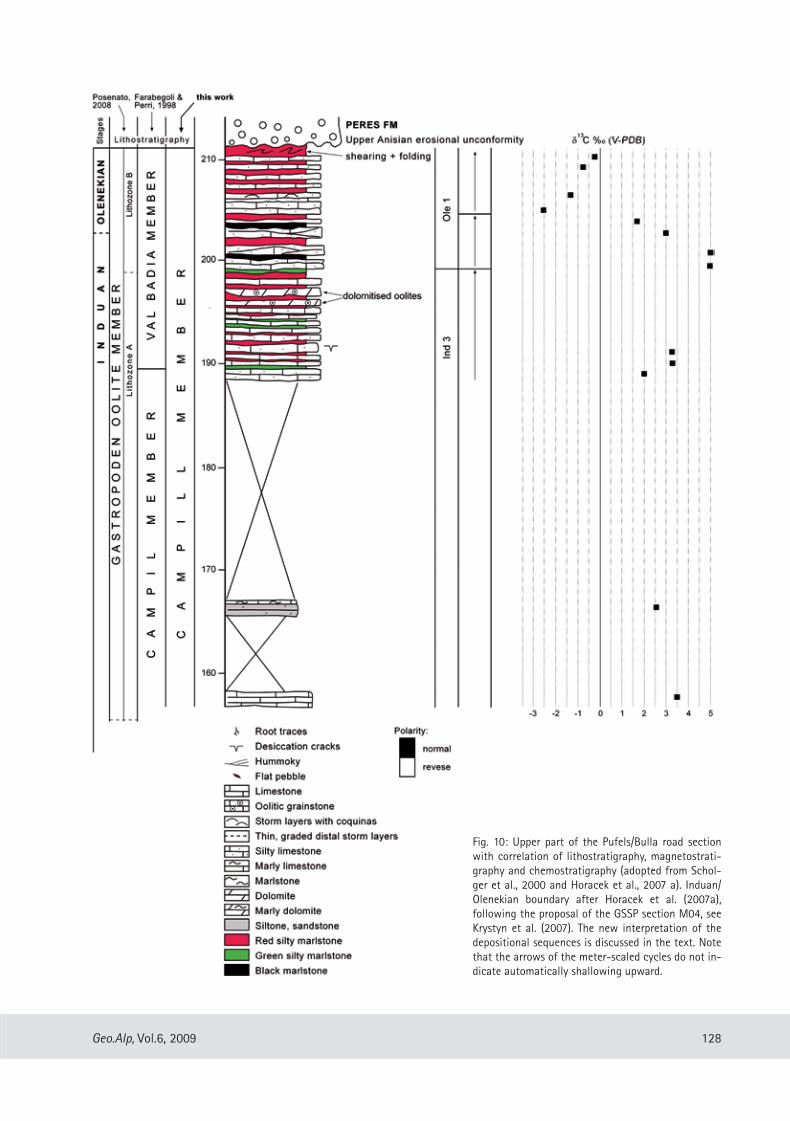
Fig. 10: Upper part of the Pufels/Bulla road section with correlation of lithostratigraphy, magnetostrati-graphy and chemostratigraphy (adopted from Schol-ger et al., 2000 and Horacek et al., 2007 a). Induan/Olenekian boundary after Horacek et al. (2007a), following the proposal of the GSSP section M04, see Krystyn et al. (2007). The new interpretation of the depositional sequences is discussed in the text. Note that the arrows of the meter-scaled cycles do not in-dicate automatically shallowing upward.

129 Geo.Alp, Vol. 6, 2009
neath microbial mats and are usually preserved on flat upper surfaces of siltstone or sandstone beds.
Further on, from ca. 152 m to 186 m the road sec-tion is mostly covered. The next outcrops at the top of the section show some folding and ramp folds, but exact balancing of the stratigraphy by retrodeforma-tion is possible.
The last 20 meters of the section (Fig. 10) are important for two reasons: (1) we recognize a pro-minent change in the facies development from pe-ritidal to subtidal offshore environment, and (2) this change is accompanied by a strong negative shift of the carbon isotope curve which is correlatable to the proposed GSSP section of the Induan-Olenekian Boundary in Mud (Spiti, Himalaya) (Krystyn et al., 2007). Peritidal cycles are made up by greenish to reddish silty and sandy marls with wave ripples and mud cracks alternating with dm-bedded silty bi-oclastic limestones and few yellowish oolitic dolo-mites and marly dolomites. Posenato (2008) termed this unit “lithozone A” of the Gastropod Oolite Mb in the definition of Broglio Loriga et al. (1990). Two thinning upward cycles with some dm thick amal-gamated hummocky cross-stratified silty limestone beds at their base represent the transgressive phase of sequence “Ole 1” (accepting the strong negative carbon isotope excursion as a proxy for the IOB). The background sedimentation is still composed by red silty and sandy marlstones. Rare dark gray to black
once more to the shoreface facies with thickening of shell tempestites and scour fillings.
Biostratigraphic remarks: The Seis/Siusi Member in the Dolomites is known for the abundance of Claraia specimens defining the Claraia Zone. The subzones with C. wangi-griesbachi, C. clarai and C. aurita oc-cur in the upper Mazzin, lower and upper Seis mem-bers (Broglio Loriga et al., 1990, Posenato, 2008). In the Pufels/Bulla sections several findings of Claraia specimens have been documented by Mostler (1982).
Campill Member
The start of the Campill Member is defined here with the first distinct occurrence of quartz/mica sandstones. Half meter- to meter-thick calcareous sandstone beds with hummocky cross stratification and a remarkable glauconite accumulation represent the transgressive phase of the sequence Ind 3. The beds grade to thinner bedded storm layers (bioclastic shell tempestites) forming thinning upward cycles on the scale of several meters (Figs. 10, 11). U-shaped burrows interpreted as Diplocraterium burrows, mi-croripples and wrinkle structures are remarkable se-dimentary structures in this part of the section. Most typical are “Kinneyia” structures, mm-scale winding ridges resembling small-scale interference ripples. After Porada & Bouougri (2007) they formed under-
Fig. 11: Lower part of the Campill Member with thin-ning upward cycles of tem-pestite beds. Road cut of the abandoned road to Pufels/Bulla. Scale: 2 meters. Photo courtesy of Lois Lammerhu-ber, Vienna.

130Geo.Alp, Vol.6, 2009
Acknowledgments
The present paper is an update of the field guide book presented for the meeting “The Triassic climate. Workshop on Triassic palaeoclimatology” which was held in Bozen/Bolzano, from June 3-7, 2008. We ex-press our thanks to E. Kustatscher (Museum of Nature South Tyrol) for inviting us to participate as excursion guides. Our special gratitude goes to the Geological Survey of the Autonomous Province of Bozen/Bolza-no for energetic assistance in the field.
References
Aigner, T. (1985): Storm depositional systems. - Lec-tures Notes in Earth Sciences 3, 175 p, Springer.
Bechstädt, T. & Brandner, R. (1970): Das Anis zwischen St. Vigil und dem Höhlensteintal (Pragser-und Olanger Dolomiten, Südtirol). - In: Mostler, H. (Ed.), Beiträge zur Mikrofazies und Stratigraphie von Tirol und Vorarlberg (Festband des Geologischen Insti-tutes 300-Jahr-Feier Universität Innsbruck). Wag-ner, Innsbruck: 9–103.
Brandner, R. (1988): The Permian-Triassic Boundary in the Dolomites (Southern Alps, Italy), San Antonio Section. - Ber. Geol. B.-A., 15: 49 – 56.
Broglio Loriga, C., Masetti, D. & Neri, C. (1983): La Formazione di Werfen (Scitico) delle Dolomiti occi-dentali: sedimentologia e biostratigrafia. - Riv. Ital. Paleont., 88 (4): 501-598.
Broglio Loriga, C., Goczan, F., Haas, J., Lenner, K., Neri, C., Scheffer, A.O., Posenato, R., Szabo, I. & Mark, A.T. (1990): The Lower Triassic sequences of the Dolo-mites (Italy) and Trasnsdanubian Mid-Mountains (Hungary) and their correlation. - Mem. Sc. Geol. Padova, 42, 41-103.
Chuodens-Sánchez , V. de & González, L. A. (2009): Calcite and Aragonite precipitation under con-trolled instantaneous supersaturation: elucidating the role of CaCO3 saturation state and Mg/Ca ratio on calcium carbonate polymorphism. - Journal Sed. Res., 79: 363-376.
De Zanche, V., Gianolla, P., Mietto, P., Siorpaes, C. & Vail, P. R. (1993): Triassic sequence stratigraphy in the Dolomites (Italy). - Mem. Sci. Geol., 45: 1-27.
laminated marlstones may indicate short intervals of decreasing oxygen at the sea bottom.
The road section ends with the upper Anisian ero-sional unconformity on top of the lower part of the Campill Member. Upper Anisian Conglomerates (Vol-tago-/Richthofen Conglomerate) directly overlie red siltstones, sandstones and silty marls.
Conclusions
The lithostratigraphic and sedimentologic stu-dy has enabled the identification of meter-scale transgressive-regressive cycles (parasequences) in peritidal to subtidal depositional environments. As-sociations of the parasequences constitute in va-rying stacking patterns four depositional sequences, which may have regional significance. This is proven by careful study of integrated stratigraphy of seve-ral sections in the Dolomites and Iran (Horacek et al., 2007 a, b). It evidences that the main excursions of the carbon isotope curve are clearly correlated to sequence stratigraphic boundaries: (1) transgressive systems tract (TST) of sequence Ind 1, (2) TST of Ole 1 (see also Krystyn et al., 2007) and (3) the TST at the base of the Val Badia Member (not preserved in the Pufels section). This would imply that the profound changes in the global carbon cycle in the Lower Tri-assic are forced by eustatic sea level changes. The TSTs of the sequences Ind 2 and Ind 3 are not clearly mirrored by the carbon isotope curve at Pufels, and a general trend is not obvious.
Only in the passage of more terrigenous input, i. e. at the base of the Campill Member, irregularities in the trend of the carbon isotope curve are noticed. More conspicuous is a negative shift in the Iranian sections (Horacek et al. 2007). On the other hand, the regional importance of the terrigenous input signal is evidenced by the magnetostratigraphic correlation with the continental facies of the German Triassic. Equivalent to the terrigenous Campill event in the Southalpine and the Upper Buntsandstein in the Aus-troalpine, the Volpriehausen Formation at the base of the Middle Buntsandstein starts with the first basin-wide influx of coarse grained sands (Szurlies, 2004). These distinct breaks in the sedimentation style indi-cate a climate change to a more humid environment with increased rainfall and continental runoff.

131 Geo.Alp, Vol. 6, 2009
Korte, C., Kozur, H. W. & Veizer, J. (2005): δ13C and δ18O values of Triassic brachiopods and carbonate rocks as proxies for coeval seawater and palaeo-temperature. - Palaeogeography, Palaeoclimatolo-gy, Palaeoecology, 226: 287-306.
Korte, C., Kozur, H. W., Joachimsky, M. M., Strauss, H., Veizer, J. & Schwark, L. (2004): Carbon, sulfur, and strontium isotope records, organic geochemistry and biostratigraphy across the Permian/Triassic boundary in Abadeh, Iran. - Int. J. Earth Sci. (Geol. Rdsch.), 93: 565-581.
Krainer, K. (1987): Zusammensetzung und fazielle Ent-wicklung des Alpinen Buntsandsteins und der Wer-fener Schichten im westlichen Drauzug (Kärnten/Osttirol).- Jahrb. Geol. B.-A, 130: 61-91.
Krystyn, L., Richoz, S. & Bhargava, O. N., (2007): The Induan-Olenekian Boundary (IOB) – an update of the candidate GSSP section M04. – Albertiana, 36: 33-45.
Mostler, H. (1982): Bozener Quarzporphyr und Wer-fener Schichten. In: Mostler, H. (Ed.), Exkursionsfüh-rer zur 4. Jahrestagung der Österreichischen Geolo-gischen Gesellschaft, 43-79, Innsbruck.
Newton, R. J., Pevitt, E. L., Wignall, P.B. & Bottrell, S. H. (2004): Large shifts in the isotopic compositi-on of seawater sulphate across the Permo-Triassic boundary in northern Italy. - Earth and Planetary Science Letters, 218: 331-345.
Perri, C. M. (1991): Conodont biostratigraphy of the Werfen Formation (Lower Triassic), Southern Alps, Italy. - Boll. Soc. Pal. Ital., 30/1: 23-45.
Porada, H. & Bouougri, H. (2007): Wrinkle structures – a critical review. – Earth Science Reviews, 81: 199-215.
Posenato, R. (2008): Global correlations of mid Early Triassic events: The Induan/Olenekian boundary in the Dolomites (Italy). – Earth Science Reviews, 91: 93-105.
Pruss, S. B., Bottjer, D. J., Corsetti, F. A. & Baud, A. (2006): A global marine sedimentary response to the end-Permian mass extenction: Examples from southern Turkey and western United States. - Earth Science Reviews, 78: 193-206.
Scholger, R., Mauritsch, H. J. & Brandner, R. (2000): Permian-Triassic boundary magnetostratigraphy from the Southern Alps (Italy). - Earth and Planeta-ry Science Letters, 176: 495-508.
Farabegoli, E. & Perri, C. M. (1998): Permian/Triassic boundary and Early Triassic of the Bulla section (Southern Alps, Italy): lithostratigraphy, facies and conodont biostratigraphy. - Giornale di Geologia, 60 (Spec. Issue ECOS VII Southern Alps Field Trip Guidebook): 292-311.
Farabegoli, E., Perri, C. M. & Posenato, R. (2007): Envi-ronmental and biotic changes across the Permian-Triassic boundary in western Tethys: The Bulla para-stratotype, Italy. - Global and Planetary Change, 55: 109-135.
Geologische Karte der Westlichen Dolomiten 1:25.000. (2007), Autonome Provinz Bozen – Südtirol, Amt f. Geologie u. Baustoffprüfung, Bozen/Kardaun.
Gianolla, P., De Zanche, V. & Mietto, P. (1998): Triassic sequence stratigraphie in the Southern Alps (Nort-hern Italy): definition of sequences and basin evolu-tion. - SEPM Special Publication, No. 60: 719-747.
Horacek, M., Brandner, R. & Abart, R. (2007a): Carbon isotope record of the P/T boundary and the Lower Triassic in the Southern Alps: evidence for rapid changes in storage of organic carbon; correlation with magnetostratigraphy and biostratigraphy. - Palaeogeography, Palaeoclimatology, Palaeoecolo-gy, 252: 347-354.
Horacek, M., Richoz, S., Brandner, R., Krystyn, L., Spötl, C. (2007b): Evidence for recurrent changes in Lo-wer Triassic oceanic circulation of the Tethys: The δ13C record from marine sections in Iran. - Palaeo-geography, Palaeoclimatology, Palaeoecology, 252: 355-369.
Horacek, M., Brandner, R., Richoz, S., Povoden, E., in review: Exact correlation of the 13C curve and the paleomagnetic pattern across the Permian- Triassic Boundary in the Seis/Siusi section, N-Italy.
Hug, N. & Gaupp, R., 2006: Palaeogeographic re-construction in red beds by means of genetically related correlation: results from the upper Zech-stein (Late Permian). -Z. dt. Ges. Geowiss., 157/1, 107-120, Stuttgart.
Korte, C. & Kozur, H. W. (2005): Carbon isotope strati-graphy across the Permian/Triassic boundary at Jol-fa (NW-Iran), Peitlerkofel (Sas de Pütia, Sas de Pu-tia), Pufels (Bula, Bulla), Tesero (all three Southern Alps, Italy) and Gerennavár (Bükk Mts., Hungary). - Journal of Alpine Geology/Mitt. Ges. Geol. Berg-baustud. Österr., 47: 119-135.

132Geo.Alp, Vol.6, 2009
Wheeler, H. E. (1964): Baselevel, lithosphere Surface, and Time-Stratigraphy. – Geol. Soc. Amer. Bull., 75: 599-610.
Wignall, P. B. & Hallam, T. (1992): Anoxia as a cause of the Permian-Triassic mass extinction: facies evi-dence from northern Italy and the western United States. - Palaeogeography, Palaeoclimatology, Pa-laeoecology 93: 21-46.
Manuscript submitted: 14.1.2009Revised manuscript accepted: 7.9.2009
Shaffer, G., Olsen, S. M. & Pederson, O. P. (2009): Long-term ocean oxygen depletion in response to carbon dioxide emissions from fossil fluids. – Nature Ge-oscience, vol. 2: 105-109.
Szurlies, M. (2004): Magnetostratigraphy: the key to a global correlation of the classic Germanic Trias-case study Volpriehausen Formation (Middle Bunt-sandstein), Central Germany. – Earth and Planetary Science Letters, 227: 395-410.
Szurlies, M., Bachmann, G. H., Menning, M., Nowaczyk, N. R. & Käding, K. C. (2003): Magnetostratigraphy and high-resolution lithostratigraphy of the Permi-an-Triassic boundary interval in Central Germany. - Earth and Planetary Science Letters, 212: 263-278.
133 Geo.Alp, Vol. 6, 2009
Errata Corrige
Errata corrige to Geo.Alp, Vol. 5, p. 121-137, 2008Preliminary report on a new vertebrate track and flora site from Piz da Peres (Anisian – Illyrian): Olang Dolomites, Northern Italy
The original manuscript unfortunately contains the following errors that could not be corrected prior to publication.On page 126, Plate 3, Fig. 3 shows Neuropteridium voltzii, Plate 3, Fig. 2 shows Scolopendrites sp., Plate 3, Fig. 4 shows ?Botrychium sp., Plate 4, Figs. 5-6 show Voltzia recubariensis.The author list submitted originally read Michael Wachtler, Rossana Todesco and Marco Avanzini. Marco Avanzini as coordinator of the research deeply regrets that he changed the sequence of authors and that there was an insertion of another co-author without giving prior information to all authors.
Leider kam es nach Abgabe des Originalmanuskriptes zu einigen bedauerlichen Fehlern, welche nicht mehr vor Drucklegung korrigiert werden konnten.Seite 126: Tafel 3, Fig. 3 zeigt Neuropteridium voltzii, Tafel 3, Fig. 2 zeigt Scolopendrites sp., Tafel 3, Fig. 4 zeigt ?Botrychium sp. Voltzia recubariensis wurde auf Tafel 4, Fig. 5-6 abgebildet.Die ursprüngliche Autorenliste bestand aus Michael Wachtler, Rossana Todesco, Marco Avanzini. Marco Avanzini als Koordinator des Forschungsprojektes bedauert, dass er die Autorenreihenfolge geändert und einen weiteren Autor aufgenommen hat, ohne die ande-ren Autoren zu informieren.

134Geo.Alp, Vol.6, 2009
NATURMUSEUM SÜDTIROLMUSEO SCIENZE NATURALI ALTO ADIGE
MUSEUM NATÖRA SÜDTIROL
Gredleriana
NATURMUSEUM SÜDTIROLMUSEO SCIENZE NATURALI ALTO ADIGE
MUSEUM NATÖRA SÜDTIROL
Gredleriana
2008
8 Projekt „Habitat Schlern / Sciliar“
Die Veröffentlichungsreihe „Gredleriana“ des Naturmuseums Südtirol (Bozen) ist ein Forum für naturwissenschaftli-che Forschung in und über Südtirol. Sie stellt eine Kommunikationsplattform dar für all jene, die in Südtirol forschen oder in der Ferne Südtirol und den alpinen Raum als Ziel ihrer naturwissenschaftlichen Forschung haben.
Band 8: 25 Euro 630 Seiten)Abonnement (1 Band jährlich): 20 Euro

135 Geo.Alp, Vol. 6, 2009