Embed Size (px)
Citation preview
ORIGINAL
The role of basement inheritance faults in the recent fracturesystem of the inner shelf around Alboran Island,Western Mediterranean
A. Maestro-González & P. Bárcenas & J. T. Vázquez &
V. Díaz-del-Río
Received: 7 April 2006 /Accepted: 15 June 2007 / Published online: 25 July 2007# Springer-Verlag 2007
Abstract Fractures associated with volcanic rock outcropson the inner shelf of Alboran Island, Western Mediterra-nean, were mapped on the basis of a side-scan sonarmosaic. Absolute maximum fracture orientation frequencyis NW–SE to NNW–SSE, with several sub-maximaoriented NNE–SSW, NE–SW and ENE–WSW. The originof the main fracture systems in Neogene and Quaternaryrocks of the Alboran Basin (south Spain) appears to becontrolled by older structures, namely NE–SW and WNW–ESE to NW–SE faults which cross-cut the basement. Thesefaults, pre-Tortonian in origin, have been reactivated sincethe early Neogene in the form of strike-slip and extensionalmovements linked to the recent stress field in this area.Fracture analysis of volcanic outcrops on the innercontinental shelf of Alboran Island suggests that the shelfhas been deformed into a narrow shear zone limited by twoNE–SW-trending, sub-parallel high-angle faults, the mainorientation and density of which have been influenced byprevious WNW–ESE to NW–SE basement fractures.
Introduction
Reactivation of ancient faults, a common mechanism ofdeformation in the brittle crust, depends mainly on theaction of a new, different stress field and the direction, dipand strength of the faults. In strongly deformed areas, faultreactivation may lead to basin inversion or development ofpull-apart or extensional basins (De Graciansky et al. 1989;Williams et al. 1989). In weakly deformed intra-cratonicareas, fault reactivation can lead to the fracturing of coverunits overlying the basement. Surface fracture patternsresulting from reactivation of deep-seated faults in thebasement depend on (1) the kinematic nature of the fault,i.e. strike-slip, normal or reverse. In the case of strike-slipfaults R, R′ and T fractures are formed in the surface cover(Riedel 1929; Tchalenko 1970; Naylor et al. 1986; Mandl1988). Normal or reverse basement faults tend to producesurface faults parallel to the underlying basement faults(Mandl 1988; Withjack et al. 1990). Surface fracturepatterns also depend on (2) the rheological properties ofthe overlying sequence (unilayer or multilayer; Horsfield1977; Mandl 1988) which mainly control the width of thedeformed zone of the overlying basement fault cover.
In the Western Mediterranean, the Alboran Ridge, themost distinctive Alboran Basin feature, cuts the basinobliquely in a NE–SW direction. This structure is ananticlinorium trending N065E, bounded by two major left-lateral strike-slip fault systems, one in the north and one inthe south. The water depth to the ridge becomes shallowertowards the northeast in the central Alboran Sea, where theridge crest breaks the water surface to form the AlboranIsland (Fig. 1a). Due to the scarcity of sediments, therelative homogeneity of rock type and the simplicity ofbedrock structure, the volcanic rock outcrops around
Geo-Mar Lett (2008) 28:53–64DOI 10.1007/s00367-007-0089-8
DO00089; No of Pages
A. Maestro-González (*)Servicio de Geología Marina,Instituto Geológico y Minero de España,Rios Rosas 23,28003 Madrid, Spaine-mail: [email protected]
P. Bárcenas :V. Díaz-del-RíoInstituto Español de Oceanografía,Apartado 285,29640 Fuengirola, Málaga, Spain
J. T. VázquezDepartamento de Geología, Facultad de Ciencias del Mar,Universidad de Cádiz,Campus Río San Pedro,11510 Puerto Real, Cádiz, Spain
Alboran Island are ideally suited for the study of fracturesand their relationship with geological structures (Fig. 1b).
The objectives of this study are (1) to define the fracturepattern of volcanic rock forming the inner continental shelfof the Alboran Island on the basis of side-scan sonarimages, and (2) to establish the origin and distribution ofthe fracture patterns within the older and more recenttectonic framework.
Geological setting
The Recent/Neogene evolution of the Alboran Basin isrelated to the continental collision generated by thenorthward movement of the African plate relative to Iberia,which resulted in westward thrusting and subsequentextension of the Alboran Block, and the creation of oceaniccrust in the south-western Algero–Balearic basin plain(Rehault et al. 1985; Dewey et al. 1989; Mauffret et al.1992).
The Alboran Basin region has been under continuous N–S to NW–SE compression since the Tortonian at least, andprobably much earlier (Ott d’Estevou and Montenat 1985;Philip 1987; Sanz de Galdeano 1990; Srivastava et al.1990; Roest and Srivastava 1991). Since that time, theactual axis of maximum compression seems to have varied,from about NW–SE in the Tortonian to N–S from the lateTortonian to early Pliocene, reverting to about NW–SE inthe Pliocene (De Larouzière et al. 1988; Sanz de Galdeano1990) and with a return also to NW–SE in more recenttimes (De Mets et al. 1990).
The predominant trend of the most important faults inthe Alboran Basin is east–northeast to northeast (Camposet al. 1992; Woodside and Maldonado 1992; Fig. 1a).Other fault systems are oriented north–northwest and east–southeast (Maldonado et al. 1992). Both margins of one ofthe most relevant structures in the central Alboran Basin,the Alboran Ridge, are affected by faults trending in thesame predominantly north-eastern direction. This systemis probable the offshore extension of the Jebha Fault,which separates two major structural domains of the RifCordillera: the eastern External Rif and the Internal Rifianzones (Leblanc 1990). Land studies have demonstratedthat all these faults have a major left-lateral strike-slipcomponent (De Larouzière et al. 1988). The structure ofthis faulting offshore along the northern margin of theAlboran Ridge may be reverse or strike-slip, with acompressive component (Bourgois et al. 1992; Camposet al. 1992). The ridge itself is truncated along its flanksby several major faults (Fig. 1a). The northern flank isbounded by a major fault escarpment extending roughlyWNW–ESE (Dillon et al. 1980; Mauffret et al. 1987). This
fault is inferred to have a substantial reverse component,the origin of the progressively higher elevation of theAlboran Ridge towards its northern end culminating in theAlboran Island (Woodside and Maldonado 1992). More-over, Woodside and Maldonado (1992) describe thepresence of at least one fault which compartmentalizesthe central sector of the ridge, with a WNW–ESEdirection. Some active reverse or right-lateral strike-slipfaults with a compressive component have been sug-gested, the northern side having been elevated higher.
In the northern sector of the Alboran Ridge, AlboranIsland is located in the centre of a NE-SW-oriented shoalarea (continental shelf), which is ellipsoidal and elongate inshape. The shelf is widest on the north-eastern side,tapering from 17 to 2 km in width; the shelf break is atan average depth of 110 m. Its slope is steeper towards thesoutheast, with a mean gradient of 13°. In this area, twomajor canyons with associated turbidite systems, andtectonic and gravitational morphology have been identified(Bárcenas et al. 2000). North-western slope gradients aregentle, about 5°. The asymmetry of the south-eastern slopegradient relative to that of the north-western slope is due torecent tectonic activity which has significantly affected themorphology and sedimentary processes on the south-eastern slope (Bárcenas et al. 2000).
Alboran Island and its shelf consist primarily ofpyroclastic volcanic material such as ash flow tuffs andblocks as well as ash flow deposits, overlain by Neogene–Quaternary sedimentary units. The volcanic rock depositsare very similar to those outcropping onshore in the strato-volcanic complex of Cabo de Gata (southeast Spain) andRas Tarf (northern Morocco), which form a NE–SW-oriented belt of calc-alkaline volcanic rocks. The pyroclas-tic bed direction is ENE–WSW, and the dip is towards thenorth (Hernández-Pacheco and Ibarrola 1970); the age ofthese rocks has been estimated to be between 9.26±0.02and 9.37±0.01 Ma (Duggen et al. 2004).
Methods
This study is based on a network of 39 side-scan sonar(EG&G, 500 kHz) tracks obtained in September 1994during the Alboran 9409 cruise on board the B/O F.P.Navarro (Instituto Español de Oceanografía, Fuengirola,Spain; Fig. 2a). These tracks around Alboran Island werespaced about 200 m apart, comprise a total length of morethan 120 km up to a depth of 60 m, and were aligned SW–NE and WNW–ESE to cover the inner continental shelf ofthe island.
The large number of fractures identified in this survey(Fig. 2b) was classified by means of an automatic
54 Geo-Mar Lett (2008) 28:53–64

exploration program. This program reads vectorial files(DXF in our case) and explores, systematically, first alongthe x-axis and then along the y-axis, generating a file which
provides, among other things, the length and orientation ofeach line. Other conventional statistical programs were runon these data for fracture analysis.
Fig. 1 a Structural scheme of the Alboran Sea. 1 Normal faults, 2reverse faults, 3 strike–slip components, 4 anticlines, 5 axis ofdepocentres with maximum sediment thicknesses, 6 boundary ofdiapiric bodies, 7 basement highs, 8 basement (presumed volcanic), 9volcanic basement outcropping or sub-outcropping, 10 diapirs, ACHAlboran Channel, AR Alboran Ridge, DB Djibouti Bank, EAB Eastern
Alboran Basin, WAB Western Alboran Basin, YR Yusuf Ridge, JBJebha Fault, NF Nekor Fault, XB Xauen Bank, TB Tofiño Bank, RTRas Tarf, MB Malaga Basin, MoB Motril Basin, ChB Chella Bank, ABAlmeria Basin, SF Serrata Fault, CB Cabo de Gata (modified fromComas et al. 1992). b Detailed geological map of the study area
Geo-Mar Lett (2008) 28:53–64 55
Fracture density maps displaying fracture distribution aredrawn from calculations of the length of lines containedwithin cells, in a network, divided by cell area. From thedata file bearing the coordinates of the beginning and endof each fracture, the number of fractures beginning orending within each cell is calculated. To archive this, an
automatic computation program able to determine thelength of fractures, or the length of segments of fracturesincluded within each cell, was used (program Lindens;Casas et al. 2000).
The compilation of fracture density maps begins with thedetermination of the most appropriate cell size. Critical grid
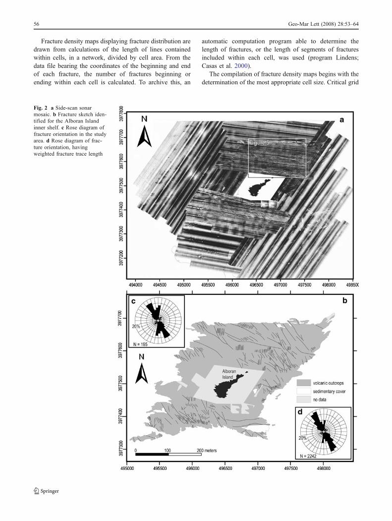
Fig. 2 a Side-scan sonarmosaic. b Fracture sketch iden-tified for the Alboran Islandinner shelf. c Rose diagram offracture orientation in the studyarea. d Rose diagram of frac-ture orientation, havingweighted fracture trace length
56 Geo-Mar Lett (2008) 28:53–64
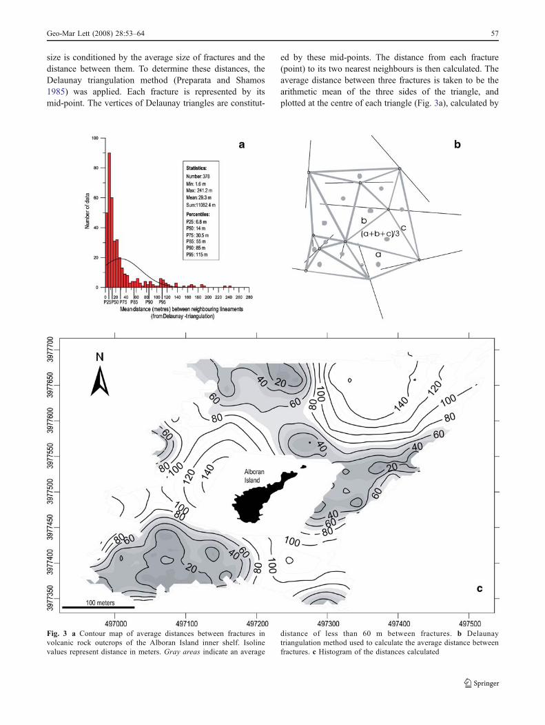
size is conditioned by the average size of fractures and thedistance between them. To determine these distances, theDelaunay triangulation method (Preparata and Shamos1985) was applied. Each fracture is represented by itsmid-point. The vertices of Delaunay triangles are constitut-
ed by these mid-points. The distance from each fracture(point) to its two nearest neighbours is then calculated. Theaverage distance between three fractures is taken to be thearithmetic mean of the three sides of the triangle, andplotted at the centre of each triangle (Fig. 3a), calculated by
Fig. 3 a Contour map of average distances between fractures involcanic rock outcrops of the Alboran Island inner shelf. Isolinevalues represent distance in meters. Gray areas indicate an average
distance of less than 60 m between fractures. b Delaunaytriangulation method used to calculate the average distance betweenfractures. c Histogram of the distances calculated
Geo-Mar Lett (2008) 28:53–64 57
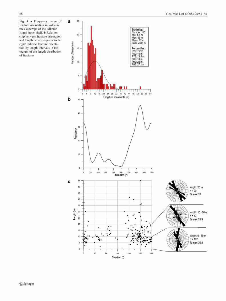
Fig. 4 a Frequency curve offracture orientation in volcanicrock outcrops of the AlboranIsland inner shelf. b Relation-ship between fracture orientationand length. Rose diagrams to theright indicate fracture orienta-tion by length intervals. c His-togram of the length distributionof fractures
58 Geo-Mar Lett (2008) 28:53–64
means of an automatic program (Triangle, by J. Bernal,unpublished data) as the arithmetic mean of the three sidesof each triangle (Fig. 3b). To display the variations of thisdistance and the most representative distances from theirdistribution over the area, a contour map of averagedistances between fractures was drawn (Fig. 3c).
Results
From the analysis of the side-scan sonar mosaic, a totalof 195 fractures were mapped in the volcanic rock outcropsof the Alboran Island inner shelf (Fig. 2b). The length offractures varies from 1.7 to 55 m. Their size distribution is
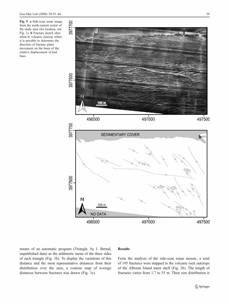
Fig. 5 a Side-scan sonar imagefrom the north-eastern sector ofthe study area (for location, seeFig. 2). b Fracture sketch iden-tified in volcanic outcrop whereit is possible to determine thedirection of fracture planemovement on the basis of therelative displacement of bedlines
Geo-Mar Lett (2008) 28:53–64 59
log-normal, with a mode of 8–9 m (Fig. 4a). Theorientations of the fractures in the area are represented byrose diagrams (Fig. 2c). To avoid the influence of line-segmentation number, fracture trace length was weighted inthe statistical analysis of fracture direction (Fig. 2d).
Orientation
Maximum orientation of volcanic rock fractures on theAlboran Island inner shelf is clearly NW–SE, with adispersion of about 50° (Fig. 4b); other secondary maximaare NNE–SSW, NE–SW and ENE–WSW. Moreover, it is
possible to determine the direction of movement of somefracture planes on the basis of the relative displacement ofbed lines (Fig. 5); NW–SE to NNW–SSE fractures showright-lateral strike-slip, NNE–SSW fractures left-lateralstrike-slip movement.
Relationships between direction and length (Fig. 4c)indicate that NW–SE to NNW–SSE fracture orientations,and fracture lengths from 2 m to longer than 20 m are themost common. NNE–SSW fractures are dominant in the 2–10 m interval; also, NE–SW-trending fractures show asecondary maximum in the same interval. A secondarymaximum of ENE–WSW-trending fractures is evident in
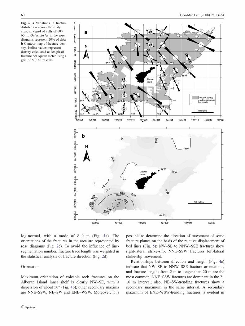
Fig. 6 a Variations in fracturedistribution across the studyarea, in a grid of cells of 60×60 m. Outer circles in the rosediagrams represent 20% of data.b Contour map of fracture den-sity. Isoline values representdensity calculated as length offracture per square meter using agrid of 60×60 m cells
60 Geo-Mar Lett (2008) 28:53–64
the 10–20 m interval. Moreover, it was possible to establisha secondary maximum of WNW–ESE fracture direction forfracture lengths longer than 20 m. An important aspect oflength–orientation relationships is the decreasing occur-rence of NNE and NE–ENE fractures with increasinglength.
Spatial variation in fracture orientation was calculated bymeans of a grid of square cells, representing the length andnumber of fractures in each cell (Fig. 6a). The results showa ubiquitous pattern of dominant NW–SE direction, withsecondary maxima similar to those obtained in the analysisof the total data. Fractures with NW–SE direction arepresent in the entire study area. Nevertheless, there areother fracture directions which characterize certain loca-tions: (1) fractures with NNW–SSE orientation are situatedin the southwest (between horizontal reference lines3977302 and 3977422, Fig. 6a) and the west (betweenvertical reference lines 497265 and 497445, Fig. 5a); (2)fractures with WNW–ESE orientation are observed in thenorth (between horizontal reference lines 3977542 and3977722, Fig. 6a) and the west (between vertical referencelines 497265 and 497325, Fig. 6a); (3) in some places inthe north, a NE–SW direction becomes more evident(between horizontal reference lines 3977602 and 3977722,Fig. 6a).
Density
The mean average distance between fractures in thecontinental shelf volcanic outcrops is 30 m (Fig. 3b). Themode of about 7 m is very similar to that of the fracturelength (Fig. 4a). The cumulative percentage Φ85 is about55 m. The contour map of distance between fractures(Fig. 3c) shows that, in most parts of the study area, thedistance between lineaments varies between 1 and 60 m.
For a density map to be geologically meaningful, theminimum cell size must be greater than the distancebetween fractures previously calculated (Cortés et al.2003). To calculate fracture density, several tests weremade with cells of different sizes. Within this context, itshould be noted that a contour map drawn from a cell sizewhich is obviously too small (30×30 m) is no better than asimple fracture map, since about 41% of cell values arenull. We eventually chose a cell size of 60×60 m (abouttwo times the average spacing of fractures) in order to drawa geologically meaningful outcrop-scale map (Fig. 6b),thereby achieving reasonable accuracy and a minimum ofcells with null values between fractures (cf. only 15% ofcell values were null).
Several fracture density minima (west and southeast ofthe island) are the result of poor signal quality of the side-scan sonar images. Fracture density maxima within volca-nic outcrops on the inner continental shelf are located(Fig. 6b) on the south-western border and along thenorthern and eastern edge.
Discussion
Fracture density variations in the study area can becorrelated with underlying macrostructures associated withthe pre-Neogene basement (see Fig. 1a). The relationship ismade particularly clear by comparing the fracture densitymaximum with macrostructure orientation. In this area,fracture density is higher in certain zones, with contourselongate and parallel to the dominant NW–SE structuresdescribed by several authors in the vicinity (e.g. Woodsideand Maldonado 1992; Vázquez et al. 2000; Marín-Lechadoet al. 2005). Such a relationship may be the result of largestructures acting as inhomogeneities and ‘stress raising
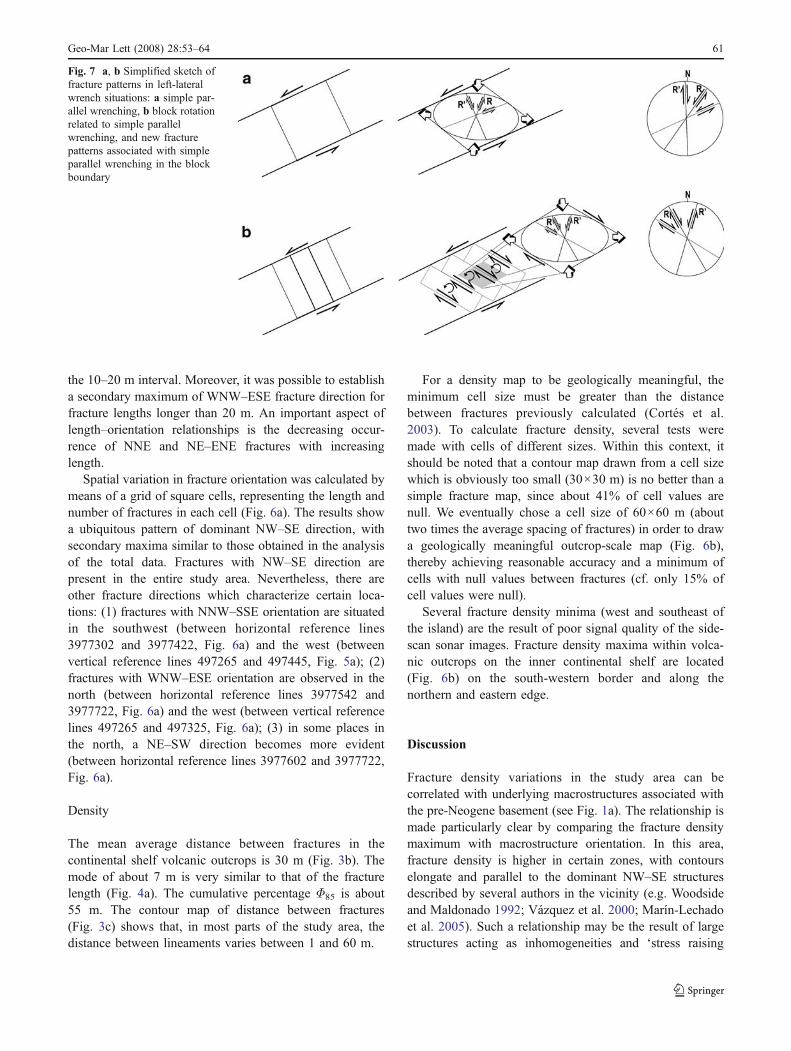
Fig. 7 a, b Simplified sketch offracture patterns in left-lateralwrench situations: a simple par-allel wrenching, b block rotationrelated to simple parallelwrenching, and new fracturepatterns associated with simpleparallel wrenching in the blockboundary
Geo-Mar Lett (2008) 28:53–64 61
zones’ (Pollard and Segall 1987; Sassi et al. 1993; Sassiand Faure 1997).
Although fracture orientation in the volcanic outcrops isvariable (see Fig. 2b), the NW–SE absolute maximum offracture orientation is evident throughout the study area.This directional maximum correlates well with one of thetwo fault and fold maxima mapped in the basement rock(Fig. 1a). Since these orientations coincide, fractureformation in the Upper Miocene probably relates to basinfloor anisotropy. Reactivation of faults in pre-Neogenerocks during the Upper Miocene–Quaternary has beenobserved in several onshore and offshore areas of theAlboran Sea (among others, by Gensous et al. 1986; DeLarouzière et al. 1988; Woodside and Maldonado 1992;Watts et al. 1993). That the basin basement fault patternshould be the same as that of the volcanic outcrops seems areasonable assumption.
Given the fracture orientation, we propose that thesefaults are the result of reactivation of similarly orientedbasement faults in the Alboran Basin. The basement faultrelationship with counterparts in the Upper Miocenevolcanic cover cannot, however, be inferred directly.Analogue model studies suggest that basement faultmovement produces a set of minor tectonic structures inthe cover. Fractures/faults in the cover, not necessarilylocated directly above the basement fault, may haveoccurred within an upward-opening fan of minor faults(Horsfield 1977; Naylor et al. 1986; Mandl 1988; Withjacket al. 1990). At the surface, these fractures develop along aband located over the main basement fault. Their orienta-tion depends on (1) the strike-slip/dip–slip relationships ofthe basement fault, (2) the mechanical and geometricalcharacteristics of the cover, and (3) the magnitude of thestress-inducing deformation.
The late Tortonian and Messinian stress field directionwas shown, from meso-structural analysis, to reflectroughly NNW–SSE to N–S compression (Montenat et al.1987; Sanz de Galdeano 1990). The left-lateral northeaststrike-slip faults were activated at that time. Intense tectonicdeformation occurred along the Alboran Ridge, which hasreacted by transpression, as would be the case in anenormous positive flower structure (Bourgois et al. 1992).The N–S Recent stress field direction has also favouredleft-lateral movement along the northeast-trending faults(Philip 1987). Wrenching produced two main sets ofintersected vertical fractures along the wrench zone. Oneset, the low-angle fractures, has angles between 10 and 30°relative to the wrench strike, and the same displacementdirection as that of the main wrench zone and final wrenchfault. The other set, i.e. the high-angle fractures, intersectsthe wrench at angles of between 70 and 90°, and has adisplacement direction opposite to that of the wrench.These conjugate fractures can take the form of either joints
or faults, or both, depending on the magnitude ofwrenching (Wilcox et al. 1973). The low- and high-angleconjugate fractures have been termed Riedel shears (R) andconjugate Riedel shears (R′) respectively by Tchalenko andAmbraseys (1970).
If fractures affecting volcanic rock around the AlboranIsland originated from simple shear movement along theENE–WSW Alboran Ridge edge faults, then Riedel shearswould trend NE and N (see Fig. 7a). However, in our casethe NE–SW fracture (R) direction of movement is left-lateral, whereas the N–S fracture (R′) direction of move-ment is right-lateral. This fracture pattern is not coincidentwith the fracture pattern observed in the volcanic outcrops.Nevertheless, if previous anisotropy were oriented oblique-ly to the wrench direction, then movement of the mainfaults would produce external rotational deformation of theindividualized crustal blocks (Fig. 7b). Wrenching forces,which result from simple regional shear, act in oppositedirections, as if on separate parallel lines, so as to form acouple. The resulting deformation is generally restricted toa linear wrench zone, parallel to the couple and to the edgesof the moving crustal blocks. A left-lateral wrench has anexternal direction of rotation which is counter-clockwise.Edges between blocks act as individualized wrench zones,and tend to deform somewhat independently. Therefore, ifshear is concentrated along WNW–ESE faults reactivatedby left-lateral strike-slip movement of faults located inAlboran Ridge margins, then orientation of the mainconjugate Riedel fractures will trend NW to NNW (R, withright-lateral strike-slip movement) or NNE (R′, with left-lateral strike-slip movement). The foregoing would explainthe orientation and direction of fracture movement observedin the volcanic outcrops on the inner continental shelf ofAlboran Island.
Conclusions
Study of side-scan sonar imagery of volcanic outcrops onthe inner continental shelf of Alboran Island proved usefulin the analysis of recent, visually inspected fracturepatterns.
The absolute maximum of fractures, NW–SE with adispersion of about 50°, is fairly ubiquitous in the studyarea. Other relative maxima are NNE–SSW, NE–SW andENE–WSW.
Average distances between fractures, ranging from 1 to60 m, were calculated by means of triangulation. The best-fitting grid square with which to calculate geologicallymeaningful density (length of fractures per km2) was foundto be 60×60 m.
Density contour maxima elongation in the NW–SEdirection, coincident with one main structural orientation,
62 Geo-Mar Lett (2008) 28:53–64
suggests that fracture density is controlled by largestructures underlying volcanic rock outcropping aroundAlboran Island.
Fracturing in Upper Miocene volcanic rock could resultfrom reactivation of faults trending NE and WNW to NWwithin the Alboran basin basement. Left-lateral strike-slipdisplacement of NE–SW-oriented faults along the AlboranRidge edges caused the counter-clockwise rotation of thevarious blocks which compartmentalize the ridge. Theseblocks are bounded by WNW–ESE and NW–SE fractureswhich were reactivated with right-lateral strike-slip move-ment. Wrenching caused two main sets of conjugatefractures trending NNW and NNE. NNW–SSE fracturemovement is right-lateral strike-slip, associated with Riedelshear fractures (R). NNE–SSW fracture movement has aleft-lateral strike-slip component, and can be related toconjugate Riedel shear fractures (R′). As inferred from faultpopulation analysis, reactivation of faults was probably dueto a NW–SE-oriented compressional stress field regimeactive during the late Tortonian and Messinian, or in morerecent times.
Acknowledgements We thank Burg Flemming, Jesús Galindo-Zaldívar and an anonymous referee for providing corrections andconstructive comments which significantly improved the manuscript.The authors are grateful to the Instituto Español de Oceanografía, andthe officers and crew of the B/O F.P. Navarro for their assistance atsea, and to Dr. Javier Bernal (CAMD-NIST, USA) who developed theTRIANGLE program for application of the Delaunay method. This isa contribution to the project CONSOLIDER-INGENIO 2010CSD2006-0041-TOPOIBERIA.
References
Bárcenas P, Vázquez JT, Díaz del Río V, Fernández-Salas LM, TelloO, Sanz JL (2000) La vertiente meridional del Banco de la isla deAlborán: presencia de dos sistemas cañón-abanico submarino. In:Ext Abstr Vol VI Reunión Nacional de Geomorfología, 17–20September 2000, Madrid University, pp 169
Bourgois J, Mauffret A, Ammar A, Demnati A (1992) Multichannelseismic data imaging of inversion tectonics of the Alboran Ridge(Western Mediterranean Sea). Geo Mar Lett 12:117–122
Campos J, Maldonado A, Campillo AC (1992) Post-messinianevolutional patterns of the central Alboran Sea. Geo Mar Lett12:173–178
Casas AM, Cortés AL, Maestro A, Soriano MA, Riaguas A, Bernal J(2000) LINDENS: a basic program for lineament analysis.Comput Geosci 26:1011–1022
Comas MC, García-Dueñas V, Jurado MJ (1992) Neogene tectonicevolution of the Alboran Sea from MCS data. Geo Mar Lett12:157–164
Cortés AL, Soriano MA, Maestro A, Casas AM (2003) The role oftectonic inheritance in the development of recent fracturesystems, Duero Basin, Spain. Int J Remote Sens 24:4325–4345
De Graciansky PC, Dardeau G, Lemoine M, Tricart P (1989) Theinverted margin of the French Alps and foreland basin inversion.
In: Cooper MA, Williams GD (eds) Inversion tectonics. Geol SocSpecial Pub 44:87–104
De Larouzière FD, Bolze J, Bordet P, Hernández J, Montenat C, Ottd’Estevou P (1988) The Betic segment of the lithospheric trans-Alboran shear zone during the Late Miocene. Tectonophysics152:41–52
De Mets C, Gordon RG, Argus D, Stein S (1990) Current platemotions. Geophys J Int 101:425–478
Dewey JF, Helman ML, Turco E, Hutton DHW, Knott SD (1989)Kinematics of the western Mediterranean. Geol Soc Lond SpecialPub 45:265–283
Dillon WP, Robb SM, Gary Greene M, Lucena JC (1980) Evolution ofthe continental margin of southern Spain and the Alboran Sea.Mar Geol 36:205–226
Duggen S, Hoernle K, Bogaard P, Harris C (2004) Magmaticevolution of the Alboran region: the role of subduction informing the western Mediterranean and causing the MessinianSalinity Crisis. Earth Planet Sci Lett 218:91–108
Gensous B, Tesson MR, Winnock E (1986) La marge méridionale dela Mer d’Alboran: caractères structuro-sédimentaires et évolutionrécente. Mar Geol 72:341–370
Hernández-Pacheco A, Ibarrola E (1970) Nuevos datos sobre lapetrología y geoquímica de las rocas volcánicas de la Isla deAlborán (mediterráneo Occidental, Almería). Estud Geol26:93–103
Horsfield WT (1977) An experimental approach to basement-controlled faulting. Geol Mijnb 56:363–370
Leblanc D (1990) Tectonic adaptation of the external zones around thecurved core of an orogen: the Gibraltar Arc. J Struct Geol12:1013–1018
Maldonado A, Campillo AC, Mauffret A, Alonso B, Woodside JM,Campos J (1992) Alboran Sea Late Cenozoic tectonic andstratigraphic evolution. Geo Mar Lett 12:179–186
Mandl G (1988) Mechanics of tectonic faulting. Models and basicconcepts. Developments in Structural Geology 1. Elsevier,Amsterdam
Marín-Lechado C, Galindo-Zaldívar J, Rodríguez-Fernández LR,Pedrera A (2005) Active faults, seismicity and stresses in aninternal boundary of a tectonic arc (Campo de Dalías andNíjar, southeastern Betic Cordilleras, Spain). Tectonophysics396:81–96
Mauffret A, El-Robrini M, Gennesseaux M (1987) Indice de lacompression récent en mer Méditerranée: un bassin losangiquesur la marge nord-algérienne. Bull Soc Geol Fr 8:1195–1206
Mauffret A, Maldonado A, Campillo AC (1992) Tectonic frameworkof the eastern Alboran and western Algerian basins, westernMediterranean. Geo Mar Lett 12:104–110
Montenat C, Ott d’Estevou P, Masse P (1987) Tectonic andsedimentary characters of the Betic Neogene basins evolving ina crustal transcurrent shear zone (southeast Spain). Bull CentreRech Explor-Prod Elf-Aquitaine 11:1–22
Naylor MA, Mandl G, Sijpesteijn CHK (1986) Fault geometries inbasement-induced wrench faulting under different initial stressstates. J Struct Geol 8:737–752
Ott d’Estevou P, Montenat C (1985) Evolution structurale de la zonebétique orientale (Espagne) du Tortonien à l’Holocène. C R AcadSci Paris 300:363–368
Philip H (1987) Plio-Quaternary evolution of the stress field in theMediterranean zones of subduction and collision. Ann Geophys5B:301–320
Pollard DD, Segall P (1987) Theoretical displacements and stressesnear fractures in rock, with application of faults, joints, veins,dikes, and solution surfaces. In: Atkinson BK (ed) Fracturemechanics of rocks. Academic, London, pp 277–349
Preparata FP, Shamos MI (1985) Computational geometry—anintroduction. Springer, Berlin
Geo-Mar Lett (2008) 28:53–64 63

Rehault JP, Boillot G, Mauffret A (1985) The western MediterraneanBasin. In: Stanley DJ, Wezel FC (eds) Geological evolution ofthe Mediterranean Basin. Springer, Berlin, pp 101–130
Riedel W (1929) Zur Mechanik geologischer Brucherscheinungen.Zentralb Mineral Geol Paläontol B:354–368
Roest WR, Srivastava SP (1991) Kinematics of the plate boundariesbetween Eurasia, Iberia, and Africa in the north Atlantic from theLate Cretaceous to present. Geology 19:613–616
Sanz de Galdeano C (1990) Geologic evolution of the BeticCordilleras in the western Mediterranean, Miocene to the present.Tectonophysics 172:107–119
Sassi W, Faure JL (1997) Role of faults and layer interfaces on thespatial variation of stress regimes in basins: inferences fromnumerical modelling. Tectonophysics 266:101–119
Sassi W, Colletta B, Balé P, Paquereau T (1993) Modelling ofstructural complexity in sedimentary basins: the role of pre-existing faults in thrust tectonics. Tectonophysics 226:97–112
Srivastava SP, Roest WR, Kovacs LC, Oakey G, Lévesque S, VerhoefJ, Macnab R (1990) Motion of Iberia since Late Jurassic: resultsfrom detailed aeromagnetic measurements in the Newfoundland
Basin. In: Boillot G, Fontboté JM (eds) Alpine evolution ofIberia and its continental margins. Tectonophysics 184:229–260
Tchalenko JS (1970) Similarities between shear zones of differentmagnitudes. Geol Soc Am Bull 81:1265–1640
Tchalenko JS, Ambraseys NN (1970) Structural analysis of the Dasht-e Baÿaz (Iran) earthquake fractures. Geol Soc Am Bull 81:41–60
Vázquez JT, Bárcenas-Gascón P, Díaz-del-Río V, Sanz JL (2000)Características morfoestructurales del entorno sumergido de laIsla de Alborán. Geotemas 1(4):235–238
Watts AB, Platt JP, Buhl P (1993) Tectonic evolution of the AlboranSea Basin. Basin Res 5:153–177
Wilcox RE, Harding TP, Seely DR (1973) Basic wrench tectonics.AAPG Bull 57:74–96
Williams GD, Powell CM, Cooper MA (1989) Geometry andkinematics of inversion tectonics. In: Cooper MA, Williams GD(eds) Inversion tectonics. Geol Soc Special Pub 44:3–15
Withjack MO, Olson J, Peterson E (1990) Experimental models ofextensional forced folds. AAPG Bull 74:1038–1054
Woodside JM, Maldonado A (1992) Styles of compressional neo-tectonics in the Eastern Alboran Sea. Geo Mar Lett 12:111–116
64 Geo-Mar Lett (2008) 28:53–64