Embed Size (px)
Citation preview
Account of Purley on Thames
Section R200432
The Spread of Settlements
IntroductionThe essentials of the structure of present day Local Government areas can be traced to the earliestdays of the Saxon migrations. There had been a very vital and competent form of government in thecities and regions of Britain under the Romans but it did not survive the movements of people duringthe Dark Ages.
Under the Saxons, government grew up from two extremes: the direct and personal rule of the kingand the enshrined right of every man to have a say in matters that directly affected him. Theeffective community unit developed as the parish. This started out as a small isolated settlement at aconvenient point of geography, a river crossing, a sheltered valley, a clearing in a wood, or as inPurley's case, a piece of dry land in a marsh and was finally defined in the reign of King Edgar.
The SettlementThe extent of a community's territory was limited either by a natural boundary, such as the RiverThames, or by the distance covered by a single strip that could be conveniently cultivated by oneperson. This latter limit was effectively about half to three quarters of a mile and gave rise to aspacing between villages of around one and a quarter miles which is so typical of the Englishcountryside.
Once the settlement was well established and tenure passed from father to eldest son there was noland left for the younger sons. They had to move on. The most common place for them to settle wasat the next convenient point where they were separated by this key distance. It is interesting to seehow this worked out in the Purley area.
Inter-settlement SpacingsTaking Purley Magna as centred on the church, its neighbouring ancient points of settlement are at
Purley Parva 1800 ydsLa Hyde 2200Kentwood 1600
average 1900
For Purley Parva, centered on Westbury Farm, the distances are:-Purley Magna 1800La Hyde 1500Pangbourne 2200
average 1800
For La Hyde, centered on Purley Hall they are:-Purley Parva 1500Purley Magna 2200Sulham 1800
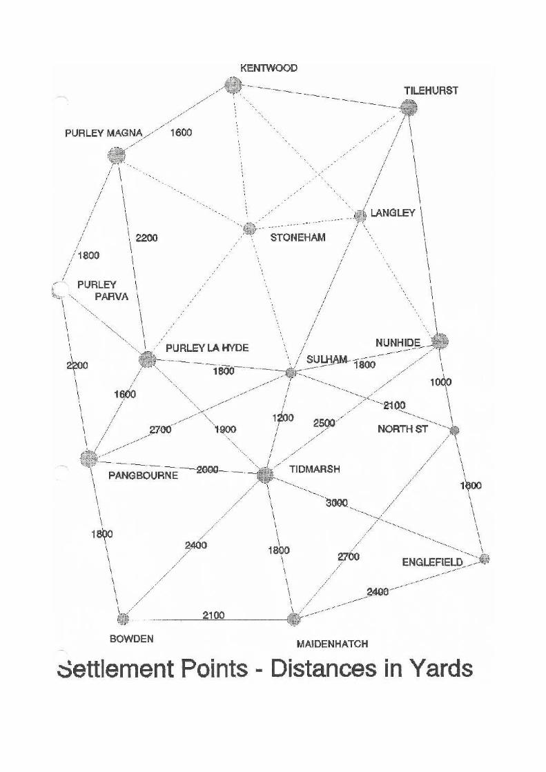
Tidmarsh 1900Pangbourne 1600
Average 1800
For Tidmarsh, centered on the church:-Sulham 1200Nunhide 2500North St 2300Chalkpit Fm 1500 Maidenhatch 1800Bowden 2400Pangbourne 2000
Average 1950
For Sulham, centered on the church:-La Hyde 1800Tidmarsh 1200Pangbourne 2700North St 2100Nunhide 1800Chalkpit Fm 2300
Average 2000
The average for these five settlements is thus 1900 yards ie just slightly over the mile. This figure isslightly below the English typical spacing and may well reflect difficulties in ploughing because ofthe terrain. The distances are not always easy to measure as the centre points can be defined only towithin a hundred yards or so.
A diagram showing this network has some very apparent gaps in Tilehurst and one should alsopostulate therefore some ancient settlement points around the Long Lane/Dark Lane area (Stoneham)and in the water tower area (Langley).
Successions of SettlementsIt is interesting therefore to see how this concept of settlement spread works in the triangle of landbounded by the Thames and Kennet rivers and extending to the downlands of Basildon andBradfield.
There is evidence to indicate that the earliest settlement was sited in Reading around St Mary leButts. A one kilometre radius circle around this point approximates fairly closely to the ancient townarea with St Giles parish on the south side of the Kennet, St Laurence Parish occupying the east endand St Mary's Parish the west end.
Moving out the second wave would have given settlements based upon Coley and Battle, plus afurther settlement to the east. The Coley Parish would have some very extensive meadows on thebanks of the Kennet and likewise the Battle Parish meadows on the banks of the Thames. To take upthe land effectively it would appear that the Battle Parish was centered about half a kilometre northeast of Battle hospital around the Cow Lane area.
This leaves a nice gap for the third wave of Northcote and Southcote.
The fourth wave gives Tilehurst, Kentwood and Calcot. At this juncture the gap between the riversis widening and it would seem Tilehurst and Kentwoodwere established first, the former occupyingthe high ground and the latter the low ground around the Thames. This left only a small area forCalcot which seems to have been further squeezed by virtue of Burghfield extending its influenceacross the Kennet to establish a mill on the Holy Brook which being an artificial creation, is moresuited for driving a mill than the Kennet meandering across the marshes. Calcot appears to havecompensated for this by extending much further along the Kennet than would have been normal, tothe Wessex boundary.
The fifth wave gives Purley Magna, Stoneham and Langley. The latter two are sharply limited by theescarpment to the south and west and by the extension of Calcot to the south.
Purley Magna could well have been a much earlier settlement based upon a gravel mound among theThames marshes and a convenient place to bring chalk and flints down to the river for shipment backto the main settlement at Reading.
The sixth wave appears to have been confined to the west by the boundary between Anglia andWessex which was agreed between Aela and Cedric around 511. This gives four very small parishesoccupying the land down to the mid point of the Sul/Pang valley, (ie Purley Parva, Purley La Hyde,Sulham and Nunhide.
This apparent boundary could actually be very much more ancient than the supposed agreementbetween Aella and Cerdic. It could well be the boundary between the Roman Provinces of BritanniaPrima (Cirencester) and Maxima Caesariensis (London) In recent years the Parish of Purley hasceded territory to Pangbourne and reteated to the SulBrook whereas previously it extended well intowhat is now the settlement of Pangbourne. It also raises the intriguing possibility that there was aRoman Estate in Maxima Caesariensis spanning both La Hyde and Purley Parva with a villa yet to bediscovered.
The pattern beyond this ancient boundary is rather different in that the spread does not appear to havebeen from the Reading direction outwards. Rather a number of more isolated settlements seem tohave established themselves, possibly based upon Roman estates. Certainly this applied to theMaidenhatch area where the remains of a Roman villa were found during roadworks for the M4.
Englefield was the base camp of Aella in 518 and it is likely that a very ancient settlement was usedas the basis for a new Anglian and later Saxon village. It is likely that Pangbourne and Theale beganlife as settlements around the river crossings on the road from Silchester to Wallingford. Tidmarshoccupied the centre of the valley and spread out in a nice circle although confined by the boundary tothe east. This left a small area centred on North Street which might have been an extension ofNunhide across the agreed boundary to make it viable as a settlement.
Further settlements followed, of Bowden, Lower Basildon, Upper Basildon, Bradfield and so on intowest Berkshire. By the time formal parish boundaries had to be agreed in King Edgar's time so thattithes could be assessed accurately, it would seem that several of the ancient settlements had mergedto form the parishes we know today. What likely happened was that neighbouring settlements cameinto common ownership and it was only in the major settlement that the church was established. Theminor settlements therefore would have been obliged to pay their third of the tithe to their parishchurch and the remaining two thirds to their local monastery.
Thus Bowden, Maidenhatch and Pangbourne were merged into the new parish of Pangbourne;Kentwood, Langley, Calcot, Stoneham and Theale into Tilehurst; Purley Magna, Purley Parva andPurley La Hyde into Purley; and Nunhide and Sulham merged.
This pattern of parishes exists in the area today, although a number of changes have occurred. TheBorough of Reading gradually extended its boundaries subsuming Battle, Coley, Southcote and
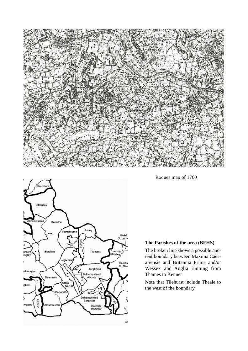
Roques map of 1760
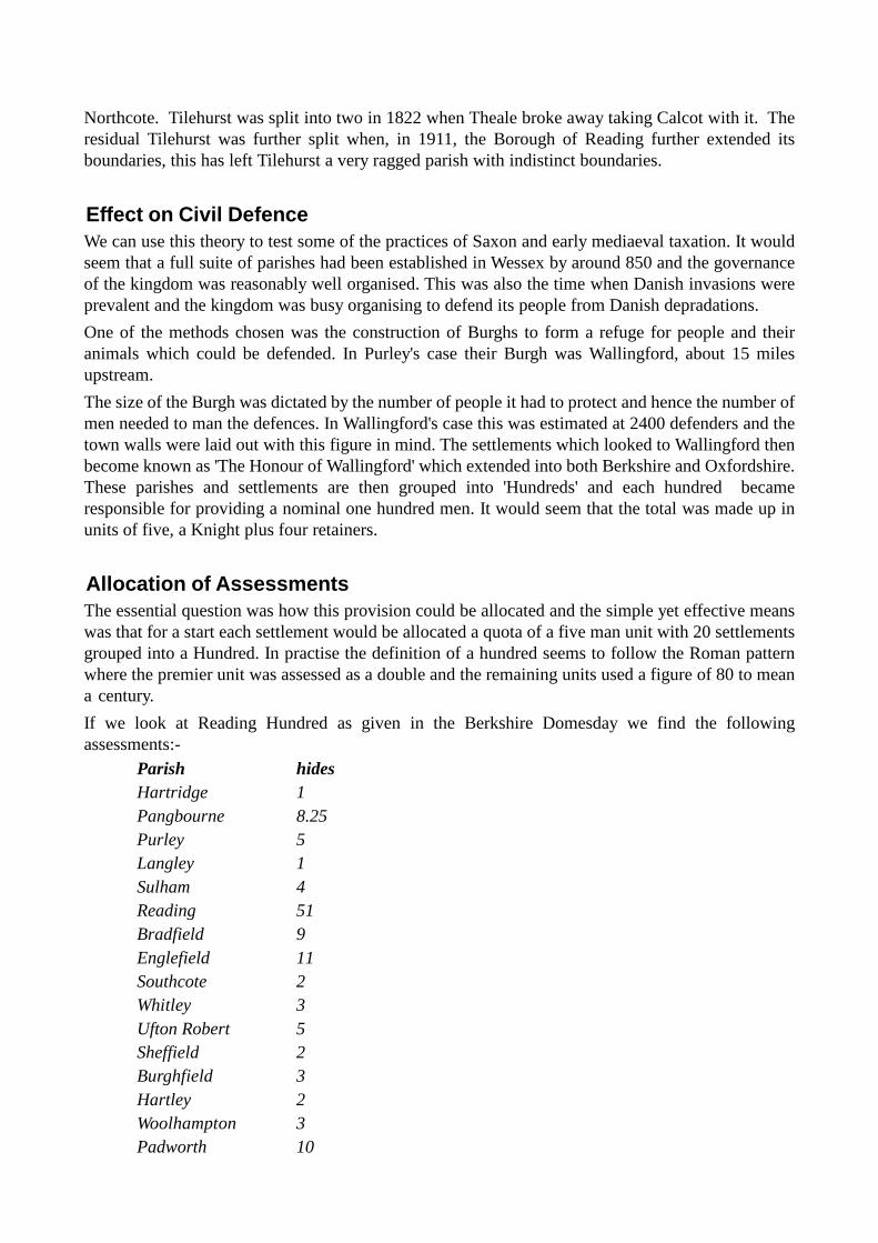
The Parishes of the area (BFHS)
The broken line shows a possible anc-ient boundary between Maxima Caes-ariensis and Britannia Prima and/orWessex and Anglia running fromThames to Kennet
Note that Tilehurst include Theale tothe west of the boundary
Northcote. Tilehurst was split into two in 1822 when Theale broke away taking Calcot with it. Theresidual Tilehurst was further split when, in 1911, the Borough of Reading further extended itsboundaries, this has left Tilehurst a very ragged parish with indistinct boundaries.
Effect on Civil DefenceWe can use this theory to test some of the practices of Saxon and early mediaeval taxation. It wouldseem that a full suite of parishes had been established in Wessex by around 850 and the governanceof the kingdom was reasonably well organised. This was also the time when Danish invasions wereprevalent and the kingdom was busy organising to defend its people from Danish depradations.
One of the methods chosen was the construction of Burghs to form a refuge for people and theiranimals which could be defended. In Purley's case their Burgh was Wallingford, about 15 milesupstream.
The size of the Burgh was dictated by the number of people it had to protect and hence the number ofmen needed to man the defences. In Wallingford's case this was estimated at 2400 defenders and thetown walls were laid out with this figure in mind. The settlements which looked to Wallingford thenbecome known as 'The Honour of Wallingford' which extended into both Berkshire and Oxfordshire.These parishes and settlements are then grouped into 'Hundreds' and each hundred becameresponsible for providing a nominal one hundred men. It would seem that the total was made up inunits of five, a Knight plus four retainers.
Allocation of AssessmentsThe essential question was how this provision could be allocated and the simple yet effective meanswas that for a start each settlement would be allocated a quota of a five man unit with 20 settlementsgrouped into a Hundred. In practise the definition of a hundred seems to follow the Roman patternwhere the premier unit was assessed as a double and the remaining units used a figure of 80 to meana century.
If we look at Reading Hundred as given in the Berkshire Domesday we find the followingassessments:-
Parish hidesHartridge 1Pangbourne 8.25Purley 5Langley 1Sulham 4Reading 51Bradfield 9Englefield 11Southcote 2Whitley 3Ufton Robert 5Sheffield 2Burghfield 3Hartley 2Woolhampton 3Padworth 10
Ufton Nervet 5Aldermaston 16.5Stratfield Mortimer 11Wokefield 18Burley 3
Total 174
Reading thus appears to have been the double-Hundred and was in fact soon after split into two(Reading and Theale) seemingly when the Abbey of Reading was founded with the Abbey takingover Reading Hundred from Wallingford. This split was not based on a simple line but seeminglyreflecting whether or not the Abbot had jurisdiction. Thus Purley became part of Theale andPangbourne part of Reading.
We may thus assume therefore that Reading Hundred had to find 200 men from an area of roughly37500 acres or 187 acres per man. This is surprisingly close to the accepted figure of 180 acres to ahide. If we use the Roman definition of the assessment we have 180 men from 37500 acres or 208acres per hide.
Settlements in the Purley AreaGoing back to the settlements we postulated using the wave theory we can begin to get an idea as tohow the allocation for this part of Reading Hundred was arrived at. The settlements postulated in thetriangle between Thames, Kennet and Pang are:
wave settlement Parish1 Reading (original) Reading2 Coley Reading2 Battle Reading3 Northcote Reading3 Southcote Southcote4 Tilehurst Tilehurst4 Kentwood Tilehurst4 Calcot Tilehurst5 Purley Magna Purley5 Stoneham Tilehurst5 Langley Tilehurst6 Purley Parva Purley6 Purley La Hyde Purley6 Sulham Sulham6 Nunhide Sulham
And by counting one unit per settlement we come up with an assessment ofparish units domesday hides 1066Reading 4 51Southcote 1 2Tilehurst 5 0Langley 1 1Purley 3 5
Sulham 2 4
Total 17 63
Ignoring Reading for the moment and noting that Tilehurst does not figure in Domesday save for itssingle settlement Langley we find that Southcote, Tilehurst, Langley, Purley and Sulham takentogether account for 12 settlements and 12 hides Thus in this area there is a very precise correlationbetween hideage and wave settlements at the time of the Norman conquest.
If we look further at Reading we find that if we assume it to be made up from the original settlement,plus Battle, Coley and Northcote it covers an area roughly of 2850 acres. Using the figure of 187acres to the hide this gives 15 hides. In Domesday [1/42] we also note that Reading has 28 'sites'which we may assume to count as an assessment as a hide as well as other dues. Thus adding 28hides for sites to 15 hides for acreage we get the 43 hides of King Edward's holdings in 1066[Domesday 1/41]. The remaining eight hides attributed to Reading refer to lands belonging to achurch held by the Abbot of Battle [Domesday 15/2] and which we may assume were not actuallywithin the town area as it is listed in Domesday under Compton Hundred.
Relation to AreaThe acreage of the area being considered is rated (by counting squares on an OS Map) as follows:-
area acresReading centre 750Norcot 580Southcote 700Tilehurst (Borough) 700Battle 830Kentwood 380Langley 350Coley 690Purley 1150Sulham 725Tilehurst (W Berks) 1545
Total 8400
If this is equivalent to the 17 settlements postulated by the wave theory then the average size wouldbe 495 acres. ie somewhat below the area we would expect from a circle 1900 yards in diameter, ie585 acres; but we must remember that we had four parishes constrained by the Pang as the Westernboundary and it is not possible to cover territory completely by circular areas without considerableoverlapping.
Thus using the wave theory applied to the area of interest, we can deduce both the value of a hide,expressed in acres and the number of units of assessment that we would expect from the triangle ofland bordered by the Thames, Kennet and Pang. It would also account for the curious omission ofTilehurst from Domesday.
ReferencesDomesday Survey for Berkshire (1086)Acreages for 1860 taken from VCH (Berkshire) Domesday Book and Beyond (Maitland 1896)