Embed Size (px)
Citation preview

REVIEW PAPER - EXPLORATION GEOLOGY
The structural style and hydrocarbon exploration of the subthrustin the Berati Anticlinal Belt, Albania
Telo Velaj1
Received: 24 January 2014 / Accepted: 28 February 2015 / Published online: 27 March 2015
� The Author(s) 2015. This article is published with open access at Springerlink.com
Abstract The Albania thrust belt consists of both in-
ternal and external tectonic zones, which are westward
overthrusts with large amplitude (50–100 km), above the
Apulian Patform and the South Adriatic Basin. The Ex-
ternal Albanides are subdivided into distinct tectonic-s-
tratigraphic units: the Kruja zone (shallow carbonate
water) in the east and the Ionian zone in the west, which
is represented by pelagic limestone. The Ionian zone,
located between the Sazan (Pre-Apuliane) and Kruja
zones, consists of three anticlinal belts: the Berati,
Kurveleshi and Cika anticlinal belts. Their western mar-
gin is bordered on overthrust faults, which have produced
large westward overthrusts on each of them, with ampli-
tudes of 10–30 kms, and are utilized through a large di-
apir masses. Therefore, they mask perspective plays in
subthrusts. The Berati anticlinal belt is the most eastern in
the Ionian zone and lies mostly in the Albanian territory
and partly in the Greek territory. It has a length of about
225 kms and a width 12–22 kms, and is differentiated into
two sectors: the southern sector (south of the Qafa Ki-
coku) and the northern sector (north of the Qafa Kicoku).
Understanding the evolution of evaporite tectonics is
important in determining the principal features of the
structural model on the Berati anticlinal belt. The changes
in the lithostatic pressure on the space have a greater role
in the development of evaporite tectonics, which are
conditioned by the deposition thickness of the cover
sediments above the evaporites and the presence of weak
tectonic loops. These loops belong to the intersecting
places of transverse and longitudinal fault generated since
the rifting phase (T3-Cr1). Such intersecting places are
the Dumrea (Albania) and Zavrohon (Greece) on the
surface. We stress that evaporites are also extended over
regional thrust faults of the Berati belt, helping its over-
thrusting westward about 20–30 km (depicted by seismic
and deep wells data). The tectonic evaporite effect differs
from the expansion of the Berat thrust belt. Thus, in its
southern part, as a result of a diapirism that has not
emerged on the surface, it is helping orogenies in devel-
oping large fan-type anticline structures (Golika, Nemer-
cka, Mitsikeli anticlines, etc.), that have backthrusts in
their eastern flank. Moreover, we encountered the pres-
ence of a carbonate massive in the middle of the Epiro-
Akarnani syncline (e.g. Timfeu massive in Greece),
caused by the ‘‘blind’’ evaporite body effect. The northern
sector (north of Qafa e Kicoku), is characterized by a
smaller evaporite effect, which is reflected in increasing
density of the anticlinal structures on the surface units and
their normal passing to each other. The Dumrea diapir is
a considerable ellipsoid-shape evaporite mass outcropping
with a surface area of about 210 km2 and axes
20 9 10 km. It is an ordinary diapir with a westward
overthrust (20–30 km). Most oil fields in Albania are in
carbonate sections (Cr2-Pg2) in the anticline structures
delivered to the thrust of adjacent units. There is another
new prospect of the high perspective: The carbonate
structures under overthrust of different units (subthrust
complex) of the Ionian zone. The subthrust in the Ionian
zone is divided into three types: 1. The subthrust beneath
overthrust of thrust belts. These overthrusts are related to
the evaporite detachment horizon, and they mask folded
structures of subthrust. 2. The subthrusts beneath the
overthrusts of the anticline units. These overthrusts have a
local character and they are more developed in the
Kurveleshi thrust belt. 3. The subthrusts beneath the
& Telo Velaj
1 1575 W. Street Road # 336, Warminster, PA 18974, USA
123
J Petrol Explor Prod Technol (2015) 5:123–145
DOI 10.1007/s13202-015-0162-1

overthrusts of the tectonic zones of the orogenetic front
(Ionian and Kruja Zones) above the western au-
tochthonous (Apulian Platform and South Adriatic Basin).
These structures display duplex and triplex style. Cur-
rently, the more interesting opportunity lies in the sub-
thrust beneath the Berati thrust belt. This has a higher
perspective than the other subthrusts beneath the Kurve-
lesh and Cika anticlinal belts. Actually, the Berati sub-
thrust is in the processes of being the subject of a seismic
survey and exploration drilling. The discovery of a new
oil field in the subthrust of the Berati anticlinal belt, with
drilling of the Shpiragu-2 well, which in the first test gave
800–1300 barrels (light oil with density 35–37� API) and
2–5 mmcfd gas per day, is of great importance for the
entire tectonic ensemble of the Dinaric-Albanid-Hellenic.
The presence of prospective structures such as the Dum-
rea anticline in the north and its continuation southward
(the Shpiragu oil field, Molishti anticline, etc.), beneath
the thrust belt, as shown by both drilling and seismic data,
together with the presence of the surface structures (e.g.
the Kasidhiaris, Kurenton and Thesprotikon anticlines) in
Greece, shows the regional scale potential of petroleum
plays. These prospects for new oil and gas discoveries
constitute the object of this important paper, offering
completely new ideas.
Keywords Berati thrust belt � Evaporites � Overthrust belt
� Albania � Apulian Platform � Ionian Zone � South �Adriatic Basin
Introduction
Albania is part of the Dinaric-Albanid-Hellenic arc of the
Alpine orogeny. It is located between the Dinarides in the
north and the Hellenides in the south. The collision of the
African and Eurasian plates caused the Albanides to become
folded and displaced from east to the west (Fig. 1). A con-
ventional foreland-thrust system characterizes the present-
day architecture of the Albanian thrust belt (Velaj 2011).
The Apulian Platform is overthrust in the east by Al-
banides-Dinarides-Hellenides and to the west of Apennines
(Fig. 1). The Albanides-Dinarides-Hellenides comprises
four main units: the autochthonous foreland, the foredeep,
the internal and the external tectonic zones. All the tectonic
zones are thrusting westwards (Fig. 1), partially covering
each other, and are thrust together over the autochthonous
foreland (the Apulia Platform, the Peri-Adriatic Depression
and the South Adriatic Basin) (Argnan 2010; Velaj 2011).
The Apennines are overthrust towards the east above the
Apulian Platform. Here, subthrust plays include oil fields
such as Monte Alpi, Tempa Rossa, etc. (Heard and
Robinson 2010). Overthrusting occurred during the Neo-
gene and Quaternary Periods (Scrooca 2010; Cazzola et al.
2011).
The autochthonous foreland is represented by the Apu-
lian Platform (Italy), Sazani zone (Albania) and Paxos zone
(Greece). The Apulian Platform is not folded, but the
Sazani and Paxos zones are folded, offering greater pro-
spects for oil and gas exploration (Velaj 2011). These
subthrusts plays, beneath the Albanides-Dinarides-Hel-
lenides orogenic units, are analogous to those in Italy
(Fig. 1) (Picha 2002; Heard and Robinson 2010).
The Peri-Adriatic Depression represents the basin of the
external zones of the Albanides-Dinarides-Hellenides and
the Apennines in Italy. Post-carbonate deposition is com-
posed of terrigenous sediments (N13t-N2
P), the placement and
distribution of which definitely indicate a basin environ-
ment, which itself is included in the South Adriatic Basin
(Fig. 2) (Zappaterra 1994; Picha 2002). The southern and
western part of this basin (Albania, Greece and Italy)
overlies the Ionian, Kruja and Apulian Platform (Frasheri
et al. 2009; Bega 2010; Velaj 2012), whereas in the north,
it continues with the South Adriatic Basin, which has
Fig. 1 Schematic geological
cross-section between the
Albanides and Apennines, see
Fig. 2 for location (According
to Cazzola et al. 2011, modified
by Velaj)
124 J Petrol Explor Prod Technol (2015) 5:123–145
123

continuous sedimentation from the upper Triassic to the
Pliocene.
General information on the albanides
Regional geology
In Albania, the thrust belt is divided into two parts: the
Internal and the External Albanides. The Internal Alban-
ides composed of the Mirdita and Korabi zones, which are
characterized by the presence of allochthonous ophiolites
(Upper Jurassic) and by many folding phases (Upper
Jurassic, Eocene etc.) (Fig. 1). The external Albanides (a
carbonate thrust belt), are composed of the Ionian, Kruja
and Krasta-Cukali zones (Fig. 3).
Only the external zones and the autochthonous foreland
have been explored for the petroleum industry. Geological
and geophysical studies performed in the External Alban-
ides show that the structures and structural belt have been
displaced westward by 10–30 km (Fig. 5) (Velaj 2011).
The eastward amplitude of a backthrust in the eastern flank
of the structures may be up to 5–10 kms (Figs. 15, 16)
Velaj (1999).
Sratigraphy of the Ionian Zone and Berati anticlinal
belt
In terms of stratigraphy, the Ionian zone consists mainly of
Upper Triassic evaporite (T3), carbonates of the Upper
Triassic to the Eocene (T3-Pg2), flysch–flyschoides of the
Oligocene to the Serravallian (Pg3-N12s) and Neogene
marine sediments (N13t-N2
P) (Velaj 1999; Karakitsios 2003)
(Fig. 4).
The Upper Triassic evaporites consist of gypsum, an-
hydrides, salts, multicolored clays and breccias with in-
terbedded dolomite and thin organic-rich shales. Volcanic
rocks (Dumre, Picar-Kardhiq), quartz bipyramidal (Dumre,
Picar-Kardhiq, Delvine, Gline, Janicat, Korab) and am-
phibolite rocks (diabaze, gneiss and volcanic tuffs) are
Fig. 2 The tectonic scheme for
the relationship between
Albanides-Dinarides-
Hellenides-Apeninnes
(According to Zappaterra 1994,
modified from Velaj)
J Petrol Explor Prod Technol (2015) 5:123–145 125
123

encountered locally. Salts are widespread in the Kurvelshi
anticlinal belt, whereas gypsum and anhydrite facies pre-
dominates in the Berati and Cika belts (Velaj 2001).
The carbonate formation is of Upper Triassic to Eocene,
and in general, it belongs to pelagic facies. Upper Triassic
dolomite and massive limestones with organic-rich shale
interbedded (Lower Jurassic) represented neritic facies and
are overlain by pelagic limestone with chert, marl and shale
interbedded, which was deposited continuously throughout
the Jurassic, Cretaceous and up to the Upper Eocene. At the
beginning of the Lower Jurassic (Lias), Ionian zone dif-
ferentiation is noticed at the bottom of the basin, which is
associated with the formation of two carbonate facies:
pelagic facies represented by crystalline limestone with
chert lenses and neritic facies represented by algal lime-
stone and dolomite. In the Toarcian (J13t), the differen-
tiation of the basin bottom of the Ionian Trough becomes
clearer, having an island archipelago view. In the central
Fig. 3 Tectonic map of Albania
and anticline carbonate
structures in the Ionian and
Kruja Zones (Modified from
Velaj)
126 J Petrol Explor Prod Technol (2015) 5:123–145
123

part of the Ionian zone (Kurveleshi anticlinal belt), litho-
facies of marls schist with Possidonia is formed, whereas
on both sides (Berat and Cika anticlinal belts), the litho-
facies of limestone and dolomite limestones with amoni-
ties, know as ‘‘Amonitico Rosso’’, are formed. It is
shallower than ‘‘Posidonia’’ facies (Velaj 2011). The
Middle Jurassic is represented by the lower chert package
which consists of many cherts followed by micritic and
biometric limestone deposition also rich in cherts. During
the Upper Jurassic, the deepening of the Ionian Trough
continue and is associated with a marked increase in sili-
cious material (the upper chert package), which meets in
the entirety of the Ionian zone. At the Tithonian–Berrasian,
the sea depth reaches the largest values covering the Li-
assic neritic deposits. These deposits are overlain uncon-
formably on micritic-biometric limestone rich in tintinide.
In the Ionian zone, the Cretaceous depositions are of
pelagic facies and are represented by porcellaneous, clayey
limestone and bituminous clays (Lower Cretaceous) on
which lies phosphatic-biometric limestone and the inter-
calation of organic–clastic and pelitomorphic limestone
(Upper Cretaceous). During the Paleocene–Eocene, the
pelagic conditions of Upper Cretaceous paleogeography
are still preserved, reflected in the formation of micritic and
detrital limestone intercalations. At this time, the erosion
activity in the Upper Cretaceous carbonate platform from
the Kruja zone in the east and the Sazani zone in the west,
contributed as a distal source to the thick carbonate tur-
bidities deposited in the Ionian Basin during the Upper
Cretaceous and Paleocene (Velaj et al. 1999; Roure et al.
2004). These turbidities, which reworked platform car-
bonate, are interbedded within a finer-grained pelagic
Fig. 4 Generalized stratigraphic column for the Ionian zone and the Berati anticlinal belt showing lithologies, oil fields, source rocks and seals
J Petrol Explor Prod Technol (2015) 5:123–145 127
123
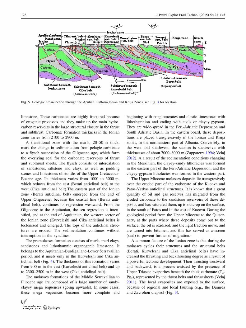
limestone. These carbonates are highly fractured because
of orogenic processes and they make up the main hydro-
carbon reservoirs in the large structural closure in the thrust
and subthrust. Carbonate formation thickness in the Ionian
zone varies from 2100 to 2900 m.
A transitional zone with the marls, 20–50 m thick,
mark the change in sedimentation from pelagic carbonate
to a flysch succession of the Oligocene age, which form
the overlying seal for the carbonate reservoirs of thrust
and subthrust sheets. The flysch consists of intercalation
of sandstones, siltstone and clays, as well as pudding
stones and limestones olistoliths of the Upper Cretaceous-
Eocene age. Its thickness varies from 1000 to 3000 m,
which reduces from the east (Berati anticlinal belt) to the
west (Cika anticlinal belt).The eastern part of the Ionian
zone (Berati anticlinal belt) emerged from the end of
Upper Oligocene, because the coastal line (Berati anti-
clinal belt), continues its regression westward. From the
Oligocene to the Aquitanian, the sea regression is inten-
sified, and at the end of Aquitanian, the western sector of
the Ionian zone (Kurveleshi and Cika anticlinal belts) is
tectonized and emerged. The tops of the anticlinal struc-
tures are eroded. The sedimentation continues without
interruption in the synclines.
The premolasses formation consists of marls, marl clays,
sandstones and lithothamnic organogenic limestone. It
belongs to the Aquitanian-Burdigaliane-Lower Serravallian
period, and it meets only in the Kurveleshi and Cika an-
ticlinal belt (Fig. 4). The thickness of this formation varies
from 900 m in the east (Kurveleshi anticlinal belt) and up
to 2300–2500 m in the west (Cika anticlinal belt).
The molasses formations of the Middle Serravallian to
Pliocene age are composed of a large number of sandy-
clayey mega sequences (going upwards). In some cases,
these mega sequences become more complete and
beginning with conglomerates and clastic limestones with
lithothamnion and ending with coals or clayey-gypsum.
They are wide-spread in the Peri-Adriatic Depression and
South Adriatic Basin. In the eastern board, these deposi-
tions are placed transgressively in the Ionian and Kruja
zones, in the northeastern part of Albania. Conversely, in
the west and southwest, the section is successive with
thicknesses of about 7000–8000 m (Zappaterra 1994; Velaj
2012). A a result of the sedimentation conditions changing
in the Messinian, the clayey-sandy lithofacies was formed
in the eastern part of the Peri-Adriatic Depression, and the
clayey-gypsum lithofacies was formed in the western part.
The Upper Miocene molasses deposits lie transgresively
over the eroded part of the carbonate of the Kucova and
Patos-Verbas anticlinal structures. It is known that a great
quantity of oil and gas reserves has migrated from the
eroded carbonate to the sandstone reservoirs of these de-
posits, and has saturated them, up to outcrop on the surface,
in the south of Patos and in the east of Kucova. During the
geological period from the Upper Miocene to the Quater-
nary, at the parts where these deposits come out to the
surface, the oil is oxidized, and the light fraction move, and
are turned into bitumen, and this has served as a screen
(seal) to prevent further of migration.
A common feature of the Ionian zone is that during the
molasses cycles their structures and the structural belts
(Berati, Kurveleshi and Cika anticlinal belts) have in-
creased the thrusting and backthrusting degree as a result of
a powerful tectonic development. Their thrusting westward
and backward, is a process assisted by the presence of
Upper Triassic evaporites beneath the thick carbonate (T3-
Pg2), represented by the thrust belts and thrustsheets (Velaj
2011). The local evaporites are exposed to the surface,
because of regional and local faulting (e.g., the Dumrea
and Zavrohon diapirs) (Fig. 3).
Fig. 5 Geologic cross-section through the Apulian Platform,Ionian and Kruja Zones, see Fig. 3 for location
128 J Petrol Explor Prod Technol (2015) 5:123–145
123

Therefore, the most general model of duplex structures
of the Ionian zone is as follows: carbonate structure on the
surface, fault plane, flysch and subthrust underlying the
carbonate structure on subthrust (Delvina, Shpiragu oil
field, etc.) (Figs. 6, 10, 16, 17, 18, etc.). The subthrust
complex may have considerable petroleum potential.
Oil and gas exploration
Geological and geophysical studies show that in the
western edge of the thrust belts of the Ionian zone, a nar-
row strip of flysch deposits is present which originated
from the subthrust complex, that creates folds associated
with the thrusting faults, exposed as rootless folding
(Figs. 10, 16, 18, etc.). Their roots represent perspective
structures of the subthrust underlying the thrust belts
(Figs. 10, 16, etc.). However, this flysch has generally lost
its relationship with its eastern carbonate roots (Figs. 10,
16, 18, etc.) Velaj (1999).
There are two types of oil and gas accumulation in
Albania:
First, oil and gas accumulation in the carbonate of the
Upper Cretaceous-Eocene age are associated with folded
and faulted anticlines, which provide good structural traps,
charged from Mesozoic source rocks (Table 1) (Gorishti,
Ballshi, Karbunara, Visoka, Hekali, Amonica and Delvina)
(Fig. 9). There are two main types of carbonate plays: (1)
heavy oil reservoirs charged during the Serravallian (Gor-
ishti, Amonica, Ballshi, Visoka, Karbunara, Gerneci, etc.)
and (2) light oil and condensate charged during the post-
Pliocene (Delvina, Cakran, Shpiragu, etc.) (Curri 1993;
Prifti and Muska 2010). Most of them belong to the thrust
complex of the Ionian zone (Kurveleshi anticlinal belt) and
only three belong to the subthrust (Delvina, Karbunara,
Shpiragu). The Delvina oil field is completely covered with
the overthrust of the Mali Gjere anticline. Its prognosis,
exploration and discovery are performed based on indirect
geological data Velaj (1999). The Karbunara oil field lo-
cated beneath the overthrust of the Kremenara anticline
(Fig. 5), is considered as a typical oil field formed into a
zone with an intensive development tectonic. Shpiragu is a
ramp anticline in the Cretaceous-Eocene beneath the over-
thrusting of the Berati anticlinal belt (Fig. 5) (AKBN 2012).
Second, oil accumulation in the clastic plays is com-
posed of Tortonian-Messinian reservoirs sand pinch-out
and sand lenses sealed by inter-formational shales. There
are two main types of clastic plays: the first being those of
Miocene sandstones charged from underlying Mesozoic
Fig. 6 Geological development scheme in the Berati anticlinal belt
J Petrol Explor Prod Technol (2015) 5:123–145 129
123

deep-water carbonate structures (Patos-Marinza and Ku-
cova oil field). The organic matter present in these depo-
sitions and the condition and history of the geologic
development, have been not favorable for hydrocarbon
formation. This means that the oil here is accumulated
through the vertical migration from the carbonate struc-
tures (Kucova anticline etc.) (Fig. 19). Their oil and gas
bearings are mainly related to lithological, lithological-
structural, bedded, tectonically screened, and irregular
reservoirs (Prifti and Muska 2010). The Patos-Marinza is
the largest producing oil field in continental Europe,
holding approximately 7.5 billion barrels. The Kucova oil
field has 297 million barrels of original oil in place. The
reservoirs are Tortonian and Messinian sandstones that
overlie the carbonate thrust anticline (Patos-Verbas and
Kucova) (Fig. 19). The second type of clastic plays is
biogenic gas accumulation in Miocene and Pliocene
sandstones charged by the terrigenous source rock of the
Fig. 7 The schematic profile of
thickness change from the north
to the south in the Berati
anticlinal belt, see Fig. 9 for
location
Fig. 8 Schematic profile of
thickness change from the east
to west in the Berati anticlinal
belt, see Fig. 9 for location
130 J Petrol Explor Prod Technol (2015) 5:123–145
123

Peri-Adriatic Depression (Divjaka, Panaja, Frakulla,
Povelca, Ballaj and Durresi) (Fig. 9).
History of exploration
To date, exploration and production in Albania have focused
primarily on shallow carbonate formations (1500–3500 m)
that produce oil and gas condensate in thrust structures:
Visoka, Gorisht-Kocul, Ballsh-Hekal, Cakran-Mollaj and
Finiq-Krane. All these oil fields belong to the Kurveleshi
anticlinal belt, which is the most complicated part of the
Ionian zone. The Balkan region has proven oil reserves to-
taling about 345 million barrels. Of that, 198 million barrels
are located in Albania (AKBN 2012).
Intensive exploration efforts during 1989 yielded a new
Delvina oil field (condensate and gas).This was the first oil
field discovery in the subthrust (Fig. 5) (Velaj et al. 1998).
The current production from the two existing wells on this
oil field (Del-4, Del-12) is 700 Mcf/ds of natural gas and 47
barrels/day of 62.5 API condensate. At roughly the same
time, the Karbunara oil field was discovered beneath the
Kremenara anticline (Fig. 5). The Kanina-1 drilled
(5362 m) in the Tragjasi anticline (Cika anticlinal belt),
was located beneath an anticlinal structure in the subthrust
(Fig. 5) and it has proven hydrocarbons in the system: a
163 m oil leg was found, but not flows (16–20 API, low
porosity 0.019 %). The wells Vlora-10 and Vlora-11 have
attacked one anticlinal structure on the subthrust, beneath
the overthrust of the Ionian zone (Fig. 5), and a small
amount of oil and gas flowed on the surface Velaj (1999;
Velaj 2001). In December of 2001, the Occidental Com-
pany (OXY) declared the Shpiragu discovery, after drilling
and testing of the Shpiragu-1 well in the subthrust, beneath
the overthrust of the Berati anticlinal belt (Figs. 5, 20). The
Shpiragu well proved light oil (370 API) from a fractured
carbonate reservoir of the Upper Cretaceous-Eocene. The
available data (deep wells Dumre-7, Shpiragu-1, Shpiragu-
2, etc., and seismic works), show that the Shpiragu anti-
clinal structure extends to the north beneath the overthrust
of the Dumre diapir (Fig. 10) and to the south with the
Molishti and other similar structures, etc. (Fig. 20). There
has been limited exploration to date. However, three-di-
mensional technology and deep wells drilling have created
the possibilities for intensive exploration of the subthrust of
the Berati thrust belt, which is with high perspective. The
Shpiragu-2 well reached a total depth of 5547 m in late
June (2013), and the company has completed setting the
production line. The rig has been released and it will be
mobilized to the Molisht-1 drill site upon completion of the
road and lease construction, where the depth of the top
carbonate reservoir is estimated to be roughly
4500–4600 m. Stimulation and testing equipment rig up
will begin once the drilling rig is off the Shpirag-2 lease.
The company intends to test 350–400 m of the target car-
bonate zone. Two other drilling sites are also currently
along the Shpiragu thrust sheet (Petromanas Energy Inc
2013).
The content of this paper is based on the latest data
obtained from deep wells (Shpiragu-1, Shpiragu-2, Dumre-
7, Kanina-1. Delvine-4, Ardenica, etc.), a considerable
volume of high quality 2D seismic data, and various
complex studies (geochemical, stratigraphic, tectonics,
etc.). The aim is to shed light on the prospects of oil and
gas exploration in the subthrust of the Berati anticlinal belt,
and in the subthrust of all the External Albanides. The
conclusions of the article also apply to exploration in the
upthrust of the External Hellenides (Greece) and
Montenegro.
Petroleum system
The thrusting and overthrust model in the External Al-
banides (Ionian and Kruja Zones), was proved from geo-
logical surface observation Velaj (1999, 2001; Meco and
Aliaj 2000; Karakitsios 2007), and seismic works and deep
wells (Shpiragu-1, Shpiragu-2, Dumre-7, Kanina-1, Ar-
denica-7, Vlora-10, Vlora-11, etc.). From these data, it
seems that Albania has good potential for further hydro-
carbon exploration. The prospect of Albania is associated
Table 1 Source rocks in the Ionian zone
No. Zone Age Lithology Sample location TOC (%) HI (MgrHc/gr) Tm Kerog. type VR/E
1 Ionian Upper Triassic Shale/clay/limestones Outcrop 0.02–38.5 617 416 I 0.54–0.88
2 Lower Jurassic Dolonute shale Outcrop 0.01–52 450 434 I/II 0.55–0.75
3 Toarcian Posidonia shale Outcrop 0.09–3.7 588 432 I/II 0.5–0.6
4 Middle Clay Well 2 505 424 II 0.57
5 Jurassic Shale Outcrop 0.04–9.4 508 432 I 0.52
6 Upper Jurassic Shale Outcrop 0.03–509 520 430 I 0.45–0.57
7 Lower Cretaceous Dolom/shale Outc./well 0.02–27 521–700 413 I/II 0.45–0.54
J Petrol Explor Prod Technol (2015) 5:123–145 131
123

with folded and hanging wall anticlines formed by high-
angle faults, which provides good structural traps, sourced
by Mesozoic source rocks (Velaj 2011; Zelilidis et al.
2003) (Table 1). The focus in recent years has been on
deeper subthrust carbonate structures that contain the
lighter oil and condensate (Petromanas Energy Inc. 2013).
Potential discoveries will be found in subthrust complexes,
under the overthrusts of the structural anticlinal belts
(Berati, Kurveleshi and Cika anticlinal belts) and under the
overthrusts of anticline units (Kurveleshi anticlinal belt)
(Fig. 5). In addition, good hydrocarbon potential will be
found under the regional overthrust of tectonic zones of
orogenetic fronts (Ionian and Kruja Zones), above the
western Albanian autochthonous (Apulia Platform and
South Adriatic Basin). This overthrust has a regional
character (Albania, Greece and Montenegro) and has
masked the subthrust structures with its large dimensions
(Fig. 5) and high perspective. One of these structures is
attacked by an exploratory well in the Vlora region (Vlora-
10, Vlora-11) (Fig. 5) (Velaj 2011).
Fig. 9 The schematic map of
distribution of oil fields,
regional faults in the External
Albanides and lithological
sections
132 J Petrol Explor Prod Technol (2015) 5:123–145
123

Reservoir rocks
Oil and gas reservoirs have been proven in both the deeper
marine carbonates of the Ionian zone and in the clastic
section of the Peri-Adriatic Depression. The limestone
reservoir ranges in age from the Upper Cretaceous to the
Eocene. The main type of reservoir consists of fractured
carbonates. The reservoir storage capacity, from the
Eocene to the Upper Cretaceous is greatly improved, be-
cause of increases in secondary porosity, which consists of
fracture and vuggy porosity, and some levels have good
porosity up to 8 %. Core data on the Cakran oil field show
matrix porosity ranging from 2.5 to 3 % with a maximum
porosity of 6 % including fractures. From the well core
measurement of Paleocene reservoirs belonging to the
Kurveleshi anticlinal belt, the fracture porosity was found
to range between 2.4 and 2.5 % (Prifti and Muska 2010).
The reservoir of the central part of Albania, related to
Miocene deltaic sandstones, has a porosity ranging be-
tween 10 and 30 % and permeability ranging between 2000
Fig. 10 Schematic geological
cross-section in the Dumrea
area
Fig. 11 Seismic cross-section
through the Dumre diapir, see
Fig. 14 for location
Fig. 12 Schematic geological
cross-section in Zavrohon
diapir, see Fig. 14 for location
J Petrol Explor Prod Technol (2015) 5:123–145 133
123

and 300 md, similar to the Patos-Marinza and Kucova oil
fields.
The reservoir of the gas fields of the Peri-Adriatic De-
pression, related to molasses sandstones of the late Mio-
cene (Tortonian-Messinian) or turbidities of the Pliocene
age, has a porosity ranging between 12 and 37 %.
Seals
Flycsh and flycshoidal deposits of the Oligocene age (Pg3)
have proven to be effective seals for hydrocarbon accu-
mulations in carbonate sections including the Gorisht-Ko-
culi, Cakran, Balsh-Hekal and Amonica oil fields. In
addition, analogue flysch are effective seals for carbonate
subthrust reservoirs (Shpiragu, Delvina, Karbu-nara oil
fields) and it will be effective for all the subthrusts in the
Ionian zone. The considerable clayey thickness of the
Tortonian-Pliocene has been proved as a good seal for the
gas fields (Divjaka, Kryevidhi, Frakulla, Povelca, Ballaj
etc.) and oil fields (Patos-Marinza, Kucova and Pekisht-
Murrizi), in the Peri-Adriatic Depression (Fig. 4).
The following are also predicted to be good seals within
the carbonate formation of the Ionian zone::clayey-marl of
the Toarcian (J13t), cherty packages of the Jurassic and
clayey thin layer of the Lower Cretaceous.
Source rocks
Several source rock levels have been observed in outcrops
in the Ionian zone with good to excellent quality. Source
rocks of the Upper Triassic–Lower Jurassic prove to have
total organic carbon (TOC) value of 4.96–29.6 %. Based
on the values of the Hydrocarbon Index HI = 617–778
mgCH/gr and the maceral components, the organic matter
is Type I, able to generate liquid hydrocarbon. The vitrinite
reflectance (Ro = 0.65–0.70 %) shows that the organic
matter is matured. Moreover, black shale intercalations of
the Upper Triassic from thin to thick organic-rich layers,
comparable to those of the Burano formation (Lower Tri-
assic) in Southern Italy (Scrooca 2010), with higher TOC
values (up 52 %), have been recorded. In addition, in the
Toarcian limestone (J13t) met one organic-rich level corre-
sponding to widespread Posidonia shale, with a TOC of
2–20 % and Type I and II organic matter. The TOC for the
source rock of the Jurassic is 0.17–15.66 %. The maceral
components of the organic matter show that it belongs to
Type I–II, able to generate liquid and gaseous hydrocar-
bons. The vitrinite reflectance values Ro[ 0.5 show that
the organic matter is matured.
Very good source rock is found in the Lower Cretaceous
of the Berati anticlinal belt, with TOC = 0.34–26.1 % and
HI = 272–666 mgHc/gr, (belonging to Type I/II, able to
generate liquid hydrocarbon). The vitrinite reflectance
values Ro = 0.42–0.53 % show that the organic matter is
in the maturing stage or is matured. A couple of thicker
shale/limestone intervals are known from the Lower Cre-
taceous with maximum TOC of 27 % (Prifti and Muska
2010) (Table 1).
The flysch and flyschoidal deposits of the Ionian zone,
based on the maceral component (where the oxidized and
wooden components predominate), as well as the average
value of HI = 71 mgHc/gr, show that their organic matter
is able to generate gaseous hydrocarbons.
The geochemical indexes of the organic matter from the
Tortonian deposits in the Peri-Adriatic Depression:
HI = 34.8 mgHc/gr, Ro = 0.330 % as well as the
Fig. 13 The change of the
structural plane of the Berati
anticlinal belt over time and its
evaporite tectonics
134 J Petrol Explor Prod Technol (2015) 5:123–145
123
predominating oxidized and wooden composition, show
that the organic matter of these deposits is able to generate
gas of biogenic and mixed origins.
In some cases, a higher content of liptinites of conti-
nental origins is noticed in the organic matter of these
deposits, which is able to generate unsaturated liquid hy-
drocarbon condensate.
Differences are noticed between the geochemical in-
dexes of the Pliocene in the Peri-Adriatic Depression and
those of Tortonian (i.e., an increase in the ‘‘oxidized’’
composition and the decrease of the liptinite composition).
The organic matter of the Pliocene deposits was able to
generate dry methane gas of biogenic origin.
Trap formation and migration
Three main periods of massive migration and accumulation
of oil are distinguished. These periods coincide with three
main phases in the formation of structures of the Ionian
Basin: The Berati anticlinal belt underwent a compression
regime during the Upper Oligocene-Aquitanian, whereas
the Kurveleshi and Cika anticlinal belts were thrust-folded
at the end of the Lower Miocene and Pliocene. These main
folding phases are responsible for the formation of the
carbonate traps (Cr2-Pg2), for oil and gas accumulation.
The trap-formation mechanism in the Berati anticlinal belt
and its subthrust, is linked to the compressive tectonic
regime and resulting in overthrusting. This mechanism is
valid not only for the carbonate reservoir, but also for most
traps concerning the clastic reservoirs located in lithologic–
stratigraphic traps, formed during the Upper Miocene (e.g.,
the Kucova oil field, etc.) Many traps were completed
when the Oligocene flysch was deposited on top of the
carbonate. Hanging wall anticlines formed by high-angle
faults are present beneath the overthrust of the Berati an-
ticlinal belt.
Traps may also exist in the Lias shallow water carbon-
ates sealed by Posidonia shales and the pelagic thin bedded
Lower Cretaceous limestones.
Prospect in the Berati subthrust is associated with folded
and faulted anticlines, which provide good structural traps,
sourced by Mesozoic source rocks. These deep compres-
sive structures are expected beneath the overthrust of the
Berati anticlinal belt, forming the main objective of sub-
thrust hydrocarbon accumulation in the Upper Cretaceous-
Eocene fractured carbonate. Hydrocarbon production from
the carbonate depends on a system of faults and fractures.
The timing of oil generation and expulsion occurred in
two phases: during the Lower Miocene and Pliocene. Mi-
gration on the carbonate interval occurred in simple path-
ways within a single thrust sheet, from mature source rocks
at the depth, updip to reservoir in hanging wall anticline
traps. All deposition within the Berati anticlinal belt shows
the evidence of oil migration as in sample of wells drilled,
as well as in surface seeps.
The Ionian Basin oil fields formed at different periods,
depending on the trap-formation time and maturation stage of
the source rocks, is reflected in oil composition changes.
Condensate and light oil accumulations formed in the post-
Pliocene (Carbonate oil fields: Cakran, Delvina and Shpi-
ragu), whereas heavy oil accumulations formed earlier
(Middle Miocene to Messinian) (Carbonate oil fields: Gorisht,
Ballsh, Amonica, Karbunara, Visoka, etc., and clastic sand-
stones oil fields: Patos-Marinza, Kucova, etc.) (Curri 1993).
The clastic oil play comprises the Upper Miocene
reservoir charged by Mesozoic deep-water carbonate rocks
(Fig. 19), in lithologic-stratigraphic traps, formed above
the unconformity (Fig. 19).
Materials and methods
For the geological interpretation of oil and gas exploration
in the subthrusts of the Ionian zone in general, and the
Berati anticlinal belt in particular, we used all the data
available to date and my intensive experience and many
studies on oil and gas exploration in these areas Velaj
(1999; Aliaj 2004; Velaj 2011; etc.).
These data include regional geological studies on the
tectonic style and development processes of the Ionian
zone and of the Berati anticlinal belt in particular (Curri
1993; Velaj 2001; Karakitsios 2003; Zelilidis et al. 2003;
Brita et al. 2006; Mavromatidis 2009; Vilas et al. 2009;
AKBN 2012; Prifti and Muska 2010 etc.). We used the
interpretation of the seismic data of modern works (3D)
carried out in recent years by foreign companies (OMV,
Petromanas Inc., Shell.com., etc.), together with the pro-
cessing and reprocessing of 2D seismic data in combina-
tion with the results from deep wells (e.g., Shpiragu-1
5333 m, Shpirag-2 5800 m, Kanina-1 5312 m, Dumre-7
6119 m, Delvina 4 3550 m, Ardenica-7 6700 m, Fortuzaj
etc.). This served as the basis of knowledge of the con-
temporary geology in depth and to explain the future
subthrust exploration perspective (Aliaj 2004; Velaj 2011;
Petromanas Energy Inc. 2013). In this paper, the structural
stratigraphic and paleontological data were used from new
studies of outcropping stratigraphic units and from deep
wells drilling; Geochemical analysis was performed
(Rock–Eval pyrolysis, bitumen isotope ratio, etc.) on oil
and gas and oil-source rock correlation, together with op-
tical analysis of selected kerogens (Curri 1993).
Analyzing all the data together, allowed us to make a
contemporary interpretation of the depth geology and to
give opinions on the exploration of the Albanian subthrust
(mainly for the Berati anticlinal belt) and partially for the
Greek territory (Ioannina area).
J Petrol Explor Prod Technol (2015) 5:123–145 135
123

The tectonic development of the Berati anticlinalbelt
Tectonic evolution in the Berati thrust belt is mainly con-
trolled by the relative movement of the Adriatic-Apulian
subplate, which is located between the Eurasian and Afri-
can plates, and dates from the Mesozoic to the Tertiary.
During the rifting stage (T3-J3-Cr1), the subplate moved in
an ENE direction. It was then affected by extensional
tectonics, and it formed a series of ridges and furrows,
corresponding to present tectonic zones (Ionian, Kruja,
Krasta, etc.) (Fig. 3) (Aliaj 2004; Velaj 2011). As a result
of further movement in a SE direction during the collision
stage (Cr2-Serravallian), the tectonic style changed from
extensional to compressional, which led to the folding of
the Ionian zone and the development of the Berati,
Kurveleshi and Cika anticlinal belts. Extensional faults
created during the rifting stage were reactivated as thrusts,
and the large-scale westward overthrust of the Berati an-
ticlinal belt developed. The Triassic evaporites present the
principal level of detachment.
During the postcollision stage (Serravallian-N2P), the
front of the deformation migrated westward and a simul-
taneous westward emplacement of the Berati anticlinal belt
occurred above the Memaliaj-Botsara synclinal belt
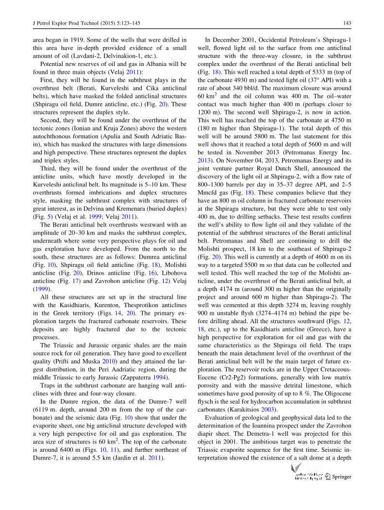
(Figs. 12, 14, 15).
The main evolutionary features of the evaporite tectonic
on the Berati belt were conditioned from the regional tec-
tonic phenomena. It is evident that the thickness of the car-
bonate and flysch deposits increase from north to south and
from west to east (Figs. 7, 8), creating an area of least
thickness in the northeastern part (Glina-Zavrohon to Ioan-
nina) thereby exerting the lightest pressure on the under-
placed evaporite formation in this region (Fig. 7). Addi-
tionally, the flysch formation has a reduced thickness to the
western edge of the Berati belt, which actually coincides with
its regional tectonic fault (Figs. 5, 8). Consequently, the area
from Glina-Zavrohon to Ioannina exerts the smallest litho-
static pressure on the evaporites, which enables intense de-
velopment of the salt tectonics (Velaj 2001).
During the rifting stage (T3-Cr1), the Berati anticlinal
belt was divided into many horsts and grabens due to
transverse and longitudinal listric faults (Fig. 14). During
this stage (pillow stage), salt movement occurred due to
buoyancy effects at the depressive and tectonically weak
loops (Fig. 6), while in the compression stage (Cr2-Ser-
ravalian) (diapir stage), the Berati anticlinal belt develop-
ment, was a consequence of the joint action of tangential
forces and the contribution of salt tectonics.
The influence of salt tectonics in determining the char-
acteristics of the geology of the Berati anticlinal belt de-
pends on a number of factors:
The lithostatic pressure applied to the evaporites varied
at different positions, because of deposition thickness
changes (Figs. 7, 8). In addition, in the early compression
stage (Cr2-Serravalian), longitudinal listric faults started to
react by passing into thrusting faults. Thrust and overthrust
took place during the compression stage (Cr2-Serravalian),
in which the Berati anticlinal belt with all the elementary
structures (anticlines, synclines etc.) more or less took its
conclusive form (Figs. 6, 19). These faults originated
during the rifting stage (T3-J3-Cr1) and they were reacti-
vated during the compression stage (Cr2-Serravallian)
(Velaj 2011).
The regional overthrust of the Berati anticlinal belt
forms an arch (Figs. 9, 14). Its central part has a meridional
direction (Molisht-Shpirag Zone), while both its ex-
tremities suffered deviations: The northern extremity
shifted northeastward, while the southern extremity shifted
southeastward. Therefore, this fault has western convexity
with the presence on the surface of evaporite diapirs in its
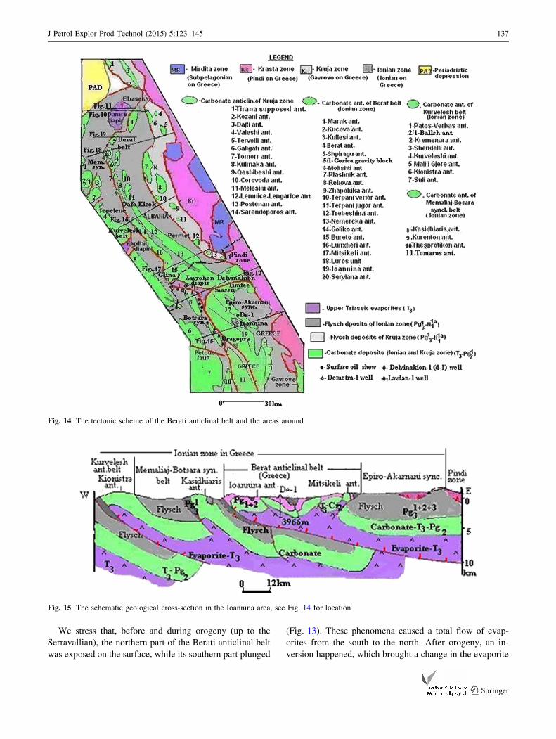
two extremities (Dumrea, Zavrohon) (Fig. 14).
The formation of the tectonic faults took place concur-
rently with the sedimentation and fold-formation processes.
The fact that the Neogene Piggyback Basin (N13t-N2
P) of
Kucova Bay is not touched by the overthrust tectonic of the
Berati anticlinal belt (Fig. 19), shows that the tectonic
activity ended before the Serravallian (N12S) (Velaj 2012).
The westward thrust process of the Berati anticlinal
belt continued in the post-collision stage (N12S-N2
P). This
coincided with the inter formation of new fault planes
(Fig. 8). As a result of this action, which continued with
variable intensity throughout time, there were accompa-
nying flysch deposits of folded subthrust complexes that
‘‘brought’’ in the western margin of the Berati thrust belt,
exposed a rootless fold. Their root represents perspective
structures in the subthrust (Figs. 10, 12, 15, 18) (Velaj
1999, 2012).
During this time, the evaporites were not in equilibrium,
and they started to move along the thrust fault and tec-
tonically depressive loops, causing the complication of the
thrust and subthrust complexes. During the compression
stage (Cr2-Serravalian), the most favorable place for
evaporite eruption was in the north part (Fig. 7). In most
depressive loops, the eruption emerged on the surface
(Figs. 9, 14), but in some places, they remained in the
subsurface as ‘‘blind’’ diapirs (Fig. 14).
The frontal structures of the Berati anticlinal belt, in
general, have bigger dimensions and a deeper erosional
level which has conditioned a smaller lithostatic pressure
on evaporites (Figs. 12, 16, 17, etc.). Therefore, the evap-
orites moved along the plane of the regional overthrust
(Fig. 6) and helped the westward movement (Figs. 10, 12,
15, 19).
136 J Petrol Explor Prod Technol (2015) 5:123–145
123
We stress that, before and during orogeny (up to the
Serravallian), the northern part of the Berati anticlinal belt
was exposed on the surface, while its southern part plunged
(Fig. 13). These phenomena caused a total flow of evap-
orites from the south to the north. After orogeny, an in-
version happened, which brought a change in the evaporite
Fig. 14 The tectonic scheme of the Berati anticlinal belt and the areas around
Fig. 15 The schematic geological cross-section in the Ioannina area, see Fig. 14 for location
J Petrol Explor Prod Technol (2015) 5:123–145 137
123

flow direction from the north to the south (Fig. 13). These
phenomena further complicated the regional tectonics.
The evaporite eruptions related to the presence of weak
tectonic nodules were conditioned from the intersection of
the cross fault with longitudinal faults. Therefore, the
Dumrea diapir was related to the intersection place of four
regional tectonic faults: the Berati thrust belt fault, the
strike-slip fault of the western edge of the Kurveleshi an-
ticlinal belt, the strike-slip fault of the western edge of the
Cika anticlinal belt, and the strike-slip fault of the western
edge of the Kruja tectonic zone (Fig. 9). The Zavrohon
diapir was related to the intersection of the Berati anticlinal
belt strike-slip fault and that of Delvinakion (Fig. 14).
As a result of the joint action of all the presented factors,
the most appropriate conditions for the eruption of evap-
orites were at the western edge of the Berati belt, because
of the lower lithostatic pressures and the presence of the
regional thrust fault, which had a suitable tectonic plane for
evaporites flow because of their plasticity (Velaj 2001).
The high density of the evaporite body (2.55 kg/m3)
suggested that the buoyancy effect was non-existent at this
time. However, a density inversion is not necessary to drive
the evaporite diapir if there is a tectonic or differential
loading mechanism. Moreover, the low viscosity of the
halite matrix must have been crucial to allow the evaporites
to move freely and produce diapirs (Velaj et al. 1998).
In this way, development of the evaporite tectonic de-
pends on the deposition thickness (Figs. 6, 7) of the
evaporite sedimentary cover and the presence of the tec-
tonic depressive loops. These loops belong to the inter-
section of the transverse and longitudinal fault generated
since the rifting phase (T3 to J3-Cr1). In such intersection
places, the Dumrea (Albania) and Zavrohon (Greece)
diapirs erupted to the surface (Figs. 7, 12). The evaporites
also extended along all of the regional overthrust faults of
the Berati belt, and they helped increase the size of this
overthrust (Figs. 10, 12, 17, 19).
Diapiric structures
Dumrea diapir
The Dumrea diapir is represented as a large old salt dome
with a surface area of 210 km2 (the biggest evaporite body
of the Albanides), which outcrops with an elliptical shape
with axes 20 9 10 km. Its volume is about 2500 km3. The
evaporite body has an ordinary diapiric shape with a
thickness of about 6 km and a westward overthrust dis-
placement of about 20–30 km (Fig. 10) (Velaj 2001; Roure
et al. 2004).
A dense grid of seismic surveys was carried out in this
area. There are plenty of seismic reflectors under the salt
diapir body, recognized by the lack of reflectors. The base
of the evaporite body, one strong seismic reflection, is
recorded. The existence of many reflectors under the
evaporite diapir, which extends west to east, shows that
evaporites have come only from the east and northeast
(Fig. 11). The seismic horizons under the salt body to-
gether with the data from the Dumre-7 well (in-depth
6110 m met Lower Oligocene deposits about 200 m away
from the top of the carbonate), show the perspective of the
carbonate subthrust for hydrocarbon exploration (Velaj
2001) Fig. 10). The new depth migrated lines, which offer
better constraints on the 3D geometry of the structural
closure, show that this structure extends to the northeast of
the Dumre-7 well. The apex of the structure is now
Fig. 16 The schematic geological cross-section in the Goliko area, see Fig. 14 for location
138 J Petrol Explor Prod Technol (2015) 5:123–145
123

expected at a depth of about 5.5 km to the northwest of
Dumre-7 (Jardin et al. 2011).
Glina-Zavrohon diapir
The surface appearance of the Zavrohon diapir is about
30 km long and 10 km wide. This diapir continues south
under the Ioannina anticline up near Dragopsa (Figs. 14,
16). In this way, the length of the Zavrohon diapir is about
50 km and it causes the geological construction as a pla-
teau of the anticline of Ioannina (Figs. 12, 15) (Marnelis
et al. 2007).
Because the intensity of evaporite tectonics is not the
same everywhere, the effect on the space of the Berati
thrust belt differs. Thus, in its southern part, as a result of a
diapirism that has not emerged on the surface, it has aided
in the development of positive fan-type structures of large
dimensions (18–35 km long and 6–8 km wide), such as the
Goliko, Nemercka and Mitsikeli (Greece) anticlines, with
backthrusts in the eastern flank (Figs. 12, 14, etc.). In ad-
dition, the presence of a carbonate massive in the middle of
the Epiro-Akarnani syncline (e.g. Timfeu massive, etc.)
and the Ioannina anticline as a plateau (Figs. 12, 15, 16), is
caused by the ‘‘blind’’ evaporite body effect (Karakitsios
2003). The Nemercka anticline goes directly to the south
with the Mitsikeli anticline (Greece), with a length of about
80–90 km near the city of Arta (Fig. 14), having a total
length of about 115–120 km. This is one of the greatest
mountains in the entire territory of the Ionian zone (Al-
bania and Greece) (Karakitsios 2003).
The eruption time must be related to the early struc-
turalism of the Berati anticlinal belt, and it has been also
the affecting the east margin of the Memaliaj synclinal belt
(Fig. 6).
The diapir eruption has been a continual process, start-
ing from the extension (rifting) phase, and the maximal
development it achieved during the compression stage. It
took its last features in the post-collision stage, and during
the first part of the compression stage (up to the Lower
Oligocene). In the beginning, the evaporite tectonic is
characterized by gravitational movements, while later, the
orogenic movements predominated (Fig. 6).
The geological setting of the Berati anticlinal belt
The Berati thrust belt is situated on the most eastern side of the
Ionian zone. It lies to the west of the Permet-Epiro-Akarnani
syncline and to the east of the Memaliaj-Botsara syncline. It
has the form of a mega anticline with trends of 310�–180�. In
general, the southern structures have the Albanides trend from
the northeast to the southwest with an azimuth angle of 312�(up to the Kelcyra Valley, Fig. 14), and further north, they
suffer a deviation of an azimuth of 330�. This leads to the
formation of a bounding in the Kelcyra site. This trend is also
seen in the northern part of Shpiragu (Fig. 14), and further
north, it suffers a deviation northeastward.
The structures of the Berati anticlinal belt are charac-
terized by the anticline and syncline located on the tec-
tonics lines, and these are placed in the form of steps
towards one another (Fig. 14). In the southern part, the
anticlinal line of Nemercka-Trebeshina-Terpani-Berati and
the line of Bureto-Lunxheri-Goliko-Rehova are located in
the east and in the west, respectively. These are separated
by a narrow synclinal warp, which remains uncomplicated
by any tectonic fault. The eastern structural line has the
regular style, being represented by full structural elements,
while the western structural line located on the front of it is
Fig. 17 The schematic geological cross-section in the Bureto area, see Fig. 14 for location
J Petrol Explor Prod Technol (2015) 5:123–145 139
123

more complicated, with the western side generally de-
tached by thrust tectonic movements. These structural li-
nes, within the larger anticlinal structures generally form
the low-order structural elements, such as the structural
nose, hunches, synclinal tongue, etc.
This anticlinal belt is characterized by a western
asymmetry of anticline structures and some of them are in
the form of the fan-type (Nemercka, Goliko and Mitsikeli).
The anticlines of Goliko and Nemercka, in their southern
parts, have an eastern asymmetry (Figs. 14, 16).
Development of the anticlinal structures throughout the
eastern line (Nemercka-Berati line) (Fig. 14) continue
along the entire belt, while the western line continues up to
the Rehova anticline, where it melts within the synclinal
and allows the development of other anticlinal lines in the
northeast (Fig. 14). Thus, the Bureto anticline line ends at
the Rehova anticline, but in the northwest, there is the
anticline line of Gllava-Plashnik-Molisht-Kulles-Kucova,
in which distinguished and other structures occur in the
form of bumps as Zhapokika, Gllava and Plashnik.
More westerly, the Shpiragu anticline is developed,
which forms the forehead of the most advanced part of the
Berati anticlinal belt. Notice, that disconnecting and sliding
towards the northwest from this anticline is the Gorica
gravity block is of considerable size (Fig. 14) Velaj (1999).
The joint characteristic of the anticline structures of this
anticlinal belt is their western asymmetry because of the
westward thrusting. Sometimes, their western flank is
missing on the surface, especially in structures of its most
western line (Fig. 14).
As a result of orogenic action and evaporite movement,
the Berati belt is differentiated in three sectors: (1) the
sector southward of the Zavrohon diapir (Ioannina area),
(2) the sector northward of the Zavrohon diapir (Zavrohon
up to Qafa Kicoku) and, (3) the sector northward of the
second sector (Qafa Kicoku up to the Dumre area).
The sector from the Zavrohon diapir to the south, which
developed in the Greek territory, includes the following
units: First, it includes the Mitsikeli anticline, which is the
direct continuation of Nemercka anticline in the Albania
territory (Fig. 14). This area has a very strong deformation,
which is associated with an east-verged thrust fault (Mit-
sikeli backthrust), with an amplitude of 8–10 km and an
overthrust in its west flank (Figs. 14, 15) (Karakitsios 2003,
2007). The Pogoniani monocline has a slight folding, and it
is cut by several cross-tectonic faults, which end at the
evaporite Zavrohon diapir (Figs. 12, 14, 15). The boundary
between the Pogoniani monoclinal and northern structures
is realized (Fig. 12) by an old cross-tectonic (the syn-
sedimentary fault of the Delvinakion). Thanks to this cross
fault and a ‘‘blind’’ diapir (Figs. 12, 14, 15), a carbonate
massive developed (the Timfeu massive), which is in the
center of the Epiro-Akarnani synclinal (continuity of the
Permeti synclinal). This synclinal’s Cretaceous deposits are
represented by dolomitic limestone, and it has a neritic
facies in its eastern part (Karakitsios 2003; Marnelis et al.
2007).
The sector that developed from Zavrohon diapir up to
Qafa Kicoku, has anticlinal structures with enormous di-
mensions, and it is represented by carbonate deposits (J3-
Pg2) which has in the core oldest deposists (the evaporites in
the western flank of the Bureto anticline, Fig. 14), that are
overthrust westward (Figs. 16, 17, etc.), rarely with a
backthrust in the eastern flank (Nemercka and the Mitsikeli
anticlines). The features of the backthrust on the eastern
flank of the structures are very developed in the Greek
territory, because of the diapir effect (Figs. 12, 15). This
phenomenon is generally developed in the later phases of
the collision stage (Cr2-N12s), due to the evaporite diapir
tectonics and the reactive westward thrust process. In this
sector (Fig. 14), two anticlinal structural lines developed:
the Trebeshina and Nemercka anticlines in the east and the
Goliko, Lunxheri and Bureto anticlines in the west. They
are divided from one another by a narrow and shallow
syncline, which is without any tectonic complication. The
southern part of these structures has tectonic contact (in a
synclinal tongue shape) with the evaporite diapir. Their
anticlinal structures are very prolonged. The eastern line
(Trebeshina, Nemercka and Mitsikeli anticline lines) con-
tinues northward with the Terpani and Berati anticlines,
while the western one (Goliko, Lunxheri and Bureto anti-
cline line) continue with only with Rehova anticline. The
southern part of the Nemercka anticline (the biggest of the
Berati belt) has a slight eastern asymmetry, and more to the
south it passes into a fun shape, with an overturned back-
thrust in the east flank (Fig. 17), which is a result of an
unsuccessful diapir. This anticline, near the Timfeu mas-
sive, is unified with the western line and is cut in two pieces
from the Delvinakion cross fault (Fig. 14). The influence of
the diapir is not noticeable in the Trebeshina anticline
(Fig. 14), whose characteristics are similar to those we have
seen throughout the Berati anticlinal belt. All the anticlines,
mentioned above, are the brahi-anticlinal type. South to
Qafa Kicoku (Fig. 14), an intrusive development of the
evaporitic diapir is observed. The Zavrohon diapir, which is
a surface diapir, is very intense in this sector, having de-
veloped a weak tectonic loop. This diapir is tectonically
very complicated, which has influenced the structural model
of the overlying deposits (Figs. 12, 14, 15). The structures
of the western line (Bureto-Lunxheri-Goliko-Rehova) have
western asymmetry and are limited by a regional fault that
has an overthrust character (Figs. 14, 16, 17). To the south,
the Bureto anticlinal has tectonic contact with the Zavrohon
diapir and at the same time it appears in a specific view as a
synclinal ‘‘tongue’’ and structural ‘‘nose’’ (Fig. 14). The
Bureto anticline in its middle part has a monocline form, but
140 J Petrol Explor Prod Technol (2015) 5:123–145
123

to the north and south, it changes into the structural ‘‘nose’’
form (Fig. 14). The southern part has tectonic contact (in a
synclinal tongue shape) with the Zavrohon diapir. The
evaporites of Glina, which meet in the tectonic fault of the
western flank of the Bureto anticline, are on the continuity
of the Zavrohon diapir, which has helped the amplitude of
the regional overthrust of the Berati anticlinal belt. North-
ward, the fault of the western flank of the Lunxheri anticline
continues to the eastern flank of the Goliko anticline
(Fig. 16) that looks like a horst under the influence of the
unsuccessful diapir (Fig. 16). The anticline of Goliko has a
fan-shape and development morphology. In this anticline,
secondary structures are found. Besides the above charac-
teristic, in the structures distinguished set up of them as
‘‘steps’’. In addition, we see the existence of secondary folds
in ‘‘nose’’ shape and with tectonic complications (Fig. 14).
In the northern sector of the Berati anticlinal belt (from
Qafa Kicoku up to Dumrea), the dimensions of the struc-
tures are smaller than those of the southern part, and the
amplitude between them is about 1500–2000 m (Fig. 14).
This total lift of the southern part of the Berati anticlinal
belt compared to the northern part, shows the intensive
development of the evaporite tectonic in that area
(Figs. 12, 15, 17). The two most eastern structural lines
(Terpani-Berat and Rehova) are direct continuations of the
southern one (Fig. 14). Northwestward, some of the
structural lines appeared, with the view of the cupola form
(Zhapokika and Plashniku anticlines) and others with the
brahiantclinal shape. The structural dimensions here are
smaller in comparison to the southern ones, but their
density at the surface is higher. The structural axes are
gradually plunged northward. The separating syncline of
the anticline lines is generally shallow and continuous. The
Kulles and Zhapokika anticlines are tectonically restricted
northward in their two flanks (Fig. 14) forming a ‘‘horst’’
model. The Marak anticline is represented by a dozen
transverse faults in its northern part, due to the Dumrea
evaporite diapirs (Fig. 14) (Velaj 2001).
Fig. 18 The schematic
geological cross-section in the
Shpiragu area, see Fig. 14 for
location
Fig. 19 The schematic geological cross-section in Kucova Oilfield, see Fig. 14 for location
J Petrol Explor Prod Technol (2015) 5:123–145 141
123

Geological-geophysical studies have predicted in the
subthrusts, the Dumrea and Shpiragu carbonate anticlines
(Figs. 10, 11, 18), which underlie the Berati anticlinal belt
(Velaj 2011).
Outcrops data in the Greek territory (Fig. 14) show an
anticline structural line, in the west of the regional fault of
the Berati belt (Thesprotikon, Kurenton and Kasidhiaris
anticlines) and in the eastern margin of the Botsara syncline.
This line continues northward under the Zavrohon diapir
(Figs. 12, 14, 15) and further north under the overthrust of
the Berati anticlinal belt in Albania (Fig. 20) Velaj (1999).
Petroleum potential of the Berati anticlinal belt
Surface oil seeps in the Berati anticlinal belt (Kucova,
Rehova, Plashnik, etc.) have been observed since the be-
ginning of the last century (1926) and they have drawn the
attention of many scientists for further exploration.
After a few years, in Kucova, drilling focused around
the area of the surface seepage started, leading to the dis-
covery of bitumen impregnation. This led to the discovery
of the first oil field in Albania (1928), within the Tortonian-
Upper Miocene sandstones. These deposits overlie the
thrust anticline of eroded carbonate (Fig. 19).
The oil field consists of multiple stacked sand and
sandstone reservoirs. The oil migrates from carbonate
reservoirs (Fig. 19). Up to now, the cumulative production
from this oil field has been around 24 million barrels.
In Greece, surface oil seeps have been found mostly
along the eastern margins of the Botscara syncline
(Fig. 14) from Dragopsa to the Zavrohon diapir, in the
contact tectonic thrust fault between the carbonate and
overlying units (Karakitsios 2003). They are observed
mainly in the west flank of the Ioannina anticline and in the
eastern flanks of the Kasidhiaris, Kurenton and Thespro-
tikon anticlines (Fig. 14) (Mavromatidis et al. 2004;
Mavromatidis 2009). Exploration activity in the Dragopsa
Fig. 20 The schematic tectonic
map of perspective plays in
subthrust of the Berati thrust
belt
142 J Petrol Explor Prod Technol (2015) 5:123–145
123
area began in 1919. Some of the wells that were drilled in
this area have in-depth provided evidence of a small
amount of oil (Lavdani-2, Delvinakion-1, etc.).
Potential new reserves of oil and gas in Albania will be
found in three main objects (Velaj 2011):
First, they will be found in the subthrust plays in the
overthrust belt (Berati, Kurveleshi and Cika anticlinal
belts), which have masked the folded anticlinal structures
(Shpiragu oil field, Dumre anticline, etc.) (Fig. 20). These
structures represent the duplex style.
Second, they will be found under the overthrust of the
tectonic zones (Ionian and Kruja Zones) above the western
autochthonous formation (Apulia and South Adriatic Bas-
in), which has masked the structures with large dimensions
and high perspective. These structures represent the duplex
and triplex styles.
Third, they will be found under the overthrust of the
anticline units, which have mostly developed in the
Kurveleshi anticlinal belt. Its magnitude is 5–10 km. These
overthrusts formed imbrications and duplex structures
style, masking the subthrust complex with structures of
great interest, as in Delvina and Kremenara (buried duplex)
(Fig. 5) (Velaj et al. 1999; Velaj 2011).
The Berati anticlinal belt overthrusts westward with an
amplitude of 20–30 km and masks the subthrust complex,
underneath where some very perspective plays for oil and
gas exploration have developed. From the north to the
south, these structures are as follows: Dumrea anticlinal
(Fig. 10), Shpiragu oil field anticline (Fig. 18), Molishti
anticline (Fig. 20), Drinos anticline (Fig. 16), Libohova
anticline (Fig. 17) and Zavrohon anticline (Fig. 12) Velaj
(1999).
All these structures are set up in the structural line
with the Kasidhiaris, Kurenton, Thesprotikon anticlines
in the Greek territory (Figs. 14, 20). The primary ex-
ploration targets the fractured carbonate reservoirs. These
deposits are highly fractured due to the tectonic
processes.
The Triassic and Jurassic organic shales are the main
source rock for oil generation. They have good to excellent
quality (Prifti and Muska 2010) and they attained the lar-
gest distribution, in the Peri Aadriatic region, during the
middle Triassic to early Jurassic (Zappaterra 1994).
Traps in the subthrust carbonate are hanging wall anti-
clines with three and four-way closure.
In the Dumre region, the data of the Dumre-7 well
(6119 m. depth, around 200 m from the top of the car-
bonate) and the seismic data (Fig. 10) show that under the
evaporite sheet, one big anticlinal structure developed with
a very high perspective for oil and gas exploration. The
area size of structures is 60 km2. The top of the carbonate
is around 6400 m (Figs. 10, 11), and further northeast of
Dumre-7, it is around 5.5 km (Jardin et al. 2011).
In December 2001, Occidental Petroleum’s Shpiragu-1
well, flowed light oil to the surface from one anticlinal
structure with the three-way closure, in the subthrust
complex under the overthrust of the Berati anticlinal belt
(Fig. 18). This well reached a total depth of 5333 m (top of
the carbonate 4930 m) and tested light oil (37� API) with a
rate of about 340 bbl/d. The maximum closure was around
60 km2 and the oil column was 400 m. The oil–water
contact was much higher than 400 m (perhaps closer to
1200 m). The second well Shpiragu-2, is now in action.
This well has reached the top of the carbonate at 4750 m
(180 m higher than Shpiragu-1). The total depth of this
well will be around 5800 m. The last statement for this
well shows that it reached a total depth of 5600 m and will
be tested in November 2013 (Petromanas Energy Inc.
2013). On November 04, 2013, Petromanas Energy and its
joint venture partner Royal Dutch Shell, announced the
discovery of the light oil at Shpiragu-2, with a flow rate of
800–1300 barrels per day in 35–37 degree API, and 2–5
Mmcfd gas (Fig. 18). These companies believe that they
have an 800 m oil column in fractured carbonate reservoirs
at the Shpiragu structure, but they were able to test only
400 m, due to drilling setbacks. These test results confirm
the well’s ability to flow light oil and they validate of the
potential of the subthrust structures of the Berati anticlinal
belt. Petromanas and Shell are continuing to drill the
Molishti prospect, 18 km to the southeast of Shpiragu-2
(Fig. 20). This well is currently at a depth of 4600 m on its
way to a targeted 5500 m so that data can be collected and
well tested. This well reached the top of the Molishti an-
ticline, under the overthrust of the Berati anticlinal belt, at
a depth 4174 m (around 300 m higher than the originally
project and around 600 m higher than Shpiragu-2). The
well was cemented at this depth 3274 m, leaving roughly
900 m unstable flysh (3274–4174 m) behind the pipe be-
fore drilling ahead. All the structures southward (Figs. 12,
18, etc.), up to the Kasidhiaris anticline (Greece), have a
high perspective for exploration for oil and gas with the
same characteristics as the Shpiragu oil field. The traps
beneath the main detachment level of the overthrust of the
Berati anticlinal belt will be the main target of future ex-
ploration. The reservoir rocks are in the Upper Cretaceous-
Eocene (Cr2-Pg2) formations, generally with low matrix
porosity and with the massive detrital limestone, which
sometimes have good porosity of up to 8 %. The Oligocene
flysch is the seal for hydrocarbon accumulation in subthrust
carbonates (Karakitsios 2003).
Evaluation of geological and geophysical data led to the
determination of the Ioannina prospect under the Zavrohon
diapir sheet. The Demetra-1 well was projected for this
object in 2001. The ambitious target was to penetrate the
Triassic evaporite sequence for the first time. Seismic in-
terpretation showed the existence of a salt dome at a depth
J Petrol Explor Prod Technol (2015) 5:123–145 143
123
of 4000 m. Following penetration of the Ioannina carbon-
ate sequence (0–1897 m) and while still within the evap-
orites (1897–3966 m), the drilling met exceedingly high
pressure. That prohibited the continuation of drilling. That
led to the plugging and abandonment of the well. There-
fore, the initial aim was not achieved. It is possible under
the overthrust of evaporites to develop a carbonate per-
spective structure (Fig. 12), such as the southern con-
tinuation of the Tomaros anticline (Marnelis et al. 2007).
This anticline develops in the west of the Ioannina anticline
and it should continue northward under the overthrust
(Figs. 14, 15). In this way, it is possible to develop an oil-
bearing carbonate structure under the Ioannina anticline,
which may have been the cause of the high pressure in the
Demetra-1 well. This anticline should continue under the
overthrust of the Zavrohon diapir (Fig. 12) and perhaps
even further north in the Albanian territory.
Conclusions
Based on the analysis of all the data, we reach the fol-
lowing conclusions:
Western Albanian geology (External Albanides) is
dominated by a series of NNW-SSE structural thrust sheets
divided into tectonic zones. The zones from west to east are
as follows: the Sazani (pre-Apulian), Ionian, Kruja and
Krasta-Cukali. The Ionian Zone is subdivided into three
anticlinal belts from east to west: The Berati, the Kurve-
leshi and the Cika anticlinal belts.
The Berati anticlinal belt is the most eastern in the Ionian
zone and it is spread partly in Albanian and in Greek ter-
ritory and overthrust considerably towards the west
(20–30 km), thereby hiding perspective structures that oc-
cur in the subthrust. Presently, the joint venture of Shell and
Petromanas (with Shell at a 75 % share) is performing in-
tensive drilling activity (Shpiragu-2 (current) and Shpiragu-
3, Shpiragu-4 and Molishti-1)(scheduled) (Fig. 8), and
seismic works, to discover the oil fields in the subthrust.
The evolution of evaporite tectonics is very important in
the determination of the principal features of the structural
model in the Berati anticlinal belt. The diapir eruption has
been a continuous process, starting from the rifting stage
(T3 to J3-Cr1), with its maximal development achieved
during the compression stage (Cr2-Serravallian). Its final
features were created in the post-collision stage (Ser-
ravallian to Pliocene). In the beginning, the evaporite tec-
tonics was characterized by gravitational movements; later,
the orogenic movements dominated.
There are two types of hydrocarbon accumulation in
Albania: fractured limestones of Upper Cretaceous-Eocene
carbonate of the Ionian zone and those in the Neogene of
the Peri-Adriatic Depression.
The oil fields in carbonate are of two types: (1) thrust oil
fields (Amonica, Ballshi, Cakrani, Gorisht-Koculi, Finiq-
Krane, Hekal, Gernec and Visoka; and (2) subthrust oil
fields (Delvina, Karbunara and Shpiragu).
To date, there has been limited exploration of the sub-
thrust. The advances in three-dimensional technology and
deep drilling have created possibilities for the exploration
of the Albania subthrust.
The oil fields in the Messinian-Tortonian are as follows:
Patos-Marinza, Kucova, Pekisht-Murrizi.and Bubullima.
The gas fields are: (1) In the Messinian-Tortonian:
Divjaka, Frakulla, Povelca, Panaja, Durresi; (2) In the
Pliocene (Ballaj, Divjaka).
The complexity and diversity of the subthrust plays re-
main a challenge to future exploration for oil and gas in
Albania. At present, the more interesting play is the sub-
thrust beneath the overthrust of the Berati anticlinal belt,
which has already experienced intensive activity (drilling
and seismic works) from the Shell and Petromanas com-
panies. At same time, the subthrust beneath the overthrust
of the other anticlinal belts (Kurveleshi and Cika) and
beneath the overthrust of the External Albanides (Ionian
and Kruja Zones) (Fig. 5) are the main object of interest for
the immediate future.
Acknowledgments The structure and evolution of the External Al-
banides in general, and particularly the Berati anticlinal belt, has been
the subject of numerous scientific studies conducted by Albanian ge-
ologists, as well as foreign authors. I thank all the authors (Prof. Alfred
Frasheri, Prof. Shyqyri Aliaj and Karatiksios V., etc.), who helped me.
These works, together with my long experience in oil and gas explo-
ration in the Albanian territory, have led to a very large perspective for
research on subthrusts. In addition, I thank Petromanas Energy Inc. for
their serious work done in oil and gas exploration in the Berati anticlinal
belt and for their publication of all the data with full transparency.
Open Access This article is distributed under the terms of the
Creative Commons Attribution License which permits any use, dis-
tribution, and reproduction in any medium, provided the original
author(s) and the source are credited.
References
AKBN (National Agency of Natural Resources) (2012) Petroleum
exploration opportunities in Albania, Beograd, 2009
Aliaj SH (2004) The Albania orogen: Convergence zone between
Eurasia and the Adria microplate. The Adria Microplate: GPS
geodesy, tectonics and hazards. 2006 Springer. Printed in the
Netherlands. pp 133–149
Argnan A (2010) Variations in structural style along the front of the
Albanides fold belt and heritage of Mesozoic paleogeography.
ILP Task Force on sedimentary basins. November 7–12 2010,
Tirana (Albania)
Bega Z (2010) Platform carbonate subthrusts as major hydrocarbon
plays in NW Albania-Montenegro region. ILP Task Force on
Sedimentary Basins. In: International workshop. November
7–12, Tirana, Albania, pp 27–30
144 J Petrol Explor Prod Technol (2015) 5:123–145
123

Brita R, Wall R, Girbacea R et al (2006) Evolution of fracture and
fault-controlled fluid pathways in carbonate of the Albanides
fold-thrust belt. AAPG Bull 90(8):1227–1249
Cazzola A, Fantoni R, Franciozi R. et al (2011) From thrust and fold
belt to foreland basins: hydrocarbon exploration in Italy. Search
and discovery, Article #10374 (2011)
Curri F (1993) Oil generation and accumulation in the Albanide
Ionian Basin. Spec Publ Eur Assoc Pet Geol 3:281–293
Frasheri A, Salvadori B, Bare V (2009) Geophysical outlook on
structure of the Albanides. J Balk Geophys Soc 12:9–30
Heard G, Robinson M (2010) Acreage in the Southern Adriatic and
future exploration potential. In: 8th Maghreb and Mediterranean
Conference in Mavrakesh, Maroco. November, 2010
Jardin A, Roure F, Nikolla L (2011) Subsalt depth seismic imaging
and structural interpretation in Dumrea area, Albania. Oil and
gas science Technology, Rev. IFP. Energie nouvelles, vol 66, no
6, pp 919–929
Karakitsios V (2003) Evolution and petroleum potential of the Ionian
Basin (Northeast Greece). In: AAPG international conference
and exhibition, September 21–24, 2003, Barcelona, Spain
Karakitsios Rigakis N (2007) Evolution and petroleum potential of
Western Greece. J Pet Geol 30:197–218
Marnelis F, Roussos N, Rigakis N, Karakitsis V (2007) Structural
geology of the Western Greece. Planning for the Greek
Licencing round, Nicosia, January 26, 2012
Mavromatidis A (2009) Review of hydrocarbon prosectivity in the
Ionian basin, Western Greece. Energy Sour Part A 31:619–632
Mavromatidis A, Kelessidias VC, Monopolis DG (2004) A review of
recent hydrocarbon expploration in Greece and its pontetial. In:
1st international conferenceon advances in minerals resource
management and envirnmental geotechnology, 7–9 June 2004,
Chania, Crete, Greece
Meco S, Aliaj SH (2000) Geology of Albania. Publisher: Gebruder
Borntraeger, 246 pages, 116 figs, 1 tab
Petromanas Energy Inc. (2012) Sepac-investor showcase, November
21, 2012
Petromanas Energy Inc (2013) Corporate presentation 2013
Picha F (1998) Exploration for hydrocarbons under thrust Belts-A
challenging frontier. AAPG search and discovery article #
90937. AAPG Annual convention and exhibition, Salt Lake,
Utah
Picha F (2002) Late orogenic strike-slip faulting and escape tectonic
in frontal Dinarides-Hellenides. Croatia, Yugoslavia, Albania
and Greece. AAPG Bulletin 86(9):1659–1671
Picha F (2011) Late orogenic faulting of the foreland plate: an
important component of petroleum system in the orogenic belts
and their forelands. AAPG Bulletin 95:957–981
Prifti I, Muska K 2010) Hydrocarbon occurrences and petroleum
geochemistry of Albania oils. International workshop, November
7–12, Tirana, Albania, p 137–143
Roure F, Nazaj SH et al (2004) Kinematic evolution and petroleum
system- An appraisal of the outer Albanides in K. R. McClays,
thrust tectonics and hydrocarbons systems. AAPG Mem.
82:474–493
Scrooca D (2010) Southern Apennines: Structural setting and tectonic
evolution. J Virtual Explor, Electronic Edition, ISSN 1441-8142,
vol 36, paper 13
Velaj T (1999) Exploration in overthrusting tectonic zones. In: 2nd
international symposium on petroleum geology. April 22–24,
1999. Zagreb, Croatia pp 79–84
Velaj T (1999) The effect of the evaporite tectonic in the structural model
of the Berati belt of Albanides. In: Second Balkan geophysical
congress and exhibition. Istanbul, July 5–9, pp 184–185
Velaj T (2001) Evaporite in Albania and their impact on the thrusting
processes. Journal of the Balkan Society, vol 4, no 1, February
2001, pp 9–18
Velaj T (2011) Tectonic style in Western Albania Thrustbelt and its
implication on hydrocarbon exploration. AAPG search and
discovery Article #10371. November 2011
Velaj T (2012) Tectonic style and hydrocarbon exploration evaluation
of duplex Kruja zone in Albania. Nafta J Nr. 63, no 7–8, Zagreb,
Croatia, pp 236–242
Velaj T, Jano K, Gjani E (1998) Salt movement on external Albanides
and its implications for thrust and subthrust complex. In: EAGE
conference and technical exhibition, Leipzig, Germany, 8–12
June, 1998, p 533
Velaj T, Davison I, Serjani A (1999) Alsop I (1999) Thrust tectonic
and the role of evaporites in the Ionian zone of the Albanides.
AAPG Bull 83(9):1408–1425
Vilas N, Malandain J, Barrier L et al (2009) From outcrop and
petrographic studies to basin-scale fluid flow modelling: The use
of the Albanian natural laboratory reservoir characterization.
Tectonophysics pp 367–392
Zappaterra E (1994) Source-rock distribution model of Periadriatic
Region. AAPG Bull 78:394–421
Zelilidis A, Piper DJ, Vakalas I, Avramidis P, Getsos (2003) Oil and
gas plays in Albania: do equivalent plays exist in Greece? J Pet
Geol 26(1):29–48
J Petrol Explor Prod Technol (2015) 5:123–145 145
123