Embed Size (px)
Citation preview
| �05
aVerTano rolé
The Terraced landscapes of The MalTese IslandsAlthough terracing is such a prominent landscape feature, it remains one of the least understood phenomena of Mediterranean landscapes. Intensively terraced areas may be encountered in several Mediterranean countries but, surprisingly, in others they are absent, despite topographic and geomorphological conditions which seem highly suited to terracing. Some Mediterranean islands possess a long history of terracing (e.g., Majorca, Malta, and Crete) while other islands show few, if any, traces of such structures (e.g., Sicily and Rhodes). Terrace construction methods and the related art of building retaining drystone walls also vary between regions. This rich variety of human responses to demanding environments and the scattered distribution pose intriguing questions for landscape research.
Even within the micro-scale of a group of small islands, like the Maltese archipelago, a variety of terrace styles may be identified. Maltese terraces are, probably, some of the oldest in the Mediterranean. In fact, the islands’ unusually long history of human occupation has created a particularly intimate relationship between the island environment and its inhabitants. It is tempting to attribute the first terrace constructions to the ancient megalithic temple culture of the islands. A surviving stretch of wall within the Skorba temple complex closely resembles the building style of contemporary terrace walls (Trump 1966). These temples are amongst the oldest free-standing structures in the world (the Skorba temples have been dated to 4,500 BC) and the terraces form a harmonious backdrop to these ancient sites. The origins of Maltese terraces are lost in time but, they probably owe their existence to the severely limited availability of land and the paucity of natural resources on the islands. Terracing is particularly suitable for cultivation on Mediterranean slopes with difficult soil conditions, and its benefits will be discussed below.
The advantages of terraces have ensured their survival into the present millen-nium; however, they often demand a great deal of maintenance and their neglect, or abandonment, often creates considerable infrastructural problems. Therefore it is crucially important to reassess their role in modern agricultural practice, and also in non-agricultural sectors (such as tourism), to ensure the sustainability of such ancient landscapes.
| �05
Pedroli B, Van Doorn A, De Blust G, Paracchini ML, Wascher D & Bunce F (Eds. 2007).Europe’s living landscapes. Essays on exploring our identity in the countryside. LANDSCAPE EUROPE / KNNV.
�06 |
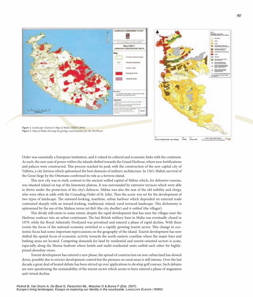
The landscape of norTh-wesT MalTaLandscape studies of Malta are limited and whatever descriptions are available are often highly localised. They are also scattered amongst a number of official reports which focus on planning and management issues (Plan-ning Services Division and Colin Buchanan & Partners 1990; Planning Services Division 1990). Some notable exceptions exist, such as Bowen-Jones et al. (1961) which has considerable historical importance. A more recent study is that of Haslam and Borg (1998) which focuses on Maltese valleys. The latest significant contri-bution is that of the Landscape assessment Study (MEPA 2004) which highlights the features and issues that influence a dynamic Maltese Landscape. This study was carried out as part of the revision of Malta’s Structure Plan as well as to fulfil national obligations undertaken through Malta’s participation in the European Land-scape Convention (Mallia 2003). The main landscape units identified by this exercise are shown in Figure 1.
Other studies which focus primarily on the north-west have been carried out within a coastal area man-agement framework. The Coastal Area Management Program (CAMP) (UNEP/MAP 2003) also contributed significantly to issues related to landscape structure. One thematic activity within CAMP-Malta addressed problems related to soil erosion and desertification, identifying processes which contributed to the morphol-ogy (Tanti et al. 2002). Since terraced landscapes on the main island of Malta are largely confined to the north-western part of the island, this chapter will focus on this particular region.
an anthropogenic landscapeTerraced slopes have long formed an integral element of the Mediterranean landscape. To northern Europeans, such a landscape often evokes romantic and idyllic images of sun-drenched hills rich with grapevines, olives, and citrus trees. However, in reality, Mediterranean terraced landscapes are better perceived as a human re-sponse to a harsh and demanding environment. The relative scarcity of land suitable for arable agriculture gave rise to an intensive form of cultivation which demanded a high input of labour with little mechanical aid.
“All visitors to Malta are invariably impressed by the vast extent of stone terrace walls which give the ground-level observer an impression of rocky barrenness” (Bowen-Jones et al. 1961 p.188). This impression is reinforced by the fact that tree crops are very limited on the island. Surprisingly, olives and vines were scarce until very recently, despite the fact that historical records reveal that olive oil was a major export commodity during the Roman period of Maltese history. The explanation for this curious phenomenon is rooted in past.
The Maltese Islands have long played a major role in the power games of the Mediterranean basin and their conquest was a high priority for a series of rising empires in the region. This conditioned agricultural activity in three distinct ways. The first was a need to provide the local garrison with fresh, perishable produce which could not be imported easily. A second imperative was that some crops were cultivated to suit specific military needs. An example of this is the cotton crop grown during the Corso1 which provided raw material for sail cloth (Earle 1970, Blouet 1967). A third consequence dates back to medieval times when tree crops, like olives, were no longer cultivated. This is because such crops were more vulnerable to hostile invasions, and they could easily be destroyed2. Unlike annual crops, olives require long-term capital investment which takes a long time to bear fruit. The Maltese olive industry never fully recovered from its medieval demise.
At present, the Maltese economy is no longer geared towards servicing a military presence, but this has been replaced by the domestic market, as well as a large tourist sector. Because of this, market gardening still accounts for most agricultural production. European accession has also served to revive the long-inactive olive and viticulture sectors.
The social context: comparing traditional rural landscapes with the urbanising tourist frontAfter the arrival of the Crusading Order of St. John in Malta in 1530, a spatial dichotomy developed within the island. By that period, the Order was a maritime power in the Mediterranean and it recognised the value of Malta’s harbours in its new role as a bulwark of Christendom in the Central Mediterranean. Moreover, the
1 The Corso was a period, extending from the Middle Ages to the beginning of the nineteenth century, during which Maltese corsairs roamed
the Mediterranean in search of Ottoman shipping.
2 One of the most severe raids occurred in 1429 when the islands were sacked by Moslem corsairs
who carried off the entire population of Gozo into slavery. Several settlements were abandoned
while agriculture suffered long term conse-quences, since there were no farm animals left for
ploughing (Wettinger 1975, Dalli 2002)
Chapter 24: Rolé
Pedroli B, Van Doorn A, De Blust G, Paracchini ML, Wascher D & Bunce F (Eds. 2007).Europe’s living landscapes. Essays on exploring our identity in the countryside. LANDSCAPE EUROPE / KNNV.
| �07
Order was essentially a European institution, and it valued its cultural and economic links with the continent. As such, the new seat of power within the islands shifted towards the Grand Harbour, where new fortifications and palaces were constructed. This process reached its peak with the construction of the new capital city of Valletta, a city fortress which epitomised the best elements of military architecture. In 1565, Malta’s survival of the Great Siege by the Ottomans confirmed its role as a fortress island.
This new city was in stark contrast to the ancient walled capital of Mdina which, for defensive reasons, was situated inland on top of the limestone plateau. It was surrounded by extensive terraces which were able to thrive under the protection of the city’s defences. Mdina was also the seat of the old nobility and clergy, who were often at odds with the Crusading Order of St. John. Thus the scene was set for the development of two types of landscape. The outward-looking, maritime, urban harbour which depended on external trade contrasted sharply with an inward-looking, traditional, inland, rural terraced landscape. This dichotomy is epitomised by the use of the Maltese terms tal-Belt (the city dweller) and ir-rahhal (the villager).
This divide still exists to some extent, despite the rapid development that has seen the villages near the Harbour coalesce into an urban continuum. The last British military base in Malta was eventually closed in 1979, while the Royal Admiralty Dockyard was privatised and entered a phase of rapid decline. With these events the focus of the national economy switched to a rapidly growing tourist sector. This change in eco-nomic focus had some important repercussions on the geography of the island. Tourist development has now shifted the spatial focus of economic activity towards the north-eastern coastline where the major bays and bathing areas are located. Competing demands for land by residential and tourist-oriented sectors is acute, especially along the Sliema Seafront where hotels and multi-residential units outbid each other for highly-prized shoreline views.
Tourist development has entered a new phase; the spread of construction on non-urban land has slowed down, possibly due to stricter development control but the pressure on rural areas is still intense. Over the last decade a great deal of heated debate has been stirred up over applications to develop golf courses. Such debates are now questioning the sustainability of the tourist sector which seems to have entered a phase of stagnation and virtual decline.
Figure 1. Landscape Character Map of Malta (MEPA 2004)Figure 2. Map of Malta showing the geology and boundary for the Northwest
Pedroli B, Van Doorn A, De Blust G, Paracchini ML, Wascher D & Bunce F (Eds. 2007).Europe’s living landscapes. Essays on exploring our identity in the countryside. LANDSCAPE EUROPE / KNNV.
�0� |
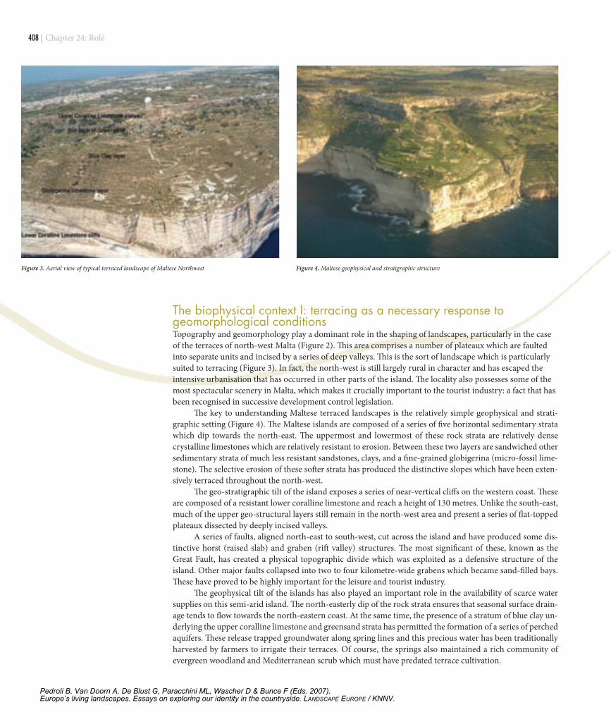
The biophysical context I: terracing as a necessary response to geomorphological conditions Topography and geomorphology play a dominant role in the shaping of landscapes, particularly in the case of the terraces of north-west Malta (Figure 2). This area comprises a number of plateaux which are faulted into separate units and incised by a series of deep valleys. This is the sort of landscape which is particularly suited to terracing (Figure 3). In fact, the north-west is still largely rural in character and has escaped the intensive urbanisation that has occurred in other parts of the island. The locality also possesses some of the most spectacular scenery in Malta, which makes it crucially important to the tourist industry: a fact that has been recognised in successive development control legislation.
The key to understanding Maltese terraced landscapes is the relatively simple geophysical and strati-graphic setting (Figure 4). The Maltese islands are composed of a series of five horizontal sedimentary strata which dip towards the north-east. The uppermost and lowermost of these rock strata are relatively dense crystalline limestones which are relatively resistant to erosion. Between these two layers are sandwiched other sedimentary strata of much less resistant sandstones, clays, and a fine-grained globigerina (micro-fossil lime-stone). The selective erosion of these softer strata has produced the distinctive slopes which have been exten-sively terraced throughout the north-west.
The geo-stratigraphic tilt of the island exposes a series of near-vertical cliffs on the western coast. These are composed of a resistant lower coralline limestone and reach a height of 130 metres. Unlike the south-east, much of the upper geo-structural layers still remain in the north-west area and present a series of flat-topped plateaux dissected by deeply incised valleys.
A series of faults, aligned north-east to south-west, cut across the island and have produced some dis-tinctive horst (raised slab) and graben (rift valley) structures. The most significant of these, known as the Great Fault, has created a physical topographic divide which was exploited as a defensive structure of the island. Other major faults collapsed into two to four kilometre-wide grabens which became sand-filled bays. These have proved to be highly important for the leisure and tourist industry.
The geophysical tilt of the islands has also played an important role in the availability of scarce water supplies on this semi-arid island. The north-easterly dip of the rock strata ensures that seasonal surface drain-age tends to flow towards the north-eastern coast. At the same time, the presence of a stratum of blue clay un-derlying the upper coralline limestone and greensand strata has permitted the formation of a series of perched aquifers. These release trapped groundwater along spring lines and this precious water has been traditionally harvested by farmers to irrigate their terraces. Of course, the springs also maintained a rich community of evergreen woodland and Mediterranean scrub which must have predated terrace cultivation.
Figure 3. Aerial view of typical terraced landscape of Maltese Northwest Figure 4. Maltese geophysical and stratigraphic structure
Chapter 24: Rolé
Pedroli B, Van Doorn A, De Blust G, Paracchini ML, Wascher D & Bunce F (Eds. 2007).Europe’s living landscapes. Essays on exploring our identity in the countryside. LANDSCAPE EUROPE / KNNV.
| �0�
The biophysical context II: the natural vegetation of the north-westIt is believed that the original climax vegetation cover of the Maltese Islands was sclerophyllous woodland composed largely of Aleppo pine (Pinus halipensis) and holm oak (Quercus ilex). This has practically been destroyed, except for a small isolated stand of oaks located at Wardija. Estimates of the age of individual speci-mens vary between 500 to 900 years (Lanfranco et al. 1996). Much of this woodland must have been cleared for arable cultivation since it would have occupied the most fertile soils on the island. It is very probable that the regeneration of woodland would have been further prevented through grazing and possibly fire.
Degraded sclerophyllous woodland was converted, by a series of anthropogenic processes, into a patchy, evergreen scrub community known as macchia. This is quite common in most Mediterranean countries and is composed of large shrubs and small trees which may reach a height of three metres; though they are often limited to one or two metres. This macchia is characterised by olive (Olea europaea), lentisk (Pistacia lentis-cus), wild fig (Ficus carica), carob (Ceratonia siliqua), wild almond (Amygdalus communis) and bay (Laurus nobilis).
The more exposed limestone platforms have been colonised by a natural vegetation cover of garigua. This is largely composed of aromatic, spiny, woody scrub species which are resistant to the stressful Mediterra-nean summer drought and extreme exposure. They are often found growing in pockets of residual soil and the more common species include Mediterranean heath (Erica mutliflora) and aromatic herbs such as Mediter-ranean thyme (Thymus capitatus), and rosemary (Rosmarinus officinalis ). The aromatic oils contained within these herbs makes them more resistant to drought conditions. Many sub-types of garigua can be found de-pending upon variations in slope and exposure to salt-laden winds. Most of these ecosystems are highly valu-able to science since they contain several endemic species. Such species include: Maltese spurge (Euphorbia melitensis); Maltese fleabane (Chiliadenus bocconei); Maltese spider orchid (Ophrys melitensis) and Maltese sea lavender (Limonium melitensis). They have thus been accorded protection within national environmental and planning legislation.
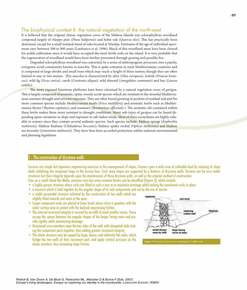
1 : The construction of drystone walls
Terraces are simple but ingenious engineering exercises in the management of slopes. Farmers gain a wide area of cultivable land by reducing its slope while stabilising the steepened slope at the terrace face. Such steep slopes are supported by a buttress of drystone walls. Terraces can be very stable structures but their integrity depends upon the maintenance of these drystone walls, as well as the original method of construction. Even on a small island like Malta, practices vary but some common factors can be identified (Figure 5), which include:• a highly porous structure where rocks are fitted in such a way as to maximise drainage while locking the constituent rocks in place• a structure which is held together by the angular shape of its rock components and not by the use of mortar• a stable pyramidal structure achieved by the construction of two walls which are
slightly tilted inwards and meet at the apex• Larger component rocks are placed at lower levels where stress is greatest, with the
wider surface area in contact with the bedrock maximising friction. • The internal structural integrity is secured by an infill of much smaller stones. These
occupy the spaces between the angular shapes of the larger facing rocks and pro-vide rigidity while maximizing drainage.
• Occasional cross-members span the two sides of the wall; with elongated slabs lock-ing the component parts together; thus adding greater structural integrity.
• The whole structure may be capped by large, heavy, and relatively flat rocks; which bridge the two walls at their narrowest part, and apply vertical pressure on the whole structure, thus increasing slope friction.
Figure 5: Structure of a terrace-retaining dry rubble wall
Pedroli B, Van Doorn A, De Blust G, Paracchini ML, Wascher D & Bunce F (Eds. 2007).Europe’s living landscapes. Essays on exploring our identity in the countryside. LANDSCAPE EUROPE / KNNV.
�10 |
Unfortunately the general public’s attitude towards the garigua habitat still varies from neutral to nega-tive. The Maltese term for garigua is xaghri and this often carries connotations of wasteland and a general perception of unproductive land. Manifestations of this attitude take the form of occasional fly tipping by in-sensitive individuals, as well as the more serious dumping of construction waste by some building contractors. This attitude seems to be slowly changing and credit needs to be given to educational campaigns organised by NGOs as well as environmental and educational authorities.
Equally neutral or negative perceptions apply to the Mediterranean steppe habitat. Such ecosystems are most often a product of the degradation of arable land, garigua, or macchia, and form grasslands with no tree cover. These steppic grasslands dry out during the summer drought and its plants shrivel into various shades of yellows and browns giving the impression of a Mediterranean desert.
Many of the plants which colonise steppe are opportunistic annual plants which include a high propor-tion of exotics. Examples of the most common exotics include cape sorrel (Oxalis pes-caprae) and crown daisy (Chrysanthemum coronarium). Other species, however, are native to the islands and include common awn-grass (Stipa capensis), thistles such as the mediterranean thistle (Galactites tomentosa) and clustered carline thistle (Carlina involucrata); umbellifers such as wild carrot (Daucus carota), common fennel (Foeniculum vulgare), and giant fennel (Ferula communis); legumes such as common vetch (Vicia sativa) and, tuberous or bulbous species like the southern star of Bethlehem (Ornithogalum narbonense). Rocky steppe is also quite common in many parts of north-west Malta and this harbours geophytes such as asphodel (Asphodelus aesti-vus) and sea squill (Urginea maritima).
A careful observation of the landscape of the north-west reveals some very interesting patterns in the distribution of natural habitats and corresponding human land use patterns. Several features can be recog-nised, including beaches, sea cliffs, inland cliffs, wide flat-bottomed graben valleys, and incised v-shaped val-leys. The last present some interesting patterns and will be discussed further.
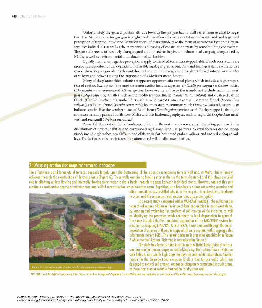
2 : Mapping erosion risk maps for terraced landscapes The effectiveness and longevity of terraces depends largely upon the buttressing of the slope by a retaining terrace wall and, in Malta, this is largely achieved through the construction of drystone walls (Figure 6). These walls contain no binding mortar (hence the term drystone) and this plays a crucial role in allowing surface flowing and internally flowing storm water to drain freely through the gaps between individual stones. However, walls of this sort require a considerable degree of maintenance and skilled reconstruction when breaches occur. Repairing such breaches is a time-consuming exercise and
often necessitates costly skilled labour. In the long run, breaches have a tendency to widen and the consequent soil erosion rates accelerate rapidly.
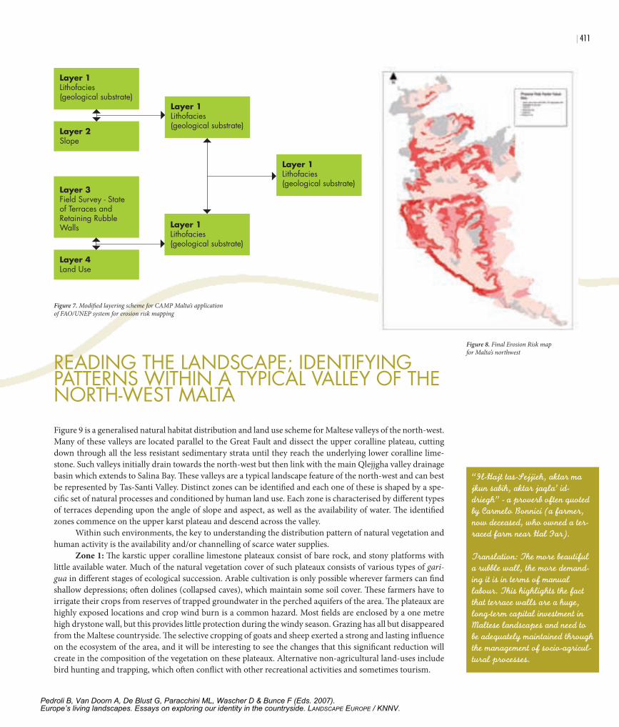
In a recent study, conducted within MAP-CAMP (Malta)*, the author and a team of colleagues addressed the issue of land degradation in north-west Malta, by locating and evaluating the problem of soil erosion within the area; as well as identifying the processes which contribute to land degradation in general. The study included the first empirical application of the FAO/UNEP system for erosion risk mapping (PAP/RAC & FAO 1997). It was produced through the super-imposition of a series of thematic maps which were overlaid within a geographic information system (GIS). The layering scheme is presented graphically in Figure 7 while the final Erosion Risk map is reproduced in Figure 8.
The study has demonstrated that the areas with the highest risk of soil ero-sion are rain-fed terrace slopes on underlying clay. The surface flow of water on such fields is particularly high since the clay-rich soils inhibit absorption. Another reason for the disproportionate erosion levels is that terrace walls, which are designed to control soil erosion, cannot be adequately constructed in such areas, because clay is not a suitable foundation for drystone walls.
* MAP CAMP stands for UNEP’s Mediterranean Action Plan – Coastal Area Management Programme. Several CAMPs have been conducted for most countries of the Mediterranean Basin and some are still in progress.
Figure 6. A typical example of a dry rubble wall armouring a terrace slope
Chapter 24: Rolé
Pedroli B, Van Doorn A, De Blust G, Paracchini ML, Wascher D & Bunce F (Eds. 2007).Europe’s living landscapes. Essays on exploring our identity in the countryside. LANDSCAPE EUROPE / KNNV.
| �11
readInG The landscape; IdenTIfyInG paTTerns wIThIn a TypIcal Valley of The norTh-wesT MalTaFigure 9 is a generalised natural habitat distribution and land use scheme for Maltese valleys of the north-west. Many of these valleys are located parallel to the Great Fault and dissect the upper coralline plateau, cutting down through all the less resistant sedimentary strata until they reach the underlying lower coralline lime-stone. Such valleys initially drain towards the north-west but then link with the main Qlejjgha valley drainage basin which extends to Salina Bay. These valleys are a typical landscape feature of the north-west and can best be represented by Tas-Santi Valley. Distinct zones can be identified and each one of these is shaped by a spe-cific set of natural processes and conditioned by human land use. Each zone is characterised by different types of terraces depending upon the angle of slope and aspect, as well as the availability of water. The identified zones commence on the upper karst plateau and descend across the valley.
Within such environments, the key to understanding the distribution pattern of natural vegetation and human activity is the availability and/or channelling of scarce water supplies.
Zone 1: The karstic upper coralline limestone plateaux consist of bare rock, and stony platforms with little available water. Much of the natural vegetation cover of such plateaux consists of various types of gari-gua in different stages of ecological succession. Arable cultivation is only possible wherever farmers can find shallow depressions; often dolines (collapsed caves), which maintain some soil cover. These farmers have to irrigate their crops from reserves of trapped groundwater in the perched aquifers of the area. The plateaux are highly exposed locations and crop wind burn is a common hazard. Most fields are enclosed by a one metre high drystone wall, but this provides little protection during the windy season. Grazing has all but disappeared from the Maltese countryside. The selective cropping of goats and sheep exerted a strong and lasting influence on the ecosystem of the area, and it will be interesting to see the changes that this significant reduction will create in the composition of the vegetation on these plateaux. Alternative non-agricultural land-uses include bird hunting and trapping, which often conflict with other recreational activities and sometimes tourism.
Layer 1Lithofacies(geological substrate)
Layer 2Slope
Layer 3Field Survey - State of Terraces and Retaining Rubble Walls
Layer 4Land Use
Layer 1Lithofacies(geological substrate)
Layer 1Lithofacies(geological substrate)
Layer 1Lithofacies(geological substrate)
Figure 7. Modified layering scheme for CAMP Malta’s application of FAO/UNEP system for erosion risk mapping
Figure 8. Final Erosion Risk map for Malta’s northwest
“Il-Hajt tas-Sejjieh, aktar ma jkun sabih, aktar jaqla’ id-driegh” - a proverb often quoted by Carmelo Bonnici (a farmer, now deceased, who owned a ter-raced farm near Hal Far).
Translation: The more beautiful a rubble wall, the more demand-ing it is in terms of manual labour. This highlights the fact that terrace walls are a huge, long-term capital investment in Maltese landscapes and need to be adequately maintained through the management of socio-agricul-tural processes.
Pedroli B, Van Doorn A, De Blust G, Paracchini ML, Wascher D & Bunce F (Eds. 2007).Europe’s living landscapes. Essays on exploring our identity in the countryside. LANDSCAPE EUROPE / KNNV.
�12 |
Zone 2: The upper coralline plateaux are often undercut by erosion of the less resistant greensand and blue clays and large blocks detach and slide down into the valley. Such erosion also leaves near-perpendicular cliff faces which are colonised by rupestral plant communities. One of the more common examples is the ca-per bush (Capparis orientalis). The presence of large boulders and the inherent geomorphological instability of the area render it marginal to arable cultivation. Some narrow terraces may be found at the base of the cliffs, but these have now largely been abandoned and are currently being taken over by regenerating macchia. Until a few years ago, these marginal fields were grazed, but the virtual disappearance of foraging herds of goats and sheep is now accelerating the process of regeneration.
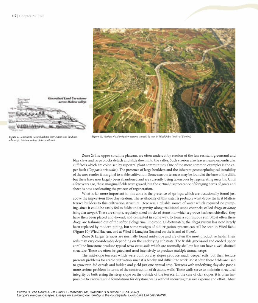
What is far more important in this zone is the presence of springs, which are occasionally found just above the impervious Blue clay stratum. The availability of this water is probably what drove the first Maltese terrace builders to this cultivation structure. Here was a reliable source of water which required no pump-ing, since it could be easily fed to fields under gravity, along traditional stone channels; called driegi or dorog (singular dorga). These are simple, regularly-sized blocks of stone into which a groove has been chiselled; they have then been placed end-to-end, and cemented in some way, to form a continuous run. Most often these driegi are fashioned out of the softer globigerina limestone. Unfortunately, the dorga system has now largely been replaced by modern piping, but some vestiges of old irrigation systems can still be seen in Wied Babu (Figure 10) Wied Hazrun, and at Wied il-Lunzjata (located on the island of Gozo).
Zone 3: Larger terraces are normally found mid-slope and are often the most productive fields. Their soils may vary considerably depending on the underlying substrate. The friable greensand and eroded upper coralline limestone produce typical terra rossa soils which are normally shallow but can have a well-drained structure. These are often irrigated and used intensively to produce multiple annual crops.
The mid-slope terraces which were built on clay slopes produce much deeper soils, but their texture presents problems for arable cultivation since it is blocky and difficult to work. Most often these fields are used to grow rain-fed cereals and fodder, and yield just one annual crop. Terraces with underlying clay also pose a more serious problem in terms of the construction of drystone walls. These walls serve to maintain structural integrity by buttressing the steep slope on the outside of the terrace. In the case of clay slopes, it is often im-possible to excavate solid foundations for drystone walls without incurring massive expense and effort. Most
Figure 9. Generalised natural habitat distribution and land use scheme for Maltese valleys of the northwest
Figure 10. Vestiges of old irrigation systems can still be seen in Wied Babu (limits of Zurrieq)
Chapter 24: Rolé
Pedroli B, Van Doorn A, De Blust G, Paracchini ML, Wascher D & Bunce F (Eds. 2007).Europe’s living landscapes. Essays on exploring our identity in the countryside. LANDSCAPE EUROPE / KNNV.
| �13
terrace walls in such fields require a good deal of maintenance and suffer badly from neglect and abandon-ment. This is one of the main reasons why terraces on the island of Gozo, which possess a higher proportion of exposed clay slopes, are experiencing accelerated soil erosion.
Zone 4: This is the zone where terraces are occasionally prone to some flood damage during the intense, torrential, autumn rain. These terraces retain a fair degree of moisture even during the summer drought and are often devoted to horticulture; with a special focus on citrus and other fruit trees. In some cases, as in Tas-Santi Valley, these terraces are not contained behind drystone walls but are retained by dense growths of the great reed (Arundo donax).
Zone 5: This is the valley watercourse and the area in the immediate vicinity of the stream, which is prone to frequent seasonal flooding. Such watercourses are considered highly valuable ecosystems by scien-tists because they are very rare habitats in a semi-arid country. Moreover they often harbour rare and endemic species; a good example is the endemic freshwater crab (Potamon fluviatile lanfrancoi).
Unfortunately, the high regard for watercourses is not universal. All too often, streams act as disposal areas, although this practice has decreased considerably over the last few years. This may be attributed to a change in perception and appreciation of such habitats amongst the general population. Moreover, such habitats enjoy the protection of environmental and planning legislation. Such protection has been increased to such an extent that it has raised conflicting issues with farmers. In fact, during the CAMP process, farmers complained that watercourses were creating problems of flood damage, since they could not legally be cleared to allow fast drainage during intense rainstorms. This was raising the level of storm-water runoff to such a height that serious soil erosion was occurring along the lower terraces located near the watercourse (Tanti et al.).
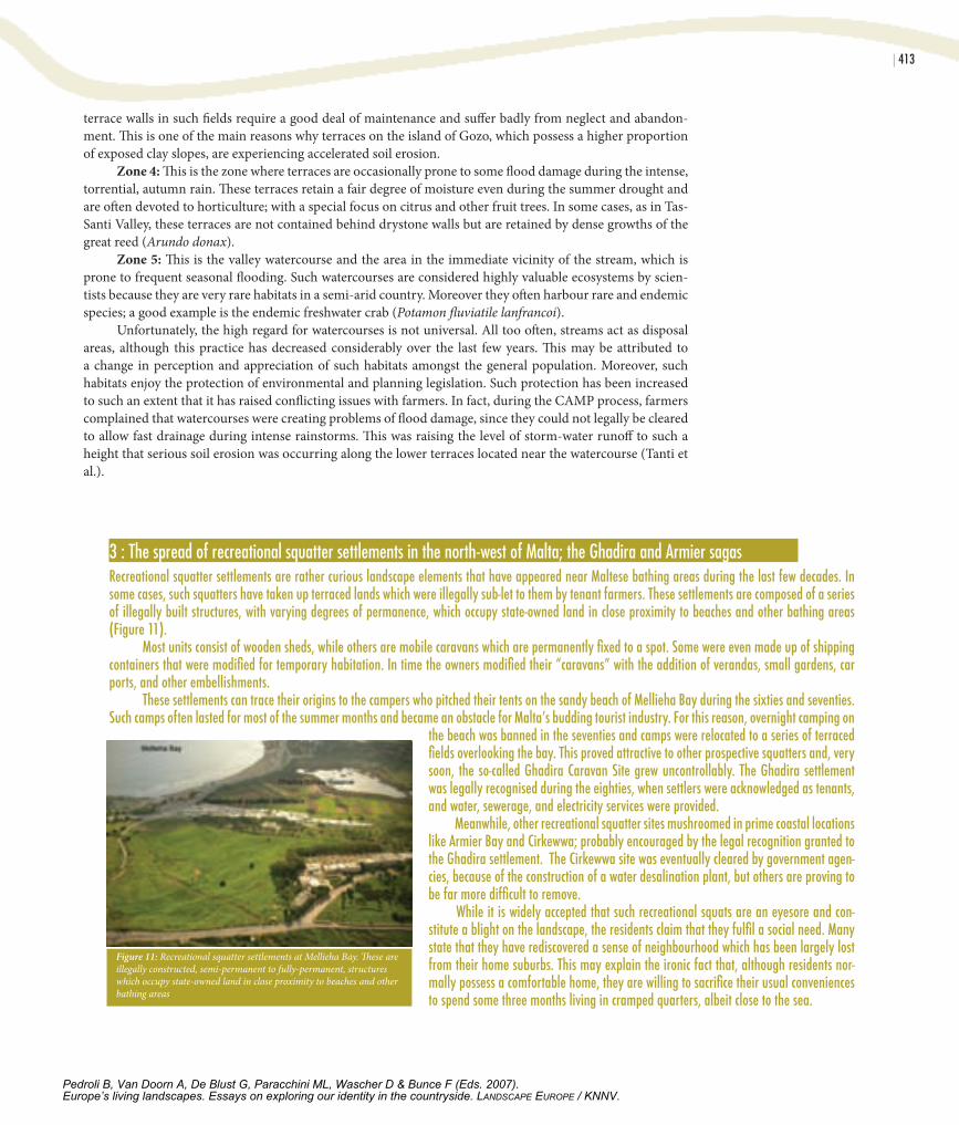
3 : The spread of recreational squatter settlements in the north-west of Malta; the Ghadira and Armier sagas Recreational squatter settlements are rather curious landscape elements that have appeared near Maltese bathing areas during the last few decades. In some cases, such squatters have taken up terraced lands which were illegally sub-let to them by tenant farmers. These settlements are composed of a series of illegally built structures, with varying degrees of permanence, which occupy state-owned land in close proximity to beaches and other bathing areas (Figure 11). Most units consist of wooden sheds, while others are mobile caravans which are permanently fixed to a spot. Some were even made up of shipping containers that were modified for temporary habitation. In time the owners modified their “caravans” with the addition of verandas, small gardens, car ports, and other embellishments. These settlements can trace their origins to the campers who pitched their tents on the sandy beach of Mellieha Bay during the sixties and seventies. Such camps often lasted for most of the summer months and became an obstacle for Malta’s budding tourist industry. For this reason, overnight camping on
the beach was banned in the seventies and camps were relocated to a series of terraced fields overlooking the bay. This proved attractive to other prospective squatters and, very soon, the so-called Ghadira Caravan Site grew uncontrollably. The Ghadira settlement was legally recognised during the eighties, when settlers were acknowledged as tenants, and water, sewerage, and electricity services were provided. Meanwhile, other recreational squatter sites mushroomed in prime coastal locations like Armier Bay and Cirkewwa; probably encouraged by the legal recognition granted to the Ghadira settlement. The Cirkewwa site was eventually cleared by government agen-cies, because of the construction of a water desalination plant, but others are proving to be far more difficult to remove. While it is widely accepted that such recreational squats are an eyesore and con-stitute a blight on the landscape, the residents claim that they fulfil a social need. Many state that they have rediscovered a sense of neighbourhood which has been largely lost from their home suburbs. This may explain the ironic fact that, although residents nor-mally possess a comfortable home, they are willing to sacrifice their usual conveniences to spend some three months living in cramped quarters, albeit close to the sea.
Figure 11: Recreational squatter settlements at Mellieha Bay. These are illegally constructed, semi-permanent to fully-permanent, structures which occupy state-owned land in close proximity to beaches and other bathing areas
Pedroli B, Van Doorn A, De Blust G, Paracchini ML, Wascher D & Bunce F (Eds. 2007).Europe’s living landscapes. Essays on exploring our identity in the countryside. LANDSCAPE EUROPE / KNNV.
�1� |
Several watercourses in northwest Malta have been colonised by the great reed (Arundo donax) and these are regularly harvested in order to make cane furniture. Some farmers; especially in the San Blas area of Gozo; construct very effective wind breaks out of the reeds, which are worked into the rubble walls of the terraces. This creates a very picturesque form of terracing which is largely restricted to the island and is rare in Malta.
No permanent rivers exist in Malta. There are only seasonal streams in the larger drainage basins and several ephemeral streams. This is partly due to the seasonal precipitation regime which is characteristic of Mediterranean climatic regimes and also partly due to the karstic nature of its geology. In fact, the Maltese word for valley is wied, which shows the Semitic origin of the language, but it also has connotations of dry river valleys with highly seasonal flow regimes (Arabic wadi or oued). As in other Semitic cultures, a valley in Malta is not named after the stream that flows through it, since this is normally not permanent, but refers to the terrestrial topographic feature (e.g., Wied il-Kbir – the Large Valley not the Large River). Streams in Malta have no name but the valley through which they flow does. Moreover, different stretches of a wied may have different names along different parts of its length; so, for example, changes to the name Wied il-Kbir include Wied ic-Cawsli and Wied Qirda. A wied system may change names as frequently as six times within a length of 10 kilometres.
Is the rural landscape of Malta doomed?The survival of the Maltese rural landscape has often been questioned. The factors that contribute to its pos-sible demise include: a combination of acute demand for tourist and residential development; increased rec-reational pressure; marginal agricultural activity; water stress; terrace wall maintenance; and unfavourable land tenure systems.
Malta is already the most densely populated country in Europe but the voracious appetite of the con-struction industry seems to be unchecked. Rising land prices, coupled with economic and political pressures, resulted in MEPA revising the boundaries of development zones in 2006. It seems that the term sustainability assumes new interpretations under such circumstances.
� : The impact of Laws of Inheritance on the rural landscape Legislation has a profound impact on the evolution of landscapes and never more so than in the Mediterranean. Many countries in the region possess legislative systems which are based, in varying degrees, on the ancient Roman Civil Code. The Maltese judicial system is no different; despite two hundred years of British colonial rule. Therefore, legislation that regulates inheritance is based upon the principle of equity amongst inheritors. This is very different from other cultures, like the Anglo-Saxon tradition, which permits an individual to transfer his estate to just one of his offspring. The Law of Inheritance has been largely responsible for the problem of fragmentation of landholdings within the Maltese Islands. The problem is compounded by the fact that titles of tenancy are also inherited in the same manner. This means that state-owned land, leased to individual tenants, is also highly fragmented. Average farm size (76%) for the Maltese Islands is no more than one hectare in size (NSO 2001), while some farmers may be forced to cultivate several small fields which may be located kilometres apart. Land fragmentation has various negative consequences on the rural landscape. These include an increased demand for access roads, the limited ap-plication of modern agricultural techniques, and marginal economic returns. Faced with such constraints, it is not surprising to observe that the agricultural sector is in decline. Of the total number of farmers, 89% now work on a part time basis, and 55% are over 50 years of age (NSO 2001). It is feared that this trend may be exacerbated by competition from cheaper agricultural imports following Malta’s accession to the European Union. These factors contribute significantly to an increased risk of land abandonment and, in the case of terraced landscapes, the consequences are particularly serious. Similar experiences in other parts of the Mediterranean (Roxo et al 1996; Margaris et al 1996), and further afield (Mainguet 1994; Middleton and Thomas 1997), show a strong causative relationship between unfavourable socio-economic factors, land abandonment, and accelerated soil erosion. Lack of maintenance of terrace walls eventually results in the removal of entire soil profiles, especially if grazing inhibits the development of a dense vegetation cover. This is disastrous if one considers the fact that the terrace constitutes a form of inherited rural capital which is irreplaceable within a human time frame.
Chapter 24: Rolé
Pedroli B, Van Doorn A, De Blust G, Paracchini ML, Wascher D & Bunce F (Eds. 2007).Europe’s living landscapes. Essays on exploring our identity in the countryside. LANDSCAPE EUROPE / KNNV.
| �15
chanGes In Terraced landscapes “Understanding terraces is the key to understanding the chronology and development of many Mediterranean landscapes. We do not have that key.” (Grove and Rackham 2001; p.112) This lament is particularly applicable to Maltese terraced landscapes, since the task of assigning unequivocal dates to terraces is notoriously dif-ficult. This is partly due to the combination of factors which follow.• Terrace wall construction methods were not deemed to be of such importance as to warrant specific study and
no written records have been found which document the construction methods employed centuries ago.• Terrace construction methods have apparently changed little over time. It is only recently that some farm-
ers have taken short-cuts and repaired terrace retaining walls with standard limestone building blocks. Such repairs never last long.
• Terraces are in constant need of repair. Sections of drystone walls are often rebuilt quickly following col-lapse, in order to prevent further soil erosion, and consequently the same terrace wall would have multiple dates.
• It is impossible to identify a particular style which can be dated to a known historical period.
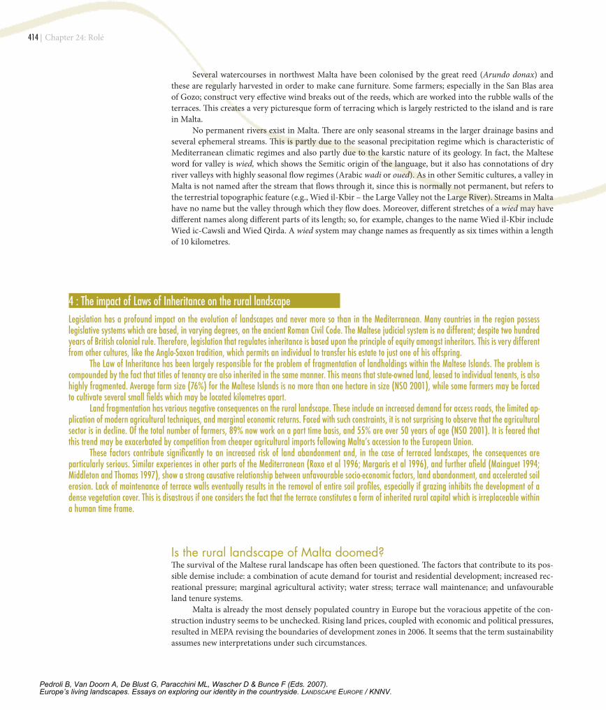
Figure 12. Urbanised terraced slopes overlooking Mellieha Bay
Pedroli B, Van Doorn A, De Blust G, Paracchini ML, Wascher D & Bunce F (Eds. 2007).Europe’s living landscapes. Essays on exploring our identity in the countryside. LANDSCAPE EUROPE / KNNV.
�16 |
It is obvious that highly significant changes to terraced landscapes are currently occurring. This is due to a number of processes which are causing negative as well as some positive impacts on environmental and agrarian quality. Such processes have set trends which are expected to continue into the foreseeable future.
Probably the single greatest impact on terraced landscapes in Malta is the spread of urbanisation and concomitant peri-urban development. Such development includes quarrying, manufacturing, warehousing, and other industry which is generally deemed as undesirable within residential urban areas. Some residen-tial complexes, on the other hand, actively favour terraced locations which often command spectacular and unhindered views. Examples of such development include the Busietta Gardens complex in Madliena valley, Santa Maria Estate in Mellieha, and the north-facing terraced slopes overlooking Mellieha Bay (Figure 12).
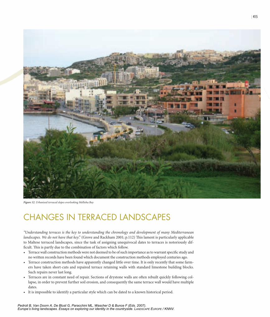
Figure 13. Several hectares of abandoned and degraded terraced lands have been rehabilitated and planted with vines
Figure 14. Bird hunting hides and trapping sites have become a regular feature of the Maltese countryside
5 : Some impacts on terraced landscapes of Malta’s accession to the European Union
Terraced cultivation is deeply influenced by external factors; probably more so than conventional large-scale agriculture. Maltese terraces are small in area and cannot generally accommodate heavy machinery. Therefore production tends to be small-scale, artisanal, and particularly prone to suffer from the liberalisation of trade and associated cheaper imports. Despite the fact that the Maltese agricultural sector is still in transition, some obvious impacts can already be identified within the rural landscape. With the notable exception of early potatoes destined for the European market, most Maltese agricultural effort was geared towards satisfying local demand. The sector was protected through a complex system of trade barriers which allowed some imports as the need arose (Role et al 2005). European accession spelled the end of this system, but it opened opportunities for two particular activities which are perfectly suited to terrace cultivation: viticulture and olive cultivation. The Maltese wine industry has experienced a considerable amelioration in quality during the last two decades; this was partly fuelled by the demand for good quality local wines generated by the tourist sector. Most of the grapes needed to satisfy this demand used to be imported until May 2006. European accession now obliges local vintners to use local grapes in order to satisfy DOC requirements and this has resulted in a steep rise in demand for local, quality grapes. Some wine producers even provide the vines and help in their planting, provided that the farmer signs a contract to supply them with the produce. Many farmers have thus been encouraged to plant vines on terraces which were previously semi-abandoned (Figure 13). European accession has also boosted olive cultivation. This crop has experienced a revival over the last few years since the edaphic conditions found in Malta seem ideal for producing an extremely high quality olive oil. As with viticulture, the higher value of olives is serving as an incentive to rehabilitate previously semi-abandoned terraces and bring them back into production.
Chapter 24: Rolé
Pedroli B, Van Doorn A, De Blust G, Paracchini ML, Wascher D & Bunce F (Eds. 2007).Europe’s living landscapes. Essays on exploring our identity in the countryside. LANDSCAPE EUROPE / KNNV.
| �17
Another interesting process is the rise in the number of small hobby farms. It seems that accelerated urbanisation has driven individuals to stake their claim to a place in whatever remains of the rural environ-ment and they use such sites as week-end recreational retreats. This has proved to be a mixed blessing in some respects. On one hand, hobby farmers have been instrumental in maintaining terraces and rebuilding col-lapsed drystone walls. They have also injected external cash into the rural economy. On the other hand, hobby farmers put enormous pressure on government authorities to be allowed to erect a variety of buildings on their properties. These range from single rooms to elaborate farmhouses. Such constructions mar the essential rural character of the landscape and, in this respect, the Malta Environment and Planning Authority (MEPA) has been instrumental in slowing this trend by withholding the necessary development permits.
Sometimes hobby farms are bought as a form of speculative investment, on the assumption that urban growth would proceed in the direction of the farm. If that were to occur, property values would soar with its re-zoning as a building development area. A related phenomenon is recreational bird hunting and trapping which has increased rapidly over the last few years. In addition, such activity has intensified over a smaller area since extensions in building development have eaten up more and more of the remaining countryside. Bird hunting normally occurs in and around cultivated terraces where some farmers may actually be hunters themselves. In fact, hunting hides and trapping sites have become a regular feature of the Maltese countryside (Figure 14). They are highly concentrated in terraced areas overlooking the coastal cliffs but several others are located on the upper coralline limestone plateaux.
Bird trapping requires the construction of trapping sites, the laying down of nets, and an elaborate trigger mechanism. All vegetation is removed from the trapping site and a hide is constructed which allows a trapper to sit while waiting to spring the trap. Besides the negative environmental impact on avifauna, the removal of vegetation poses the added threat of soil erosion. Many trappers have no interest in farming and maintaining terrace walls, therefore land degradation is particularly evident around trapping sites. This sort of recreational activity also constitutes a lucrative alternative for landowners. Anecdotal evidence reveals that well-placed trapping sites on the island of Gozo are leased for annual sums reaching LM 600 (approximately €1400). This income is far more than can be realised through cultivation and, in addition, demands no effort on the part of the landowner. Perhaps a more benign change in terraced landscapes is the current trend amongst farmers of replanting terraces with vines and olives. This is a direct result of Malta’s accession to the European Union
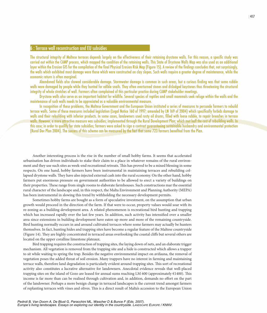
6 : Terrace wall reconstruction and EU subsidies
The structural integrity of Maltese terraces depends largely on the effectiveness of their retaining drystone walls. For this reason, a specific study was carried out within the CAMP process, which mapped the condition of the retaining walls. This State of Drystone Walls Map was also used as an additional layer within the Erosion GIS for the compilation of the final Physical Erosion Risk Map (Figure 15). A review of the findings concludes that, not surprisingly, the walls which exhibited most damage were those which were constructed on clay slopes. Such walls require a greater degree of maintenance, while the economic return is often marginal. Abandoned fields also showed considerable damage. Stormwater damage is common in such areas, but a curious finding was that some rubble walls were damaged by people while they hunted for edible snails. They often overturned stones and dislodged keystones thus threatening the structural integrity of whole stretches of wall. Farmers often complained of this particular practice during CAMP stakeholder meetings. Drystone walls also serve as an important habitat for wildlife. Several species of reptiles and small mammals seek refuge within the walls and the maintenance of such walls needs to be appreciated as a valuable environmental measure. In recognition of these problems, the Maltese Government and the European Union instituted a series of measures to persuade farmers to rebuild terrace walls. Some of these measures included legislation (Legal Notice 160 of 1997; amended by LN 169 of 2004) which specifically forbids damage to walls and their rebuilding with inferior products. In some cases, landowners used rusty oil drums, filled with loose rubble, to repair breaches in terrace walls. However, a more attractive measure was subsidies; implemented through the Rural Development Plan; which met half the cost of rebuilding walls. In this case; in order to qualify for state subsidies; farmers were asked to sign a contract guaranteeing sustainable husbandry and environmental protection (Rural Dev Plan 2004). The success of this scheme can be measured by the fact that some 723 farmers benefited from the Plan.
Pedroli B, Van Doorn A, De Blust G, Paracchini ML, Wascher D & Bunce F (Eds. 2007).Europe’s living landscapes. Essays on exploring our identity in the countryside. LANDSCAPE EUROPE / KNNV.
�1� |
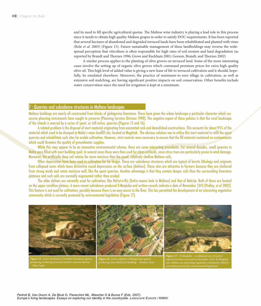
7 : Quarries and subsidence structures in Maltese landscapes Maltese buildings are nearly all constructed from blocks of globigerina limestone. These have given the urban landscape a particular character which suc-cessive planning instruments have sought to preserve (Planning Services Division 1990). The negative aspect of these policies is that the rural landscape of the islands is marred by a series of spent, or still active, quarries (Figures 15 and 16). A related problem is the disposal of inert material originating from excavated rock and demolished constructions. This accounts for about 95% of the material which used to be dumped at Malta’s main landfill site; located at Maghtab. The obvious solution was to utilise this inert material to refill the spent quarries and rehabilitate such sites for arable cultivation. However, strict controls were necessary to ensure that the fill material contained no contaminants which could threaten the quality of groundwater supplies. While this may appear to be an innovative environmental scheme, there are some interesting precedents. For several decades, small quarries in Malta were filled with inert building spoil. In several cases these were then used for citrus orchards, since citrus trees are particularly prone to wind damage. Moreover, the artificially deep soil retains far more moisture than the usual, relatively shallow Maltese soils. Other depressions have been used in cultivation for far longer. These are subsidence structures which are typical of karstic lithology and originate from collapsed caves which leave distinctive round depressions on the surface (dolines). These sites are attractive to farmers because they are sheltered from strong winds and retain moisture well, like the spent quarries. Another advantage is that they contain deeper soils than the surrounding limestone plateaux and such soils are normally augmented rather than eroded. The older dolines are normally used for cultivation; like Hofret-ir-Riz (hofra means hole in Maltese) and that of Bahrija. Both of these are located on the upper coralline plateau. A more recent subsidence produced Il-Maqluba and written records indicate a date of November 1343 (Pedley, et al 2002). This feature is not used for cultivation; possibly because there is no easy access to the floor. This has permitted the development of an interesting vegetation community which is currently protected by environmental legislation (Figure 17).
Figure 15. Active hardstone (Coralline limestone) quarry producing crushed gravel and sand for concrete slurries – Ghar Lapsi
Figure 16. Active softstone (Globigerina) quarry producing stone blocks for building - Dwejra, Gozo
Figure 17.– Il-Maqluba – a collapsed cave structure reported to have occurred in November 1343. Il-Maqluba now shelters an interesting vegetation community which is currently protected by environmental legislation
and its need to fill specific agricultural quotas. The Maltese wine industry is playing a lead role in this process since it needs to obtain high quality Maltese grapes in order to satisfy DOC requirements. It has been reported that several hectares of abandoned and degraded terraced lands have been rehabilitated and planted with vines (Role et al. 2005) (Figure 13). Future sustainable management of these landholdings may reverse the wide-spread perception that viticulture is often responsible for high rates of soil erosion and land degradation (as reported by Brandt and Thornes 1996; Grove and Rackham 2001; Geeson, Brandt, and Thornes 2002)
A similar process applies to the planting of olive groves on terraced land. Some of the more interesting cases involve the setting up of organic olive groves which command premium prices for extra high quality olive oil. This high level of added value is giving a new lease of life to terraced cultivation and it should, hope-fully, be emulated elsewhere. Moreover, the practice of minimum-to-zero tillage in cultivation, as well as extensive soil mulching, are having significant positive impacts on soil conservation. Other benefits include water conservation since the need for irrigation is kept at a minimum.
Chapter 24: Rolé
Pedroli B, Van Doorn A, De Blust G, Paracchini ML, Wascher D & Bunce F (Eds. 2007).Europe’s living landscapes. Essays on exploring our identity in the countryside. LANDSCAPE EUROPE / KNNV.
| �1�
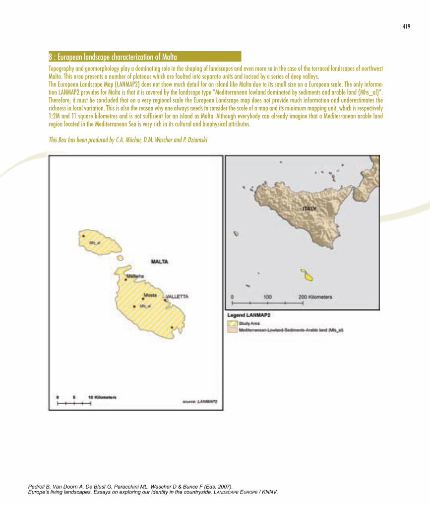
� : European landscape characterization of Malta Topography and geomorphology play a dominating role in the shaping of landscapes and even more so in the case of the terraced landscapes of northwest Malta. This area presents a number of plateaus which are faulted into separate units and incised by a series of deep valleys.The European Landscape Map (LANMAP2) does not show much detail for an island like Malta due to its small size on a European scale. The only informa-tion LANMAP2 provides for Malta is that it is covered by the landscape type “Mediterranean lowland dominated by sediments and arable land (Mhs_al)”. Therefore, it must be concluded that on a very regional scale the European Landscape map does not provide much information and underestimates the richness in local variation. This is also the reason why one always needs to consider the scale of a map and its minimum mapping unit, which is respectively 1:2M and 11 square kilometres and is not sufficient for an island as Malta. Although everybody can already imagine that a Mediterranean arable land region located in the Mediterranean Sea is very rich in its cultural and biophysical attributes. This Box has been produced by C.A. Mücher, D.M. Wascher and P. Dziamski
Pedroli B, Van Doorn A, De Blust G, Paracchini ML, Wascher D & Bunce F (Eds. 2007).Europe’s living landscapes. Essays on exploring our identity in the countryside. LANDSCAPE EUROPE / KNNV.
�20 |
referencesBlouet B (1967) The Story of Malta. Faber and Faber, London.Bowen Jones H, Dewdney J C & Fischer W B (1961) Malta - Background for Development, Durham, Geogra-
phy Dept. Durham Colleges.Brandt C J, Geeson N & Thornes J B (2002) Mediterranean Desertification: A Mosaic of Processes and Responses
Chichester, John Wiley and Sons.Brandt C J & Thornes J B (1996) Mediterranean Desertification and Land Use, Chichester, Wiley.Dalli C (2002) Iz-Zmien Nofsani Malti, PIN, Pjeta, Malta.Earle P (1970) Corsairs of Malta and Barbary, London.Grove A T & Rackham O (2001) The Nature of Mediterranean Europe: an ecological history, New Haven, Yale
University Press.Haslam S M & Borg J (1998) The River Valleys of the Maltese Islands: environment and human impact, Valletta,
F.I.S. (Univ. of Malta) and CIHEAM.Lanfranco E (1996) Flora of the Maltese Islands. In Sultana J & Falzon V (Eds.) Wildlife of the Maltese Islands.
Floriana, Environment Protection Department.Mainguet M (1994) Desertification: natural background and human mismanagement, Berlin, Springer Verlag,.Mallia F (2003) The Relevance of the European Landscape Convention to the Maltese Context. In Landscape
in the European Policy. Council of Europe Conference Proceedings, Rome, Italy (Nov 2003)Malta environment and planning authority (2004) Landscape Assessment Study of the Maltese Islands. Gov-
ernment of Malta.Margaris N S, Koutsidou E & Giourga C (1996) Changes in Traditional Mediterranean Land-Use Systems. In
Brandt C J & Thornes J (Eds.) Mediterranean Desertification and Land-Use. Chichester, John Wiley.Middleton N & Thomas D (1997) World Atlas of Desertification, UNEP Arnold.National statistics office (2001) Census of Agriculture, Floriana, Malta, NSO.PAP/RAC & FAO (1997) Guidelines for Mapping and Measurement of Rainfall-induced Erosion Processes in
the Mediterranean Coastal Areas. Split, PAP/RAC & FAO.Pedley M, Hughes-Clark M & Galea P (2002) Limestone Isles in a Crystal Sea, San Gwann, Malta, PEG.Planning services division (1990) Structure Plan for the Maltese Islands. Valletta, Government of Malta.Planning Services division & Colin Buchanan & partners (1990) Malta Structure Plan - Report of Survey.
Government of Malta.Role A, Attard G, Muscat J, Camilleri S, Sammut S J, Camilleri P & Scicluna K (2005) Sustainable rural land
management in the Maltese Islands: an evaluation of policy instruments and future needs. IN ZDRULI, P. & LIUZZI, G. T. (Eds.) MEDCOASTLAND: Drafting Appropriate Policies and Guidelines to Support Sus-tainable Land Management in the Mediterranean Region. Bari, Italy
Roxo M J, P Cortesao Casimiro & R Soeiro de Brito (1996) Inner Lower Alentejo Field Site: Cereal Cropping, Soil Degradation and Desertification. In Brandt C J & Thornes, J. (Eds.) Mediterranean Desertification and Land-Use. Chichester, John Wiley.
Rural Development Department (2004) The Rural Development Plan for Malta. Ministry for Rural Affairs and the Environment, .
Tanti C, Role A, Borg A & Calleja I (2003) Protection of Soil and Rural Landscapes in Northwest Malta. In UNEP/MAP (Ed.) MAP Tech Rep. No. 138 - Coastal Area Management Programme Athens, EPD and UNEP.
trump DH (1966) Skorba. London, The Society of Antiquaries.UNEP/MAP (2003) MAP CAMP Project "Malta". MAP Tech Rep. No. 138 - Coastal Area Management Pro-
gramme Athens.Wettering, G. (1975) The Lost Villages and Hamlets of Malta. In Luttrell A T (Ed.) Medieval Malta: Studies on
Malta Before the Knights. London (181-216).
Chapter 24: Rolé
Pedroli B, Van Doorn A, De Blust G, Paracchini ML, Wascher D & Bunce F (Eds. 2007).Europe’s living landscapes. Essays on exploring our identity in the countryside. LANDSCAPE EUROPE / KNNV.