Embed Size (px)
Citation preview
JAIRM, 2019 – 9(2), 63-96 Online ISSN: 2014-4806 – Print ISSN: 2014-4865
https://doi.org/10.3926/jairm.127
The UAVs Threat to Airport Security: Risk Analysis and Mitigation
John Pyrgies
SkyAngels Lab (Belgium)
Received February, 2019
Accepted May, 2019
Abstract
Purpose: This research studies the UAV incidents in the vicinity of worldwide airports in orderto deliver a quantitative and qualitative analysis of this phaenomenon, to analyse the risksassociated to this threat and propose mitigation measures that brings this risk to an ‘acceptable’level.
Design/methodology: A population of 139 ‘serious UAV incidents in the vicinity ofworldwide airports’ has been constituted on the basis of the FAA and NASA databases andarticles published on the Web by online media. This phaenomenon has then been analysedquantitatively using descriptive statistics techniques and qualitatively by analysing in-depth somerepresentative incidents. A risk analysis has then been performed based on the FAA Safety RiskManagement 5-steps process to identify the hazards i.e. the root causes of those UAV incidents,determine their outcome i.e. negative consequences that jeopardize airports objectives andassign them a severity level and likelihood i.e. frequency level. Analysed risks have then beenassessed based on FAA ARP Risk Matrix. Mitigation measures (prevention, deterrence, denial,detection, neutralisation) have been identified following a ‘Defence-in-Depth’ approach.
Findings: The findings of the study are that those UAV incidents are more numerous thananticipated and happen higher and further from the airports than expected: they happen notonly in CTRs but also in TMAs. This has an impact on the mitigation measures that shall notonly be deployed at airports side but also be on-boarded in manned aircrafts.
Originality/value: To our knowledge, no study has combined different sources to constitutesuch a population focused on ‘serious’ UAVs incidents around airports worldwide, has appliedthe official FAA Safety Risk Management process to assess this risk and followed a structured‘Defence-in-Depth’ approach typically used in Cybersecurity to mitigate this risk.
Keywords: airport security and safety, Unmanned Aerial Vehicles (UAVs) threat, risk analysis and
mitigation, Counter-UAVs technologies.
-63-
Journal of Airline and Airport Management 9(2), 63-96
To cite this article:
Pyrgies, J. (2019). The UAVs threat to airport security: Risk analysis and mitigation. Journal of Airline and Airport Management, 9(2), 63-96. https://doi.org/10.3926/jairm.127
1. IntroductionCivil UAVs market is developing at an exponential growth with business applications mainly inthe film industry,aerial photography, inspection of technical infrastructure like wind farms, real estate, agriculture and private andpublic security.
Today those UAVs are used as RPAS: Remotely Piloted Aircraft Systems with their pilot controlling the flight atall time generally in Visual Line Of Sight (VLOS) but even in Beyond Line Of Sight (BLOS).
The next step, in a close future, is to have the UAVs performing autonomous flights for applications like parceldelivery, emergency equipment delivery, search and rescue at sea… Autonomous UAV flights poses sometechnical challenges like the capability to ‘detect-and-avoid’ manned aircraft and other UAVs and organisationalchallenges like their integration in controlled airspace in the scope of the next generation of Air TrafficManagement systems envisaged by the NextGen (US) and SESAR (EU) undertakings.
Professionals, who leverage this new UAV technology for expanding their business, have generally no priorknowledge in aviation but are used to professional responsibility and liability and tend to follow the rules whoseinfringements could jeopardize their whole enterprise. Professionals who use UAVs thus tend to follow therequired training and observe all the safety procedures when operating their UAV.
Besides the evolution of UAV business market, a UAV hobbyist market has developed where consumers, alsowithout any prior knowledge of aviation but without professional liabilities, have been able to acquire inmultimedia chains, without any formality and warnings, powerful UAVs that can flight at several thousand feetheights. Millions of such UAVs have been sold and are in hands of people who are unaware of the damages theycould cause to civil aviation.
The press has been reporting, for a couple of years, serious incidents where UAVs have been involved in Mid AirCollisions (MAC) with manned aircrafts, Near Mid Air Collisions (NMAC) and airport airspace closures.
This study has been initiated to acquire a better knowledge of the ‘UAV incidents phaenomenon in the vicinityof airports’, a place of high concentration of aircrafts where the most critical phases of the flight: Taking offand landing take place. The study also analyses and assesses the risk and propose mitigation measures.
This study will be used as a basis and context for my own PhD covering the ‘certification (DO178C/DO278) ofintelligent algorithms embedded in UAVs and integrated in air traffic control ground systems’.
2. Literature Review
2.1. Safety and security risk management for airports
Neubauer, Fleet and Ayres (2015) have produced a Guidebook for Safety Risk Management for Airports whichprovides guidance to assist airports on conducting Safety Risk Assessments (SRA)for addressing their specificrisks in the scope of the Safety Risk Management (SRM) process. The 5 steps of the SRM process areformalized in the guide: Describe the system, identify hazards, analyse risks, assess risks, mitigate risks. Theguidebook also provides a set of useful templates and information which can be exploited when performing aSRA: checklists, risk matrixes, severity and probability tables, preliminary hazard lists, mitigation tables, samplereports for small and large airports, typical accident and incident rates, typical Key Performance Indicators(KPI), basic probability and statistics.
European Union Agency for Network and Information Security (2016) has published the Securing Smart Airportsreport which provides a guide aimed at airport decision makers, airport information security professionals,national authorities in charge of cyber-security for airports and cyber-security industry representatives. Smartairports are those implementing new smart components providing improved services and user experience to
-64-
Journal of Airline and Airport Management 9(2), 63-96
travellers. However, those new smart components increase the ‘attack surface’ of airport assets to new attackvectors and the new risks they introduce need to be identified, assessed and mitigated. The report highlights keyassets of smart airports, analyses their vulnerabilities to attack scenarios, prescribes good practices and concludeswith 8 recommendations, including the prioritisation of cyber-security to guarantee passengers and operatorsstaff safety. Of particular interest and relevance to our study is the attack scenario: ‘drone intercept as mobile vehiclefor jamming and spoofing aircraft-airport and traffic control-airline communications’.
2.2. UAVs opportunities and threats for airports
Price and Forrest (2016) examine, in the chapter 9 of their book, potential security threats to General Aviation(GA) airports and provide strategies to protect them. GA consists of flight operation that is not commercialservice or military i.e. flight training, recreational flights, business flights, experimental aircrafts, this with varioustypes of aircrafts: jets, gliders, helicopters…The authors mention it is more likely that UAVs will start coexistingwith manned aircraft when operating out from GA facilities, used as droneports, rather than from busycommercial service airports. They report that in 2013, FAA picked 6 GA airports to perform researches aboutstandards for UAVs categories, traffic control procedures and NextGen, sense and avoid technologies, airspaceintegration, differing climates, airworthiness, reliable data links and failure mode testing. Relevant to our study isthe identification of the security threats for airports originated from UAVs: surveillance conducted on airport bya spy UAV, UAV purposely flown into a passenger aircraft, UAV weaponized with a gun and used to attack high-value targets after bypassing airport security perimeter, UAV transformed in flying Improvised Explosive Device(IED) and flown in airports high-value targets, UAV carrying chemical, biological or radiological elements anddispensing the agent in the air over the airport. The authors mention that from an airport operator’s perspective,the main deterrence against illegal use of drones for criminal or terrorist operations is to monitor UAVs activitieson and around the airport.
ACI Europe (2018) identifies drone risks posed to airports and their outcome: safety risk to aviation linked togrowing amateur drones fleet, including near misses and collisions with passenger aircrafts; disruption of airtransport due to prompt closure of runways, such as Dubai airport’s hour-long closure in October 2016,implyingsubstantial financial cost for airports and airlines and impacting passengers’ journey. The ACI report alsomentions UAVs opportunities for airports which could bring process improvements and cost efficiencies:pavement surface condition, ground lighting, runways and taxi ways inspections; obstacle surveys; areas andperimeters surveillance; construction work surveys; improved situational awareness during emergencies; 3Dmapping; aircraft checks, calibration of navigational equipment (e.g. ILS). Hosting drones could also bring newbusiness opportunities for airports. The report explains that the simplification and automation of drones trafficmanagement through Unmanned Traffic Management (UTM) will optimize the limited ground and air capacities.The report concludes with the necessity to finalise the European safety rulebook on drones; the need forguidelines and benchmarking related to measures protecting airports from drones (i.e. technical systems to detectand neutralise drones); the need for authorities, Air Traffic Control (ATC) and operators to collaborate towardsintegration of drones in airport environments; the need to ready the industry for future drones opportunities.
Gettinger and Michel (2015) deliver a report that represents the results of a detailed analysis of 921 incidentsinvolving UAVs and manned aircraft in the U.S. National Airspace System from December 2013 to September2015. 2 categories of incidents have been considered: Sightings where a pilot or air traffic controller spotted adrone not posing an immediate threat of collision and Near Mid Air Collisions (NMAC) as defined by the U.S.Federal Aviation Administration (FAA). Based on researches from the Crashworthiness for Aerospace Structuresand Hybrids (CRASH) Lab at Virginia Tech, the authors also discuss about the effects that a collision between aUAV and a manned aircraft could lead to and identify the ‘at risk’ systems: radome, front exterior of cockpit,wing and empennage leading edges, flaps, stabilizers and finally… The propulsion system. The Virginia Techteam found that if a 1 meter diameter UAV was ingested into a 3 meter diameter turbofan engine, this couldcause engine failure.
-65-
Journal of Airline and Airport Management 9(2), 63-96
2.3. Counter-UAVs technologies
Wallace (2015) reports the most notorious security incidents involving UAVs and states the problem faced by lawenforcement and security agencies to combat the UAV threats: poor understanding of the issue due to thenovelty of UAVs and lack of cohesive defense strategy. The study seeks to answer the 2 following researchquestions: How are UAVs used for illegal purposes or terrorism? and What are the current defense methods against UAVthreats?. The study identifies and describes following UAV threats: nuisance to the general public, includingindividual’s privacy violation, property trespassing and children and animals upsetting; aerial surveillance,including observation of young children and aerial reconnaissance to collect ‘intelligence’ information about thevulnerabilities in critical infrastructures, government sites, business and private citizens in order to prepare anattack against those ‘targets’; airspace interference, including near-misses between UAVs and airliners andinterruption of aerial emergency responses due to the presence of UAVs in the disaster area; Kinetic/Kamikazethreat materialized when UAVs accidently cause damages to people or properties, but could also be used ‘out-of-the-box’ to purposely cause injuries and even fatalities due to their lethal potential; Payload threat/smuggling,including transportation of illegal contraband or cargo, bypassing security barriers and perimeters like the onesprotecting a prison or a border. Weaponized threat consists in the construction and modification of UAVs tocarry and employ different types of weapons, including non-lethal and lethal projectile weapons, ImprovisedExplosive Devices (IEDs) and Weapons of Mass Destruction (WMD) based on chemical, biological andradiological substances; Electronic threat, consisting in using a UAV to perpetrate a cyber-attack. The studypresents the UAVs defense concepts, relying upon a ‘defense-in-depth’ approach organised into 5 concentriclayers: prevention through actionable intelligence, including UAV components purchase monitoring; deterrencerelying on new legislations to both fund agencies to acquire UAVs defense measures and to establishcivil/criminal penalties to deter illegal UAVs use; denial through passive security measures that decrease theeffectiveness of UAVs in conducting illegal activities or terrorism, including the selection of a right location thatpresents impediments to a UAV attack (e.g. indoor rather than outdoor venue) and ‘geofencing’ implemented byUAV manufacturers that prevents a ‘out-of-the-box’ UAV approaching critical infrastructures, including airports,based on its Global Navigation Satellite System (GNSS) position; detection of the UAVs, identification andtracking to prepare their neutralisation, including active detection with radars adapted to detect UAVs whichpresent small cross-sections and radar software that distinguish them from birds and passive detection withvisual, acoustic, thermal/infrared and RF communications monitoring systems, this latter allowing to detect thecommunication between the UAV and the radio-control unit of its pilot; interruption/destruction, includinginterception of the pilot, jamming UAV’s control and/or GNSS signals to interrupt them, spoofing whichconsists in sending falsified GNSS navigation or control data, destruction with projectile weapons, directedenergy weapons, guided munitions and interception with a Counter-UAVs UAV. ‘Destructive’ techniques areeffective but can cause ‘collateral damages’ due to falling projectiles and debris of the hostile UAV with itsdangerous payload.
Michel (2018) provides a comprehensive market study that identifies 235 Counter-UAV products, already on themarket or in active development, produced by 155 manufacturers in 33 countries. The Counter-UAV market hasgrown exponentially those last years, proportionally to the rise of concerns around the drones threat. The authormentions the usage of Counter-UAV systems: on the battlefield, they are deployed to protect military bases,mobile ground units and convoys; In civilian environments, they are used primarily for airspace protection atairports, securing large events, VIP protection and counter-smuggling operations at prisons. Future applicationsare protection of critical infrastructures (on top of airports) and private property protection. The study describesthe main detection and tracking techniques implemented by those products: radars, radio-frequency scanners,electro-optical cameras, infrared cameras, acoustic sensors. The study notes that those techniques are usuallycombined to increase the effectiveness of the UAV detection system. Interdiction techniques are also described:radio-frequency jamming, GNSS jamming, control data spoofing, electromagnetic pulse, laser, nets, machineguns, water projectors, sacrificial collision drones and are also usually combined. Those detection andinterdiction techniques are used alone or combined in systems that can be ground-based, hand-held or UAV-based i.e. carried by a Counter-UAVs UAV. RF and GNSS jamming is the most common interdiction technique.Relevant to our own study, it shall be noted that only one system combines ground-based and UAV-based
-66-
Journal of Airline and Airport Management 9(2), 63-96
elements and only 2 products are based on projectiles designated specifically for Counter-UAV. The reportdescribes the challenges of Counter-UAV systems: detection effectiveness: UAVs are small, low altitudeaircrafts which are hard to detect and can be confused with birds; false negatives and false positives: findingthe right ‘sensitiveness’ setting is a real challenge; Distinguishing legitimate and illegitimate drone use: aslegitimate UAVs use is becoming common in the civilian environments and on the battlefield, the Counter-UAVsystem should not shoot down a legitimate, ‘allied’ UAV. Interdiction hazards: kinetic interdiction techniquesare risky due to the fall of the UAV or its debris on the ground and non-kinetic techniques can interfere withlegitimate communications. Interdiction effectiveness: some large scale trials have demonstrated that UAVs arevery resilient against damage and that most of current solutions need further improvements. The report alsomentions the effectiveness limitations of non-kinetic techniques: RF jamming is useless if the UAV isprogrammed to operate autonomously such as GNSS jamming in the case the UAV can operate in GNSS deniedenvironments, spoofing is very difficult to implement. Legality of interdiction: interdiction techniques likejamming and spoofing can be illegal. Lack of standards: There are no standards for the design and use ofCounter-UAV systems, implying significant performance and reliability variances. The report also raises theconcern that hostile UAVs might form a swarm, which is still more challenging to fight. The report also coversthe approach of a Dutch firm: use (living) bird of preys to intercept rogue UAVs. Relevant to our study is theposition of the FAA that ‘advised airports against the use of jammers since they can interrupt air trafficmanagement operations’ and the electronic identification which allows to quickly spot the ‘good’ UAVs in theperimeter.
Buric and De Cubber (2017) provide an inventory of the threats represented by malicious UAVs: violation ofprivacy; intelligence; weapons and ammunition transport; terrorist attacks using weapons, bombs, grenades,radioactive materials; intentional or unintentional collide with other authorized aircraft vehicles; using drones asprojectiles (kamikaze drones); people injuring; propaganda; critical infrastructure properties and goods damage;transport of the illegal objects (smugglers); stopping or slowing commercial UAVs industry development. Theydescribe the exploited vulnerabilities: Low cost of recreational and commercial UAVs; Weakness of the exportcontrol; Gaps into existing regulatory framework: for both using UAVs and Counter-UAV tools, this latterincluding the right to destroy a hostile UAV, the right to jam its radio-communication, the right to hack itscomputer program; Lack of the effective Counter-UAV technology, including the lack of common standardswhich could guide potential developers of such systems; Deployment challenges taking into account the varietyof environments where malicious UAVs could be encountered and conditions of use: day, night, meteorologicalconditions; misunderstanding by the different decision levels of the real threat dimension i.e. decisions related toregulatory countermeasures are taken at different administrative and political levels; technological rapidlydevelopment that brings new features to UAVs and increase their resistance against countermeasures e.g.commercial UAVs flying without GNSS, artificial intelligence that allows them to operate in swarm collaborativemode; ISTAR capabilities for commercial and recreational UAVs i.e. Information, Surveillance, TargetAcquisition and Reconnaissance which used to be limited to military UAVs; Commercial and recreational UAVsmodified to get military features i.e. as the ones modified by ISIS in order to increase their lethality, theireffectiveness and resistance to countermeasures; environments where malicious UAVs can be used i.e. in moreand more busy RF spectrum and ‘noisy’ backgrounds making them more and more difficult to detect andclassify. The study proposes an architecture for a Counter-UAV system and a 5 steps ‘kill chain’ model:detection: with active radar; passive radar i.e. use ‘electro smog’ generated by GSM or WIFI as a source ofillumination; passive optics: video, thermal or infrared cameras; active optics i.e. LIDAR; acoustic sensors; RFemissions scanner; B-field detection i.e. exploiting disturbance of the magnetic field around a UAV and qualifytheir performance; A 3 steps classification process to be implemented by a data fusion algorithm: determine ifdetected object is a UAV; determine if it represents a threat; assess the risk level based on target type, directionof arrival, range, velocity, estimated time of arrival, number of hostile UAVs, number of sensors that haveconfirmed target, altitude, output from queried UAV traffic management database, size; Tracking of thethreatening UAVs on a Geographic Information System (GIS) map with their ID; Neutralization whosemethod(s) are chosen according to the environment and its effects on target hostile UAVs among: geofencing,firearms, lasers, missiles, gun nets, counter-UAV UAVS, birds, jamming, high power electromagnetic weapon(electronic blast), hacking; Forensic whose goal is to establish the identity of the UAV owner, the purpose the
-67-
Journal of Airline and Airport Management 9(2), 63-96
UAV was used for, the flight path and the home point. The report also presents the SafeShore project whoseobjectives are to cover gaps in European coastal border surveillance and prevent cross-border crime such astrafficking in human beings and smuggling of drugs. It addresses the threats presented by small UAVs departingfrom maritime platforms such as yachts, boats and human intruders on the sea shore which cannot be detectedby regular coastal radars. SafeShore innovative UAVs detection solution leverages a 3D LIDAR combined withpassive acoustic sensors, passive radio frequency detection and cameras. Another goal of SafeShore is to performfusion of information to increase the ‘situational awareness’ of actors in charge of the European coastalprotection. Of interest to our study is the high-level requirements specification for a Counter-UAV system:should cover all steps of the ‘kill chain’ i.e. detection, classification, risk assessment, tracking, neutralisation,forensic; Detection should combine all types of state-of-the-art sensors; Neutralization should include alternativesolutions ‘engaged’ according to results of data fusion and processing, risk assessment and validated by a human;Information should be gathered and analysed in the forensic phase to develop future preventive and reactivemeasures; Standard interfaces should be used to insure interconnection with Law Enforcement Agenciescommand and control rooms. It shall be noted that first SafeShore trials have taken place during secondfortnight of May 2018 on the Belgian coast where the prototype developed by the project team has beenbenchmarked with ‘off-the-shelf ’ detection solutions already available on the market based on Doppler radar,electro-optic camera, infrared camera and acoustic sensor. At the moment of writing the present article, testresults are being processed and compiled. In this coastal environment, the challenges are the ‘noise’ generated bythe waves motion and the high number of birds flying which have to be distinguished from small UAVs.
Gettinger and Michel (2015) also presents solutions that might reduce of prevent UAV incidents: geo-fencinglike the one installed in the DJI and 3DR UAVs which maintains an up-to-date list of restricted airspaces; Sense-and-avoid systems that allow a UAV to detect a potential collision with another aircraft and take evasive action;UAV Traffic Management (UTM) systems based on cellular networks.
3. UAV Incidents at Civilian Airports
3.1. Methodology
The goal was to constitute a population of worldwide UAV incidents to be in a position to perform aquantitative and qualitative analysis in order to draw the characteristics of the ‘UAV incidents at civilian airports’phaenomenon.
A Google search has been initiated with the search keys: ‘UAV incidents airports’, ‘drone incidents airports’,‘UAV incidents aéroports’, ‘drone incidents aéroports’.
Wikipedia (2018) has been spotted in the first page of the search result and the UAV incidents referred in thecategories ‘Alleged aircraft collisions’ and ‘Aircraft near-miss incidents’ have been further analysed. The incidentshaving happened in the vicinity of civilian airports have been selected. Additional UAV airport incidents returnedby the searches result, mostly reported by the online media, have also been studied.
Those selected UAV airport incidents have then been ‘formatted’ as per following criteria:
• Date.
• Airport.
• Incident Type.
• Source of information.
• Manned aircraft type involved.
• Number of UAVs involved.
• Flight phase.
• Altitude (feet).
• Distance between UAV and aircraft (feet).
• Distance from airport (KMs).
• Indicator if UAV was captured.
• Indicator if UAV pilot was identified.
-68-

Journal of Airline and Airport Management 9(2), 63-96
• Effects of incidents.
N.B. There is little info about the UAVs type involved in those incidents.
This search also allowed to identify Dan Gettinger and Arthur H. Michel (2015) which leverages the FAA (2018)and NASA (2018) UAV incidents databases. Those 2 databases have been exploited and Near Mid Air Collision(NMAC) incidents have been selected in our population. It must be noted that we retained only the incidentswhere the manned aircraft pilot(s) have explicitly declared a NMAC.
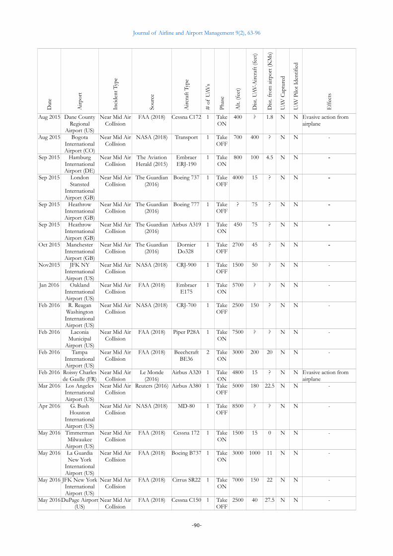
A population of 139 UAV incidents in the vicinity (i.e. <35 kilometers) of worldwide civilian airports has beenconstituted and can be found in the Annex I.
The observation period is from May 2014 till May 2018.
Following chart provides the distribution of those 139 UAVs incidents over their sources:
Figure 1. UAV incidents distributed per reporting sources (NASA & FAA, 2018)
Following chart provides the distribution of those 139 UAVs incidents over the years of the observation period:
Figure 2. UAV incidents distributed per year (NASA & FAA, 2018)
-69-

Journal of Airline and Airport Management 9(2), 63-96
3.2. Quantitative analysis
The population of ‘UAV incidents in the vicinity of worldwide civilian airports’ constituted in the scope of thisstudy (Annex I) has been exploited to perform a statistical quantitative analysis of this phaenomenon and answerto a set of questions.
3.2.1. What type of UAV incidents?
Following chart provides the distribution of those 139 UAVs incidents over the types of incidents:
Figure 3. UAV incidents distributed per incident types (NASA & FAA, 2018)
Following table provides a definition of the UAV incident types:
Incident Type DefinitionNear Mid Air Collision (NMAC)
FAA defines a Near Mid Air Collision (NMAC) as an incident associated with the operation of an aircraft in which a possibility of a collision occurs as a result of proximity of less than 500 feet to another aircraft, or a report is received from a pilot or flight crew member stating that a collision hazard existed between two or more aircraft.
Mid Air Collision (MAC)
SKYbrary (2018) defines a Mid Air Collision (MAC) as an accident where two aircrafts come into contact with each other while both are in flight.
Airspace Closure Airspace closure, for an airport, is a period of time during which no aircraft is permitted to operate to and from that airport.
Jetliner Sighting ‘Jetliner Sighting’, as per our definition, is the action of taking pictures and/or videos of an aircraft, typically a jetliner, during its landing or taking off phase with the camera embeddedin a UAV. Those pictures and/or videos are later on posted on the social media.
Airport indoor Sighting
‘Airport indoor Sighting’, as per our definition, is the action of taking pictures and/or videos with the camera embedded in a UAV flying inside an airport hall.
Table 1. UAV incidents type definition
3.2.2. Where did those UAV incidents occur and the most affected airports?
Following chart provides the distribution of the 139 UAVs incidents over the countries where they took place:
-70-

Journal of Airline and Airport Management 9(2), 63-96
Figure 4. UAV incidents distributed per country (NASA & FAA, 2018)
Interpretation: United States authorities i.e. NASA and FAA maintain and publish UAV incidents databases,which are the main sources of our study, besides worldwide online media. This is thus normal that we have morecases reported in the U.S. United Kingdom has encountered many UAV incidents reported by the online media.The root cause of this proportionally high level of UAV incidents in U.K. is worth further investigating.
A ‘hit parade’ of the airports with the biggest UAV incidents frequency has been established from ourpopulation:
Airport Number of UAV incidentsHeathrow International Airport (GB) 9Gatwick International Airport (GB) 3London Stansted International Airport (GB) 1
TOTAL LONDON AIRPORTS 13JFK New York International Airport (US) 2La Guardia New York International Airport (US) 4Liberty Newark International Airport (US) 2
TOTAL NEW-YORK AIRPORTS 8Miami International Airport (US) Nombre 4Logan Boston International Airport (US) 3Los Angeles International Airport (US) 3Dubai International Airport (AE) 3Philadelphia International Airport (US) Nombre 3
Table 2. Airports with highest UAV incidents frequency
A ‘hit parade’ of the airports which have been the most impacted, in term of flights delayed, returned ordiverted and the associated economic losses, has also been established from our population. Those airports havefaced ‘Airspace closure’ incidents:
Airport Number of airspace closuresDubai International Airport (AE) 3Gatwick International Airport (GB) 2Sharjah International Airport (AE) 1Chengdu Shuangliu International Airport (CN) 1Chongqing International Airport (CN) 1Auckland International Airport (NZ)) 1
Table 3. Airports the most impacted due to their airspace closure
-71-

Journal of Airline and Airport Management 9(2), 63-96
N.B. Liège has not been included in the table as it only ‘suffered’ from a partial closure of its airspace, therunway has not been affected.
3.2.3. What types of manned aircraft involved in UAV incidents?
Following chart provides the distribution of the 2 MAC, 124 NMAC and 2 jetliner sighting incidents over thetypes of involved manned aircrafts:
Figure 5. UAV incidents distributed over manned aircraft types (NASA & FAA, 2018)
Interpretation: All types of aircraft are affected by the phaenomenon.
3.2.4. How many UAVs involved in the incidents?
Following chart provides the distribution of the UAV incidents over the number of UAVs involved in theincident:
Figure 6. UAV incidents distributed over number of involved UAVs (NASA & FAA, 2018)
3.2.5. UAVs incidents at take-off or landing phase?
Following chart provides the distribution of the 2 MAC, 124 NMAC and 2 jetliner sighting incidents over theincidents over the take-off and landing phases:
-72-

Journal of Airline and Airport Management 9(2), 63-96
Figure 7. UAV incidents distributed over taking off/on phases (NASA & FAA, 2018)
Interpretation: The trajectory of a landing plane is different from the one of a taking off plane. A taking offplane reaches a higher height at a shorter distance from the runway.
3.2.6. At what height UAVs incidents happen?
Following chart provides the distribution of the UAV incidents over the height intervals at which they happened(when height was known):
Figure 8. UAV incidents distributed over the height interval (NASA & FAA, 2018)
Following table provides some statistical indicators about the height of UAV incidents in our population andcompare them with (Gettinger & Michel, 2015):
-73-

Journal of Airline and Airport Management 9(2), 63-96
Statistical Indicator Value for ourpopulation
Value found in BardCollege study
Interpretation
Average 3075 Feet Not Available Average ≤ 5 NMs (Bard)≤ 8 KMs (our)
1832 Feet 1887 Feet Very close values in the 2 studies.
Average > 5 NMs (Bard)> 8 KMs (our)
4704 Feet 5032 Feet Very close values in the 2 studies.
Mediane 2500 Feet Not Available Range - Minimum 200 Feet Not Available Range - Maximum 12500 Feet Not Available Standard deviation 2568 Feet Not Available
% > 400 Ft (Bard)% > 500 Ft (our) 91.3 % 90.2 %
Max height for UAVs:in U.S: 400 Feet.in Europe: [300 - 500] Feet.
Table 4. Statistical indicators for UAV incidents height
Important remark: It shall be noted that for some UAV incidents, the height was provided at Mean Sea Level(MSL, in which case the value represents an altitude), and in some cases Above Ground Level (AGL). Ideally forour study, all height values should have been expressed AGL. We have NOT made the correction taking intoaccount the elevation of the airport. So for some cases, the value represented in term of MSL is higher than theequivalent AGL value and thus those incidents are presented ‘higher’ than they actually are.
3.2.7. At what distance was the UAV from the manned aircraft?
Following chart provides the distribution of the UAV incidents over the intervals of distance between the UAVand the manned aircraft (when such distance was known):
Figure 9. UAV incidents distributed over the distance intervals (NASA & FAA, 2018)
-74-
Journal of Airline and Airport Management 9(2), 63-96
Following table provides some statistical indicators about the distance between the UAV and the manned aircraftin our population and compare them with the ones found in the Bard college study (Gettinger & Michel, 2015):
Statistical Indicator Value for ourpopulation
Value found in BardCollege study
Interpretation
Average 113 Feet 217 Feet Bard study population differs fromours as they also included sightings andincidents where pilots did not explicitlydeclared NMAC. Thus our incidentsare more ‘serious’ and the UAVs tendto be closer from manned aircrafts inour population.
Mediane 90 Feet 150 Feet
Range - Minimum 0 Feet Not Available Collision!
Range - Maximum 1000 Feet Not Available One NMAC declared by pilot althoughdistance > 500 feet
Standard deviation 137.5 Feet Not Available
Table 5. Statistical indicators for distance between UAV and manned aircraft
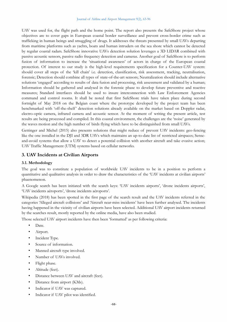
3.2.8. At what distance was the UAV from the airport?
Following chart provides the distribution of the UAV incidents over the intervals of distance between the UAVand the airport (when such distance was known):
Figure 10. UAV incidents distributed over the distance from airport (NASA & FAA, 2018)
Following table provides some statistical indicators about the distance between the UAV and the airport in ourpopulation and compare them with the ones found in the Bard college study (Gettinger & Michel, 2015):
Statistical Indicator Value for ourpopulation
Value found in BardCollege study
Interpretation
Average 9.47 KMs Not Available Mediane 8 KMs Not Available
Range - Minimum 0 KM Not Available Above the runway!Range - Maximum 31,5KMs Not Available Standard deviation 7.23 KMs Not Available
% < 5 NMs (Bard)% < 10 KMs (our) 63.7 % 58.8 %
Min distance from airport:in U.S: 5 NM (9.26 KMs).in Europe: [3 - 10] KMs.
Table 6. Statistical indicators for distance between UAV and airport
-75-
Journal of Airline and Airport Management 9(2), 63-96
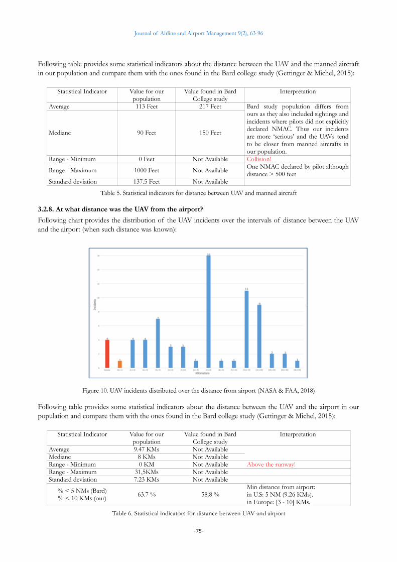
Following chart shows the relation between the ‘distance from airport’ (X-axis) and ‘height’ (Y-axis) variables forour UAV incidents population (when such distances and heights were known):
Figure 11. Relation between airport distance and incident height (NASA & FAA, 2018)
Interpretation: Distance from airport and height are linked by an increasing function: height of UAV incidentstend to increase as distance from airport increase. This could be linked to the trajectory of aircrafts aroundairports: they flight lower when closer to airports.
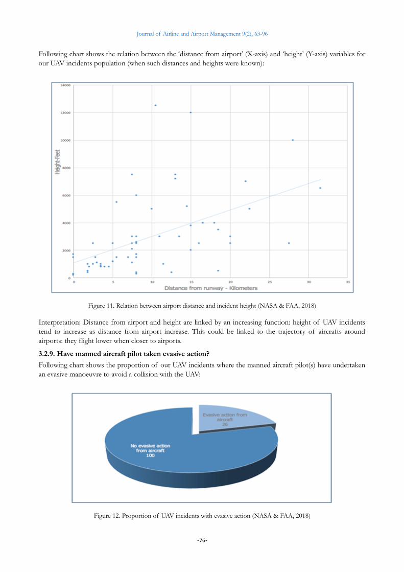
3.2.9. Have manned aircraft pilot taken evasive action?
Following chart shows the proportion of our UAV incidents where the manned aircraft pilot(s) have undertakenan evasive manoeuvre to avoid a collision with the UAV:
Figure 12. Proportion of UAV incidents with evasive action (NASA & FAA, 2018)
-76-
Journal of Airline and Airport Management 9(2), 63-96
Interpretation: In many cases, manned aircraft pilots report they had no time to take evasive action and onlyprovidence has helped in avoiding the collision with the UAV.
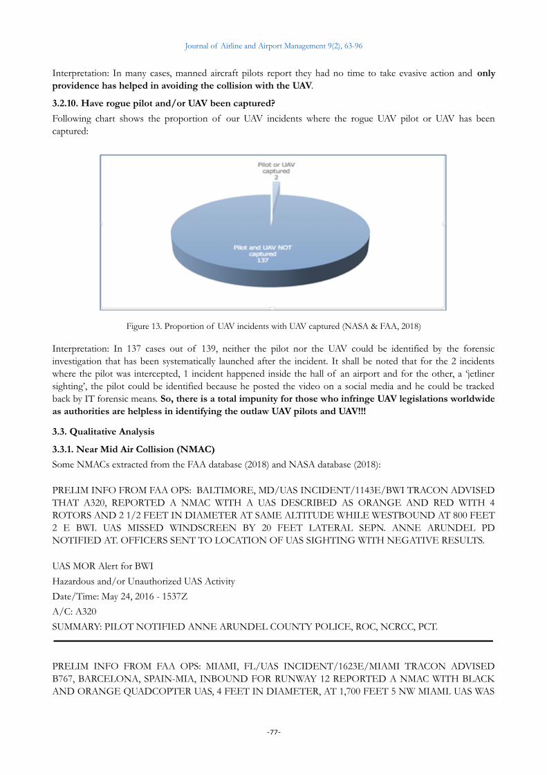
3.2.10. Have rogue pilot and/or UAV been captured?
Following chart shows the proportion of our UAV incidents where the rogue UAV pilot or UAV has beencaptured:
Figure 13. Proportion of UAV incidents with UAV captured (NASA & FAA, 2018)
Interpretation: In 137 cases out of 139, neither the pilot nor the UAV could be identified by the forensicinvestigation that has been systematically launched after the incident. It shall be noted that for the 2 incidentswhere the pilot was intercepted, 1 incident happened inside the hall of an airport and for the other, a ‘jetlinersighting’, the pilot could be identified because he posted the video on a social media and he could be trackedback by IT forensic means. So, there is a total impunity for those who infringe UAV legislations worldwideas authorities are helpless in identifying the outlaw UAV pilots and UAV!!!
3.3. Qualitative Analysis
3.3.1. Near Mid Air Collision (NMAC)
Some NMACs extracted from the FAA database (2018) and NASA database (2018):
PRELIM INFO FROM FAA OPS: BALTIMORE, MD/UAS INCIDENT/1143E/BWI TRACON ADVISEDTHAT A320, REPORTED A NMAC WITH A UAS DESCRIBED AS ORANGE AND RED WITH 4ROTORS AND 2 1/2 FEET IN DIAMETER AT SAME ALTITUDE WHILE WESTBOUND AT 800 FEET2 E BWI. UAS MISSED WINDSCREEN BY 20 FEET LATERAL SEPN. ANNE ARUNDEL PDNOTIFIED AT. OFFICERS SENT TO LOCATION OF UAS SIGHTING WITH NEGATIVE RESULTS.
UAS MOR Alert for BWI
Hazardous and/or Unauthorized UAS Activity
Date/Time: May 24, 2016 - 1537Z
A/C: A320
SUMMARY: PILOT NOTIFIED ANNE ARUNDEL COUNTY POLICE, ROC, NCRCC, PCT.
PRELIM INFO FROM FAA OPS: MIAMI, FL/UAS INCIDENT/1623E/MIAMI TRACON ADVISEDB767, BARCELONA, SPAIN-MIA, INBOUND FOR RUNWAY 12 REPORTED A NMAC WITH BLACKAND ORANGE QUADCOPTER UAS, 4 FEET IN DIAMETER, AT 1,700 FEET 5 NW MIAMI. UAS WAS
-77-
Journal of Airline and Airport Management 9(2), 63-96
100 FEET OFF RIGHT WING. NO EVASIVE ACTION TAKEN. MIAMI DADE COUNTY PDAVIATION UNIT NOTIFIED.
UAS MOR Alert for MIA
Type: Hazardous and/or Unauthorized UAS Activity
Date/Time: Sep 26, 2016 - 2023Z
A/C: (H/B763)
Summary: WHILE ON ILS APP FOR RWY 12 AT MIA, ACFT REPORTED A UAS NEAR ILS FIXVEPCO (5NM NW OF MIA) AT 1,700FT. PILOT ADVISED TO CALL FACILITY TO PROVIDE MOREINFORMATION. PILOT SPOKE TO TRACON FLM AND STATED HE SAW A BLACK ANDORANGE OBJECT WITH 4 PROPS PASS 100FT OF HIS RIGHT WING. THE OBJECT WAS AHAZARD TO HIS AIRCRAFT AND CONSIDERED THIS A NMAC. PILOT DID NOT TAKEEVASSIVE ACTION, ALSO STATED THAT PASSENGERS DID SEE AN OBJECT OUT THE RIGHTSIDE WINDOWS. DEN, ROC, MDPD NOTIFIED.
PRELIM INFO FROM FAA OPS: NEW YORK, NY/UAS INCIDENT/1508E/LAGUARDIA ATCTADVISED SOUTHWEST DAL - LGA, REPORTED A TEAL COLORED UAS 1,000 FEET BELOWAIRCRAFT WHILE SOUTHWEST BOUND AT 3,000 FEET ON 6 MILE FINAL FOR RUNWAY 22. NOEVASIVE ACTION TAKEN. NYPD AVIATION UNIT NOTIFIED.
CLOSE--OUT INFO FROM FAA OPS: NEW YORK, NY/UAS INCIDENT/1740E/LAGUARDIA ATCTADVISED SOUTHWEST DAL - LGA, PIC REPORTED A NMAC AND TCAS RA WITH A TEALCOLORED UAS. UAS WAS 1,000 FEET BELOW AIRCRAFT WHILE SOUTHWEST BOUND AT 3,000FEET ON 6 MILE FINAL FOR RUNWAY 22. NYPD AVIATION UNIT NOTIFIED.
MOR Alert for LGA
Hazardous and/or Unauthorized UAS Activity
Date/Time: May 10, 2016 - 0ESAZ
A/C: (B737)
Summary: ACFT B737 REPORTED DRONE 6 NE OF LGA AT 2000 AS THEY WERE TURNING FINALFOR RY22. DRONE WAS TEAL COLOR.
While on short final for runway 31L at 1500 feet, a drone/UAV was headed straight for our aircraft at a bearingof 135 at a high rate of closure and barely missed us. My first officer was the first to spot what he first thoughtwas a collection [of] balloons emerging from the runway 31L center line. As the object got closer we saw that theobject was some sort of diamond-shaped drone with a single pusher prop behind it. The drone passed less than50 feet directly over the nose of our aircraft where we got a good look at it. We reported the encounter toTower. They tried, but could [not] successfully track the vehicle on radar. This drone incident was a greatconcern to me compared to the other encounters reported by aircraft this year for a variety of reasons. First, wasthe deliberate nature of the drone's operator in heading right for our aircraft down the center line of a major USairport runway in a difficult political climate. Next, was the type of drone used. This drone was not your typicalfour-rotor toy as in previous encounters. The four to five foot fixed-wing, diamond-shape, stealthypolice/military style fuselage, with short, blended, delta wings and down sloping winglets, had a belly mountedcamera globe. This was closely related to an upgraded 'Killer Bee (or Bat)' drone I once spotted during my timeas an aviator in the military. Finally, I was concerned that ATC had no ability to track this larger UAV and findthose responsible. We need more visual binocular scanning from tower, rather than relying on Airport Radarwhich doesn't seem to pick up drones of the size and type I encountered. [Authorities] recommended to me thata pilot should hit the ident button on the transponder when you see a drone coming in close proximity to youraircraft. He said it helps ATC better pinpoint the location of these small vehicles (NASA - JFK Nov 2015incident).
-78-
Journal of Airline and Airport Management 9(2), 63-96
While flying the FYTTE4 RNAV STAR to ORD, we were on downwind leg for Rwy 27R, level at 4000 MSL andbetween the VULCN and HIMGO waypoints. I and the First Officer (FO) visually acquired a mostly stationaryairborne object ahead of the aircraft and to the right side of our flight path. We quickly closed with the objectand then the object passed off the right side of the aircraft at very close range. Although I had initially identifiedthe object as looking like some drifting party-type balloons, as we passed the object the FO stated 'I think it's adrone'. While I never got a good enough look to be certain that the object was a small unmanned device, the FOwas in a much better position to visually track the object so I trust his judgment on the matter. In addition, Inoted that the object seemed to be very nearly motionless, which would be unusual for balloons, which aregenerally ascending at low altitudes such as this one. After passing the object, the FO reported the presence of apossible drone just south of our course at present position. The entire event happened so quickly that as theFlying Pilot I didn't take any evasive action, since it appeared that we would miss the object narrowly off ourright-hand side. The cause of the event would appear to be someone's reckless decision to intentionally ormistakenly operate a small unmanned device in close proximity to air traffic executing arrival procedures toORD. Education of small UAV operators is paramount to ensure that folks know that a small unmanned devicecan pose a significant safety hazard for even such a significantly larger aircraft such as a jet airliner. In addition,I'm certain that the technology exists to detect even small unmanned devices and alert the pilots of larger aircraftto their presence. That technology would be hugely helpful in preventing drone strikes and near misses (NASA -Chicago Oct 2017 Incident).
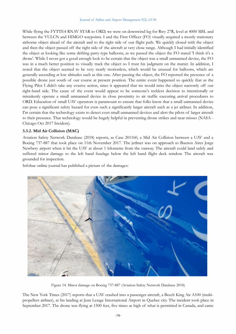
3.3.2. Mid Air Collision (MAC)
Aviation Safety Network Database (2018) reports, as Case 201160, a Mid Air Collision between a UAV and aBoeing 737-887 that took place on 11th November 2017. The jetliner was on approach to Buenos Aires JorgeNewbery airport when it hit the UAV at about 1 kilometre from the runway. The aircraft could land safely andsuffered minor damage to the left hand fuselage below the left hand flight deck window. The aircraft wasgrounded for inspection.
Infobae online journal has published a picture of the damages:
Figure 14. Minor damage on Boeing 737-887 (Aviation Safety Network Database 2018)
The New York Times (2017) reports that a UAV crashed into a passenger aircraft, a Beech King Air A100 (multi-propellers airliner), at his landing at Jean Lesage International Airport in Quebec city. The incident took place inSeptember 2017. The drone was flying at 1500 feet, five times as high of what is permitted in Canada, and came
-79-

Journal of Airline and Airport Management 9(2), 63-96
from the left as the plane approached the runway. This was the first occurrence of a collision between a UAVand a commercial aircraft in Canada. The aircraft landed safely and suffered from minor damages: scratches onthe wing. The UAV could not be located neither his pilot identified.
Remark: numerous UK online media reported a collision between a UAV and a British Airways Airbus A320jetliner during its approach to Heathrow London airport in April 2016. The forensic investigation found noevidence of a UAV collision and mentioned that the suspect object could have been a plastic bag.
3.3.3. Airspace closure
NATS2 (2017) provides a very interesting video about the 2nd July 2017 Gatwick UAV incident.
It shows howthe spotting of a UAV flying on the approach path to Gatwick airport evolves over the followinghours and impacts on air traffic:
• Airport authorities decide to suspend arrivals and direct aircrafts to Timba and Willo hold zones.
• Once the 2 hold zones have been filled up, arriving aircrafts were diverted to other airports due to fuel considerations and acontingency hold was activated.
• Then after checking the drone had disappeared, the runway was reopened for arrivals…
• And shortly after, the drone was spotted again and arrivals were suspended again.
• More aircrafts were diverted to other airports while the Solent ‘en-route’ hold was activated to retain traffic at higheraltitudes to spare fuel.
• Runway was re-opened after further inspection verified that the drone had definitively gone away.
• Disruptions it caused on the air traffic lasted till end of the day, with returning aircrafts delayed at departure airports.
Figure 15. Air traffic Perturbation due to UAV at Gatwick (NATS2, 2017)
3.3.4. Airport indoor sighting
South China Morning Post3 (2017) reports a man has been arrested after flying a UAV in the restricted departurearea at the Honk Kong International Airport.
He flew the UAV inside the hall of the airport and took pictures while awaiting a flight to Tokyo. Hethen postedthe pictures on social media, which triggered a forensic investigation by the airport police who identified him.He was intercepted by the police at the Honk Kong International Airport when he returned from Tokyo. TheUAV was found in his bag. He violated the Airport Authority Bylaw on flight safety and carries a maximumpenalty of six months in jail and a 50 000 HK$ fine.
-80-
Journal of Airline and Airport Management 9(2), 63-96
3.3.5. Jetliner sighting
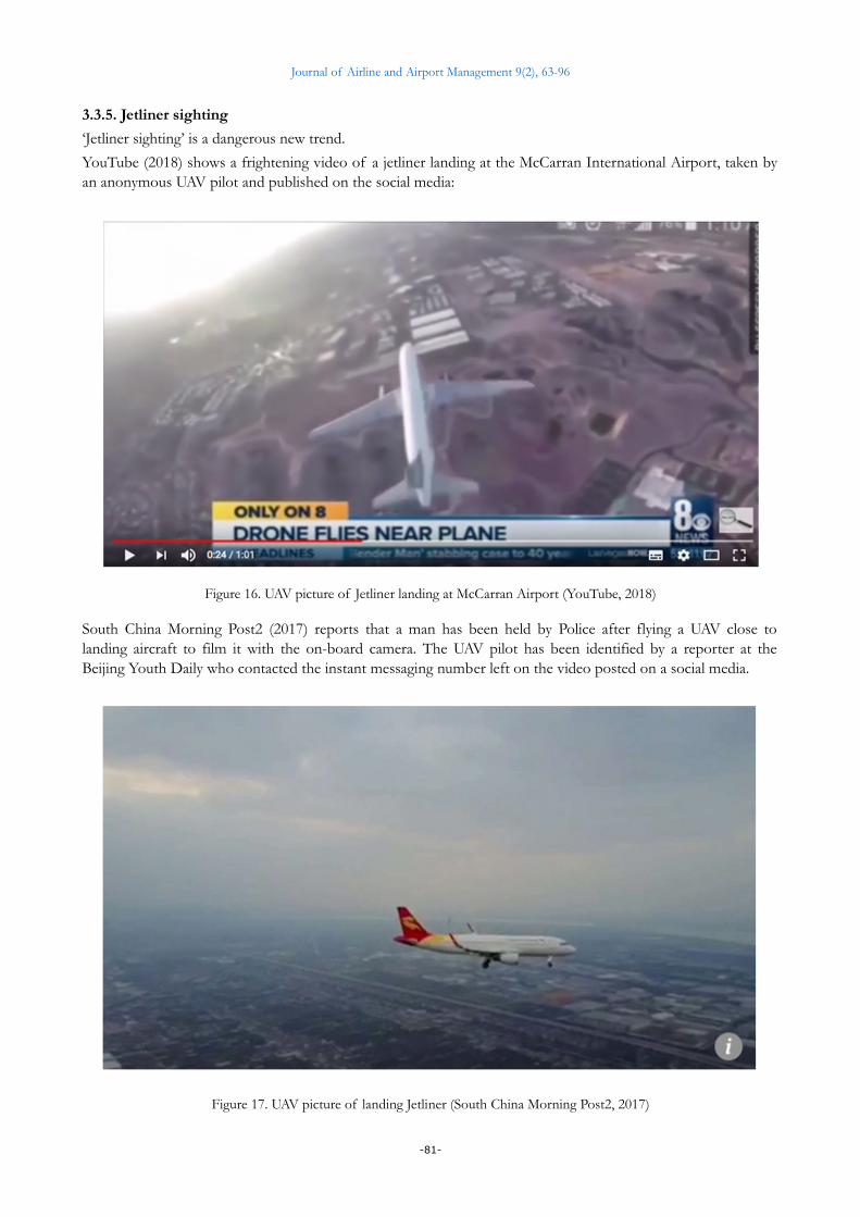
‘Jetliner sighting’ is a dangerous new trend.
YouTube (2018) shows a frightening video of a jetliner landing at the McCarran International Airport, taken byan anonymous UAV pilot and published on the social media:
Figure 16. UAV picture of Jetliner landing at McCarran Airport (YouTube, 2018)
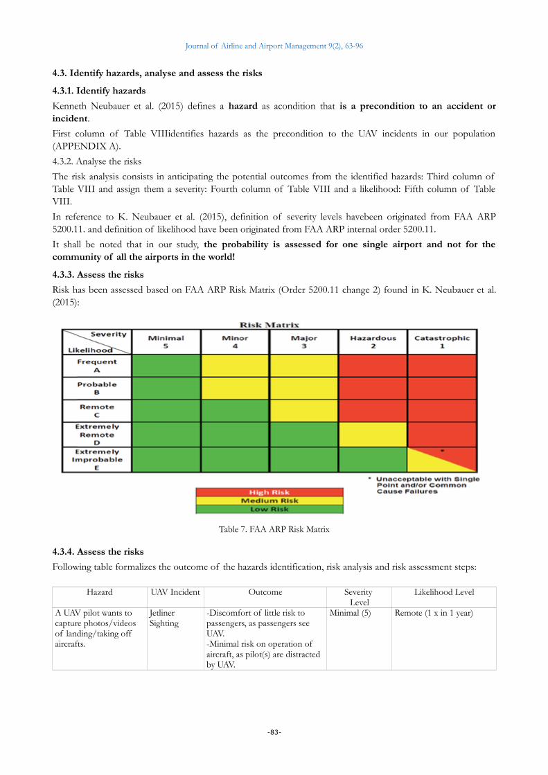
South China Morning Post2 (2017) reports that a man has been held by Police after flying a UAV close tolanding aircraft to film it with the on-board camera. The UAV pilot has been identified by a reporter at theBeijing Youth Daily who contacted the instant messaging number left on the video posted on a social media.
Figure 17. UAV picture of landing Jetliner (South China Morning Post2, 2017)
-81-

Journal of Airline and Airport Management 9(2), 63-96
4. Risk Analysis and Mitigation
4.1. Methodology
We have followed the Safety Risk Management (SRM) 5-Steps process described in Neubauer et al. (2015).
4.2. Describe the system
We have followed the 5M Model to describe the system.
4.2.1. Mission
In the scope of our study, we will consider that the missions of a civilian airport i.e. its objectives are:
1. To insure the safety of passengers, personnel of companies hosted at the airport including airlines andown personnel within the physical perimeter of the airport.
2. To protect assets of passengers, of companies hosted at airport including aircrafts and own assets withinthe physical perimeter of the airport.
3. To insure the safety of passengers and crew on-board aircrafts during their taking-off and landingphases at the airport, within the airspace under its control i.e. equivalent of Terminal Radar ApproachCONtrol (TRACON) in U.S. which usually handles traffic in a 30 to 50 Nautical Miles (56 to 93 KMs)range from the airport.
4. To protect aircrafts assets during their taking-off and landing phases at the airport within the airspaceunder its control.
5. To maximize the passengers’ user experience inside the perimeter of the airport and on-board theaircrafts taking off and landing at the airport.
6. To minimize nuisances to its neighbourhood.
7. To maximize the financial returns for its shareholders.
4.2.2. Man
In the scope of our study, we will consider that the men… and women are:
1. The pilots of the aircrafts taking off and landing at the airport.
2. The air traffic controllers controlling the airspace under the responsibility of the airport.
3. The personnel in charge of the safety and security within the physical perimeter of the airport.
4.2.3. Machine
In the scope of our study, we will consider that the machines are:
1. The aircrafts taking off and landing at the airport and stationary at the airport.
2. Equipment to insure the operation of the airport, fixed (control tower) or mobile (gas truck).
4.2.4. Management
In the scope of our study, we will consider that the management is:
1. Coordination of the physical security and safety at the airport.
2. Coordination of the Air Traffic Control at the airport.
3. Coordination of the actions in the cockpit of aircrafts taking off and landing at the airport.
4. Communication between airport Air Traffic Control and pilots during the taking off and landing at theairport.
4.2.5. Media (environment)
In the scope of our study, we will consider that the media is:
1. Weather and night conditions: fog, strong wind, rain, high and low temperatures, snow, ice…
2. Geo-political climate: terrorist attack threat, political tensions between states, tensions between religiouscommunities…
3. UAV market growth and UAV and Counter-UAV technologies evolution.
-82-
Journal of Airline and Airport Management 9(2), 63-96
4.3. Identify hazards, analyse and assess the risks
4.3.1. Identify hazards
Kenneth Neubauer et al. (2015) defines a hazard as acondition that is a precondition to an accident orincident.
First column of Table VIIIidentifies hazards as the precondition to the UAV incidents in our population(APPENDIX A).
4.3.2. Analyse the risks
The risk analysis consists in anticipating the potential outcomes from the identified hazards: Third column ofTable VIII and assign them a severity: Fourth column of Table VIII and a likelihood: Fifth column of TableVIII.
In reference to K. Neubauer et al. (2015), definition of severity levels havebeen originated from FAA ARP5200.11. and definition of likelihood have been originated from FAA ARP internal order 5200.11.
It shall be noted that in our study, the probability is assessed for one single airport and not for thecommunity of all the airports in the world!
4.3.3. Assess the risks
Risk has been assessed based on FAA ARP Risk Matrix (Order 5200.11 change 2) found in K. Neubauer et al.(2015):
Table 7. FAA ARP Risk Matrix
4.3.4. Assess the risks
Following table formalizes the outcome of the hazards identification, risk analysis and risk assessment steps:
Hazard UAV Incident Outcome Severity Level
Likelihood Level
A UAV pilot wants to capture photos/videos of landing/taking off aircrafts.
Jetliner Sighting
-Discomfort of little risk to passengers, as passengers see UAV.-Minimal risk on operation of aircraft, as pilot(s) are distracted by UAV.
Minimal (5) Remote (1 x in 1 year)
-83-

Journal of Airline and Airport Management 9(2), 63-96
Hazard UAV Incident Outcome Severity Level
Likelihood Level
A UAV pilot wants to capture photos/videos of landing/taking off aircrafts.A UAV pilot flies too high in the vicinity of the airport (>[300 - 500]Feet) and/or too close of the runway ( < [3 - 10] KMs) without authorizations from ATC.
UAV NMAC -Discomfort of little risk to passengers, as passengers see UAV.-Minimal risk on operation of aircraft, as pilot(s) are distracted by UAV.
Minimal (5) Remote (1 x in 1 year)
-Evasive action from aircraft pilot(s) to keep separation with UAV.-Physical distress on passenger due to abrupt evasive manoeuvre.
Major (3) Remote (1 x in 1 year)
UAV MAC -Minimal damage to aircraft. Minor (4) Extremely Remote (1 x in 10 year)
-Major damage to aircraft and/or minor injury to passengers.
Major (3) Extremely Remote (1 x in 10 year)
-Severe damage to aircraft and/or serious injury to passengers.
Hazardous (2) Extremely improbable (1 x in 100 years)
-Complete loss of aircraft and/or fatalities in passengers.
Catastrophic (1) Extremely improbable (1 x in 100 years)
Airspace Closure
-Flights diverted, delayed, cancelled and/or returned.-Passengers stranded at airport or diverted to alternative airports.-Economic losses for airport and airlines.
Hazardous (2) Extremely Remote (1 x in 10 year)
A UAV pilot wants to capture photos/videos inside the hall of the airport
Airport indoor sighting
-Discomfort of little risk to passengers
Minimal (5) Remote (1 x in 1 year)
-Minor injury to passengers Minor (4) Extremely Remote(1 x in 10 year)
Table 8. Hazards as precondition to UAV incidents, risk analysis and assessment
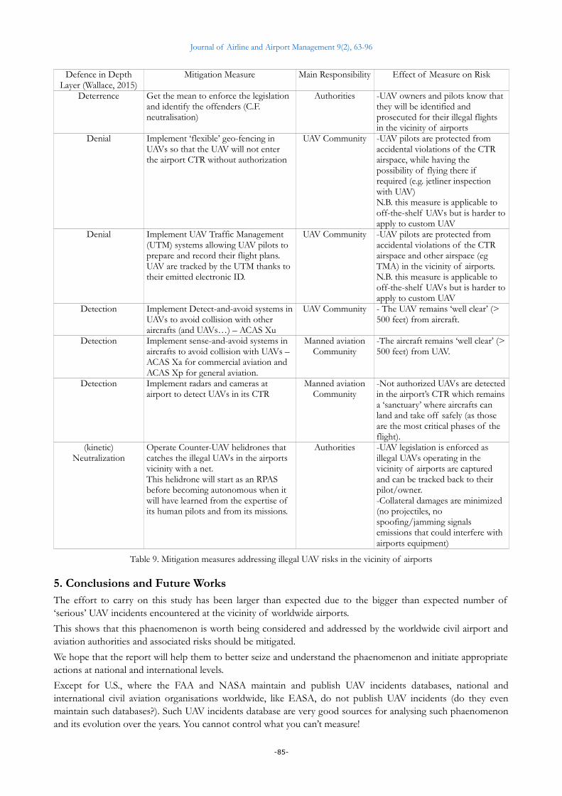
4.4. Mitigate the risks
We have followed the ‘defense-in-depth’ approach described in Wallace (2015) to identify the measures thatmitigates the analysed risks and more specifically the extremely improbable but catastrophic scenario where aUAV pilot flies too high in the vicinity of the airport and/or too close of the runway without authorizationsfrom ATC which results in a Mid Air Collision with an aircraft causing it so severe damages that it gets lost withfatalities among passenger:
Defence in DepthLayer (Wallace, 2015)
Mitigation Measure Main Responsibility Effect of Measure on Risk
Prevention Harmonized UAV legislations ruling the UAV flights in the vicinity of airports and UAV pilot training
Authorities -A legal framework is set to forbid dangerous UAV pilots actions and penalties are defined
Prevention Legislations are ‘evangelized’ through media campaign and UAV selling channels
Authorities -The legislation is known by the owners and pilots of UAVs
Prevention UAV pilots are trained and know the rules to observe in the vicinity of airports
UAV Community -UAV pilots know the rules, procedures and restrictions to flight in the vicinity of airpo
Deterrence Record identity of UAV owner at purchase time
Authorities -UAV owners know that they can be tracked back from the serial number of their UAV
-84-
Journal of Airline and Airport Management 9(2), 63-96
Defence in DepthLayer (Wallace, 2015)
Mitigation Measure Main Responsibility Effect of Measure on Risk
Deterrence Get the mean to enforce the legislation and identify the offenders (C.F. neutralisation)
Authorities -UAV owners and pilots know that they will be identified and prosecuted for their illegal flights in the vicinity of airports
Denial Implement ‘flexible’ geo-fencing in UAVs so that the UAV will not enter the airport CTR without authorization
UAV Community -UAV pilots are protected from accidental violations of the CTR airspace, while having the possibility of flying there if required (e.g. jetliner inspection with UAV)N.B. this measure is applicable to off-the-shelf UAVs but is harder toapply to custom UAV
Denial Implement UAV Traffic Management (UTM) systems allowing UAV pilots to prepare and record their flight plans. UAV are tracked by the UTM thanks to their emitted electronic ID.
UAV Community -UAV pilots are protected from accidental violations of the CTR airspace and other airspace (eg TMA) in the vicinity of airports.N.B. this measure is applicable to off-the-shelf UAVs but is harder toapply to custom UAV
Detection Implement Detect-and-avoid systems inUAVs to avoid collision with other aircrafts (and UAVs…) – ACAS Xu
UAV Community - The UAV remains ‘well clear’ (> 500 feet) from aircraft.
Detection Implement sense-and-avoid systems in aircrafts to avoid collision with UAVs – ACAS Xa for commercial aviation and ACAS Xp for general aviation.
Manned aviationCommunity
-The aircraft remains ‘well clear’ (>500 feet) from UAV.
Detection Implement radars and cameras at airport to detect UAVs in its CTR
Manned aviationCommunity
-Not authorized UAVs are detectedin the airport’s CTR which remainsa ‘sanctuary’ where aircrafts can land and take off safely (as those are the most critical phases of the flight).
(kinetic)Neutralization
Operate Counter-UAV helidrones that catches the illegal UAVs in the airports vicinity with a net. This helidrone will start as an RPAS before becoming autonomous when it will have learned from the expertise of its human pilots and from its missions.
Authorities -UAV legislation is enforced as illegal UAVs operating in the vicinity of airports are captured and can be tracked back to their pilot/owner.-Collateral damages are minimized (no projectiles, no spoofing/jamming signals emissions that could interfere with airports equipment)
Table 9. Mitigation measures addressing illegal UAV risks in the vicinity of airports
5. Conclusions and Future WorksThe effort to carry on this study has been larger than expected due to the bigger than expected number of‘serious’ UAV incidents encountered at the vicinity of worldwide airports.
This shows that this phaenomenon is worth being considered and addressed by the worldwide civil airport andaviation authorities and associated risks should be mitigated.
We hope that the report will help them to better seize and understand the phaenomenon and initiate appropriateactions at national and international levels.
Except for U.S., where the FAA and NASA maintain and publish UAV incidents databases, national andinternational civil aviation organisations worldwide, like EASA, do not publish UAV incidents (do they evenmaintain such databases?). Such UAV incidents database are very good sources for analysing such phaenomenonand its evolution over the years. You cannot control what you can’t measure!
-85-

Journal of Airline and Airport Management 9(2), 63-96
The findings of the study, compared to what was anticipated when initiated, is that those UAVincidents are more numerous and happen higher and further from the airports than expected: Theyhappen not only in CTRs but also in TMAs. This has of course an impact on the mitigation measures:they shall not only be deployed at airports side but also be on-boarded in manned aircrafts!
The study could not determine an important point: Who are those illegal UAV pilots and what are theirmotivations? This because the illegal UAVs cannot be intercepted so far and tracked back to theirpilot/owner.
Future works will be pursued:
• Risk analysis and assessment of UAV hazards that have not yet (fortunately!) materialized: terroristattack lead or facilitated with UAVs against airports and stationary, landing and taking-off aircrafts,cyber-attacks facilitated by UAVs as part of ‘hybrid wars’ in highly instable geo-political contexts…
• Maintain the UAV incidents database and expand it as such incidents become published by morenational and international civil aviation authorities worldwide.
• Share the study with the national and international UAVs, airports and civil aviation authorities andcommunities to inform them and collect their feedback to make the study evolve.
• Share the study with the Counter-UAV industry so that they can develop products and services thataddress this risk appropriately, effectively and efficiently and that respond to worldwide airport and civilaviation authorities needs and requirements.
• Leverage the study in the scope of own PhD whose subject is the certification (DO178C/DO278) of‘intelligent’ algorithms embedded in UAVs and integrated in air traffic control ground systems. Thosealgorithms are aimed to be implemented in the detection and neutralisation systems mentioned in thepresent article:
◦ Detect-and-avoid systems embedded in UAVs to avoid collision with manned aircrafts and otherUAVs.
◦ Detect-and-avoid systems embedded in aircrafts to avoid collision with UAVs.
◦ Detection systems deployed at airports to detect UAVs in their CTR.
◦ Autonomous Counter-UAV helidrones that can intercept illegal UAVs and catch them with a net.
Declaration of Conflicting InterestsThe author declared no potential conflicts of interest with respect to the research, authorship, and/or publication of this article.
Funding The author received no financial support for the research, authorship, and/or publication of this article.
References Airports Council International (ACI) Europe (2018). ACI EUROPE POSITION on Drone Technology.
Arabian Business (2017). Shutting down Dubai International Airport due to a drone costs $100,000 a minute. Retrieved from: http://www.arabianbusiness.com/content/375851-drone-costs-100000-minute-loss-to-uae-airports (Accessed 1st May 2018).
Aviation Safety Network Database (2018). Case 201160: AerolineasArgentinas flight AR1865 suffered a collision with a drone. Retrieved from: https://aviation-safety.net/wikibase/wiki.php?id=201160 (Accessed 1st May 2018).
BBC News (2015). Lufthansa plane in near miss with drone on Warsaw approach. https://www.bbc.com/news/world-europe-33605869 (Accessed 1st May 2018).
BBC News (2017). Plane in UK’s first double-drone near-miss case. http://www.bbc.com/news/uk-39747042 (Accessed 1st May 2018).
BBC News (2018). Air New Zealand calls for drone legislation after near miss. https://www.bbc.com/news/amp/world-asia-43551373 (Accessed 1st May 2018).
-86-

Journal of Airline and Airport Management 9(2), 63-96
BBC News2 (2017). ‘Matter of luck’ that Easyjet plane missed drone. https://www.bbc.com/news/uk-scotland-edinburgh-east-fife-39748047 (Accessed 1st May 2018).
BBC News3 (2017). Drone in near miss with plane near Edinburgh Airport. https://www.bbc.com/news/uk-scotland-edinburgh-east-fife-40019778 (Accessed 1st May 2018).
Belga (2017). Des drones perturbent l’espace aérien au tour de l’aéroport de Liège. http://www.dhnet.be/regions/liege/des-drones-perturbent-l-espace-aerien-autour-de-l-aeroport-de-liege-59f1f4d7cd705114eff4a7f0 (Accessed 1st May 2018).
Buric, M., & De Cubber, G. (2017). Counter Remotely Piloted Aircraft Systems. MTA Review, Vol. XXVII(1), Jun. 2017.
CNET Magazine (2018). Drone hovers right above jet landing at Las Vegas airport. https://www.cnet.com/news/drone-hovers-over-jet-landing-at-las-vegas-airport/ (Accessed 1st May 2018).
CTV News (2014). Drone flight near Vancouver airport attracts Transport Canada, RCMP attention. https://www.ctvnews.ca/canada/drone-flight-near-vancouver-airport-attracts-transport-canada-rcmp-attention-1.1788494(Accessed 1st May 2018).
Daily Mail (2018). Heathrow jet narrowly avoids disaster after unmanned drone passes within FIVE FEET of the pilot’s window. http://www.dailymail.co.uk/news/article-5319195/Drone-passes-5-feet-passenger-jet-Heathrow.html (Accessed 1st May 2018).
Daily Mail2 (2018). Heathrow jet carrying up to 160 passengers narrowly avoids disaster after unmanned drone passes within 20feet of the pilot’s window. http://www.dailymail.co.uk/news/article-5620369/Heathrow-jet-carrying-160-passengers-avoids-disaster-near-miss-drone.html (Accessed 1st May 2018).
European Union Agency for Network and Information Security (Enisa) (2016). Securing Smart Airports.
FAA (2018). Federal Aviation Administration UAS Sightings Report. https://www.faa.gov/uas/resources/uas_sightings_report/ (Accessed 1st May 2018).
Gettinger, D., & Michel, A. (2015). Drone Sightings and Close Encounters: An Analysis. Center for the Study of the Drone at Bard College.
Gulf News (2016). Drone intrusion briefly shuts Dubai airport operation. https://gulfnews.com/news/uae/emergencies/drone-intrusion-briefly-shuts-dubai-airport-operations-1.1903507 (Accessed 1st May 2018).
Gulf News2 (2016). Dubai, Sharjah airports briefly closed due to drone intrusion. https://gulfnews.com/news/uae/transport/dubai-sharjah-airports-briefly-closed-due-to-drone-intrusion-1.1920838 (Accessed 1st May 2018).
Infobae (2017). https://www.infobae.com/sociedad/2017/11/11/insolito-un-avion-de-aerolineas-que-estaba-por-aterrizar-en-aeroparque-choco-con-un-drone-y-quedo-fuera-de-servicio/ (Accessed 1st May 2018)
Independent (2014). Quadcopter drone flew ‘deliberately close’ to UK passenger plane. https://www.independent.co.uk/life-style/gadgets-and-tech/news/quadcopter-drone-deliberately-flown-at-uk-passenger-plane-came-too-close-9820880.html (Accessed 1st May 2018).
Le Monde (2016). Un avion de ligneévite de justesse un droneprès de l’aéroport de Roissy. https://www.lemonde.fr/pixels/article/2016/03/03/un-avion-de-ligne-evite-de-peu-un-drone-pres-de-l-aeroport-de-roissy_4876294_4408996.html (Accessed 1st May 2018).
Michel, A. (2018). Counter-Drone Systems. Centre for the study of the drone at Bard College.
NASA (2018). Aviation Safety Reporting System Database Online. https://asrs.arc.nasa.gov/search/database.html (Accessed 1st May 2018).
NATS (2017). Drone disruption at Gatwick. https://nats.aero/blog/2017/07/drone-disruption-gatwick/ (Accessed 1st May 2018).
NATS2 (2017). NATS Gatwick drone incident, YouTube. https://www.youtube.com/watch?v=V0rfFFZ332k (Accessed 1st May 2018).
-87-
Journal of Airline and Airport Management 9(2), 63-96
Neubauer, K., Fleet, D., & Ayres, M. (2015). A Guidebook for Safety Risk Management for Airports, Airport Cooperative Research Program (ACRP) Report 131 (sponsored by the Federal Aviation Administration). https://doi.org/10.17226/22138
Newshub (2018). CAA ‘hopping mad’ over latest drone incident. Retrieved from: https://www.newshub.co.nz/home/travel/2018/04/caa-hopping-mad-over-latest-drone-incident.html (Accessed 1st May 2018).
Price, J., & Forrest, J. (2016). Practical Aviation Security: predicting and preventing future threats (third edition).Chapter 9 - General aviation and unmanned aerial vehicle security (pp.393-435). Elsevier. https://doi.org/10.1016/B978-0-12-804293-9.00009-6
Reuters (2016). Lufthansa reports near miss with drone over Los Angeles. Retrieved from: https://www.reuters.com/article/us-california-drone-lufthansa-idUSKCN0WL01B (Accessed 1st May 2018).
SKYbrary (2018). Initiated by EUROCONTROL in partnership with ICAO and other organisations. Retrieved from: https://www.skybrary.aero/index.php/Main_Page (Accessed 1st May 2018). https://www.skybrary.aero/index.php/AIRPROX (Accessed 1st May 2018).
South China Morning Post (2017). Drone flights disrupt southwest Chinese airport for third time in recent days. Retrieved from: http://www.scmp.com/news/china/society/article/2089974/drone-flights-disrupt-southwest-chinese-airport-third-time-recent (Accessed 1st May 2018).
South China Morning Post2 (2017). Public security officials say aviation enthusiast’s filming near Hangzhou airport endangered public safety. Retrieved from: http://www.scmp.com/news/china/society/article/2062739/chinese-man-held-after-flying-drone-close-landing-aircraft (Accessed 1st May 2018).
South China Morning Post3 (2017). Man accused of flying drone to take photos in Honk Kong International Airport arrested. Retrieved from: http://www.scmp.com/news/hong-kong/law-crime/article/2103002/man-accused-flying-drone-take-photos-hong-kong (Accessed 1st May 2018).
The Aviation Herald (2015). Incident: Finnair E190 at Hamburg on Sep 19th 2015, near collision with drone on final approach. Retrieved from: http://avherald.com/h?article=48ca8755 (Accessed 1st May 2018).
The Guardian (2014). Investigators confirm Heathrow plane in near miss with drone. Retrieved from: https://www.theguardian.com/world/2014/dec/12/heathrow-plane-near-miss-drone (Accessed 1st May 2018).
The Guardian (2016). Pilots call for research into impact of drone hitting a passenger jet. Retrieved from: https://www.theguardian.com/business/2016/mar/02/pilots-research-impact-drone-hitting-passenger-jet?CMP=twt_gu (Accessed 1st May 2018).
The Guardian (2017). Drone flew ‘within wingspan’ of plane approaching Heathrow. Retrieved from: https://www.theguardian.com/technology/2017/mar/31/drone-wingspan-plane-approaching-heathrow-near-misses (Accessed 1st May 2018).
The New York Times (2017). After Drone Hits Plane in Canada, New Fears About Air Safety. Retrieved from: https://www.nytimes.com/2017/10/17/world/canada/canada-drone-plane.html (Accessed 1st May 2018).
The Straits Times Asia (2017). Drones disrupt over 240 flights in Chongqing. Retrieved from: https://www.straitstimes.com/asia/east-asia/drones-disrupt-over-240-flights-in-chongqing (Accessed 1st May 2018).
The Telegraph (2017). Drone ‘put 130 lives at risk’ after near-miss with plane approaching Gatwick. Retrieved from: https://www.telegraph.co.uk/news/2017/10/15/drone-put-130-lives-risk-near-miss-plane-approaching-gatwick/ (Accessed 1st May 2018).
TOTALMunich (2016). Over 30 drones incident at German airports. Retrieved from: http://www.total-munich.com/201608081077/blog/news/over-30-drone-incidents-at-german-airports.html (Accessed 1st May 2018).
Wallace, R. (2015). Examining Unmanned Aerial System Threats & Defenses: A Conceptual Analysis. International Journal of Aviation, Aeronautics and Aerospace, 2(4). https://doi.org/10.15394/ijaaa.2015.1084
Wikipedia (2018). UAV-related events. Retrieved from: https://en.wikipedia.org/wiki/UAV-related_events (Accessed 1st May 2018).
-88-

Journal of Airline and Airport Management 9(2), 63-96
YouTube (2018). Drone in near miss with passenger jet just feet from plane landing at Las Vegas McCarran Airport. Retrieved from: https://www.youtube.com/watch?v=D6B0Lhyityk (Accessed 1st May 2018).
Appendix A: Population of UAV incidents around civilian airports
Dat
e
Air
port
Inci
dent
Typ
e
Sour
ce
Airc
raft
Typ
e
# o
f U
AV
s
Pha
se
Alt.
(fee
t)
Dis
t. U
AV
-Airc
raft
(fee
t)
Dis
t. fr
om a
irpo
rt (K
Ms)
UA
V C
aptu
red
UA
V P
ilot I
dent
ified
Eff
ects
May 2014 WinchesterRegional
Airport (US)
Near Mid AirCollision
NASA (2018) Helico 1 TakeON
800 200 2 N N Evasive action from helicopter
May 2014 LondonSouthend
InternationalAirport (GB)
Near Mid AirCollision
Independent(2014)
ATR 72 1 TakeON
? 75 ? N N -
May 2014 VancouverInternationalAirport (CA)
Near Mid AirCollision
CTV News(2014)
Boeing 777 1 TakeON
? 90 ? N N -
Jun 2014 Teterboro Gen.Avi. Airport
(US)
Near Mid AirCollision
NASA (2018) Small transp. 1 TakeON
800 50 4 N N -
Jul 2014 HeathrowInternationalAirport (GB)
Near Mid AirCollision
The Guardian(2014)
Airbus A320 1 TakeON
? 20 ? N N -
Aug 2014 LeesburgExecutive
Airport (US)
Near Mid AirCollision
NASA (2018) Cessna 172R 1 TakeOFF
1200 20 ? N N -
Sep 2014 ? (US) Near Mid AirCollision
NASA (2018) PA-28Chrerokee
1 TakeON
3000 50 ? N N -
May 2015 DetroitMetropolitan Airport (US)
Near Mid AirCollision
FAA (2018) Cessna C172 1 TakeON
3000 ? ? N N Evasive action from airplane
Jun 2015 Long Beach Airport (US)
Near Mid AirCollision
FAA (2018) Pilatus PC12 1 TakeON
5000 ? 10 N N Evasive action from airplane
Jun 2015 Groton NewLondon
Airport (US)
Near Mid AirCollision
FAA (2018) Piper P28A 1 TakeON
5200 ? 14.5 N N Evasive action from airplane
Jun 2015 Cherry Capital Airport (US)
Near Mid AirCollision
FAA (2018) BombardierCL30
1 TakeON
2100 300 7.5 N N -
Jul 2015 Cherry Capital Airport (US)
Near Mid AirCollision
FAA (2018) Cessna C172 1 TakeON
3500 100 18.5 N N -
Jul 2015 ShannonAirport (US)
Near Mid AirCollision
NASA (2018) Skylane 182 1 TakeON
1100 75 3 N N -
Jul 2015 San DiegoInternationalAirport (US)
Near Mid AirCollision
NASA (2018) Transport 1 TakeON
4000 100 ? N N -
Jul 2015 La GuardiaNew York
InternationalAirport (US)
Near Mid AirCollision
NASA (2018) B737-800 1 TakeON
2500 200 2.5 N N -
Jul 2015 Warsaw ChopinInternationalAirport (PL)
Near Mid AirCollision
BBC News(2015)
EmbraerERJ-195
1 TakeOFF
2500 300 5 N N -
Aug 2015 Yeager Airport(US)
Near Mid AirCollision
FAA (2018) Helico 2 TakeON
1700 100 8 N N -
Aug 2015 BostonInternational Airport (US)
Near Mid AirCollision
FAA (2018) BeechcraftBE9L
1 TakeON
2500 400 16 N N -
-89-
Journal of Airline and Airport Management 9(2), 63-96
Dat
e
Air
port
Inci
dent
Typ
e
Sour
ce
Airc
raft
Typ
e
# o
f U
AV
s
Pha
se
Alt.
(fee
t)
Dis
t. U
AV
-Airc
raft
(fee
t)
Dis
t. fr
om a
irpo
rt (K
Ms)
UA
V C
aptu
red
UA
V P
ilot I
dent
ified
Eff
ects
Aug 2015 Dane CountyRegional
Airport (US)
Near Mid AirCollision
FAA (2018) Cessna C172 1 TakeON
400 ? 1.8 N N Evasive action from airplane
Aug 2015 BogotaInternationalAirport (CO)
Near Mid AirCollision
NASA (2018) Transport 1 TakeOFF
700 400 ? N N -
Sep 2015
HamburgInternationalAirport (DE)
Near Mid AirCollision
The AviationHerald (2015)
EmbraerERJ-190
1 TakeON
800 100 4.5 N N -
Sep 2015
LondonStansted
InternationalAirport (GB)
Near Mid AirCollision
The Guardian(2016)
Boeing 737 1 TakeOFF
4000 15 ? N N -
Sep 2015
HeathrowInternationalAirport (GB)
Near Mid AirCollision
The Guardian(2016)
Boeing 777 1 TakeOFF
? 75 ? N N -
Sep 2015
HeathrowInternationalAirport (GB)
Near Mid AirCollision
The Guardian(2016)
Airbus A319 1 TakeON
450 75 ? N N -
Oct 2015 ManchesterInternationalAirport (GB)
Near Mid AirCollision
The Guardian(2016)
DornierDo328
1 TakeOFF
2700 45 ? N N -
Nov2015 JFK NYInternationalAirport (US)
Near Mid AirCollision
NASA (2018) CRJ-900 1 TakeOFF
1500 50 ? N N -
Jan 2016 OaklandInternationalAirport (US)
Near Mid AirCollision
FAA (2018) EmbraerE175
1 TakeON
5700 ? ? N N -
Feb 2016 R. ReaganWashingtonInternationalAirport (US)
Near Mid AirCollision
NASA (2018) CRJ-700 1 TakeOFF
2500 150 ? N N -
Feb 2016 LaconiaMunicipal
Airport (US)
Near Mid AirCollision
FAA (2018) Piper P28A 1 TakeON
7500 ? ? N N -
Feb 2016 TampaInternationalAirport (US)
Near Mid AirCollision
FAA (2018) BeechcraftBE36
2 TakeON
3000 200 20 N N -
Feb 2016 Roissy Charlesde Gaulle (FR)
Near Mid AirCollision
Le Monde(2016)
Airbus A320 1 TakeON
4800 15 ? N N Evasive action from airplane
Mar 2016 Los AngelesInternationalAirport (US)
Near Mid AirCollision
Reuters (2016) Airbus A380 1 TakeOFF
5000 180 22.5 N N -
Apr 2016 G. BushHouston
InternationalAirport (US)
Near Mid AirCollision
NASA (2018) MD-80 1 TakeOFF
8500 ? ? N N -
May 2016 TimmermanMilwaukee
Airport (US)
Near Mid AirCollision
FAA (2018) Cessna 172 1 TakeON
1500 15 0 N N -
May 2016 La GuardiaNew York
InternationalAirport (US)
Near Mid AirCollision
FAA (2018) Boeing B737 1 TakeON
3000 1000 11 N N -
May 2016 JFK New YorkInternationalAirport (US)
Near Mid AirCollision
FAA (2018) Cirrus SR22 1 TakeON
7000 150 22 N N -
May 2016DuPage Airport(US)
Near Mid AirCollision
FAA (2018) Cessna C150 1 TakeOFF
2500 40 27.5 N N -
-90-
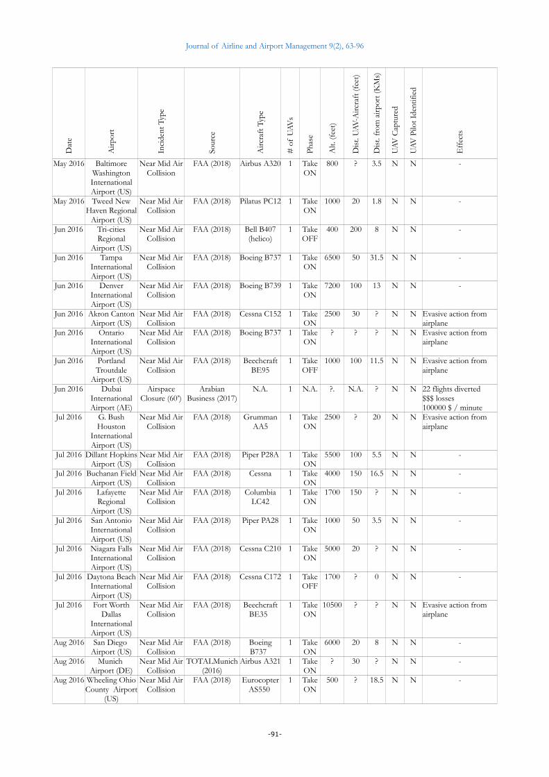
Journal of Airline and Airport Management 9(2), 63-96
Dat
e
Air
port
Inci
dent
Typ
e
Sour
ce
Airc
raft
Typ
e
# o
f U
AV
s
Pha
se
Alt.
(fee
t)
Dis
t. U
AV
-Airc
raft
(fee
t)
Dis
t. fr
om a
irpo
rt (K
Ms)
UA
V C
aptu
red
UA
V P
ilot I
dent
ified
Eff
ects
May 2016 BaltimoreWashingtonInternationalAirport (US)
Near Mid AirCollision
FAA (2018) Airbus A320 1 TakeON
800 ? 3.5 N N -
May 2016 Tweed NewHaven Regional
Airport (US)
Near Mid AirCollision
FAA (2018) Pilatus PC12 1 TakeON
1000 20 1.8 N N -
Jun 2016 Tri-citiesRegional
Airport (US)
Near Mid AirCollision
FAA (2018) Bell B407(helico)
1 TakeOFF
400 200 8 N N -
Jun 2016 TampaInternationalAirport (US)
Near Mid AirCollision
FAA (2018) Boeing B737 1 TakeON
6500 50 31.5 N N -
Jun 2016 DenverInternationalAirport (US)
Near Mid AirCollision
FAA (2018) Boeing B739 1 TakeON
7200 100 13 N N -
Jun 2016 Akron CantonAirport (US)
Near Mid AirCollision
FAA (2018) Cessna C152 1 TakeON
2500 30 ? N N Evasive action from airplane
Jun 2016 OntarioInternationalAirport (US)
Near Mid AirCollision
FAA (2018) Boeing B737 1 TakeON
? ? ? N N Evasive action from airplane
Jun 2016 PortlandTroutdale
Airport (US)
Near Mid AirCollision
FAA (2018) BeechcraftBE95
1 TakeOFF
1000 100 11.5 N N Evasive action from airplane
Jun 2016 DubaiInternationalAirport (AE)
AirspaceClosure (60’)
ArabianBusiness (2017)
N.A. 1 N.A. ?. N.A. ? N N 22 flights diverted$$$ losses 100000 $ / minute
Jul 2016 G. BushHouston
InternationalAirport (US)
Near Mid AirCollision
FAA (2018) GrummanAA5
1 TakeON
2500 ? 20 N N Evasive action from airplane
Jul 2016 Dillant HopkinsAirport (US)
Near Mid AirCollision
FAA (2018) Piper P28A 1 TakeON
5500 100 5.5 N N -
Jul 2016 Buchanan FieldAirport (US)
Near Mid AirCollision
FAA (2018) Cessna 1 TakeON
4000 150 16.5 N N -
Jul 2016 LafayetteRegional
Airport (US)
Near Mid AirCollision
FAA (2018) ColumbiaLC42
1 TakeON
1700 150 ? N N -
Jul 2016 San AntonioInternationalAirport (US)
Near Mid AirCollision
FAA (2018) Piper PA28 1 TakeON
1000 50 3.5 N N -
Jul 2016 Niagara FallsInternationalAirport (US)
Near Mid AirCollision
FAA (2018) Cessna C210 1 TakeON
5000 20 ? N N -
Jul 2016 Daytona BeachInternationalAirport (US)
Near Mid AirCollision
FAA (2018) Cessna C172 1 TakeOFF
1700 ? 0 N N -
Jul 2016 Fort WorthDallas
InternationalAirport (US)
Near Mid AirCollision
FAA (2018) BeechcraftBE35
1 TakeON
10500 ? ? N N Evasive action from airplane
Aug 2016 San Diego Airport (US)
Near Mid AirCollision
FAA (2018) BoeingB737
1 TakeON
6000 20 8 N N -
Aug 2016 Munich Airport (DE)
Near Mid AirCollision
TOTALMunich(2016)
Airbus A321 1 TakeON
? 30 ? N N -
Aug 2016 Wheeling OhioCounty Airport
(US)
Near Mid AirCollision
FAA (2018) EurocopterAS550
1 TakeON
500 ? 18.5 N N -
-91-
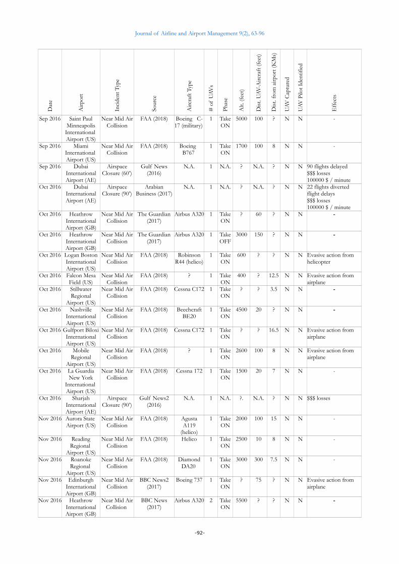
Journal of Airline and Airport Management 9(2), 63-96
Dat
e
Air
port
Inci
dent
Typ
e
Sour
ce
Airc
raft
Typ
e
# o
f U
AV
s
Pha
se
Alt.
(fee
t)
Dis
t. U
AV
-Airc
raft
(fee
t)
Dis
t. fr
om a
irpo
rt (K
Ms)
UA
V C
aptu
red
UA
V P
ilot I
dent
ified
Eff
ects
Sep 2016 Saint PaulMinneapolis
International Airport (US)
Near Mid AirCollision
FAA (2018) Boeing C-17 (military)
1 TakeON
5000 100 ? N N -
Sep 2016 MiamiInternational Airport (US)
Near Mid AirCollision
FAA (2018) Boeing B767
1 TakeON
1700 100 8 N N -
Sep 2016 DubaiInternationalAirport (AE)
AirspaceClosure (60’)
Gulf News(2016)
N.A. 1 N.A. ? N.A. ? N N 90 flights delayed $$$ losses 100000 $ / minute
Oct 2016 DubaiInternationalAirport (AE)
AirspaceClosure (90’)
ArabianBusiness (2017)
N.A. 1 N.A. ? N.A. ? N N 22 flights diverted flight delays$$$ losses 100000 $ / minute
Oct 2016 HeathrowInternationalAirport (GB)
Near Mid AirCollision
The Guardian(2017)
Airbus A320 1 TakeON
? 60 ? N N -
Oct 2016 HeathrowInternationalAirport (GB)
Near Mid AirCollision
The Guardian(2017)
Airbus A320 1 TakeOFF
3000 150 ? N N -
Oct 2016 Logan BostonInternationalAirport (US)
Near Mid AirCollision
FAA (2018) RobinsonR44 (helico)
1 TakeON
600 ? ? N N Evasive action from helicopter
Oct 2016 Falcon MesaField (US)
Near Mid AirCollision
FAA (2018) ? 1 TakeON
400 ? 12.5 N N Evasive action from airplane
Oct 2016 StillwaterRegional
Airport (US)
Near Mid AirCollision
FAA (2018) Cessna C172 1 TakeON
? ? 3.5 N N -
Oct 2016 NashvilleInternationalAirport (US)
Near Mid AirCollision
FAA (2018) BeechcraftBE20
1 TakeON
4500 20 ? N N -
Oct 2016 Gulfport BiloxiInternationalAirport (US)
Near Mid AirCollision
FAA (2018) Cessna C172 1 TakeON
? ? 16.5 N N Evasive action from airplane
Oct 2016 MobileRegional
Airport (US)
Near Mid AirCollision
FAA (2018) ? 1 TakeON
2600 100 8 N N Evasive action from airplane
Oct 2016 La GuardiaNew York
International Airport (US)
Near Mid AirCollision
FAA (2018) Cessna 172 1 TakeON
1500 20 7 N N -
Oct 2016 SharjahInternationalAirport (AE)
AirspaceClosure (90’)
Gulf News2(2016)
N.A. 1 N.A. ?. N.A. ? N N $$$ losses
Nov 2016 Aurora State Airport (US)
Near Mid AirCollision
FAA (2018) AgustaA119
(helico)
1 TakeON
2000 100 15 N N -
Nov 2016 ReadingRegional
Airport (US)
Near Mid AirCollision
FAA (2018) Helico 1 TakeON
2500 10 8 N N -
Nov 2016 RoanokeRegional
Airport (US)
Near Mid AirCollision
FAA (2018) DiamondDA20
1 TakeON
3000 300 7.5 N N -
Nov 2016 EdinburghInternationalAirport (GB)
Near Mid AirCollision
BBC News2(2017)
Boeing 737 1 TakeON
? 75 ? N N Evasive action from airplane
Nov 2016 HeathrowInternationalAirport (GB)
Near Mid AirCollision
BBC News(2017)
Airbus A320 2 TakeON
5500 ? ? N N -
-92-

Journal of Airline and Airport Management 9(2), 63-96
Dat
e
Air
port
Inci
dent
Typ
e
Sour
ce
Airc
raft
Typ
e
# o
f U
AV
s
Pha
se
Alt.
(fee
t)
Dis
t. U
AV
-Airc
raft
(fee
t)
Dis
t. fr
om a
irpo
rt (K
Ms)
UA
V C
aptu
red
UA
V P
ilot I
dent
ified
Eff
ects
Nov 2016 HeathrowInternationalAirport (GB)
Near Mid AirCollision
The Guardian(2017)
Boeing 777 1 TakeON
? ? ? N N -
Dec 2016 Boca Raton Airport (US)
Near Mid AirCollision
FAA (2018) Airbus A320 1 TakeON
10000 ? 28 N N -
Dec 2016 Liberty NewarkInternationalAirport (US)
Near Mid AirCollision
FAA (2018) Bell B06(helico)
1 TakeON
1100 50 7.5 N N -
Dec 2016 PhiladelphiaInternationalAirport (US)
Near Mid AirCollision
FAA (2018) BeechcraftBE30
1 TakeON
4000 30 ? N N -
Jan 2017 HangzhouXiaoshan
InternationalAirport (CN)
Jetlinersighting
South ChinaMorning Post2
(2017)
Boeing 737 1 TakeON
1350 ? 8.5 Y Y -
Jan 2017 Mesa PhoenixInternationalAirport (US)
Near Mid AirCollision
FAA (2018) Piper P28 1 TakeON
2800 100 ? N N -
Feb 2017 HonoluluInternationalAirport (US)
Near Mid AirCollision
FAA (2018) RobinsonR44 (helico)
1 TakeOFF
1500 50 ? N N -
Feb 2017 AtlantaInternationalAirport (US)
Near Mid AirCollision
FAA (2018) Cessna 172 1 TakeON
4500 ? ? N N Evasive action from airplane
Feb 2017 MiamiInternationalAirport (US)
Near Mid AirCollision
FAA (2018) EurocopterH-65
(helico)
1 TakeON
300 50 8 N N
Mar 2017 Deer ValleyPhoenix
Airport (US)
Near Mid AirCollision
FAA (2018) Piper P28A 1 TakeON
? ? 5.5 N N Evasive action from airplane
Mar 2017 Los AngelesInternationalAirport (US)
Near Mid AirCollision
FAA (2018) Boeing 763 1 TakeON
300 300 0 N N -
Mar 2017 Atlanta Airport(US)
Near Mid AirCollision
FAA (2018) Piper PA44 1 TakeON
4000 100 ? N N -
Apr 2017 PrincetonAirport (US)
Near Mid AirCollision
FAA (2018) Van’s RV8 1 TakeON
3000 ? 7.5 N N -
Apr 2017 ChengduShuangliu
InternationalAirport (CN)
AirspaceClosure
South ChinaMorning Post
(2017)
N.A. 4 N.A. ? N.A. ? N N 58 flights diverted to other airports4 flights returned10000 passengers stranded at airport
May 2017 ChongqingInternationalAirport (CN)
AirspaceClosure
The StraitsTimes Asia
(2017)
N.A. >1 N.A. ? N.A. ? N N 40 flights diverted to other airports60 flights cancelled140 flights delayed10000 passengers stranded at airport
May 2017 ArlingtonMunicipal
Airport (US)
Near Mid AirCollision
FAA (2018) GrummanAA5
1 TakeON
? 200 ? N N -
May 2017 MesquiteMetropolitanAirport (US)
Near Mid AirCollision
FAA (2018) Piper PA32 1 TakeON
7500 100 7.5 N N -
May 2017 EdinburghInternationalAirport (GB)
Near Mid AirCollision
BBC News3(2017)
Saab 340 1 TakeON
4000 15 18 N N -
-93-

Journal of Airline and Airport Management 9(2), 63-96
Dat
e
Air
port
Inci
dent
Typ
e
Sour
ce
Airc
raft
Typ
e
# o
f U
AV
s
Pha
se
Alt.
(fee
t)
Dis
t. U
AV
-Airc
raft
(fee
t)
Dis
t. fr
om a
irpo
rt (K
Ms)
UA
V C
aptu
red
UA
V P
ilot I
dent
ified
Eff
ects
Jun 2017 La GuardiaNew York
InternationalAirport (US)
Near Mid AirCollision
FAA (2018) EmbraerE190
1 TakeON
1500 ? 8 N N -
Jun 2017 WindhamAirport (US)
Near Mid AirCollision
FAA (2018) Cessna C172 1 TakeON
3800 200 15 N N -
Jun 2017 Saint PaulMinneapolisInternationalAirport (US)
Near Mid AirCollision
FAA (2018) ? 1 TakeON
3000 20 8 N N -
Jul 2017 GatwickInternationalAirport (GB)
AirspaceClosure
NATS (2017) N.A. 1 N.A. N.A. N.A. N.A. N N Flights diverted Flights on hold zonesFlights returnedPassengers delayed and/or stranded
Jul 2017 Honk KongInternationalAirport (HK)
Airportindoorsighting
South ChinaMorning Post3
(2017)
N.A. N.A. N.A. N.A. N.A. N.A. ? Y -
Jul 2017 GatwickInternationalAirport (GB)
Near Mid AirCollision
TeleGraph(2017)
Airbus A319 1 TakeON
? ? ? N N Evasive action from airplane
Jul 2017 DetroitMetropolitanAirport (US)
Near Mid AirCollision
FAA (2018) EmbraerE75L
1 TakeON
4000 100 16.5 N N -
Jul 2017 Hector FargoInternationalAirport (US)
Near Mid AirCollision
FAA (2018) Eurocopter EC145(helico)
1 TakeOFF
1400 10 ? N N -
Jul 2017 La GuardiaNew York
InternationalAirport (US)
Near Mid AirCollision
FAA (2018) Airbus A319 1 TakeON
3000 ? ? N N Evasive action from airplanePolice sent an helicopter on NMAC location to investigate
Jul 2017 Liberty NewarkInternationalAirport (US)
Near Mid AirCollision
FAA (2018) Boeing 764 1 TakeON
850 100 3.5 N N -
Aug 2017 SikorskiMemorial
Airport (US)
Near Mid AirCollision
FAA (2018) Cessna C680 1 TakeON
12500 ? 10.5 N N -
Aug 2017 Ann ArborMunicipal
Airport (US)
Near Mid AirCollision
FAA (2018) Cessna C152 1 TakeON
500 ? ? N N Evasive action from airplane
Aug 2017 PhiladelphiaInternationalAirport (US)
Near Mid AirCollision
FAA (2018) Learjet LJ55 1 TakeOFF
? 35 ? N N Evasive action from airplane
Aug 2017 PortlandInternationalAirport (US)
Near Mid AirCollision
FAA (2018) Boeing 739 1 TakeON
1500 ? 5.5 N N -
Sep 2017 Reno-TahoeInternationalAirport (US)
Near Mid AirCollision
FAA (2018) Piper P28A 1 TakeON
200 100 0 N N Evasive action from airplane
Sep 2017 Luis MunozMarin San
Juan InternationalAirport (US)
Near Mid AirCollision
FAA (2018) ATR AT45 1 TakeON
2500 400 7.5 N N Evasive action from airplane
Sep 2017 Mc ArthurLong Island InternationalAirport (US)
Near Mid AirCollision
FAA (2018) CanadairCL60
1 TakeON
12000 25 15 N N -
-94-

Journal of Airline and Airport Management 9(2), 63-96
Dat
e
Air
port
Inci
dent
Typ
e
Sour
ce
Airc
raft
Typ
e
# o
f U
AV
s
Pha
se
Alt.
(fee
t)
Dis
t. U
AV
-Airc
raft
(fee
t)
Dis
t. fr
om a
irpo
rt (K
Ms)
UA
V C
aptu
red
UA
V P
ilot I
dent
ified
Eff
ects
Sep 2017 Jean LesageInternationalAirport (CA)
Mid AirCollision
The New YorkTimes (2017)
Beech KingAir A100
1 TakeON
1500 0 ? N N Minor damage to aircraft
Oct 2017 HeathrowInternationalAirport (GB)
Near Mid AirCollision
Daily Mail(2018)
Airbus A321 1 TakeON
1700 5 ? N N -
Oct 2017 ZamperiniTorrance Field
(US)
Near Mid AirCollision
FAA (2018) Cessna C340 1 TakeON
5000 ? ? N N -
Oct 2017 Fort LauderdaleExecutive
Airport (US)
Near Mid AirCollision
FAA (2018) Socata 1 TakeON
1500 ? 2.8 N N -
Oct 2017 BurlingtonRegional
Airport (US)
Near Mid AirCollision
FAA (2018) NorthAmerican
P51
1 TakeON
? ? 3.5 N N -
Oct 2017 Palm SpringInternationalAirport (US)
Near Mid AirCollision
FAA (2018) Socata 1 TakeON
? 5 ? N N -
Oct 2017 LouisvilleInternationalAirport (US)
Near Mid AirCollision
FAA (2018) Bell B06(helico)
1 TakeON
1400 ? ? N N -
Oct 2017 O’HareChicago
InternationalAirport (US)
Near Mid AirCollision
NASA (2018) CRJ-200 1 TakeOFF
4000 ? ? N N -
Oct 2017 GatwickInternationalAirport (GB)
AirspaceClosure
NATS (2017) N.A. 1 N.A. N.A. N.A. N.A. N N Flights diverted Flights on hold zonesFlights returnedPassengers delayed and/or stranded
Oct 2017 LiègeInternationalAirport (BE)
AirspaceClosure(partial)
Belga (2017) N.A. 3 N.A. N.A. N.A. N.A. N N Flights diverted (to avoid the zone where drones were flying)
Nov 2017 Logan BostonInternationalAirport (US)
Near Mid AirCollision
FAA (2018) Cirrus SR22 2 TakeON
7500 20 13 N N -
Nov 2017 Logan BostonInternationalAirport (US)
Near Mid AirCollision
FAA (2018) Cessna C402 1 TakeOFF
2600 400 8 N N -
Nov 2017 Los AngelesInternationalAirport (US)
Near Mid AirCollision
FAA (2018) Boeing B737 1 TakeON
8000 100 ? N N -
Nov 2017 Jorge NewberyBuenos Aires InternationalAirport (AR)
Mid AirCollision
Aviation SafetyNetwork
Database (2018)
Boeing B737 1 TakeON
? 0 1 N N Minor damage to aircraft (close to cockpit window)Aircraft grounded for inspection
Dec 2017 San FranciscoInternationalAirport (US)
Near Mid AirCollision
FAA (2018) Airbus A320 1 TakeON
1700 ? ? N N -
Jan 2018 HeathrowInternationalAirport (GB)
Near Mid AirCollision
Daily Mail2(2018)
Airbus A319 1 TakeOFF
4800 20 ? N N -
Jan 2018 PhiladelphiaInternationalAirport (US)
Near Mid AirCollision
FAA (2018) ? 1 TakeON
3000 200 13.5 N N -
-95-
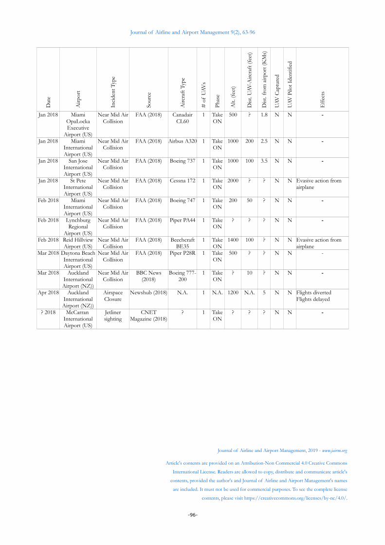
Journal of Airline and Airport Management 9(2), 63-96
Dat
e
Air
port
Inci
dent
Typ
e
Sour
ce
Airc
raft
Typ
e
# o
f U
AV
s
Pha
se
Alt.
(fee
t)
Dis
t. U
AV
-Airc
raft
(fee
t)
Dis
t. fr
om a
irpo
rt (K
Ms)
UA
V C
aptu
red
UA
V P
ilot I
dent
ified
Eff
ects
Jan 2018 MiamiOpaLockaExecutive
Airport (US)
Near Mid AirCollision
FAA (2018) CanadairCL60
1 TakeON
500 ? 1.8 N N -
Jan 2018 MiamiInternationalAirport (US)
Near Mid AirCollision
FAA (2018) Airbus A320 1 TakeON
1000 200 2.5 N N -
Jan 2018 San JoseInternationalAirport (US)
Near Mid AirCollision
FAA (2018) Boeing 737 1 TakeON
1000 100 3.5 N N -
Jan 2018 St PeteInternationalAirport (US)
Near Mid AirCollision
FAA (2018) Cessna 172 1 TakeON
2000 ? ? N N Evasive action from airplane
Feb 2018 MiamiInternationalAirport (US)
Near Mid AirCollision
FAA (2018) Boeing 747 1 TakeON
200 50 ? N N -
Feb 2018 LynchburgRegional
Airport (US)
Near Mid AirCollision
FAA (2018) Piper PA44 1 TakeON
? ? ? N N -
Feb 2018 Reid HillviewAirport (US)
Near Mid AirCollision
FAA (2018) BeechcraftBE35
1 TakeON
1400 100 ? N N Evasive action from airplane
Mar 2018 Daytona BeachInternationalAirport (US)
Near Mid AirCollision
FAA (2018) Piper P28R 1 TakeON
500 ? ? N N -
Mar 2018 AucklandInternationalAirport (NZ))
Near Mid AirCollision
BBC News(2018)
Boeing 777-200
1 TakeON
? 10 ? N N -
Apr 2018 AucklandInternationalAirport (NZ))
AirspaceClosure
Newshub (2018) N.A. 1 N.A. 1200 N.A. 5 N N Flights diverted Flights delayed
? 2018 McCarran InternationalAirport (US)
Jetlinersighting
CNETMagazine (2018)
? 1 TakeON
? ? ? N N -
Journal of Airline and Airport Management, 2019 - www.jairm.org
Article's contents are provided on an Attribution-Non Commercial 4.0 Creative Commons
International License. Readers are allowed to copy, distribute and communicate article's
contents, provided the author's and Journal of Airline and Airport Management's names
are included. It must not be used for commercial purposes. To see the complete license
contents, please visit https://creativecommons.org/licenses/by-nc/4.0/.
-96-