Embed Size (px)
Citation preview

Sanjay Parthasarathy
October 12, 2006
UAVs in Urban EnvironmentsHoneywell Aerospace Advanced Technology

2 HONEYWELL SP_Oct 2006
Agenda
• Multi-vehicle operations
• Organic Air Vehicle - 2
• Small UAVs in urban environments
• Obstacle Avoidance Flight Tests

3 HONEYWELL SP_Oct 2006
Heterogeneous Urban RSTA Team (HURT)
Multi-year program run out of DARPA/IXO with Northrop Grumman as prime
Program purpose:To provide tactical information services to the dismounted war-fighter
Specific program goals:• To deliver real-time, three-dimensional RSTA information directly to the war-
fighters in a MOUT environment. • To achieve unlimited and unrestricted interoperability among heterogeneous
collections of unmanned platforms. • To demonstrate collective autonomy that never goes obsolete.
Honeywell role:Developed integrated planning & control scheme for entire HURT system

4 HONEYWELL SP_Oct 2006
HURT Operation
• “Monitor <designated area>”• “View <Coordinate> from
<perspective>”• “Search <feature> for <pattern>”• “Map area defined by <bounds>”• “Establish comms net among
<nodes>”• “Deliver <payload> to <coordinate>”• “Fly as decoy along <route>”
HURT makes it possible to issue high-level commands to a team of RSTA vehicles. HURT makes it possible to issue high-level commands to a team of RSTA vehicles.
High-level tasking interface“Provide me with cellular coverage
as I move”“Show me what’s in that window”
HURT provides a common, shared command interface to capabilities of the RSTA assets
Heterogeneous, networked unmanned systems
High-level RSTA
service command
HURT control center exploits existing UAV datacomms
HURT user(s)

5 HONEYWELL SP_Oct 2006
Program Status
Year 1 demo (Sept. 2005)• Successful flight demo of 4 UAVs (RMax, 2 ravens and 1 Pointer) flying
RSTA missions autonomous at MOUT site
• Demonstrated persistent full-area surveillance, eyes-on-to-target, moving ground target tracking
• Honeywell led the planning & control component of the HURT program- Provided core planning software & integrated algorithmic modules for
autonomous moving target tracking, eyes-on-to target and coordinated multi-UAV area surveillance
Year 2 Objectives• Algorithms substantially developed for
- 3D routing & coverage planning with airspace de-confliction constraints- Moving target tracking from fixed-wing minimally-capable small UAVs- Dynamic platform and payload arrival and/or departure- Arbitrary set of platforms and payloads- Any number of RSTA service requests- Airspace de-confliction without altitude separation

6 HONEYWELL SP_Oct 2006
Small UAVs in Urban Environment
• Organic Air Vehicle – 2 program
• Obstacle Avoidance- Dynamic mapping- Path Planning
• GPS-denied operations
• Extend to DARPA Urban Challenge
7 HONEYWELL SP_Oct 2006
Organic Air Vehicle II (OAV II)
•Vertical Take-off and Landing ducted fan-vehicle•112 pounds dry weight•Heavy fuel engine•Perch and Stare capability•Carries a 15+ pound Mission Equipment Package (MEP)•Active collision avoidance system
•Autonomously detect and avoid obstacles as small as a 6 mm wire• Integrated GPS/INS system with active sensor for
•collision avoidance and •GPS denied navigation in urban environments

8 HONEYWELL SP_Oct 2006
Dynamic Mapping and Path Planning
• Organic Air Vehicle – 2 program
• Obstacle Avoidance- Use knowledge of environment- Find Obstacles- Plan a Path- Get to Goal
• GPS-denied operations
• Extend to DARPA Urban Challenge

9 HONEYWELL SP_Oct 2006
Probabalistic Evidence Grid
•Sensor Independent
•ProbabalisticProbability increases with
each detection to a saturation level
Probability decreases with each lack of detection allowing objects to be deleted appropriately
Includes sensor field of view and vehicle motion & perspective to improve resolution
•Allows multi-sensor fusion
Evidence Grid showing bushes, containers and wire on poles
10 HONEYWELL SP_Oct 2006
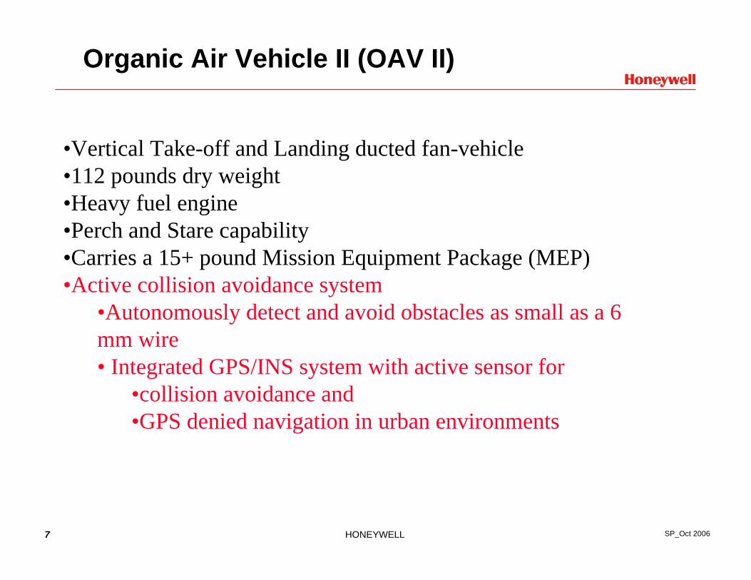
Path Planning and Obstacle Avoidance
• Objectives:- Want algorithm that always finds paths when paths exist- Want smooth paths, so vehicle can follow the path without
slowing too much- Want fairly optimal (short) paths- Want fast runtime (eg, less than 1 second, when
implemented in C)
• Laplacian algorithm, with Multigrid solver, satisfies these objectives

11 HONEYWELL SP_Oct 2006
Laplacian Algorithm (no local minima)Like air escaping from hole in enclosed container
• Boundary Conditions: potential=0 on obstacles & outer walls, potential = -1 at end point.
• Interior: Iterate potential = average of potentials of neighboring points• Interior has -1 < potential < 0 No local min in interior, since average of neighbors• All max & min points lie on boundary where potential = 0 or -1, so only min is at end
point• Solve for potential using multigrid, then follow gradient of potential
12 HONEYWELL SP_Oct 2006
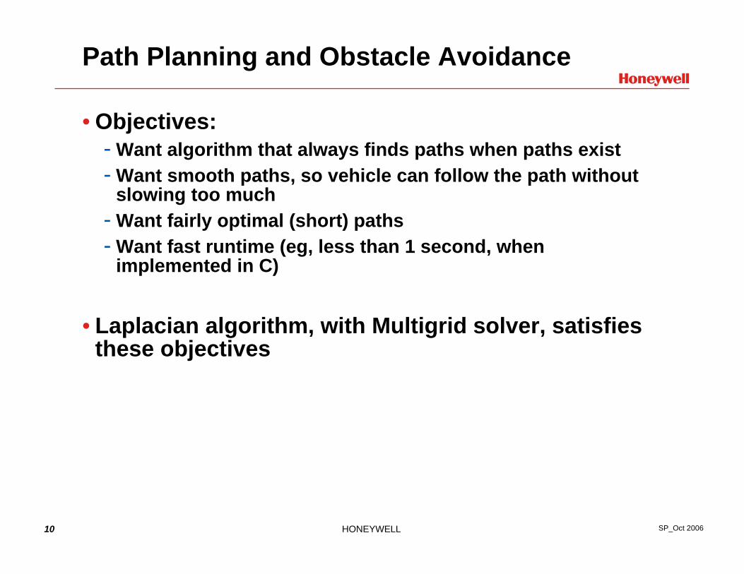
Guaranteed solution when path exists
When sensor sees this uncharted obstacle, vehicle turns around.
When sensor sees this small uncharted obstacle, vehicle maneuvers past it.
Ft. Benning McKenna Urban site buildings

13 HONEYWELL SP_Oct 2006
Further Speedup: Grid obstacles finely, crude grids elsewhere

14 HONEYWELL SP_Oct 2006
Movie of helicopter avoiding obstacles
• Laplacian Algorithm updating at 1 Hz• Inner-loop reactive obstacle avoidance updating at 5 Hz
15 HONEYWELL SP_Oct 2006
Summary
• Laplacian Algorithm, with Multigrid Solver, Satisfies Objectives:- Always finds paths when paths exist- Gives smooth paths, so vehicle can follow the path without
slowing too much- Gives fairly optimal (short) paths- Has fast runtime (eg, less than 1 second, when implemented
in C)- Flops = 5*(path_length/space_between_obstacles)*(number
of grid points)
• Extend Obstacle Avoidance to Collision Avoidance and GPS-Denied navigation
• Algorithm independent of sensor modality, can be applied to Ground and aerial vehicles