Embed Size (px)
Citation preview

International Journal of Social Science and Economics Invention ISSN: 2455-6289
https://doi.org/10.23958/ijssei/vol07-i03/278 53
Original article
The Urbanization and Growth of Malaysia: Case
Study of Iskandar Region
Muhammad Yazrin Yasin1,2
, Jamalunlaili Abdullah2, Mariney Mohd Yusoff
1 and Norzailawati Mohd Noor
3
1Department of Geography, University of Malaya,50603 Kuala Lumpur, Malaysia.
2Faculty of Architecture, Survey and Planning, Universiti Teknologi MARA, 40450 Shah Alam, Malaysia.
3 Kuliyyah Architecture and Environmental Design, International Islamic University of Malaysia, 50728 Kuala Lumpur
Malaysia.
Correspondence: Muhammad Yazrin Yasin : yazri n ya sin@ gma il.com
Received: February 02, 2021; Accepted: February 09, 2021; Published: 04 March 2021
Abstract
This paper discusses the process of economic growth and urbanization in Malaysia, the contribution of Johor in the nation’s growth and the
development of Iskandar Malaysia. First, we explore the range of institutions that engage in urban and regional planning at various level and
their respective statutory development plan. Next, we present the contextual of the south Johor particularly Iskandar region and the new
administrative of Iskandar Puteri. The development of Iskandar region is intended to benefit all in south Johor and by coordinating the efforts of
various Government agencies, Iskandar Regional Development Authority (IRDA) is helping locals share the benefits of economic growth.
Afterwards, we evaluate some issues that have arisen with regard to the physical development and the statutory development plans in Johor and
Iskandar region on urbanization and urban growth pattern. From the analysis, we identified that among issues aroused are the absence of urban
growth boundary within Iskandar region; land use change and agricultural land encroachment; low density and mixed-use development and
environmental change and degradation.
Introduction
Malaysia is a country strategically located in the center of South
East Asia. Since its independence in 1957, the country has been
developing rapidly. There is a need to examine how urban and
regional planning trough national physical plan, state structure
plan, regional and local plan developed and assumed center stage
in environmental change concept, particularly in land use planning
and urban growth pattern. Because of the diversity of urban area,
understanding urban growth pattern is a major challenge for urban
planners and managers. The complexity of urban environment,
social necessitate and economic anxiety requires an attentive
development plans with a sustainable urban growth policy [1].
Conventionally, the development plans were used as the main tools
for urban growth management. Thus, the role of the national
development and planning framework is essential in achieving a
sustainable and holistic ecosystem.
The second highlight is to present the contextual of the south
Johor particularly Iskandar region and the new administrative of
Iskandar Puteri. The development of Iskandar region is intended to
benefit all in south Johor and by coordinating the efforts of various
Government agencies, Iskandar Regional Development Authority
(IRDA) is helping locals share the benefits of economic growth.
IRDA was formed under the IRDA Act 2007, Act 664 to provide
proper direction, policies and strategies in relation to the
development of Iskandar region (see Figure 1). This is achieved
through previous Comprehensive Development Plan (CDP) 2006-
2025 [2], which was prepared by Khazanah Nasional to guide
IRDA to work hand in hand with all relevant planning authorities
to develop Iskandar region. The revised CDP ii 2014-2025 ensures
all planning strategies remain relevant to the people of Johor in
general and Iskandar in specific.
Lastly, this paper explores some issues that have arisen with
regard to the physical development and the statutory development
plans in Johor and Iskandar region on urbanization and urban
growth pattern. Among issues aroused are: the absence of urban
growth boundary within Iskandar region; land use change and
agricultural land encroachment; low density and mixed use
development and environmental change and degradation.

Volume 07, Issue 03 March 2021 Original Article
www.ijssei.in 54
Figure 1: Iskandar region is consisting of 9 local government authorities in south Johor [2].
Urban planning institutions and statutory
development plans
The early urban planning practices in Malaysia are based on the
Crown colony during British occupation and it goes way back in
1912. Six decade later, a new and improve town and country
planning was established with the passing of Town and Country
Planning Act 1976 (Act 172) that elaborate the power of the
federal and the state governments. The system was very similar to
the one that has been practice in England and Wales, where
structure plan and local plan are the tools for urban growth and
development control. Today, the Department of Town and Country
Planning also known as Plan Malaysia is the governing body of the
execution of Act 172 in the Federal and States of peninsular
Malaysia. The mission of the department is to spur national
physical planning through the implementation of comprehensive,
systematic and innovative development planning for the well-being
of society.
Physical planning in this context is referring to the national
development planning framework, comprises of 3 stages. The first
stage is the strategic development planning of the nation, steered
by the Five-Year Malaysia Plan as the highest strategic planning
document. The vision of the Five-Year Malaysia Plan is to balance
economic growth and fiscal consolidation initiatives to ensure
continuous and inclusive development without impairing growth
prospects (see Figure 2) [3]. Although the National Physical Plans
is not part of the Five-Year Malaysia Plan, but the former must
correspond and in accordance with the latter [4]. Other policies such
as monetary, socioeconomic, human capital etc. must be consistent
with the Five-Year Malaysia Plan. This initial stage, however, are
established also to determine the extension and direction of
physical and land use planning to the regional or state and local
level.
Figure 2: The national development planning framework and
the statutory development plans. Adapted from [3].

Volume 07, Issue 03 March 2021 Original Article
www.ijssei.in 55
The National Physical Plan (NPP) was initiated as a result of the
amendment of Act 172 in 2001. The act stated that NPP is a written
statement formulating strategic policies for the purpose of
determining the general directions and trends of the physical
development of the nation. The National Physical Planning
Council (NPPC) is the body that regulate the NPP, chairs by the
Prime Minister and the Director General of Plan Malaysia are the
secretary of the council. Although according to Section 2A (1) of
Act 172, the head executive of state governments are members of
the council, the council (NPPC) can only advise and negotiate with
the state governments, as the town and country planning is under
the concurrent list of the Federal Constitution. Also, in Section 6B (4), the NPP is required by the act to have a 5-year revision to in
tandem with the review of the Five-Year Malaysia Plan.
The lower stage in the framework is the State Structure Plan
(SSP) and other state policies regulated by the respective state
government, without inadvertently contemplating the economic
and physical policies that were set from the top. The SSP is
virtuous as long as it does not contradict with the state
development plan and state policies under the State List of the
federal Constitution. SSP is a state statutory planning document
that provide a guideline and control over state physical
development. SSP has a long list of current state policies binding to
the document. For example, the previous Selangor State Structure
Plan 2020 has included 104 policies for economic development (21);
social development (11); physical development and environment (68);
and planning and delivery (4).
The head executive of the state governments, the Menteri Besar
chairs the State Planning Committee (SPC) which play a role as the
secretariat that produced and gazette the SSP assembled by the
respective state Town and Country Planning Department in
Peninsular Malaysia. Just like NPP, the SSP is required by the act
to have a 5-year revision to ensure its alignment to the latest
policies, plans and strategic both at the national and the state level.
Essentially, three things that SSP must not disregard are:
(i) Specified and implicated the state policies and strategic
plans regarding:
a. Urban and rural land use and development planning.
b. Ways to improve the natural and manmade environment.
c. Roads and transport networks planning and management.
d. Ways to achieve sustainable socioeconomic growth and
wellbeing.
(ii) Any directive or policy statement determined or directed
by the state planning committee or national physical
planning council in specific or special matters or issues;
(iii) Specified any significance relation and effects of the
above policies, plans, matters or issues to other
development plans of the neighboring states or regions.
In parallel, the planning framework has another requirement for
regional planning committee under subsection 6A(5)(b) of the Act
172 called the regional plans. Although commonly the regional
authority has more than one state that need interstate cooperation to
tackle significant strategic matters of regional concerns jointly,
exception for regional authority in Johor, Sabah and Sarawak to
produce regional plans considering they were one state growth
conurbation. Regional plan consists of spatial policies and broad
development strategies to guide and coordinate development
including key regional infrastructure provision such as highways,
ports and airports. Since the regional planning authority is
established by the federal government, funding and financial
assistance from the federal government has become a conventional
practice to accelerated development in these economically lagging
regions. Thus, most of their policies and proposals for spatial
planning is a translation of Five-Year Malaysia Plan if not less.
Regional planning authorities also generated their own income
through foreign direct and strategic investments.
At the nethermost stage where the service delivery is the
frontline, local plan is the ultimate guidance that focus on social,
economic and environmental of the confined jurisdiction. The
Local Plan is prepared with a disposition of translating the policies
and strategies of SSP with more specific development proposal and
building and land use control of a local authority. Just like NPP
and SSP, local plan is a requirement by Act 172 that consists of
i. A spatial translation of national and state strategies,
policies and plans onto physical and social development;
ii. A written statement of land use planning and
development, including the most sustainable ways to
develop potential land, mitigate environmental
degradation, rehabilitating topography and natural
landscape, preserve and improvise urban designs,
providing ample infrastructures and transport networks;
iii. A key diagram in a form of an overall land use planning
map supported by layers of maps of urban and rural use
(growth centers, boundaries, limits), zones (residential,
industrial, commercial, environmentally fragile),
physical development (infrastructures,
telecommunications, utilities, public amenities,
recreations, public transportations), and other concerned
matters.
Conversely, the role of planning institution and the statutory
development plans function to determine the extension and
direction of physical and land use planning to the regional or state
and local level. Through the provision of the statutory plans via the
Act, the planning institutional legalized the document as main
reference on urbanization process. To further enhance the role of
planning institution and the statutory development plans, and to
meet with continuous urban and economic growth, the national
development planning framework requires in built system of big
data for reviewing, monitoring and projecting growth. This is due
to the amount of physical and geographical information such as
satellite images, land use land cover data, maps and other
geospatial attributes that need to be retrieved, processed and
analyzed to produce statutory development plans. Therefore, all the
policies, strategies, regulations, procedures stated in the statutory
plans should be embraced by all stakeholders in urbanization
process in Malaysia.
Malaysia’s economic growth and urbanization
Malaysia has enjoyed a spurring economic growth and
development at its peak since 1970s to 2000s (Table 1). In the
1970s, Malaysia used to rely on agricultural and mining which put
them in resource-based and fragile economy. Over many years, it
has developed and transformed into manufacturing and
international trade. Gradually service oriented industry such as
tourism, financial and high-tech manufacturing has greatly changed
Malaysia’s economic and positioned them as one of tiger cub of
Asia. At present, Malaysia is pulling it best resources and human
capital to become a knowledge-driven and innovation-based
economy.

International Journal of Social Science and Economics Invention ISSN: 2455-6289
https://doi.org/10.23958/ijssei/vol07-i03/278 56
Table 1: Malaysia economic transformation 1960s – 2010s [5,6].
1960s 1970s 1980s-1990s 2000s 2010s
Agricultural &
mining
Primary
industries
Export oriented Services High-tech services Knowledge-driven Innovation
Timber, rubber,
tin, forestry
Commodity,
Manufactur-ing
and domestic
production
Oil & Gas
FDI driven
investment
High-tech production
Trade
Hospitality,
Hotel,
Financial
Operations and IT
hub,
Outsourcing and
shared services
Business hub and
centre of
excellence
High value
business
function
IR 4.0
By and large, the last half century has been a period of economic
prosperity and urban growth for Malaysia. However, the initial
driver that propelled early economic development and urban
agglomeration for Malaysia was tin mining and rubber plantation [7]. Large tin deposits were found in Perak and Selangor, making
settlements of miners fast growing and becoming mining towns.
Rubber plantations also contributed to workers estate, then
agglomerate into small growth center. Even Kuala Lumpur was
founded by tin miner and trader called Sutan Puasa [8]. Then the
prominent economic landscape was gradually changing in the
1970s into commodity based particularly palm oil. Palm oil was
brought in by the British government in the 1870s, but the mass
plantations and production begins a century later. The government
under a statutory body named Federal Land Development
Authority or FELDA has open many new settlements in the 1970s
which was part of new rural development scheme. The FELDA
scheme was introduced to help rural poor into newly cleared areas
for cash crops and other range of economic development.
Late 1970s or early 1980s has witnessed the transition from
agricultural economy to industrial based. With the support of
National Industrial Policy and Industrial Master Plan,
manufacturing and domestic production achieved remarkable
growth [9]. Many factories and warehouses were built in the
suburban areas. The rural migration was prompted at this point and
many new settlements was built, creating industrial districts mostly
concentrated in Penang, Selangor, Johor and Melaka. This has
cause divided urbanization rate among the states (Table 2).
Growing in manufacturing and domestic production has changed
and improved overall urban infrastructures, logistics, employment
and economic growth [9]. The spillovers of manufacturing
industries have direct impact involve land use changes – when the
land is converted from some rural use to urban one. It can be
concluded that with an effective industrial policy, manufacturing
industries will drive long term growth of nation and spur
urbanization.
Table 2: Malaysia’s Federal Territory and state urbanization
rate 1970-2010 [10].
State/ Federal
Territory*
Year
1970 1980 1990 2000 2010
Johor 26.3 35.2 47.8 63.7 72.0
Kedah 12.6 22.5 32.5 38.8 64.3
Kelantan 15.1 28.1 33.5 33.5 41.5
Melaka 25.1 23.8 38.7 67.4 86.5
Negeri Sembilan 21.6 32.6 42.0 55.0 65.9
Pahang 19.0 26.1 30.4 42.1 51.0
Perak 27.5 33.8 53.6 59.0 69.2
Perlis 0.0 8.9 26.6 33.8 51.8
Penang 51.0 47.5 75.0 79.5 90.6
Sabah 16.9 19.9 33.2 48.1 53.3
Sarawak 15.5 18.0 37.5 48.0 53.2
Selangor 45.6 40.9 75.2 88.1 91.4
Terengganu 27.0 42.9 44.5 49.4 59.1
Kuala Lumpur* - 100.00 100.00 100.00 100.00
Labuan* - 46.3 48.4 72.26 81.8
Putrajaya* - - - 62.8 100.00
Then, in the 1990s, with the continuation of Industrial Master Plan
2, but the focus is on bridging an integrated industrial networks and
cluster development that consists of high technology production
and business development strategy [9]. Petroleum and
petrochemical industries have also evolved, through integration
with manufacturing sectors and hi-tech production. The
government has also initiated a cluster-based development of
information technology and multimedia industries of Multimedia
Super Corridor (now known as MSC Malaysia) in 1996. This has
further placed a direct effect on urban growth and land
development because high tech industries require proximity of
knowledge sources, so they can exploit and benefit from. For
example, an R&D specialized firms would benefit from research
university presence, in acquiring specific knowledge and human
capital.
In the new millennium, Malaysia has promoted the county to
transform into high tech services as the new source of economic
growth. The persistence development of MSC Malaysia and the
National Information Technology Agenda has paid off when the
industrial has reached a competitive strength, built upon relatively
low labor cost, sound physical and policy infrastructure, fairly
educated workforce, availability of support services, and spearhead
by foreign direct investment [11]. At this stage, the concentration of
development has focused in the urban areas, especially in the
national and regional conurbation. The economic transformation
has affecting land use change, for need of housing and other urban
amenities. Many firms and business have moved to the suburbs
provided it is greatly connected and high accessibilities and results
in urban expansion.
A study by Hassan and Nair [10] has confirmed the relationship
between rapid urbanization and the economic transformation,
knowledge-based development and persistent government policies
and strategies. The shift from agriculturally based into industrial
based and then into knowledge based economic has driven a rapid
increase in urban growth in towns and cities throughout the
country. The level of urbanization in Malaysia has never slowed
down since 1970 with every decade shows utmost increase from
26.8% in 1970 to 70.9% in 2010 (Table 3). This goes along with
the extreme increment of urban population by 557.5% or 16
million. The average population growth rate however shows a
contrasting figure with decreasing rate every 10 years. The most
likely causes are the instantaneous rate of urban spatial growth and
changes in towns and cities boundaries.
Table 3: Malaysia’s urbanization and population growth rate
1970-2010 [10].
Year Urbanization Average population growth
Volume 07, Issue 03 March 2021 Original Article
www.ijssei.in 57
rate (%) rate (%)
1970 26.8 -
1980 35.8 5.2
1990 50.7 5.1
2000 61.7 4.8
2010 70.9 3.5
According to PwC Malaysia [12], from 1990s to 2010s, Malaysia’s
economy compare to most other ASEAN countries were strong and
resilient, despite the effect of the global economic downturn.
Malaysia is also a large trading partner of intermediary goods to
China and are currently Southeast Asia’s third largest economy by
GDP after Indonesia and Thailand. Manufacturing grew at 4.3%
and contributing to year-on-year growth of 4.9%.
Forecasted growth seems way better and the economist is
positive that it is on track to achieve a fully developed nation in
2025. Malaysia’s GDP per capita has reach a high 60% of the
average OECD countries, and projected to continue climbing
(Figure 3). This will eventually have an effect on the extension and
direction of urbanization in Malaysia.
Figure 3: Malaysia’s economy compare to OECD average GDP
per capita as a proportion of the OECD average [12].
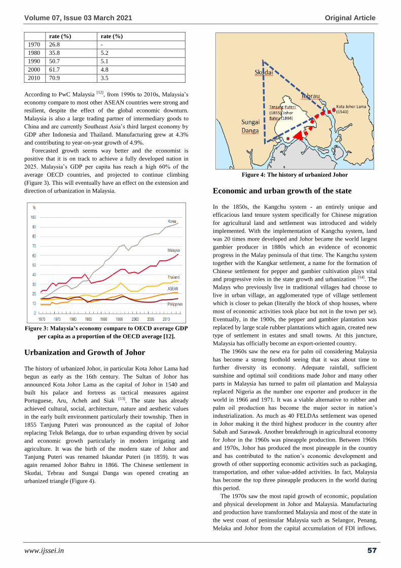
Urbanization and Growth of Johor
The history of urbanized Johor, in particular Kota Johor Lama had
begun as early as the 16th century. The Sultan of Johor has
announced Kota Johor Lama as the capital of Johor in 1540 and
built his palace and fortress as tactical measures against
Portuguese, Aru, Acheh and Siak [13]. The state has already
achieved cultural, social, architecture, nature and aesthetic values
in the early built environment particularly their township. Then in
1855 Tanjung Puteri was pronounced as the capital of Johor
replacing Teluk Belanga, due to urban expanding driven by social
and economic growth particularly in modern irrigating and
agriculture. It was the birth of the modern state of Johor and
Tanjung Puteri was renamed Iskandar Puteri (in 1859). It was
again renamed Johor Bahru in 1866. The Chinese settlement in
Skudai, Tebrau and Sungai Danga was opened creating an
urbanized triangle (Figure 4).
Figure 4: The history of urbanized Johor
Economic and urban growth of the state
In the 1850s, the Kangchu system - an entirely unique and
efficacious land tenure system specifically for Chinese migration
for agricultural land and settlement was introduced and widely
implemented. With the implementation of Kangchu system, land
was 20 times more developed and Johor became the world largest
gambier producer in 1880s which an evidence of economic
progress in the Malay peninsula of that time. The Kangchu system
together with the Kangkar settlement, a name for the formation of
Chinese settlement for pepper and gambier cultivation plays vital
and progressive roles in the state growth and urbanization [14]. The
Malays who previously live in traditional villages had choose to
live in urban village, an agglomerated type of village settlement
which is closer to pekan (literally the block of shop houses, where
most of economic activities took place but not in the town per se).
Eventually, in the 1900s, the pepper and gambier plantation was
replaced by large scale rubber plantations which again, created new
type of settlement in estates and small towns. At this juncture,
Malaysia has officially become an export-oriented country.
The 1960s saw the new era for palm oil considering Malaysia
has become a strong foothold seeing that it was about time to
further diversity its economy. Adequate rainfall, sufficient
sunshine and optimal soil conditions made Johor and many other
parts in Malaysia has turned to palm oil plantation and Malaysia
replaced Nigeria as the number one exporter and producer in the
world in 1966 and 1971. It was a viable alternative to rubber and
palm oil production has become the major sector in nation’s
industrialization. As much as 40 FELDAs settlement was opened
in Johor making it the third highest producer in the country after
Sabah and Sarawak. Another breakthrough in agricultural economy
for Johor in the 1960s was pineapple production. Between 1960s
and 1970s, Johor has produced the most pineapple in the country
and has contributed to the nation’s economic development and
growth of other supporting economic activities such as packaging,
transportation, and other value-added activities. In fact, Malaysia
has become the top three pineapple producers in the world during
this period.
The 1970s saw the most rapid growth of economic, population
and physical development in Johor and Malaysia. Manufacturing
and production have transformed Malaysia and most of the state in
the west coast of peninsular Malaysia such as Selangor, Penang,
Melaka and Johor from the capital accumulation of FDI inflows.

Volume 07, Issue 03 March 2021 Original Article
www.ijssei.in 58
For Johor, the focus of manufacturing was on steel and shipping.
The shift from agriculturally based to manufactured based has
great implication to urbanization. The urbanization rate of Johor
was 26.2%, fifth position among other states in Malaysia. Rural to
urban migration has contributed to rapid urban population of Johor.
Thus, municipal townships have expanded, for housing estates and
suburban areas has already replacing villages and agricultural
areas.
Then in the 1980s, commodity price fell, and the state
government continue to focus on manufacturing and domestic
production as a method of generating employment and encouraging
growth. The manufacturing sectors constantly grows and
diversified with electrical and electronics (E&E) manufacturing
where Johor was one of three main centers with sustained level of
FDI. The highest foreign-owned firms are Japan (48%), Singapore
(35%) and the United State of America (6%). There were over
4,700 firms and employs some 330,000 workforces between 1980s
– 2000s in Johor and E&E is the largest sub sector in terms of
employment, investment, output and export earnings [15]. Prior to
year 2000s, urbanization rate in Johor was almost two third (63%)
and Johor Bahru has been granted a city status and most of the
districts in Johor has municipal status such as Batu Pahat, Muar,
Kluang, and Segamat.
The Johor State Structure Plan 2030 has reported, for the period
of 2010 to 2015, Johor was the fourth largest contributor of GDP
(9.2%) to the Malaysian economy with an average annual growth
rate (AAGR) at 5.9%. Based on the population, the GDP per capita
for Johor increased USD5683 (2010) to USD7323 (2015) with
AAGR of 5.2%. In general, the economic growth of Johor was led
by manufacturing with 30.7%, followed by agricultural sector
(14.9%), commerce (12.5%). By saying economic growth and
agglomeration capitalized urban growth and expansion, that being
the case of rapid urbanization in Johor. Table 4 summarizes Johor
economic and urban transformation from prior to 1850s until
2010s.
Table 4: Johor economic and urban transformation 1850s – 2010s [14]
Prior to 1850s 1850s - 1880 1880s – 1900s 1900s – 1960s 1960s-1970s 1970s -2000s 2000s
Primary forest,
traditional
agricultural
Gambier Pepper and
Gambier
Rubber Pineapple and
Palm Oil
Commodity,
manufacturing and
domestic production
Oil & Gas
FDI-driven investment
High-tech production
Trade
Rural and river
settlement
Kangkar and
traditional
village
Pekan and
urban villages
Estate and
small town
New Village
FELDA
settlement
Municipal
townships
Regional city
Key government and agencies’ role on growth
They are few agencies that play important roles for the formulation
of economic growth. The first is the Johor State Economic
Planning Unit (UPENJ), the agency in authority for policy
formulation and development planning. The UPENJ is responsible
to monitors international and national investments in Johor,
formulate economic plan and sectoral policy and engage
partnership and privatization projects, and profit-generating
initiatives. They produce a five-year economic plan on planning,
coordinating and executing economic activities between
government and private sectors. Another agency that in charge for
promotional and advocacy of investments is the Johor State
Investment Center (JSIC), is responsible to promote foreign and
local investment in the manufacturing and service sector, undertake
planning for industrial development, evaluate applications for
manufacturing licenses and permits, and to assist local exporter to
develop and expand their export market.
But the most significant agency that contributed to the
economic and development growth of the state of Johor
Corporation formerly known as the State Development Economic
Corporation or JCorp. Johor Corporation was established as a
public enterprise in 1968 coinciding when the Federal Government
had introduced the New Economic Policy – a two-point-saw
strategic blueprint to fostering nation building and adjusting
economic disproportion. Thus, their vision and missions reflecting
NEP, which was geared to achieve economic inequity by
positioning the Malays in the economic cake. Among the key
projects being carried out by Johor Corporation are the Ibrahim
International Business District (IIBD) – designed to transform
Johor Bahru City Center into a metropolis of a world stature,
Pengerang Industrial Park – an eco-industrial park, B5 Johor Street
market, Tebrau City – redevelopment of former army camp into
integrated township and Arena Larkin sport city (Table 5).
Specifically, for Iskandar region, the key player of Iskandar
Malaysia’s economic development is the Iskandar Region
Development Authority (IRDA). IRDA was formed under the
IRDA Act 2007, Act 664 and it is technically a federal agency
which come under the purview of Prime Minister’s Department
prior to 2018. However, because of the interest of the state of
Johor, Iskandar Malaysia is jointly chaired by the Prime Minister
and the Menteri Besar of Johor. Currently IRDA is positioned
under the Government Investment Companies Division (GIC),
Ministry of Finance. The 2,200 square kilometer region that was
established in 2006 is responsible for policy formulation,
investment promotion and facilitation, and mainstreaming
development. IRDA has achieved so many progresses and making
Iskandar region grown by leaps and bounds, even surpassing its
key economic target and rolling out the implementation of various
programs.
Table 5: Proposed and On-Going Urban Development/ Redevelopment in Iskandar, Johor [16].
Project Size Location Cost Theme Completion
Pengerang Integrated
Petroleum Complex
54, 363
acres
Pengerang USD6.7b Refinery and petrochemical 2020
Pengerang Eco-Industrial Park
61.8 acres Pengerang USD370 mil Eco-industry 2021
Ibrahim International Business 250 acres Johor Bahru Central USD5b Urban redevelopment 2025

Volume 07, Issue 03 March 2021 Original Article
www.ijssei.in 59
District (IIBD) Business District
Arena Larkin 102.7 acres Mont Austin USD87 mil Sports city 2020
Tebrau City 382.7 acres Tebrau USD1.16b Integrated Township 2022
B5 Johor Street Market 5.8 acres Tampoi USD22 mil Queen Victoria Market 2020
Determinants of urban growth in Iskandar,
Johor
Iskandar has all the determinants of urban growth: spatial
externalities; human capital; agglomeration economy;
technological innovation; and institutional reform; that reflected by
the GDP in the range of 7.5% annually (RM47 billion in 2012).
Dogan and Stupar [17] explains, urban development redevelopment
and mega project as catalyst are essential in an expanding market
economy, which capitalize urbanization and growth. Iskandar has
entered second stage of development and several initiatives to
create growth opportunities and moving implementation. The
early phase of Iskandar Malaysia’s development also witnessed the
implementation and completion of key infrastructures projects such
as new roads and highway – Eastern Dispersal Link (EDL), Senai
Desaru Highway, Iskandar Coastal Highway as well as major roads
and irrigations projects around the capital. Iskandar also has done
so much on institutional reform such the implementation of smart
growth concept that focuses on flagship zones as development
areas; transformation and regeneration program for Johor Bahru
central business district; and provide fiscal and non-fiscal
incentives to direct development to specific areas.
The largest catalyst project is a 54,363-acre Pengerang
Integrated Petroleum Complex (PIPC), it was one big step in
creating value to the downstream oil and gas value chain in the
south of Peninsular Malaysia. The project will house oil refineries,
naphtha crackers, petrochemical plants, liquefied natural gas
(LNG) import terminals and a regasification plant. New high value
and high demand products and by-products create a more dynamic
and progressive oil and gas industry in Malaysia. This will
generate economic growth and moving up the value chain. To
complement PIPC operations, another downstream oil and gas
project was designed as part of Pengerang master plan for
supporting maintenance, repair and overhaul work. The 61.8-acre
Pengerang Eco Industrial Park PEIP is located side by side with
PIPC also serve as a human capital development through technical
and vocational education training city.
An urban redevelopment and rejuvenation project of Johor
Bahru central business district named Ibrahim International
Business District (IIBD) was planned to propel Johor Bahru as a
world class business district and the fulcrum of business,
investment and entrepreneurship. The planning process behind the
250-acre IIBD has considered economic, social and environmental
components, with the aim to ensure quality and sustainability urban
environment. Another redevelopment scheme that initiated as a
privatization project to cater for integrated township including
affordable housing is the 382.7-acre Tebrau City that was
previously a Malay, Ranger and Special Force Regiments Majidee
Camp before being handed over for land swap. With sustainable
land use and density planning, both redevelopment projects endow
spatial externalities and sought to avoid urban shrinkage and
depopulation of Johor Bahru central.
Simultaneously, being the capital of Johor, Iskandar Malaysia
stimulates territorial interest as a result of proximity and urban
expansion - gaining optimal benefits from spillovers and
agglomeration economies from neighboring Singapore that
subsequently create urban growth and expansion. A research by
Konstadakopulos [18] on the element of continuity in the markets,
the element of dynamic synergy and turnover of the human capital
or labor forces has produced an agglomeration economy for both as
a result of the proximity of Singapore-Johor. On a daily basis,
220,000 vehicles crossing both the Causeway and the Second Link
with 127,600 (58%) are motorcycles, 79,200 (36%) cars, 2,200
light trucks (1%), 4,400 heavy trucks (2%), 1,100 taxis (0.5%) and
5,500 buses (2.5%) [19]. The group of users of these crossings are
(from highest to lowest) workers, school-going commuters,
shoppers, and logistics providers or business providers. This shows
how large economic agglomeration and economic complementarity
beneficial for Iskandar.
The similar case for technological innovation and human
capital: new firm needed to be in technology district because in the
vicinity, the speed of technological transformation and the
investment in technological innovation are much higher [20]. In case
of Iskandar Malaysia, clearly it has great potential and has become
the regional location of choice for knowledge and innovation.
Iskandar has several higher institutions operating in EduCity,
Medini such as Newcastle University Medicine Malaysia,
University of Southampton Malaysia, University of Reading
Malaysia, Raffles University Iskandar, and Marlboro College
Malaysia and also University of Technology Malaysia (UTM) and
Southern University College in Skudai and UiTM in Bandar Seri
Alam and this certainly will stream up innovation and technology
concentration.
Table 6 shows some of the private initiative projects in Iskandar,
Johor indicating the size, location, cost, theme and the completion
date of the project.
Table 6: Private initiatives projects in Iskandar, Johor
Project Size Location Cost Theme Completion
EduCity 305 acres Medini USD55 mil Higher education hub 2020
Legoland Malaysia 76 acres Medini USD180 mil Family theme park 2012
Pinewood Iskandar Malaysia Studio 30 acres Medini USD420 mil Production studios 2014
Johor Premium Outlet 27 acres Kulai USD9 mil Premium Outlet 2011
The development vision
The development vision of Johor
Johor placed between two powerful regional hubs: Greater Kuala
Lumpur and the island city-state of Singapore. Greater Kuala
Lumpur is an alternative term to Klang Valley, and has a more
précised geographical referenced, which covers by 10
municipalities with an area of 1,078.49 square miles (2,793 square
kilometers). The context Greater Kuala Lumpur was first coined by
Bunnell et al. [21] in 2002. But the precise geographical boundary
was set by the Economic Planning Unit, Prime Minister
Department. The context is similar to Greater London and Greater

Volume 07, Issue 03 March 2021 Original Article
www.ijssei.in 60
Toronto in term of describing larger conurbation of the original
capital. According to PwC’s World in 2050 Report, Greater Kuala
Lumpur not only serve as the national growth conurbation, but it
has evolved to become a global city that bridge Asia and the world.
Singapore – a South East Asia (SEA) global powerhouse has been
a progressive knowledge-based services economy. The country has
one of the highest per capita income in the world with an
outstanding economic prosperity and wealth. Thus, it is not
unusual for Singapore to be one of the wealthiest countries in Asia
because their government actively taking part in steering the
nation’s economic development and endure to position itself into
the challenging global economy. Therefore, an understanding of
urbanization of Greater Kuala Lumpur and the spill-over of
Singapore investment into its surrounding region, is essential to
this research because the consequences of the role of the city and
increasing global population fostered undesired development.
In the regional development context, National Physical Plan has
identified Greater Kuala Lumpur and neighboring state capital of
Seremban as the National Growth Conurbation (see Figure 5). The
Kuala Lumpur Growth Conurbation was aimed to provide for a
potential population of 10.4 million or 37% of the Peninsular
Malaysia population, somewhat equal to six time the population of
Kuala Lumpur in 2005 which is 1.6 million [22]. These large
conurbation and relative population have already transformed
Greater Kuala Lumpur as a regional commercial and financial hub,
attracting investors and business to expand their operation here.
However, again according to the Federal Department of Town and
Country Planning (2010) [22], an in-depth analysis for major issues
of Kuala Lumpur Conurbation is desperately requires to be
addressed is the spatial planning concern, predominantly mixed
uses and higher density in brownfield area. This has forced lower
density development to the periphery. Another concerned issue is
transportation especially in view of environmental context whereby
carbon emission has quadrupled in urban areas in the last 10 years.
Figure 5: Urban Hierarchy Linkages Map [22].

International Journal of Social Science and Economics Invention ISSN: 2455-6289
https://doi.org/10.23958/ijssei/vol07-i03/278 61
Being a neighbor to Singapore, Johor has enjoyed extensive benefit
in so many ways – from the agglomeration of economy where
handsome investments in manufacturing sector pour in, to the
spatial externalities where properties are securely purchased – has
result in rapid urbanization. Singapore’s FDI to Johor amounts to
RM864.69 million in 2018 [5]. However, Greater Kuala Lumpur
(representing the Federal Government) will continue to play major
roles in regulating this process because Malaysian urban policies
have the tendency to embrace the capital region [21]. Johor does not
seem to have financial capacity nor leadership to position itself in
the global marketplace. Dependency towards the Federal
government financially and politically has limit Johor to freely
policy making, planning and execution.
Land use pattern in Johor generated predominantly by economic
growth and urbanization together with increased population
pressure and have resulted in widespread of built-up area. The
rapid growth has produced significant transformation from rural to
urban features in Johor. Land use change of Johor in the first phase
(1991 to 2001) is compared with the second phase (2001 to 2015).
Southern Johor has received one of the highest built-up land use
change. The whole of Johor’s built-up areas increased 370% from
1991 to 2001 and in 2015 it was ten times than in 2001. The typical
process of urbanization is a contradiction with the sustainable
development: the expansion of the urban land use – and continue to
change – leading to decreased agricultural, rural and forest area.
However, in Johor, agricultural land relatively has not much
change with 4% decreased from 1991 to 2001 and gain 3.4% from
2001 to 2015. This is because the state government believe the
agricultural sector is still important to the economy and deserves
attention because of the large number of people dependent on it.
Thus, agriculture sector remains strong, and it is still needed for the
food security and easy supply of essential food.
The obvious land use change is barren land, increased 381%
from 1991 to 2001. However, the trend reverses from 2001 to 2015
and shrink 78.4%. Major attributes for barren land are bare soil,
gravels, rocks, or loose and shifting sand. In some case, barren land
consists of cultivated land. Thus, barren land is temporary land use
to prepare for new planting or land clearance to displace non-built-
up area to built-up area. This is due to the much rapid urbanization
in the first phase. Forest was also greatly decreased with 27% in
the first phase, and further 6.6% decreased in the second phase. It
may involve a geographic displacement of forest clearing across
state through trade in agricultural and forest products. The
displacement in land use stems from a growth in demand that
cannot be met through national production. Table 7 shows the land
use in Johor from 1991-2015.
Table 7: Land use in Johor 1991 – 2015 [23]
Land use 1991 2001 2015
Hectares % Hectares % Hectares %
Agricultural 1,162,106 61.2 1,111,179 58.5 1,155,455 60.9
Barren land 52,071 2.7 198,634 10.5 42,555 2.2
Built-up area 18,833 1.0 69,338 3.7 190,666 10.0
Mines 6,758 0.36 10,934 0.58 2,848 0.15
Waterbody 10,986 0.58 33,867 1.8 59,012 3.1
Forest 647,854 34.1 474,657 25.0 448,072 23.6
Johor strategic growth plan was formulated to achieve the
development vision of Johor which is to become a high-income
state and an ideal destination for investment and quality of life. The
development vision also promotes participation of the community,
accompanying the public and the private sector. The vision is
supported through: creating a competitive and viable ecosystem;
development of high skill workforces; advanced technology and
infrastructure provision; progressive and sustainable growth; and
an efficient and responsive public service. The strategic growth
plan is intended to have a balance growth throughout the state, and
by strategically assign every district with their own major
economic sector (Table 8).
In the urban hierarchy context, Johor has three level of
township: regional township, capital township and municipal or
provincial township [23]. Johor Bahru conurbation is the only
regional township, also as the capital of the state, with economic
and administrative influence beyond regional boundary and
population around 1.5 to 3 million. Then they have 9 capital
townships and 25 provincial townships. The strategic growth plan
and the urban hierarchy could have impact on the spatial and
temporal pattern of urbanization. Thus, the size of the capital and
the provincial township was planned to become more even with
every district having their own economic sector. This is in line with
the first pillar of Johor SSP 2030 to overcome future challenges: to
achieve dynamic and balanced growth in the south conurbation and
outside the conurbation.
Table 8: Economic sector according to district [23]
District Development Theme Economic sector
Johor Bahru Asia’s home for business International trade, manufacturing, pharmaceutical, healthcare
Kulai Connecting Johor to the world Information and communication technology, manufacturing, logistic
Kota Tinggi Coastal jewel Tourism, agricultural biotechnology, petrochemical, oil and gas
Mersing Naturally splendid Ecotourism, fisheries and marine activity, agricultural, light manufacturing
Pontian Southern sanctuary Eco tourism, fisheries and maritime activity, light manufacturing
Batu Pahat Manufacturing and processing nucleus Manufacturing, food processing, agro-tourism
Muar Aspiring hub for talent and knowledge Education, entrepreneurship training, manufacturing, heritage tourism, agricultural
Kluang Growing with the land Eco tourism, agricultural, manufacturing
Segamat Agricultural powerhouse Agricultural, eco and agro-tourism, manufacturing
Tangkak Crossroad of culture and adventure Lifestyle and adventurous tourism, light manufacturing, agricultural
Development vision of Iskandar Malaysia As discussed in Section 4.3, Iskandar region has a package of
growth determinants. One of the substantial commodities for

Volume 07, Issue 03 March 2021 Original Article
www.ijssei.in 62
Iskandar region to grow is the availability of land. In the initial
development of Iskandar in 2006, from the total area of 220,000
hectares, 60% of Iskandar land use is agriculture, while only 15%
is built up areas. Forest including mangrove and river basin make
up the rest of the land use. It was initially planned to accommodate
from 1.5 to 3 million population in 2025 [24]. With a vision towards
becoming a strong and sustainable metropolis of international
standing, Iskandar has put their effort to provide a resilient
ecosystem, anchored by 9 economic sectors to achieve
environmental conservation and carbon reduction; strong and
resilient economic growth; supports social development and
enhance the quality of life; and becoming one strong region.
Iskandar was initially planned to be the second multimedia
super corridor, becoming the dynamic regional corridor through
spatial management and good governance by 2025. The
establishment of Iskandar Regional Development Authority
(IRDA), an ad hoc agency formerly under the purview of Prime
Minister’s Department, was to coordinate the policy formulating of
Iskandar consolidating the federal and the state government. The
first Comprehensive Development Plan 2006-2025 (CDP) was
implemented, and the focus are more on physical development of
five flagships namely the Johor Bahru city center, Nusajaya (was
later renamed Iskandar Puteri), Western Gate Development,
Eastern Gate Development, and Senai – Skudai (see Figure 6).
Figure 6: Iskandar Malaysia and 5 flagships development [2].
The first phase in the CDP focused in three flagship zones along
the straits of Johor (JB, Nusajaya and Pasir Gudang) but most
investment are concerted in Nusajaya as it has the largest
undeveloped land use. Nusajaya will be developed as the new
administrative center with firms, landmarks, institutions,
educations and residential areas as to meet with urban expansion,
knowledge spillovers, technological innovation and institutional
reforms. While Kota Iskandar is the new administrative center for
the state government that house the state legislative assembly, the
state secretary office and other state departments is part of the
institutional reform, whereas Medini Iskandar is the new CBD.
Medini is a mixed-use urban development that features retail
centers, community centers, theme parks, eco parks, private
education hub (EduCity), private healthcare facilities and many
more. EduCity was planned to enrich the R&D firms by giving
initiatives to place competitive international universities as a two-
point saw initiative to promote technological innovation in
Iskandar to attract high technology firms.
In the second blueprint, CDP II 2014 - 2025, Iskandar continues
to be developed as a holistic ecosystem and aim to become a
Sustainable Metropolis of International Standing, supported by
three main strategy: wealth generation; resource optimization and
low carbon; and wealth sharing and inclusiveness. Wealth
generation help to create a strong and resistant economy through
regional economic growth derived from technological innovation
and knowledge based human capital. Resource optimization and
low carbon safeguard the region from environmental degradation
and natural resources exploitation through sustainable urban
development and lifestyle, while wealth sharing and inclusiveness
through spatial planning development to achieve a resilient and
inclusive society in Iskandar. Iskandar has given all the effort that
would heighten their environment and socioeconomic wellbeing
and position Iskandar as a competitive global region.
Urbanization and urban growth pattern in
Iskandar region
In this paragraph, the urbanization and urban growth pattern is
discussed in relation to the development plans, and the
development vision of the state and the Iskandar region. The
greatest issue is the absence of the growth boundary. Along with
these have been the rapid land use change and agricultural land
encroachment, low-density and non-mixed-used development, and
the height of environmental change and degradation.
The Growth Boundary of Iskandar Malaysia
region
The 3rd National Physical Plan (NPP-3) has blasting statement on
sustainable development and planning as their key principle, in
achieving livable and resilient nation. In the case Iskandar region,
the result has been, a rapid spread of built-up urban areas, with a

Volume 07, Issue 03 March 2021 Original Article
www.ijssei.in 63
filling in, at lower densities, of the entire region, denying a
sustainable urban growth development. The fact that a conurbation
having economic relationship and experiencing population growth
to form a continuous developed built –up area has developed
outside the envisaged planning, resulting in a leapfrog and
haphazard growth. And yet, efficient urban planning requires the
spatial extent of urban expansion and boundary demarcation [25]
also known as urban growth boundary. The delimitation of an
urban growth boundary assists an orderly urban growth expansion,
optimize urban spatial development and reduce the risk of
environmental degradation.
Land use change and agricultural land
encroachment
Land use pattern in Iskandar in 2005 in the pre regional corridor
time was predominantly agriculture land and covers 70.2%. The
main attributes for agricultural land were palm oil plantation 76.3%
and rubber plantation 12.2%. Built up areas are mostly to be found
in Johor Bahru central district, low-rise built-environment made up
of linked houses and two/three storey building along Federal Route
1 (main road connecting from Johor – Singapore causeway to
Kuala Lumpur, up to the north of peninsular Malaysia) and Federal
Route 3 (main road connecting from Johor running along east coast
of Malaysia). Built up areas are also concentrated in Skudai,
located northwest of JB, a medium dense capital township largely
grew contributed because of the presence of Universiti Teknologi
Malaysia. Built up areas are also concentrated in the northeast of
JB – Pasir Gudang, another capital township developed due to the
proximity of Pasir Gudang port and heavy industrial areas
surrounding it.
Land use change in Iskandar in 2013 is predominantly due to
growing built up areas previously taking up 16.7%, now taking up
26.4%. Built up areas in 2013 are now more spread especially to
the previously ‘greenfield’ in Iskandar Puteri (Table 9). Thus,
agricultural land decreased to 60.0% of Iskandar region. Apart
from palm oil plantation, the ‘greenfield’ area was partly Gelang
Patah and Pulai settlement with several relocated traditional
villages of Kampung Tiram and Kampung Paya Mengkuang, and a
swamp forest in Sungai Pulai and Sungai Redan. This explained
the decreased of forest previously taking up 12.0% and later
shrinks to 11.0%. Consequently, the expansion of urban land use
leading to decreased of agricultural, rural and forest area. Another
type of land use change in Iskandar is open space area, doubled
from 1.1% in 2005 to 2.6% in 2013. This is highly due to the
initiatives from IRDA to build more urban parks and range to ease
the urban pressure of densely populated Iskandar.
Table 9: Land use in Iskandar, 2005 and 2013. Source: IRDA
2016
Land use 2005 2013
Hectares % Hectares %
Agricultural 119,302 70.2 106,332 60.0
Built up area 9,725 16.7 47,119 26.4
Forest 20,337 12.0 19,485 11.0
Open space 1,935 1.1 4,525 2.6
Low density and non-mixed-use development
Higher density and more compact city designs prevented
automobile dependent because it produces higher parking cost,
reduce transport distances and generated higher levels of transit
service [26], while mixed used development increased mobility and
encouraged equal access to public service [27]. Iskandar Malaysia
by comparison is a medium-density conurbation with 5,936 people
per kilometer square [23]. Many Asian cities retain a rather high-
density character, but with slightly difference nature from city to
city or region to region. Some of the highest densities cities in the
world are to be found in Asia such as Manila, Mumbai and Dhaka
ranging from 28,508 to 41,515 people per kilometer square. For
regional cities or conurbation, Tokyo – Yokohama conurbation that
consist of 8 municipalities has 4,700 people per kilometer square
while Greater Jakarta that consists of 6 municipalities has 10,200
people per kilometer square. Thus, positioned Iskandar between the
two.
Table 10: Mega-gated Residential Development [22,28].
Residential Size Location Units (est.)
Horizon Hills 1200 acres Iskandar Puteri 1,713
East Ledang 275 acres Iskandar Puteri 582
Ledang Height 360 acres Iskandar Puteri 458
Puteri Harbor 688 acres Iskandar Puteri 1,980
Danga BayWaterfront 616 acres Danga Bay 2,200
Iskandar also features several low densities residential for upper
class households. This has turned the sustainable urban
development that was frequently applaud in the CDP as self-
contradictory. Iskandar Puteri (previously Nusajaya) development
are consisting of luxury mega-gated residential communities such
Horizon Hills, Puteri Harbour, Danga Bay Waterfront, East Ledang
and Ledang Heights (see Table 10). Except for Puteri Harbor and
Danga Bay Waterfront, these wealthy suburban bungalows styled
development is considered sprawl development because of their
extreme low density (50 population per hectare), car-dependence
layout with low connectivity road network and non-mixed used
development, imitating American 1950s post WW II suburbs [29].
Low density and conventional zoning land use are associate with
environmental degradation such as higher fuel consumption as the
vehicle miles travelled (VMT), and higher energy consumption,
and it goes against Iskandar’s vision. On the contrary, Iskandar
also promotes quality living for their residences. For this reason,
there is options for several suburban styled development to be
built. Of course, high density living have the downsides and
concerns, such stress of overcrowded population, traffics and
hygienic issue [30]. Figure 7 shows the key development in
Iskandar.

International Journal of Social Science and Economics Invention ISSN: 2455-6289
https://doi.org/10.23958/ijssei/vol07-i03/278 64
Figure 7: Key Development in Iskandar Puteri, Iskandar [28].
The height of environmental change and
degradation
The CDP was above and beyond promoting sustainability in their
vision through policies, strategies and planning statements.
However, in the execution stage there are some unfortunate
contradictory. The Sungai Skudai and Johor Strait waterfront
Danga Bay was an environmentally fragile 110-acre mangrove
forest that has to make way for Iskandar Coastal Highway and
Danga Bay development. Hundreds of mangroves inhabitant’s
species including endangered species of milky stork – white
plumaged stork that was around estimated about 5,000 presence are
now rarely can be seen. Development took place amidst objection
from many stakeholders. This is one evidence of lack of
environmental awareness in planning decision.
Rapid and persistent urbanization has notable environmental
change and degradation [31]. Massive urban growth is usually
accompanied by an increased burden on rural and agricultural land,
due to endless energy consumption, exasperating air and water,
noise pollution, and loss of agricultural productivity and
encroachment of natural land. In many parts of Iskandar, especially
in the previously ‘greenfield’ like Gelang Patah, Pulai, Pekan
Nenas, Tiram, Kulai and Kelapa Sawit, has abundant of
agricultural and vegetation land. The growth pattern has led to a
massive land use change that steadily shrink agricultural and forest
land including swamp forest.
Urbanization also responsible to the degradation of
environmentally fragile land and affecting their natural ecosystem
in the long run. Land use change from any natural form of land to
built-up development will inevitably increase in impervious
surface, which turn storm water velocity (volume, speed, direction)
and content (polluted). Water velocities pose extremely high risk to
flash flood and inundate. The impervious surface also transfers
grease, sedimentation and other fatal contaminant to storm water
that eventually enter reservoir as raw water. Density development
also contribute to the quality of groundwater resources [32].
Conclusions
This paper has outlined how the national development planning
framework and its institutions work, the process of economic
growth and their significant impact to urbanization in Malaysia, the
contribution of Johor to the nation’s growth and the development
of strong and resilient regional economic, and the issues regarding
urban growth pattern particularly in Iskandar.
The role the role of planning institution and the statutory
development plans function to determine the extension and
direction of physical and land use planning to the regional or state
and local level. Through the provision of the statutory plans via the
Act, the planning institutional legalized the document as main
instrument on urban growth control. While in the state level, Johor
has introduced mechanisms for a dynamic and balanced urban
growth in the south conurbation (Iskandar) and outside the
conurbation. First, the state embraced an urban hierarchy which
has three level of township. Then, they introduced the Johor
strategic growth plan, where they strategically assign every district
with their own major economic sector. It turns out the strategy has
been fruitful to the resilient economic and sustainable urban
growth of Johor.
Iskandar Malaysia region which is competing with neighboring
economic powerhouse of Singapore and is planned around five
flagship zones is one of the most successful regional development
corridors developed under the Ninth Malaysia Plan by the federal
government and their investment arm Khazanah Nasional. Through
their statutory development plans, CDP and CDP II, Iskandar has
already considered a successful high impact development project in
terms of economic growth as Iskandar has been recognized as one
of the highest contributions for National Gross Domestic Project.
Initially, the aim of regional development corridors was to reduce
regional imbalance and to accomplish equitable growth, human
capital and socioeconomic wellbeing throughout the country.
Consequently, the rapid growth of regional corridors has changed
the predominant land use and become catalytic agent to urban
growth pattern.
On the contrary, urbanization rate and urban growth pattern of
Iskandar has been the downsides for their top-down initiatives to
meet with infrastructural, social and economic demand of their
vision. Iskandar instead, turned out to be fronting social, economic
and environment cost incurred. The absence of growth boundary
result in a rapid spread of built-up urban areas, with a filling in, at
lower densities, of the entire region, denying a sustainable urban
growth development. The rapid land use change has effect on the
decreased of agricultural, rural and forest area. The low density and

Volume 07, Issue 03 March 2021 Original Article
www.ijssei.in 65
the non-mixed used development have contributed to automobile
dependent urban sprawl and increased the vehicle miles travelled
(VMT). Iskandar rapid urban growth also can be perceived as
notable environmental change and degradation. However, further
evidence on the development of Iskandar region and on the effects
of the urban growth pattern are needed to better understand the
fault, if any.
Funding
The authors would like to thank Malaysia’s Public Service
Department for funding the research activity.
Conflicts of Interest
The authors declare no conflict of interest. The funders had no role
in the design of the study; in the collection, analyses, or
interpretation of data; in the writing of the manuscript, or in the
decision to publish the results.
References
[1] Perveen, S.; Kamruzzaman, M.; Yigitcanlar, T.
Developing policy scenarios for sustainable urban
growth management: A Delphi approach. Sustainability
2017, 9, 1787.
[2] Khazanah Nasional Comprehensive Development Plan
for South Johor Economic Region 2006-2025; Putrajaya,
Malaysia, 2006;
[3] Federal Department of Town and Country Planning
National Physical Plan 3; Kuala Lumpur, Malaysia,
2016;
[4] Economic Planning Unit Eleventh Malaysia Plan, 2016-
2020: Anchoring Growth on People; Kuala Lumpur,
Malaysia, 2015;
[5] Malaysian Investment Development Authority (MIDA)
Johor’s 2018 FDI surges to RM24.03 bln - exco.
Bernama 2019.
[6] Malaysian Investment Development Authority (MIDA)
Malaysia: Investment Performance Report 2016; Kuala
Lumpur, Malaysia, 2016;
[7] Sendut, H. Patterns of urbanization in Malaya. J. Trop.
Geogr. 1964, 16, 114–130.
[8] Lubis, A.-R. Sutan Puasa: Founder of Kuala Lumpur; 1st
ed.; Areca Books: Penang, Malaysia, 2018; ISBN
9675719338.
[9] Mohamed, Z.; Abd Kadir, Z.; Abdul Raof, N.A.
Malaysia Industrial Master Plans (IMPs) and the focus
on the nation technology and innovation development. J.
Sci. Technol. Innov. Policy 2018, 4, 11–19.
[10] Hasan, A.R.; Letha Nair, P. Urbanisation and growth of
metropolitan centres in Malaysia. Malaysian J. Econ.
Stud. 2017, 51, 87–101.
[11] Yigitcanlar, T.; Sarimin, M. Multimedia Super Corridor,
Malaysia: Knowledge-based urban development lessons
from an emerging economy. VINE J. Inf. Knowl. Manag.
2015, 45, 126–147.
[12] PricewaterhouseCoopers (PwC) Why Greater Kuala
Lumpur is the ideal business hub for regional and global
companies; Kuala Lumpur, Malaysia, 2017;
[13] Mohd Nasir, F.; Aman Hashim, H. The Archaeological
Architecture of Kota Johor Lama. In Proceedings of the
The 2nd International Nusantara Cultural Heitage
Symposium; University of Bung-Hatta: Padang,
Indonesia, 2017; pp. 85–92.
[14] Hui Ching, L.; Raja Shahminan, R.N.; Mursib, G. The
settlement of Kangkar as the frontier Chinese settlement
in Johor, Malaysia. Int. J. Built Environ. Sustain. 2019,
6, 47–53.
[15] Ministry of International Trade and Industry (MITI)
Third Industrial Master Plan (IMP3); Kuala Lumpur,
Malaysia, 2006;
[16] Civil Service Delivery Unit (CSDU) National
TRansformation Programme Annual Report 2017;
Putrajaya, Malaysia, 2017;
[17] Dogan, E.; Stupar, A. The limits of growth: A case study
of three mega-projects in Istanbul. Cities 2017, 60, 281–
288.
[18] Konstadakopulos, D. Learning behavior and co-operation
of small high technology firms in the ASEAN Region:
Some evidence from the Singapore-Johor agglomeration
Agglomeration. ASEAN Econ. Bull. 2000, 17, 48–59.
[19] Ghee, T.C.; Mooi, S.K. Addressing the Singapore-Johor
Causeway Cross-borderhigh Toll Charges. In
Proceedings of the 4th International Conference on
Multidisciplinary Research & Practice; Research and
Scientific Innovation Society (RSIS): Gujarat, India,
2017; pp. 220–233.
[20] Paci, R.; Usai, S. Externalities, knowledge spillovers and
the spatial distribution of innovation. GeoJournal 1999,
49, 381–390.
[21] Bunnell, T.; Barter, P.; Morshidi, S. Kuala Lumpur
metropolitan area. A globalizing city-region. Cities 2002,
19, 357–370.
[22] Federal Department of Town and Country Planning
Natioanl Physical Plan 2; Kuala Lumpur, Malaysia,
2010;
[23] Department of Town and Country Planning (DCTP)
Draft of State Structure Plan 2030; Johor, Malaysia,
2018;
[24] Rizzo, A.; Khan, S. Johor Bahru’s response to
transnational and national influences in the emerging
Straits Mega-City Region. Habitat Int. 2013, 40, 154–
162.
[25] Kun, J.; Chao, Z.; Yanzhao, Y.; Zhen, Y. Delimitation of
urban growth boundary based on the coordination of
ecology and residential activity spaces: A case study of
Jinan, China. J. Resour. Ecol. 2019, 10, 518.
[26] Buehler, R.; Pucher, J.; Gerike, R.; Götschi, T. Reducing
car dependence in the heart of Europe: lessons from
Germany, Austria, and Switzerland. Transp. Rev. 2017,
37, 4–28.
[27] Geyer, H.; Quin, L. Social diversity and modal choice
strategies in mixed land-use development in South
Africa. South African Geogr. J. 2019, 101, 1–21.
[28] Tek, W.M.; Hui, Y.M.; Wei, Q.H.; Seah, I. Iskandar
Malaysia: A Tale of Two Cities; Kuala Lumpur,
Malaysia, 2013;
[29] Barrington-Leigh, C.; Millard-Ball, A. A century of
sprawl in the United States. Proc. Natl. Acad. Sci. U. S.
A. 2015, 112, 8244–8249.
[30] Ng, E. Towards planning and practical understanding of
the need for meteorological and climatic information in
the design of high-density cities: A case-based study of
Hong Kong. Int. J. Climatol. 2012, 32, 582–598.

Volume 07, Issue 03 March 2021 Original Article
www.ijssei.in 66
[31] Wei, Y.D.; Ye, X. Urbanization, urban land expansion
and environmental change in China. Stoch. Environ. Res.
Risk Assess. 2014, 28, 757–765.
[32] Jia, X.; O’Connor, D.; Hou, D.; Jin, Y.; Li, G.; Zheng,
C.; Ok, Y.S.; Tsang, D.C.W.; Luo, J. Groundwater
depletion and contamination: Spatial distribution of
groundwater resources sustainability in China. Sci. Total
Environ. 2