Embed Size (px)
Citation preview
Joint meeting of the Italian Environmental Network and the European Network ENEA-MA Rome 18-19 October 2012
The vulnerability to climate change of
Convergence Regions
Pierfrancesco FIGHERA
Linea 3 - Azioni orizzontali per l’integrazione ambientale
POAT “Ambiente” PON GAT 2007-2013
Ministero dell’Ambiente e della Tutela del Territorio e del Mare Direzione Generale per lo Sviluppo Sostenibile, il Clima e l’Energia
Impacts of climate change
2
Climate change is a global challenge that generates different impacts
at local level, depending on environmental criticalities and on
economic and social characteristics.
Economic and social disparities among regional areas are increasing
and the cohesion policies effectiveness could be reduced as a result of
climate change effects.
Climate change has become a central issue in the European agenda,
obliging policymakers to develop strategies and criteria to respond with
adequate policy instruments at EU's disposals.
Distribution of climate change challenge
3
Impacts of climate change on European regions should be analyzed
and evaluated with different approaches, according to the territories’
physical and natural vulnerability, their level of economic development,
their natural and human adaptive capability and the disaster
surveillance mechanisms.
In the European Mediterranean Regions, such as Southern Italy, Spain,
Greece, Bulgaria, Cyprus, Malta and Hungary, current delays of
development indicators and likely inequalities about access to the
public environmental services and ecosystems’ resources, will increase
their exposure to climate change challenges, and also the
environmental and social disparities with other more developed regions.
Our Proposal to Assess Climate Vulnerability
4
This report proposes to apply a methodology to measure the territorial
vulnerability to climate challenge at municipal scale, through a
synthetic index of social, economic and environmental phenomena.
This report illustrates the spatial distribution of climate change effects in
Convergence Objective territories and aims to provide information and
considerations relevant to:
a) To verify the compliance of regional development programs with the
EU‘s strategic priorities in regard of climate and energy;
b) To define the strategies to mitigate and adapt climate changes to the
regional and local contexts;
c) To establish the climatic conditionality of programs aimed to develop
climate and energy criteria, to select operations in the implementation
phase, and to identify a set of indicators to monitor the impact of those
programs on the climate.
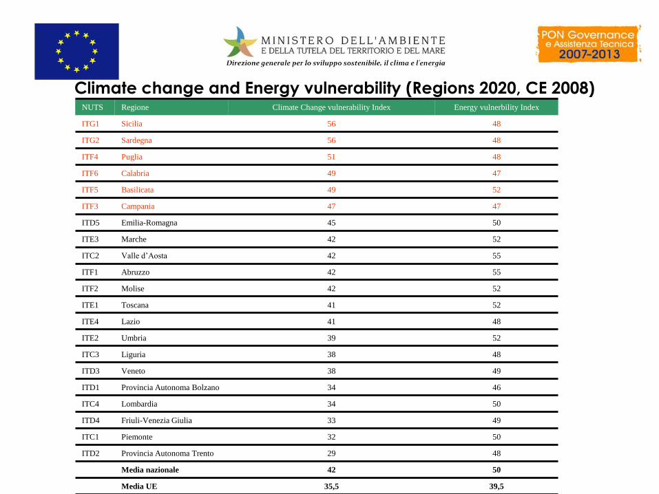
Climate change and Energy vulnerability (Regions 2020, CE 2008) NUTS Regione Climate Change vulnerability Index Energy vulnerbility Index
ITG1 Sicilia 56 48
ITG2 Sardegna 56 48
ITF4 Puglia 51 48
ITF6 Calabria 49 47
ITF5 Basilicata 49 52
ITF3 Campania 47 47
ITD5 Emilia-Romagna 45 50
ITE3 Marche 42 52
ITC2 Valle d’Aosta 42 55
ITF1 Abruzzo 42 55
ITF2 Molise 42 52
ITE1 Toscana 41 52
ITE4 Lazio 41 48
ITE2 Umbria 39 52
ITC3 Liguria 38 48
ITD3 Veneto 38 49
ITD1 Provincia Autonoma Bolzano 34 46
ITC4 Lombardia 34 50
ITD4 Friuli-Venezia Giulia 33 49
ITC1 Piemonte 32 50
ITD2 Provincia Autonoma Trento 29 48
Media nazionale 42 50
Media UE 35,5 39,5
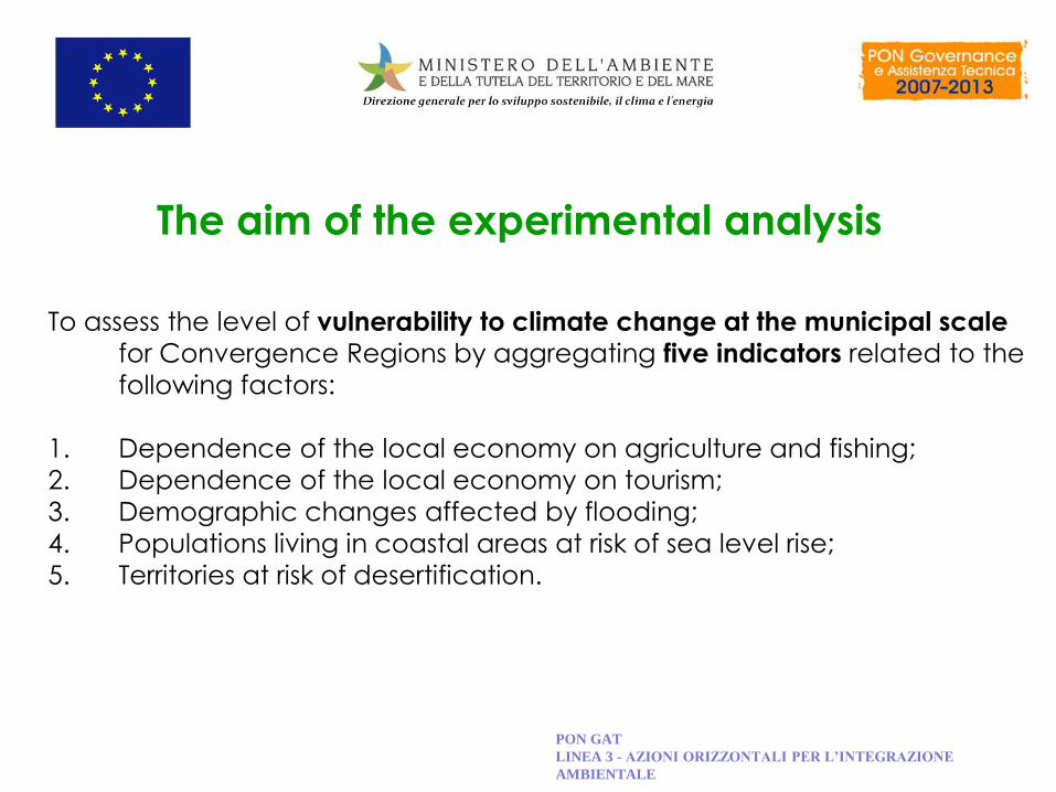
The aim of the experimental analysis
To assess the level of vulnerability to climate change at the municipal scale
for Convergence Regions by aggregating five indicators related to the
following factors:
1. Dependence of the local economy on agriculture and fishing;
2. Dependence of the local economy on tourism;
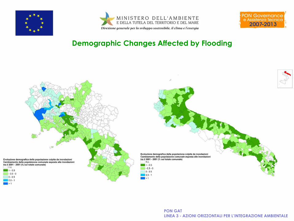
3. Demographic changes affected by flooding;
4. Populations living in coastal areas at risk of sea level rise;
5. Territories at risk of desertification.
PON GAT
LINEA 3 - AZIONI ORIZZONTALI PER L’INTEGRAZIONE
AMBIENTALE
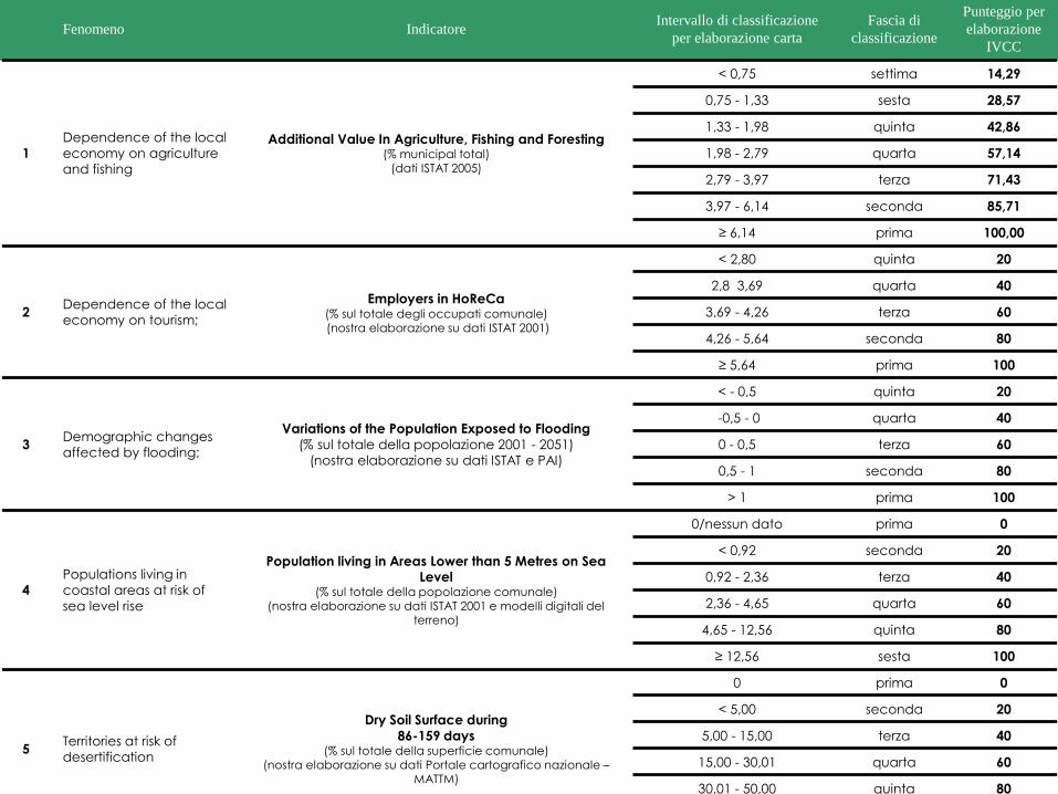
Fenomeno Indicatore Intervallo di classificazione
per elaborazione carta
Fascia di
classificazione
Punteggio per
elaborazione
IVCC
1
Dependence of the local
economy on agriculture
and fishing
Additional Value In Agriculture, Fishing and Foresting (% municipal total)
(dati ISTAT 2005)
< 0,75 settima 14,29
0,75 - 1,33 sesta 28,57
1,33 - 1,98 quinta 42,86
1,98 - 2,79 quarta 57,14
2,79 - 3,97 terza 71,43
3,97 - 6,14 seconda 85,71
≥ 6,14 prima 100,00
2 Dependence of the local
economy on tourism;
Employers in HoReCa (% sul totale degli occupati comunale) (nostra elaborazione su dati ISTAT 2001)
< 2,80 quinta 20
2,8 3,69 quarta 40
3,69 - 4,26 terza 60
4,26 - 5,64 seconda 80
≥ 5,64 prima 100
3 Demographic changes
affected by flooding;
Variations of the Population Exposed to Flooding
(% sul totale della popolazione 2001 - 2051)
(nostra elaborazione su dati ISTAT e PAI)
< - 0,5 quinta 20
-0,5 - 0 quarta 40
0 - 0,5 terza 60
0,5 - 1 seconda 80
> 1 prima 100
4
Populations living in
coastal areas at risk of
sea level rise
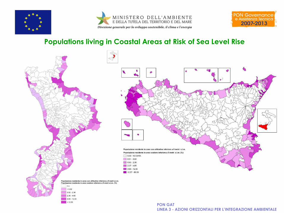
Population living in Areas Lower than 5 Metres on Sea Level
(% sul totale della popolazione comunale) (nostra elaborazione su dati ISTAT 2001 e modelli digitali del
terreno)
0/nessun dato prima 0
< 0,92 seconda 20
0,92 - 2,36 terza 40
2,36 - 4,65 quarta 60
4,65 - 12,56 quinta 80
≥ 12,56 sesta 100
5 Territories at risk of
desertification
Dry Soil Surface during 86-159 days
(% sul totale della superficie comunale) (nostra elaborazione su dati Portale cartografico nazionale –
MATTM)
0 prima 0
< 5,00 seconda 20
5,00 - 15,00 terza 40
15,00 - 30,01 quarta 60
30,01 - 50,00 quinta 80
≥ 50 sesta 100
PON GAT
LINEA 3 - AZIONI ORIZZONTALI PER L’INTEGRAZIONE AMBIENTALE
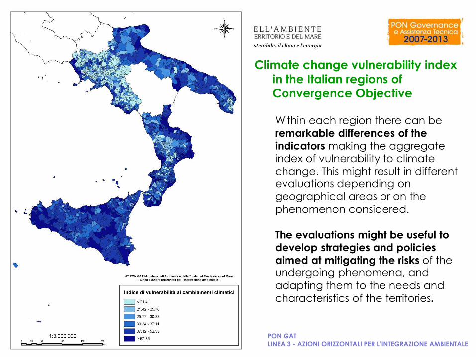
Within each region there can be
remarkable differences of the
indicators making the aggregate index of vulnerability to climate
change. This might result in different evaluations depending on
geographical areas or on the
phenomenon considered.
The evaluations might be useful to
develop strategies and policies
aimed at mitigating the risks of the undergoing phenomena, and
adapting them to the needs and
characteristics of the territories.
Climate change vulnerability index
in the Italian regions of
Convergence Objective
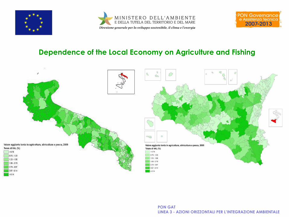
Dependence of the Local Economy on Agriculture and Fishing
PON GAT
LINEA 3 - AZIONI ORIZZONTALI PER L’INTEGRAZIONE AMBIENTALE
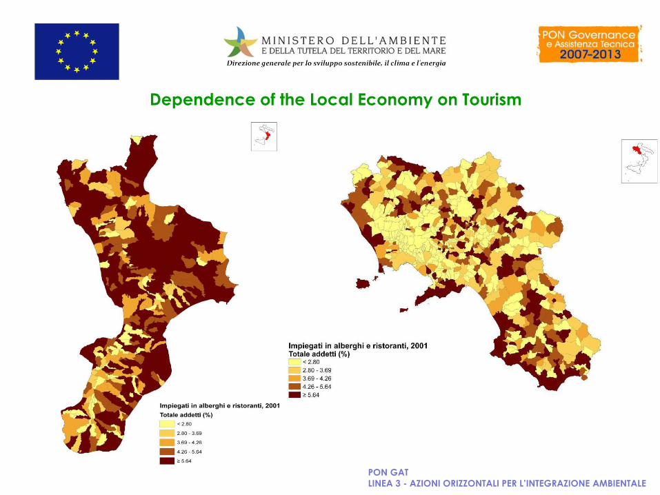
Dependence of the Local Economy on Tourism
PON GAT
LINEA 3 - AZIONI ORIZZONTALI PER L’INTEGRAZIONE AMBIENTALE
PON GAT
LINEA 3 - AZIONI ORIZZONTALI PER L’INTEGRAZIONE AMBIENTALE
Demographic Changes Affected by Flooding
PON GAT
LINEA 3 - AZIONI ORIZZONTALI PER L’INTEGRAZIONE AMBIENTALE
Populations living in Coastal Areas at Risk of Sea Level Rise
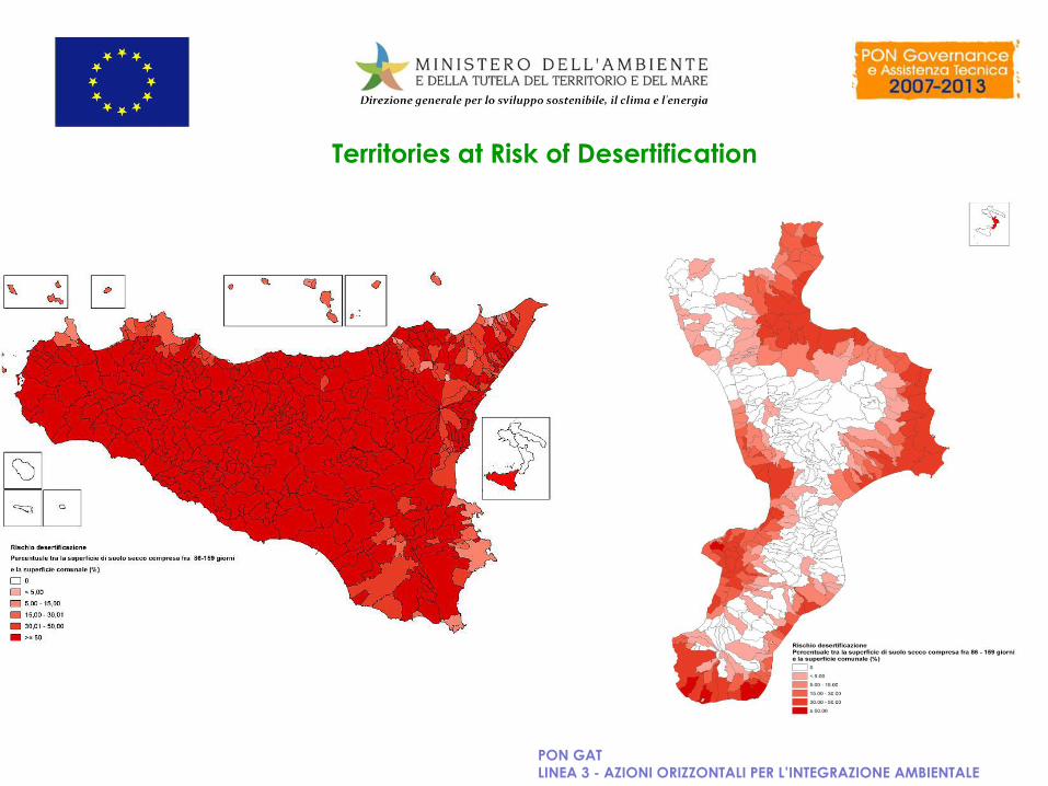
Territories at Risk of Desertification
PON GAT
LINEA 3 - AZIONI ORIZZONTALI PER L’INTEGRAZIONE AMBIENTALE
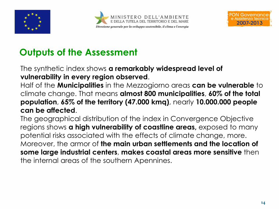
Outputs of the Assessment
14
The synthetic index shows a remarkably widespread level of
vulnerability in every region observed.
Half of the Municipalities in the Mezzogiorno areas can be vulnerable to
climate change. That means almost 800 municipalities, 60% of the total
population, 65% of the territory (47.000 kmq), nearly 10.000.000 people
can be affected.
The geographical distribution of the index in Convergence Objective
regions shows a high vulnerability of coastline areas, exposed to many
potential risks associated with the effects of climate change, more.
Moreover, the armor of the main urban settlements and the location of
some large industrial centers, makes coastal areas more sensitive then
the internal areas of the southern Apennines.
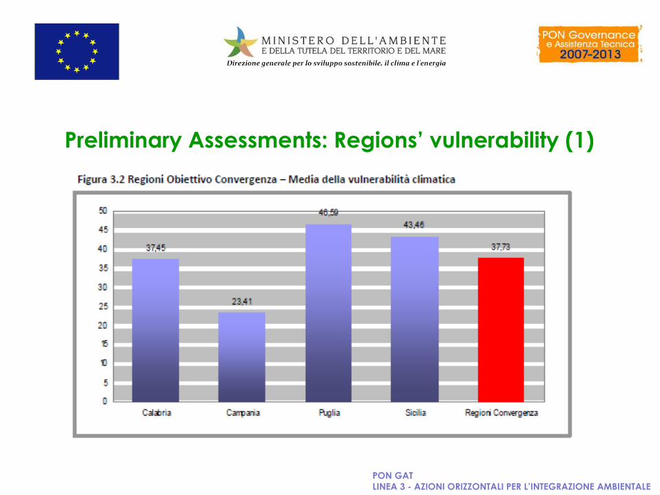
Preliminary Assessments: Regions’ vulnerability (1)
PON GAT
LINEA 3 - AZIONI ORIZZONTALI PER L’INTEGRAZIONE AMBIENTALE
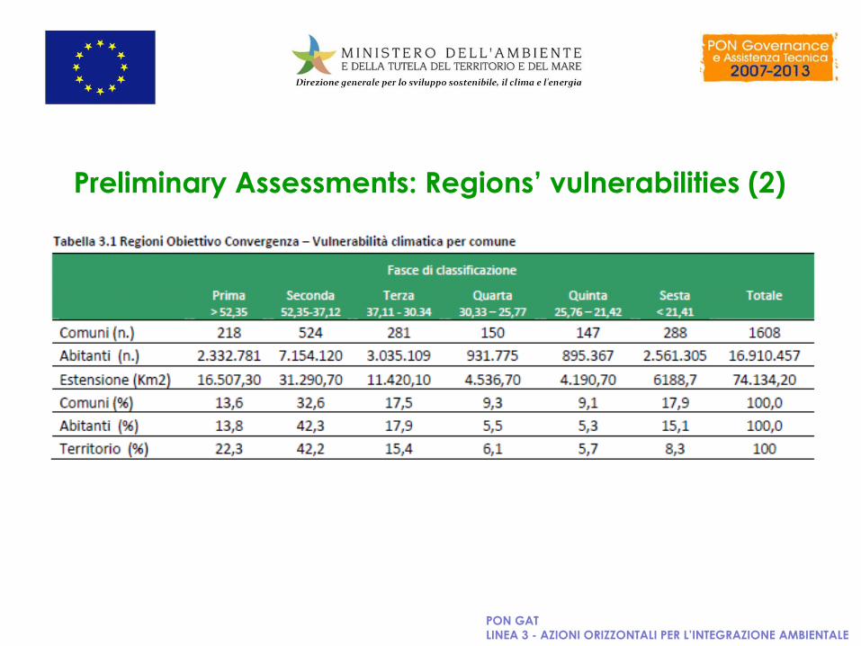
Preliminary Assessments: Regions’ vulnerabilities (2)
PON GAT
LINEA 3 - AZIONI ORIZZONTALI PER L’INTEGRAZIONE AMBIENTALE
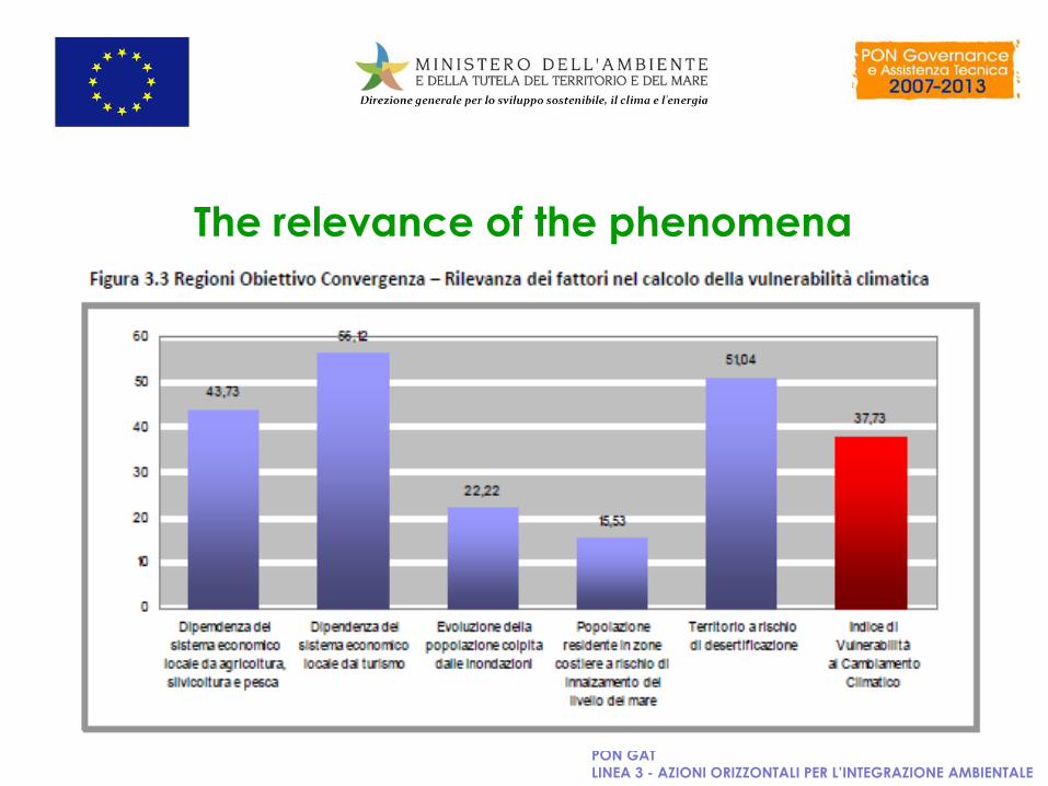
The relevance of the phenomena
PON GAT
LINEA 3 - AZIONI ORIZZONTALI PER L’INTEGRAZIONE AMBIENTALE
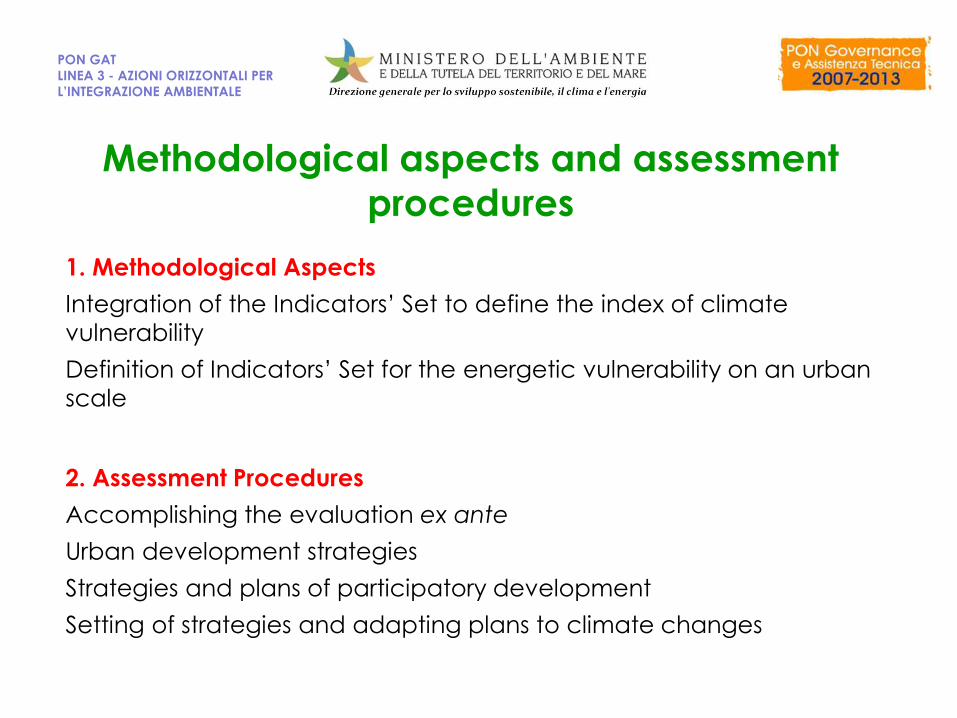
Methodological aspects and assessment
procedures
1. Methodological Aspects
Integration of the Indicators’ Set to define the index of climate
vulnerability
Definition of Indicators’ Set for the energetic vulnerability on an urban
scale
2. Assessment Procedures
Accomplishing the evaluation ex ante
Urban development strategies
Strategies and plans of participatory development
Setting of strategies and adapting plans to climate changes
PON GAT
LINEA 3 - AZIONI ORIZZONTALI PER
L’INTEGRAZIONE AMBIENTALE
PON GAT
LINEA 3 - AZIONI ORIZZONTALI
PER L’INTEGRAZIONE
AMBIENTALE
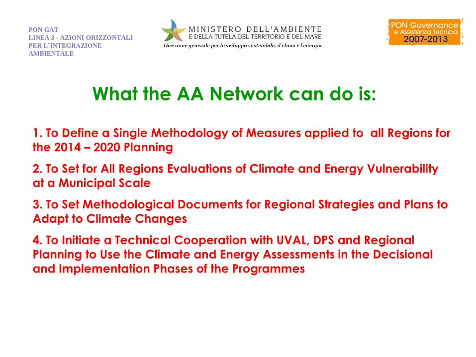
What the AA Network can do is:
1. To Define a Single Methodology of Measures applied to all Regions for
the 2014 – 2020 Planning
2. To Set for All Regions Evaluations of Climate and Energy Vulnerability
at a Municipal Scale
3. To Set Methodological Documents for Regional Strategies and Plans to
Adapt to Climate Changes
4. To Initiate a Technical Cooperation with UVAL, DPS and Regional
Planning to Use the Climate and Energy Assessments in the Decisional
and Implementation Phases of the Programmes
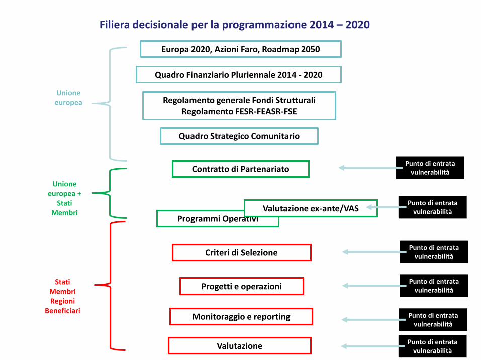
Filiera decisionale della programmazione 2004-2020
Europa 2020, Azioni Faro, Roadmap 2050
Regolamento generale Fondi Strutturali Regolamento FESR-FEASR-FSE
Quadro Strategico Comunitario
Contratto di Partenariato
Programmi Operativi
Criteri di Selezione
Progetti e operazioni
Monitoraggio e reporting
Valutazione ex-ante/VAS
Quadro Finanziario Pluriennale 2014 - 2020
Valutazione
Unione europea
Unione europea +
Stati Membri
Stati Membri Regioni
Beneficiari
Punto di entrata vulnerabilità
Punto di entrata vulnerabilità
Punto di entrata vulnerabilità
Punto di entrata vulnerabilità
Punto di entrata vulnerabilità
Punto di entrata vulnerabilità
Filiera decisionale per la programmazione 2014 – 2020
Authors
Ministero dell’Ambiente delle Tutela del Territorio e del Mare Giovanni BRUNELLI - Dirigente Direzione per lo Sviluppo Sostenibile,il Clima e l’Energia
Elio MANTI
Regione Campania Antonio RISI – Responsabile Autorità Ambientale
Pierfrancesco FIGHERA
Melania Rosaria ROMANO
Ferdinando D’ARGENIO
Regione Puglia Antonello ANTONICELLI – Direttore Area Ambiente
Giuseppe ANGELINI - Responsabile Autorità Ambientale
Erminia SGARAMELLA
Daniela BATTISTA
Alessandra LISI CERVONE
Regione Calabria Francesca CURRÀ – Nucleo di Valutazione
Ernesto NAIMO
Marco CAFERRO
Arturo VELTRI
Regione Siciliana Rossella REYES - Dipartimento Regionale della Programmazione
Angelo FUCARINO
PON GAT
LINEA 3 - AZIONI ORIZZONTALI PER
L’INTEGRAZIONE AMBIENTALE