Embed Size (px)
Citation preview
SCIENCE CHINA Physics, Mechanics & Astronomy
© Science China Press and Springer-Verlag Berlin Heidelberg 2012 phys.scichina.com www.springerlink.com
*Corresponding author (CAO YueLing, email: [email protected]; HU Xiao- Gong, email: [email protected]) †Recommended by ZHOU JiLin (Associate Editor)
• Article • July 2012 Vol.55 No.7: 1307–1315
doi: 10.1007/s11433-012-4746-1
The wide-area difference system for the regional satellite navigation system of COMPASS†
CAO YueLing1,2*, HU XiaoGong1*, WU Bin1, ZHOU ShanShi1, LIU Li3, SU RanRan3, CHANG ZhiQiao3, HE Feng3 & ZHOU JianHua3
1 Shanghai Astronomical Observatory, Chinese Academy of Sciences, Shanghai 200030, China; 2 Graduate University of Chinese Academy of Sciences, Beijing 100049, China;
3 Beijing Global Information Application and Development Center, Beijing 100094, China
Received February 25, 2012; accepted March 21, 2012; published online May 2, 2012
The regional satellite navigation system of COMPASS (Phase I) provides both open services and authorized services. Author-ized services offer differential corrections and integrity information to users to support higher positioning, navigation and tim-ing precision. Experimenting with real data, positioning accuracy is estimated with a 3GEO/4IGSO COMPASS constellation. The results show that with dual-frequency and single-frequency pseudo-range measurements, the positioning errors are respec-tively 8 and 10 m (RMS) for open service users, while for authorized users, the errors are 4 and 5 m (RMS), respectively. The COMPASS constellation geometry may cause large error to occur in the height component by 7–9 m for dual- or sin-gle-frequency users, which can be effectively reduced with the differential corrections supplied by the authorized services. Multipath errors are identified and corrected for COMPASS, resulting in 25% positioning accuracy improvement for du-al-frequency users and 10% improvement for single-frequency users.
COMPASS, equivalent satellite clock error, ionospheric grid, multipath error, positioning error
PACS number(s): 93.85.Bc, 02.30.-f, 06.20.Dk
Citation: Cao Y L, Hu X G, WU B, et al. The wide-area difference system for the regional satellite navigation system of COMPASS. Sci China-Phys Mech Astron, 2012, 55: 13071315, doi: 10.1007/s11433-012-4746-1
Despite of the extensive and popular applications of Global Navigation Satellite Systems (GNSS) such as GPS and GLONASS, these GNSS systems can no longer meet the demands of advanced users. Positioning precision, service continuity and integrity are critical for precise geographic surveying and aviation navigation, which may be achieved by building additional satellite-based or ground-based aug-mentation systems. For that purpose, Wide Area Augmenta-tion System (WAAS, http://www.gps.gov/technical/ps/), European Geostationary Navigation Overlay Service (EGNOS) and other augmentation systems have been cur-
rently developed. Maintained by different operating agen-cies and providing augmentation service to specific users, these augmentation systems are independent of GPS or GLONASS’ operation control systems [1–3].
The Chinese regional satellite navigation system of COMPASS adopts a unique system architectural design. Unlike other GNSS systems, COMPASS is in extensive use of Geostationary Earth Orbit (GEO) and Inclined Geosta-tionary Earth Orbit (IGSO) satellites which are more suita-ble for regional services and is designed to simultaneously provide open service (OS) and authorized service (AS) us-ing the same control and operation segment. Basic naviga-tion information is provided by OS for free in the form of navigational messages and differential corrections and in-tegrity information are provided to authorized users for the

1308 Cao Y L, et al. Sci China-Phys Mech Astron July (2012) Vol. 55 No. 7
need of high precision positioning and timing (http://www. beidou.gov.cn/xtjs.html).
Orbital errors, satellite clock errors and pseudo-range measurement errors are the main error sources for position-ing and timing [4,5]. Apparent positions of GEO satellites are relatively static to monitoring stations on ground, re-sulting in the high correlation in the determination of satel-lite orbits and satellite clocks. Moreover, limited geograph-ical distribution of monitoring network for COMPASS pre-sents challenge to the precise orbit determination. Since independent time synchronization (TS) system is developed to supplement the regional tracking network, orbits and clocks may be obtained by simultaneously processing both tracking and TS data. Consequently, uncalibrated instru-mental errors of TS system may degrade navigation accu-racy [6]. Cheaper single-frequency receivers are more pop-ular than dual-frequency receivers, and the ionospheric de-lay is one of the largest and more unpredictable sources of error for single-frequency receiver users [7].
Differential corrections for orbits, clocks as well as ion-ospheric delay are generated by processing data from mon-itor receivers in a near real-time mode and then broadcasted to authorized users. Given the constellation design of COMPASS, orbital and clock differential corrections are combined as one, or equivalent satellite clock error, which is computed as the average User Range Error (URE) of ser-vice area with uniformly distributed monitor stations whose coordinates are known precisely. This differential correction is updated rapidly to account for fast changing satellite clock errors. To minimize the ionospheric delay errors for single-frequency users, ASs provide regional ionospheric grid which is more accurate and timely than analytical func-tion based models. The ionospheric grid could be generated by setting up uniform and densely distributed tracking mon-itor stations.
Two modes of services are compared in Table 1. Multipath error is one of the largest errors in pseudo-
range observations. Serious multipath errors have been identified in pseudo-range for COMPASS GEO/IGSO sat-ellites with peak-peak multipath errors reaching more than 4 m [8]. Impacts of pseudo-range multipath errors on the dif-ferential information are evaluated, and real-time multipath error correction for COMPASS is proposed by improving the methods developed for WAAS in this study.
1 Wide-area differential algorithm
The observation equation of pseudo-range is as follows:
sat
rcv orb satclk satclk tgd
cor rcvclk IFB mp
| |
( ) ,i
i i
P t
f iono t t t
i
i i
X X
(1)
where iP is pseudo-range; subscript i indicates different
frequency; satX and rcvX are satellite and receiver posi-
tion vectors; satclkt and rcvclkt are satellite and receiver
clock errors; orb and satclk are projections of satellite
orbit and clock errors in line of sight; tgd i and IFB i rep-
resent satellite relative group delay and receiver in-ter-frequency bias [9]; ( )if iono is the function of iono-
spheric delay; cort is system errors which could be mod-
eled precisely, such as tropospheric correction, antenna phase center correction, ocean tide correction; mpt i and
i are multipath error and noise. The information such as
satellite orbit, satellite clock, ionosphere and satellite rela-tive group delay in observation eq. (1) can be obtained from navigation (NAV) messages. The NAV prediction errors become larger with time which could be effectively cor-rected with differential corrections by analyzing data col-lected at reference stations with high-precision known coor-dinates [3,5].
The satellite clock errors translate into pseudo-range measurements, but projections of satellite orbit errors vary with observation directions. As orbital altitudes are as high as about several ten thousand kilometers, the angle between orbital radial direction and any user’s line-of-sight direction within COMPASS’s regional service area is less than 10°. If the largest URE caused by orbit radial error is R, the mini-mum URE will be 0.98R . The difference between the aver-age URE in the regional area and the actual URE will be less than 1% R. Since the orbit radial error R is usually less than 1 m [4], the difference is about 1 cm and can be ne-glected. To take advantage of this minor difference, COMPASS uses equivalent satellite clock parameter to correct satellite clock errors and orbit radial errors as well as average projection of orbit tangential and normal errors in combination. The equivalent satellite clock error is denoted
Table 1 Comparison of OS and AS
Aspects OS AS
Users Public users Authorized users
Monitor stations master monitor station/orbit determination stations
7 in total master monitor station/orbit determination stations/
differential monitor stations 27 in total Orbits and satellite clocks navigation message navigation messages + equivalent satellite clock error parameters
Ionospheric correction 8 parameters/14 parameters Klobuchar models 5°×5° ionospheric grid
Information transmitting all satellites GEO satellites
Updating period 1 h for orbits and satellite clocks; 2 h for ionospheric
model parameters 18 s for equivalent satellite clock error;
3 min for ionospheric grid
Cao Y L, et al. Sci China-Phys Mech Astron July (2012) Vol. 55 No. 7 1309
as pcor in the paper: orb satclkpcor .
In eq. (1), system errors are calculated by models and the ionospheric delay is eliminated by dual-frequency meas-urements combination. Treating receiver clock error and receiver inter-frequency bias as one of the unknown varia-bles, pcor and the receiver clock errors may be estimated based on the navigation message and pseudo-range meas-urements of multi-stations to multi-satellites, if the receiver coordinates are precisely known as given in eq. (2).
rcvclk IFB
2 22 21 tgd1 2 tgd2 sat1 1 2 2
rcv2 2 2 21 2 1 2
satclk cor mp
( )
| |
.
pcor t
f ff P f P
f f f f
t t t
X X
(2)
For the satellite relative group delay tgd is usually not
precisely determined, from eq. (2) one can see that the cali-brated error of tgd will affect the accuracy of equivalent
satellite clock error. Multipath errors mpt should also be
taken into account. For dual-frequency or triple-frequency users, ionospheric delay could be corrected effectively by observation combination. For single-frequency users, mod-els must be developed to correct for the ionospheric delay. Different ionospheric models generally have unequal accu-racies [10].
In COMPASS’ OS mode, Klobuchar 14 and Klobuchar 8 parameters are broadcasted in the NAV message to calcu-late ionospheric delay. At present, accuracy of these models is about 70% [11].
For authorized users, COMPASS provides Ionospheric Grid Point (IGP) corrections every 5° latitude and longitude grid point over the service coverage area and broadcasts the corrections every 3 min. Both the spatial and time resolu-tions are improved over the NAV models. The authorized single-frequency users may estimate the Ionospheric Pierce Point (IPP) delay by utilizing the vertical delays at the sur-rounding four IGPs.
The algorithm to compute IGP delay is as follows: Firstly, the Monitor receivers’ IPP delay is extracted with
dual-frequency pseudo-range measurements, where IPP is the point at where the receiver’s line-of-sight to satellite intersects at an assumed ionospheric shell.
Secondly, each IGP delay may be estimated by interpo-lating the monitor receivers’ IPP delay to its surrounding four grids, as given in eq. (3):
ippipp ipp2
Grid2
ipp
/
,(1 / )
i
i
TECFu R
fTEC
Rf
(3)
where, 2ipp / iTEC f is IPP delay; 2
Grid / iTEC f is IGP de-
lay; ippFu is the mapping function of IPP delay and
ipp 1 / cos( )Fu z ; z is the zenith angle; ippR is the spheri-
cal distance between IPP and IGP; other parameters are according to eq. (1).
2 Real-time multipath correction
Significant multipath errors have been detected in pseudo- range observations of the regional satellite navigation sys-tem [8], which may seriously affect the accuracy of differ-ential corrections. In order to estimate effects caused by the multipath error on pcor, precise orbits and clocks are used in this experiment instead of the predictive orbits. pcor es-timates so obtained contain multipath errors but contribu-tions from satellite orbit and clock errors are minor.
Though carrier phase measurements have high precision and small multipath errors, they are usually used for post analysis for the precise estimation of integrity ambiguity and cycle slips. In the paper, we use the post-processing carrier phase measurements to compute wide-area differen-tial corrections to compare with the results of the pseudo- range measurements.
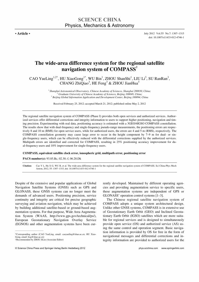
Figure 1 illustrates the pcor for one GEO satellite (top subplot) and for one IGSO satellite (bottom subplot). The red points are the pcor estimates computed with raw pseu-do-range data and the blue points are those computed with carrier phase data. It can be seen that the pcor computed with raw pseudo-range data is seriously contaminated by multipath errors. Peak-peak value error produced by multipath is 1–2 m with standard deviations reaching 0.2– 0.3 m.
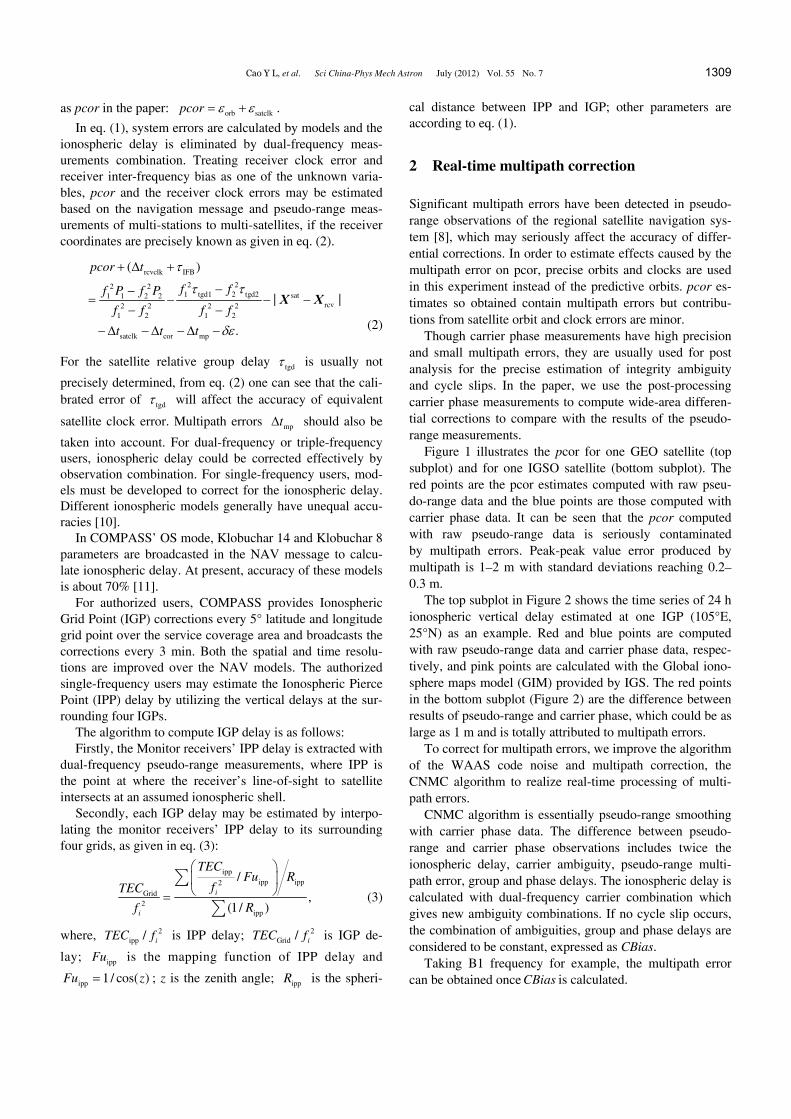
The top subplot in Figure 2 shows the time series of 24 h ionospheric vertical delay estimated at one IGP (105°E, 25°N) as an example. Red and blue points are computed with raw pseudo-range data and carrier phase data, respec-tively, and pink points are calculated with the Global iono-sphere maps model (GIM) provided by IGS. The red points in the bottom subplot (Figure 2) are the difference between results of pseudo-range and carrier phase, which could be as large as 1 m and is totally attributed to multipath errors.
To correct for multipath errors, we improve the algorithm of the WAAS code noise and multipath correction, the CNMC algorithm to realize real-time processing of multi-path errors.
CNMC algorithm is essentially pseudo-range smoothing with carrier phase data. The difference between pseudo- range and carrier phase observations includes twice the ionospheric delay, carrier ambiguity, pseudo-range multi-path error, group and phase delays. The ionospheric delay is calculated with dual-frequency carrier combination which gives new ambiguity combinations. If no cycle slip occurs, the combination of ambiguities, group and phase delays are considered to be constant, expressed as CBias.
Taking B1 frequency for example, the multipath error can be obtained once CBias is calculated.

1310 Cao Y L, et al. Sci China-Phys Mech Astron July (2012) Vol. 55 No. 7
Figure 1 Multipath error in equivalent satellite clock correction. Top subplot is GEO PCOR; bottom subplot is IGSO PCOR; red points are the results computed with raw pseudo-range; blue points are the results computed with carrier phase data; black points are the results computed with CNMC pseu-do-range.
Figure 2 Multipath error in IGP. Top subplot is 24 h vertical ionospheric delay. Red, raw pseudo-range results; black, CNMC pseudo-range results; blue, carrier phase results; pink, GIM model results. Bottom subplot is the difference between raw pseudo-range and carrier phase (red) and difference between CNMC pseudo-range and carrier phase (green).
2
21 1 1 22 2
1 2
2( ) ,p
fM P L L L CBias
f f
(4)
where pM is multipath error; 1P is B1 pseudo-range; 1L
and 2L are B1, B2 carrier phase; if is frequency.
Cao Y L, et al. Sci China-Phys Mech Astron July (2012) Vol. 55 No. 7 1311
The CBias estimate is initialized as follows, where 0t
is initial time:
2
20 0 0 1 0 2 02 2
1 2
2( ) ( ) ( ) [ ( ) ( )].
fCBias t P t L t L t L t
f f
(5)
After initialization, the CBias estimate is updated as fol-lows:
1
22
1 1 22 21 2
1( ) ( ) ( ) ( )
2 ( ) ( ( ) ( )) ,
i i i i
i i i
CBias t CBias t P t L tN
fCBias t L t L t
f f
(6)
where it is the update time; N is number of updates in the
estimate. CNMC algorithm needs to be initialed when a cycle slip
is detected. The initial estimate value of CBias contains multipath error and will converge to true value as the epoch increasing. Varying with amplitudes of initial multipath errors, the initialization process may cost about 1–3 h. Ex-periments show that the RMS of pseudo-range multipath errors decreases from 0.4 m to 5–6 cm with the CNMC re-al-time processing. In this paper, pseudo-range corrected with CNMC algorithm is denoted CNMC pseudo-range. The black curve In Figure 1 is the time series of pcor com-puted with CNMC pseudo-range. Comparison with pcor computed with carrier phase data shows that the accuracy is significantly improved. The black curve in the top subplot in Figure 2 are the ionospheric delay of the IGP computed with CNMC pseudo-range and green points in the bottom subplot are the differences with respect to ionospheric delay time series computed with carrier phase data. The results show that the residual multipath errors in IGP are only sev-eral centimeters after CNMC processing.
3 Results and discussion
3.1 User Equivalent Ranging Error (UERE)
User positioning accuracy for observations of navigation systems depends mainly on two factors, namely the Dilution of Precision (DOP) and User Equivalent Range Error (UERE). The DOP is a function of the geometry of the sat-ellite constellation with respect to the user and depends on the location of the user. UERE is defined as the residuals by removing other errors like ionosphere delay and troposphere delay errors in pseudo-range measurements. It is primarily related to the error resource in the signal propagation [12]. Under the current constellation design, the precision of user positioning could only be improved by the reduction of UERE [4].
We analyzed the influence of wide-area differential cor-rections on the UERE in AS based on the comparison with
the UERE in OS. The formula of UERE calculation for OS and AS are as follows:
sat
OS rcv satclk tgd cor
rcvclk IFB
| |
( ) ,
UERE P t t
f iono t
X X
sat
AS rcv satclk tgd cor
rcvclk IFB
| |
( ) ,
UERE P t t
f iono t pcor
X X
where OSUERE and ASUERE are UERE in open and AS,
respectively. For single-frequency users f (iono) is the ion-ospheric corrections from Klobuchar 14 parameter model in OS and Ionospheric Grid in ASs, respectively. Eq. (7) is usually used for system evaluation. According to the system design, PCOR is the differential corrections and provided to authorized users only to correct their pseudo- range obser-vations.
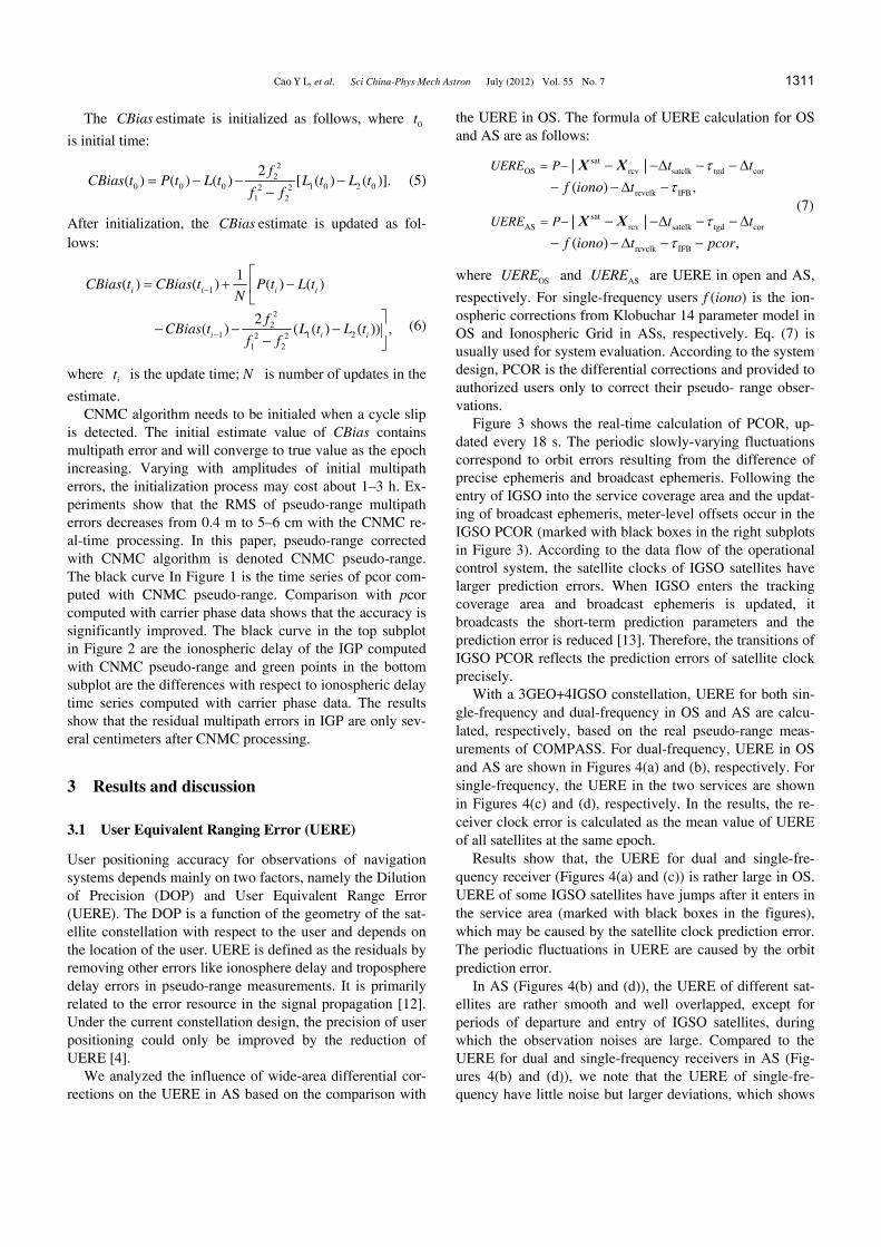
Figure 3 shows the real-time calculation of PCOR, up-dated every 18 s. The periodic slowly-varying fluctuations correspond to orbit errors resulting from the difference of precise ephemeris and broadcast ephemeris. Following the entry of IGSO into the service coverage area and the updat-ing of broadcast ephemeris, meter-level offsets occur in the IGSO PCOR (marked with black boxes in the right subplots in Figure 3). According to the data flow of the operational control system, the satellite clocks of IGSO satellites have larger prediction errors. When IGSO enters the tracking coverage area and broadcast ephemeris is updated, it broadcasts the short-term prediction parameters and the prediction error is reduced [13]. Therefore, the transitions of IGSO PCOR reflects the prediction errors of satellite clock precisely.
With a 3GEO+4IGSO constellation, UERE for both sin-gle-frequency and dual-frequency in OS and AS are calcu-lated, respectively, based on the real pseudo-range meas-urements of COMPASS. For dual-frequency, UERE in OS and AS are shown in Figures 4(a) and (b), respectively. For single-frequency, the UERE in the two services are shown in Figures 4(c) and (d), respectively. In the results, the re-ceiver clock error is calculated as the mean value of UERE of all satellites at the same epoch.
Results show that, the UERE for dual and single-fre- quency receiver (Figures 4(a) and (c)) is rather large in OS. UERE of some IGSO satellites have jumps after it enters in the service area (marked with black boxes in the figures), which may be caused by the satellite clock prediction error. The periodic fluctuations in UERE are caused by the orbit prediction error.
In AS (Figures 4(b) and (d)), the UERE of different sat-ellites are rather smooth and well overlapped, except for periods of departure and entry of IGSO satellites, during which the observation noises are large. Compared to the UERE for dual and single-frequency receivers in AS (Fig-ures 4(b) and (d)), we note that the UERE of single-fre- quency have little noise but larger deviations, which shows
(7)

1312 Cao Y L, et al. Sci China-Phys Mech Astron July (2012) Vol. 55 No. 7
Figure 3 Real-time equivalent satellite clock correction (red points are results from raw pseudo-range, blue points are results from CNMC pseudo-range, left subplots are the GEO PCOR, right subplots are the IGSO PCOR). X-axis is time, unit hour. mean and std are respectively mean value and stand deviation of PCOR.
Figure 4 (a) Dual-frequency UERE in OS; (b) dual-frequency UERE in AS; (c) single-frequency UERE in OS; (d) single-frequency UERE in AS. In the figures, red, green and blue points are GEO UERE, black, yellow, pink and indigo are IGSO UERE, X-axis is time, unit hour, and Y-axis unit is meter.

Cao Y L, et al. Sci China-Phys Mech Astron July (2012) Vol. 55 No. 7 1313
the accuracy of ionospheric grid correction model. In user positioning, the common segment of UERE for
different satellites will be absorbed by receiver clocks, and the varying segment will affect positioning precision. Using 48 h’ data with sampling at 10 s, we derive the statistic of UEREs. RMS of UERE for dual-frequency receivers are 1.4 and 0.4 m in OS and AS, respectively. For single-fre- quency users, The RMS of UERE are 1.8 and 0.6 m in OS and AS.
Analysis of UERE for multi-days shows that the results are at the same level. We can see that UERE drops with the introduction of wide-area differential corrections in AS.
3.2 Real-time single point positioning (SPP)
SPP is performed using dual-frequency and single-fre- quency pseudo-range of monitor stations in OS and AS. In data analysis, troposphere delay, ocean tide, relativity cor-rection, satellite and receiver antenna phase center offsets are corrected by the model.
The coordinates of the monitor stations have been pre-
cisely determined using GPS, with accuracy better than 10 cm and are used as benchmarks to evaluate the calculated positioning accuracy. The precision of positioning are pre-sented in east, north and height components.
The time series of SPP for one of the stations are shown in detail. Figure 5 shows the positioning accuracy for du-al-frequency receiver, while Figure 6 shows the positioning accuracy for single-frequency receiver. In the top subplots of each figures, red, green and blue points describe the posi-tioning error in east-west, north-south and height compo-nents, respectively. In the middle subplots, red points rep-resent the three-dimensional positioning error. In the lower subplots, pink, blue and black points represent the DOP in east-west, north-south and height components, respectively. The RMS of positioning errors and the mean value of DOP during 48 h are shown in Table 2.
For the four stations, the statistics of DOP in three com-ponents during 48 h are shown in Table 3. With MEO satel-lites join in COMPASS service, positioning accuracy is expected to improve given the improvement in positioning geometry.
Figure 5 (a) Positioning error computed by dual-frequency raw pseudo-range in OS; (b) positioning error computed by dual-frequency raw pseudo-range in AS; (c) positioning error computed by dual-frequency CNMC pseudo-range in AS. In top subplots are positioning errors in east-west, north-south and height components; in middle subplots is 3D positioning error; in bottom subplots are DOP in east-west, north-south and height components.

1314 Cao Y L, et al. Sci China-Phys Mech Astron July (2012) Vol. 55 No. 7
Figure 6 (a) Positioning error computed by single-frequency raw pseudo-range in OS; (b) positioning error computed by single-frequency raw pseu-do-range in AS; (c) positioning error computed by single-frequency CNMC pseudo-range in AS. In top subplots are positioning errors in east-west, north-south, height directions; in middle subplots is 3D positioning error; in bottom subplots are DOP in east-west, north-south, height components.
Table 2 User positioning error and DOP (48 h)
Frequency mode
Service mode East-west compo-
nent error (m) North-south compo-
nent error (m) Height component
error (m) Three-dimensional position error (m)
East-west DOP
North-south DOP
Height DOP
Dual- frequency
OS 1.04 3.86 5.25 6.60
1.1 2.4 4.2 AS (raw pseudo-range) 0.46 1.23 2.42 2.75
AS (CNMC pseudo-range) 0.31 0.82 1.37 1.63
Single- frequency
OS 1.31 3.85 5.51 6.84
1.1 2.4 4.2 AS (raw pseudo-range) 0.49 1.86 3.77 4.23
AS (CNMC pseudo-range) 0.48 1.81 3.55 4.02
Table 3 DOP in east, north and height components
Station ID East-west North-south Height
1 1.0 2.8 4.3
2 2.3 2.3 4.0
3 1.1 2.4 4.2
4 1.1 2.6 4.6
3.2.1 Positioning accuracy for dual-frequency
Figure 5(a) shows positioning error in OS with raw du-al-frequency pseudo-range observations. The positioning error in AS with raw pseudo-range observations and CNMC
pseudo-range observations are shown in Figures 5(b) and (c), respectively.
It shows that the largest DOP is in height component and the smallest is in east-west component. The discontinuity of the DOP is caused by the departure and entry of IGSO. The jump in the height component is caused by the satellite clock errors of IGSO.
From Table 2, we see that the largest positioning error is in height component, and it varies with time. The position-ing precision in east-west component is best. Compared with OS, the three-dimensional positioning accuracy is im-proved by 60% in the AS. After multipath error is corrected

Cao Y L, et al. Sci China-Phys Mech Astron July (2012) Vol. 55 No. 7 1315
by CNMC, the positioning errors and noise are clearly re-duced, particularly in the height component.
The analysis of four monitor stations show that, with du-al-frequency raw pseudo-range observations, the RMS of three-dimensional positioning error is about 8 m in OS, of which 7 m is in height component. While in AS, the RMS of three-dimensional positioning error is reduced to 4 and 3 m in the height component.
3.2.2 Positioning accuracy for single-frequency With the same navigation information and differential cor-rections, SPP is performed using the single-frequency pseudo-range observations.
Figure 6(a) shows the positioning errors in OS with raw pseudo-rang observations. Figures 6(b) and (c) show the positioning errors in AS with raw pseudo-range and CNMC pseudo-range observations, respectively.
We notice that the three-dimensional positioning error is still large for single-frequency even in the AS. Analysis of four monitor stations shows that, using single-frequency original pseudo-range observations, the RMS of three-di- mensional positioning error is about 10 m in OS, of which 9 m is in height component. In AS, the RMS of three-dimen- sional positioning error is only 5 and 4 m is in the height component. The positioning accuracy is improved by 50% in the AS.
4 Conclusions
After assessing pseudo-range multipath errors on the esti-mates of equivalent satellite clock corrections and grid models of ionospheric delay, we have proposed an algo-rithm (CNMC) based on WAAS multipath error elimination method, to realize real-time pseudo-range multipath error correction. Firstly, experiments show that with this algo-rithm precision of differential information provided to COMPASS’ authorized users can be effectively improved. The AS accuracy of regional satellite navigation system for COMPASS is reported for the first time, through UERE and positioning errors comparison for dual-frequency and sin-gle-frequency users. Features in positioning errors and DOP factors relevant to the 3GEO/4IGSO constellation are iden-tified and discussed. Experimenting with real data from COMPASS shows that for COMPASS’ authorized users, the UERE for dual-frequency and single-frequency users are improved by 70% and 60%, respectively with the appli-cation of wide-area differential corrections.
Secondly by limiting the constellation geometry of the regional satellite navigation system, positioning errors in height and north-south components are larger than for the east-west component. This limitation can be overcome for authorized users for whom differential corrections infor-mation is available. For double-frequency and sin-gle-frequency users, the positioning accuracy are improved by 50% and 30%, respectively in the height components, and by 70% and 50%, respectively in the north-south com-ponent when such differential corrections are applied.
Thirdly, the multipath errors in GEO/IGSO pseudo-range deteriorate the precision of differential corrections by 0.2–0.5 m and could seriously affect the AS accuracy. The CNMC algorithm proposed can efficiently correct the mul-tipath errors and reduce the impacts to the centimeter level. Analysis of monitor receiver data show that with CNMC corrections, SPP accuracy is about 3 and 4.5 m for dual- frequency and single-frequency users respectively after the application of differential corrections.
Positioning accuracy is significantly improved for COMP- ASS’ AS users, however the accuracy for single-frequency users is still not acceptable for double-frequency users by about 2 m, suggesting significant errors remaining in the ionospheric grid models. Aiming to improve the modeled ionospheric delay grid models, further efforts are planned in following studies. Among them is the simultaneous estimation of DCB parameters (TGD for satellites and IFB for receiv-ers) along with ionospheric grid values. New fitting meth-ods for IGP delay estimation and smaller grid spaces are expected to improve spatial resolutions for the grid models.
This work was supported by the National Natural Science Foundation of China (Grant Nos. 11103064 and 11173049) and the Shanghai Committee of Science and Technology, China (Grant No. 11ZR1443500).
1 Hein G W. From GPS and Glonass via GENOS to Galileo-positioning and navigation in the third millennium. GPS Solut, 2000, 3(4): 39–47
2 Song W L, Tan S S. The current status and development of WAAS technique (in Chinese). Radio Eng China, 2007, 37(6): 50–52
3 Ashley W L, Umberto G, Fernandez J L. EGNOS: A step closer to operational qualification. In: Proceedings of the 19th International Technical Meeting of the Satellite Division of the Institute of Navi-gation (ION GNSS). Fort Worth: Fort Worth Convention Center, 2006. 906–912
4 Zhou S S, Hu X G, Wu B, et al. Orbit determination and time syn-chronization for a GEO/IGSO satellite navigation constellation with regional tephemeris and clock algorithms racking network. Sci Chi-na-Phys Mech Astron, 2011, 54: 1089–1097
5 Chen J P. Research of GPS Integrity Augmentation (in Chinese). Dissertation for Doctoral Degree. Zhengzhou: Institute of Surveying and Mapping Information Engineering University, 2001
6 Wen R H, Feng X C. Research on time delay characteristic of para-bolic antenna along with temperature variety (in Chinese). Radio Eng, 2010, 40(6): 42–44
7 Allain D J, Mitchell C N. Ionospheric delay corrections for sin-gle-frequency GPS receivers over Europe using tomographic map-ping. GPS Sol, 2009, 13(2): 141–151
8 Feng X C, Cheng X B, Gao S, et al. The study of analysis methods for multipath effect of GNSS receiver’s measurement data (in Chi-nese). GNSS World China, 2010, 01: 11–15
9 Huang S L, WU X L, Liu L, et al. Separation solution methods of TGD and IFB for compass system (in Chinese). Geom Sci Eng, 2010, 03: 28–32
10 Zhang H P, Ping J S, Zhu W Y, et al. Brief review of the ionospheric delay models (in Chinese). Prog Astron, 2006, 24(1): 16–26
11 Wu X L, Ping J S, Liu L, et al. Hardware delay solution of regional satellite navigation system (in Chinese). Geom Inform Sci Wuhan Univ, 2011, 36(10): 1218–1221
12 Jiao W H, Ding Q, Li J W, et al. Monitoring and assessment of GNSS open services (in Chinese). Sci Sin-Phys Mech Astron, 2011, 41: 521– 527
13 Zhu L F, Tang B, Li C. Analysis on performances of the two models for satellite clock error prediction (in Chinese). J Spacecr TT&C Technol, 2007, 26(3): 39–43