Embed Size (px)
Citation preview


This page is left intentionally blank

Learning from the April 25, 2015, Nepal earthquake: Mapping the deformation and site response
Learning from earthquakes: Every earthquake offers a learning experience, enabling researchers to be prepared for future events. So is the recent pair of large earthquakes that shook parts of Nepal and the northern Indian plains. Even at the face of the tragedy that an earthquake brings along, earthquake scientists must prepare themselves to go through its effects on natural settings as well as built environment. The April 25th and May 12th, 2015 earthquakes in Nepal present themselves as the two major post-instrumentation era events in the Himalayan region and they provide an unprecedented opportunity to study the earthquakes in relation to the seismotectonic settings of the Himalayan convergence. Besides, these also provide templates to revisit the historically documented earthquakes and their effects in this region that has witnessed many events in the past. Through a specific project to facilitate field studies and learning from the earthquake effects, the Ministry of Earth Sciences and the Indian Institute of Science, have provided us the opportunity to learn from the actual effects of a large Himalayan earthquake. This brief report presents our preliminary observations during the field trip through the north Indian plains of UP and Bihar to parts of Nepal that were affected by the earthquake. Our observations are presented in the general background of the seismotectonic setting of the Himalaya. General background: The May 25, Mw 7.8 earthquake in the Nepal Himalaya was not a surprise as it occurred within the eastern segment of the postulated central seismic gap, considered as a locked segment of the Himalaya, where the Indian and Eurasian continents are converging at the rate of ~ 18-20 mm/yr ( 2000). It is quite well-known that the present-day structure of the Himalaya has resulted from the progressive underthrusting of the Indian plate, leading to a stack of thrust sheets that get progressively younger, southward. In this geometry, the oldest and the northernmost is the Main Central Thrust (MCT), followed by the Main Boundary Thrust (MBT) and the Main Frontal Thrust (MFT), all of which sole into the Main Himalayan Thrust (MHT) (Fig. 1). The deeper part of the MHT is believed to be creeping smoothly while the shallower parts slips episodically during great earthquakes such as the 1905 Kangra and 1934 Nepal events.

Fig. 1 : (a) Map showing large and great earthquakes along the Himalayan arc (modified from Rajendran et.al., 2015). Several of the lower magnitude, but significant earthquakes in the Jammu and Kashmir region haven’t been plotted here(b) Shows the cross-section of the terrain, highlighting the HFT, MBT and MCT
Fig. 2: Earthquake locations for the Mw 7.8 April 25th event, the Mw 7.3 May 12th event and their corresponding aftershock effects.

The segment between the 1905 and 1934 ruptures has not slipped in a great earthquake in the historically recorded period and earth scientists had forecasted that a large earthquake is imminent in this part known as the central gap. The documented history also suggests of the occurrence of large earthquakes in eastern Nepal (e.g., 1255, 1833 events etc.) suggesting that there
Thrust faulting near Kakani. P.C.: Thulasiraman Natarajan
Fig. 3: Preliminary moment tensor inversion solution for the Mw 7.8, April 25th, 2015 event. As can be noted from the slip distribution, maximum slip occurs towards the East of the mainshock. This is consistent with field observations.
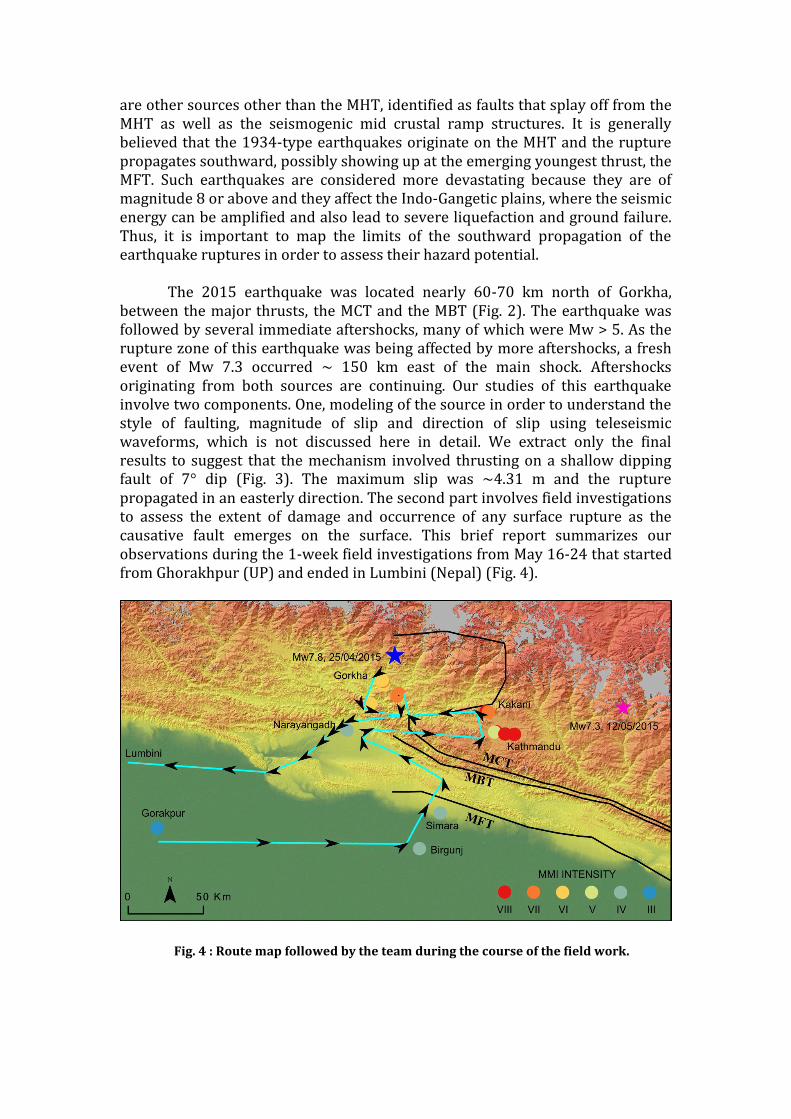
are other sources other than the MHT, identified as faults that splay off from the MHT as well as the seismogenic mid crustal ramp structures. It is generally believed that the 1934-type earthquakes originate on the MHT and the rupture propagates southward, possibly showing up at the emerging youngest thrust, the MFT. Such earthquakes are considered more devastating because they are of magnitude 8 or above and they affect the Indo-Gangetic plains, where the seismic energy can be amplified and also lead to severe liquefaction and ground failure. Thus, it is important to map the limits of the southward propagation of the earthquake ruptures in order to assess their hazard potential. The 2015 earthquake was located nearly 60-70 km north of Gorkha, between the major thrusts, the MCT and the MBT (Fig. 2). The earthquake was followed by several immediate aftershocks, many of which were Mw > 5. As the rupture zone of this earthquake was being affected by more aftershocks, a fresh event of Mw 7.3 occurred ~ 150 km east of the main shock. Aftershocks originating from both sources are continuing. Our studies of this earthquake involve two components. One, modeling of the source in order to understand the style of faulting, magnitude of slip and direction of slip using teleseismic waveforms, which is not discussed here in detail. We extract only the final results to suggest that the mechanism involved thrusting on a shallow dipping fault of 7° dip (Fig. 3). The maximum slip was ~4.31 m and the rupture propagated in an easterly direction. The second part involves field investigations to assess the extent of damage and occurrence of any surface rupture as the causative fault emerges on the surface. This brief report summarizes our observations during the 1-week field investigations from May 16-24 that started from Ghorakhpur (UP) and ended in Lumbini (Nepal) (Fig. 4).
Fig. 4 : Route map followed by the team during the course of the field work.

Field observations:
1. Intensity surveys:
In order to assess damage due to past earthquakes, that which lack any instrumental record, intensity surveys are carried out. These surveys involve researchers systematically noting down accounts of locals who experienced the effects of the past earthquake and assigning a measure of the damage based on the MSK/Modified Mercalli scale.
The motivation behind conducting these kinds of surveys for modern earthquakes is largely to verify the damage patterns reported from instrumental records (GPS, InSAR, PGA/PGV) as well as from modeling studies (Seismic Waveform/ Moment Tensor Inversion). Our study involved interviewing 31 participants, on the 25th April Nepal earthquake, geographically spanning from the North Indian plains all the way to the high mountain villages of Nepal (Fig. 4). The route we traced on our onward journey was one through Gorakhpur in Uttar Pradesh to the capital city of Nepal, Kathmandu through the border town of Birgunj with a stopover at Narayanghat. The questionnaire contained 22 questions spanning from type of building construction, building damage and ground deformation to level of panic. We assigned points to each questionnaire based on the match with the MSK scale and provide a visual tool to assess the damage and destruction associated with the Nepal earthquake. The intensity of the earthquake experienced at each of these surveyed regions is colour-coded and plotted in Fig. 4.

The results of our survey yielded some very unusual findings. a) The greatest damage was concentrated in the Kathmandu valley area.
The photograph shows a row of buildings that fell against one-another in the valley adjacent to the Swayambhunath Temple in Kathmandu.
P.C.: Matthew Wood.
Sifting through the rubble. P.C. : Matthew Wood

b) Heritage sites such as Bhaktapur were brought down to rubble and debris.
Destruction to a church in Kathmandu. The number of casualties here was ~47. P.C. : Matthew Wood
One of the most affected regions in Bhaktapur, Kathmandu. P.C. : Matthew Wood

The fallen alley - Bhaktapur. P.C. : Matthew Wood
Studying the style of construction in Bhaktapur was crucial to making comparisons with the large number of standing structures in and around Kathmandu. P.C. : Matthew Wood

c) Villages located near the epicenter and to the west of the extent of the fault seemed to observe a lower intensity of damage.
d) Southern Nepali towns show up only as a 5-6 on the MSK scale with a progressive increase in magnitude towards the north.
This survey brings up a rather interesting point to consider – the maximum damage was actually observed far away from the epicenter while epicentral regions seem to have observed only moderate damage. Bias towards population centers has always been a problem in using felt reports to locate earthquakes, and the 2015 event is a clear example. The other aspect of damage is the site-specific amplification of seismic energy which also give rise to biases in locating historical earthquakes.
One of the many multi-storeyed buildings that still stand tall in a village within the Gorkha district of Nepal. The epicentre of the April 25th quake lies just ~60 km north of this hamlet. P.C. : Thulasiraman Natarajan

2. Damage to structures A common observation in all the Nepali towns that our team visited was that old buildings (>30 years old) collapsed either partially or completely. On inspecting the materials used in construction we found that they were invariably made of unburnt bricks with mud and cement (rarely) as a binder. In some cases when cement had been used as a binder, there was no bonding structure to the brick laying (no interlocking structures)
Several newer buildings also seemed to have collapsed due to ground shaking, but on closer inspection we found that these buildings were constructed in phases. For example, the foundation was laid with only a ground floor in mind, but in the last couple of years higher storeys were added. The result of such poor planning is that the structural integrity of the ground floor compromised during the intense shaking following the earthquake, and the higher storeys come crashing down on the basement. We examined the possibility of liquefaction of the soft sediments which form the Kathmandu valley, though we observed no such effects. However, a contemporary report by Geotechnical Extreme Events Reconnaissance (GEER) has stated that there have been liquefaction events in Manamaiju, Ramkot, Chagunarayan, Hattiban and Imadol; most of which fall along the fringes of the Kathmandu Valley (Nepal – 2015 April 25 Mw 7.8 Gorkha
This structure near Swayambhunath temple in Kathmandu is a stark example of buildings that have poor interlocking bricks layered using mud as the binder. P.C. : Revathy Parameswaran

Earthquake, GEER, 2015. Further the GEER reports of extensive landslides and
related failure from the northern parts, closer to the Higher Himalayas which our team
could not examine due to issues with logistics. As for the brick buildings, new or old, poor design seemed to be the single most important factor that controlled the damage.
Although this building seems perfectly fine from afar, a closer look reveals that it collapsed over its own ground floor! The white square-inset has been blown up to show a squished car beneath the structure. Thankfully there were no casualties here. P.C. : Matthew Wood.

Well-planned buildings irrespective of their age remain standing with only marginal external damage to plaster or small on the outer surface. In fact, sites like Bhaktapur show this type of buildings standing while all the poorly constructed buildings around it lie in its constituent elements on the ground.
The brick-coloured building in the far-left was constructed as per the new rules established for civil constructions in Nepal. It sustained little damage during the April quake in comparison to the devastation down the same alley. P.C. : Matthew Wood.
This building is one of the many examples of how a single, poorly-constructed house can damage adjacent structures. Note the girders used in the construction of beams and pillars. Inset shows the effect of the quake on the building and its surroundings. P.C. : Matthew Wood.

It is imperative to point out that there was only nominal damage to roads, bridges, electric poles, concrete culverts etc. The roads that we traversed did not show any sign of earthquake damage, and even in the hilly towns electric poles and lines remain intact. Assessing the spatial variation in structural damage only reinforces our observations from the intensity survey. Thus, towns such as Gorkha, Mugling and Phujel, located near the western extent of the fault plane showed much less destruction to man-made environment as opposed to the Kathmandu valley area and Bhaktapur. Furthermore, damage to roads was minimal and was localized to the eastern edge of the Kathmandu valley. The damage from this earthquake once again reiterates the fact that it was shoddy construction that was the real killer.
3. Damage to heritage structures Akin to most of the flourishing civilizations in the world, a sizable history of the region’s physical and climatic history is recorded by heritage sites and old temples. One of the most popular historical heritage sites in Kathmandu is the Pashupathinath Temple. It caught the attention of popular media mostly because despite major quakes like the 1934 Bihar earthquake and 2015 Nepal events, the main shrine sustained minimal damage. This sparked local awe and therefore, the media was eager to feature this site extensively. For the same reason, our team visited the site to examine the damages caused by the 2015 Nepal pair of earthquakes. The only notable damage observed was in the main entrance where the wooden pillar has detached from the brick-framework. The outer walls have also developed some deep seated cracks.
The main entrance to Pashupathinath Temple
P.C. : Matthew Wood.

Adjacent to the Pashupathinath stands an old temple named Poonsva Mahadev which the local population believes to be more than 200 years old. The structure is currently also used as an old-age home. One of the administrative personnel of this facility elaborated on the changes that the structure had undergone due to seismic activity over the last 100 years. The structure had apparently sustained immense damage during the 1934 A.D. (this is equivalent of 1990 B. S., Bikram Sampath, year in the Nepali Calendar) Bihar earthquake. It was later restored. The April 25th, earthquake affected it to a smaller extent, as compared to its 1934 processor. Based on the information we obtained from the local population, neither of these earthquakes caused damages to the Sanctum Sanctorum of the temple. Also, the May 12th, 2015, Mw 7.3 event left the temple unaffected.
Deep cracks on the construction along the outer walls of the Pashupathinath Temple.
P.C. : Matthew Wood.

Damage sustained by Poonsva Mahadev temple. P.C. : Matthew Wood.
Fallen plaster and tilted shrine ornaments in Poonsva Mahadev. P.C. : Matthew Wood.

One of the prime attractions of Kathmandu city has been the Dharara or the Bhimsen tower. Based on the local knowledge, we have roughly reconstructed the timeline for this historical structure. The Dharara is believed to have been built in 1825 B.S. and stood tall at 11 storeys at the time. The structure collapsed during the 1990 B.S. (1934 A.D.) Bihar quake and was rebuilt to 9 storeys later. During the April 25th, there were 67-70 tourists within the Dharara and many perished. Local shop-owners who work ~10 m away from the main structure describe the collapse of the tower as follows – “ We were inside, at the farther end of the shop, when the shaking began. We could not move. However we managed to somehow cross the length of the shop (~2m) and head to the door. We saw the tower sway twice. And then it collapsed completely in the next 3-5 seconds… It killed almost everyone inside…”
The once mighty symbols of Nepal now lie in ruins. The ruins of their iconic Dharara remain painful memories of the deadly quake. Despite such overwhelming loss, the hardworking and strong-willed citizens are at work, rebuilding their nation, with amazing resilience.
The dilapidated Dharara P.C. : Matthew Wood.

4. Ground failure Admittedly, our trip to the earthquake-affected Nepal was overshadowed by the reports of the visual media, which almost reported that most of Kathmandu remains buried under the ruins. Thus we were prepared to face situations where maneuverability within towns would be extremely difficult. We were pleasantly surprised to find that all the major highways were intact, and though we took a very roundabout route (Fig. 4) to reach the capital, we hardly noticed any ground deformation or fissures on the roads. Apart from the intermittent appearance of collapsed brick houses, it seemed like most of the countryside had not experienced a Mw7.8 thrust earthquake. Of course we were told that the picture is quite different in some parts of the affected areas, where landslides have blocked the routes and many villages were cut off. Perhaps, the fast paced relief operations made it possible to drive through these narrow mountain roads that are now cleared of the debris. In the city of Kathmandu we did observe some landlevel changes and evidences of fissures and ground deformation. The Araniko Highway (en route Bhaktapur from Kathmandu) showed some remarkably consistent trending fractures on either side of the road, with the central part of the road slumping by almost 90 cm (information obtained from local authorities). We were able to trace these cracks all the way into alleys where they were lost in the foundation of buildings.
One of the makeshift houses built by the locals along Balaji Road near Swayambhunath temple in Kathmandu.
P.C. : Revathy Parameswaran

To back up our findings, we conducted Kinematic GPS surveys on both sides of the road so as to create a Digital Elevation Model (DEM) of the surface and corroborate the findings of the local authorities.
Site of slumping on Arniko Highway. Continuous line shows visible cracks while dotted lines are inferred continuation of structure.
One of the linear cracks cutting across the Arniko Highway. P.C. : Matthew Wood

From our own interviews of the locals we found out that the slumped part of the road used to be a lake-bed many years ago, which was filled up to make the highway. Therefore, the fissures seem to have developed as the filled part yielded. Several extensional fractures including failure of drainage pipes were observed on the flanks of this slump feature.
5. Microtremor studies Damage to a city like Kathmandu, built on soft sediments is expected to sustain severe damage. In the post-earthquake scenario, which suggested severe damage at some parts of the valley and practically no damage at other sites, we obtained ambient noise (microtremor) data from several sites (eg. Balaji road, Kathmandu; Dharara, Kathmandu; Gorkha; Kakani etc) using three component sensors. These data are to be processed to compute the spatial variations of dominant frequencies and amplification factors, and examine their control over the observed damage. However the spatial variations in the intensity of damage needs to be explored with further analysis.
6. Visit to Shiva cave Staligmites and other growth structures in the Himalayan caves are considered proxies for tilting and breakage from earthquake shaking. Siddababa Gupha, a limestone cave in Bimalnagar that displays the classic stalagmite and stalactite formations, was another spot of our study. One of our collaborators, Dr. C.P.Rajendran, had visited the very same cave 2 years ago and was curious to check if the recent earthquake had caused
Thulasiraman setting up a three-component sensor at a site next to the Dharara P.C. : Matthew Wood

any disturbances to the structures in the cave. The climb to the cave involved an increase in elevation of about 280m on a steep and tortuous stairway. Our guide for this cave exploration was Bhim Singh, a local of Bimalnagar, who was actually in the heart of the cave when he felt the ground shake during the earthquake. Instead of running out, he just remained inside and prayed, staring at the dark silence of the cave. As the shaking passed by, Mr. Singh made his way to the mouth of the cave, thankful that he was not crushed by detached roof of the cave. He later checked and saw that nothing had collapsed, not even the most vulnerable straws that grow from the ceilings.
.
7. Relief and rehabilitation efforts: Relief and aid is still pouring into Nepal from various parts of the world. We saw trucks carrying food, blankets, bricks and construction material forming a long line at the border. In the affected towns and villages, tents provided by Indian, Chinese and Japanese agencies had become make shift homes for refugees and the locals alike. Most people appeared scared to go back into their houses at night in fear of another large earthquake. We also met some high-spirited and tough soldiers from the Indian Army, involved in clearing the debris and rescue operations in Bhaktapur Several people helped us in undertaking this task, which looked quite arduous, as we planned it out, pitched against the ground reports and another large aftershock that occurred just three days before our departure. Mr. Sunil Kupperi, an Indian relief worker in Kathmandu
The Seismology and GPS lab team from CEaS, IISc, accompanied by Harsh Lekhak at the mouth of the Siddababa Cave. P.C. : Matthew Wood

offered help in finding a place to stay. Juggling between the tasks of relief operations and his own official duties, he found time to chat with us and direct us to the most affected areas. The Nepali people themselves were very forthcoming with information surrounding the earthquake and were eager to assist us and learn what could be done to avoid this kind of damage in the future. Mr. Rajat found us somewhat lost in the ruins of Bhaktapur, and offered to spend the rest of the day with us, also explaining the various activities, group prayers and community lunches, slowly getting back to life. Mr. Harsh Lekhak, part of a Nepali disaster mitigation NGO chose to join us for the next few days and helped us with Nepali translation, as we passed through the villages, searching for any evidence of ground deformation.
Part of the team with the Indian Army regiment that was posted in Nepal for rescue and restoration operations. P.C. : Matthew Wood

Survey team from IISc: Prof. Kusala Rajendran (Associate Professor at CEaS, IISc)
- [email protected] Thulasiraman N (Ph.D student at CEaS, IISc)
- [email protected] Revathy Parameswaran (Ph.D student at CEaS, IISc)
- [email protected] Rishav Mallick (M.Tech student at CEaS, IISc)
Collaborative participants: Prof. C.P. Rajendran (Scientist G, NCESS; Faculty, JNCASR)
- [email protected] ; [email protected] Matthew Peter Wood (Ph.D student at University of Melbourne)
This report was prepared by:- Revathy M. Parameswaran (Ph.D student at CEaS, IISc) Thulasiraman N (Ph.D student at CEaS, IISc) Rishav Mallick (M.Tech student at CEaS, IISc) - With inputs from Prof. Kusala Rajendran, Dr C.P. Rajendran and Matthew
Peter Wood. Acknowledgements: The post-earthquake survey by the IISc team at Nepal and Northern India was supported by the Ministry of Earthsciences and the Indian Institute of Science Bangalore. We acknowledge help from Sunil Kupperi and Harsh Lekhak at Nepal. Furthermore, we particularly thank Matthew Wood, who is also a professional photographer, for the vivid shots featured in this report.

![[PAGE INTENTIONALLY LEFT BLANK]€¦ · inogen, inc. fiscal 2015 annual report. [page intentionally left blank]](https://img.pdfslide.net/doc/110x75/603dd78a05f41851485839e0/page-intentionally-left-blank-inogen-inc-fiscal-2015-annual-report-page-intentionally.jpg)


![[This space left intentionally blank]](https://img.pdfslide.net/doc/110x75/568159d1550346895dc723b5/this-space-left-intentionally-blank.jpg)


![Handbook [This Page Intentionally Left Blank]](https://img.pdfslide.net/doc/110x75/622f73f2d735c167bc7fe569/handbook-this-page-intentionally-left-blank.jpg)
![[This page intentionally left blank.] - Regina](https://img.pdfslide.net/doc/110x75/61b424db652c60231a4f25af/this-page-intentionally-left-blank-regina.jpg)