Embed Size (px)
Citation preview
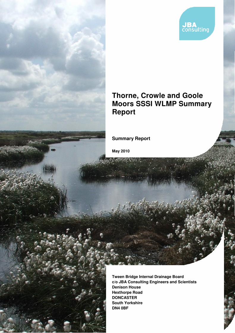
Thorne, Crowle and Goole Moors SSSI WLMP Summary Report
Summary Report May 2010 Tween Bridge Internal Drainage Board c/o JBA Consulting Engineers and Scientists Denison House Hexthorpe Road DONCASTER South Yorkshire DN4 0BF

2008s3746 Thorne Moors WLMP Summary Report v5.doc
2008s3746 Thorne Moors WLMP Summary Report v5.doc i
JBA Office JBA Consulting Denison House Hexthorpe Road Doncaster South Yorkshire DN4 0BF
JBA Project Manager Kieran Sheehan
Revision History Revision Ref / Date Issued Amendments Issued to
Draft Summary Report June 2010 Tween Bridge IDB
Contract This summary report describes work commissioned by Tween Bridge Internal Drainage Board (IDB) under Environment Agency letter of 3rd March 2009. Tween Bridge IDB’s representative for the contract was Ian Benn. Alex Jones, Kieran Sheehan, Ian Morley and Sam Bishop of JBA Consulting carried out the work.
Prepared by .................................................. Alexander Jones BSc MSc
Assistant Analyst (Hydrogeologist)
Reviewed by ................................................. Kieran Sheehan BSc MSc PGCE MIEEM MIfL
Senior Analyst (Ecologist)
Purpose This summary document has been prepared solely as a draft report for Natural England and the partner IDBs. JBA Consulting accepts no responsibility or liability for any use that is made of this document other than by the Client for the purposes for which it was originally commissioned and prepared.
2008s3746 Thorne Moors WLMP Summary Report v5.doc ii
Acknowledgments JBA would like to thank Natural England for providing vegetation and dipwell data for this study and granting access to the site. Special thanks should also go to the six Internal Drainage Boards who have sponsored the production of this Water Level Management Plan, with financial support from the Environment Agency.
Copyright © Jeremy Benn Associates Limited 2010
Carbon Footprint
107g
A printed copy of the main text in this document will result in a carbon footprint of 107g if 100% post-consumer recycled paper is used and 136g if primary-source paper is used. These figures assume the report is printed in black and white on A4 paper and in duplex.
JBA is a carbon neutral company and the carbon emissions from our activities are offset.

Contents
2008s3746 Thorne Moors WLMP Summary Report v5.doc
1.� Thorne, Goole and Crowle Moors Water Level Management Plan ................. 1�
1.1� Introduction and Background ................................................................................. 1�1.2� WLMP Investigative Works .................................................................................... 2�1.3� Restoration Aims ................................................................................................... 7�1.4� Proposed Plans ..................................................................................................... 9�1.5� Impacts of Thorne, Goole and Crowle Moors on the surrounding land ................. 10�
Appendices........................................................................................................................ I�
A.� Additional Figures ............................................................................................... I�
2008s3746 Thorne Moors WLMP Summary Report v5.doc
List of Figures Figure 1-1: Historic Land Uses on and around the Site ............................................. 2�
Figure 1-2: Broad Habitat Types across the SSSI ....................................................... 4�
Figure 1-3: Sub-regions of the SSSI ............................................................................. 6�
Figure 1-4: Water Level Classification across the SSSI ............................................. 8�
Figure 1-5: Surface water Discharge Points ................................................................ 11�
Figure 1-6 Natural England Proposed HPZ and the Adjusted Proposed HPZ (Green = Natural England Proposed HPZ, Blue = proposed adjustments and Red = SSSI site boundary) .................................................. 12�
Figure A 1: Implementation Plan - Engineering Works ............................................. I�
Figure A 2: Implementation Plan - Scrub Clearance .................................................. I�
List of Tables Table 1-1: Costings break-down by area ...................................................................... 10�
2008s3746 Thorne Moors WLMP Summary Report v5.doc 1
1. Thorne, Goole and Crowle Moors Water Level Management Plan
1.1 Introduction and Background This report summarises the findings of a programme of investigatory studies, to inform a revision of the current Water Level Management Plan (WLMP) for Thorne, Crowle and Goole Moors Site of Special Scientific Interest (SSSI). Recommendations are made that, if implemented, will increase the site’s ability to maintain high stable water levels, which will improve the ecological condition of the site.
Thorne, Crowle and Goole Moors form the largest lowland raised mire in England and were designated as a SSSI in 1986. Thorne Moors have since been internationally recognised, being designated as a Special Protection Area (SPA) and Special Area of Conservation (SAC). A condition assessment carried out by Natural England on 1st September 2008 found the SSSI to be in unfavourable condition, and cited drainage as a particular problem.
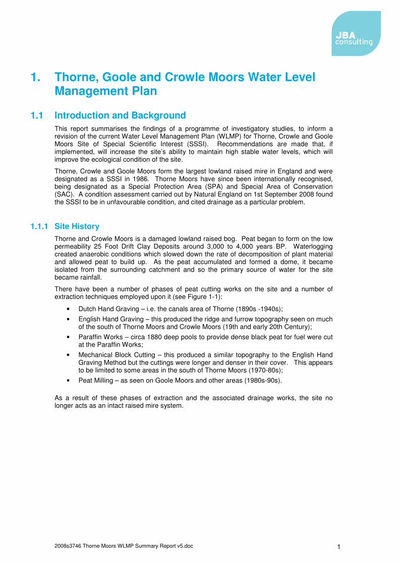
1.1.1 Site History Thorne and Crowle Moors is a damaged lowland raised bog. Peat began to form on the low permeability 25 Foot Drift Clay Deposits around 3,000 to 4,000 years BP. Waterlogging created anaerobic conditions which slowed down the rate of decomposition of plant material and allowed peat to build up. As the peat accumulated and formed a dome, it became isolated from the surrounding catchment and so the primary source of water for the site became rainfall.
There have been a number of phases of peat cutting works on the site and a number of extraction techniques employed upon it (see Figure 1-1):
• Dutch Hand Graving – i.e. the canals area of Thorne (1890s -1940s); • English Hand Graving – this produced the ridge and furrow topography seen on much
of the south of Thorne Moors and Crowle Moors (19th and early 20th Century); • Paraffin Works – circa 1880 deep pools to provide dense black peat for fuel were cut
at the Paraffin Works; • Mechanical Block Cutting – this produced a similar topography to the English Hand
Graving Method but the cuttings were longer and denser in their cover. This appears to be limited to some areas in the south of Thorne Moors (1970-80s);
• Peat Milling – as seen on Goole Moors and other areas (1980s-90s).
As a result of these phases of extraction and the associated drainage works, the site no longer acts as an intact raised mire system.
2008s3746 Thorne Moors WLMP Summary Report v5.doc 2
OS Licence 100018880 2010
Figure 1-1: Historic Land Uses on and around the Site
1.2 WLMP Investigative Works The aim of the investigative works was to research existing information about the site and produce new data which could be used to practically inform the WLMP. The following methodology was used to determine the recommendations proposed;
• A review of the historic development of the site to aid in understanding its current nature;
• A vegetation survey to identify the spatial distribution of habitats, identify key vegetation features, give an indication of the water level height and its fluctuations and inform the levels to which particular areas will achieve the desired vegetation communities;
• Geological, hydrological and hydrogeological conceptualisation was undertaken to understand how water is supplied to and moves through the system, and the controls upon the watertable;
• A semi quantitative assessment of the degree to which water level targets are currently being achieved on site;
2008s3746 Thorne Moors WLMP Summary Report v5.doc 3
• A review of the current Hydrological Protection Zone (HPZ) to assess where water level targets might not be achieved due to drainage around the site’s periphery.
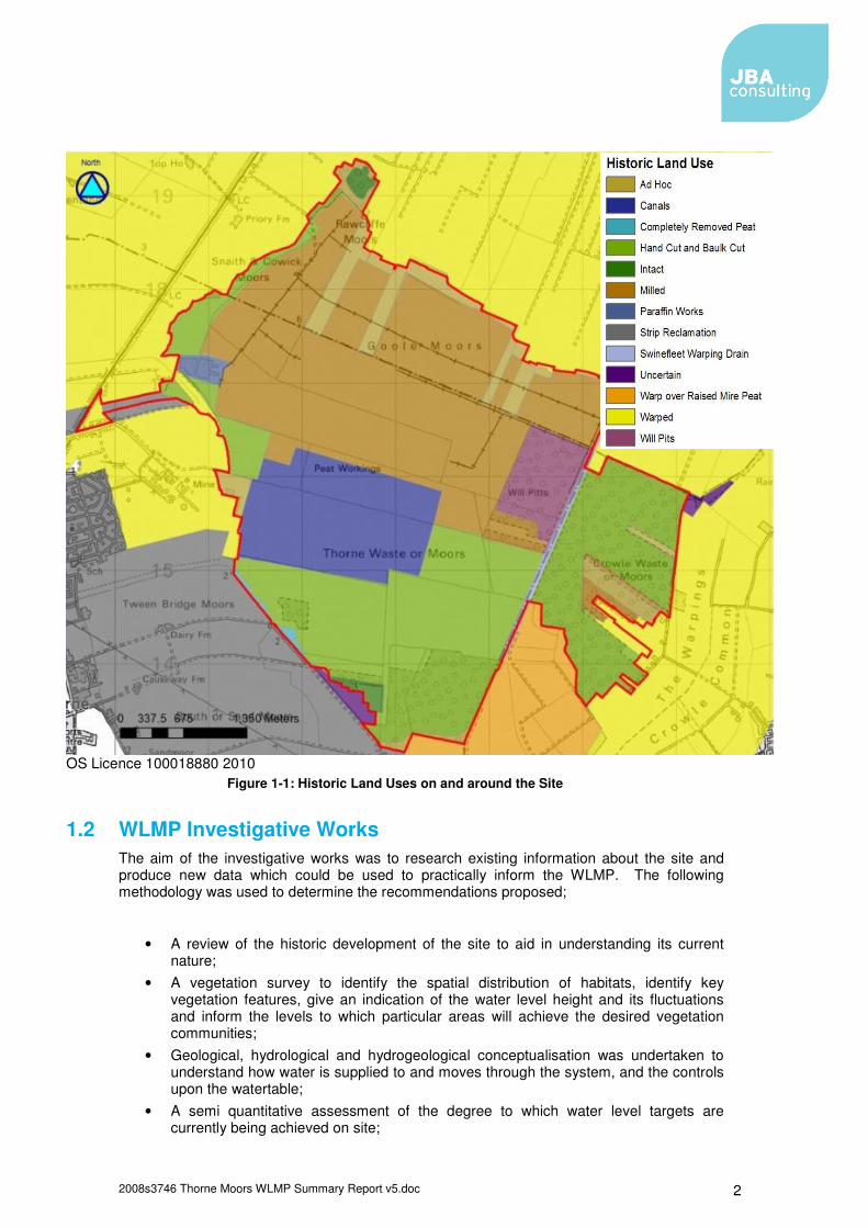
1.2.1 Ecology and Vegetation The main vegetation interest on the site revolves around its restoration into an intact lowland raised mire, with its associated plant communities. At present the vast majority of Thorne, Crowle and Goole Moors do not meet the definition of a raised mire and much of the vegetation can be categorised as poor fen, woodland of various sorts, and open water with some grassland areas around the periphery of the peat mass (Figure 1-2). This does not mean that the existing vegetation cover does not contain any interest, in fact, quite the contrary, the moors are home to a number of rare and unusual plants, including many species of moss.
2008s3746 Thorne Moors WLMP Summary Report v5.doc 4
OS Licence 100018880 2010
Figure 1-2: Broad Habitat Types across the SSSI
At present the majority of the woodland is concentrated south of the Limestone (Fison’s) Road, much of it being birch (Betula spp.) pioneer woodland that has developed on the areas of bare peat. There are, however, a few exceptions to this, including the wet woodlands at Pony Bridge and Will Pitts as well as the Oak (Quercus robur) woodland at Woodpecker Corner.
Poor fen exists over much of the centre of the site and, in some areas, is taking over from the birch woodland as the site becomes wetter. This habitat is characterised by the presence of soft rush (Juncus effusus) and cotton-grasses (Eriophorum spp.) and thins out northwards where it grades into the peat flats of Goole Moors and its large areas of ephemeral open water.
2008s3746 Thorne Moors WLMP Summary Report v5.doc 5
Crowle Moors is composed of the poor fen, birch scrub woodland and wet woodland habitats, although here their distribution is linear, based on the land holding pattern and subsequent peat-cutting that has occurred in the area.
Neutral grasslands are scattered around the periphery of the site, especially in the Inkle Moor area, with isolated patches elsewhere, such as at Elmhirst. The presence of grassland on the site is indicative of the underlying clay being present at the surface, i.e. areas that have previously been warped, cut for peat or, alternatively, areas that have never formed part of the raised mire.
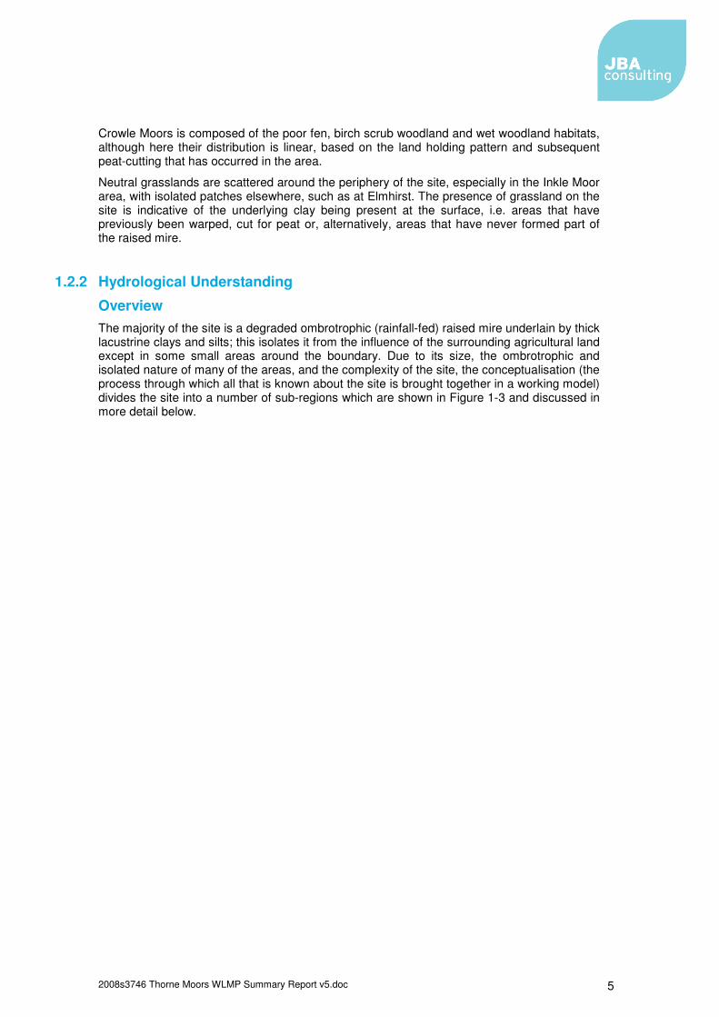
1.2.2 Hydrological Understanding
Overview The majority of the site is a degraded ombrotrophic (rainfall-fed) raised mire underlain by thick lacustrine clays and silts; this isolates it from the influence of the surrounding agricultural land except in some small areas around the boundary. Due to its size, the ombrotrophic and isolated nature of many of the areas, and the complexity of the site, the conceptualisation (the process through which all that is known about the site is brought together in a working model) divides the site into a number of sub-regions which are shown in Figure 1-3 and discussed in more detail below.
2008s3746 Thorne Moors WLMP Summary Report v5.doc 6
OS Licence 100018880 2010
Figure 1-3: Sub-regions of the SSSI
Northern Goole Moors Northern Goole Moors is an isolated area of intact raised mire. The area is bordered by ditches on all sides which drain the mire, leading to the establishment of bracken and birch woodland around the edges. In the centre, the watertable is near or at the surface during the winter and some Sphagnum is present.
The milled area This area covers much of Goole Moors, Snaith and Cowick Moors and the northern half of Thorne Moors. It has been subject to mechanical milling peat extraction which has produced large, flat, bare fields of peat surrounded by deep drains. This whole area forms a depression in the centre of the mire. Therefore, to ensure that this area does not become what would in effect be a lake, the standing water is pumped out by Natural England into the Swinefleet Warping Drain and discharged into the Ouse. This area has been subject to a restoration programme by Natural England, who have installed an extensive series of bunds over much of the area to aid rewetting, stabilise groundwater fluctuations and thereby produce conditions that allow the appropriate bog vegetation to colonise.
2008s3746 Thorne Moors WLMP Summary Report v5.doc 7
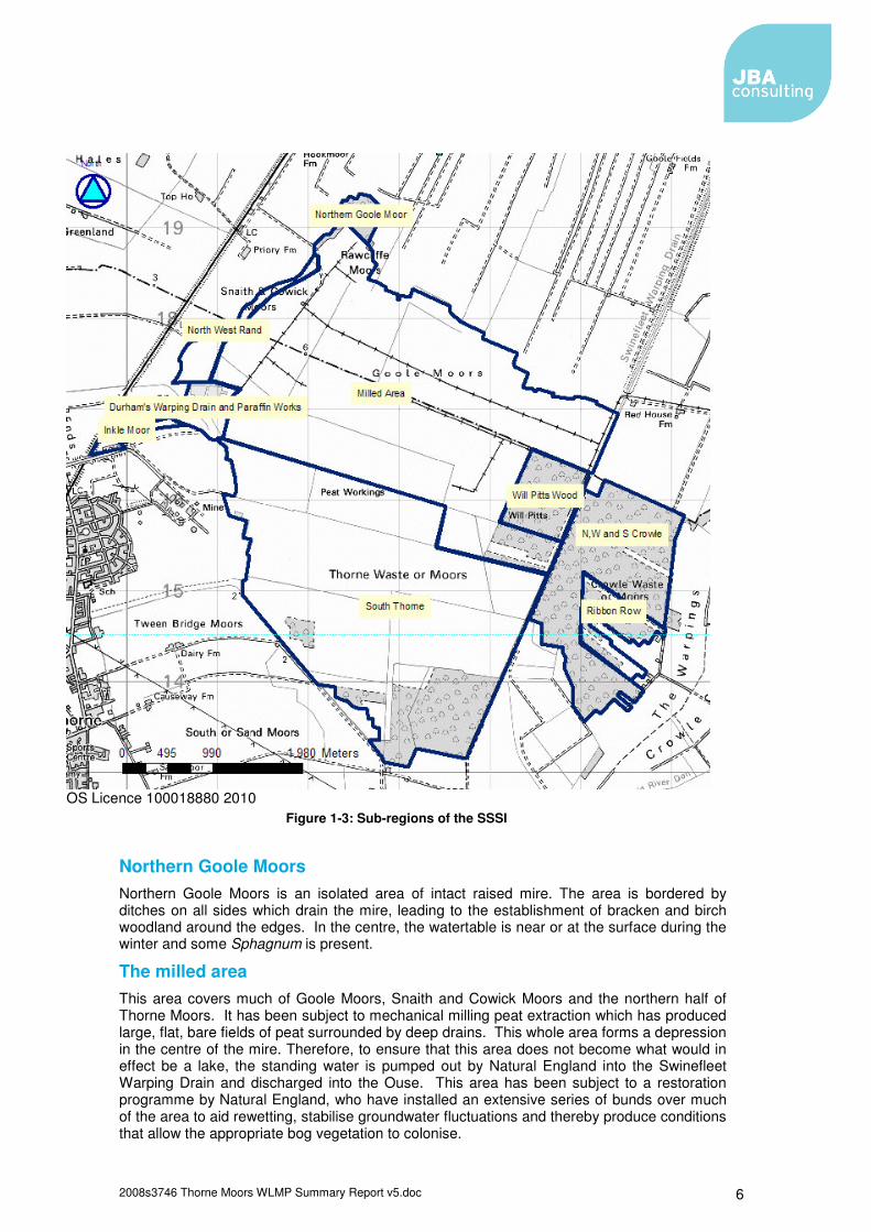
The North West Rand This area lies on the western boundary of the milled areas and stands proud of both the milled area and the agricultural land to the west. In the past it has been subject to peat extraction using English hand graving, producing the current ridge-furrow topography. On the edge of the site, a lagg alder thicket exists, which is subject to regular inundation.
The Paraffin Works In this area peat was historically extracted to produce paraffin. The area is covered by small regularly spaced pools.
Inkle Moor Inkle Moor has never been part of the ombrotrophic peat mass, though its western end would have formed part of the lagg around the raised mire, and has been subject to several phases of agricultural reclamation. This unit of the SSSI has been designated for its neutral grassland, interest rather than lowland raised bog.
Will Pitts Wood This is an area of wet woodland which was subject to extraction before it was unsuccessfully warped. This led to the abandonment of this area for agricultural production and the subsequent establishment of wet woodland.
South Thorne This area has a complicated history and includes areas subject to Dutch hand graving (the canals), English hand graving and mechanical bulk extraction, Rhododendron cultivation and agricultural improvement. This has created a complex topography and microtopography which has changed how water moves through the system. The area is made more complex by the floated roads which divide and isolate areas by acting as low permeability bunds. This has led to a very heterogeneous landscape, with areas of suitable high stable watertables lying very close to drier areas colonised by thick birch scrub.
North, West and South Crowle This area is bounded to the west by the Swinefleet Warping Drain which isolates Crowle Moors from Thorne Moors. The area has been subject to English hand graving, which has increased the drainage of the surface of the bog. Like the South Thorne area, this area is quite heterogeneous. On its southern boundary an area of woodland, has colonised due to the efficient drainage of the agricultural land that borders the site.
Ribbon Row This is an area in the centre-east of Crowle Moors. Here the land was historically owned in long narrow strips. These strips have been subject to different degrees of peat extraction, which has left some narrow extant strips, bordered by areas where the majority of the peat has been extracted, separated by tall peat cliffs. This has left the high areas drained and colonised by birch scrub and the low areas subject to rapidly fluctuating watertables and colonisation by Juncus spp.
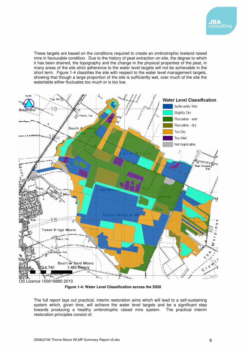
1.3 Restoration Aims In the areas designated under the SSSI citation for their lowland bog interest, target water levels for the site have been defined as follows (JBA Consulting, 2008):
• The watertable is to be maintained close to the ground surface (ideally c.0.10mbgl (metres below ground level)) and should not fall to more than 0.25mbgl in more than one year in five.
• Water levels in the ditches should not fall more than 0.50mbgl in more than one year in five.
2008s3746 Thorne Moors WLMP Summary Report v5.doc 8
These targets are based on the conditions required to create an ombrotrophic lowland raised mire in favourable condition. Due to the history of peat extraction on-site, the degree to which it has been drained, the topography and the change in the physical properties of the peat, in many areas of the site strict adherence to the water level targets will not be achievable in the short term. Figure 1-4 classifies the site with respect to the water level management targets, showing that though a large proportion of the site is sufficiently wet, over much of the site the watertable either fluctuates too much or is too low.
OS Licence 100018880 2010
Figure 1-4: Water Level Classification across the SSSI
The full report lays out practical, interim restoration aims which will lead to a self-sustaining system which, given time, will achieve the water level targets and be a significant step towards producing a healthy ombrotrophic raised mire system. The practical interim restoration principles consist of;
2008s3746 Thorne Moors WLMP Summary Report v5.doc 9
• Stopping further degradation of the peat mass by raising the watertable to near or at the ground surface throughout the year;
• Removal of scrub in areas where it is inappropriate and ensuring it does not re-establish through raising the watertable;
• The establishment of peat forming vegetation; • Given the timescales involved in the creation of raised mire peat, restoration
measures should have a long life span or lead to the creation of a self-sustaining system;
• The interim restoration aims decided upon should be stepping stones towards the creation of a self-sustaining lowland raised mire system.
Due to the variation in the state of the site, the particular nature of the practical interim restoration aims varies across the site. For example, the aim for Northern Goole Moors, which is the most intact part of the site, is to create a sustainable isolated lowland raised mire within decades. Whereas, on the milled area, which as been subject to extensive recent mechanical peat extraction, the first interim aim is less ambitious; requiring the initial creation of a poor fen habitat colonised by cotton-grass and Sphagnum with a high, stable watertable in which peat accumulation can occur.
1.4 Proposed Plans
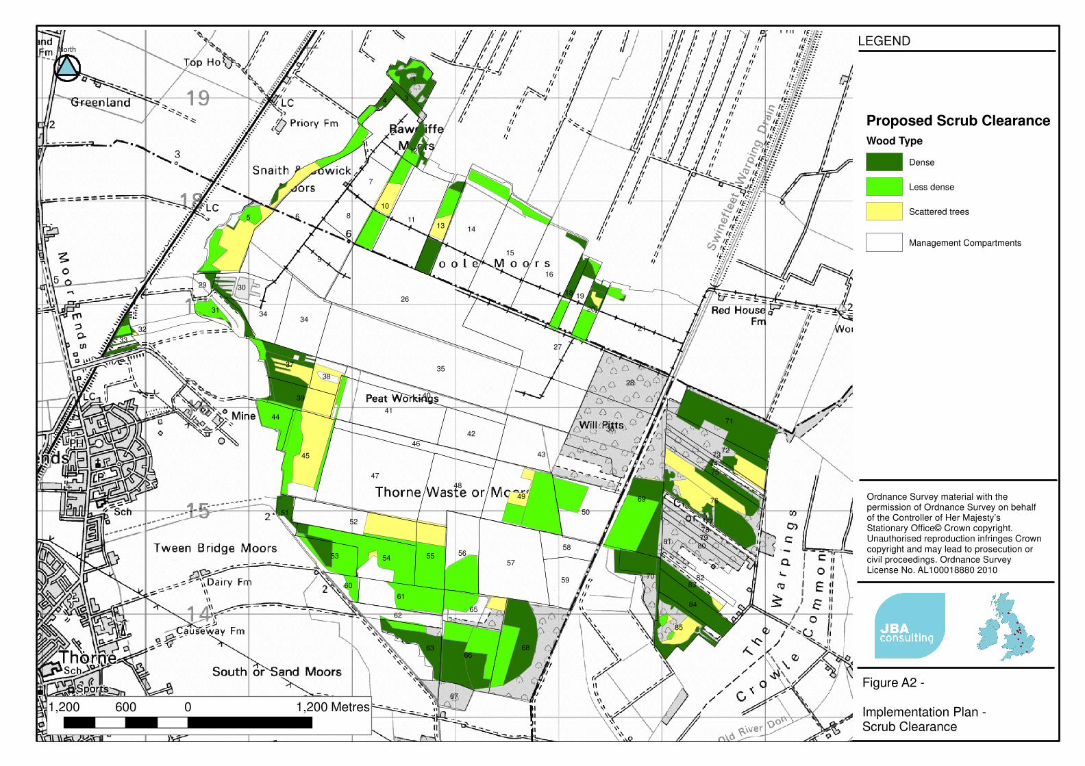
An options appraisal informed by the practical interim restoration aims was then conducted to assess alternative approaches to the actions required. Over the whole site similar techniques are recommended to aid restoration, these include;
• Scrub clearance; • Bund systems, including contour bunding of hand cut areas; • Ditch blocking; • Piling and re-profiling; • Lagg creation; • New ditches outside of the mire; • Levees; • Pumping and modification of the drainage regime.
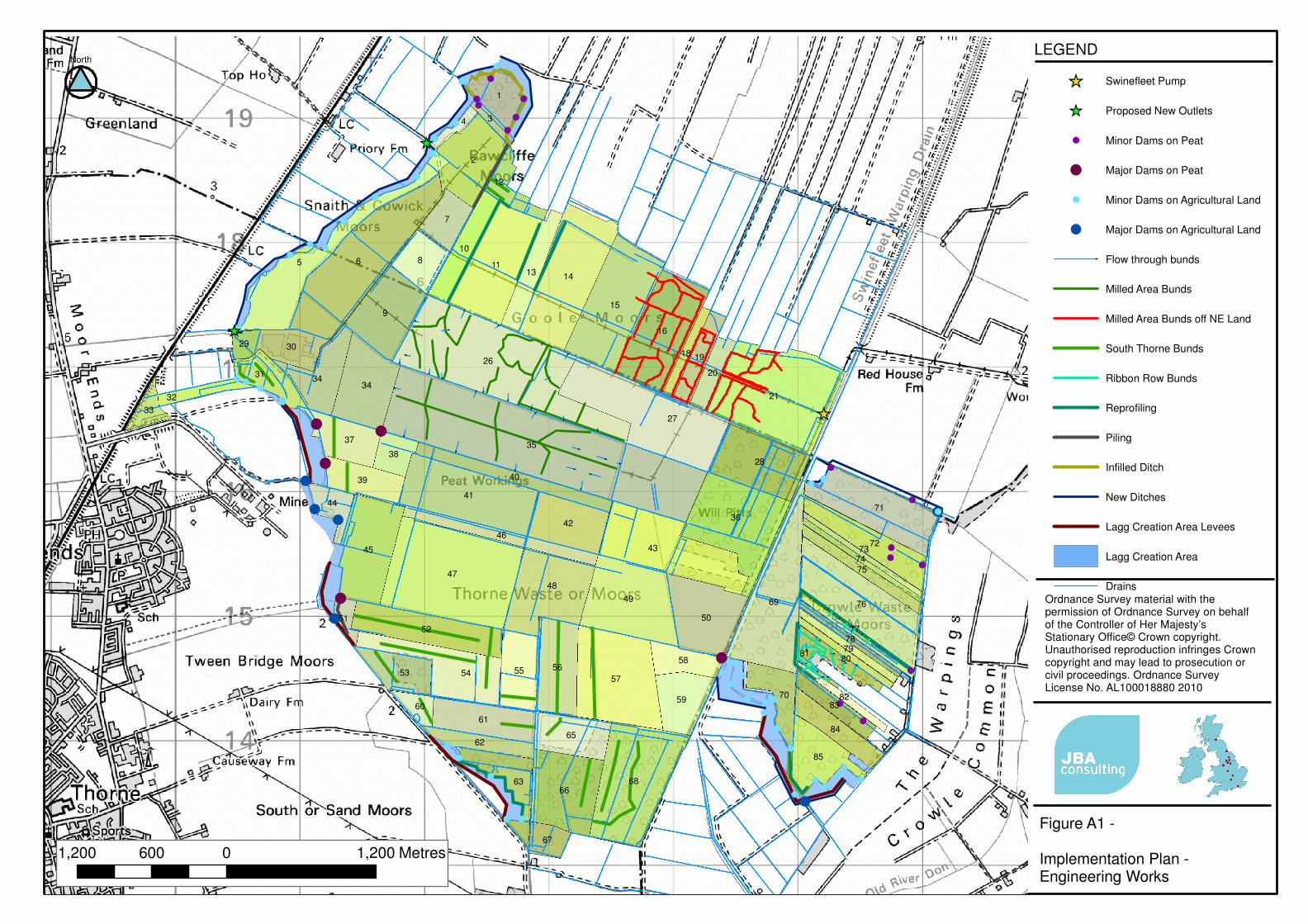
The preferred option best fulfils the practical restoration aims and will aid in leading to the creation of a self-sustaining ombrotrophic raised mire habitat in favourable condition. The location of the structures in the preferred option are shown in Figure A 1 and Figure A 2.
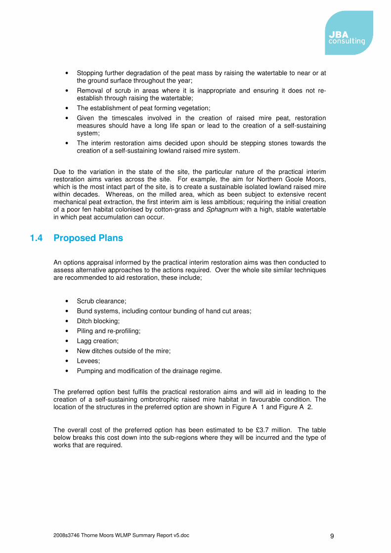
The overall cost of the preferred option has been estimated to be £3.7 million. The table below breaks this cost down into the sub-regions where they will be incurred and the type of works that are required.
2008s3746 Thorne Moors WLMP Summary Report v5.doc 10
Table 1-1: Costings break-down by area Costing Area Northern
Goole Moor milled area
South Thorne
Crowle North West Rand
Inkle, Durham's and Paraffin
Works Costs (£) Costs (£) Costs (£) Costs (£) Costs (£) Costs (£)
Clearance of woodland and scrub
31,000 112,500 491,000 310,000 38,200 31,000
Reprofiling N/A 11,800 47,800 113,800 N/A N/A
Creating and infilling drains and levee creation
10,800 N/A 19,200 10,400 9,200 100
Drain Blocking 1,500 N/A N/A 2,400 200 1,000
Bunding N/A 382,000 18,500 47,900 N/A N/A
Handling Peat and Clay
N/A 12,700 63,500 151,000 N/A N/A
Piling N/A 29,600 14,400 N/A N/A N/A
Adjustable Weirs N/A 19,100 38,600 16,600 N/A N/A
EIA(Environmental Impact Assessment)
20,000 N/A N/A N/A N/A N/A
Pumping Station N/A 815,000 N/A N/A N/A N/A
Preliminaries (site set up, planning etc.)
8,700 276,600 144,200 130,500 9,500 6,400
Engineer's Fees 3,500 111,200 86,800 52,400 3,800 2,600
Total 75,500 1,770,500 924,000 835,000 60,900 41,100
1.5 Impacts of Thorne, Goole and Crowle Moors on the surrounding land
1.5.1 Current Impacts on the Surrounding Land Due to the site's current drainage, topography and the underlying clay, water levels on site and in the surrounding area tend to have little influence on each other. The site, though it does not currently meet the water level targets, is in general, significantly wetter than the surrounding agricultural land. This, however, does not mean the wet nature of the site puts additional strain on the surrounding agricultural system; rather the reverse. The site is fed solely by rainfall, and so it is wetter because it is able to hold onto its water and store it on-site for a greater period than the well drained agricultural land. This means that more water is lost to evapotranspiration and peak flows off the site are attenuated. There are however certain areas where water from the site does enter the surrounding agricultural drainage network.
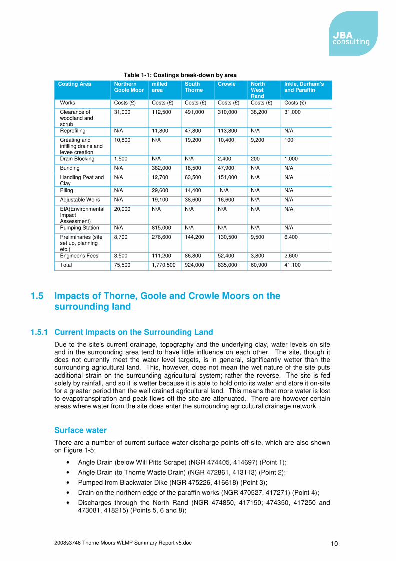
Surface water There are a number of current surface water discharge points off-site, which are also shown on Figure 1-5;
• Angle Drain (below Will Pitts Scrape) (NGR 474405, 414697) (Point 1); • Angle Drain (to Thorne Waste Drain) (NGR 472861, 413113) (Point 2); • Pumped from Blackwater Dike (NGR 475226, 416618) (Point 3); • Drain on the northern edge of the paraffin works (NGR 470527, 417271) (Point 4); • Discharges through the North Rand (NGR 474850, 417150; 474350, 417250 and
473081, 418215) (Points 5, 6 and 8);
2008s3746 Thorne Moors WLMP Summary Report v5.doc 11
• Though the Southern Boundary Drain is blocked by an earth bund (NGR 471282, 415150), this regularly overtops (Point 7);
• Other minor discharge points (e.g. Point 0).
The majority of these points tend to have relatively small discharge rates. The discharge points from Goole Moors northwards have only been observed to flow in the winter when water levels on Goole Moors rise enough above the surface to allow water to flow off-site. The majority of the other major discharge points either have control structures on them, or earth bunds, or in the case of point 3 is the pumping station.
OS Licence 100018880 2010
Figure 1-5: Surface water Discharge Points
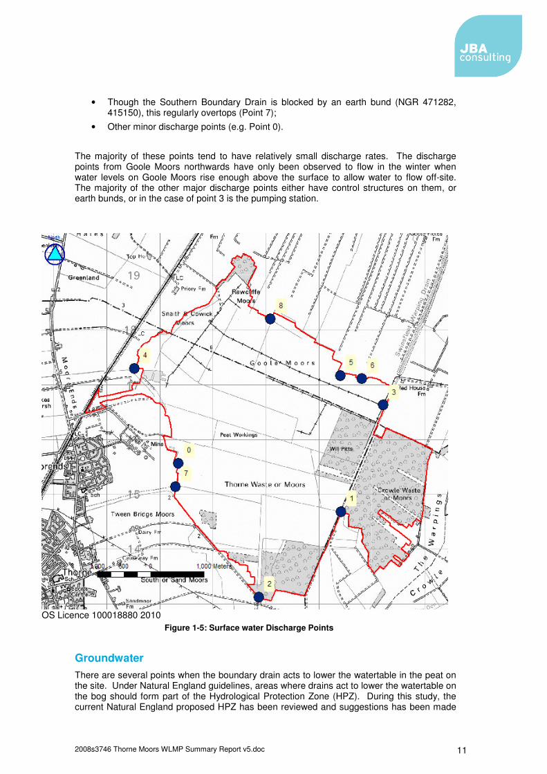
Groundwater There are several points when the boundary drain acts to lower the watertable in the peat on the site. Under Natural England guidelines, areas where drains act to lower the watertable on the bog should form part of the Hydrological Protection Zone (HPZ). During this study, the current Natural England proposed HPZ has been reviewed and suggestions has been made
2008s3746 Thorne Moors WLMP Summary Report v5.doc 12
to where it could be adjusted, given the finding of this study. This has resulted in a smaller overall proposed HPZ, though slightly larger in key locations, such as Northern Goole Moors, where the boundary ditch was observed to drain the bog.
OS Licence 100018880 2010
Figure 1-6 Natural England Proposed HPZ and the Adjusted Proposed HPZ (Green = Natural England Proposed HPZ, Blue = proposed adjustments and Red = SSSI site boundary)
In Figure 1-6, in areas where the adjusted proposed HPZ deviates from the site boundary, it is believed the drains in these areas are lowering groundwater on the site and discharging groundwater to the surrounding drainage system.
1.5.2 Impact on the Proposed Restoration Scheme on the Surrounding Land
Modifications to the Drainage Regime The proposed restoration plan will have two main impacts on the surrounding land and the IDB drainage systems;
2008s3746 Thorne Moors WLMP Summary Report v5.doc 13
• The existing Natural England pump which discharges water to the Swinefleet Warping Drain would be replaced by a new pumping system based on automated telemetry. This would maintain relatively high water levels within the main ditches all year, whilst still maintaining the capacity to deal with large rainfall events. The capacity of this system will be subject to discussions with the Engineer to the relevant IDBs
• Increasing the number of discharge points from the system by reopening ditches that breach the North West Rand at NGR 472057, 418769 (Creykes Gate) and 470476, 417290 (Durham’s Warping Drain). At the detailed design stage the impact on the downstream catchment and pumping stations will be assessed. This will include an assessment of suitable maximum consented discharge rates.
Both these changes are designed to aid in the management of the drains on the milled area (Figure 1-3) and allow a more flexible drainage system to be run.
Other Control Structures In addition to the proposed changes to the way the milled area drainage is managed, there will be three new adjustable control structures on major discharge locations; two of which would replace existing structures. These locations are;
• Angle Drain (below Will Pitts Scrape) at NGR 474405, 414697; • Southern Boundary Drain at NGR 471282, 415150; • North East Corner of Crowle Moors at NGR 476144, 415823.
At these locations adjustable weirs will be installed to better control the rate of discharge off site. The setting of suitable maximum discharge rates from these structures will be informed by on-site monitoring and discussed with the Engineer to the relevant IDBs.
Lagg Creation Area In intact lowland raised mires, lagg habitats form a semi wet transition habitat from the main peat mass to the surrounding land. Around Thorne Moors, much of this habitat has been agriculturally improved and drained. The review of the HPZ (see Figure 1-6) has identified areas where the agricultural drains lower the watertable on-site. Under the restoration plan it is proposed that many of these areas be reverted to lagg habitat. In general, lagg creation areas consist of;
• Blocking boundary drains; • Building levees where required; • Reinstating agricultural boundary drains away from the bog edge in locations where
they will no longer receive input from the bog; • Allowing the area in between the site boundary and new drains to form a buffer zone
of intermediatory habitat. It is hoped that this will have two impacts; firstly to reduce drainage from the boundary of the site to maintain high groundwater tables on-site; and secondly reduce the volume of groundwater discharging from the site to the surrounding agricultural drains, especially reducing peak flows through attenuation.

2008s3746 Thorne Moors WLMP Summary Report v5.doc 14

2008s3746 Thorne Moors WLMP Summary Report v5.doc I
Appendices
A. Additional Figures Figure A 1: Implementation Plan - Engineering Works
Figure A 2: Implementation Plan - Scrub Clearance
�
��
�
�
�
�
�
��
�
��
�
�
�
�
�
�
��
��
�
�
�
�
�
�
�
�
�
��
�
�
�
��
� �
�
�
�
�
��
�
�
�
�
�
�
�
�
�
�
�
��
�
��
�
�
�
��
��
��
35
6
26
5
47
21
27
9
68
2
69
14
57
15
76
43
41
36
11
49
16
48
71
45
66
28
54
5052
8
34
1
56
7
42
72
61
85
65
34
55
63
59
37
40
10
39
13
53
84
70
31
30
58
62
19
81
83
12
20
38
44
67
4
3233
60
51
29
46
75
18
3
7877
7980
74
82
73
Figure A1 -
Implementation Plan -Engineering Works
LEGENDNorth
�� Swinefleet Pump
�� Proposed New Outlets
� Minor Dams on Peat
� Major Dams on Peat
� Minor Dams on Agricultural Land
� Major Dams on Agricultural Land
Flow through bunds
Milled Area Bunds
Milled Area Bunds off NE Land
South Thorne Bunds
Ribbon Row Bunds
Reprofiling
Piling
Infilled Ditch
New Ditches
Lagg Creation Area Levees
Lagg Creation Area
DrainsOrdnance Survey material with thepermission of Ordnance Survey on behalfof the Controller of Her Majesty’sStationary Office© Crown copyright.Unauthorised reproduction infringes Crowncopyright and may lead to prosecution orcivil proceedings. Ordnance SurveyLicense No. AL100018880 2010
1,200 0 1,200600 Metres
35
6
26
5
47
21
27
9
68
2
69
14
57
15
76
43
41
36
11
49
16
48
71
45
66
28
54
5052
8
34
1
56
7
42
72
61
85
65
34
55
63
59
37
40
10
39
13
53
84
70
31
30
58
62
19
81
83
12
20
38
44
67
4
3233
60
51
29
46
75
18
3
7877
7980
74
82
73
Figure A2 -
Implementation Plan -Scrub Clearance
LEGENDNorth
Proposed Scrub ClearanceWood Type
Dense
Less dense
Scattered trees
Management Compartments
Ordnance Survey material with thepermission of Ordnance Survey on behalfof the Controller of Her Majesty’sStationary Office© Crown copyright.Unauthorised reproduction infringes Crowncopyright and may lead to prosecution orcivil proceedings. Ordnance SurveyLicense No. AL100018880 2010
1,200 0 1,200600 Metres

Offices at Atherstone Doncaster Edinburgh Haywards Heath Limerick Newcastle upon Tyne Newport Northallerton Northampton Saltaire Skipton Tadcaster Wallingford Warrington Registered Office South Barn Broughton Hall SKIPTON North Yorkshire BD23 3AE t:+44(0)1756 799919 e:[email protected] Jeremy Benn Associates Ltd Registered in England 3246693
Visit our website www.jbaconsulting.co.uk