Embed Size (px)
Citation preview
Timber Harvesting and Potential Impacts to the Duhamel Creek Alluvial Fan
FPB/IRC/193 April 2014
Forest Practices Board FPB/IRC/193 i
TTaabbllee ooff CCoonntteennttss
Commentary.............................................................................................................................. 1
The Complaint ........................................................................................................................... 2
Background .............................................................................................................................. 2
Geology / Geography ................................................................................................................................ 2 History ....................................................................................................................................................... 4
Legislation ................................................................................................................................................. 8
Investigation Results ................................................................................................................ 9
How did the licensee address the risk of flooding and debris flows in its planning? ................................ 9 Were the licensee’s assessments reasonable and sound? .................................................................... 10
Was the licensee’s public consultation effective? ................................................................................... 13
Conclusions ............................................................................................................................ 14
Recommendation ................................................................................................................... 14
Appendix 1: Chronology of Key Events ............................................................................... 15
Forest Practices Board FPB/IRC/193 1
Commentary The perceived risk of a landslide into Duhamel Creek that could cause debris flooding at the Duhamel Creek alluvial fan, due to road building associated with an approved cutting permit, has generated considerable public and media attention and was the subject of this complaint investigation.
The Board accepts the results of the professional assessments, which indicate little incremental increase in risk of flooding on the Duhamel alluvial fan or of a landslide associated with the approved cutting permit.
However, the Board does acknowledge that the issue has not abated locally. The following three factors seem to be at play.
First, many local residents have little confidence in the results of the professional assessments, as assessments have been conducted in the past in this watershed, as well as others, and yet landslides have still occurred. It seems there may be a need for professionals and professional associations to build some trust at the local level.
Second, in the event that a landslide or flooding associated with logging affects water quality or public safety on the fan, residents wonder who will bear the costs associated with remediation. Specifically, it is the licensee who assesses risk and receives benefits from logging, but it is the residents who live with the risk. The Board has identified this matter in past reports and recently published a bulletin on the issue.1
Third, the matter of landslides and flooding in Duhamel Creek is of heightened concern to residents in the vicinity, especially those living on the alluvial fan at the mouth of the creek. An assessment by the Regional District of Central Kootenay (1990) identified “a significant public safety threat from a flood.” A provincial government assessment (2004) indicated possible damage “to habitable areas and occupants from exposure to deep water, high velocity flows, and/or debris impact.” Board staff heard residents expressing concern that government was doing little to deal with these issues, except possibly increasing the risk by continuing to issue cutting permits in Duhamel Creek.
In the Board’s opinion, a local public planning process for the Duhamel watershed with participation of the provincial government and the regional district would be a worthwhile undertaking before any further developments are approved. At the very least, government should inform residents about how it (or other responsible governments/agencies such as the regional district) is responding to public safety concerns posed by the 1990 and 2004 government assessments on the Duhamel alluvial fan.
1 Board Bulletin, Volume 16, Balancing Risk Across Resource Values in Forest Operations, March 2014; http://www.fpb.gov.bc.ca/BULLETIN_016_Balancing_Risk_Across_Resource_Values_in_Forest_Operations.pdf.
2 FPB/IRC/193 Forest Practices Board
The Complaint In June 2012, the Board received a complaint about Kalesnikoff Lumber Co. Ltd.’s (the licensee) planned road building and harvesting for cutting permit 40 (three cutblocks) in the Duhamel Creek community watershed. The complainant was concerned that harvesting and road building would increase the risk of flooding and debris flows, which could potentially damage property, reduce water quality and endanger the lives of residents of the Duhamel Creek alluvial fan. The complainant also wanted to know who would be responsible if such damage occurred and was concerned commitments made during public consultation had not been honored. The complainant is a local resident on the alluvial fan with a large investment in his own water distribution system.
Background
Geology / Geography
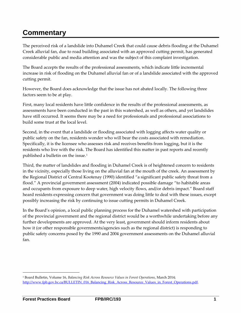
Duhamel Creek flows through a steep sided valley into the West Arm of Kootenay Lake, about 10 kilometres east of Nelson, BC. The watershed is accessed by the Six Mile Lakes Road, which runs from the West Arm of Kootenay Lake up Duhamel Creek to a lower gradient pass (Six Mile Lakes) through to Lemon Creek, which flows out to the Slocan Valley (see Figure 1).
Figure 1. Duhamel Creek Overview.
Forest Practices Board FPB/IRC/193 3
Duhamel Creek frequently experiences natural disturbances. The presence and influence of historical landslides and other erosion events are evident throughout the length of Duhamel Creek. The valley sidewalls and streambeds have been eroded over time by events like avalanches, landslides and debris slides. Some of the eroded material was transported downstream, particularly in extreme run-off events, where it settled and created the Duhamel alluvial fan.
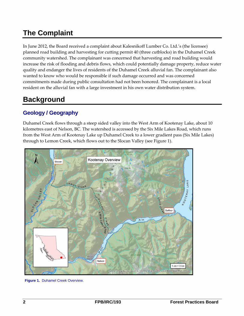
An alluvial fan is a relatively flat to gently sloping landform shaped like an open fan made up of mostly coarse-grained soils, deposited by a stream where it flows from a narrow mountain valley onto a broad valley, or wherever the stream gradient suddenly decreases. The Duhamel Creek fan is about 1500 metres wide, protrudes into Kootenay Lake about 440 metres and Highway 3A bisects it (see Figure 2).
Figure 2. Duhamel Alluvial Fan.

4 FPB/IRC/193 Forest Practices Board
Terrain Stability Field Assessment (TSFA)
A TSFA evaluates the likely effect of timber harvesting or road construction on terrain stability; and recommends site-specific actions to reduce the likelihood of post-harvesting or road-related landslides. These actions may involve modification of the cutblock layout, harvesting technique, road location, trail location, construction techniques, maintenance, or rehabilitation techniques.
– Adapted from the Mapping and Assessing Terrain Stability Guidebook, Second Edition, August 1999.
History
Logging has occurred in the watershed since the late 1800s. A small community has developed on the fan over the past 100 years. The Six Mile Lakes Road was built in the early 1900s to provide a route between Kootenay Lake and the Slocan Valley. Major floods have been recorded that have done damage to private and public property. For example, Highway 3A has been damaged a number of times over the past 60 years due to high flows in the creek.
In 1990,2 an alluvial fan hazard assessment conducted for the Regional District of the Central Kootenay ranked 78 percent of the Duhamel fan as posing a significant public safety threat from a flood. A 1998 Forest Renewal BC project, done by Klohn-Crippen Consultants Ltd.,3 identified Duhamel Creek as having a high hazard rating for avulsion (the stream diverting to a new channel). In 2004, the provincial government’s flood hazard mapping rated the Duhamel Creek fan as ‘E’ meaning, “damage to habitable areas and occupants from exposure to deep water, high velocity flows, and/or debris impact possible.”
The provincial government designated Duhamel Creek a community watershed in 1995 and currently has authorized 121 water licences for obtaining drinking water from the creek. Since 1995, about 130 hectares of forest has been harvested in this 5060 hectare watershed, with much of that area now greened up and recovering its hydrologic function.
In the 1990s, the Ministry of Forests, Lands and Natural Resource Operations’ (MFLNRO) Small Business Forest Enterprise Program (SBFEP, now called BC Timber Sales) built a road in the upper reaches of the valley and in 1997 a slide occurred off that road (see Figure 3). In 2003, the SBFEP
permanently deactivated the road to try to restore natural drainage. Extensive portions of the road were ’debuilt’ by pulling back side-cast fill onto the excavated road to restore the natural contour of the slope. However, in some places, the road fill from the old road was too far downslope to pull back.
In 2007, the licensee decided to reconstruct that road to access timber. A geotechnical professional completed a TSFA and reported a low landslide initiation hazard if the licensee followed the professional’s recommendations. After construction, the professional confirmed that the road had been built as recommended.
2 Hyperlinks on date link to the chronology and in the chronology link back to the text. 3Terrain Stability Inventory – Alluvial and Debris Torrent Fans – Kootenay Region http://www.for.gov.bc.ca/hfd/library/ffip/Boyer_D1999.pdf
Forest Practices Board FPB/IRC/193 5
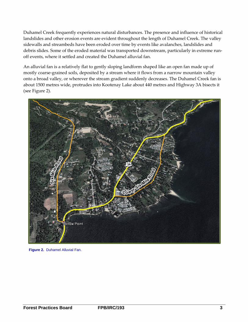
In 2010, a slope failure occurred below the road. The licensee assessed the impact to Duhamel Creek and found that the slide deposited a minor amount of sediment into a low gradient reach, approximately 5.6 kilometres upstream from the nearest water intake. The licensee reported the slide to MFLNRO. The licensee said in the assessment that it was not aware of the sediment impacting downstream water users, as the event was not reported by members of the Six Mile Water Users Group. The licensee determined the cause of the slope failure to be a combination of poor original road building techniques (in the 1990s) that created fill slopes supported by woody debris; incomplete deactivation to remove that debris; and altered culvert discharge onto the tenuous residual fill slope after the road reconstruction in 2007.
In May 2011, a debris slide, larger than the 2010 slide, originated 25 metres below the road in the residual fill that was too far downslope to pull back during the 2003 deactivation. According to the Six Mile Water Users Group, who assessed the impacts from this slide in September 2011, it caused increased turbidity and maintenance efforts at their water intake, but they did not share this information with the licensee at the time. During the Board’s investigation in April 2013, the water-users told the investigator about it and the information was then forwarded to the MFLNRO and the licensee.
Figure 3. Duhamel Operating Area.
6 FPB/IRC/193 Forest Practices Board
In October of 2013, a hydrologist and a resource road specialist, both members of the Association of Professional Engineers and Geoscientists of British Columbia, conducted a professional assessment of the impacts of the 2011 slide on the stream. They found that the most important impact on the channel was the constriction of flow where the slide debris entered the stream, and suggested that this constriction may encourage some channel widening on the east bank over the next 20 years. They also found that other impacts were restricted to local side bar deposits of small cobbles4 about 20 metres downstream from the slide. The professionals observed that the low channel gradient in the vicinity of the slide limits the ability of flowing water to mobilize sediment. They concluded that there is a negligible risk of a large jam of sediment and woody debris forming in the channel at this location and, “that no exceptionally high volume of fine sediment entered Duhamel Creek during the 2011 slide and this deposit.” They speculated that the sediment experienced by water users may have been mobilized from another source.
In summary, the Duhamel Creek watershed is a hydrologically active watershed with a high likelihood of flooding and landslides. Conditions in the creek change over time with high flows, which can have impacts downstream. Landslides associated with logging roads have occurred in the past. The water user group associated significant impacts on water quality and a water intake with the 2011 slide. Two years after this slide, the professionals working for the licensee found no evidence of an exceptionally high volume of sediment entering the creek from the 2011 slide.
Public Consultation and Planning in the Duhamel Creek Watershed
Just after the licensee was assigned the Duhamel Creek watershed as an operating area in 1997, it joined a round table created as part of an interior watershed assessment procedure (IWAP) started by the SBFEP. At that time, provincial forest practices legislation required that an IWAP be completed in community watersheds. The IWAP for the Duhamel Creek Watershed was completed in 1999 and included input from local water user groups. In 2004, the licensee hired a geotechnical professional to conduct a hydrologic assessment, building on the IWAP, to further explore hydrologic conditions, processes and risks, and link them to management guidance.
4 Cobbles – 10 cm diameter rocks.
Watershed Assessment
An evaluation of a watershed’s current functioning condition and likely future state.
Hydrologic Assessment
A judgment or opinion relating to the effects of precipitation and evaporation on water and its occurrence and character in streams, lakes and sub-surface areas.
Note: There are no professional standards for hydrologic assessments in BC; however, in the BC forest sector, hydrologic assessments are expected to be broad in scope, approximating a watershed assessment.
Forest Practices Board FPB/IRC/193 7
The Forest Planning and Practices Regulation (FPPR) requires that a forest stewardship plan (FSP) or an amendment be made available for public review and comment for 60 days. The licensee complied with this requirement in November 2004. The licensee did not receive comments on the FSP related to the issues in this complaint. In the FSP, the licensee committed to send out letters to registered water users in community watersheds before starting development. In 2009 and 2010, the licensee fulfilled an FSP commitment to notify water users about proposed activities. It sent letters to the complainant and other water users explaining the proposed development in cutting permit (CP) 40.
In 2011, the complainant responded to the letters, met with the licensee and asked the licensee to explain its plans in an open public meeting. Based on past experience, the licensee decided to limit meeting attendees to MFLNRO and a smaller group of 12 local residents.
At the meeting, the licensee explained its plans and committed to have a geotechnical professional conduct a TSFA on the planned road location. The complainant submitted a petition signed by over 100 people stating that they were concerned about the logging. The complainant requested all logging stop until an independent MFLNRO specialist reviewed the terrain stability report. MFLNRO agreed to have a specialist review it and report back to the water users when done.
In June 2012, about a year after that meeting, MFLNRO had not reported the results of its review, so the complainant submitted a complaint to the Board. It turned out that the terrain stability report was still not completed, therefore the licensee had not given it to MFLNRO. In August 2012, the licensee’s geotechnical professional finished the report and delivered it to MFLNRO as promised. In November 2012, in accordance with MFLNRO’s commitment, a ministry specialist reviewed it and explained the results to the complainant.
Since the complaint was filed, the licensee has continued to have discussions with the complainant and other Duhamel residents and it commissioned an assessment of the 2011 slide, as discussed earlier in this report.
Complainant’s Request for the Board to Stop the Road Building and Logging
Even before the complaint was submitted, it was apparent that the complainant wanted the Board to stop the logging, but the Board does not have that authority. The licensee initially volunteered to hold off on applying for a CP until the Board issued a preliminary report. When the Board sent out a ‘fact check’ report to the participants to ensure that the facts, as the investigator understood them, were correct, the licensee considered that to be a preliminary report and so it requested that MFLNRO issue the CP. The complainant had asked that government not issue the CP. However, the licence agreement says that MFLNRO must issue CPs if a licensee meets the following criteria: they do not conflict with other tenures; they are within a forest development unit in an approved FSP; and they do not unjustifiably infringe on aboriginal interest. Accordingly, MFLNRO issued the CP.
The complainant continued to raise this concern with the Board, so the investigator advised the complainant that the only other avenue to stop the logging was Section 77 of the Forest and Range Practices Act (FRPA). Section 77 allows the Minister to stop road building or harvesting if the Minister reasonably believes those activities will, “result in a contravention of the Acts and will probably cause
8 FPB/IRC/193 Forest Practices Board
a catastrophic impact on public health or safety.” A few residents made section 77 requests and MFLNRO sent staff to investigate CP 40, but found no grounds to stop the activities.
Legislation
FRPA requires licensees to submit one plan to government for approval—an FSP, which must include results and strategies that are consistent with government objectives. FRPA also requires that licensees carry out the strategies in their FSP.
Government’s objective in community watersheds relates to water quality and quantity going into and coming out of the water intake (waterworks). The licensee included the following strategy in its FSP to meet this objective:
For the purposes of this section, ‘hydrological assessment’ is a professional level analysis of existing and/or potential forest development related effects on water and water-related resources conducted at the site or watershed level which may include:
• Identifying historical and current hydro-geomorphic processes affecting runoff, peak flows, sediment delivery, and sediment transport in a watershed.
• Providing a qualitative risk analysis that assesses the sensitivity of a watershed to increases in peak flows, increases in sediment delivery or changes to riparian function, and determining the likelihood for impacts to aquatic values in the main stem channel and at the Point of Diversion given past development/disturbance and proposed development.
• Providing recommendations for forest management to minimize the likelihood of impacts to aquatic values associated with proposed development.
Hydrological assessments will be conducted in advance of new development activities within a watershed and will be periodically updated to monitor changes and provide recommendations in the realm of harvesting, road construction, or permanent deactivation. Planning and implementation of operational activities is to be consistent with the recommendations of the hydrological assessment as determined by a qualified professional.
To partially answer the complaint’s question about who would be responsible if damage occurs, the Board notes that section 37 of the FPPR requires licensees to ensure that their practices do not cause landslides that have a material adverse effect on soils or water (and other forest resources). Contravention can result in penalties and remediation orders. Licensees can avoid contravening FRPA’s practice requirements if they demonstrate due diligence—show that they have taken all reasonable steps to avoid the event. There are other remedies outside of FRPA for assigning responsibility, but they are outside the jurisdiction of the Board, so the investigation did not deal with them.
Forest Practices Board FPB/IRC/193 9
Investigation Results The Board’s mandate is to examine compliance with FRPA and its fundamental purpose is to encourage sound forest practices, including fair and equitable application of legislation and continuing improvements in forest practices. Therefore, the investigation focused on three questions:
1. How did the licensee address the risk of flooding and debris flows in its planning? 2. Were the licensee’s assessments reasonable and sound? 3. Was the licensee’s public consultation effective?
How did the licensee address the risk of flooding and debris flows in its planning? Hydrologic Assessment
The licensee carried out a hydrologic assessment in 2004. The assessment observed that flooding and stream channel diversion (avulsion) on the fan of Duhamel Creek fan occurs during large flood events triggered by extreme weather conditions and rapid snow melt from the steep alpine slopes. The assessment concluded that, ”forestry activities situated on the lower elevation slopes of the watershed will not increase the existing hazard of flooding or avulsion on the fan of Duhamel Creek.” CP 40 is on the lower elevation slopes, as is other potential harvesting being considered by the licensee, so according to the hydrologic assessment, it should not affect the existing hazard of flooding on the fan.
Terrain Stability Field Assessment
As promised in the 2011 meeting, the licensee commissioned a TSFA for portions of the proposed road in CP 40 and areas below the road that may be influenced by the road.
Three sections of proposed road were examined:
• A proposed spur road that crossed a gully between two blocks in an area mapped as being potentially unstable (terrain class IV – Level C mapping).
• A portion of the proposed road that crossed steep gullied terrain, even though it was mapped as being stable.
• The front end of the proposed road, where reconstruction of a permanently deactivated re-contoured road traversed unstable slopes (according to terrain class V- Level C mapping).
The TSFA report was completed in 2012, after being reviewed by the author of the 2004 hydrologic assessment. The report concluded that, “road construction will not significantly increase the low likelihood of landslide initiation provided the recommendations within this report are followed and culverts are installed as flagged in the field and marked on the map provided.” The TSFA report also said that if a landslide was initiated at the road, it was unlikely that a debris slide would traverse the gentle lower slopes or the Six Mile Lakes Road.
10 FPB/IRC/193 Forest Practices Board
Finding
The licensee had a hydrologic assessment done in 2004 and a terrain stability assessment done in 2012. According to the respective assessments, there is a low likelihood that harvesting within the elevation band that includes CP 40 will increase the existing risk of flooding on the Duhamel fan or that the sections of the road examined would cause a landslide that would reach Duhamel Creek.
Were the licensee’s assessments reasonable and sound?
Board investigators reviewed the hydrologic assessment to see if it met the licensee’s FSP strategy for hydrologic assessments, which, by virtue of being in the FSP, becomes a planning requirement under FRPA. There is no similar planning requirement for TSFAs.
Hydrologic Assessment
FSP planning requirement
FRPA requires that a licensee carry out the strategies specified in its FSP. In this case, the strategy for community watersheds is to do a hydrologic assessment in advance of new development activities and periodically update the assessment.
It is the licensee’s view that the 2004 watershed assessment meets the definition of hydrologic assessment in the FSP. The licensee interprets the need to update the hydrologic assessment to apply only when there is an appreciable change to the functioning condition of the watershed such as, a debris flow, major wildfire, or extensive harvesting exceeding the ECA5 threshold.
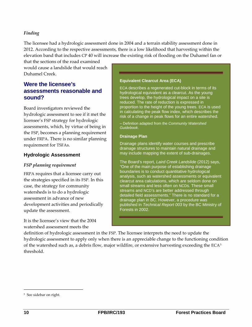
5 See sidebar on right.
Equivalent Clearcut Area (ECA)
ECA describes a regenerated cut-block in terms of its hydrological equivalent as a clearcut. As the young trees develop, the hydrological impact on a site is reduced. The rate of reduction is expressed in proportion to the height of the young trees. ECA is used in calculating the peak flow index, which describes the risk of a change in peak flows for an entire watershed. – Definition adapted from the Community Watershed Guidebook.
Drainage Plan
Drainage plans identify water courses and prescribe drainage structures to maintain natural drainage and may include mapping the extent of sub-drainages.
The Board’s report, Laird Creek Landslide (2012) says, “One of the main purpose of establishing drainage boundaries is to conduct quantitative hydrological analysis, such as watershed assessments or equivalent clearcut area calculations, which are seldom done on small streams and less often on NCDs. These small streams and NCD’s are better addressed through detailed field assessments.” There is no standard for a drainage plan in BC. However, a procedure was published in Technical Report 003 by the BC Ministry of Forests in 2002.
Forest Practices Board FPB/IRC/193 11
The licensee recently calculated the ECA, using new hydrologic recovery curves from new scientific research, and the area to be harvested in the proposed development. It also recalculated the ECA using the 2004 standard and the proposed area to be harvested. Both of these ECA calculations yielded essentially the same result as in 2004, which is below what it considered the threshold for concern. The licensee’s FSP states that a hydrologic assessment is done ‘at the site or watershed’ level. Therefore, the licensee believes that updated ECA calculations, drainage plans and TSFAs at the site level satisfy the FSP requirements for periodic updates to the watershed-level hydrologic assessment. The licensee still considers the 2004 hydrologic assessment to be an accurate assessment of the state of the watershed, so it sees no reason to revisit the assessment.
The original 2004 watershed hydrologic assessment did not anticipate or consider logging conducted beyond 2004. The Board agrees with the licensee that a full drainage plan may meet the definition of site-level hydrologic assessment, but the Board does not agree that checking to see that the ECA is below a threshold and doing a TSFA for several segments of a proposed road meets the implied intent of a periodic update to the watershed hydrologic assessment.
Even though the licensee did a thorough, professional watershed assessment for the entire watershed in 2004, it is the Board’s opinion that after eight years, when new development is proposed, the assessment should be updated by a professional hydrologist to reflect past harvesting, other disturbance events that have occurred in the intervening years and foreseeable new forest development.
Further, an update would allow the licensee to consider new hydro-geomorphic science and best practices developed since 2004, such as the Land Management Handbook 61- Managing Forested Watersheds for Hydrogeomorphic Risk on Fans (LMH61) published in 2009.
Since the focus of the complaint is about public safety and water quality to the community water intake on the alluvial fan, the Board used the standard in LMH61 to determine if the assessments were reasonable and sound. This handbook provides, “the first comprehensive, provincial level framework for assessing risk on fans from upstream watershed activities.”6
Board investigators reviewed the 2004 assessment and found that it used a very similar decision framework to LMH61. The only component missing was the final step—monitoring and updating. An update to the hydrologic assessment for the community watershed, as suggested by the Board, would have completed that framework. Ideally, the steps in this decision framework should be completed by a team, consisting of a terrain specialist and hydrologist, under the supervision of the coordinating professional. Even if an update showed no change to the function of the watershed, that would be meaningful in itself, to show the interested public that the watershed is resilient to the effects of the harvesting that has occurred.
6 Land Management Handbook 61 page 2.
12 FPB/IRC/193 Forest Practices Board
Influence of unstable areas in lower reaches of watersheds
According to LMH61, “Naturally unstable areas in the lower portion of a watershed have been found to more strongly influence the nature of hydrogeomorphic processes (e.g., more sediment can be delivered to fans during a hydromorphic event) than unstable areas that are located further from the fan in the headwaters of the watershed.”7 The 2004 hydrologic assessment describes riparian function as follows, “riparian vegetation along Duhamel Creek … moderates bedload transportation rates, and contributes to channel bed and bank stability. Sensitivity is reduced as a result of large floods that flush LWD out of the system every few decades … The lack of [large woody debris] LWD has resulted in … a sustained negative impact to channel stability... in reaches 1 and 2.”
The proposed development is in the lower reaches of the Duhamel Creek watershed. Since the 2004 watershed assessment, there have been landslides and avalanches in the low gradient reaches of the upper watershed. It was unclear if some of that material had migrated downstream and increased the channel bedload in the lower reaches, therefore the Board investigator contacted the hydrologist who completed the 2004 assessment. The hydrologist satisfied the investigator by explaining that lower down Duhamel Creek, below the proposed development, sediment from an adjacent sub-basin has created a large alluvial fan blocking Duhamel Creek, causing a low gradient wetland to form, which should dissipate a debris flood and make migration of debris to lower reaches unlikely.
Terrain Stability Field Assessment
LMH61 says, “In the interior of British Columbia, most significant landslides associated with forestry operations are related to drainage diversion by forest roads and trails located on gentle to moderately sloping terrain, some distance upslope from steeper, more landslide-prone terrain (gentle-over-steep).”8 The detailed TSFA report for the road identified areas downslope of the road that were gentle and would mitigate the effects of a landslide. These gentle slopes are situated over steep slopes mapped as possibly unstable. It was unclear if gentle-over-steep conditions were present in this area. The Board investigator contacted the licensee’s geotechnical professional who explained that he knew the characteristics of the area and that this area is not classic gentle-over-steep terrain. He satisfied the Board by explaining that, if he thought gentle-over-steep conditions existed, he would have identified that issue to the licensee. He also explained that maintaining natural drainage patterns is a strategy to avoid problems associated with gentle-over-steep terrain. He had reviewed the terrain and proposed drainage structures for the road and was satisfied.
Further, the terrain specialist and the hydrologist work in the same office and the terrain specialist was very familiar with the hydrologist’s assessment. The terrain specialist explained that even if a landslide did occur and entered Duhamel Creek, the nature of the low gradient wetland at the large alluvial fan below the proposed development would mitigate any debris flood before it had a chance to impact the alluvial fan.
7 Land Management Handbook 61, page 17. 8 Land Management Handbook 61, page 24.
Forest Practices Board FPB/IRC/193 13
In October 2013, the licensee engaged the same professionals to conduct an assessment of the 2011 slide impacts on the stream. The professional assessment focused on the 2011 landslide, its likely impacts on the Duhamel channel and whether it posed additional risk to the lower Duhamel fan. It also helps provide a better understanding of the stability and condition of the Duhamel Creek main stem.
Finding
The 2004 hydrologic assessment and the 2012 terrain stability assessment were done to a professional standard and appear to be reasonable and sound. However, an update of the 2004 hydrologic assessment for the watershed, as suggested by the Board, would provide current information and a record of the changing watershed condition as context for current licensee planning and operations. Such an update would be clearly consistent with the licensee’s FSP strategy.
NOTE: The professional assessment of the impacts of the 2011 landslide on Duhamel Creek conducted in October 2013 could be used to better integrate information about the proposed development and the potential for causing instability in the Duhamel main stem. If that was done, that integrated information could be used as part of an effective update of the 2004 watershed assessment.
Was the licensee’s public consultation effective?
The licensee met and went well beyond both the legislated requirements for consultation under FRPA—to advertise the FSP—and its FSP commitment to contact water licensees in advance of new development. In investigating complaints from the public, the Board looks beyond basic compliance and encourages effective consultation. The Board’s standard for effective consultation can be found in its Bulletin 003, Opportunity for Public Consultation Under FRPA, which states, “Effective consultation allows British Columbians to find out what is happening in their forests, express their views and have them seriously considered by decision-makers.”9
The licensee is responsible for the planning and consultation in the watershed. In this case, the licensee started a dialogue by sending out letters to the local public early in the planning process. The letters asked people to contact the licensee if they wanted clarification of the plans. The licensee provided information, met with individuals, held a meeting and explained in some detail its plans for logging. While the licensee limited the meeting to 12 people, there is no evidence that any interested parties, including the complainant, were excluded from reviewing the plans or making comment. In the meeting, the licensee explained that it was entitled to log in the Duhamel Creek Watershed, as the watershed is in the provincial forest. The licensee has shared information, received comments and seriously considered public input in its planning.
Since the complaint was submitted, there has been much media attention focused on stopping the logging in Duhamel Creek. Recently, members of the community have formed the Duhamel Watershed Alliance in order to engage the licensee in consultation, and there is ongoing dialogue between them and the licensee on future operational planning in the Duhamel Creek watershed. The complainant’s position remains unchanged. He wants the land use changed to prohibit logging in the
9 Opportunity for Public Consultation Under FRPA, page 1.
14 FPB/IRC/193 Forest Practices Board
lower portion of the Duhamel Creek watershed. The Board has considered concerns about land use in the past:
The Board believes that effective public consultation requires providing an opportunity for public input at the appropriate planning level. Concerns about land use, such as permitting logging rather than creating a protected area, need to be addressed in strategic land and resource management plans…concerns about proposed roads and cutblock locations need to be addressed in operational or site plans. If concerns are directed to the wrong planning level, they cannot be properly addressed and the result will be dissatisfaction for all parties. 10
Currently, government does not have a planning process in place that can address the complainant’s land use concerns.
Finding
The licensee met its legislated review and comment requirements and, overall, the licensee’s consultation efforts were effective. The licensee cannot address the complainant’s desire to prohibit logging in the watershed, and the complainant remains dissatisfied.
Conclusions Government recognized the importance of consumptive water use in the Duhamel watershed and designated it a community watershed almost 20 years ago. Since then, various levels of government have determined the Duhamel Creek alluvial fan poses some significant threats to public safety from flooding and associated damage. The provincial government also decided that this watershed would be available for timber harvesting. Several landslides associated with harvesting and road building have occurred in the watershed.
Accordingly, the licensee carefully planned new harvesting in Duhamel Creek, engaging appropriate professionals to conduct assessments that appear to be reasonable and sound. However, an update of the watershed hydrologic assessment, to record and interpret the changing watershed conditions since 2004, would help to clarify the rationale and context for the current planning decisions.
In its planning, the licensee effectively consulted with Duhamel residents. Still, some residents remain opposed to any further logging in the watershed.
Recommendation In accordance with section 131(2) of the Forest and Range Practices Act the Board recommends that the licensee update the 2004 watershed assessment using the standard as outlined in Land Management Handbook 61 – Managing Forested Watersheds for Hydrogeomorghic Risks on Fans by March 31, 2015.
10 Opportunity for Public Consultation under Forest and Range Practices Act (FRPA), page 1.
Forest Practices Board FPB/IRC/193 15
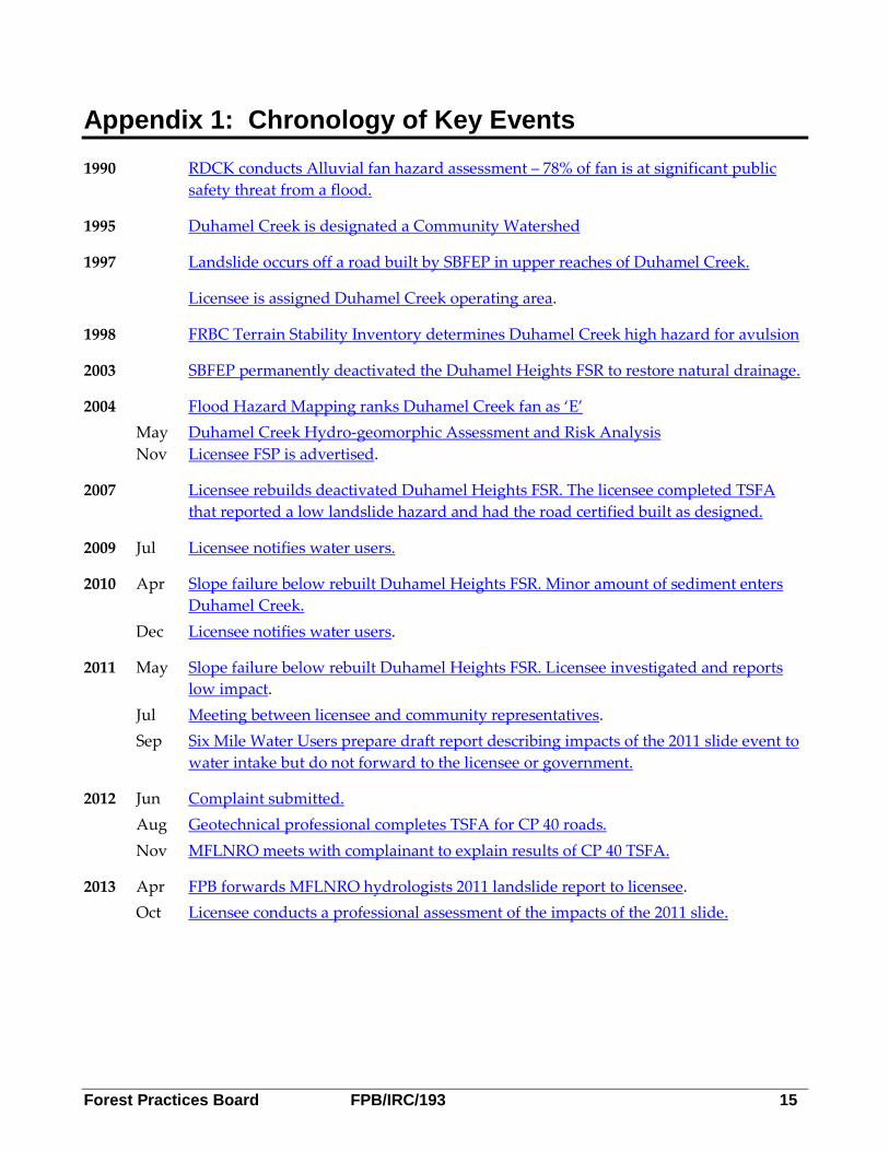
Appendix 1: Chronology of Key Events 1990 RDCK conducts Alluvial fan hazard assessment – 78% of fan is at significant public
safety threat from a flood.
1995 Duhamel Creek is designated a Community Watershed
1997 Landslide occurs off a road built by SBFEP in upper reaches of Duhamel Creek.
Licensee is assigned Duhamel Creek operating area.
1998 FRBC Terrain Stability Inventory determines Duhamel Creek high hazard for avulsion
2003 SBFEP permanently deactivated the Duhamel Heights FSR to restore natural drainage.
2004 Flood Hazard Mapping ranks Duhamel Creek fan as ‘E’ May Duhamel Creek Hydro-geomorphic Assessment and Risk Analysis Nov Licensee FSP is advertised.
2007 Licensee rebuilds deactivated Duhamel Heights FSR. The licensee completed TSFA that reported a low landslide hazard and had the road certified built as designed.
2009 Jul Licensee notifies water users.
2010 Apr Slope failure below rebuilt Duhamel Heights FSR. Minor amount of sediment enters Duhamel Creek.
Dec Licensee notifies water users.
2011 May Slope failure below rebuilt Duhamel Heights FSR. Licensee investigated and reports low impact.
Jul Meeting between licensee and community representatives. Sep Six Mile Water Users prepare draft report describing impacts of the 2011 slide event to
water intake but do not forward to the licensee or government.
2012 Jun Complaint submitted. Aug Geotechnical professional completes TSFA for CP 40 roads. Nov MFLNRO meets with complainant to explain results of CP 40 TSFA.
2013 Apr FPB forwards MFLNRO hydrologists 2011 landslide report to licensee. Oct Licensee conducts a professional assessment of the impacts of the 2011 slide.
PO Box 9905 Stn Prov Govt
Victoria, BC V8X 9R1 Canada
Tel. 250.213.4700 | Fax 250.213.4725 | Toll Free 1.800.994.5899
For more information on the Board, please visit our website at: www.fpb.gov.bc.ca