Embed Size (px)
Citation preview

AccommodationCampsitesThere are DOC campsites at Pureora and Piropiro. Camping is also permitted along the trail in designated areas. Visit www.doc.govt.nz/pureora.
Further informationDepartment of Conservation Te Kuiti OfficePhone +64 7 878 1050. Email [email protected]. i-Sites/information centres located in Te Kuiti, Taumarunui, Taupo, Waitomo and Tokoroa
Published by Department of Conservation Te Kuiti, New ZealandSeptember 2017
Editing and designPublishing Team, DOC National Office
Timber Trail
This publication is produced using paper sourced from well-managed, renewable and legally logged forests.
Cov
er: C
ross
ing
the
Mar
amat
aha
Brid
ge. P
hoto
: Thr
ive
Phot
ogra
phy
Pureora – OngarueTrail guide
Length: 85 km
Grade: 2–3
Total climb: 420 m
Fitness level: Good
Skill level: Intermediate Grade 3
Time: 1–2 days cycling or 4 days walking
At forest edge shelter. Photo: Nicky Palmer
R10
3627

A backcountry cycling adventureAncient forest, deep valleys, historic bush tramways and the magnificent Ongarue Spiral await cyclists on the Timber Trail journey.
The Timber Trail is one of 23 great rides developed as part of Nga Haerenga, The New Zealand Cycle Trail – www.nzcycletrail.com. Most of the trail is in Pureora Forest Park, managed by the Department of Conservation (DOC).
Getting thereThe trail begins on Barryville Road, Pureora, off SH30 between Te Kuiti and Mangakino. The central section can be accessed from Piropiro at the end of Kokomiko Road, Waimiha, and the southern end from Ongarue via SH4. Follow the brown signs to the entrance points.
Parking is available at all entry/exit points. It is 56 km by sealed and gravel road from Pureora to Piropiro, 40 km by sealed and gravel road from Piropiro to Ongarue, and 53 km by sealed road from Pureora to Ongarue.
Riding the trailThe Timber Trail is open all year around. Be prepared for adverse weather conditions at all times.
The first 4 km from Pureora is an easy flat gradient, but the trail then starts to climb. The trail is graded intermediate (Grade 3) the rest of the way to Piropiro. It is easy (Grade 2) either way between Piropiro and Ongarue. See the cycle trail website www.nzcycletrail.com for further descriptions of cycle trail grades.
There are a few steep ascents/descents and drop-offs in places where you may choose to get off your bike and push. Be aware of hidden rocks, sticks,
fallen trees or slippery clay exposed by the weather. Dappled light, sun or mist can affect your vision, so ride with care.
Plan and prepareBefore you go, know the Outdoor Safety Code – 5 simple rules to help you stay safe:1. Plan your trip
Before you go, check the status of the Timber Trail at www.doc.govt.nz/timber-trail. Thoroughly clean and prepare your bicycle and equipment, and take essential bicycle spares and tools.
2. Tell someoneTell someone your plans and leave a date for when to raise the alarm if you haven’t returned. See www.adventuresmart.org.nz for further information.
3. Be aware of the weatherCheck the forecast at www.metservice.com.
4. Know your limitsThe trail is in a remote environment and is subject to weather extremes. Have a ‘trail-time’ goal and turn around if necessary.
5. Take sufficient suppliesPack enough warm clothing, extra food and a torch/head lamp in case you need to stay out overnight. Have insect repellent, sun screen and a first aid kit.
See www.doc.govt.nz/pureora for more safety information.
Things to noteSigns: Green and yellow DOC signs indicate access points, distances between places and approximate walking times. Please read these signs.
Trail markers: The trail is marked with orange directional markers and blue-and-white distance markers, indicating distances from Pureora. When travelling north from Ongarue, they count down the kilometres left to travel to Pureora. If you do not see these markers, you are not on the trail.
Cellphone coverage: There is limited cellphone coverage – do not rely on it as a means of emergency communication. Please carry a personal locator beacon (for hire outlets see www.beacons.org.nz).
Private land: Small sections of the trail cross private land. Please respect the landowners’ rights.
Drinking water: Water can be taken from streams along the trail. You may wish to boil, filter or treat it before drinking.
Waste: There are no rubbish bins along the trail, and no rubbish collection at Piropiro Campsite. Please arrange to take your rubbish home with you.
Toilets: There are limited numbers of toilets along the track. Please take your own toilet paper and hand sanitiser.
Walkers on the trail. Photo: DOC Cyclists on the trail. Photo: DOC
War on WeedsPlease don’t bring invasive weeds to Pureora Forest Park. Thoroughly clean your bicycle and equipment before you arrive. Together we can make a difference for our native plants and wildlife.Your safety is your responsibility.

30 30
N
PUREORA
forest edge
Link Rd
Bog Inn Hut
HarrisonsCreek
DOCField Base
PiropiroCampsite
Maramataha Bridge
Terminus
Kokomiko Rd
BenneydaleMangakino
Plains Rd
Pikiariki Rd
Maraeora Rd
Barryvi
lle R
d
5 km
15 km
20 km25 km
35 km
40 km
30 km
10 km
45 km
50 km
Cabba
ge T
ree
Rd
crawler tractor
Piropiro Rd
Mt Pureora1165 m
highest point 980 m
Maram
ataha River
Okauaka Stream
Ongarue River
Mangakokakotaea Stream
2 3 4 5 6 7 8 9 10 km
0 1 2 3 4 5 6 7 8 9 10 km
Easier part-day optionsFor young families or riders with insufficient time or experience to ride the full trail, there are a number of options.
Map 1Pureora to forest edge shelter and return (16 km). Beginning the cycle trail in Pureora, return at the exit points at Cabbage Tree Road or Tui Road.
Crawler tractor loop (5 km). The crawler tractor junction is marked on a sign 3 km past the cycle trail entrance at Pureora. Ride past the tractor and out to Perham’s Avenue. Follow the road back to Pureora.
Pureora to Piropiro (Map 1)
EASY INTERMEDIATE
40 km 13.5 hr walking
While the trail may be ridden in either direction, the topography will encourage most people to ride from north to south, ie from Pureora to Ongarue.
Close to the DOC Pureora Field Base on Barryville Road, the Timber Trail starts out at an easy gradient, before climbing through regenerating bush to the forest edge shelter – a welcome spot to rest and enjoy the view.
The forest edge shelter is a sensible place to turn back if you have doubts
about your ability to safely complete the entire trail.
The trail climbs to its highest elevation of 980 m, and then it is predominantly downhill. The trail crosses two suspension bridges, each over 100 m long, and follows an old logging road for part of the way.
A signposted track just before the 40 km mark leads to the Piropiro Campsite, which has toilets, shelters and stream water.
Map 1
Piropiro Campsite to Okauaka Stream (4 km one way). You may be lucky and see blue duck/whio in the Okauaka Stream, or meet up with others completing the trail from Pureora.
Map 2Piropiro Campsite to Maramataha Bridge and return (9 km). Join the trail at the campsite and cycle to the bridge for a great view of the stream. The view is worth the climb.
Bennett Road to Ongarue Spiral (15.5 km return) or to Mangatukutuku Bridge (25 km return). This is the most accessible way for day visitors to see the spiral. Follow the trail from the Ongarue entrance.
SNAPSHOTEasy, single-file riding for
the first 4 kmClimb for 15 km
Predominantly downhill for the following 18 km
Easy, single-file riding for the final 3 km.
4
N
ONGARUE
PiropiroCampsite
HistoricNo. 11 Camp
Maramataha Bridge
Terminus
Mystery CreekHistoricNo. 10CampBruntons
OngarueSpiral
Ongarue-Waimiha Rd
Ongarue River
Bennett Rd
Ngakonui - Ongarue Rd
Mangakahu Strm
Te Kuiti
Taumarunui
GoatCreek
Am
os Rd Kokomiko Rd
MangatukutukuBridge
35 km
40 km
30 km
45 km
50 km
55 km
60 km
65 km70 km
75 km80 km
85 kmPiropiro Rd
Waikoura Stream
Mangatukutuku Stream
Waione Stream
Maram
ataha River
Okauaka Stream
WaikouraBridge
0 1 2 3 4 5 6 7 8 9 10 km
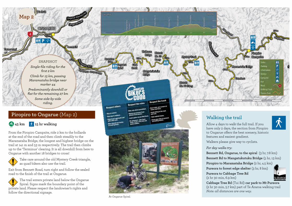
Piropiro to Ongarue (Map 2)
EASY
45 km 15 hr walking
From the Piropiro Campsite, ride 2 km to the bollards at the end of the road and then climb steadily to the Maramataha Bridge, the longest and highest bridge on the trail at 141 m and 53 m respectively. The trail then climbs up to the ‘Terminus’ clearing. It is all downhill from here to Ongarue with another 18 bridges to cross!
Take care around the old Mystery Creek triangle, as quad bikers also use the trail.
Exit from Bennett Road, turn right and follow the sealed road to the finish of the trail at Ongarue.
The trail enters private land below the Ongarue Spiral. Signs mark the boundary point of the
private land. Please respect the landowner’s rights and follow the directional signage.
Map 2
At Ongarue Spiral.
Walking the trailAllow 4 days to walk the full trail. If you have only 2 days, the section from Piropiro to Ongarue offers the best scenery, historic features and easiest gradient. Walkers please give way to cyclists.
For day walks try:Bennett Rd, Ongarue, to the spiral (3 hr, 7.8 km) Bennett Rd to Mangatukutuku Bridge (5 hr, 13 km)Piropiro to Maramataha Bridge (2 hr, 4.5 km)Pureora to forest edge shelter (3 hr, 8 km)Pureora to Cabbage Tree Rd (2 hr 30 min, 6.9 km)Cabbage Tree Rd (Tui Rd) car park to Mt Pureora (2 hr 30 min, 5.7 km) part of Te Araroa walking trail Note: all distances are one way.
SNAPSHOTSingle-file riding for the
first 2 kmClimb for 15 km, passing
Maramataha bridge near marker 44
Predominantly downhill or flat for the remaining 27 km
Some side-by-side riding.