Embed Size (px)
Citation preview
Prepared by: Pat Lee, GIS Manager, GISPPennyrile Area Development DistrictDate: July 2016File: MB-Todd-cover.mxd
Todd CountyTodd CountyE911 MapbookE911 Mapbook
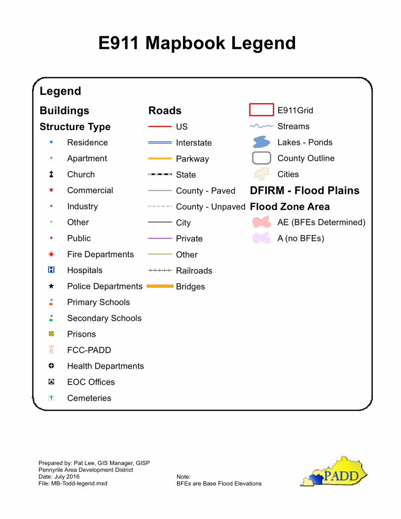
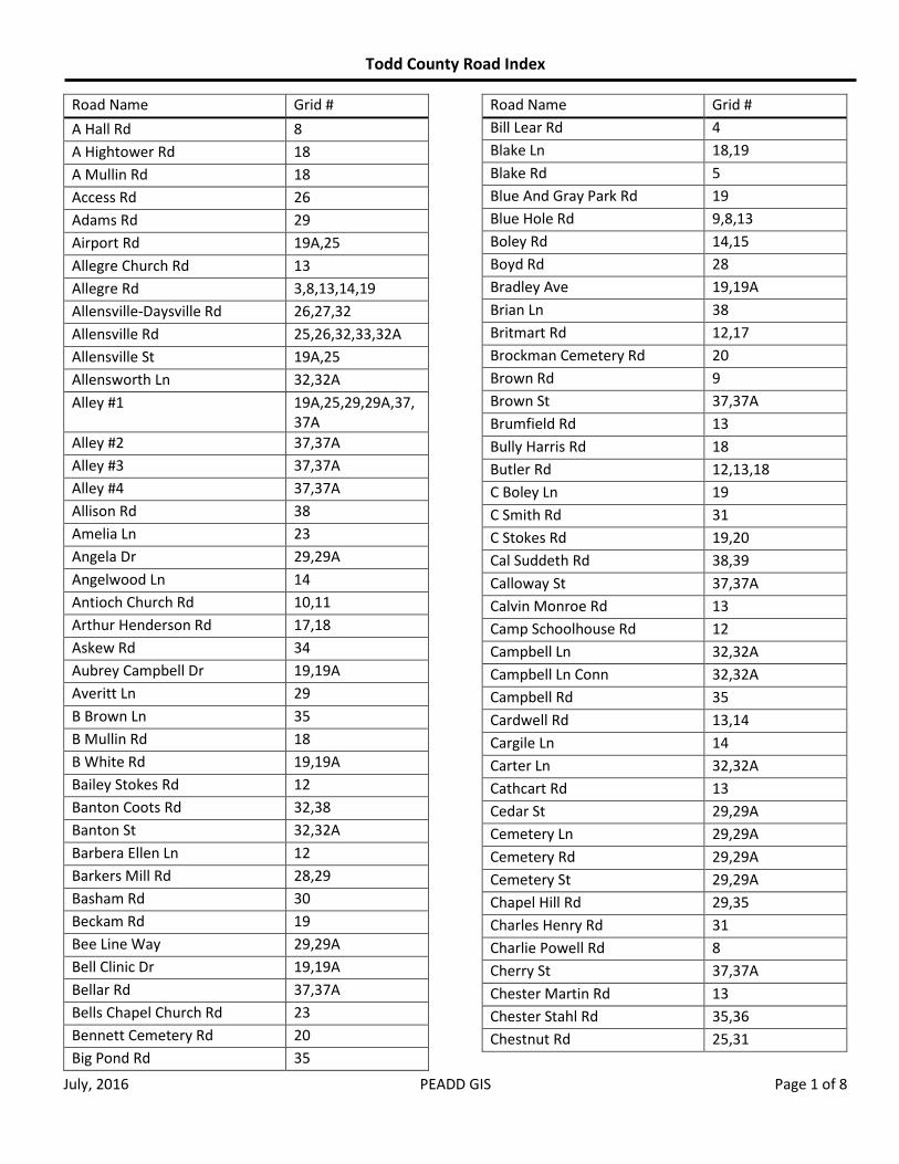
Prepared by: Pat Lee, GIS Manager, GISPPennyrile Area Development DistrictDate: July 2016File: MB-Todd-legend.mxd
LegendBuildingsStructure Type
" Residence! Apartmentæ ChurchP Commercial! Industry! Other! PublicÅ̧ Fire DepartmentsÆP Hospitals^ Police Departmentsn Primary Schoolsn Secondary Schools"ÎD PrisonsY FCC-PADD!E Health Departments"!# EOC OfficesÝ Cemeteries
RoadsUSInterstateParkwayStateCounty - PavedCounty - UnpavedCityPrivateOtherRailroadsBridges
E911GridStreamsLakes - PondsCounty OutlineCities
DFIRM - Flood PlainsFlood Zone Area
AE (BFEs Determined)A (no BFEs)
E911 Mapbook Legend
Note:BFEs are Base Flood Elevations
987
3 6542
1
11
38 39363534 37
3128 30 3329 32
23 272422 2625
2118 19 2017
13 1612 1514
10
37A
29A
19A
32A
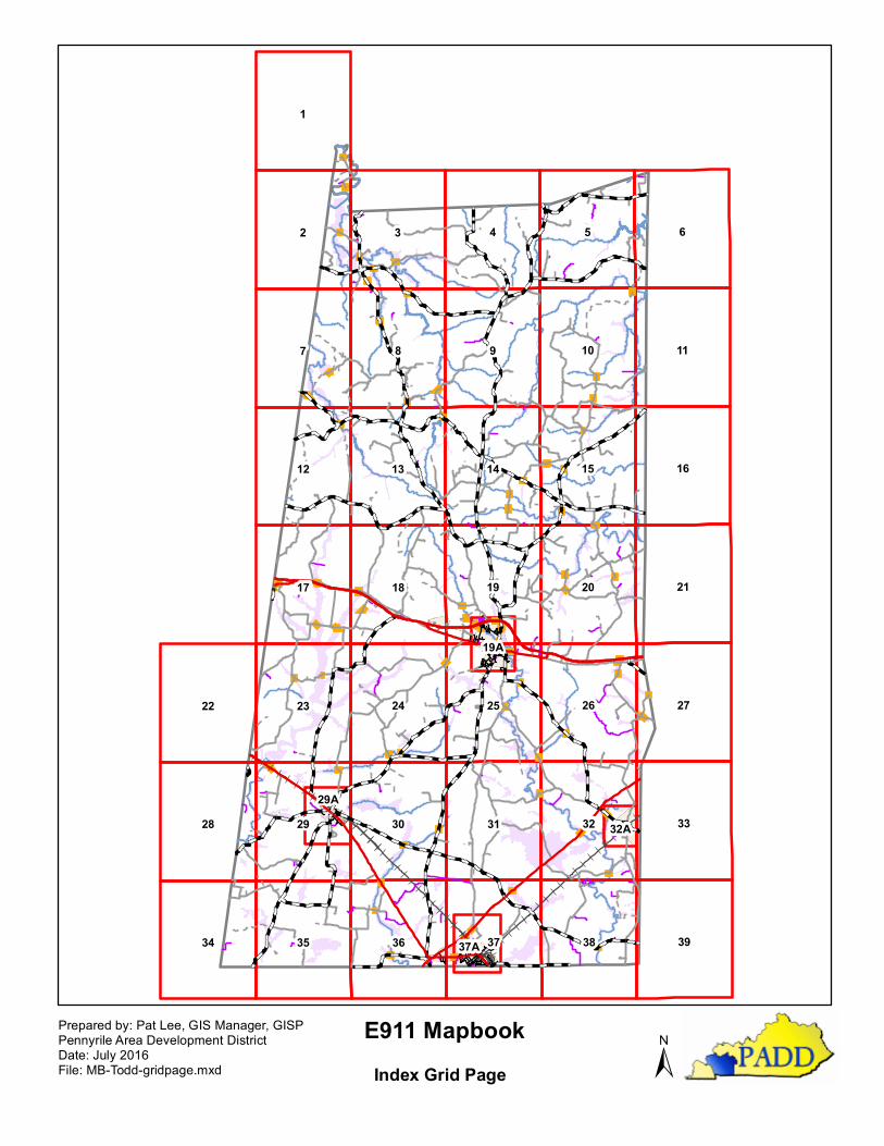
E911 Mapbook±
Prepared by: Pat Lee, GIS Manager, GISPPennyrile Area Development DistrictDate: July 2016File: MB-Todd-gridpage.mxd Index Grid Page
Todd County Road Index
July, 2016 PEADD GIS Page 1 of 8
Road Name Grid #
A Hall Rd 8
A Hightower Rd 18
A Mullin Rd 18
Access Rd 26
Adams Rd 29
Airport Rd 19A,25
Allegre Church Rd 13
Allegre Rd 3,8,13,14,19
Allensville-Daysville Rd 26,27,32
Allensville Rd 25,26,32,33,32A
Allensville St 19A,25
Allensworth Ln 32,32A
Alley #1 19A,25,29,29A,37,37A
Alley #2 37,37A
Alley #3 37,37A
Alley #4 37,37A
Allison Rd 38
Amelia Ln 23
Angela Dr 29,29A
Angelwood Ln 14
Antioch Church Rd 10,11
Arthur Henderson Rd 17,18
Askew Rd 34
Aubrey Campbell Dr 19,19A
Averitt Ln 29
B Brown Ln 35
B Mullin Rd 18
B White Rd 19,19A
Bailey Stokes Rd 12
Banton Coots Rd 32,38
Banton St 32,32A
Barbera Ellen Ln 12
Barkers Mill Rd 28,29
Basham Rd 30
Beckam Rd 19
Bee Line Way 29,29A
Bell Clinic Dr 19,19A
Bellar Rd 37,37A
Bells Chapel Church Rd 23
Bennett Cemetery Rd 20
Big Pond Rd 35
Road Name Grid #
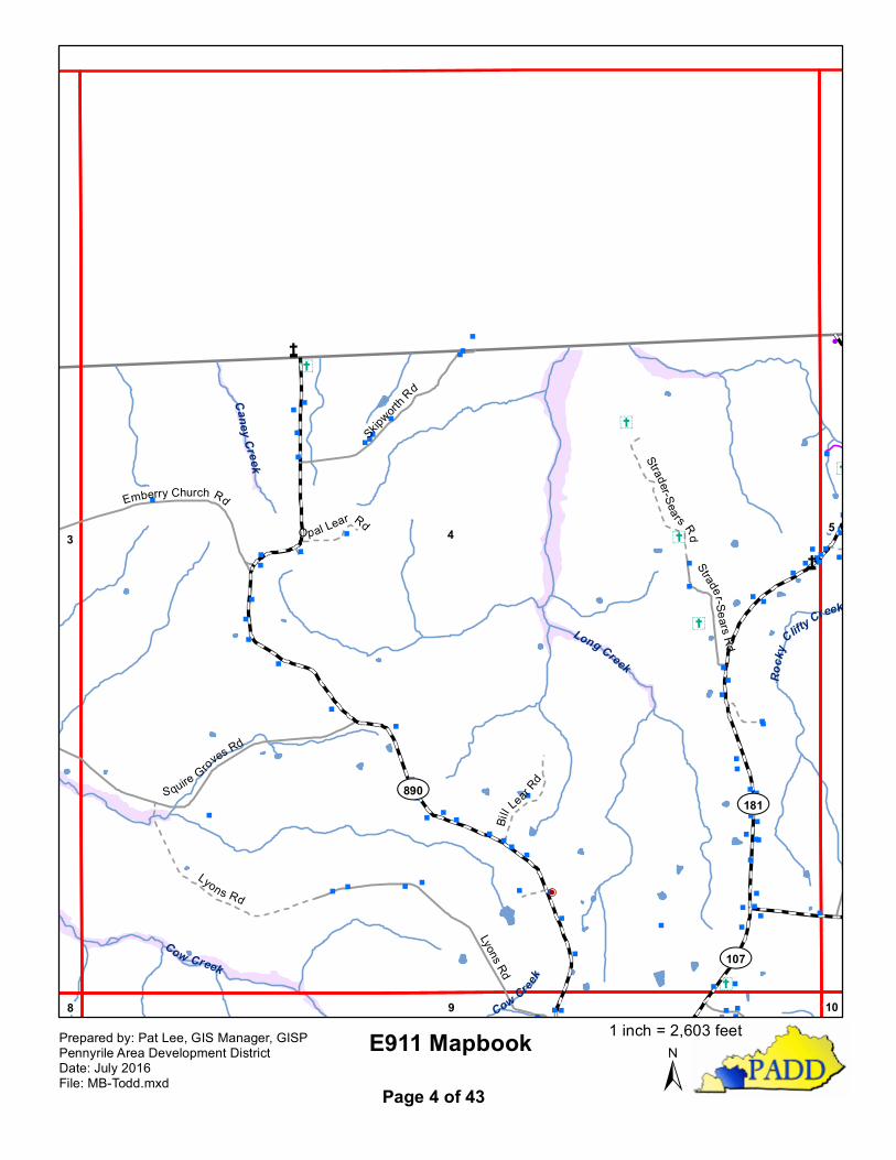
Bill Lear Rd 4
Blake Ln 18,19
Blake Rd 5
Blue And Gray Park Rd 19
Blue Hole Rd 9,8,13
Boley Rd 14,15
Boyd Rd 28
Bradley Ave 19,19A
Brian Ln 38
Britmart Rd 12,17
Brockman Cemetery Rd 20
Brown Rd 9
Brown St 37,37A
Brumfield Rd 13
Bully Harris Rd 18
Butler Rd 12,13,18
C Boley Ln 19
C Smith Rd 31
C Stokes Rd 19,20
Cal Suddeth Rd 38,39
Calloway St 37,37A
Calvin Monroe Rd 13
Camp Schoolhouse Rd 12
Campbell Ln 32,32A
Campbell Ln Conn 32,32A
Campbell Rd 35
Cardwell Rd 13,14
Cargile Ln 14
Carter Ln 32,32A
Cathcart Rd 13
Cedar St 29,29A
Cemetery Ln 29,29A
Cemetery Rd 29,29A
Cemetery St 29,29A
Chapel Hill Rd 29,35
Charles Henry Rd 31
Charlie Powell Rd 8
Cherry St 37,37A
Chester Martin Rd 13
Chester Stahl Rd 35,36
Chestnut Rd 25,31

Todd County Road Index
July, 2016 PEADD GIS Page 2 of 8
Road Name Grid #
Church Hill Ln 19A,25
Church Ln 38
Church St 29,29A,32,32A
Clarksville Rd 29,29A,34,35
Clarksville St 29,29A
Clay Cole Rd 20
Claymore Campground Rd 15
Cliff Hill Church Rd 5
Cliff Hill Rd 5,6,10
Clifty-Kirkmansville Rd 3,8,9
Coal Bank Rd 10,14,15
Cole St 29,29A
College St 19A,25
Collier Spring Rd 14
Commerce St 19,19A,37,37A
Contessa Ln 29,29A
Cook Ln 9
Cordie Wilson Rd 18
Cordis Kenner Rd 15
Coursey Rd 14
Covington St 37,37A
Cox Rd 26,32
Coy Case Rd 18
Crawford Rd 10,15,16
Creighton Rd 38
Curtis Small Rd 31,32
Cypress Ln 36
Dalton Ridge Rd 20
Darden Ln 19
Davenport Rd 35
David Hightower Rd 18
Davis Mill Rd 19,23,24,25,29, 29A
Deborah St 19A,25
Dennis Hurt Rd 20
Dickinson Quarry Rd 30
Dickinson Rd 24
Dixie Bee Ct 29,29A
Dixie Beeline Hwy 22,23,29,29A,30, 36,38
Dixie St 37,37A
Dobbs Rd 27
Road Name Grid #
Docs Dr 29,29A
Doctor Boyles Rd 31,32
Dogwood Rd 35,36
Don Dr 19,19A
Dorris Dossett Rd 8
Dossett Rd 13
Dowdy Rd 19
Downer Ln 36
Duke St 19A,25
Duncan Ridge Rd 11
Dunheath Dr 19A,25
E Main St 19A,25
Eagle Ln 14
Earl Almy Rd 18
East Greenfield Rd 14
East Jefferson Davis Hwy 26,27
East Jefferson St 19A,25
East Lester Chapel Rd 36
East Mcreynolds Dr 19A,25
East Mitchell Spur Rd 8
East Mullin Rd 18
East Nelson Cole Rd 20
East Park St 37,37A
East Ruth Dr 19,19A
East Shelby Ave 19,19A
East Washington St 19A,25
Edlin St 37,37A
Edwards Ln 9
Eighth St 29,29A
Elaine Ct 19A,25
Elk Fork Rd 19,19A,25
Elk St 25,19A
Elkton-Trenton Rd 24,25
Elkton Cemetery Rd 19,19A
Elkton Park Rd 19A,25
Elm St 19A,25,29,29A
Eloise Moore Rd 18
Elvis Presley Blvd 29
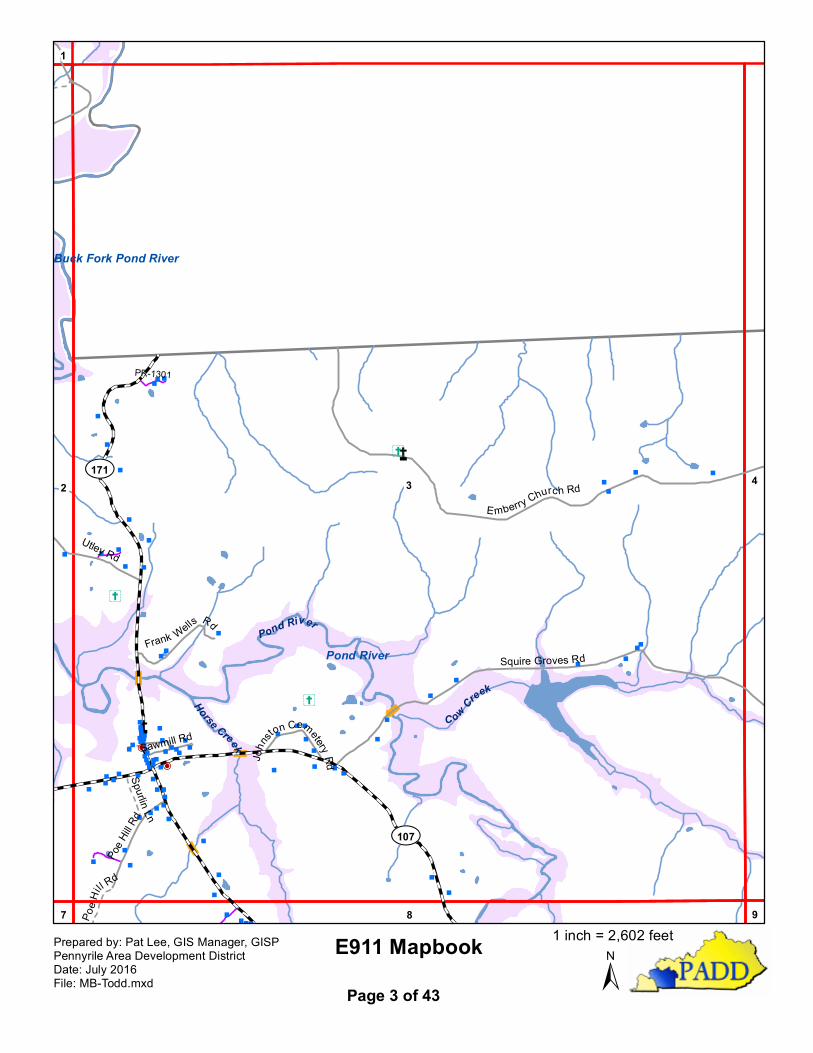
Emberry Church Rd 3,4
Ewing St 37,37A
Fairgrounds Rd 37,38,37A
Todd County Road Index
July, 2016 PEADD GIS Page 3 of 8
Road Name Grid #
Fifth St 29,29A,37,37A
First St 29,29A,37,37A
Flat Rock Rd 12
Flat Rock Schoolhouse Rd 12
Forgy Town Rd 19,19A
Foster Rd 17
Fourth St 29,29A
Fowler Ln 38
France Rd 9
Francies Cemetery Spur 8
Francies Rd 8
Frank Wells Rd 3
Frederick Rd 28,29
Freeman Rd 38
Friendly Acres Trailer Court Rd 29
Frogue Rd 25
Front St 37,37A
Fulcher School Rd 17
Gail Sears Rd 15
Gardner Rd 32
Garth Ln 19A,25
Gates Rd 20,26
Gayle Ln 19A,25
George F Addison Rd 24
Georgetown Cir 25
Gibson Hightower Rd 18
Gills Chapel Church Rd 31
Glenn Ct 19A,25
Glenwood Cemetery Rd #1 19,19A
Glenwood Cemetery Rd #2 19,19A
Glenwood Cemetery Rd #3 19,19A
Glenwood Cemetery Rd #4 19,19A
Goebel Ave 19A,25
Goodman Rd 20,21
Goodnight Rd 10
Goshen Rd 12,17
Gower St 37,37A
Graysville Rd 36
Green Acres Cir 36
Green St 37,37A
Greenville Rd 4,5,9,14,19,19A,36
Road Name Grid #
Guinn Rd 22,23
Gum Grove Rd 2
Gun Club Rd 24
Guthrie Highland Cemetery Rd 37,37A
Guthrie Rd 25,30,31,36
H Gorrell Rd 15
Hadden Mill Rd 19,20
Hadden Rd 30
Hadensville Rd 37,38,39
Haley Dr 19,19A
Hall Rd 9,10,15
Hammacksville Rd 29,29A,35
Hampton St 19A,25
Hardison Rd 27
Harris Dr 15
Harris Ln 13
Harris Rd 15
Harry Tucker Rd 7
Heltsley Ln 9
Henderson Rd 17,23
Henry B Farmer Rd 32,32A
Herman Rd 25,31
Highland Lick Rd 13,14,15,16
Highland Rd 37,37A
Hilton Rd 36
Homer Powell Rd 7
Hoover Martin Rd 18
Hopkinsville Rd 17,18,19,19A
Howard Cir 19A,25
Howard Dickerson Rd 28
Howell St 37,37A
Hurricane Hill Rd 7
Hurt Ln 20
Industrial Dr 19,19A,25
Industrial Dr #1 19,19A
J Johnson Rd 10
J. Cross 26
Jack Gray Rd 30,35,36
Jai Ct 38
James Mitchell Rd 8
Jamie Dr 19,19A

Todd County Road Index
July, 2016 PEADD GIS Page 4 of 8
Road Name Grid #
Jason Ridge Rd 5,6
Jefferson Davis Hwy 17
Jefferson Davis Monument Dr 17
Jefferson Davis Monument Dr Conn
17
Jennifer Dr 19,19A
Jim Green Rd 24
Joe Gill Rd 32,32A
Joe Potter Rd 20
John Dr 19,19A
John Greenfield Rd 19
John Hightower Rd 18
John U Young Rd 39
John Young Rd 32
Johnson Chapel Rd 26
Johnson Dr 19
Johnson Mill Rd 5
Johnsons Ln 32
Johnston Cemetery Rd 3
Joiners Ave 19,19A
Jonah Wilson Rd 5
Jones Dr 3
Jones Rd 12
Jordan Ave 19,19A
Jordan Ln 37,37A
Judge Rager Ln 4
Keith Tr 18
Kendall St 37,37A
Kentucky St 37,37A
Kimberly St 25,19A
Kirkman Cemetery Rd 13
KY-107 2,3
KY-115 17
KY-171 3,19
KY-181 14
KY-189 7,12
Lack Rd 14
Lance Dr 19,19A
Lasters Ave 19,19A
Latham Rd 9
Law Ln 8
Lawson-Hester Rd 15
Road Name Grid #
Lawson Poindexter Rd 36
Lear Rd 4
Leavell Ln 19A,25
Lewis Jones Rd 7,8,12,13
Lewis Jones Spur Rd 7
Liberty Rd 13,14
Lina Martin Rd 20
Lizzy Dancy St 37,37A
Locust St 37,37A
Log Gap Rd 9
Long Rd 14,19
Lucian Stokes Rd 14
Lucky Ln 19A,25
Lyons Rd 4,9
M Gorrell Rd 15
M Hall Rd 8,13
Machine Shop Rd 36
Magnolia Dr 19A,25
Main St 37,37A
Majors Ln 20
Mallory Dr 19A,25
Marion St 19A,25
Markham Rd 13,18
Marshall Ln 35
Martin Rd 20
Marvin Powell Rd 8
Marvin Powell Rd Conn 8
Mary Dr 19,19A
Mary St 19,19A
Maton Rd 23
Mccormick Cemetery Rd 13
Mckinney Bend Rd 1,2,3
Mcpherson Cemetery Rd 6
Mcpherson Rd 5
Meadow Haven Cemetery Rd 25
Meadowhaven Ln 25
Meredith Ln 30,31
Merritt St 37,37A
Merriweather St 37,37A
Micah Dr 25,19A
Millen Rd 24,25
Todd County Road Index
July, 2016 PEADD GIS Page 5 of 8
Road Name Grid #
Miller Dr 19A,25
Miller Valley Rd 20,26
Mimms Rd 29
Mimms St 37,37A
Minnie Hollow Rd 8
Mitchell Spur Rd 8
Moe Dr 18
Monroe Ln 13
Moore Ln 5
Moore Rd 15
Moore St 37,37A
Morningside Dr 19A,25
Morris St 37,37A
Morris Weathers St 19A,25
Morton Ln 17,23
Mount Pleasant Cir 32,32A
Mount Pleasant Ln 32,32A
Mount Sharon Rd 10,15
Murray Ct 19A,25
Murray Rd 24
Myer Dr 19,19A
N David Hightower 18
Nat Pennick Rd 31
Nat Pennick Rd Spur 31
Nelson Cole Rd 20
Nelson Rd 37,37A
Nnn Ln 38
Norris St 37,37A
North Allen St 19A,25
North Kennedy St 19A,25
North Kentucky St 37,37A
North Lester Chapel Rd 36
North Lincoln St 19A,25
North Main St 19,19A,25,29,29A
North Perry St 19A,25
North Streets Ave 19A,25
North Williams Ln 19A,25
Oak Ridge Ct 19
Oak St 29,29A,37,37A
Old Allensville Rd 25,31,32
Old Bells Chapel Rd 24
Road Name Grid #
Old Creosote Ln 37,37A
Old Fairgrounds Ln 37,37A
Old Quarry Rd 19,25
Old Quarry Rd Spur 19,25
Old Railroad Ln 25,31,37,37A
Old Trenton Rd 24,25,29,29A,30
Old Volney Rd 26,27
Olive St 19A,25
Oneil Rd 15
Opal Lear Rd 4
Pace St 32,32A
Patriot St 36
Paul J Wright Rd 15
Pea Ridge Rd 15,20
Penchem Rd 29,29A,30,31,37
Penchem St 29,29A
Pennyrile Court #1 37,37A
Pennyrile Court #2 37,37A
Pennyrile Court #3 37,37A
Pete Wheeler Rd 26
Petrie Rd 12
Phillipi Rd 24
Phillips Rd 14
Pilot Rock Rd 12,13
Pleasant Grove Rd 30
Pleasant Hill Church Rd 15
Poe Hill Rd 3,7,8
Pogue Rd 14
Pond River Rd 19,19A
Poplar St 19A,25
Port Royal Rd 36
Posey St 37,37A
Powell Hollow Rd 8
Powell Lake Rd 8
Powell Rd 24
PR-1001 10,11
PR-1102 25
PR-1103 25
PR-1104 32
PR-1107 31
PR-1108 25
Todd County Road Index
July, 2016 PEADD GIS Page 6 of 8
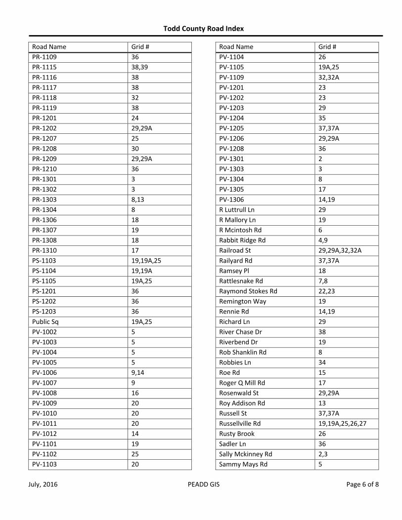
Road Name Grid #
PR-1109 36
PR-1115 38,39
PR-1116 38
PR-1117 38
PR-1118 32
PR-1119 38
PR-1201 24
PR-1202 29,29A
PR-1207 25
PR-1208 30
PR-1209 29,29A
PR-1210 36
PR-1301 3
PR-1302 3
PR-1303 8,13
PR-1304 8
PR-1306 18
PR-1307 19
PR-1308 18
PR-1310 17
PS-1103 19,19A,25
PS-1104 19,19A
PS-1105 19A,25
PS-1201 36
PS-1202 36
PS-1203 36
Public Sq 19A,25
PV-1002 5
PV-1003 5
PV-1004 5
PV-1005 5
PV-1006 9,14
PV-1007 9
PV-1008 16
PV-1009 20
PV-1010 20
PV-1011 20
PV-1012 14
PV-1101 19
PV-1102 25
PV-1103 20
Road Name Grid #
PV-1104 26
PV-1105 19A,25
PV-1109 32,32A
PV-1201 23
PV-1202 23
PV-1203 29
PV-1204 35
PV-1205 37,37A
PV-1206 29,29A
PV-1208 36
PV-1301 2
PV-1303 3
PV-1304 8
PV-1305 17
PV-1306 14,19
R Luttrull Ln 29
R Mallory Ln 19
R Mcintosh Rd 6
Rabbit Ridge Rd 4,9
Railroad St 29,29A,32,32A
Railyard Rd 37,37A
Ramsey Pl 18
Rattlesnake Rd 7,8
Raymond Stokes Rd 22,23
Remington Way 19
Rennie Rd 14,19
Richard Ln 29
River Chase Dr 38
Riverbend Dr 19
Rob Shanklin Rd 8
Robbies Ln 34
Roe Rd 15
Roger Q Mill Rd 17
Rosenwald St 29,29A
Roy Addison Rd 13
Russell St 37,37A
Russellville Rd 19,19A,25,26,27
Rusty Brook 26
Sadler Ln 36
Sally Mckinney Rd 2,3
Sammy Mays Rd 5
Todd County Road Index
July, 2016 PEADD GIS Page 7 of 8
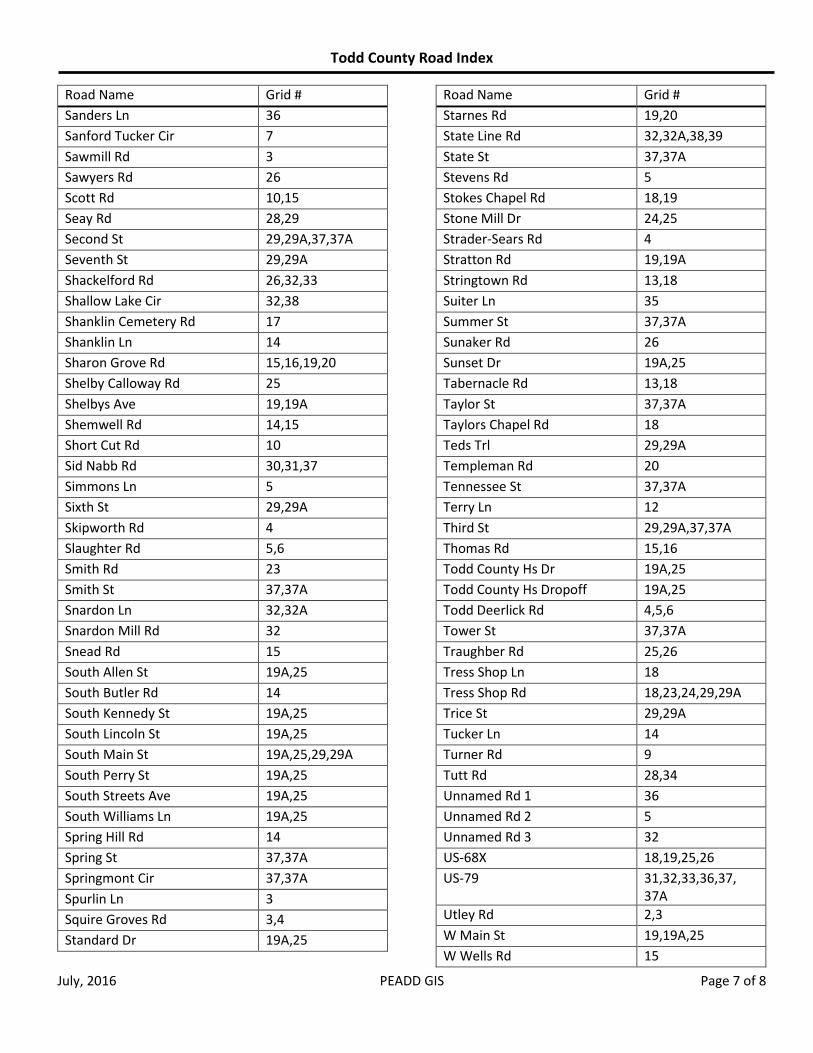
Road Name Grid #
Sanders Ln 36
Sanford Tucker Cir 7
Sawmill Rd 3
Sawyers Rd 26
Scott Rd 10,15
Seay Rd 28,29
Second St 29,29A,37,37A
Seventh St 29,29A
Shackelford Rd 26,32,33
Shallow Lake Cir 32,38
Shanklin Cemetery Rd 17
Shanklin Ln 14
Sharon Grove Rd 15,16,19,20
Shelby Calloway Rd 25
Shelbys Ave 19,19A
Shemwell Rd 14,15
Short Cut Rd 10
Sid Nabb Rd 30,31,37
Simmons Ln 5
Sixth St 29,29A
Skipworth Rd 4
Slaughter Rd 5,6
Smith Rd 23
Smith St 37,37A
Snardon Ln 32,32A
Snardon Mill Rd 32
Snead Rd 15
South Allen St 19A,25
South Butler Rd 14
South Kennedy St 19A,25
South Lincoln St 19A,25
South Main St 19A,25,29,29A
South Perry St 19A,25
South Streets Ave 19A,25
South Williams Ln 19A,25
Spring Hill Rd 14
Spring St 37,37A
Springmont Cir 37,37A
Spurlin Ln 3
Squire Groves Rd 3,4
Standard Dr 19A,25
Road Name Grid #
Starnes Rd 19,20
State Line Rd 32,32A,38,39
State St 37,37A
Stevens Rd 5
Stokes Chapel Rd 18,19
Stone Mill Dr 24,25
Strader-Sears Rd 4
Stratton Rd 19,19A
Stringtown Rd 13,18
Suiter Ln 35
Summer St 37,37A
Sunaker Rd 26
Sunset Dr 19A,25
Tabernacle Rd 13,18
Taylor St 37,37A
Taylors Chapel Rd 18
Teds Trl 29,29A
Templeman Rd 20
Tennessee St 37,37A
Terry Ln 12
Third St 29,29A,37,37A
Thomas Rd 15,16
Todd County Hs Dr 19A,25
Todd County Hs Dropoff 19A,25
Todd Deerlick Rd 4,5,6
Tower St 37,37A
Traughber Rd 25,26
Tress Shop Ln 18
Tress Shop Rd 18,23,24,29,29A
Trice St 29,29A
Tucker Ln 14
Turner Rd 9
Tutt Rd 28,34
Unnamed Rd 1 36
Unnamed Rd 2 5
Unnamed Rd 3 32
US-68X 18,19,25,26
US-79 31,32,33,36,37, 37A
Utley Rd 2,3
W Main St 19,19A,25
W Wells Rd 15
Todd County Road Index
July, 2016 PEADD GIS Page 8 of 8
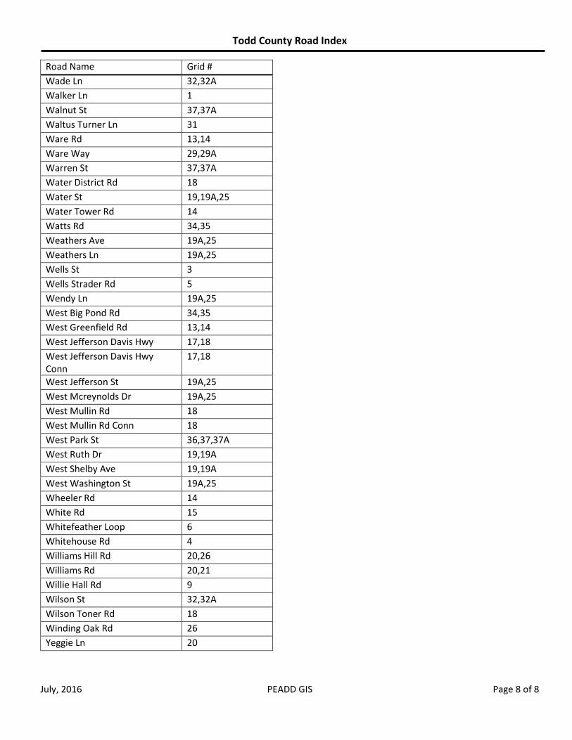
Road Name Grid #
Wade Ln 32,32A
Walker Ln 1
Walnut St 37,37A
Waltus Turner Ln 31
Ware Rd 13,14
Ware Way 29,29A
Warren St 37,37A
Water District Rd 18
Water St 19,19A,25
Water Tower Rd 14
Watts Rd 34,35
Weathers Ave 19A,25
Weathers Ln 19A,25
Wells St 3
Wells Strader Rd 5
Wendy Ln 19A,25
West Big Pond Rd 34,35
West Greenfield Rd 13,14
West Jefferson Davis Hwy 17,18
West Jefferson Davis Hwy Conn
17,18
West Jefferson St 19A,25
West Mcreynolds Dr 19A,25
West Mullin Rd 18
West Mullin Rd Conn 18
West Park St 36,37,37A
West Ruth Dr 19,19A
West Shelby Ave 19,19A
West Washington St 19A,25
Wheeler Rd 14
White Rd 15
Whitefeather Loop 6
Whitehouse Rd 4
Williams Hill Rd 20,26
Williams Rd 20,21
Willie Hall Rd 9
Wilson St 32,32A
Wilson Toner Rd 18
Winding Oak Rd 26
Yeggie Ln 20

"
"
"
"
"
Ý
Ý
"ÎD
"ÎD
^̂
ÆP
ÆPÆP
1
2 3
Pond River
Pond RiverMcKinney Bend Rd
Wal ker Ln
E911 Mapbook±
Prepared by: Pat Lee, GIS Manager, GISPPennyrile Area Development DistrictDate: July 2016File: MB-Todd.mxd Page 1 of 43
1 inch = 2,600 feet
"
"
""
"
"
"
"
"
" "
"
"
"
"""
""
""
" ""
"
Ý
Ý
Ý
Ý
Ý
"ÎD
n
^̂
ÆP
ÆPÆP
Å̧
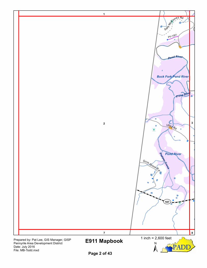
2 3
1
7 8
Pond River
Buck Fork Pond River
Pond River
Pepper Creek
Pond River
¾À107
Utley Rd
Gum Grove Rd
SallyMcK
inney Rd
PV-1301
E911 Mapbook±
Prepared by: Pat Lee, GIS Manager, GISPPennyrile Area Development DistrictDate: July 2016File: MB-Todd.mxd Page 2 of 43
1 inch = 2,600 feet
""
"
"""
"
"
"
"
"
""
"
"
"
""
"
""
"
"
""
""
"
"
"
"
""
"
"
"
""
""
""
"
"""""""æ
"
""
"
"
"
"
"""
"
"
"
"
"""
""""""
P""""
"
""
"
"
æ
"
" "
"
""
"
""
""
""
""
"P "" "
"
"
"
""
Ý
Ý
Ý
Ý
Ý
Ý
Ý
"ÎD
^̂
ÆP
ÆPÆP
3 42
8
1
97
Pond River
Buck Fork Pond River
Pond RiverHorse Creek
C ow Creek
¾À171
¾À107
Squire Groves Rd
Emberry Church Rd
Utley Rd
Poe H
ill Rd
Frank Wells Rd
Sawmill Rd
John
ston Cemetery Rd
Spurlin Ln
Poe H
ill Rd
PR-1301
E911 Mapbook±
Prepared by: Pat Lee, GIS Manager, GISPPennyrile Area Development DistrictDate: July 2016File: MB-Todd.mxd Page 3 of 43
1 inch = 2,602 feet
"" "
"
"
"
""
"
"
"P"
"
"
"
""
""
"
"
"
"
"
"
"
"
"
"
"
"
"
"
"
"
""
""
"
"
"
"
""P""
"" ""
"
""
"
"
""
"
"
""
"
"
""
"
"
"
"
"
""
"!
""
"
"
"
"
"æ"
""
"
""
"
"æ""
"
"
"
"
"
"
"
"
"
"
"
"
æ!
!
"
"
"
"
"
""
"
"
"
"
"
"
"
æ
Ý
Ý
Ý
Ý
Ý
Ý
Ý
Ý
YY
"ÎD
^̂
^
ÆP
ÆPÆP
Å̧
Å̧
4 53
98 10
Long Creek
Cow Creek
Rock
y C
liftyCreek
Caney Creek
Cow Creek
¾À890¾À181
¾À107
Lyons Rd
Squire Groves Rd
Skipworth
Rd
Emberry Church Rd
Strader-Sears Rd
Lyons Rd
Bill Lear R
d
Strader-Sears RdOpal Lear Rd
E911 Mapbook±
Prepared by: Pat Lee, GIS Manager, GISPPennyrile Area Development DistrictDate: July 2016File: MB-Todd.mxd Page 4 of 43
1 inch = 2,603 feet
""
"
""
"
"
"
"
"
""
""
"
""
"!
"
"
" "
"
"
""
""
"
"
"" " "
"
"
""
" "
"
" ""
"
""""
æ""
"
"
""""
""
""
"
"
"
"
"
"
"""
"
"æ"
""
"
""
"
"æ""
"
"" æ
""
" "
"
"
"
"
æ"
""
""
""" " ""
""
"
"
"
"
"
"
""
" "
"
"""""
"""
""""""""
"
"P
"""""
"
"
"
"
"
"
"
"
"
"
"
""
"
"
"
""""
"""""
"
Ý
Ý
Ý
Ý
Ý
Ý
Ý
"ÎD
^
Å̧
Å̧
5 64
109 11
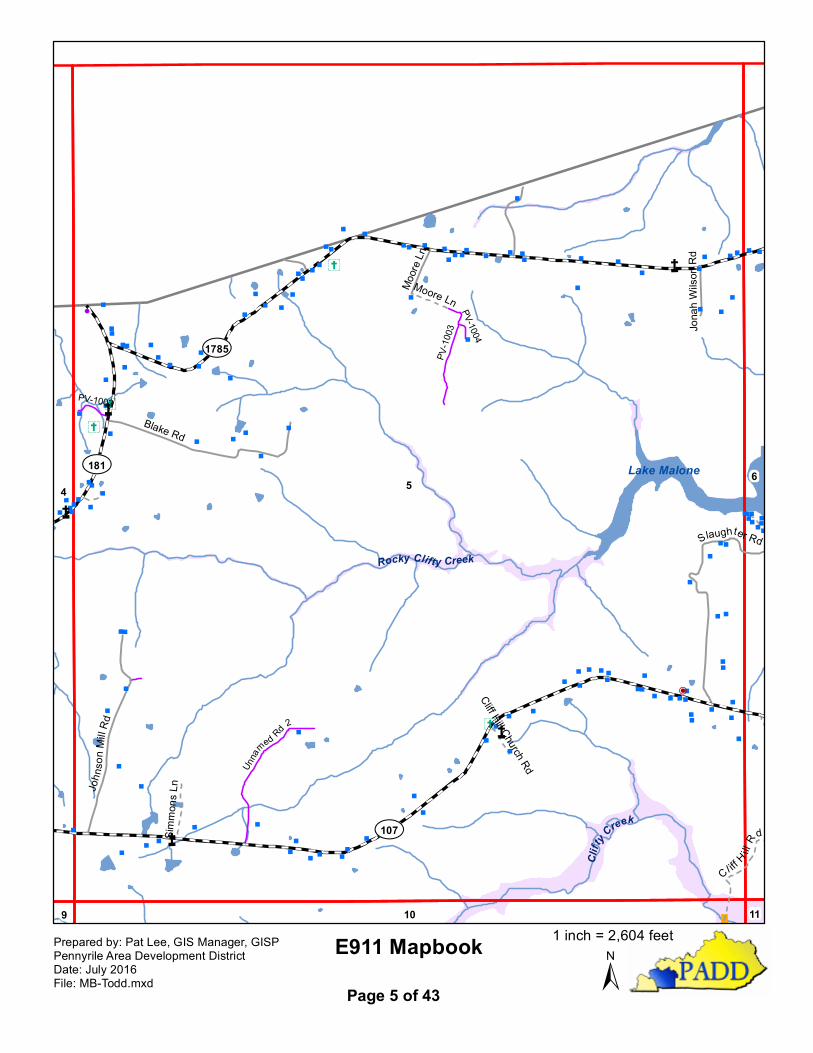
Lake Malone
Rocky Clifty Creek
Clifty
Creek¾À107
¾À1785
¾À181
Blake Rd
John
son M
ill Rd
Slaughter Rd
Moore
Ln
Jona
h Wils
on R
d
Cl iff H illRdSim
mons
Ln
Moore Ln
Cliff Hill Church Rd
PV-10
03
Unna
med Rd 2
PV-1002
PV-1004
E911 Mapbook±
Prepared by: Pat Lee, GIS Manager, GISPPennyrile Area Development DistrictDate: July 2016File: MB-Todd.mxd Page 5 of 43
1 inch = 2,604 feet
"
" "
"
" ""
"
""""
"
""
"
"
"
"
"
""
"
""
" "
"
"""""
"""
""""""""
"
"
"
""""
"""""
Ý
^
Å̧
Å̧
Å̧
65
1110
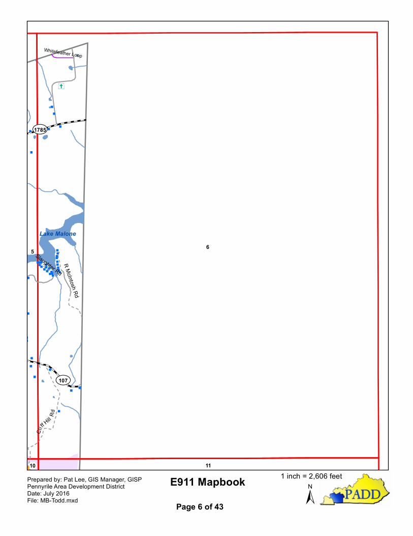
Lake Malone
¾À107
¾À1785
R McIntosh Rd
Cliff Hill Rd
Slaughter Rd
Whitefeather Loop
E911 Mapbook±
Prepared by: Pat Lee, GIS Manager, GISPPennyrile Area Development DistrictDate: July 2016File: MB-Todd.mxd Page 6 of 43
1 inch = 2,606 feet

" "
"
"
"
"
"
""
"
"
""
"
"
"
"
"""
"
"
"
"
""
Y
"ÎD
n
ÆP
ÆPÆP
Å̧
7 8
2
12
3
13
Buck Fork Pond River
Pepper Creek
Weathers Branch
Caney Creek
¾À189
Rattlesnake Rd
Lewis Jones R
d
Homer Powell RdRa
ttlesna
ke
Rd
Lewis Jone sRd
E911 Mapbook±
Prepared by: Pat Lee, GIS Manager, GISPPennyrile Area Development DistrictDate: July 2016File: MB-Todd.mxd Page 7 of 43
1 inch = 2,600 feet

"
"
"
"
" "
"
"
"
"
"
"
""
"
"
""
""
"
"
"
"
""
"
"
"" " "
" "
"
"
"""
"
"
"
"
" "
"
"
"
"
"
æ" "
"
"""
"
"
"
"
"
"
"
"
"
"
""
""
"
"
"
"
"
"
"
" "
"
""""
""
"
"
""
"
""
"
"""
"
"
"
"
"
"
"
"
""
"
P
"
"
P
"
"""
"
"
"
"
"
"
"
"
"
"
"
"
"
""
"
"
"
"
""
"
Ý
Ý
Ý
Ý
Ý
Y
"ÎD
ÆP
ÆPÆP
8 97
3
13
42
1412
Pond River
Hors
e Cree
k
Shelton Branch
Po
nd River
Wolf Branch
¾À107
¾À171
Rattlesnake Rd
Francies Rd
Blue Hole Rd
Marvin
Powell Rd
AHa
ll Rd
Lewis Jones Rd
RobSh
anklin
Rd
Powell Lake Rd
Charli
e Pow
ell Rd
PoeHil
l Rd
Francies Rd
Marvin Powell Rd
Minnie Hollow Rd
Dorris
Dosse
tt Rd
Powe
ll Hollo
w Rd
PV-13
04
PR-1303
PR-1304
Law Ln
E911 Mapbook±
Prepared by: Pat Lee, GIS Manager, GISPPennyrile Area Development DistrictDate: July 2016File: MB-Todd.mxd Page 8 of 43
1 inch = 2,602 feet
" æ"
"P
"
"
"
"
"""
"""
"
"
"
"
"
"
""
"
"
"
""
"
"
""
"
"
"
"
P"
P
PP"""
"
"
"
""
"
""
"
"
"
"
"
P"
""
"
"
"
"
"
"
"
"
"
" " "" " ""
""
!
"
"
"
" "
"
"
"
"
""
"
"
"
"
"
"
P"
""
P
"""""
""
"
"
"
"
"
"
""
"
"
""
"
"" """
"""" " "
"" ""
"
"
" "
"
"
"
"
"
""!PP
"""
æ""""
""
""
""
""
"""
"
"
""""""P
"""
"""
æ""""
"P""""
""""
""""""
"
"
""
"
"
"
"
æ!
!
"
"
"""""""
"
"
"""
"""
"
"
"
"
"
Ý
Ý
Ý
Ý
Ý
Ý
Ý
YY
"ÎD
ÆP
ÆPÆP
Å̧
98
4
10
14
53
13 15
Pond River
Clifty
Cree
k
Sulfur Lick
Wolf Branch
Kate Branch
Cow Creek
Slim Jimmy Branch
¾À107
¾À181
¾À890
Blue Hole Rd
Latham Rd
Heltsley Ln
Hall Rd
LogGa
p Rd
Brown Rd
Turner Rd
Lyons Rd
Edwa
rds Ln
Hall Rd
Willie Hall Rd
France Rd
PV-10
06
E911 Mapbook±
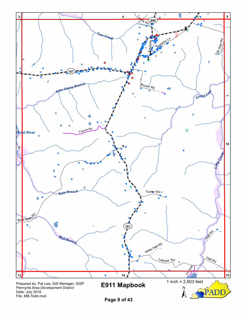
Prepared by: Pat Lee, GIS Manager, GISPPennyrile Area Development DistrictDate: July 2016File: MB-Todd.mxd Page 9 of 43
1 inch = 2,603 feet
"
"
"
"
"
"" æ
""
" "
"
"
"
"
"
"
"
"
"
"""
""
"
"
"
"
"
"
"
"
P
P
"""
"
"
"
"
"
"
æ
""
"
"
""
"
"
"
æ"
"
"
"
"
"
""
"" "
"
"
"
" "
"
"
""""
"
"
""
""
"
"
""
"
""""
"""
"
"
"
"
"
"
"
"
"
"
""
"
"
""
""
"
"
"
"
"
"""
"
"
"
""
""
"
"
"
"
"
"
"
"
"
""
"""
"
""""
"
"
"
"
"
Ý
Ý
"ÎD
Å̧
Å̧
109
5
11
15
64
14 16
Clifty C reek
Li ttleClifty
Creek
Antioch CreekCopper Spring Branch
C lifty Creek
Coal Bank Rd
Moun
t Sha
ron R
d
Short Cut Rd A ntioch Church Rd
Crawford RdScott
RdHall Rd
Log Gap Rd
Crawford Rd
Cliff Hill Rd
PR-1001
Goodnight Rd
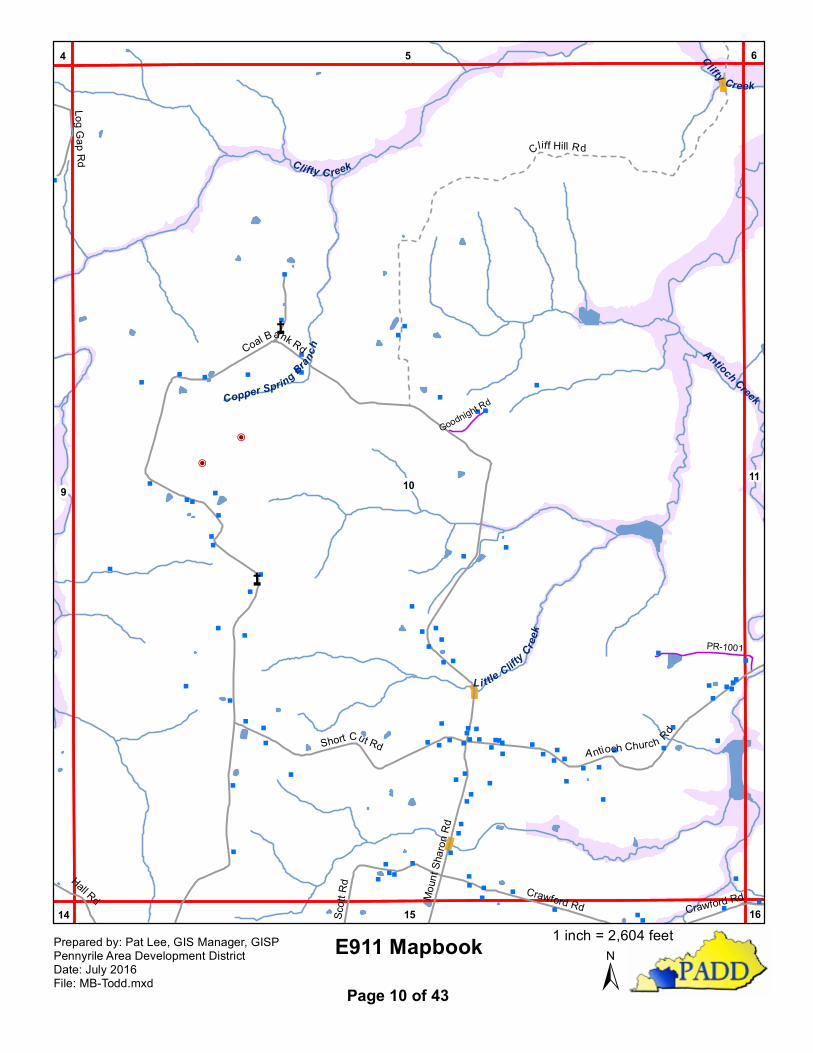
E911 Mapbook±
Prepared by: Pat Lee, GIS Manager, GISPPennyrile Area Development DistrictDate: July 2016File: MB-Todd.mxd Page 10 of 43
1 inch = 2,604 feet
"
"
""""
"
æ"
""
""
"
"
"
"""
"
"
"
"""
"
""
"
"""
""
"
Ý
Å̧
Å̧
11
6
10
16
5
15
Antioch Creek
LittleClifty
Creek
Clifty Creek
Crawford Rd
Antioch Church Rd
E911 Mapbook±
Prepared by: Pat Lee, GIS Manager, GISPPennyrile Area Development DistrictDate: July 2016File: MB-Todd.mxd Page 11 of 43
1 inch = 2,606 feet
"
"
P
"
""
"
"
"
"
"
P"
"
"
"
"
"
""æ
""
""
"
"
"
""
"
"
""""
""
"
"æ"
"
"
"
""
"
P
"
""
"
P
"
P
P
"
""
"
"
""
"
"
"
"
"
"
"
"
"
"
"
"
"
"
""
"
""
P "
"
""
"
"
"
"P
"
"
""
"
"
"""
"""""
"" "
"
"
"ÎD
n
n
ÆP
ÆPÆP
Å̧
Å̧
Å̧
Å̧
12
7
13
17
8
18
Buck Fork Pond River
Warrens Fork
¾À507
¾À189
¾À508Fla
t Roc
k Rd
Goshen Rd
Britm
art Rd
Terry Ln
Roy A
ddiso
n Rd
Jone
s Rd
Flat Rock RdPetrie Rd
Bailey Stokes Rd
E911 Mapbook±
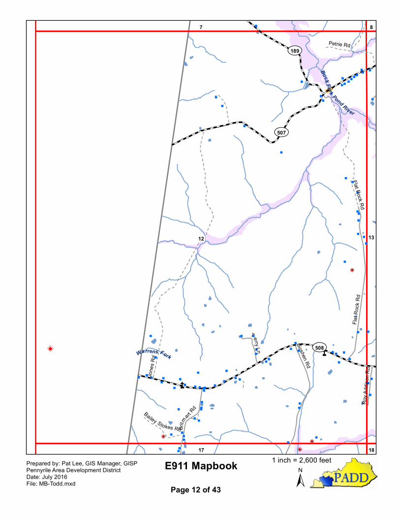
Prepared by: Pat Lee, GIS Manager, GISPPennyrile Area Development DistrictDate: July 2016File: MB-Todd.mxd Page 12 of 43
1 inch = 2,600 feet
""
"""
"
"
"
"
"
"
"
"
"
"
""
"
"
""
"P
"
"
"
"
""æ
"
"
"
"
"
"
P"
"
"
"
"
"
"
"
"
"
""
P"
P
"
P
P
"
""
"
"
""
"
"
"
"
"
"
"
"
æ
P"
"
""
"
"
"
""
"""
"""
"
""
""
"
"
"
"
"
"
"""""
"
"
"
"
""
"
""
!
P
"
"
"
æ
"
"
"
""""
"
"
"
"
""
"
"
"
"
""
"
"
"
!
!"
"P
"P"
""
"
"
"
"
"
"
""
"""
"
"
" "" "
æ " " "
"
"
"
!
""
"
"
"
"
"
""
""
""
"""""
"" "
"
P"""P"""""""
" "
"
"
"""
"
"
"
"
"
"
"
"
P
"
"""
"
"
"
"
"
"
"
Ý
ÝÝ
Ý
"ÎD
n
ÆP
ÆPÆP
Å̧
Å̧
13
8
1412
18
97
17 19
Pond River
Fork Pond River
Pond
Riv
er
Buck Fork Pond River
Shelton Branch
Elk Fork
¾À507
¾À171
¾À508
¾À508
Calvin Monroe Rd
Harris Ln
M Hall Rd
Stringtown Rd
Liberty Rd
Chester Martin Rd
Dossett R
d
Monroe Ln
Blue Hole Rd
Allegre Church Rd
Harris Ln
Brumfiel
d Rd
Ware Rd
Markha
mRd
Cardwell
Rd
Cathc
art Rd
E911 Mapbook±
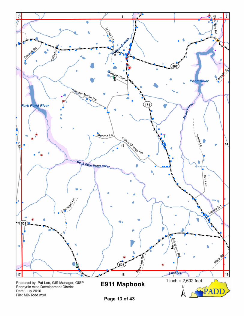
Prepared by: Pat Lee, GIS Manager, GISPPennyrile Area Development DistrictDate: July 2016File: MB-Todd.mxd Page 13 of 43
1 inch = 2,602 feet
"
""
"""
"
"
"
"
"
"
"
"
"
"
"
"
""
""
"
"!
"
""
"
"
"
"
""
"
P "
"
"
"
"
"
""
"
!
"
"
"
"
"
"""
""
""
"
"
"
"
"
"
"
"
P
"
""
""
"
""
"
"
"
"
"
"
P
""""
""
"""
!
""
"
"
"
"
"
"
""
""
"
""
"
"
""P
"
"
"
"
"""
"""
" " "
"
""""
""""""
"
"
"
"
"
"
"
"
"
"
"
æ"
"
"
"
""
" "
"
"
"
""
P"
"
"
""
""
"
P"P"
"
"
"æ
"
"P
"
"
"
"""
"""
"
""
"
P"""
"
"
"
"
"
"
"
"
"
"
"
"
"
"
"
"""PP""
"""
""
"" "
"
"
"
"
"
""
"
"
"
"
"
"
"
"
"
""
"
""
"
" " ""
"
P
"
""
"P
"
"
"
"
"
"
"
P
"
"
"
"
""
"
" "
"
"
"
"
"
"
""
"""
""
"
""
"
"
"
"
""
"
"
"
"
"
"
P
"
"
"
"
"
"
"
"
"
"""""
"
""
"
""
"
""""
" "
"
"
"
"
""
" " "
"
"
P
"
Ý
ÝÝ
Ý
"ÎD
n
ÆP
ÆPÆP
Å̧
Å̧
Å̧
Å̧
14
9
1513
19
8 10
18 20
Francis Branch
Clifty Creek
North Fork Whippoorwill Creek
Steward Branch
Pond River
Pond
Rive
r
¾À181
¾À507
¾À171
Renn
ie Rd
Coal Bank Rd
Liberty
Rd
Lack RdShe
mwell
Rd
Collier SpringRd
Phillips
Rd
Boley Rd
Pogue Rd
EastGr
eenfi
eldRd
West Greenfield Rd
Water Tower Rd
Tucker Ln
Shanklin Ln
Lucia
n Stok
es R
d
Cardwell Rd
Ware Rd
L ong Rd
Wheeler
Rd
Coursey Rd
Eagle Ln
C Boley LnCargile Ln
South Butler Rd
Angelwood Ln
PV-1 306
Tucker Ln
PV-10
06
E911 Mapbook±
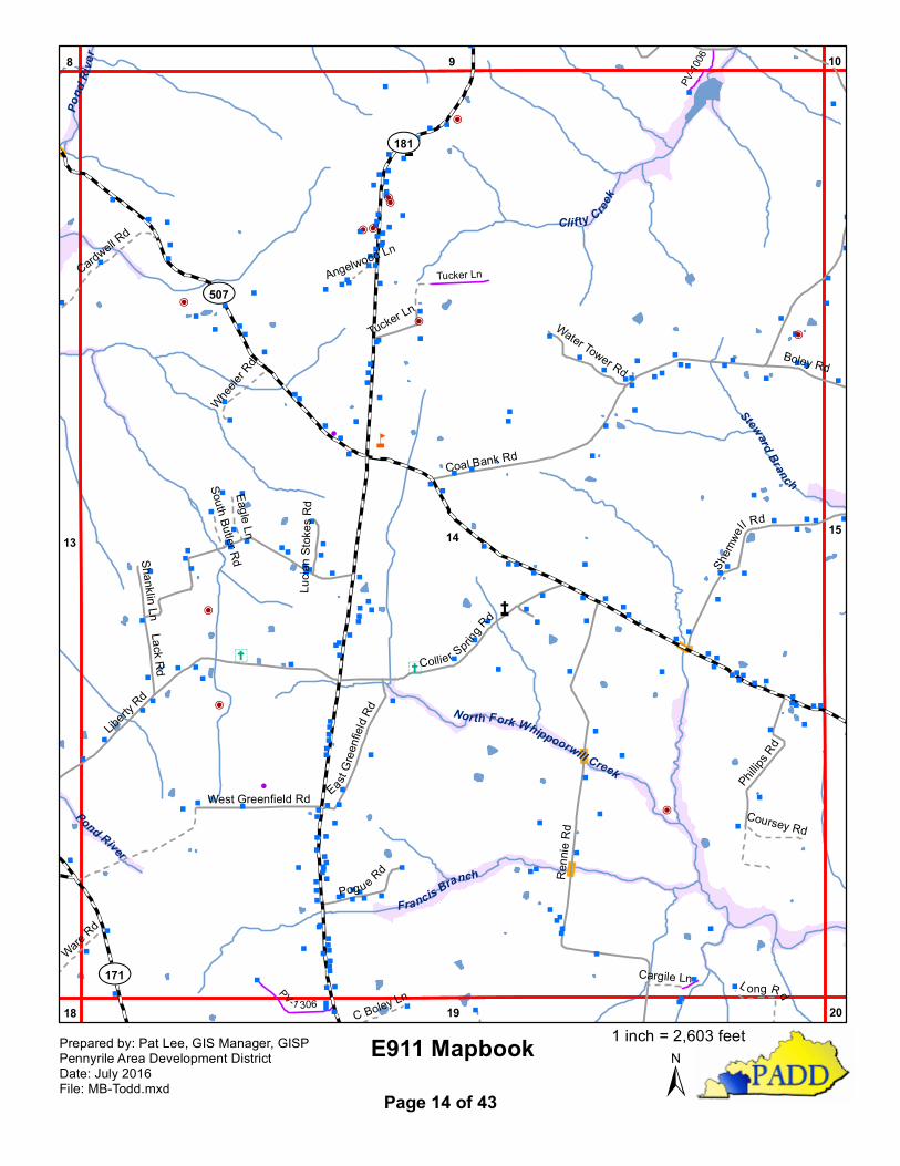
Prepared by: Pat Lee, GIS Manager, GISPPennyrile Area Development DistrictDate: July 2016File: MB-Todd.mxd Page 14 of 43
1 inch = 2,603 feet
"
"
P
P"
"
"
"
""
"P
"
"
"
"
"
"
" "
"
"
"
"
"
"
"
"
"""
""
""
"
"
"
"
" "
"
æ"
"
"
"
"
""
"
""
"
"
"
"
"
"
"
"
"
P
"
"
æ"
"
"
"
"
"
"
""
"
"
""
"""
"
"
"
""
""
"
"
"
"
!
""
"
""
"
"
P!! "æ""
""
"
"
""
"
"
"
"
""
"
"
""""
"
"
"
"
"
"
"
""""
""
""
"
"
""
"
"
""
""
"
"
"
""
"
"
"
"
"""
""
"P
"
"
"
"
"
"
"
"
"
"
æ
"
"
"
"
"
"
"
"
P"
"P """
"""
""PP""""
"
" "
"
""
"
"
"
"
"
"
"
""
"
"
""""
"
"
"
"
""
""
"""
"
""
""
" " "
"
"
P
"
"
"
""
"P
""
""
""
""" "
"
"
"
"
"
"
"
" "
" "
""
"
"
"
"
"
"
"
"
"
"
"
"
""
""
"
"
"
"
"
"
"
"
"
Ý
Ý
Ý
"ÎD
Å̧
Å̧
15 1614
10
20
9 11
19 21
Antioch Creek
Wolf Lick CreekSteward Branch
North Fork Whippoorwill Creek Whippoorwill Creek
¾À106
¾À507
¾À178
White Rd
Crawford Rd
Bol e y RdMoun
t Shar
onRd
Coal
Bank R d
Scott
Rd
Shemwell Rd
Harris
Rd
Hall Rd
Thom
as R
d
Snead Rd
Lawson-Hester Rd
H Gorrell Rd
PeaR
id geR
d
Pleasant Hill Church Rd
Moore Rd
W We
lls Rd
Roe Rd
Oneil Rd
M Gorrell Rd
Cordis Kenner Rd
Paul J Wright Rd
Harris Dr Gail S
ears
Rd
PV-10
08
E911 Mapbook±
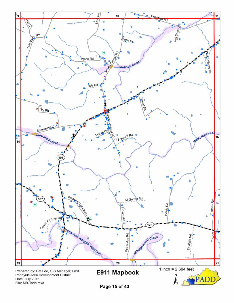
Prepared by: Pat Lee, GIS Manager, GISPPennyrile Area Development DistrictDate: July 2016File: MB-Todd.mxd Page 15 of 43
1 inch = 2,604 feet
"
"
"""
"
"
"
"
"
"
"
"
""""
""
""
"
""
"
"""
""
"
"
""
" "
" "
""
""
"
"
"
"
"
"
Å̧
Å̧
1615
11
2120
10Ga
rrett
Bran
ch
Wolf Lick Creek
¾À106
¾À178
Thom
as R
dCrawford Rd
E911 Mapbook±
Prepared by: Pat Lee, GIS Manager, GISPPennyrile Area Development DistrictDate: July 2016File: MB-Todd.mxd Page 16 of 43
1 inch = 2,606 feet
"
"
"
"
P
"
"
"
"
"
"
"
"
"
"
P
"
"
"
"
""
"
""
P "
"
""
"
"
"
"P
"
"
"
""
"""
""
"P
"
"
"
"
"
""
!æ""
" P"""
""
""
""
"
"
"
""
P"
"
"
"
"
"
"
"
""
"
"
"
"
"
"
"
"
""""""
" """" "
"
""
PP"""""
"
"""""""P"P""
""
"
""
"
"
"""
"
"
"
""
"
"
"
!!
!
"
ÝÝ
Ý
Ý
Ý
"ÎD
n
n
n
n
nn
n
^
^^
^
^
ÆP
ÆPÆP
Å̧
Å̧
Å̧
Å̧
Å̧
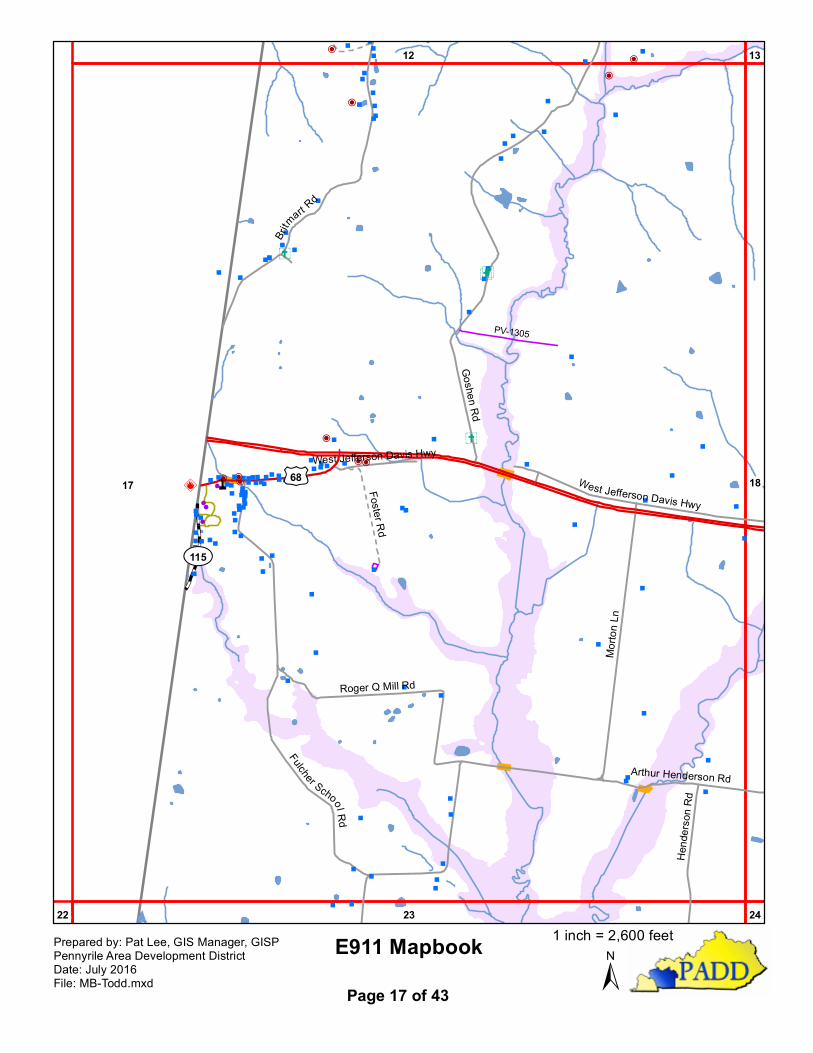
17 18
12
23
13
2422
£¤68
¾À115
Morto
n Ln
Goshen Rd
Britmart Rd
Roger Q Mill Rd
Fulcher SchoolRdWest Jefferson Davis Hwy
Hend
erson
Rd
Arthur Henderson Rd
West Jefferson Davis HwyFoster Rd
PV-1305
E911 Mapbook±
Prepared by: Pat Lee, GIS Manager, GISPPennyrile Area Development DistrictDate: July 2016File: MB-Todd.mxd Page 17 of 43
1 inch = 2,600 feet
P"""
"""P
P"PP
""
""
"
"
"
P""
"
"""
"
"
P"""""
"
""
"""
"
"
"
"
"
"
"
"
""P
"
"
"
"
""
æ
"
"
""
"P" "
"
"
"
"
"
"
"
"
"
æ"
"
"
"
"
"
"
"
"
""
"
"
""
"
"""
""
"
"
" ""
"
P
"
""
"
"
"
"
"
""
""
"
"
" ""
P
" "
"" "
"
"
"
"
"
"
"
"
"
"
""
"
æ"
"
"""
""
"" ""
""
"
"
""
"
""
""
"
"""
"
""" " " "" " "
"
"
"
"
P"
"
P"
"
"
"
"
"
"
"
""""
"
"
"
"
""
"
"""
"
""
"
æ
"
"
"
""
"P
"
PPP"" "
""
"
"
"
P"PP
P
P"
P" !
"" "
"P"" "P
"
""""""""
"""
""
"
""
""
P
"
""
"
"
""
"
"""
""
"
"
"
"
"
"
"""
"
"
"
"
"
"
"
"
"
!
"
P
"
"
"
Ý
Ý
ÝÝ
Ý
Ý
"ÎD
n
n
n
n
nn
^
^^
^
^
ÆP
ÆPÆP
Å̧
Å̧
Å̧
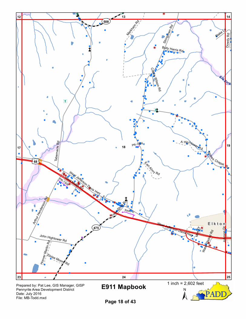
18 1917
13
24
14
23
12
25
Elk Fork
£¤68
¾À475
¾À508
String
town R
d
Tabe
rnacle
Rd
Stoke s Chape l Rd
West Jefferson Davis Hwy
Arthu
r Hen
derso
n Rd
John Hightower Rd
Blake Ln
Dowd
y Rd
West Mullin Rd
Bully Harris Rd
John
son D
r
Tress S
hop Rd
Cordie Wilson Rd
Moe D
rWa
ter Di
strict
Rd
West Jefferson Davis Hwy
Markham
RdA Hightower R d
Earl Alm y Rd
Hoov
er Ma
rtin R
d
Eloise Moore Rd
Keith Tr
PR-1308
PR-1306
E l k t o nE l k t o n
E911 Mapbook±
Prepared by: Pat Lee, GIS Manager, GISPPennyrile Area Development DistrictDate: July 2016File: MB-Todd.mxd Page 18 of 43
1 inch = 2,602 feet
"""
""""
"
"""
"
"""""""""""
" """"
!
""""""""""
""""""""
"""""""""""""""
"""""
""""" ""
""""""""""""""""""""
"""""""""" """"
""""""""""""
""""""
"""""""""
""""
"
""""""""""
""
""""""""
""
"""P"" """
""""
"""!
""""""""""""
""""
""P
""
"""P"""""æ"æ
"
"
"
"
"P"""""
"PPPP
!!
!
P"
"
!
!
PPP
P
PPP
""""""""
"
P
P
P
""
"
"
"
"
PPP
P""
"
"P
""""""P
P"
" "
" æ "
PPP
P P! """"""""
"""""" ""
"""""æ
!""""P"""""""""""! !!PP"P""
""""
!!!!!!
PPPP"""""P"""""
""
"
"""""æ"""""
!
"
PPPP""
""PPP
!P"""" P
PPPP"""""""P""""""""""
""""
"""""""
""""""""
""""""""
"""""""""
"""""""""æ"
""""""P"""""""
"""""
"""""""""""""
""""""""""""""
""""
"
PPPP
"""""""""P
"""""""""""""P""
""""""P"P""""" Pæ"P
!!!"
"""""æ"
!
PPPPPPP"
!
PP"""""
""""""""""""P"""
"
""
""
"
""
"
"P
"
!
"
"
"""""
"
"
"P" "
"
""
"
P""
"
"""
"""
""
""""
""""""
""""
""""""
" """"""
"""
"
""P
"
""
"P"
"""
""
"
PPPPPPPPPPPPP!""!
""""PPPPPPPPPPPPPPPPP
æPP!PPP
PPPPPP!
""
""""""""""
"""
P
"
"
"
""
"""
"
P
"
"
"
"
"
"
"P
"
"
"
"
"
""
"""
"
"
"
"
"
"
"
"
"
"
PPP
!
P
"""
PP
P
"""" ""
"
"
"
"" "
"
"
"
"""
"
"
"
"
æ"
""
"
"
""
""
"
æ"
"
"
"
""
"""
"
""
""P
""
"
"""""
""
P"
""
"
" "
"
"
""
""
""
"
""
"
"
"
"
"
""P
"
"
"
"
"""
"""
"
"
"
"
P
"
"
"
"
"
""
"
"P"
""
""
"
"
"
"
"
"
"
""
"
""
"
"
" """
"
"
"
"
"
"
"
"
""
"
"
"
"
"
"
"
"
" "
"" " ""
"
""
""
"
"
""""
"
" "
æ
"
"
"
"""
"
"
"
"
"" "
"P
"
"
"
"
""""
""
"""""
"""
"
"
""
"P"
""
"
"
"
"""
""
"
"""
"
"
"
""
"
"
"
"
"
"
"
"
"
"
""
"
"
"
"
"
"""
"
Ý
Ý
Ý
Ý
"!#
!E
Y
YY
"ÎD
n
n
n
n
nn
^
^^
^
^
ÆP
ÆPÆP
Å̧
Å̧
Å̧
Å̧
Å̧
Å̧
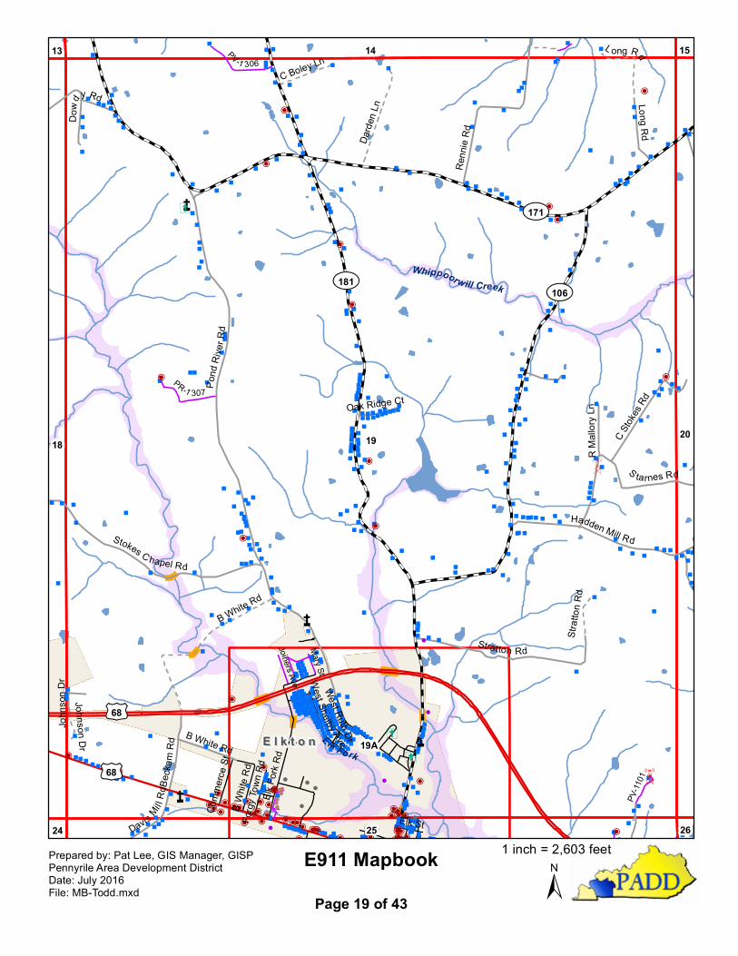
19
19A
2018
14
25
15
24
13
26
Elk Fork
Whippoorwill Creek
£¤68
£¤68
¾À181¾À106
¾À171Po
ndRiv
erRd
Renn
ie Rd
Stratton Rd
C Stok
es Rd
Stokes C hapel Rd
Hadden Mill Rd
S tarnes Rd
Long Rd
B White Rd
Davis Mil lRd
D owd
y Rd
Beck
amRd
R Ma
llory
LnOak Ridge Ct
John
son D
r
B White Rd
Darde
n Ln
L ong RdC Boley Ln
Stratt
on R
d
Johnson Dr
Elk Fo
rk Rd
B Whit
e Rd
Elk St
Comm
erce S
t
West Shelby Ave
Forgy
Town
Rd
West Ruth Dr
PV-1 306
PR-1 307
PV-11
01
Mary St
Joiners Ave
E l k t o nE l k t o n
E911 Mapbook±
Prepared by: Pat Lee, GIS Manager, GISPPennyrile Area Development DistrictDate: July 2016File: MB-Todd.mxd Page 19 of 43
1 inch = 2,603 feet
"
""
""
""
"
""
"
"
"
"
"
"
"
"
""
"""
"""""
!
"
"
"
"
"
"
"
"
""
"""
"
"
""
""
""
""
""
"
"
""
"
"
"
"
"
"""
"""
""
""
"
" ""
"""
""" " " " " "
""
"""""
"""" "
"""
" " """
" ""
"" "
"
"
"""
"
"
"""
""
""
""
""
""
"
""
""
"
""""
""""""
""
" "
""""""
"
"
""
"
P
""
" """
"
"
""""
!
""""""""""""
""
"""P"""""æ"æ
"
"
"
"P"""
"""PPP
P
!
!
!
P
"
"
!
!
PPP
P
PP
P
"""
" """
"
"
P
P
P
"
"
"
"
"
"
PPP
P"
PP
P
P P
!"
" " """" "
"
"" """
""
"""
" "æ
!" "
" "P """ " " "" " " ""
! !! PP"P "
"
"
"
""
!
!
!
!
!!
PPP
P
"""""P
""""
"
"
"
"
"
"
"""æ""
""
"
!
"
PP
P P""
""PP
P
!P
""
"" P
PPPP
"""""""
P
"
"
""" "
"
"
""
"
"""
"
""
"
"
""
""""
""
" "
""""
""""
""""
"
"
"
"""""
"
" """"
""
""
æ"
"
"
"""" P
""""
""""
"
"
""
""""""""""
"""
""""""
"""""""
"
""
"""""
!
!""
""
""""
""
"
"
""
""
"
"
"
"
"
"
"
"
""
"
"
"
"
"
"
"
"
"
"
"
"
"""
"
P
!
"
"
"
"
"
"
"
"
"
""""
"""""""
"" "
"""
""
"""
"""
" æ "
"""""""""
!
""""" "
"
P P
PP
!!
"""
" ""
"
""
"
"
"
""
"
"""""P
""" " "
"
" " "
""""""""
""""
" " P """""""
"
P
"
P
"
""
""""""""
" " " " " Pæ"
P!!!
"
""
"æ"
""
æ"
!
PPPPP
PP"
!
"!
"""""
"
"
""
"
" "
"
""
"
"
"
""
""P
!
" "" "
PP"
"
"
"
"
"
"
"
"
"
"
""
!
!""
"
"" "
"""
""
"
"""
""
"P"
""
"""" "
""
""
"
"
""
"
"""
P""
""
""
"""
"
""
"""
"""
""
""æ""""""""""
"""
"
!
P
!
PP"""""
""
""
""
""
""
""
"""
"
"
"
"
""""
"
"
"
" !!
"
"
""
"
!
"
"""""
"
"
""
"""
""
"
"""
"
"""
"
"""
"
"
"
""
P
"
"
"
"
"
"""
""
"
"
"
""
"
"æ
"""""
"P ""
"
! ""
"
"
"
"
PPPPPPPPPPPPP!"
"!
"
"""P PPPPPP
PPPPPPPPP
P
æP
P
!PPP
PPPPP
P
!
"
"
"
"
"
""
"
""
"
"
"
""
"" "
P
"
"
"
"
"
P
"
PPP
!
P
!
!
"
!
P
""
"
PP
P
!
!
"
""
"" ""
"
"
æ
""
"
"
"
""
"
Ý
Ý
"!#
!E
n
n
n
n
nn
^
^ ^
^
^
Å̧
Å̧
Å̧
Å̧
Å̧
Å̧
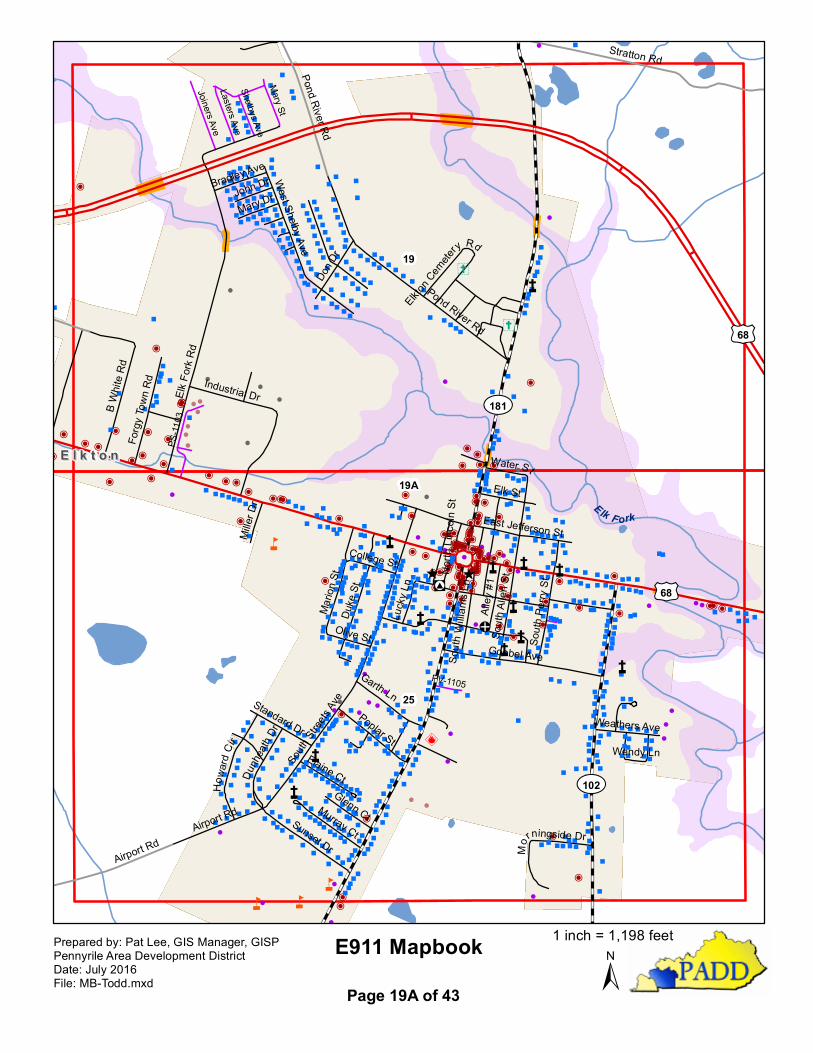
19A
25
19
Elk F ork
£¤68
£¤68
¾À102
¾À181
Stratton Rd
Airport Rd
Pond River Rd
Elk Fo
rk Rd
Pond River Rd
South
Stree
ts Ave
Goebel Ave
Mario
n St
B Whit
e Rd
Sunset Dr
Industrial Dr
Elk St
Duke
St
Don D
r
Airport Rd
Poplar St
Garth Ln
Alley
#1
West Shelby Ave
Murray Ct
Howa
rdCir
Forgy
Town
Rd
South
Allen
St
Dunh
eath
Dr
Elaine CtGlenn Ct
South
Perry
St
Water St
East Jefferson St
Standard Dr
Olive St
Mary Dr
Miller
Dr
South
Willia
msLn
Lucky
Ln
John Dr
College St
Weathers Ave
Bradley Ave
Mo
rningside Dr
Elkton Cem
etery Rd
Wendy Ln
North
Linc
oln S
t
PS-11
03
Mary St
Joiners AveLasters AveShelbys Ave
PV-1105
E l k t o nE l k t o n
E911 Mapbook±
Prepared by: Pat Lee, GIS Manager, GISPPennyrile Area Development DistrictDate: July 2016File: MB-Todd.mxd Page 19A of 43
1 inch = 1,198 feet
"
"
""
"""
"""
"""
"
"
""
"
""
"
""
"
"
"
"
"
"
"
P
"
"
"
"
"
" " ""
"
"
"
"""
""
"
"
""""
""
"
"
" "
"
"
"
"
"
"""
""
P
"
""
"""
"
"
"
"æ
"
"
"
"""
"
""
""
"P
"
"
""
"
"
"
"
"
"
"
"
"
"
"
"
"
"
"
"
""
"
"
"
"
"
P
"
""
"
"
"
""
"
" æ"
"
"
"
"""
"
""""
"
"
"
"
"
""
""
"""
"
"
""
"
"
""
"
"
"
""
"
"
"
"
""
""
"
"
"
"P"
"
"
" "
""
"
"
"
"
"
"
"
""
"
"
"
"
"
"
"
æ
Ý
Ý
Ý
Y
Y
Y
Y
Y
"ÎD
Å̧
Å̧
Å̧
20 2119
15
26
16
25
14
27
Whippo
orwill C
reek
Whippoorwil l Creek
¾À106
Miller Valley Rd
Hadden Mill Rd
Hurt Ln
Clay Cole Rd
Pea Ridge RdWilliams Rd
Goodman Rd
Joe P
o tter
Rd
L in a Martin Rd
Williams Hill Rd
Templeman Rd
Starnes Rd
Yeggie Ln
Dennis Hurt RdBennett Cemetery Rd
Nelson C ole Rd
Majors LnGa
tes R
d
Majors Ln
Dalton Ridge Rd
PV-1103
PV- 10
09
PV-1010
PV-1011
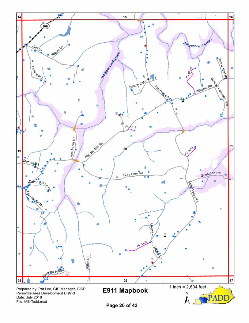
E911 Mapbook±
Prepared by: Pat Lee, GIS Manager, GISPPennyrile Area Development DistrictDate: July 2016File: MB-Todd.mxd Page 20 of 43
1 inch = 2,604 feet
" "
"
"
"
"""
"æ"
""""
"
"
" "
Ý
Å̧
Å̧
Å̧
2120
16
2726
15
Garrett Branch
Williams Rd
Goodman Rd
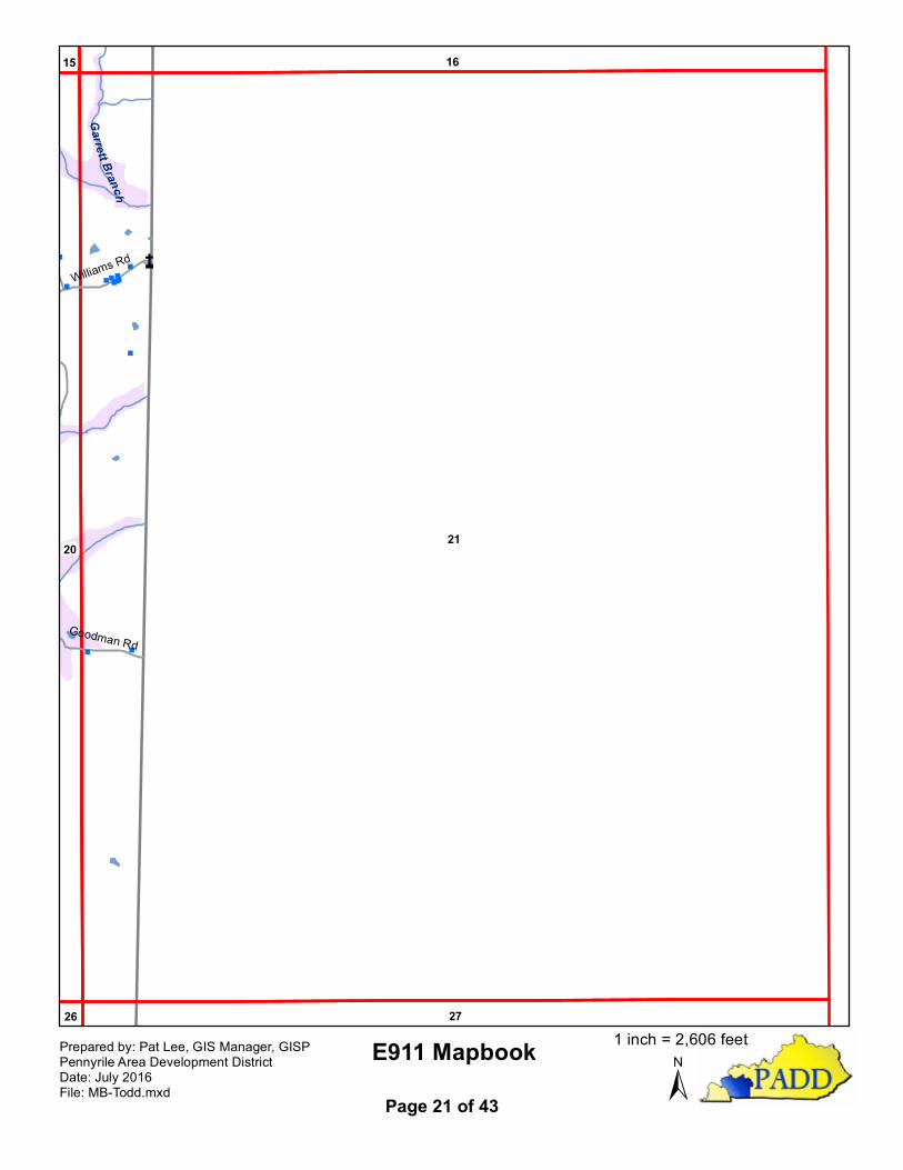
E911 Mapbook±
Prepared by: Pat Lee, GIS Manager, GISPPennyrile Area Development DistrictDate: July 2016File: MB-Todd.mxd Page 21 of 43
1 inch = 2,606 feet
"
"""
"
"
"
n
n
n
^
^^
^
^
Å̧
Å̧
22 23
28
17
29
£¤41
Guinn R
d
E911 Mapbook±
Prepared by: Pat Lee, GIS Manager, GISPPennyrile Area Development DistrictDate: July 2016File: MB-Todd.mxd Page 22 of 43
1 inch = 2,600 feet

P
"
"""
""
"
"
"
"
""
"
"
"
"
"
"
"
"
""
"
"
"
"
"
"
"
""
"
"
"
""
""
""
P"
"
"
"
"
"
P
""
""
æ
"
"
"
"
"
"
"
Ýn
n
n
nn
n
^
^^
^
^
Å̧
Å̧
Å̧
Å̧
Å̧
23 2422
17
29
18
3028
West Fork Red River
Bluehole Creek
£¤41
¾À475
Morton Ln
Maton Rd
Davis
Mill R
d
Raymond
Stokes
Rd
Hend
erson
Rd
Guinn R
d
Smith Rd
Amelia Ln
PV-1201
PV-1202
E911 Mapbook±
Prepared by: Pat Lee, GIS Manager, GISPPennyrile Area Development DistrictDate: July 2016File: MB-Todd.mxd Page 23 of 43
1 inch = 2,600 feet
""""""P
"
"
"
"
"
P
"
""
æ
"
"
"
"
"
"
"
""
""
""
"
"
"
"
"
""
"""
"
""
"
"
"
"
"
""
""
"
"
"""
"
"
"
"
" "
"
""
"
"
""
"" "
"""
"
"
"
"
"
"
" ""
"" "" "
"
"
"
"
"
" " ""
"
""
"
" "
"
"
"
""
"
P
"
"
"
"
"
"""
"
"
"
!
"
"
"
"
"
"
"
"
"
""
"
""
æ
""""
""
Ý
Ý
Ý
n
n
n
nn
^
^^
^
^
Å̧
Å̧
Å̧
24 2523
18
30
19
29
17
31
Reins Lick Creek
Reins Lick Creek
¾À1753
¾À104
¾À475
Davis Mill R
dDickinson Rd
Old Bells C
hapel Rd
JimGr
een Rd
Phillipi Rd
Millen Rd
Murray Rd
Powell Rd
Phill ipi Rd
GunClub
Rd
Murray Rd
Mi l len Rd
PR-1 201
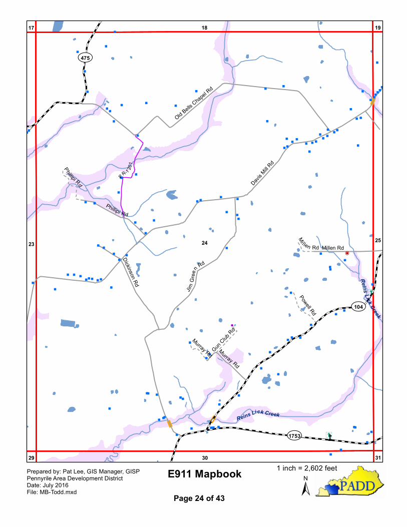
E911 Mapbook±
Prepared by: Pat Lee, GIS Manager, GISPPennyrile Area Development DistrictDate: July 2016File: MB-Todd.mxd Page 24 of 43
1 inch = 2,602 feet
" """"
!
" """"
""""""""""
""
""""""""
""
"""P"" """
""""
"""!
""""""""""""
" ""
"
"
""""
""""
P""
"""
""""
"
""P
""
"""P"""""æ"æ
"
"
"P"""""
"PPPP
!!
!
P"
"
!
PPP
P
PPP
"""
"""""
"
P
P
P
"
"
"
PPP
P""
"P
""""""P
" "
" æ "
PPP
P P! """"""""
"""""" ""
"""""æ
!""""P"""""""""""! !!PP"P""
""""
!!!!!!
PPPP"""""P"""""
""
"
""
"
PPPP""
""PPP
!P"""" P
PPPP"""""""P"""""""
"""""""""""
"""""""
""""""""
""""""""
"""""""""
"""""""""æ"
""""""P""""""""
""""
"""""""""""""
""""""""""""""
"""""""
!!"""""
"""""
""
"""
"""
"""""""
"""
"""
""
"""""""""
P"
"
!
"
""""
""""
""""""""""""""
"""""
""""""
"æ "
"""""""""
!""""""
"
PPPP
! !
"""" """"""""""""""""P
"" """
"
"" "
""""""""""""""P""
""""""P"P"""""""""""
""""" Pæ"P!!!
"
"""æ"""æ"
!
PPPPPPP"
!
" !""""""
""""" "
"""""
"""
""P
!
""" "
PP""""""""""
"""
!!"""
"" """"""
"""
"""
"P""""""""""
""""""
""""P"
"""
"""""""""
""""
""""
"æ""""""""""
""""!
P
!PP"""""
""""
""""
"""""""
"""
""""""""" !!
"""""
!
""""""""""
""""""""""""" """"
"""""
P"
"
""
"
"""""""""""
"æ""""""P"""
"
"
""
"
"P
"
PPPPPPPPPPPPP!""!
""""PPPPPPPPP
PPPPPPPP
æPP!PPP
PPPPPP!
"""
P
PPP
!
P
!!
"
!
P
"""
PP
P
!!
"
"""" ""
"
"
"
"
"
"
"
"""
"
"
"P
"
"
"
"
"
"
"
"
"
"
"
"
"
"
"
"
"
"
"
"
"
""
P"
""""""
"" "
"""
" "
"
"
"
"
"
"
"
""
"
" ""
""
"
"
"
"
P
"
"
"
"
""
"
"
!"
"
"
"
P"
"
"
"
"
"
"
"
"
"
"
"
"
"
"
"
"" !
"
"
"
"
""
"
!
"
"P
"P
"
"
"
P
"
""
"
"
"
"
!
"
"
""PP
æ
"
"
"
"
"
"
""
"
"
"
""
""
""
"
"
"
"
" "
"
"
"
"""
"
"
"
"
"
"
"
P
"
"
"
"""
"
""
"
Ý
Ý
Ý
Ý
"!#
!E
YY
n
n
n
nn
^
^^
^
^
Å̧
Å̧
Å̧
Å̧
Å̧
Å̧
25
19A
2624
19
31
20
30
18
32
Elk Fork
Dry B
ranch
£¤68
£¤68
¾À102
¾À104
¾À1753
¾À181
¾À181
Old Allensville Rd
Chestnut Rd
Old R
ailroa
d Ln
Davis
Mill R
d
Frogue Rd
Old Q
uarry
Rd
Airport Rd
C Smith Rd
Traughber RdStone Mill Dr
Airport Rd
Shelby Calloway Rd
South
Stree
tsAv
e
Goebel Ave
Mario
n St
Sunset DrAirport Rd Murray Ct
Elm St
Miller
Dr
Weathers Ave
PR-11
02
PR-1207
PR-1103
PR-11
08E l k t o nE l k t o n
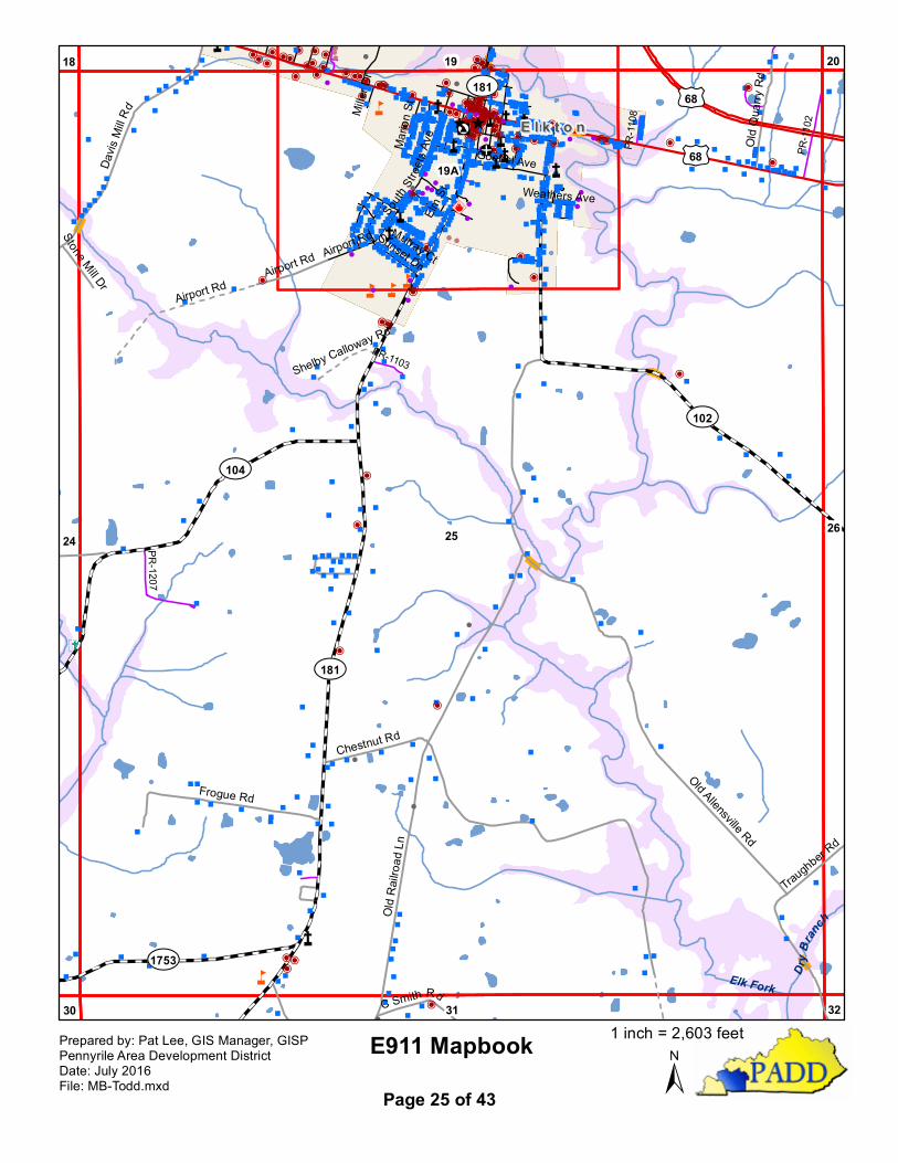
E911 Mapbook±
Prepared by: Pat Lee, GIS Manager, GISPPennyrile Area Development DistrictDate: July 2016File: MB-Todd.mxd Page 25 of 43
1 inch = 2,603 feet
"
""""
""""
P"
P
"""""
"
"
""
"""
"""
"
"
""
"
""
"
""
"
""
"P"
"
"
" "
""
"
"
"
"
" """"""""""""""
""
""
""""" "
"
"
" """ " "
" "" "" " P
""
" P"
"
"
""
"
"
P"
" "
""
"""""
""""""""ææ"""""
""""
"
"""
"
"
"
"
"
"
"
"
""
"
"
"
"
""
"
"
"
""
"
"
"
"
"
"
""
"
"""
"
"
"
"
""
"
"
"
"
"
"
"
"
"
""
"
"
"
"
"
"
"
"
"
"
"
""
""
"
"
æ
Ý
Y
Y
Y
Y
Å̧
Å̧
Å̧
26 2725
20
32
21
31
19
33
Dry
Branch
£¤68
¾À102
¾À1309East Jefferson Davis Hwy
Traughber Rd
Allensville-Daysville Rd
Gate s Rd Miller
ValleyRd
Cox R
d
Sawyers R
d
Willia
msHill R
d
Pete Wheeler Rd
Wind
ing O
ak R
d
Allensville-Daysville Rd
Gates
Rd
J. Cross
Sawyers Rd
Rusty B
rook
Sunak
er Rd
Acce
ss R
d
PV-1104
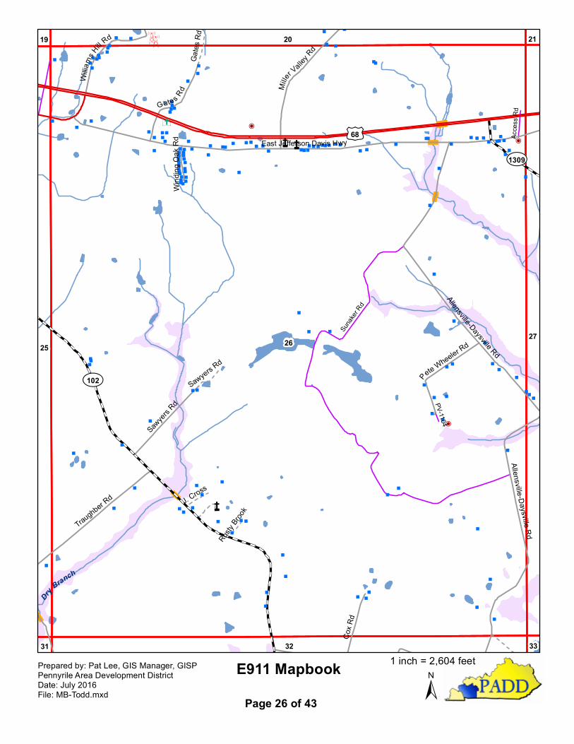
E911 Mapbook±
Prepared by: Pat Lee, GIS Manager, GISPPennyrile Area Development DistrictDate: July 2016File: MB-Todd.mxd Page 26 of 43
1 inch = 2,604 feet
" "" " P
""
" P"
"
"
"
"
"
"
"
"
"
"
""
""
"
"
"
"
""
"
"
"
""
"
Å̧
Å̧
Å̧
2726
21
3332
20
£¤68
¾À1309
Hardis
onRd
Dobbs Rd
Allensville-DaysvilleRd
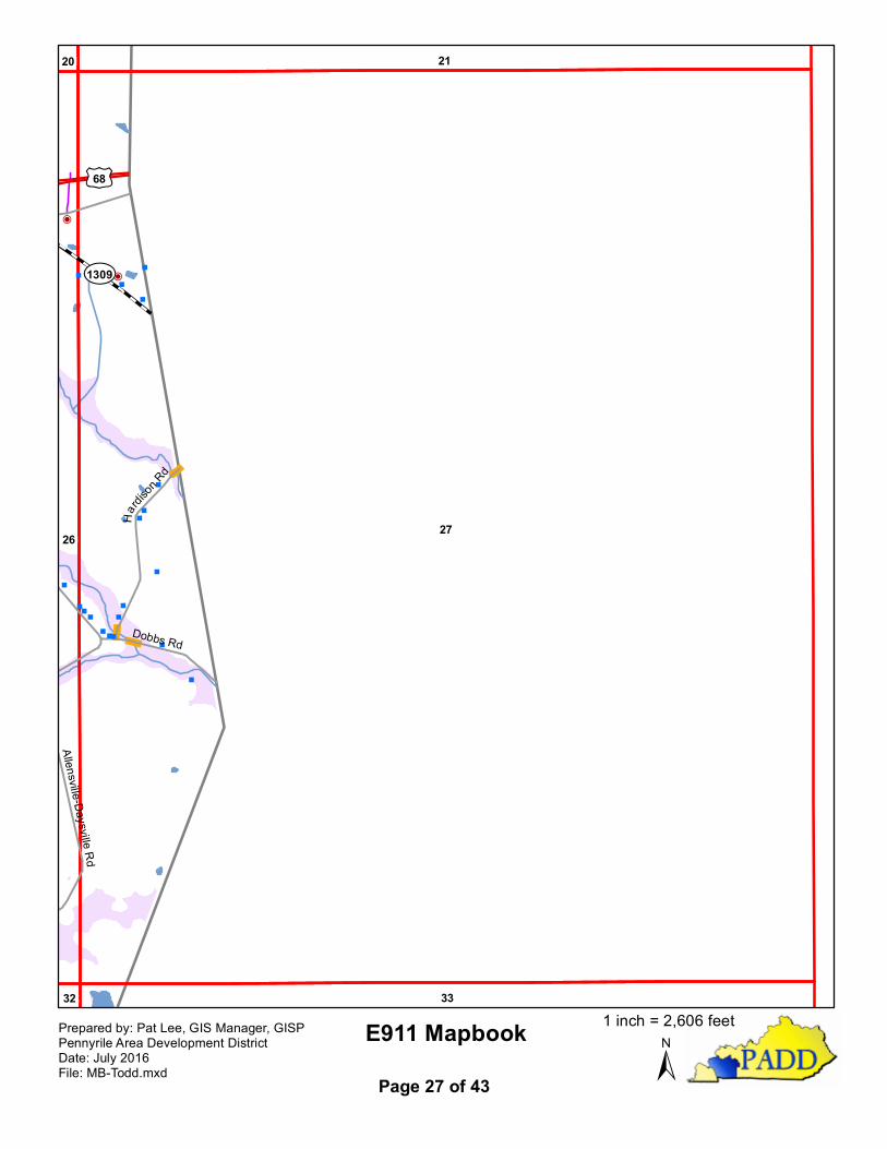
E911 Mapbook±
Prepared by: Pat Lee, GIS Manager, GISPPennyrile Area Development DistrictDate: July 2016File: MB-Todd.mxd Page 27 of 43
1 inch = 2,606 feet

""
"
"
"
""
"
"
"
"
"
"
"
"" "
"
"
"
"
"
"
"
"
"
n
^
^^
^
^
Å̧
Å̧
28 29
22
34
23
35
West Fork Red River
¾À2627
¾À1453
Seay Rd
Tutt Rd
Frederick Rd
E911 Mapbook±
Prepared by: Pat Lee, GIS Manager, GISPPennyrile Area Development DistrictDate: July 2016File: MB-Todd.mxd Page 28 of 43
1 inch = 2,600 feet
""PP
"æ""""
""""
!
æPPP!PPPPPPP!!PPPPP""
"
""""""æ
" """""
""""""
"
"
""
""
"
"""""
"!"
"""
"
P
"P
""
""
"
"P"
""
"
"
"
"
""
"
"
"
"
"
"
"""
"
"
""
"
"
"
"
""" """
""""
"""""""
"
""
"
"
"
"
"
"
"
"
æ
""
""
""
"
" """"""""""""""""""""""""
""
"""
""
""""""
"""
"
"
"
"
"""
"
"
"
"" "
"
""""""
""""
!
""
"
"
"
"
"
"
"" "
"
"P
"
"
""
"
""
"
"
"
"
"
"
"
"
"
""" ""
""""
PPæ"
""
""
"
"P""
""
!"""
"""æ
""""
"""
""""P"""
""
"""
"
P
"
"
"
"
"
"
"
"
"
!
""
"""""
""""""
""""""
""!
!
"""""""
"
""""""
"""
"
"
""
""""""
"""""
"
"
"""""
P
"""""""
""""
""
"
"
"
"
"
"
"
Ý
n
n
n
nn
n
^
^^
^
^
Å̧
Å̧
Å̧
Å̧
29
29A
3028
23
35
2422
3634
West Fork Red River
Reins Lick Creek
£¤41
¾À104
¾À2627
¾À475
¾À1802
¾À848
Seay Rd
Mimm
s Rd Davis
Mill R
d
Adam
s Rd
Contessa Ln
Ange
la Dr
Ware
Way
Averitt Ln
Frederick Rd
R Luttrull Ln
Chapel Hill Rd
Rosenwal d St
Sixth St
Teds Trl
Cemetery Ln
Oak St
Trice S
t
PR-1209
PV-1203
PR-1202
Elvis
Pres
ley Bl
vd
T r e n t o nT r e n t o n
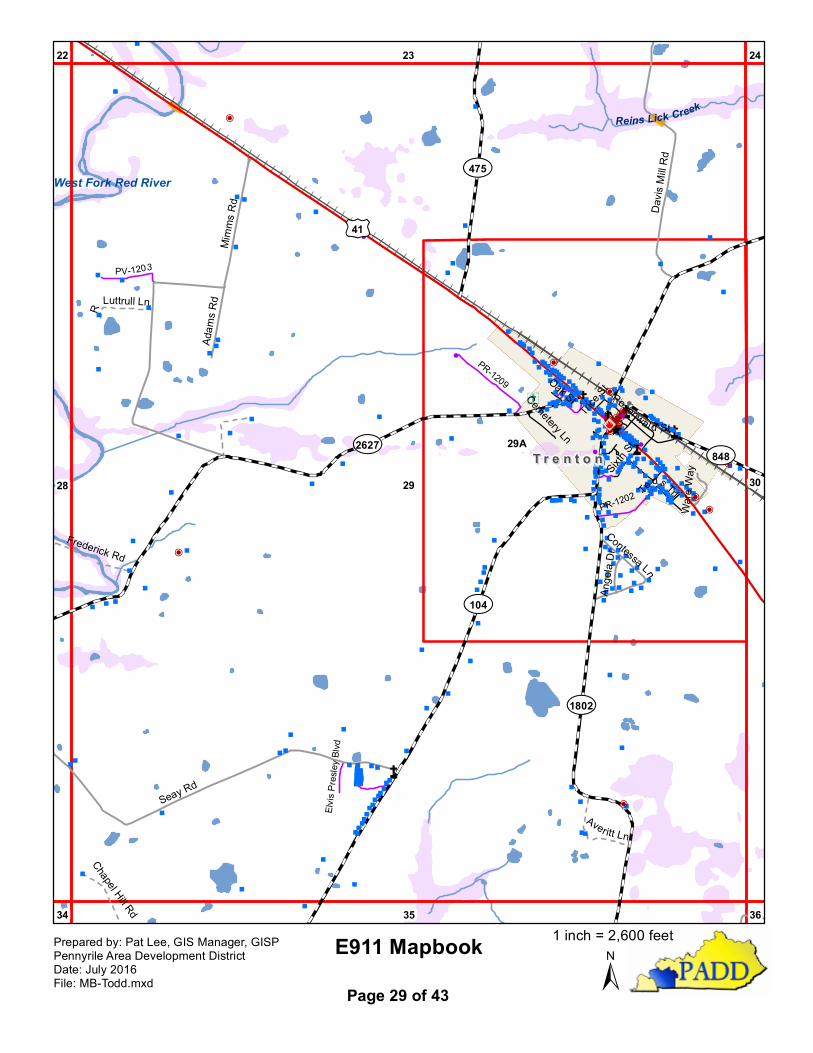
E911 Mapbook±
Prepared by: Pat Lee, GIS Manager, GISPPennyrile Area Development DistrictDate: July 2016File: MB-Todd.mxd Page 29 of 43
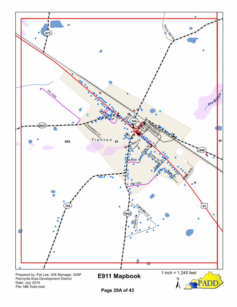
1 inch = 2,600 feet
""P
P
"æ""
""
"""
"
!
æPPP!
PPP
PPPP!!PPPPP"
"
"
""""""
æ" "
"
"""
"
"
"
""
"
"
"
"
""
"
"
"""
""
"
!"
""
""
P
"P
"
"
"
"
"
"
""
"
"
"
"
"
"
""
"
"
"
"
"
"
"
"
"
"
""
"""
""
"
"
"" """""
"
"
"
"
"
"
"
"
"
""""
""
""""
!
"
"
""
""
"" "
""
PPæ
"
""
"
"
"
"P
""
""
!""
"
""
"æ"
""
"
"
""
""
""
P"
""
"
""
""
"
"
"
"
"
"
""
" """" "
"""
""
"
"
""
"
"!
!
"
"
"
"
"
" "
"
"
"
"
"
""
"""
"
"
"
"
"""
"""
"
"
"""
"
"
"
""
" "
P
""
""
""
"
"
"
""
""
"
"
"
Ý
n
n
n
nn
n
^
^ ^
^
^Å̧
2929A 30
Dry Branch
£¤41¾À104
¾À2627
¾À848
¾À475
¾À1802
¾À104
Contessa Ln
Davis Mill Rd
Ange
la Dr
WareWay
Rosenwald StSixth
St
Teds Trl
Cedar St
Railroad St
Eighth S
t
Cemetery Ln
Oak St
Trice S
tCole St
Dixie Bee CtElm St
PR-1209
PR-1202
O ak St
PV-1206
T r e n t o nT r e n t o n
E911 Mapbook±
Prepared by: Pat Lee, GIS Manager, GISPPennyrile Area Development DistrictDate: July 2016File: MB-Todd.mxd Page 29A of 43
1 inch = 1,245 feet

"
""
P
æ"
!"
"
"
"""
"
"
"
"
æ
"
"
"" " " "
"
"
"
P
"
"
""
"
"
æP
"
"
"
"
"
"
"
"
"
"
"
"
P"
"
"P
"
""
"
!"
"
""
"
""
"
"""
"
"
"
"
""
"
"
""
"
"
""P
P
""P
"P
""
""
"
""
"
"
"""
"
"
"
"
"
"
"
"
"
"
"
"
""
"
""
æ
""""
"
""!
"
Ý
Ý
n
n
n
nn
^
^^
^
^
Å̧
Å̧
30 3129
24
36
25
35
23
37
29A
Spring Creek
Dry Branch
Reins Lick Creek
£¤41
¾À848
¾À181
¾À104
Pleasan t Grove R d
Meredith Ln
Jack Gray Rd
Basham Rd
Hadden Rd
Dickinson Quarry Rd
Sid Nabb Rd
PR-1208
E911 Mapbook±
Prepared by: Pat Lee, GIS Manager, GISPPennyrile Area Development DistrictDate: July 2016File: MB-Todd.mxd Page 30 of 43
1 inch = 2,602 feet
"
"
"
""
"
""
"
"
"
"
"
"
"
"
"!
!
"
"
""
"
""
"""
"
"
"
""
"P
"
"
"
"""
""
""
"
"
"
""
P
æ
"
"
"""
"
P
"
"
"
"
"
æ"
"P
"
"
"
"
"
""P
"
"
"
"
"
"
"
"
"
"
"
"
"
"
"
""
" "
"
"
"
"
!"
"
"
"
P"
"
"
"
"
"
"
"
"
"
"
"
""
"
"
"
"
"
"
"
"
"
""
"
"
"
"
""P
"
P"
"
"
"
"
"
""
""
"
æ"
"
!
!""
"
"
"
"
"
"
"
"
"
"
"
"
"
"
"
"
""PP
æ
"
"
"""
"
""
"
Ý
Ý
Ý
n
n
n
nn
^
^^
^
^
Å̧
Å̧
Å̧
Å̧
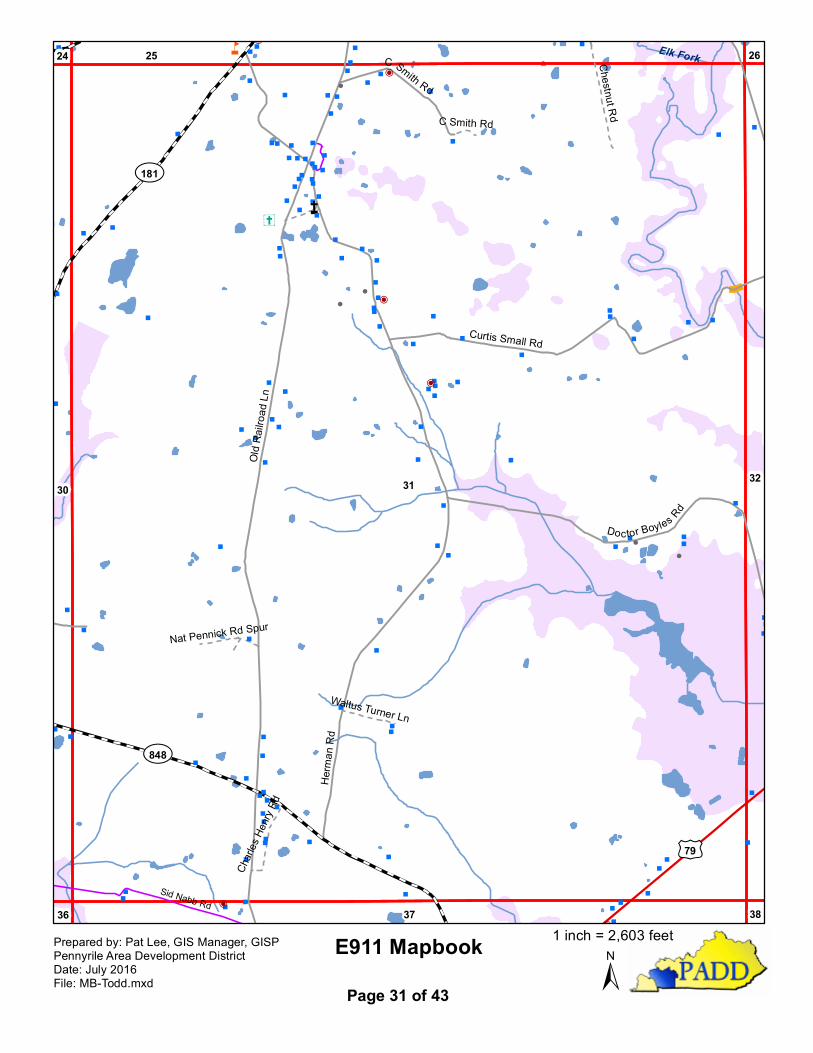
31 3230
25
37
26
36
24
38
Elk Fork
£¤79
¾À181
¾À848
Herm
an R
d
Old R
ailroa
d Ln
Curtis Small Rd
Doctor Boyles Rd
C Smith Rd
Chestnut Rd
Charl
es He
nry Rd
Waltus Turner Ln
Nat Pennick Rd Spur
C Smith Rd
Sid Nabb Rd
E911 Mapbook±
Prepared by: Pat Lee, GIS Manager, GISPPennyrile Area Development DistrictDate: July 2016File: MB-Todd.mxd Page 31 of 43
1 inch = 2,603 feet

"
"
"
"
"
""
"
"
"
"
""
"
"
"
"
"
"
"
""
""
""
"
""
!
""
"
""
"
"
"
"
""
"
""
"
""
"
" " ""
"
""""""""
"""" "
"""""
"
"
"
"
" "
"
""
""
"
"
"
"
""
"
""
"
"
"
"
"
"
"
"
"
"
"
"
"
"
"
"
"
"
"
""
" """
"
P""""""""
""""""
"
"""
"
æ"""P!PP
!P""
""""
"
"
"
"
"
"
""
"
"
P
""
"æ""æ"" "P"!
"
"
""æ"
"
"
"
"
"
""
"
"
"
"
"""""""
!
""
"
"
"""
"
"
"
""
"""
""
""
""""
"
""
"
""" æ !
""
"
"
!
"Ý
Ý
Å̧
Å̧
32
32A
3331
26
38
27
37
25
39
Elk Fork
Rum Spring Creek
£¤79
¾À102
Snardon Mill Rd
State
Line R
d
Old Allensville Rd
Gardner RdJoe Gill Rd
Doctor Boyles Rd
Johnsons Ln
Allen
sville-
Daysv
ille Rd
Wilson S
t
Curtis Small Rd
Cox R
d
Banton StCampbell Ln
Shackelford Rd
Wilson St
John Young Rd
PR-1118
Unnamed
Rd 3
PR-1104
PR-1117
A l l e n s v i l l eA l l e n s v i l l e
E911 Mapbook±
Prepared by: Pat Lee, GIS Manager, GISPPennyrile Area Development DistrictDate: July 2016File: MB-Todd.mxd Page 32 of 43
1 inch = 2,604 feet

""
!
"
"
"
"
"
""
"
" "
"
"
P""
"
""
"""
" "" "
"
"
"
"
""
"
æ"
"
"P!
PP!P
""
"
"
"
"
"
"
"
"
"
"
"
"
"
P
"
"
" æ " " æ "" "
P"
!
"
"
"
"
æ
"
"
"
"
!
"
"
"
"
"
"
"
"
"
"
""
""
"
"
"
"
"
"
""
"
"
"
"
"
"
"
"
æ!
"
"
"
"
!
"
Ý
Ý
Å̧
Å̧
3232A 33
Rum
Sprin
g Cre
ek
ElkFo
rk
¾À102
Joe G
ill Rd
State
Line R
dWilson St
Snardon Ln
Banton St
Mount Pleasan t Ln
Pace St
Campbe ll Ln
Church S
tAllensworth Ln
Henry B Farmer Rd
Carter Ln
Wilson St PV-1109
A l l e n s v i l l eA l l e n s v i l l e
E911 Mapbook±
Prepared by: Pat Lee, GIS Manager, GISPPennyrile Area Development DistrictDate: July 2016File: MB-Todd.mxd Page 32A of 43
1 inch = 883 feet
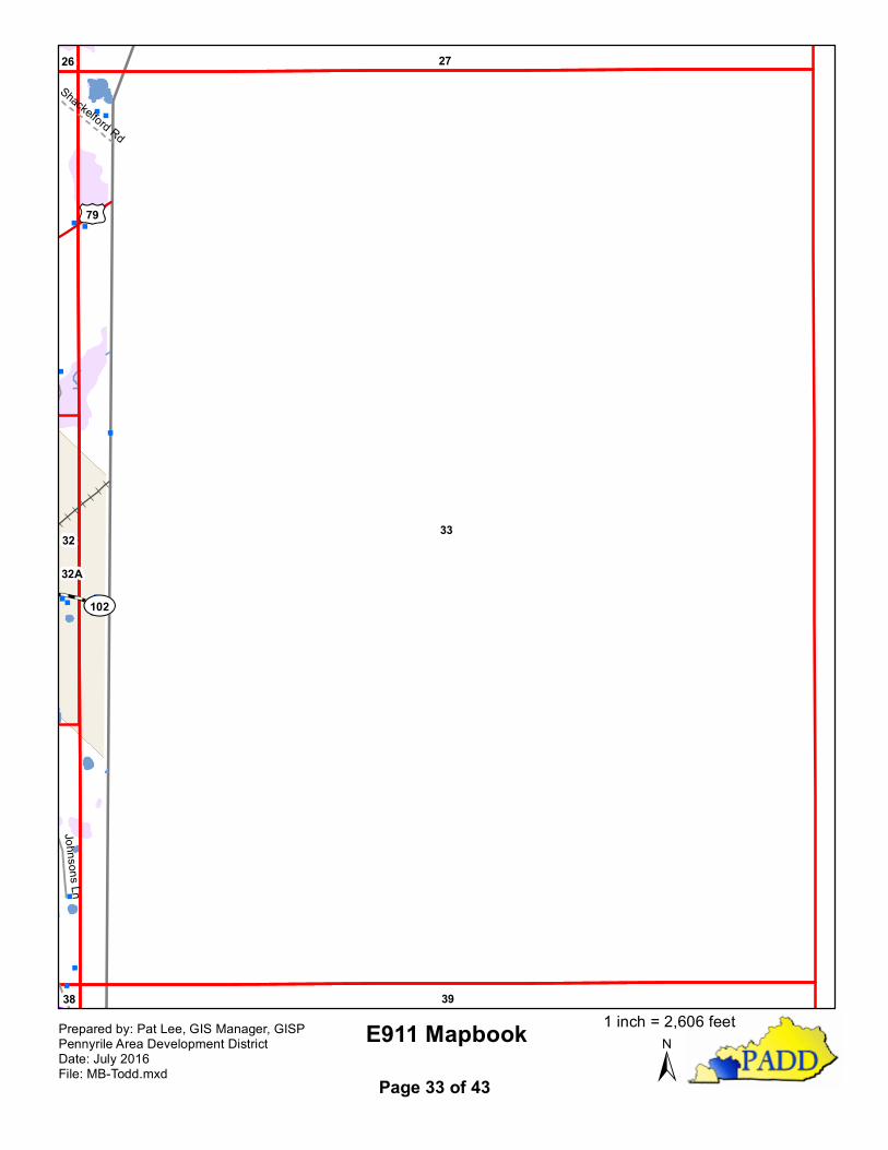
"
""
""
"
"
"
"
"
"
"
"
"
"
"
"
"
""""
""""""
"
"""
"
æ""P
"
"
Ý
Ý
Å̧
Å̧
3332
27
3938
26
32A
£¤79
¾À102
Johnsons Ln
Shackelford Rd
E911 Mapbook±
Prepared by: Pat Lee, GIS Manager, GISPPennyrile Area Development DistrictDate: July 2016File: MB-Todd.mxd Page 33 of 43
1 inch = 2,606 feet
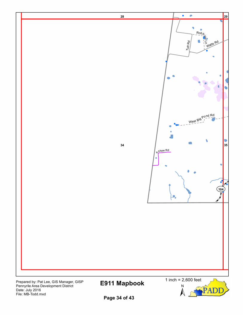
"
"
""
"
"
"
"
""
"
"
"""
"
^
^^
^
^
Å̧
Å̧
34 35
28 29
¾À104Tu
tt Rd
Watts Rd
West Big Pond Rd
Robbies Ln
Askew Rd
E911 Mapbook±
Prepared by: Pat Lee, GIS Manager, GISPPennyrile Area Development DistrictDate: July 2016File: MB-Todd.mxd Page 34 of 43
1 inch = 2,600 feet
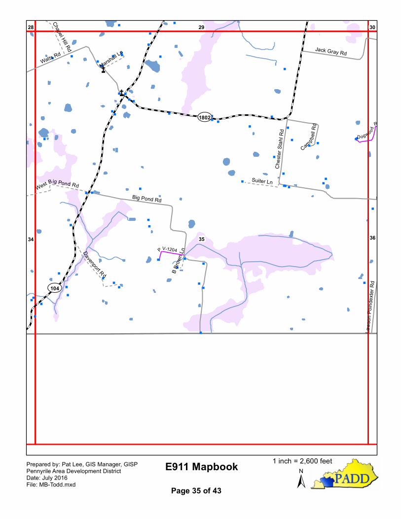
""
" "
"
"
"
"
"
"""
"
"
"
"
"
""
"
"""
"
"
"
"
æ
"""
""
"
"
"
"
"
æ
"
"
""
"
"
""
"
"
"
" "
"
"
"
"
"
"
"
"
"
"
"
"
"
"
"
"
"
""
"
"
"
"
"
"
^
^^
^
^
Å̧
Å̧
35 3634
29 3028
¾À1802
¾À104
Big Pond Rd
Watts Rd
Ches
ter S
tahl R
d
Jack Gray Rd
Cam
pbell R
d
Laws
on Po
index
ter R
d
Davenport R d
Suiter LnWest Big Pond Rd
Chapel Hill Rd
Marshall Ln
B Brow
n LnPV-1204
D ogwo od
Rd
E911 Mapbook±
Prepared by: Pat Lee, GIS Manager, GISPPennyrile Area Development DistrictDate: July 2016File: MB-Todd.mxd Page 35 of 43
1 inch = 2,600 feet

"
P
"
"
P"
PP P
"
!P"PPPP""""""""""
"""""""""""
""""""
"""""
""""" " """
"""""
!
P"
!PP
"
"!
" "PPP""
"
""
"
""
"
" ""
"
"
"
""
PP
"
""""""""""""""""""""P"""""""""""""
""""""""""""""""""
""""""""
"
"
"
æ
"
"
"
"
"
"
!
!
!
"
P"
"
"P
"
"
P"
"
"
""
" "
"" "
"
"
"
"P
"
""
"
""
""
""
" "
"
"
"
"
P
"
YY
^
^^
^
^
Å̧
36 3735
30 3129
Spring Creek
£¤41
£¤79
¾À294
¾À181
¾À2128
North Lester Chapel R
d
Jack Gray RdLa
wson
Poi nd
exter
Rd
Dogwood Rd East Lester Chapel Rd
Graysville Rd
Hilton Rd
Sadler Ln
Down
er Ln
Sand
ers Ln
Cypre
ss Ln
PV-12
08
Unnamed
Rd 1
PR-12
10
Dogw oo
d Rd
PS-1201
G u t h r i eG u t h r i e
E911 Mapbook±
Prepared by: Pat Lee, GIS Manager, GISPPennyrile Area Development DistrictDate: July 2016File: MB-Todd.mxd Page 36 of 43
1 inch = 2,602 feet
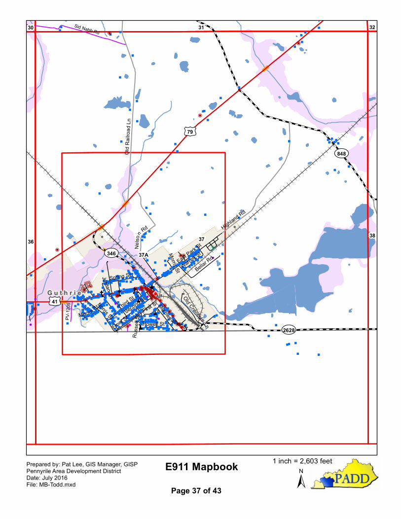
"""
"
"
"
""
"P"
"
"
"
"""
""P
"
"
"
"
"
"
"
"
"
" "
"
"
""
"
"
"
"
""
"""
""
"
!
"
"
"
!
"
""""
" """"
""
""P""
"
"""
"
""""
"""""""
""""
"""
"""
"""æ
"" """"""""""""
!
""""""
""""""""""
"" " "
"æ"
"""
P
"""""""
""""
"""
"""
"""""""
""""""""
"""""""""PP
"""""""
""
""
"
""""""P
""
"""
"""""
"
"
"
"
"
"
"
""
P
"
"
"
"
" "
""
""
!
""PP"
P"
P"
PP
!""""
""!!
!"
PPPPPPPPP!"""""""""" PP
"
"""""""""P
"
""""""
""""
"""""
P"
"
"
"
!
"""""""""
""""""
"
"""
""
"""""""""" "
" "
PP""P""""""""""""""æ""""
!!P!!!!!!!
!!!!P!!
!!!!"
"""""
"""""""""""
"
"
""
P""
""""" " """"æ"""""""æ !PP
PPPPPPP
"
P
"
"
P"
"""""""""
"""""""""""
""""""
"""""
""""" " """
"""""
!
P"
""""
"" "
"""""
""
""""
"""
"""
"""
" """"
"
""""
"""""""
""
""
"
"""
"""""""""""""
""""
"
"""
""""
""
""
"""""""""""æ"
""æ"""""
""""""""""""
"
""
PP""""!""""""
"""""
"
"
""
""""""""
"
"""""""
""
!P
"
P
"
Ý
YY
^
^^
^
^
Å̧
37
37A
3836
31 3230
£¤79
£¤41
¾À2628
¾À848
¾À346
Old R
ailroa
d Ln
Highland Rd
Nelso
n Rd
East Park S
t
Third StNorris St
Second St
Bellar Rd
Spring St
Front StFirst St
Howell St
Warren St
Russ
ellSt
Old Creosote Ln
Merriweather StMoore St
Morris St
Jordan Ln
Sid Nabb Rd
PV-12
05
G u t h r i eG u t h r i e
E911 Mapbook±
Prepared by: Pat Lee, GIS Manager, GISPPennyrile Area Development DistrictDate: July 2016File: MB-Todd.mxd Page 37 of 43
1 inch = 2,603 feet
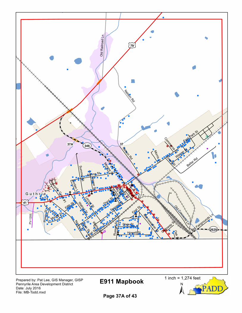
"
"
!
"
"
"
!
"
"
"
"
""
""
""
"
"
""
P
""
"
""
"
"
""
""
"""
"""""""
"
"
"""
""
"
""æ"
"" " "" "" """ " ""
!
""
"" " ""
"""""""" "
"" " "
" æ
"
"""
P
""""
"""
"
""
"
"
""
"
""
"""
"""
"
"
"""""""
"
""
""
""
""
PP
""
""
"""
"
"
"
"
"
"""
""
"P
"
"
"
"
"
"
" "
""
"
"
"
"
"
"
"
""
!
""
P
P "
P"
P
"
P
P
!
"""
"""!!
!
"
PPPPPPPPP!
"
""
"
"""""" P
P
"
"
""
"
""""
"
P"
"""
""
"
""
""
""
"
""
P"
"
"
"
!
"
""
"
"""""
""
""""
"
"""
"
"
"" " "
""
" " " " "
""
PP""P"""""""
"""""
""æ"""
"
!! P
!
!!!
!!
!
!
!!
!
P!!
! ! !!
"
""
"
""
""""
"""" "
"""
"
"
"
P"
" "" "" "
" " """ æ "" "" " " " æ ! P P
PPPPPPP
"
P
"
""
"
"
"
" "
""
"""
""
"""
"
"""
"
""
""
"
""
"
""
"
""
"
"
""
"
"""
"
"
"
""
"
"""
"""
""
""
"
"""
"""
"
"
"
"
""
"
""
""
"
"
""
"
"""
"""""""æ
"
""æ
"
""
""
""
"""
"""
"""
""
"
"
PP""""
!
""
""
""
""
"""
"
"
"
"
""
""
"
""""
"""""
""
""
Ý
^
^ ^
^
^
Å̧
3737A
£¤79
£¤41
¾À346
¾À2628
Nelson Rd
Old R
ailroa
d Ln
East Park S
t
Third St
Norris St
Second St
Bellar Rd
Spring St
Front St
Locust St
First St
Howell St
Summer St
Nelson Rd
Walnut StWarren St
Russ
ell S
t
Old Creosote Ln
Merriweather St
Dixie St
Green St
Gower St
Moore StFifth St
Main St
Cherry St
Pose
y St
Morris St
Jordan Ln
Tower St
Alley #2Alley #1
Commerce St
Mimms St
Calloway S
t
Old Fairgrounds Ln
Pennyrile Court #1
Oak St
Walnut St
PV-12
05
G u t h r i eG u t h r i e
E911 Mapbook±
Prepared by: Pat Lee, GIS Manager, GISPPennyrile Area Development DistrictDate: July 2016File: MB-Todd.mxd Page 37A of 43
1 inch = 1,274 feet
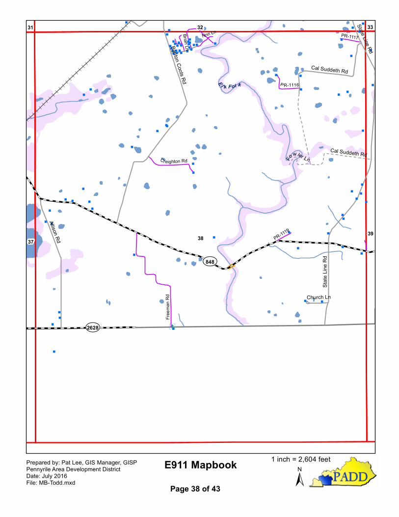
""
"
"
"
""
"
"
"
" "
"
""
"
"
" " ""
"
""""""""
"""" "
"""""
"
"
"
" "
"
""
"
"
""
"
"
"
"
""
"
"
"
"
"
"
"
"
"
""
"
"
"
"
"
"
"
"
"
"
"
"
"
"
"
"
"
"
"""""""
""
"
"
"
"
"
""
"
"
"
"
"
"
Ý
38 3937
32 3331
El k Fork
¾À848
¾À2628Sta
te Lin
e Rd
Allison Rd
Banton Coots Rd
Cal Suddeth Rd
Church Ln
State Line Rd
Cal Suddeth RdFo
wler LnFre
eman
Rd
Cr eighton Rd
P R-1116
PR-1117
Brian Ln
PR-1119
Nnn Ln
E911 Mapbook±
Prepared by: Pat Lee, GIS Manager, GISPPennyrile Area Development DistrictDate: July 2016File: MB-Todd.mxd Page 38 of 43
1 inch = 2,604 feet
"
"
"
"
"
""
"
"
"
"
"
"
"
"
"
"
"
"
"
"
"
3938
3332
¾À848
State
Line R
d
E911 Mapbook±
Prepared by: Pat Lee, GIS Manager, GISPPennyrile Area Development DistrictDate: July 2016File: MB-Todd.mxd Page 39 of 43
1 inch = 2,606 feet