Embed Size (px)
Citation preview

TOPOGRAPHICAL INQUIRY
Jack C. Kuo
December 2011
Submitted towards the fulfillment of the requirements for the Doctor of Architecture degree
School of Architecture
University of Hawai‘i
Chairperson
Kazi Ashraf
Committee
Jaimey Hamilton
Tom Witten


To my mother, Grace.
TABLE OF CONTENTS
1. ABSTRACT 2
2. INTRODUCTION 3
3. THEORETICAL BACKGROUND 4
4. TOPOS.GRAPHŌ 8
5. TOPOGRAPHY THE INSTRUMENT 12
6. CRITICAL EXPLORATIONS 18
7. DATUM 25
8. PROJECT SAMPLING 27
i. FIELD ROTATION 28
ii. TROLLSTIGEN PLATEAU 31
iii. RYOANJI ROCK GARDEN 35
iv. HIGH LINE 40
9. TYPOLOGY 44
10. DATUMS AS TOPOGRAPHIC STRATEGY 57
11. CONCLUSION 63
12. BIBLIOGRAPHY 66
Topographical Inquiry 1

1. ABSTRACT
Landscape and architecture share a paradoxical relationship, and there exists a disjunction
between the two fields. The topics, however closely related, are not regarded nor practiced
cohesively. Ordinary design agendas exacerbate the problem by promoting uniqueness over
conformity, and ingenuity over hackneyed repetition. This drive for expression, although integral to
both professions, can mistakenly neglect proven basic solutions in fear of triteness. On the other
hand, the autonomous practice of architecture from landscape results in built environments
characterized by haphazard collections of forms and voids, many of which more akin to white noise
than organic design solutions.
Theories and criticisms of architecture make up the bias towards the built environment. These
assessments are often bound by still images, drawings, and documentaries that render the built
architectural form as primary and everything else, including landscape, as secondary. In other
words, the framework of architecture is often more self-serving than not, and it leaves the
relationship between architecture and landscape in ambiguity.
The study of emblematic projects provide ground for the analysis of the revealing topography
as both the subject and the object of this inquiry. This thesis is an exploration into the concept of
topography as the sharedness of landscape and architecture; aiming to ease the disjunction between
the two fields as well as ideas towards conflation.
Topographical Inquiry 2

2. INTRODUCTION
In eighteenth century England, neoclassical architecture designs began to contrast landscape
setting in aesthetics and formal order. This divergence of landscape and architecture styles
challenged the architects and designers of the time to come up with strategies to satisfy both fields.
The solutions often took form as grottos and artificial ruins set into the landscape to represent a
relationship between architectural and landscape designs. However, these structures only serve
aesthetic purposes. The popularization of the picturesque style exacerbated the problem by
concealing traces of human intervention in the landscape, and this disconnect remains even in
today’s practices.
The divergence lead to the specialization of landscape profession apart from architecture. The
term “landscape architecture” was first used in 1828 to describe picturesque architectural language.
The term later resurfaced more meaningfully in 1858 when Frederick Olmsted and Calvert Vaux
described their work to the board of the Central Park Commission, thus establishing the term as
well as profession of landscape architecture in the United States.1 The profession grew in the latter
part of the century, and the significance of parks, open spaces, and public spaces came to represent
the field.
Meanwhile, historically, architecture is usually identified as built entities that contrast the idea of
landscape. One of the reasons being advancements in building technology throughout
industrialization and contemporary practice enabled the rapid growth of the field and resultant
urbanization. As such, architecture drove the development of cities, and much of landscape on the
urban stage was deduced as secondary. This approach resulted in cities with accumulated systems
with no single guiding principle in the building-driven network.
In a conference on “The Place of Nature in the City in Twentieth-Century Europe and North
America” on December 1, 2005, Anne Whiston Spirn of the Massachusetts Institute of Technology
argues that the urban population must re-learn the language of the landscape in order to instill new
perspective into the evolution of a city. Spirn presents the language of landscape as a natural
byproduct of survival skills, and it applies to more than just fishermen or farmers whose livelihoods
Topographical Inquiry 3
1 “Olmsted & Vaux,” Prospect Park Alliance, http://www.prospectpark.org/about/history/architects

are directly dependent on their immediate
landscape. As architecture and landscape
necessitates around human intervention, there is
reason to believe our fluency with the the two
subjects landscape affects our abilities to evolve
the built environment cohesively. The attempt to
explore this trend is often discussed in the topic
of landscape urbanism.
In professional practice, landscape and
architecture have been separated apart, and this
is reinforced by diverging strategies. Landscape
urbanism promotes the disciplinary realignment
in which landscape replaces architecture as the
driving force of urban design. Joining these two
terms into a combined field of study aims to
spark new ways of approaching the notion of
building cities as ecological networks. However,
there is a conflict of terminology and
methodology which contributes greatly to current design discourse as well difficulties in actual
implementation.
Furthermore, this realignment of principles does not address the core issue of the disjunction
between architecture and landscape. Instead, it is important to understand the underlying structure
of such proposal of approaching the two topics from the bottom up, both as human interventions.
Landscape describes altered land, as distinct from virgin land before human influence, and all
landscapes are deemed constructed. Architecture is clearly a humanistic phenomenon, but and it
too is a product of civilization. Landscape and architectural works are both human actions upon a
site, and as such, are related through the common concept of constructing upon nature.
Topographical Inquiry 4
Image 1: Three Natures.

3. INTERRELATEDNESS OF LANDSCAPE AND ARCHITECTURE
To understand the interrelatedness of landscape and architecture, one has to first look at their
role as part of nature. The term ‘nature’ carries an extensive history resulting in drastically different
perceptions by different cultures ranging from the physical environment to religious deities. In a
sense, ‘nature’ is very much a human construct of the world. As the basis for Topographical Inquiry,
Marcus Tullius Cicero’s notion of the three natures best establishes the interrelatedness of landscape
and architecture.
Cicero identifies three natures;2 the first
nature is undisturbed, virgin, and we know it
most closely as primal wilderness. The idea of
first nature is in a way incomprehensible by
humans because the mind automatically
perceives with innate biases, and even the
image of the most untamed nature are
constructed collages from a humanistic point
of view. Second nature is a state as altered by
humans for the sake of sustenance, which
includes farmland, houses, and other means of
civilization. This makes up most of our
habitable space and is most closely related to
the concept of inhabitation. The third nature is
the idealization of wilderness in the form of
gardens. It is a rendition of Eden; a calculated
reconstruction of the first nature, which is
otherwise by definition out of our reach and
beyond human comprehension.
The three natures represent the human
psychological tendency for categorization, and
Topographical Inquiry 5
2 John Dixon Hunt, Greater Perfections: The Practice of Garden Theory, (Philadelphia: University of Pennsylvania Press, 2000).
Image 2 & 3: Louis Kahn’s design for Franklin Delano Roosevelt Memorial.

it is easy to simply identify architecture as second nature and landscape design as something of the
third nature. However, both reveal a shared concern for engaging nature; a situated-ness based on
modification of the surroundings. For topography, this involve more than the interest in the physical
layout of the terrains. There are also the considerations and awareness for other material and
spatial qualities of the elements such as texture, temporality, and many other aspects of ‘nature’ as
the catalyst and justification of the modifications.
Architecture, even in its most primitive form, is an alteration of one’s natural surroundings for
the sake of sustenance. Given the definition of Cicero’s Second Nature, architecture is need based,
and its engagement with nature should be of importance to our existence while agreeable with its
surroundings. Similar to Louis Kahn’s idea of altering the land while caring for it, it is a stewardship
of its surrounding.
Louis Kahn’s designs are easily recognizable for their formal expression. Although Kahn totaled
relatively few projects, and only for a short period of time from the late 1950s to 1974, his works
expanded upon the modernist style to embody much more than just the dictum of “Form follows
function” and the emphasis on simplicity and clarity in forms. In relation with Spirn’s idea of
improving the fluency with the language of landscape, Kahn’s works fundamentally stems from the
idea that architecture be continuous with the landscape from which it is constructed upon.
In Kahn’s view, architecture is a conscious practice, and it exist to build upon what nature
inspires and allows; “...what nature can make, man cannot make. And what man can make, nature
cannot make without a man.”3 This constructive relationship exists most obviously in Kahn’s idea
grounding and letting buildings take place based on the given dynamics of their nature. The idea of
incarnating architecture from the landscape enables Kahn’s projects to be more than objects on a
site, but rather manifestations of the surrounding conditions. The idea of stewardship is most
evident in Kahn’s description of the inspiration for a temple as a part of a mountain: “Look, I won’t
hurt you, I am going to take you and treat you beautifully. I am going to cut your edges, I am going
Topographical Inquiry 6
3 Kazi Ashraf, “Taking Place, Landscape in the Architecture of Louis Kahn,” Journal of Architectural Education, Volume 61, Issue 2, PP48-58, 2007.

to put stone upon stone and I am going to build an enclosure, a place where i can try to express
the greatness of eternity of which I am a part.”4
This idea of the ground level in architecture and landscapes is not simply the two-dimensional
plane; it embodies the natural dynamism. In accord with the notion of stewardship, preparation of
this ground should be the obligatory process that precede the act of building. The process, not
limited to scientific and quantifiable site analysis, must identify the proper moments to solidify
decisions towards building upon the ground.
For landscape, the idea of engaging nature is seemingly direct since the physical formations and
design palates are mainly direct results of nature. However, the issue of landscape includes not just
the physical landforms, but also the constructed interventions. For example, gardens exemplify the
human inputs of engaging nature. From the expansive English garden to the Japanese Zen garden,
for many cultures garden is an art of modification of the terrain as constructing the idealized
nature. Today, the contemporary landscape presents another set of opportunities and constraints of
engagement. Often dealing with a highly complex form of Cicero’s Second Nature, today’s
landscape have to engage equally complex aspects of its nature, such as cultural and political
agendas.
The practice of landscapes echoes the notion of nature-driven design; the obvious being the
traditions of gardening, a direct idealization of the perfect nature. Since coined by Federick Law
Olmsted, the field incorporates multidisciplinary topics including horticulture, arts, industrial design,
geology, ecology, engineering, and various related environmental studies. On another level, by
definition, the inherent challenge to solve environmental, social, as well as aesthetic and functional
issues sets landscape practices ahead of architecture in terms of response to and taking place in
nature.
The potential of manifestation based upon a constructive modification of nature is shared by
both landscape and architecture. For both, the concern over the revision of nature for our own use
leads to both physical and functional solutions. While there may be further specific segregation
based on differences in methodology and end products for landscape and architecture, such as a
Topographical Inquiry 7
4 Kazi Ashraf, “Taking Place, Landscape in the Architecture of Louis Kahn,” Journal of Architectural Education, Volume 61, Issue 2, PP48-58, 2007.

botanical garden verses a parking garage; the
arguments still all share the basic question of
how to appropriately engage nature. In the
topographical sense, the modification and
remaking of the second or third nature
resembles a shared process between the
realization of landscape and architecture.
Topographical Inquiry 8
Image 5: CAD generated topography.
Image 6 : Common phys ica l model representation of topography as terrain..
Image 4: Flattened topographic map.

4. TOPOS.GRAPHŌ.
The etymology of topography based on its Greek origin is a practice of describing a place. This
began as written accounts and grew more complex with the renewal of the body of knowledge and
awareness about the landscape. Topography by today’s architectural standard is a degenerated
exercise of flattening the terrain; a convenient representation of contour lines to signify altitudes and
heights of the site. The common surveys and maps document certain physical attributes of a
landscape, but the habitual flattening of the topography as the preferred method of representation
may be counterintuitive to the fundamental philosophy of design. Design; landscape, architectural,
industrial, or otherwise, favors processes of consequence over ones of imposition. However, the
common practice of representing the idea of topography as mere geographical relief automatically
initiates the project on tabula rasa as it disregards the cumulative evolution of the surrounding
nature.
This indulgence with built solutions dangerously leads to the disconnect with landscape. The
threshold between the projects and their environment disengages any possible interface with the
Topographical Inquiry 9
While Landscape Urbanism responds to the limited
understanding of project and context currently
employed in the realization of cities, it does so
mainly at an infrastructural and planning level.
Critics argue that the theories of landscape
urbanism does not yet solve many urban problems
because they ignore real-life agenda and are too
difficult to implement in specificity; others even go
as far as calling it “Sprawl in a Pretty Green Dress.”7
Projects following landscape urbanism ideas have
gained popularity within the last decade, but much
Image 7: Landscape taking over cities.

landscape. Many studies attempt to absolve this threshold, including the theories on landscape
urbanism by the likes of James Corner, propose more integration of architecture and landscape.
Corner proposes the use of landscape as a verb and a process because the noun tense implies
it as an object separate or larger than the individual architecture. The goal is to rediscover a
“proposition of disciplinary unity, albeit a unity that contains, or holds together, difference”.5 In the
same regard, landscape urbanists argue that landscape should be the organizing principle of the city
and its urban experience. This follows Charles Waldheim’s “Reference Manifesto”6 seeking to
replace architecture with landscape as the basis upon which the city is constructed. This idea
realizes that buildings can not be simply architectonic entities that stand disconnected from the
landscape. Rather, the process is a derivative of the context and fundamentally calls for a fluid
system of the built, vernacular, and natural landscape as the basis for any project. It promotes a
cohesive understanding of place, project, and user in conjunction with the natural world. In this
perspective, landscape is not just the marketable and utopian antithesis to architecture.
Topographical Inquiry 10
5 James Corner, “Landscape Urbanism in the Field,” Topos, issue 71, 2010, p. 44
6 Charles Waldheim, The Landscape Urbanism Reader, (New York: Princeton Architectural Press, 2006).
Image 8: The degenerated popularization of equating urban landscape as simple blanketed exercises of “greening.”

of the field focuses on organization of cities as an urban design solution. Architecture benefits
indirectly from the renewed awareness on landscape, but one less explored concept remains in the
study of topography.
Operating with the basis that landscape and architecture are related by their inherent need of
altering the landscape, we can begin studying topography as the instrument towards conflation of
the two fields.
As David Leatherbarrow argues, topography is part of the narrative of buildings, landscapes,
cities, and the people who use them.7 In Topographical Stories: Studies in Landscape and Architecture,
Leatherbarrow states there are two common schools of thought regarding landscape and
architecture. One declares that the two fields are distinct and they should be studied separately.
This, of course, leads to the segregation of landscape architecture and architecture as professions as
well as design solutions. The second school of thought proposes the two are indeed the same, and
should share the same creative origins. While the two sides both produce convincing arguments, a
third hypothesis states that landscape architecture and architecture are similar to each other.
Leatherbarrow contend that topography is the common ground between the two practices, and it
“not only establishes their similarity, but also provides them with the grounds for their
contribution.”8
Topographical Inquiry 11
7 David Leatherbarrow, Uncommon Ground, (Cambridge: The MIT Press, 2000).
8 David Leatherbarrow, Topographical Stories: Studies in Landscape and Architecture, (Philadelphia: University of Pennsylvania Press, 2004).

5. TOPOGRAPHY THE INSTRUMENT
It may be more fruitful, then, to scrutinize topography not as just maps indicating heights and
altitude, but rather as something shared by architecture and landscape in regards to addressing
nature. This system is both the generative and performative, a technology, of the relationships
between civilization and nature. When considering the issue of instrument, one must understand its
purpose lest irrational applications resulting in disjunct relationships.
Undoubtedly, technology has fundamentally changed human’s relationship with the earth. In
Martin Heidegger’s famous essay The Question Concerning Technology,9 he distills the topic of
technology to its essence in order to come to terms about the opportunities and constraints it
possesses. For Heidegger, the rapid transition from collections of direct palimpsest of human-earth
relationships to expedited global culture is a source of danger regarding technology. This
reservation stems from what he concludes as the common tendency to capture and utilize the
essence of modern technology as instruments.
Instruments are means to achieve human ends; specifically those of building up or arranging, and
they also carry the purpose of causing that end. However, as instrument becomes more elaborate
and more processes are involved, its basic means becomes diluted due to complexity, thus placing
too much focus on the mastery of the instrument itself and forgetting the fact that it is a reference
to a broader cause and end. One example is the hydroelectric power plant verses the windmill.
Both are examples of technological instruments to achieve the ends of usable energy, but the
distinction between the two is evident when contrasting the direct primordial essence of the
windmill through which the instrument has a much clearer identity and direct relationship to
nature, especially in comparison to the complexity and dominance of a hydroelectric power plant.
Heidegger writes:
“The hydroelectric plant is set into the current of the Rhine. It sets the Rhine to
supplying its hydraulic pressure, which then sets the turbines turning. This turning sets
those machines in motion whose thrust sets going the electric current for which the
Topographical Inquiry 12
9 Martin Heidegger, "The Question Concerning Technology," Basic Writings, Ed. David Farrell Krell, trans. William Lovitt (New York: Harper& Row, 1977).

long-distance power station and its network of cables are set up to dispatch electricity.
In the context of the interlocking processes pertaining to the orderly disposition of
electrical energy, even the Rhine itself appears to be something at our command.”10
For Heidegger, this example embodies the issue of instrument; it is a means to achieve human
ends with implications of active intentions. However, this should not translate to the assumption
that it is completely an issue of human manipulation. In fact, instruments, though vital, are meant to
cause an end. Heidegger introduces this integral sense as “occasioning”, bringing forth into presence
that which was not in presence, through the process of unconcealment. The aforementioned
examples reveals specific forces of nature and translates them for human ends. This core argument
suggests that instrument is not solely a human construct conceived as autonomous, but rather as
activity, or means, for “the call of unconcealment.”11
Topography as the instrument, then, is the means to arrange for human ends. It serves a human
need by unveiling an engagement with an existing nature. This requires both the reference to the
surrounding context as well as the active engagement of that nature. Unsurprisingly, the common
practice of “site analysis” serves as the fountainhead of the engagement.
Analysis of nature is the first cognitive process in creating any environment. In fact, the primal
instinct of finding habitable shelter revolves around decisions of locating oneself and making a place
within the landscape, both critical to one’s survival and well-being. In the modern sense, topography
embraces technology to allow for a science of measurement.
The most common method of instrumentation is the practice of mapping. It is an accessible
exercise that functions for multiple objectives, and designers are familiar with a wide range of
mapping techniques stemming from the McHargian methods of analysis through overlays. This
methodology introduced a logical way of studying human relationship with nature as well as a
convenient analytic and representational format. The layer of maps, each showing a single interest,
acknowledges that landscape and architecture each as qualities amongst a much broader scope of
Topographical Inquiry 13
10 Martin Heidegger, "The Question Concerning Technology," Basic Writings, Ed. David Farrell Krell, trans. William Lovitt (New York: Harper& Row, 1977).
11 Martin Heidegger, "The Question Concerning Technology," Basic Writings, Ed. David Farrell Krell, trans. William Lovitt (New York: Harper& Row, 1977).

issues. The simple idea of overlaying maps, containing all types of information, results in a clarified
process of scrutinizing the opportunities and constraints of a context, thus leading to more
compatible prescriptions of designs. The process of breaking down nature into manageable layers
and deciphering the appropriate actions is a way to reveal the essential relationship between the
end goal and the existing.
Topographical Inquiry 14
Image 9:
Image 9: Mapping exercise of San Francisco showing environmental policies.

Topographical Inquiry 15
Image 10: Mapping exercise of San Francisco showing political policies.

Topographical Inquiry 16
Image 11: Mapping exercise of San Francisco showing economical policies.

Since McHarg’s Design with Nature,12 there has been improvements and new proposals for the
morphology of human settlement. Mapping today is a combination of historical precedents and
advancing technologies that allows for greater precision in representing contextual data, which in
turn influences designs of architecture and landscape. Mapping today includes not only overlays, but
also real-time tracking as well as augmented reality. These advancements combine to not only
better analyze existing information, but they enable better projections into the future. Many
projects now work with GIS and have tremendous databank of available digital tools and online
maps. The ability to get real-time access to information is often used for diagrammatic purposes,
utilized for a Neo-McHargian overlay mapping with the ability to predict and simulate decisions.
Topography as a successful instrument of the landscape looks beyond simply being inert rational
data storage. On another level, topography enables the activity of stewardship of nature, a
productive alteration of sorts. As such, the main goal of topography as the instrument is then to
capture the dynamic quality of the contextual and script the architectural incarnation. Thus what is
seen in a topographical project is the reference to the culmination of calculated perception, the goal
and the activity itself. Such realization lends a conscious understanding of the architecture and
landscape, overtly expressed or otherwise. It is this reference to the gathered data that successfully
unconceals topography.
Topographical Inquiry 17
12 Ian McHarg, Design with Nature, (New York: John Wiley & Sons, 1969).

6. CRITICAL EXPLORATIONS
To begin to understanding the reasoning and strategies of topographical examples, these
conceptual studies looks to identify signs supporting the integral claim of topography as an
instrument of landscape. The graphic and modeling techniques use the aim to emulate the
operational affect of topography.
The initial example of interest is the Seattle Art Museum Olympic Sculpture Park. With the
Seattle Art Museum Olympic Sculpture Park, Weiss/Manfredi transforms an underdeveloped
waterfront property into a cohessive presentation of architecture and landscape. The site is
originally an industrial brownfield used for fuel storage and transfer station. The project negotiates a
forty-foot grade change from street to sea level, and the lot is diveded into thirds by the four-lane
Elliott Avenue and Burlington Northern Santa Fe Railroad tracks.
Topographical Inquiry 18
On the conceptual level, the project reshapes
the existing landscape through the construction
of a new topography. The nature of the steep
s i te required extensive excavat ion for
remediation, but instead of simply creating
conventional levels for the sake of programming,
Weiss/Manfredi drapes a 2,000-foot zig zag path
bridging the divided parcels of the site. This new
and continuous topography gesture creates
connections previously lacking in the brown field
site and acts as a highly technical X-Ray rendition
of the context by joining program and open
space interacting with the existing infrastructure.
Image 12: Connecting sites.
Image 13: Constructed landscape
Image 14.
Image 15.

The idea of joining programs is not a novel concept, but perhaps what makes this exercise
topographical is that it involves connecting various contextual conditions. Most of the time,
architecture or landscape works of this scale only engage upon one general condition; in other
words, urban museums usually are sited on flattened city blocks, therefore, it is convenient for
architecture to literally dominate the design. However, the Seattle Art Museum Olympic Sculpture
Park engages three different types of context; urban city block, infrastructure, brownfield, as well as
shoreline condition. Presumably, siting one project on multiple contextual conditions puts the
engagement of the site as the first priority.
Not all projects have the opportunity to draw
inspiration from multiple sites. Therefore it is important
to step back and investigate how designers use certain
strategies in more conventional, single-sited works. An
intriguing technique that implies a strong topographical
implementation to a singularly focused site is at Roden
Crater. The Roden Crater Project is very much Jame’s
Turrell’s life project. It has been on going since the 1970s
and the quest list is extremely limited. The project is
being constructed in a dormant volcano in the Painted
Desert of northern Arizona, northeast of Flagstaff. If the
project has to fall in a category, a celestial observatory
would be the closest description. However, Turrell
fascination with the phenomena of light is far beyond just
observation. The topography he creates connects to a
very personal and intimate awareness for one’s
experience of nature.
Topographical Inquiry 19
Image 16: Aerial photo of Roden Crater.
Image 17: Roden Crater.

Topographical Inquiry 20
The qualities of light that shapes Roden
crater are very intricate and fine. There
are distinctions between sunlight,
moonlight, starlight, emitted light, and
reflected light. The spaces capture that
light in physical space for the users to
experience.
Roden Crater revolves around design of
light, and it is the topographical
instrument. The natural phenomenon
shape the entire project. Light is
represented as nature, instrument, and
experience. It literally is the whole
project, from concept to program and
object to subject. The perceptions and
interactions with the topography and the
ever-changing nature of light created by
the light of the sun, moon, stars and
other celestial events fully integrates
architecture and landscape.
Since the site at Roden Crater is so
monotonous, the focused use of light as an
ins t r ument complete ly d i c ta tes the
experience. In fact, light is presented as
nature , instr ument , and exper ience .
suggesting that topography can manifest
through simple and uncomplicated conditions.
Image 18: Sketch of Roden Crater.
Image 19 - 21: Light as the topographic instrument
in carving out spatial experience.

The idea of complete immersion works splendidly at Roden Crater, but the project enjoys
complete remoteness. Another strategy can be seen in designs that physically envelopes the users
in order to create a desired experience. Chinese gardens surrounds the users with artificial
landscape scenes to emphasize the project.
Chinese art and culture has always involved landscape, and gardens are only a part of the rich
tradition. It can be argued that, before gardens, landscape arts took form through poems and
shanshui paintings. In fact, poets like Li Bai were famous for drifting purposelessly on the Yangtze
river, spontaneously transforming his experiences into poetry. Shanshui paintings are famous for
their expressions of the grandness of natural elements, but there almost always exists a hint of
human intervention and scale tucked beautifully into the contours.
Given the strong bond between Chinese culture and nature, its not surprising that the
manitestation of the Chinese landscape is equally scholarly and emotional. The projects of any
space always begins with the matter of siting and feng shui, a concept foreign in western traditions.
This concept of geomacy is an experiential practice as well as a technical science, and the Chinese
used it to determine the best methods to flow with good cosmic influences. Gardens are no
exception to this belief. Although they were generally built by the wealthy, gardens were more for
expressions of a person’s knowledge and wisdom than declarations of status. They stir the poetic
and artistic reverie of the owners to create the promulgation of deep emotions.
Of all the Chinese garden examples, The Master-of-Nets Garden is perhaps the prime example
of a study in topographical. This garden was first built in the 12th century during the Southern Song
Dynasty, widely accepted as the most intellectually advanced period of Chinese history. It is the
smallest of the famous gardens of Suzhou, covering only 0.4 hectares, but it is the most meticulous
and delicate in terms of precision and care.
Topographical Inquiry 21
Image 22: Sketch of Master of Nets Garden.

Due to its small size, The Master-of-Nets Garden contains a dense composition of architectural
structure as well as scenic elements. Here, the microcosm and recreation of nature takes center
stage. Segmentation of the composition varies the impressions the user perceives and compensates
for the small footprint of the garden. Closed to open, dark to light, high to low, mountains to water,
the enclosed garden acts as a poetic representation of the perfect landscape for the owners.
Topographical Inquiry 22
The notion of surrounding the user with
topographical instrument does not have to
equate to constructed enclosure. Some
examples such as the the Igualada Cemetery
Park designed by Enric Miralles uses the
natural curvature of the site to envelope the
topography.
The Igalada Cemetery Park sits near the Rivera de Odena just
outside of the town of Igualada. The challenge of the project is
to find a niche between the natural river valley and the busy
townscape and design a new topography suitable for the
tranquility of a cemetery. For Miralles, it was even more
important to showcase the concept of time in a project
embedded with memories. The topography acts upon constructing built form as a depiction of
its landscape and with the history associated with it. The Cemetery carves out a long man-made
path, built as part of the landscape, through which people experience different spaces while
moving. They all follow a natural order and weathering as they would do in the existing
landscape. The travel through the land enables the experience of space and memories are
achieved at the same time.
Image 23: Plan sketch of Igualada Cemetery
Image 24: Igualada Cemetery
Image 25: Section sketch of Igualada Cemetery

A similar strategy of experiencing the landscape
through travel is used at Trollstigen Plateau National
Tourist Routes. Here, Reiulf Ramstad creates travel
through the landscape to celebrate it. All of the
design elements, including paths, lookouts, mountain
lodging, restaurant, gallery, and even flood barriers,
are molded into the landscape so that the visitor's
experience of the topography seems very intimate.
The thoughtfulness regarding the manifestation of
built spaces and materials in response to the
landscape highlight the site’s temperality and
character, and the series of prepositional relations
describe the topography of the site. The
architecture become clear and precise transitions
between program and the natural landscape.
Topographical Inquiry 23
Image 26: Trollstigen Plateau.
Image 27: Trollstigen Plateau.
Image 28: Traveling through the landscape.

A commonality between all of the examples is the
relationship to the context. Seattle Art Museum
Olympic Park deals with the concept of a single project
spanning multiples sites while Roden crater uses the the
specific condition of light to enliven spaces. Chinese
gardens like the Master of the Nets Garden mimics the
greater context through representative imitation while
Igualada Cemetery Park and Trollstigen Plateau National
Tourist Routes relie on a travel down the context.
This common thread of acknoledging and experiencing
the context is both physical and metaphorical. Certain
experiences rely on sensory stimulation while others
refer to more cognitive associations. On the whole, this
process of reference to the contextual concerns reveals
an important topic in Topographical Inquiry.
Topographical Inquiry 24
Image 29: Seattle Art Museum Olympic Sculpture Park.
Image 30: Roden Crater.
Image 32: Master of Nets Garden.
Image 33: Igualada Cemetery Park.
Image 31: Trollstigen Plateau.
7. DATUM
A datum is a reference from which other measurements can be made. A common vertical
datum used is sea level, and human associate their relationship with verticality as distance above or
below sea level. This particular datum is very recognizable, and people automatically understand the
situation even without first hand experience. For example, it is common knowledge to associate
15,000 feet above sea level with low temperatures, thinner air, decrease in oxygen and altitude
sickness, and conversely 15,000 feet below with high pressure, lack of sunlight, novel life forms and
deep fissures. Humans refer to datums and have various expectancies, yet the datums are not
always absolute. Sea level itself is a constantly fluctuating reality; it is never actually quantifiable.
However, taking the average of all the fluctuations and setting a definition allows people to refer to
this datum for other things, and its most common use as a measure of altitude does not even have
a direct connection to the water itself.
Both landscape and architectural today are especially aware that intricacies regarding context
that cannot be captured in singular frames of simply before and after,13 and designers have to be
increasingly concerned with the issue of multidisciplinarity. This is compounded by the ease of
information sharing and gathering in the modern world, thus, this sense of an anchored reference is
ever more crucial in establishing the process of clearly revealing the way human engage nature.
Within the topic of Topographical Inquiry, a datum is both determined and referenced. Datums also
are not always constant; they can change just as landscapes are made and remade. Simply, it needs
to be a determined anchor to activate the revealed moments of topography. At the same time, this
hypothesis accommodates the basic analytical information about the context, and, therefor, tenures
to the existing nature.
As a reference, the datum serve both the designer as well as well as the users. From a design
standpoint, the datum is the way to strongly communicate how a design engages nature and how
these spaces are activated. Much like the idea of using mean sea level to represent what is in reality
a constantly fluctuating measurement based on tides, waves, atmospheric pressures, wind and
currents; the topographical datum determines the specific to-be-experienced conditions based on
Topographical Inquiry 25
13 Peter Reed, Groundswell, (New York: Museum of Modern Art, 2005), 18.

analysis. This is a paramount trait inherent to Topographical Inquiry, distancing it from utopian ideas
of “responsibly relating to nature” simply through non-action and minimal intervention.
This underlines the characteristic of a datum as a contextual issue, and it can be understood as
the main tactic used in the revealing moments of the topography as well as the activation moments
of the topography. This translates to the more involved manifestation of a design intention, beyond
just the static conditions of space and place, and creates events as part of the spatial experience.
It is this event that allows the users to be part of the revealed topography because they
consume the revealed references of the topography as part of the experience of a project. In this
regard, a datum acts as a point of reference to achieve the physical as well as cognitive connection
with the context. In sync with the degrees of topography, datums can take on different
characteristics; one can take on a more physical modulation as well as mentally constructed
moments.
Physical modulation exists through the arrangement of spaces and programs, and this is often
understood as the primary creed in architectural practice. Within the notion of datum, this
prescribed arrangement as part of nature controls the physical interaction and experience with the
context. In other words, the modulation can set the tone for the desired experience through
various representations of space and program. Such interplay of spacing and programs implies the
shift away from on forming and instead a focus on the process of creating experiences and specific
natures. This process adds to the conventional design notion of composing only within opposing
alternatives; solid and void, figure and ground by encouraging more exploration into various
engagements with nature.
While the physical arrangement controls corporal engagement with spatiality of nature, the
cerebral aspect of datum reveals the moments of engagement. This requires the astute
understanding of the intangibles of a context such as cultural values, beliefs, and social psychology of
the existing nature. Such references create mental experiences beyond the immediate physicality as
well as revealing meaningful relationships with the context. The combination of physical and mental
references activate topographical moments unique to each project. For built environments, this
leads to improved orchestra in design as well as a discernible sensitivity as part of the context.
Topographical Inquiry 26

8. PROJECT SAMPLING
The selected projects exemplify the inquiry through better
awareness of the relationship between landscape,
architecture, and nature; therefore, the realization of
typology of such relationships. While all designs, from
furnitures to skyscrapers, have various degrees of
topographical connection with their immediate nature, the
projects here underline Topographical Inquiry as a revealing
activity of human tenure upon nature, as well as the use of
datums to arrange and activate those tenured moments.
These four projects are shor tlisted from a initial
preliminary collection of examples for their focus and
distinction in revealing topography. They vary in their
respective nature, and they are diverse in the revealed
topography. They demonstrate diverse instrumentation
and unique revelations. Comparing and contrasting the
examples helps to identify specific strategies and
topographic typologies applicable to design.
Topographical Inquiry 27
Image 34: Field Rotation.
Image 35: Trollstigen Plateau National Tourist Routes.
Image 36: Ryoanji Rock Garden.
Image 37: High Line.

FIELD ROTATION - Governor State University, Illinois - Marry Miss
“I want ... that visceral quality, that immediate intimate engagement with the place of with the situation that you are noticing something in the way that you haven’t before.” - Mary Miss14
Mary Miss’ artwork, even from an early period,
often revolves around the idea of integrating
oneself into the context and the environment.
The field of public art was once neglected and
considered as peripheral to the art world
where artists who could not make it past the
pristine boundaries of the galleries, thus
deemed as unsophisticated work. For Miss, the
optimism to operate upon the existing limits
drove her work from the 1970s. Today she is
acknowledged as a pioneer in the field of public
art, one who makes the users and their
response as the driving force of every work.
Many of Miss’ work focus on the idea of
dismantling; taking things apart and restructuring
them.15 In “Field Rotation”, the project’s vast
surround, ambiguous extents, and the familiarity
of the materials used act as a reflection of the
American Midwest’s second nature. This
installation consists of an arrangement of long
spokes of spaced wooden poles radiating from
a courtyard sunken into a central berm. The
poles have a regional association through their
telephone pole-like materiality and, the grass
Topographical Inquiry 28
14 Daniel M. Abramson and Mary Miss, Mary Miss, (New York: Princeton Architectural Press, 2004).
15 Daniel M. Abramson and Mary Miss, Mary Miss, (New York: Princeton Architectural Press, 2004), 9.
Image 38: Aerial view of Field Rotation.
Image 39: Constructed berm.
Image 40: Sculpture in sunken courtyard.

mound resemble the Midwestern prairie sod houses, and the entire piece twists the landscape and
relates to the history of crop rotation in the regional culture. Upon further inspection, the
excavated courtyard set within the berm makes for a dramatic revelation; in it there is a cross
timber armour-like structure rising above a discreet well filled with water.
Mary Miss calls the courtyard a “refuge in the landscape”16 as it effectively separates the senses
from the outside environment. This again parallels the buildings of the prairie in the vast American
Midwest. However, just as one acclimates with the surrounding, the sense of peace upon
encountering the dark well at the center of the design. The seemingly bottomless well with its
narrow edges and a disappearing ladder creates a lost of balance and anxiety amidst the otherwise
protective courtyard.
The instrument for “Field Rotation” is not overt because it is unconcealing a rather elegant
sensibility about the Midwest nature. The alterations relate to the history of crop rotation in the
regional culture, and the movement through the project accentuates the unveiling process. The
height of this experience is evident in the embedded courtyard as its construction within the berm
juxtaposes nature and artifice. It creates a refuge as a means of seeing the landscape from a
forgotten perspective.
The topographical instrument here is not the structure itself, but the function as the catalyst to
create physical and psychological experiences for the users. The seemingly minute act of centrifugal
suggestion and the subtle building-up of the berm are specific methods to refer to the contextual
nature while revealing what is otherwise a neglected-everyday occurrence. Staying in tune as a
topographical practice, Field Rotation is not overly tied to the monumental tradition of sculpture
nor does it focus on a specified authority or awe over the users like “anything that’s meant to be a
big thing out in the desert.”17 Instead, Miss reveals opportunities for viewers to exercise their own
perception by focusing on human scale, intimate experience, and elements of the context.
“Field Rotation” exemplifies the topographical inquiry as a way of revealing the relationship of
landscape and architecture. It reveals built space as an astute commentary of its nature, beyond just
Topographical Inquiry 29
16 Daniel M. Abramson and Mary Miss, Mary Miss, (New York: Princeton Architectural Press, 2004).
17 Daniel M. Abramson and Mary Miss, Mary Miss, (New York: Princeton Architectural Press, 2004), 11.

the ordinary boundaries. Here, as the means of instrumentation, Mary Miss creates a topography
that traces the cultural and historical background of the landscape. The perfect cuts of the poles,
the rise of the berm, the sunken courtyard, and the twisting parti all engage the landscape beyond
just physical meanings. Furthermore, the experience of “Field Rotation” is crucial to the success of
the topography as the designed sequence of moments is most influential in revealing the awareness
of the landscape. The gradual and comforting buildup of experiences ends with a dramatic
realization of just how limited our supposed control of the world is. It presses the users to
understand that any achievements of intervention is still part of the organic context of nature.
Topographical Inquiry 30
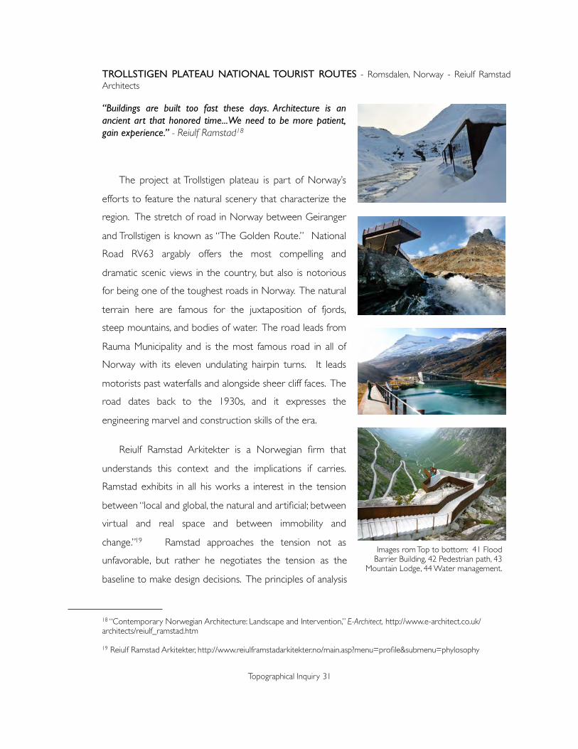
TROLLSTIGEN PLATEAU NATIONAL TOURIST ROUTES - Romsdalen, Norway - Reiulf Ramstad Architects
“Buildings are built too fast these days. Architecture is an ancient art that honored time...We need to be more patient, gain experience.” - Reiulf Ramstad18
The project at Trollstigen plateau is part of Norway’s
efforts to feature the natural scenery that characterize the
region. The stretch of road in Norway between Geiranger
and Trollstigen is known as “The Golden Route.” National
Road RV63 argably offers the most compelling and
dramatic scenic views in the country, but also is notorious
for being one of the toughest roads in Norway. The natural
terrain here are famous for the juxtaposition of fjords,
steep mountains, and bodies of water. The road leads from
Rauma Municipality and is the most famous road in all of
Norway with its eleven undulating hairpin turns. It leads
motorists past waterfalls and alongside sheer cliff faces. The
road dates back to the 1930s, and it expresses the
engineering marvel and construction skills of the era.
Reiulf Ramstad Arkitekter is a Norwegian firm that
understands this context and the implications if carries.
Ramstad exhibits in all his works a interest in the tension
between “local and global, the natural and artificial; between
virtual and real space and between immobility and
change.”19 Ramstad approaches the tension not as
unfavorable, but rather he negotiates the tension as the
baseline to make design decisions. The principles of analysis
Topographical Inquiry 31
18 “Contemporary Norwegian Architecture: Landscape and Intervention,” E-Architect, http://www.e-architect.co.uk/architects/reiulf_ramstad.htm
19 Reiulf Ramstad Arkitekter, http://www.reiulframstadarkitekter.no/main.asp?menu=profile&submenu=phylosophy
Images rom Top to bottom: 41 Flood Barrier Building, 42 Pedestrian path, 43
Mountain Lodge, 44 Water management.

and decisiveness are embedded into each unique project derivitive of defining elements in nature.
The interpreted tectonics, structural solutions, spatial continuity, and material choices all aim to
articulate the sites’ possibilities and natural qualities. Because of this philosophy, Ramstad’s works
begin on a basis of “attunement”20 with nature.
Regarding Trollstigen Plateau, Ramstad feels that the vehicular route alone deprives the visitors
of the visceral relationship with the landscape; an example of a misused technology as the intention
to expedite access to the destination actually lessens one’s enjoyment. He remembers the exciting
memories from driving through Trollstigen himself, but they were all too brief and short lived.
Ramstad suspects this is the phenomenon for many Norwegians who only know this landscape as
snapshots of images rather than the actual experience, so he set out to rediscover the experience
through more deliberate and dedicated means in this location by accepting the natural physicality as
the foundation for architecture. The primary objective of the projects of Trollstigen Plateau is then
to manifest architecture from the physical geography for pedestrian tourists. This provides access to
parts of the fjord previously too remote or inhospitable.
The project at the Trollstigen Plateau is one of eighteen interventions along this particular
tourist route, and it sits at one of the most dramatic fjords in the region. Its programs, materials, and
building methods highlights the site’s temper and character ; each a direct reference to the specific
nature it exists in. The project reveals the landscape as a substratum for architecture, but the
significance of Trollstigen Plateau is neither the architectural solutions nor the landscape grandeur.
The subject here is the unveiling and coming into being of a habitable nature and creating an
alternative sequence of spaces geared towards bridging the gap between the built forms and the
geography.
This idea considers the realization of architecture from different specific sites, and consequently,
the means and results are different. The environment here is considerably harsh, especially in the
winter, and the architecture it generates reflects that character. The extreme conditions obviously
affects the various elements at Trollstigen; the Mountain Lodging, Outlook Plateau, and the Flood
Barrier Building are all very robust. They vary in degree of affect based on the opportunities and
constraints of the site. As a result, the design process included expertise of hydrologists and
Topographical Inquiry 32
20 Reiulf Ramstad Arkitekter, http://www.reiulframstadarkitekter.no/main.asp?menu=profile&submenu=phylosophy

geologists, and topography becomes an organic process of taking-place in the landscape. For
example, the footpaths along the river practically float over the site as the topography expresses
the delicacy of the moment. On the other hand, the outlook plateau is the most stirring piece
because its site is dramatic and causes such heroic gesture.
Reiulf Ramstad set out to respond to the brutal nature at Trollstigen. Due to the fact that
access to the site is dictated by snow and ice, the design team imposed new ways of working over
several seasons to create temporal element. In that regard, the generative topography takes palce
over time, in sync with the landscape. Ramstad sees it as a neglected part of architecture and likens
it to the difference between fast food and prepared meal. The architecture are built in succession
and therefor weather sequentially. The weathering of materials in such a site reveals the ambient
aspect of the landscape at Trollstigen. Not only that, the architecture become clear and precise
transitions between humanly planned zones and the landscape, and the built spaces also become
real-time prototypes to deal with natural conditions at the site such as unpredictable runnoff,
avalanches and heavy precipitation.
Topographical Inquiry 33
All of the design elements, including paths, lookouts, mountain lodging, restaurant, gallery,
and even flood barriers, are molded into the landscape so that the visitor's experience of the
topography seems very intimate. Spaces like the lodging provide a sense of decompression
from the harsh elements while the memorable moments in the tourist routes such as the
cantilever outlook plateau provokes user experience with a graduation of danger. The
thoughtfulness regarding the manifestation of built spaces and materials in response to the site
highlight the environmental temperality and character, and the series of prepositional relations
describe the multitude of topography at the site.
Image 45: Sketch of the collection of installations at Trollstigen Plateau.

The approach of revealing topography used at the Trollstigen Plateau National Tourist Routes is
extremely aware of the natural landscape and precise in its modus operandi. The architecture and
built projects along the routes are caused by the site to describe and remediate the harsh seasonal
conditions of the site. At the same time, the implementations along the routes vary in scale and
impact in accordance to the opportunities and constraints; ensuring that the instrument itself does
falsely become the main concern. The reference to the fjord and thought process reveals the
opportunities to marry human programs with natural landscape.
Topographical Inquiry 34

RYOANJI TEMPLE ROCK GARDEN - Kyoto, Japan - Unknown
“A place beyond time and space where it is possible to experience the pure potentiality that is the source of all existence.” - David and Michiko Young21
Ryoanji is a Zen temple in the northwestern
part of Kyoto, Japan. The complex includes
several sub-temples and an expansive pond
garden, but the most famous part of the temple
is the rock garden. Hostorians speculate that the
rock rock garden was constructed after the
burning of Ryoanji during the Onon Was in the
15th Century.
The rectangular garden sits longitudinally on
an east-west axis and is small in physical size, only
30 meters by 10 meters. The garden features a
sea of carefully raked white sand, surrounding
fifteen roks are arranged in five groupings. The
arrangement of rock groupings is in such a way
that one can never see all fifteen rocks from any
single vantage point. The Ryoanji rock garden has
has been interpreted as a representation of the
natural world: islands rising from a sea,
mounta ins peak ing above c louds , and
constellations in the sky. The garden is enclosed
to the east, south, and west by a clay wall baked
in rapeseed oil and then whitewashed. The wall
is low enough that one can see beyond its
physical limits from the elevated verandah on the
north side of the garden. There are two
Topographical Inquiry 35
21 David and Michiko Young, Art of the Japanese Garden, (Singapore: Tuttle, 2005).
Image 46: Ryoanji Rock Garden.
Image 47: Garden in winter.
Image 48: Partial arragement at Ryoanji.

indications of boundary that dictate the edge of the garden. The first is a continuous band of stone
and the second is a border of round black pebbles. The shift in texture and hardness reinforce the
boundaries of the garden.
The garden at Ryoanji follows the famous Karesansui style in Japan. This technique is often
associated with Zen Buddhism, and the main elements include stones and fine gravel or sand. Kare
means dry, weathered, and Sansui translates to landscape; mountains are typically represented by
the stone arrangements and the purposefully raked gravel and sand suggest bodies of water. The
simplistic and minimalist approach of Karesansui relies on the intuitive Gestalt laws22 to create
aesthetic and psychological phenomena. The Proximity law states that elements psaced closer
together are perceived as belonging together; the similarity law suggests that elements with similar
appearance are grouped together; the smoothness law states that elements group together if they
align to a smooth path. The enclosedness law says objects group together if theyare arranged on a
closed path, and the simplicity law implies that the simpler the configuration of the parts, the easier
it is to perceive the parts. In addition to the basic laws of proximity, Karesansui gardens also utilize
texture effects to manipulate contrast verses mixture, thus adding to the process of visual
perception. The contour junctions also play important roles evident in the arrangement of rocks.
The formation of odd or even juntions contributes to the control over perception.
The intentional Karesansui principles at Ryoanji can be summed up into four major aesthetic
ideals of asymmetry, tranquility, simplicity and naturalness.23 The calculated implementation of the
strategies and design elements controls the process of perception. Just as importantly, the idea of
Ma, or empty space, dictates a suggestive and distilled composition of the garden. The design of
such subtle spaces requires the conceptualization of the empty space first, and while this seems
counterintuitive, but the experience created revolves around the implied role of such spaces.
The Karesansui principles in combination with the Gestalt principles create an expression of
feeling and thinking. In this sense, the topography is designed as a incarnation of the Zen
interpretations of the natural world in which teaching is never expressed through elaborate text,
but through quiet parables. Nothing is told at the garden, and there are no scripted ways to view
Topographical Inquiry 36
.22 Gert J. Van Tonder and Michael J. Lyons, “Visual Perception in Karesansui Gardens,” http://www.kasrl.org/IAEA.pdf
23 Nitschke, G. Japanese Gardens. (Koln: Benedikt Taschen Verlag GmbH, 1993).

or experience the garden. In a more poetic fashion, the garden is like a profound “sermon in
stone.”24 There are no elements for the mind to hang on to, and thoughts are suspended in space.
Studies on the garden reveal numerous compositional techniques such as gestault, framing,
junctions, and textures, but perhaps what makes Ryoanji’s rock garden unique is the purity of the of
the topography.
Topographical Inquiry 37
24 Ryoan-ji Temple, http://www.kyoto.travel/it/2011/01/ryoan-ji-temple-1.html
Image 49: Sketch of plan & sectional relationships at Ryoanji Rock Garden.

Studies by Gert van Tonder and Michael Lyons has shown that the empty space of the garden
implicitly structures the entire experience through influecing visual perception. They concluded that
besides the principles existing in other gardens, Ryoanji possesses a composition which they
decipphered through the explaination of “medial axis,”25 or a bisecting axis equidistant from two
starting points.
(A1) The medial axis between two points is the locus of equidistant points between
them. (A2) A two-dimensional shape (dark outline) and its medial axis transform
(internal shading) computed with our model. (A3) Contrast sensi- tivity enhancement
Topographical Inquiry 38
25 Gert J. Van Tonder and Michael J. Lyons, “Visual Perception in Japanese Rock Garden Design,” http://www.kasrl.org/axiomathes.pdf
Image 50: “Medial Axis” analysis of Ryoanji Rock Garden.

data of Kova ́ cs et al. (1998) of a triangle, with vertical and horizontal cross sections to
show data in detail, were replicated with the model by Van Tonder and Ejima (2003).
(B1) Medial axis transformation of Ryoanji. The layout is after Oyama (1995). The
outlines of rocks appear within the rectangle of gravel. The verandah and main hall are
also outlined. The central room appears as a bold black outlined square. Rock contour
values are scaled to relative rock heights. (B2) The simulation, with rock contour values
all set equal. (B3, B4) The medial axes for the original simulation and perturbed
simulations are highlighted in white, for clarity. (C1) An enlarged view of the medial axis
tree of the left most rock cluster. (C2) The global medial axis tree. (C3) Horizontal
reflection and enlargement of a section of the local tree reveals a close similarity with
the global structure (C4).26
Ryoanji reveals not just a cultural representation of the world, but also a modification of nature.
Just as Zen attempts to stabilize the human mind and spirit, the topography of Ryoanji finds the
essence of spatiality by finding balance in a condensed landcape and architecture. The stones, sand
and foliage are all natural occurrences, but they are decisively placed, textured, and framed in such a
way that the form and its negative space becomes a significant, if not integral, role in the design. It
reveals to the users the connection and awareness of nature. The meditative experience inspires
the viewer to look for the relationship between the positive and negative, the built and the unbuilt,
and the interplay between the imobile placement of the stones verses the shifting patterns of
shadows and colors. The architecture, the overall landscape, and the topography heighten the
experience as the karesansui extends beyond its physical form to manifest in unseen spaces.
At Ryoanji, there exists a complete harmony between the highly calculated modification of
nature. The composition achieves its simple and eternal aspects with attention to every detail such
as textures, asymmetry, and simplicity. This concept of intricacy combined with the deep
enculturation of the topography is a world within a world, and it creates a perfect mixture of
landscape and architectural.
Topographical Inquiry 39
26 Gert J. Van Tonder and Michael J. Lyons, “Visual Perception in Japanese Rock Garden Design,” http://www.kasrl.org/axiomathes.pdf

HIGH LINE - Manhattan, New York - James Corner Field Operations, Diller Scofidio + Renfro
“Who the hell looks up, in this town? Who has time?” - David Zickerman27
The High Line is a new 1.5-mile long public park built on
an abandoned elevated railroad stretching from the
meatpacking district to the hudson rail yards in manhattan.
The project is a collaboration between James Corner Field
Operations and Diller Scofidio + Renfro, inspired by the
melancholic, unruly beauty of the postindustrial ruin.
The history of the High Line dates back to 1934 when the
first trains operated from 34th Street to St. John’s Park
Terminal as Spring Street.28 The decision to navigate
through the city blocks as opposed to over the avenue was
in response to the largely negative associations with
elevated tracks. The line connectes directly to warehouses
and factories, and conveniently allowed the trains to station
inside the buildings. With growing neglect, the sothernmost
section of the High Line was demolished in the 1960s, and
the last train operated in 1980.
Topographical Inquiry 40
27 Horst Hamann, New York Vertical, (New York: teNeues, 2007).
28 ‘High Line,” http://www.thehighline.org/about/high-line-history
Image 52: High Line through New York.Image 51: High Line through New York.
Image 53: Original elevated rail.
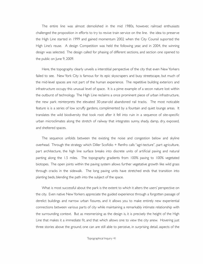
The entire line was almost demolished in the mid 1980s, however, railroad enthusiasts
challenged the proposition in efforts to try to revive train service on the line. the idea to preserve
the High Line started in 1999 and gained momentum 2002 when the City Counsil suported the
High Line’s reuse. A design Competition was held the following year, and in 2004, the winning
design was selected. The design called for phasing of different sections, and section one opened to
the public on June 9, 2009.
Here, the topography clearly unveils a interstitial perspective of the city that even New Yorkers
failed to see. New York City is famous for its epic skyscrapers and busy streetscape, but much of
the mid-level spaces are not part of the human experience. The repetitive building exteriors and
infrastructure occupy this unusual level of space. It is a pime example of a secon nature lost within
the outburst of technology. The High Line reclaims a once prominent piece of urban infrastructure,
the new park reinterprets the elevated 30-year-old abandoned rail tracks. The most noticable
feature is is a series of low scruffy gardens, complimented by a fountain and quiet lounge areas. It
translates the wild biodiversity that took root after it fell into ruin in a sequence of site-specific
urban microclimates along the stretch of railway that integrates sunny, shady, damp, dry, exposed,
and sheltered spaces.
The sequence unfolds between the existing the noise and congestion below and skyline
overhead. Through the strategy which Diller Scofidio + Renfro calls “agri-tecture”, part agriculture,
part architecture, the high line surface breaks into discrete units of artificial paving and natural
panting along the 1.5 miles. The topography gradients from 100% paving to 100% vegetated
biotopes. The open joints within the paving system allows further vegetative growth like wild grass
through cracks in the sidewalk. The long paving units have stretched ends that transition into
planting beds, blending the path into the subject of the space.
What is most successful about the park is the extent to which it alters the users’ perspective on
the city. Even native New Yorkers appreciate the guided experience through a forgotten passage of
derelict buildings and narrow urban fissures, and it allows you to make entirely new experiential
connections between various parts of city while maintaining a remarkably intimate relationship with
the surrounding context. But as mesmerizing as the design is, it is precisely the height of the High
Line that makes it a immediate fit, and that which allows one to view the city anew. Hovering just
three stories above the ground, one can are still able to perceive, in surprising detail, aspects of the
Topographical Inquiry 41

city’s character impossible to notice behind an office window. One is close enough to the street life
to feel a part of the heartbeat of the city, yet at the same time, longer vistas across the city brings
about a experience found only at the High Line.
Topographical Inquiry 42
Image 54: Map of High Line.
Another conscious effort to preserve this experience
is the regulated access to the park. As of now, there are
only four access points; a remarkable decision considering
the real estate possibilities for such a park space in New
York City. The renewed frameworks includes not only the
intended programs, but also a submarket of functions
along the line prevously unimaginable. This includes the
retrofits and upgrades of existing buildings as well as the
grounds for future development possibilities. The
influence of the High Line creates an anchor for the
surrounding environment, thus extending the line’s
topography beyond its own jurisdiction.
The topography here is a immediate fit into the New
York City landscape. It is a acknowledgement to the
continuous growth that is part of New York City. The set
of topographical decisions unconceal a new urban space.
On another level, the High Line represent the realization
of a resolute framework that is the foundation of urban
topography.
Topographical Inquiry 43

9. Typology
This research explores the idea of topography as a
consolidation of several key interdisciplinary ideas. The
extent of the topic is inherent in both architecture and
landscape designs, and applicable in a multitude of spatial
design. In understanding topography as both a revealing
process as well as a tenure upon nature, it is possible to
catalogue the specific typology of Topographical Inquiry. These
projects represent the application of topography, and they
effectively exemplify the aspects of the topography as integral
agent for both landscape and architecture designs.
Topography refers to the context and reveals a broad range
of engagement of nature through specific activities. For
example, the tenure at Trollstigen Plateau is drastically
different from that of New York City’s High Line, and the
topography of the respective projects reflect the sensitivity
to the difference in measures. They reveal different degrees
of topography with unique actions and revealing moments;
therefor, the level of alteration and resultant characteristics
are different. On another level, the sample projects
represent not a fixed universal solution, but rather various
topographical typologies; a key assimilation in topographical
Inquiry.
Topographical Inquiry 44

INCISION
The typology of incision is a physical action; a deliberate intervention on the terrain. This idea of
altering the ground plane at an existing site is fundamental to Topographical Inquiry as it deals directly
with the human tenure of nature by changing the scale of relationship between user and site.
Topographical Inquiry 45
In “Field Rotation”, Marry Miss first modifies the ground plane by creating berms, instilling a
gradual and comfortable exterior facade to blend in inconspicuously with the rest of the
landscape. The transition into the center court alters not just the terrain, but more importantly
the bodily relationship with the ground plane. Incision in this case creates an artificial undulation
in an otherwise flat site. The only access points into the sunken courtyard are a pair of ladders,
and the travel into the incision forces the user to experience the site through a more intimidate
experience.
Image 55: Sketch of process of incision at Field Rotation.

Carme Pinos cuts out a descent into a
geologically poor river valley; thereby removing
the visitors from the real world distractions.
Here, the incision into the land also controls the
temporality of the project. The total
submersion allows the designers to then dictate
the entirety of the experience. In this case,
Miralles slows down the project to create
deeper connection between user, program, and
nature. The gentle descent into the valley shuts
out external distractions from the surroundings.
The path and the crypts present a psychological
experience by putting the user up close to the
excavated earth. In accepting the reality of this
Topographical Inquiry 46
The interior courtyard reinforces the
feeling of one setting into the ground plane,
and a second incision is made at the center of
the installation to anchor the concept into the
design. Once within the incision, however, the
revealed topography of American Midwest
culture dominates the project as the
experience shifts from traveling on the site to
one that is within the site.
This type of topography establishes an
intimate human perception with the ground,
thus reinforcing the user experience. The
Igualada Cemetery Park by Enric Miralles and
Image 56: Exercise of incision.
seemingly unattractive site and transforming the
ground plane, Miralles amplifies the notion of
solidarity and permanence by instilling continuity
from incised space to the hard bedrock
throughout the project. It proves the primarily
physical action is influential to the emotional
outcome of the project.
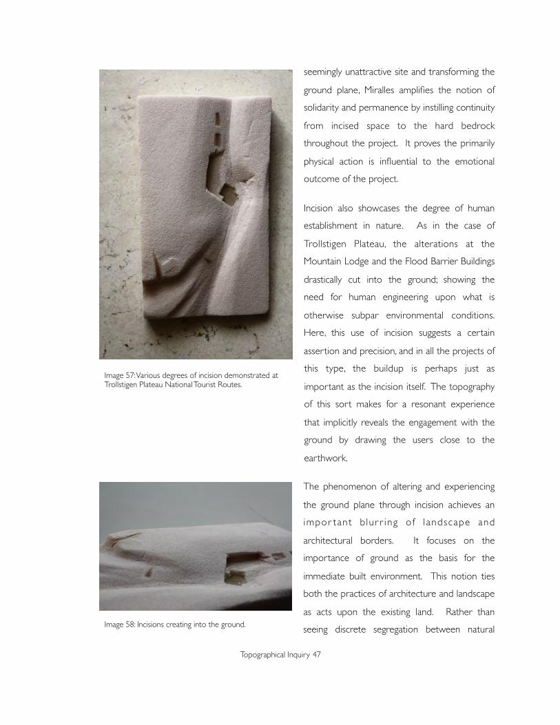
Incision also showcases the degree of human
establishment in nature. As in the case of
Trollstigen Plateau, the alterations at the
Mountain Lodge and the Flood Barrier Buildings
drastically cut into the ground; showing the
need for human engineering upon what is
otherwise subpar environmental conditions.
Here, this use of incision suggests a certain
assertion and precision, and in all the projects of
this type, the buildup is perhaps just as
important as the incision itself. The topography
of this sort makes for a resonant experience
that implicitly reveals the engagement with the
ground by drawing the users close to the
earthwork.
The phenomenon of altering and experiencing
the ground plane through incision achieves an
impor tant blur r ing o f l andscape and
architectural borders. It focuses on the
importance of ground as the basis for the
immediate built environment. This notion ties
both the practices of architecture and landscape
as acts upon the existing land. Rather than
seeing discrete segregation between natural
Topographical Inquiry 47
Image 57: Various degrees of incision demonstrated at Trollstigen Plateau National Tourist Routes.
Image 58: Incisions creating into the ground.

surfaces and architecture forms, this typology presents the preparation of earthwork as having a
tectonic quality of its own, and therefore enabling projects to physically achieve much more intimate
engagements with nature.
Topographical Inquiry 48

ENCAPSULATION
An encapsulated topography is one of metaphoric engagement. This typology envelops an
idealized topography. One methodology is to condense specific vernacular references and motifs as
a way to simulate nature; the resultant project reveals much more than what is physically
experienced. In the case of Field Rotation, the gravitational pull of parts of vernacular materials
successfully reveals a larger American Midwest landscape. At Ryoanji, however, the same concept
relies on the use of distillation to achieve a precisely delineated Topography. The focus on emptiness
and essential reveals a highly idealized and focused experience.
In a typology of encapsulation; as
evident in the Mary Miss’ implementation of
vernacular culture and motifs and in Roanji’s
allusion to Japanese cultural and religious
beliefs, it is crucial to intimately understand
and interpret the intangibles of an existing
nature in order for this topography to
succeed as an idealization of human tenure.
This type of project relies less on physical
involvement and rather on contrasting a
high degree of concentration, however, the
physical establ ishment of definit ive
boundary serves as a strong gesture in
encapsulating the desired Topography.
The mental condensation and distillation is achieved through a physical encapsulation. At Field
Rotation, the height of the berm and the array of poles form a perfect horizontality ceiling. The
design gestures the notion of being physically immersed in the topography. This physical
encapsulation controls the experience of the users by only communicating the desired elements.
Mary Miss does this with a modest selection of materials and forms to keep with a highly focused
concentration.
Topographical Inquiry 49
Image 59: The centripetal parti at Field Rotation.

Topographical Inquiry 50
Image 60: Sketch of condensation process.

Ryoanji’s encapsulation can be seen in the more traditional use of walls. The eaves over the
viewing area was also later additions to the garden, further holding the users’ experience with a
physical presence. The more intricate encapsulation is the treatment of the edge of the garden.
There are three texture changes from the rock garden to the actual exterior. The alternating tiles,
stones, and different tiles reflect the a technique commonly used in Japanese garden design in which
texture changes create borders around the composition. In this case, the delineation between the
pure and distilled garden is emphasized in order to underline the concept of maintaining purity in
the encapsulated topography.
Topographical Inquiry 51
Image 61: Evolution of Distillation at Ryoanji .

SEQUENCE
Topography is also shown through the traveled experience in landscape and architecture. It
involves an aspect of movement which is sensitive to user awarenes. Since landscape and
architecture both posess a highly dynamic quality, topography establishes the same sense of
ephemeral experience through a choreographed travel. The notion of experience brings up time
and movement, and since time cannot be realistically controlled, movement becomes the key in
enhancing experiences. The use of these spatial sequences manifests in the Topographical as
programming structures.
Sequence as the culmination of movement constitutes the incarnation of context. As evident
in Trollstigen Plateau and the High Line, embracing this physical traveling generates a myriad of
experiences. Le Corbusier’s concept of “promenade architecturale” reiterates the principle that
design unfolds step by step through the movements of the user. Thus in many of Le Corbusier’s
architecture, the user follow certain form of prescribed movement. Furthermore, if the spatial
sequence implies movement, then such movement can be mapped and choreographed. This
implied narrative characterizes this typology and reveals an route as a method to perceive
topography.
Topographical Inquiry 52
Image 62: Sequence of separate programs and topographic moments.

Besides the physical arrangement of space,
sequence can also represents the process of events
that inform a Topography. In Ryoanji, for example,
the chain of events over the course of several
hundred years shaped its current topography. The
garden originally was not enclosed opposite of the
viewing platform; according to records, the backdrop
of the garden utilized natural bushes and trees.
However, fires and subsequent reconstructions led
to the more distinct boundaries. The High Line
followed a sequence of history, politics, and culture
of New York City to restructure an underutilized
part of the context. This type of transformational
sequence contrast the physical sequence because
the narrative is adapted rather than implicitly
determined.
Sequence can be based on a set of precise rules
for transformation. The resultant topography then
becomes the object of interest. The programs and
established movements at the High Line provided
strict guidelines for the transformation of the park,
and they also became the resultant topography.
Trollstigen Plateau, however, displays a sequence
based on progression; the projects are results of
numerous reworked variations stemming from a
design concept or intention. The object of interest is
not the program specifics, but rather the negotiation
between the project and nature. In other words, the
sequence of topography in the projects is innately
established from the onset of the projects, and it can
be prescribed from the beginning or established
through the design process.
Topographical Inquiry 53
Image 63: High Line ‘s context.
Image 64: High Line ‘s sequence as linked to the city.
Image 65: Rigid sequence of High Line.

There is also the notion of closed sequences verses open sequences. Closed sequences, like
that of Field Rotation, have predictable endings whereas open sequences can take on new elements
and transformations depending on the evolution of context. Mary Miss used a close sequence to
emphasize a focused topography. and the sequence at Ryoanji consists of chronological
transformations over an extended period of time during which the narrative and programmatic
structure of the garden and its surroundings evolved over time.
Topographical Inquiry 54

CONJUGATE SPACING
Rather than leaving a separation between landscape and architecture, topography explores
possibilities to negotiate the gap between the natural and artificial. The notion of this interstitial has
always been enticing because, in theory, it implies the mastery of the concept of making space
between forms. However, in terms of successful Topography, the idea of conjugate spacing uses
various information and conditions to become potential abridging spaces of the built condition and
the context. The key divergence is the becoming, instead of being of the conjugate spacing; meaning
instead of the resulted secondary voids, it manifests contextual conditions into the basis for the
built. This effectively removes the notion of interstitial as simply something in between. This
typology of topography is a matter of affect between built projects and nature. The idea of
conjugate space seeks to undermine the conceptual and physical clarity of figure and ground, built
and unbuilt.
The conjugate space essentially introduces an additional phase in design. The initial phase of
design considers site, and boundaries. Every design has an edge, and it constitutes the basis of a
design, the context of a project. The second phase of design takes into account the concept of
program and function. Conjugate space introduces a interstitial phase in which translates the site
and boundary conditions into programs, functions, and human platforms. This suggests a
fundamental adaptability. In the case of Trollstigen Plateau, the idea, as a whole, meant to soften the
between structure, surface, and space. However, despite the unceremonious masterplan, the
appropriate conjugate spacing were actually the episodic manifestations based on complex analysis.
The consideration of connectivity results in intricate Topographic results that blur the disjunction
between landscape and architecture.
At Trollstigen Plateau, the interstitial between
the built projects and the natural is not definitive.
The conjugate spaces range from the stilts,
cantilevers, to dams. The resultant platforms are
not interstitial of void, but rather functional
connections to the site. The structures and
programs express both global archetype
references while maintaining an open term with
Topographical Inquiry 55Image 66: Prominent spaces.

the context. At the same time, the resultant
spaces show both diversity and the character of
continuous adaptability. This approach showcases
the presence of an engagement with nature
through a functional flexibility.
These typologies are emblematic of various
pertinent topographical strategies in engaging
nature. On another level, given the basis that
Topography is the sharedness between landscape
and architecture, the typologies should not be
considered exclusive from each other as there
are subtle reoccurring themes and references.
While they differ in execution, the typologies
undoubtedly share a commonality of arranging
space and creating moments, a kinship of
reference to nature, and an overarching idea of
datum to incarnate human tenure upon nature.
Topographical Inquiry 56
Image 67: Engineered spaces
Image 68: Stilted spaces.

10. DATUMS AS TOPOGRAPHIC STRATEGY
In the engagement of nature, the process of making spaces is paramount as the catalyst of a
topographic experience. This datum enables the perception of the references through the
combination of physical and cognitive exploration. The topographic typologies share a commonality
of using datums as a process of making space as well as activating the topographic revealing
moments. Hence, these strategies can be categorized into the datum of modulation and the datum
of continuum.
MODULATION
In the case of Trollstigen Plateau National Tourist Routes, Ramstad considered the purpose of
intervention. Its datum of modulation examines a distinct concept of transforming the ground plane
of the existing context through the integration of architecture and nature. This emphasis on
program over design, focusing on mirroring nature at four different sites, encourages the aspiration
to experience the range of topography.
Trollstigen Plateau’s topography demonstrates a collection of “acts” that each responds to a
very specific nature. The singular interventions vary in degree from the heroic “Outlook Plateau”,
the light touch of the “Outlook Point”, to the controlled artifice of the “Mountain Lodge” and “Flood
Barrier Building”. These are heavily driven by manifesting the site conditions for human use, and the
new artificially constructed environments emulate the natural aspects. The resultant experience is
not a facade, nor is it just an idealization of nature. The project as a whole relies on a physical
experience through these spaces to activate these programs and spaces into an event of engaging
the natural scenery of the fjord.
The datum that thread through the entire project as a cohesive piece is this combined episodic
programs contrasting in touch yet appropriately reshapes the terrain for habitability while mirroring
the context. Each point of interest along this modulation highlights a different topographical
engagement; at times cantilevering-over, other stilted-up-on, and, when necessary, drastically
modifying the natural terrain to facilitate human use. The entire piece collectively creates the event
Topographical Inquiry 57

of situational interaction with nature where the site and constructed perform a duet; similar to the
harmonious syncing of sound and movement in a musical ballet. For the users, the modulated
design not only efficiently moves pedestrian traffic along the route, but also adjusts their topography
with the Trollstigen Fjord, resulting in a full range of topographic experience.
Contrasting the Nordic scenic environment, the High Line deals with a drastically different
context of New York City. However, the same concept of program driven modulation can also be a
way to address revealing a topography in a city. Corner and Diller Scofidio + Renfro considered
the need for growth and change; especially in the context of New York City. However, departing
from the ordinary method of overhauling and masking, the designers created an unique itinerary
offering the ability to connect the past, present, and future, thus defining a genius loci. The sense of
process, not just repetition, affects the users’ visualizations of the context’s spatial and temporal
qualities, and ultimately gives the redevelopment a singular Topography. Hence, Topographical
Inquiry encourages bold design.
The High Line’s historical background already stems from the concept of rail delivery system
through the city, offering transport of goods to and from warehouses without affecting the social life
of the city in the beginning of the 20th Century. The Line always had this semi-exclusive relationship
with the city at its own specific points, and the new invigoration stays true to the hidden character
through highly controlled itinerary through the city.
By limiting the number of access points to just four in the first section of the park, the program
has better control of how to frame the city. This is somewhat contradictory to the conventional
idea of an open park in which the users are free to create their own itinerary. Beginning from the
South, the Gansevoort Stair is one of the more prominent entrances as it leads to Gansevoort
Plaza, which caps the southernmost tip of the project. The program leads North to the Gansevoort
Woodland and Washington Grasslands, two distinctly landscaped sections of the park meant as
visual and mental triggers. The 14th Street Entry is also distinctly prominent, reflecting the more
generous West 14th Street itself. The Diller Von Furstenberg Sundeck & Water Feature consist of
modern seating spaces. The program here intends to slow down the procession as the High Line
runs adjacent to the existing 14th Street Park. Further North, the Chelsea Market Public Art
display pulls the users’ focus back within the Structure itself, creating an introverted viewpoint in the
park. The entrance at West 16th Street is comparably mundane, but the emphasis here shines on
Topographical Inquiry 58

the 10th Avenue Square and the way it navigates the elbow of the rail structure, crossing Tenth
Avenue. The open theater is a see and be seen program that really alters the viewing experience to
and from the High Line. The entrances at West 18th Street and West 20th Street sandwich the
Chelsea Grasslands and are understated. They are meant to provide access to the park, but not at a
high volume. This strategy is in accord with the overall masterplan and considers the impact of
future entrances further North on the High Line.
The different segments of the park, following different design concepts and landscaping
strategies, encourage a traveling through different stages; not dissimilar to a ground level pedestrian
experience through the city blocks. The park’s modulation also includes the placement of different
frames on the city vista; at times slowing down the experience and providing extroversion, while
other parts suggest a brisk pace with introverted implications. These culmination of the unique
itinerary evoke different associations with the city. The infrastructure of the past now facilitates a
park’s future by enabling a selection of recreational programs to take place. This embodies a way of
establishing urban parks in which the Topography reveals a complex medium capable of articulating
references to industrial infrastructure, new public programs, as well as existing city life. The
modulation of a controlled itinerary enables the High Line to reveal a piece of the complex urban
Topography while promoting the users to form various correspondence with New York City.
Topographical Inquiry 59

DATUMS OF CONTINUUM
A different type of datum relies less on the physical travel, but rather on the mental experience
to imperceptibly tie together the activity of arranging spaces as well as realizing moments out of
those spaces. In Field Rotation, the idea of dismantling and restructuring creates a Topography that
is a totum pro parte of its context. Here, the datum of continuum focuses much more on the
cognitive revelation as the created Topography, thus the project does not have to rely heavily on the
immediate context as is the case for Trollstigen Plateau National Tourist Routes or the High Line.
The centripetal attraction from Miss’ recomposed elements, which are made less discernible due to
the intimate motifs and up-close circulation of the composition from crop rotation concept to
vernacular materials, transcends physicality to impose a condensed metaphor upon the users.
The wooden posts, reminiscent of local telephone poles, span out in a radial pattern. As the
users naturally transition into the heart of Field Rotation, the berm effectively removes them from
the mundane physical surrounding by shutting out needless distractions. The unfinished concrete
sides as well as the wooden sculpture of the interior court condense the local context references in
an embedded manner. This layout presents a psychological exercise that first unseeingly gathers
the references of broader context with an inward travel, then creates a centrifugal effect with an
almost hallowed installation. By utilizing the seemingly uninteresting site and transforming it with
humble materials, Miss reveals a congruence using her decided incision, the resultant space, and the
surrounding land intended to evoke mental travel. This cerebral condensation identifies a very
strong topography to the space.
Ryoanji Temple Rock Garden displays a similar proviso of mental experience and synecdoche.
However, the datum here is the distillation of physical elements to achieve as pure an engagement
with nature as perhaps humanly possible. This methodology of leaving-out is deeply enculturated in
the arts and knowledge of Japan, and it is not so much about elimination as it is about leaving in the
taste of the essential. The feel of the garden has changed due to various reconstructions of the
surrounding temple complex. The boundary of Ryoanji borrows external natural elements per basic
garden design principle, but these views are kept at a distance behind the high garden walls. In 1789
the original modest temple building was transformed into a much grander complex transferred
from another site. The open walkway that had previously existed at the eastern portion of the
Topographical Inquiry 60

garden was replaced with a wall and new gate after a second fire in 1797; this created the restricted
views of the garden from only along the veranda.
The meaning of the of the rock garden is highly analyzed with geometry and proximity studies,
but the datum is in fact the break at the borders of the garden which designates the viewers’
vantage point, distance and vista, as well as letting in only a controlled environment of the
surrounding nature. This distillation at Ryoanji Rock Garden forms an artificial vessel that promotes
the concept of meditating on “mu”, or nothingness. The concept contrasts the western idea of
being, and as a datum of continuum, it acts the organizing theme to the entire garden. Relating back
to the analytical study on Ryoanji, the in-between is the main concern of the design. This emptiness
displaces the notion of presence and removes the stability of place. the abolishment of these two
preconceived ideas leaves the focus purely on the subject; the topography. This implies that built
solutions of architecture and landscape can exists in the world of conscious presence while forming
a continuum into the unconsciousness and abstract revelations. This way, the built environment can
consider the engagement with nature beyond the traditional motivation of building and
constructing.
The composition around the garden may have changed over the centuries, but the principle
datum of distilling, creating a deliberate break around the project always remained. The
reconstructions, previously planned or not, only emphasized this sense of wabi, relatable to a serene
absence, by filtering out even more of the external forces. Dissimilar to the usual techniques of
controlling movement through materiality or proximity, the user does not move in experiencing
Ryoanji’s topography. The revealed tenure with nature is a mental engagement, comparable to that
of Mary Miss’ Field Rotation.
The datum of continuum can also be seen as the process of making moments and drawing out
the invisible; the ability to show the intangible references that make them part of the topographical
revelation. This differs from modulation in the sense that it refers to not just the present sensory
and mental experiences, but also tries to bring in past time, present instants, and pointing to future
moments. It is this continuum of times and references that makes the modulated spaces into
moments. The present experience is referred to previous events as well as indicating future events.
The concept of modulation and continuum on the surface imply explicit associations to physical
experiences and cerebral awareness, however, these full culmination of the concept of datum
Topographical Inquiry 61

represents the making of distinct topographical moments. On another level, datum as the physical
and cognitive reference to nature is the basis for incarnating topographical moments. The
typologies denote the unique topographical revealing moments because they epitomize both
modulation and continuum.
Topographical Inquiry 62

11. CONCLUSION
Designs considering topography as the instrument reveals how made spaces engage nature.
These engagements essentially highlight how humans utilize and refer to context. This activity brings
a shared subject between landscape and architecture practice. The sample projects demonstrate
unconcealment as purposeful topographical activities and instrument as the means of achieving
harmonized landscape and architecture designs. The process of unconcealment is comprehensive in
the sense that it requires not just the firm understanding of the site and context, but involves
purposeful methodology for engagement. In this sense, topography the instrument is a subject in
design; one that aims to establish discourse with the Cicerian nature.
Referring back to the Heideggerian notion of instrumentality, it becomes apparent that
topography is both the activity of unconcealment as well as that which is revealed; it is a means and
an end, the subject and the object. In other words, the instrument of revealing as a topographical
activity is actually caused by the human tenure, and the unconcealment itself is the most apt way of
describing a specific relationship with nature. The most basic representation of this establishment is
a person’s physical situation to the ground: standing, sitting, laying prone, and even buried; these all
reveal specific tenures of the most direct and immediate affinity between man and ground, yet the
ground will always be the object upon which these tenures take place. topography expands upon
this fundamental idea to form more complex relationships, and such is the case regarding landscape
and architecture.
It is not difficult to consider topography as an object because, as part of design exercise, the
notion of space has always been about transformed settings. Traditional ideas revolve around
alteration of the existing, and a premium is placed upon the object transformed. An example of
this fixation is evident through the common practice of comparison between the before and after.
One practitioner of this juxtaposition was Humphrey Repton29 , a late-eighteenth-century British
landscape designer who presented his clients of improvements to existing scenes with overlays.
One of the renderings for a project at a Fort near Bristol, Repton illustrated the improved vista by
shielding distant buildings with trees in the mid-ground, and a reshaping and smoothing of the earth
in the foreground creates better continuity in the foreground. The combination of masking and
Topographical Inquiry 63
29 Peter Reed, Groundswell, (New York: Museum of Modern Art, 2005), 15.

softening of the contours creates a more attractive view more suitable for the program of the
space.
This use of overlays was an ingenious promotional technique for Repton, and when applied to
the projects, it undoubtedly features the object of a design exercise. However, over-dependence on
just the before and after can dangerously lead to simple “picture-making” in designs. As objects of
topography, the before and after vista at the Fort near Bristol each represent a certain standings
upon nature, but what is lacking in this form of representation is the instrumentation and analytical
process in reaching the after. Thankfully, designers today are very aware of the intricacies involves in
designing spaces and utilize evolving methods of instrumentation to achieve better informed
designs.
On another level, the prospect of technology advances the topographical relationship with
nature; such is the case with airplanes allowing man to fly over the ground, revealing a completely
novel objectivity. In the case of the built environment, a common case in expanding topography is
the fixation upon density. Advancements in infrastructure, transportation and construction
technologies enable the modern built environments to redefine the human tenure upon nature.
They are highly human-centric and telling of how we engage context. However, much like the
example of the hydroelectric power plant, high complexity can and often do lead to the departure
from a stewarded tenure to an emphatic human-centricity. The culmination of topography as the
object and subject, then, is the revealed experience which is then consumed by the users, regardless
of their understanding in the topic, and while the subject of topographical instrumentation may be
indiscernible to the untrained eye, the experiences do not go unnoticed.
Topographical Inquiry 64
Image 69: Overlaying landscape.

The projects mentioned here illiterates many issues of topography. While individual projects
represent different applications of topography, the common theme of revealing sheds light on
perhaps a niche in design that is ultimately applicable to other contexts. It is important then to
realize the appropriate topography for specific contexts. It is obvious that the proper measure in an
urban context may prove to be incongruous in a rural context. As such, the degree and the
method of topographical revelation are of significant consequence.
Topographical Inquiry is not a completely novel discourse, but a look at a trend for manifesting
designs through a process of revelation. The projects chronicled provide examples of distinct
Topographies that abridge the disjunction between landscape and architecture. The datums and
typologies communicate the means of developing a stewardship of nature through spatiality.
However, this does not describe an exhaustive list, rather, the inquiry into the concept of
Topography represents the stimulus of the conflation of the theory and practice of the related fields
without favoring either one.
As something that is shared by the practice of landscape and architecture, this inquiry as well as
the methodology towards the the establishment of typologies serve to stimulate further discourse
regarding responsibly manifesting the built environment. The realization that nature is a human
construct of the environment and topography is the subject as well as object of engagement
establishes the basic understanding of the relationship between landscape and architecture upon
which more complex proposals can expand. This inquiry applies not only as a tool of analysis, but
also provides insight on specific strategies and datums to initiate designs.
Topographical Inquiry 65

12. BIBLIOGRAPHY
PRINTED RESOURCES
As, Imdat, and Daniel Schodek. Dynamic Digital Representations in Architecture, Visions in Motion. New York: Taylor & Francis, 2008. Print.
Frampton, Kenneth. Tadao Ando, Buildings, Projects, Writings. New York: Rizzoli, 1984. Print.
Garcia, Mark. The Diagrams of Architecture. Chichester : John Wiley & Sons, 2010. Print.
Gaventa, Sarah. New Public Spaces. London: Mitchell Beazley, 2006. Print.
Hamann, Horst. New York Vertical. New York: teNeues, 2007. Print.
Heidegger, Martin. "The Question Concerning Technology." Basic Writings Ed. David Farrell Krell, trans. William Lovitt. New York: Harper& Row, 1977. Print.
Higuchi, Tadahiko. The Visual and Spatial Structure of Landscapes. Cambridge: The MIT Press. 1983. Print.
Hunt, John Dixon. Greater Perfections: The Practice of Garden Theory. Philadelphia: University of Pennsylvania Press, 2000. Print.
Jodidio, Philip. Tadao Ando at Naoshima, Art Architecture, Nature. New York: Rizzoli, 2006. Print.
Geuze, Adriaan. “Second Nature.” Topos 71. 2010: 40-42. Print.
Leatherbarrow, David, and Mohsen Mostafavi. Surface Architecture. Cambridge: The MIT Press, 2002. Print.
Leatherbarrow, David. Topographical Stories: Studies in Landscape and Architecture. Philadelphia: University of Pennsylvania Press, 2004. Print.
Leatherbarrow, David. Uncommon Ground. Cambridge: The MIT Press, 2000. Print.
McHarg, Ian. Design with Nature. New York: John Wiley & Sons, 1969. Print.
Miss, Mary, and Daniel M. Abramson. Mary Miss. New York: Princeton Architectural Press, 2004. Print.
Morris, Edwin T. The Gardens of China, History, Art, and Meanings. New York: Charles Scribner’s Sons, 1983. Print.
Nitschke, Gunter. Japanese Gardens. Italy: Taschen GmbH, 2003. Print.
Palmboom, Frits. “Landscape Urbanism: Conflation or Coalition.” Topos 71. 2010: 43-49. Print.
Topographical Inquiry 66

Reed, Peter. Groundswell. New York: The Museum of Modern Art, 2005. Print.
Tschumi, Bernard. Architecture and Disjunction. Cambridge: The MIT Press, 1996. Print.
Tschumi, Bernard. Event-Cities. Cambridge: The MIT Press, 2000. Print.
Tschumi, Bernard. Event-Cities 2. Cambridge: The MIT Press, 2000. Print.
Waldheim, Charles. “On Landscape, Ecology and other Modifiers to Urbanism.” Topos 71. 2010: 21-24. Print
Waldheim, Charles. The Landscape Urbanism Reader. New York: Princeton Architectural Press, 2006. Print.
Young, David and Michiko. Art of the Japanese Garden. Singapore: Tuttle, 2005. Print.
Topographical Inquiry 67

WEB RESOURCES
Ashraf, Kazi. “Taking Place, Landscape in the Architecture of Louis Kahn.” Journal of Architectural Education 61.2. (2007): 48-58. Web. September 8, 2010.
Plinius. “Some Landscape, Third Nature.” Blogspot. Web. September 15, 2011.
“Contemporary Norwegian Architecture: Landscape and Intervention.” E-Architect. Web. November 22, 2011.
“Jorge Ayala, Landscape Urbanism.” FIELD. Web. November 19, 2010.
High Line. High Line and Friends of the High Line. Web. October 15, 2010.
Kahn, Louis. “Lecture at Drexel University.” Drexel University. Philadelphia, PA. 1968. Lecture.
MacIntyre, Peter D., Noels, Kimberly A., Moore, Brenda. “Perspectives on Motivation in Second Language Acquisition: Lessons from the Ryoanji Garden.” Cape Breton University and University of Alberta. Web. September 28, 2010.
Mehaffy, Michael. “The Landscape Urbanism: Sprawl in a Pretty Green Dress.” Planetizen. Web. September 12, 2010.
“Olmsted & Vaux.” Prospect Park Alliance. Web. November 22, 2011.
Reiulf Ramstad Arkitekter. Reiulf Ramstad Arkitekter. Web. January 20, 2011.
“Ryoan-ji Temple.” Kyoto Travel Guide. Web. December 1, 2011.
Saieh, Nico. “National Tourist Route Trollstigen / Reiulf Ramstad Architects.” ArchDaily. Web. October 12, 2010.
Van Tonder, Gert J., Lyons, Michael J. “Visual Perception in Japanese Rock Garden Design.” Web. September 10, 2010.
Van Tonder, Gert J., Lyons, Michael J. “Visual Perception in Karesansui Gardens.” Web. September 10, 2010.
Topographical Inquiry 68

IMAGES
1. Three Natures. Web. September 23, 2010.
2. Kahn vs. Shaped. Web. November 20, 2011.
3. Franklin Delano Rooselvelt Memorial. Web. November 20, 2011.
4. GSA. Web. December 8, 2011.
5. Valley cc. Arisona State University. Web. December 1, 2011.
6. Gomes + Staub Architects. Tenney Circle House Model with Topography. Web. May 8, 2011.
7. Metrograma. 2009. Kent State University. Web. December 7, 2011.
8. Green City. Web. December 8, 2011.
9. Kuo, Jack. SF Environment. 2009. Arch576. School of Architecture, University of Hawai’i.
Composition. December 8, 2011.
10. Kuo, Jack. SF Politics. 2009. Arch576. School of Architecture, University of Hawai’i.
Composition. December 8, 2011.
11. Kuo, Jack. SF Economy. 2009. Arch576. School of Architecture, University of Hawai’i.
Composition. December 8, 2011.
12. Kuo, Jack. Olympic Sculpture Park Section Sketch. 2010. Drawing. December 8, 2011.
13. Kuo, Jack. Olympic Sculpture Park1. 2011. Model. December 8, 2011.
14. Kuo, Jack. Olympic Sculpture Park2. 2011. Model. December 8, 2011.
15. Kuo, Jack. Olympic Sculpture Park3. 2011. Model. December 8, 2011.
16. Roden. Web. November, 2010.
17. James Turrell Roden Crater Sky Space. Web. November, 2010.
18. Kuo, Jack. Roden Crater Section Sketch. 2010. Drawing. December 8, 2011.
19. Kuo, Jack. Roden Light1. 2011. Model. December 8, 2011.
20. Kuo, Jack. Roden Light2. 2011. Model. December 8, 2011.
Topographical Inquiry 69

21. Kuo, Jack. Roden Light3. 2011. Model. December 8, 2011.
22. Kuo, Jack. Master of Nets Garden Sketch. 2010. Drawing. December 8, 2011.
23. Kuo, Jack. Igualada Parti Sketch. 2010. Drawing. December 8, 2011.
24. Bernarducho. Igualada Cemetery. Flickr. October 10, 2010.
25. Kuo, Jack. Igualada Section Sketch. 2010. Drawing. December 8, 2011.
26. Sumi_1250604101restauranttrollstigenrramir1000x577. Web. October 10, 2010.
27. ImageVaultHandler. Fjord Norway. Web. October 13, 2011.
28. Kuo, Jack. Trollstigen Concept Model. 2010. Model. December 8, 2011.
29. Olympic Sculpture Park. Web. December 1, 2011.
30. Roden + 2. Web. December 1, 2011.
31. Sumi_1250604101restauranttrollstigenrramir1000x577. Web. October 10, 2010.
32. Master of Nets Garden 1. Web. December 1, 2011.
33. 1294958228-dscn2604-528x396. ArchDaily. Web. December 8. 2011.
34. Field Rotation. Governers State University Nathan Manilow Sculpture Park. Web. May 8, 2011.
35. 1304716574-1. ArchDaily. Web. December 8, 2011.
36. Ryoan-ji 2. Web. December 8. 2011.
37. Sectiononetop3. Dezeen. Web. October 20, 2011.
38. Field Rotation. Princeton Architectural Press. Print. September 19, 2011.
39. Field Rotation. Princeton Architectural Press. Print. September 19, 2011.
40. Field Rotation. Princeton Architectural Press. Print. September 19, 2011.
41. 4627199275_0604f00516. Flickr. Web. September 19, 2011.
42. 4trollstigen_turistvei_23. Reiulf Ramstad Arkitekter. December 8, 2011.
43. Sumi_1250604101restauranttrollstigenrramir1000x577. Web. October 10, 2010.
44. trollstigen_building_r280910_11. E-Architect. Web. August 24, 2011.
Topographical Inquiry 70

45. Kuo, Jack. Trollstigen Site Integration Sketch. 2011. Drawing. December 8, 2011.
46. 3909_11. Japan Guide. Web. December 8, 2011.
47. kyoto-ryoanji-snow-cc-datigz-p. Sacred Destinations. Web. December 8, 2011.
48. Ryoanji Rock Garden_3. Web. December 8, 2011.
49. Kuo, Jack. Ryoanji Compositional Sketch. 2011. Drawing. December 8, 2011.
50. Van Tonder, Gert J., Lyons, Michael J. Medial Axis. Web. December 8, 2011.
51. Rose, Brian. Highline003. Web. December 8, 2011.
52. ny-high-line-park-615. National Geographic. Web. December 8, 2011.
53. Westbeth_original1. Friends of the High Line. Web. December 8, 2011.
54. High-line-map1. Harvard Graduate School of Design. Web. August 8, 2011.
55. Kuo, Jack. Field Rotation Section Sketch. 2011. Drawing. December 8, 2011.
56. Kuo, Jack. Incision Exercise1. 2011. Model. December 8, 2011.
57. Kuo, Jack. Incision Exercise2. 2011. Model. December 8, 2011.
58. Kuo, Jack. Incision Exercise3. 2011. Model. December 8, 2011.
59. Field Rotation. Princeton Architectural Press. Print. September 19, 2011.
60. Kuo, Jack. Field Rotation Condensation. 2011. Drawing. December 8, 2011.
61. Kuo, Jack. Evolution of Distillation at Ryoanji. 2011. Drawing. December 8, 2011.
62. Kuo, Jack. Trollstigen Events. 2001. Composition. December 8, 2011.
63. Kuo, Jack. High Line Site. 2010. Model. December 8, 2011.
64. Kuo, Jack. High Line. 2011. Model. December 8, 2011.
65. Kuo, Jack. High Line Connection. 2011. Model. December 8, 2011.
66. Kuo, Jack. Trollstigen Topography. 2011. Drawing. December 8, 2011.
67. Kuo, Jack. Trollstigen Topography. 2011. Drawing. December 8, 2011.
68. Kuo, Jack. Trollstigen Topography. 2011. Drawing. December 8, 2011.
Topographical Inquiry 71

69. Repton, Humphrey. View from the Fort, Near Bristol. 1803. Print. November 12, 2011.
Topographical Inquiry 72