Embed Size (px)
Citation preview
1 2
3 Tornadoes in the Central United States and 4
the “Clash of Air Masses” 5
6 7
DAVID M. SCHULTZ 8
Centre for Atmospheric Science, School of Earth, Atmospheric and Environmental 9 Sciences, University of Manchester, Manchester, United Kingdom 10
11
YVETTE P. RICHARDSON AND PAUL M. MARKOWSKI 12
Department of Meteorology, Pennsylvania State University, University Park, 13 Pennsylvania 14
15 16
CHARLES A. DOSWELL III 17
Doswell Scientific Consulting, Norman, Oklahoma 18
19 20 21
22 Submitted as an Article to Bulletin of the American Meteorological Society 23
24 25
26 November 2013 26 27 28 29
30 Corresponding author address: Prof. David M. Schultz; Centre for Atmospheric Science; 31 School of Earth, Atmospheric and Environmental Sciences; University of Manchester; 32 Simon Building, Oxford Road; Manchester M13 9PL, United Kingdom. 33 E-mail: [email protected] 34
35
2
36
ABSTRACT 37
After tornado outbreaks or individual violent tornadoes occur in the central United States, 38
media stories often attribute the number or the intensity of tornadoes to the “clash of air 39
masses” between warm tropical air and cold polar air. This article argues that such a 40
characterization of tornadogenesis is oversimplified, outdated, and incorrect. 41
Temperature gradients can be important in tornadogenesis, but not in the ways envisioned 42
on the synoptic scale with the clash-of-air-masses conceptual model. In fact, excessively 43
strong horizontal temperature gradients (either on the synoptic scale or associated with a 44
storm’s own cool outflow) may be detrimental to tornadogenesis. Therefore, this article 45
recommends that a greater effort be made to communicate accurately to the public the 46
current scientific understanding of the conditions under which tornadoes are formed. 47
48
CAPSULE 49
Media reports that clashing air masses produce tornadoes improperly characterize the 50
abundant new observational and modeling research on how tornadoes form. 51
52
53
3
The central United States is home to the most frequent violent tornadoes on 54
Earth (Fig. 1). When major outbreaks of such tornadoes occur, the media often 55
explains their occurrence as the result of the “clash of air masses.” Consider the 56
following example: 57
58
Oklahoma provides a fertile breeding ground for tornadoes because of the 59
clash between the warm, moist air from the Gulf and cold air from the 60
Rockies and Canada: One of the main keys to tornado formation, Smith 61
says, is "a large temperature spread over a short distance." “Water holds 62
its heat more than land or air," Smith says. "So Oklahoma's proximity to 63
the Gulf of Mexico means there is a source of very warm, moist air. As 64
cold air comes from Canada, you can get temperatures of 80 degrees [F] 65
in the body of the state while it is in the 20s in the Panhandle." He says 66
this provide [sic] the power to fuel severe thunderstorms. 67
http://www.usatoday.com/story/news/nation/2013/06/08/oklahoma-68
tornadoes-ef5-moore/2401885/ 69
70
Other examples of media reporting that the clash of the air masses is responsible for 71
tornadogenesis may be found at http://www.independent.co.uk/news/tornado-disaster-72
clash-of-air-masses-in-tornado-alley-1091490.html, 73
http://www.myfoxaustin.com/story/21871999/weather-facts-tornado-rotation, in the 74
November 2013 issue of National Geographic 75
(http://ngm.nationalgeographic.com/2013/11/biggest-storm/tornado-formation), and in 76
4
Fig. 2. Therefore, the consistent message in the media is that tornadoes form along the 77
boundaries between air masses, such as cold fronts or drylines, with tornado formation 78
being directly linked to the intensity of the “clashing” between adjacent air masses. 79
80
The reality is that air masses “clash” all the time, but such a situation rarely produces 81
tornadoes. Further, as we will discuss, many tornadoes occur outside of regions where 82
air masses are “clashing.” Therefore, using this canard as an explanation for the 83
occurrence of tornadoes is at best a gross oversimplification. 84
85
Why and when the specific phrase “clash of the air masses” was introduced to explain 86
tornadoes in the central United States is not clear. One possible origin may be this 1942 87
quote from Sylvester E. Decker, the climatologist for the Weather Bureau Office in Des 88
Moines, Iowa, describing tornadoes in Iowa over the past 15 months (House 1963, p. 89
141): 90
Usually more than two air masses are present. There is first of all the 91
original cold air mass to the north of the front, a warm [air] mass to the 92
south of the front with a stable air mass that is drier and warmer aloft 93
over the warm air mass. 94
The concept of fronts as airmass boundaries originates from the Norwegian cyclone 95
model (Bjerknes 1919; Bjerknes and Solberg 1921, 1922), which describes the formation 96
of low-pressure systems along the polar front, a region where cold polar air is adjacent to 97
warm tropical air. That World War I had recently ended at the time of the introduction of 98
5
this frontal terminology (think All Quiet on the Western Front) is no coincidence 99
(Friedman 1989, pp. 187–188). 100
101
In the relatively flat central United States, continental polar, continental tropical, and 102
maritime tropical air masses meet easily, a factor in creating the baroclinic environments 103
that favor extratropical cyclonesis. The extratropical cyclones that bring together the 104
ingredients for severe convective storms (moisture from the Gulf of Mexico, steep lapse 105
rates coming off the high, dry terrain of the Rocky Mountains, and vertical wind shear) 106
are closely tied to the pole-to-equator thermal gradients, but the mere presence of those 107
gradients on the synoptic scale is no guarantee that these ingredients will be brought 108
together in any specific extratropical cyclone. 109
110
Horizontal temperature gradients also exist on the storm scale. Temperature gradients 111
associated with downdrafts and outflow are likely important in tornadogenesis in 112
supercells (the most violent tornadoes are almost always associated with rotating 113
convective storms called supercells, Fig. 3), but, as we will discuss, “airmass clashing” is 114
not the best way to describe the role of such storm-scale temperature gradients in 115
tornadogenesis. In fact, excessively strong storm-scale temperature gradients are 116
associated with nontornadic supercells (e.g., Markowski and Richardson 2009). 117
118
MOVING BEYOND THE “CLASH OF THE AIR MASSES” ON THE SYNOPTIC 119
SCALE. 120
6
There are two ways that synoptic-scale horizontal temperature contrasts can rightly be 121
thought to have some relevance in tornado development. One is through their link to 122
vertical wind shear (essential to supercell storms), and the other through their link, at 123
times, to storm initiation. 124
125
With regard to vertical shear, the vertical derivative of the geostrophic wind with height 126
is directly related to the horizontal temperature gradient, which is why it is called the 127
thermal wind. Thus, greater temperature contrast implies greater vertical shear for this 128
component of the wind. Another part of the wind shear is that associated with the 129
ageostrophic wind, which is not directly related to the horizontal temperature gradient. 130
Moreover, whatever the source of the shear, it must be located where there is buoyant 131
instability to feed a storm. Tornadic storms are not necessarily collocated with the 132
maximum vertical shear; rather, they are located where there is “enough” shear and that 133
shear overlaps with instability. So, although there is a loose connection between 134
temperature gradients and vertical wind shear, the connection is even looser between 135
temperature gradients and tornadic storms. Indeed, Diffenbaugh et al. (2013) showed 136
that under expected climate change, while vertical shear at midlatitudes decreases in 137
general as a result of weakening meridional thermal gradients, the number of days with 138
conditions favorable for severe weather increases, owing to the greater overlap of regions 139
of favorable shear and instability. 140
141
With regard to the initiation of storms, all convective storms are initiated when air parcels 142
with convective available potential energy (CAPE) are lifted to their level of free 143
7
convection (LFC), with one of the most common mechanisms for storm initiation being 144
ascent associated with airmass boundaries (e.g., fronts, drylines) or other subsynoptic-145
scale boundaries (e.g., outflow boundaries, sea-breeze fronts). Thus, the frequent 146
proximity of low-level temperature gradients to developing convective storms is not 147
unique to supercells. 148
149
In addition, the strength of the temperature gradient along a synoptic-scale airmass 150
boundary has no known relationship to the potential for storms initiated along the 151
boundary to spawn tornadoes (often supercells have moved a significant distance away 152
from a synoptic-scale initiating boundary by the time they reach maturity and pose a 153
tornado threat).1 If anything, there is some indication that squall lines, not supercells, are 154
more likely when the temperature gradient (or synoptic-scale forcing for ascent) 155
associated with an airmass boundary is intense (e.g., Roebber et al. 2002; Arnott et al. 156
2006; Stonitsch and Markowski 2007; Dial et al. 2010; Duda and Gallus 2010; Schumann 157
and Roebber 2010). In other words, strong horizontal temperature gradients may actually 158
pose a decreased risk of significant tornadoes (EF2 or greater tornadoes; Hales 1988), 159
given that squall lines are less likely to produce significant tornadoes than are discrete 160
supercells (Trapp et al. 2005a; Thompson et al 2012; Smith et al. 2013). 161
162
Furthermore, not only is the strength of the temperature gradient associated with clashing 163
air masses of questionable relevance to tornadic supercell initiation, but many tornadic 164
1 In contrast, nonsupercell tornadoes are favored in storms that have a slow forward motion relative to the initiating airmass boundary. Nonsupercell tornadoes (e.g., Wakimoto and Wilson 1989) also seem to require that the initiating boundary be associated with misocyclones at the surface (i.e., cyclonic vorticity at the surface that precedes the tornadoes) (e.g., Lee and Wilhelmson 1997).
8
supercells are not even initiated along fronts. Three examples follow. First, tornadic 165
storms commonly form along or near a dryline, a zone of strong moisture contrast but 166
only a modest temperature gradient (e.g., Rhea 1966; Schaefer 1974; Ziegler and 167
Rasmussen 1998). Second, tornadic supercells commonly develop as a result of moist, 168
unstable air flowing gently upslope (i.e., toward the west) on the High Plains, especially 169
in regions where such orographic lifting is enhanced (e.g., the Palmer Divide of eastern 170
Colorado, the Cheyenne Ridge of southeastern Wyoming). Such upslope severe weather 171
regimes typically are found on the cool side of (not along) a synoptic-scale front or 172
outflow boundary produced by an antecedent mesoscale convective system (e.g., Doswell 173
1980). Third, supercells may even form along rainbands in hurricanes (e.g., McCaul 174
1987; Baker et al. 2009; Molinari and Vollaro 2010; Green et al. 2011; Edwards et al. 175
2012). Thus, there are diverse situations in which strong tornadoes could form with no 176
strong temperature gradient present. 177
178
If there is any clashing of air masses associated with supercell tornadoes, perhaps it is in 179
the vertical, rather than the horizontal. Deep moist convective storms, including 180
supercells, form as a result of the release of buoyant instability, and this instability in the 181
central United States frequently comes from the vertical collocation of Gulf of Mexico 182
warm, moist air underneath cool and dry midlevel air from the southwest, forming a so-183
called elevated mixed layer (e.g., Carlson et al. 1983). Critically, this vertical distribution 184
of air masses must also be associated with deep-layer shear over several kilometers in 185
depth to allow storm-scale rotation to occur within supercells. As described above, 186
although a part of this wind shear is associated with horizontal temperature gradients due 187
9
to thermal wind balance, the area of greatest “clashing between two air masses” is not 188
necessarily the area of greatest tornado development. 189
190
To summarize, the clash of air masses on the synoptic scale may be associated with 191
strong temperature gradients, but these situations tend not to be favorable for supercells 192
and tornadoes. Instead, the clash of the air masses most relevant for supercells may be in 193
the vertical as warm, moist air from the Gulf of Mexico underlies the steep lapse rates 194
within the elevated mixed layer, producing buoyant instability and vertical wind shear, 195
environmental conditions favorable for supercellular convection. 196
197
MOVING BEYOND “CLASH OF THE AIR MASSES” ON THE STORM SCALE. 198
Existing understanding of tornadogenesis on the scale of a convective storm is far from 199
complete. Anecdotal evidence suggests that only around 26% of supercells with radar-200
detected mesocyclones (rotation of a broader scale than a tornado) become tornadic 201
(Trapp et al. 2005b), so the key issue is what conditions permit tornado formation in only 202
a minority of supercells. 203
204
Observations with mobile radars have suggested that strong rotation, down as low as 205
several hundred meters, can be present in a supercell without a tornado (i.e., a potentially 206
damaging circulation) ever developing at the surface (e.g., Markowski et al. 2011). 207
Unlike the rotation at midlevels, rotation at the surface cannot develop with only an 208
updraft and environmental shear (horizontal vorticity) because parcels will be moving 209
10
away from the ground as the vorticity is tilted into the vertical (e.g., Davies-Jones and 210
Brooks 1993). Thus, the downdrafts in a supercell are essential to tornadogenesis. 211
212
Leading hypotheses for tornadogenesis suggest that vertical vorticity develops as air 213
descends within a storm-scale temperature gradient within the outflow (e.g., Davies-214
Jones et al. 2001; Markowski and Richardson 2009; Wurman et al. 2013). If the near-215
surface circulation produced in this manner within the outflow moves into a region of 216
strong upward forcing, it can be accelerated upward and contracted to tornadic strengths 217
via conservation of angular momentum. Although the degree of storm-scale baroclinity 218
available to produce the tornadic circulation increases as the outflow temperature 219
decreases, this same decrease makes it difficult to carry out the final contraction because 220
the low-level vertical accelerations required to contract the circulation are inhibited by 221
negatively buoyant air. Therefore, there is a “sweet spot” in the temperature contrast that 222
allows the development of significant circulation while also allowing the final contraction 223
to take place. This situation is in contrast to tornado likelihood increasing with the 224
intensity of the temperature contrast. In addition, there is some indication that colder 225
outflow may be shunted away from the location of maximum updraft, such that the final 226
contraction does not occur (Markowski and Richardson 2013). 227
228
Two empirical factors seem to be helpful in discriminating between tornadic and 229
nontornadic supercells: the lifting condensation level (LCL) and the vertical wind shear 230
in the lowest kilometer (e.g., Rasmussen and Blanchard 1998; Brooks et al. 2003; 231
Thompson et al. 2003; Grams et al. 2012; Thompson et al. 2012). A low LCL is related 232

11
to high low-level relative humidity and, presumably, warmer downdrafts (Markowski et 233
al. 2002; Shabbott and Markowski 2006). Strong low-level shear enhances and lowers 234
the base of the midlevel mesocyclone (formed through tilting of environmental horizontal 235
vorticity as described above), which is then associated with greater ability to lift (and 236
contract) the outflow air because of vertical pressure gradients associated with changes in 237
rotation with height (Markowski and Richardson 2013). Therefore, the two empirical 238
factors favored for tornado environments refute the idea that a colder downdraft (i.e., 239
“greater clashing”) is better on the storm scale. [One instance in which an airmass 240
boundary can influence tornadogenesis may be the interaction of an ongoing supercell 241
with an outflow boundary from a different cell, an interaction that has been shown to 242
coincide with tornadogenesis on some occasions (e.g., Wurman et al. 2007). These 243
interactions are not well understood and are not essential for tornado formation, and even 244
sometimes lead to storm demise rather than intensification (e.g., Markowski et al. 245
(1998).] Thus, there appears to be little support for clashing air masses on the storm-scale 246
being responsible for tornadogenesis. 247
248
CONCLUSION. 249
Based on our arguments above, we are forced to conclude that the notion of 250
tornadogenesis being directly related to the “clash of air masses” has limited utility as an 251
explanation on both the synoptic scale and storm scale. Therefore, repeating this myth in 252
the media does the public a disservice and does not reflect the science of severe storms as 253
it has developed in recent decades. Given the large investment in tornado research by the 254
National Science Foundation (e.g., over $10 million on VORTEX2 alone; Wurman et al. 255
12
2013) and the rapid progress in understanding of tornadoes that has resulted, we hope that 256
future information provided to the public can better reflect that growth in scientific 257
understanding. 258
259
Acknowledgments. Partial funding for Schultz was provided by the U.K. Natural 260
Environment Research Council to the Diabatic Influences on Mesoscale Structures in 261
Extratropical Storms (DIAMET) project at the University of Manchester (grant number 262
NE/I005234/1). Funding for Richardson and Markowski was provided by the U.S. 263
National Science Foundation (AGS-1157646). 264
265
266
13
REFERENCES 267
Arnott, N. R., Y. P. Richardson, E. M. Rasmussen, and J. M. Wurman, 2006: 268
Relationship between a weakening cold front, misocyclones, and cloud 269
development on 10 June 2002 during IHOP. Mon. Wea. Rev., 134, 311–335. 270
Baker, A. K., M. D. Parker, and M. D. Eastin, 2009: Environmental ingredients for 271
supercells and tornadoes within Hurricane Ivan. Wea. Forecasting, 24, 223–244. 272
Bjerknes, J., 1919: On the structure of moving cyclones. Geofys. Publ., 1 (2), 1–8. 273
Bjerknes, J., and H. Solberg, 1921: Meteorological conditions for the formation of rain. 274
Geofys. Publ., 2 (3), 3–61. 275
Bjerknes, J., and H. Solberg, 1922: Life cycle of cyclones and the polar front theory of 276
atmospheric circulation. Geofys. Publ., 3 (1), 3–18. 277
Brooks, H., J. W. Lee, and J. P. Craven, 2003: The spatial distribution of severe 278
thunderstorm and tornado environments from global reanalysis data. Atmos. Res., 279
67–68, 73–94. 280
Carlson, T. N., S. G. Benjamin, G. S. Forbes, and Y-F. Li, 1983: Elevated mixed layers in 281
the regional severe storm environment: Conceptual model and case studies. Mon. 282
Wea. Rev., 111, 1453–1474. 283
Davies-Jones, R., and H. Brooks, 1993: Mesocyclogenesis from a theoretical perspective. 284
The Tornado: Its Structure, Dynamics, Prediction, and Hazards. Geophys. 285
Monogr., No. 79, Amer. Geophys. Union, 105–114. 286
Davies-Jones, R., R. J. Trapp, and H. B. Bluestein, 2001: Tornadoes and tornadic storms. 287
Severe Convective Storms, Meteor. Monogr.,No. 28, Amer. Meteor. Soc., 126–288
221. 289

14
Dial, G. L., J. P. Racy, and R. L. Thompson, 2010: Short-term convective mode evolution 290
along synoptic boundaries. Wea. Forecasting, 25, 1430–1446. 291
Diffenbaugh, N. S., M. Scherer, and R. J. Trapp, 2013: Robust increases in severe 292
thunderstorm environments in response to greenhouse forcing. Proceedings of 293
the National Academy of Sciences. 110, 16361–16366. 294
Doswell, C.A. III, 1980: Synoptic-scale environments associated with High Plains severe 295
thunderstorms. Bull. Amer. Meteor. Soc., 61, 1388–1400. 296
Doswell, C. A. III, G. W. Carbin, and H. E. Brooks, 2012: The tornadoes of spring 2011 297
in the USA: An historical perspective. Weather, 67, 88–94. 298
Duda, J. D., and W. A. Gallus Jr., 2010: Spring and summer Midwestern severe weather 299
reports in supercells compared to other morphologies. Wea. Forecasting, 25, 190–300
206. 301
Edwards, R., A. R. Dean, R. L. Thompson, and B. T. Smith, 2012: Convective modes for 302
significant severe thunderstorms in the contiguous United States. Part III: 303
Tropical cyclone tornadoes. Wea. Forecasting, 27, 1507–1519. 304
Friedman, R. M., 1989: Appropriating the Weather: Vilhelm Bjerknes and the Construction 305
of a Modern Meteorology. Cornell Univ. Press, 251 pp. 306
Grams, J. S., R. L. Thompson, D. V. Snively, J. A. Prentice, G. M. Hodges, and L. J. 307
Reames, 2012: A climatology and comparison of parameters for significant tornado 308
events in the United States. Wea. Forecasting, 27, 106–123. 309
Green, B. W., F. Zhang, and P. Markowski, 2011: Multiscale processes leading to supercells 310
in the landfalling outer rainbands of Hurricane Katrina (2005). Wea. Forecasting, 311
26, 828–847. 312
15
Hales, J. E., Jr., 1988: Improving the watch/warning program through use of significant 313
event data. Preprints, 15th Conf. on Severe Local Storms, Baltimore, MD, Amer. 314
Meteor. Soc., 165–168. 315
House, D. C., 1963: Forecasting tornadoes and severe thunderstorms. Severe Local 316
Storms, Meteor. Monogr. 27, Amer. Meteor. Soc., 141–155. 317
Lee, B. D., and R. B. Wilhelmson, 1997: The numerical simulation of non-supercell 318
tornadogenesis. Part I: Initiation and evolution of pretornadic misocyclone 319
circulations along a dry outflow boundary. J. Atmos. Sci., 54, 32–60. 320
Markowski, P. M., and Y. P. Richardson, 2009: Tornadogenesis: Our current 321
understanding, forecasting considerations, and questions to guide future research. 322
Atmos. Res., 93, 3–10. 323
Markowski, P. M., and Y. P. Richardson, 2013: The influence of environmental low-level 324
shear and cold pools on tornadogenesis: Insights from idealized simulations. J. 325
Atmos. Sci., 70, doi: 10.1175/JAS-D-13-0159.1. 326
Markowski, P. M., E. N. Rasmussen, and J. M. Straka, 1998: The occurrence of 327
tornadoes in supercells interacting with boundaries during VORTEX-95. Wea. 328
Forecasting, 13, 852–859. 329
Markowski, P. M., J. M. Straka, and E. N. Rasmussen, 2002: Direct surface 330
thermodynamic observations within the rear-flank downdrafts of nontornadic and 331
tornadic supercells. Mon. Wea. Rev., 130, 1692–1721. 332
Markowski, P., M. Majcen, Y. Richardson, J. Marquis, and J. Wurman, 2011: 333
Characteristics of the wind field in three nontornadic low-level mesocyclones 334
16
observed by the Doppler on Wheels radars. Electronic J. Severe Storms Meteor., 335
6, 1–48. 336
McCaul, E. W., 1987: Observations of the Hurricane “Danny” tornado outbreak of 16 337
August 1985. Mon. Wea. Rev., 115, 1206–1223. 338
Molinari, J., and D. Vollaro, 2010: Distribution of helicity, CAPE, and shear in tropical 339
cyclones. J. Atmos. Sci., 67, 274–284. 340
Rasmussen, E. N., and D. O. Blanchard, 1998: A baseline climatology of sounding-341
derived supercell and tornado forecast parameters. Wea. Forecasting, 13, 1148–342
1164. 343
Rhea, J. O, 1966: A study of thunderstorm formation along dry lines. J. Appl. Meteor., 5, 344
58–63. 345
Roebber, P. J., D. M. Schultz, and R. Romero, 2002: Synoptic regulation of the 3 May 346
1999 tornado outbreak. Wea. Forecasting, 17, 399–429. 347
Schaefer, J. T., 1974: The life cycle of the dryline. J. Appl. Meteor., 13, 444–449. 348
Schumann, M. R., and P. J. Roebber, 2010: The influence of upper-tropospheric potential 349
vorticity on convective morphology. Mon. Wea. Rev., 138, 463–474. 350
Shabbott, C. J., and P. M. Markowski, 2006: Surface in situ observations within the 351
outflow of forward-flank downdrafts of supercell thunderstorms. Mon. Wea. Rev., 352
134, 1422–1441. 353
Stonitsch, J. and P. Markowski, 2007: Unusually long duration, multiple-Doppler radar 354
observations of a front in a convective boundary layer. Mon. Wea. Rev., 135, 93–355
117. 356
17
Smith, B. T., R. L. Thompson, J. S. Grams, C. Broyles, and H. E. Brooks, 2012: 357
Convective modes for significant severe thunderstorms in the contiguous United 358
States. Part I: Storm classification and climatology. Wea. Forecasting, 27, 1114–359
1135. 360
Thompson, R. L., R. Edwards, J. A. Hart, K. L. Elmore, and P. M. Markowski, 2003: 361
Close proximity soundings within supercell environments obtained from the 362
Rapid Update Cycle. Wea. Forecasting, 18, 1243–1261. 363
Thompson, R., B. Smith, J. S. Grams, A. R. Dean, and C. Broyles, 2012: Convective 364
modes for significant severe thunderstorms in the contiguous United States. Part 365
II: Supercell and QLCS tornado environments, Wea. Forecasting, 27, 1136–1154. 366
Trapp, R. J., S. A. Tessendorf, E. S. Godfrey, and H. E. Brooks, 2005a: Tornadoes from 367
squall lines and bow echoes: Part I: Climatological distribution. Wea. 368
Forecasting, 20, 23–34. 369
_____, G. J. Stumpf, and K. L. Manross, 2005b: A reassessment of the percentage of 370
tornadic mesocyclones. Wea. Forecasting, 20, 680–687. 371
Wakimoto, R. M., and J. W. Wilson, 1989: Non-supercell tornadoes. Mon. Wea. Rev., 372
117, 1113–1139. 373
Wurman, J. W., Y. Richardson, C. Alexander, S. Weygandt, and P. F. Zhang, 2007: 374
Dual-Doppler and single-Doppler analysis of a tornadic storm undergoing 375
mergers and repeated tornadogenesis. Mon. Wea. Rev., 135, 736–758. 376
Wurman, J., D. Dowell, Y. Richardson, P. Markowski, E. Rasmussen, D. Burgess, L. 377
Wicker, and H. B. Bluestein, 2013: The Second Verification of the Origins of 378
18
Rotation in Tornadoes Experiment: VORTEX2. Bull. Amer. Meteor. Soc., 93, 379
1147–1170. 380
Ziegler, C. L., and E. N. Rasmussen, 1998: The initiation of moist convection at the 381
dryline: Forecasting issues from a case study perspective. Wea. Forecasting, 13, 382
1106–1131. 383
384
19
FIGURE CAPTIONS 385
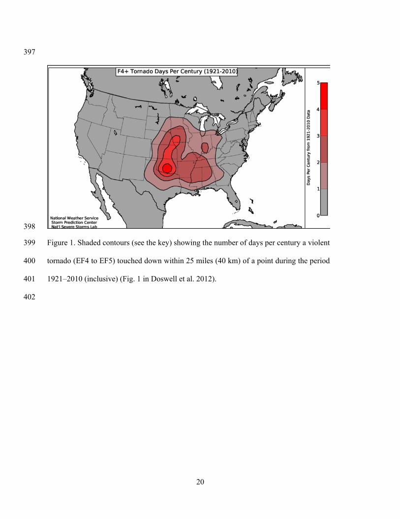
Figure 1. Shaded contours (see the key) showing the number of days per century a violent 386
tornado (EF4 to EF5) touched down within 25 miles (40 km) of a point during the period 387
1921–2010 (inclusive) (Fig. 1 in Doswell et al. 2012). 388
389
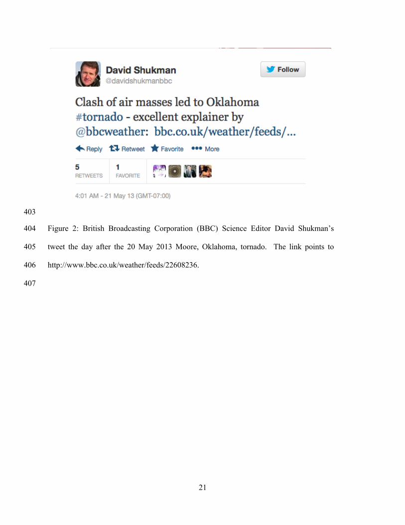
Figure 2: British Broadcasting Corporation (BBC) Science Editor David Shukman’s 390
tweet the day after the 20 May 2013 Moore, Oklahoma, tornado. The link points to 391
http://www.bbc.co.uk/weather/feeds/22608236. 392
393
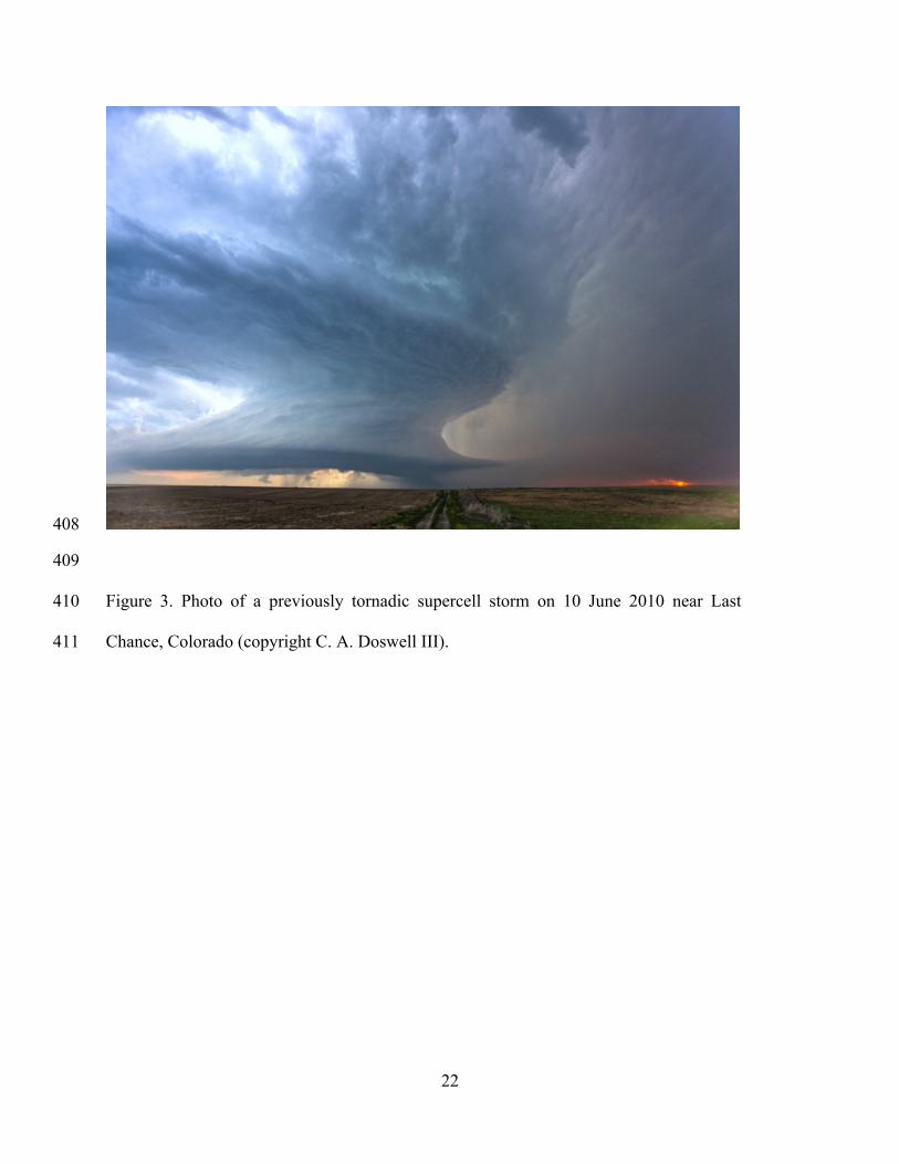
Figure 3. Photo of a previously tornadic supercell storm on 10 June 2010 near Last 394
Chance, Colorado (copyright C. A. Doswell III). 395
396
20
397
398
Figure 1. Shaded contours (see the key) showing the number of days per century a violent 399
tornado (EF4 to EF5) touched down within 25 miles (40 km) of a point during the period 400
1921–2010 (inclusive) (Fig. 1 in Doswell et al. 2012). 401
402
21
403
Figure 2: British Broadcasting Corporation (BBC) Science Editor David Shukman’s 404
tweet the day after the 20 May 2013 Moore, Oklahoma, tornado. The link points to 405
http://www.bbc.co.uk/weather/feeds/22608236. 406
407
22
408
409
Figure 3. Photo of a previously tornadic supercell storm on 10 June 2010 near Last 410
Chance, Colorado (copyright C. A. Doswell III). 411