Embed Size (px)
Citation preview
TORONTO AND REGION CONSERVATION AUTHORITY 2016 Page | ii
FLOOD CONTINGENCY PLAN
Table of Contents
1.0 INTRODUCTION ......................................................................................................................................................... 1
1.1 EMERGENCY MANAGEMENT AND CIVIL PROTECTION ACT ............................................................................................. 1
2.0 ROLES AND RESPONSIBILITES OF AGENCIES .............................................................................................................. 3
2.1 MUNICIPAL ROLE .............................................................................................................................................................. 3
2.2 CONSERVATION AUTHORITY ROLE ................................................................................................................................... 3
2.3 PROVINCIAL ROLE (SURFACE WATER MONITORING CENTRE) .......................................................................................... 3
2.4 INTERACTION OF AGENCIES – OVERVIEW......................................................................................................................... 4
3.0 FLOOD MESSAGES ..................................................................................................................................................... 5
3.1 NORMAL............................................................................................................................................................................ 5
3.2 WATERSHED CONDITIONS STATEMENT ............................................................................................................................ 5
3.3 FLOOD WATCH .................................................................................................................................................................. 6
3.4 FLOOD WARNING .............................................................................................................................................................. 6
3.5 LAKE ONTARIO & GEORGIAN BAY SHORELINE HAZARD WARNING .................................................................................. 6
3.6 COORDINATING ISSUANCE OF FLOOD MESSAGES ............................................................................................................ 8
4.0 FLOOD RESPONSE PROCEDURES ................................................................................................................................ 9
4.1 COMMUNICATIONS AND OPERATIONS RELATED TO MUNICIPAL EMERGENCY OPERATION CENTRES ............................ 9
4.2 FLOOD PROTECTION AND MITIGATION PROGRAM ........................................................................................................ 10
APPENDIX A: FLOOD AND WEATHER TERMINOLOGY ............................................................................................................ 11
A.1 STANDARDIZED DESCRIPTION OF FLOOD MAGNITUDE .................................................................................................. 11
A.2 WEATHER FORECAST TERMINOLOGY AND DEFINITIONS ................................................................................................ 11
APPENDIX B: SAMPLE FLOOD MESSAGES .............................................................................................................................. 14
B.1 SAMPLE SPRING BREAKUP MESSAGE .............................................................................................................................. 14
B.2 SAMPLE WATER SAFETY WATERSHED CONDITIONS STATEMENT .................................................................................. 15
B.3 SAMPLE FLOOD OUTLOOK WATERSHED CONDITIONS STATEMENT ............................................................................... 16
B.4 SAMPLE FLOOD WATCH .................................................................................................................................................. 17
B.5 SAMPLE FLOOD WARNING .............................................................................................................................................. 18
APPENDIX C: PRIMARY CONSERVATION AUTHORITIES ........................................................................................................... 19
APPENDIX D:
APPENDIX E: FLOOD VULNERABLE AREAS ............................................................................................................................... 22
TORONTO AND REGION CONSERVATION AUTHORITY 2016 Page | iii
List of Figures
FIGURE 1: Local Conservation Authorities ........................................................................................................................................ 2
FIGURE 2: Interaction of Agencies .................................................................................................................................................... 4
FIGURE 3: TRCA Flood Risk Management Staff Responsibilities ..................................................................................................... 26
List of Tables
TABLE 1: Critical Water Levels and Wave Heights for Lake Ontario ................................................................................................. 7
TABLE 2: Wind Velocity Descriptions ................................................................................................................................................ 8
TABLE A.1: Intensity of Rain Based on Rate of Fall ......................................................................................................................... 12
TABLE A.2: Estimating Intensity of Rain .......................................................................................................................................... 12
List of Revisions
Revision Number Summary of Changes Revision Date
1.0 Sections 1, 2, 3, 4
Appendix B & Appendix D
January 2016
2.0 Section 3 Appendix B & Appendix D
January 2016
3.0 Sections 1, 2, 4 Appendix D
January 2016
FLOOD CONTINGENCY PLAN 2016
TORONTO AND REGION CONSERVATION AUTHORITY 2016 1
1.0 Introduction
The responsibility for dealing with flood contingency planning in Ontario is shared by municipalities, Conservation
Authorities (CAs) and the Ministry of Natural Resources and Forestry (MNRF), on behalf of the province. As with all
emergencies, municipalities have the primary responsibility for the welfare of residents, and should incorporate
flood emergency response into municipal emergency planning. The Ministry of Natural Resources and Forestry and
the Conservation Authorities are primarily responsible for operating a forecasting and warning system, and the
province may coordinate a response in support of municipal action.
The Conservation Authorities of the Greater Toronto Area (GTA) have developed a Flood Forecasting and Warning
program for the municipalities and residents within their collective watersheds and the shoreline of Lake Ontario
and Georgian Bay. The purpose of this service is to reduce risk to life and damage to property by providing local
agencies and the public with notice, information and advice so that they can respond to potential flooding and
flood emergencies.
This Flood Contingency Plan is intended for all public officials and agency staff likely to play a role in the
prevention, mitigation, preparedness, response and recovery pertaining to flood events. This version of the Flood
Contingency Plan provides general information on TRCA’s Flood Forecasting and Warning program, as well as
specific information and contacts for municipalities within TRCA’s jurisdiction.
The Conservation Authorities of the Greater Toronto Area include Conservation Halton (HRCA), Credit Valley
Conservation Authority (CVCA), Toronto and Region Conservation Authority (TRCA), Lake Simcoe Region
Conservation Authority (LSRCA), Central Lake Ontario Conservation Authority (CLOCA), Ganaraska Region
Conservation Authority (GRCA), Nottawasaga Valley Conservation Authority (NVCA) and Kawartha Conservation
(KLCA).
1.1 Emergency Management and Civil Protection Act
Ontario's Emergency Management and Civil Protection Act (EMCPA, 2006) sets out requirements for the
development, implementation and maintenance of municipal and ministry emergency management programs.
These comprehensive emergency management programs are based on the five principles of emergency
management: prevention, mitigation, preparedness, response, and recovery. The programs include the
development of hazard identification and risk assessment (HIRA) for each of the 56 identified provincial hazards.
The province describes six “pillars of preparedness"; each an essential component of an emergency management
program, including:
1. Emergency Plans
2. Emergency Operations Centre
3. Training
4. Exercises
5. Emergency Information
6. Public Education
The province has assigned the responsibility of emergency response for flooding to the Ministry of Natural
Resources and Forestry, which includes flood forecasting and warning as well as flood control operations. Where a
Conservation Authority exists, the province relies on the Conservation Authority to assist them in their assigned
responsibilities for flooding.
FLOOD CONTINGENCY PLAN 2016
TORONTO AND REGION CONSERVATION AUTHORITY 2016 2
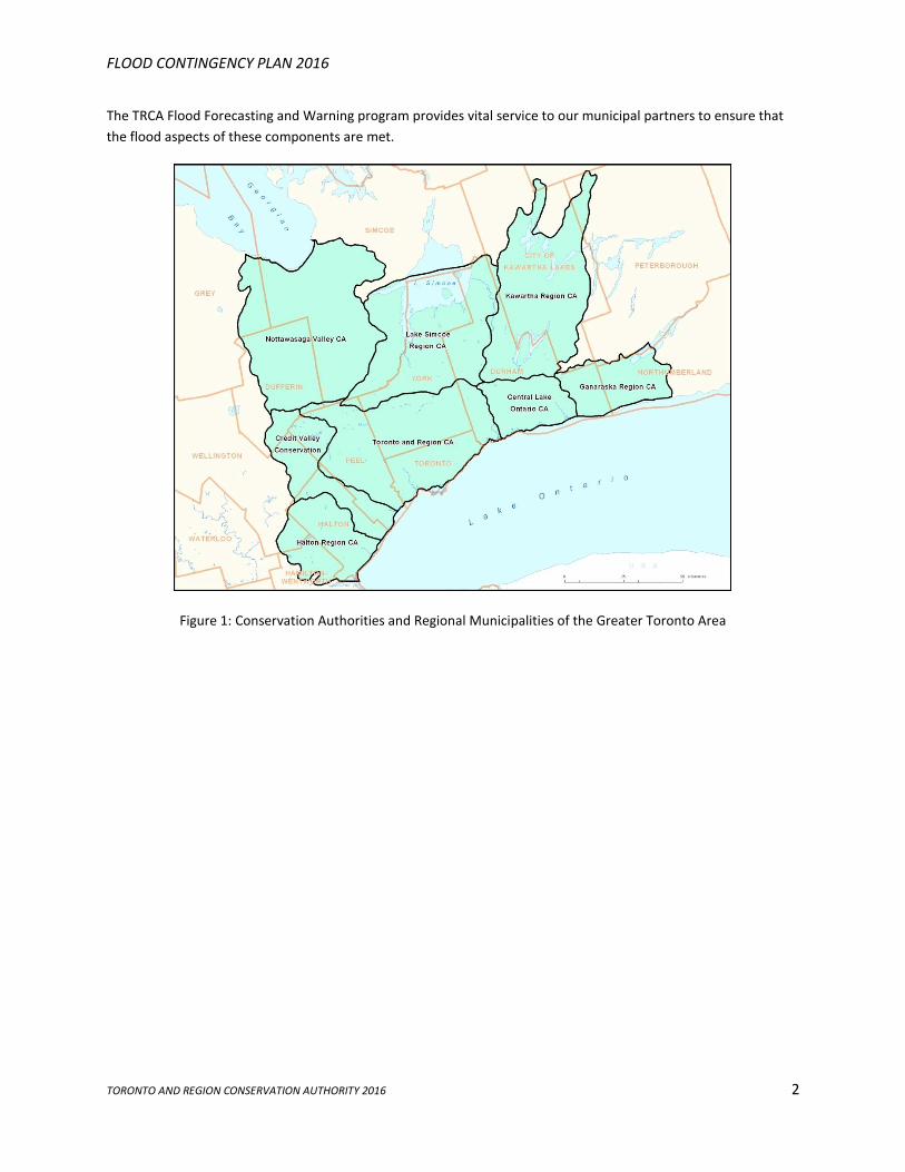
The TRCA Flood Forecasting and Warning program provides vital service to our municipal partners to ensure that
the flood aspects of these components are met.
Figure 1: Conservation Authorities and Regional Municipalities of the Greater Toronto Area
FLOOD CONTINGENCY PLAN 2016
TORONTO AND REGION CONSERVATION AUTHORITY 2016 3
2.0 Roles and Responsibilities of Agencies
2.1 Municipal Role
Under the Emergency Management and Civil Protection Act (Ontario Regulation 380/04), municipalities have the
primary responsibility and authority for response to flooding and flood emergencies, and also for the welfare of
residents and protection of property. In order to fulfill this responsibility, municipalities should ensure that
emergency plans are kept current and tested on a regular basis.
Upon receiving a Flood Watch or Flood Warning municipalities shall:
1. Notify appropriate municipal officials, departments and agencies in accordance with their
municipal emergency plan.
2. Determine the appropriate response to a flood threat and, if warranted, deploy municipal
resources to protect life and property.
3. If required, declare a flood emergency and implement their emergency response plan.
4. Request provincial assistance under the Emergency Management and Civil Protection Act, if
municipal resources are inadequate to respond to the emergency.
5. Maintain liaison with Conservation Authority Flood Duty Officers.
2.2 Conservation Authority Role
Conservation Authorities have several areas of responsibility for flooding and flood emergencies:
1. Support municipal flood emergency planning by providing technical advice pertaining to flood
risk (e.g., hydrology, hydraulics, flood vulnerable areas, etc.) and engaging in flood mitigation
projects to reduce flood risk prior to flood events.
2. Maintain a local network, collect data, and monitor watershed and weather conditions daily in
order to provide timely warning of anticipated or actual flood conditions (i.e., operate a flood
forecasting and warning system). Provide updated forecasts and other supporting technical data
pertaining to flood conditions under their jurisdiction during an event.
3. Issue flood messages to municipalities and other appropriate agencies, including the media and
the public, to advise of potential flooding when appropriate.
4. Operate Conservation Authority dams and flood control structures to reduce the effects of
flooding when appropriate.
5. Maintain communications with municipalities and the MNRF Surface Water Monitoring Centre
during a flood event.
2.3 Provincial Role (Surface Water Monitoring Centre)
1. Operate and maintain a provincial forecasting and warning system to alert MNRF District Offices
and Conservation Authorities of potential meteorological events that could create a flood hazard.
2. Maintain communications with MNRF District Offices and Conservation Authorities regarding the
status of provincial flood potential.
3. Receive messages from CAs, MNRF Districts and other agencies and provide analysis and
information that is used to guide the MNRF’s response to a flood.
4. Assists the MNRF Districts where CAs do not exist in the preparation of river response forecasts,
daily planning cycle, and the monitoring of local storm conditions.
FLOOD CONTINGENCY PLAN 2016
TORONTO AND REGION CONSERVATION AUTHORITY 2016 4
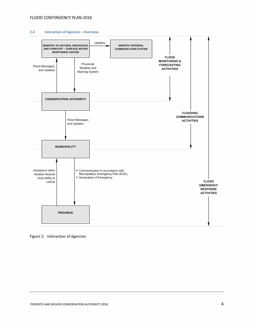
2.4 Interaction of Agencies – Overview
Figure 2: Interaction of Agencies
Provincial
Weather and
Warning System
Flood Messages,
and Updates
Flood Messages
and Updates
Updates
Communication in accordance with Municipality’s Emergency Plan (EOC)
Declaration of Emergency
Assistance when
situation beyond
local ability to
control
MINISTRY INTERNAL
COMMUNICATION SYSTEM
MUNICIPALITY
PROVINCE
CONSERVATION AUTHORITY
MINISTRY OF NATURAL RESOURCES
AND FORESTRY – SURFACE WATER
MONITORING CENTRE
FLOOD
MONITORING &
FORECASTING
ACTIVITIES
FLOODING
COMMUNICATIONS
ACTIVITIES
FLOOD
EMERGENCY
RESPONSE
ACTIVITIES
FLOOD CONTINGENCY PLAN 2016
TORONTO AND REGION CONSERVATION AUTHORITY 2016 5
3.0 Flood Messages
A flood is defined as a situation where water levels in a watercourse exceed the channel banks. Each Conservation
Authority operates a 24-hour flood forecasting and warning program that monitors weather forecasts and
watershed conditions. This information is used to assess the potential for flooding. When spring melt or severe
storms are anticipated, the Conservation Authority estimates the severity, location, and timing of possible
flooding, and provides these forecasts to local agencies.
When conditions warrant, Conservation Authorities will communicate with local agencies using one of the
following types of flood messages (Appendices A and B provide additional details): Watershed Conditions
Statement, Flood Warning, or Flood Watch.
The standard content of a flood message includes:
• The date and time of issuance
• Identification of sender (Conservation Authority and name of Flood Duty Officer)
• General recipient list
• Summary of weather forecast (expected precipitation, temperature, timing, etc.)
• Description of potential flood magnitude, a general assessment of flooding implications,
identification of potentially unsafe areas, or early notice of the potential for flooding
• Date and time of next update
• Conservation Authority contact for additional information
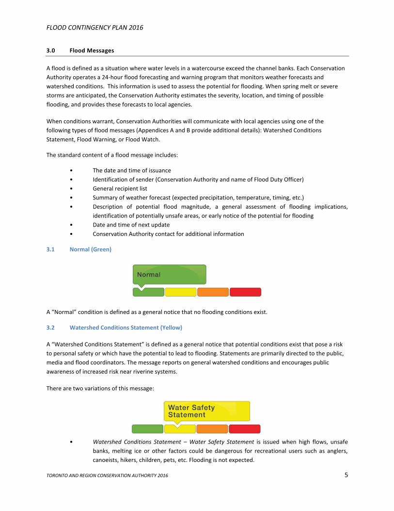
3.1 Normal (Green)
A “Normal” condition is defined as a general notice that no flooding conditions exist.
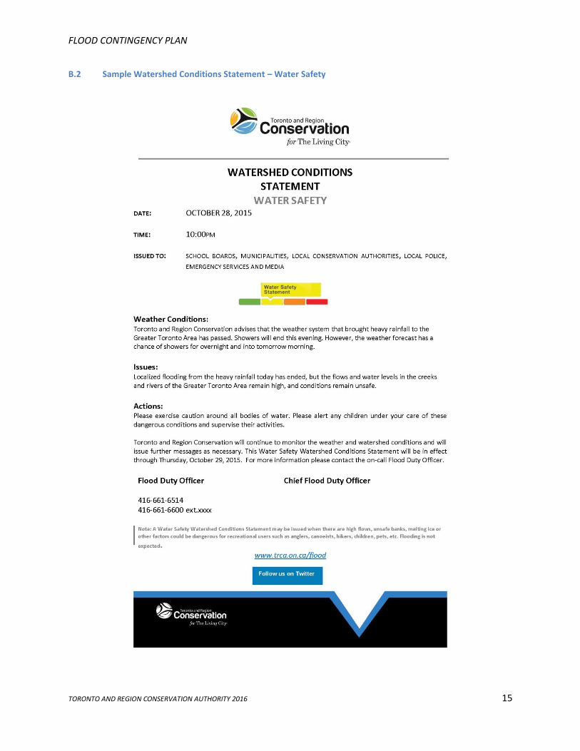
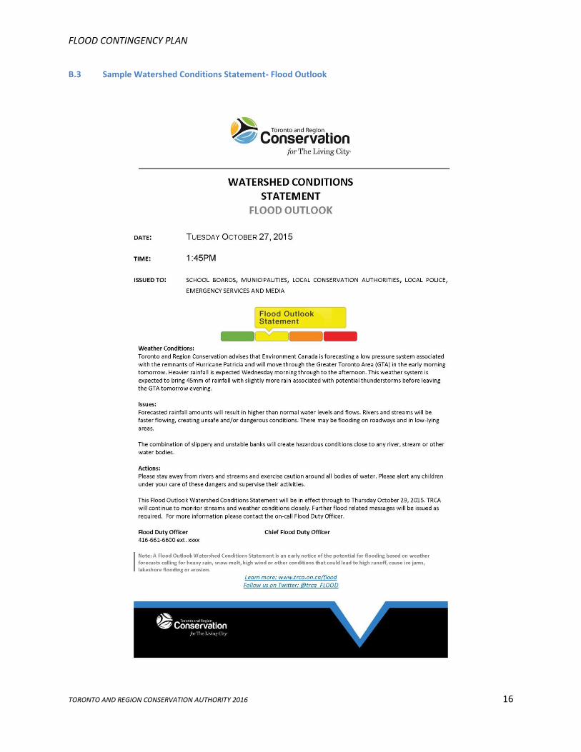
3.2 Watershed Conditions Statement (Yellow)
A “Watershed Conditions Statement” is defined as a general notice that potential conditions exist that pose a risk
to personal safety or which have the potential to lead to flooding. Statements are primarily directed to the public,
media and flood coordinators. The message reports on general watershed conditions and encourages public
awareness of increased risk near riverine systems.
There are two variations of this message:
• Watershed Conditions Statement – Water Safety Statement is issued when high flows, unsafe
banks, melting ice or other factors could be dangerous for recreational users such as anglers,
canoeists, hikers, children, pets, etc. Flooding is not expected.
FLOOD CONTINGENCY PLAN 2016
TORONTO AND REGION CONSERVATION AUTHORITY 2016 6
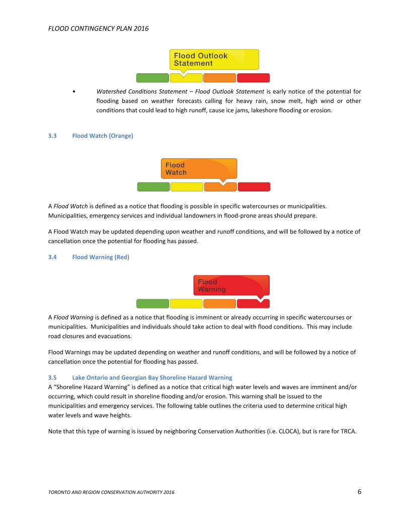
• Watershed Conditions Statement – Flood Outlook Statement is early notice of the potential for
flooding based on weather forecasts calling for heavy rain, snow melt, high wind or other
conditions that could lead to high runoff, cause ice jams, lakeshore flooding or erosion.
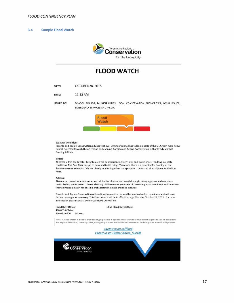
3.3 Flood Watch (Orange)
A Flood Watch is defined as a notice that flooding is possible in specific watercourses or municipalities.
Municipalities, emergency services and individual landowners in flood-prone areas should prepare.
A Flood Watch may be updated depending upon weather and runoff conditions, and will be followed by a notice of
cancellation once the potential for flooding has passed.
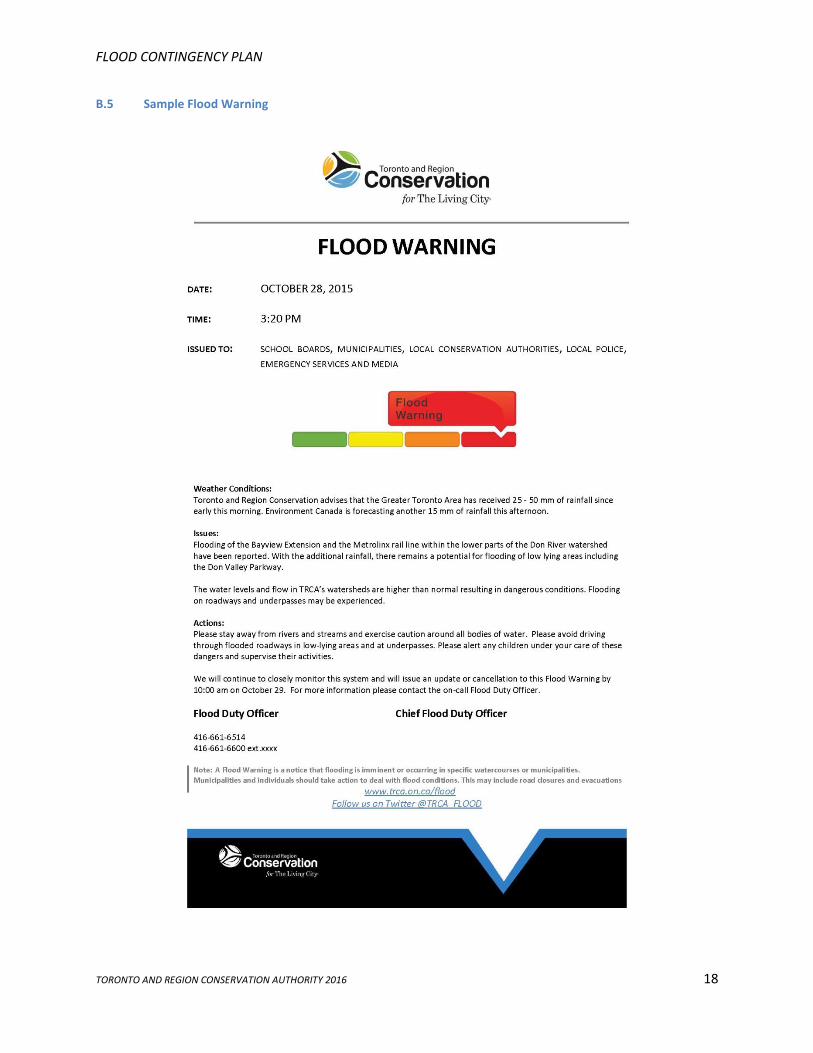
3.4 Flood Warning (Red)
A Flood Warning is defined as a notice that flooding is imminent or already occurring in specific watercourses or
municipalities. Municipalities and individuals should take action to deal with flood conditions. This may include
road closures and evacuations.
Flood Warnings may be updated depending on weather and runoff conditions, and will be followed by a notice of
cancellation once the potential for flooding has passed.
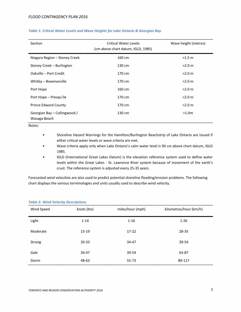
3.5 Lake Ontario and Georgian Bay Shoreline Hazard Warning
A “Shoreline Hazard Warning” is defined as a notice that critical high water levels and waves are imminent and/or
occurring, which could result in shoreline flooding and/or erosion. This warning shall be issued to the
municipalities and emergency services. The following table outlines the criteria used to determine critical high
water levels and wave heights.
Note that this type of warning is issued by neighboring Conservation Authorities (i.e. CLOCA), but is rare for TRCA.
FLOOD CONTINGENCY PLAN 2016
TORONTO AND REGION CONSERVATION AUTHORITY 2016 7
Table 1: Critical Water Levels and Wave Heights for Lake Ontario & Georgian Bay
Section Critical Water Levels
(cm above chart datum, IGLD, 1985)
Wave height (metres)
Niagara Region – Stoney Creek 160 cm >1.5 m
Stoney Creek – Burlington 130 cm >2.0 m
Oakville – Port Credit 170 cm >2.0 m
Whitby – Bowmanville 170 cm >2.0 m
Port Hope 160 cm >2.0 m
Port Hope – Presqu’ile 170 cm >2.0 m
Prince Edward County 170 cm >2.0 m
Georgian Bay – Collingwood /
Wasaga Beach
130 cm >1.0m
Notes:
• Shoreline Hazard Warnings for the Hamilton/Burlington Beachstrip of Lake Ontario are issued if
either critical water levels or wave criteria are met.
• Wave criteria apply only when Lake Ontario’s calm water level is 90 cm above chart datum, IGLD
1985.
• IGLD (International Great Lakes Datum) is the elevation reference system used to define water
levels within the Great Lakes - St. Lawrence River system because of movement of the earth’s
crust. The reference system is adjusted every 25-35 years.
Forecasted wind velocities are also used to predict potential shoreline flooding/erosion problems. The following
chart displays the various terminologies and units usually used to describe wind velocity.
Table 2: Wind Velocity Descriptions
Wind Speed knots (kts) miles/hour (mph) kilometres/hour (km/h)
Light 1-14 1-16 1-26
Moderate 15-19 17-22 28-35
Strong 20-33 34-47 39-54
Gale 34-47 39-54 63-87
Storm 48-63 55-73 89-117
FLOOD CONTINGENCY PLAN 2016
TORONTO AND REGION CONSERVATION AUTHORITY 2016 8
The following terms are also used when describing wind velocities and their influence on critical wave heights.
Wind Direction: the direction from which the wind is blowing
Wind Setup: the vertical rise above normal water level on the leeward site of a body of water caused
by wind stresses on the surface of the water
Leeward: the direction toward which the wind is blowing, the direction toward which waves are
traveling
Wave Height: the amplitude measured from wave trough to wave crest, for offshore areas, outside
the breaker line
3.6 Coordinating Issuance of Flood Messages
Conservation Authorities utilize an array of technologies to disseminate flood messages. TRCA issues messages
using a web-based e-mail service, SMS text (using an e-mail to text service), Twitter, RSS feed, and website
technologies. Messages are sent to designated individuals within municipalities and other local agencies. These
individuals, in turn, are responsible for relaying the message to relevant individuals and departments within their
organizations, and activating their role as defined by their organization’s Emergency Response Plan.
Conservation Authority jurisdictions are based on watershed boundaries, not regional or municipal boundaries.
Therefore, in many areas, local governments may be serviced by two or more Conservation Authorities. To
streamline and coordinate communication with local agencies, a primary Conservation Authority has been
assigned for each region and municipality. All Conservation Authorities will issue flood messages that are specific
to their jurisdictions. However, during extreme weather events, when resources are stretched, the designated
primary CA for each region and municipality will be responsible for direct communication and will coordinate
incoming information from all relevant CA’s to their primary region/municipality.
During most storm events, municipalities, local agencies, and residents requiring information or assistance should
contact the local Conservation Authority having jurisdiction for the area of interest. Appendix C displays the
principal Conservation Authority for each municipality in the GTA.
FLOOD CONTINGENCY PLAN Flood Response Procedures
TORONTO AND REGION CONSERVATION AUTHORITY 2016 9
4.0 FLOOD RESPONSE PROCEDURES
As previously mentioned, during an actual flood event the primary responsibility for the welfare of residents and protection of property rests with the municipality. Upon receiving a flood message, municipalities should monitor their local conditions and determine the appropriate action, which may include activating their Emergency Response Plan.
Where a flood emergency is beyond the capacity of a municipality, provincial assistance can be requested in accordance with the municipality’s Emergency Response Plan.
During a flood, Conservation Authorities will continue to provide updated information as well as technical advice on flood mitigation.
During the emergency, the Conservation Authority representative will continue to advise the MNRF Surface Water Monitoring Centre of the status of the situation. The Surface Water Monitoring Centre will be responsible for updating and relaying information related to the emergency to MNRF district offices.
4.1 COMMUNICATIONS AND OPERATIONS RELATED TO MUNICIPAL EMERGENCY OPERATIONS CENTRES
The Province of Ontario, through its Emergency Management and Civil Protection Act legislation, requires all municipalities to have valid emergency response plans and procedures in place. One component of this requirement is the need to have a defined Emergency Operations Centre (EOC) where municipal activities can be undertaken in the event of an emergency. Under normal flooding operations where there is no need to activate the EOC, each GTA Conservation Authority will provide information as requested by their local municipalities. This section defines how the GTA Conservation Authorities will operate (e.g., continue to provide advice and information to municipalities) in the case where EOCs are activated.
The primary Conservation Authority (as defined in Appendix C) will present one or more members of staff at the EOC (if resources permit). Staff will coordinate flood related information and advice on behalf of all of the CA’s that service the given local and/or regional Emergency Operations Centre (EOC/REOC).
As several Conservation Authorities may manage watercourses within the jurisdiction of an individual municipality or region, the primary Conservation Authority staff assigned to attend the EOC/REOC will be required to provide advice on watersheds which would not be within their normal area of expertise. To ensure that this system of information coordination and sharing proceeds in a seamless manor, the following procedures are to be in effect during those occurrences:
1. The primary Conservation Authority will be responsible for coordinating communications between their assigned local or regional emergency preparedness staff and all other CA’s with watercourses within the EOC service area. They will discuss the need to begin the emergency response process and whether a need exists for the regional/municipal EOC group to assemble. The decision to assemble the Emergency Control Group is determined by the local or regional emergency preparedness staff, and will be based on the level and degree of flood threat which may be affecting the municipality and/or region.
2. The primary Conservation Authority will coordinate with secondary Conservation Authorities to develop
and schedule telephone conferences or discussions to ascertain specific flood related information as well
as updated weather forecast information.
3. The secondary Conservation Authorities will consolidate flooding and weather information into a briefing
note which will be forwarded to their representative at the Regional EOC at the agreed upon designated
times (or as required).
4. All GTA Conservation Authorities will ensure that their internal operations manuals/procedures reflect the
requirements outlined above.
FLOOD CONTINGENCY PLAN Flood Response Procedures
TORONTO AND REGION CONSERVATION AUTHORITY 2016 10
To ensure the effectiveness of the above procedure, each GTA CA will develop a working relationship with the
emergency management offices of each of their municipal/regional partners.
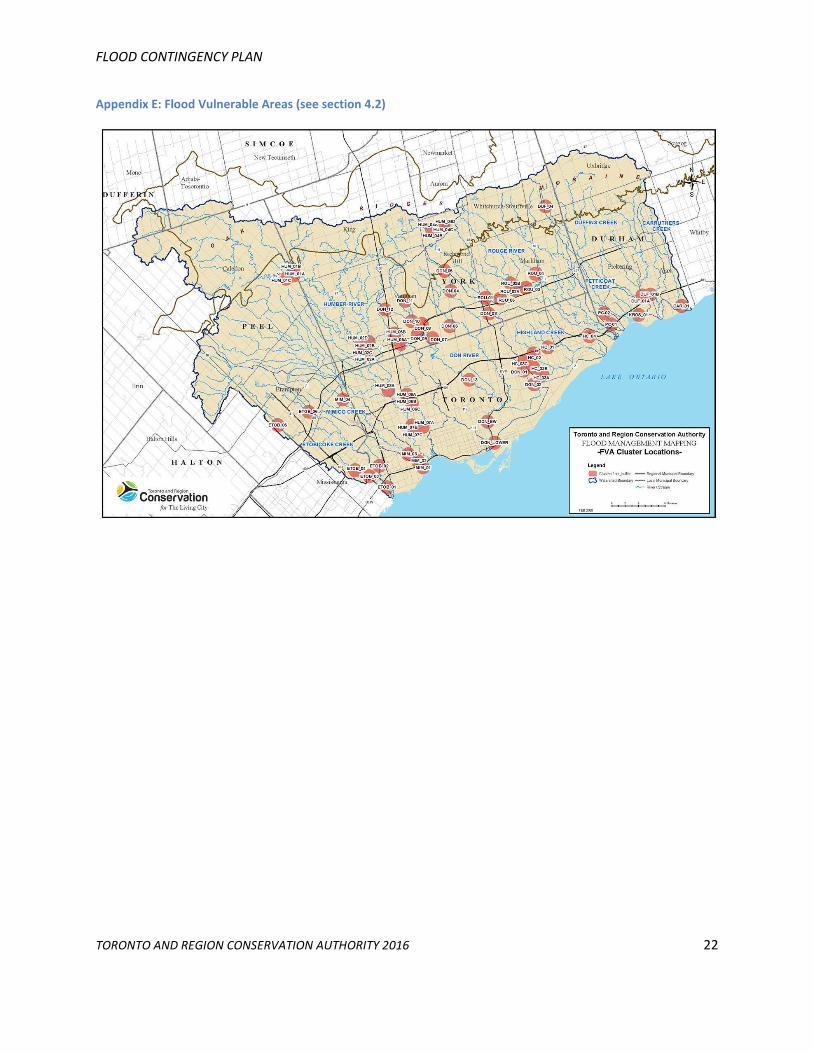
4.2 Flood Protection and Mitigation Program
TRCAs Flood Protection and Remedial Capital Works Project involves the identification of flood risk (flood
vulnerable areas) within our jurisdiction, and the development and implementation of tools and/or capital works
projects that will reduce the risk to both life and property with respect to flooding. The identification of flood risk
was addressed through the development of a Flood Protection and Remedial Capital Works Strategy. The strategy
includes an analysis of flood mitigation options in order to prioritize areas or structures within the TRCA
jurisdiction requiring remedial flood protection works and/or acquisition. Implementation is achieved through
large scale capital remedial works, technological advances in forecasting, municipal outreach, public education and
data management.
Recent advancements in technology have allowed for the development of improved forecasting tools, as well as
the historical analysis of typical storm events in the GTA. This information is being used to gain a better
understanding of the response of the watersheds to various types of rainfall events, which has a direct impact on
emergency response plans.
See Appendix E for Flood Vulnerable Area map.
FLOOD CONTINGENCY PLAN Flood Response Procedures
TORONTO AND REGION CONSERVATION AUTHORITY 2016 11
Appendix A: Flood and Weather Terminology
A.1 Standardized Description of Flood Magnitude
In order to improve the understanding of flood messages sent by the various Conservation Authorities, Flood
Watches and Flood Warnings may include the following terminology to describe the magnitude of anticipated
flooding.
No Flooding: Water levels remain within channel banks.
Nuisance Flooding: Flooding of low lying lands. However, road access remains available and no structures
will be flooded.
Minor Flooding: Potential for some structural flooding and sections of road access may be impassable.
No evacuation is required.
Major Flooding: Potential for significant basement flooding, some first floor flooding, and significant
road access cuts. Evacuation possibly required.
Severe Flooding: Potential for many structures to be flooded, major disruption of roads and services.
Evacuation is required due to risk to life and major damages to residential, industrial,
commercial and/or agricultural sites. The event may produce negative environmental
impacts caused by spills of hazardous substances such as sewage, oils, chemicals, etc.,
that pose a threat to public safety and/or to the eco-system.
A.2 Weather Forecast Terminology and Definitions
A key component of a Conservation Authority’s flood forecasting and warning system is the ability to interpret
weather forecasts. Definitions of the most commonly used weather forecasting terms, related to precipitation are
provided below
Terms such as drizzle, rain, or snow are used to indicate the occurrence of precipitation. The various forms of
precipitation are defined as follows:
Drizzle: Fairly uniform precipitation composed exclusively of fine drops with diameters of less
than 0.5 mm, falling very close together. Drizzle appears to flow while following air
currents.
Rain: Precipitation, in the form of drops larger than 0.5 mm.
Snow: Precipitation of snow crystals, predominantly in the form of six-pointed stars.
These terms may be accompanied by qualifying words and numbers to provide further detail regarding the
intensity, amount and proximity of the precipitation. Qualifiers may be used in various combinations to describe
weather phenomena.
FLOOD CONTINGENCY PLAN
TORONTO AND REGION CONSERVATION AUTHORITY 2016 12
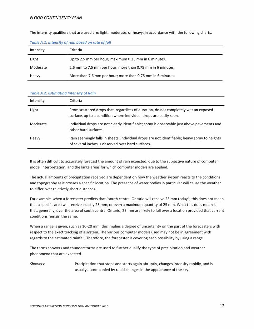
The intensity qualifiers that are used are: light, moderate, or heavy, in accordance with the following charts.
Table A.1: Intensity of rain based on rate of fall
Intensity Criteria
Light Up to 2.5 mm per hour; maximum 0.25 mm in 6 minutes.
Moderate 2.6 mm to 7.5 mm per hour; more than 0.75 mm in 6 minutes.
Heavy More than 7.6 mm per hour; more than 0.75 mm in 6 minutes.
Table A.2: Estimating Intensity of Rain
Intensity Criteria
Light From scattered drops that, regardless of duration, do not completely wet an exposed
surface, up to a condition where individual drops are easily seen.
Moderate Individual drops are not clearly identifiable; spray is observable just above pavements and
other hard surfaces.
Heavy Rain seemingly falls in sheets; individual drops are not identifiable; heavy spray to heights
of several inches is observed over hard surfaces.
It is often difficult to accurately forecast the amount of rain expected, due to the subjective nature of computer
model interpretation, and the large areas for which computer models are applied.
The actual amounts of precipitation received are dependent on how the weather system reacts to the conditions
and topography as it crosses a specific location. The presence of water bodies in particular will cause the weather
to differ over relatively short distances.
For example, when a forecaster predicts that “south central Ontario will receive 25 mm today”, this does not mean
that a specific area will receive exactly 25 mm, or even a maximum quantity of 25 mm. What this does mean is
that, generally, over the area of south central Ontario, 25 mm are likely to fall over a location provided that current
conditions remain the same.
When a range is given, such as 10-20 mm, this implies a degree of uncertainty on the part of the forecasters with
respect to the exact tracking of a system. The various computer models used may not be in agreement with
regards to the estimated rainfall. Therefore, the forecaster is covering each possibility by using a range.
The terms showers and thunderstorms are used to further qualify the type of precipitation and weather
phenomena that are expected.
Showers: Precipitation that stops and starts again abruptly, changes intensity rapidly, and is
usually accompanied by rapid changes in the appearance of the sky.
FLOOD CONTINGENCY PLAN
TORONTO AND REGION CONSERVATION AUTHORITY 2016 13
Thunderstorm: A local storm produced by cumulonimbus clouds, and is accompanied by lightning
and/or thunder. Thunder storms are essentially overgrown showers that produce
thunder and lightning.
The probability of precipitation is another qualifier frequently used in forecasts. The probability of precipitation
represents the likelihood of the occurrence of measurable precipitation at any point in the region. Thus a
probability of 30 per cent means that out of 100 similar situations, precipitation should occur 30 times.
Rain, snow, periods of rain, or intermittent rain or snow will normally appear with probabilities of 90 or 100 per
cent, and indicate that a major weather system will affect the region. The amount of precipitation may vary.
The terms showers, flurries or occasional rain (or snow) imply that the precipitation will not be continuous, and
any point in the region is likely to get a measurable amount. These terms are normally combined with probabilities
in the 60 to 80 per cent range.
The term scattered is used to qualify the terms showers and flurries when only a portion of the region is expected
to get measurable precipitation. The probabilities associated with scattered showers are in the 30 to 50 per cent
range.
When isolated thunderstorms are forecast, a probability of precipitation of 10 or 20 per cent is normally applied.
Only a small part of the region is likely to get rain, but those areas that do are likely to get intense heavy rain for
short periods. Thunderstorms may occur during a continuous rain (i.e., embedded thunder storms). Hail, strong
winds, and even tornadoes can result from severe thunderstorms.
FLOOD CONTINGENCY PLAN
TORONTO AND REGION CONSERVATION AUTHORITY 2016 14
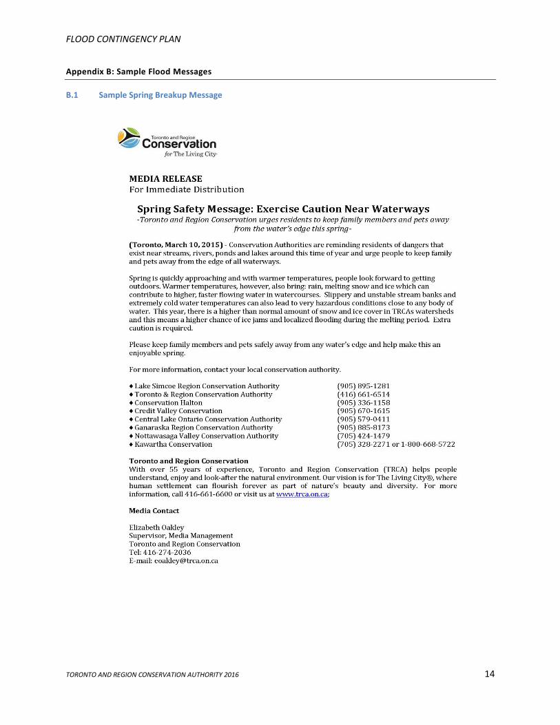
Appendix B: Sample Flood Messages
B.1 Sample Spring Breakup Message
FLOOD CONTINGENCY PLAN
TORONTO AND REGION CONSERVATION AUTHORITY 2016 15
B.2 Sample Watershed Conditions Statement – Water Safety
FLOOD CONTINGENCY PLAN
TORONTO AND REGION CONSERVATION AUTHORITY 2016 16
B.3 Sample Watershed Conditions Statement- Flood Outlook
FLOOD CONTINGENCY PLAN
TORONTO AND REGION CONSERVATION AUTHORITY 2016 17
B.4 Sample Flood Watch
FLOOD CONTINGENCY PLAN
TORONTO AND REGION CONSERVATION AUTHORITY 2016 18
B.5 Sample Flood Warning
FLOOD CONTINGENCY PLAN
TORONTO AND REGION CONSERVATION AUTHORITY 2016 19
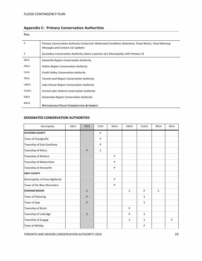
Appendix C: Primary Conservation Authorities
Key:
P Primary Conservation Authority Contact for Watershed Conditions Statement, Flood Watch, Flood Warning
Messages and Contact List Updates
S Secondary Conservation Authority shares a portion of a Municipality with Primary CA
KRCA Kawartha Region Conservation Authority
HRCA Halton Region Conservation Authority
CVCA Credit Valley Conservation Authority
TRCA Toronto and Region Conservation Authority
LSRCA Lake Simcoe Region Conservation Authority
CLOCA Central Lake Ontario Conservation Authority
GRCA Ganaraska Region Conservation Authority
NVCA NOTTAWASAGA VALLEY CONSERVATION AUTHORITY
DESIGNATED CONSERVATION AUTHORITIES
Municipality HRCA TRCA CVCA NVCA LSRCA CLOCA GRCA KRCA
DUFFERIN COUNTY P
Town of Orangeville P
Township of East Garafraxa P
Township of Mono P S
Township of Mulmur P
Township of Melancthon P
Township of Amaranth P
GREY COUNTY
Municipality of Grey-Highlands P
Town of the Blue Mountains P
DURHAM REGION S S P S
Town of Pickering P S
Town of Ajax P S
Township of Brock P
Township of Uxbridge S P S
Township of Scugog S S P
Town of Whitby P
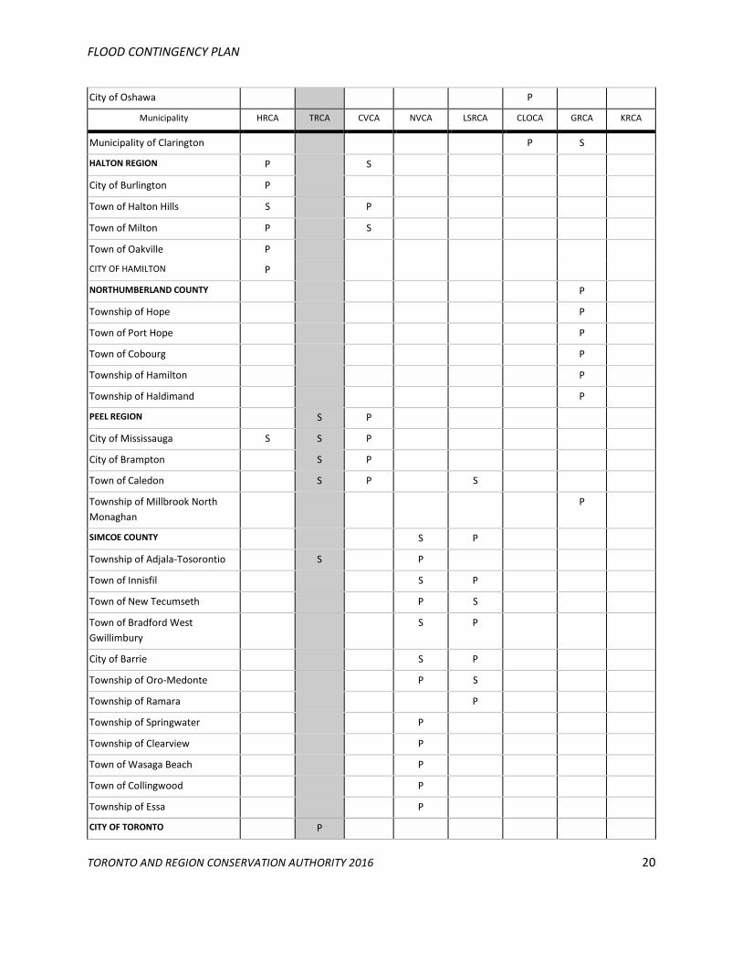
FLOOD CONTINGENCY PLAN
TORONTO AND REGION CONSERVATION AUTHORITY 2016 20
City of Oshawa P
Municipality HRCA TRCA CVCA NVCA LSRCA CLOCA GRCA KRCA
Municipality of Clarington P S
HALTON REGION P S
City of Burlington P
Town of Halton Hills S P
Town of Milton P S
Town of Oakville P
CITY OF HAMILTON P
NORTHUMBERLAND COUNTY P
Township of Hope P
Town of Port Hope P
Town of Cobourg P
Township of Hamilton P
Township of Haldimand P
PEEL REGION S P
City of Mississauga S S P
City of Brampton S P
Town of Caledon S P S
Township of Millbrook North
Monaghan
P
SIMCOE COUNTY S P
Township of Adjala-Tosorontio S P
Town of Innisfil S P
Town of New Tecumseth P S
Town of Bradford West
Gwillimbury
S P
City of Barrie S P
Township of Oro-Medonte P S
Township of Ramara P
Township of Springwater P
Township of Clearview P
Town of Wasaga Beach P
Town of Collingwood P
Township of Essa P
CITY OF TORONTO P
FLOOD CONTINGENCY PLAN
TORONTO AND REGION CONSERVATION AUTHORITY 2016 21
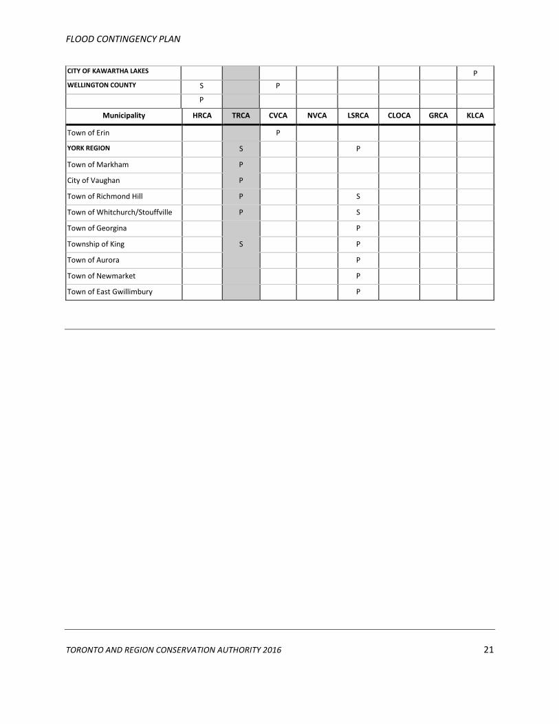
CITY OF KAWARTHA LAKES P
WELLINGTON COUNTY S P
P
Municipality HRCA TRCA CVCA NVCA LSRCA CLOCA GRCA KLCA
Town of Erin P
YORK REGION S P
Town of Markham P
City of Vaughan P
Town of Richmond Hill P S
Town of Whitchurch/Stouffville P S
Town of Georgina P
Township of King S P
Town of Aurora P
Town of Newmarket P
Town of East Gwillimbury P
FLOOD CONTINGENCY PLAN
TORONTO AND REGION CONSERVATION AUTHORITY 2016 22
Appendix E: Flood Vulnerable Areas (see section 4.2)