Embed Size (px)
Citation preview
Funded
by the
Commonwealth
of Massachusetts
through the
Montachusett Regional
Planning Commission’s
District Local
Technical Assistance
(DLTA)
Program
2018
Explore
Lunenburg!
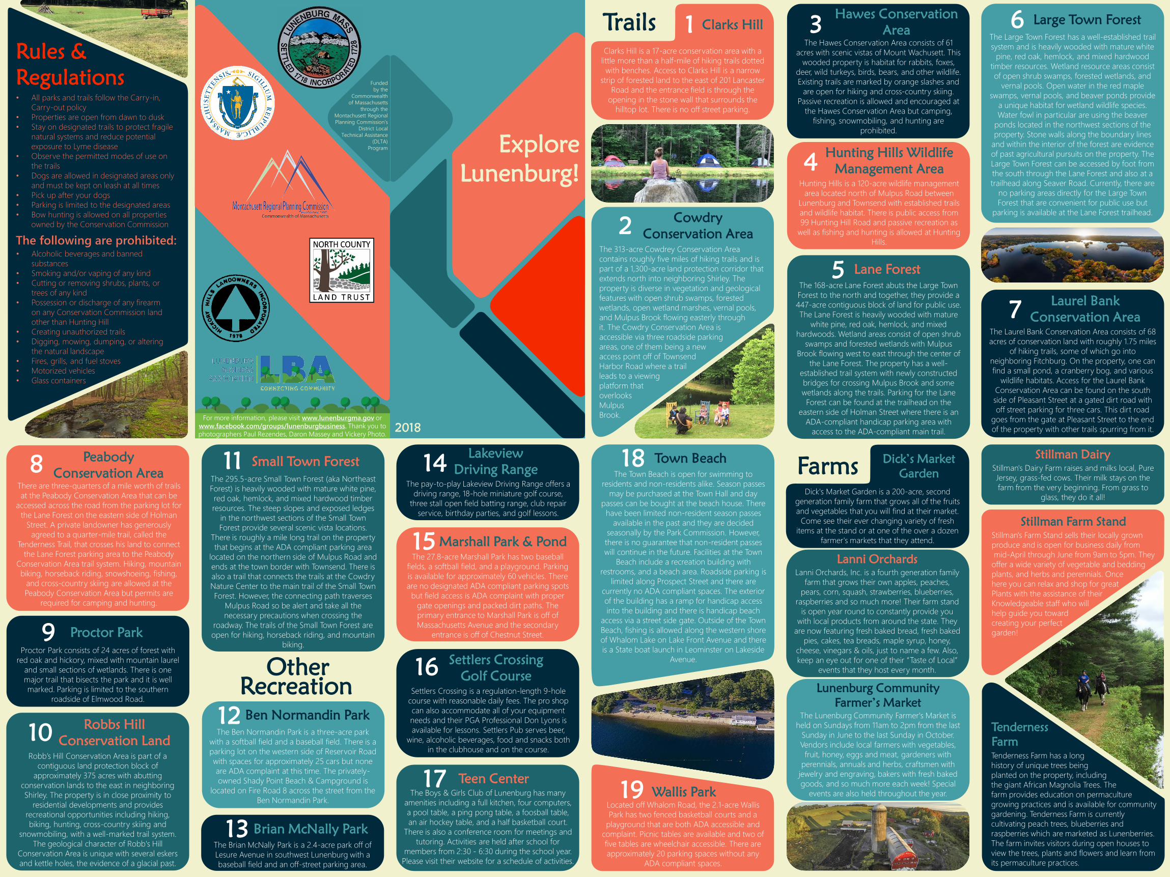
FarmsDick’s Market
Garden
Dick's Market Garden is a 200-acre, second
generation family farm that grows all of the fruits
and vegetables that you will find at their market.
Come see their ever changing variety of fresh
items at the stand or at one of the over a dozen
farmer's markets that they attend.
Trails Clarks Hill1
Clarks Hill is a 17-acre conservation area with a
little more than a half-mile of hiking trails dotted
with benches. Access to Clarks Hill is a narrow
strip of forested land to the east of 201 Lancaster
Road and the entrance field is through the
opening in the stone wall that surrounds the
hilltop lot. There is no off street parking.
The Hawes Conservation Area consists of 61
acres with scenic vistas of Mount Wachusett. This
wooded property is habitat for rabbits, foxes,
deer, wild turkeys, birds, bears, and other wildlife.
Existing trails are marked by orange slashes and
are open for hiking and cross-country skiing.
Passive recreation is allowed and encouraged at
the Hawes Conservation Area but camping,
fishing, snowmobiling, and hunting are
prohibited.
2Cowdry
Conservation Area
3Hawes Conservation
Area
Hunting Hills Wildlife
Management Area4
Hunting Hills is a 120-acre wildlife management
area located north of Mulpus Road between
Lunenburg and Townsend with established trails
and wildlife habitat. There is public access from
99 Hunting Hill Road and passive recreation as
well as fishing and hunting is allowed at Hunting
Hills.
Lane Forest5The 168-acre Lane Forest abuts the Large Town
Forest to the north and together, they provide a
447-acre contiguous block of land for public use.
The Lane Forest is heavily wooded with mature
white pine, red oak, hemlock, and mixed
hardwoods. Wetland areas consist of open shrub
swamps and forested wetlands with Mulpus
Brook flowing west to east through the center of
the Lane Forest. The property has a well-
established trail system with newly constructed
bridges for crossing Mulpus Brook and some
wetlands along the trails. Parking for the Lane
Forest can be found at the trailhead on the
eastern side of Holman Street where there is an
ADA-compliant handicap parking area with
access to the ADA-compliant main trail.
6 Large Town Forest
The Large Town Forest has a well-established trail
system and is heavily wooded with mature white
pine, red oak, hemlock, and mixed hardwood
timber resources. Wetland resource areas consist
of open shrub swamps, forested wetlands, and
vernal pools. Open water in the red maple
swamps, vernal pools, and beaver ponds provide
a unique habitat for wetland wildlife species.
Water fowl in particular are using the beaver
ponds located in the northwest sections of the
property. Stone walls along the boundary lines
and within the interior of the forest are evidence
of past agricultural pursuits on the property. The
Large Town Forest can be accessed by foot from
the south through the Lane Forest and also at a
trailhead along Seaver Road. Currently, there are
no parking areas directly for the Large Town
Forest that are convenient for public use but
parking is available at the Lane Forest trailhead.
The Laurel Bank Conservation Area consists of 68
acres of conservation land with roughly 1.75 miles
of hiking trails, some of which go into
neighboring Fitchburg. On the property, one can
find a small pond, a cranberry bog, and various
wildlife habitats. Access for the Laurel Bank
Conservation Area can be found on the south
side of Pleasant Street at a gated dirt road with
off street parking for three cars. This dirt road
goes from the gate at Pleasant Street to the end
of the property with other trails spurring from it.
Laurel Bank
Conservation Area7
8Peabody
Conservation Area
There are three-quarters of a mile worth of trails
at the Peabody Conservation Area that can be
accessed across the road from the parking lot for
the Lane Forest on the eastern side of Holman
Street. A private landowner has generously
agreed to a quarter-mile trail, called the
Tenderness Trail, that crosses his land to connect
the Lane Forest parking area to the Peabody
Conservation Area trail system. Hiking, mountain
biking, horseback riding, snowshoeing, fishing,
and cross-country skiing are allowed at the
Peabody Conservation Area but permits are
required for camping and hunting.
Proctor Park9Proctor Park consists of 24 acres of forest with
red oak and hickory, mixed with mountain laurel
and small sections of wetlands. There is one
major trail that bisects the park and it is well
marked. Parking is limited to the southern
roadside of Elmwood Road.
Robbs Hill
Conservation Land10
Robb’s Hill Conservation Area is part of a
contiguous land protection block of
approximately 375 acres with abutting
conservation lands to the east in neighboring
Shirley. The property is in close proximity to
residential developments and provides
recreational opportunities including hiking,
biking, hunting, cross-country skiing and
snowmobiling, with a well-marked trail system.
The geological character of Robb's Hill
Conservation Area is unique with several eskers
and kettle holes, the evidence of a glacial past.
Small Town Forest11The 295.5-acre Small Town Forest (aka Northeast
Forest) is heavily wooded with mature white pine,
red oak, hemlock, and mixed hardwood timber
resources. The steep slopes and exposed ledges
in the northwest sections of the Small Town
Forest provide several scenic vista locations.
There is roughly a mile long trail on the property
that begins at the ADA compliant parking area
located on the northern side of Mulpus Road and
ends at the town border with Townsend. There is
also a trail that connects the trails at the Cowdry
Nature Center to the main trail of the Small Town
Forest. However, the connecting path traverses
Mulpus Road so be alert and take all the
necessary precautions when crossing the
roadway. The trails of the Small Town Forest are
open for hiking, horseback riding, and mountain
biking.
Ben Normandin Park12The Ben Normandin Park is a three-acre park
with a softball field and a baseball field. There is a
parking lot on the western side of Reservoir Road
with spaces for approximately 25 cars but none
are ADA complaint at this time. The privately-
owned Shady Point Beach & Campground is
located on Fire Road 8 across the street from the
Ben Normandin Park.
Brian McNally Park13The Brian McNally Park is a 2.4-acre park off of
Lesure Avenue in southwest Lunenburg with a
baseball field and an off-street parking area.
Teen Center17The Boys & Girls Club of Lunenburg has many
amenities including a full kitchen, four computers,
a pool table, a ping pong table, a foosball table,
an air hockey table, and a half basketball court.
There is also a conference room for meetings and
tutoring. Activities are held after school for
members from 2:30 - 6:30 during the school year.
Please visit their website for a schedule of activities.
18 Town Beach
The Town Beach is open for swimming to
residents and non-residents alike. Season passes
may be purchased at the Town Hall and day
passes can be bought at the beach house. There
have been limited non-resident season passes
available in the past and they are decided
seasonally by the Park Commission. However,
there is no guarantee that non-resident passes
will continue in the future. Facilities at the Town
Beach include a recreation building with
restrooms, and a beach area. Roadside parking is
limited along Prospect Street and there are
currently no ADA compliant spaces. The exterior
of the building has a ramp for handicap access
into the building and there is handicap beach
access via a street side gate. Outside of the Town
Beach, fishing is allowed along the western shore
of Whalom Lake on Lake Front Avenue and there
is a State boat launch in Leominster on Lakeside
Avenue.
Marshall Park & Pond15The 27.8-acre Marshall Park has two baseball
fields, a softball field, and a playground. Parking
is available for approximately 60 vehicles. There
are no designated ADA compliant parking spots
but field access is ADA complaint with proper
gate openings and packed dirt paths. The
primary entrance to Marshall Park is off of
Massachusetts Avenue and the secondary
entrance is off of Chestnut Street.
Settlers Crossing is a regulation-length 9-hole
course with reasonable daily fees. The pro shop
can also accommodate all of your equipment
needs and their PGA Professional Don Lyons is
available for lessons. Settlers Pub serves beer,
wine, alcoholic beverages, food and snacks both
in the clubhouse and on the course.
Settlers Crossing
Golf Course16
Lanni Orchards
Lanni Orchards, Inc. is a fourth generation family
farm that grows their own apples, peaches,
pears, corn, squash, strawberries, blueberries,
raspberries and so much more! Their farm stand
is open year round to constantly provide you
with local products from around the state. They
are now featuring fresh baked bread, fresh baked
pies, cakes, tea breads, maple syrup, honey,
cheese, vinegars & oils, just to name a few. Also,
keep an eye out for one of their “Taste of Local”
events that they host every month.
The Lunenburg Community Farmer's Market is
held on Sundays from 11am to 2pm from the last
Sunday in June to the last Sunday in October.
Vendors include local farmers with vegetables,
fruit, honey, eggs and meat, gardeners with
perennials, annuals and herbs, craftsmen with
jewelry and engraving, bakers with fresh baked
goods, and so much more each week! Special
events are also held throughout the year.
Lunenburg Community
Farmer’s Market
Stillman Dairy
Stillman's Dairy Farm raises and milks local, Pure
Jersey, grass-fed cows. Their milk stays on the
farm from the very beginning. From grass to
glass, they do it all!
Stillman Farm Stand
Stillman's Farm Stand sells their locally grown
produce and is open for business daily from
mid-April through June from 9am to 5pm. They
offer a wide variety of vegetable and bedding
plants, and herbs and perennials. Once
here you can relax and shop for great
Plants with the assistance of their
Knowledgeable staff who will
help guide you toward
creating your perfect
garden!
Tenderness
Farm
Tenderness Farm has a long
history of unique trees being
planted on the property, including
the giant African Magnolia Trees. The
farm provides education on permaculture
growing practices and is available for community
gardening. Tenderness Farm is currently
cultivating peach trees, blueberries and
raspberries which are marketed as Lunenberries.
The farm invites visitors during open houses to
view the trees, plants and flowers and learn from
its permaculture practices.
19 Wallis Park
Located off Whalom Road, the 2.1-acre Wallis
Park has two fenced basketball courts and a
playground that are both ADA accessible and
complaint. Picnic tables are available and two of
five tables are wheelchair accessible. There are
approximately 20 parking spaces without any
ADA compliant spaces.
The 313-acre Cowdrey Conservation Area
contains roughly five miles of hiking trails and is
part of a 1,300-acre land protection corridor that
extends north into neighboring Shirley. The
property is diverse in vegetation and geological
features with open shrub swamps, forested
wetlands, open wetland marshes, vernal pools,
and Mulpus Brook flowing easterly through
it. The Cowdry Conservation Area is
accessible via three roadside parking
areas, one of them being a new
access point off of Townsend
Harbor Road where a trail
leads to a viewing
platform that
overlooks
Mulpus
Brook.
Other
Recreation
Lakeview
Driving Range14The pay-to-play Lakeview Driving Range offers a
driving range, 18-hole miniature golf course,
three stall open field batting range, club repair
service, birthday parties, and golf lessons.
For more information, please visit www.lunenburgma.gov or
www.facebook.com/groups/lunenburgbusiness. Thank you to
photographers Paul Rezendes, Daron Massey and Vickery Photo.
Rules &
Regulations
• All parks and trails follow the Carry-in,
Carry-out policy
• Properties are open from dawn to dusk
• Stay on designated trails to protect fragile
natural systems and reduce potential
exposure to Lyme disease
• Observe the permitted modes of use on
the trails
• Dogs are allowed in designated areas only
and must be kept on leash at all times
• Pick up after your dogs
• Parking is limited to the designated areas
• Bow hunting is allowed on all properties
owned by the Conservation Commission
The following are prohibited:• Alcoholic beverages and banned
substances
• Smoking and/or vaping of any kind
• Cutting or removing shrubs, plants, or
trees of any kind
• Possession or discharge of any firearm
on any Conservation Commission land
other than Hunting Hill
• Creating unauthorized trails
• Digging, mowing, dumping, or altering
the natural landscape
• Fires, grills, and fuel stoves
• Motorized vehicles
• Glass containers
Lake Shirley
Hickory Hills Lake
Fort Pond
WhalomLake
MassapoagPond
BixbyReservoir
TurnerPond
PaigePond
North Nas hua R iver
RESE
RVOIR
ROAD
PAGE STREET
FLAT H
ILL RO
AD
MULPUS ROAD
GOODRICH STREET
SUMMER STREET
F ISHER ROAD
HOLLIS ROAD
TYLER RO AD
HOWARD STREET
HOLMAN STREET
NORTH STREET
TURNER ROAD
ELMWOOD ROAD
DAYSTR
EET
PIERCE STREET
LUNE
NBUR
G ROA
D
CROS
S ROA
D
HOLDEN ROAD
LEOMINSTER SHIRLEY ROAD
LANC
ASTE
R ROAD
SUNNYHILL ROAD
WEST
TOWN
SEND
ROAD
LEOMINSTER ROAD
AIRPORT ROAD
PROSPECT STREET
LEOM
INSTE
R ROAD
SHIRLEY RD
LUNENBURG ROAD
KING AVENUE
STARR STREET
MAIN STREET
INDUSTRIAL ROAD
WATSON AVENUE
PRIEST STREET
PATTON STREET
WATER STREET
BEMIS
ROAD
JOHN FITCH
HIGHW
AY
YOUNGS ROAD
GRAHAM ST
LINCO
LNST
REET
JOSLIN STREET
PROSPECT STR EET
SCEN
ICDR
IVE
HARVARD STREET
WHITE
STRE
ET
PIONE
ERRO
AD
GRAN
TWA Y
CHISHOLM TRAIL
CATACUNEMAUG ROAD
GREAT ROAD
PIERCE ROAD
WARR
ENRO
AD
SOUTH HARBOR ROAD
SEAV
ERRO
AD
FITCH
BURG
ROADOLD CITY ROAD
VINTO
N PON
D RD
P L EASANT STREETPRATT STREET W HALOM ROAD
FISH STREE T
ELM STREET
WEST STREET
ELECTRIC AVENUE
UPLAND AVEEASTERN AVE
TILTON AVE
WHITE STREET
BEAL STREET CHESTNUT ST REET OAK AVENUE
TURK
EYHIL
L RDHIGHLAND STREET
NORTHFIELD ROADGILCHRIST STREET
MASSACHUSETTS AVENU E
ARBOR STREET
BUR RAGE STREE T
FLAT HILL ROA D
AUTU
MN ROAD
ROUND STREET
KILBURN STREET
LANCASTERAVENUE
CHAS
E ROA
D
OLD STAGE COACH ROAD
NEWWEST TOWNSEND ROAD
TOWNS
E NDHA
RBOR
ROAD
COVE ROAD
ISLAND ROAD
ROBBS HILL RD
KALEVA RO AD
RIVER STREET
PEAR
L HILL
ROAD
LANCASTER AVENUE
Fitchburg Municipal Airport
13
13
13
2A
2A
225
2
12
13
2A
31
TOWNSEND
LEOMINSTER
SHIRLEY
FITCHBURG
LANCASTER
ASHBY
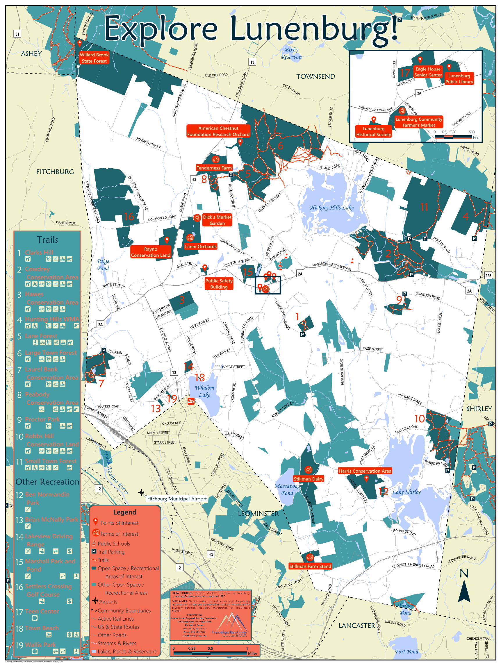
Stillman Dairy
Lanni Orchards
Tenderness Farm
Stillman Farm Stand
Dick's MarketGarden
Public SafetyBuilding
RaynoConservation Land
Harris Conservation Area
Willard BrookState Forest
American ChestnutFoundation Research Orchard
0 0.5 10.25Miles
/Lunenburg_TourismBrochure_2018/Lunenburg_TourismBrochure_18x24P.mxd [1:24,000] 02_06_19
LegendPoints of InterestFarms of Interest
Public SchoolsTrail ParkingTrailsOpen Space / Recreational Areas of InterestOther Open Space / Recreational AreasAirportsCommunity BoundariesActive Rail LinesUS & State RoutesOther RoadsStreams & RiversLakes, Ponds & Reservoirs
LunenburgPublic Library
Eagle HouseSenior Center
LunenburgHistorical Society
Lunenburg CommunityFarmer's Market
MASSACHUSETTS AVE NU E
MAIN
STRE
ET
WHITING STREET
MEMORIAL DRIVE
LANCASTER AVE
2A
0 250 500125Feet
Explore Lunenburg!
Trails
Other Recreation
1234567891011
12131415161718
Clarks Hill
Cowdrey Conservation Area
Hawes Conservation Area
Hunting Hills WMA
Large Town Forest
Laurel Bank Conservation Area
Peabody Conservation Area
Proctor Park
Robbs Hill Conservation Land
Lane Forest
Small Town Forest
Ben Normandin Park
Brian McNally Park
Lakeview Driving Range
Town Beach
Marshall Park and Pond
Settlers Crossing Golf Course
Wallis Park
1
2
3
4
56
7
8
9
10
11
12
13
17
18
15
16
19
19
Teen Center
14