Embed Size (px)
Citation preview

FINAL DRAFT
NOT FOR CIRCULATION OR CITATION
FINAL DRAFT 27/05/2015
Transboundary river basins
A Global Comparative Assessment of Baseline Status and Future Trends
Transboundary Waters Assessment Programme (TWAP) River Basins Technical Summary
River basins – a shared resource, a shared responsibility
The world’s 286 transboundary river basins span 151 countries, including more than 40% of the
Earth’s population and land area (Figure 1). They support the socioeconomic development and
wellbeing of humanity and are home to a high proportion of the world’s biodiversity.
These river systems cross borders, and through our dependence on their water, link countries in a
complex web of environmental, political, economic and security-related interdependencies.
Transboundary water management is challenging since the water-management regime, priorities and
cultures usually differ between countries. It therefore requires coordination across different political,
legal, institutional and technical settings.
The Transboundary Waters Assessment Programme (TWAP) was initiated by the Global Environment
Facility (GEF) to create the first baseline assessment of all the planet’s transboundary water
resources. The purpose of this is to provide benchmarks of the current state of water systems to
inform policy, encourage knowledge exchange, identify and classify water bodies at risk and increase
awareness of the importance and state of transboundary waters. The TWAP River Basins Report is
one of five assessments of transboundary water systems (see http://www.geftwap.org ).
This assessment aims to be of use to a broad variety of stakeholders, including transboundary
institutions of specific water systems (e.g. river-basin organizations, bi-national and inter-State
Commissions), national institutions and governments, regional and international agencies and donors.
The report is released following the entry into force of the UN International Watercourses Convention
(2014), providing a solid baseline for this Convention and for international and regional institutions with
an interest in water and food security. It is also designed to be relevant to groups of countries
managing shared resources, and to individual countries to broaden their understanding of the current
situation and future outlook.
Throughout the report, the authors have sought to identify needs for further research and methods to
complement those applied to this study of transboundary river basins1. However, gaps in data should
not be an excuse for inaction. The world has entered a phase of risk management, where risks of
environmental degradation, water scarcity and climate change are increasingly real. Here, the
precautionary principle must be invoked. Failure to manage transboundary river basins may result in
significant human suffering and economic losses.
1 See Chapter 6 of the TWAP River Basins Report

FINAL DRAFT
NOT FOR CIRCULATION OR CITATION
Transboundary Waters Assessment Programme (TWAP) River Basins Technical Summary FINAL DRAFT 5/06/2015 2
Figure 1 – Transboundary rivers that link countries in a common future. 151 countries and 2.8 billion
people share 286 transboundary river basins.
Introduction to the assessment
This Technical Summary describes the global assessment of transboundary river basins, as detailed in the TWAP River Basins Report (available on http://twap-rivers.org/).
This is the first truly global and comprehensive assessment of the world’s 286 transboundary river basins covering a broad spectrum of issues (natural and social sciences) and scales (from large to very small basins and Basin Country Units (BCUs)). It is the work of a consortium of nine partners, coordinated by the UNEP-DHI Partnership, Denmark. Partners include: Center for Environmental Systems Research, University of Kassel, Germany; Center for International Earth Science Information Network, Columbia University, USA; City University of New York (Environmental CrossRoads Initiative) USA; International Union for the Conservation of Nature; International Geosphere-Biosphere Program; Oregon State University, USA; and Stockholm International Water Institute, Sweden. Each partner contributed expertise, datasets, models and assessment tools to undertake this broad global assessment.
The aims of the TWAP River Basins component are to:
i) undertake a baseline comparative assessment of all of the world’s transboundary river
basins, and a selection of deltas, which will enable the identification of priority issues and hotspots at
risk from a variety of stressors;
ii) establish a sustainable institutional framework to undertake the baseline assessment as
well as periodic assessments to track changes over time.
The assessment uses indicators of ‘stressors’ which are listed in Table 1 below. They fall under five
key themes (water quantity, water quality, ecosystems, governance and socioeconomics) to provide a
comprehensive picture of the state of transboundary river basins today. Using the same five thematic
groups, the report also provides projections for 2030 and 2050, providing some estimates of the state
of transboundary river systems for us and the next generation.
The assessment strives to address both human and ecosystem vulnerability to stresses since these
are closely linked. The baseline and global nature of the assessment limits the extent to which specific
causal links between human-ecosystem interactions can be established, since these vary from basin
to basin and in most cases warrant detailed case investigations.
0%
20%
40%
60%
80%
100%
Population Land area Discharge
Global share within transboundaryRiver Basins (%)

FINAL DRAFT
NOT FOR CIRCULATION OR CITATION
Transboundary Waters Assessment Programme (TWAP) River Basins Technical Summary FINAL DRAFT 5/06/2015 3
Table 1 - Overview of TWAP River Basins Assessment Thematic Groups and Indicators. There are
five thematic groups, and 15 core indicators. Five indicators are projected for 2030 and 2050.
THEMATIC GROUP INDICATOR
Baseline Transboundary Status (2010) Projected Transboundary Stress
(2030/2050)
Water Quantity
1. Environmental water stress
2. Human water stress
3. Agricultural water stress
1. Environmental water stress
2. Human water stress
Water Quality 4. Nutrient pollution
5. Wastewater pollution 3. Nutrient pollution
Ecosystems
6. Wetland disconnectivity
7. Ecosystem impacts from dams
8. Threat to fish
9. Extinction risk
[Environmental water stress]
Governance
10. Legal framework
11. Hydropolitical tension
12. Enabling environment
4. Exacerbating factors to
hydropolitical tension
Socioeconomics
13. Economic dependence on water
resources
14. Societal well-being
15. Exposure to floods and droughts
5. Change in population density
Water Systems Links
Lakes 1. Lake influence
Coastal areas 2. Delta vulnerability (sea level rise, wetlands, population & governance)
The state of water resources in any location depends on a complex array of natural circumstances,
stressors and management responses. Measuring differences within each basin involves assessment
of the transboundary nature of the issues and links between locations. In this assessment, the
transboundary nature of basins has been highlighted through the use of Basin Country Units (BCUs) -
the portions of each basin belonging to the respective country - and for deltas through delta country
units (DCUs).
Using BCUs (and DCUs) helps to show how each country contributes to the overall picture of risk in a
given basin. It also illustrates that basin-wide problems and solutions in transboundary basins are
often directly linked to individual countries. Thus, this BCU approach contributes to identifying
countries that may need to be proactive or may need more assistance to solve problems that have
transboundary implications.
For both individual indicators and for combinations of indicators, this assessment provides a global
perspective of the magnitudes of risk, a framework for comparative analysis of risks among basins,
and identification of basins most and least at risk. Overall, this provides a context for policy responses
at global and regional levels but also at the basin and country levels, and facilitates inter-basin
learning. TWAP River Basin results can also be used in combination with detailed studies on individual
basins.
The assessment paints a complex picture. There are serious risks to many basins in different parts of
the world, with differing levels of development, for all of the assessed stressors. There is no single
most important issue, and there are no basins with either ‘very low’ or ‘very high’ risk for the full range
of issues. Thus, the issues (indicators) are presented in the full report separately and together2 in a
series of linked analyses which drill down into the results from a number of different perspectives.
2 Indicators are presented separately in Chapter 3, and together in Chapter 4 of the TWAP River Basins Report

FINAL DRAFT
NOT FOR CIRCULATION OR CITATION
Transboundary Waters Assessment Programme (TWAP) River Basins Technical Summary FINAL DRAFT 5/06/2015 4
Results
The key findings for each thematic group are given below, with maps illustrating one of the indicators
from that group. Taken together, the maps illustrate the diversity of results between the thematic
groups and hence the challenges to identifying overall hotspots.3
3 For more detailed indicator-by-indicator analysis, see Chapter 3 of the TWAP River Basins Report.

FINAL DRAFT
NOT FOR CIRCULATION OR CITATION
Transboundary Waters Assessment Programme (TWAP) River Basins Technical Summary FINAL DRAFT 5/06/2015 5
Socioeconomics
The socioeconomics thematic group has three indicators: economic dependence on water resources
(proportion of countries’ economic activity within the basin), societal wellbeing (human development
indicators such as infant mortality) and exposure to floods and droughts (in terms of economic loss
and population affected).
Key findings:
1. Climate-related risk is linked to economic dependence and low wellbeing: Basins with high
economic dependence, low levels of societal wellbeing and high exposure to floods and droughts
have the highest climate-related risks. These basins are found mostly in Africa and south and
southeast Asia. They include, at the highest levels of vulnerability, the Limpopo, the Ganges and
the Mekong.
2. Wellbeing and governance capacity to address disasters are linked: In basins where societal
wellbeing is low, governance capacity to address vulnerability to floods and droughts is also likely
to be low. Women, children and people with disabilities are groups particularly vulnerable to
floods and droughts. Attention might be warranted to assess governance needs and increase
capacity in these countries and basins.
3. Larger basins have larger economic dependence: Larger basins tend to have higher levels of
economic dependence on basin water resources, due mainly to the fact that larger basins are
likely to include greater portions of the populations and areas of the countries. The 14 basins with
the highest levels of economic dependence collectively comprise a population that is almost 50%
of all transboundary basins (almost 1.4 billion people). These larger basins may be harder to
manage from a transboundary point of view because of the number of countries and diversity of
priorities. Management becomes even more critical to safeguard socioeconomic wellbeing in
these countries.
Figure 2 Exposure to Floods and Droughts by Transboundary River Basin. The map illustrates relative risk
levels from floods and droughts. The red regions are those with highest relative risk from either floods or
droughts. Moderate and high risks are widespread across the globe.

FINAL DRAFT
NOT FOR CIRCULATION OR CITATION
Transboundary Waters Assessment Programme (TWAP) River Basins Technical Summary FINAL DRAFT 5/06/2015 6
Water Quantity
Agriculture is the largest user of water globally, so understanding areas of agricultural water stress is
important for future food security. The water quantity thematic group has three indicators:
environmental water stress (the alteration of flow regimes from natural flow conditions), human water
stress (water availability per capita and water use compared to availability), and agricultural water
stress (the imbalance between water use and availability). These three indicators provide a composite
picture of water stress in terms of quantity for transboundary river basins and BCUs.
Key findings:
1. Action to address agricultural water stress must not increase environmental water stress:
Hotspots of environmental water stress are highly correlated with those of agricultural water
stress. Addressing agricultural water stress (for example through increasing large-scale water
storage) should be done with careful consideration of environmental water requirements.
2. Human water stress needs to be addressed to mitigate projected environmental and agricultural
stress: Actions to counter human water stress should be expedited in river basins that are already
prone to water stress to mitigate the increasing stress projected for most of these regions.
Figure 3 - Environmental Water Stress by Transboundary River Basin. The map illustrates relative risk levels
of risk to ecosystems based on the alteration of flow regimes from natural conditions, due to withdrawals and dam
operations. The red regions are those with highest relative risk, mostly in Middle East/Central Asia and North
America.

FINAL DRAFT
NOT FOR CIRCULATION OR CITATION
Transboundary Waters Assessment Programme (TWAP) River Basins Technical Summary FINAL DRAFT 5/06/2015 7
Water Quality
Poor water quality can lead to loss of vital ecosystem services, livelihoods and ill health. The water
quality thematic group has two indicators: nutrient pollution and wastewater pollution. The nutrient
pollution indicator mainly addresses nutrient (nitrogen and phosphorus) over-enrichment
(eutrophication). The wastewater pollution indicator mainly addresses risks of pathogens (found in
untreated human waste). Together, these two indicators give an overall snapshot of the risk to human
populations and ecosystems from pollution.
Key findings:
1. Water quality risks are high in many transboundary river basins: Water quality is severely affected
in more than 80% of the basins, either by nutrient over-enrichment (typically in developed regions
e.g. North America and Europe) or by pathogens (generally in developing regions, e.g. South
America, Africa, and in northern Asian basins with Russia), or in both (e.g. emerging economies
in southern and eastern Asia).
2. Water quality risks are projected to increase: The projected scenario for nutrient pollution
suggests that the relative risk will increase in around 30% of basins between 2000 and 2030, with
the risk in two basins increasing by three categories. Between 2030 and 2050 nutrient pollution
risk is projected to increase further in 21 basins, while in six basins the risk decreases by one
category4. The effects of nutrient pollution are also likely to exacerbate risks across other
indicators and water systems (e.g. ecosystem health, coastal areas and aquifers).
3. Mitigation measures are needed in all river basins to reduce risks: In basins with a risk of nutrient
and wastewater pollution, improvements to wastewater treatment may help to reduce both risks.
Improved nutrient management in agriculture (e.g. crop and livestock) will likely be needed to
reduce current risks of nutrient pollution in many basins. Even in basins with relatively low risk,
both strategies are likely to become more important as the global population continues to rise,
which is likely to increase risks of nutrient and wastewater pollution unless adequate mitigation
measures are in place.
Figure 4 – Nutrient Pollution by Transboundary River Basin. The map illustrates relative risk levels from
nutrient pollution. The red regions are those with highest relative risk. Moderate and high risks are widespread
across the globe.
4 High confidence results only
FINAL DRAFT
NOT FOR CIRCULATION OR CITATION
Transboundary Waters Assessment Programme (TWAP) River Basins Technical Summary FINAL DRAFT 5/06/2015 8
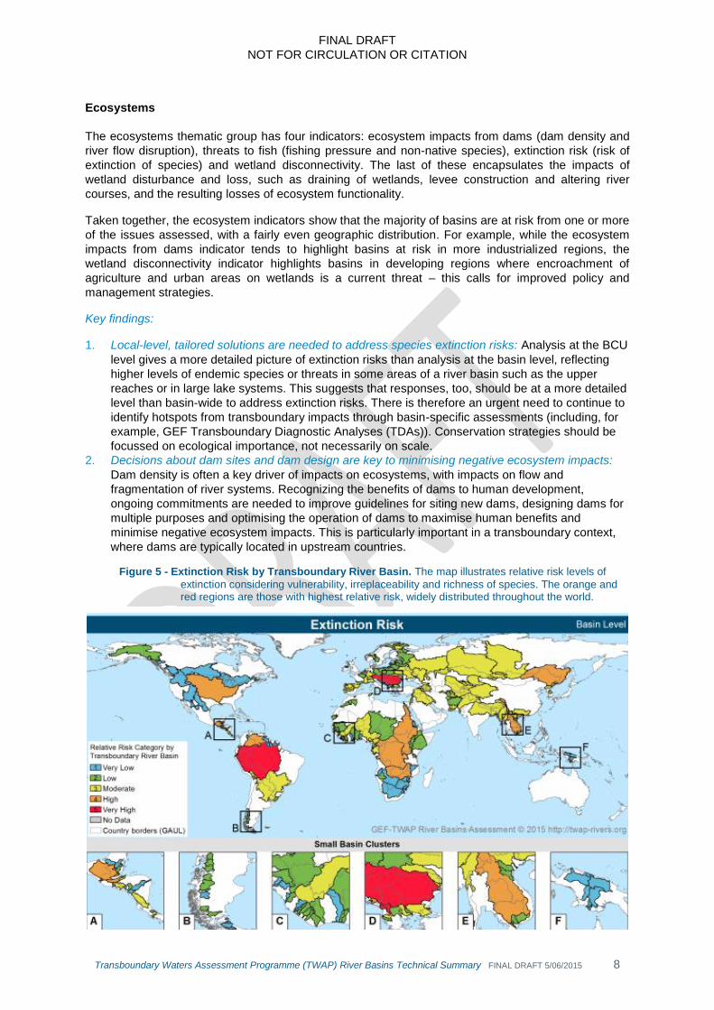
Ecosystems
The ecosystems thematic group has four indicators: ecosystem impacts from dams (dam density and
river flow disruption), threats to fish (fishing pressure and non-native species), extinction risk (risk of
extinction of species) and wetland disconnectivity. The last of these encapsulates the impacts of
wetland disturbance and loss, such as draining of wetlands, levee construction and altering river
courses, and the resulting losses of ecosystem functionality.
Taken together, the ecosystem indicators show that the majority of basins are at risk from one or more
of the issues assessed, with a fairly even geographic distribution. For example, while the ecosystem
impacts from dams indicator tends to highlight basins at risk in more industrialized regions, the
wetland disconnectivity indicator highlights basins in developing regions where encroachment of
agriculture and urban areas on wetlands is a current threat – this calls for improved policy and
management strategies.
Key findings:
1. Local-level, tailored solutions are needed to address species extinction risks: Analysis at the BCU
level gives a more detailed picture of extinction risks than analysis at the basin level, reflecting
higher levels of endemic species or threats in some areas of a river basin such as the upper
reaches or in large lake systems. This suggests that responses, too, should be at a more detailed
level than basin-wide to address extinction risks. There is therefore an urgent need to continue to
identify hotspots from transboundary impacts through basin-specific assessments (including, for
example, GEF Transboundary Diagnostic Analyses (TDAs)). Conservation strategies should be
focussed on ecological importance, not necessarily on scale.
2. Decisions about dam sites and dam design are key to minimising negative ecosystem impacts:
Dam density is often a key driver of impacts on ecosystems, with impacts on flow and
fragmentation of river systems. Recognizing the benefits of dams to human development,
ongoing commitments are needed to improve guidelines for siting new dams, designing dams for
multiple purposes and optimising the operation of dams to maximise human benefits and
minimise negative ecosystem impacts. This is particularly important in a transboundary context,
where dams are typically located in upstream countries.
Figure 5 - Extinction Risk by Transboundary River Basin. The map illustrates relative risk levels of
extinction considering vulnerability, irreplaceability and richness of species. The orange and red regions are those with highest relative risk, widely distributed throughout the world.

FINAL DRAFT
NOT FOR CIRCULATION OR CITATION
Transboundary Waters Assessment Programme (TWAP) River Basins Technical Summary FINAL DRAFT 5/06/2015 9
Governance
The governance thematic group has three indicators: legal framework (e.g. existence and substance
of basin treaties), enabling environment (water governance capacity at the national level) and
hydropolitical tension (potential sources of political tension in the basin relating to water and
institutional capacity to diffuse such tension).
Governance indicators show a concentration of transboundary basins with good formal institutional
capacity, both transboundary and national, in Northern America and Europe, with other positive
examples spread through the remaining regions. Many regions still lack formal frameworks for
cooperation, which can reduce tensions when basins are under pressure. In parallel with developing
instruments for cooperation, renewed efforts are needed to ensure that formal arrangements translate
into action and fair cooperation between countries.
Key findings:
1. More effort is needed on transboundary agreements: The adoption of international principles
associated with the shift of water paradigms toward more sustainable development has been
faster in domestic water governance arrangements than in international treaties. Focus is needed
on renegotiating and implementing transboundary agreements to incorporate more integrated
approaches into basin-level management.
2. Construction of water infrastructure needs a cooperative context: The construction of new water
infrastructure is in progress or planned in many transboundary basins, including in areas where
international water cooperation instruments are still absent or limited in scope. In such areas, a
formal institutional framework for transboundary dialogue could help to assuage potential
disputes stemming from unilateral basin development.
3. Capacity building is required within countries to meet transboundary objectives: There have been
advances in the development of transboundary institutional capacity to deal with transboundary
tensions and the application of integrated approaches to national water management, but
capacity building is still work-in-progress in most countries.
Figure 6 - Legal Framework by Transboundary River Basin. The map illustrates relative risk levels
relating to the existence of key principles of contemporary water governance in international agreements, as well as the ratification of one of the two global international freshwater conventions. It does not measure the performance or implementation of the agreements. The red regions are those with highest relative risk.

FINAL DRAFT
NOT FOR CIRCULATION OR CITATION
Transboundary Waters Assessment Programme (TWAP) River Basins Technical Summary FINAL DRAFT 5/06/2015 10
Looking deeper: integrated analysis across themes
Taken together, the results of this assessment reveal complex links, which can be clarified by further
analysis. An integrated analysis of the indicators has therefore been undertaken, using a number of
statistical techniques to examine the relationships among the indicators and identify key patterns
across thematic groups.5
A selection of broad findings from the integrated analysis follows.
Basins with similar risk profiles
While each basin has unique challenges and opportunities, understanding similarities between them
can facilitate inter-basin learning and further the development of broad management strategies that
may be applicable to multiple basins with similar risk profiles. A cluster analysis was undertaken to
identify such basin groups (Figure 7).
Figure 7 - Cluster analysis showing seven groups of basins with similar risk profiles, numbered 1-7.
Common risk profiles can facilitate inter-basin learning and shared approaches to management.
Key findings:
Cluster group 1: Undeveloped basins with opportunities for sustainable development: 45
basins (covering a population of roughly 90 million) that have generally low risk for most indicators.
These tend to be either small basins in various parts of Africa, presumably with little water resource
development, or isolated basins in temperate and polar regions, presumably with low pressures on
water resources. This group represents basins that are largely undeveloped and may therefore offer
opportunities for sustainable development.
Cluster group 2: Inadequate governance, high ecosystem risk despite low development of
water resources: 39 basins (870 million people) appear to have inadequate governance which
manifests in high risks to ecosystems, despite relatively low levels of development of water resources.
These basins present a challenge for sustainable development and the management of risk,
particularly given the moderate to high levels of exposure to droughts and floods respectively.
Assessing governance needs in these basins would appear to be a priority.
Cluster group 3: Poor governance, high risk, high water use: 25 basins (80 million) have
generally poor governance and generally high risks across the socioeconomics indicators, and appear
5 See Chapter 4, TWAP River Basins Report.

FINAL DRAFT
NOT FOR CIRCULATION OR CITATION
Transboundary Waters Assessment Programme (TWAP) River Basins Technical Summary FINAL DRAFT 5/06/2015 11
to be utilizing relatively high portions of their available water resources and have high economic
dependence on them. Transboundary inter-sectoral allocation mechanisms may be useful
management tools in these basins.
Cluster group 4: High human wellbeing, good governance, high risk for ecosystems and
human water stress: 25 basins (280 million) tend to have high levels of societal well-being, and good
governance, but also high risk to ecosystems and of human water stress and moderate risk of
environmental water stress. Low risks of agricultural water stress but high risks from ecosystem
impacts from dams implies that storage capacity has been developed to mitigate agricultural water
stress, but at the expense of the environment.
The remaining cluster groups, 5 – 7, have relatively few basins, so characteristics are more likely to be
driven by the circumstances in a few of the basins rather than broad similarities. Nevertheless,
possible interpretations of these groups are included in the TWAP River Basins Report.
Correlations between indicators across thematic groups
Determining correlations between indicators across thematic groups can help to identify the strength
of the statistical relationships of the links in the conceptual model that underpins this work. The results
indicate how the human dimension of transboundary rivers, gauged by socioeconomic and
governance indicators, is related to the physical dimension represented by water quality and quantity
and ecosystem impacts. For example:
wastewater pollution, societal well-being and enabling environment (governance at the country
level) are strongly related, suggesting that addressing wastewater pollution should occur in
parallel with improvements in societal well-being and national governance;
environmental, human and agricultural water stress, and exposure to drought, which are usually
worse in basins with high inter-annual variability of water flows, are strongly correlated. This
confirms that in the past dams have been built to address water flow variability to meet high
human and agricultural demands, with negative impacts on environmental water flows;
there is a negative correlation (although weak) between governance and societal well-being
indicators, and ecosystem impacts from dams and threats to fish. This would imply that basins
which have been developed to support high levels of societal wellbeing may have done so at
the expense of the environment.
Upstream and downstream relationships and transboundary cooperation
The relationships between upstream and downstream areas within each basin are arguably one of the
most important features of in-basin dynamics. Upstream actions can impact downstream BCUs. It is
therefore key to observe how risks at the source of a river relate to risks further downstream and at the
mouth of the river.
The average risk for all indicators for BCUs located at the mouth of a transboundary basin is
marginally higher than their respective BCUs at the source. Almost twice as many BCUs at the river
mouth have higher risk than their respective BCUs at the source, although the differences are
generally not large.
The disparity of levels of risk among countries can act as a catalyst or as an obstacle for
transboundary cooperation and have different effects on the overall status of the basin. However,
there is no clear correlation between the level of general risk disparity and the overall level of risk in
basins. This needs to be evaluated on a case-by-case basis, since the web of causal relationships is
too complex to be captured in a global baseline study.
Without adequate benefit-sharing agreements and cooperative approaches to integrated water
resource management, economically-dependent downstream countries may be negatively impacted.
Unilateral appropriation of water resources often leads to tensions between countries. However, even
with the best of intentions, it may become increasingly challenging to develop policies, laws and
management arrangements for transboundary benefits during prolonged water scarcity or when there
are tensions between national priorities and transboundary considerations. This is illustrated by

FINAL DRAFT
NOT FOR CIRCULATION OR CITATION
Transboundary Waters Assessment Programme (TWAP) River Basins Technical Summary FINAL DRAFT 5/06/2015 12
complicated transboundary cooperation surrounding dam building in upland areas such as the upper
reaches of the Mekong, the Blue Nile, and the Indus rivers.
So, while establishing mechanisms to facilitate transboundary cooperation is an important starting
point, successful outcomes will only be achieved through a mixture of political will, adequate resources
and technical capacity at both national and transboundary levels.
Risk projections
Simulated projections for 2030 and 2050 were generated based on a ‘business-as-usual’ socio-
economic scenario with associated high greenhouse gas (GHG) emissions. These affect future
temperature and rainfall patterns, which in turn affect water availability, reliability and variability. The
following indicators were considered: environmental stress induced by flow regime alteration, human
water stress, nutrient pollution, potential exacerbating factors to hydropolitical tension, and change in
population density.
Four future risk hotspots for transboundary river systems were identified (see Figure 8). Environmental
and human (E&H) water stress is anticipated to increase in all four:
Orange and Limpopo basins, Southern Africa: increased Environment and Human (E&H)
water stress due mainly to increasing water withdrawals, and nutrient pollution due mainly to
increased human sewage. Countries affected: Botswana, Lesotho, Mozambique, Namibia, South
Africa, Zimbabwe.
Selected Central Asia basins: range of factors differing between basins, including increased
E&H water stress due to combination of projected increases and decreases in water availability,
increasing water withdrawal and population density, increased nutrient pollution and hydropolitical
tensions. Basins: Tarim, Indus, Aral Sea, Helmand, Murgab, Hari, Talas, Shu and Ili. Countries
affected: Afghanistan, China, India, Iran, Kazakhstan, Kyrgyzstan, Nepal, Pakistan, Tajikistan,
Turkmenistan, Uzbekistan.
Ganges-Brahmaputra-Meghna basin: increased E&H water stress due mainly to increased
(>50%) water demand driven by population growth. Nutrient pollution remains high, with
agriculture sources (fertilizer and animal manure) being major contributors and sewage becoming
increasingly important, and there is increased risk of hydropolitical tension associated with new
water infrastructure. Countries affected: Bangladesh, Bhutan, China, India, Myanmar, Nepal.
Selected Middle East basins: continuing high to very high risk of E&H water stress due to
decrease in renewable freshwater resources and higher water demand from increased population
and irrigation. Nutrient pollution increases or remains in the highest risk category; increased risk
of hydropolitical tension due to political context. Basins: Orontes, Jordan River, Euphrates and
Tigris. Countries affected: Egypt, Iraq, Iran, Israel, Jordan, Lebanon, Palestine, Saudi Arabia,
Syria, Turkey.

FINAL DRAFT
NOT FOR CIRCULATION OR CITATION
Transboundary Waters Assessment Programme (TWAP) River Basins Technical Summary FINAL DRAFT 5/06/2015 13
Figure 8 – Four future risk hotspots for transboundary river basins. The figure shows the percentage
change in three key drivers (population, water withdrawals, and water availability) from 2010 to 2050.
In addition to the four hotspots, the within-basin differences between countries – illustrated by certain
indicators – are expected to increase in many other basins (e.g. the Nile, Northern Africa).
Delta vulnerability in transboundary river basins
The assessment of 26 deltas was undertaken as an initial attempt to investigate the interface between
river basins and coastal areas, which have been assessed in full within the Large Marine Ecosystem
(LME) component of the TWAP (www.geftwap.org). This deltas assessment has four indicators, which
broadly reflect the thematic groups used in the analysis of river basins: relative sea-level rise, wetland
ecological threat, population pressure and delta governance.6
Key findings:
1. The vulnerability of deltas differs across the world: The results show a geographical spread of
vulnerability depending on the indicator. The Ganges-Brahmaputra-Meghna delta appears to be
the most vulnerable, followed by the Niger and Volta deltas. The Amazon, Orinoco and Yukon
deltas appear to have low to moderate vulnerability.
2. Deltas in Asia are most at risk: In general the deltas in Asia seem to have the most serious
challenges in terms of human vulnerability caused by a combination of relative sea level rise and
population pressures (and sometimes poor delta governance).
6 Refer to Chapter 5, TWAP River Basins Report.

FINAL DRAFT
NOT FOR CIRCULATION OR CITATION
Transboundary Waters Assessment Programme (TWAP) River Basins Technical Summary FINAL DRAFT 5/06/2015 14
Figure 9 – Vulnerability of 26 deltas which are part of transboundary river basins (maximum relative risk category of relative sea level rise, wetland ecological threat, population pressure and delta governance)
As well as investigating deltas, the relative influence of man-made and natural lakes on river basins
was assessed. The lakes influence indicator measures the buffering and storage capacity of lakes in a
river basin, giving an indication of how the basin might react to certain threats, and how some of the
risks may be mitigated in basins with a high proportion of reservoirs, where water flows can to some
extent be controlled.
Some policy and management response options
Some of the issues raised in this assessment are closely linked to the natural levels of water
availability and population density, which exert inherent pressures on water resources, as well as
historic actions (e.g. dam building), which may be difficult to address through policy measures.
However, all the indicators provide information that can be incorporated into policy development and
management planning. For example, understanding the relative level of ecosystem impacts from dams
provides impetus to further develop policies to protect the remaining ecosystems in the basin (e.g.
through protected areas), or to improve dam operation to ensure environmental flow allocations and
management of sediment load to the river mouth and coastal areas.
Governance capacity at basin and national levels underpins the ability to respond to risks identified in
this assessment. The governance thematic group of indicators can help to identify transboundary
basins and countries where more detailed assessments of governance/capacity needs may be
warranted, particularly where other risks are also high. Basins in cluster groups 2, 3 and 7 (Figure 7)7
may require the most urgent attention in this case.
A closer examination of the individual indicators would be required to identify specific basins and
BCUs that would benefit from targeted policy development. Assessment of capacity needs could for
example be implemented through GEF Transboundary Diagnostic Analysis (TDA) and Strategic Action
Plans (SAP) which could enhance the connectivity and relevance of capacity needs assessments to
wider economic and infrastructure planning decision-making processes.
In addition to governance considerations, classes of response options to address risks identified in this
assessment, and achieve human and natural system water security, include:
Infrastructure: either constructed or natural, for addressing risks associated with water scarcity
(water quantity thematic group), water pollution (water quality thematic group), societal
wellbeing (water supply and sanitation) and exposure to floods and droughts. Many win-win
options are available through environmental protection measures for direct human gain (e.g.
7 Refer to Section 4.2 in the TWAP River Basins Report.

FINAL DRAFT
NOT FOR CIRCULATION OR CITATION
Transboundary Waters Assessment Programme (TWAP) River Basins Technical Summary FINAL DRAFT 5/06/2015 15
‘green infrastructure’ for improvements to water quality and flood and drought mitigation) and
optimization of infrastructure solutions (e.g. multipurpose dams).
Improved technical and institutional capacity: (particularly related to the enabling environment
and other governance indicators) for addressing a wide range of risks through increasing levels
of knowledge to better guide policy development, planning and management.
Economic incentives / investments: cost-recovery measures (e.g. for addressing water scarcity
or water quality). Options include progressive tariff structures for all water uses, subsidies for
improving water efficiency, and charges (e.g. pollution charges).
Environmental protection / rehabilitation: basins in cluster group 2 may be particularly relevant
here, with generally high species-extinction risk, moderate risks across all thematic groups and
high risk of hydropolitical tension, suggesting impending construction of water infrastructure with
a lack of adequate governance. Cluster group 4 also has high risks in the ecosystems thematic
group, but generally good governance, implying that these risks may already be being
addressed.
The implementation of any of the above classes of policy responses is dependent on governance and
economic capacity. Thus, basins with weaker capacity may have a much larger set of issues to
address in parallel with more specific responses such as infrastructure development for improvements
to societal wellbeing. In these basins, it is particularly important to have an integrated approach to
management.
Special attention should also be paid to the impact of upstream interventions on the most vulnerable
deltas (e.g. reduction of sediment load by the construction of dams, changed hydrodynamics of rivers,
pollution, and increased risk of salinity intrusion).
The cluster groups identified show that some basins face similar challenges. Appropriate partnerships
should therefore be developed, with exchange of knowledge and experience (best practices) and
working together on similar issues for joint outcomes. These are likely to include greater private sector
engagement and ultimately investment in delivering joint objectives with government and international
organizations and development partners.
The private sector is an important but often overlooked stakeholder in water resource management. It
is heavily involved in investment and construction of infrastructure projects, and industry is also an
increasingly significant user and potential polluter of water. The involvement of the private sector
provides great opportunities but also poses some challenges to governance of water resources,
particularly at the transboundary level.
Focus should be not only on high-risk basins but also on low- and moderate-risk basins (e.g. cluster
group 1) where sustainable development and management may ensure that they remain at relatively
low risk. Interventions in the short term may present opportunities for significant savings in the long
term if the situation worsens.

FINAL DRAFT
NOT FOR CIRCULATION OR CITATION
Transboundary Waters Assessment Programme (TWAP) River Basins Technical Summary FINAL DRAFT 5/06/2015 16
Conclusion – understanding our river basins now and into the future
There are several worldwide initiatives that could benefit from the elaborate methodology and
indicators that have been developed for this global assessment (see TWAP River Basins Sustaining
Mechanisms document for more detail). Other mechanisms adopting this methodology, partly or fully,
would also assist in fully realizing the potential value of TWAP results by keeping the datasets alive,
and contribute to periodic assessments.
For example, there is considerable opportunity to make use of the TWAP River Basins Report
methods and indicators to support the two global international watercourse conventions (United
Nations Economic Commission for Europe (UNECE) and UN) considering the current lack of
monitoring mechanisms that make indicator-based comparisons between basins over time possible.
Furthermore, the timing of the TWAP assessment coincides with the entry into force of the UN
International Watercourses Convention, providing a solid baseline for this Convention.
The TWAP assessment can also support monitoring of the proposed Sustainable Development Goals
(SDGs). All targets under the proposed water goal (and some under other goals) are relevant to
transboundary basins. The indicators and results of this report can support a number of these targets,
including those related to water quantity, water quality, sustainable use of water resources, and
protection of ecosystems. Target 6.5 explicitly mentions transboundary cooperation: “by 2030
implement integrated water resources management at all levels, including through transboundary
cooperation as appropriate”. All three governance indicators will be able to support this target,
particularly the legal framework and enabling environment indicators.
It is important that, in relation to the SDGs and other global assessments, the TWAP methodology is
not confined to transboundary basins. The majority of datasets are global, gridded data that can be
aggregated to the desirable unit (e.g. region, country, and local area).
The assessment framework and indicators developed in this assessment may also be useful as a
platform for river-basin organisations seeking to establish monitoring and evaluation systems. This
basin-level information could feed back into future global analyses. It can also be used to develop the
GEF Transboundary Diagnostic Analyses (TDAs) into a more science-driven, robust and comparable
process.
Other organizations that could benefit from the TWAP River Basins Report methodology and results
as a complement to qualitative country/basin reports include Regional Economic Commissions,
transboundary institutions and bi/tri-lateral commissions, intergovernmental organizations and
roundtables, development agencies, investment framework agencies, the International Network of
Basin Organizations (INBO) and regional basin umbrella organisations, the World Water Assessment
Programme (WWAP), Global Water Partnership (GWP), Delta Alliance and other regional institutions
with a mandate for monitoring and assessing transboundary waters. Some of the ways in which the
results and conclusions of this and future assessments can benefit such institutions are: priority
setting, work programming and investment targeting, informing negotiations, and collaborative
economic and environmental ventures.
Most importantly, the TWAP has fostered a willing partnership of institutions with the capacity to work
with other interested parties to either reproduce the assessment in full or to adapt and improve
aspects of the assessment to be fit for a number of purposes at many different levels. The TWAP data
portal provides an entry point to further information and provides users with the opportunity to explore
the data (http://www.geftwap.org/).