Embed Size (px)
Citation preview
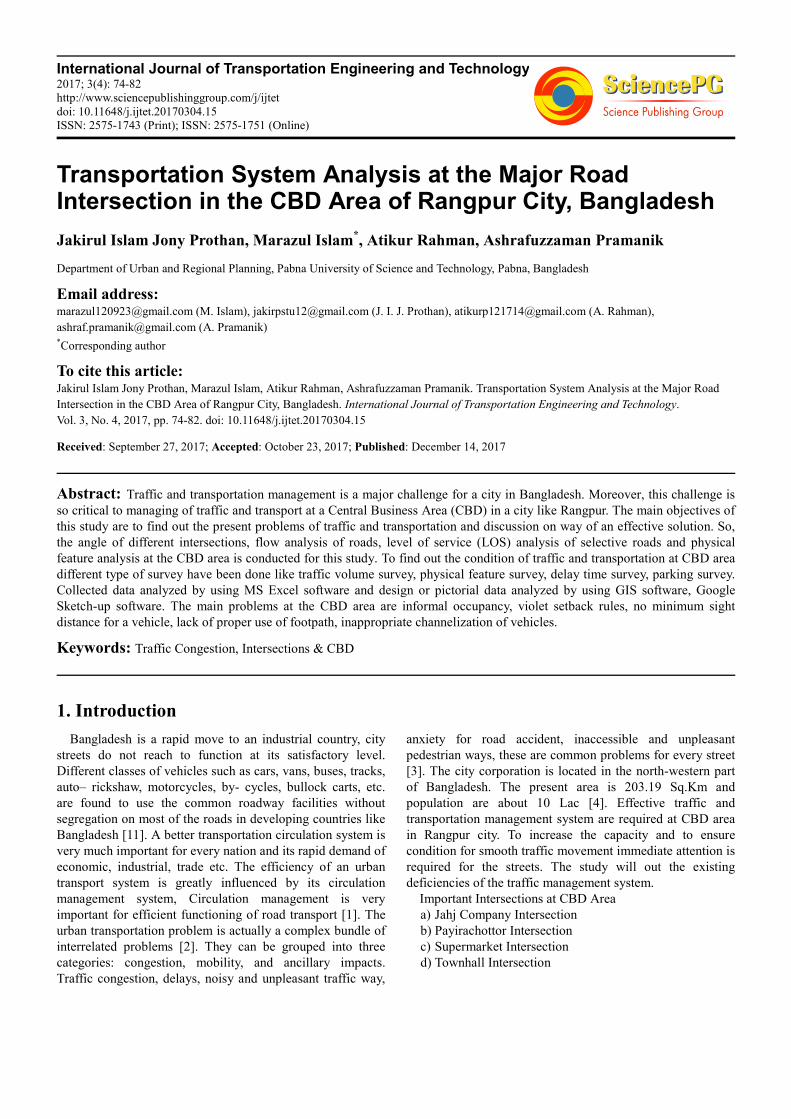
International Journal of Transportation Engineering and Technology 2017; 3(4): 74-82 http://www.sciencepublishinggroup.com/j/ijtet doi: 10.11648/j.ijtet.20170304.15 ISSN: 2575-1743 (Print); ISSN: 2575-1751 (Online)
Transportation System Analysis at the Major Road Intersection in the CBD Area of Rangpur City, Bangladesh
Jakirul Islam Jony Prothan, Marazul Islam*, Atikur Rahman, Ashrafuzzaman Pramanik
Department of Urban and Regional Planning, Pabna University of Science and Technology, Pabna, Bangladesh
Email address:
[email protected] (M. Islam), [email protected] (J. I. J. Prothan), [email protected] (A. Rahman),
[email protected] (A. Pramanik) *Corresponding author
To cite this article: Jakirul Islam Jony Prothan, Marazul Islam, Atikur Rahman, Ashrafuzzaman Pramanik. Transportation System Analysis at the Major Road
Intersection in the CBD Area of Rangpur City, Bangladesh. International Journal of Transportation Engineering and Technology.
Vol. 3, No. 4, 2017, pp. 74-82. doi: 10.11648/j.ijtet.20170304.15
Received: September 27, 2017; Accepted: October 23, 2017; Published: December 14, 2017
Abstract: Traffic and transportation management is a major challenge for a city in Bangladesh. Moreover, this challenge is
so critical to managing of traffic and transport at a Central Business Area (CBD) in a city like Rangpur. The main objectives of
this study are to find out the present problems of traffic and transportation and discussion on way of an effective solution. So,
the angle of different intersections, flow analysis of roads, level of service (LOS) analysis of selective roads and physical
feature analysis at the CBD area is conducted for this study. To find out the condition of traffic and transportation at CBD area
different type of survey have been done like traffic volume survey, physical feature survey, delay time survey, parking survey.
Collected data analyzed by using MS Excel software and design or pictorial data analyzed by using GIS software, Google
Sketch-up software. The main problems at the CBD area are informal occupancy, violet setback rules, no minimum sight
distance for a vehicle, lack of proper use of footpath, inappropriate channelization of vehicles.
Keywords: Traffic Congestion, Intersections & CBD
1. Introduction
Bangladesh is a rapid move to an industrial country, city
streets do not reach to function at its satisfactory level.
Different classes of vehicles such as cars, vans, buses, tracks,
auto– rickshaw, motorcycles, by- cycles, bullock carts, etc.
are found to use the common roadway facilities without
segregation on most of the roads in developing countries like
Bangladesh [11]. A better transportation circulation system is
very much important for every nation and its rapid demand of
economic, industrial, trade etc. The efficiency of an urban
transport system is greatly influenced by its circulation
management system, Circulation management is very
important for efficient functioning of road transport [1]. The
urban transportation problem is actually a complex bundle of
interrelated problems [2]. They can be grouped into three
categories: congestion, mobility, and ancillary impacts.
Traffic congestion, delays, noisy and unpleasant traffic way,
anxiety for road accident, inaccessible and unpleasant
pedestrian ways, these are common problems for every street
[3]. The city corporation is located in the north-western part
of Bangladesh. The present area is 203.19 Sq.Km and
population are about 10 Lac [4]. Effective traffic and
transportation management system are required at CBD area
in Rangpur city. To increase the capacity and to ensure
condition for smooth traffic movement immediate attention is
required for the streets. The study will out the existing
deficiencies of the traffic management system.
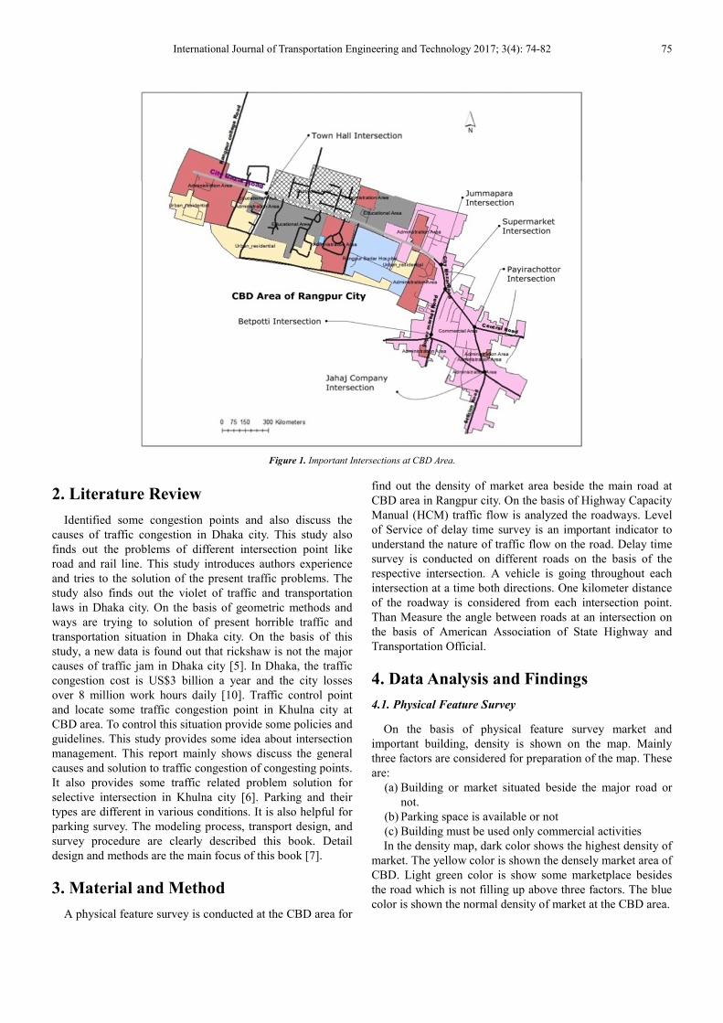
Important Intersections at CBD Area
a) Jahj Company Intersection
b) Payirachottor Intersection
c) Supermarket Intersection
d) Townhall Intersection
International Journal of Transportation Engineering and Technology 2017; 3(4): 74-82 75
Figure 1. Important Intersections at CBD Area.
2. Literature Review
Identified some congestion points and also discuss the
causes of traffic congestion in Dhaka city. This study also
finds out the problems of different intersection point like
road and rail line. This study introduces authors experience
and tries to the solution of the present traffic problems. The
study also finds out the violet of traffic and transportation
laws in Dhaka city. On the basis of geometric methods and
ways are trying to solution of present horrible traffic and
transportation situation in Dhaka city. On the basis of this
study, a new data is found out that rickshaw is not the major
causes of traffic jam in Dhaka city [5]. In Dhaka, the traffic
congestion cost is US$3 billion a year and the city losses
over 8 million work hours daily [10]. Traffic control point
and locate some traffic congestion point in Khulna city at
CBD area. To control this situation provide some policies and
guidelines. This study provides some idea about intersection
management. This report mainly shows discuss the general
causes and solution to traffic congestion of congesting points.
It also provides some traffic related problem solution for
selective intersection in Khulna city [6]. Parking and their
types are different in various conditions. It is also helpful for
parking survey. The modeling process, transport design, and
survey procedure are clearly described this book. Detail
design and methods are the main focus of this book [7].
3. Material and Method
A physical feature survey is conducted at the CBD area for
find out the density of market area beside the main road at
CBD area in Rangpur city. On the basis of Highway Capacity
Manual (HCM) traffic flow is analyzed the roadways. Level
of Service of delay time survey is an important indicator to
understand the nature of traffic flow on the road. Delay time
survey is conducted on different roads on the basis of the
respective intersection. A vehicle is going throughout each
intersection at a time both directions. One kilometer distance
of the roadway is considered from each intersection point.
Than Measure the angle between roads at an intersection on
the basis of American Association of State Highway and
Transportation Official.
4. Data Analysis and Findings
4.1. Physical Feature Survey
On the basis of physical feature survey market and
important building, density is shown on the map. Mainly
three factors are considered for preparation of the map. These
are:
(a) Building or market situated beside the major road or
not.
(b) Parking space is available or not
(c) Building must be used only commercial activities
In the density map, dark color shows the highest density of
market. The yellow color is shown the densely market area of
CBD. Light green color is show some marketplace besides
the road which is not filling up above three factors. The blue
color is shown the normal density of market at the CBD area.
76 Jakirul Islam Jony Prothan et al.: Transportation System Analysis at the Major Road Intersection in the CBD Area of Rangpur City, Bangladesh
Figure 2. GIS-Based Density Map of Market Area.
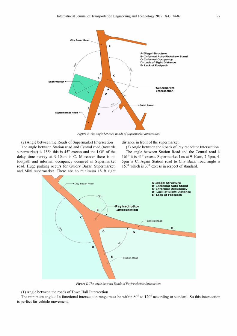
4.2. Standard Angle Analysis at Intersections in CBD Area
The minimum angle of an intersection should not be less
than 65⁰ [8]. For the functional intersection, the angle range
must be within 80⁰ to 120⁰ [8].
(1) Angle between the Roads of Jahaj Company
Intersection
The angle between Station road and G.L. Roy road (Shapla
chottor to G.L. Roy road direction) is 75⁰ which are 5⁰ less
than the standard. Another angle between Station road and
G.L. Roy road (City bazar to G.L. Roy road direction) is
140⁰ which is 20⁰ excess than the standard angle. The Los
delay time survey is C. Angle between Station road and
Dwanbari road (Shaplachottor to Dwanbari road direction) is
108⁰ and LOS of delay time survey at 9-10am, 2-3pm, 4-
5pmof the Dwanbari road is C. Again angle between Station
road and Dwanbari road (Dwanbari Road to Station Road
towards city bazar) is 52⁰ this angle is 25⁰below the
standard.
Figure 3. The angle between Roads of Jahaj Company Intersection.
International Journal of Transportation Engineering and Technology 2017; 3(4): 74-82 77
Figure 4. The angle between Roads of Supermarket Intersection.
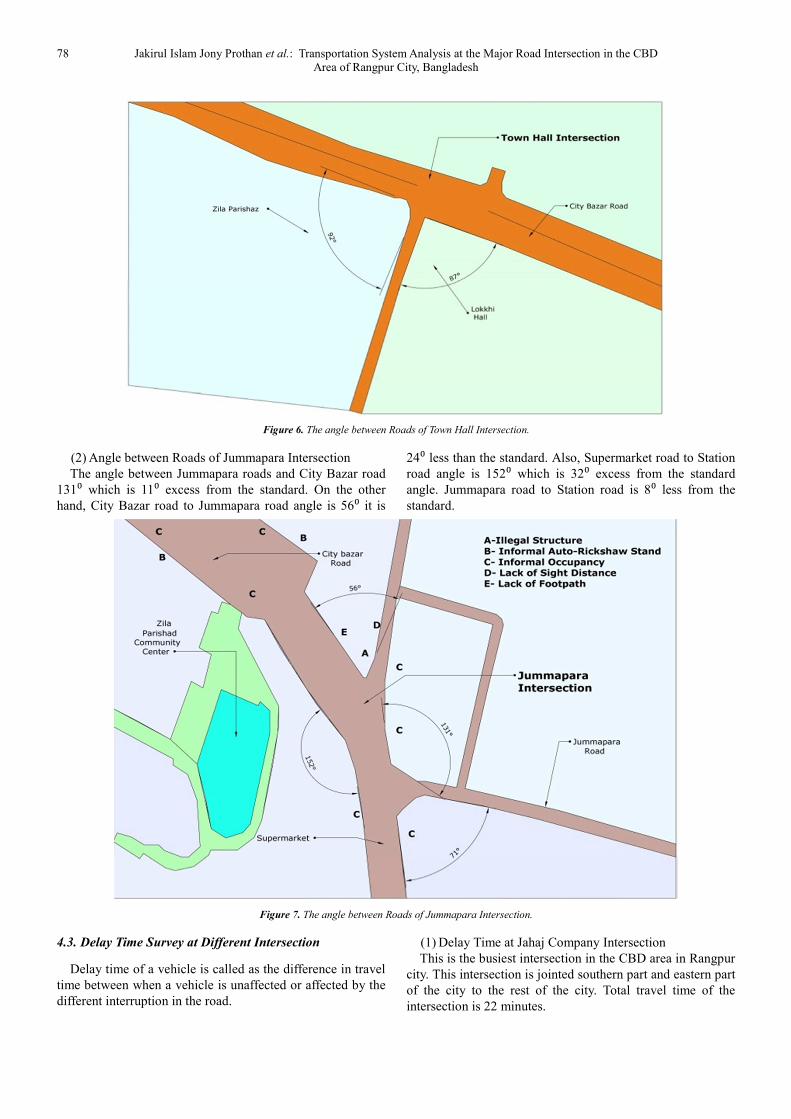
(2) Angle between the Roads of Supermarket Intersection
The angle between Station road and Central road (towards
supermarket) is 155⁰ this is 45⁰ excess and the LOS of the
delay time survey at 9-10am is C. Moreover there is no
footpath and informal occupancy occurred in Supermarket
road. Huge parking occurs for Guidry Bazar, Supermarket,
and Mini supermarket. There are no minimum 18 ft sight
distance in front of the supermarket.
(3) Angle between the Roads of Payirachottor Intersection
The angle between Station Road and the Central road is
161⁰ it is 41⁰ excess. Supermarket Los at 9-10am, 2-3pm, 4-
5pm is C. Again Station road to City Bazar road angle is
157⁰ which is 37⁰ excess in respect of standard.
Figure 5. The angle between Roads of Payira chottor Intersection.
(1) Angle between the roads of Town Hall Intersection
The minimum angle of a functional intersection range must be within 80⁰ to 120⁰ according to standard. So this intersection
is perfect for vehicle movement.
78 Jakirul Islam Jony Prothan et al.: Transportation System Analysis at the Major Road Intersection in the CBD Area of Rangpur City, Bangladesh
Figure 6. The angle between Roads of Town Hall Intersection.
(2) Angle between Roads of Jummapara Intersection
The angle between Jummapara roads and City Bazar road
131⁰ which is 11⁰ excess from the standard. On the other
hand, City Bazar road to Jummapara road angle is 56⁰ it is
24⁰ less than the standard. Also, Supermarket road to Station
road angle is 152⁰ which is 32⁰ excess from the standard
angle. Jummapara road to Station road is 8⁰ less from the
standard.
Figure 7. The angle between Roads of Jummapara Intersection.
4.3. Delay Time Survey at Different Intersection
Delay time of a vehicle is called as the difference in travel
time between when a vehicle is unaffected or affected by the
different interruption in the road.
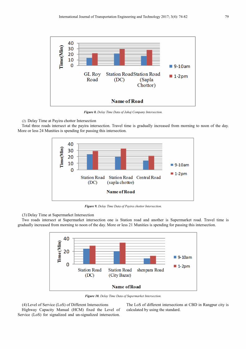
(1) Delay Time at Jahaj Company Intersection
This is the busiest intersection in the CBD area in Rangpur
city. This intersection is jointed southern part and eastern part
of the city to the rest of the city. Total travel time of the
intersection is 22 minutes.
International Journal of Transportation Engineering and Technology 2017; 3(4): 74-82 79
Figure 8. Delay Time Data of Jahaj Company Intersection.
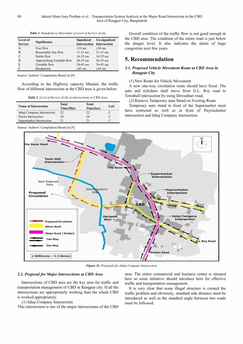
(2) Delay Time at Payira chottor Intersection
Total three roads intersect at the payira intersection. Travel time is gradually increased from morning to noon of the day.
More or less 24 Munities is spending for passing this intersection.
Figure 9. Delay Time Data of Payira chottor Intersection.
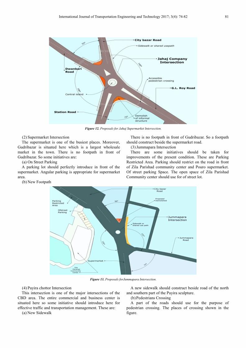
(3) Delay Time at Supermarket Intersection
Two roads intersect at Supermarket intersection one is Station road and another is Supermarket road. Travel time is
gradually increased from morning to noon of the day. More or less 21 Munities is spending for passing this intersection.
Figure 10. Delay Time Data of Supermarket Intersection.
(4) Level of Service (LoS) of Different Intersections
Highway Capacity Manual (HCM) fixed the Level of
Service (LoS) for signalized and un-signalized intersection.
The LoS of different intersections at CBD in Rangpur city is
calculated by using the standard.
80 Jakirul Islam Jony Prothan et al.: Transportation System Analysis at the Major Road Intersection in the CBD Area of Rangpur City, Bangladesh
Table 1. Standards to Determine of Level of Service (LoS).
Level of
Service Significance
Signalized
Intersection
Un-signalized
Intersection
A Free flow ≤10 sec ≤10 sec
B Reasonably free flow 11-15 sec 11-15 sec
C Stable flow 16-25 sec 16-25 sec
D Approaching Unstable flow 26-35 sec 26-35 sec
E Unstable flow 36-45 sec 36-45 sec
F Breakdown ≥45 sec ≥45 sec
Source: Authors’ Compilation Based on [9]
According to the Highway capacity Manual, the traffic
flow of different intersection at the CBD area is given below.
Table 2. Level of Service (LoS) at Intersections in CBD Area.
Name of Intersection Total
Time(Min)
Total
Time(Sec) LoS
Jahaj Company Intersection 22 22 C
Payira Intersection 24 24 C
Supermarket Intersection 21 21 C
Source: Authors’ Compilation Based on [9]
Overall condition of the traffic flow is not good enough in
the CBD area. The condition of the entire road is just below
the danger level. It also indicates the alarm of huge
congestion next few years.
5. Recommendation
5.1. Proposed Vehicle Movement Route at CBD Area in
Rangpur City
(1) New Route for Vehicle Movement
A new one-way circulation route should have fixed. The
auto and rickshaw shall move from G.L. Roy road to
Townhall intersection by using Dewanbari road.
(2) Remove Temporary auto Stand on Existing Route
Temporary auto stand in front of the Supermarket must
have restricted as well as in front of Payirachottor
intersection and Jahaj Company intersection.
Figure 11. Proposals for Jahaj Company Intersection.
5.2. Proposal for Major Intersections at CBD Area
Intersections of CBD area are the key area for traffic and
transportation management of CBD in Rangpur city. If all the
intersections are appropriately working than the whole CBD
is worked appropriately.
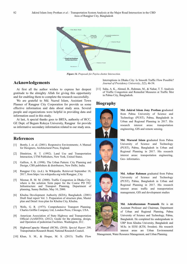
(1) Jahaj Company Intersection This intersection is one of the major intersections of the CBD
area. The entire commercial and business center is situated here so some initiative should introduce here for effective traffic and transportation management.
It is very clear that some illegal structure is created the
traffic problem and obviously, standard side distance must be
introduced as well as the standard angle between two roads
must be followed.
International Journal of Transportation Engineering and Technology 2017; 3(4): 74-82 81
Figure 12. Proposals for Jahaj Supermarket Intersection.
(2) Supermarket Intersection
The supermarket is one of the busiest places. Moreover,
Gudribazar is situated here which is a largest wholesale
market in the town. There is no footpath in front of
Gudribazar. So some initiatives are:
(a) On Street Parking
A parking lot should perfectly introduce in front of the
supermarket. Angular parking is appropriate for supermarket
area.
(b) New Footpath
There is no footpath in front of Gudribazar. So a footpath
should construct beside the supermarket road.
(3) Jummapara Intersection
There are some initiatives should be taken for
improvements of the present condition. These are Parking
Restricted Area. Parking should restrict on the road in front
of Zila Parishad community center and Pouro supermarket.
Of street parking Space. The open space of Zila Parishad
Community center should use for of street lot.
Figure 13. Proposals forJummapara Intersection.
(4) Payira chottor Intersection
This intersection is one of the major intersections of the
CBD area. The entire commercial and business center is
situated here so some initiative should introduce here for
effective traffic and transportation management. These are:
(a) New Sidewalk
A new sidewalk should construct beside road of the north
and southern part of the Payira sculpture.
(b) Pedestrians Crossing
A part of the roads should use for the purpose of
pedestrian crossing. The places of crossing shown in the
figure.
82 Jakirul Islam Jony Prothan et al.: Transportation System Analysis at the Major Road Intersection in the CBD Area of Rangpur City, Bangladesh
Figure 14. Proposals for Payira chottor Intersection.
Acknowledgements
At first all the author wishes to express her deepest
gratitude to the almighty Allah for giving this opportunity
and for enabling them to complete the research successfully.
We are grateful to Md. Nazrul Islam, Assistant Town
Planner of Rangpur City Corporation for provide us some
effective information and data about study area. Several
people and organizations were helpful in providing data and
information used in this study.
At last, A special thanks goes to BRTA, authority of RCC,
GE Dept. of Begum Rokeya University, Rangpur for provide
us informative secondary information related to our study area.
References
[1] Bently, I. et. al. (2001). Responsive Environments; A Manual for Designers, Architectural Press, England.
[2] Dimitrion, H. T. (1992). Land Use and Transportation Interaction, UTM Publishers, New York, United States.
[3] Gallion, A. B. (1998). The Urban Pattern: City Planning and Design, CBS publishers & distributors, New Delhi, India.
[4] Rangpur City. (n.d.). In Wikipedia. Retrieved September 18, 2017, from https://en.wikipedia.org/wiki/Rangpur_City
[5] Meenar, R. M. M. (2000). Traffic Congestion in Dhaka City: where is the solution Term paper for the Coarse PD 592: Infrastructure and Transport Planning, Department of planning, Sunny Buffalo, May 10, 2000.
[6] Khulna Development Authority (KDA), Bangladesh. (2001) Draft final report Vol. 3. Preparation of structure plan, Master plan and Detail Area plan for Khulna City, Khulna.
[7] Wells, G. R. (1975). Comprehensive Transport Planning. Charles Griffin Company Ltd, London Press, Chicago, USA.
[8] American Association of State Highway and Transportation Official (AASHTO). (2012). Guide for the planning, design, and Operation of pedestrian Facilities. Washington, D.C.
[9] HighwayCapacity Manual (HCM), (2010). Special Report 209, Transportation Research Board, National Research Council.
[10] Khan, S. M., & Hoque, M. S. (2013). Traffic Flow
Interruptions in Dhaka City: Is Smooth Traffic Flow Possible? Journal of Presidency University, 2(2), 46-54.
[11] Saha, A. K., Ahmed, B., Rahman, M., & Nahar, T. T. Analysis of Traffic Congestion and Remedial Measures at Traffic Mor in Pabna City, Bangladesh.
Biography
Md. Jakirul Islam Jony Prothan graduated
from Pabna University of Science and
Technology (PUST), Pabna, Bangladesh in
Urban and Regional Planning in 2017. His
research interest areas: transportation
engineering, GIS and remote sensing.
Md. Marazul Islam graduated from Pabna
University of Science and Technology
(PUST), Pabna, Bangladesh in Urban and
Regional Planning in 2017. His research
interest areas: transportation engineering,
Geo- informatics.
Md. Atikur Rahman graduated from Pabna
University of Science and Technology
(PUST), Pabna, Bangladesh in Urban and
Regional Planning in 2017. His research
interest areas: traffic and transportation
management, GIS and development studies
Md. Ashrafuzzaman Pramanik He is an
Assistant Professor and Chairman, Department
of Urban and Regional Planning, Pabna
University of Science and Technology, Pabna,
Bangladesh. He completed his undergraduate in
URP from Khulna University, Bangladesh and
M.Sc. in EESI (KTH, Sweden). His research
interest areas are Urban Environmental
Management, Water Resource Management, and Urban Planning.