Embed Size (px)
Citation preview
Walking Route
World Heritage Signpost
Kumano Kodo(Area registerd onthe UNESCO world Heritage List)
Parking LotRestroom(toilet)
Parking LotRestroom(toilet)
To Owase
To MatsusakaKisei-ouchiyama IC
Haiku Monumentof Kisyu-koOuchiyama-gawa
River
Umegadani StationTeraurabashi Bridge
Hachibashira ShrineThere are guardian deities at Ouchiyama-gawa River area. This place is known as a beauty spot for cherry blossoms in the spring and for autumn leaves in the fall.
Nisaka Tunnel
Taiki Town Small shrine of Three jizoIkoi Rock
Nisaka-toge Pass GuidepostThe Viewpoint at ManbouTsuzurato-toge Pass(357m)
Nisaka-toge Pass There is asite of Tea House (241m)
Okimi-daira(View spot)
Kihoku Town
AzaleaSanbonmatsu(Site of Chohachichaya Tea House)
ShishigakiSite of the Milestone
Kisei Highway To pass under R42
Hall of KoshinMichi-no-eki Kii-nagashimaManbou Rest Station
Magotaro Tunnel
Katagami-ike PondTo Nishiki
JR Kisei Li
neHigashi-nagashima Tunnel
Hana-hiroba(Rest spot)
Kii-nagashima IC
Fureai-hiroba MandoroKii-nagashima Station
Kihoku Town OfficeAkaba-gawaRiver
Kumano-nada Recreation CityNagasima PortUomachi
Ikoi RockIkoi Rock The Azalea PathThe Azalea Path
Okimi-daira ViewpointOkimi-daira Viewpoint ShishigakiShishigaki
In April and May this grove of azaleas come in full bloom, accented by the young green leaves of spring. You can enjoy any season in this well-lit woodland with its many types of trees.
Travelers always used this rock as a bench, so it got the name, "Ikoi Ishi" or The Rest Rock. The cool wind coming over this ridge makes it an excellent place to take a break.
Just after you leave the forestry road, you should see a short stone wall called a "shishigaki" paralleling the path. This was built to keep wild boar from ravaging the crops.
This is the perfect place to take a break with a spectacular view. Two poems written by the travel writer Suzuki Bokushi in the Edo period (1603 - 1868) are written on boards put up here.
D i s t a n c eWalking timeL e v e lThe Course
Approx. 7.5Km from Umegadani Station to Kii-Nagashima Station2hrs. and 30mins.
About 300 years ago, these roads were being repaired and this route replaced the old steeper route, Tsuzura Pass making this the official entrance to the Kii Provence and Kumano. After crossing the pass, there is a deciduous forest, much like you would have seen 300 years ago.
Nisaka-toge Pass
Tsuzurato-toge Pass
Kumano-nadaRecreation City
Taiki Town
Kihoku Town
To MatsusakaKisei-ouchiyama ICHaiku Monument
of Kisyu-koGuardian Deity
Ouchiyama-gawaRiver
Tsuzurato-togePass Guidepost
Umegadani StationTeraura-bashiBridgh
Nakano-bashiBridgh
Sho-Koen Park(Rest spot)
There is the statue ofSanjyusan-Kannon on the way.
Hachibashira ShrineThere are guardian deities at Ouchiyama-gawa River area. This place is known as a beauty spot for cherry blossoms in the spring and for autumn leaves in the fall.
Tochiko-bashiBridgh
Fire Center
Nisaka Tunnel
Tochiko-gawaRiver
Tsuzurato-togePass Guideboard
Tsuzurato-toge Pass the trailheadWe enter the Kumano Kodo from here.Tani-gawa River is one of the upstream of Miya-gawa River.
ForestryRoadTsuzurato-toge Pass(357m)
Nisaka-toge Pass(241m)
Stone Statue ofMountain God
Stone walls ofNozurazumi
Shiko-gawaRiver
Walking Route
World Heritage Signpost
Kumano Kodo(Area registerd onthe UNESCO world Heritage List)
Stone PathStone Statue ofMountain GodShiko-oku Kisei HighwayForestry
RoadSignpostHana-hiroba
(Rest spot)
To TaikiTown Nishiki
Mago-taro Tunnel
Michi-no-eki Kii-nagashimaManbou Rest Station
GuardianDeity
Katagami-ikePond
Higashi-nagashima TunnelKii-nagashima IC
Hall of Koshin
JR Kisei LineKihoku
Town Office
Higashi-nagashima Community Hall
Akaba-gawaRiver
Tsuzurato-togePass Guidepost
Fureai-hiroba MandoroKii-nagashimaStation
Uomachi Nagashima PortTo Owase
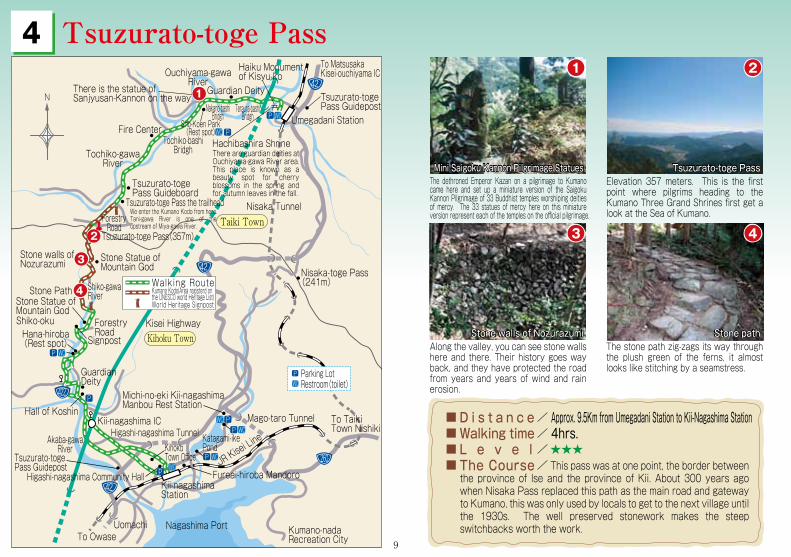
Mini Saigoku Kannon Pilgrimage StatuesMini Saigoku Kannon Pilgrimage Statues Tsuzurato-toge PassTsuzurato-toge Pass
Stone walls of NozurazumiStone walls of Nozurazumi Stone pathStone path
Elevation 357 meters. This is the first point where pilgrims heading to the Kumano Three Grand Shrines first get a look at the Sea of Kumano.
The dethroned Emperor Kazan on a pilgrimage to Kumano came here and set up a miniature version of the Saigoku Kannon Pilgrimage of 33 Buddhist temples worshiping deities of mercy. The 33 statues of mercy here on this miniature version represent each of the temples on the official pilgrimage.
The stone path zig-zags its way through the plush green of the ferns, it almost looks like stitching by a seamstress.
Along the valley, you can see stone walls here and there. Their history goes way back, and they have protected the road from years and years of wind and rain erosion.
D i s t a n c eWalking timeL e v e lThe Course
Approx. 9.5Km from Umegadani Station to Kii-Nagashima Station4hrs.
This pass was at one point, the border between the province of Ise and the province of Kii. About 300 years ago when Nisaka Pass replaced this path as the main road and gateway to Kumano, this was only used by locals to get to the next village until the 1930s. The well preserved stonework makes the steep switchbacks worth the work.
9
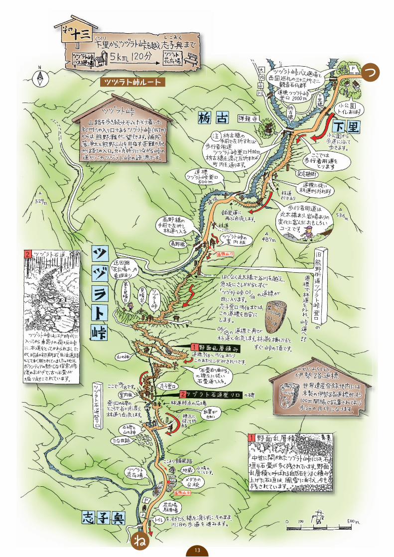
ツヅラト峠ルートつ
ね13