Embed Size (px)
Citation preview

^i , AKTMENT OF THE INTERIOR OPLN FILE REPORT 19i6 U1UTEU STATES GEOLOGICAL SURVEY
Nines and Prospects, Idaho Springs District
Clear Creek and Gilpin Counties, Colorado Descriptions and Kapa
By
Robert H. Moench and Avery Ala Drake, Jr.
Prepared on behalf of the U.S. Atomic Energy Commission
Introduction
The Idoiho Springs mining district forms an important segment of tae Front Range mineral belt, a northeast-trending zone of coextensive intrusive rocks ancl hydrothermal ore deposits of early Tertiary a2«_. la is belt, which is about 50 miles long, extends from the region iu~ west ct iioulder southwestward across the Front Range.
From 1859, when placer gold was discovered in Idaho Springs and lode gold in Central City, through 1959, ores valued at about $200 million were shipped from a 50-square-mile area that includes the Idaho Springs and adjacent districts to the north, west, and southwest. The adjacent Central City district, which produced ores valued at more than $100 million, is clearly the most important district in the mineral belt The Idaho Springs district from 1860 to 1959 produced ores valued «t about $65 million, and the districts to the west and southwest produced smaller amounts. Gold has accounted for about 60 percent of the value of the ore, but in some areas silver provides the chief values, and copper, lead, and zinc add value to the ores in most areas.
Mining activity in the Idaho Springs and adjacent districts was at its "heyday" in the late 1800's, it declined sharply after 1914, it was somewhat renewed during the 1930's, and it greatly declined during Worlc War II. In the 1950's uranium prospecting stimulated some mining activ ity. Mo uranium was produced, however, and at the close of the decade only one mine--the Bald Eagle was being worked for its precious- and base-metal ores.
iOPDEPARTMENT OF THE INTER11 UNITED STATES GEOLOGICAL SURVEY
OPni FILE, 1966Mi'-.oo and prospects, Idaho Spring' di.'riot, Cioar Creek and Gilpin Celtics, Colo,, by R. H. MoencL and A. A. Drake, Jr..

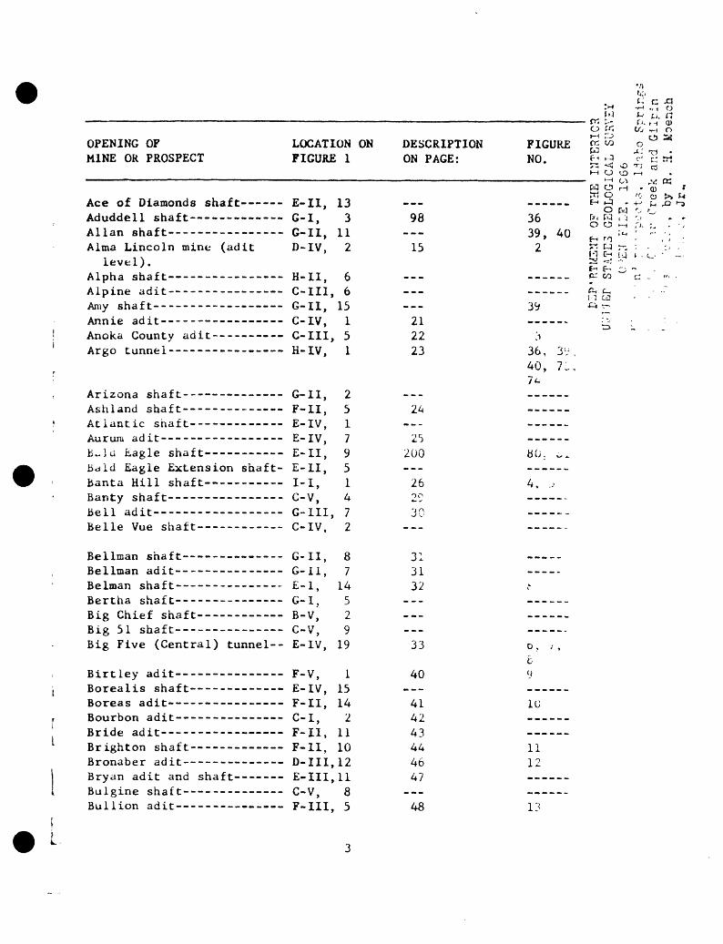
In this report, 135 mines and prospecLa cire described. The mine*, ami prospects described are those that were accessible at the time of this study, as well as a few inaccessible properties for which some information was available. Most of the dat«i for the inaccessible 01 unimportant properties were obtained from Bastin and Hill (1917) and Spurr, Garrey, and Ball (1908). The following list shows, in alpha betical order, the names of about 325 openings of mines and prospects, their coordinate location on the district map (fig. 1), the page of this report on which their description starts, and the number of the Illustration, if any, referring to them:
TT OF Ti:2
Coanr,iec . and A. A. D
1
p*""
""
CO
O3
03
CO
03
O3
03
03
03
03
03
O3
CO
CO
03
03
W
0^
tic
03
(X
tP
t£
Jt>
Jt>
Jj>
5>
Jt>
Jt>
J^
")>
J>
Jt>
Jt>
tC
CI^
I^^O
OO
P-
p-
p-
p-
re re
re re
re
re
co
co
atc
rtw
^
»-<
3 3
3 ^ ^
»
»
P-
P- X
Op-P
-C
'"!'"**"!
OO
OO
OQ
^P
JP
JP
J K
JKj3
3^
ww
-JH
^J
Srp
' O
QO
3*<
"O
T3P
40^
p-p
-3co
p-r
eo
"Co
co
pj
**i
en o
sr
PJ 0
0 re
x
co 3
D PJ
o ce
re
w 3
co <
sO
3
crr
t o
w M
re
p-
p-
sr
co 3
co
co
co fit
1' r»
3
3
rt
srr
e
re M
3
re
Co
re
O
Co
3
P-
X
<
P'
33
<
CLC
flpC
CoC
oC
op-C
XC
o
CO
CoC
o
to
P-1
P-
0CL
M
3 CL
co
co
re to
re
co cn
CP
-ST
P-O
CO
QD
.O
3o
cxm
co
srs
^3
sC
ow
p-
p-C
oO
. Co
D
"b
hS
TS
rco
on
re
rtco
KJ
»-J
t-'p
-
tow
3C
P-rtC
XC
o«O
CC
XS
rrtC
oco
rtC
LP
-C
oC
L
x-s
Co
Co
Co
CL
Sr
»-h
»-j
rererT
Cocrsr
re3r»
M-h
h
O^
(- C
o
D-S
T
p-r
tST
p-
OH
iCO
H^H
i>-'C
o
co
rt
3'C
oco
^rt
rt
rr
t 'r
rt^-h
Co
p-c
o
rt
co
rt
rertsrrtrtrtM
i sr
cofd
w
CO
H^M
I *<
3
rt3rtm
t-h
3
Co
rtco
S
TK
Srh
tirtrt
CX
rt
rtrtM
i
t-h
Co
P-C
orf
Co
0M
rt
rt»-t^re>
-h
CX
t-«-
Co
Co
rt
3
rt
p-
3sr
K-
w
rt
re&
**
s p
-H
ti O
n~
^rt
rt
3
Co
c a
3
en
p-
3
Cf
rtre
co^"
* ^^
i
rti
i
*5do
wo
ii'j>«
io>iiti
3H'|j
w
ot/ootn
oci
OO
OM
MW
WW
^O
C
CO
OO
OD
C
DC
i
i i
i i
i i
i i
i i
i i
i i
i i
i i
i i
i i
i i
i l
i i
i i
i i
iM
"
MM
MM
-
M<
~
<-vw
^
>-<
M
<M
WS
* M
M<
<M
M
<JM
<M
MM
<
K
*
^*
»*
V
W
**
^/1
00
P
J hO
C
^ H
^ hO
£
*"
^J^
H~*
'^
^
^O
ho
W
~i
f^-
^»J
00
hO
^*
J ^*
* H
*
^^
VC
^O
J~
* t^
1^ hO
H
^ ^^
h" *
^^
CT^
^T^
hO
H
I t
ill
i i
N:
I r
lit
J>
l^^4
>^>
^-4
Sl^
Lo
iltU
>L
oU
>
I C
o to
ho
I
C
h-
I ro
I
hohoholll
H-1
OO
l*o
Os>
£^U
>ho>
-'IO
O
J 1
1 i
K:
t
^J
1 C
3 > "
> CT
> 1
O
^^
' J>
i
U>
hO
»-
1 1
1 C
r 1
H- '
H-'H
- '
h-ll
^C
r'1
O
'r
1 1
J>
OC
>
J^O
OlC
v)
C'jj
ro
H-
1 o
' it
* cr
£
o
0s
'_»
i ^
fo v
II
.-
v.
.-
| »
1 1
L
11
' C-
«-
J LO
1
.J'
-
» '
» i
vr
: '
i c>
J>
J>
CL
O-
C
rto
a3
a o
re hh
8 f-
1r
P- a
n P
- h
On
Co
T sr
3
Co
Oh
"t>
0
rt
Cu 0) CO cr 6) l-h rt
5 O
W
i
l
4 «
M
Ml
^H
4
* t«>
Co i
SO
1
Co
l
>J
CO?
o>
s» D
3C 0
M
*T3
z 2
W Z M
o z
jc
O
hfl o
o ^
to *^0 w o H M O
O
O
c >
ft
M
p-
Z o z
0
C5z w
>T3
Oj^
po
O
MW
*^
fl
H 2 z
*y^
^SO
M
O C
IT OF
THE
INTERIOR
STATES GEOLOGICAL SU
RVEY
o >z:
-r FI
LE,
is 66
n'
*" '
'V
-:ot
of
Idih
o
Spr
ir.i
, C
' u-
C
reek
an
d G
ilp
in5
''-'.:
. .
by
R.
H.
k'oe
nch
' 1
-:i
,',
Jr.
L
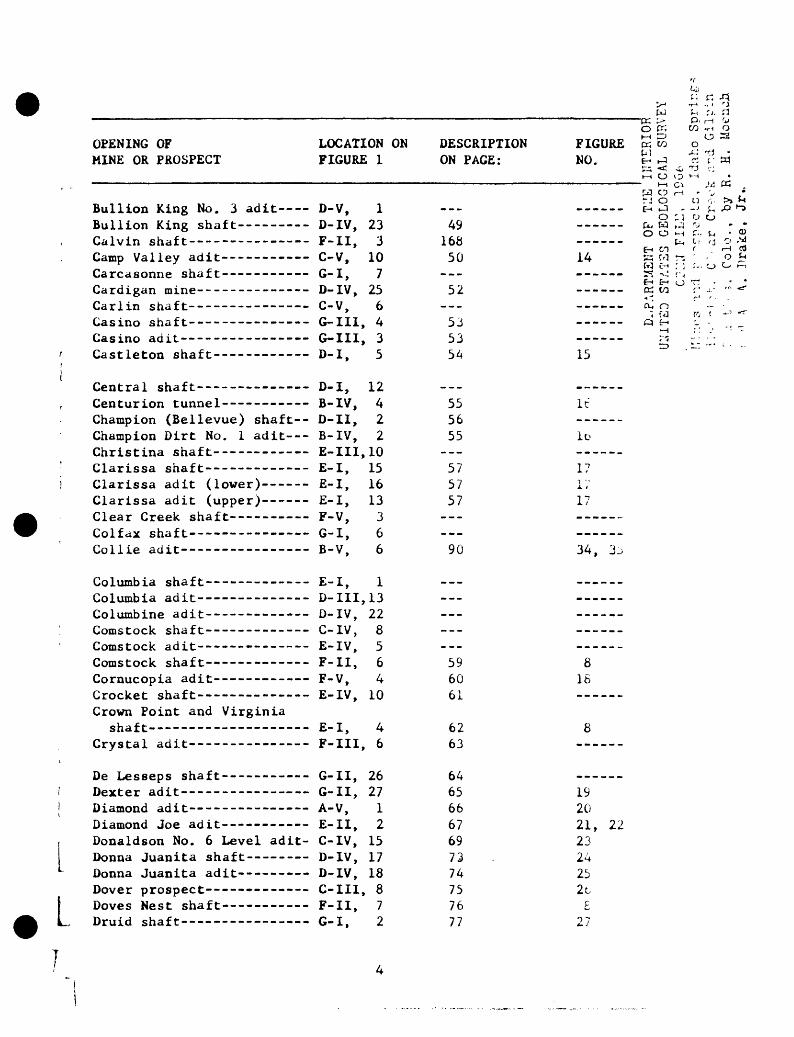
OPENING OFMINE OR PROSPECT
Bullion King No. 3 adit Bullion King shaft---- -Calvin shaft---------- --Camp Valley adit--- Carcasonne shaft--------- Cardigan mine--------------(*a y 1 « « ch'if-*-
Casino shaft---------- ---Casino adit--------- -----Castleton shaft----- -
Central shaft---- ---- Centurion tunnel- ---- --Champion (Bellevue) shaft-Champion Dirt No. 1 adit- Christina shaft---- - - Clarissa shaft--- --------Clarissa adit (lower) --Clarissa adit (upper)------Clear Creek shaft --Colfax shaft-- - ------Collie adit- -----
Columbia shaf t-------------Columbia adit--------------Columbine adit-------------Comstock shaf t-------------Comstock adit---------- --Comstock shaft ---- -----Cornucopia adit----- -- -Crocket shaft----- --- --Crown Point and Virginia
shaft- ---- -Crystal adit------- -
De Lesseps shaft-------- -Dexter adit-------- -- Diamond adit ------- -- .Diamond Joe ad it- ----------Donaldson No. 6 Level adit-Donna Juanita shaft ----Donna Juanita adit-- -- -Dover prospect-------- ---Doves Nest shaft---- -Druid shaft--------- -----
LOCATION ONFIGURE 1
D-V, 1D-IV, 23F-II, 3C-V, 10G-I, 7D-IV, 25C \l £.
*
G-III, 4G-III, 3D-I, 5
D-I, 12B-IV, 4D-II, 2B-IV, 2E-III, 10E-I, 15E-I, 16E-I, 13F-V, 3G-I, 6B-V, 6
E-I, 1D- III, 13D-IV, 22C-IV, 8E-IV, 5F-II, 6F-V, 4E-IV, 10
E-I, 4F-III, 6
G-II, 26G-II, 27A-V, 1E-II, 2C-IV, 15D-IV, 17D-IV, 18C-III, 8F-II, 7G-I, 2
DESCRIPTIONON PAGE:
---
4916850
__.52
535354
-_-
555655
-__575757
._--_.
90
_____-
----_.
596061
6263
64656667697374757677
K-I ru o 2 FIGURE K w o
M X3 TJ NO. E- H3 rt r tn
t~< O O i~ I
W O r~\ ' 'J *
O '^} 0 O
O O ̂H £'.. 1~> ®
14 Is ?3 r-. - - o £W c-< : i r-. o o f^
------ ccit/3 r -i- '" *=*
j *"fj {? r "*"^ ""^~fc 1 r 1 " ' '
15 ^ ' ~
It
ID
17j. >17
34, 3^
816
8
192021, 222324252t£
° 7

f
L
OPENING OFMINE OR PROSPECT
Dubuque shaft---- --East shaft-------------- East Hukill shaft----------Eclipse shaf t--------------Edgar adit and shaft-------Edgardine shaft------------Edgar Extension adit-------Edna Fannie adit-----------Edward shaft -------------Edward adit------------- -Eikhorn shaf t----- ---------
Elliot and Barber adit-----England adit--- ------------Enterprise shaf t-----------Esmaralda shaf t------------Essex shaft----------- -Etna ad it------------------Eulalie adit---------------EureKa- Swansea adit--------Fairmount shaf t------------Fannie shaf t---------------
Fanny shaft------------- -Forge Hill (Fairmont) adit-Fortune adit---------------Foxhall tunnel-------------Fraction shaft------- ----Franklin No. 73 shaft-- -Franklin No. 87 shaft------Free Gold adit -------- -Freeman shaf t--------------Freighters Friend shaft --
French Flag shaft---- --Frontenac adit and shaft- G and M (Centennial) adit Galatea shaft------- --- Galatea (Hudson-Burr) adit-Garden shaft---------------Gem shaft------- ----- --Gem adit----- ------- -German shaft ------ -----
LOCATION ONFIGURE 1
C-III, 1B-V, 4E-IV, 3G-III, 1E-111,13G- 1 11, 12F-III, 8G-IV, 2C-IV, 5C-IV, 11G-I, 4
D-IV, 5C-IV, 3E-I, 18G-III, 8E-IV, 13G-II, 24D-IV, 9E-II, 4E-III, 4E-I, 12
E-II, 6E-I, 17E-III, 2G-III, 2B-V, 5H-II, 1H-II, 5C-II, 2H-II, 7G-II, 29
H-II, 12F-I, 2E-IV, 9H-II, 16H-II, 14G-II, 4G-II, 13G-II, 28D-I, 6n-TTT 1
DESCRIPTIONON PAGE:
90
808283
--_
1584
---85
-.-86
_--
---87 889092931769495
9798101
102189103
---
FIGURENO.
34
28
29
^
30
3i
32
33343939, 40
39, 4040
3637
3573, 7439, 4u3V
t -1 t-O r-1
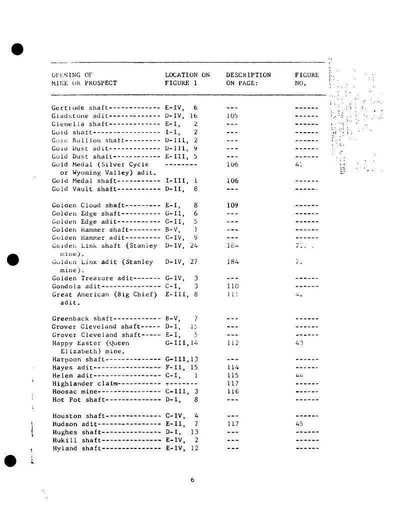
OPENING OFMINE OR PROSPECT
Gertiude shaft-------------Gladstone adit----- ------Gienella shaf t--------- -- --Gold shaft-----------------Gold Bullion shaf t- --------Gold Dust adit-------------Gold Dust shaft------ -----
Gold Medal (Silver Cycleor Wyoming Valley) adit.
Gold Medal shaft--- - Gold Vault shaft-----------
Goiden Cloud shaf t-------- -Golden Edge shaft----------Golden Edge adit-------- ---Golden Hammer shaf t--------Golden Hammer adit---------
Goidei. Link shaft (Stanleym i 1 1 e ) .
Gulden Link adit (Stanleymine) .
Golden Treasure adit-------Gondola adit---------------
Great American (Big Chief)adit.
Greenback shaft------------
Grover Cleveland shaft-----Grover Cleveland shaft-----
Happy Easter (QueenElizabeth) mine.
Harpoon shaft--------------Hayes adit------------- Helen adit-----------------Highlander claim------ ---Hoosac mine-------- -- --Hot Pot shaft--- --------
Houston shaft- ------- Hudson adit----------------Hughes shaft----------- --Hukill shaft--
LOCATION ONFIGURE
E-IV,D-IV,E-I,T -T
D-II1,D-II1,E-II1,
I-III,D-II,
E-I,
G-II,G-II,B-V,C-IV,D-IV,
D-IV,
G-IV,c-i,E-I1I,
B-V,D-I,P T
G-III,
G-III,F-II,c-i,
C-III,D-I,
C-IV,E-I1,D-I,
E-IV,F-TV
1
61622295
18
86519
24
27
338
715^
14
1315
1
38
47
132
1 9
DESCRIPTION FIGUREON PAGE: NO.
105 -----
106 4]
106 ----- ------
i.\J7
18 < 71, .
184 7,
110 ------
111 ^
112 43
114115 4a1 1 7 ------
116
117 45
. r

L
OPENING OFMINL OR PROSPECT
Idaho tunnt' 1 ---------------Irene ad i t------- ----------Jnckson sna i t- -------------
Jennie Lino Isu. 1 adit-----J. L. Lino is on sii.i i I --------J. Warner shaft .ni'. aoit---Jotlli L. Shaf t-- ------------
John Paul Jones au it -------Jones shut t---- ------------
Josepnino shaft anu adit. ---JUUIDO <(d i t -----------------
Kangaroo shaft--- ----------
Kelly No. 4 level adit--- Kelly shaft----------------Kentuck adit- --------------Kinda-U.P.R. mine--- -----Latavette adit -------------
Lawrence L (Philadelphia)mine.
Lead Belt adit- ------------Liberator shaf t------------
Little Albert No. 5 adit---Little Annie adit- -------
Llttlfc Ca , lU it------------
Little i. L i a shaft----------
Littlc- Lrnr.K. ^dit-----------LitLle harry a^.it----------Little i 1 X cidit------------
Livinu,ston shaf L-----------Loeuer shaf t---- -----------Lord Byron shaft-----------Lost Summit shaf t --------- -Lost Vein adit-------------
Lower East Lake adit-------Lower Lake adit------------Lucania tunnel -------------MAB adit-------------------M and E adit-- -----------Manhattan shaf t------------Manhattan adit-------------Martha Perks adit----------Mastedon ad it--------------Maude Munroe mine- -------
LOCATION ONFIGURE
F-II1,U-V,
G-II,L-ill,iJ- I ,G- IJ,L-I,
G-IV,G-ll,U - I vr ,E-IV,
F-I1,B-IV,C-IV,E-II,C-I,
E-IV,C-I11,
F-I1,B-V,
B-IV,D-H,
D-V,
E-IV,F-II,D-IV,D-1I1,E-l,
E-III,C-V,
E-III,D-IV,
F-II,E-II,C-II,D-III,D-V,C-V,C-V,
C-III,D-III,D-IV,
1
77
23y
i 4L')
il
i
1^4
4Itt
12b
16144
177
8316
589
13109147
157
2101
1561
122
118
DESCRIPTIONON PAGE:
119_ _ _---
121122__»---------------
___---
---
12312o127
129
130131
132___133_.-134
50
135
136138141143144
145---146147
i, 9"* -r
FIGURE o fe £NO. £ ti
------ W 0 M .?< : o tli------ e-< ^ » 4o r j -
------ ':. W j
46 ° "' ;-:' -
------ -*- <-> :. . .
------
------ ,., -
------
16------47, /-°ii-"~) '.
1 0 ,
c
u
j
14
557, 5657
58
5v
60
t OO >'

OPEN INC, OFMINE OR PROSPECT
May Day or Ready Cash adit-Max shaf t------------------Mayflower adit-------------May Queen Annex adit-------May Queen adit--- ----------McMickle adit- -------------Merrimac adit--------------Metropolitan tunnel- -------Metropolitan adit----------
Metropolitan prospect------
Miami tunnel----- ----------'Minnie shaf t-------- -------Minott shaft---------------MIX adit----- -----------M K shaft ----------------Mona adit------------------Monte Cristo adit----------Moose shaf t----------------M o r gan shaft---------------Morning Star shaf t ---------
Morning Star shaf t---------Morning Star shaf t---------Mount Etna adit--- ---------Mount Vesuvius adit--------Myra shaft-------- ---------Nashville shaf t----- -------Needham adit----- ----------New Bedford adit-----------New Century adit-----------Niagara shaf t--- -----------
Nighthawk shaf t-- ----------Nonpareil shaft ---- ----Nonpareil adit----- --------
No. 11 adit (Alma Lincolnmine) .
No. 12 adit (Alma Lincolnmine) .
October shaf t--------------Old Settler adit-----------Old Settler shaft- -------
LOCATION ONFIGURE
G-II,E-IV,D-III,D-III,E-IV,C-IV,C-III,F-II,C-V,
F-IV,D-l,
G-II,F-III,U-I,
E-II,D-IV,H-I,
A- IV,C-IV,
D-III,G-II,C-IV,C-IV,C-V,F- T
D-III,E-IV,C-V,
H-I1,F-IV,F-IV,D-IV,
D-IV,
C-V,
A- IV,A-IV,
1
121643
20124133
31
221/11127
61
i *-
1 J5
lo10
Ib1111
1512
20
21
1434
DESCRIPTION F 1C LIKEON PAGE: NO.
74 25
148 61
150
151 62/̂
152 6,
189 73, 7---- _--___
154 -__-_-.
155 i-...15t ------
-_- --------- --_.--- -----__- -____.-__ -__-_
f-k \(-* )
157 6515
15
66159 6b
L

I
OPENING OFMINE OR PROSPECT
Old Stanley shaft- -------Oliver shaf t---------------Oregon shaf t---------------Oro Fino adit--------------Oro adit-------------------Ottawa shaf t-- -------------Owatonna shaf t-------------Patten adit----------------Pennsylvcinia adit- ---------Pnillips shaft-------------
Phoenix adit---------------Phoenix prospect-----------Pine Shade shaf t-----------Pine Tree shaft------- ---
President Hayes shaft------Pride of the West shaft----Protection adit------------Providence snaf t-----------Quartermasier shaf t-- ------Ked Jacket adit----- -------
Red Lyon adits-------- -----Refuge shaf t---------------Reilly(?) shaft Remington ad it- ------------Richmond shaf t-------------Rickard shaf t--------------Rio Grande shaft ---------
Road level adit (Stanleymine)-------- ------- -
Rockford tunnel------------St. Joseph shaft-------- -
Salisbury mine-------- - Santa Fe shaft -------- Seaton shaft -------------September adit-------------
640 Level adit (AlmaLincoln mine)------------
Shafter adit---- Shafter shaft----------
LOCATION ONFIGURE 1
D-V, 2E-IV, 14D-I, 4H-II, 2n T T T 1 Li
G-III, 9F-l, 1F-III, 3D-IV, 6D-I, 9
B-IV, 5C-V, 13G-II, 20H-II, 3D-I, 3D-IV, 14E-III, 17E-III, 12F-IV, 4F-III, 4
D-V, 4E-III, 7H-II, 8F-III, 2D-II, 1G-II, 19E-I, 7
D-IV, 12B-III, 1H-II, 4
D-IV, 10G-II, 9G-II, 16C-II, 3
D-IV, 19E-III, 3E-III, 16H_TT in
DESCRIPTION FIGUREON PAGE: NO.
71
\ C.Q
U C
208 361 £. U
161 -_-_-_
162 67
165 79
---
166 -__--.___ ________ ______168 --_--.
167 -
165 7V
184 71, 7..170 16, 6c
172
173 -1 "7 /
176
15
177 69177 17 Q ______
o o
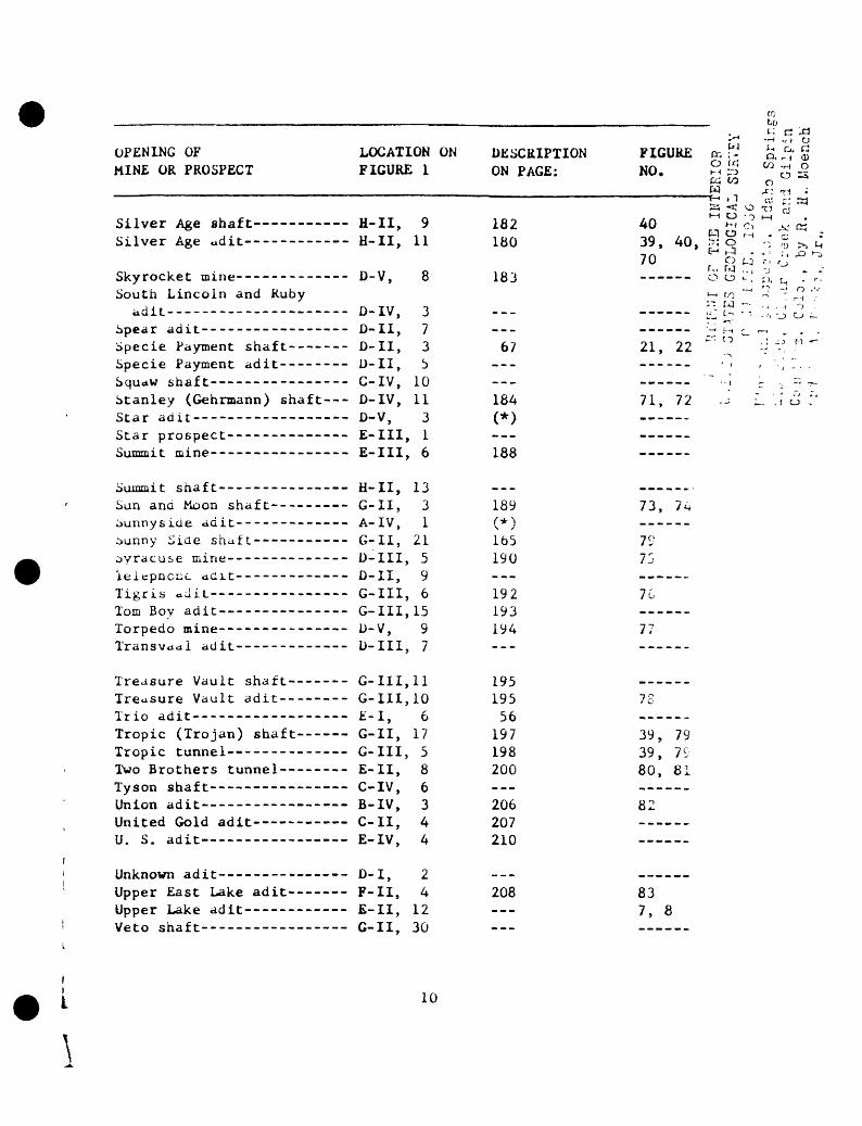
OPENING OFMINE OR PROSPECT
Silver Age shaft - - Silver Age udit------------
Skyrocket mine-------------South Lincoln and Ruby
adit- --------------------Spear adit-----------------Specie Payment shaft-------Specie Payment adit--------Squaw shaf t----------------
Stanley (Gehrmann) shaft---Star adit------------ ---Star prospect--------------Summit mine----------------
Summit shaf t---------------Sun and Moon shaf t---------Sunnyside adit-------------bunny Side shaft.-----------byracuse mine--------------'lelepncuc aCit-------------Tigris ddiL----------------Tom Boy adit------ ------Torpedo mine----------- --Transvaal adit-------------
Treasure Vault shaft-------Treusure Vault adit--------Trio adit------------------Tropic (Trojan) shaft---- Tropic tunnel--------------Two Brothers tunnel--------Tyson shaft----------------Union adit----------- - -United Gold adit U. S. adit
Unknown adit-------- ----Upper East Lake adit-------Upper Lake adit------------Veto shaft------ - --
LOCATION ONFIGURE 1
H-II, 9H-II, 11
D-V, 8
D-IV, 3D-II, 7D-II, 3D-II, 5C-IV, 10D-IV, 11D-V, 3E-III, 1E-III, 6
H-II, 13G-II, 3A- IV, 1G-II, 21D-III, 5D-II, 9G-III, 6G 111,15D-V, 9D-III, 7
G-III, 11G-III, 10E-I, 6G-II, 17G-III, 5E-II, 8C-IV, 6B-IV, 3C-II, 4E-IV, 4
D-I, 2F-II, 4E-II, 12G-II, 30
DESCRIPTIONON PAGE:
182180
183
-«__-_67
__-_-_
184(*)
188
--_189(*)
165190
192193194-__
19519556
197198200-_-206207210
___
208 -__
t; c xi& -r-< .r) 0
FIGURE K : J £. % gNO. £ S ^ o 5ca to o
S < o 4i cj ^40 ^ " ̂ ̂ ̂ cj39, 40, ,T: o M -'- % >>70 ^ o * r, rj -° fr- M ,., -j J >_ -- 0 0 ̂ . fi ( j_, .
> i '? - O .' ( l fQ ^-> " ,'' w - ., .:, ^> .
------ -~4 i.^ ,-_ ^ __ ,
21, 22 ^ ^ :j -' ". " '
71, 72 .j L \] o :
73, 74
7975
76
77
7c
39, 7939, 7580, 81
82
837, 8
L
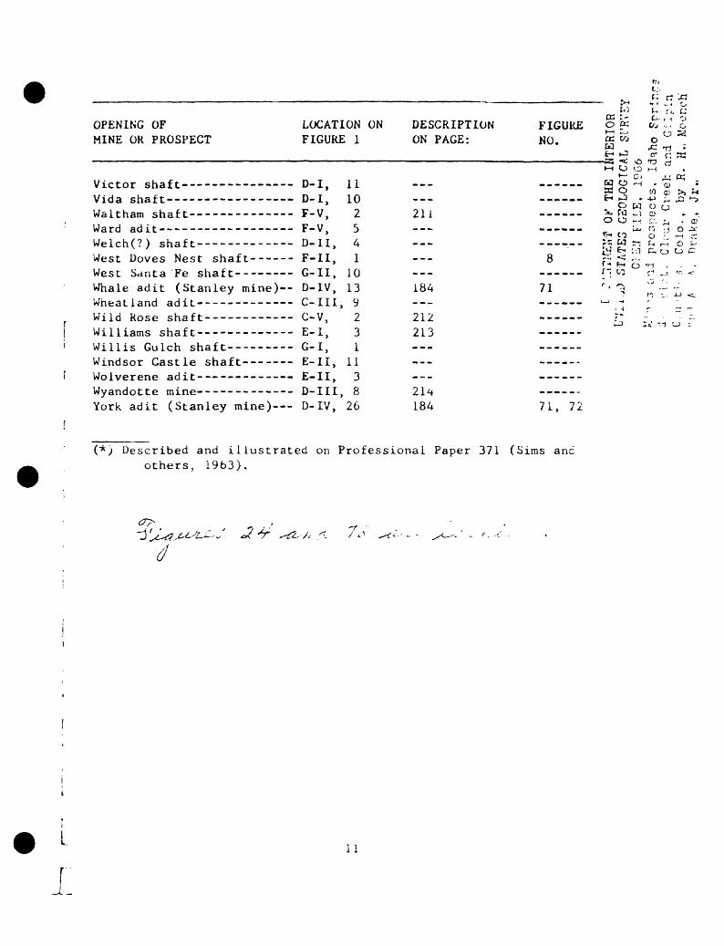
OPENING OF MINE OR PROSPECT
Waltham shaft---- --------
Whale adit (Stanley mine)--
Wild Rose shaft-----------Williams shaft------- ----Willis Gulch shaft---------
York adit (Stanley mine)---
LOCATION ON FIGURE 1
D-I, D-I, F-V, F-V, D-II, F-II, G-II, D-IV, C-III, C-V,E-I, G-I, E-II, E-II, D-III, D-IV,
11 10 25 4 1
10 13 9 2 3 1
11 3 8
26
mt;,f.: r: '^3
W ^ f». c; DESCRIPTION FIGURE o« &"..'% ON PAGE: NO. « % o ° a
W rC T) *6-1 »-_I cr" r" W
211
184
212 213
214 184
HH O 0 l-M
- W 0 rH - Q ^WO W QJ >j
o w o ob o -H t?. ^, .^* CO O r. -H
8 ^S;^ auo ' f- 5 ° TH ' ,;
71 ; < ^ ;J T; L .LJ r '^ :» -1 u
71, 72
(*) Described and illustrated on Professional Paper 371 (Sims and others, 1963).
(1
11

. i it, ,i t , 0:1 o i L he 'Jesc r i be<; .;..< . . s.. ' ;,; o . JM ' l . , 11 < shown ;,, tne d . L i i '. t map (fig. 1 ) . They u.'i / !><. i-.ur.-fi f,y n:,< I the j-iij coordinate index. For exa,,iple, tin i.u>. .lit j a tunnel (C-ll, i) i.-, located by the number i within C (nor th-soul h) ..md Ii (east-west) on figure 1. Similarly the name of a mine or piuspeci opening shown on the map may be found by referring to the list accompanying the map, which is arranged by grid coordinates.
Purpose and scope of report
The Precambrian bedrock, Tertiary veins and porphyritic intrusive rucks, and all accessible mines were mapped during an investigation of tne uranium and associated ore deposits of the Idaho Springs district ao part of a larger study in the central part of the Front Range mineral belt. Much of the information obtained in this study has been publisned by the U.S. Geological Survey in two reports: Bulletir 1I82-A, Geology of Precambrian rocks, Idaho Springs district, Coiorauc, by K. H. Moench (1964); and Bulletin 1208-A, Economic geology of the Idaho Springs district, Clear Creek and Gilpin Counties, Coiorauo. by K. H. Moench and A. A. Drake, Jr. (1966). The 133 mine and prospc. descriptions, geologic maps of those mines and prospects tnat wer*> accessible, and several plan maps and projections of inaccessible properties that were also made available to the authors, are materia. that is supplementary to the bulletin on the economic geology of tn-_ district. Because the descriptions and maps contained herein are : limited interest, they are being made available in this form to tno.-.- who want them. Reproductions of the entire report, or individual page, thereof, are available at private expense from the U.S. Geologica> Survey Library, Building 23, Federal Center, Denver, Colorado 8022;;.
Fieldwork
Most of the mines and prospects were mapped during tne summer of 1953 and 1954. Some additional fieldwork was done in the Bic F;. tunnel and the Bald Eagle mine in 1959. The accessible mines we:., mapped on scales of 1:480, 1:600, and 1:1,200.
Acknowledgments
We wish to thank our colleagues P. K. Sims, J. E. Harrison, J. D. Wells, C. C. Hawley, and F. B. Moore of the U. S-. Geological Survey, who mapped parts of the surface and some of the mines in the Idaho Springs district. We were ably assisted in the fieldwork by Max Schafer, A. E. Dearth, Alien F. Moench, J. R. McDonald, and Peter Buseck. Many thanks are also due the late Mr. Charles L. Harrington, U.S. Mineral Surveyor, Idaho Springs, Colo., who furnished many mine maps and useful data, and Mr. J. Price Briscoe, who allowed the writers to publish assay records of _he Idaho Springs Sampling Works, a now-defunct company that Mr. Briscoe owned from 1919 to 1936.
UNITED STATES Gi;oi/>.T".v. s^v:::
oc U, Id-iho rnrir.g,
r.jr.t 3"k, GJ .-., by R. ii. Mour.c:: rid A. A. Lri*..«, J v -

Mi. Caii beJ.'.t-r ol the U.L.. Burt'-.u u\ F.IIH -, tarnished .1 usriui jiu-'-'j iished report on the Lucania tumu-1 an.; Mi. Frank Jones oi iiiuhu ^j,;i;i^:, provided assay data and maps tor ni^ny mimr.%. Mr. A. J. Martin oi tne U.S. Bureau of Mines provided production 1 igures for individual minc.s of the district which are published with permission.
References cited '
Bastin, E. S. , and Hill, J. M., 1917, Economic geology of GilpinCounty and adjacent parts of Clear Creek and Boulder Counties, ; Colorado: U.S. Geol. Survey Prof. Paper 94, 379 p.
i . Callbreath, J. F., Jr., 1899, The mineral resources of Clear Creer
County, Colorado: Denver, Colo., Mining Reporter, v. 40.
Collins, G. E. , 1913, The application of genetic theories to the '-search for local enrichments in veins: Colorado Sci. Soc. Proc.^'v. 10, p. 211-232.
Fossett, Frank, 1879, Colorado, its gold and silver mines, farms anustock ranges, and health and pleasure resorts: New York, Crawforc- 540 p.
Harrison, J. E. , and Wells, J. D., 1956, Geology and ore deposits 01 the Freeland-Lamartine district, Clear Creek County, Colorado U.S. Geol. Survey Bull. 1032-B, p. 33-127.
______1959, Geology and ore deposits of the Chicago Green, areci,Creek County, Colorado: '.S. Geol. Survey Prof. Paper 319, i± L
Hollister, 0. J., 1867, The mi.es of Colorado: Springfield, Maso., S. Bowles and Co., 450 p.
Kimball, J. P., 1886-1889, Reports of the Director of the Mint o;.production of gold and silver in the United States for the years 1885, 188b, 1887, 1888: Washington, Govt. Printing Office.
Leech, E. 0., 1890-1893, Reports of the Director of the Mint onproduction of gold and silver in the United States for the years 1889, 1890, 1891, 1892: Washington, Govt. Printing Office.
Levering, T. S., and Goddard, E. N., 1950, Geology and ore depositsof the Front Range, Colorado: U.S. Geol. Survey Prof. Paper 22j. 319 p.
Moench, R. H., 1964, Geology of Precambrian rocks, Idaho Springs district, Colorado: U.S. Geol. Survey Bull. 1182-A, 70 p.
Moench, R. H., and Drake, A. A., Jr., 1966, Economic geology of theIdaho Springs district, Clear Creek and Gilpin Counties, Colo.:U.S. Geol. Survey Bull. 1208-A.
Sims, P. K., Drake, A. A., Jr., and Tooker, E. W., 1963, Economicgeology of the Central City district, Gilpin County, Colorado: U.S. Geol. Survey Prof. Paper 359, 224 p.
13

!
, i'. r.. , .i! . f 'ic r . , i Vo ' , < .t : ' - ' 'it,;. . ' ..... -< ; a t < ': 01 <
depths 11 : , ' i 11 t r a i par L o i L n«-- ft ;. i'.n i, < , .u i -i i MIL, C<; i or ado:U.S. Clt-ul. ->.irvey Pru'l. i'api.-r i/. , i i - |>.
Spurr, J. E. , Garrey, G. H. , and ball, >. Ji., IV ;h , htonoi.ut gc of" the Georgetown quadrangle (tivtinf-; with tne Li..;>irc uib Colorado, will i a see t i_on, Genera] geology, by S. li. ti.iii: U.S. * ' Geol. Survey Prof. Paper GJ, 422 p. £j --^
r"> '- ; {j- L . . >, bureau oi .'-lines, i -J Z<-»- 1 VJ J i , flinei^J resi/uicc", of Lne United fr-; c/j
states (ajinual voiumts i»r the years j IK! n :iL eti). E---\^ "ir. -; ^ ^
______ iVJ^-1'jjV, Minerals yiaruouk (ai,i : .a; v.jjume.s for the years n ' ;me! icated) . t-'-\~ . '"''
r ."' r.,:
'.-.'(. A I s, J. U. , l^t»(J, Pel rogra[)liy of radioacLive Tertiary igneous - - - ,locks, Fron Range mineral belt, Colorado: U.S. Geol. Survey --.,.-. -Hull. 10J2-E, p. 223-272 /T96J7. |-:'.":' ' ) P.

Alma Lincoln mine (U-iV, 2, 'j , and others)
The Alma Lincoln mint, on the south side of Clear Creek about a mile west of Idaho Springs, is one ol the largest mines in the district. It includes the workings on two important veins the Lincoln and the Elliot and Barber and on three lesser veins--the South Lincoln, Josephine, and Donna Juanita(?).
The Alma Lincoln mine has several adits, all connected by crosscuts or raises. The principal adits are the Lincoln (U-IV, 2, shown on fig. 2 as the adit level), the Platt level, the Elliot and Barber (U-IV, 5), tht Elliot and Barber No. 2 level, the Lincoln-640 level (U-IV, 19), the No. 11 adit (U-IV, 20), and the No. 12 adit (U-IV, 21). Most of the Ruby level (U-IV, 3) was inaccessible in 1954, and is not shown on figure 2. As Spurr, Garrey, and Ball (1908, fig. 136) showed, the adiL of the Ruby level was driven on the South Lincoln vein, and a shorr crosscut was driven to the Lincoln vein, which was stoped on this ieve-.
The Alma Lincoln mine was opened several years before 1900 ana w^_ worked almost continuously from 1902 to 1943. The Lincoln vein wa^ worked on a small scale from 1902 to 1929, ana it was tne iarges~ producer in the Idaho Springs district during 1930-40; it was iarge^ inactive, because of scarcity of labor and mine equipment, during tn._ 19:>0's. The Elliot and Barber vein was mined sporadically auring tii*. sanc period; its total yield was considerably smaller tnan tnat or tn» Lincoln vein. Little stoping has been done on the South Lincoln a;.~ Josephine veins.
U.S. Bureau of Mines recorded 10,689 tons of crude ore and io,/oG tons of concentrates shipped from the Alma Lincoln mine, mostly iron, the Lincoln vein, during 1902-50, which yielded: gold--41,074 oz; silver--170,169 oz; copper--443,238 Ibs; lead--2,064,999 Ibs; zinc-- 78,384 Ibs. Production records for the Elliot and Barber vein during the same period were combined with the Alma Lincoln records, but they were separated in 1904, 1925-29, and in 1933. During these years the Elliot and Barber vein produced 1,184 tons of crude ore and 195 tons of concentrates which yielded: gold--950 oz; silver--3,714 oz; copper--6,502 Ibs; lead 42,619 Ibs; zinc--ll,436 Ibs.
The Lincoln vein cuts microcline gneiss and small bodies of amphibolite and pegmatite; the Elliot and Barber vein cuts mainly biotite gneiss. The South Lincoln vein crosses the contact between these major rock units, and this contact is exposed in the crosscuts that connect two levels on the Lincoln and Elliot and Barber veins (fig. 2). These rocks strike northeast and dip dominantly northwest.
DEPARTMENT OF THE I!:iTr" UNITED STATED GEOLOGICAL 5';?.
15 r" 1 ; : ' -' -' '"'"I-! 1 r.c r. and re .? IK- - - -' - 3 " 't h o S cl: -'.riot, C-- '.^ C ; «. /< . t-nJ G 1
and A- A i--"^^

The microcline gneiss is gently wurpud wncrcas the biotite gneiss in places i% tightly folded along northeast-trending axes. The gneisses are cut by dikes of biotite-quartz latite porphyry, and trachytic granite porphyry. A north-northeast-trending dike of biotite-quartz latite porphyry cuts the South Lincoln, Josephine, and Elliot and Barber veins (fig. 2). Trachytic granite porphyry, which is older than the veins, is exposed near the southeast end of the Lincoln adit level crosscut, near the Donna Juanita(?) vein.
The wallrocks are altered adjacent to the veins. A thin inner zone of bleached, sericitized, and pyritized rock is surrounded by a wider zone of argillized rock. At places the altered rone on one vail is thicker than it is on the opposite wall.
Five veins are developed in the Alma Lincoln mine, from northwesi to southeast, the Lincoln, South Lincoln, Josephine, Elliot and Barber, and Donna Juanita(?). The Lincoln and the Elliot and Barber, the mos<- important of these veins, are subparallel in strike, but convergr upward. On the Lincoln adit level they are 370 to 500 feet apart, bu- on the ridge to the southwest of the mine openings they are only 40 feet apart (fig. 1). These veins, together with the Fraction vei;. constitute a vein system that converges to the southwest with the Lore Byron-Stanley-Edgar vein system (fig. 1).
Lincoln vein.--The Lincoln vein strikes N. 40u-5b° E., uip; 30°-50° N., and has been traced on the surface for distances or aoc^L 2,500 feet west-southwest and east-northeast from the Lincoln aci: level portal (fig. 1). The vein is 0 to 24 inches thick. Tyoicai it is symmetrically layered and has a core of base-metal mineral, bordered by coarse-grained pyrite and quartz. Locally, nowever, veinlets of base-metal sulfides and sulfosalts cut the pyrite-quart.- vein material.
The Lincoln vein is a pyritic lead-zinc vein. It contains mort- pyrite than most veins of this type, however, and the galena-spnalerite ratio also is unusually high. Cubes of pyrite as much as 2 incnt.s across constitute 50-70 percent of the metallic minerals. The pyritr immediately adjacent to the base-metal core is commonly stained a aeen yellow, presumably by copper. Other ore minerals, in order of decreasin. abundance, are galena, chalcopyrite, tennantite, and sphalerite. Smal amounts of enargite are present, and traces of native gold, pearceitt, and polybasite were noted in polished sections. Secondary ore minerals are covellite, chalcocite, cerussite, malachite, and azurite. In par.-, of the vein less than 350 feet beneath the surface the galena is pre ferentially replaced by a fine-grained mixture of covellite and cerus site, and less commonly by malachite, azurite, and chalcocite. Quartz is the most abundant gangue mineral; small amounts of ankerite(?) are locally present.
J I T\--.T--«T-T>S»- D'-^-AFTMEIIT 07 TrH
r : '\ - 7 '16 ,.. > - -
' .....: .0'- . , i,.<" i.. : ,\ . 1 . ;'; a '.-:~ , <

Uranium-bearing minerals are present at several localities on the No. 2 and No. 3 Lincoln levels. Assays of three samples (L-2-3, L-3-2, L-3-NE), none of which contains more than 0.1 percent uranium, are given in the following table. Forty feet from the southwest face of the No. 2 level, the vein is abnormally radioactive for a linear distance of 5 feet; an assay (sample L-2-3) gives 0.089 percent equiva lent uranium, and 0.063 percent uranium. Betazippeite and zippeite are distributed along late fractures crossing the vein. Also, small ros- settes of schroeckingerite are scattered along the drift wall a foot or so away from the vein where betazippeite was found. Pitchblende(?), a dark-gray gangue mineral, and some pyrite, occur in the same irregula^ veinlets that cut the sulfides and contain the betazippeite. At one place on the No. 2 level and at several places on the No. 3 level, a fracture that contains crushed sulfide minerals and zippeite cuts the vein but generally follows its footwall. Samples L-3-2 and L-3-NE from this radioactive fissure contained 0.056 and 0.059 percent equiva lent uranium and 0.047 and 0.095 percent uranium, respectively. Assoc iated with the zippeite are a few grains of dull-black material with a conchoidal fracture, possibly thucholite. The material is highly radioactive, has a specific gravity of 1.91 to 1.93, and gives a clear X-ray powder pattern similar to sphalerite.
Chip samples of the Lincoln vein were taken on all accessible levels (fig. 2 and table). The assays indicate that the gold distribu tion is somewhat erratic but tends to increase in those parts of the veins that contain abundant base-metal minerals.
The Lincoln vein has a well-defined zone of supergene alteration. On the adit level the vein is completely oxidized for a distance of 1C feet from the portal; on the Platt level it is oxidized for about 40 feet from the portal; and on the 640-, No. 11- and No. 12 levels it is oxidized for about 50 feet, 70 feet, and 170 feet from the respective portals.
A large ore shoot that plunges at a medium angle northeast was mined from the Lincoln vein (fig. 2). The factors that localized this shoot are not fully understood. The ore and gangue minerals have fillec a single fracture that appears to have been open over almost the full extent of the mine workings. The vein tends to thicken where it strike.- more to the east than the average, consistent with the observed right- lateral offset of 2 1/2 feet, but the stoped ground covers relatively north-striking parts as well as east-striking parts. Changes in dip ac not appear to have been important, even though slight normal dipslip movement took place at a late stage of mineralization.
DLVA^TVr^!? G" T7.E I^TTI ' UNITED 3?:.ITS G/JOLOGJ C/J, s:
Mines an.l p: _,.- . - ;.; , ,.- A - 17 r^.^ 10 ,'" ^'. "" ~ ^ " ' ,
^ ̂ - ' , I-. ' ^ . , t-v R. 11. and A. A . i 1.1:. ^, ^ -.

DEPARTMENT OF
THE INTERIOR
UNITED STATES GEOLOGICAL SUF.V7Y
OPEN FI
LE,
196t
Min
es
and
pro
spects
, Id
aho
S*;r
! d
isti
ict,
C
lear
C
reek
an
d G
I '.v
v C
ounti
es,
Co
lo.,
by
R.
H.
Voj
: -
and
A.
A.
Dra
ke,
. 3i.
Labo
ra
tory
Se
rial
No.
217^29
217
,30
2175
51
217552
217.
.5.,
21
7556
217^
37
217^
58
217539
217o40
2175
41
217542
217545
2'"
'
Fiel
d No
.
Al-4
Al-5
Al
-6Li -5a
LI -;
Li- -9
LI -lla
Li -
11 b
L-2-la
L-2-lb
L-2-
.5
L-5-1
L-5-
3
L-ll-la
L-H-l't
I -1
2-1
I - 1 2 -
. I -1-5
I - '
:
i.
Level
Adit
Adit
Ad
it
Platt
Platt
i'latt
1 la
ttn a
1 1 2 2 2 5 3 11
11 12 12 2
naly^ed by
Equivalent
uranium
(per
cent
)
0. 003
.001
.001
.001
.001
.002
.002
.0
01
.001
. 0
01
.001
.0
01
.001
.001
.0
01
.001
. 002
. 089
r.ssayi
. l
S.
I'. Furnan,
M.
.
Ounces
(per
cent
) Gold
-----
0. Ih
----
- .02
-----
.10
----
- .40
----
- .02
----
- .Ob
-----
4. bO
-----
.60
----
- . '2
----
- . 7
' J-----
.12
0.063
Tr.
.047
^ 1 JcLeo
\ el-;
'-a:
pics
, Line "i
In
ve i n
,
. i
i,
, ,
T.!'
- ,
' .uilber.;,
i).
',.
.' IT.PA
per
ton
^i Ive
r
0. b8
. 78
. 13
. 73
4.
02
. 46
9. 44
25. 7b
2. I
b5.
76
S. 7
0
4. 00
31.
72
9 . (
) ( >
.''8
4. 5
n
C o p pe r
0. 12
.01
.01
.64
.52
.02
. 41
3. 72
.04
]. 49
. HI
1. ^
1. "9
. 17
. 1')
Percent
Lead
,.inc
0.18
O.Ob
.14
.25
. Oo
.11
. Oo
.10
1.84
1.58
.26
.12
47.55
5.0,:
30.92
. lh
. 29
. OS
.59
.44
.81
.17
1. 5
2 1. 02
1. >o
. 20
, .
', ^
1 0
. 0')
2.
. .)'
1.27
,\1-
i Li
r ,
'. .' .
Li .
rtiickness
( inches)
6 0 11
10
6 2 2 f b 101
-
1 1
n c ̂
1 ;
: i ;
c
1 Jo .
> s ,
^ .
Dor inar,
tI'O.
Do.
Quar
t..-
. 1'yri te
. Dcninant
Dormant
Calena,
Dor irart
t y r
i t e ,
Quart
c ,
Galena.
Quartz ,
Do;- i
"jn r
0\idi.-e:l
.'0
Q 1 1
r t
.- ,
T
. .'
1 ..'
:
quartz,
pvr
" re
, ^; or din
p\
r i to.
ea let- a
.
r1 al cop
v ouar t
; ,
tr.ice
>:a
p v r
i t e .
c p r a
1 e r
i
p v r
i to.
p p (
.< 1 e
r i
. .'
'...
v
. C.
.-.r.
e I
ve=- arks
r-vn te.
trac
e ga
lera
. spralerite
are
. a 1 e r a
, s p
t a
1 e r i
1 2 ,
c
rite
, tennantite.
pyr
i te.
ler.a. sphalerite, copper
t?,
copper minerals.
te ,
copp
er r-ineral=.
p\ r i te.
galera.
spha
leri
te,
cor-
e si
-.-'
ne i te.
°
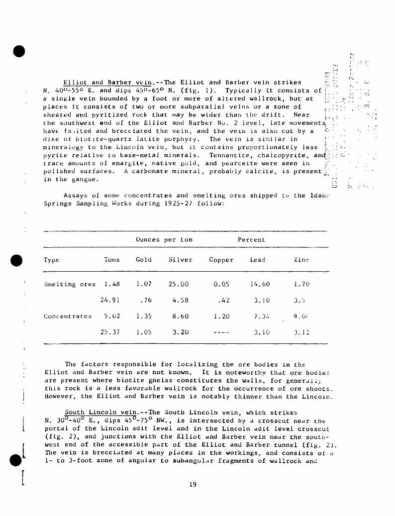
Elliot and Barber vein.--The Elliot and Barber vein strikes r, N. 40°-55° E. and dips 45"-65° N. (fig. 1). Typically it consists of |j a single vein bounded by a foot or more of altered wallrock, but at ' - places it consists of two or more subparallel veins or a zone of sheared and pyritized rock that may be wider than the drift. Near ^ the southwest end of the Elliot and Barber No. 2 level, late movements^ have faulted and brecciated the vein, and the vein is also cut by a dike of biotite-quartz latite porphyry. The vein is similar in \' mineralogy to the Lincoln vein, but it contains proportionately less I : pyrite relative to base-metal minerals. Tennantite, chalcopyrite, and: 1.:: trace amounts of enargite, native gold, and pearceite were seen in ; , polished surfaces. A carbonate mineral, probably calcite, is present ' :'in the gangue. r,'
rj>
Assays of some concentrates and smelting ores shipped to the Idaho Springs Sampling Works during 1925-27 follow:
L ,
Ounces per ton Percent
Type Tons Gold Silver Copper Lead Zinc
Smelting ores 1.
24.
Concentrates 5.
25.
48
91
02
37
1.07
.76
1.35
1.05
25.
4.
8.
3.
00
58
60
20
0.05 14.60
.42 3.10
1.20 7.34
---- 3.10
1.70
3.5
9 . or
3.12
The factors responsible for localizing the ore bodies in the Elliot and Barber vein are not known. It is noteworthy that ore bodies are present where biotite gneiss constitutes the walls, for generally this rock is a less favorable wallrock for the occurrence of ore shoots. However, the Elliot and Barber vein is notably thinner than the Lincoln.
South Lincoln ye in.--The South Lincoln vein, which strikes N. 30°-40° E., dips 45°-75° NW., is intersected by a crosscut near the portal of the Lincoln adit level and in the Lincoln adit level crosscut (fig. 2), and junctions with the Elliot and Barber vein near the south west end of the accessible part of the Elliot and Barber tunnel (fig. 2) The vein is brecciated at many places in the workings, and consists of a 1- to 3-foot zone of angular to subangular fragments of wallrock and
19

ore containing pyrite, galena, and 8phalerj.it. Locally the ore and walirock fragments are thinly coated by quartz and pyrite. The brec cia is similar to that from the Stanley mine described by Levering and Goddard (1950, p. 18<>).
The ore minerals in the vein are pyrite, sphalerite, galena, chalcopyrite, tennantite, and enargite. The gangue is quartz and siderite.
Two Idaho Springs Sampling Works assays of smelling ore indicate 1.07 to 1.22 oz gold per ton, 14.48 to 24. 2<J oz silver per ton, 0.10 to 2.30 percent copper, 4.70 to 11.10 percent lead, and 1.20 percent zinc. So far as ts known, the vein has produced very little ore.
Josephine vein. The Josephine vein, which strikes N. 40° E. and dips 52° NW. , is exposed in the main crosscut from the Lincoln adit, level (fig. 2). It is only 25 feet southeast of the South Lincoln vein, and both veins converge to the southwest with the Elliot anc Barber. According to Spurr, Garrey, and Ball (1908, p. 357), tnc Josephine vein is generally similar to the South Lincoln vein. An assay of 6.74 tons of concentrates by the Idaho Springs Sampling Works in 1919 yielded 0.19 oz gold and 12.15 oz silver per ton, 53.84 percent lead, and 2.10 percent zinc.
Donna Juanite(?) vein.--The Oonna Juanita(V) vein, which strike, about N. 65° E. and dips 35°-60° N., is exposed 610 feet southeast c; the Elliot and Barber vein near the face of the main crosscut (fig. 2 It ts as much as 4 inches thick and follows a gouge zone. Tne veir is similar in mineralogy to the Lincoln vein, and contains pyritt., galena, sphalerite, chalcopyrite, tennantite, and some enargite, Quartz was the only gangue mineral noted. The vein is subparallel t^ but cuts, a dike of trachytic granite porphyry.
20
.('..: Cro.'.': oiid '1 ; '.bin (. II . Loci.cnA . , , lr Tx , , N . , .. ....:,. .,.
Annie adit (C- IV, 1) . . ,. _' ' ttaj A, n . iU'u/.o, Jr..
Development . --Drift adit about 100 feet long.
Wal Irock. -- Microcline gneiss.
Vein. - -Annie : Strikes N. 42° E. , dips 49° N. ; appears to be continuous with the Houston to the south- southwest ; consists of numerous close-spaced anastomosing veinlets of quartz ai.d pyrite in a zone of altered wa J Irock 1 to 2 feet thick.

Anoka County au i i (Oil I, j)-^- A. A. L'r.'ir. .>, Jr..
The Anoka County adit is on the south sine oi Clear Creek ubout 1,000 teet northwest of the mouth of Tr.'il Creek (fig. 1). Very little- is known of the history or production 01 tnc -i.ine. U.S. Bureau oi Mine recorded ')0 tons of ore and i ton of concent r a Lc , shipped in 1934 wnicn vi eloed J.'jG oz ^olci, 43 ox silver, and 104 J^s lead.
Micruciine gneiss i^ trie princip-il v 1 1 1 rock in trie mine. These rocks strike- northeast ami dip 25°-4VJ l*d. Tertiary quartz bostonite diKe, cut the-- gneiss and ure cut ^nd oilset by tlie vciii (fi^',. jj.
Tin adit follows several subparalJel br inch ing veins, wnicn generally east to northeast and dip 2^°-43° K. Individual veins are i-4 inches thick, but locally are as mucn as Itt incnes thicK ine- apparently are part of the vein system worked in the Donalcison, wneatian ami Little Albert No. 5 mines to the southwest and trie Hoosac mine to tn nort f -.e.!5:t (fig. 1).
The dominant vein minerals are quartz and pyrite. Small amount,. tonn.-.ntite and galena occur in tiny vugs in the quartz, and f ine-gra ineo ^. rite is disser.iin.iteci in tne altered v.llrock adjacent to the vei: lae individual veins are part]/ to completely oxidizeo to a poini ..;,w. ou teet from the portal. A 4-inch ci.iy sample across the unoxici;;. vein ass.-yed 0.14 oz gold and l./c ox silver per toi., O.oo i>erccr.t corpt- ^.3b percent le.id. and C.-»9 percent zinc, wuereas a sample of oxidize, vein 'iiate-ri.il fro-.i near tnc port.-i a'<s->veci ,. trace ui goici, 0.5'v1 :.
er ti:n, 0.03 percent copper, 0.31 percent ie^a, and O.itf percer.L ..iLyse,^ oy .). L. oKinner ..nc; James Wuhiberg). Ur.ly the oxidize^ tr.e vein h a ̂ !)e^n bt^-pev:.
The veins are cut, .-aid they offset the quartz Dostonite porphvr. dike.-,. Tae apparent displacement alone the individual veinlets ran"; Iro:. 5 to 20 feet, and .-.11 the north Wails .'re shifted westw<.rn WLL., rosDCCt to the south walls the result or a left-lateral movement.

tr
Argo tunnel (H-IV, 1) ViJ \ / L . ' /.'.'' 1J '
The Argo tunnel, formerly called the Newhouse, is the longest tunnel in the district, extending 4.16 miles from near Idaho Springs to the north-central part of the Central City district. The trace of the tunnel within the Idaho Springs district is shown on figure 1. The portal is at an altitude of about 7,560 feet, and accordingly the tunnel cuts several veins in the northern part of the Idaho Springs district and in the Central City district at depths of considerably mowe than 1,000 feet. It was inaccessible in 1954, but was examined and partly mapped by both Bastin and Hill (1917, p. 303-306) and Lovering and Goddard (1950, p. 178-179). A generalized geologic sec tion through the tunnel was prepared by Sims, Drake, and Tooker, I^D^, fig. 20.
The Argo tunnel was started about 1900 and was completed in 1907. Veins it services were worked intermittently until 1941. The tunnel was driven to intersect many of the valuable veins of the Idaho Springs and Central City districts at depths considerably greater than those of the deepest shaft workings, in order to decrease the cost of deep raining, furnish cheap and rapid transportation to the mills and rail road at Idaho Springs, and to afford drainage ior the workings con nected to it. Within the Idaho Springs district tne tunnel is connecter to only two mines, the Gem (fig. 39) and the Sun and M«jon.
The tunnel intersected several important veins that crop out. ii. the eastern part of the Idaho Springs district, including in order iron, the portal, the Edgardine, Queen, Seaton, Tropic, Gem, Beiiman, Sun and Moon, Morning Star, and Frontenac-Aduddell. Only the Seaton, Gem, Sun and Moon, and Frontenac-Aduddell veins were extensively mined from the tunnel level. Descriptions (by Bastin and Hill, 19i7) of the main veins cut in the tunnel are given elsewhere in this report.
. r.ch
23
Ashland shaft. (F-II, 5)
Development.--Shaft and short drifts. / /. ;. J
Product ion.--46 tons of crude ore shipped in 1956, yielded 5 oz gold, 91 oz silver, 100 Ibs copper, and 900 Ibs lead.
Vein.--Ashland: Strikes about N. 73° E. , dips about 60° N.
Vein minerals.--Probably pyrite, galena, sphalerite, chalcopyrite, tennantite, quartz.
Tenor.--46 tons shipped in 1956 averaged 0.1 oz gold and 2 oz silver per ton, O.li percent copper, and 0.99 percent lead.
24

. Aurum adit (t-IV, 7) C'r^. ,-Mcr:, CoJo.. Ly ];. H.
n;.'i A. A. i....:., , ,;.-.Development.--Short drift-adit, winze, and two shafts, 90 and
280 feet respectively north of the adit.
Vein.--Aurum: Strikes N. 2° E., dips 79° W.; 4 inches thick. It is possibly the continuation of the Jennie Lind No. 1 vein.
Wall rock.--Pegmatite and biotite gneiss.
Vein minerals.--Pyrite, amber sphalerite, tennantite, chalcopyrite and quartz.
25
lL
!' ' : . ' ' . . ' - J '..'}'
Banta Hill mine ( 1 - 1, 1 ) f . ,;, i,. ,,,.; ',.i;,iji( .; _, c '...{/.:. II. l-k<-M'J«
By P. K. bims ^ 5 /.. A. I. :...: '.-. «J i'
The Banta Hill mine is on the southeast side of Banta Hill, north of Pleasant Valley, in the northeast part of the district. The mine, which is on the Banla Hill Ranch along Elkhorn Gulch, was opened before 1900, but no production was recorded until 1906. Subsequently it was worked during the depression years of the 1930's and again during the early part of World War II. It was rehabilitated in 1954 and was bein^ worked in 1955.
U.S. Bureau of Mines recorded 923 tons of crude ore and 98 ton- of concentrates shipped during 1906-44. This ore yielded 195.07 oz golc, 12,060 oz silver, 43,452 Ibs copper, 178,699 Ibs lead, and 4,378 Ibs zinc. Several tons of ore was hoisted in 1955 but the exact quantity is not known, for the ore was combined with that from the Widow Woman and Cherokee mines in the Central City district. Part of the milled ore wat fill from the large stope above the 202-level and part was from a stou^ on the 290-level.
The mine workings consist of a shaft, sunk on the Banta Hill veil; which is inclined an average of 65° SW, and levels at vertical deptr.. of 142, 202, 251, and 290 feet (fig. 4). The shaft reportedly exteno about 80 feet below the 290-level. Large stopes are present west or the shaft on all levels. In 1955 only the 142-level was inaccessible.
The country rock is predominantly biotite gneiss. Tne gneiss IF cut by 2 small dikes of quartz monzonite porphyry (fig. 4), which appear to be apophyses from a large body of quartz monzonite that crops ou. west of the mine (fig. 1). These dikes were not traced on the surface, but the easternmost dike projects from the surface through the mint workings to the lowest level.
The sillimanite-biotite gneiss is altered to a hard, dense rock for distances of about an inch from the veins; breccia fragments in the veins characteristically are bleached and silicified(?). The quartz monzonite porphyry also is hardened in the vein zone, and the feldspar phenocrysts are largely converted to clay minerals.
Two principal veins have been developed--the Banta Hill and Bunkhouse (or Black Cat)--and a third, herein called the "A" vein, has been cut in a crosscut on the 202-level (fig. 5). The Banta Hill vein is cut by the Bunkhouse vein west of the shaft on all levels; numerous spur veins are present at the intersection.
The Banta Hill vein strikes about N. 68° W. , and dips about 65'J J*. It cuts the foliation of the wallrock at angles of 45° or larger. At most places the vein is barren, but west of its intersection with the
26

L
Bunkhoust vein, the Banta Hill vein and small veins connecting the two ,, are mineralized. Commonly, brecciated wallrock between fractures near,,/ this intersection also is mineralized, the whole locally constituting r ,J low-grade ore, as shown on the 290-level (fig. 5). The barren part of^ c the Banta Hill vein is a fracture or an irregular zone of subparallel ^[. fractures with associated breccia. The walls are poorly defined; goug^ '-- is absent. The mineralized segment contains milky quartz and locally ,-' '". clear quartz, minor amounts of pyrite, galena, sphalerite, tennantite,^ and carbonate minerals. Jlo_st_of_the carbonate is pink (probably rhodo- _ chrositeXj but some is tan or white. faastin and Hill (1917, p. 280) _ reported sparse barite. The sphalerite is amber to nearly white. The galena is dominantly fine grained but locally medium grained. The pyrite is fine grained and most of it is disseminated through the quartz or replaces the country rock adjacent to quartz.
The galena, sphalerite, and tennantite generally occur in 1-incu thick stringers or lenses along well-defined fractures. Quartz trial contains variable amounts of rhodochrosite(?) and pyrite commonlv forms the walls of these veinlets. At places vugs are filled with clear terminated quartz, crystals of rhodochrosite(?), or cubes of pyrite.
The Bunkhouse (or Black Cat) vein strikes N. 50°-60° E. and aipr 80° NW to vertical. It cuts the Banta Hill vein west of the shaft without apparent offset. Several curving link veins that probabiv formed by shearing related to the fracturing that produced the Bunkhouse structure, leave, or cut, tae Banta Hill vein west of the intersecti~:. and join the Bunknouse vein several feet to the northeast, forming . complex fracture pattern at the intersection (fig. 5). The vein i- irregular and consists of several connecting or interlacing mineralize fractures and locally associated breccia. The walls commonly are poorj defined and gouge is rarely present. The vein contains white quarL^ galena, sphalerite, rhodochrosite, pyrite, and purple fluorite. Mosr of the sphalerite is darker than that in the Banta Hill vein; pyrite and carbonate minerals are more abundant and quartz is less abundant than in the Banta Hill vein. Ore minerals are sparse in exposed parts of the veins; probably they are more abundant locally, however, for the vein was stoped extensively north of its intersection with the Banta Hill vein.
The "A" vein, cut in the crosscut on the 202-level, is about 85 feet south of and nearly parallel to the Banta Hill vein. The vein is about an inch wide in the crosscut and it contains as much as half an inch of fine-grained galena in gouge.
The principal ore shoot in the mine is at the intersection of the Banta Hill and Bunkhouse veins. Ore is present in the Banta Hill vein for distances ranging from 40 to 90 feet west of the intersection, and also in the link veins (and associated broken ground) connecting the two major veins. The shoot plunges steeply southwest; it has been largely mined out from the surface to the 290-level (fig. 4). Locally
27
on the 290-level, the ore shoot in the Banta Hill vein is as much as ffl 10 feet wide; it consists largely of low-grade ore and rarely exceeds 1; : 10 percent in combined lead, zinc, and copper. Above the 290-level, f ~" samples from the stope, which averages 3 feet in width, contained H 0.01-0.12 oz gold, 2.68-63.3 oz silver, 2.12-15.5 percent lead, 0.01- ^ 0.18 percent copper, and 0.01-3.9 percent zinc. £;
One s«?l»»cted sample of galena- and sphalerite-rich ore from the ,'*: stope above the 251- level, 55 feet southeast ol the intersection of ['' the Banta Hill and Bunkhouse veins, assayed: gold--0.06 oz per ton, '"': s 11 ver--68.80 oz per ton, copper--!.33 percent, iead--28.47 percent, :. zinc--36.40 percent. A separate of the galena assayed: gold--0.04 oz per ton, s il ̂ /er--81. U/ oz per ton. A separate of the sphalerite assayed: gold--U.02 oz per ton, silver--2.12 oz per ton, copper-- 0.2 percent. A pyrite mill concentrate assayed: gold--0.08 oz pe" ton, silver--3.u2 oz per ton.
A sractller ore shoot in the Bunkhouse vein, mined on the 202- anc 251-levels (fig. 5), occurs where the vein-fissure intersects Tertiarv quartz monzonite porphyry. In the stoped ground the porphyry is fractured and locally brecciated along the vein for a width of 5 feet or more locally. Considerable breccia-type ore is formed wnere veii- minerals cement the fractured rock. Joint surfaces commonlv ar-_ coated by pyrite and rhodochrosite. In contrast, the vein is narro-- and weakly mineralized where it has biotite gneiss walls.
Small quantities of siliceous smelting ore shipped in 1900 an.. 1906 contained about 0.20 oz gold per ton, 20 oz silver per ton, 24 percent lead, and 4 percent or less zinc (Bastin and Hill, 1917, p. 280). Selected shipments sent to the Idaho Springs Sampling assayed as follows:
.
Year Tons GoldOunces per ton
Silver LeadPercent
ZincCRUDE ORE
1926
1934
20.31
67.53
0.30
.05
70.80
5.35
13.20
.50
8.4U
.40CONCENTRATES
1935 2.89
1.02
0.61
.43
46.02
59.15
7.20
19.30
8.50
5.0U
The ore shoot formed at the intersection of the Banta Hill and Bunkhouse veins should extend along its plunge to greater depths; this shoot represents the most promising ground for future development
28

L L
Banty mine (C-V, 4) . ; Vu ;' n
C. Development. --Shallow shaft . . t r ,-- v .I/I ^ir. v .
Production. --Smal 1; U.S. Bureau of Mines recorded 13 tons of crude ore shipped in 1911, 1928, and 1933, which yielded 3.24 uz gold, 42 oz silver, 60 Ibs copper, and 47 Ibs zinc.
Veins. --Northeast (? ) extension of the Fraction vein: Strike N. 54° E. , dip 60° W. The vein is 6 inches thick and is oxidized in the shaft.
Wall rock. - -Microc line gneiss and quartz diorite.
Vein minerals. --Pyrite, galena, sphalerite, chaicopyrite, quartz, and siderite.
29
Bell adit (G- 11 I, 7) ' - ' .. >....iL^d A . A . b.,A .i'..',. Jr.,
Development.--630-loot drift adit.
Veins.--Bel 1: Strikes E to N. 63°, uips nearly vertical.
Wa11rock.--Biotite gneiss.
Mincra]s.--Pyrite. sphalerite, quartz, Darite, and siderite(?).
30
Bellman mine (G-II, 7, 8) _ ^ ;, , ; , ,
Development. 630-foot drift adit; 250-foot inclined shaft with 5 short levels; 490-foot lateral east of the Argo tunnel.
Production. At least $50,000 worth.
Veins.--Bellman: Strikes N. 75° E., dips 55°-85° NW. Six to 18 inches of fractured, silicified, and pyritized wallrock; locally tra versed by 2-inch veinlets of base-metal minerals. Vein intersects Gem vein in Gem lateral about 1,200 feet west of Argo tunnel.
Wa 11 rock.--Mic roc line gneiss, subordinate biotite gneiss, anc1 quartz monzonite porphyry.
Vein minerals. Gold, galena, sphalerite, chalcopyrite, ten- nantite, pyrite, quartz, rhodochrosite, and calcite.
Ore bodies.--A shoot that plunges to the east; irregular shaped and apparently controlled by intersections of branching fractures.
Tenor. First level De Losca stopes produced $25,000 in ore from a space 20 feet long by 10 feet high by 2 feet wide. Assav of chip sample from east face of second level: gold 1.10 oz per ton; silver--106 oz per ton; copper--^ percent; lead--1.2 percent. Assay of chip sample 100 feet east of Argo tunnel: gold--1.88 oz per ton; silver 15 oz per ton; copper--!.3 percent; lead 13 percent.
31

s
Belman mine (E-1, J4) ,^ d y A ^
Deve lopment.--Sha f t, drifts, and stupes ui unknown extent.
Production.--63 tons of crude ore, 21 tons oi concentrates .hipped during~190J-42, possibly net from shait, yielded: gold-- 321 oz; silver--!,267 oz; copper--33b Ibs; lead--797 ibs, zinc-- 317 Ibs; records incomplete.
Vein.--Belraan: Strike N. 53° W., dip 75° N.
Wailrock.--Biotite gneiss and granite gneiss at surface, possibly microc line gneiss in lower workings.
Vein minerals.--Probably pyrite, galena, sphalerite, chalcopyrite, tennantite, and quartz.
32
. : :,(;' - ! .i c: i '-.nBig Five (Central) tunnel (E-1V, 19)r .- > ; , (;, , .. ,.. j ; . >,' <.;. <:.
The Big Five or Centia 1 tunnel extends almost due north for a distance of about 9,450 ii.-et. The portal is on the north side of Clear Creek at the west edv^e of Idaho Springs, at an altitude of 7,600 feet (fig. 1). In 1954 the tunnel was inaccessible beyond the Edgar vein, but in 1959 the Contract Engineering Co. of Denver cleaned out most of the tunnel and gained access to the Lake vein about 8,350 feet from the portal. That company drilled a vertical hole from the surface to the Lake drift for ventilation and for a hoist cable. The, then raised 276 feet on the drill hole and crosscut from the 276 (Savre} level northeast to the Belman vein and southeast to the Lake veir.. Figure 6 is a geologic map of the tunnel from the portal almost to the Belman vein; figure 7 is a plan of the Sayre level and the drifts on the Lake and Belman veins in the northern part of the Big Five tunnel.
Production from all veins mined in the Big Five tunnel, plus that from the Miami tunnel and other lesser mines, is combined in the record:, of the U.S. Bureau of Mines, and production from specific veins cannot be distinguished. Most of the ore came from the Edgar, Lake, and Belman veins in the Big Five tunnel. U.S. Bureau of Mines recorder 17,^96 tons of crude ore and 7,241 tons of concentrates shipped durirv 1901-3), wnich yieldeu: goiu--17,b43 oz; silver--487,ib5 oz: copper-- 725,22tt IDS, lead--1,^bj,699 Ibs; and zinc--210,OtoS ibs.
The great length of the Big Five tunnel affords excellent exposur- of the Precarabrian rocks at a large angle to their strike, providing valuable data on the structure of the Precambrian rocks, as well as on the Tertiary veins. Between the portal and the Fulton vein (fig. 6), the tunnel cuts intimately interlayered and complexly folded microclmt gneiss, biotite gneiss, pegmatite, granite gneiss, and araphibolite. These rocks strike about N. 60° E. and dip steeply north. North of the Fulton vein to a point about 440 feet north of the Hudson(?) vein, the tunnel cuts mainly biotite gneiss, which has been intricately folded; the contact between the biotite gneiss and the microcline gneiss has been folded. North of tnis contact on the level of the tunnel, microcline gneiss is tae dominant rock type, and few thin layers of biotite gneiss, amphioolite, and pegmatite are exposed. Northward from the contact tne northward dips flatten, and near the Belman vein the tunnel crosses an open syncline. The Precambrian rocks are cut by several dikes of Tertiary quartz monzonite porphyry, bostonite porphyry, and an unidentified type of porphyry.
The most important veins are the Edgar, Shafter, Lake, and Belman. All the significant veins are described below, in order of their distance from the portal.
33
hd i I h vein. - - Th e B i j.1, Five tunnel cuts the Ldith vein about i , 240 feet from the portal, and a short drift on this vein has been driven to the east. The vein striV.es N. 70° i. , and dips steeply north; it was not found at the surface. The vein is made up largely of a 6-inch thick zone of silicified and pyritized rock, and a thin fissure filling of quartz and pyrite. / dike of bostonite porphyry closely parallels the vein, and is cut by the vein in the drift.
Fulton vein.--The Fulton vein is cut by the tunnel about 2,385 feet from the portal, and a short drift has been driven on this vein to the west. Small stopes have been extracted at two places along the drift, and the drift is caved at a larger stope about 230 feet from the tunnel. The Fulton vein strikes N. 65° E. , dips 70°-80° NW., and is subparallel to the rock foliation. The vein is as much as 6 inches thick and is bordered on both sides by a zone of altered wallrock as much as 18 inches thick. The vein consists largely of quartz and pyrite, and veinlets of base-metal minerals are on the hanging wall and footwall. The base-metal minerals include about equal proportions of galena and sphalerite, subordinate amounts of tennantite, and a trace of chalcopyrite. Tnese minerals cement breccias of silicified and pyritized wallrock. A numoer of thinner veins, composed of quartz, pyrite, galena, and sphalerite, closely parallel the main vein. According to H. S. Sanderson (written communication, 1927) eight test shipments of ore from this vein assavf 0.40 to 1,51 oz gold per ton, 14.36 to 43,65 oz silver per ton, 6.L t 14.5 percent lead, and 0.35 to 6.80 percent copper. Idaho Sprung: Sampling Works assays for the years 1927, 1928, 1934, and 1935 reoort that a total of 460.6 tons mainly concentrates--was shipped. The assav- of four typical shipments of concentrates from the Fulton vein for 1^., 1934, and 1935 follow:
L I
Ounces
Year
1927
1934
1934
1935
Tons
3.60
6.71
19.92
12.29
Gold
1.32
.86
.73
.84
Silver
21.20
13.55
23.80
11.78
Copper
2.12
1.28
2.82
3.97
Percent
Lead
6.00
3.16
12.78
10.32
Zinc
3. 12 .
3.98 :
10.60
6.00 -
The fault occupied by the Fulton vein cuts and displaces an unidentified porphyry dike that strikes N. 45° W. and dips 40°-50° N. The fault has an apparent right-lateral horizontal displacement of 17 feet. The Fulton vein in turn is cut by a fault 200 feet west of the
34

main tunnel that strikes N. 25° L. and dips 87 W. ; the apparent hori zontal displacement along this fault is 5 feet and left-lateral. This fault may correlate with the north-northeast-trending mirum vein which is exposed at the surface (fig. 1). On the surface the Fulton vein intersects the Edgar vein about 350 feet northeast of the Edgar shaft. The Fulton vein was traced 1,000 feet northeast from this intersection and co the southwest it may be continuous with the Virginia vein.
Ed fear ye in . - - The Big Five tunnel cuts the Edgar vein about 2,475 feet from the portal. This vein has been extensively developed and stoped both east and west of the tunnel, but these workings were inaccessible at the time of this study. The vein strikes abou:. N. 70° E. , and dips about 75° N. where it is cut by the tunnel. Hcrt it contains a thin fissure-filling of white comb quartz and pyrite i. a 3-foot zone of intensely altered wallrock.
Great American (or Jennie Lind) vein. --The Great American (or Jennit Lind) vein is cut by the Big Five tunnel about 3,710 feet from the portal t\ drift extends east from the tunnel, but was not entered because of bad air. It may be 625 feet long (Bastin and Hill, 1917, p. 358). The vein strikes nearly east to N. 70 E. and dips 30°-55° N. It contains aoout one foot of altered, sheared, and pyritized rock, and thin veinlets c. qjartz and pyrite. Bastin and Hill (1917, p. 358) reported that this vein is nowhere strongly mineralized in the drift.
The Great American vein is named in this report for the American adit (E-III, 8). In that tunnel this vein trends nortne«.sL a:i , is cut by the Jennie Lind No. 1 vein, which trends north-northeast. Similar relations are exposed in the Great American drift on the Bi ? : Five tunnel level (Bastin and Hill, 1917, p. 358).
Shafter vein. --The Shafter vein is cut by the Big Five tunnel about ^,230 feet from the portal. Drifts, which were not examined because of r^vi air, extend east and west of the tunnel. Here the vein strikes h. 55 E. and dips 85 N. , and contains about a foot of quartz and pvrite bounded on either side by a foot of sheared, altered, and pyritizeci rock.
StrongQ) fault. --The Strong(?) fault, intersected 5,660 feet from ihe portal, strikes N. 75° E. , and dips about 75° N. It is a fracture rone about 20 feet wide that contains several gouge- lined faults, but ^ittle evidence of mineralization. Bastin and Hill (1917, p. 358) correlate this structure with the Strong vein at the surface, but thi.s correlation is questionable, for it would have to dip about 40° N. to ?roject to the position of the Strong vein at the outcrop.
35

t
«
HuUson(?) voin --Tue Big Five tunnel intersects .1 vein, thought by has tin and Hill (19i7, p. 358) to be the Hudson vein, about 6,460 feet from the portal. 'In is vein is developed by drifts that extend east and west from the tunnel. Because of bad air the drifts were not entered. The vein strikes about N. 55 U E. , dips about 60° N. , and contains as much .is 3 inches wf quartz, pyrite, and base-metal minerals in a zone of sheared und silicified rock as much as 4 feet thick. Correlation of this vein from the tunnel to the surface is uncertain.
Good For Nothing(?) and Great Center(?) veins.--About 7,000 fee? fro;n the portal the Big Five tunnel cuts the Good For Nothing(?) anu Great Center(?) veins, which intersect without displacement. The Good For Nothing(?) vein strikes N. 70° E. and dips 57° N. It is as much as t> incaes thicK, »>nd contains white quartz and coarse pyrite. The Great Center(V) vein strikes N. 45° W. where it crosses the tunnel, but swings to on easterly strike east of the tunnel, and a more northerly strike west of the tunnel. The vein dips steeply northeast to nearly vertical and consists of as much as 3 feet of sheared, silicified and pyritizeJ rock with a few veinlets of quartz and pyrite.
Kmtuck vein.--The Big Five tunnel intersects the Kentuck vei 1 7,325 feet iron; the portal, and short drifts have been driven on 11, The vein striKes N. 75° E. , and dips 37° N. in the tunnel, but probob'- steepens upward to about 80 N. at the surface. It consists of as muc:. .is .: loot of silicified utvi pyritized rock cut by small veiniets 01 quartz, pyrite, am, base-metal sulfides and sulfosalts.
Lake vein.--The Lake vein is cut by the Big Five tunnel about 8,330 iec-t from the portal, and long drifts have been driven both east unu west (fig. 7). A large stope extends east of the tunnel for a distance of 600 to 1,100 feet. In 1959 the Contract Engineering Co. of Ut-nver raised 276 feet on the drill hole from the surface, ^nd crosscut ^2:> feet S. 60° E. to the Lake vein (fig. 7). As of 1959 the Lake vein had not been explored between the Sayre level und the lower workings on the Lower Lake and Windsor Castle mines a height of dbout 800 feet. However, the depth of workings below the Lower Lake tunnel and the Bald Eagle drift in the Two Brothers tunnel is not known, anu so.ne of those workings are known to be water filler.
The Lake vein strikes about N. 72° E. near the Big Five tunnel, but strikes about N. 55° E. where it is stoped (fig. 7). Near the tunnel it dips about 45° N., which relatively flat dip probably continues upward nearly to the workings on the Lower Lake tunnel, where the vein steepens markedly. However, judged from the eastward convergence of the trace of the vein on the Sayre level with the drift on the Big Five tunnel level, the vein apparently steepens in the vicinity of the stope (fig. 7).
36

The Lake vein tills .1 right-lateral tuult, the northwest wall having moved about 80 teet to the northeast. About 5bU feet east of the Big Five tunnel this vein apparently displaces the Beiiuan vein. Though the position of the belman vein near the intersection is not accurately known, the drifts on the Belman are offset about 80 feet across the Lake vein, and this apparent displacement is consistent in direction and amount with that in the Bald Eagle mine where the offset Precambrian rocks gives a reliable indication of tne displace ment on the vein.
Where intersected by the tunnel and in the accessible drift to the west, the Lake vein is a zone of sheared, silicified, and pyritize rock as much as 10 feet wide that is traversed by many veinlets of quartz and pyrite. A stope of moderate size has been extracted from the west drift. Veinlets of pyritic material tend to thicken with strike changes to the east, which is consistent with the infp.rrec right-lateral relative movements on the structure. Nearly horizontal slickenside-striae were noted at a number of places.
Base-metal minerals may have been extracted from the large stopt above the Lake drift. Here the vein apparently steepens and to a more nortnerly strike (fig. 7), suggesting that the ore filled openings tnat resulted from dip-slip movements and not rror. rignt-lateral movements. In the Bald Eagle mine, where tne relation. between base-metal and pyritic ore types are well exposed in Lne san.^ vein, the base-metal ore minerals were deposited during or snortiv after a slignt, normal dip-slip movement, whereas the dominant move ment before and during the pyritic mineralization was right lateral.
If these relations apply as well to the Lake vein in the Big Five tunnel, the ore in the ground above the Sayre level snould De best where strike changes to the east are combined with steepening.
Belman vein.--The Big Five tunnel cuts the Belman vein about 8,910 feet from the portal, but because of bad air it was not examine^, on the tunnel level. Extensive drifts have been driven on the Beiman vein (fig. 7), and ore has been mined in at least two stopes from tnis level (fig. 6). The ore shoot worked in the stope near the Big Five tunnel extends at least 420 feet west of the tunnel (Bastin and Hill, 1917, p. 283). In 1959 the Contract Engineering Co. of Denver crosscut on the Sayre level N. 20° E., 340 feet to the Belman vein, and Moench examined and sampled the exposure there. The Belman vein has not been explored above the Sayre level for a vertical interval of as much as 1,200 feet. However, the extent and depth of workings from the surface are not known (fig. 8), and if extensive mining is undertaken from below, extreme caution should be exercised, for these workings are undoubtedly water-filled.
37

The Belm;in vein strikes about N. 55°-60° W. , locally swinging to about N. 3!>° W. , and dips V>°-700 N. It is part of the J. L. Emerson- Gem vein system, which trends northwest across the district. About 700 feet southeast of its intersection with the Big Five tunnel, the Beiman vein is probably displaced by the Lake vein as snown by the offset of the East BeIman drift on figure /. The Belman vein near the Big Five tunnel consists of .1 zone of sheared, altered, and siiicified rock aboui 30 feet thick and a footwaji "pay streak" that ranges from 3 to 9 feet in thicKness (Bastin and Hill, 1917, p. 283). The hanging wail of tht altered zone is marked by a fracture zone. The footwall pay streak commonly contains 2 or 3 veins as much as 14 inches wide of pyritic ore that contains subordinate amounts of chalcopyrite and, in some of the best ore, tennantlte.
The footwall "pay streak" is exposed on the Sayre level (fig. 7) and here it is more than 10 feet thick. The following section across the vein was measured by Moench:
Thickness Feet Inches
Footwall vein:vThite quartz and coarse pyrite; some
grayish-red hematitic quartz and sparse tennantite--------------- -
Altered rock containing green and white clay cut by thin veinlets of quartz and pyrite; large plates of micaceous mineral follow fractures-
Central zone:Sheared, argillized, siiicified, and pyritized rock cut by quartz and pyrite veinlets; trace amounts of chalcopyrite; some quartz is grayish red and hematitic----------'
Veinlet ofjgalena, chalcopyrite, and tennantite traverses center of zone-
Hanging-wall vein:White and gray quartz, pyrite---------White and gray quartz, sheared pyrite
trace of tennantite- Pyrite, white quartz- Tennantite, pyrite, . Gouge, sheared pyrite-
10
1-30
1
e--------------
and quartz-----e--------------
- - - u 0 0--- 0
1
_>7 54
10
Field hu.of sample(See nexLtable.;
Ib
2a
2D
3a
3b 3c3d 3e
Total footwall "pay streak" exposed- 10
38

r.r
Analyses (by Dwight L. skinner) o£ representative samples oi the described parts of the vein follow (thicknesses represented by samples are given in the preceding table on page 38):
Laboratory No.
275083
084
085
086
091
090
089
038
ub/
Field No.
la
Ib
2a
2b
3a
3b
3c
3d
3e
OuncesGold
0.56
trace
trace
.28
.10
.08
.04
.60
.10
per tonSilver
0.04
.02
.10
2.72
1.10
.50
.18
9.24
.92
Copper
0.012
.005
.005
.92
.006
.007
.024
3.20
.46
PercentLead Zinc
<0.1 0.69
< . 1 .29
< .1 .i.
16.8 i.2i
.38 <" . i
.26 <.i
.2-
.M.
.2,
n chip sample of the full width of the structure (10 ft 7 in) ed: 0.12 02 gold and 1.5 02 silver per ton, 0.55 percent lead, percent copper, and 0.25 percent 2inc (analysis by Dwight L.
. These data combined with descriptions of Bastin ana Hill .1-,'i,, p. 283) suggest that the Belman vein near the Big Five tunnel ~nu the Sciyre level is a pyritic copper vein. Gold content is f^iriv lar^e in both the hanging-wall and footwall parts of the structure, ;uc silver and copper are promising only in the hanging-w.il 1 vein, _t least on the Sayre level.
An economic mining operation will depend on finding wider parts jf tne hanging-wall, or possibly footwall, veins. These veins probably rill openings in a left-lateral fault, the northeast wall probably naving moved northwest relative to the southwest w^ll. If so, thu .'eins should widen where they swing to a more than average westerly strike. The stope shown on figure 7 is in such a place.
39

Birtley adit (F-V, 1) ...... ;i. i:. Mo-n-" ' . / . i>. ,. ; . ii./ .
Birtley adit is on the north side of Spring Gulch about 800 feet west of its mouth. It is a 300-foot drill adit that bears northeast, a side drift, and a crosscut (fig. 9). No stoping was done and no production is known.
The wallrocks consist predominantly of biotite gneiss and of a few layers of pegmatite. These rocks dip predominantly east or south east at small to medium angles except at the end of the southeast crosscut where they dip steeply northward. Minor folds plunge gently about N. 53° E. A very irregular dike of quartz bostonite porphyry is exposed at three places in the workings.
Several thin veins that strike N. 15°-30° E. and dip 35°-55° SE. are exposed in the workings. The most important vein is 2 to 12 incnes thick and consists of gouge that contains fine-grained pyrite. The other veins are about one-half inch thick and contain quartz and pyrite. The veins probably are nearly barren.
I
»L
40
Boreas (F-I1, 14) and Metropolitan (F-I1, 13) adits
The Boreas adit, near the head c. f Boomer.mp, Gulch on the Boreas claim, was worked last in the late 1930's. This adit may have had a different name in the past. The Metropolitan adit, on the east side of Boomerang Gulch, was driven prior to 1900 and was sporadically worked until 1941.
U.S. Bureau of Mines recorded 476 tons of crude ore and 189 tons of concentrates was shipped from the Metropolitan during 1901-41. Thi. ore would have a value of about $80 per ton at 1953 metal prices.
In 1954 the Metropolitan adit was caved at the portal, but Bastin and Hill (1917, p. 294) described it as being 1,850 feet long on a bearing of N. 60° E.
Biotite gneiss is the dominant wallrock of the Boreas adit (fig. 10). These rocks strike mainly northeast, dip steeply southeast, ana are on the southeast limb of a northeast-trend ing anticline.
The Boreas adit follows parts of the Metropolitan and Kangaro^ veins (fig. 10). The Metropolitan vein striKes nearly east anu clip. b5°-80° S. It is faulted near the portal by the Kangaroo vein, an. the west segment shifted about 30 feet to the northeast. The Metro politan vein consists of several anastomosing veinlets. Inaiviaiic.- veinlets contain as ir.uch as 8 incnes of quartz, pyrite, ana spar?- chalcopyrite. A 3-inch veinlet ol galena, sphalerite, and tennantiL is exposed near the face of the drift on the hanging wall ol tne vei:;. Samp ling-works assays of ore from the Metropolitan vein show 0.2 t>, 1.95 oz gold andll.5 to 64 oz silver per ton (Bastin and Hill, 19]/, p. 294).
Where exposed near the portal of the Boreas adit the Kangaroo vein is 5 to 12 inches thick and contains sparse disseminated pyrite (fig. 9). Near the face it strikes N. 72° E. , dips 65°-80° NW.. ana thickens to as much as 24 inches; it has a 4- to 5-inch streak of galena, sphalerite, and tennantite on the footwall. Right-lateraI movement along the Kangaroo vein has displaced the northwest wall to the northeast with respect to the southeast wall. Accordingly the vein should be widest where it strikes more easterly than normal, which accords with the stoped areas shown on figure 10.
41

Bourbon adit (C-i, 2)
Development. --A crosscut adit 110 ieet long, and a drift 61)0 feet long.
Vein.--Bourbon: Strikes N. 80° W. , dips 25°-78° N., averages about 55° N.; it is as much as 6 inches thick.
WalIrock.--Microc line gneiss.
Vein minerals.--Pyrite. galena, chalcopyrite, tennantite, ar.u quartz.
42
' '''' ;..'.. " {Jl ;.. h. )-'.<'^ c:h(J', , ! I ' , >' > - ' '
i i \ > ' 1 r . ; ^: . «J ^ /T-. IT 11) ' ^ . >v. ^1^---'Brltif adit (F-1I, ^' -
DeveloEment.- "^ adit -Sy-TUS^ot ra.se.
abined with Idaho tunnel.
. N 70° E. to east dip, 3U°-60° HE. ;: Strikes N. /u
pyri te, and quart,. ^ ^ ̂ ̂ ^ ̂ ̂ ̂ silvet pc:
ton; -'rt8eie::ranndg 3-"-pe;cent zinc.
L

C" ^ < -'.'I': f -i
C-, ,r : ' '; , C-;i" , L/ H. II. toBrighton mine (F-II, 10)^.^ A A> Lr^;c , j r ..
The Brighton mine, at the head of Boomerang Gulch, is opened by an inclined shaft and four levels (fig. 11). A winze from the 197-level connects to a sub level. Stopes are present on all levels.
U.S. Bureau of Mines recorded 4,215 tons of crude ore and 626 tons of concentrates shipped during 1905-52. The largest shipment, 3,500 tons of crude ore, was in 1906. These shipments yielded totals of 865 oz gold, 36,652 oz silver, 86,291 Ibs copper, 137,438 Ibs lead, and 200,779 Ibs zinc. In addition, 399 tons of ore valued at $5,538.61 was shipped to the Idaho Springs Sampling Works during 1927-37. Before 1899 the property reportedly yielded ore worth $50,000 (Callbreath, 1899, p. 123).
Microcline gneiss is the predominant wallrock of the mine, and numerous pods, lenses, and layers of pegmatite are present. These rocks strike generally east-northeast and dip northwest.
The Brighton vein is exposed on all five levels, but it is not exposed on the west half of the 197-level. The vein strikes nearly east and dips about 30°-60° N. It ranges from about 6 inches to about 2- inches in thickness, and its unstoped narrower parts are composed largeiv of quartz and pyrite. The wider parts in the vicinity of the ore shooi contain abundant base-metal minerals which are best exposed on the tw. lowest levels. Here, galena and sphalerite, subordinate quartz, pyritc, chalcopyrite, and tennantite, and small amounts of enargite and chalcocite are present. The chalcocite is the latest-formed mineral, and may be supergene in origin.
As shown on the map and sections on figure 11, three veins cut anc displace the Brighton vein. Vein A, exposed on the 197- and 143-levels, strikes about N. 75° W. and dips 75° N., more steeply than the Brighton vein. A small body of biotite-bearing pegmatite has been displaced by vein A on the 197-level. The two contacts on this body dip about 60° in opposite directions, and both have been displaced 7 feet by vein A, tnt north wall having moved to the east relative to the south wall. Vein *"., 5-38 inches thick, is nearly barren and consists largely of gouge and pyritized, silicified, and brecciated wallrock; locally it contains veinlets of quartz and pyrite as much as 4 inches thick.
Veins B and C are similar in character and attitude to vein A ana similarly cut the Brighton vein. Vein C is exposed on the 143-level where it apparently displaced the Brighton vein a few feet by left- lateral movements and possibly by an updip component. Vein B, a split from vein A, is exposed on the 197-level. The relative displacement on this vein is not known.
44

The Brighton vein has been mined on all levels, and most of the ore is confined to a shoot that rakes northeast at a moderate angle. ».p By 1954 the shoot had been mined out on the upper levels, but some > i ' ore was exposed in the 247-level and in a sublevel below the 247- it: r- level (Leonard Abbott, oral communication). The shoot probably con- ^ .J tinued downward along its plunge. It appears to be localized by M strike changes combined with probable left-lateral movements. This ,-. --. movement apparently produced openings on the east-striking segments i j where the vein swings from a west-northwest strike, and these openings were subsequently filled with ore and gangue minerals. o
The ore from the Brighton vein is variable in metal content; 399 tons shipped during 1927-37 gave the following range in metal content: 0.10 to 1.80 (avg 0.40) oz gold per ton; 2.90 to 48.45 ^r- (avg 12.50) oz silver per ton; 1.75 to 48.45 (avg 20) percent lead; < 1.00 to 24.55 (avg 12) percent zinc; and 0 to 2.20 percent copper. "' -: i
f 45L

Bronaber adit (D-III, 12) ^
The Bronaber adit, about 1,200 feet northeast of the mouth of Georgia Gulch, consists of a 130-foot crosscut adit and about 420 feet of drift on the Bronaber vein (fig. 12). There is no known production from the property. The Bronaber vein appears to be the northeast extension of the Monte Cristo vein (fig. 1).
The wallrocks are dominantly biotite gneiss that contains small conformable layers and pods of pegmatite and granite gneiss. The rocks dip steeply to the northwest, and are locally contorted by drag folds that plunge N. 55° E.
The Bronaber vein strikes N. 45°-68° E. , and dips 67° N. to vertical or slightly steeper than the wallrock foliation. The vein consists of as much as 4 inches of quartz and pyrite and sparse base- metal sulfides, principally chalcopyr ite. Locally, the vein and its envelope of silicified and pyritized wallrock is as much as 8 inches thick.
The wallrock in the northeast part of the drift (fig. 12) is-intensely silicified, heavily impregnated with pyrite, and fractured.The altered zone and fractures are part of the Idaho Springs faulL.
46

ij.: j-i'i-:^ .'/;'/.'' \l r,f,',!;/,';,/'.., '. . .. (,- ...: ! *;. :, r.'v,
!' i a-;-' t" v* , .1:);;; o ::; ' , :.. dl., .j-irt, C ' j:-. 4 - '.: .ui: ui..: Gi ir>;n
Bry«in adit and shaft (E-III, ll)Co;:.:ti«ju, C(>}.-., ;y R. 11. Mocnch*aiid A. A. Dia^u, Jr.
Development.--173-foot drift adit and a shallow shaft.
Vein.--Bryan: Strikes N. 55° E., dips 81° N.; parallels the wallrock foliation.
Wall rock.--Biotite gneiss.
Vein minerals.--Pyrite and quartz.
IK,, no,, .d,t (K-iii, »... . TO A. . / 1>I ar'" , 0 i
The bullion adit, in boomerang Gu.lc.ti, |ust below the Virginia Canyon road, bears approximately N. 80° W. and is about }00 ieet long (tig. 13). Additional workings, inaccessible in 19:>4, include an underhand stope in tne adit and an inclined shaft just outside the portal. As tne combined dump of the adit and shaft contains about :>£>u,OOU cubic feet of broken rock, it is probable that there are extensive mine workings from the .shaft.
The total production from the property is not known. The U.o. Mint recorded for 1887 and 1891 (Kimoall, 1886-1889; Leach, 1890-1893; a production of 0.45 oz gold and 6,b22 oz silver. A ton of crude ore shipped in 192^ contained 0.27 oz gold, 23 oz silver, 118 Ibs leac , and 98 Ibs zinc.
The predominant wallrock of the mine is biotite gneiss. A single body of pegmatite and one of quartz monzonite porphyry are shown o;; figure 13.
The adit is driven on the Bullion vein, which strix.es N. 80" * and dips steeply north. The vein is 12-24 inches thick anu average- la inches. It consists largely of 1/4-inch to 3-incn veiniets c: galena, sphalerite, and minor amounts of chalcopyrite and tennantit-. tnat cut altered and pyritized wallrock. A layer of pegmatite wa.^ displaced along the vein, so that the north segment was shifted abov^r 5 feet to the west by a left-lateral movement.
Four northeast- trending veins that dip steeply to the southeast cut and offset the Bullion vein. These veins, which are thin and low grade, are described on figure 13. Apparent right- lateral displacement^ of tne Bullion vein by each of the three faults nearest the portal art about 6 feet, and by the northeast- trending fault near the face of the adit about 30 feet.
The Bullion vein is thicker and contains more sulfide minerals near intersections with the cross veins. The intersections plunge steeply.
i Oi ;yin " ooncn
C .bullion King mine (b-iV, 2J/
li
L)e ve 1 opine nt . - - 5tia i t and drift adit.
Product ion . --Records are incomplete, but the U.l>. Bureau of Mines records for 1903, 1904, 1907, and 1916 indicate that 482 tons of crude ore was shipped, most of it in 1903. This ore yielded a total of: 38.85 oz gold, 2,248 oz silver, 4,867 ibs copper, 18,205 Ibs lead, and 8, 160 Ibs zinc.
Vein. --Bullion King: Strikes N. 55° h. , dips about 70° N* . , 350 feet northeast of the shaft the vein splits into branches trK-i diverge to the northeast.
Wall rock. --Granite gneiss, pegmatite, and biotite gneis^.
Vein minerals. --Pyrite, galena, sphalerite, abundant quartz, e probably chalcopyrite and tennantite.
anc
Tenor. --Three ore lots (probably concentrates) shipped, in 1902- assayed, by the Idaho Springs Sampling Works, 0.08-0.22 oz g^-1- 18.8-32.4 oz silver, 2.5-4.6 percent copper, 13.7-33.2 percent ie-::. and 12 percent zinc (in 2 of 3 shipments) (Spurr, Garrey, ^nd Bo>.*, 1908, p. 365).
49

Camp Valley-Lord Byron t.une (C-V, 10, 7)
The Camp Valley-Lord Byron mine, one of the principal mines in the Spring Gulch .irea, develops the southwest part of the Lord Byron- Stanley vein system. The mine has been closed since about 1941, but part of the workings were accessible in 1954.
U.S. Bureau of Mines recorded 20,644 ions of crude ore and 3,798 tons of concentrates shipped during 1907-41. The most productive year was 1937 when 11,905 tons of crude ore and 798 tons of concentrates was shipped. Tne total yield was 5,305 oz gold, 36,867 oz silver, 127,897 Ibs copper, 1,202,670 Ibs lead, and 139,941 Ibs zinc.
Principal access to the Camp Valley-Lord Byron mine is through the Camp Valley crosscut adit on the northwest side of Spring Gulch. The Lord Byron shaft is 760 feet S. 67° W. from the Camp Valley adit (fig. 1). In 1954 it was accessible to a depth of about 150 feet, at which depth a drift extends a distance of about 300 feet to the south west and 135 feet to the northeast. As this drift is completely stopeo and lagged, it was not mapped during our investigation. Another shaft, the Niagara (C-V, 11), is 810 feet N. 53° E. from the adit and probabl> is on the same lode. The workings off the Camp Valley adit are shown on figure 14.
' The predominant wallrocks of the mine are biotite gneiss, pegmatite, granite gneiss, biotite-muscovite granite, and microcline gneiss. These rocks are completely folded and strike mainly northeast and dip steeply
i northwest. In the northeast part of the main drift, a dike of trachytic granite porphyry is cut by a dike of an unidentified gray massive fine grained rock. In the Lord Byron shaft and connected drifts, the Lord Byron vein is parallel to and along the south wall of a dike of trachytic granite porphyry that strikes about N. 60° E. and dips 70°-90° NW.
Three veins are exposed in the mine, the most important of which is the Lord Byron, the southwest part of the Lord Byron-Stanley vein
i system. The Lord Byron vein consists of a zone of several discontinuous,closely spaced vein elements that strike about N. 50° E. and are con-
f nected by veinlets that strike about N. 70° E. (fig. 14). The general s strike of the vein zone is about N. 60° E. , and the dip is steep to the
north or rarely to the south. Individual elements of the Lord Byron vein are 1-6 inches and tend to be thicker where they are fewer. Their
| aggregate thickness is as much as 5 feet. Breccias cemented with sul- l fides are common at the junctions of the segments. Those parts of the
Lord Byron vein that strike N. 50° E. are subparallel to the wallrock foliation, but in general the vein cuts across the foliation at a small angle.I.
L 0.;;. r.j;., _. c
50 .: ."' !-..-,- '.;.:\:''

The Lord Byron vein is a pyritxc lead-zinc vein. Sphalerite is subordinate to galena, and smaller amounts of ehalcopyrite and tennantite are present. Covellite, bornite, enargite, and native gold are present in trace amounts. Quartz is the dominant gangue mineral, and siderite and barite are present locally. Layers of comb quartz and pyrite form the fissure walls and siderite and base- metal minerals fill the center. The Idaho Springs Sampling Works recorded shipment of 527.89 tons of concentrates and smelting ore during 1918-39. Assays of typical shipments of direct shipping or*- and concentrates follow:
Type of sh ipment
Concentrates
Smel t ing
Concentrates
Floats
Concentrates
Tons
21.24
5.40
3.66
19. 71
4.91
1. 75
19.60
OuncesGold
1.73
1.29
.80
1.91
1.79
.99
.53
per tonSilver
8.
8.
15.
10.
24.
5.
9.
38
97
80
98
09
50
80
PercentCopper Lead
2.50 7.
1.71 24.
1.26 16.
.84 22.
.<4<4 14.
2. 10 3.
2.10 10.
80
68
00
85
92
10
30
Zinc
7.
5.
26.
4.
5.
2.
5.
30
10
02
8,
7b
80
00
» t- r
t--
i
r
Most of the stopes on the Lord Byron vein are where the lode cuts relatively competent granite gneiss, microcline gneiss, and pegmatite, and they appear to plunge southwest at intermediate angles parallel to the line of intersection of the vein and the layer ing.
The Little Wiliie vein, exposed at the portal (fig. 14), stritce., N. 60° E. , dips 45°-61° NW. , and consists of about 2 inches of quarti. pvrite, and gossan bounded by an envelope of altered wailrock 8 to 30 inches tnick. Siickenside-striae on the vein wall plunge nearly downd ip.
/i tnin unni-r-od vein is exposes 9u feet from the portal. It strikes N. *o' H., dips /!> lw/. , ^nd consists of 1 inch of ;2oss..r, H'unued on e-'C.i wj 1 1 oy 2 1/2 inches of altered rock. ProLuiblv tni~ vein is a s;-> 1 i t fron the Lorn Bvron vein.
51

Cardigan mine (D-IV, 25) c ' C:a;..: .-.. A. :;.' .... , >' > .
Development.--Three drift adits aggregating about 2,000 feet in length.
Product ion.--2,113 tons of crude ore shipped during 1906-40 yielded 641.44 oz gold, /,43b oz silver, 14,155 ibs copper, 61,115 ibs lead, and 21,1/1 Ibs zinc.
_Ve_in.--Cardigan: Strikes N. 60° E. , dips 40° N.
Wall rock.--Biotite gneiss.
Vein minerals.--Pyrite, galena, sphalerite, cha Icopyrite, tennantite, and quartz.
Tenor.--4.19 tons of crude ore shipped to the Idaho Springs Sampling Works in 1939 assayed 0.65 oz gold and 5.00 oz silver per ton, 2.30 percent lead, and 1.90 percent zinc.
52

Casino mine (G-III, 3, 4) '- ' ". ^o'.i-.. L.y *.. .. A. A. l)ia\^, Jr.
Development. --300- loot shaft and several lewis; 640-foot adit connecting to first levei from Casino sh.ift.
Product ion.-- 1 Jl oz gold, 4,719 oz silver, J,/8U Ibs lead pro duced in 1889, 1891) (Leech, 189U-1893); 102 tons crude ore, 3 tons concentrates shipped during 1911-41, yielding 68 oz gold, 2,182 oz silver, 272 Ibs copper, /,239 Ibs lead, 4,969 Ibs zinc.
Veins.--Danube: Strikes N. 60° E., dips 8U° SE. Casino: Strikes east, dips 8u° N.
Wallrocks.--Biotite gneiss and dikes of bostonite porphyry.
Vein minerals.--Danube: galena, sphalerite, copper minerals, pyrite, and gray to brownish quartz. Casino: galena, sphalerite, copper minerals, pyrite, quartz, and possibly sylvanite.
Tenor.--Danube: 4 tons crude ore yielded 0.36 oz gold, 24 oz silver, 129 Ibs lead, 250 Ibs zinc. Casino: local rich telluridc ore; extremely variable silver-gold ratio.
53

Casth-tor mine (D- I, 3)
/- . ..;. . ( >..... ' ' . 1 ! ';'' ' '
.-....-. C . , C; !: a- - C . :.
Iru Lastleton mine, at. the head ul Virginia Canyon, was opened be inn- 190U and was last worned in 1943. The shaft was 400 feet deepu. 1899 (''a i ! breath, Itt99, p. 123).
''. ). bureau of "-lines recorded 1,473 tons o! crude ore and 272 tons '. t f. r,-ic ent r at c>. sni/ped riurinv 1902-4'j. This ore yielded 802 oz golo, fj,44H t;7. silver, l (i ,\2'i :bs copper, l,Alb ios it-ad, and ^,193 Ibs /.inc. Tin ..ctossible mno workings consist of an inclined shaft . which follows tne dip of the vein, and at least two levels (fi^:. 15).
The Gas tie ton vein, which c-its predominant eranite >'iieiss, strikes about N. bO° W. and dips 39 r -b7° NE. It ranpes from b to about 4H inches in thickness, and generally is wider on the recond level. Jt consists largely of quartz and pyrite, and chalcopvrite and tennantite locally fill fractures in brecciated quart/-pvr it e vein material. The horizontal component of movement along the fault filled by the Castleton vein probably was left lateral.
The Castleton vein splits into two segments just oeiow tne fir_ revel. Tne unnging- Wdl 1 seginent is exposed on the second level DV . Gurics of short crosscuts northwest of the shaft (fig. i}). Tr.:r hangin^.-wal 1 vein is similar to the ma in Castleton vein in attituc.. and cnar^ctcr.
T:ifc Columbia vein(.; ), exposea in a crosscut and drift 33 fett iron, the snatt on tne second level, strikes about N. 6^^ £. . dips steeply N'->., and is about 24 inches thiCK. Tne vein is comooseu of quartz and pyrite. Secondary copper minerals ccat tue aritt w^^^.,
n^' ttie presence of copper in the vein.
The Wilbarne(?) vein is exposed just beyond the accessible oari of the south crosscut on the second level (fig. 15). It is aboul parallel to the Castleton vein, but nothing is known of its mineralogi character .

Champion Dirt miii'- .ai . Centurion tunnel (li-lV, 2., 4)
Tne Champion iHrt mine is cm ttu- southeast side of Trail Creek, ;!>out 1 mile fior, its moutn. It is opened by several adits at altitudes jf 8,'380 to 8,/Zc Lett (ii,,. l f ;). Tue Centurion tunnel, tne portal ol -..i*_n is about buu ieet nortiit-isl of ttie portal of the Cnampjon Uirt No. 1 aciit, is a IjObj-foot crosscut that trends L>. 21° L. A drift on the Cht'nnp i on iJirt vein, driven .it anout 400 feet from the port.< I ot t.u- Centurion tunnel, connects to a siwft and to .1 winze to a unit iron 1 the Kockforci tunnel (fi;.;,. lo). .Vith the exception of part :>; the Kocr:foru tunnel drilt, these workings were inaccessible in l^~>< . Most of fno ioiiewin.; description is froi.i Spurr, G..rrey, aid B.t ! i (} *(>*, p. J39).
Production from the Champion Dirt vein was probably substantial, but records are scant. U.S. Mint recorded that 205 oz of gold and 4,652 oz of silver was produced in 1890-91 (Leech, 1890-1893).
Surface mapping suggests that the dominant rocks exposed in the workings are biotite gneiss and granite gneiss. These rocks probably strike generally northwest and dip gently north, for the mine is near the axis of the Trail Creek syncline.
1 , . ., : !>.-'. Jirt vt-i'i strii--.es N. 7V L. to N. / /' .. ,n<. <.: i J> '-~a 1 ' ! . 'iat- i;> <ver .^u > .i^^-Jt 3 )° >. -ove tae L''i^ v> LOP Jirt N . : -it. . : ic. c .i.. " bei.jw t.uii. icvt.-l. On the .a.'per levels t.;e vein
-. ..-L>-. iiK.iv ~ : t..i^k wr.ere it ^ats >raiiite gneiss. It is proo-'-^iy j i- r >.n -. a/r. >. u r iu. r. i rer - i.^ - y to tai- ifor.jl^son veiii, ./ pyritic
" wi_-i.r., '..[>. . i-> tr.e e-.stw.r. 1. continuation of tne Cnai.ipion Jirt . c. f . IU L s <:.^sc r i u'rd in tue otctiop. on tiie Uonaldson mine. The wi i -r. Jir^ v -..a cut.- nc displ ices ,. c;ike of !;ostcnite porphyry; _ ..i'M -,- . 1 i ... s :>eL:r. shifted Zj»-3j feet to the west relative tv.' L ... .'.t,-. v,..] [. , -. iCft-1- ter. 1 uispl..ce;'ient. A breccia dike that stri .e 1- . "xvjt N. -'t'>" rl. cuts tne Champion Dirt vein.
L-.r; c stopes ..re present on the upper adit levels and on the Ccntaricn tur.ac] level. 'S;aali sto[>es ,.re present on the Champion Jirt Nc . 1 li:vo 1 .

l. [
:uul A. /'-, . I;; ,:...«, ,i'
Champion (Bellevue)-Trio mine (D-ll, 2, E-l, 6)
Development. --1,130-foot shaft and 1,000-foot adit; raise connects the adit with the 655-foot level of the shaft workings.
Production.--3.751 oz gold, 36,390 oz silver, and 33,900 Ibs copper was shipped in 1888 and 1889. 1,377 tons of smelting ore and 314 tons of concentrates shipped between 1908 and 1937 contained 825.38 oz gold, 8,153 oz silver, 22,039 Ibs copper, 21,660 Ibs lead, and 3,049 Ibs zinc.
Veins.--Champion: Strikes nearly east-west, dips 45° N.
Wallrock.--Biotite gneiss and granite gneiss.
Vein minerals.--Pyrite. chalcopyrite, galena, sphalerite, an^ quartz.
Ore bodies.--Most of the ore came from stopes above the 655-tooL level. Stopes are near the shaft above the 451-foot level, but extent about 400 feet west and 500 feet east of the shaft between the 451-foot and 655-foot levels.
Tenor.-- 68 lots of ore shipped between 1888 and 1911 assayed: gold, 0.20 to 6.64 oz per ton; silver, 1.0 to 34.5 oz per ton; and copper, less than 1.5 to 7.2 percent.
56

Clarissa mine (E-I, 13, 15, 16)
By P. K. Sims
Tne Clarissa mine, near the head of Virginia Canyon, was opened and largely developed before 1900; since that time it has been worked only on a small scale by leasers. In 1902, 8 tons of crude ore was shipped that yielded 9.5 oz gold, 20 oz silver, and 100 Ibs copper; and in 1922 and 1934, 32 tons of crude ore and concentrates were shipped to the Idario Springs smelting-works. The lower adit of the mine was opened and partly rehabilitated in 1955, enabling the author to examine and map part of this level (fig. 17).
The Clarissa mine was developed from three openings an incline shaft (E-I, 15) and two adits referred to as the lower (E-I, 16) and upper (E-I, 13) adits. The Clarissa shaft follows the Clarissa vein to the 30-foot (or upper adit) level, but below that level the shaft lies north of the vein; accordingly, on the 185-level a 50-foot crosscut connects the shaft to the Clarissa drift. The lower adit, whose portal is in Virginia Canyon, connects to the workings on the 135-level from the shaft through a 500-foot crosscut and a drift on the Clarissa vein (fig. 17). In 1955, only part of the workings on the lower adit level were accessible.
The mine workings are largely in Precambrian microcline gneiss, biotite gneiss and pegmatite are present in the workings east anc northeast of the shaft on the 135-foot level. The generally low-dippin^ foliation of the Precarabrian rocks is cut by the veins at a large angle (fig. 17).
Three principal veins Clarissa, Blue Bell, and East--have been mined in the Clarissa mine; a fourth vein, midway between the Blue Bell and East veins, was stoped on the 135-foot level (fig. 17).
1 The Clarissa vein probably correlates with the Champion-Trio vein, which was worked on the west side of Virginia Canyon; it terminates eastward against the Belman vein (fig. 1). In the mine the Clarissa
[ vein strikes N. 80°-85° W. and dips about 65° N. The Blue Bell vein strikes about N. 45° W. and dips 45°-80° NE., the dip generally
, being steeper in the upper levels and flatter in the lower levels.i According to Bast in and Hill (1917, p. 281), the Blue Bell vein is
offset along the Clarissa vein for 30 feet on the 70-foot level and for at least 70 feet on the 185-foot level (fig. 17). The East vein,
1 probably the Belman vein (fig. 1), strikes on the average about N. 50° W. and dips about 60° NE. The East vein cuts off the Clarissa vein, and a continuation of the Clarissa vein has not been found east
? of the East vein.»k.
r s?
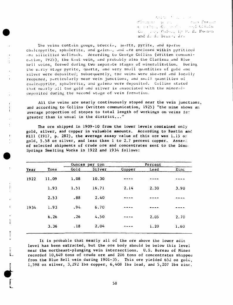
,.",:;. ,' \> , , : .,;> i or ,L : I ' '; , C . ,' ' ' ' , i d i I I. i
arid A. A. In «..,. , Jr.
The veins contain gouge, breccia, ju.trtz, pyrite, and sparse chciJ copyr ite, sphalerite, and galeiui, and are enclosed within pyritized ,mu silicitied wallrock. According to George Collins (written comuiuni- c^tion, 1923), the East vein, and probably also the Clarissa and Blue Bell veins, formed during two separate stages of mineralization. During the e-rly stage pyrite, quartz, and very small quantities of gold and silver were deposited; subsequently, the veins were sheared and locally reopened, particularly near vein junctions, and suu.lJ quantities of cualcopyrite, sphalerite, a;id galena were deposited. Collins stated that nearly all tne gold and silver is associated with the mineral- deposited during the second stage of vein formation.
All the veins are nearly continuously stoped near the vein junctions, and according to Collins (written communication, 1925) "the mine shows an average proportion of stopes to total length of workings on veins tar greater than is usual in the district..."
The ore shipped in 1909-10 from the lower levels contained only- gold, silver, and copper in valuable amounts. According to Bastin and Hill (1917, p. 282), the average assay value of this ore was 1.15 o? gold, 5.58 oz silver, and less than 1 to 2.7 percent copper. Assav:. of selected shipments of crude ore and concentrates sent to the lean Springs Smelting Works in 1922 and 1934 follows:
Year
1922
1934
Tons
11.09
1.93
2.53
1.93
6.26
3.36
OuncesGold
1.08
1.51
.88
.94
.26
.18
per tonSilver
10.30
16.71
2.40
6.70
4.50
2.04
PercentCopper Lead
2.14 2.30
---_
2.05
1.20
Zinc
----
3.90
-___
2.70
1.60
It is probable that nearly all of the ore above the lower adit level has been extracted, but the ore body should be below this level near the northeast-plunging vein intersections. U.S. Bureau of Mines recorded 10,649 tons of crude ore and 206 tons of concentrates shipped from the Blue Bell vein during 1901-35. This ore yielded 652 02 gold, 1,598 oz silver, 3,292 Ibs copper, 6,408 Ibs lead, and 5,207 Ibs zinc.
58
Comstock mine (F-II, 6)
Development.--385-foot shaft and about 1,000 feet ot drift. Third level connects to fifth level of Doves Nest mine.
Production.--2,042 tons of smelting ore and 159 tons of concentrates shipped from 1902 to 1917 contained 800.33 oz gold, 26,141 oz silver, 3,782 Ibs copper, and 451,731 Ibs lead. Mine produced $200,000 in ore prior to 1899 (CallDreath, 1899).
Veins.--Comstock: Strikes N. 70° W., dips 65° NE.; part of the J. L. iJnerson-Gem vein system.
Vein minerals.--Galena, silver, sphalerite, chalcopyrite, pyrite, and quartz.
Tenor.--Smelting ore shipped from 1902 to 1917 averaged 0.35 oz gold per ton; 11.4 oz silver per ton; and 9.7 percent lead.
59
'..ornucupia adit (F-V, 4) ' ' '
The Curn.ic..,/1.1 unit au i L is on the west side of Cuica^ 1 .- <.r<t. ,foO feet north oi t lu mouth of Spring Gulch. Th<- adit is i/0 leMlong and bears N. JS) C) '.J. There are no stupes (ii/,. 18).
Tne Cornucopia vein follows a fault that strin.es about N. 40° '-.'. and dips b2 0 -6ti 1 ' XL., subparallel to the Idaho Spring iault which is 700. to lJbi> feet to the northeast. To jud;-e fro:;, the offset of rock units at tne surface, the vein occupies a i elt-lateral fault that tuu an a,.-.parent horizontal displacement of ah^ut 100 feet and uas laaiteu granite gneiss on the northeast side, and biotite gneiss, anphibulite, and granite gneiss on the southwest .side. Tin a;:; "n - bolite occupies an open sync line that plunges gently southwest. WiL tnis except io;., tiie rocks strike mainly northwest and dip gent ' v nort».
The Cornucopia vein is as much as 2 feet thick and consist:. .. ~ cark-gray tii.e-grained quartz that contains disseminated pyrite. Tex tures observed in a poiisned section indicate that the pyrite is granulated. sparse vugs in the quartz are filled with trace anoint- .,£ si'ita i er i te and hematite. Secondary copper sulfate minerals CCT..I- ;:'^:ily coat tne vein;, but primary copper minerals were not founa. 'i:r waiirocK on tue hanging wail is intensely altered and impregnate with pyrite; tnis zon^- of altered rock is at least 23 feet tniw^. beyono this zone tne rock appears fresh. N<_cn. the portal ana at $(- erai piaces along the drift, post mineralization faults have cut <~. orecciated the vein to form a white gouge. A chip sample tal-rn acr^ 24 inches of dark-gray quartz and pyrite assayed 0.02 oz goiu per £_ 1.28 oz silver per ton, 0.01 percent copper, 0.30 percent ieau, a:.. 0.29 percent zinc (analyses by J. E. Wilson, H. H. Lipp, D. L. i>Kinni_. and W. D. Goss). In mineralogy and grade the vein is similar to tu.ir of the adjacent Idaho Springs fault in the Wait ham shaft (F-V, 2"- and other mine openings.
60

Crocket :,hait ( L- IV, K)>- , _ < . ,,;, : : ,] -;.
(.-... . .i< ,. : . . , i^ n. i:. i:i-k-ve 1 opuic-n L . -- inc 1 ined -/haft, tu^-l A, A. lii^u. Jr.
Prpduction. --Crude ore and concentrates snipped froru 1908 to 193!> yielded 199.61 oz gold, 0,241 oz silver, 17,331 Ibs copper, 4,717 Ibs le.jd, .ind 430 los zinc. U.S. Mint records indicate that the mine was in operation prior to 1901, but production is not known.
Ve in. --Crocket, a footwail brancn ol the .'jtanley vein: Strikes N. 5/° L. , dips 80° NVJ.; a 4-inch to 2 i/z-ioot zone of fractured aiter«>«, pyriti^ed rock cut by veinlets of pyritt- unci o.ise-retal mineral.'-
Vein minerals.--Pyritc, g.ilena, sptialcrite, chalcopyrite, tennantiLc, and quartz.
Tenor.--14 lots of ore shipped to sampling works from 1891 to 19L- assayed 0.4 to 1.8 oz gold per ton, 13.2 to 88 oz silver per tor.. J.. . to 8.5 percent cooper, ^nd 8 percent or less zinc. Fourteen lots snu;n< between 1919 and 1922 assayed 0.27 to 1.32 oz goic per ton, 5. hu to 2_>.c. oz silver per ton, 0 to 2.40 percent copper, 0 to 4.75 percent le«Ao, .... U to 2.85 percent zinc.
L

L
nrr: A ./...,. . - ' -
Crown Point and Virginia mine (E-l, 4)
Development.--720-foot shaft, six levels, extensive stopes; cross cuts from third, fourth, and fifth levels connect to Williams mine.
Production.""5,564 tons of crude ore, 543 tons of concentrates shipped between 1901 and 1938 yielded 2,663 oz gold, 27,016 oz silver, 11,396 Ibs copper, 7,825 Ibs lead, and 3,274 ibs zinc; at least $500,00u produced before 1900 (Callbreath, 1899, p. 139).
Vein.--Crown Point: Strikes N. 50° W., dips 75° N.; part of J. L. Emerson-Gem vein system.
Wallrock.--Biotite gneiss and granite gneiss; lowest levels pos sibly in microcline gneiss.
Vein minerals.--Pyrite, chalcopyrite, tennantite, galena, sphalerite sparse chalcocite, bornite, ruby silver, and abundant quarts.
Ore body.--Large body of indefinite outline.
Tenor.--Four shipments of concentrates, totaling 8.33 tons, assaye-- 0.18 to 0.79 oz gold, and 6.15 to 15.05 oz silver per ton, and as mucr as 6.5 percent lead, 1 percent copper, and 2.9 percent zinc; 1,200 tor.^ of concentrates shipped in 1907 assayed 0.43 oz gold and 1.20 oz silver per ton, and 695 tons of concentrates shipped in 190i assayed 0.55 o^ gold and 2.95 oz silver per ton.
L'

I ' , . I . t *' . .. .v/; '.:/>: o . . ,';',':». tV
. . I i .,, I '
; -]i ' t, ; , 1 >:-i;:o SpringsCrystal adit (F-III, 6) ' ' ' ' C:ii ' 1 ' "^ GllpLn
., ( . ... by h. 11. KocnchDeve lopment . -- /'90- i ooL adit. ' "' - -^- < '-'».
ProducLion. --About $150, OUU prior to 188^ (Callbreath, 1899, p. 138); 480.12 oz ^old, 27,308.37 oz silver, 183 Ibs copper, 5,400 ibs iead, and J,i77 Ibs zinc was produced between 1888 and 1 9 i b .
. --Crystal : :>; rir.es N. 48° E., dips 73°- 89° N.%7 . ; alsoseveral si.iall nortn-northeast- and east-northeast- 1 rend in^ veins.
.' . i i 1 r. ^2:k . - - 'i)om inanely biotite gneiss.
Vein ininerals. --Pyritc , galena, sphalerite, and q
Tenor. --35 tons of smelting ore shipped between 1888 and 19 contained 0,15 to 3 oz gold per ton, 5.5 to 95 oz silver per toi. less tnan 5 percent copper, 3 to 17 percent lead, ana b tu 10 percent zinc .
63

.
De Lesseps mine (G-II, 26) -
Development. Inclined shaft that connects with 2 levels at depths of 82 and 160 feet and a 440- foot adit. The shaft workings connect with the Dexter adit.
Veins. De Lesseps: Strikes N. 80° E. , dips 60°-70° NW. Cross vein: Strikes N. 75° W. , dips 60°-85° NE.
Wa 11 rock. --Mic roc line gneiss.
Vein minerals. Galena, sphalerite, chalcopyrite, tennantite, quartz, and carbonate.
Tenor. 8.3 tons of ore shipped in 1893 assayed 1.03 oz gold, 32 oz silver, 11.5 percent lead, and 12 percent zinc.
64
Dexter adit (G-II, 27) f i- ;, C, ., i> L. H.t . : A. A. I - :,; . J *'.
The Dexter adit, near the head of Gilaon Gulch, gives access to the Dexter and the De Lesseps veins, and connects to the De Lesseps shaft workings. The claim was located and worked prior to 1900, but it was not mentioned by Bastin and Hill (1917).
U.S. Bureau of Mines recorded 179.5 tons of crude ore and 47 tons of concentrates shipped during 1917-46. This ore yielded a total of 86.99 oz gold, 2,724 oz silver, 7,258 Ibs copper, 74,461 Ibs lead, and 23,565 Ibs zinc.
The accessible mine workings (fig. 19) consist of about 270 feec of crosscut and 300 feet of drift, and connect to the first level of the De Lesseps shaft workings.
The wallrocks are pegmatite, migmatite, and biotite gneiss. Thest rocks are layers within the thick layer of microcline gneiss that croci out at the surface in this area. A northwest-trending bostonite porpnyry dike is exposed between the Dexter and the De Lesseps workings.
The Precambrian rocks are folded into a series of northeast-trending asymmetrical folds and terrace-type warps. Dips generally are moderate, but locally they are steep because of the intricate folding.
Two principal veins, the Dexter and De Lesseps veins, are exoose in the mine. These two veins intersect about 140 feet northeast c. the crosscut. Numerous minor unexplored veins and gouge-filled Irg. tures are present also.
The Dexter vein strikes about N. 45° E. and dips 60°-70° NW. It is narrow and barren in most of the accessible workings, but wnert stoped reportedly contained as much as 6 inches of silver-bearin galena-sphalerite ore. The wallrocks are sheared, silicified, ano pyritized adjacent to the vein and are cut by several small branch veins.
The De Lesseps vein strikes about N. 85° E. and dips about 70° NW. It ranges from 3 to 12 inches in thickness and consists of several 1- to 3-inch veinlets of white to clear quartz, pyrite, galena, sphalerite, rhodochrosite, chalcopyrite, and tennantite that cut silicified, pyn- tized, and sheared wall rock. Ore was probably localized by the inter- section of the Dexter and De Lesseps veins, for the stopes are near this intersection (fig. 19).
L65

' . .:; / i M,, . ' ',' > . 'u! i <:'. , ':.:.- l',\>r \ nt
' ' . C ! - -.j- (,: '. M i Oi 1,-jn Diamond adit (A-V, 1) (; ., ;. , : t r. ;., tt t .y jv _ };_ Moenon
a;,.] A . A . DiuiiiJ, Jr. By J. E. Harrison
The portal of the Diamond adit is on the south side of Trail Creek, at the west edge of the district (fig 1). The workings consist of b37 feet oi drift and crosscut (fig. 20). There is no known production.
Tne wallrock is garnet iferous biotite-quartz gneiss, which is part. of the Liotite gneiss unit, and sheared pegmatite. These rocks strike east-northeast to northwest and dip 30°-60° N. This variation expresses gentle undulations near the crest of an open anticline, the axis of which probably bears about N. 30 E.
The vein strikes about N. 80° E. and dips 30°-45° N. It consists of about 8 inches of brecciated wallrock that contains one or more veins, 1-3 inches tnick, of quartz, pyrite, chalcopyrite, galena, sphalerite, and caroonate. The vein is mostly gossan from the crosscut to a point 200 feet west along the drift, which is about 100 feet beio'? the surface.
Ine vein worked in tne Diamond adit is exposed and was stoned i: tne Little Johnie mine worKings in the Freeland-Lamartine distric: (Harrison and Wells, 1956, p. 10b-110).
66

Diamond Joe adit (E~.ll, 2) and Specie Payment mine (D-ll, 3)
Tne Diamond Joe adit in upper Virginia Canyon and the Specie Payment shaft on the west slope oi Bellevue Mountain are connected and develop the same vein system. The Specie Payment mine was opened in 1876 (iiastin and Hill, 1917, p. 28/) and was last worked in 1930. Apparently the Diamond Juc- adit was driven alter 1912 lor it is not mentioned by Hastin and Hill; it was beinp worked in 19JJ.
The Diamond Joe adit is 1,283 teet lon^,, has a general wester,,, bearing, and connects to tiie specie Payment mine through two raise:, and the 218-level (fig. 21). Tne Specie Payment shaft reportedi> has an inclined depth oi 585 feet (Bastin and Hiil, 1917, p. 286), but was flooded below the 338-level in 1953. The Gasoline inclint trom the Little Annie adit also connects to the Specie Payment workings (Bastin and Hill, 1917, p. 286), and the Diamond Joe adi: connects to the Two Brothers tunnel through an underhand stopc. In 1953, the Two Brothers workings directly below the Diamond Joe adit were inaccessible.
U.S. Bureau of Mines recorded 44,0/j tons oi crude ore an- 9,ib3 tons of concentrates shipped from the combined Specie Pavme;.: mine, and the Diamond J^e, Little Annie, and Mona aaits. This or. yielded 45,366 oz gold, 269,704 oz silver, 540,842 IDS copper 283,383 Ibs lead, and 38,799 Ibs zinc. The value of this ore ai 1955 prices would be approximately $2,100,000. Bastin and Hi,.. (1917, p. 287) reported that the Specie Payment and Little Annie mines yielded ore worth about $1,500,000 prior to 1912.
The wallrock on the adit level is mostly microcline gneiss, which contains lenses of pegmatite (fig. 21). Two dikes of bostonite porphyry cut the Precambrian gneiss in the Diamond Joe adit and the Specie Payment shaft (fig. 22). Biotite gneiss overlies the microcline gneiss and is exposed in the levels immediately above the adit level. The principal rocks on the upper mine level are migmatite, pegmatite, and biotite gneiss. These rocks have a general northeast strike and medium angles of dips. East of the 1283-raise they dip northwest and, west of the raise, southeast. An open northeast-trending synclinal axis is near the 1283-raise.
The Specie Payment and Diamond Joe workings develop a vein system that has a general near-east strike and a dip of 15°-75° N. (average about 40° N.). The vein system is complex and consists of several discontinuous subparallel interconnected branching veins. The Specie Payment shaft and most of the drifts are on the main Specie Payment vein. Just east of the shaft on the 338-level, a vein below the Specie Payment vein, called the footwall vein, is
67

;.:.>: A. A I.. :.,,;.
followed southwestward by the drift. 'Tin iootwall vein also is exposed in a crosscut and spur drift on the 218-level about 260 le<t west of tiie 1283-raise. The footwaii and Specie Payment veins join on the Diamond Joe 108-level, about 20 feet west of the 1283-raise. On the adit level the main vein is fairly con tinuous and has numerous branches. It has many local irregu larities in attitude. Its dip is in general steeper than on the upper ievels.
The Cross vein intersects the Specie Payment vein on the 33^- ievei near the western end of the 218-level (fig. 21), but i? crosses both the Specie Payment vein and the footwaii veins witi.^. noticeable displacement. It strikes about N. 50° E. and dips i\-' - 70° NW.
The more important veins of the Specie Payment vein system ran;. in width from b to about 24 inches. Locally they consist ot severu subparaiiel quartz-pyrite veinicts that traverse strongly silicin*^ and pyritized wallrock, and at other places they contain as much a-> 24 inches of nvrite, chalcopyrite, and sparse galena and sphalerite. Burnite :md tennantite are also present locally. Some purple riuor 1 occurs along loiiation planes and in tiny fractures in the v;aii" adjacent to the veins. Fractures filled by gray chal ceclonv ( : } 2 ' Lb<i sulticie veinlets. Zippeite, a secondary mineral that on :;.. formed after the mine workings were driven, coats the vein a r .u . _.. vails in the vicinity of dikes of quartz bostonite porpnvr
Ore shipped from the mines between iyl8 and 193^ snowea t. . following rariges in metal content: 0.22 to tj.47 oz gold ner to. 0.7A to 63.10 02 silver per ton, 0 to 34 percent lead, 0 to s.' percent copper, and 0 to 15 percent zinc.
The movement on the Specie Payment vein was small and lari'fiv normal. -Also, a small amount of left-lateral shift took place. The ore bodies are small and discontinuous and the factors thai localized them are not known.
68

.' ! .'. < . I ./I,'. Ji. ).'..>'-;ic;l, A. A. / -., , . MJ -.
Donaldson mine (C-1V, 13)
The Donaidson mine is on the crest and north slope of the ridge tin-it divides Spring Gulch and Trail Creek, about 2,500-3,000 feet southwest oi tiie mouth of Trail Creek (fig. 1). It is opened by a shallow shaft and several adits, 100 ieet or less vertically apart, tnat are driven on the steep east flank of the hill (fig. 1). The upper adits and tne workings from eacii are shown on figure 16; the lower adits are shown in plan on figure /3. /-.side from adit 6 (C-1V, 13) the adits are not identified separately on figure 1. Only adit levels -», i) , and 5 were accessible in 1954. Large stopes are probably distributed on all levels, for some were noted on tne lower levels mapped during our investigation (fig. 23), and otiiers arc reportec on the upper levels (Spurr, Garrey, and Ball, 1908. p. 33-*- aitm.^n few are shown on figure 16.
Tae i. line probably has been a substantial source of ore, but prc- o_ct^wi-, records are scanty. U.S. Bureau of Mines recorded a total ui iZj L.ns of crude ore shipped from the Uonaldson, Kelly, and Wneatiar,'. :nes in 1916 and 1932-34. This ore yielded 37.66 oz gold and IDZ ox
silver. According to U.S. Mint records (Leech, 1890-1893), ore shipp< in I:;'j-i2 yielded 1,747 oz gold and 1,480 oz silver.
T:ie wallrocKS in tne accessible part of the mine are microcline gneiss, a single pod of biotitic pegmatite, and two types of porpnyry jiK.es (fig. 2j). The gneissic rocks striKe northeast and dip 3(J°-Hb° N*'. in most of the mine out dip b3°-7(j° near the portal of adit level '_.. They are in tigtit folds tnat are overturned to tne souineast and plun t e about N. 10° t. Trie di^ce rocks are quartz monzonite porpnyry, exposed on parts of both wails of adit level 5, and a biotite- qua rtz . .-tice porphyry dike exposed on levels 5 and o. Tne quartz monzonite porpi.vry is cut by the veins, whereas this rocK, the veins, ana <>. .ui-L-vre :v.inerai breccia are cut by the biotite- quartz latite. Tne Met ;te- quartz latite forms northwest-striking dikes and irregular or.-L5 trial roux;nly parallel tne vein (fig. 23); similar rock was
:i'ur._ ;y opurr, Garrey, and Ball (1908, p. 337-338) near the west end ot t..c Donaldson No. 2 adit and in the Kelly No. 4 adit (on the same vein). l^ e D iotite- quartz latite is light gray, dense to glassy, and locally porpnyritic. It has a flow lamination that parallels ttie tortaous contacts of the dike. One sample of this dike assaveu (analyzed by S. P. Furman and J. E. Wilson) 0.020 percent equivalent uranium and 0.013 percent uranium or considerably more uranium tnai: any ctner dike of this type (Wells, 1961).
4
Tne Donaldson vein and several related smaller branch veins have 5 been developed in the mine- workings. The Uonaldson vein also has bee; i vorkec in tne Kelly, Little Albert, and Champion Dirt mines to the
west arui in the ^he at land adit to the east (fig. 1). The Donaldsor.
69

vein strikes N. 45°-60° E., dips 25°-45° NW., and ranges in thickness from 1 inch to 3 1/2 feet. Locally, particularly on the No. 4 level, the Donaldson vein splits into several small veins. Where the vein is narrow it consists only of quartz and suIfides that locally exhibit comb structure; where it is relatively thick it consists of brecciated wallrock cemented by quartz and sulfides. The thicker vein sections have resulted from repeated movements along the vein during mineraliza tion. The rock between the vein branches is altered, silicified, and impregnated with pyrite. The rock adjacent to the narrow veins free of breccia is altered for distances of 3 to 6 inches on each side.
The Donaldson vein is a pyritic copper vein. Quartz and pyrite occur in about equal amounts and constitute most of the vein material. Chalcopyrite generally predominates over tennantite, but the two are subordinate in amount to quartz and pyrite. Galena and sphalerite are minor constituents. Other rare vein minerals are pearceite. hematite, and covellite. The pearceite occurs as blebs in pyrite and blades in galena. Native gold was noted along a boundary between quartz and tennantite and as blebs in tennantite.
Although the vein typically is a simple fissure filling, ore deposition was complicated by at least two periods of movement durir.;. mineralization, by postmineral brecciation, and by intrusion oi tn*. biotite-quartz latite dike rock. Fine-grained pale-yellow pyrit- and white quartz in the vein commonly are cut by fissures containi:., coarse-grained, yellow, cubic pyrite, comb quartz, and tennantitt chalcopyrite, and minor amounts of galena and sphalerite. Ine.s younger vein minerals generally are in the center of the vein Locally, the younger sulfides fill fractures that break sharpi> across the earlier pyrite vein material at an angle steeper tnan LH dip on the main vein, suggesting some downdip movement of the hangir.,, wall before or during the base-metal stage of mineralization. Locally the wallrocks and the early quartz and pyrite vein materials are brecciated and healed with coarse pyrite and dark sulfides. At other places all the sulfides are intensely brecciated, and fragments are embedded in a matrix of finely granulated rock and vein material.
Chip samples of those parts of the vein containing only quartz and pyrite and those parts containing base-metal minerals were assayed. (See following table.) The fine-grained pyrite, sample DL-6-7, was the earliest pyrite deposited in the vein. This pyrite and assoc iated quartz was brecciated and cemented by the relatively coarse grained quartz and pyrite (samples DL-4-6, DL-6-5, and DL-6-6). Locally the coarse-grained quartz and pyrite was brecciated and cemented by base-metal minerals and some pyrite; an analysis of this assemblage is represented by sample OL-4-5. As might be expected, silver and copper are most abundant in the base-metal-rich part of the vein.
f 70i.

.) . .,, ' , i ": .' I 1.;.-,r..<::3 .. i ;'..(' i " C. :. M.'i Gi J i^ .f i -;.:) :'..., Coi'>., t,y i,. H. l.'oonch h'j A. A. Drako, Jr.
Assays of selected samples from the tourthand sixtii levels of the Donaldson mine
Analyzed by D. L. Skinner and James Wahlberg_/
LaboratoryNo.
217567568569570571
FieldNo.
DL-4-5-4-6-6-5-6-6-6-7
OuncesGold
0.44.16.34.80.26
per tonSilver
6.58.30
1.503.92.54
Copper
12.50.01.23.01.03
PercentLead
0.89.63.39.33.38
Zinc
1.91.20
2.02.23.32
DL-4-5. Base-metal sulfide ore that cements breccia fragments. Allpyrite is excluded.
DL-4-6. A 2 I/2-inch vein of white and gray quartz and medium-grainedpyrite.
DL-6-5. Coarse-grained pyrite and quartz that cement breccia fragmentswidth is 8 inches.
DL-6-6. Coarse-grained pyrite and quartz; width is 4 incher DL-6-7. Fine-grained pyrite; width is 4 inches.
Idaho Springs Sampling Works assays of ore shipped between and 1935 follow:
Type of ore
Smelting
Concentrates
Smelting
Tons
1.13.61
1.246.263.952.14
OuncesGold
1.53.48.74.98
1.60.77
per tonSilver
3.8010.505.005.958.208.25
Copper
1.0011.05
3.056.003.80
PercentLead
X. « ~
0.20
Zinc
1.10
__-,
.30
LThe ore bodies in the Donaldson vein are localized at vein junction:
and at small deflections in strike. The shoots plunge nearly downdip and slightly west of north. Spurr, Garrey, and Ball (1908, p. 338) suggested that two vein junctions on levels 0, 1, 2, and 3 (fig. 16) are the sites of ore shoots. One of the junctions forms an ore shoot about 20 feet thick that plunges north to northwest between level 2 and the zero level. The other junction forms the western edge of the ore shoot that yielded most of the ore in the upper workings. This junction is exposed Dear the west face of level 4 (fig. 23), approximately at tht
71

we.M edge of a large stope that extends upward to level 3. Although the vein is stoped above level 4 nearly from face to portal, it is not stoped below the level. Only minor stopin^ was done on level i>; if this level were driven another 1!>0 feet, the downward projection of the main ore shoot should be encountered.
DEPARTMENT O r THE TKTEP10P
, -, r .and A A. i,. .;
L I
72
I .rAhTMUT 01' TiiS TilTEHlf'UTi:;) STAT-JO G:J'JLJC:CAL C/JKVEY
C , ck
Donna Juanita shaft (D-IV, 17) (Yr..: 0 i i p ; n H.
A
The Donna Juanita shaft on the floor of Clear Creek Canyon is collared in alluvial fill at an altitude of 7,668 feet (fig. 1). It is developed by a 423~foot inclined shaft from which 4 levels have been turned. Extensive stoping has been done from the lower levels (fig. 24). All workings were water filled at the time of this study. The shaft head and surface plant appeared to be in relatively good repair in 1954; records suggest that the shaft was sunk in the late i930 f s.
U.S. Bureau of Mines recorded 1,601 tons of concentrates shipped during 1940-42. This ore yielded 2,006 oz gold, 13,980 oz silver, 33,876 Ibs copper, 69,272 Ibs lead, and 29,039 Ibs zinc.
The wallrocks in the mine, as judged from their nearby surface exposures^ are biotite gneiss, pegmatite, and granite gneiss. These rocks strike northeast and dip northwest.
The Donna Juanita vein, which strikes N. 75°-85° E.' and dips 300-40° N. , is the principal vein in the mine. It is probably con tinuous with the Salisbury vein to the east, and to the* west it is exposed in the Donna Juanita adit. On the basis of the production records, it is probably a pyritic lead-zinc vein, and consists of quartz, pyrite, galena, sphalerite, and copper minerals.
The zone of stopes shown on figure 24 apparently defines an irregular ore shoot that plunges northeast at a moderate angle.
73

0?riJ FILE, 1966Miner, and c' , :rict. C
iri'i;. Col'., i.,/ A. A. Drake, Jr.
Idaho Springs fcr.d Gilpin
t. ii. ,Moench
Donna Juanita (D-IV, 18) and May Day or Ready Cash adits
The Donna Juanita and May .Day or RffatJy~Ca'§n"~adits are on the south jide of Clear Creek at altitudes of 7,692 feet and 7,702 feet respectively, the two adits bear southwest and are connected by a 90- foot crosscut. Ore oas been extracted from small s topes above both drifts (fig. 25-).
U.S. Bureau of Mines recorded 50 tons of crude ore and 15 tons of concentrates shipped from the May Day adit in 1920-22 and 1926-27. This ore yielded 32 oz gold, 237 oz silver, 291 Ibs copper, and 1,294 Ibs tine. The production from the Donna Juanita adit is not known.
Pegmatite and biotite gneiss, which strike N. 45°-85° E. and dip 45°-65° N. , and a subparallel dike of trachytic granite porphyry are the principal wallrocks in the adits (fig. 25). A 2-foot-thick sheet of biotite-rich pegmatite in the crosscut has a radioactivity of about 0.15 ftr/hr, or about 3 times the background.
The Donna Juanita vein strikes N. 55° E. , and dips 40°-55° NW. , ^parallel to the wallrocks. In the Donna Juanita shaft to the north- cast this vein swings to a more easterly strike. The vein consists of*bout an inch of white quartz and pyrite in a 6- to 2^- inch zone of altered rock.
Two veins, A and May Day, are exposed near the portal of the May Jay or Ready Cash adit. Vein A strikes N. 35° E. and dips 25°- 30° NW. , tnd the May Day vein strikes about N. 73° E. , and dips 40°-65° N. ; the tw veins join at the portal. Vein A is composed of about 4 inches of Quartz, pyrite, and gouge, the May Day vein is 4 to 6 inches thick and consists of vuggy white quartz and pyrite, and both are oxidized to about 3> feet from the portal. ^
A 0.69-ton sample of smelting ore shipped to the Idaho Springs**a?ling Works in 1934, either from the Donna Juanita adit or the ^»nna Juanita shaft workings, assayed 1.42 oz gold per ton, 12.60 oz*Uver per ton, 2 percent copper, 1.47 percent lead, and 2.80 percent
The intersection of the May Day and A veins apparently localized i for stopes above and below the adit level are at their junction, calculated plunge of this line of intersection is at about 32° W. 240.
74

Dover prospect (C-I11, 8) ' '' " ''' ' ", - > ., j .. j;i ' l ' I-- J - -. . ; , u^.
The Dover prospect is on the east side of Fall River, about 500 feet north of its junction with Clear Creek. It is opened by two adits which are connected by a cross drift, as shown on figure 26.
The wullrock throughout the prospect is microcline gneiss. The layering of the gneiss generally trends northeast and dips gently northwest except locally where it is deformed by open, north-trending folds.
The main drift follows the Dover vein, which strikes N. 25°-40° E. and dips northwest at medium angles. The south branch drift (fig. 26 V; follows a thinner footwall branch of the Dover vein, which strikes N. ?0°-90° E. and dips 43°-53° NW. Both veins are low in grade. The Dover vein consists of 4 inches to 2 feet of sheared silicified and pyritized vallrock and minor to moderate amounts of white postmineraj gou vv:e. The branch vein consists of 2 to 4 inches of quartz and pyrite, locally coated with secondary copper sulfate. This vein is oxidized for a distance of 25 feet from the portal.
A nor : hwest-trending fault cuts and displaces the Dover veir about; 420 ,eet from the portal and has a right-lateral shift of aDou: 7 feet. j> e fault probably correlates with the northwest-trendinr veir expos-d 600 feet from the portal in the Lawrence L (Philadelphia mine. Loc Hy it is mineralized and contains as much as 2 feet o. quarrz anc disseminated pyrite. Postmineral gouge is locally abundar"
Another northwest-trending fault is exposed at the northeast end of t-ne mai 7. Dover drift, but the workings on this fault are caved. This fault apparently is equivalent to the fault that is followed bv the ^tain southwest drift in the Lawrence L (Philadelphia) mine.
L 75

Doves Nest mine (F-I1, 7) ( '
Oeve1opment.--600-foot inclined shaft and 6 levels; about 1,000 feet of drifts. Fifth level connects to the third level of the Comstock mine.
Production. Reportedly about $350,000; the mine produced 1,568 oz gold and 20,237 oz silver in the years 1887 and 1890-92 (Kiraball, 1886- 1889; Leech, 1890-1893).
Veins.--Doves Nest: Strikes N. 60° W., dips 60° NE.; part of the J. L. Emerson-Gem vein system.
Vein minerals.--Galena, sphalerite, chalcopyrite, pyrite, and quartz.
Ore bodies.--Vein stoped on all levels; ore shoot appears to plunge steeply to the northwest.
76

<--> ' . < ,-.!.. ii. Druid mine (G-l, 2) ' ;. 1 . , . . ;
The Druid mine, near the head of South Willis Gulch, was opened sometime prior to 1904. It was active during the periods 1904 to 1925 and 1934 to 1942. U.S. Bureau of Mines recorded 34,108 tons of crude ore and 3,560 tons of concentrates shipped between 1904 and 1949. This ore yielded 21,753 oz gold, 310,363 oz silver, 529,748 Ibs copper, and 477,905 Ibs lead. The mine reportedly yielded about $367,000 prior to 1904, and the total production, reevaluated to the average 1955 metal prices, approximates $2,000,000.
Tne mine workings consist of the 480- foot Druid shaft, the Olc (SearLe) shaft which connects to the Druid 150- level, and numerous drifts, stopes, and levels (fig. 27). In 1954 all the workings were inaccessible, but Gollins (1913, p. 229-231; 1930, p. 264-265) ana Bastin and Hill (1917, p. 272-274) gave good descriptions of tne mine and much of tne following discussion is taken from their work.
Above the 350- level the wallrock is mainly biotite gneiss, buL below this level microcline gneiss predominates. An east-striking dike of bostonite porphyry is exposed on the 50- level of the Druid shaft and the 90-level of the Old shaft. The dike is not visible oi» the surface, nor is it cut on any of the other levels.
The Druid workings develop a series of subparallel veins thai strike K. 40°-70° E. and dip 55°-80° NW. These veins are members c* the Lake-Fronteriac-Druid vein system, which has been traced tor ove 2 miles in the district and extends northeastward into the Centra. City district.
The main vein of the property is the Searle (South) vein tnai is especially well exposed on the 150- , 200- , and 300-levels. 1.. shows great variation in thickness; in a few places it is narrow and nearly barren, but at places it attains a maximum thickness of 11 feet. The ore of this vein is generally similar to that of the Frontenac and A^uddell mines. It is a rich heavy sulfide ore bordered by pyritized reck. Polished sections of ore collected from the dump contain breccia red quartz and pyrite which are cemented by sphalerite, tennantite, enargite, chalcopyrite, and galena.
Ore shoots in the Druid mine and the Aduddell mine on the same lode are unique in that they are pipe like and apparently formed by replacement. According to Co 11 ins (1913, p. 229), the replacement ore bodies lie ro the north of and adjacent to the Searle vein and are very irregular in outline. The ore consists of galena, sphalerite, quartz, pyrite, chalcopyrite, and sparse sooty chalcocite that have preferentially replaced the more micaceous layers in the biotite gneiss. The fona of the replacement ore bodies, as inferred from stopes, is tnai of irregular vertical pipes from 10 to 30 feet long (strike length), - to 10 reet thic.t., and as much as 50 feet high. The distribution of the
77

ore minerals is more erratic than indicated by tin- stope form. Locally an ore body appears to end against completely barren rock. Tne bnrreri rock may be only a tew feet thick, and 6 to 10 feet of the ore may be tound behind the barren layer. Although replacement ore was found primarily in the biotite gneiss, it may also occur in microcline gneiss, as in the Aduddell mine.
The relation of the replacement ore bodies to the fissure fillings is not well understood. Collins (1913, p 223) interpreted the history of mineralization as follows: (1) formation of the replacement ere bodies; (2) fracturing of the replacement bodies and deposition ci pyrite in the Searle vein fissure; (3) reopening and brecciation oi the Searle vein; and (4) deposition of sphalerite, galena, and coppe- minerals in the resulting fractures. Bastin and Hill (1917, p. 27J, however, believed that the Searle vein and the localizing fissures oi the replacement ore were a phase of the galena-sphalerite-copper minera ization; and this interpretation seems most probable to us.
The coarse pyritic ore of the Searle vein contained 0.1 to 0.2 oz gold and 3 to b oz silver per ton. Enargite-rich ore contained 0.15 te 0.25 oz gold and 12 to 18 oz silver per ton. Galena-rich ore from tne Searle vein on the 300-level assayed 1 oz gold and 108 oz silver pe* ton. The average content of ore and concentrates shipped from Apri. to July 1911, was gold, 3.02 oz per ton, and silver, 30.17 oz per to. Some typical assays (Idaho Springs Sampling Works) of smelting oie ai: concentrates shipped from the Druid mine are given in the followi::, table.
I78

Ounces per ton PercentYearA wO. L Tons -
Gold Silver Copper Lead Zinc
Smelting ore
19191920192019211921
19211921192219221922
19221923192419241925
4.07 4.985.046.382.88
4.823.597.918.273.43
22.6814.806.152.569.29
0.91 1.721.02.502.13
.461.29.45
2.072.37
.51
.501.701.302.97
6 1 O. 12 ----
10.66 0.5022. 10 . 237.20 11.80
7.00 30. 42 . 6312.20 12.40 9.10
12.62 21.32 12.45 15.70 16.16
__ __1.65 .80
____4.95--_- .75
__ __.65
2.502.40----
1.80.23.32
----
1.60
3.15
__ __3.678.256.30----
Concentrates
1919191919191919
191919201922
4.805.1411.544.85
3.6512.827.04
1.32.87
1.981.72
.80
.712.28
7.90 0.2212.95 9. 35 . 1510.35
6.00 11.87 8.35
____
____2.50----
1.10
1.70
........
2.00
79

L L
hdgar mine (E-lll, U> ;.-.;!
The Edgar mine is about halt a mile nortn of the mouth ot Hukill Gulch. The mine working?; consist of a 252-foot inclined shaft, two main adits at altitudes of 8,159 and 8,240 feet, and more than 2,000 linear feet of drifts. Large stopes are present on all levels (fig. 28). The 8,159-adit level connects to the shaft, which connects to levels at altitudes of 8,080 and 7,907 feet. The 7,907- (or main) level connects to the Miami tunnel (F-1V, 3: fig. 1). The 7,907- (main) level also is connected to the Brown level of the Big Five tunnel (altitude 7,610 feet) through the Brown raise. The head of this raise is shown on figure 28.
Production figures are not available for the Edgar mine, and all production from the mine probably is included under the records for Big Five tunnel, for both the mine and the tunnel were under the same ownership. The records of the Idaho Springs Sampling Works credit the Edgar mine with a production of 916.5 tons of ore, valuec at $26,911.74 between 1920 and 1934.
The Edgar vein striK.es about N. 65° E. and dips between 70° N. and 70° S. The vein continues to the northeast, where it is deveiooea by the Edgar Extension mine (F-III, 8: fig. 1), and to the southwesc, where it is known as the Hukill vein, and thence the Stanley veiri. Many ot the workings in the Edgar mine are lagged, particularly ir the stoped areas, and little is known concerning the better parts or the Edgar vein. Where observed the vein consists of one or mor* subparallel anastomosing veinlets composed of quartz and sulfiat- minerals in a zone of intensely altered wallrock as much as 5 teei thick. Most veinlets are an inch or two thick, but some are a~ much as 8 inches thick.
At most places the Edgar vein cuts the wallrock layering at small angles. Locally it is parallel to the layering and many veinlets branch parallel to the layering, and die out a few feet from the main vein elements. The vein appears to be wider and richer in sulfides where it strikes more easterly than the average.
The dominant wallrock is complexly folded biotite gneiss, which is locally migroatitic. A few lenses of pegmatite, granite gneiss, and amphibolite, as well as a few Tertiary dikes, are shown on figure 28. The rocks strike northeast to east-northeast and dip between 70° N. and 80° S.
The Edgar vein is typically a zone of sheared, silicified, and pyritized wallrock and subparallel veins of quartz and pyrite, crossed by veinlets of galena, sphalerite, chalcopyrite, pyrite, tennantite, and minor amounts of covellite and pearceite. Locally, minor amounts of base-metal minerals fill vugs within the quartz-pyrite veins. Secondary siderite and anglesite were noted at places. The following
80

auo A . A . i-r;, i:< , ,; j
assays (Bastii; «md Hill, 1917, p. 360) indicate the abundance of base-metal minerals on the Brovm level:
Ounces per ton PercentGold Silver Lead Zinc
0.51
.48
39.50
67.20
17.00
26.50
10
15
Ore obtained in the early 1870's carried much more silver than any obtained after 1900, high-grade ore averaging 0.5 oz gold, 80 ui. silver, and seldom less than 45 to 50 percent lead (Bastin and Hill, 1917, p. 360). The silver-rich ore was probably taken from the surface and near-surface workings, and may represent ore that war enriched in silver. Idaho Springs Sampling Works assays of five typical shipments of concentrates shipped in 1925, 1926, 1927, 192V. and 1934 follow:
Tons
16.14
11.02
16.16
22.41
3.34
OuncesGold
0.895
.325
.89
1.72
2.04
per tonSilver
26.11
34.15
16.90
19.70
21.12
Copper
1.70
.23
.58
3.50
1.20
PercentLead
13. bt
16.00
10.73
2.00
8.70
Zinc
C ' " _* . -1 -
6. 2
2.b<
3. Or,
3.30
The apparent horizontal displacement along the Edgar vein is about 10 feet, the northwest wall having shifted northeast relative to the southeast wall (fig. 28). East of the shaft on the 8,159- level (fig. 28), the Edgar vein is displaced by a fault that strikes N. 10°-25° E. and dips 70°-85° NW. The east segment of the Edgar vein has been offset about 5 feet with respect to the west segment. This fault is concealed on the main level, but is probably the same fractur? as that exposed in the Fulton drift 210 feet west of the Big Five tunnel; it may correlate with the Jennie Lind No. 1 vein, the Aurur. vein (fig. 1), and the north-northeast-bearing vein in the Great American adit, and in the Great American drift in the Big Five tunnel.
Ore controls in the Edgar vein appear to be related to changes in the attitude of the vein. The thicker parts of the vein and stoped are, are on the more easterly trending parts of the vein, in accord with tht right-lateral displacement. Ore may also be localized where the vein intersects the series of folds near the northeast end of the main level (fig. 28).
81

Edgardim- mine (G-1II, 12)
Deve1opmen t.--Sha ft connecting to extensive drifts, and two short adits.
Production.--300 tons of crude ore and 10 tons of concentrates shipped in 1905 yielded 30.85 oz gold and 26 oz silver.
Vein. Edgardine: Strikes N. 60° E. , dips 60°-70° NW. , part of Treasure Vault vein system.
Wallrocks.--Biotite gneiss, and migmatite in adit; microcline gneiss in shaft.
Vein minerals.--Galena, sphalerite, pyrite, copper minerals, quartz, and rhodochrosite.
Tenor.--722 and 930pounds of smelting ore respectively assave- 1.25 oz gold and 4 oz silver per ton; and 0.3 oz gold and 13 oz silve: per ton, and 2 percent lead and 7 percent zinc.
82
Edgar Extension adit (F-I1I, 8)
The Edgar Extension adit, on the southwest side of Virginia Canyon about 1 mile north of Idaho Springs, is developed by a drift adit which bears S. 50° W. (fig. 29). In 1954 the adit was caved at a stope 330 feet from the portal. There is no record of production from the property.
Biotite gneiss is the principal wall rock, but two small conformable pegmatite bodies are exposed in the adit. The rocks are complexly folded. The adit follows the axis of an asymmetric anticline that plunges about 30° N. 50°-65° E. The northwest limb of the anticline dips steeply to the northwest, whereas the opposing limb dips north east at medium angles. Other folds have axes that trend about N. 70° L. and plunge northeast.
The vein exposed in the adit appears to correlate with the Edgar vein worked in the Edgar mine about 3,000 feet southwest, but it may be a branch from this vein. In the Edgar Extension adit, the vein strikes N. 50° E. , dips steeply northwest or southeast subparallel tc the wall rocks, ranges in thickness from 1 inch to 3 feet, and consists of several anastomosing veinlets. Pyrite is the most abundant suifidc and small pods and veinlets of galena and sphalerite are present.
r iI
83
',' " L;i>. i.::,r ..uii- i ', -t tin head of drdi^.M) Gulc.h. n*...r L'n. i » . ' L .. i i w , _ '"'luii., .,; ii.,, (julc.li uiid Clt-.ir Creek Lanyun. it i. ijp«.-n<n'
v- JL r.wc . 1- i i ciii.1 i :.. i^iL ,>n the England vein, fro;; wr.icn ir rlnwest- -.i : LI., rf'i».,^'jt ciMiiiftt i <. ^ ...tiort drift i>n tin- Houst "i, vi:,. .1 .-.u.iilo
"oln veinLit en ;,uiu on Lii<- iiou.',L"ii vein. /.''., r i. ;:.; 'L:.; i n 1 mini i i ;. . JO).
'1..S. Burt-flu ot Milieu recordt-d i j tons of cruue ore, proba'uivthe noasLor, vein, shipped tro'-,> Lhe hngland mine in 10J2. 'Hiis or_yielded zA.26 oz gold and j/ oz silver.
Hicrocline gneiss is the predominant walirock in the access IL workings, and a few layers of pegmatite and amphiboiite are exposc-' (fig. 30). These rocks strike about N. 50° E. and dip 40°-70° NV.
IVo prominent veins, the England and Houston, ar^ exposed in accessible workings. The England vein, probably the southwestwtir extension of the Lincoir, vein, striken II. 4 i3°-75° E. and dips ^n-_- N"^. , subparaliei to titC layering oi the wa]Jiocks. lin- vein >.. la u inches thici-. ano loc it. oxidized to 4'T feet ir ^if quartz, pyrite, galer-."; pyrite, sp'.a] c-r i tc. , and e vibibie secondary minerai as much as 6 inches on fc«-
ally splits into subu::r ' i 1 1- i st_-v/me:... .--, Lf»- portni. Where unoxioizc^. it ^ , :i,c K^.A!] amounts u; tennantite, -t.; i^.rKiii-. Chnlrrvite an.: covcj.ixL.fc ai« ; . The waiirock is altered and pyr 1 1 . cii side of trie vein.
The Houston vein, which is 320 feet northwest oi" the Lnxianu v«_- probably crosses the Tyson-Edward vein to the southwest, as snov- fi>:ure 1. The Tyson-Edward vein was not recognized in the crossc... ana these veins probably intersect above the adit level. The HOUSI.J- vein was also traced about 2,000 feet northeast to the Annie adit. It striK.es N. 50° E. , and dips 35°-60° NW. , and is subparaliei to tit; waiirock layering, so that curvatures in the vein are controlled ; pert by warps and folds in the wailrocks. The vein is 3 to b incru thick and is symmetrically layered, consisting, from the walls inw.ir^, oi intergrown coarse-grained white comb quartz and cubic pyrite, coci t bv intergrown coarse-grained sphalerite, cha Icopyr ite, tennantite, am, galena. Galena is the most abundant base-metal sulfide. Secondcr\ cerussite and covellite can be seen at many p'aces as replacements o: gaiena. A chip sample across the Houston vein assayed 0.52 oz eel* 1 per ton, 1 i . DO oz silver per ton, 11.18 percent cooper, 13.02 percent lead, and 1.33 percent zinc (analyses by D. L. Skinner and James Wan 1 berg) .
Most of the Houston vein is at the center of a zone of alters rock as much as 2 feet wide. At one place, however, the vein deiiect sharply from the center to the margin of this zone and back aeair. This relationship indicates that the ore was emplaced after the TOCK: were altered and subsequently reopened.
84

Esmaralda and Ottawa mines (G-lLi, 8, 9)
Development.--Two shafts and short drifts that connect the Esmaralda and Ottawa mines.
Production.--228.76 oz gold, 14,159.17 oz silver, and 7,733 Ibs lead was produced during the years 1887-92 (KimbaJl, 1886-1889; Leech, 1890-1893).
Veins. --Esmaralda-Ottawa: Strikes N. 5U° L. , clips 75° NW. to vertical.
Wall rock.--Dominantly biotite gneiss.
Vein minerals.--Pyrite, chalcopyrite, sphalerite, galena, tennantite, and quartz.
Tenor. --1.3b tons of smelting ore shipped to the Idaho Springs sampling Works in 1927 assayed 0.53 oz gold to the ton, 61 oz silver to tne ton, and 3.15 percent zinc. The silver may have been secondari! enriched.
85

l
L
Ktna adit (G-ll, 24)
The Etna adit is near the head of Gilson Gulch, about 420 feet S. 13° W. from the Minott shaft of the Sun and Moon mine. There is no record of production from the adit. The property is developed by a 230-fool drift adit that bears N. 58° E. (fig. 31).
The adit is in amphibolite that contains some' layers of pegmatite, or which only two bodies are sufficiently thick to be shown on the map. The pegmatite is sheared and moderately well foliated. The foliation in a) 1 rocks strikes northeast and dips 40°-63° N"W.
The adit is driven on a small vein that strikes N. 56° E. , dipj. 3 t>°-63° NW., and is 1 to 4 inches thick. About 33 feet from the porta; the vein is 2 inches thick and consists of quartz and moderate amounts of galena and sphalerite. About 100 feet from the portal the smai. vein is joined from the northwest by a larger vein, the Etna, whicr strikes about N. 60° E. and dips 34°-69° NW. The Etna vein is 12 to 3b inches thick. Both veins show small left-lateral displacement, tht hanging walls having moved southwest relative to the footwalls. Iitt thickening of the Etna vein is in harmony with the left-lateral dis placement.
A 10-inch chip sample across the Etna vein at the face of tnedrift assayed 0.16 oz gold per ton, 6.34 oz silver per ton, 1.33 percen;copper, 2.87 percent lead, and 11.94 percent zinc (analyses hv :-,, .Furman, D. L. Skinner, and E. C. Mallory, Jr.).
86

L
L
A . A . i t . ' , .J ;
Forge Hill (Fairmont) adit (t-1, 17)
The Forge Hill adit, also known as the Fairraont adit, is on the west slope of Pewabic Mountain, northeast of the J. L. Emerson-Gum vein system. The property probably was opened in the 1880's, and it was worked sporadically until 1935 and again in 1954, 1955, 195/, and 1958.
U.S. bureau of Mines recorded 881 tons of crude ore shipped between 1918 and 1958. This ore yielded 28 oz gold, 1,424 oz silver, 1,332 Ibs copper, 29,9J2 Ibs lead, and 14,0b2 Ibs zinc. The most productive year recorded was 1955, when b39 tons was shipped.
The Forge Hill adit is about 800 feet long and trends nortn- northeastward (fig. 32). Drifts have been driven on three veins.
Tne wallrocks of the adit are largely biotite gneiss ana a small amount of pegmatite. These rocks strike variably from northeast tu northwest, and dip predominantly east to north at medium to low angles.They are cut by a dike of quartz bostonite porphyry thatN. 52 £. , uips 75° NW. , and averages about 35 feet in width (fig. 3z;.
Altnougn several veins are cut by the adit, only the Roscoc , Fainnont, ana Forge Hill No. 2 veins nave been mined to anv extenL. Host of ine ore produced froi.i ttie auxi has come from the Fairmont v<_^..
Tne Koscoe vein strikes N. 70° E. , clips 50°-7U° NW. , anu ranr- rroiii 6 to about 24 inches in width. Generally the vein is poo::: 1 ' ninerulized, but near the face of the east drift it ha? u o.-inch stre~i: on the footwall composed of galena, sphalerite, and minor amounts _ pyrite, chaicopyr ite, and tennantite. Several branch veins .Leave t:. Roscoe vein and pass into the hanging wall and footwali.
Tne Fairmont vein strikes N. 85° W. , dips 50°-85° N. , and ranges from L> to about .24 inches in width. At most places it is narrow anu contains minor amounts of pyrite, quartz, chaicopyr ite, galena, and sphalerite, Dut locally, as at the face of the east drift, it contains abundant galena, sphalerite, and minor amounts of pyrite, tennantite, quartz, and chalcopyrite (fig. 32). The galena and sphalerite are coated by a thin film of covellite at most places in the workings. The north segment of the bostonite dike has been shifted about 7 feel to the west by movement along the vein (fig. 32). The vein widens near strike changes, in accord with tne left-lateral displacement. It was being mined in 1954, and probably yielded the recorded ore produced in 19:><*, 19}5, 1957, and 1958.
The Forge Hill No. 2 vein, also known as the Tip Top vein, strikes N. 60° £. , dips 38°-58° NW. , and where exposed in the back of the crosscut consists of about 18 inches of pvritiferous gouge that is CUL by 1/2- to 1-inch veinlets of pyrite, chalcopyrite, and minor amounts of galena and sphalerite. Near the face of the west drift, the vein thins to about half an inch of gouge.
87

L
Foxhall tunnel (G-lII, 2)
The Foxhall tunnel, at the head of Seaton Gulch, was started prior to 1900 and was worked until 1922. It was probably reopened in the 1930's but no record of such work is available.
U.S. Bureau of Mines recorded 12,740 tons of crude ore and 339 tons of concentrates shipped from the tunnel between 1901 and 1922. This ore yielded 12,735 02 gold, 450,010 02 silver, 388,214 Ibs copper, 2,134,117 Ibs lead, and 211,867 Ibs 2inc. Most of this ore was produced from the Seaton vein, but between 1901 and 1909 some was produced from the Inter Ocean(?) and Total Eclipse veins. According to U.S. Mint records the mine produced 890 oz gold, 57,299 02 silver, 6,840 Ibs copper, and 60,988 Ibs lead between 1887 and 1892 (Kimball, 1886-1889; Leech, 1890-1893).
The tunnel is 1,309 feet long and trends N. 17° W. (fig. 33). Threeraain drifts have been driven from the tunnel and are acces sible for a few feet to a few hundred feet (fig. 33). The ground above these drifts has been largely stoped. A winze has been sun; from the main tunnel about 20 feet south of the Inter Ocean(?) drift, A level is turned from this winze at a depth of 150 feet (Bastin ar." Hill, 1917, p. 299). The win2e workings were inaccessible in 1953. A 100-foot raise from the Seaton drift about 440 feet east of tht- tunnel connects to the seventh level of the Seaton mine, and a winz> from which four levels have been turned was sunk about 700 feer eas. of the tunnel.
The wallrocks of the mine are largely biotite gneiss and sub ordinate amounts of pegmatite, amphibolite, and two dikes of bostonitv porphyry (fig. 33). Rock mapped as migmatite (fig. 33) is biotite gneiss that contains about equal amounts of pegmatite as thin, con formable layers. The Precambrian rocks strike generally east-northea.^' and are folded along east- to northeast-trending axes.
Several veins are cut in tne Foxhall tunnel, but only the Total Ecliose, Inter Uucan'/.'), and Seaton veins have been extensively mint^. Trie Duik of tue production was from the Seaton vein. Possibly tn»_ Inter Ucean(O vein of figure JJ was called the Casino vein by liastir, and Hill (Iyl7, p. 29S), but the Casino vein, as worked through tnu Casino tunnel anu shaft, is thought to cross or branch from the Inter Oct'..n(:) vein to the east of the Foxhail tunnel.
The Total Lclipse vein, cut about 365 feet from the portal, strict, anout N. ib E. and dips 60 -77 NW. As the vein is largely stooecj i, the accessible drift its mineralogic character was not seen. At place. the vein is a nearly barren fracture zone 2 to 24 inches wide, but at other places it contains as much as 12 incues of pvrite-bearing gra. quartz. Probably it also contains some galena, sphalerite, and copou; minerals.
r 88L,

The Inter Gcean(Y) vein, cut about 165 feet nortn ol the Total Eclipse vein, striKes about N. >0° L. and dips 68°-85° SE. Several branching fractures pass Iroui tne vein into tue hanging wail of the drift. The vein lias been largely stoped out, and little could be seen of its mineralogic character. About 60 feet west of the tunnel it consists of 12 to 18 incnes of silicified rock cut by several gouge-filled fractures. According to Bastin and Hill (1917, p. 299;, the vein (called tne Casino vein by them) on trie subievel about 9j feet west of the shaft consists of tnree narrow veiniets 1/2 to ^ inches tnick that lie nearly parallel to the foliation. The veinieti. contain fine-grained sphalerite, galena, tennantite, ana subordinate amounts of pyrite in a gangue of gray quartz and rhodochrosite(. /.
Another small vein is cut about 297 feet north of the Inter Ocean(?) vein. It strikes N. 77° E., dips 70°-80° NW., and is a 1k- to 18-inch fracture zone that contains a few veinlets of galena and sphalerite. The vein parallels overturned fold axes.
A thin vein about 340 feet north of tne Inter Ocean(?) possibly correlates with the Casino vein.
The Seaton vein, cut about 1,173 feel from the portal, averaee^ about 2 feet in thickness and is made up of several imbricating sub- parallel vein elements th*t have a general N. 80° E. trend. it. : < highly variable in dip, ranging from a3° to 70° NW. suoparaliei i. the waiirock foliation. Near the caved part 01 tne west drirt. tnie- separate veins are present. The footwaii vein consists ot t> incti'j; of gouge and sparse pyrite. The connecting vein is composed oi . inches of sphalerite and galena, and the hanging-wall vein contains about 12 inches of gouge and half an inch of galena. About 65 fee-: east of the tunnel the vein contains as much as 8 inches of sheare^ galena, sphalerite, and a minor amount of lateO) pyrite. The vein in the winze consists of gouge, altered and pyritized wallrock, and a 5-inch band of galena, sphalerite, and subordinate pvrite and quartz (Bastin and Hill, 1917, p. 296). The grade of ore frorm the Seaton vein is variable. Tennantite-rich parts of the vein are reported to contain high values in silver; a specimen from the winze, just belov the tunnel level, assayed 1 oz gold and 118.4 oz silver per ton (Bastin and Hill, 1917, p. 296).
Twenty-seven lots of ore shipped to the Idaho Springs Sampling WorKS oetween 19UZ and 19 ID assayed U. 12 to 2.35 (avg 1.13) oz goi^; per ton; 7. D to 1U5 (avg 39.66) oz silver per ton; 2.3D percent or less copper; 2b.4 percent or less lead; and 24 percent or less zinc (Bastin and Hill, 1917, p. 296).
F*

L L f
ar:d A. A lj; .,;, , j : -.
Fraction mine (B-V, 5, b)
The Fraction mine, in the southwest part of the Idaho Springs district, is opened by three shafts from which several levels have been driven and a crosscut adit (fig. 34). In recent years the principal access has been through the Collie adit. Owners of the Fraction mine refer to workings developed through the Collie adit since 1933 as the Kitty Clyde Mine, even though the Collie adit workings connect to the Fraction mine to the east, and not to the Kitty Clyde shaft on the same vein a short distance west of the mapped area (Harrison and Wells, 1959, p. 69).
According to Spurr, Garrey, and Ball (1908, p. 351) at the time of their study, the mine had produced ore that yielded $75,000 to $100,000. U.S. Bureau of Mines recorded 593 tons of crude ore and 26 tons of concentrates shipped from the Fraction shaft between 1902 and 1934. This ore yielded 1,040 oz gold, 10,947 oz silver, 736 Ibs copper, 2,193 Ibs lead, and 815 Ibs zinc. The records also show that 258 tons of crude ore and 132 tons of concentrates was shipped from the Collie adit between 1933 and 1959. The most produc tive year was 1959, when 134 tons of crude ore was shipped. The total yield of ore from the Collie adit was 251 oz gold, 5,166 o? silver, 17,616 Ibs copper, 56,610 Ibs lead, and 957 Ibs zinc.
Microcline gneiss and amphibolite are the principal walirocks on the Collie adit level (fig. 35). Both rock types are interlavere; with one another and locally on such a scale that individual iayer~ cannot be separated at the map scale. These rocks strike northeast and dip northwest at medium angles.
The Fraction vein is an important part of the Fraction-Lincoln vein system (fig. 1), which can be traced southwestward from near Clear Creek to the Kitty Clyde mine of the Chicago Creek area (Harrison and Wells, 1959, pi. 2). Northeastward from the Fraction mine, the Fraction vein was traced on the surface through the Banty shaft (C-V, 4) and beyond.
At the Fraction mine the vein strikes N. 55°-75° E. and dips 30°-50° NW., subparallel to the rock layering. In the Collie adit level, the vein cuts amphibolite and microcline gneiss, but near the Fraction shaft it follows the contact between microcline gneiss and biotite gneiss. The vein splits into two branches 220 feet southwest of its easternmost exposure on the Collie adit level (fig. 35). The two branches diverge to the southwest and the main drift follows the southeast branch.
The Fraction vein is a pyritic lead-zinc vein. It is a simple, symmetrically layered vein 2 to 6 inches thick that contains pyrite, sphalerite, galena, chalcopyrite, abundant quartz, subordinate siderite and barite, and sporadic wolframite. The wolframite occurs
90

as red-brown randomly oriented blades intergrown with quartz in the outermost parts of the vein. A trace of covellite was the only secondary ore mineral seen. Galena and sphalerite predominate over the other base-metal sulfides in the northeastern part of the mine, whereas chalcopyrite and tennantite predominate in the southwestern part.
A chip sample from the southwest part of the Collie adit assayed 0.32 oz gold per ton, 4.30 oz silver per ton, 4.10 percent copper, 1.31 percent lead, and 1.29 percent zinc (analyses by J. E. Wilson, H. H. Lipp, D. L. Skinner, W. D. Goss). This sample shows considerably more copper relative to lead than typical ore from the Fraction mine. Assays of typical ore shipped to the Idaho Springs Sampling Works from the Fraction shaft and the Collie adit are shown in the following table:
Ore Type
Concentrates
--do SmeltingConcen
tratesFloats
Not specified do do do
Tons
2.585.124.48
4.20.38
1.511.272.812.05
Ounces per ton
Gold
Fraction
0.8451.16.545
.84
.62
Collie
0.681.311.221.22
Silver
shaft
9.6518.2515.30
12.4616.85
adit,
3.457.257.005.00
Percent
Copper Lead
, 1920, 1921
1.59 2.182.17 13.302.14 27.93
.28 6.431.50 6.86
1935, 1936
1.75 4.00 * on -----D. 7V -----
o 60
Zinc
3.2014.0016.60
3.718.65
0.90.701.501.00
Spurr, Garrey, and Ball (1908, p. 351) reported that ore in the Fraction mine occurs at the junction of veins. In addition, ore bodies are localized where the vein is deflected to a more easterly strike. These ore bodies plunge nortn-northeast.
91
Franklin No. 73 mine (H-1I, 1)
Development.--670-foot inclined shaft, 7 principal levels, and several sublevels and winzes, not shown on figure 39. Workings con nect to the Franklin No. 87 mine on the east and the Freighters Friend mine on the west (fig. 39).
Production.--Pre-1952 production combined with Silver Age tunnel. Mine reopened in 1956; 1,382 tons of smelting ore shipped between 1956 and 1959, yielding 273 oz gold, 8,354 oz silver, 5,400 Ibs copper, and 90,500 ibs zinc.
Veins. Franklin-Freighters Friend: Strikes about N. 70° W., dips 45°-60° N. Washington(?): Strikes N. 60° E., dips 50°-65° NW. Washington vein apparently joins Franklin-Freighters Friend vein west of the shaft. A northeast-trending right-lateral fault shifts Franklin vein about 20 feet on levels east of shaft.
Wallrocks.--Micocline gneiss and albite granodiorite porphyry.
Vein minerals.--Galena, sphalerite, silver, gold, tennantite, chalcopyrite, pyrite, quartz, rhodochrosite, and barite.
Ore bodies.--An ore body as much as 14 feet wide occurs near the intersection of the Washington(?) and Franklin veins. Ore is best near connection to Freighters Friend mine.
Tenor. 1,334 tons of crude ore shipped from 1947 to 1951 averagec 0.16 oz gold per ton and 4.91 oz silver per ton; 3.96 percent lead; and 4.74 percent zinc; 312 tons of concentrates shipped from 1947 to 1951 averaged 0.74 oz gold per ton, 30.96 oz silver per ton, 27 percent lead, 12.7 percent zinc, and 1.3 percent copper; 1,382 tons of crude ore shipped from 1956 through 1959 averaged about 0.2 oz gold, 6 oz silver, 0.2 percent copper, and 3.3 percent lead.
92

Franklin No. 87 mine (H-II, b)
Development.--450-foot shaft with 7 levels; sixth level is Silver Age adit and connects to Franklin No. 73 mine to the west; stope below bottom level connects to seventh level of Freeman mine to the east.
Product ion.--$250,000 prior to 1899; post-1902 production combined with Silver Age adit.
Veins.--Franklin: Strikes N. 80° W., dips 50°-60° NE.; 12 to 18 inches wide. Another element of Gem vein system is subparallel to the Franklin vein; wallrock between veins contains numerous thin sulfide veiniets.
Wallrock.--Microc1ine gneiss and albite granodiorite porphyry.
Vein minerals.--Galena, sphalerite, silver (some wire variety), tennantite, chalcopyrite, pyrite, white and gray quartz, rhodochrosite, barite, and siderite.
Ore bodies.--Stoped almost continuously from surface to bottom level. (See figure 40.)
Tenor.--Surface ores yielded $100 to $150 per ton prior to 1900, largely in silver from secondary minerals. Idaho Springs Sampling Works assays of smelting ore shipped between 1888 and 1910 averaged 0.15 oz gold and 23 oz silver per ton, 38 percent lead, and 18 percent zinc.
L
c 93

" '... c 4 . c 1 : . . L.. I 01.pinCfu.': ' . . C;- : . . : ./ /. ii.
Hrirt / A. Dra-e. Jr.
Freeman mine (H-II, 7)
Development.--720-foot shaft; the shaft intersects the Silver Age adit 330 feet below the collar.
Production. Combined with Silver Age adit.
Veins.--Franklin and Ship Ahoy: Franklin strikes N. 80° W., dips 65° N.; Ship Ahoy strikes about N. 85° E. , dips about 70° N., splits from hanging wall of Franklin vein.
Wallrock.--Microcline gneiss, subordinate biotite gneiss, and quartz monzonite porphyry.
Vein minerals.--Silver (some native), galena, sphalerite, pyrite, tennantite, chalcocite(?), quartz, rhodochrosite, barite, siderite, and calcite.
Ore bodies.--Vein is stoped almost continuously both above and below the Silver Age adit.
Tenor. 0.05 to 1.52 oz gold per ton, 4 to 161 oz silver per ton, as much as 40 percent lead, and as much as 20 percent zinc; copper- rich near surface due to secondary enrichment; copper-poor in lower workings.
94

' . Jc! . C-> . ' :.' ..:. i , -. , (oio. , * / ... 11 ./'. . A . £j u . (i , Jr .
Freighters Friend mine (G-I1, 29)
The Freighters Friend mine, in Gilson Gulch, was opened before 1900, and it was worked last in 1958. The most active periods since 1900 were between 1908 and 1912 and again in 1957.
U.S. Bureau of Mines data indicate that at least 6, 458" tons of crude ore and 1,295 tons of concentrates have been shipped from the mine since 1904. This ore yielded 3,446 oz gold, 28,931 oz silver, 18,607 Ibs copper, 221,277 Ibs lead, and 53,055 Ibs zinc. Probably much additional ore from the mine has been included with production from the Gem mine. Incomplete production data for the years 1890-9Z show 149 oz gold and 4,403 oz silver (Leech, 1890-1893), giving a mucn higher silver-gold ratio than post- 1900 production. This suggests that the early-mined ore was considerably richer in silver than that mined after 1900.
The mine is opened by an inclined shaf t--vertical depth 428 feet- from which 6 levels have been driven. (See figures 39 and 40.) The second level (fig. 39) connects to the Gem mine; the fifth level (not shown) connects to the Franklin mine through the Silver Age adit; and the sixth level also connects to the Franklin mine. A winze 260 feet east of the shaft on the sixth level (not shown) has been sunk about 141 feet, and a seventh level has been turned from this winze. Considerable stoping has been done on all levels both east and west of the shaft (fig. 40).
The predominant wallrock of the mine is microcline gneiss, whicn contains small layers of amphibolite, biotite gneiss, and pegmatite. A quartz monzonite porphyry dike is parallel to the hanging wall of the vein on the first level, and a large body of the same rock is south of the shaft on the sixth level.
The mine exploits a part of the Gem vein system, which in this mine consists of three principal veins--the Freighters Friend (Gem tootwall vein), the Gem hanging-wall vein, and the Washington vein. Most of the mining has been done on the Freighters Friend vein, but the Washington and Gem veins have been developed and stoped at places. All the veins strike about N. 75° W. and dip 35°-80° NE. They are largely composed of galena, sphalerite, and rhodochrosite on the upper levels of the mine, and of pyrite near the shaft on the sixth level. The ore in the Freighters Friend vein occurs in a poorly defined shoot that plunges about 50° to the east. The vein flattens markedly in dip below the fifth level in the shaft and most of the stopes .are above this level, suggesting that the ore occurs on the steeper parts of the vein.
Although half the dollar yield of the mine has been from gold, the veins do not carry large amounts of this metal. The avera,ge gold assay of a 100-foot section of the Gem vein, as exposed on
95
A .
the sixth level about 3^0 feet west of the shaft, is O.Jtt oz per ton over a width of 1 foot. The average gold assay of a 100-foot section of the Freighters Friend vein, starting 305 feet east of the snaft, is 0.18 oz over a 4-foot width.
Considerable amounts of ore may remain at depth in this mine. The main Freighters Friend ore body has not been extensively mined below the fifth level, and should extend a few hundred feet farther in depth. Moderately rich ore is exposed in the winze below the sixth level, and the ore bodies in the adjacent Gem mine extend far below the present workings in the Freighters Friend mine (fig. 40).
96

L
i
(.; .;, l\' .:, i. -. , i ..' ' arid A. A- L'r;.:-. ,-, Jr.,
French Flag mine (H-II, 12)
Development.--Shaft, 260 feet deep, with levels at depths of 95, 180, and 245 feet. Dogenas adit connects to the 95-foot level. The 180-level connects to the 80-level of the Silver Age shaft.
Product ion.--Combined with Silver Age adit.
Veins.--North Silver Age-French Flag-Gold Medal vein: Strikes N. 60° W., dips 60° NE.
WalIrock.--Microcline gneiss, pegmatite, biotite gneiss, quartz monzonite porphyry, and light-colored granodiorite porphyr>.
Vein minerals.--Galena, sphalerite, sparse pyrite, quartz, rhodochrosite, and barite.
97

('.', i . fc.n'1 A
L I
Frontenac (F-l, 2) and Aduddell (G-I, 3) mtnes
The Frontenac and Aduddell mines, at the head of South Willis Gulch, develop the same veins. The mines were opened in 1869 and were operated until 1894, when they were closed because of excessive water. The mines were reopened prior to 1902 and operated nearly continuously until 1922. They were active again from 1933 to 1940. Reportedly the mines closed in 1940 because of ownership difficulties, and not for lack of ore (R. R. Hinckley, oral communication, 1953).
U.S. Bureau of Mines recorded that the Aduddell mine produced 14,567 tons of crude ore and 1,102 tons of concentrates between 1906 and 1927. More than 90 percent of the total was shipped in 1906. This ore yielded 6,122 oz gold, 76,940 oz silver, 355,797 Ibs copper, and 484,387 Ibs lead. If produced in 1955, this ore would have had a value of about $463,000. The Aduddell mine reportedly producec ore worth about $900,000 prior to 1899 (Callbreath, 1899). The. Frontenac mine produced 51,746 tons of crude ore and 50,423 tons of concentrates between 1902 and 1940, which yielded 37,407 oz gold. 791,360 oz silver, 2,791,524 Ibs copper, 4,951,332 Ibs lead, and 125,765 Ibs zinc. At 1955 prices this ore would have a value of about $3,600,000. The mine reportedly yielded ore worth about $1,250,000 prior to 1899 (Callbreath, 1899). Of this total, about $980,000 came from above the fourth level (Bastin and Hill, 1917, p. 271). According to U.S. Mint records (Kimball, 1886-1899; Leecn, 1890-1893), the Aduddell mine in the years 1887-90 and 1892 produced 12,140 oz gold, 130,376 oz silver, 118,823 Ibs copper, and 203,055 Ibs lead. In the same years the Frontenac mine produced 33,771 oz gold, 251,208 oz silver, 481,923 Ibs copper, and 116,527 Ibs lead. The total dollar value of the ore from the two mines probably exceeds $6,000,000.
The mines are developed by four inclined shafts, an adit, and numerous drifts (fig. 36). The Argo tunnel passes beneath the Frontenac mine about 11,210 feet from the portal of the tunnel; the east drift (Druid lateral) extends more than 1,300 feet from the tunnel (Bastin and Hill, 1917, p. 304). All the workings were inaccessible in 1954, but the mines were examined by Bastin and Hill (1917, p. 269-271; p. 304-305) and much of the following is taken from their description.
The shafts are collared in biotite gneiss and pegmatite, but at depth pass into microcline gneiss, which is the prevailing wallrock in most of the workings.
The contact between the microcline gneiss and the overlying biotite gneiss strikes northeast and dips gently northwest. A bostonite porphyry dike was cut on the fourth level east of the Aduddell East shaft.
98

;,'',«. r - .. .-; C. . ;,
C> :.; .;, (,'. '. .. , \ j i\. II.. i.lo«-i,c;hctlld /. A. +j,l in.'J.», oi.'.».
The Frontenac vein system is made up of two, and in some places several, subparallel veins, The veins of this system have an average strike of N. 50° E.; they dip 60°-80° NW. and range from 4 to 7 feet in thickness. The two principal veins are referred to as the North and South veins, but their identification in all parts of the mines is uncertain. The Frontenac veins are part of the extensive vein system developed by the Druid and Kokomo mines to the northeast and by the Owatonna, East Lake, Lake, Bald Eagle, and Windsor Castle mines to the southwest. The relative movement in the Frontenac and Aduddell mines is not known, but in the East Lake and Bald Eagle mines the offset is right lateral.
Pyrite, lead-zinc, and highly siliceous replacement ores are present in the mines. The common minerals of the lead-zinc ore arc galena, sphalerite, chalcopyrite, tennantite, pyrite, and enargite. At many places, veins of quartz and pyrite are cut by veinlets of galena, sphalerite, and copper minerals (Bastin and Hill, 1917, p. 269-271; p. 304-305).
Throughout much of the Aduddell workings a highly siliceous replacement ore is associated with pyrite veins or is in separate ore bodies. A replacement ore body on the sixth level is 5 feet wide, and the ore minerals replace highly fractured microclinc gneiss. The more quartzose parts of the replacement bodies art generally richest in sulfides. All gradations exist from slight! to completely replaced microcline gneiss. Many of the suliide-ric.. parts are veinlike in form owing to complete replacement aiont. ~ number of subparallel fractures. Pyrite is the predominant sultiae of these bodies, and galena, sphalerite, and some chalcopyrite ar» also present. Rhodochrosite is present in a few places as a ganpu- mineral.
A vein known as the Flat vein is exposed in the Frontenac adit level and at places in the lower levels in the southwest part of the mine. It strikes about N. 60° E., dips 40° NW., and is nearly barren. Its relation to the Frontenac vein system is not known.
Two main ore shoots are present in the mines. One intersects the surface just southwest of the Aduddell East shaft and plunges southwest at a medium angle; the other intersects the surface at the Frontenac shaft and plunges gently southwest (fig. 36). The ends or the ore shoots were not reached during mining.
99

Assays from the Idaho Springs Sampling Works of selected shipments of smelting ore from the Frontenac and Aduddell mines are shown below. According to Bastin and Hill (1917, p. 271), 27,000 tons of smelting ore shipped from the upper levels averaged $23.30 per ton, and ore mined in 1912 averaged $25 per ton.
L
L
Short tons of ore
9.332.547. 146.59.5
54.49.32.53.810.3
9.89.93.04.97.0
11.49.3
22.76.3
OuncesGold
0.28.50.44.37.20
.44
.45
.94
.47
.35
.20
.57
.52
.20
.19
.20
.22
.18
.28
per tonSilver
11.7018.2422.0019.608.15
18. 1023.1023.5019.809.05
13.1514.4312.0012.3511.46
8.806.956.505.30
PercentCopper
2.004.454.503.102.10
4.404. 103.701.851.85
2.653.05
-.__ -...
Lead
6.006.806.906.20----
-___
--.-
..___-___
5.0014.3522.50
11.50_»-_
Zinc
1.502.00-__-.
----
4.00
-_--..._.
--__
1.206.5C
14.80
100
G and M (Centennial) adit (E-IV, 9)
The G and M (Centennial) adit ie on the west side of Hukill Gulch. It is a crosscut, driven 655 feet on a general northerly bearing, that intersects the Two Kings and Hukill veins (fig. 37). The Two Kings drift and shaft were caved in 1954, but according to Bastin and Hill (1917, p. 359) the drift extends 330 feet to the east.
Production from the adit has been small, and U.S. Bureau of Mines recorded 52 tons of crude ore and 2 tons of concentrates shipped from the Two Kings vein in 1910-14. This ore yielded 51.05 oz gold, 515 oz silver, and 920 Ibs copper. There has been no production from the Hukill vein.
The wallrocks are biotite gneiss, which is locally migraatitic, two bodies of pegmatite, and a dike of bostonite porphyry. The gneisses strike N. 65°-85 E. and dip 50°-70° NW., and are tightly folded near the face of the adit.
The Two Kings vein, which strikes N. 75° E. and dips 75° NW., is about 12 inches thick where exposed and consists of angular fragments of vein material and wallrock embedded in gouge. Fragments ot quartz pyrite, sphalerite, subordinate amounts of chalcopyrite, and a tract of galena and covellite are present. Sampling works assays of smeltin, ore, aggregating about 18 tons, showed 1.08 to 2.84 oz gold and 11 LC 24 oz silver (Bastin and Hill, 1917, p. 359).
The Hukill vein is exposed by a drift near the end of the adit. It strikes N. 77° E., dips 62° NW. to 76° SE., and is barren of sul- fides at this locality.
L 101

Galatea (Hudson-Burr) adit (H-II, 14)
The Galatea (Hudson-Burr) adit is in Silver Aj^e Gulch at an altitude ol 8,533 feet. It was opened prior to 1900, and wa» pros-
' pected sporadically since then.
iU.S. Bureau of Mines recorded a total of 38 tons of crude ore
, and 13 tons of concentrates shipped in 1915, 1935, 1944, and 1946. i This ore yielded 13.31 oz gold, 278 oz silver, 193 Ibs copper, and 7,205 Ibs lead. Production in 1915 was probably from the shaft
workings (H-II, 16).
The workings that were accessible in 1954 are shown on figure 3t The crosscut probably extends about 400 feet farther northward to thr
r Galatea vein, which also is developed by a shaft (H-II, 16), now | inaccessible. The adit crosses folded and sheared biotite gneiss,
roigmatite, pegmatite, and amphibolite. These rocks strike raainiy east to northeast, and dip 35°-80° NW.
i The S^ver Gem vein strikes N. 60° E. and dips 60°-70° NV.(fig. 38), and ranges in thickness from 2 to about 18 inches. It
f consists largely of gouge and several thin pyrite veiniets, but i. , the stoped crea it consists of several veinlets of galena, sphaientt-
chalcopyri; =? f quartz, pyrite, and sparse siderite. Slickenside striaon the veir wall are numerous and subhorizontal.
The G« .atea vein probably is cut in the caved extension of cn~ Galatea ad (fig. 38). The vein strikes about N. 80° E. and aip about 70° >"«. Ore on the dump of the Galatea shaft contains quart and pyrite, though undoubtedly base-metal sulfides and sulfosalt are present in the vein.
The Sc ,. Joseph probably also is cut by the caved extension of the Galatea adit, for it is known to lie between the Silver Gem ana Galatea vei - s . A shaft (H-II, 4), on the ridge between Elkhorn and Silver Age Mulches, develops the St. Joseph vein. This vein striker about N. 7:: ~ E. and dips 60° NW.
[ 102
L L
Gem mine (G-II, 13)
The Gem mine, on Seaton Mountain, is one of the largest and most productive mines in the district. It was opened long before 1900, and the last recorded shipment was in 1939. In this century the mine was most active prior to 1920, and since 1923 the largest yearly production did not exceed 200 tons. The workings were not accessible in 1954 and much of the following is taken from Bastin and Hill (1917, p. 290-292).
U.S. Bureau of Mines recorded total shipments of 99,789 tons c: crude ore and 34,659 tons of concentrates between 1902 and 1939. Pan of this production probably was from the Freighters Friend mine. wnic.. was operated by the Gem Company. This ore yielded 66,622 oz goio. 1,142,075 oz silver, 1,296,948 Ibs copper, 8,656,540 Ibs lead, anc 1,423,522 Ibs zinc. At the average 1955 metal price this ore woult4 have a value of about $5,277,000; gold accounts for nearly half the total. Considerable ore was produced from the mine prior to 1902. According to U.S. Mint records (Kimball, 1886-1889; Leech, 1890-1893;, the Gem mine produced 5,323 oz gold, 25,903 oz silver, and 24,923 ID* copper. The production to 1912 supposedly was about $2 1/2 million. It is probable that the total yield of ores from the Gem mine is wort; about $7 million at 1955 metal prices.
The Gem workings consist of an inclined shaft 1,420 feet aee: from which 16 levels have been driven (figs. 39 and 40). Tne Dian an sketch projection of the mine (figs. 39 and 40) do not agree, as tne were prepared in different years; however, they show the general rela tions of the mine workings. The Gem sixth level connects to the Freighters Friend second level (fig. 40). The Gem shaft joins a lateral from the Argo tunnel (Gem 20-level) about 150 feet east of the tunnel. A winze and short levels below the tunnel level increase the vertical depth of the workings to 1,504 feet. Much stoping has been done on all levels of the mine (fig. 40).
The predominant wallrock of the mine is microcline gneiss and Tertiary quartz monzonite porphyry is abundant on the 9th, 13th, 17t:4 , 18th, and Argo tunnel levels, particularly west of the shaft. Quartz monzonite porphyry is reported to occur on the footwall of the vein system.
The Gem vein, which strikes N. 75°-85° W. and dips 30o-80° N. (averages about 50 N.), is the most important part of the extensive J. L. Emerson-Gem vein system. In the Gem mine, the vein system con sists of two nearly parallel veins, 20 to 30 feet apart, known as the footwall and hanging-wall veins. From the surface to the 9th level, the Gem shaft follows the footwall vein; below the 9th level, it follows the hanging-wall vein. The Gem footwall vein is the Freighters Friend vein in the Freighters Friend mine. The rock between the veins is more or less altered and mineralized and at places has been stoped.
103

a; id / . /- . jui ....c , J ''
L
According to Bastin and Hill (1V17, p. 291), pyrite is the most abundant sulfide in the hanging-wall and footwall veins, and galena, sphalerite, chalcopyrite, tennantite (called tetrahedrite by Bastin and Hill), enargite, and bornite are present. Quartz is the dominant gangue mineral, and rhodochrosite is abundant. The rhodochrosite, base-metal sulfides and sulfosalts, and some quartz and pyrite occur mainly in veinlets that cut earlier-formed pyrite and quartz. A body of ore about 100 feet long by 100 feet wide on the 12th level near the Gem shaft carried gold telluride minerals, probably mainly
sylvanite.
The diversity in the mineral character of the vein in various parts of the mine makes it difficult to assign an average value to the ore. The average of 170 assays of samples cut in 1921 was 0.2o o^ gold and 6.73 oz silver per ton. Judged from the available sample data, the smelting ore from pyrite-type vein material contains fror 0.30 to 3 oz (average less than 1 oz) gold per ton and from 5 to Ji oz silver per ton. The base-metal sulfide ore, on the other hand i, richer. Samples of the so-called hazda ore body taken from the 16tn level indicate an average value of about $67 per ton at 1955 metai prices. The average assay of this ore body is 0.28 oz gold per ton, 10.4 oz silver per ton, and 16 percent lead. Assays of different types ore «ire tabulated by Bastin and Hill (1917, p. 291-292;.
The ore bodies are large, but the factors responsible tor localizing the ore are not known.
Much ore is probably present in the mine above the Argo tunnellevel, and chances of finding ore below that level are good We alsosuggest that Cue Gem hanging-wall vein be prospected above the 8th1 ~..^x 1level.
104
i-T
C- . i. . . , I-./ i:- 1!Mid /. . A . L ',...':, J X'
Gladstone mine (D-IV, 16)
Development.--A shaft, a 630-foot drift adit, and a 265-foot drift 75 feet below the adit connecting to the shaft and a winze.
Production.--A total of 413 tons of crude ore and 52 tons of concentrates were shipped between 1908 and 1921. This ore yielded 577.56 oz gold, 3,858 oz silver, 14,373 Ibs copper, and 1,623 Ibs lead.
Vein.--Gladstone: Strikes N. 65° E., dips 60°-70° N.; it is 2 inches to 1 foot thick.
Wallrock.--Biotite gneiss and pegmatite.
Vein minerals.--Pyrite. copper minerals, galena, sphalerite, and quartz.
105

l. l
(' ' .: ',;-i c ' , C -r C i ' ,- :i!> i
C . ' : ""i , Co '.">., t ;/ i/ . li . fI "i 1 .' . / - I ;. .. i-:c , Jr.
Gold Mt-clal (Silver Cycle or Wyoming Valley) adit
and Gold Medal shaft (I-III, 1)
The Gold Medal adit, also known as the Silver Cycle adit and the Wyoming Valley adit, is in lower Gilson Gulch about 1,700 feet S. 2° E. from the Silver Age adit; its location is not shown on figure 1. A shaft was driven on the Gold Medal vein, and the adit intersects this vein about 1,720 feet from the portal.
U.S. Bureau of Mines recorded 58 tons of crude ore and 36 tons of concentrates shipped between 1917 and 1928. Production prior to 1920 probably came from the shaft, and all later production came iron; the adit. This ore yielded 89 oz gold, 1,830 oz silver, 756 Ibs copper, 14,359 Ibs lead, and 9,398 Ibs zinc.
The drifts on the Gold Medal vein (fig. 41) are caved a short dis tance from the adit, but according to old maps they extend at least 430 feet farther to the west and 500 feet farther to the east. The west drift reportedly passes below the French Flag mine at a depth G- about 385 feet and connects to the Silver Age shaft workings. Some stoping has been done above these drifts, but the amount is not knowi
The Gold Medal shaft is inclined and follows the dip of the Gol. Medal vein. This shaft, inaccessible in 1954, is known to be 285 feer deep, and three levels of unknown length extend from the shaft. Tht^ bottom of the shaft is about 305 feet above the level of the Gold adit.
The most abundant rock type in the adit is biotite gneiss, layers of amphibolite and pegmatite occur within the sequence of biotic
I gneiss. Younger dikes of quartz monzonite porphyry and a single dike c ; leucocratic granodiorite cut these older rocks. The Precambrian rocks
strike generally west-northwestward and dip northeast.
The Silver Cycle vein, cut near the portal of the adit, strikes N. 75° E. and dips steeply northwest, and has an average width of about 2 feet. It consists largely of sheared, altered rock and gouge,
! with minor amounts of disseminated pyrite. This altered rock is cut 1 by a few 1-to 5- inch veinlets of gray quartz containing sparse large
cubes of pyrite. The Silver Cycle vein is tentatively correlated with f the Golden Rod vein by projection. The Golden Rod shaft is about 1,700 I feet S. 80° W. from the adit portal. The Golden Rod vein is reported
(Bastin and Hill, 1917, p. 303) to contain some streaks of galena- sphalerite ore.
Vein A, exposed in the crosscut 33 feet northeast of the Silver Cycle vein, is 5 feet thick and strikes N. 75° W. and dips 65° NE. It consists largely of silicified wallrock that carries abundant cupri ferous pyrite. This vein was not seen at its projection in the Silver Cycle drift.
106

"' ' i»->:,>>< <-. ' ., Jd.-jho .'(J " ' ', C'jc;ir Cr-'< K and Gilpln( - ' > :, Co lo. , by K. H. MoenohJiifl A . A . i* ;j k<. , Jr .
The ArtillerymanO) vein is cut about midway in the adit. It strikes N. 55° W., dips 60° NE., and consists of 18 inches of iron- stained gouge that contains sparsely disseminated pyrite.
The Gold Medal vein, the eastern part of the extensive J. L. Emerson-Gem vein system, strikes about N. 70° W. and dips 60° NE. The vein and altered wallrock combined are about 18 inches wide where exposed and contain quartz and pyrite. The ore that was mined contained galena, sphalerite, chalcopyrite, tennantite, siderite, rhodochrosite, barite, quartz, and pyrite. Frank Jones of Idaho Springs, Colo., kindly furnished the writers with assays of specimens of the Gold Medal vein made during 1927-28, some of which are shown in the following table. The most valuable ore was found near the face of the Gold Medal west drift.
The Gold Medal vein follows a left-lateral fault, as do other major faults in the J. L. Emerson-Gem fault zone; accordingly, the most favorable sites for ore are along the more easterly trending parts of the vein fissure.
Three veins (B, C, D) were cut in the adit north of the Goici Medal vein. Each has been developed by short drifts. Vein B strike N. 70° W., dips 40°-60° NE., and is on the footwall of a wide ait^ of light-colored granodiorite porphyry. It is nearly barren whert exposed and contains sparse pyrite in a wide zone of gouge. Vein C is exposed 50 feet north of-Vein B and in a drift to the west. Wner< exposed in the adit it strikes eastward and dips 15°-41° N., and con sists of 8 to 12 inches of altered and pyritized rock tnat contair.. a 4-inch veinlet of galena, sphalerite, chalcopyrite, pyrite, quartz, rhodochrosite, and barite. Eastward and westward from the adit tru vein swings to a northwest strike and thins. Vein D, at the contact of light-colored granodiorite porphyry and quartz monzonite porphyry, strikes N. 70° W. and dips 53°-60° NE. It is as much as 4 inches thick, and consists of gouge and sparse disseminated pyrite.
The caved part of the crosscut adit (fig. 41) appears to contain backfill, and accordingly it is probable that another vein was developed to the north.
107

Come assays ol
or
eIr
oni
the
(.ol
d Medal
vein,
1927
-
C'. .,
J '
Co. i
an
d
^ ̂
(_
.
. ti« c
- .
A. A.
[Data from old records furnished by Krank Jo
nes.
Tr.
, trace]
o? .
, Dr
ake,
Jr.
Ounc
es per
ton
Perc
ent
Desc
ript
ion
Date
Gold
Silver
Copp
erLead
o 00
1927
Center of
breast - --------
Dec.
28
Sphalerite streak -----------
Sept
. 2
Mill or
e fr
om raise--------------- -
Oct. 29
Do - -._
-_--
--.-
---_
Oct. 31
Smel
ting
streak -------------
July
11
Goug
e at
breast - -- -- ---- -
May
29Picked high grade -------- --
juiy 12
Chal
copy
rite
-ten
nant
ite streak --
Aug.
10
Gold
Medal
drif
t, 389
feet
fr
om ad
it--
Oct. 31
Gold M
edal
drift, 53
0 feet from ad
it--
No
v. 15
192
8Cr
ossc
ut No
. 1- - ---_.-_-_--- -
June
6
Mill
or
e from ra
ise
No.
2 -------
June 27
Brea
st Gold Medal drift -
July
15
Do----------- - --------------
do---
Do ----- -- --
--do
Do------ - ------ - --- ---
--
do-
Do - -
-»
- -
-- -- -
-
do
-
Do--------------------------------
July
20
Do--
-- -
July
21
0.12 .48
.06
.16
1.64 .10
.20
.32
.16
.20
.16
.88
Tr.
.06
.10
.20
.32
. 10
.2
1
6.30
60.7
26.
3410
.24
165.16 .90
96.6
042.48
10.2
47.
40
17.0
42.
721.
402.
143.
70
22.40
26.8
82.
7043
. 40
5.6
2.2
1.3
3.4
8.2
3.2 .7
48.2 Tr.
63.7 3.1 .7
4.1
1.65
6.4
47.2
0
17.3 4.1
8.1
6.4
4.1
9.30

.
.'.',' < !' , .: : ,-, f,
I.,',. . , v/ i:. Jl. K Golden Cloud mine (E-I, 8) ;i , : ;, / (/ j ;
Development.--670-toot inclined shaft with levels at 100-foot intervals.
Production.--$40,000 prior to 1899; 3,350 tons of smelting ore and 10 tons of concentrates shipped between 1903 and 1938 contained 1,158.56 oz gold, 12,431 oz silver, 171 Ibs copper, 339 Ibs lead, and 500 Ibs zinc.
Veins.--Golden Cloud: Strikes N. 74° W., dips 45° NE.~~"~~
Wall rock.--Biotite gneiss and pegmatite.
Vein minerals.--Pyrite, chalcopyrite, galena, sphalerite, and quartz.
Ore bodies.--2 principal stopes above the 400-level yielded $25,000 and $14,000 respectively.
Tenor.--Shipments assayed 0.20 to 2.45 oz gold per ton; 4.35 to 16.20 oz silver per ton; copper, lead, and zinc are not recorded for most shipments.
109
' . ';,'.<
Gondola adit (C-l, 3).., M » ,,
Ucvelopmcnt.--200-foot drift adit.
Veins.--Gondola: Strikes N. 75° E., dips 35°-41° N. A south branch strikes N. 85° fc. , and dips 49° N. The Gondola vein and the branch vein are as much as 2 inches thick.
Wallrock.--Microc line gneiss.
Vein minerals. Pyrite, galena, and quartz.
110

L E
Great American (Big Chief) adit (E-IH, 8)
The Great American (Big Chief) adit is in the upper part of Hukill Gulch about two-thirds of a mile north of Clear Creek. The workings consist of a northeast-trending draft adit. In 1954 it was caved 260 feet from the portal (fig. 42). The adit has yielded no ore. The wallrock is tightly folded biotite gneiss which strikes generally northeast. Two veins are developed, the Great American and Jennie Lind No. 1. The Great American vein strikes N. 45° E. and dips 75° N. to 85° S. and is cut and displaced by the nearly vertical Jennie Lind No. 1 vein, which strikes N. 17° E. The Great American vein is 2 to 6 inches thick, consists of quartz and pyrite. The Jennie Lind No. 1 vein contains as much as 4 feet of gouge that is cut by numerous veinlets of quartz and pyrite, some of which have been granulated.
A chip sample from the Great American vein assayed 0.24 oz goia per ton, 2.22 oz silver per ton, 0.01 percent copper, 0.35 percent lead, and 0.19 percent zinc; a chip sample from the Jennie Lind No. 1 vein assayed 0.24 oz gold per ton, 2.92 oz silver per ton, 0.13 percent copper, 0.15 percent lead, and 0.15 percent zinc (analyses DV D. L. Skinner and James Wahlberg).
The Jennie Lind No. 1 vein displaces the Great American vein, tn~ east segment having been shifted about 5 feet to the north relative tc the west segment. Two sets of slickenside-striae were seen on th^ walls of the Jennie Lind No. 1 vein; one set plunges gently south an- the other plunges down the dip of the vein.
Ill

., 1 J A. A. L..*;:J, ,Jr
Happy Easter (Queen Elizabeth) mine (G-III, 14)
The portal of the Happy Easter mine, also known as the Queen Elizabeth mine (fig. 1), is on the southwest side of the Virginia Canyon Road about three-fourths mile north of Idaho Springs. Produc tion from the Happy Easter mine probably is small. Sampling-works assays for the years 1923-25 indicate that at least 53 tons of smelting ore and concentrates was shipped.
The mine workings consist of two adits that are connected by a crosscut (fig. 43). In 1953 the southernmost adit was caved 540 feet from the portal. A shaft passes through the adit level about 475 feet from the portal of the south adit; but the levels above and below were inaccessible when the mine was examined.
Biotite gneiss is the most abundant wallrock, and amphibolite and pegmatite are exposed at the southwest end of the accessible workings. These rocks strike generally northeast, dip steeply northwest and north east, and are tightly folded.
Veins of three general trends are exposed in the mine: (1) northeast trending veins that dip south at medium angles; (2) east-northeast to east-trending veins that dip steeply north; and (3) a north-trending vein that dips at a low angle to the east (fig. 43). The northeast- trending vein is exposed in the south adit; it consists of a thin fracture bordered by half an inch of altered and pyritized wallrock; it cuts an east-trending vein. The east-northeast- to east-trending veins each consist of as much as 12 inches of quartz and pyrite locally cut by half-inch veinlets of galena and sphalerite. The flat north- trending vein apparently connects veins that strike northeast to east. It consists of as much as 3 inches of coarse cubic pyrite and a minor amount of carbonate. These veins apparently are the same as the gold telluride veins worked in the Treasure Vault mine about 300 feet to the northeast.
A few Idaho Springs Sampling Works assays of typical ore shippedin 1923-25 follow:
Tons0.96.72
13.787.564.1211.38
OuncesGold5.001.09.58.27.58
1.15
per tonSilver53.2094.1060.3325.3520.9548.74
PercentLead15.908.606.10
1.874.78
Zinc14.7012.708.123.124.207.00
112

The attitude of the veins is largely controlled by the foliation and fold structure of the Precambrian rocks. The vein in the south adit is parallel to the northwest limb of a syncline. This vein thickens and splits where it intersects the axis of the syncline, and one branch forms the north-trend ing flat-dipping vein. Near the stcped area several close-spaced veins that strike east-north east are subparallel to the foliation. Where they intersect fold axes near the stope they thicken and apparently collectively form an ore shoot that plunges parallel to the fold.
The type of wallrock may also have influenced the location of the ore shoots, for the main vein is stoped where the wallrock changes from biotite gneiss to amphibolite and pegmatite.
113

Co .... , .-.. r,. :-, ; , Hayes adit ( K-11 , 1!>) ar . fl A y. Jj r;ir; u , j',
Deve1opmcnt.--430 feet of drift, stopes, and 15-foot crosscut; connects to Bride adit by a 118-foot winze.
Product ion.--Sma11; combined with Idaho tunnel.
Veins.--Fourth of July: Strikes east, dips 75°-80° N.; poorly mineralized. Bride: Strikes N. 80° E. to N. 80° W., dips 30°-50° N. ; as much as 2 feet wide.
Wa1Irock.--Microc1ine gneiss and quartz monzonite porphyry.
Vein minerals.--Galena, sphalerite, chalcopyrite, tennantite. pyrite, and quartz.
Ore bodies.--Stopes are on Bride vein particularly where itr,strike is east; one small stope is on Fourth of July veiu.
114
Helen adit (C-l, i) k " d A - '
The Helen adit is on the north side oi Phillips Gulch, 2,UUO feet east of its junction with Fall River. It is a north-northwest-trending adit that curves eastward near the face (fig. 44).
The wallrock is microcline gneiss, which is folded into a series of broad, nearly horizontal warps that trend about N. 20° L.
The adit is driven on a series of barren fractures that striK<_ N. 23 W. , but it crosses three small unnamed, northeast-striKin;/ veins. These veins range in thickness from less than 1 to 7 inche:- and consist largely of quartz and pyrite, and pyrite is disseminated in the wallrock. Some galena and sphalerite occur in two of tae veins.
L
115

.Hoosac mine (C-II1, 3)
Development.--A 1,200-foot drift adit trending N. 65° E. on the Rising Sun vein; about midway along a crosscut is turned north to drifts on the Martha Perks vein (about 350 feet from adit) and the Hoosac vein (about 600 feet from adit); short northwest-trending drifts on May Queen Cross (?) vein are turned from Martha Perks and Hoosac drifts.
Product ion.--2U8.5 tons of crude ore and 105 tons of concentratesshipped between 1906 and 1935 yielded 187.92 02 gold, 653 oz silver,3,01b Ibs copper, 2,446 Ibs lead, and 236 Ibs zinc. A large part ofthis production probably was from the Rising Sun vein.
Veins.--Hoosac, the easternmost extension of the Donaldson vein: Strikes about east, dips about 30° N. Martha Perks: Strikes about N. 70° E., dips about 65° N.; vein is 3 to 6 inches thick. Rising Sun: Strikes N. 67° E., dips 55° N.; vein is 3 to 8 inches thick. May Queen Cross: Strikes about N. 60° W., dips about 65° N.; part of the Idahc Springs fault.
Wallrock.--Mainly microcline gneiss; subordinate amphibolite pegmatite, and at least two dikes of porphyry.
Vein minerals.--Pyrite. chalcopyrite, tennantite, galena, sphalerite, and quartz.
L
L116

fc.,'! A. /. . .-
Hudson (E-II, 7) and Highlander claims
fI By P. K. Sims
The Hudson and Highlander claims are 1 2/3 miles north of Idaho Springs in Virginia Canyon near the mouth of Robinson Gulch. Several
! small veins, which trend east-northeast, west-northwest, and north- northwest, have been worked to a small extent on these properties and
r adjacent claims, but so far as known the production has been small.i In 1954, the Hudson adit (E-II, 7), a crosscut adit (fig. 45), was
opened by Uncompahgre Mining Corp. It was planned to mine uraninite- bearing Precambrian pegmatites that crop out on the Highlander clair..
1 and to explore the vein cut at 205 feet in the tunnel. During develop-1 ment, a raise was driven on a pegmatite body to the surface, and about
250 feet of drift was driven on the v.ein after the mine was mapped[ (fig. 45). In 1955 the company shipped 42 tons of hand-sorted uraniun--| bearing pegmatite, taken largely from surface pits on the Highlander
claim, that assayed 0.13 percent U-jOg; and 9.5 tons of gravity-r concentrated uraninite-bearing pegmatite (Don Malleck, oral communica
tion, 1954). Subsequently, 17 tons of smelting sulfide ore reported to have an average value of $87 per ton and 65 tons of mill ore (average value $64 per ton), were mined from the 205-vein (Don Malleck, oral communication, 1954). Small-scale mining of the 205-vein was beim: continued in 1956 and 1957. In three years of mining (1955-1957, U.^>. Bureau of Mines records) a total of 717 tons of ore was shipped from
[ the vein, largely from a stope 15 feet east of the adit (fig. 45).!v This ore yielded 70 oz gold, 1,490 oz silver, 3,300 Ibs copper, an-
35,900 Ibs lead. The tenor of this ore is 0.1 oz gold and 2.i oz silver per ton, 0.23 percent copper, and 2.5 percent lead, whicn is
i notably lower in grade than the initial shipments of smelting and mill ore.
' The principal mine openings on the property are the Hudson adit (fig. 45), Hudson shaft, inclined about 40° N. which is 130 feet southwest of the portal, and a small adit which is 245 feet N. 62° £.
i from the portal.
iThe dominant rocks exposed on the claims and in the Hudson adit
f (fig. 45) are mixed biotite gneiss, amphibolite, and pegmatite, which I together form a layer or lens at least 300 feet wide in a large body . * * of microcline gneiss. The rocks strike east-northeast and generally
dip 30°-60° N. All rocks are cataclastically deformed; locally they ( are changed to augen gneisses.
L L
Three sets of veins--east-northeast, west-northwest, and north- northwest (fig. l)--are exposed on the properties; of the three, the east-northeast set is the most important.
The principal vein in the Hudson adit, the 205-vein (fig. 45),strikes N. 60°-75° E. and dips 45°-50° NW. Except locally, it isnearly parallel to the foliation of the wallrocks. At the stope the
vein strikes N. 75° E. and dips an average of 45° NW. It ranges from less than an inch to about Id inches thick and it consists of several
117

<-iGM.-iy & paced , f>ubp<>i ;ii it i , tnch-wi.dc vein lets that cut olttr* and pyritized wall rock. Jn the stope the vein locally contain.', at much as 12 inches oi interprown gaiena, sphalerite, pyritc, aria chalcopyrite, but in the drift it is less than 2 inches thick.
118
Idaho tunnel (F-lll, O 1!n
The Idaho tunnel, in Boomerang Gulch, was opened prior to 1900 and was operated almost continually until 1945.
Production data for the Idaho tunnel, Bride adit, and Fourth of July mine are combined in the records of the U.S. Bureau of Mines. Thest records show that 3,550 tons of crude ore and 5,595 tons of concentrate: was shipped from these three properties between 1902 and 1945. This or-. yielded 3,660 oz gold, 175,444 oz silver, 224,369 Ibs copper, 2,291,93; Ibs lead, and 1,494,420 Ibs zinc. If produced in 1955, this ore woui'. have a value of about $878,000. The Idaho tunnel had a production G> about $100,000 before 1899 (Callbreath, 1899, p. 165).
The Idaho tunnel is a crosscut driven about 1,980 feet on a bearin^ of N. 25° E. All the workings were inaccessible in 1954, and most 01 the following description is taken from Bastin and Hill (1917, p. 301-3u<_ The veins are tentatively correlated and named according to our finding:, and distances from the portal accord with a mine survey that postdate:: the work of Bastin and Hill (1917, fig. 58).
The tunnel is driven in biotite gneiss to a point about 1,475 tecL from the portal, beyond which it is in pegmatite. A dike of bostoniL, porphyry is exposed in the drift 1,015 feet from the portal, and a of quartz monzonite porphyry is exposed 1,625 feet from the
The Idaho tunnel cuts 5 veins the Inter Ucean(?), Argc(",. Metropolitan, Kangaroo, and Bride. Most of the development wort; x. on the Kangaroo and Bride veins. The Inter Ocean(?) vein, cut abou: 410 feet from the portal, is nearly vertical, strikes N. 62° E. , anc is poorly mineralized. At most places vein material is lacking, but locally it contains about 1 1/2 inches of light-gray quartz and pyrite. The Argo(?) vein strikes about N. 75° E. and contains as much as 3 inches of galena, sphalerite, and white quartz. The Metropolitan(? ) vein, crossed by the tunnel about 610 feet from the portal, strikes nearly east and dips 55° N. The vein, at this level, is thin and consists of 1 to 3 inches of galena, sphalerite, and a little pyritt.
The Kangaroo vein is cut about 1,050 feet from the portal and is developed both east and west of the crosscut. It strikes about N. 55 W L dips 60°- 70° NW. , and ranges from 6 to about 24 inches in thickness. A typical section of the vein contains 5 inches of intergrown galena, sphalerite, and pyrite, bordered by 5 inches of silcified, fracturea, and pyritized biotite gneiss. Locally the vein consists of several veinlets of galena and sphalerite in as much as 2 feet of altered wallrock.
I lly
r

L
C ..,!, i. , >:>,.' . , './ i'. H. Mo'-:.':'. M jid A . A . b; '-it ( , ' -t'
The bride is the principal vein developed by the tunnel; it is intersected about 1,625 feet from the portal. The vein strikes about N. 70° W. and dips 60°-70° NE. About 120 feet west of the tunnel it splits into hanging-wall and footwall branches. The Bride vein ranges from 4 to about 30 inches in thickness and consists of many narrow subparallel veinlets of galena, sphalerite, and pyrite cutting intensely altered wallrock. One of the best parts of the vein is exposed in a stope about 40 feet west of the crosscut; there it is about 2 feet wide and consists of many subparallel veinlets of galena, sphalerite, pyrite, and sparse chalcopyrite. At another place in the stope the vein consists of 12 inches of intergrown sulfides, parts of which contain single crystals 3/4 to 1 inch across.
Because of the high zinc content, much of the ore from the Bride vein was beneficiated before shipment to the smelter to avoid the zinc penalty in lead-silver ore. Idaho Springs Sampling Works assays of different types of concentrates shipped in 1911 are given below (Bastin and Hill, 1917, p. 302). The average assay of 506 tons of smelting or^ shipped from 1902 to 1935 was: 0.36 oz gold per ton, 15.8oz silver per ton, 0.12 percent copper, 26.0 percent lead, and 2.5 percent zinc.
Type
Pyritic
Sphalerite
Galena
OuncesGold
0.31
.59
.49
.47
.42
.56
.56
per tonSilver
11.9
23.7
25.1
24.5
23.0
21.8
21.2
Copper
.._.
2.60
2.35
2.70
2.40
1.80
____
PercentLead
3.00
6.10
6.70
8.20
7.40
45.10
34.30
2 in;
8.5C
9.5o
21.5,
23.75
23. 10
7.00
7.00
120

<', > .:; .;' :.. <.< ! .. , t.y J<. : ; . ,'ir.rl A . A . !>; - ! ku , Jr .
Jennie Lind No. 1 adit (E-II1, 9)
The Jennie Lind No. 1 adit in the upper part of Hukill Gulch at an altitude of 8,630 feet, is a drift adit that bears N. 17° E. In 1954 it was caved 280 feet from the portal (fig. 46; see also Sims and others, 1963, p. 104-105). The accessible part of the adit is mainly in biotite gneiss; granite gneiss is exposed at the portal (ftg. 46). These rocks strike N. 50°-75° E. and dip steeply north west, and are tightly folded near the portal.
The Jennie Lind No. 1 vein strikes N. 14°-20° E. and dips 60° NW. to vertical. The vein is completely oxidized for the first 80 feet of the adit. Farther from the portal it consists of gouge and as mucn as 6 inches of quartz and partly oxidized pyrite. Tennantite, chalco- pyrite, and galena are locally associated with the pyrite and quartz.
Abnormal radioactivity was detected at two places along tne vein as shown on figure 46. Autunite and metatorbernite, the source of tne radioactivity, are distributed along joints and are locally disseminate: in the altered biotite gneiss adjacent to the vein. The vein is aboui. as radioactive as the altered wallrock, but no uranium minerals werf1 identified in the vein.
A sample of unoxidized vein material assayed 0.21 percent equiva lent uranium, 0.005 percent uranium, 0.40 oz gold per ton, 2.07 c~ silver per ton, 0.03 percent copper, 0.13 percent lead, and 0.2C percent zinc. A sample of gouge, gossan, and altered wallrock assave 0.025 percent equivalent uranium, 0.025 percent uranium, a trace o. gold, 0.10 oz silver per ton, 0.02 percent copper, 0.11 percent lea^ and 0.23 percent zinc (analyses by S. P. Furman, E. C. Mallory, Jr., D. L. Skinner, and W. D. Goss).
The Jennie Lind No. 1 vein probably cuts the Edgar vein, the Fulton vein in the Big Five tunnel, and the Great American vein in the Great American (Big Chief) adit and probably in the Great American drift in the Big Five tunnel as well. At these localities the Jennie Lind No. 1 vein is represented by a gouge-filled fault that is nearly barren of sulfides and shows left-lateral displacement of as much as 5 feet. The Jennie Lind No. 1 vein may also be continuous with the aurum vein to the south (fig. 1).
121

( . :, ' >' . ;,y i^. H. ;i ! A. A. Drakt;, Jr.
J. L. Emerson mine (D-I, 14)
Development.--Shaft reported to be 39p feet deep; levels at depths of 260 and 320 feet.
Production.--Sma11.
Vein.--J. L. Emerson: Strikes N. 50° W., dips northeast; north west end of J. L. Emerson-Gem vein system.
Wallrock.--Mostly biotite gneiss and some pegmatite at surface; microcline gneiss in deep workings.
122

.;.-.. (, - ',') V ' - :, i. ,' . , ! ., ! H J.1.' '*"'''
A. L. iJj-.j/':, JJ'-
Kinda-U.P.R. mine (C-I, A)
The Kinda-U.P.R. mine, about halfway between the summit of fiellevue Mountain and Fall River, consists of several adits and shafts between altitudes of 8,511 and 8,764 feet (fig. 1). Because of some uncertainties of mine and vein names, all the workings are herein referred to as the Kinda-U.P.R. mine, rather than the Kinda mine or the U.F.R. mine.
U.S. Bureau of Mines recorded that 1,194 tons of crude ore was shipped between 1901 and 1933. This ore yielded 496 oz gold, 8.692 oz silver, and 17,348 Ibs lead.
The mine is opened by seven adits and three shafts. In 1952 si> adits, aggregating about 2,150 feet of drift, were accessible (figs. 47 and 48).
Biotite gneiss and granite gneiss are the dominant wallrocks in the upper two levels; microcline gneiss is the wallrock in the lower levels. The contact between the microcline gneiss and the combined granite gneiss and biotite gneiss is nearly horizontal and passes about halfwnv between the 8,644-level adit and the 8,706-level adit.
The mine is near the crest of the southern extension of the Centr^. City anticline, and the wallrock layering dips gently and striken variably on all levels. Locally the foliation dips as much as 75" t, the east or southeast.
Two principal veins, herein called the north vein and the soutn vein, are developed in the mine. The north vein is developed by the 8,511-, 8,566-, 8,623-, 8,706-, and 8, 764-levels. The south vein is developed only by the 8,555-level. The north vein is a sinuous aggregate of close-spaced veinlets, one of which is generally more prominent than the others. The vein strikes about N. 60° E. and dips 30°-60° NW. The wallrocks are shattered, silicified, and pyritizeu over a wide zone along the vein, and are cemented by vuggy white quartz and a small amount of pyrite. This feature is best seen in the lower (8,511-) adit, where the main vein is difficult to distinguish from a maze of irregular small veinlets. The total width of the broken zone may locally exceed 100 feet. The most prominent vein in the lower adii is as much as 2 1/2 feet thick where the dip steepens. In the upper two adit levels, the north vein cuts granite gneiss and biotite gneiss. and thins considerably where it is deflected parallel to the foliation. Pods of vein material, vein curvatures, and vein intersections plunge 30° or less to the west. Slickenside-striae, observed on a single surface, plunge N. 70° W. at 45°, and because the veins thicken locally where they steepen, the movement of the opposing walls was probably oblique, north wall to the west and down relative to the south wall.
123

The north vein is similar in character to the Specie Payment vein, and may be a split from the footwall of that vein.
The most striking feature of the north vein is the abundance of coarse white, locally vuggy quartz. It is partly or completely oxi dized in most of the workings. Pyrite is probably the most abundant sulfide in unoxidized parts of the vein for impressions of large cubes are abundant in the coarse white quartz of the oxidized parts. The silver and base-metal content of the vein is low, for most has been oxidized and leached. Assays of chip samples from different parts of the vein are given in the following table. One lot of 2.60 tons of smelting ore shipped to the Idaho Springs Sampling Works in 1919 assayed 0.40 oz gold per ton and 8.50 oz silver per ton.
The south vein, which may converge upward with,the north vein, is exposed in the main drift of the 8,555-level adit of the fifth level (figs. 47 and 48). It strikes sinuously about N. 70° £. am dips 30°-70° N. The vein is as much as 2 feet thick and is generally thickest on the steepest parts. It is completely oxidized for the first 100 feet of the adit and partly oxidized in the remainder. Much of the vein consists of gouge containing disseminated pyrite. Coarse white quartz and coarse pyrite are less common than in the north veil Base-metal minerals locally form the center of the vein or pods scat tered throughout the vein. A polished section of a sample of base metal-bearing ore, taken 280 feet from the portal, contains quart_ pyrite, tennantite, and chalcopyrite, some sphalerite, and a trac of covellite and galena. The wallrocks are extensively altered or both sides of the vein.
Ore bodies on both the north and south veins are probably localized where the dip is steeper and at vein intersections and junctions, and may plunge gently northwest or west.
124

Assays of chip sa
mple
s from the
Kind
a-U.
P.
R. mine
[Analyzed by H.
H. Lipp,
James
Wahlberg,
Laboratory
Seri
al No
.
217590
2175
91
2175
92
2175
9321
7594
217595
Ounces per
ton
Samp
le
Gold
Silv
er
1-1
0.06
0.68
2-1
.02
.98
2-2
.18
5n-2
.02
1.28
5n-l
----
6-1
.02
3.22
D.
L.Skinner,
W.
D. Goss,
E.
C. Ma
llor
y, Jr.
]
Perc
ent
Copper
----
0.01 .40
Lead
0.16
1 . 6
8
Zinc
....
0.07
13.1
9
Rema
rks
Uppe
r adit
; 6
in.
gossan;
2d le
vel.
26
in.
part
ly oxidized v
ein;
2d
le
vel.
24
in
. gossan;
5th
level, no
rth
adit
.
30 in.
gossan;
5th
level, no
rth
adit
.24 in
. go
ssan
; 6t
h (l
ower
) le
vel.
16 in.
coarse wh
ite
quar
tz,
pyri
te,
sphalerite.
OF TH
E INTERIOR
STAT3S GEOLOGICAL SURVEY
OPI3
IJ Fi
ll.
1?56
' IP
S an
d prospects. Id
aho
Spring,
, Clear Creek and
Gilpin
, Co
lo.,
by
R.
H. Moench
. A. Drake,
Jr.,
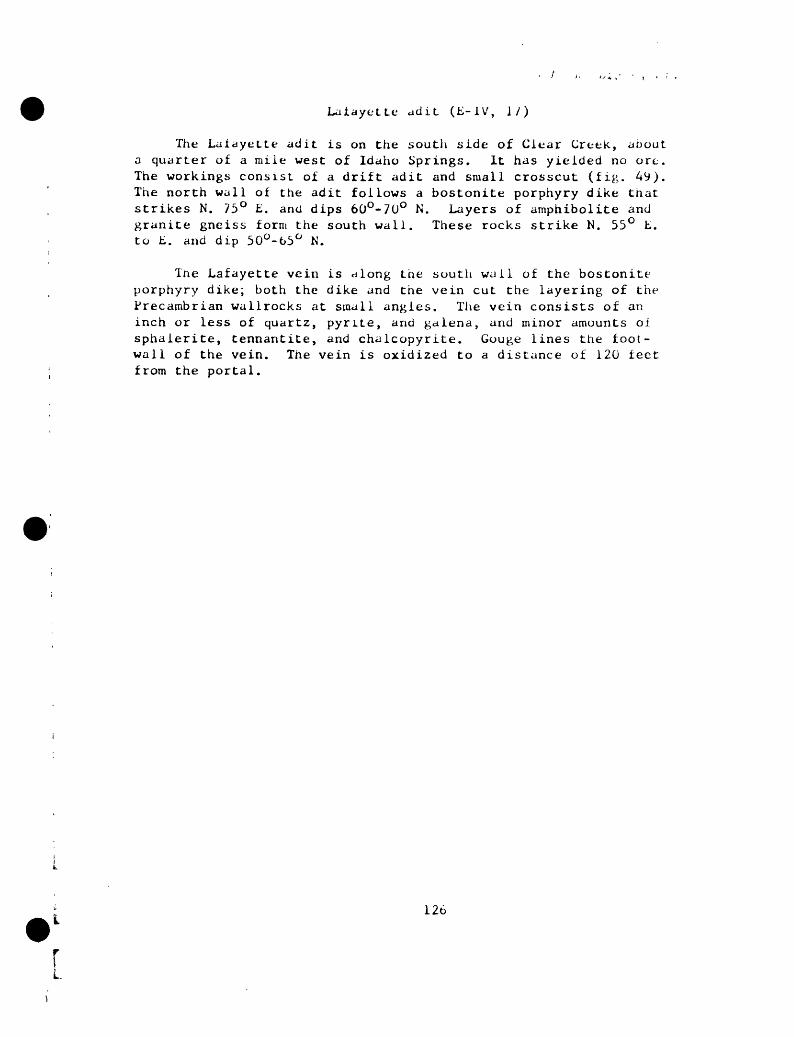
Lafayette adit. (E-1V, I/)
The Lafayette adit is on the soutli side of Clear Creek, about a quarter of a mile west of Idaho Springs. It has yielded no ore. The workings consist of a drift adit and small crosscut (fig. 49). The north wall of the adit follows a bostonite porphyry dike that strikes N. 75° E. and dips 60°-70° N. Layers of amphibolite and granite gneiss form the south wall. These rocks strike N. 55° E. to E. and dip 30°-65° N.
The Lafayette vein is along the south wall of the bostonite porphyry dike; both the dike and the vein cut the layering of the Precambrian wallrocks at small angles. The vein consists of an inch or less of quartz, pyrite, and galena, and minor amounts of sphalerite, tennantite, and chalcopyrite. Gouge lines the foot- wall of the vein. The vein is oxidized to a distance of 120 feet from the portal.
126
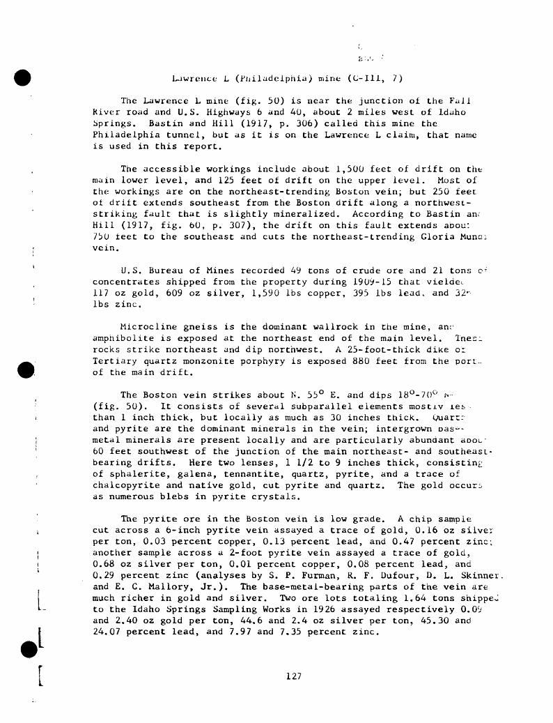
Lawrence- L (Philadelphia) mine (C-I11, 7)
The Lawrence L mine (fig. 50) is near the junction of the Fall River road and U.S. Highways 6 and 40, about 2 miles west of Idaho Springs. Bastin and Hill (1917, p. 306) called this mine the Philadelphia tunnel, but as it is on the Lawrence L claim, that name is used in this report.
The accessible workings include about 1,500 feet of drift on the main lower level, and 125 feet of drift on the upper level. Most of the workings are on the northeast-trending Boston vein; but 250 feet of drift extends southeast from the Boston drift along a northwest- striking fault that is slightly mineralized. According to Bastin an; Hill (1917, fig. 60, p. 307), the drift on this fault extends abou: 750 feet to the southeast and cuts the northeast-trending Gloria Muna: vein.
U.S. Bureau of Mines recorded 49 tons of crude ore and 21 tons O T concentrates shipped from the property during 1909-15 that vieldei 117 oz gold, 609 oz silver, 1,590 Ibs copper, 395 Ibs lead, and 32' Ibs zinc.
Microcline gneiss is the dominant wallrock in the mine, anc amphibolite is exposed at the northeast end of the main level. Xnes;. rocks strike northeast and dip northwest. A 25-foot-thick dike or Tertiary quartz monzonite porphyry is exposed 880 feet from the port~ of the main drift.
The Boston vein strikes about N. 55° E. and dips 18°-70° i*--I (fig. 50). It consists of several subparallel elements mostiv ies i than 1 inch thick, but locally as much as 30 inches thick. Quarrr
and pyrite are the dominant minerals in the vein; intergrown oas~- | metal minerals are present locally and are particularly abundant aoou- 1 60 feet southwest of the junction of the main northeast- and southeast-
bearing drifts. Here two lenses, 1 1/2 to 9 inches thick, consisting , of sphalerite, galena, tennantite, quartz, pyrite, and a trace of
chalcopyrite and native gold, cut pyrite and quartz. The gold occurs as numerous blebs in pyrite crystals.
The pyrite ore in the Boston vein is low grade. A chip samplet cut across a 6-inch pyrite vein assayed a trace of gold, 0.16 oz silver
per ton, 0.03 percent copper, 0.13 percent lead, and 0.47 percent zinc; | another sample across a 2-foot pyrite vein assayed a trace of gold, i 0.68 oz silver per ton, 0.01 percent copper, 0.08 percent lead, and
0.29 percent zinc (analyses by S. P. Furman, R. F. Dufour, D. L. Skinner and E. C. Mallory, Jr.). The base-metai-bearing parts of the vein are much richer in gold and silver. Two ore lots totaling 1.64 tons shippeJ
* - to the Idaho Springs Sampling Works in 1926 assayed respectively 0.09 and 2.40 oz gold per ton, 44.6 and 2.4 oz silver per ton, 45.30 and 24.07 percent lead, and 7.97 and 7.35 percent zinc.1
127
The Boston vein is abnormally radioactive on the main level oi the mine from 363 feet to 445 feet from the portal, as shown on figure 50, but samples from two of the most radioactive parts of the veins assayed only 0.001 percent equivalent uranium.
Three fault zones that locally contain pyrite, quartz, and some gouge strike north-northwest, dip 50°-70° NE. , and offset the northeast-trending veins (fig. 50). SIickenside-striae in the fault zones plunge less than 40° northwest and southeast, sug gesting that the strongest component of movement was strike-slip. The movement on the faults was right lateral and had apparent hori zontal components oi 3 to 25 feet.
128

L»2ad Belt adit (F-II, 8;
Development.--Ad it bearing northeast.
Production.--280 tons of crude ore, shipped in 1957, yielded 9 oz gold, 181 oz silver, 300 Ibs copper, and 5,100 Ibs lead.
Vein. Lead Belt: Strikes N. 80° E., dips steeply north; probably crosses Gem vein about 250 feet from portal.
Vein minerals. --Probably galena, sphalerite, chalcopyrite, tennantite, quartz.
Tenor.--Ore shipped in 1957 averaged 0.03 oz gold, 0.65 oz silver, 0.05 percent copper, and 0.9 percent lead.
129rv.

Little Albert No. 5 adit (B-IV, 1)
The portal of the Little Albert No. 5 adit is on the southeast side of Trail Creek at an altitude of 8,456 feet. It is a 550-foot crosscut that trends i>. 14° E., from which a drift has been turned on the Champion Dirt-Donaldson vein (fig. 51). Overhead stopes are above the caved parts of the drifts. Spurr, Garrey, and Ball (1908, p. 339) stated: "practically all of the ore obtained in the Little Albert mine is reported to have come from upper workings located near the surface."
Production data are scant. U.S. Mint recorded 1,043 oz gold and 3,343 oz silver from ore shipped in 1891.
The wallrocks are intricately folded layers of granite gneiss, biotite gneiss and amphibolite, and bodies of biotite-muscovitt granite (fig. 51). The wallrocks in the first 330 feet of the crosscut dip predominantly at small to moderate angles north, witr local sharp variations. Beyond 330 feet they strike more uniforml- northeast and dip more steeply (30° to 60°) northwest.
The Champion Dirt-Donaldson vein is the only vein exposed in the Little Albert No. 5 adit. Here the vein has an average strike of about N. 67° E., and cuts across the gneissic rocks at a low angle. The dip of the vein ranges from 27° to 71° N. and tends re. steepen and thicken where the strike is more easterly than averatru. Tne calculated plunge of the vein curvature near the west end c-j the drift is about 40° N. 55° W.
The vein is 1 to 5 inches thick and consists of vuggv wnit quartz and much pyrite, most of which fills the vugs. Ihe waiiroc. is intensely altered and pyritized as much as 14 inches on eitne side of the vein and is less altered an additional 3 inches. Gou<2t and brecciated ore is common along the vein. A chip sample from the vein assayed 0.16 oz gold and 0.60 oz silver per ton, 0.05 percent copper, 0.31 percent lead, and 0.28 percent zinc (analyses by D. L. Skinner and James Wahlberg).
No major ore shoots exist on the Little Albert level. The veil is thinner than in the nearby Donaldson mine, and base-metal mineral; are sparse. Apparently, the thick zone of altered biotite gneiss along the vein in the Little Albert No. 5 adit was soft and plastic and open fissures did not form readily.
The small ore bodies in the Little Albert adit appear to be localized by changes in attitude of the vein. The Champion Dirt- Donaldson vein thickens where it steepens and swings to an easterly strike. If the drift were extended a short distance northeast 01 the present face, more favorable wallrocks granite gneiss and raicrocline gneiss--should be intersected.
f 130
L

; ,.-j /,. A. I- 1 .J, J;'-
Little Annie adit (D-II, 6)
The Little Annie adit is on the west slope of Bellevue Mountain. The accessible workings (fig. 52) consist of an east-northeast-trending drift on the Cross vein and a northwest-trend ing drift on the Specie Payment vein. A winze, called the Gasoline Incline, connects to the Specie Payment mine (Bastin and Hill, 1917, p. 286-287). The production from the mine is combined with that from the Specie Payment mine, the Diamond Joe adit, and the Mona adit.
The predominant wall rocks of the mine are biotite gneiss and mig- matite, consisting of intimately interlayered biotite gneiss and pegma tite. These rocks strike east-northeast, dip northwest or southeast at medium angles, and are folded along east-northeast-trending axes. A quartz bostonite porphyry dike is exposed near the intersection oi the Cross and Specie Payment veins.
The Cross vein, exposed at the portal of the Little Annie adit, strikes east-northeast and dips 60°-80° NW. It ranges in thickness from a knife edge to about 20 inches and consists of vuggy and commonly brecciated quartz, pyrite, and sparse chalcopyrite, galena, and sona- lerite. Gouge is abundant along the vein walls. The vein is largely oxidized near the portal.
The Specie Payment vein is intersected by the Cross vein with nc visible displacement (fig. 52). The Specie Payment vein is very irreg ular in attitude, but generally strikes about N. 60° W. and dips aoou. 40° NE. It ranges in thickness from 6 to about 30 inches. Most c~ the ore minerals are oxidized and only a few exposures of unoxidizec ore were noted. Bastin and Hill (1917, p. 286) give more detailed des criptions of the vein mineralogy on the levels below the Little Annie adit. Free gold is reported to occur in white quartz in the lower levels of the mine.
There is little available information on the average grade of the ore produced from this mine. A shipment of 7.57 tons in 1934-35 averaged 0.32 oz gold, 5.43 oz silver, 3.45 percent lead, and 3.5 percent zinc.
I.

Little Cub adit (D-V, 5)
The Little Cub adit, on the north side of Spring Gulch, is a /80-foot drift adit that bears N. 53° E. , and a 90-foot crosscut to the northwest (fig. 53). There is neither record of production nor evidence of stoping.
The wallrocks are biotite gneiss, and a small amount of pegmatite, These rocks strike northeast and dip steeply northwest.
The Little Cub vein strikes about N. 53° E., and dips steeply northwest parallel to the walirocks. It is rarely more than an inch thick, contains only quartz and pyrite, and is in a zone as much as 16 inches thick of altered and pyritized walirocks. White gouge locally lines the vein.
132
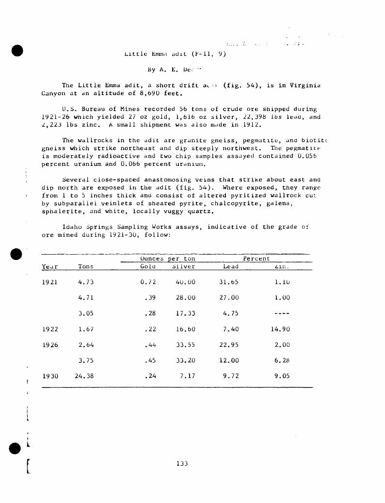
Little Emma adit (F-ll, 9)
By A. E. De. '
The Little Emma adit, a short drift av. > (fig. 54), is in Virginia Canyon at an altitude of 8,690 feet.
U.S. Bureau of Mines recorded 36 tons of crude ore shipped during1921-26 which yielded 27 oz gold, 1,616 oz silver, 22,398 ibs lead, and2,223 Ibs zinc. A small shipment was also made in 1912.
The wallrocks in the adit are granite gneiss, pegmatite, and biotiti gneiss which strike northeast and dip steeply northwest. The pegmatite is moderately radioactive and two chip samples assayed contained 0.056 percent uranium and 0.066 percent uranium.
Several close-spaced anastomosing veins that strike about east and dip north are exposed in the adit (fig. 54). Where exposed, they range from 1 to 5 inches thick and consist of altered pyritized wallrock cut- by subparallel veinlets of sheared pyrite, chalcopyrite, galena, sphalerite, and white, locally vuggy quartz.
Idaho Springs Sampling Works assays, indicative of the grade of ore mined during 1921-30, follow:
Year Tons
1921 4.
4.
3.
1922 1.
1926 2.
3.
1930 24. f
73
71
05
67
64
75
38
OuncesGold
0.72
.39
.28
.22
.44
.45
.24
per tonSilver
40
28
17
16
33
33
7
.00
.00
.33
.60
.55
.20
.17
PercentLead ^ir:.
31.
27.
4.
7.
22.
12.
9.
65
00
75
40
95
00
72
1.
1.
..
14.
2.
6.
9.
10
00
--
90
00
28
05
133

Little Six adit (D-1II, 10)
De v e1opment.- - A southeast-trending crosscut adit more than 425 feet long; 320 feet from the portal a 360-foot east-northeast-trending drift follows the Bronaber vein.
Vein.--Bronaber: Strikes N. 72° E. , dips 70° N.; 2-10 inches thick. The crosscut adit follows a thin barren fracture.
Wallrock.--biotite gneiss and pegmatite; an east-trending dike of quartz monzonite porphyry is exposed at the portal.
Vein minerals.--Fyrite and quartz.
I » L
rI

Lost Vein adit (D-IV, 7)
Development. A 690-foot drift adit trending N. 75° E.; a crosscut 440 feet from the portal extends 80 feet southeast to a 150-foot drift. Adit was not found by us; location obtained from Bastin and Hill (1917, p. 364).
Product ion.--Not known; one small lot shipped in 1910 contained 0.2 oz gold and 3.2 oz silver.
Veins.--Lost Vein: Strikes N. 75° E., dips 60°-65° N. Unnamed vein: Strikes N. 47° E., dips 70° N. Each vein about 2 inches thick,
Wallrock. Dominantly biotite gneiss.
Vein minerals.--Pyrite and quartz.
135

II.
Lower East Lake adit (F-II, 2)
The Lower East Lake adit, on the south slope of Pewabic Mountain, was opened prior to 1900 and was operated sporadically until 1951. Most of the production from the adit is combined with that of the Lower Lake adit and Windsor Castle mine. Thirty-two small lots of ore, aggregating 317.34 tons, shipped to the Idaho Springs Sampling Works yielded $3,608.00.
The Lower East Lake adit is driven about 891 feet on a general bearing of N. 60° E. (fig. 55). A 50-foot raise is driven about the adit level about 730 feet from the portal; a winze of unknown depth has been sunk about 645 feet from the portal. The location of stope,c is shown on figure 55, but their exact extent is not known.
The adit is in migmatite, biotite gneiss, and pegmatite, a? shown on the geologic map (fig. 55). The rocks strike east-northeast and dip northwest at moderate angles. They are locally deformed by broad crosswarps that plunge north-northwest.
The Lower East Lake adit develops the East Lake vein of tne Frontenac-Lake vein system. In the adit, the vein consists of tvr principal elements and several imbricating elements whose general attitude is parallel to the foliation. Numerous northwest-trending veinlets form connecting links between the major vein elements.
The vein ranges froin 4 to about 30 inches in thickness. In tn biotite gneiss, the thickness of the vein averages about 5 inches, tr_* in the pegmatite it averages about 18 inches. In the 73G-rait>«_, 30 inches of intergrown sulfides was exposed in 1953.
Quartz, pyrite, sphalerite, and galena are the dominant veil, minerals, and smaller amounts of tennantite and chalcopyrite are present. Quartz and pyrite are dominant in the thin parts of the vein where it cuts biotite gneiss, but where it cuts pegmatite the vein consists of as much as 30 inches of intergrown sulfides anc gangue minerals. The base-metal minerals are most abundant in the steeper fractures suggesting that they were deposited largely sub sequent to normal dip-slip faulting.
The ore is valued chiefly for gold, silver, and lead. Idaho Springs Sampling Works assays of some smelting ore and concentrates from the Lower and Upper East Lake adits are given in the following table. A study of this table suggests that silver is largely associated with lead and copper minerals, and that high gold values occur with high copper values. Hand-picked galena from the mine assayed 0.03 oz gold and 27.31 oz silver per ton. Hand-picked sphalerite assayed 0.07 oz gold and 1.73 oz silver per ton.
136

A .
YearOunces per ton Percent
TonsGold Silver Lead Copper Zinc
Smelting ore
1919
1920
1924
1935
193o
10.902.97
17.91
5.811.522.32
15. 19
4. 1648.6820.3212.89
2.453. 132. 64.94
0. 10. 14. 14
.23
.30
. 10
.09
.33
. 14
.20
. 16
. 10
.05
. 108. 26
15.6514.5539.65
15. 4514. 8018. 10
4. 00
53. 6010.4010. 1014.25
5.303.958.20
31. 00
15.4517.5725.00
31.0529.8516.86
2.5o
19.503.304.303.36
5.409.0010.5010.70
17.80---- 21.15
1.30 11.51
.51 5.30
.92 J. 15---- 16.00
---- 9.50
1.2o 20. 5C---- 2. 2ti..__. 5,01 9.27
10.20 12.50---- 15,70
1.70 11.00
Concentrates
1920
1934
4. 7410.57
16.9411.522. 22
0.52. 22
.51
.52
.59
17.5018. 20
29. 6053. 0060. 80
3o. 009. 70
10. 7321. 7020. 80
_ __ _
0. 602. 00
. 7U
14. 12^. ...
ID. 0'.1.-,...'.21. 9',
3.30 30 9. 10 6.85 1.00
The largest stope in the Lower East Lake adit is on that part of the vein that cuts pegmatite. This rock is more competent than either migmatite or biotite gneiss and supports wider fissures. Also, the vein's strike is deflected about 20° to the east where it enters the pegmatite. Because the vein fills a right-lateral fault, open spaces would tend to form in segments where the strike is nearer east than
average.
137

Lower Lake adit (fc-Ii, 10)
The Lower Lake adit is on the east side of Virginia Canyon, about 1 2/3 miles north of Idaho Springs.
Production from the Lower Lake, Lower East Lake, and Upper East Lake adits, and the Windsor Castle vein (about 250 feet north-northeast ot the portal of the Lower Lake adit), all of which are on the same vein system, are combined in the records of the U.S. Bureau of Mines. According to these recora^, the four properties produced 12,728 tons of crude ore and 6,012 tons of concentrates during 1902-b5, wnich yielded 13,135 oz gold, 140,081 oz silver, 314,079 Ibs copper, 640,211 Ibs lead, and 361,441 Ibs zinc. U.S. Mint recorded ore shipped from the Lake mine during 1888-92 yielded a total of 746 oz gold, 38,048 oz silver, 17,219 Ibs copper, and 1,188,210 Ibs lead (Kimball, 1886-1889: Leec;., 1890-1893). The Lower Lake adit was last active in 1954.
The accessible workings in the Lower Lake adit include about. 1,100 feet of drift and crosscut (fig. 56). Several stopes, a raii- and a winze are also shown on figure 56, but they are not access ib I o- The Windsor Castle shaft passes through the Lower Lake adit level i a caved part of the drift on the Lake vein.
The wallrock, largely raicrocline gneiss, strikes east and dip c 10°-35° N. It is intensely altered adjacent to the veins.
The Lower Lake adit was driven northeasterly on Vein A a distan-- of 370 feet, whence the tunnel crosscuts to the north to the Lake vei: and caved workings on the Lake vein were bypassed. A short drirt wa. turned northwestward on Vein B from the Vein A drift 80 feet from tn- portal, connecting to caved workings on the Lake vein. Bastin and E_ (1917, p. 284) called Vein A the Lake vein, and they called the Lak. vein of this report the Windsor Castle vein. They are probably in error, however, for the Lake vein is generally considered to be a major, throughgoing structure that is continuous with the Bald Eagle vein to the west, and the Frontenac, Aduddell, and Druid veins to the east. In depth the Lake vein projects to the Big Five tunnel, where it is an important structure. Vein A is a minor structure that was not found anywhere except in the Lower Lake adit.
Vein A strikes N. 45° E. and dips steeply northwest. It converges northeastward with the Lake vein, and the two veins apparently join about 50 feet from the face (fig. 56). Vein A is along an unimportant structure and consists of several subparallel interconnecting veinlets in generally less than a foot of altered and pyritized wall rocks. Local pods of coarse pyritohedral pyrite as much as 4 inches thick, and small amounts of sphalerite, galena, chalcopyrite, tennantite, and carbonate minerals have been found. A chip sample taken across Vein A assayed 0.92 oz gold and 4.52 oz silver per ton, 0.82 percent copper, 0.24 percent lead, and 0.04 percent zinc (analyses by H. H. Lipp, D. L. Skinner, and W. D. Goss).
138

Vein B strikes N. 2 L>°-4!)° W. , and dips steeply southwest. The vein contains less than 1/2 inch of quartz and pyrite and is bordered by as much as 14 inches of altered rock. This vein crosses Vein A without displacement, and it terminates against the Lake vein.
The Lake vein, which strikes northeast and dips steeply northwest, is one of the most important veins in the district, and all of the production from the Lower Lake adit has been supplied by it. This vein was mined extensively from 191)3 to 1960 on the southwest side of Virginia Canyon, where it is called the Bald Eagle vein. To the northeast the Lake vein was worked in the Windsor Castle mine, the Lower and Upper East Lake mines, and the Frontenac, Aduddell, and Druid mines.
In the Lower Lake adit, the Lake vein consists of two separate elements as much as 5 feet apart, each of which is 2 to 8 inches thick. The footwall element is commonly thicker than tne hanging- wall element. Subsidiary branches from both are present locally, and the wallrock between the main vein elements is altered and abundantly pyritized. In order of decreasing abundance the dominant sulfides are pyrite, galena, sphalerite, tennantite, and chalcopyrite. Quartz is the principal gangue, but trace amounts of barite and carbonate minerals, probably siderite or ankerite, are present iocallv as i. native gold.
Assays of 7 tons of smelting ore shipped to the Idaho Springs Sampling Works in 1921 and 1940 follow:
Tons
4.06
2.30
0.64
OuncesGold
0.10
.18
.10
per tonSilver
4.70
6.70
2.30
PercentLead
12.72
21.00
_--_
Zinc
b.32
8.22
2.05
The Lake vein fills a right-lateral fault, as determined on the Bald Eagle vein a short distance to the southwest. There, the hanging wall moved about 80 feet northeast relative to the footwall. In the Lower Lake adit one set of slickenside-striae plunges at a low angle to the northeast and another plunges directly downdip. Cross frac tures, possibly tension cracks, are filled with base-metal sulfides. These fractures dip to the south and intersect the main veins along lines that plunge to the southwest. These data suggest that during the base-metal stage of mineralization the north wall moved down and slightly to the east relative to the footwall.
139

The factors responsible for localizing the ore bodies are not clearly known. The parts of the Lake vein that bear base-metal sulfides are thicker where the dip is steeper than the average, in accord with the inferred relatively late normal dip-slip movement. Possibly the small ore body near the intersection of the Lake vein and Vein A is controlled by open spaces developed at the intersection. If so, this ore shoot should plunge about 35° NE.
140
[

il.
Lucania tunnel (C-ll, 1)
The portal of the Lucania tunnel is on the east side of Fall River Canyon at an altitude of 7,890 feet (fig. 1). The tunnel, which trends N. 40° E. (fig. 57) was driven to cut several of the rich veins in the Quartz Hill area of the Central City district. However, by 1911 the tunnel had been advanced only 6,340 feet--far from its intended goal (Bastin and Hill, 1917, p. 309). In 1959 and 1960 the tunnel was advanced a considerable distance, but we did not examine the new workings.
The veins intersected in the tunnel proved disappointing, buL ~ few of these have been productive at shallow depths. A little ore was shipped from vein No. 15 (Yellowstone?) in 1908 and 1909 (Bastin anc Hill, 1917, p. 309). This ore carried as much as 1 02 of gold and 12 02 of silver per ton, and 20 percent lead; but the average tenor was less than half these amounts. U.S. Bureau of Mines recorded a total of 18 ton? of crude ore shipped from the J. L. Emerson vein in 1910, 1911, and 1913. This ore yielded 16.40 02 gold, 142 02 silver, 232 Ibs copper, 4,064 Ibs lead, and 683 Ibs 2inc. Apparently this ore came from small lenses of base-metal minerals encountered during drifting on the vein, for sucn ore was not seen by Bastin and Hill (1917, p. 309), Carl Belser (writtei communication, 1937), or us. U.S. Bureau of Mines recorded that tne total production from all veins during 1907-13 was 543 tons of crude orv and 23 tons of concentrates, yielding 118 02 gold, 2,769 oz siivei. 1,084 Ibs copper, 7,289 Ibs lead, and 1,283 Ibs zinc.
The wallrock in the tunnel is dominantly microcline gneiss, whicn contains thin layers of amphibolite and pegmatite, particularly between 1,500 and 3,000 feet from the portal. The structure of the wallrocks is simple and consists of broad open folds that trend northeast anc plunge gently either to the northeast or southwest. In general, the foliation of the rocks dips gently to the northwest, for the tunnel is a short distance northwest of and about parallel to the axis of the Central City anticline.
The veins cut by the tunnel strike in three directions. Most strike east to N. 70° W. and dip north; a few strike N. 40°-60° E. and dip northwest; and one, the J. L. Emerson vein, strikes N. 50°-55° W. and dips northeast.
The most important veins are described below in order of increasinf distance from tne portal. The numbers were assigned to the veins at the time the tunnel was driven. Assay data are given on figure 57.
An east-trending vein that dips about 65° N. is cut at 2,765 feet. It consists of 1 to 14 inches of gouge and 12 inches of altered wallrock on each side. The main vein contains sparse pyrite, and veinlets branching from the footwall contain some galena and sphalerite.
141

and A. /- i^'Ji'.' 1 . - r -
Vein No. 13 is cut at 3,110 feet. It strikes east, dips 75° N. , and consists of 30 inches of intensely altered wallrock containing veiniets of quartz and pyrite.
Vein No. 14, intersected at 3,270 feet, strikes east, dips 70° N., and consists of about 12 inches of quartz, pyrite, and bleached wallrock.
Vein No. 15, possible the Yellowstone vein, is cut at 3,435 feet. It is a group of veins that strike east and dip steeply north; individual elements consist of 1 to 2 inches of quartz and pyrite with local small pods and veiniets of galena and sphalerite. The galena and sphalerite occur at the junction with branching, "horsetail" veins, and on tht east-striking part.
Vein No. 17, intersected at 3,695 feet is a zone that strikes east and dips 60°-75° N. It consists dominantly of quartz, pyrite, local 3- inch pods of galena, sphalerite, and sparse chalcopyrite, tennantiLt, and siderite. A polished section showed a single irregular patch o r native gold along a quartz-sphalerite contact. Assay data (fig. 57/ indicate that the highest gold values occur in the base metal-rich part? of the vein zone.
Vein No. 20, possibly the Specie Payment, is 4,580 teet from tu- portal. It is a wide shear zone that strikes N. 80° W., and consists of 2 to 3 feet of intensely silicified and pyritized wallrock cut D 1- to 6-inch-thick vein of sphalerite and galena on the hanging wr and a similar but thinner vein on the footwall. The hanging-wall ve:- dips 36° N.; the footwall vein dips 74° N. Sphalerite, galena, tev nantite, pyrite, quartz, and small amounts of chalcopyrite and sident- were seen on a polished surface. According to Carl Belser (writte: communication, 1937), two samples over a width of 2.2 feet and 4.0 tee contained 0.11 and 0.10 oz gold per ton respectively. Assays of tv. chip samples collected during the present study are given on figure 57.
The J. L. Emerson vein, cut at 5,760 feet, is a wide shear zon< that strikes N. 55° W. and dips 65° NE. From footwall to hanging wall, the vein consists of the following: (1) a dark-gray silicified zone 1 to 5 feet thick containing disseminated pyrite and coated with secondar; copper sulfate. Slickenside-striae on the footwall plunge N. 40° W. an 15° and N. 65°-85° E. at 60°-66°; (2) about 12 feet of altered microclirv, gneiss traversed by numerous veiniets of white quartz and pyrite; and (3) about 30 feet of less altered and pyritized wallrock. Two smalle-1- northwest-trending shear and altered zones are present northeast of the J. L. Emerson vein (fig. 57). According to Carl Belser (written communication, 1937), a composite of 37 samples from the vein shows: 0.06 oz gold per ton, 0.54 oz silver per ton, 0.15 percent lead, a trac- of copper, and 0.30 percent zinc. The assay of a 4 1/2-foot chip sample from the lower dark-gray silicified zone collected during the present study agrees well with these data (fig. 57). Some base-metal mineral.- were found during drifting on this vein in 1910, 1911, and 1913. It i.- probable that these ore minerals, as well as relatively high values ii f gold and silver, occur in small lenses.
142
and ;. ' ' -*' - >ja '
MAb adit (D-III, 15)
Development.--Drift adit about 100 feet long.
Vein.--MAB: Strikes N. 43° E., dips 40° NW.; about 2 inches thick and is radioactive for a distance of 42 feet from the portal (Sims and others, 19fa3, p. 105).
Wallrock.--Microc line gneiss which is altered about 3 inches on either side of the vein.
Vein minerals.--Pyrite, sparse chalcopyrite, galena, and sphalerite, and abundant quartz.
Tenor.--One sample assayed 0.035 percent equivalent uranium, 0.10- percent uranium, 0.20 oz gold and 0.34 oz silver per ton, 0.01 percent copper, 0.07 percent lead, and 0.09 percent zinc (analyses by S. P. Furnu R. F. Dufour, D. L. Skinner, and E. C. Mallory, Jr.).
143
M and K ad i I (D-V, 6)
The M and E adit, on the south side of Spring Gulch, is a 500- foot southwest- trending drift adit (fig. 58). A small stope has been ex tracted above the main drift about 200 feet from the portal. U.S. Bureau of Mines recorded 14.5 tons of crude ore and 1 ton of concentrates shipped from the adit, which yielded 7.36 oz gold, 213 oz silver, 42 Ibs copper, 713 Ibs lead, and 488 Ibs zinc.
Granite gneiss forms most of the waiirui^K, ancJ some ampnibol ite an: an irregular dike of quartz oostonite porphyry are present (tig. 5tt ; The granite gneiss contains numerous layers and wisps of biotite. Tn< gneissic rocks strike N. 4^°-bJ° E. , ancJ dip b5°-9<.J 0 N^.
A thin sinuous vein is exposed in the main drift. It strike:, generally N. 55° E. , and dips 30°-50° NW. At one place it swings to N. 30° W. strike and flattens. At this point the vein is displace*- by a second vein that strikes N. 15° E. and dips 50° to 60° E. Tnt_ apparent horizontal displacement along the latter vein is about 20 feet and is left lateral.
Both veins are thin and consist of iron-stained fractures tnai are generally less than an inch thick and are filled with quartz an._ minor amounts of galena and pyrite. Where stoped, the northeast- trending vein consists of two 1/4-inch veinlets of quartz and galena in a 3- inch zone of sheared pegmatite. The thickness of the nortneast- trending vein does not vary with the curvatures, and little movement took place along the fissure.

Manhattan adit (C-V, 12)
The Manhattan (fig. 59)> on the north side of Spring Gulch (lig. 1), is a 350-foot drift adit that trends N. 55° E. There is no known production.
Biotite gneiss containing thin layers of pegmatite constitute most of the wallrocks; a small body of quartz diorite is exposed at the north face. These rocks strike N. 55° E. , parallel to the drift, and dip 45°-80° NW., averaging about 60° NW.
A thin vein that strikes N. 55° E. and dips about 50° N. is exposed along the drift. About halfway along the drift the vein splits into two segments that diverge to the northeast at a small angle. The vein is oxidized for a distance of 200 feet from the portal. In its oxidized parts, it consists of about an inch of vuggy quartz; where unoxidized it consists of 1 to 4 inches of quartz and pyrite. An unidentified black prismatic mineral wai noted in a 1/4-inch-thick quartz-pyrite veinlet. Gouge is cotnmor; along the vein. The wallrock is intensely altered 6 to 24 inches on each side of the vein.
145
Mastedon adit (U-I I I, I])
Development.--73-foot drift-adit that bears S. 20° E.
Ye in.--Mastedon vein: Strikes N. 47° W., dips 69° NE., and follows part of the Idaho Springs fault; consists of a wide zone of broken, silicified, and pyritized wallrock which is cut by two postmineral(?) faults. One of these faults is parallel to the vein zone.
WalIrock.--Quartz monzonite porphyry and biotite gneiss.
Vein minerals.--Pyrite and quartz.
f 146L

Maude Munroe mine (D-1V, 8)
The Mauoe Munroe mine is on the north side of Clear Creek, about 7UO feet southeast of the mouth of Georgia Gulch. It consist;; of two drifts having an aggregate length of 640 feet and a short crosscut (iig. 60). Small overhand stopes are along both drifts, and ,1 winze has been sunk from the north drift.
U.S. Bureau of Mines recorded 963 tons of crude ore and 246 ton:, of concentrates snipped during 1907-37 which yielded 772 02 gold, 6,493 oz silver, 11,223 Ibs copper, 21,144 Ibs lead, and 17,039 IDS zinc. Sampling-works records (Bastin and Hill, 1917, p. 36A) indicate that the mine also was producing during 1891-98.
Folded granite gneiss and biotite gneiss, which strike about N. 82° K. and dip 40°-80° N. , are the dominant wallrocks. These rocks are cut by a small body of trachytic granite porphyry (fig. 60).
Two veins are exposed in the mine, both of which swing from o strike of N. 65° E. near tne portal to nearly east-west near the face, and dip 40°-80° N. They are subparallel to the wallrock foliation. and appear to thicken where tney dip more steeply than average.
Wnere exposed in the drifts, the veins consist largely of pynte- bearing gouge as much as 18 inches tnick. Locally, they contain as much as 8 inches of quartz and pyrite cut by pods and veinlets c: base-metal minerals, as much as 2 inches thick, that contain quarts, sphalerite, galena, and pyrite, and minor amounts of tennantite am chalcopyrite. All the sulfides have been brecciated and cemented D. dark-gray cryptocrystalline quartz.
An 8-inch chip sample taken across a brecciated pyrite and quartz vein that is cemented by base-metal minerals assayed 0.46 oz gold and 5.16 oz silver per ton, 0.51 percent copper, 2.17 percent lead, and 1.02 percent zinc (analyses by S. P. Furman, J. E. Wilson, H. H. Lipp, D. L. SKinner, and W. D. Goss). Two sampling-works assays of concen trates shipped in 1891 and 1898 show 0.95 and 0.55 oz gold and 19.30 ana 2.50 oz silver per ton (Bastin and Hill, 1917, p. 364). Smelting ore contained as much as 2.t>5 oz gold and 24 oz silver per ton. A few assays of typical smelting ore shipped to the Idaho Springs Sampling Works during 1921-36 follow:
Tons
3.109.85
14. 131.86
15.07
OuncesGold
0.23.39.39.20.41
per tonSilver
8.304.504.651.205.45
PercentLead
3.55.8b
____________
£inc
3.80i.ob2.00.50
2.00
147

;:/ifJ A A. .>. a/.<:, J . ..
Mayflower adit (E-IV, 16)
The Mayflower adit is on the south side of Clear Creek, across from the mouth of Hukill Gulch. The accessible workings consist of a drift adit that extends southwest for a distance of about 1,600 feet, three short crosscuts that extend to the northwest, and a 460- foot crosscut that extends southwest from the face of the drift (fig. 61). A northeast drift from this crosscut was caved in 1954. Near the portal, ore has been extracted from a stope which is 100 feet long and extends nearly to the surface.
Production data are incomplete, but the U.S. Mint recorded for 1887-91 a yield of 941 oz gold, 34,557 oz silver, and 290,793 Ibs-- lead (Kimball, 1886-1889; Leech, 1890-1893). Since 190^, tne mint is known to have produced 374 tons of ore that yielded 402.89 oz gold, 4,834 oz silver, 3,237 Ibs copper, and 14,695 Ibs lead.
Interlayered amphibolite and pegmatite are the dominant wallrocks in the mine, and microcline gneiss is exposed along tin- last 100 feet of the long crosscut. These rocks strike northeasi and dip 35°-85° NW., averaging about 60°, and are complexly foldeu. Two Tertiary bostonite porphyry dikes are also present.
The Mayflower vein strikes about N. 70° E. , dips 75°-85 0 KV;. , and at the surface it can be traced for a distance of aoout 700 te.L. southwest of the portal. It may be a branch of the Star vein i Spring Gulch (fig. 1). In the first 150 feet of the adit, the M*' - flower vein is 5 to 12 inches thick, and fills a single nssurt At 150 feet, it splits into two or more subparallel anastomosing branches, which are typically about an inch thick. The vein cnanges markedly in strike and dip along its course, apparently as a resui: of intersecting several rock units of different competence.
The vein consists of pyritized wallrock containing veinlets of quartz and pyrite that are cut by many pods and veinlets of base-meta minerals. In the southwestern part of the mine, base-metal sulficies and sulfosalts, in varying proportions, form the core of the vein and are bounded by quartz and pyrite. Galena is the dominant base- metal mineral; chalcopyrite, sphalerite, and tennantite are less abundant; marcasite, enargite, bornite, and covellite are sparse. Quartz is the dominant gangue mineral, and siderite and rhodochrosite are locally abundant. Wolframite is locally intergrown with quartz.
One sample of base-metal ore assayed 0.26 oz gold and 5.00 oz silver per ton, 1.75 percent copper, 1.10 percent lead, and 8.00 percent zinc; another sample assayed 0.16 oz gold and 11.30 oz silver per ton, 0.95 percent copper, 2.13 percent lead, and 2.65 percent zinc (analyses by S. P. Furman, J. E. Wilson, H. H. Lipp, D. L. Skinner, and W. D. Goss).
148

/ / . j: . tj j'.
The ore body stoped in the mine occurs where the vein dips more steeply than average, and possibly was localized along the intersection of the vein with the axis of a fold in the Precambrian rock. The main stope appears to plunge gently N. 60° E. subparallei to warps and other linear structures in the wallrocks.
149

May Queen adit (1)-111, J;
Development. --Crosscut-adit, bearing southeast and probabj.y a drift bearing northeast.
Production.--5 tons of crude ore shipped in 1933, yielding 4.83 oz gold and 1 oz silver.
Vein.--May ^ueen: Probably strikes northeast and dips northwest. The vein probably crosses the northwest-trending Idaho Springs fault.
Wallrock.--Microc line gneiss and quartz monzonite porphyry.
Vein minerals.--Pyrite and quartz.

Metropolitan tunnel (C-Ili, A)
The portal of thi> Metropolitan tunnel is at the mouth of Trail Greek--; at an altitude <>f 7,750 feet. It is mostly a crosscut tunnel that trends south- southwest lor more than A, 500 feet (fig. 62). It was inaccessible in 195A because of bad air, and part of the fol lowing description is from Bastin and Hill (1917, p. 366). Apparently the tunnel was driven after Spurr, Garrey, and Ball (1908) had studied the area, for they did not mention it.
The dominant wallrock in the tunnel is microcline gneiss, small bodies of amphibol ite and pegmatite are probably exposed as A dike of quartz monzonite porphyry is cut at 250 feet from the porta^ and another at 2,020 feet.
Two veins are intersected by the tunnel. The Morning Star veir., intersected at about 750 feet from the portal, strikes about N. 20° £. and dips 35° W. It is 2-3 inches thick and consists of gray quartz and pyrite, bounded on one or both sides by several inches of gouge. The Metropolitan vein, intersected at about 2,400 feet from the portai is developed by a short drift. It was not described by Bastin and Hill (1917, p. 366).
151

L
Miami Lunnei (F-IV, 3)
The portal of the Miami tunnel is about 1/4 mile north of Idaho Springs, at an altitude of about 7,863 feet. The tunnel is owned by the Colorado School of Mines and is operated on an experimental basis. It was operated during the early days in the district to mine the Edgar vein and other less important veins, but it was supplanted in the early 1900's by the Big Five tunnel which intersects the same veins at a greater depth and provided underground transportation to the mill site. The ore that was shipped from the mine since 190* is included with that produced from the Big Five tunnel.
The tunnel (fig. 63) extends about 2,000 feet north-northwest and connects with a drift from the Edgar shaft (fig. 28). Only the Edgar vein has been mined on the tunnel level.
The wallrocks in the Miami tunnel consist of intimately inte^- layered pegmatite, granite gneiss, amphibolite, biotite gneiss, an; microcline gneiss. These rocks are cut by dikes of quartz monzonit and granite porphyry (fig. 63). The gneisses strike mainly east- northeast, dip steeply northwest, and are complexly folded.
Several veins are cut by the tunnel, but only the Edgar has bee, extensively mined. Most of these veins strike east to northeast, air- steeply northwest, and are subparallel to the foliation of the walirocKo An exception, the Little Chief(?), strikes north-northeast and die steeply east.
The Nonpareil(?) vein, exposed 640 feet from the portal, reporter. (Bastin and Hill, 1917, p. 356) was explored for about 450 ieet. b-_ the drifts were inaccessible in 1954. The vein contains two parai it- elements that strike N. 80° E. and are connected by a northeasL- striking vein. These vein elements dip steeply north, are 1 to 6 inches thick, and consist of gouge, sheared quartz, and pyrite.
The Clyde-Gertrude(?) vein consists of several branches inter sected between 800 and 835 feet from the portal. The main branch strikes N. 52° E. and dips 50°-70° NW. Others strike about N. 75° E. , and dip 55°-85° NW. The individual veins are 1 to 6 inches thick and consist of coarse-grained, white and gray quartz and pyrite, and locally have cores of amber sphalerite, galena, tennantite, chalcopyrite, and rhodochrosite(?). The wallrocks are nearly unaltered adjacent to some veins but are altered and pyritized as much as 2 feet on either side of other veins.
The Gold Button(?) vein, intersected 1,095 feet from the portal, was explored by 140 feet of drift. It strikes N. 65° E., dips 75°- 85° NW., and consists of about an inch of quartz, pyrite, galena, and sphalerite. In part, the vein follows the footwall of a granite porphyry dike.
152

The Shaw(?) vein in intersected by the tunnel 1,260 ieet from the portal. It strikea N. 65° E., dips 68° NW., and consists ol 1 to 4 inches of quartz, pyrite, and lesser amounts of galena and sphalerite.
The Little Chief(?) vein is exposed 1,600 feet from the portal but was not explored. H strikes N. 38° E., dips 77° S., and con sists of 3 feet of fractured and intensely altered and pyritized wallrock.
The Judge(?) vein is exposed 1,760 feet from the portal. It strikes N. 52° E. , dips 59° N. , and consists of 5 inches of fine grained breccia containing fragments of vein quartz and pyrite.
The Edgar vein, exposed at the face of the tunnel, was mined extensively in the Edgar mine (fig. 28) and is described under that heading.
153

, '. , r// »'. if. I'' < ;A. iyJ-fifC':, J.T.
Mona adit (E-II, 1)
Development. Drift adit at least 400 feet long.
Production. Combined with Diamond Joe adit and Specie Payment mine.
Veins.--Mona: Strikes N. 75° E., dips 60°-65° N.; as much as 3 feet wide with 1- to 3-inch veinlets of sulfides on both wa 11s.
Vein minerals.--Galena, sphalerite, chalcopyrite, pyrite, an. white and gray quartz.
Tenor. --0.46 to 4.85 oz gold and 3 to 23 oz silver per tor., and 0 to 4 percent copper.
154

Monte Cristo adit. (1J-1V, 1)
The Monte Cristo adit, which has yielded little ore, is approxi mately 1 1/2 miles west-northwest of Idaho Springs on the north side of U.S. Highways 6 and 40. The adit is a drift about 500 feet long that bears N. 57° E. (fig. 64). A 10-ton shipment made in 1957 yielded an ounce of gold and 4 oz silver.
The wallrocks consist dominantly of migmatitic biotite gneiss, and a few pegmatite bodies. These rocks strike mostly about N. 55° E and dip 40°-70° NW. A dike of quartz bostonite porphyry is exposed in a crosscut near the face ot the adit.
The Monte Cristo vein is composed of several subparallel anasto mosing vein elements that strike about N. 60° E. and dip steeply NW., about parallel to the wallrocks. Individual vein elements are 1 to c inches thick and are composed mainly of quartz and pyrite. Wnere stoped, the main vein is 4 inches thick and contains quartz and pyrite that is coated with secondary copper sulfate. A chip sample taken across the vein assayed 1.08 oz gold and 1.84 oz silver per ton, 2.65 percent copper, 0.05 percent lead, and 0.10 percent ziru (analyses by S. P. Furman, J. E. Wilson, H. H. Lipp, D. L. Skinner and W. D. Goss). The abundance of copper in the assay indicates tn<- presence of chalcopyrite and tennantite.
The vein elements are thickest where they cross tne wallroc.. foliation at a large angle, and they are thinnest where tney lie i., the plane of the foliation. The vein is stoped where it crosses tru foliation at a high angle along a fold axis, and a small ore body probably plunges parallel to the axis of this fold.
155
arj'i \. l . i,
Moose mine (H-I, 1)
Development.--InclIned shaft.
Veins.--Moose: Strikes N. 60° E., dips 45° NW.
Wallrock.--Albite granodiorite porphyry and a breccia of biotiti gneiss, pegmatite, microcline gneiss, and porphyry.
Vein minerals.--Pyrite, galena, sphalerite, chalcopyrite, quartz rhodochrosite, and white, green, and purple fluorite.
Ore bodies.--One small shoot plunges southwest.
r 156k.

Nonpareil adit (F-IV, 2)
The Nonpareil adit, about 2,400 feet north of Idaho Springs near the head of Dry Gulch, is a drift that extends 200 feet west-southwest (fig. 65). There has been no production.
Granite gneiss and a 1-foot-thick dike of altered bostonite porphyry form the walls of the adit. The foliation in the granitt gneiss strikes N. 60°-88° E. and dips 55° NW. to 80° SE.
The Nonpareil vein strikes N. 75° E. and dips about 60° NW. It ir. as much as 24 inches thick, and is composed dorainantly of gray and whir:- quartz, pyrite, and subordinate base-metal sulfides, mainly sphalerite. The vein is thinnest near the portal, where it strikes about east.
Radioactivity near the portal is as much as about 0.4 Mr/hr and averages 2 to 4 times the radioactivity farther in the adit. Tne higne~ radioactivity apparently is associated with the bostonite dike. Tht vein is generally slightly more radioactive than the wallrock, but nc uranium minerals were found.
157

,, .CM.:.Li';". CoJo., I./ H. H. Moench8.nrl A. A. Drake, Ji-.
Oro adit (D-1I1, 14)
Development.--Short northeast-trending drift-adit; and a shallow shaft (not shown on fig. 1) near the bank of Clear Creek.
Production.--U.S. Bureau of Mines recorded 225 tons of crude ore shipped in 1904 and 4 tons in 1911 and 1914, yielding 68.69 oz gold and 8 oz silver.
Veins. Oro: Strikes about N. 45° E. , dips 48° NW.; it is th-_- northeast extension of the Lincoln vein.
Wal1 rock.--Microc 1ine gneiss and amphibolite.
Vein minerals. Pyrite and quartz.
158

(: , ,,;; ,. r;s . , ' , I. . |! . If.'"
ri MI A . A . uraK i;, J i
Old Settler mine (A-1V, 4)
By J. £. Harrison
The collar of the Old Settler shaft (A-IV, 4), at an altitude of 8,990 feet, is in a saddle on the ridge between Trail Creek and Turkey Gulch (fig. 1). The lowest workings in the mine are accessible through an adit (A-IV, 3), the portal of which is at an altitude of 8,722 feet in Turkey Gulch (fig. 66). A second adit, at an altitude of 8,840 feet in a small gulch 380 feet south of the prominent fork near the head ofTurkey Gulch, and the main (inclined) shaft were inaccessible in 195J.
*
The Old Settler vein was discovered in 1860 and was worked exten sively in the following few years (Spurr, Garrey, and Ball, 1908, p. 34u;. The mine had long been idle at the time of Spurr and Garrey's visit in 1906. They concluded (p. 341): "The production from this mine has bee., considerable, but as most of the records have been lost, its total pro duction is unknown; probably, however, it is at least to be valued in the tens of thousands of dollars." Since 1906, the mine has Deen reopene. and worked at various periods. In 1909, 6 tons of ore yielded 5.7t> o:_ gold and 73 oz silver. During 1934-37, 156 tons of ore was shipped whic; yielded 215.1 oz gold, 498 oz silver, 2,028 Ibs copper, and 24 Ibs zir_ In 1954, 28 tons of ore was shipped, yielding 5 oz gold, 206 oz 100 Ibs copper, and 800 Ibs lead. Idaho Springs Sampling WOTKS for 1934-36 range from 0.48 to 3.57 oz gold and 1.65 to /.20 oz silver per ton. Copper, lead, and zinc were not reported in these assays* DU^ should have been present according to past production records ana a study of the ore now exposed.
The wallrocks are predominantly granite gneiss that contains dis continuous layers and lenses of migmatitic biotite gneiss. These rocks dip mainly north but locally dip south at a low angle.
The Old Settler vein trends easterly, but is highly variable in local strike; it dips 32° to 54° N. It probably continues to the east as the Phoenix vein (fig. 1). The vein attitude is generally irregular but subparallel to the foliation in the enclosing gneisses. On the lower adit level the vein is about 12 inches thick and consists of sheared quartz, pyrite, and traces of chalcopyrite, tennantite, galena, and free gold on the margins, and of unsheared quartz, siderite, pyrite, tennantite, chalcopyrite, minor amounts of galena and sphalerite, and a trace of free gold in the middle. Traces of secondary covellite are present locally. Free gold, seen only in polished section, is mostly associated with the base-metal minerals and occurs as blebs in pyrite and quartz, as veinlets filling fractures in pyrite, and as a veinlet along a pyrite-chalcopyrite contact. A trace of polybasite is associatec with native gold. Spurr, Garrey, and Ball (1908, p. 340-341) stated that soft oxidized ore near the surface contained azurite and malachite, and that some of the pyrite ore in the upper workings was associated with a black sooty copper sulfide, probably chalcocite.
159
Movement alony, the Old Settler vein probably was mostly horizontal and left lateral; the apparent horizontal displacement is about 3 feet. A late, normal dip-slip movement is suggested by vein structures in the Phoenix and Donaldson mines. Such movement, if subsequent to the indicated strike-slip movement, would tend to reduce the apparent strike-slip indicated in the Old Settler mine.
f̂ 160

r-ic:,, C!' -., f - " '
f ' 1 .-,. Coh>. , \>'Ju:r i ;, . \. brake. Jr
Pennsylvania adit (D-1V, 6)
Development. A 450-foot drift adit.
Vein. Probably the northeast extension of the Elliot and Barber vein: Strikes about N. 70° E., dips about 51° NW.
Wallrock.--Pegmatite and biotite gneiss.
Vein minerals. Pyrite and quartz.
161

Phoenix mine (B-IV, !>)
By J. E. Harrison
The portal of the Phoenix mine is a few feet above road level on the northwest side of the Trail Creek road, about 3/4-mile south west from the confluence of Trail Creek and Clear Creek (fig. 1).
The Phoenix mine consists of a 350-foot drift-adit and a winze connecting the adit level with drifts on two lower levels (fig. 67 ). The bottom of the winze reportedly breaks into a drift from the Rockford tunnel, which has its portal in Turkey Gulch. Extensive stoping has been done in the Phoenix mine in the area between the second level and the surface.
U.S. Bureau of Mines recorded that in 1911, 1930, and 1934-42, 30,623 tons of ore was shipped from the mine, which yielded 5,558.4: oz gold, 10,037 oz silver, 9,401 Ibs copper, 1,856 Ibs lead, and 1,655 Ibs zinc.
The wallrock consists predominantly of granite gneiss con taining layers and lenses of migmatitic biotite gneiss. A bostonit-. aike that strikes N. 45° E. and dips 57° SW. is exposed on the tunnej level and again on the first level. The axis of an open synclint: that plunges about N. 25° E. at medium angles probably is cut nea the west end of the second level drift. The wallrocks are folae^ i> a series of gentle warps along the southeast limb of the synclint the veins apparently follow these warps in part.
The Phoenix vein consists of two or more subparallel veins that strike N. 42°-90° E. and dip 22°-51° NW. To the west the vein prob ably connects with the Old Settler vein, and to the east it was traced about 2,500 feet (fig. 1). The Phoenix vein ranges from 8 to 80 inches in thickness; the thicker parts contain as many as four separate elements. The dominant ore minerals are pyrite, chalcopyrite, tennantite; galena and sphalerite are sparse. A minor amount of pearceite occurs as tiny blebs in galena and as intergrowths with tennantite and chalcopyrite. Quartz is the domi nant gangue mineral, although at places ankerite forms lenses as much as 2 feet long and 3 inches thick.
The ores in the mine apparently were deposited during two stages of mineralization. Early quartz pyrite vein material is intensely sheared and is cut by unsheared veins of quartz, carbonate, pyrite, chalcopyrite, tennantite, and sparse red sphalerite and galena. Gold is present in both the early pyritic ore and the later base-metal sulfide ore. Assays of selected samples of the sheared quartz-pyrite vein material, representing the first stage, the unsheared quartz- pyrite ore of the second stage, and the copper-rich ore of the second stage are shown on the following table.
162

Assays of selected or
e samples irom th
e Phoenix mine
Laboratory
No.
D-100872
D-100873
D-100874
Ounces
Gold
1.34
1.36 .46
per ton
Silver
6.50
1.24
1.64
Analyzed by W.
Copper
5.74
.06
.14
U. Goss and
Perc
ent
Lead
0.12
.07
.11
D.
L.
Zinc
0.07 .03
.11
Skinner j
Material sampled
Predominantly chalcopyrite and
tennantite with minor
imou
nts
ofcarbonate, quartz,
and
pyrite.
Intensely sheared quartz and
pyrite.
Unsheared quartz an
d pvrite.

The general tenor of the- ore- is indicated by Idaho '^prin^y Sampling Works assays of 293 tons of concentrates and smelting tot 1927-29 and 1934:
Type
Concentrates
Smelt ing
Ton s
4.5015.7843.5019.915.42
OuncesGold
0.602.582.653.05
.56
per tonSi 1 ver
9. 1014.3024.2018.20
.31
Copper
1.103.507.803.79
PercentLend Zinc
....---- u.H4 2.6'-0.18 2.7o - _ ..__.
Displacement on the Phoenix vein-fissure probably is a product of two different stages of movement. The first and most important movement on the vein, before the pyritic stage of mineralization, was probably strike-slip; the north wall moved westward relative tc the south wall. The second movement, prior to the copper-rich stae_ of mineralization, was probably a normal dip-slip movement. Tin- apparent strike-slip displacement of the dike (as much as 65 feet) is considerably greater than the apparent dip-slip displacement (abou, 10 feet) (fig. 57). The net-slip, therefore, is nearer a true strii-"- slip than a true dip-slip. Cross fractures filled with copner-nc material strike about parallel to the main vein but dip more steeply they have the position of tension for a normal downdip movement, an suggest that at least a minor normal movement took place.
An ore shoot is localized at the intersection of the dike ana the vein. This intersection plunges N. 45°-60° E. at angles of 2°-25°, and the vein steepens and thickens upon entering the dike. Both stages of movement (strike-slip and dip-slip) widened the fractures at the intersection. Both the pyritic and the later copper-rich ores are gold-bearing. Not all the ore, however, is confined to the dike.
164
Piiu- Shade mine (G-II, 19, 20, 21)
Development.--3 inclined shafts: Rickard (G-II, 19) on west, Pine Shade (G-II, 20) and Sunny Side (G-II, 21) on east; Pine Shade- is more than 500 feet deep and connects to 8 levels; Rickard connects to Pine Shade second level, Sunny Side connects to Pine Shade South level, and Tropic tunnel connects to Pine Shade sixth level.
Production.--!,362 oz gold, 30,955 oz silver, 71,466 Ibs lead in 1890-92 (Leech, 1890-1893). During 1939-42, 53 tons of crude ore and 6 tons of concentrates was shipped, yielding 30 oz gold, 1,29") oz silver, 621 Ibs copper, 10,097 Ibs lead, and 9,637 Ibs zinc.
Veins.--Pine Shade: Strikes N. 87° W. and dips 60° N. ; is eastward extension of Seaton vein. Intersected at Pine Shade shaft by vein that strikes N. 75° E. and dips 70°-75° NW.; Rickard shaft apparently sunk on this vein.
Wall rocks. Microcline gneiss and bostonite porphyry at surface, possibly some biotite gneiss and amphibolite in workings,
Vein minerals.--Galena, sphalerite, copper minerals, pyrict- and quartz.
Tenor.--Rich in silver; 9.3 tons of concentrates assayed £.1 oz gold and 85.4 oz silver per ton, and 14 percent lead and 23 oerce: zinc (Clarence Marchington, written communication, 193c<.
165

Protection adit (E-III, 17)
Development.- - 190-foot drift adit. A small underhand stope is 20 feet from the portal.
Vein. Protection: Strikes N. 64° E., dips 64° N.
Wallrock.--Pegmatite and biotite gneiss.
Vein minerals.--Pyrite, sphalerite, galena, copper minerals, anc: quartz.

Red Lyon adits (D-V, A)
Development.--Two adits that bear S. 32° W. , a winze, and short drifts.
Veins.--Two veins along opposite walls of a dike of bostonite porphyry that strikes northeast and dips steeply northwest. Both veins probably are branches of the Little Mattie-Newton-Wild Rose vein system to the southwest in the Chicago Creek area (Harrison and Wells, 1959, pi. 2). The thicker vein follows the southeast contact of the dike.
Wallrock.--Bostonite porphyry, probably the same dike as tha. exposed in the Little Mattie workings to the southwest. The gneis: wallrocks are probably amphibolite and pegmatite.
167
Rod Jacket (F-II1, 4) and Patten (F-III, 3) adits and Calvin (F-II, 3) shaft
By P. K. Sims
The Red Jacket and Patten adits and Calvin shaft are in Virginia Canyon nortneast of Idaho Springs. Except for a small part of the Patten adiL, these workings were inaccessible in 1934. The Red Jacket adit (F-III, 4), about 25 feet long, is 40 feet northwest of the Patten adit.
Tae production after 1901 from the Red Jacket, Patten, and Calvin , exclusive of ore shipped to the Idaho Springs Sampling WorKL, 9b. oz gold, 10,200 oz silver, 11,425 Ibs copper, 77,700 Ibs leau
and c-v ,24: Ibs zinc, mostly from the Calvin clairu.
The country rocks, microcline gneiss and pegmatite, strike northeas and --? fc-"-70° NW. An east-striking dike of quartz raonzonite porphvr- cross=5 t".e claims near the Calvin shaft.
7ne rrincipal veins are the Patten and Calvin veins (fig. 1 > ; sever--! '-".important veins are subparallel to the Patten vein. All tr.i veirr are subparallel to the foliation of the enclosing
The fatten vein, which strikes N. 55° E. and dips 50°-70 U K...onl '- a: :at 425 feet from the portal of its adit. One of trie twt>v i - - -spi-- 5 cmtinues to the northeast where it has been named the Calvir. ve.~ Tr = east-trending split has been named the Patten vein, as shov\_ on : - ;urc 1. Both veins dip 50°-70° NW. Reportedly the principaJ or boc.-3 occur at the junction of the two veins.
The veins consist mainly of pyrite in quartz gangue and local le">--^ a:c pods of copper-bearing minerals, sphalerite, and galena.
Idaro Springs Sampling Works assays of smelting ore mined from the p 5 :::a a: it and Calvin claim during 1919-35 are given below:
168

Year
i-;. II. Moonch
Ounces per ton PercentTons
Gold Silver Copper Lead Zinc
Patten adit
19221925
1934
1935
0.
1.
18.O ft
10.
14.16.7.
666223
216361
320444
1.589.00.62
.2021S 4- JL \J
.35
.20ftft
.20
19.6.
17.
3.1.1.
2.
2.
38 30 65
00 05 20
40 72
1.4.7.
__-
991330
--
5.00
14.00
. 60
Calvin claim
1919
1934
1935
7.
»
1.4.
5.1.2.
19
667236
127054
.49
.423.584 33" \J\J
.17
.50
.31
4.
10.35.6.
5.23.11.
30
90 20 1.6050 1.80
83 00 1.5050
16.6.
3.16.16.
1025
554020
15. 7012.60
9.5C9.80
21.0^
Pitchblende vas discovered in 1954 in the Red Jacket adit (F-III, 4), but the showing has not been developed, and little is known of the deposit. A brief description was published by Sims and others (1963,
p. 106).
169

Rockford tunnel (B-I1I, 1)
By C. C. Hawley
The portal of the Rockford tunnel, at an altitude of 7,885 feet, is in Turkey Gulch about 600 feet from its mouth. It is a 2,000-foot crosscut tunnel that trends about S. 30° E., and long drifts have been turned on the Megalona (Phoenix) and Donaldson-Champion Dirt veins (fig. 68). The Donaldson-Champion Dirt drift connects to the Centurion tunnel through a raise about 675 feet southwest of the Rockford tunnel. The Megalona drift is only a few feet vertically below the bottom of the Phoenix winze, and a drill hole connect^ the two workings.
U.S. Bureau of Mines recorded 1,026 tons of crude ore and 62 tons of concentrates shipped during 1905-37. The most productive period was 1910-11, when 5,491 tons of crude ore was shipped. The total yield was 5,361 oz gold, 13,539 oz silver, 59,548 Ibs copper, 11,123 Ibs lead, and 346 Ibs zinc.
The wallrocks are biotite gneiss, migmatite, granite gneiss, microcline gneiss, and bostonite porphyry (fig. 68). Microclir.t. gneiss is exposed near the face of the tunnel, and probably alon^ part of the inaccessible part of the Donaldson-Champion Dirt drifL, Five quartz bostonite dikes are intersected in the tunnel ana th*- Megalona drift crosses two dikes. As the portal is near the axis of the Trail Creek syncline, the gneissic rocks intersected by tne tunnel are on the east limb of the syncline and dip gently northwest, but a few minor warps locally disrupt the prevailing dip.
Two important veins, the Megalona (Phoenix) and the Donaldson- Champion Dirt, are crossed by the tunnel and both have been stoped. The Megalona (or Phoenix) vein strikes northeast to east-northeast and dips 20°-40° north, subparallel to the gneissic wallrocks. The vein ranges from less than an inch to 3 feet in thickness and consists dorainantly of medium- to coarse-grained pyrite and white and gray quartz. An overhead stope starts about 1,250 feet from the crosscut, and extends for about 600 feet along the vein (Bastin and Hill, 1917, p. 341). The vein at the east end of the stope is described on figure 68. The quartz and pyrite are fractured, and the fractures are filled with light-brown carbonate and reddish sphalerite.
The Megalona (Phoenix) vein contains less copper on the Rockford level than in the shallower workings in the Phoenix mine. Two thousand tons of ore shipped from the Rockford tunnel to the smelter in 1910 assayed (average) 0.427 oz gold and 0.769 oz silver per ton, and less than 0.4 percent copper. The copper content of all ore shipped from the tunnel during 1910 (3.268 tons) was 0.1 percent.
170

The Donaldson-Champion DirL vein strikes northeast and dips gently northwest, subparallel to the gneissic wallrocks. It consists dominantly of quartz and pyrite, and is similar in character to the Megalona vein. Averaged assays given by Bastin and Hill (1917, p. 342) suggest that its ore was richer in copper and gold than that from the Megalona vein. The exposed parts are described on figure 68, and the vein in the now- inaccessible part of the drift was described by Bastin and Hill (1917, p. 342). The average assay of 1,000 tons of ore shipped in 191i iron. the Donaldson vein was 1.11 oz gold and 3.2 oz silver per ton, and 1.19 percent copper.
A small part of the Donaldson-Champion Dirt vein is slightly more radioactive than normal. A grab sample taken 185 feet southwest oi the tunnel assayed 0.068 percent equivalent uranium and O.Olb percent uranium; an 8-inch chip sample at 191 feet 0.007 percent equivalent uranium (analyses by S. P. Furman and H. H. Lipp).
1?

C-,.. ! .-., Coio. , I// . ii and A. A. Lu'a/<;, Jr.
Salisbury mine (D-IV, 10)
Development.--Crosscut adit about 175 feet long and 400 feet of drift; many stopes.
Production. Not known, but probably substantial.
Veins.--Salisbury: Strikes irregularly but generally about east-west; dips 30°-45° N. The vein commonly has a footwall and a hanging-wall branch as much as 10 feet apart.
Wallrock.--Mainly biotite gneiss.
Vein minerals. Pyrite, chalcopyrite, tennantite, sparse galena and sphalerite, and possibly some secondary chalcocite; abundant quartz.
Tenor. Sampling-works assays of 140 tons shipped in 1908-10 show an average content of 0.84 oz gold and 8.91 oz silver per ton. Copper ranged from 0 to 11 percent and several shipments assayec; 2 to 3 1/2 percent. Some shipments assayed between 4 and 23 percent lead, and one assayed 5 percent zinc.
172
j,,,-: /, . A. Ural-'*;, J i -
Santa Fe mine (G-II, 9)
Development. --2 inclined shafts and 4 levels. Stopes extend from the surface to at least the third level.
Production. --850 tons of smelting ore and 81 tons of concentrates shipped during 1906-41 contained 228.26 oz gold, 1,896 oz silver, 1,58^ Ibs copper, 12,590 Ibs lead, and 4,139 Ibs zinc; the mine yielded 394 o: gold, 11,069 oz silver, 372 Ibs copper, and 18,082 Ibs lead during 1887-92 (Kimball, 1886-1889; Leech, 1890-1893).
Wal Irock. --Microc line gneiss and albite gSranodiorite porphvrv.
Vein minerals. Pyrite, galena, sphalerite, chalcopyrite, cennantitc quartz, and carbonate.
Tenor. 16 lots of smelting ore shipped during 1888-1904 assaye- 0.25 to 4.0 02 gold per ton, 2.7 to 38 oz silver per ton, and as much a 2.3 percent copper, 20 percent lead, and 5 percent zinc.
173

Seaton mine (G-IJ, 16)
The Seaton mine, on Seaton Mountain, was opened in 1861 (Fossett, 1879, p. 584) and was one of the more valuable properties of Clear Creek County. It was worked steadily until 1872 and inter mittently from that date until 1922. The Seaton attained notoriety in 1862, as it was the first Colorado mine that developed a vein that changed from rich gold ore at the surface to rich silver ore nt depth (Fossett, 1879).
The known production from the Seaton vein was shipped from the Foxhall tunnel (see fig. 33), and is combined with that property's production. Revaluated to 1955*s average metal prices, this ore would be worth about $1,215,000. The Seaton mine is said to have produced $600,000 prior to 1899 (Callbreath, 1899, p. 196).
The mine is developed by a shaft, steeply inclined to the norti., and 7 levels. A 100-foot winze sunk 150 feet east of the shaft or the seventh level connects to a drift from the Foxhall tunnel. A winze 270 feet farther east on the Foxhall level connects to 4 addi tional levels. The Seaton vein also is cut by the Argo tunnel abour 6,980 feet from the portal at a vertical depth of about 1,200 fee,.. Laterals from the Argo tunnel extend 760 feet to the west and 50° to the east, but were caved near the main tunnel when examinee D> Bastin and Hili (1917, p. 294). In 1954 all these workings except: a short segment of the Seaton drift in the Foxhall tunnel wer-. inaccessible (see the description of the Foxhall tunnel). Most c- the following is taken from the description of the Seaton mine D' Bastin and Hill (1917, p. 294-297).
The Seaton shaft is collared in microcline gneiss, but the shall passes in depth into biotite gneiss somewhere above the Foxhall tun nel level, and this rock prevails to the Argo tunnel level.
The Seaton is an important vein that strikes nearly east and dips <+5° to 80° N. , averaging about 60°. It can be traced on the surface to a point about 500 feet west of the shaft and to Gilson Gulch on the east. The eastern extension is developed by the Pine Shade and Sunny Side mines, and by the Tropic tunnel (G-III, 5). The east-northeast- striking Tropic vein branches from the Seaton vein about 740 feet east of the Seaton shaft, and the east-northeast-striking Pine Shade vein branches from the Seaton vein about 1,100 feet east of the Seaton shaft. The Seaton vein is crossed by the Grantham vein, which dips about 20° S., about 100 feet below the collar of the Seaton shaft.
174
:,« ,,ton vein is 1 to 5 feet thick, averaging about 2 feet. In the upper workings, the vein consists of hanging-wall and footwail splits whi. |, join near the surface, forming a rich pocket of ore. The splits al.-ii, }oin on several levels both east and west of the shaft,
cali/.in^ similar rich ore bodies. The valuable parts of the vein contain galena, sphalerite, and minor amounts of pyrite, chalcopyrite, tennantitf, an(j rhodochrosite. Specimens of ore from the upper workings contain rul, v silver, argentite, and native silver, indicating that the
n secondarily enriched with silver (Bastin and Hill, 1917 ? ais secondary enrichment in silver extended downward at leas: ;ie sixth level. The richest ore of the mine is said to havt Me fifth level (315 feet vertical depth). Gold telluride.- en present locally in the vein, for shipments of 6,000 tons ore ^n 1902 contained 9,000 ounces of gold, much higher tnar
P. 296). as far as come irom may have b of smeitir. average 01
Orein bot'r-
the Ai>.j silver
fc> vtracted from the Seaton vein through the Argo tunnel was ric: e d and zinc; 45 tons of ore shipped from the Seaton lateral o. t .nnel contained an average of 0.50 oz gold per ton. 25 o:'
ton, 20 percent lead, and 15 percent zinc (Bastin and Hill,7).
175
Co . i 4./!'.:-, OJIM. , i ./ i- J' and A. A- Lrake. Jr.
September and Free Gold adits (C-II, 3, 2)
Development.--Free Gold: a 50-foot drift-adit that bears S. 27° E. September: 100-foot drift-adit; that bears about N. 58° E., and a short cross drift 87 feet from its portal.
Veins.--September: Strikes N. 56°-78° E., dips 31°-58° N. Vein is steeper where it strikes more easterly. This vein is 1/2 to 2 inches thick and is composed of quartz and pyrite; 60 feet from the portal it displaces a vein that strikes N. 28° W. and dips 80° NE. The north wall apparently has moved east about 6 inches with respect to the south wall. The September vein is cut by the Free Gold vein 87 feet from the portal and was not found in the drift beyond the Free Gold vein.
Free Gold: Strikes N. 20° W., dips 78° W. It is a 2- to 4-foot- thick breccia zone that contains fragments of wallrock and pyrite vein material embedded in white gouge; slickenside-striae plunge 57° N.80° W.
i
Wallrock. --Mostly microcline gneiss. A dike of Tertiary quart;: monzonite porphyry is exposed on both walls 15 to 35 feet from the portal of the September adit.
Vein minerals. Pyrite and quartz.
176

;,..-i A A. LM;.. , "'
Shafter mine (E-III, 3, 16)
The Shafter mine, one of the more productive mines in the dis trict, is in upper Hukill Gulch, and is opened by two principal shafts, an adit, and several thousand feet of drift (Sims and others, 1963, p. 106). From southwest to northeast, the surface openings are the Fairmount shaft (E-IL1, 4), the Shafter adit (E-III, 3), and the Shafter shaft (E-IL1, 16). In 1954, only a part of the Shafter adit (fig. 69) was accessible. To the southwest, on the southwest side of Hukill Gulch, the vein is known as the Summit (E-III, 6) mine. The Shafter shaft is 893 feet deep on the dip of the vein and connects by a lateral to the Big Five tunnel; the Fairmount shaft is 464 feet deep and is connected to the first, second, and third levels of the Shafter shaft (Bast in and Hill, 1917, p. 360).
Bastin and Hill (1917, p. 360) also stated: "The vein between the Shafter and Fairmount shafts has been largely stoped out to th* seventh level, and east of the Shafter shaft it has been exten sively stoped for 300 to 400 feet to widths of 2 to 7 feet."
U.S. Bureau of Mines recorded 49,476 tons of crude ore and 3,512 tons of concentrates shipped during 1901-47. This ore yieidt. 19,788 oz gold, 38,131 oz silver, 40,045 Ibs copper, 4,3o3 Ibs leaJ : and 392 Ibs zinc. Ore shipped in 1941, 1942, and 1947 was obtaine- from the dump. U.S. Mint recorded 9,253 oz gold, 29,578 oz silver, and 1,974 Ibs lead from the property during 1887-92 (Kimball, 188b- 1889; Leech, 1890-1893).
Granite gneiss containing local interlayers of biotite gneiss is the principal wallrock of the adit. These rocks are tightly folded and generally strike N. 50°-75° E. and dip 70° NW. to steeply SE. Three thin dikes of bostonite porphyry also are present..
In the adit the Shafter vein strikes N. 45° E. and dips 55°-89 w NW. The vein is subparallel to the wallrock layering and locally branches into several braided branches. The vein, whose maximum thickness is 6 inches, is composed largely of fine-grained quartz and pyrite and pods and veinlets of galena, sphalerite, chalcopyrite, and tennantite. Minor amounts of secondary siderite, anglesite, and covellite were observed in the adit. The thickness of the alteration envelope is greatest in the biotite gneiss layers, generally in excess of 5 feet, whereas the granite gneiss is only slightly altered. The vein is thinnest where it dips steeply and parallels the wallrock foliation; it is stoped where branches are numerous (fig. 69). Near the caved workings, right- lateral movements on the vein have displaced a nearly vertical dike of bostonite porphyry by about 26 feet.
177

:, .,, , Clti-T C: ' I ' >
i.'ju.'i 1 '.< - Coi',. , -/ i- J'«. ' ' ' ^' l ' and A. A. Drake, Jr.
Abnormal radioactivity was noted in the adit 160 feet from the portal (fig. 69), where a maximum radioactivity of 0.2 Mr/hr was obtained from one 5-foot-thick layer of altered biotite gneiss. Here torbernite is distributed along iron-stained joints and locally is disseminated in the altered biotite gneiss. The vein also is abnormally radioactive where it cuts the most radioactive part of the biotite gneiss; it has a maximum radioactivity of 0.7 Mr/hr. Elsewhere, the radioactivity of the vein is about 0.03 or 0.04 Mr/hr, or average for the district.
A sample of the pyritic part of the vein assayed 0.04 oz gold per ton, 0.60 oz silver per ton, 0.38 percent copper, 0.30 percent lead, and 2.22 percent zinc (analyses by D. L. Skinner and James Wahlberg). Sampling-works assays (Bastin and Hill, 1917, p. 361) also give some idea of the metal content of the vein. The average recovery from 1,428 tons of smelting ore shipped in 1909-10 was 1.14 oz gold per ton and 5.75 oz silver per ton. The copper content of many shipments was less than 1.5 percent, but others assayed 3 to 4 percent and some as much as 6.9 percent. Most of the shipments did not contain commercia^ amounts of lead or zinc. Where lead was present, it was accompanied n high silver values. Sampling-works assays of 243 tons of smelting on shipped in 1908-10 from the Shafter vein, within the limits of trv Refuge claim, show 1.33 oz gold per ton, 1.63 oz silver per ton, ar,, generally less than 1.5 percent copper. Assays of 125.4z tons or or. shipped to the Idaho Springs Sampling Works in 1934-3^ yielded 0.2o LI 2.16 oz gold per ton (generally slightly less than halt an ounce oe: ton) and 0.98 to 15.60 oz silver per ton.
178

: '] }>* '
' , Cl< - - W '
. Coi'j., :/ l) --I /, /. . Drako, Jr.
Ship Ahoy mine (H-I1, 10)
Development. Shaft 320 feet deep; 470-foot drift adit.
Veins.--Ship Ahoy vein: Strikes N. 85° E., dips about 70° NE.; joins Franklin vein to west.
Wall rock.--Microc line gneiss, biotite gneiss, and albite grano- diorite porphyry.
Vein minerals.--Galena, sphalerite, pyrite, tennantite, quartz, rhodochrosite, and barite.
Ore bodies.--Ore probably localized where strike of the vein changes from nearly east to southeast.
179

Silver Age adit (H-ll, 11)
Itie Silver Age adit, in Silver Age Gulch (fig. 1), probably was opened a few years after the discovery of the Franklin-Silver Age vein in 1865 (Bastin and Hill, 1917, p. 292). The adit was mined inter mittently afterward until 1946.
U.b. Bureau of Mines recorded a total of 16,168 tons of crude ore and 2,17o tons of concentrates shipped from the Silver Age, French Flag, and Franklin mines during 1902-51. This ore yielded 4,905 oz gold, 315,/47 oz silver, 59,086 Ibs copper, 2,345,423 Ibs lead, and 926,89S ibs zinc. At 1954 metal prices this ore would have a value of about S»94'/,uOO. Ore produced from the French Flag-bilver Age-Franklin loci-. before 1900 reportedly exceeded $3 million in value. U.S. Mint recordeu (Kimball, 1886-1889; Leech, 1890-1893) that in 1887, 1888, and 1891 the silver Age mine produced 2,428 oz gold, 126,2u7 oz silver, and 322,OOu IDS ieau. In 1887, 1888, and 1890 the Franklin (Nos. 73 and 87) produce :j6o oz gold, 59,351 oz silver, and 450,685 Ibs lead.
The Silver Age adit (fig. 39) extends 2,700 feet on a general N. 80° *'. bearing. The accessible parts of the adit are shown or figure 70. A branch drift, now caved, is driven into the south wall c l he tunnel luO feet from tne portal and follows the South Silver /^. vein. Extensive stoping was done above tnis branch drilt (bastin a: tiill, 1917, p. 293). Most of tne overhead stopes 385 to 640 feet rr^- the portal (fig. 70) are on tne South Silver Age vein. At 670 teet rrc_- the portal, a crosscut north connects with a drift on the Ship Anov vein The drift on the Ship Ahoy vein is caved 91 feet west ot tne crosscui but is known to connect to the Freighters Friend sixth level about 2.00 1' feet to the west. The Freeman shaft passes through the Ship Ahoy drir:
1 about 110 feet west of the cave.
The main workings along the North and South Silver Age veins are largely in a quartz monzonite porphyry dike whose strike is parallel to that of the veins. The hanging-wall contact of the porphyry dike is exposed in the 670 crosscut and in the south drift about 40 feet east of the cave. Biotite-quartz-plagioclase gneiss is the dominant roci-, north of the main quartz monzonite porphyry dike. This rock strikes
i eastward and dips moderately steep to the north.
j Three principal veins, the South Silver Age, North Silver Age, 1 and the Ship Ahoy, are developed by the Silver Age adit. They are part
of the throughgoing J. L. Emerson-Gem vein system.
The North Silver Age vein, which strikes about N. 80 W. and dips *-- about 58° NE. , has been developed in the Silver. Age adit where it ranges
from 8 to about 30 inches in thickness, and to the east by the Silver I Age shaft, the French Flag mine, and the Gold Medal adit. Many veiniets
and barren fractures branch from the vein into both the hanging wall
180

ancJ iootwall. Those that extend into the footwall locally contain a.s much as 12 inches of quartz, galena, and sphalerite. The North Silver A^e vein where exposed consists largely of fractured, bleached, and silicitied quartz monzonite porphyry impregnated with pyrite. About 300 feet from the portal, stringers of gray quartz, fine-grained galena, and sphalerite cut the silicified and altered porphyry.
The South Silver Age vein splits from the North Silver Age vein 95 feet from the portal, and reenters the workings 385 feet from the portal (fig. 7U). The vein strikes about N. 80° W. , dips 40°-68° NE., and ranges from 6 to 30 inches in thickness. As the stoped parts art caved or lagged, little is known of the mineralogic character of the vein. Wnere exposed about 540 feet from the portal, the vein is 2- inches thick and consists of pyrite-bearing, silicified porphyry th<-t is traversed by several 1- to 2-inch-thick veinlets of quartz, fine grained galena, sphalerite, and sparse pyrite.
A barren, silicified 1-foot-thick breccia zone is exposed in tn. crosscut to the Ship Ahoy vein and in a short drift to the east. 1 intersects a west-northwest-trending vein, probably the North Silvci Age vein.
The Ship Ahoy vein, which strikes east and dips 60°-70° N., appear to join the North Silver Age vein in the drift west of the crosscut. ar:_ also is developed by the Ship Ahoy mine to the east and by tne freema: mine to the west. The vein has been stoped over almost its entu length in the accessible workings. West of the crosscut from tne bout.. Silver Age vein (fig. 70), the Ship Ahoy vein consists or abundant i- L^ 4-inch-thick veinlets of pyrite, galena, sphalerite, rnoaocnrosii barite, and quartz that traverse 18 inches of silicified walirock. ir rhodochrosite forms combs on the veinlet walls, and the sulfides an. barite fill the centers. The galena, sphalerite, and barite are layers so that galena is concentrated on the footwall of the fracture ana barite and sphalerite on the hanging wall. Vuggy ore from the same vein on the Freeman mine dump, a short distance west of the accessible work ings, contains a little tennantite, siderite, quartz, and barite. Or^ from the upper parts of the vein contained $100 to $150 worth of silver per ton (silver value 1867--$!.33 per oz) (Hollister, 1867, p. 70). This high silver content was undoubtedly a result of secondary enrich ment. However, no evidence of enrichment at the tunnel level was noted by us or by Bastin and Hill (1917, p. 293).
Assays from the Idaho Springs Sampling Works of 1,374 tons of galena-sphalerite smelting ore shipped from 1888 to 1910 show 0.05 to 1.52 (avg 0.146) oz gold per ton; 4 to 161 (avg 22.73) oz silver per ton; 38 percent or less lead; and 18 percent or less zinc; several small shipments of pyritic ore in 1910 assayed 0.28 to 1.2 oz gold and 1 to 1.7 oz silver per ton (Bastin and Hill, 1917, p. 293-294).
181

:j'. J A . A . LU'U/L' , Ji .
Silver Age shaft (H-II, 9)
Development.--Shaft 120 feet deep; levels at 80 and 112 feet. The 80-level connects to the French Flag 180-level, and the 112- level connects to Gold Medal adit by a 140-foot winze.
Production.--Combined with Silver Age adit.
Veins.--North Silver Age vein: Strikes N. 80° W., dips 60° NE.
WalIrock.--Quartz monzonite porphyry.
Vein minerals.--Galena, sphalerite, pyrite, tennantite, quartz, rhodochrosite, barite, and siderite.
Xe_nor.--Shipments from 1888 to 1910 averaged 0.146 oz gold and 22.74 oz silver per ton.
182

' / ' ' ( I '
Skyrocket mine (U-V, 8)
Development.--Drift-adit that bears N. 70° E.
Product ion.--U. S. Bureau of Mines recorded 140 tons of crude- ore and 1 ton of concentrates shipped during 1929-34 which yielded 56.32 oz gold, 640 oz silver, 56 Ibs copper, 12,011 Ibs.lead, and 2,477 Ibs zinc.
Vein.--Skyrocket: Strikes N. 70° E., dips 60°-75° NW.
WalIrock.--Mainly granite gneiss and biotite gneiss.
Vein minerals.--Galena, sphalerite, pyrite, sparse copper minerals, and abundant quartz.
Tenor.--2.99 tons of smelting ore shipped to the Idaho Springs Sampling Works in 1934 assayed 0.48 oz gold and 10.10 oz silver per ton, 35.00 percent lead, and 2.91 percent zinc.
183

Stanley mine (D-IV, 11, 12, arid others;
The Stanley mine, about a mile west of Idaho Springs, is one of the largest and most productive mines in the district. Develop ment of the mine began on the Whale claim south of Clear Creek in 1864 and on the Hukill claim north of Clear Creek in 1871 (Spurr, Garrey, and Ball, 1908, p. 341). Later, drifts were driven beneath Clear Creek, establishing that both claims are on the same vein system, and in 1878 the Whale and Hukili Companies were consolidated into the Stanley Mine Company.
U.S. Bureau of Mines recorded 10,480 tons of crude ore and 1, 3^- tons of concentrates shipped during 1901-52, which yielded 8,321 o? gold, 136,337 oz silver, 194,059 Ibs copper, 518,045 Ibs lead, anc 52,944 Ibs zinc. Nearly half of the total tonnage was shipped in 1901-02, and the pre-1900 production apparently far exceeded the oor.t- 1900 production. The mine yielded ore worth an estimated $3,600,00. before 1908 (Spurr, Garrey, and Ball, 1908, p. 341), and U.S. Mini recorded 3,079 oz gold produced in 1892 alone (Leech, 1890-1893).
The mine workings are on both sides of Clear Creek (fig. 1; fitf. 71 and include three shafts--the main Stanley (Gehrmann) (D-IV, 11), tn< Golden Link (D-IV, 24), and the Old Stanley (D-V, 2)--and five princit^. adit levels the Golden Link (D-IV, 27), York (D-IV, 26), Whale (D-IV, ij road (D-IV, 12), and Hukill (not shown on fig. 1). Seven levels have been driven from the main Stanley (Gehrmann) shaft, wnich is 620 feu^ deep and extends below the seventh level. The Golden Link shart is 670 feet deep and connects to the main mine workings. The Old btaniev shaft is about 150 feet deep and connects to two levels, each about 150 feet long. North of Clear Creek, the mine is opened by the Hukili adit and by raises that connect to the levels from the main Stanley shaft The vein has been extensively stoped from all levels between the Whale level and the sixth level (fig. 72). In 1954, only the road level and parts of the Whale and York levels were accessible.
The Precambrian wallrocks of the mine are amphibolite, pegmatite, granite gneiss, biotite gneiss, and biotite-muscovite granite (fig. 72). On the road level amphibolite and pegmatite are dominant; on the York level biotite gneiss is more abundant. Much of the pegmatite in the mine contains large laths of biotite, and locally is abnormally radioactive (as much as 0.2 Mr/hr). These rocks are tightly folded, strike generally northeast, and dip 45°-75° NW.
Tertiary intrusive rocks are dikes and lenses of quartz bostonite porphyry and biotite-quartz latite (fig. 72). Quartz bostonite por phyry is exposed on the road level on the south wall of the Joker vein and is cut by the Stanley vein about 150 feet east of its junc tion with the Joker vein. Bodies of biotite-quartz latite porphyry
184

are exposed along much of the road level and at one place on the Whale level. They are lenticular and have irregular walls. The biotite- quartz latite porphyry tends to follow the Stanley vein, but was emplaced after the sulfide mineralization, for it includes fragments of the vein and locally cuts across the vein. The biotite-quartz latite porphyry locally is cut by postmineralization breccia.
Wallrock alteration appears to have been relatively weak. Pegmatite is nearly fresh immediately adjacent to the veins, and araphibolite, which is extensively altered in most mines in the district, is only weakly altered here.
The Stanley mine develops part of a major vein system that extends about 5 miles northeastward across the center of the Idaho Springs district, from the Greenback shaft to the Edgar Extension adit (fig. 1). The vein system in the mine area is composed of three or more discon tinuous en echelon veins, most of which are interconnected by branch veins. The en echelon veins themselves may consist of one or several vein elements. The three principal veins in the accessible workings are the Stanley proper, the Joker, and the Crocket. The Stanley vein strikes about N. 40° E. in the first 1,000 feet of the road level, whence it swings to a N. 70° E. strike. The vein dips 50°-80° NW. About 1,9CK feet from the portal the Stanley vein is joined from the east by tht Joker vein, which strikes more easterly and is nearly vertical. Ttif attitude of the veins is such that their junction plunges about 35° «. The Stanley and the Crocket veins join near the portal of the road levc, (Spurr, Garrey, and Ball, 1908, p. 342). We did not see this intersec tion, as these workings were lagged in 1954. The Crocket vein reported: strikes N. 57° E. and dips 80° NW.--more easterly and steeper than tn<_ Stanley at this place--so that the vein intersection should plunge to-tm west.
Where composed of one vein element, the Stanley vein is as much as 6 inches thick, but more commonly it is composed of 3 or more close- spaced elements. Much of the vein Is brecciated parallel to its length in zones as much as 4 feet thick and consists of angular to rounded fragments of wallrock and vein material, which are embedded in a poorly to moderately well consolidated matrix. At places there is evidence o; recurrent brecciation. Locally the included fragments of vein material are sufficiently numerous to constitute ore, but more commonly the post- mineral brecciation served only to lower the grade of the ore by diluting it with wallrock.
The Stanley and Joker are pyritic lead-zinc veins. Data on the Crocket mine suggest that the Crocket vein is a pyritic copper vein. The important ore minerals in the Stanley vein, in approximate order of decreasing abundance, are pyrite, galena, sphalerite, and about equal amounts of chalcopyrite and tennantite. A trace of enargite is intergrown with tennantite. Native gold, associated with the base- metal sulfides and sulfosalts, was found in three polished sections
185
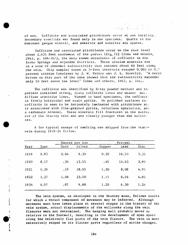
of ore. Coffinile and associated pitchblende occur at one locality. Secondary covellite was found only in one specimen. Quartz is the dominant gangue mineral, and ankerite and siderite are sparse.
Coffinite and associated pitchblende occur on the road level about 2,433 feet southwest of the portal (fig. 72) (Sims and others, 1963, p. 106-107), the only known occurrence of cof finite in the Idaho Springs and adjacent districts. These uranium minerals are in a zone of abnormal radioactivity that extends about 60 feet along the vein. Chip samples taken at 3-foot intervals assayed 0.003 to 0.3 percent uranium (analyses by J. W. Fatten ana J. L. Siverly). "A raisi driven on this part of the zone showed that the radioactivity extended only 10 feet above the level" (Sims and others, 1963, p. 10o y .
The coffinite was identified by X-ray powder methods and tn- pattern contained strong, sharp coffinite lines and weaker moi _ diffuse uraninite lines. Viewed in hand specimens, the coffinic is finely botryoidal and coats pyrite. On polished surfaces tn-- coffinite is seen to be intimately laminated with pitchblende ar.^ is associated with fine-grained pyrite, colorless sphalerite, anc a carbonate mineral. These minerals fill fractures in the sulfiu- ore of the Stanley vein and are clearly younger than the sullic- ore.
A few typical assays of smelting ore shipped from the vein dur-ing 1919-34 follow:
Year
1919
1920
1921
1922
1934
Tons
0.92
8.17
5.29
1.27
4.97
OuncesGold
0.66
.34
.19
1.06
.87
per tonSilver
9.30
13.55
18.95
23.50
9.60
Copper
0.30
.45
1.30
1.15
1.20
PercentLead
16.50
14.63
8.08
8.56
6.30
Zinc
3.25
3.90
4.95
4.80
1.26
The vein system, as developed in the Stanley mine, follows raults for which a thrust component of movement may be inferred. Although movement must have taken place at several stages in the history of the vein system, actual displacements of the wallrocks along the vein fissures were not determined. The hanging wall probably moved up relative to the footwall, resulting in the development of open space along the relatively flat parts of the vein fissure. The vein is most extensively stoped on its flatter parts regardless of strike changes.
186

and A. A . I'ra/.o , Jr.
borne of the best ore occurs at the vein intersections (Spurr, Garrey, and Ball, 1908, p. 348). A large body of high-grade ore reportedly occurred at the junction of the Stanley and Joker veins, and another ore shoot was located at the junction of the Stanley and Crocket veins. Because the Joker and Crocket veins are steeper and strike more easterly than the Stanley vein, the ore shoots should plunge at medium angles to the west. The largest part of the ore in the mine occurred in those parts of the veins that were not subjected to multiple postminera1ization brecciation (Spurr, Garrey, and Ball, 1908, p. 348).
I t187
Summit mine (E-III, 6)
Development.--A drift-adit (not shown on fig 1.) and a shaft just outside the portal.
Production.--!.!. S. Bureau of Mines recorded 494 tons of crude ore shipped in 1910, 1916, and 1932-35, yielding 397.05 oz gold, 354 oz silver, and 323 Ibs lead.
Vein.--Summit: Strikes N. 52° E., dips 67° N.; vein it southwest extension of the Shafter vein.
Wall rock.--Biotite gneiss and granite gneiss.
Vein minerals. Pyrite, copper minerals, sphalerite, galena, and quartz.
188
, J r . ,
'\'.. : : ;'.. c. c * -: 'C.,,: 1 ,-.. Con. , :../ i,. i,. ifind A. A. Drar.c, .Jr.
Sun and Moon mine (G-II, 3, 4, 22)
The Sun and Moon mine is on the ridge at the head of Gilson Gulch. The workings were inaccessible in 1954 and most of the following has been taken from Bastin and Hill (1917, p. 289).
U.S. Bureau of Mines recorded 68,354 tons of crude ore and 4,001 tons of concentrates shipped during 1902-21 which yielded 30,752 oz gold, 396,232 oz silver, 498,190 Ibs copper, 1,292,814 Ibs lead, and 300,858 Ibs zinc. The pre-1912 yield of the Sun and Moon mine was about $2,000,000 (Bastin and Hill, 1917, p. 289), at least $200,000 01 which was from the Garden shaft (Callbreath, 1899, p. 151).
The mine openings include three shafts--the Minott (G-II, 22), the Sun and Moon (G-II, 3), and the Garden (G-II, 4)--and numerous drifts and stopes (figs. 73, 74).
Most of the mine workings are probably in microcline gneiss, but the Minott shaft is collared in albite granodiorite porphyry* Biotite schist (probably the biotite-quartz-plagioclase gneiss of this report > is predominant on the Argo tunnel level (Bastin and Hill, 1917, p. 289;.
The Sun and Moon vein strikes about N. 60° E. and dips about 5C C NW. On the Argo tunnel level it is nearly barren and consists largei" of fractured, silicified, and pyritized wallrock and local massive veins of pyrite (Bastin and Hill, 1917, p. 289). Within the ore snooi (figs. 73 and 74) the vein contains abundant sphalerite, galena, chalcopyrite, and tennantite. A total of 836 tons (54 lots of smelting ore) shipped in 1908-09 contained 0.40 to 8.25 (avg 1.31) oz gold per ton; 3.81 to 37.7 (avg 14.5) oz silver per ton; less than 1.5 percent to b.9 percent copper; 13 percent or less lead; and 8 percent or less zinc.
The Sun and Moon vein is intersected just east of the Sun and Moor shaft by the Moon-William Penn vein (fig. 73) which strikes about N. 85° E. and dips 60° NW. Ore from the dump of the William Penn shaft consists largely of sphalerite and galena.
The principal ore shoot in the mine (figs. 73 and 74), a large ore body that plunges about 55° N. 40° E., yielded nearly all the production from the Sun and Moon vein. The ore shoot was probably localized at ttit- junction of the Moon-William Penn vein with the Sun and Moon vein, for this junction plunges about 50° N. 40° E.
189

ar/i A . A . Lr;j V<-, Jr.
Syracuse mine (D-II1, 5)
The Syr.icuse mine is on the southeast side of Oro Gulch at an altitude of 8,081 feet. Although production data are not available for the mine, a small amount of ore was produced during 1891-94 (Bastin and Hill, 1917, p. 365).
The mine is opened by a drift adit which is caved 1,040 feet from the portal (lig. 75). The Morning Star shaft (D-III, 6) passes through the level 900 feet from the portal.
Bioti pegmatite, present (f 220 feet f The wall re de formed : S. 55°-7C~
The -adit work.: southwest 370 feet : by a nort
The :and dips - of the ve. into sever thicker v: in the nc: gouge-fil pyrite. pyrite CL: Chalcopvi were seer
Anal selectedSy2-2b) <
:e gneiss and amphibolite are the dominant wallrocks, ana microcline gneiss, and biotite-muscovite granite also are -g. 75). A biotite-rich pegmatite exposed between 180 and :c.n the portal has a maximum radioactivity of 0.17 Mr/nr. :ks strike northeastward, dip northwest, and are localiv ' small chevron folds, the axes of which plunge gently
lit is driven on the Syracuse vein. To the northeast of tn--: V< this vein is known as the Morning Star vein, and to tne .t ir.ay be the equivalent of the MAB vein (fig. 1). Abou*. ". -n the portal (fig. 75) the Syracuse vein is cut and ofrsr^-s. st- trending fault.
incuse vein strikes N. 40 -75 H., averaging about N. 55" -.- ^-70° N. ; it is subparallel to the Wallrock foliation. Mo:--
: consists of a single vein element, but locally it spiiL L! branches. The vein is as much as 18 incnes thicK ana i ;re it strikes more easterly than normal. Locally, esoeci.^ :h eastern part of the main drift, the vein grades into oarr* .- fissures. The Syracuse vein contains abundant quartz anu
ihe thicker parts, the vein contains fine-grained quartz and r ' veinlets of quartz, pyrite, and base-metal minerals, .c . tennantite, and trace amounts of sphalerite and enargitt- .r. a polished section.
e .- (by S. P. Furman, D. L. Skinner, and James Wahlberg) o± .~-^les of the early pyrite-ricn part of the vein (Sy2-l and
of the base-metal-bearing part of the vein (Sy2-2a) follow:
Field No.Ounces p_er_t_pn_ Gold Silver
Sy2-lSy2-2aSy2-2b
0.24. 94.24
O.bb4. 3o
.Db
_CopperPercent
Lead Zinc
0.014.73
.01
0.47.39.32
0.47,5n.32
190
<!' . /!' !.. C ' '
C ,,r.' I' !., Hr,.- . .
a:.-'i /. - A- lJ^'i''«
The fault exposed in the drift strikes N. 45° W., dips 67°-84° NE. , and consists of several subparallel gouge-filled fractures. Near the northwest face of the drift some pyrite ib disseminated in the gouge along the footwall. The northwest- trending fault crosses the Syracuse vein and displaces it; the northeast part of the Syracuse vein has been shifted about 10 feet to the southeast with respect to the southwest part (fig. 75). As two sets of slickenside-striae are on the fault walls, one set plunging 35°-50° SE. and the other plunging nearly downdip, two directions of movements probably took place OP the northwest-trend ing fault a right-lateral diagonal slip followed by a minor dip-slip.
191

Tigris adit (G-III, 6)
By A. E. Dearth and P. K. Sims
The Tigris adit, on the east side of Seaton Gulch, trends S. 50° E. 400 feet and crosses tour veins--Vein A, Vein B, the Ottawa(?) vein, and the Esmeralda vein on which drifts have been driven (tig. 76). The production from the mine is not known, but extensive stopes are present on the Ottawa(?) vein and the Esmeralda vein, and a small stope is on Vein B. A shallow shaft from the surface bottom?; in the drift on Vein }..
The country rocks, largely biotite gneiss and small bodies of pegmatite, are folded along axes that trend N. 55° L.
The veins, although grossly similar, vary in width ana proportion; of contained ore minerals. All veins except the Ottawa(?) vein ar^ subparallel to the fold axes and foliation of the country rocks. Vein A strikes N. 70° E., dips 70°-80° NW., and consists predominantly of 4 cr 6 inches of gray quartz containing disseminated pyrite, and some goug-c. Vein B strikes about N. 50° E., is nearly vertical, and consists of b tt 8 inches of quartz and gouge, throughout which pyrite and sparse cnaic - pyrite are disseminated. The Ottawa(?) vein strikes N. 85° i,. , aj-u 75°-80° N., and ranges from 2 to as much as 30 inches in thicKneso. ii consists of silicified fragments of wallrock and irregular patcne; -. quartz, pyrite, sparse chalcopyrite, and rare galena. The walls a. locally coated with chalcanthite and epsomite. The Esmeralda vei apparently the largest and richest of the veins, strikes N. 50" L. , a ID 85° NW. , and ranges from 6 to 18 inches in thickness. It consist, principally of disseminated sulfides in fractured and sheared wallroc^, A thin layer of carbonate, probably rhodochrosite, occurs on the footwal. Malachite, chalcanthite, and epsomite locally coat the mine wali^, Numerous unimportant inch-wide veins of quartz and pyrite were cut i.~ the crosscut.
I 192I .

CVnif FILE, 19T6Miles and pi-osp.^ L,, Imr.o rprirv u;., riot, Clear Creek ai.d Giipin Ccuitio:i, Cole., by R. II. Moench and. A. A. Drake, Jr.
Tom Boy adit (G-III, 15)
Development.--Short drift adit.
Veins.--Tom Boy: Strikes N. 60°-80° E., dips 68°-81° NW., about parallel to the wallrock foliation.
Wallrock.--Granite gneiss.
Vein minerals.--Pyrite, quartz.
193

-, t,./ J'..'. i/rake, Jr.
Torpedo mine (D-V, 9)
The Torpedo mine is on the south side oi Spring Gulch about 1 1/4 miles west of its mouth. The mine workings consist oi an adit that bears southwest and an aggregate of more than 2,200 feet of drifts and crosscuts (fig. 77). About 1,050 feet fro. the portal the adit tranche. into two "osscuts, °ne extending 650 feet northwest, and the other extending 250 feet south.
US. Bureau of Mines recorded 51 tons of crude ore and 1 ton oi concentrates shipped in 1901, 1915, and 1918 that yielded 12 02 o^ gold and 121 oz silver.
Interfered pegmatite, granite gneiss, amphibol ite, and biotit. gneiss are the dominant wallrocks. A thin layer of microclme unei/ cut by t» conformable dikes of bostonite porphyry is exposed in en-"' northwest crosscut. These rocks strike uniformly northeast and du, steeply northwest.
One is Allowed by the adi- m ^ °rtal 63 ° *
- " I ^ NW., ,nd consists of an inch of galena, quartz, and pyritewinze, ^, feet from the portal, was sunk on this vein. The SkvrocKr- vein, exr:sed in the northwest crosscut, strikes N. 63° E dins 5^: NV., and consists of 1/2 inch of galena, sphalerite, pyrite ana auar~ The wide,: vein in the mine, probably the southwest 'extension of tT Little CL: vein, is exposed in the workings at the end ot tne soutr " crosscut This vein strikes N. 63° E. , dips 60°-80° NW. , and consist of 4 to .: inches of altered and pyritized wallrock and gouge. ^vei ls stopec ,t the end of the south crosscut, but the drift a?ong the ve is caved. ,purr, Garrey, and Ball (1908, p. 350), probably in rererenc, to this ^:n, stated "The lead, where mineralized, consists in the main of dark-gray quartz, inclosing small masses of galena, sphalerite Ina pyrite. .owever, small veinlets of telluride ore have also been fold - Radon gas was encountered in the mine, but its source was not founa The averse background radioactivity is about 0.2 Mr/hr.
rI 194

jiii': A A - i,r<-/f', .J i .
Treasure Vault mine (G-I1I, 10 and 11)
By P. K. Sims
The Treasure Vault mine, noted for its high-grade gold ore, is on the hill between Virginia Canyon and Buttermilk Gulch, about 3/4 mile north of Idaho Springs. The mine workings consist of a 125-foot shaft (G-III, 11), with levels at depths of 75 and 120 feet, and a drift adit (G-II1, 10), which connects to the west end of the lower (120-foot) level of the shaft by a 50-foot inclined raise (fig. 78). In 1955 only a part of the adit was accessible (fig. 78). The inaccessible workings shown on figure 78 were taken from an unpublished map prepared by E. S. Bastin in 1914.
Ore valued at about $100,000 has been taken from the mine; most of the values were in gold. U.S. Bureau of Mines recorded 8,289 tons of crude ore and 120 tons of concentrates shipped during 1902-37 whicn yielded 4,351 oz gold, 8,077 02 silver, 17 Ibs copper, 2,793 Ibs lead, and 686 Ibs zinc.
The wallrock is mainly microcline gneiss containing many thin layers of biotite gneiss and amphibolite and irregular, generally thin bodies of pegmatite. The rocks are tightly folded along northeast- trending axes, and dips of both limbs are steep. Individual folds art too small and numerous to show on figure 78.
Three principal east-northeast-trending veins, connected by flat cross veins, are in the mine on the adit level (fig. 78). The two southerly veins are subparullel to the fold axes and the foliation of the wallrocks. The main veins are grossly similar in mineralogy and consist of chalcedonic quartz, gouge, purple fluorite, calcite(?), and sparse pyrite. Pyrite is more abundant in the wallrocks than ii; the veins. The fluorite is largely present as vug fillings. Above a depth of 125 feet, free gold and gold telluride, probably sylvanite, are locally present. All veins are narrow, and sulfides are rarely visible.
The Treasure Vault vein, the principal vein in the mine (fig. 78), strikes N. 70°- 75° E., aips 25°-58° N. , and cuts across the structure of the wallrock. It was vjrked on all levels and was followed by the shaft between levels. Where exposed on the adit level, it is 1 to 6 inches thick and consists of bluish-gray chalcedonic quartz veinlets that cut pyritized and si.icified wallrock. According to unpublished notes by Bastin in the files of the U.S. Geological Survey, the vein consists of two veinlets cf quartz separated by about 4 feet of slightly altered wallrock near the crosscut to the raise.
A subparallel vein, herein called the South vein, is exposeo about 80 feet south of the Treasure Vault vein on the adit level. It strikes about N. 75° E. an- dips 83°-85° N. The fracture is barren at most places but locall;. contains as much as 3 inches of
195

' ,-,; ir.-u, C- , ,/ : ;. ;tnd A. A. L»; :,) ' , Jr.
white, chalcedonic quartz with sparse cubes of pyrite. This vein, according to Bastin and Hili (1917, p. 300), "Joins the Treasure Vault vein on the upper (75-foot) level about 90 feet east of the shaft and diverges from it westward." Grab samples from the South vein containing visible pyrite and quartz assayed 0.02 oz gold and 0.18 oz silver per ton, and 0.04 percent equivalent uranium (analyses by E. C. Mallory, Jr., and C. G. Angelo).
A third vein intermediate between the Treasure Vault and South veins (fig. 78), strikes about N. 70° E. and dips 70°-75° N. In the adit it is a 1- to 2-inch-thick zone of crushed and altered wallrock containing local thin stringers of cryptocrystalline quart? and sparse pyrite. It probably connects with the South vein immed iately west of the Treasure Vault adit crosscut.
Flatly dipping cross veinlets connect the three main veins. They consist of gouge and at places massive pyrite; base-metal sul- fides are absent. Their relation to the main veins is poorly under stood. According to Bastin and Hill (1917, p. 301), they locally cut the intermediate vein and the South vein, but the flat vein., observed by Sims on the adit level are cut and slightly displacec by both of these veins.
Most of the ore came from the so-called Machol stope which is adjacent to the shaft. It extended from the 125-foot level to tht surface. Some ore was extracted from a stope on the adit ievei, no'* inaccessible (fig. 73). The main ore body appears to be at anc immediately west of the intersection of the Treasure Vault vein wit^ the steep South vein, but this cannot be proved. According to Bastir and Hill (1917, p. 231) and George Collins (written communication), the high-grade ore occurs in the steep veins and also in the flatter cross veins. These ^nen noted that some of the richest ore was founc near the intersection of the steep veins and flat veins. In some of the richest ore, native gold, is locally associated with a silver- colored telluride. These minerals form irregular films on fracture surfaces near the f^at veins, and veinlets as much as 1/4 inch thick that cut brown-stained altered wallrock. Collins reported that con siderable sphalerite and galena occur in the Treasure Vault vein east of the Machol srope on the 75-foot level east of the shall, and that gray copper: probably also occurred in the high-grade part of the vein.
The tenor of tk-e ore varied greatly; some of it contained as much as 12 oz gold p.sr ton, but most of it assayed 1/2 to 1 1/2 oz per ton.
196

Tropic (Trojan) mine (G-II, 17)
Development. --Inclined shaft and at least seven levels; third level connects to Tropic adit.
Production. Mine produced ore worth $250,000 before 1899 (Callbreath, 1899, p. 210); ore yielded 391 oz gold, 42,643 oz silver, and 86,060 Ibs lead during 1887-92 (Kimball, 1886-1889; Leech, 1890-1893).
Vein. --Tropic: Strikes N. 80° E. , dips 65° N. , and ranges in .thickness from 1 inch to 6 feet; vein is a nanging-wall branch from Seaton vein.
1 rocks. --Mic roc line gneiss.
Vein minerals. --Galena, sphalerite, chalcopyrite, tennantite, anc quartz.
Tenor. --Rich in silver; samples assayed 0.19 to 1.6 oz gold and 21.3to Io9 oz silver per ton, and as much as 4.1 percent copper, 20.9 percentlead, and 23 percent zinc.
197
Tropic tunnel (G-II1, j)
The Tropic tunnel, near the head of Buttermilk Gulch, was driven in 1900, and the veins it intersected were worked intermittently until 1935.
U.S. Bureau of Mines recorded 735 tons of crude ore and 12 tons of concentrates shipped during 1902-35 which yielded 375 oz gold, 35,158 oz silver, 17,941 Ibs copper, 99,016 Ibs lead, and 64,066 Ibs zinc.
The tunnel (fig. 79) bears N. 8° W. for about 1,570 feet and is almost vertically above part of the Argo tunnel. Drifts have beeu turned on the Queen, Pine Shade, Tropic, and Gem veins. The Pine Shade drift connects to the sixth level of the Pine Shade mine, the Tropic drift connects to the third level of the Tropic shaft, and the Gem drift connects to a stope of the Gem mine. All these workings were inaccessible in 1954, and most of the following description is from Bastin and Hill (1917, p. 297-298).
The southern 1,000 feet of the tunnel cuts biotite gneiss The tunnel then crosses 170 feet of pegmatite, 260 feet of microclinr gneiss, and 100 feet of biotite gneiss. The northern part of ti;^ tunnel is in microciine gneiss. A dike of bostonite porphyry. 45 feet thick, is exposed immediately south of the Pine Shade drirL.
The Queen vein, which strikes N. 80° £. and dips 70° N. , tia. been developed a short distance east and west of the tunnel. IL ^ about 5 feet thick, and consists of numerous, nearly barren, tracture. in silicified, pyritized, and crushed wallrock.
The Pine Shade vein, which strikes about N. 80° w., and air 49°-62° NE. , and which is the eastward extension of the Seaton vein, has been developed 100 feet to the east of the tunnel and to the Pine Shade shaft on the west. It averages about 30 inches in thickness, and consists of dark-gray quartz, pyrite, galena, sphalerite, and chalcopyrite. Locally the ore has been brecciated and partly recemented by vnite quartz. The wallrock is silicified and contains disseminated pyrite.
The Tropic vein, which strikes N. 70° E., dips 70°-75° NW., has been developed as far west as the Tropic shaft and 20 feet to the east. It averages about 2 feet in thickness. Two to 4 inches of gouge com monly lines the hanging wall, below which is altered wallrock traversed by veinlets of sphalerite, galena, tennantite, chalcopyrite, and pyrite.
The Gem vein, which strikes west-northwest and dips north, is near the face of the tunnel. It is at least 20 feet thick. The driii follows the footwall of the vein, which consists of crushed, altered, and pyritized microciine gneiss that is traversed by numerous veinlets
198

of coarse pyrite as much as 8 inches tr.iri,that contains 4 inches of gouKe is 1 "C y Parail *l fracturefootwali. Between the Gem vein and H7"" " ̂ S°Uth ° f the <*»is altered and sparsely pyritized. lr"<:ture the microcHne gneiss
A nearly pure concentrate of t-,l,,, *i.3b oz gold and 20.9 oz si 1 ver per to " tr°'\ "ne Shade dumP shipment of zinc concentrates assayed !' Percent lead; a __ . t-., >.b percent lead, ,nd 27 pe cent L ^K S°" """ 2° ° 2 3llver P« A cotul of 648 tons of smelt ngoresn, if" 1" "* Hil1 ' 19U - P- 2 oz gold and 33 oz silver per ton 0 ? P " ^ i902-^- ayed U.i
b Percent zinc. P ' °' JJ percent COPP», b. b percent ieuand
199

Two-Brothers-tunnel (t-II, 8) and Bald Eagle mine (E-II, 9)
The Two Brothers tunnel is on the west side of Virginia Canyon about 2 miles nortn of Idaho Springs, and the Bald Eagle shaft is 450 feet N. 70° W. from the portal of trie Two brothers tunnel (fig. i). The shaft connects to the tunnel at a deptn of about 120 feet viu the main Bald Eagle drift (figs. 80, til). In 1954 these workings were accessible only through the Bald Lagle shait, but in 1955 the tunnel was reopened by the Bald Eagle Mining Co. 3 and mining was resumed on tne Bald Eagle vein.
The history of the Two Brothers tunnel prior tc 19J4 is not completely known, but extensive stoping had been dope on the Bald Eagle and Specie Payment veins. U.S. Mint reports for the years 1887, 1888, and 1891 (Kimball, 1886-1889; Leech, 1890-1897) and sampling-works assays dated 1888, 1889, and 1925-35 show that the vein was mined ir the early days of the district and at various times since then. iron 1 1955 to 1960 the Bald Eagle vein, worked from the Two Brothers tunnei, was by far the largest producer in the district, yielding a total of $906,000 at 1955 metal prices. Recent production data compiled by tn^ J.S. Bureau of Mines follow:
Year
1955 1956
1957 1956 1959
Total
Crude ore shipped (tons)
1,000 7,844 7,673 6,375 6,080
28,972
Gold (ounces)
149 4,379 3,947 1,141 1,588
11,204
Silver (ounces)
2,048 35,798 29, 121 18,616 22,235
107,818
Copper (pounds)
4,500 85,800 75,700 44,100 52,300
262,400
Lead (pounds)
36,500 579,300 639,200 457, 90U 385,300
2,098,200
Zinc (pounds^
6,100
_ _
6,100
L
The Two Brothers tunnel bears west-northwest to north-northwest, is about 2,500 feet long, and intersects the main drift on the Bald Eagle vein 480 feet from the portal (figs. 80 and 81). Workings on the Specie Payment vein, near the face of the tunnel, connect to the Diamond Joe adit through stopes above the Two Brothers tunnel.
Microcline gneiss is the dominant wallrock in the mine, and biotite gneiss is exposed at the sharp bend about midway in the Two Brothers tunnel (fig. 80) and along the westernmost part of the Bald Eagle drift (fig. 81). These exposures of biotite gneiss are at the bottom of the thick layer of this unit that caps Bellevue Mountain. In addition, small bodies of amphibolite and pegmatite are exposed in many parts of
200

t ' , ( Co .,'.,.::, (.'.i ,. , r y . . . . J and A . A . J;i'iij:e , «ji .
the workings. In the vicinity of the Bald Eagle drift the rocks strike generally northeast and dip northwest at flat to medium angles. Toward the western end of the Two brothers tunnel, the rocks are warped by many terraces and monoclines that trend north-northeast.
Four veins are developed by the tunnel and shaft: the bald Eagle vein (fig. 81), a thin east- trend ing vein that is followed by the tunnel for a distance of 490 feet (vein A, fig. 80), a thin unnamed vein cut 540 feet from the tunnel face (vein B, fig. 80), and the Specie Payment vein.
Bald Eagle vein.
The Bald Eagle vein is the westward continuation of the Lake veir and has been extensively stoped (fig. 81). The vein strikes N. 45°- 70° L and ranges in dip from nearly vertical to less than 40° N. Relatively steep dips are common in the eastern half of the main Bald Eagle drift and flatter dips are typical in the western half. The vein steepen.. upward and flattens downward from the main drift. A similar flattenir;^ in depth is shown by the vertical projection of the Lake vein from tm surface to the Big Five tunnel about 1,000 feet to the northeast. Ther^ the flattening occurs about 100 feet lower (about 8,bOO feet alt.) thai; in the Bald Eagle drift (about 8,700 feet alt.). These relations indicate that the Bald Eagle vein flattens in depth along an axis that plunge, gently northeastward.
The Bald Eagle vein is an excellent example of a composite lead-zinc vein and exhibits much evidence of recurrent movements berci, during, and after mineralization. Sphalerite, galena, tennantitt chalcopyrite, and pyrite occur in pods, veinlets, and "trunK" vein locally more than a foot thick that traverse a wide zone of fracture: silicified, and pyritized wallrocks. Brecciated, silicified, an, pyritized wallrocks are traversed by veinlets of quartz and pyrite, which in turn are cut by veinlets of base-metal minerals; in turn all of thesu materials are locally granulated and incorporated in gouge.
The proportions of quartz and pyrite to base-metal sulfides an-- sulfosalts are variable. Quartz and pyrite are dominant along tne eastern part of the drift where the zone of brecciated, silicified, and pyritized wallrocks is as much as 8 feet thick. Southwestward , veinletr of base-metal minerals become more continuous and thicker, and the zon^ of silicified and pyritized wallrock becomes thinner (fig. 81). Sphalerite and galena are the most abundant base-metal sulfides, and their proportions are also variable. Tennantite is next in abundance.. and chalcopyrite generally is present in only minor quantities. Small amounts of covellite, marcasite, pearceite, native gold, and a carbonatt mineral (probably siderite) also occur in the ore.
201

'' i " < , ' Cr. ,. ,C ' "> . Cu.o. , ,,;/ L. Ji.
evident of". n^l^^^^^T"1 fault ̂ ing's<Ie "" ' stage of mineralization" The contacTb t T" dUri"8 the late" the microcline gneiss in the western car, T 'he bio"'« 8"eiss and shifted about 80 feet- the north 7 f^ ° he drlft has been Subhorizontal slickeriside-strTf " m°Ved to the "°«heaot. offset approximates the true d?« f" COnmOn a"d su^est that this fractures that are f Had with ba e^rV '" addU1On ' mn' cr°" of tension fractures for right-latTraT min£ralS have the Position seen near the southwest end of th d itT^T"1*-^ ^^ may be base-metal minerals also thicken where th Veinlets of^uteTS'f0 ' nrmal dip-""p ̂ ^ y^"np:.v-u!!!r-'-tl- thacimmediately before base-metal
p-s immediately before base-met^l m n^^al SoT"^ 1'" dUri " 8 ° ! such movement is supported bv thp nr suggestion for are oriented ne-rly^djp Ld cro."^" °hfh SUckensid-"riae tha, striae. P ross the Subhorizontal slickenside-
for thethan the average. Th c tro is , *"" ""^ m°re to the dominant righJlatera! £%£ .lo^l^l^ ̂ .^""" subordinate relatively later dio s ]?f Splte of the appear to have markedly controUed oreT! "'/ 1" Varia£ions "o nc: ore has Deen mined on the flatter a l ' £ ° r mUCh of the v.« in
fractures were filled with
The ore bodies may be in th*> f^r-^ ^ ,the .hoois i. not knoj. Minor vefHtr t ' ^ ̂ piun*e of and curvatures, plunge about 30ow about I , "" " P°dS> SpUts - of the v, in with the wallrock Li^o - -"
U.S. ^ureau of Mines production records for 1955 SQ ^ average cer.cr of crude ore Thi^ o^ . , iy^5-59 indicate the oz silver oer ton, 0.44 pwcew co aver^ed 0-33 oz gold and 3.6' 'was repor onlyin 1955 but is nrob'hl K*' ^^^ ^ 2i abundance. ' * 1S P robably about equal to lead in
Selected specimens from the*results .« shown in the folovg Th"" "" ""^ a"d Ch " represent contrasting types of natJ? i Sampl£S "ere se ^cted to''include: ,. alteredandpyritize » rano ce«r,.* ; with quartz III i pyrlte " *""(3) vein, , base-metal minerals,
202

Labora
tory
S
eri
al
No.
274413
274412
274411
274410
274409
:7uV
08
2741
*07
Z74
406
27
44
05
274404
274 ,:
ij
274402
Fie
ldN
o.
BE
-.'ih
BE
~;>j
BE
-3£
BE
-3e
BE
-!d
BE
-',.
3E-;.
b
BE
- ia
B
E-2
f B
E-2
e B
E-2
U
BE
-2c
Ounce
Go
I d
0.
69
. 02 .52
1. 1
8
. 02
.02
. 10
.02
.02
.0
2
.02
. 26
, j.
.r
t,n
r i
1 ver
; 7 .
9 >
t -\
t
9. S
o
8.9
''
. lp
. 13
1. 0
2
.08
. 16
. 20
. 48
21.
24
I e
rccnt
Oo
pp
er
L".
id
,..\-
.
13.C
KI
20.
.'v;
h. '
..
in!
. i
i.'..-.
1
'. '
i -.
1
. >"?')
3. : ;
i.
, ?
i',.
br-
0.=
. ^
^ .
o1
I.1
irbre
. (T
.
:>;'
. r
[.j
ini-
::;
. IP
.
^0
. -V
:
in.
nat
!0
.42
.0
?
8 i-
;.
. 01;
.3
4
.0-4
:
ir.
. '"
.0
4
. 03
^
in.
.3°
.:'
r ir
.
/ . ^
l) '2
. 9f
t U
5. T
/ 2V
in
ts
'
' j^
e- f
- '
i '
ir.ii
-r
^ls
''n
h
ang
ing
.»"
"id
{ -. r
iti
-od
c
i '.
-MI
ban
t;-
il
l.,
- t n
! e
t co
jr,-
'.:
ba?-
,'
-.-t
il
.'. r.
era
ls.
,' il
icjf
ied,
pv
riti
r -1
r--\
;^M
tite
c '. .
! an
d
vein
lets
."
f r, il
en
a.
i i 1
i (..
i i ie
d .
lyn
't :
-%
' re
.-
itit
cc
. i a
..
sheare
d,
s il
it
i
fd
. .
; t
i "
f?d
mat
i tv
! .
vein
let
qv
ir',
: ,
: ' -
. -
.:' jn
rbo-
c . vein
quart
: v
."
; -
.
,^;.
wd
ll.
py rit
i ze
d,
s ;
! i .
;
,.,
'
;-:>
eia
. §
? "
^
. (_
.
. co
ar<
,f
' -
,''"','''' 1
-,
,3 r
d r
- :_
carb
onate
. .
?
- c_
27
44
01
274400
274399
274398
27
43
97
274396
27..S
95
11
4
';
? 4
217
7 '4
1 '
BE
-2b
BE
-2a
BE
- If
BE
- IP
. B
E-
Id
BE
-lc
BE
-lb
BE
- la
TB -
1 *
in-?
.66
.06
.02
. 40
. 02
. 20
.04
.02
. 28 ')?
12.
76
.74
.20
2. 8
4 .5
4
22.
SO
3.8
6
. 18
r. 5
2 2 '«
1 , ^
'' "'
^ .c
"' .
>5 T
'_ i n
an
d
. T.0
.
V3
. ;G
7 -i
n.
. 05
.
3S
.12
6
in.
.28
1. ^
j .
l«
: -i
n.
. 2.
' .
3 ,
: ,,
in.
: 6'
' . :
'
! "i
n.
. ' (
^ .
^ ''
'
! 4
L n ,
' id
).;
' S
' '
I/
I '
i n
. f in
o-r
- i
i -..-:
J
*
.-!'
--f-
Td
ils
tJ O
O c
1 carb
onai-
. ^ ^
|~'
"^ve
in
r r
qu 1
1' f
.: .
; v:
i '
- ->^
'
iotv
all
. ^ °
^.
._£
o
-'pyri
tizcd
w.i
llr
*c'<
o
r ^ar
.-in
s; w
all
. c_
, c^
*-?
r*M
*<
£ '^
' *
rein
of
quir
t.
M-d
rv
rif-
.
. c
^'
pyr
i t
i.-.i-
^ --
.? ' li
ock.
I3-1
"r
,_
ccar
->e
biS
'<
ta
l "~
i tvr
' s
. ^_
F;
'--
t i'ie
- gta
ir.
"J
'),i
;
'
;iu
'tjl
<
B:
O °
: a ''b
on
.tte
^
!lj ^
> M
'.-.-I
on
' r
jr ,' !
I.
^
5 "5
-.
» 1
'
i i
I s
tr -
.
. ,-
.
C . .' ! ::, *rr1 A. A. L)i ;»/.< Jr.
vein. Clearly the base-metal veins contain the highest values in precious metals as well as the bulk of the copper, lead, and zinc. One vein.of quartz and pyrite shows a fair amount of gold (BE-le, 0.4 oz/ton), but gold assays are much lower in most of the pyritic vein material, gouge, and pyritized wallrocks. The ratios of silver to gold likewise are much greater in most of the base-metal-rich material than in the pyrite materials. The ratios in the base-metal-rich specimens are also much higher than those shown by the production data, indicating that ore shipped from the vein is a mixture of both types of material, and that pyritic material is dominant over base-metal-rich material.
A few typical assays of smelting ore from the Bald Eagle vei; shipped to the Idaho Springs Sampling Works during 1925-35 follow.
Tons
15. UO7.89
11.1522.9421.8217.657.59
OuncesGold
0.455.21.67.59
1.02.96.45
per tonSilver
41.3026.0738.8747.1037.6033.2016.35
Copper
1.17.71
1.321.15.80.83
2.70
PercentLead
4.557.277.6?2.955.356.402.35
ZlTiC
i J . O -
16. 7i12. bu8.oj,12.0613. 8u8.15
Vein A.
The unnamed, east-trending vein followed by the tunnel from 785 to 1,260 feet is of no economic importance. It strikes east, dips 60°-80° and consists of less than an inch of quartz, pyrite, galena, and sphaler ite. The wallrock is altered 4 to 6 inches on either side of the vein.
L
Vein B.
The second unnamed vein is exposed in the spur drifts 540 feet from the face of the tunnel. It strikes east and dips 40°-55° N. Sever^ sinuous branches from the footwall dip 55°-70° N. The main vein is 1/2 to 6 inches thick, and consists of quartz, fine-grained pyrite, and pods of galena, sphalerite, and tennantite.
Specie Payment vein.
The Specie Payment vein strikes about N. 75 W., and dips 45°-65°K. It is exposed at only two places in the accessible parts of the Twc Brothers tunnel (fig. 80). About 40 feet from the face of the tunnel the vein consists of a wide zone of altered pyritized rock. The
204

pyritized zone is cut by ;j 5- inch- thick vein of chaIcopyrite, tennantite, galena, and sphalerite that is somewhat radioactive. Analyses (by S. P. Furman, J. r.. Wilson, H. H. Lipp, D. L. Skinner, and W. D. Goss) of chip samples from the impregnated zone (sample 30b) and the vein (sample JIM) follow:
LaboratoryNo.
217577
217578
Sample
30a
30b
Width (inches)
5.5
5.0
PercentEquivalent Uranium uranium
0.032 0.047
.005 .007
Laboratory No.
217577
217578
OuncesGold
0.64
.12
per tonSilver
19.78
.52
PercenrCopper Lead Zi;;_
2.37 1.89 0.51
1.45 .Ob 1.6~
An exposure of the Specie Payment vein in the drift 390 feetthe Two Brothers tunnel consists of 2 feet of altered wallrocK neaviiimpregnated with pyrite. This altered rock is cut by a 3 1/2-inrthick vein of quartz and pyrite containing minor amounts of galena anchalcopyrite. Analyses (by S. P. Furman, J. E. Wilson, H. H. LipD. L. Skinner, and W. D. Goss) of chip samples of the quartz-svein (sample 31a) and of the altered zone (sample 31b) follow:
Laboratory Width No. Sample (inches)
Ounces per ton PercentGold Silver Copper Lead Zinc
217579
217580
31a 3 1/2 0.50 24.66
31b 4 .02 .14
0.29 2.08 0.51
.10 .17 .32
205
Union adit (B-IV, 3)
By J. E. Harrison
The porL.il of the Union adit is near stream level on the northwest side of Trail Creek and about one mile southwest of its mouth. The adit (fig. 82) is a 1,048-foot crosscut, trending N. 22°-38° W., from which three drifts have been driven. Some stoping has been done on the two drifts nearest the portal.
The wallrocks consist dominantly of granite gneiss and a few layei: of biotite gneiss and migmatite (fig. 82). A dike of bostonite porphyr- is exposed at the portal.
Two prominent veins and several unimportant veins are exposed i^ the adit. The thickest is exposed in the drift 625 feet from tn- portal and probably is the Old Settler-Phoenix vein. It strikes N. S3" and dips 45°-50° N., and is about 3 feet thick. Another vein, 160 re: from the portal, strikes N. 60° E., dtps 50°-61° NW., ana is 10 inci- thick. All veins in the adit consist of crushed wallrock and goue. wtiica contain veinlets and fragments of quartz, pyrite, tennantite, ar. . locally carbonate. An Idaho Springs Sampling Works assay of 1.30 con of smelting ore shipped in 1920 showed 0.385 oz gold, 51.60 oz siivc., 9.85 percent lead, and 5.30 percent zinc.
[ 206

United Gold adit (C-II, A)
Development. A 450-foot drift adit that trends N. ib° E. to N. 25° W. and a 600-foot crosscut that trends about N. 75° E. The crosscut was turned 150 feet from the portal and connects to five short drifts that trend N. 20°-35° W.
Veins.--The drift adit follows a vein that strikes about N. 15° E. and dips 15° W.; it is 2-6 inches thick and consists of quartz, pyrite, and gouge. About 300 feet from the portal, this vein is cut without displacement by a nearly vertical barren frac ture that strikes N. 27° W.; this fracture also is exposed in the crosscut. Another barren fracture and four veins are exposed in the crosscut; the veins strike N. 20°-35° W., and are as much a^ 10 inches thick.
Wall rock.--Probably mainly microcline gneiss. The quartz monzonite porphyry dike cut by the September adit (C-II, 3) should be exposed in the crosscut.
Vein minerals.--Pyrite and quartz.
207

Uj/per East Lake adit (F-1I, 4) and Owatonna shaft (F-l, 1)
By A. E. Dearth and P. K. Sims
The Upper East Lake adit, on the southeast flank of Pewabic Moun tain, develops the southeast vein of the Frontenac-Lake vein system. The Owatonna shaft is 450 feet northeast of the tunnel portal and develops the Upper East Lake vein near the surface and a branch from this vein on the adit level.
The Upper East Lake adit trends about N. 55° E.; in 1955, it was caved 715 feet from the portal (fig. 83). A 35-foot crosscut to the notthwest, 385 feet from the portal, connects with the Owatonna shaft workings, but the Owatonna drift is caved southwest of the crosscut. A short crosscut to the northwest at 515 feet also inter sects the Owatonna vein.
T>.e production from the Upper East Lake adit is not known, foi it is .ombined in U.S. Bureau of Mines records with that from tnt Lower ^ast Lake adit and the Windsor Castle mine. In 1910, I/ tons of cru. e ore shipped from the Owatonna shaft contained 1.85 oz gold, 183 oz silver, 1,832 Ibs lead, and 1,283 Ibs zinc.
1 e wallrocks on the adit level are dominantly pegmatite an.;suborc nately biotite gneiss and migmatite. These rocks strikeabout . 30° E. and dip 30°-45° NW, and are warped and crenuiate^.
T-ree prominent veins are developed by the adit--the Upper East L-.ke vein, which was followed for the complete length of the adit, c_he Owatonna vein, developed from two crosscuts, and a small connec ~ ing vein between these veins (fig. 83). The Upper East Lake vein s -rikes about N. 55° E. Where it cuts biotite gneiss it dips 60°-7 C NW. ; but where it cuts pegmatite it dips 35°-60° NW. and is ger-crally thicker and richer. In biotite gneiss, the vein is 2 to 1 _ inches thick and consists of sheared wallrocks cut by inch-:: ick veinlets of sphalerite, pyrite, chalcopyrite, and sparse galenc In pegmatite, the vein is 18 to 50 inches thick, and sphal erite ^nd galena, mostly as clots and veinlets, are more abundant. In the stoped area, veinlets of sphalerite and galena cut altered and py-ritized wallrock and aggregate 10 to 12 inches in width.
XL-vie Owatonna vein strikes N. 65° E. and dips 30°-45° N. It apparently branches downward from the Upper East Lake vein below the shaft -collar. The vein is as much as 12 inches thick and consists of sheared wallrock cut oy veinlets of pyrite, chalcopyrite, sphaler ite, ai2nd galena. Veinlets of intergrown sulfides are as much as 4 inchfces thick. Sphalerite is far more abundant than galena.
208
fi

The connecting vein between the Owatonnn and Upper East Lake vein strikes about N. 75° E. and dips about 60° N. It is 2 to 3 inches thick and consists of galena, disseminated pyrite, and chalcopyrite.
The ore shipped from the mine probably came largely from the Upper East Lake vein which was stoped at three places (fig. 83). The largest stope, which appears to extend beyond the cave at the northeast end of the drift, is in pegmatite. A small stope on the Owatonna vein is in biotite gneiss. The Upper East Lake and Owatonna veins are in places slightly more radioactive than normal. The areas of abnormal radio activity are shown on figure 83. Analyses (by L). L. Skinner and E. C. Mallory, Jr.) of selected sulfide ore specimens from the mine follow:
Samp 1eOunces per ton PercentGold Silver Copper Leau Zinc
UL-1
UL-2
0.20
.16
31.96
9.86
2.15
.46
12.42
32.21
5.6.,
4.38
A semiquantitative spectrographic analysis of sample UL-1 by N. M. Conkliu indicated x. percent As, 0.x percent Cd, O.OOx-f percent In, and 0.x per cent Sb.

U. J. a'iit (h-i;, <*;
Development, --A 600-foot crosscut ddit tr,.it ; i. »N. Z6 1 W.
Veins. --Three nearly barren veins tnat >triKt- N. 8U°-85° E. and dip 60°-70° M.
Wal Irock. --HuinJ y oiotite gneiss cut !) / aikr.-, of porphyry.
Vein mineral s.--Pyrite >md quartz.
210

, r.<j ' >. , by j<. . Lra.«j. Jr.
Waltham mine (F-V, 2)
L)e ve 1 opmen t. - - Two short adits, a 200-foot shaft, and short drifts. The shaft was inaccessible in 1954 below 75 feet; the tunnels are not shown on figure 1.
Production.--U.S. Bureau of Mines recorded 3,356 tons of crude or< ano 43 tons of concentrates shipped during 1^03-H which yielded 382.3;; oz gold <<mi 81.3 oz silver.
Veins.--Two subpar<*llel veins: StriKe N. 43° W. and N. 58° W. : di, 65° NL. ; these are part of the Idaho Springs fault. These two veins ar-. connected t>y a vein that strikes N. 80° W. and dips 60° N. The soutnwe.c: vein on tne 140-foot level (Spurr, Garrey, and Ball, 1908, p. 380;, ranging in thickness from 6 inches to 1 1/2 feet, consists of clay am' crushed rock that contains scattered nodules of quartz and pyrite. wnerea the northeast vein is a crushed zone 4 to 6 feet wide tnat concains spars veinlets of quartz, pyrite, and galena. The wallrocks between tne vein., are highly fractured, altered, and impregnated with quartz and pyritt.
.vailrock. --Biotite gneisses and granite gneiss; also probably mine,. amounts oi quartz ciiorite.
Vein minerals.--Pyrite, sparse galena, ana uoundant quarts
Tenor. --2.87 tons of ore shipped to the Idaho Springs i>ampiing in 1937 assayed 0.20 oz gold and 0.80 oz silver per ton.
211

ILI
"; .,.-; ..,] j.'iho '';: * ;-.< . '- ',, C:':nr C,^.>-\r and Gl^:>li-CoiiiMr.-:;, Co3(... b.y If. H. Moononand A. A. Lrako, Jr.
Wild Rose shaft (C~V, 2)
Development.--A shallow shaft and short drifts.
Production. --SmaU .
Veins.--Probably two veins, 20 feet apart, that are branches of the Little Mattie-Newton vein described bv Harrison and Wells (1939, pi. 2). The veins strike northeast and dip steeply nortnwest.
WalIrock.--Dominantly granite gneiss.
Vein minerals. Galena, sphalerite, copper minerals, pyrite, and abundant quartz.
91 7
C: . .U<^, r;o^;. , by It ar.ci A. A. bi-a/.<.-., or.
Williams mine (E-I, 3)
Development. 535-foot inclined shaft with levels at 358, 428, and 535 feet. Crosscuts from all 3 levels connect to the Crown Point and Virginia mine.
Product ion.--Puring 1939-49, 1,650 tons of smelting ore and 2,996 tons of concentrates shipped yielded 5,160.68 oz gold, 7,822 oz silver, 32,447 Ibs copper, 19,950 Ibs lead, and 7,674 Ibs zinc.
Veins. Williams: Strikes N. 73° W. , dips 65°-80° NE.
Vein minerals.--Pyrite, galena, chalcopyrite, sphalerite, and quartz.
Ore bodies. Mine workings are on steep parts of the vein.
Tenor. Concentrates contained an average of 1.34 oz gold and 2.5 oz silver per ton; 0.54 percent copper; 0.33 percent lead; anc 0.12 percent zinc. Smelting ore contained 0.70 oz gold and 0.1P oz silver per ton.
213