Embed Size (px)
Citation preview
Unit 1: Geography of Georgia
SS8G1: The student will describe Georgia with regard to physical features and location.
Vocabulary Terms to KnowSS8G1a
• Region: An area with common characteristics such as soil, vegetation, climate, landforms, recreation and economic opportunities.
• Nation: A territory or country.• Continent: One of seven large land masses on
Earth.• Hemisphere: A half of a sphere or the Earth.

Location SS8G1a
• Located on the continent of North America• Located in the southeastern region of the USA• Georgia is bordered by five states on the:A. FloridaB. South CarolinaC. AlabamaD. TennesseeE. North Carolina

Location

Absolute & Relative Location
• Absolute Location: Georgia is between 30 ° 31‘ and 35 ° north latitude; between 81° and 85 ° 53' west longitude.
• Relative Location: Georgia is surrounded by Tennessee, Alabama, Florida, South Carolina, & North Carolina (5 border states…Review).
• Georgia is positioned in both the northern and western hemispheres.

Location
Location
• Georgia has 159 counties• Georgia is ranked 24th in size among the 50
U.S. states. • Largest state east of the Mississippi River.• Highest mountain point in Georgia is
Brasstown Bald (4,784 feet), which is located in Twiggs County
• Atlanta is the capital city.
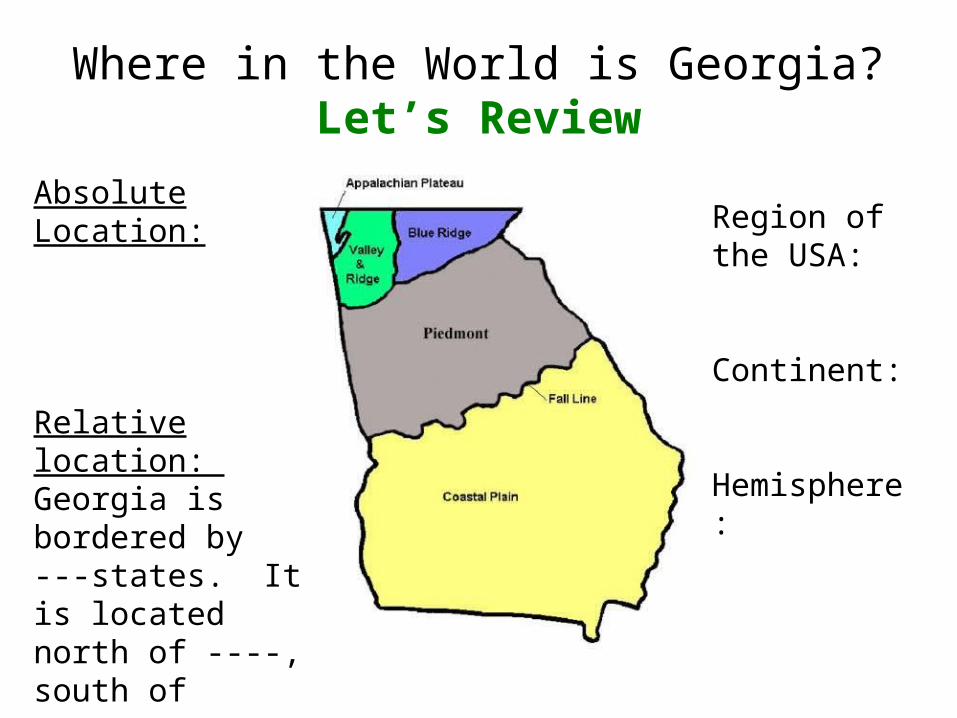
Where in the World is Georgia?Let’s Review
Absolute Location:
Relative location: Georgia is bordered by ---states. It is located north of ----, south of -----, etc.Georgia is also bordered by the ----- Ocean
Region of the USA:
Continent:
Hemisphere:
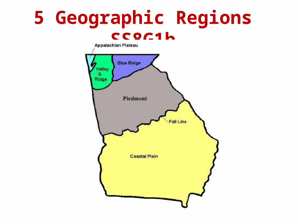
5 Geographic Regions SS8G1b

5 Geographic Regions
• Each of these regions has soil, physical features, and climate that help determine what kinds of animals and plants can live and thrive in it.
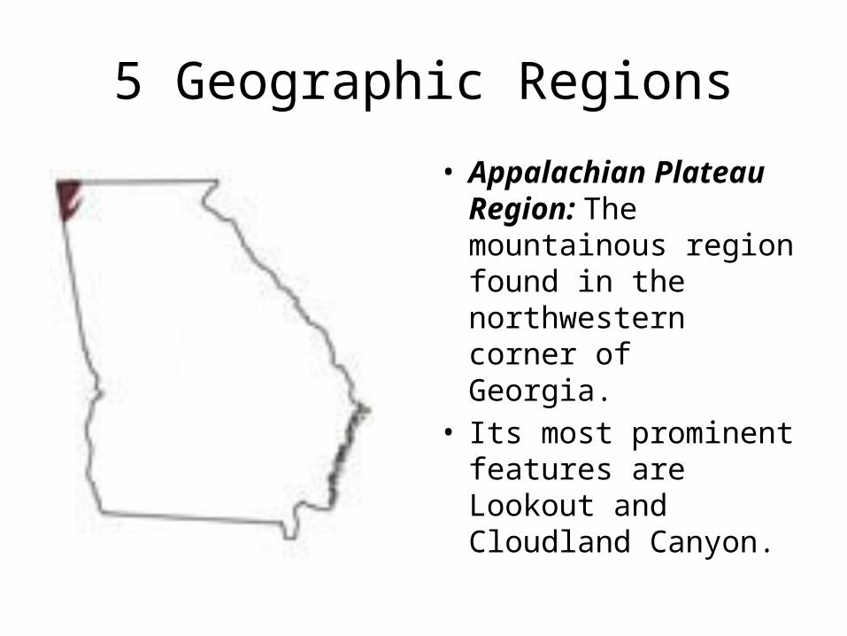
5 Geographic Regions
• Appalachian Plateau Region: The mountainous region found in the northwestern corner of Georgia.
• Its most prominent features are Lookout and Cloudland Canyon.
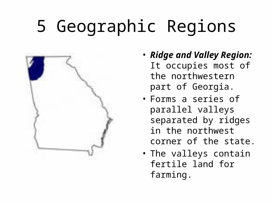
5 Geographic Regions
• Ridge and Valley Region: It occupies most of the northwestern part of Georgia.
• Forms a series of parallel valleys separated by ridges in the northwest corner of the state.
• The valleys contain fertile land for farming.
5 Geographic Regions
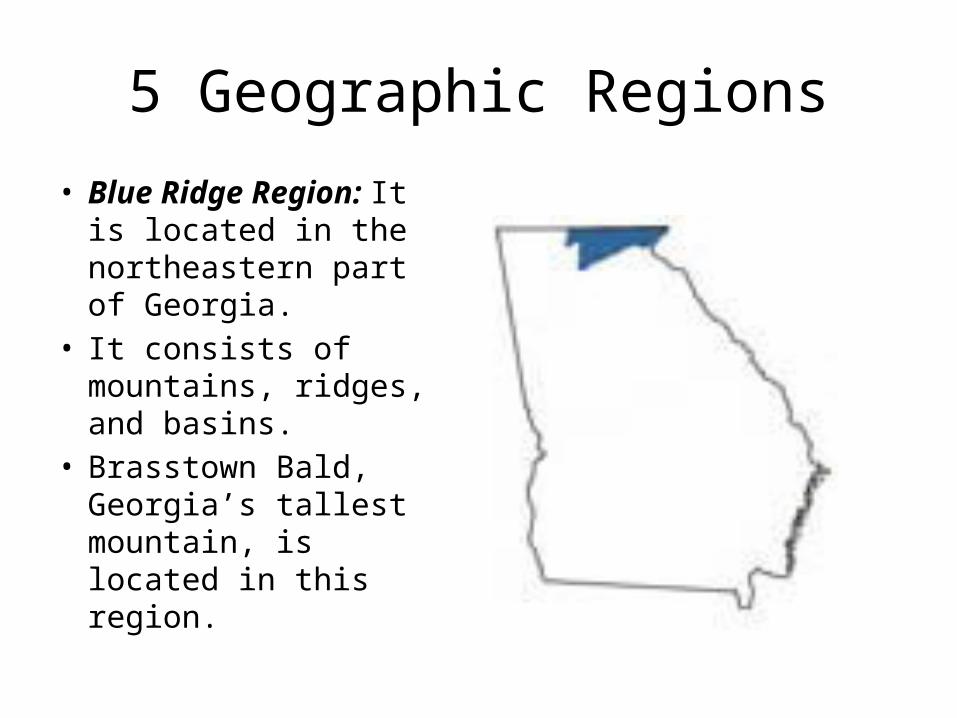
• Blue Ridge Region: It is located in the northeastern part of Georgia.
• It consists of mountains, ridges, and basins.
• Brasstown Bald, Georgia’s tallest mountain, is located in this region.

5 Geographic Regions• Piedmont Region: It contains
a series of rolling hills and occasional isolated mountains (Stone Mountain and Pine Mountain).
• Rivers and ravines are found throughout this region.
• Red clay soil is found in this region.
• ½ of Georgia’s population lives in the Piedmont Region.
• We live in this region.
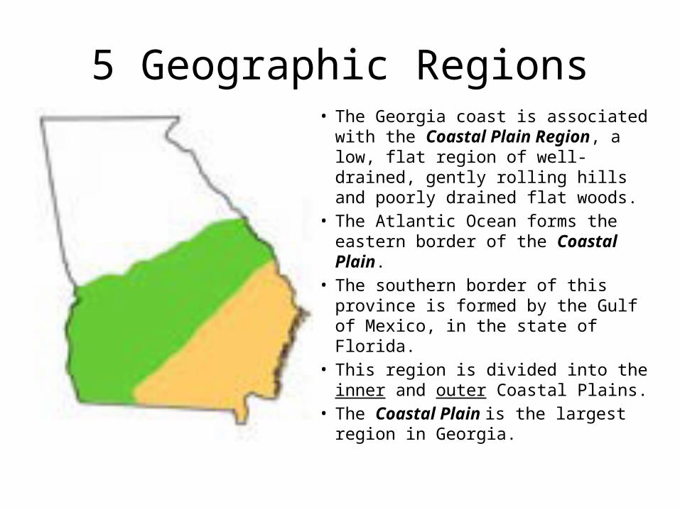
5 Geographic Regions• The Georgia coast is associated with
the Coastal Plain Region, a low, flat region of well-drained, gently rolling hills and poorly drained flat woods.
• The Atlantic Ocean forms the eastern border of the Coastal Plain.
• The southern border of this province is formed by the Gulf of Mexico, in the state of Florida.
• This region is divided into the inner and outer Coastal Plains.
• The Coastal Plain is the largest region in Georgia.

5 Geographic Regions SS8G1bAdd to your map:1. Atlanta2. Atlantic Ocean3. Brasstown Bald
Mountain4. Chattahoochee River5. Savannah River6. Okefenokee Swamp7. Label where Alabama,
Tennessee, Florida, North Carolina, and South Carolina are located on your map
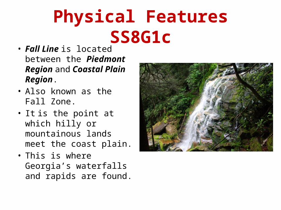
Physical Features SS8G1c• Fall Line is located
between the Piedmont Region and Coastal Plain Region.
• Also known as the Fall Zone.
• It is the point at which hilly or mountainous lands meet the coast plain.
• This is where Georgia’s waterfalls and rapids are found.

Physical Features• Okefenokee Swamp is a wetland haven for
hundreds of plants, animals, and reptiles. • 80% of the swamp is a national wildlife refuge.• It is the largest swamp in the USA (402, 000 acres).• This swamp is located in the outer Coastal Plain
Region.http://www.gpb.org/georgiastories/story/okefenokee_swamp

Physical Features
• Georgia two major seaports are: Savannah & Brunswick, GA.• Georgia’s rivers are important to the state, because they:A. Provides habitat for thousands of plant and animal species.B. Transportation routes for ships carrying goods.C. Provide drinking water for many areas.D. Generate hydroelectric power at many dams and cool the
reactors at facilities that provide nuclear power in the state.E. Source of recreation for people who like to canoe, kayak,
and swim.

Physical Features• 11 Major state rivers are:1. Etowah River2. Coosa River3. Chattahoochee River4. Oostanaula River5. Flint River6. Chattooga River7. Savannah River8. Ogeechee River9. Oconee River10. Ocmulgee River11. Altamaha Rivers
• The Chattahoochee and Savannah Rivers form part of Georgia’s eastern & western borders.

Physical Features• Along Georgia’s eastern coastline are the Barrier Islands.• They are all located in Glynn County, GA.• These islands protect Georgia’s beaches on the eastern
coastline by blocking wind, sand, and water from eroding the land.
• These islands are wildlife sanctuaries, recreation, and tourist attractions.
• Also, known as the “Golden Isles” these islands are named:
Tybee St. Simon Little St. Simon Jekyll
Sea Island Wassaw Ossabaw St. Catherine
Sapelo Cumberland Little Cumberland Wolf

Georgia’s Barrier Islands

Secret Seashore: Georgia’s Barrier Islands (Georgia Public Broadcast, 2011)
Media Clip: http://bcove.me/kulrqy1k
3-2-1 Reponses
• What are 3 facts about the fall line of Georgia?• What are 2 purposes of Georgia’s Barrier
Islands?• List 1 thing found in the Okefenokee Swamp.

Georgia’s Climate SS8G1d
• Climate refers to the average weather and patterns of weather of a region over a long period of time.
• Climate of a region influences the types of homes built, the types of industries that develop, the clothing people wear, and what crops are grown.
• Georgia’s climate is temperate/mild, which means it rarely has extremes of weather.

Climate
• Georgia’s population continues to grow, with new businesses moving to the state.
• People have migrated to Georgia from other regions of the USA, due to its temperate/mild climate.

Climate
• Georgia’s rainfall allows for:A. Agriculture in much of the stateB. The many rivers and streams provide drinking
waterC. TransportationD. Electric power
Climate
• Georgia is subject to two extreme forms of weather: tornadoes and hurricanes.
• On average, Georgia has about 20 tornadoes a year (March through May).
• Tropical storms can turn into hurricanes if their wind speed increases.
• Hurricanes that affect Georgia begin in the tropical area of Atlanta Ocean, Caribbean Sea or Gulf of Mexico.
References
Caldwell, L. A. (2010). Georgia: Its heritage and its promise. Atlanta, GA: Clairmont Press.
Klein, P. (2005). Georgia: In the American Experience. Atlanta, GA: McDougal Littell