Embed Size (px)
Citation preview

Unit 4Section 1
Continental drift and plate tectonics

When the continents were first mapped, what do you think people noticed?

Theory of Continental Drift
● Alfred Wegener
● ~1915, German Meteorologist
● Proposed that continents had once been together as a supercontinent called “Pangaea”
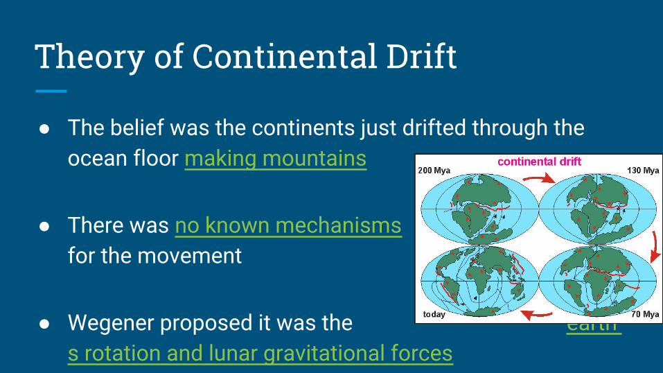
Theory of Continental Drift
● The belief was the continents just drifted through the ocean floor making mountains
● There was no known mechanisms for the movement
● Wegener proposed it was the earth’s rotation and lunar gravitational forces

Evidence: Theory of continental drift
1. The fit of the continents
Continental coastlines appear to fit together like a jigsaw puzzle. For example, South America and Africa.
Evidence: Theory of Continental Drift
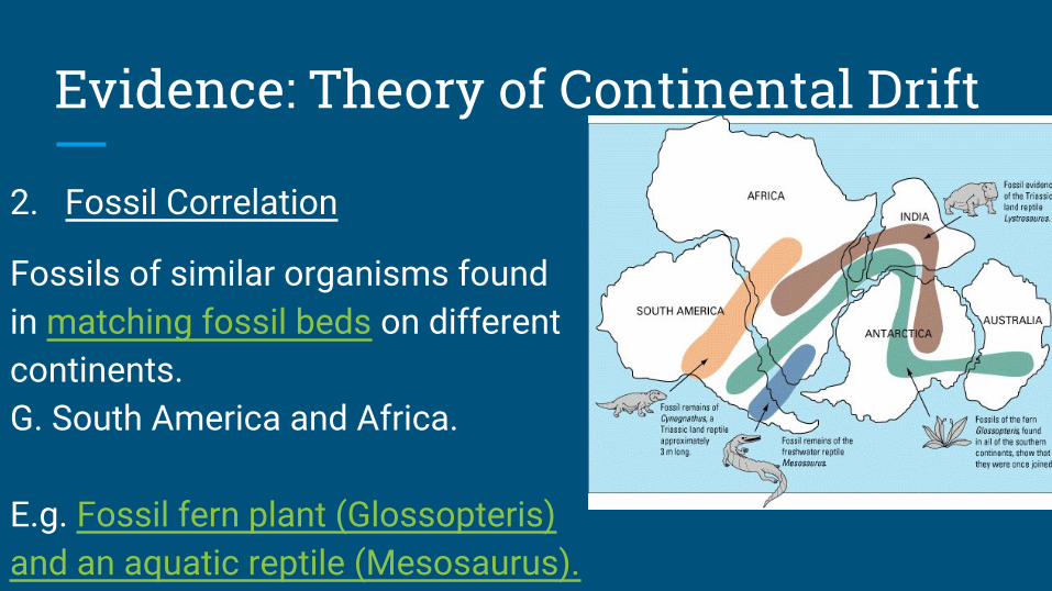
2. Fossil Correlation
Fossils of similar organisms found in matching fossil beds on different continents. E.G. South America and Africa.
E.g. Fossil fern plant (Glossopteris) and an aquatic reptile (Mesosaurus).

Evidence: Theory of Continental Drift3. Rock Types
Type of rock on neighboring continents, shield areas, line up.
E.G. Shield area of South America and of Africa line up.

Evidence: Theory of Continental Drift4. Structural Similarities
On neighboring continents, structural similarities such as folded mountains line up . E.g. The Appalachian Mountains and Caledonian Mountains.

Evidence: Theory of Continental Drift
5. Paleoclimate
Evidence of previous climates match up along the continents
E.g’s: Glacial deposits, Coal deposits and Glacial striations

Continental Drift evidence - paleoclimate
A) Glacial deposits found in South America, Africa, India, and Australia line up.

Continental Drift evidence - paleoclimate
B) Coal deposits that form in tropical swamps line up on different continents.
Continental Drift evidence - paleoclimate
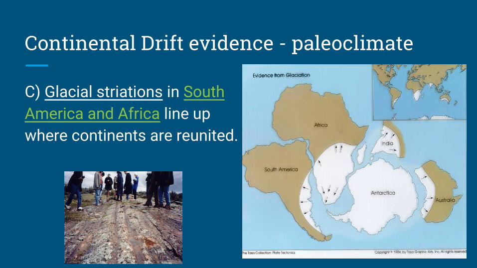
C) Glacial striations in South America and Africa line up where continents are reunited.
All this Evidence!!
But no accepted mechanism to cause the drifting
Wegener's reasoning of lunar and earth spin were overall rejected

Paradigm Shift - A new Theory
New Technology gave way to new knowledge and a new theory
Continental Drift (1915) → Plate Tectonics (1960’s)
* Required contributions from many scientists data collection
from technological devices.


The Evolution of a theory through Scientists
Complete the names and contributions section of the table for each scientist in your notes
Scientist Contribution

Frank Taylor
Contribution:
1910 – Explained the formation of the Himalayan Mountains by moving continents (no evidence given).
------------------------------------------------------------------
He was an American ‘rich boy’, funded by his father and came up with a lot of ideas that Wegener used a few years later - many ideas were not used until the 60’s

Alfred WegenerContribution:
1915 – Proposed the theory of continental drift (evidence given, but no mechanism provided). Proposed, Pangea.
------------------------------------------------------------------
Wegener was a meteorologist/geophysicist who studied the arctic. In fact he was one of the first to go inland the greenland glacier, ice drills and use pre-ski doo's. He died on an expedition, his partner and notebook have never been found.

Alexander DuToit
Contribution:
1937 – Proposed that Earth’s continents would fit more closely together at the continental margins.
------------------------------------------------------------------
A South African Geologist. He traveled between south Africa and south America and found significant geology between the two. He proposed Gondwanaland and Laurasia.
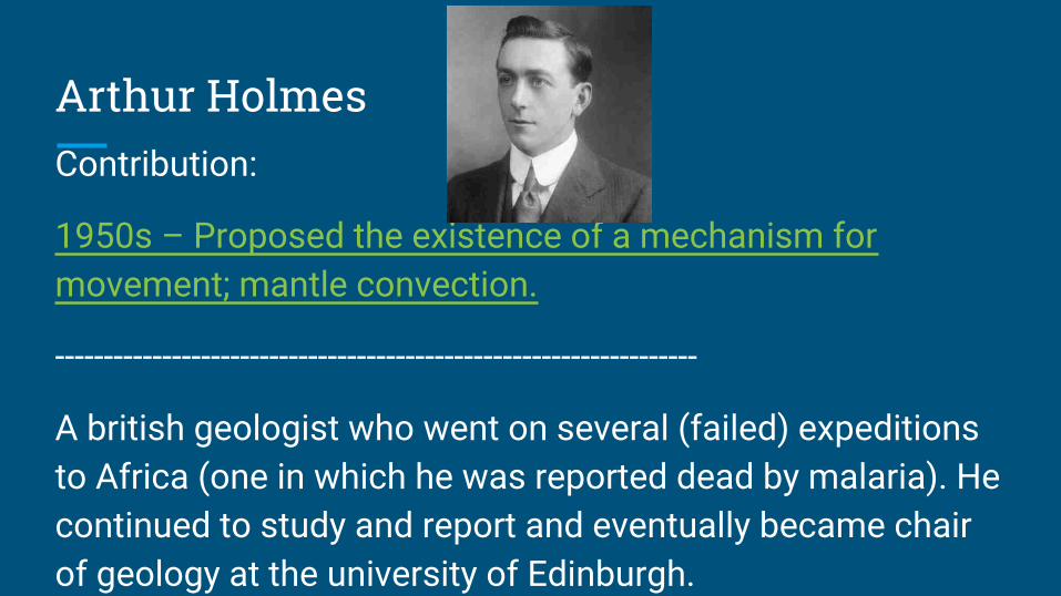
Arthur HolmesContribution:
1950s – Proposed the existence of a mechanism for movement; mantle convection.
------------------------------------------------------------------
A british geologist who went on several (failed) expeditions to Africa (one in which he was reported dead by malaria). He continued to study and report and eventually became chair of geology at the university of Edinburgh.

Harry Hess and Robert Dietz
Contribution:
1960s – Proposed the theory of seafloor spreading.
------------------------------------------------------------------
Both American Geologists dealing with oceanography. Science till the end, Hess died from a heart attack while chairing a National Science meeting. Dietz was an outspoken evolutionist and also studied meteorite impacts.
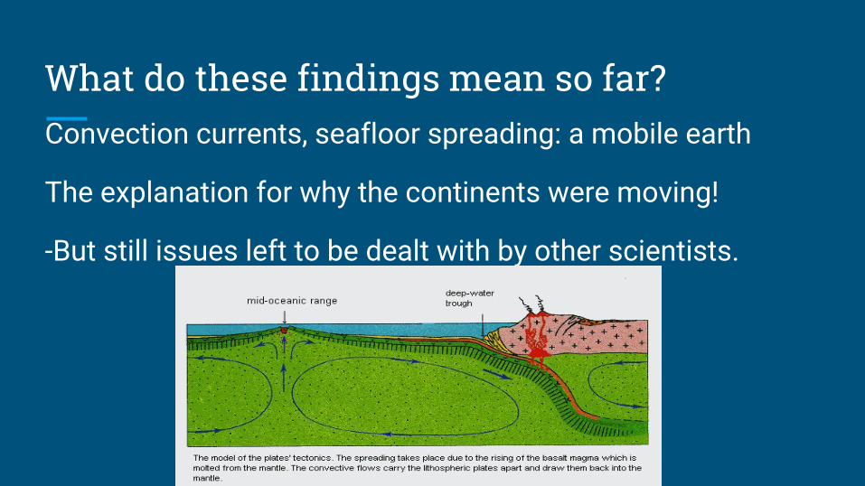
What do these findings mean so far?Convection currents, seafloor spreading: a mobile earth
The explanation for why the continents were moving!
-But still issues left to be dealt with by other scientists.

Frederick Vine and Drummond Matthews
Contribution:
1963 – Proposed the idea of magnetic reversals as evidence to support the theory of seafloor spreading.
------------------------------------------------------------------
Both British scientists, Vine was Matthew's research student they also recognized a canadian scientist (who came up with similar ideas at the time) Vine-Matthews-Morley hypothesis
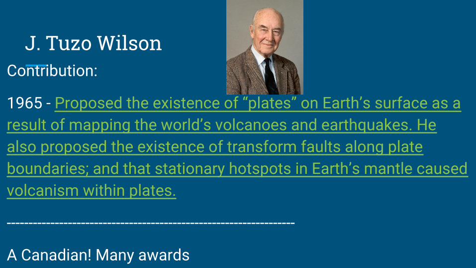
J. Tuzo WilsonContribution:
1965 - Proposed the existence of “plates” on Earth’s surface as a result of mapping the world’s volcanoes and earthquakes. He also proposed the existence of transform faults along plate boundaries; and that stationary hotspots in Earth’s mantle caused volcanism within plates.
------------------------------------------------------------------
A Canadian! Many awards

Xavier Le Pichon and Dan McKenzie
Contribution:
1970s – Proposed the actual theory of plate tectonics
------------------------------------------------------------------
Le Pichon was a french(born in vietnam) geophysicist, Mackenzie a british geophysicist. Pichon is known for the model of plate tectonics, which Mckenzie is known for the principals of plate tectonics.
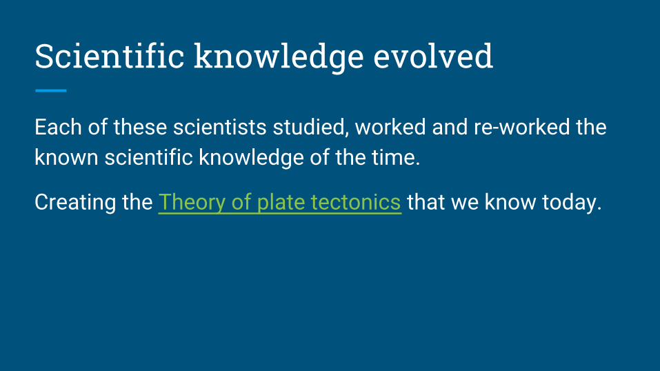
Scientific knowledge evolved
Each of these scientists studied, worked and re-worked the known scientific knowledge of the time.
Creating the Theory of plate tectonics that we know today.

The Mechanism of continental MovementAlfred Wegener Vs. Arthur Holmes
Alfred Wegener Arthur Holmes
● The moon’s tidal influence (gravity)was strong enough to cause a westward motion of the continents.
● large, sturdier continents broke through the oceanic crust much like an ice breaker.
● Convection currents in the Earth’s upper mantle (asthenosphere) were moving the continents.
● Seafloor spreading provided the link between Holmes’s mantle convection and plate tectonics theory.

Continental Drift Worksheet

Plate Tectonic Theory - What is it?
Continents and the ocean floor move due to forces in the asthenosphere ( upper mantle). NO SUCH THING AS DRIFTING!
Theory of Plate Tectonics States:
● Earth’s crust is divided into approximately twenty (21) rigid slabs called tectonic plates.
● These tectonic plates are in continuous slow motion relative to each other.
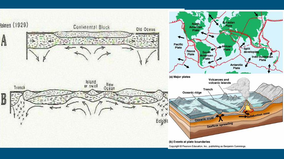

Plate Tectonic Theory - Plate FactsTectonic Plate: a massive, irregularly shaped slab of solid rock. (of the lithosphere).
Boundaries: The edges of tectonic plates.
Plate Composition:
- Oceanic crust only or - Oceanic crust is mostly Mafic. Made of basalt (lava) and gabbro (magma).
- Oceanic and continental crust.- Continental crust is largely Felsic. Made of rhyolite (lava) and granite (magma).


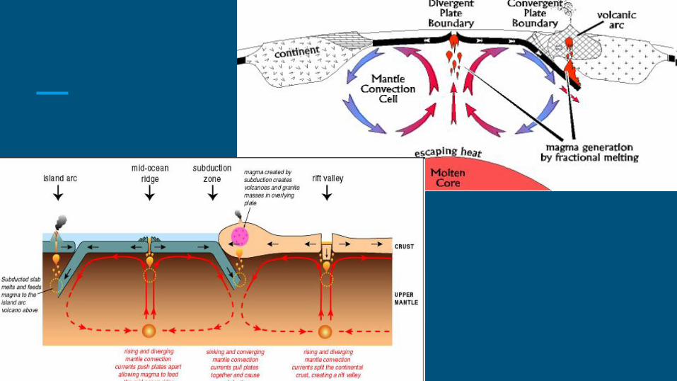
Plate Tectonic Theory - What Causes it?● Convection Currents in the mantle.
● Material moves up at ridges and moves away in opposite directions moving the ocean floors and continents.
●○ The continents are carried along on top like a conveyor belt.
○ When plates collide mountain ranges are forced up.
● Motion of plates explains occurrence of: earthquakes and volcanoes and formation of mountain ranges

Types of Plate BoundariesWhat happens when 2 plate boundaries meet depends on the motion of the plates and the type of plates that meet.
3 types:
1. Divergent2. Transform3. Convergent
a. Continent - continent collisionb. Continent - ocean collisionc. Ocean – ocean collision
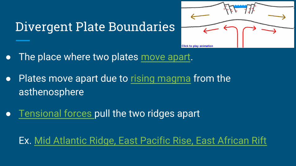
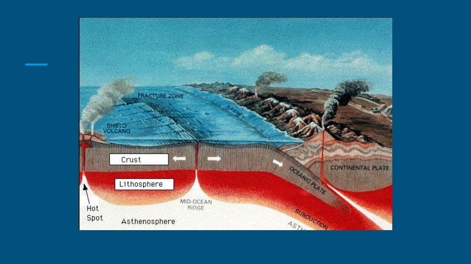
Divergent Plate Boundaries
● The place where two plates move apart.
● Plates move apart due to rising magma from the asthenosphere
● Tensional forces pull the two ridges apart
Ex. Mid Atlantic Ridge, East Pacific Rise, East African Rift
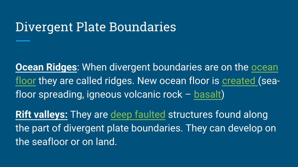
Divergent Plate Boundaries
Ocean Ridges: When divergent boundaries are on the ocean floor they are called ridges. New ocean floor is created (sea-floor spreading, igneous volcanic rock – basalt)
Rift valleys: They are deep faulted structures found along the part of divergent plate boundaries. They can develop on the seafloor or on land.

Ex: East African Rift

Ex: Mid Atlantic Ridge

Transform Plate Boundaries
Where two plates grind past each other without the production or destruction of the lithosphere. No vertical movement.
*Shear force causes plate to grind past each other*Site of frequent earthquake activity*Often found between divergent and convergent plate boundaries
Ex. San Andreas Fault in CaliforniaAlpine Fault in New Zealand
*In 1965, Canadian, J. Tuzo Wilson proposed the existence of transform faults to explain narrow fracture zones and earthquakes found in the crust.

Ridges are not totally linear!Transform faults often link divergent and convergent plate boundaries!

San Andreas Fault California

Haiti

Convergent Plate Boundaries
● Where two plates move together. (with three types)● One plate is consumed into the mantle. It descends beneath
the overriding plate. This is called subduction (subduction zone).
● Ocean trenches are formed. Old crust is destroyed at these boundaries. Some can be really deep.
*Compressional forces cause the plates to move together.* Look at directions on convection currents.*Frequent volcanic and earthquake activity

Pacific Ocean Floor: Look at the Aleutian Trench

Question: WHY IS THE EARTH NOT GETTING ANY BIGGER?

Question: WHY IS THE EARTH NOT GETTING ANY BIGGER?
Volcanism at divergent plate boundaries create new ocean crust. BUTSubduction zones at convergent plate boundaries destroy old ocean crust.
***RECYCLING OF CRUST!***

3 Types of Convergent Plate Boundaries
There are 2 types of plates (made of different rock, so different densities)
So there are three different types of convergent boundaries
1. Ocean-Ocean2. Continental-Continental3. Ocean-Continental

Three Types of Convergent Plate Boundaries:
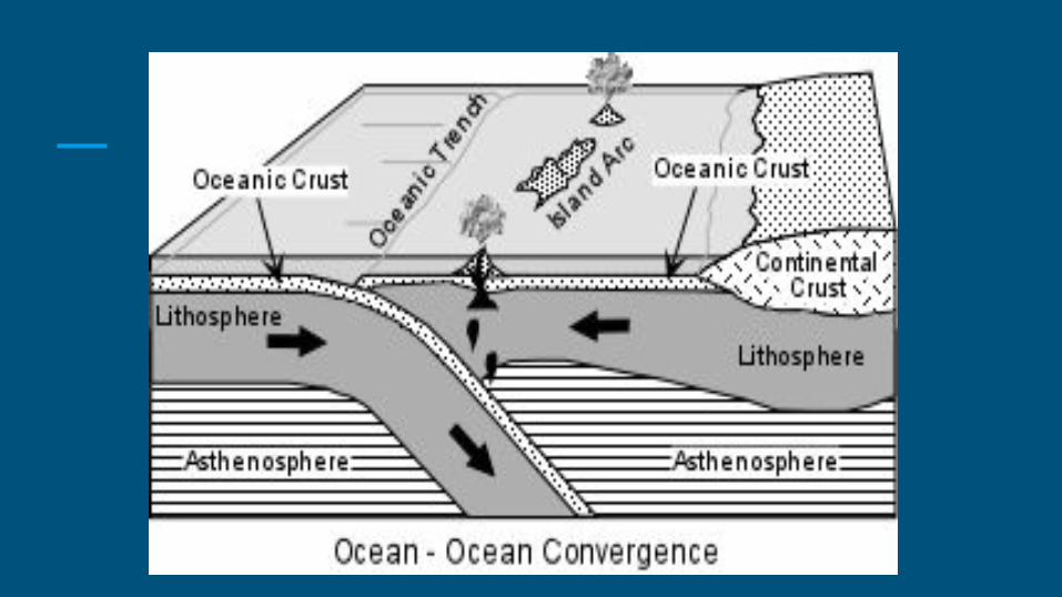
1) Ocean – Ocean CollisionsTwo ocean plates move together (both of near equal density), The older, colder, denser plate is subducted into asthenosphere*Ocean trenches and island arcs are formed at these boundaries.
Note: Subducting plate is basaltic. Subducting sediments are granitic. Mix the two and the result is andesitic magmas and lavas (diorite and andesite).
Examples: Japan arc, Japan, Mariana Arc, Philippines, Aleutian Arc, Aleutian Islands.


Japan

Aleutians and Kuriles

Pacific Ring of Fire

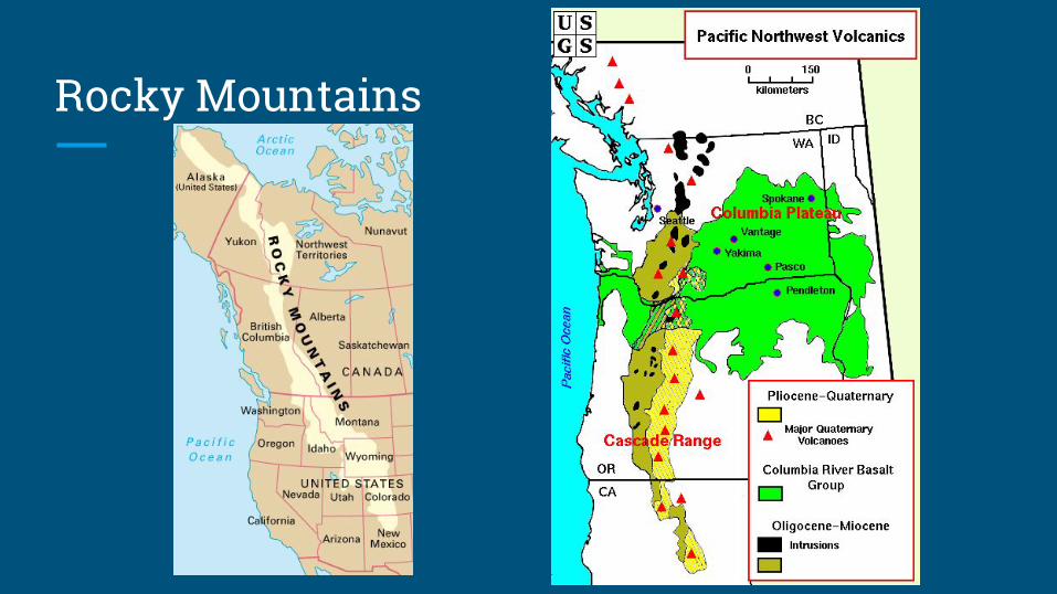
Three Types of Convergent Plate Boundaries:2) Ocean – Continent Collisions
An ocean plate and a continental plate move together. The more dense oceanic plate sinks into the asthenosphere.
● Lithosphere is destroyed (ocean plate melts) the magma rises and melts. ● If it gets to the surface it makes violent volcanic eruptions.● The basaltic mantle and basaltic oceanic crust melts together with continental
rocks (granitic) to produce granitic magma and lava (granite and rhyolite).
Ex. Andes Mountains and Rocky Mountains

Andes Mts.
Rocky Mountains

Ocean – Continent Convergent Boundary
If the subduction occurs beneath continental crust, a continental volcanic arc is produced.

Three Types of Convergent Plate Boundaries:
3) Continent – Continent Collisions
Two continental plates to move together.
Because of the low density of continental crust neither plate will subduct and the two plates ram into one another forming mountains.
Ex. Alps, Himalayas, Appalachians (in NL), Urals


Himalayas

Mountains and Convergent Plate Boundaries
1) Ocean–Continent Convergent Boundary
The Andes Mountains in South America and the Rocky Mountains in Western Canada are examples.
2) Continent – Continent Convergent BoundaryThe Himalayas are an example
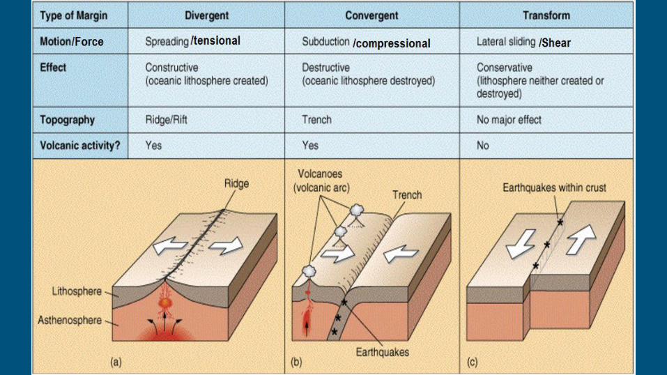


Plate Boundaries Worksheet

Evidence For Plate Tectonics
Six Pieces of Evidence:
1) Earthquakes and Volcanoes2) Paleomagnetism3) Polar wandering 4) Magnetic Reversals and Seafloor Spreading5) Ocean Drilling6) Hot Spots

1) Earthquakes and Volcanoes
● Earthquakes and volcanoes occur along belts.
● These belts mark the locations of Plate Boundaries.

DOTS = LOCATIONS OF EARTHQUAKES AND VOLCANOES

Wadati-Benioff zoneHugo Benioff suggested that earthquake patterns shows a plate subducting (sinking) into the mantle. Wadati-Benioff Zone
Pattern:
*Only Shallow earthquakes along the ocean ridge
*Deeper earthquakes as you move inland
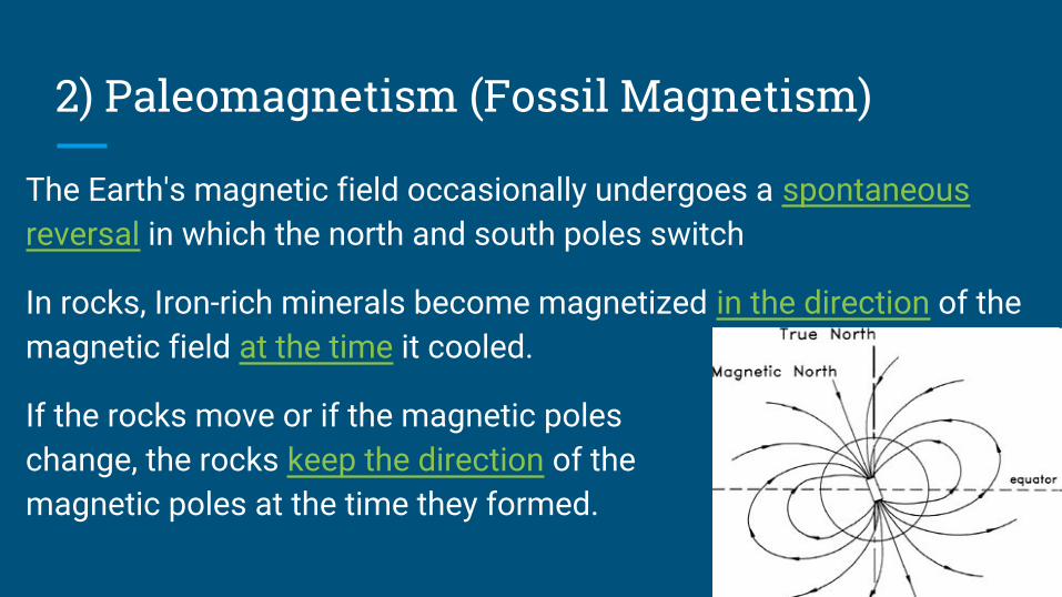
2) Paleomagnetism (Fossil Magnetism)
The Earth's magnetic field occasionally undergoes a spontaneous reversal in which the north and south poles switch
In rocks, Iron-rich minerals become magnetized in the direction of the magnetic field at the time it cooled.
If the rocks move or if the magnetic poles change, the rocks keep the direction of the magnetic poles at the time they formed.

3) Polar WanderingA plot of this magnetism showed that the magnetic pole appeared to change position considerably over the past 500 million years.
Different continental rocks show dramatically different paths
Either the magnetic pole had moved with time, known as polar wandering, or the rocks had moved, plate tectonics.

3) Polar Wandering
The magnetic poles must correspond to geographic poles since Earth’s magnetic field is generated in part by it’s rotation on it’s axis.
Magnetic poles remain stationary, but can flip. The “Apparent movement” is produced by movement of continents.
Therefore, the continents (and the plates they are on) must have moved.


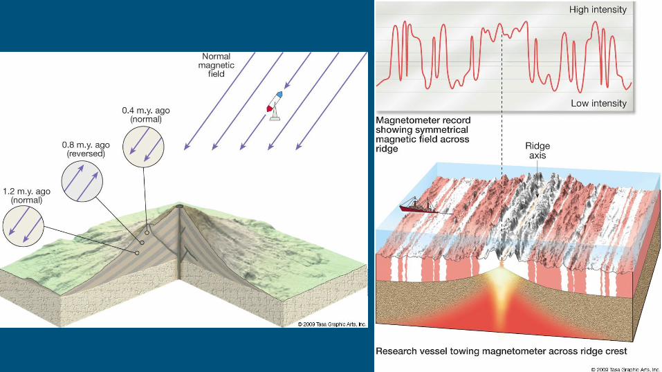
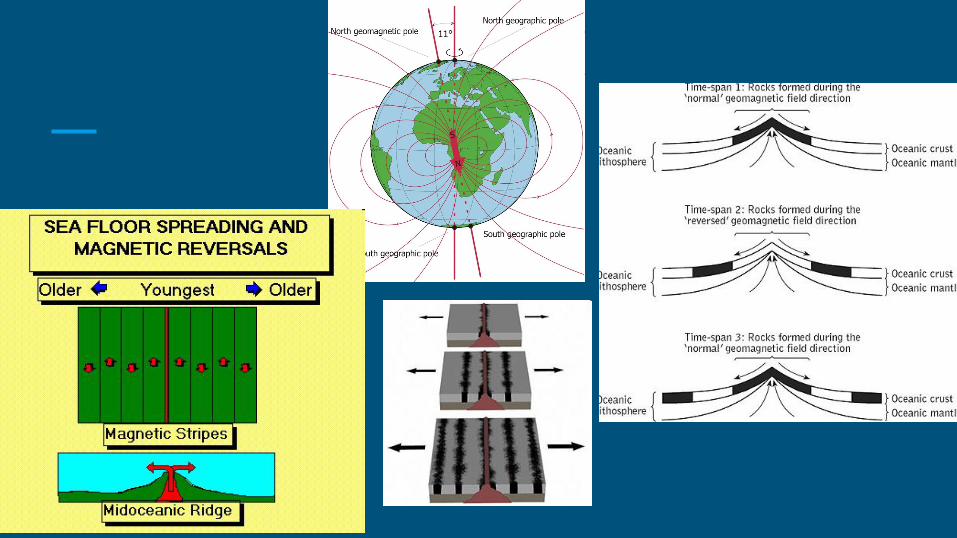
4) Magnetic Reversals and Seafloor Spreading
The earth’s magnetic field reverses polarity (south becomes north and north becomes south).
Lavas solidifying during a time of reverse polarity would display opposite magnetism as rocks forming today. Can be seen in:1) successive lava flows on volcanoes; and 2) the basaltic rock making up the ocean floor (seafloor spreading).

The reversals can be tracked by a magnetometer on both sides of a divergent boundary
This produces a mirror image that has helped in proving the seafloor spreading hypothesis
Harry Hess’s hypothesis was confirmed by geophysicists who mapped out periods of magnetic reversal as recorded in lava flows
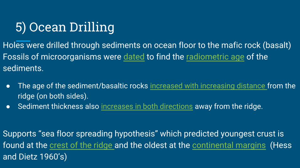
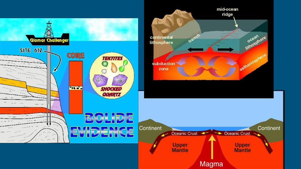
5) Ocean DrillingHoles were drilled through sediments on ocean floor to the mafic rock (basalt)Fossils of microorganisms were dated to find the radiometric age of the sediments.
● The age of the sediment/basaltic rocks increased with increasing distance from the ridge (on both sides).
● Sediment thickness also increases in both directions away from the ridge.
Supports “sea floor spreading hypothesis” which predicted youngest crust is found at the crest of the ridge and the oldest at the continental margins (Hess and Dietz 1960’s)

6) Hot Spots (i.e. intraplate volcanism) There are volcanic areas in the middle of plates that seem to go against the idea of plate tectonics at first glance.
These hot spots often create island chains, that are formed in a line of consecutive volcanoes
They are areas of concentrated heat in the mantle, capable of producing magma that in turn extrudes onto Earth’s surface

6) Hot Spots
Each time the plate moves, the magma burns through to create a new volcanic island.
Dates of the seamounts and islands shows that the age increases the farther away you go from Hawaii (and the hot spot).
This confirms that the tectonic plates do move.
Ex. Hawaiian Islands, Midway Islands, Yellowstone National Park
*Canadian J. Tuzo Wilson, along with other scientists, proposed that there are hot spots not on plate boundaries.


STSE - Plate Tectonics and Newfoundland ~ 600 million years ago, North America was part of a much larger supercontinent (Rodina). This supercontinent broke apart. A mid-ocean ridge developed along the break and the Iapetus Ocean began to open.

STSE - Plate Tectonics and Newfoundland
~540 million years ago, the convection currents shifted and subduction began. A new supercontinent formed called Pangaea.
The Appalachian Mountains were formed. Volcanoes were also occurring!
These mountains still exist on NL, but are highly weathered and eroded.

STSE - Plate Tectonics and Newfoundland ~225 million years ago, the forces in Earth’s mantle again reversed and slowly began to pull the continents apart again (divergent plate boundary again).
The Atlantic Ocean began to open and is still opening (to the east of the island).North Americam Plate
African Plate
New Divergent Boundary
African Plate Left Behind

The Geological Layout of Newfoundland - To know
Western Zone
Has been a part of the North American plate for at least the last billion years. Central Zone
Remnants of island arcs and the ancient Iapetus ocean crust. Eastern Zone
Once part of the African plate, which remained attached as Pangaea split 200 million years ago.
Humber Zone
Avalon Zone
Central Mobile Belt

Geology of Labrador
While the geology of the island of Newfoundland is easier to summarize,
the geology of Labrador is quite complex due:
● to the size of the region and ● the immense age of the Canadian Shield.

Side NotePeridotite is an Ultramafic rock. It is mafic, and dense so should not be found on the surface.
The tablelands in NL is covered in peridotite.
It is thought to originate in the Earth's mantle and was forced up from the depths during a plate collision several hundred million years ago.
Section Assignment and Quiz