Embed Size (px)
Citation preview

ASX Announcement Monday 8 May 2017
North Wing, Level 2, 1 Manning Street, Scarborough WA 6019, Australia PO Box 1059 Scarborough WA 6922, Australia ABN 18 606 128 090 T +61 8 6166 0240 F 61 8 6241 4299 E [email protected] W www.s2resources.com.au
UPDATE – SCANDINAVIAN EXPLORATION Key points
A single hole drilled 135 metres down plunge from previous S2 drilling at Bjurtraskgruvan prospect intersects 24.4 metres @ 1.1% copper
Extends known mineralization to 450 metres down plunge from outcrop and still open
DHEM indicates this hole has not tested the centre of the conductor at this point
FLEM indicates the conductor continues for a further 450 metres down plunge from this hole
Intersections of up to 148g/t silver from resampling of wide spaced historic holes at Skaggtraskberget prospect
New exploration licence applications over mineralized boulder fields in northern Sweden
New exploration licence applications in Central Lapland Greenstone belt in northern Finland - an emerging gold province
S2 Resources Ltd (“S2” or the “Company”) advises that it continues to advance its Scandinavian
exploration with positive drilling and geophysical results at the Bjurtraskgruvan and Skaggtraskberget
VMS prospects within its 100% owned Skellefte project. Additionally, the Company has increased its
land position in both Sweden and Finland in light of positive reconnaissance results and intensifying
third party activity.
Bjurtraskgruvan prospect
S2 has now completed six holes at the Bjurtraskgruvan VMS prospect. The most recent hole,
SBJK170006, drilled 135 metres down plunge from an intercept of 14.71 metres @ 2.2% zinc, 1.0%
copper and 5.4g/t silver in SBJK170003 (reported on 22nd March 2017), has intersected the thickest
zone of copper mineralization seen so far (see Figures 1 and 2, and Annexure 1). This hole intersected

a 24.4 metre thick zone grading 1.11% copper from 220.7 metres, comprising remobilized veinlets of
chalcopyrite, with several intervals of higher grade copper mineralization, including:
1.05 metres @ 4.11% copper, 0.65% zinc and 19g/t silver from 221.5 metres
3.60 metres @ 2.44% copper and 11.5g/t silver from 224.3 metres
Figure 1. Photograph of core from 222 metres in SBJK170006 (the deepest hole at Bjurtraskgruvan) showing remobilized
chalcopyrite (brassy yellow) and sphalerite (pink-brown).
Figure 2. Bjurtraskgruvan prospect showing VTEM anomaly, outcrop, drill defined mineralization (450m plunge extent), the
recent large (135m) drill step-out, and the FLEM conductor extending a further 450m down plunge from the deepest hole.
The new intersection is considered to be close to true width, and demonstrates that the
Bjurtraskgruvan VMS system extends for at least 450 metres down plunge from its outcrop and
remains open down plunge beyond this (see Figure 2).
A down hole electromagnetic (DHEM) survey of SBJK170006 has identified a conductor centred
approximately 30 metres to the east of the hole, which suggests that this intercept may be adjacent to
more massive sulphides (see Figure 2).
In addition to the DHEM, the results of a new fixed loop electromagnetic (FLEM) survey using a large
500 metre loop configuration, designed to see deeper than previous ineffective surveys using smaller
loops, have been modelled by Newexco as a large plunging conductor continuing for at least another
450m west from the deepest intercept (see Figure 2).
Importantly, this also demonstrates that the VTEM anomaly identifies the near surface part of the
plunging sulphide body but does not reliably indicate its size, extent or position at depth. This has
important implications for the many conductors identified in the Company’s VTEM surveys.
S2’s drilling and geophysics confirms that the Bjurtraskgruvan prospect comprises an elongated shoot
which represents a substantial volume of mineralized material. The focus of future drilling will be to
define its limits and to identify any higher grade sweet spots within the overall system. Despite being
drilled over a plunge extent of 450 metres, the depth of mineralization at this point is only 220 metres
below surface because of the shallow plunge.
Holes SBJK170004 and 170005, drilled up and down dip of previously reported hole SBJK170003 and
some 135 metres up-plunge from the recent deepest hole, intersected moderate widths of sulphide
breccia and stringer mineralization, including 6.28 metres @ 1.4% copper in hole 4 and 1.74 metres @
3.05% zinc in hole 5 (see Figure 2 and Annexure 1).
Skaggtraskberget prospect
Skaggtraskberget is a prospect located 4.5 kilometres west of Bjurtraskgruvan which was originally
discovered as a high grade gossanous massive sulphide outcrop grading an average of 6.0% zinc, 1.0%
copper, 30g/t silver and 4g/t gold. These grades have been verified by S2 from resampling of the gossan.
Skaggtraskberget is located 1 kilometre west of the historic Hogkulla Ostra mine (owned by Boliden),
which was mined to a depth of 130 metres in the 1950’s with reported production grades of 12.6%
zinc, 110g/t silver and 0.6g/t gold.
The Skaggtraskberget gossan was partially drilled by the Swedish Geological Survey (SGU) in the mid
1930’s to a maximum depth of 50m. A further eight wide spaced holes were drilled by Boliden nearly
30 years ago but these were not systematically sampled and assayed.
Field verification and resampling of this drilling has confirmed the presence of a 350 metre long
mineralized zone containing high levels of silver (see Figure 3).
Key intercepts from two of the three resampled holes located 300 metres apart comprise:

An upper zone of 9.75 metres @ 3.81% zinc, 0.3% copper, 45g/t silver and 0.41g/t gold
from 146.15 metres, and a lower zone of 10.0 metres @ 1.55% zinc, 28g/t silver and
0.26g/t gold from 108.6 metres in hole LPM89012
4.55 metres @ 0.91% zinc, 148g/t silver and 0.43g/t gold from 93.45 metres in
LPM89014, located 300 metres north-west of hole LPM89012
Holes LPM89012 and LPM89014 are located 300m apart in prospective stratigraphy and both show
large alteration zones with pyrite-rich stringer and semi-massive sulphides. The lack of systematic
deeper drilling in this area represents a significant opportunity (see Figure 3).
Figure 3. Skaggtraskberget Prospect showing VTEM conductivity, gossan outcrop, and historic drillhole collars.
Holmtjarn
Six holes have been completed on two of the targets at the Holmtjarn prospect (see Figure 4). The
targets tested (31 and 35) were a selected based on a combination of VTEM, geochemical and MLEM
anomalism. Four holes at Target 31 failed to intersect any significant mineralization, and the small
MLEM anomaly has been explained by the presence of pyrrhotite veining.
Two holes drilled at Target 35 intersected strongly altered, sulphide-rich felsic volcanic breccias with
strongly anomalous copper (greater than 500ppm) throughout most of hole SHOL170005 and parts of
hole SHOL170006. Several narrow zones within SHOL170005 graded greater than 0.5% copper with
minor associated gold (see Annexure 1).
Such strong alteration and anomalism is encouraging in an area known for small but very high-grade
gold-rich VMS mineralization, and the geology seen may represent the margin of a mineralized system.
Further drilling will be conducted here when ground conditions permit.

New Swedish tenure applications
S2 has applied for two large new exploration licences surrounding its granted exploration licences at
Nasvattnet and Tjalmtrask. These areas are near Agnico Eagle’s emerging 1 million ounce Barsele gold
project (see Figure 4), and cover zones characterized by the presence of mineralized boulders that may
have a local bedrock source.
Prospecting, sampling and assaying by the SGU at Nasvattnet has identified a cluster of base metal-
bearing boulders (with individual boulders containing up to 3.85% copper, 17.2% zinc, 9.2% lead, and
680g/t silver) and a zone of scheelite-bearing boulders containing up to 52% tungsten.
Similar work at Tjalmtrask has identified a number of boulders containing up to 20g/t gold, but further
work is required to verify their exact location and extent.
Figure 4. Swedish tenure and prospect locations
Finland
The Company has been increasing its tenure in the Central Lapland Greenstone Belt (CLGB) following
the recent discovery of outcropping high grade gold mineralization at the nearby Aurora zone of the
Risti gold prospect owned by TSXV listed Aurion Resources.
This discovery reaffirms the Company’s view that the CLGB, which also contains Agnico Eagle’s 8 million
ounce Kittila gold mine, is a potentially highly endowed but under-explored gold province.
S2 now has reservations, exploration licence applications and granted exploration licences covering
approximately 1,030 square kilometres of the CLGB (see Figure 6), and is in a strong strategic position
in this emerging gold province.

Figure 6. Finland tenure, comprising Reservations and Exploration Licence applications, showing known prospects
and active projects/mines.
Next
Drilling in Sweden has stopped due to the onset of the spring thaw, but will recommence later in the
summer on accessible targets once the ground has dried sufficiently. The Skaggtraskberget prospect is
likely to be the first to be drilled in the summer campaign.
In the meantime, with ground being exposed by the melting snow, various targets and prospects in
Sweden and Finland will be explored using surface prospecting. This will include searching for the
source of the clusters of mineralized boulders at Nasvattnet and Tjalmtrask in Sweden, and first pass
field assessment of the Company’s extensive land package in Finland.

Only 9 out of over 100 VTEM anomalies identified by S2 in the Skellefte belt of Sweden have been
drilled to date. A major mapping, prospecting, ground EM, IP, and base of till (BOT) geochemical
sampling program will continue throughout the northern summer to prioritise these for drill testing.
In line with its increasing commitment to the region and to ensure ongoing exploration program is
managed continuously, effectively and expeditiously, three of S2’s geologists are relocating to the
Company’s field base in Mala, in central northern Sweden.
For further information, please contact: Mark Bennett Tony Walsh Managing Director Company Secretary +61 8 6166 0240 +61 8 6166 0240
Competent Persons statement The information in this report that relates to Exploration Results is based on information compiled by Andy Thompson who is an employee of the company. Mr Thompson is a member of the Australasian Institute of Mining and Metallurgy. Mr Thompson has sufficient experience of relevance to the style of mineralization and the types of deposits under consideration, and to the activities undertaken, to qualify as Competent Persons as defined in the 2012 Edition of the Joint Ore Reserves Committee (JORC) Australasian Code for Reporting of Exploration Results, Mineral Resources and Ore Reserves. Mr Thompson consents to the inclusion in this report of the matters based on information in the form and context in which it appears.
Annexure 1 The following tables are provided to ensure compliance with the JORC code (2012) edition requirements for the reporting of exploration results. Co-ordinates in this table are given in the Swedish National Grid SWEREF 99TM.
Bjurtraskgruvan S2 drilling
Hole No. Total
Depth North East RL Dip Azim From, m To, m
Width, m
Zn% Cu% Ag g/t
SBJK170001 231 7215800 722580 227 -60 000 185.10 188.35 3.25 0.5 1.2 5.4
SBJK170002 120.5 7215950 722550 230 -60 000 21.30 24.36 3.06 1.3 <0.1 9.7
SBJK170003 216.8 7215800 722540 230 -60 000 176.00 190.71 14.71 2.2 1.0 5.4
including 177.00 179.13 2.13 8.2 1.7 8.5
SBJK170004 246.9 7215760 722540 230 -60 000 142.50 142.9 0.4 2.21 0.24 6.0
and 144.50 145.50 1.0 2.08 <0.1 1.0
and 221.12 227.40 6.28 <0.1 1.40 5.7
SBJK170005 168.0 7215840 722540 230 -60 000 40.0 41.0 1.0 1.08 <0.1 3.0
and 90.4 91.9 1.5 <0.1 1.09 8.2
and 143.71 145.45 1.74 3.05 0.68 3.7
SBJK170006 289.4 7215751 722440 229 -70 000 220.7 245.1 24.4 <0.1 1.11 5.1
including 221.5 222.55 1.05 0.65 4.11 19
and including 224.3 227.9 3.6 0.17 2.44 11.5
and including 235.0 236.0 1.0 <0.1 3.11 14

Skaggtraskberget historical drilling
Hole No. Total
Depth North East RL Dip Azim
From, m
To, m Width,
m Zn% Cu% Ag g/t
Au g/t
LPM36001 94 7217895 710865 338 -30 34 4.0 10.52 6.52 7.0 <0.1 32 3.2
And 46.0 51.64 5.64 7.0 2.1 107 1.3
LPM36002 88.1 7217896 710888 334 -30 34 48.16 49.2 1.04 7.4 <0.1 46 1.0
LPM36003 88.5 7217902 710835 343 -30 34 NSI
LPM36004 89.5 7217900 710800 348 -30 34 NSI
LPM36005 57.9 7217915 710920 330 -30 34 NSI
LPM36006 70.8 7217874 710837 342 -90 34 NSI
LPM36007 77.72 7217902 710835 343 -70 34 35.01 36.41 1.4 1.3 <0.1 94 0.01
LPM37008 59.09 7217931 710748 350 -30 34 NSI
LPM37009 102.71 7217863 710814 343 -90 34 NSI
LPM37010 98.19 7217872 710797 345 -90 34 NSI
LPM89011 * 193.85 7217837 710814 341 -50 34 75.6 77.7 2.1 2.34 <0.1 18 0.1
LPM89012 * 199 7217865 710773 345 -50 34 108.6 118.6 10.0 1.55 <0.1 28 0.26
and 146.15 155.9 9.75 3.81 0.27 45 0.41
LPM89013 145.6 7217892 710731 346 -50 34 NSI
LPM89014 * 165 7218087 710584 344 -50 34 93.45 98 4.55 0.91 <0.1 148 0.43
and 151.0 152.33 1.33 2.99 <0.1 5 0.1
LPM89015 195 7217810 710856 339 -49 34 NSI
LPM89016 129.5 7217860 710889 336 -60 34 NSI
LPM89017 174.65 7217903 710714 344 -63 79 NSI
LPM89018 128.55 7217510 711425 302 -50 34 NSI
Historical holes in bold with * have been reassayed by S2
Holmtjarn Prospect
Hole No. Total Depth
North East RL Dip Azim From,
m To, m
Width, m
Zn% Cu% Ag g/t
Au g/t
SHOL170001 161.2 7227402 717241 227 -60 040 NSI
SHOL170002 90.5 7227341 717190 230 -60 040 NSI
SHOL170003 181.1 7227273 717133 230 -60 040 NSI
SHOL170004 97.8 7227197 717069 230 -60 040 NSI
SHOL170005 167.2 7227049 715898 230 -70 040 16.32 18.00 1.68 <0.1 0.64 4 0.15
74.82 75.82 1.10 0.2 0.66 2 0.6
SHOL170006 171.6 7227019 715872 229 -60 043 NSI
Svanvit Prospect
Hole No. Total Depth
North East RL Dip Azim
From, m To, m Width,m
Zn% Cu% Ag g/t
Au g/t
SSVA16001 127.05 7215642 724691 225 -60 35 25.30 25.85 0.55 <0.1 <0.1 45 1.49
and 88.70 89.75 1.05 2.87 <0.1 5 0.03
SSVA16002 258.7 7215560 724634 225 -60 35 164.40 164.95 0.55 2.23 <0.1 <1 0.02
and 170.20 173.90 3.70 1.75 <0.1 5 0.01
and 184.60 189.65 5.05 3.15 0.2 6 0.04
SSVA16003 298 7215519 724604 228 -65 35 NSI

SSVT170004 262.8 7215533 724675 223 -60 35 218.55 220.20 1.65 2.18 <0.1 21.0 0.6
SSVT170005 203 7215574 724614 223 -60 35 160.60 161.92 1.86 1.14 <0.1 5 0.01
SSVT170006 173.2 7215594 724628 223 -60 35 NSI
The following Tables are provided to ensure compliance with the JORC code (2012) edition requirements for the reporting of exploration results.
SECTION 1 SAMPLING TECHNIQUES AND DATA Criteria JORC Code explanation Commentary
Sampling techniques Nature and quality of sampling (e.g. cut channels, random chips, or specific specialised industry standard measurement tools appropriate to the minerals under investigation, such as down hole gamma sondes, or handheld XRF instruments, etc). These examples should not be taken as limiting the broad meaning of sampling.
Drilling is undertaken by Oy Kati AB of Kalajoki Finland drilling NQ2 rod size with a DDH size of 75.7mm and core size of 50.7mm. NQ2 core samples are logged and marked up by S2 personnel. Unbiased core sample intervals were cut in half by diamond saw with half core sent for analysis at ALS Laboratories. All rock grab and rock float samples are collected from outcrop by S2 personnel and marked into sample books and a representative portion of the sample retained. All are forwarded for analyses by ALS Laboratories.
Include reference to measures taken to ensure sample representivity and the appropriate calibration of any measurement tools or systems used
Sampling and QAQC procedures are carried out using S2 protocols as per industry best practice.
Aspects of the determination of mineralisation that are Material to the Public Report. In cases where ‘industry standard’ work has been done this would be relatively simple (e.g. ‘reverse circulation drilling was used to obtain 1 m samples from which 3 kg was pulverised to produce a 30 g charge for fire assay’). In other cases more explanation may be required, such as where there is coarse gold that has inherent sampling problems. Unusual commodities or mineralisation types (e.g. submarine nodules) may warrant disclosure of detailed information
Diamond drilling was used to obtain core samples that have been cut and sampled on intervals that are determined by lithology and mineralisation. The drill core samples are sent to ALS Laboratories for analyses for gold and base metals. Drill core is sampled at S2’s facilities in Mala, Sweden.
Drilling techniques Drill type (e.g. core, reverse circulation, open-hole hammer, rotary air blast, auger, Bangka, sonic, etc) and details (e.g. core diameter, triple or standard tube, depth of diamond tails, face-sampling bit or other type, whether core is oriented and if so, by what method, etc).
Diamond drilling with NQ2 wireline bit producing a 50.7mm diameter core.
Drill sample recovery Method of recording and assessing core and chip
sample recoveries and results assessed
Diamond Drill core recoveries are visually estimated qualitatively on a metre basis and are recorded in the database.
Measures taken to maximise sample recovery and ensure representative nature of the samples
Sample quality is qualitatively logged on a metre basis, recording sample condition.
Whether a relationship exists between sample recovery and grade and whether sample bias may have occurred due to preferential loss/gain of fine/coarse material.
No relationship has been seen to exist
Logging Whether core and chip samples have been geologically and geotechnically logged to a level of detail to support appropriate Mineral Resource estimation, mining studies and metallurgical studies.
The logging uses a standard legend developed by S2 which is suitable for wireframing. Exploration holes are not geotechnically logged but resource holes are.

Criteria JORC Code explanation Commentary
Whether logging is qualitative or quantitative in nature. Core (or costean, channel, etc) photography.
All core has been photographed both dry and wet. Geological logging of the diamond drill holes is onto physical log sheets followed by importing into S2’s central database
The total length and percentage of the relevant intersections logged
All drill holes were logged in full.
Sub-sampling techniques and sample preparation
If core, whether cut or sawn and whether quarter, half or all core taken.
Core sawn in half and half core taken.
If non-core, whether riffled, tube sampled, rotary split, etc and whether sampled wet or dry.
All samples are core.
For all sample types, the nature, quality and appropriateness of the sample preparation technique.
Samples were delivered by S2 personnel to ALS Minerals laboratory in Mala, Sweden. All samples were forwarded to ALS Minerals Ojebyn, Sweden Laboratory where they are to be crushed with >70% <2mm (code CRU-31), split by riffle splitter (code SPL-21), and pulverised 1000grm to 85% <75 um (code PUL-32). Crushers and pulverizers are washed with QAQC tests undertaken (codes CRU-QC, PUL-QC). The prepared samples are forwarded to ALS Minerals Loughrea, Ireland, for analysis.
Quality control procedures adopted for all sub-sampling stages to maximise representivity of samples.
Full QAQC system in place to determine accuracy and precision of assays
Measures taken to ensure that the sampling is representative of the in situ material collected, including for instance results for field duplicate/second-half sampling.
For DDH’s non biased core cutting through using an orientation line marked on core and cut to the line
Whether sample sizes are appropriate to the grain size of the material being sampled.
Samples of appropriate size
Quality of assay data and laboratory tests
The nature, quality and appropriateness of the assaying and laboratory procedures used and whether the technique is considered partial or total.
All samples were analysed by ALS Minerals Loughrea, Ireland. Samples analysed for gold undergo a 50g fire assay with AA finish (code Au-AA26). Samples analysed for Ag, As, Bi, Ca, Cd, Cu, Fe, Hg, Mg, Mn, Mo, Ni, P, Pb, S, Sb, Tl & Zn undergo an oxidising digestion with ICP-AES Finish (code ME-ICPORE).
For geophysical tools, spectrometers, handheld XRF instruments, etc, the parameters used in determining the analysis including instrument make and model, reading times, calibrations factors applied and their derivation, etc.
No geophysical tools were used to determine any element concentrations.
Nature of quality control procedures adopted (e.g. standards, blanks, duplicates, external laboratory checks) and whether acceptable levels of accuracy (i.e. lack of bias) and precision have been established.
Full QAQC system in place including Certified Standards and blanks of appropriate matrix and levels
Verification of sampling and assaying
The verification of significant intersections by either independent or alternative company personnel.
Andy Thompson has personally inspected all drill cores and rock samples.
The use of twinned holes. No twin holes have been drilled on the project to date.
Documentation of primary data, data entry procedures, data verification, data storage (physical and electronic) protocols.
Primary sampling data is collected in a set of standard Excel templates. The information is managed by S2’s database manager for validation and compilation into S2’s central database.
Discuss any adjustment to assay data. No adjustments made

Criteria JORC Code explanation Commentary
Location of data points
Accuracy and quality of surveys used to locate drillholes (collar and down-hole surveys), trenches, mine workings and other locations used in Mineral Resource estimation.
Drill hole collars were located with a differential GPS with an accuracy of within 1 metre.
Specification of the grid system used.
The grid system used is the Standard Swedish National Grid –SWEREF 99 TM unless otherwise stated.
Quality and adequacy of topographic control.
Excellent quality topographic maps produced by the Swedish Authorities - Landmateriat
Data spacing and distribution Data spacing for reporting of Exploration Results.
Drill holes are exploratory at this stage and drilled to test geochemical and geophysical target. No set spacing of drillholes at this stage.
Whether the data spacing and distribution is sufficient to establish the degree of geological and grade continuity appropriate for the Mineral Resource and Ore Reserve estimation procedure(s) and classifications applied.
Data spacing and distribution is not sufficient at this stage to allow the estimation of mineral resources.
Whether sample compositing has been applied. No sample compositing has been applied
Orientation of data in relation to geological structure
Whether the orientation of sampling achieves unbiased sampling of possible structures and the extent to which this is known, considering the deposit type.
Drillhole orientation is designed to test geophysical targets and is not necessarily drilled perpendicular to the orientation of the intersected mineralisation.
If the relationship between the drilling orientation and the orientation of key mineralised structures is considered to have introduced a sampling bias, this should be assessed and reported if material.
The drilling at this stage is preliminary and exploratory. It is not possible to assess if any sample bias has occurred due to hole orientation at this stage.
Sample security The measures taken to ensure sample security.
Chain of custody is managed by S2 personnel. Drill core is visually checked at the drill rig and then transported to S2’s logging and cutting facilities by S2 personnel for logging, cutting and sampling. Bagged samples are transferred to ALS Laboratories in Malå, Sweden by S2 personnel.
Audits or reviews The results of any audits or reviews of sampling techniques and data.
No audits or reviews have been conducted at this stage.
SECTION 2 REPORTING OF EXPLORATION RESULTS
Criteria JORC Code explanation Commentary
Mineral tenement and land tenure status
Type, reference name/number, location and ownership including agreements or material issues with third parties such as joint ventures, partnerships, overriding royalties, native title interests, historical sites, wilderness or national park and environmental settings.
The Bjurtraskgruvan prospect is located within the Vargfors 401 Exploration Licence. The Skaggtrasktraskberget prospect I s located within the Malanaset 402 Exploration Licence. The Holmtjarn targets are located on the Holmtjarn 401 Licence and the Svan Vit Prospect is located on the Svansele 403 Licence. The exploration licences are 100% owned by S2 Sverige AB, a Swedish registered 100% owned subsidiary of S2
The security of the tenure held at the time of reporting along with any known impediments to obtaining a licence to operate in the area.
All of the Exploration Licences are in good standing and no known impediments exist on the tenements being actively explored.

Criteria JORC Code explanation Commentary
Exploration done by other parties
Acknowledgment and appraisal of exploration by other parties.
The Bjurtraskgruvan prospect was drilled, trenched and mapped in 1944 and 1979-80. Drilling was undertaken by the Swedish Geological Survey (SGU) for a total of 481m in 1944 and 1250m in 1979-80. The 1944 data was largely twinned by the later drilling and also more comprehensively sampled. The historical geological mapping has been georeferenced in relation to the drillhole collars and also correlates well with the modelled moving loop ground TEM plate. Drillhole collars have been located and surveyed by S2 personnel. All available public domain historic reports and logs at the SGU in Mala have been reviewed and collated. The Skaggtraskberget prospect was trenched in 1936 and drilled in 1936, 1937 and 1989. Drilling was undertaken by the SGU initially for a total of 826m and then by Boliden in 1989 for a total of 1331m. Drill core still exists in storage in Mala and three holes originally drilled by Boliden were re-sampled and assayed by S2R to verify historic assays and test previously un-sampled core. The 1930’s drilling was shallow and did not test the depth extent. The Boliden drilling tested the initial 100m depth extent and along strike 300m NW and SE. North of the SvanVit prospect there is a historical prospect of Snattermyran initially discovered from a mineralised boulder in 1902. During 1903-1905 trenching occurred. In 1926 3 DDH’s were drilled for a total of 152.17m with a best result of: BH2 3.46m @ 2.45% Zn, 32g/t Ag. In 1980 the Swedish Geological Survey (SGU) drilled 4 DDH’s .
Geology
Deposit type, geological setting and style of mineralisation.
The area occupies the central portion of the Skellefte Belt, a productive base and precious metal mining district dominated by bimodal volcanics, primarily felsic in composition. The mineralisation style is structurally remobilised volcanogenic massive sulphide style mineralisation within greenschist grade metamorphic rocks.
Drill hole Information
A summary of all information material to the understanding of the exploration results including a tabulation of the following information for all Material drill holes:
easting and northing of the drill hole collar
elevation or RL (Reduced Level – elevation above sea level in metres) of the drill hole collar
dip and azimuth of the hole
down hole length and interception depth
hole length.
Refer to Annexure 1 above
Data aggregation methods
In reporting Exploration Results, weighting averaging techniques, maximum and/or minimum grade truncations (e.g. cutting of high grades) and cut-off grades are usually Material and should be stated.
All reported intersections of drilling undertaken by S2 have been length weighted and density weighted. A nominal 1% Zn or 0.5% Cu lower cut-off is used for diamond drill intersections (unless otherwise stated in polymetallic intersections).
Where aggregate intercepts incorporate short lengths of high grade results and longer lengths of low grade results, the procedure used for such aggregation should be stated and some typical examples of such aggregations should be shown in detail.
High grade intervals internal to broader zones of mineralisation are reported as included intervals.
The assumptions used for any reporting of metal equivalent values should be clearly stated.
None used.
Criteria JORC Code explanation Commentary
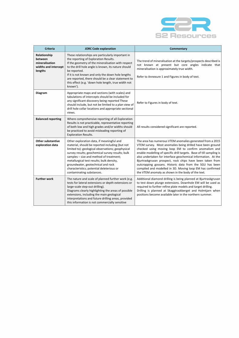
Relationship between mineralisation widths and intercept lengths
These relationships are particularly important in the reporting of Exploration Results. If the geometry of the mineralisation with respect to the drill hole angle is known, its nature should be reported. If it is not known and only the down hole lengths are reported, there should be a clear statement to this effect (e.g. ‘down hole length, true width not known’).
The trend of mineralisation at the targets/prospects described is not known at present but core angles indicate that mineralisation is approximately true width. Refer to Annexure 1 and Figures in body of text.
Diagram Appropriate maps and sections (with scales) and tabulations of intercepts should be included for any significant discovery being reported These should include, but not be limited to a plan view of drill hole collar locations and appropriate sectional views.
Refer to Figures in body of text.
Balanced reporting Where comprehensive reporting of all Exploration Results is not practicable, representative reporting of both low and high grades and/or widths should be practiced to avoid misleading reporting of Exploration Results.
All results considered significant are reported.
Other substantive exploration data
Other exploration data, if meaningful and material, should be reported including (but not limited to): geological observations; geophysical survey results; geochemical survey results; bulk samples – size and method of treatment; metallurgical test results; bulk density, groundwater, geotechnical and rock characteristics; potential deleterious or contaminating substances.
The area has numerous VTEM anomalies generated from a 2015 VTEM survey. Most anomalies being drilled have been ground checked using moving loop EM to confirm anomalism and enable modelling of specific drill targets. Base of till sampling is also undertaken for interface geochemical information. At the Bjurtraskgruvan prospect, rock chips have been taken from outcropping gossans. Historic data from the SGU has been compiled and modelled in 3D. Moving loop EM has confirmed the VTEM anomaly as shown in the body of the text.
Further work The nature and scale of planned further work (e.g. tests for lateral extensions or depth extensions or large-scale step-out drilling). Diagrams clearly highlighting the areas of possible extensions, including the main geological interpretations and future drilling areas, provided this information is not commercially sensitive
Additional diamond drilling is being planned at Bjurtraskgruvan to test down plunge extensions. Downhole EM will be used as required to further refine plate models and target drilling. Drilling is planned at Skaggtraskberget and Holmtjarn when positions become available later in the northern summer.