Embed Size (px)
Citation preview

Upper tropospheric ozone between latitudes 60S and 60N
derived from Nimbus 7 TOMS/THIR Cloud Slicing
J. R. Ziemke, S. Chandra, and P. K. Bhartia
Code 916, NASA Goddard Space Flight Center, Greenbelt, Maryland
Abstract. This study evaluates the spatial distributions and seasonal cycles in upper
tropospheric ozone (pressure range 200-500 hPa) from low to high latitudes (60S to 60N)
derived fromthe satellite retrieval method called "Cloud Slicing." Cloud Slicing is a
unique technique for determining ozone profile information in the troposphere by
combining co-located measurements of cloud-toppressure and above-cloud column
ozone. For upper tropospheric ozone, co-located measurements of Nimbus 7 Total Ozone
Mapping Spectrometer (TOMS) above-cloud column ozone and Nimbus 7 Temperature
Humidity Infrared Radiometer (THIR) cloud-top pressure during 1979,1984 were
incorporated. In the tropics, upper tropospheric ozone shows year-round enhancement in
the Atlantic region and evidence of a possible semiannual variability. Upper tropospheric
ozone outside the tropics shows greatest abundance in winter and spring seasons in both
hemispheres with largest seasonal and largest amounts in the NH. These characteristics
are similar to lower stratospheric ozone. Comparisons of upper tropospheric column
ozone with both stratospheric ozone and a proxy of lower stratospheric air mass (i.,e.,
tropopause pressure) from National Centers for Environmental Prediction (NCEP)
suggest that stratosphere-troposphere exchange (STE) may be a significant source for the
seasonal variability of upper tropospheric ozone almost everywhere between 60S and
60N except in low latitudes around 10S to 25N where other sources (e.g., tropospheric
transport, biomass burning, aerosol effects, lightning, etc.) may have a greater roleo
1. Introduction.
The first assessment of tropospheric column ozone (TCO) derived from satellite
meas,_emems was based on the residual method of Fis.hman et alo [ ! 990] which
subtracted SAGE stratospheric column ozone (SCO) from TOMS total colmnn ozone to
determine TCO. Although it was demonstrated that this method could retrieve
information of TCO distributions extending from the tropics to middle latitudes,
essentially only a climatology of TCO was obtainable because of the sparse solar
occultation measurements of stratospheric ozone profiles available from SAGE (around 1
to 2 local profile measurements per month). In addition it was noted by Fishman et al.
[1990] that this method had further difficulties caused by subtracting two large column
ozone measurements from two independent instruments (i.e., TOMS and SAGE) whichwere not inter-calibrated.
Subsequently, a number of algorithms based on tropospheric ozone residual methods
were developed with significant improvements in characterizing the seasonal, interannual,
and spatial variations of TCO in the tropics [e.g., Jiang and Yung, 1996; Kim and
Newchurch, 1996; Hudson and Thompson, 1998; Ziemke et al., 1998; Thompson and
https://ntrs.nasa.gov/search.jsp?R=20020086300 2019-04-02T10:32:27+00:00Z

Hudson,1999; Fishman and Balok, 1999; Kim et al., 2001; Ziemke et al., 2001]. The
TCO derived from these techniques have yielded many important scientific results
including characterization of ozone enhancement in the Atlantic during southern spring
[first identified by Fishman et al., 1987], evidence of an E1Nino signal [Chandra et al.,
1998, Thompson et al., 2001], solar cycle forcing [Chandra et aL, 1999], characterization
of seasonal and interannual variabilities [Ziemke and Chandra, 1999], identification of
lightning-generated TCO distributions [Martin et al., 2001], and a tropical Atlantic
Paradox [Thompson et al., 2001]. Additional studies have shown that the September-
October Atlantic maximum and/or the E1 Nino increase of tropospheric ozone over
Indonesia in 1997 were well captured in 3D photochemical transport models [e.g., Moxim
and Levy, 2000; Sudo et aL, 2001; Bey et al., 2001;Martin et al., 2002; Chandra et al.,2002a].
While much has been learned about tropical TCO from various satellite retrieval
methods, the extension of measurements and the characterization of TCO outside the
tropics has had limited success. The residual method of Fishman et al.[1990] was morerecently applied by replacing SAGE measurements with solar backscatter ultraviolet
(SBUV) to determine SCO [Vukovich et al., 1996; Fishman and Balok, 1999]. Unlike
SAGE the SBUV profiles provide daily measurements of SCO over much of the globe.
However SCO derived from SBUV has limited success because of poor vertical
resolution of ozone profile information in the vicinity of the tropopause. Fishman and
Balok [ 1999] provided an improvement to this TOMS/SBUV residual techniqu e by
applying a normalization to the SBUV profile measurements using ozonesonde
climatology [Logan, 1999].
The Cloud Slicing technique [Ziemke et al., 2001] provides a method for deriving ozonein the upper troposphere over much of the Earth wherever sufficient clouds exist andco-
located measurements of above-cloud column ozone and cloud-top pressures areavailable. The Nimbus 7 TOMS instrument determines total column ozone in the
atmosphere from measuring backscattered UV radiances at six wavelengths varying from
313 nm to 380 nm. Optically thick water vapor clouds in the troposphere are opaque at
these UW wavelengths, and as a result the column ozone arrlount actually measured by
TOMS in the presence of such clouds is "above-cloud" column ozone. Cloud Slicing
takes advantage of the opaque nature of these thick clouds and above-cloud column ozone
measurements to estimate ozone abundance in the troposphere. With this method, above-
cloud column ozone is plotted versus co-located cloud-top pressure for a chosen
geographical region and for a pre-selected pressure band. The mean slope of the
distribution directly yields mean ozone volume mixing ratio.
The current study derives upper tropospheric ozone volume mixing ratio in the pressure
range 200-500 hPa between latitudes 60S to 60N and characterizes both spatial patterns
and seasonal variabilities present in the data. Although not the main objective, we also
investigate possible implications for stratosphere-troposphere exchange (STE) by
comparing spatial distributions and seasonal cycles in upper tropospheric ozone with
lower stratospheric ozone from UARS Halogen Occultation Experiment (HALOE),

TOMStotal columnozonemeasurements,andlowerstratosphericairmassderivedfromNCEPre-analyses.Ozonein theuppertroposphereandlower stratosphereexhibitslifetimesof monthsto years,respectively.In theseregionsozoneis a chemicaltracerofairmassmotionanddistribution. Onemayexpectthatuppertroposphericozone,lowerstratosphericozone,andlower stratosphericair masswill showsimilar seasonalcycleswith theoccurrenceof STE.
Thefollowing sectionsbeginwith a descriptionof thedataandanoverviewof the CloudSlicingmethod,followed by ozonesondevalidationof measurements,characterizationofseasonalcyclesandspatialdistributions,correlationsof seasonalcycles,andfinally aSummary.
2. Nimbus 7 Data and Cloud Slicing.
Nimbus 7 Temperature Humidity and Infrared Radiometer (THIR) cloud-top pressure and
Nimbus 7 TOMS version 7 column ozone level-2 footprint measurements were combined
to determine upper tropospheric ozone from the method of Cloud Slicing [Ziemke et al.,
2001 ] The THIR instrument provides thermal emission measurements in a 2 gm-wide
channel centered about 11.5 _tm to determine cloud-top temperature. THIR cloud-top
pressure was derived from temperature using National Centers for Environmental
Prediction (NCEP) analyses. Monthly ensemble averages from Cloud Slicing were
derived from daily values from January 1979 through October 1984 between latitudes
60S and 60N (5 degree by 5 degree resolution). The pressure band for Cloud Slicing was
chosen following several trial data runs to be 200-500 hPa to optimize both number of
measurements and signal-to-noise. In tropical latitudes the tropopause lies around 100
hPa year-round while in middle and high latitudes the tropopause may lie at 300 hPa or
greater pressure. Cloud Slicing measurements represent mean ozone volume mixing ratio
in the upper troposphere lying between 500 hPa and highest cloud tops limited to 200 hPa
in THIR cloud pressure data. In annual cycles the derived distributions of ozone may to
first order be interpreted as estimates of mean ozone volume mixing ratio lying between
500 hPa and the tropopause under the premise that ozone is relatively well mixed (i.e.,
constant mixing ratio) on long time scales in the upper troposphere up to tropopause
level. Further details for the Cloud Slicing algorithm are discussed in Appendix A.
Figure 1 shows scatter plots of TOMS above-cloud column ozone versus co-located
THIR cloud-top pressure for a grid point located near Wallops, Virginia (38N, 75W).
The top three frames are three days in July 1984 and the bottom three frames are days in
August 1984. The numbers shown in each scatter plot are the derived ozone volume
mixing ratio and 2-sigma uncertainties (in parentheses) in units ppmv. The scatter in
these distributions is caused by errors in TOMS above-cloud column measurements and
also errors caused by some amount of stratospheric ozone variability over the selected 5
degree by 5 degree region (see Appendix). Some additional scatter in the plots in Figure
1 is caused by errors in converting THIR cloud-top temperature measurements to pressure
using NCEP analyses. Future satellite instruments with greater spectral resolution may
enable the determination of cloud-top pressure directly instead of having to convert

measuredcloUd-toptemperatureto pressurefrom meteorologicalanalyses.Methodscapableof derivingtropopausedirectlyfrom backscatteredUV andvisible wavelengthradiancesincludethemolecularoxygendimer(02-02) method[S. ****, personalcommunication,2002]andtherotationalRamanscattering"Ring Effect" [JoinerandBhartia, 1995].
Figure 2 shows the average number of Cloud Slicing measurements per month in this
investigation. Several regions have average monthly sampling rates of 3 to 4 values per
month which is small, yet still comparable to most ground-based ozonesonde stations
(section 3). There are two regions in Figure 2 where there are no measurements at all
from Nimbus 7 Cloud Slicing because of an insufficient number of high clouds or high
reflectivity scenes: (1) the south Pacific oceanic region west of South America, and (2)
the south Atlantic oceanic region lying between South America and Africa.
3. Validation with Ozonesonde Measurements.
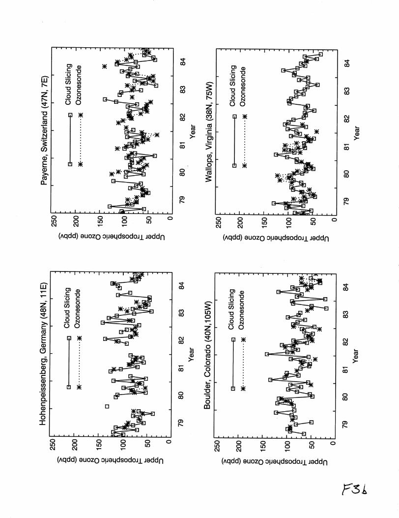
Time series of upper tropospheric ozone were compared with similar time series at
several ground-based World Ozone and Ultraviolet Radiation Data Center (WOUDC)
stations. Figure 3 shows time series comparisons of upper tropospheric ozone at several
ground station locations. It is noted that both data sources were constructed as monthly
ensembles which do not represent true monthly means. This is because measurements for
both sources are scarce with some monthly ensembles having as little as only one day of
measurements. Despite data sampling problems, upper tropospheric ozone time series in
Figure 3 indicate general agreement in mean amounts and seasonal variability with
greatest abundance around spring months and minimum amounts in Autumn in both
hemispheres. Figure 4 shows seasonal cycle comparisons of the data plotted in Figure 3,
including comparisons at several additional ground-station locations. The station
locations in Figure 4 begin in the upper left-most frame for Goose, Canada (53N, 60W)
and progress with decreasing latitude from left-to-right and downward by row. Most all
of the stations are in the NH extratropics (i.e., Europe, Japan, U.S.) and show largest
seasonal variations and mean column amounts in mid-to-high latitudes. The SH stations
(last two frames) show a reversal of the seasonal cycle variability with largest ozonearound SH spring months.
4. Characterization of Seasonal Cycles and Spatial Distributions.
The primary purpose of this investigation is to extend Cloud Slicing to middle and high
latitudes and characterize observed seasonal cycles and spatial distributions of upper
tropospheric ozone. Figure 5 shows spatial distributions of 6-year averaged 3-month
seasonal means (indicated) of upper tropospheric ozone volume mixing ratio. Largest
ozone occurs in winter and spring months in both hemispheres with greater abundance in
the NH. The most significant amounts occur in mid-to-high latitudes. In the NH
midlatitudes in winter and spring months there is evidence of partial poleward entrapment
of upper tropospheric ozone caused by the upper tropospheric wind jets which can act as
a partial barrier for meridional transport of air mass in the upper troposphere. In the NH

in winter andspringtherearelargemeridionalgradientsandenhancementsin ozonealongwind-drivenstormtrackregionssuchastheeasternU.S.andtheAsiancontinentextendinginto theeasternPacific. In theSHin winter andspringseasonsthehorizontalgradientsandmeanamountsin ozoneareweakerthanwinter andspringseasonsin theNH. Thereis alsoapersistentfeaturepresentin eachseasonin the SHsubtropicswhichindicatesanenhancementof ozonenearSouthAmerica,Africa, andAustralia. In thetropics,enhancementof uppertroposphericozoneispresenteachseasonin theAtlanticregionfrom SouthAmericato Africa comparedto theeasternandwesternPacificregions.
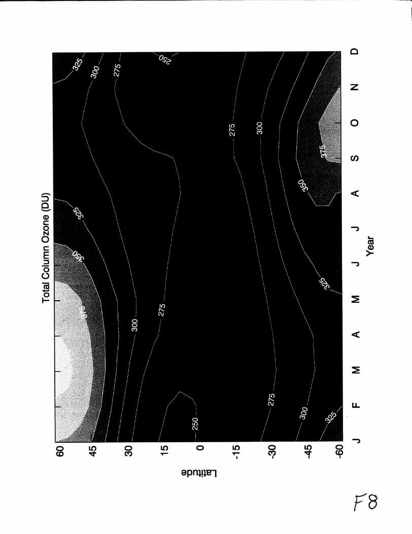
Theseasonalandspatialcharacteristicsof uppertroposphericozonein Figure5resemblethat of total columnozone(Figure6). Wenotethatthenear-globalsimilarity of uppertroposphericOzone and total ozone is not an artifact of the Cloud Slicing algorithm which
assumes that stratospheric column ozone is spatially invariant over selected 5 degree by 5
degreeregions (i.e., all above-cloud column ozone variability over the region is
tropospheric in origin). Contamination from stratospheric ozone variability within the
algorithm is limited to intense dynamical regions, particularly the tropospheric wind jet
regions which are limited to narrow meandering bands in the subtropics and middle
latitudes. The Cloud Slicing algorithm removes outlier data associated with the Wind jet
regions by applying statistical and column ozone filtering (see Appendix A).
The most coherent similarities between upper tropospheric ozone in Figure 5 and total
ozone in Figure 6 occur in the NH in winter and spring months. Most contribution to
total column ozone lies in the mid-to-lower stratosphere. Because ozone is generally a
long-lived tracer of air mass in both the upper troposphere and lower stratosphere
(lifetimes of months to years, respectively), the patterns in Figures 5 and 6 suggest a
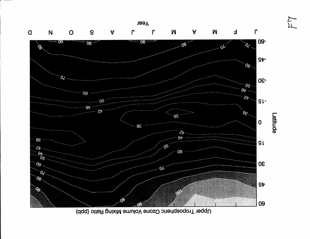
possible influence from STE (discussed in section 5):,_ Figures 7and 8 show zonal mean
seasonal cycles from the data plotted in Figures 5 and 6. It is noted for the uppertropospheric ozone data in Figure 7 that these are not true zonal means since in several
months there are regions without enough suitable clouds for applying the Cloud Slicing
method (e.g., see Figure 5 and discussion). Nevertheless, in Figures 7 and 8 both uppertropospheric ozone and total column ozone show similar seasonal variation and latitude
dependence. In the tropics seasonal cycles are different in these quantities, and both
temporal and meridional variations appear weak. Outside the tropics, mean amounts and
meridional gradients are greatest around spring months in both hemispheres.
Figure 9 shows zonal mean upper tropospheric ozone for January 1979-October 1984. As
in Figure 7, variabilities in upper tropospheric ozone in Figure 9 show largest latitudinal
gradients in the extratropics of both hemispheres with peak amounts around spring
months. It is noted that the springtime maximum in upper tropospheric ozone volume
mixing ratio in NH middle and high latitudes agrees with the NH ozonesonde assessment
of Logan [ 1999] (e.g., her Figure 27 for 300 hPa in mid-to-high latitudes and 200 hPa in
the subtropics). Figure 9 indicates a possible semiannual component in the tropics. Peak-
to-peak amplitudes of this signal are weak, around 2-4 ppmv. In some years (e.g., 1980-
1983) there is evidence of a semiannual oscillation while in other years there is not. A

semiannualcomponentin thetropicsmayindicateadynamicaland/orphotochemicalforcing relatedto thesemiannualzenithcrossingof thesunin thetropics. Comparisonsof thesemiannualandannualvariationsin total columnozoneanduppertroposphericozoneareshownin Figure10. TheannualandsemiannualamplitudeswerederivedbyapplyingbasicFourieranalysis.Bothannualandsemiannualcomponentsin totalozoneanduppertroposphericozonein Figure10comparewell in aglobal sensewith annualcyclevariationsexhibiting largeramplitudesandlargerlatitudinalgradients.
5. Correlations of Seasonal Cycles.
It has been shown that total ozone and upper tropospheric ozone indicate similar spatial
and seasonal cycle variabilities extending from low to high latitudes. A plausible
explanation for these coherent temporal and spatial relationships maybe STE processes
in the atmosphere. It is well known that ozone in the upper troposphere and lower
stratosphere is a relatively long-lived chemical tracer (e-folding lifetimes of months to
years, respectively) so that even monthly measurements in this study provide valuable
insight regarding possible occurrence of STE. Recent studies suggest that tropopause
folding and turbulent convection are significant sources for transporting stratospheric air
mass into the troposphere [e.g., Langford et al., 1996; Beekmann et al., 1997; Cho et al.,
1999; Eisele et al., 1999; Meloen et al., 2001; Bertin et al., 2001; Fujiwara and
Takahashi, 2001 ]. The global effects of STE on tropospheric ozone and its seasonal
variability may be significant. The 3D model study by Lelieveld and Dentener [2000]
indicated that upwards of 80% of tropospheric ozone may be ascribed to STE in
subtropical-to-high latitudes.
Appenzeller et al. [1996, and references therein] showed that air mass lying in the
.....lowermost stratosphere-is: fimdamental to global_ STE p rocesses.::This study investigates .............
potential STE on observed upper tropospheric ozone seasonal cycles by comparing with
both lower stratospheric ozone and lower stratospheric air mass. Air mass abundance in
the lowermost stratosphere is parameterized from tropopause pressure (see Appendix B).
For lower stratospheric ozone we include measurements from the UARS HALOE
instrument. HALOE is a solar occultation instrument-which provides prome_-' _mum_u_:-_'^--'_*:"-"
of stratospheric ozone from the top of the atmosphere down to the tropopause [Bruhl et
al., 1996]. Mean ozone volume mixing ratio from HALOE was calculated for both the
46-100 hPa and 46-215 hPa pressure bands (i.e., together encompassing the lower
stratosphere extending from tropics to high latitudes) for the 1993-2000 post-Pinatubo
time period. Although for a time period later than 1979-1984 and with sparse temporal
and spatial coverage as an occultation instrument, the combined 8 years of HALOE
measurements provide retrievals of lower stratospheric column ozone adequate to
develop seasonal cycles for this comparison. Figure 11 shows seasonal cycles in HALOE
zonal mean ozone volume mixing ratio for the 46-100 hPa pressure band evaluated for
1993-2000. For latitudes less than around 25-30 degrees the 46-100 hPa pressure band
represents the lower stratosphere. At higher latitudes the pressure band is more
representative of the mid-to-lower stratosphere. Seasonal variabilities of HALOE ozone
in Figure 11 are comparable to seasonal variabilities in upper tropospheric ozone in mid-

to-high latitudes(compareFigure11with Figure7).
Figure 12showstemporalcorrelationsasafunctionof latitudebetweenuppertroposphericozoneandHALOE (stars,long-dashedcurves),TOMStotal columnozone(bold), andNCEPtropopausepressure(dotted). Correlationcalculationswith 46-215hPaHALOE measurementswerenotplottedin Figure12equatorwardof 35degreeslatitudebecause215hPaexceedstropopausepressurein theselower latitudesin winter andspringmonths.Thecorrelationsin Figure12arebasedon12monthsof zonalmeandataat eachlatitudeandthereforeprescribeonlybasicagreementordisagreementbetweenseasonalcycles. Correlationamplitudesexceeding0.58pass95% confidence level (i.e.,
5% significance level). Seasonal cycles for upper tropospheric ozone, total ozone, and
NCEP tropopause pressure were determined from 1979-1984 data. Seasonal cycles for
HALOE lower stratospheric column ozone were evaluated for the 1993-2000 (i.e., post-Pinatubo) time period.
If STE is the dominant source of ozone seasonal variability in the upper troposphere, then
all four curves in Figure 12 would conceivably have correlations near +1 at latitudes
where this persists. In subtropical-to-high latitudes, NCEP tropopause pressure and both
HALOE lower stratospheric ozone and TOMS total ozone measurements all indeed show
correlations near + 1. However this is not the case in the low latitudes in Figure 12extending from around 10S to 25N. In these lower latitudes the correlations with NCEP
tropopause pressure become negative in the NH tropics and correlations with HALOE
and TOMS are greatly reduced to low-t0-negative values. The poorest correlations occur
in the NH tropics and are caused by a seasonal maximum in upper tropospheric ozone
during NH spring season compared to seasonal maxima around NH Autumn months in
NCEP tropopause pressure, TOMS total ozone, and HALOE lower stratospheric ozone
..... (noteseasonal:cycledifferencesfor_ mean_ozone volume_mixing: ratio_i_gures :7 and 11 ......................................
in the NH tropics). Several potential sources of upper tropospheric ozone could explain
the seasonal cycles for latitudes 10S to 25N including biomass burning, biogenic
emissions, aerosol influenced photochemistry, tropospheric transport, and cloud lightning
[e.g., Moxim and Levy, 2000; Lelieveld and Dentener, 2000; Bey et al., 2001; Thompsonet ai., 200 i; Martin et al., 200 i, 2002].
6. Summary.
This investigation has examined spatial distributions and seasonal cycles in upper
tropospheric ozone (pressure range 200-500 hPa) extending from low to high latitudes
(60S to 60N) by applying the satellite retrieval method known as "Cloud Slicing". This is
a new technique for determining ozone profile information in the troposphere by
combining co-located measurements of cloud-top pressure and above-cloud column
ozone. Previous investigations have had limited ability in measuring tropospheric ozone
beyond tropical latitudes from satellite data. Comparisons between upper tropospheric
ozone volume mixing ratio derived from Cloud Slicing and ground-based ozonesondes
for 60S to 60N compare well in monthly ensemble time series and seasonal cycles despite
sparse measurements available from either data source. These comparisons indicate the

efficacyof thismethodevenasappliedto therelativelycoarsefield,of-view scanningmeasurementsfrom Nimbus7 TOMS(50km by 50km atNadir, 100km by 100km onaverage).Futuresatelliteinstrumentswith smallerfootprint sizeandgreaterspectralresolutionthanTOMSmayprovidesignificantimprovementsto theCloudSlicingtechnique,with largernumberof measurementsandapplicationto constituentsotherthanozone.
Uppertroposphericozoneindicatesapossiblesemiannualcomponentvariability in thetropics. A semiannualoscillationappearsin someyearsbut not in otheryearswhichmaybearesultof poor signal-to-noisewith theNimbus7 measurements.Theexistenceof asemiannualcomponentin thetropicsmayindicateadynamicaland/orphotochemicalforcingrelatedto thetwice-per-yearzenithcrossingof thesunin tropical latitudes.
Spatialpatternsin uppertroposphericozonearesimilarto total columnozone,particularlyin theNH duringwinter-spring.Givenlonglifetimes(monthsto years,respectively)for ozonein theuppertroposphereandlowerstratosphere,ozonein theseregionsof theatmosphereis atracerof airmassmovementanddistribution. Thespatialpatternsandseasonalcyclesinmid-to-highlatitudesin bothhemispheresaresimilar forTOMStotal ozone,lowerstratosphericozonefrom UARSHALOE, NCEP lowerstratosphericair mass,anduppertroposphericozonefrom TOMS CloudSlicing. Themeanamountsandseasonalvariabilitiesin uppertroposphericozonein theextratropicsareboth largerin theNH comparedto theSH. Theseobservationsalongwith previous2D and3Dmodelresultsindicateapresenceof STEin theextratropics.Our analysessuggestsupportfor theconceptof acouplingof theeffectsof airmassin thelowermoststratosphere(i.e.,"middleworld") andthemeridionalcirculationwhich in modelresultsproduceslargestSTEin theextratropicsof bothhemispheresaroundspring,minimum
...................._:STEin:autumn;:_-andwith_-greater_occ.urrencein theNH ......................._...........................................................
Comparisonsbetweenlower stratosphericair mass,stratosphericozone,anduppertroposphericozoneimply that STEdoesnot appearto beamajor sourcefor theseasonalvariability of ozonein theuppertropospherein low tropicallatitudesextendingoverabroadregionfrom around10Sto 25N. In theselatitudesthereispoor temporalcorrelationsin seasonalcyclesbetweentroposphereandstratosphere,especiallyin NHtropical latitudeswerelargestamountsof uppertroposphericozonefrom CloudSlicingoccurin springmonths. Thereareseveralsourcesfor uppertroposphericozonethatcouldexplaintheseasonalcyclesin low latitudes. Thesesourcesincludebiomassburning,biogenicemissions,aerosolinfluencedphotochemistry,tropospherictransport,cloudlightning,etc.(beyondtheextentof this study).
Appendix A: Cloud SlicingAlgorithm.
Cloud Slicing was applied to daily ensemble measurements over 5 degree x 5 degree
binned regions, and then averaged within each month for the January 1979-October 1984
time period. The chosen latitude coverage of co-located TOMS and THIR footprint
measurements extends from 60S to 60N. This reduces difficulties of persistent snow and

ice in thepolarregionsandalsoeliminatesproblemswith polarnight conditionswheretherearenoTOMSbackscatteredUV ozonemeasurements.Forthe CloudSlicingtechnique,footprintmeasurements(50km x 50km atNadir, around100km by 100kmonaverage)of above-cloudcolumnozonefrom Nimbus7 TOMSareplotted versusco-locatedmeasurementsof Nimbus7THIR cloud-toppressureovera pre-selectedpressureband(200-500hPain this study). Themeanslopeof thedistributionthendirectlyyieldsmeanvolumemixing ratio for ozonewithin thatpressureband. Specifically,meanvolumemixing ratio (X, in ppmv) isdeterminedfrom
X= 1.27A_/AP, (A1)
where _ is above-cloud column ozone (in DU), and P is cloud-top pressure (in hPa). Eck
et al. [ 1987] showed for Nimbus 7 TOMS that footprint scenes with reflectivity greater
than 0.4 are almost always 100% cloud-filled (i.e., 100% cloud fraction scenes). Only
scenes with reflectivity greater than 0.44 were selected in this study to eliminate most
partially cloudy footprint scenes. This reflectivity filtering is a relaxation from the more
stringent 0.6 value of reflectivity used by Ziemke et al. [2001 ] and provides a greater
proportion of scenes for applying Cloud Slicing. Another important parameter is the
minimum number of daily co-located measurements of ozone and cloud pressure within
each 5 degree x 5 degree regio n. This number Was selected (for adequate statistics) in the
present study to be at least 20, and as in Ziemke et al. [2001 ], only computed mixing ratio
values greater than the statistical 2-sigma value were retained.
A fundamental assumption with Cloud Slicing is that stratospheric column ozone is
invariant over the selected region (i.e., all above-cloud column ozone changes over the
region are tropospheric in origin). This condition breaks down in and near strong
......................................dyn_icai:--regl-0-n_pa-_ic_-i_the:_tr0pdsi_iieric _Wi_i-d_-t_i_e_gi6_fi-_-_wfier_rat0Spheric .....- ........___:_:_:::::::_:_:_._....................
column ozone mayexhibit large zonal and meridional variability. An additional filter is
applied to identify these regions: Following analysis for each daily 5 degree x 5 degree
gridded region, only horizontal gradients in above-cloud column ozone (]A_I) less than
50 DU were retained in the data base. This number was chosen subjectively following
several trial runs with Nimbus 7 Cloud Slicing, It is likely that there is some
stratospheric contamination in the retrievals, but these effects are expected to be limited
mostly to narrow regions associated with the tropospheric wind jets. The consistency
with ozonesonde measurements (section 3) and lack of obvious outliers in these regions
suggest that the algorithm does not produce a significant amount of stratospheric ozone
gradient contamination in the retrievals. It is noted that it is also possible to identify the
wind jet regions using global meteorological analyses such as from NCEP, but there are
two reservations for doing this given the type of measurements associated with Cloud
Slicing: (1) The analyses have a coarse resolution compared to the size of TOMS
footprint measurements, and (2) the analyses must be accurate to within about 100 km to
200 km in identifying the location of the wind jets, otherwise a significant portion of bad
data may be retained and good data dispensed with Cloud Slicing.
Appendix B: Column Abundance and Air Mass in the Atmosphere.

Onecanrelateozoneandairmassin theatmospherein aself-consistentwayusingtheconceptof columnabundanceandthe Dobson Unit. The fundamemal Dobson Unit
definition applies to all constituents in the atmosphere, including the total atmosphere
itself where both volume and mass mixing ratio are unitary (100 percent content). OneDobson Unit (DU) is equivalent to 10-5 m vertical thickness of constituent underconditions of
standard pressure (1013.25 hPa) and standard temperature (273.16K) [e.g., Andrews et
aL, 1987, and references therein]. Under this definition, column amount (f2, in DU)
between two pressure surfaces P1 and P2 may be determined by integrating volume
mixing ratio (X, in units ppmv) over pressure P (in units hPa) from
if2= 0.79 ;" XdP(B1)
The constant 0.79 in (B 1) was derived for upper tropospheric levels [Ziemke et al., 2001 ],
but can be applied to any constituent in the troposphere or stratosphere with at most
around 1% relative error. For the total atmosphere, X is a constant (106 ppmv) in (B 1)
which yields a simple relationship for computing the total air column lying between two
arbitrary pressure levels P1 and P2: _ = 7.9x 10⁵(P2-P1). For the global mean surface
terrain pressure (about 990 hPa from NCEP re-analyses) this yields a global mean column
amount f2 of 7.8x 10⁸ DU for the total atmosphere.
Mass associated with column amount f2 is determined by integrating local measurements
of f2 over surface area element dS (units m2) •
(B2)
It is well known that one Dobson Unit is equivalent to 2.69x 10 20 molecules m "2 [e.g.,
Ziemke et al., 2001, and references therein]. This number applies to any individual
constituem in the atmosphere including the total atmosphere itself. In (B2), it follows
that cy is the surface mass column density (units kg m "2 DU "1) and is equivalent to
2.69x 10²°btlNA, where bt is mean molecular weight (48 for ozone, around 29 for the total
atmosphere) and NA is Avogadro's constant (6.022x 1026 particles kmoll). For the total
atmosphere of the Earth, the column amount 7.8x 10⁸ DU from (B 1) applied to (B2)
yields a total mass of around 5.2x 10¹⁸ kg. In comparison, for ozone in the atmosphere the
average total column is about 300 DU and the total mass of ozone is around 3.3x 10¹² kg.
From (B2), a surface mass density associated with local measurements of _ is given by
crY. For NCEP atmospheric air mass this parameter becomes 7.9x 10 scr(P2-P1). It
follows that a proxy for lower stratospheric air mass can be obtained by replacing P2 with
tropopause pressure from NCEP re-analyses and choosing P1 as an arbitrary constant
pressure lying above the tropopause. This investigation uses NCEP tropopause pressure

asa first-orderproxyof lower stratosphericairmassfor cross-correlationsof seasonalcycleswith uppertroposphericozonevolumemixingratio from CloudSlicing (section5).
We have incorporated NCEP re-analyses tropopause pressure which invokes the WMO
2K km 1 lapse-rate definition [WMO, 1957].
References.
Andrews, D. G., J. R. Holton, and C. B. Leovy, Middle Atmosphere Dynamics, 489 pp.,Academic, San Diego, Calif., 1987.
Appenzeller C., J. R. Holton, and KI H. Rosenlof, Seasonal variation of mass transport
across the tropopause, J. Geophys. Res., 101, 15,071 15,078, 1996.
Beekmann, M., et al., Stratosphere-troposphere exchange - regional and global
tropopause folding occurrence, final report, Task group 3b, EUROTRAC, TOR, 1996.
Beekmann, M., G. Ancellet, S. Blonsky, et al., Regional and global tropopause fold
occurrence and related ozone flux across the tropopause, J. Atmos. Chem., 28, 29-44,1997.
Bertin, F., B. Camistron, J. L. Caccia, Mixing processes in a tropopause folding observed
by an network of ST radar and lidar, Ann. Geophys,, 19, 953-963,2001.
Bey et al., Global modeling of tropospheric chemistry with ass'lmilated meteorology:
Model description and evaluation, J. Geophys. Res., 106, 23,073-23,095, 2001.
Bmhl, et al., Halogen Occultation Experiment ozone channel validationl J. Geophys.Res., 101, 10,217-10,240, 1996.
Chandra, S., J. R. Ziemke, W. Min, and W. G. Read, Effects of 1997-1998 E1 Nino on
tropospheric ozone and water vapor, "_ ' "t_reopnys. _ _" _ _ oo / -_ o / v, l o
Chandra, S., J. R. Ziemke, and R. W. Stewart, An 11-year solar cycle in tropospheric
ozone from TOMS measurements, Geophys. Res. Lett., 26, 185-188, 1999.
Chandra S., J. R. Ziemke, P. K. Bhartia, Tropical tropospheric ozone: Implications for
dynamics and biomass burning , J. Geophys. Res., in press, 2002a,
Chandra, S., J. R. Ziemke, and R. V. Martin, Tropospheric ozone at tropical and middlelatitudes, J. Geophys. Res., submitted, 2002b.
Cho, J. Y. N.,R. E. Newell, T. P. Bui, et al., Observations of convective and dynamical
instabilities in tropopause folds and their contribution to stratosphere-troposphere
exchange, J. Geophys. Res., 104, 21,549-21,568, 1999.

Eck,T. F., P.K. Bhartia,P.H. Hwang,andL. L. Stowe,Reflectivityof Earth'ssurfaceandcloudsin ultravioletfrom satelliteobservations,J. Geophys. Res., 92, 4287-4296,1987.
Eisele, H., H. E. Scheel, R. Sladkovic, and T. Trickl, High-resolution Lidar measurements
of stratosphere-troposphere exchange, J. Atmos. Sci., 56, 319-330, 1999.
Fishman, J., and J. C. Larsen, Distribution of total ozone and stratospheric ozone in the
tropics" Implications for the distribution of tropospheric ozone, J. Geophys. Res., 92,6627-6634, 1987.
Fishman, J., C. E. Watson, J. C. Larsen, and J. A. Logan, Distribution of tropospheric
ozone determined from satellite data, J. Geophys. Res., 95, 3599-3617, 1990.
Fishman, J., and A. E., Balok, Calculation of daily tropospheric ozone residuals using
TOMS and empirically improved SBUV measurements- Application to an ozone
pollution episode over the eastern United States, J. Geophys. Res., 104, 30,319-30,340,1999.
Fujiwara, M., and M. Takahashi, Role of the equatorial Kelvin wave in stratosphere-
troposphere exchange in a general circulation model, J. Geophys. Res., !06, 22,763,22,780, 2001.
Hudson, R. D., and A. M. Thompson, Tropical tropospheric ozone (TTO) from TOMS by
a modified-residual method, J. Geophys. Res., 103, 22,129-22,145, 1998.
Jiang, Y., and Y. L. Yung, Concentrations of tropospheric ozone from 1979 to 1992 over
tropical Pacific South America from TOMS data, Science, 2 72, 714-716, 1996.
Joiner, J., and P. K. Bhartia, The determination of cloud pressures from rotational Raman
scattering in satellite backscatter ultraviolet measurements, _ Geophys. Res., i 00,23,019-23,026, 1995.
Kim J° H., and M. J. Newchurch, Climatology and trends of tropospheric ozone over the
eastern Pacific Ocean: The influences of biomass burning and tropospheric dynamics,Geophys. Res. Lett., 23, 3723-3726, 1996.
Kim J. H., M. J. Newchurch, and K. Hart, Distribution of tropical tropospheric ozone
determined by the scan-angle method applied to TOMS measurements , J. Atmos. Sci, 58,2699-2708, 2001.
Langford, A. O., C. D. Masters, M. H. Proffitt et al., Ozone measurements in a
tropopause fold associated with a cut-off low system, Geophys. _Res. Lett., 23, 2501-2504,1996.

Lelieveld,J.,andF. J.Dentener,Whatcontrolstroposphericozone?,J. Geophys. Res.,105, 3531-3551, 2000.
Logan, J. A., An analysis of ozonesonde data for the troposphere- Recommendations for
testing 3D models, and development of a gridded climatology for tropospheric ozone, J.Geophys. Res., 1999.
Martin R. V., D. J. Jacob, J. A. Logan, J. R. Ziemke, and R. Washington, Detection of
lightning influence on tropical tropospheric ozone, Geophys. Res. Lett., 27, 1639-1642,2001.
Martin et al,, Interpretation of TOMS observations of tropical tropospheric ozone with a
global model and in-situ observations, J. Geophys. Res., in press, 2002.
Meloen, J., P. C. Siegmund, and M. Sigmond, A Lagrangian computation of
stratosphere-troposphere exchange in a tropopause folding event in the subtropicalhemisphere, Tellus, 53, 368-379, 2001.
Moxim, W. J., and H. Levy II, A model analysis of tropical South Atlantic Ocean
tropospheric ozone maximum: The interaction of transport and chemistry, J. Geophys,Res., 105, 17,393,-17,415, 2000.
Sudo, K., and M. Takahashi, Simulation of tropospheric ozone changes during 1997-1998
E1 Nino" Meteorological impact on tropospheric photochemistry, Geophys. Res Lett., 28,
4091-4094, 2001......
Thompson, A. M., and R. D. Hudson, Tropical tropospheric ozone (TTO) maps from
Nimbus 7 and Earth Probe TOMS by the modified-residual method: Evaluation with
sondes, ENSO signals, and trends from Atlantic regional time series, J. Geophys. Res.,104, 26,961-26,975, 1999.
Thompson, A M., B. G. Doddridge, J. C. Witte, R. D. Hudson, W. T. Luke, J. E.
Johnston, B. J. Johnston, S. J. Oltmans, and R. Weller, A tropical Atlantic Paradox-
Shipboard and satellite views of a tropospheric ozone maximum and wave-one in
January-February 1999, Geophys. Res. Lett., 27, 3317-3320, 2000.
Vukovich, F. M., V. Brackett, J. Fishman, and J. E. Sickles II, On the feasibility of using
the tropospheric ozone residual for nonclimatological studies on a quasi-global scale, J.
Geophys. Res., 101, 9093-9105, 1996.
Ziemke, J. R., S. Chandra, and P. K. Bhartia, Two new methods for deriving troposphericcolumn ozone from TOMS measurements: The assimilated UARS MLS/HALOE and
convective-cloud differential techniques, J. Geophys. Res., 103, 22,115-22,127, 1998.

Ziemke,J.R., andS.Chandra,Seasonalandinterannualvariabilitiesin tropicaltroposphericozoneJ.Geophys.Res.,104,21,425-21,442,1999.
Ziemke,J.R.,S.Chandra,andP.K. Bhartia,"Cloud Slicing":A newtechniqueto deriveuppertroposphericozonefrom satellitemeasurements,J. Geophys. Res, 106, 9853-9867,2001.
Figure Captions.
Figure 1. Scatter plots of TOMS above-cloud column ozone (in Dobson Units) versus
co-located THIR cloud-top pressure (in hPa) for a grid point located near Wallops,
Virginia (38N, 75W). The top three frames are three days in July 1984 and the bottom
three frames are days in August 1984. The numbers shown in each scatter plot are the
derived ozone volume mixing ratio and 2-sigma uncertainties (in parentheses) in units
ppbv.
Figure 2. Average number of Cloud Slicing measurements per month in this study (see
Appendix).
Figure 3. (a) and (b): Monthly ensemble time series for years 1979-1984 at several
WOUDC ground station locations (indicated) comparing upper tropospheric ozone from
Cloud Slicingwith ozonesonde measurements. Units are ppbv.
Figure 4. Seasonal cycles (from years 1979-1984) of monthly ensemble time series of
upper tropospheric ozone volume mixing ratio (units ppbv) from several ground station
locations (including stations plotted in Figure 3). Cloud Slicing measurements are solid,
......ozonesonde_measuremems_are designated_ b_ycircles. C!_o_udzS!ic:i:ngmeasuremems
include +2or statistical uncertainties.
Figure 5. Seasonal averages (DJF, MAM, JJA, SON, indicated in each frame) of TOMS
upper tropospheric ozone volume mixing ratio (units ppbv) between 60S and 60N derivedfrom Cloud _'" " Seasonal -. ..... ,_ ,_-,a_llclng. averages lntsotputatcu I 19oA xT:.._.,._ 7 Tr_e/T_m7 / 7- O'1" l_lllllUl.$_.,_ 1%J.L¥.IL_JI Jk &.Lilt
co-located measurements of above-cloud column ozone and cloud-top pressure.
Figure 6. Same as Figure 5 but for TOMS total column ozone (in Dobson Units).
Figure 7. Latitude versus month zonally averaged seasonal cycles in upper tropospheric
ozone volume mixing ratio (units ppbv) from Cloud Slicing. Seasonal cycles werederived from TOMS and THIR co-located measurements for 1979-1984.
Figure 8. Similar to Figure 7, but for TOMS total column ozone in Dobson Units.
Figure 9. Upper tropospheric zonal mean ozone volume mixing ratio for January 1979-
December 1984. Units are ppbv.

Figure10. Comparisonsof theannual(left) andsemiannual(right) amplitudesin totalcolumnozone(solid)anduppertroposphericozone(dotted).Annualandsemiannualamplitudeswerederivedby applyingbasicFourieranalysisto the 1979-1984monthlyensembletime seriesdata. Units for bothannualandsemiannualamplitudesareppbv.
Figure 11. Latitudeversusmonthzonallyaveragedseasonalcyclesin lower stratospheric(46-100hPa)meanozonevolumemixingratio (unitsppmv)from HALOEmeasurements.
Figure 12. Latitude-dependenttemporalcorrelationsbetweenuppertroposphericozoneandHALOE (dashed,stars),TOMStotalcolumnozone(bold),andNCEPtropopausepressure(dotted). Correlationamplitudesexceeding0.58pass95%confidencelevel (i.eo,5%significancelevel). Seasonalcyclesfor upper troposphericozone,total ozone,andNCEPtropopausepressureweredeterminedfrom 1979-1984data. SeasonalcyclesforHALOE lower stratosphericcolumnozonewereevaluatedfor the 1993-2000(i.e.,post-Pinatubo)time period.

37.5N 77.5W 13 JUL 84,. ........ | ......... , ......... , ......... | ........A 340
z)
330 47 (35) ppbvO3
0
*" 320 []
oo 310"1o
o 3000
>o 290
.o<l:
280 .................................................
100 200 300 400 500 600
340
a330
030
'- 320E
o0 310"1o
o 3000$>o 290
.o<
28O
Cloud-Top Pressure (hPa)
37.5N 77.5W 11 AUG 84.- ........ i ......... i ......... | ......... i ........
61 (26) ppbv
[] [] o°._
......... = ......... i ......... i ......... i .........
200 300 400 500 600
Cloud-Top Pressure (hPa)
100
340
a"-_ 330or)O
'- 320E
m
_ 310
"10
_o 3009
>o 290
<280
37.5N 77.5W 18 JUL 84......... I ......... i ......... i ......... i ........
68 (22) ppbv
[]
O n
[]
......... i ......... i ......... i ......... i ...... ,,
100
340zDa
330O3
O
'- 320E
oO 310"o
o 3000
o 290..Q,,<
28O
200 300 400 500 600
Cloud-Top Pressure (hPa)
37.5N 77.5W 18 AUG 84.- ........ m ......... m ......... m .... - .... u ......... ,
42 (20) ppbv
[] []
[]
......... m ......... m ......... m ......... m ...... mmm
100 200 300 400 500
Cloud-Top Pressure (hPa)
600
340z)a
330O3
0
c 320E
_ 310"o
o 300o,
o 290.Q<
280
37.5N 77.5W 29 JUL 84• " ........ | ......... i ......... | ......... i ........
340
E3330
O3
0
" 320E
,.=.,o
0 310
'10
o 300(..)
>o 290
..Q
<280
39 (24) ppbv
100 200 300 400 500 600
Cloud-Top Pressure (hPa)37.5N 77.5W 23 AUG 84
." ........ u ......... u ......... l ......... n ........
67 (33) ppbv
lOO
rl []
......... m ......... m ......... m ........ m .........
200 300 400 500 600
Cloud-Top Pressure (hPa)

(1)"0:3
o...
_J
60N
40N
20N
20S
40S
60S
180 150W
Number of Measurements Per Month
12ow 9ow 6ow 3ow o
Longitude
1979-1984 200-500 hPa
30E 60E 90E 120E 150E 180

I..U
z"
v
c"
C:}..
E
0
..... I .... I .... I''_1 ....
- 0 E
_oE
_o N
- 0 0 .-_
.
_ .i _-______
, , , , I .... I , , , ,r..,d , , , I , , , ,
0 0 0 0 0 0L_ 0 t._ 0 t..O
(^qdd) euozo o!JeqdsodoJiJeddn
cO
cOcO
q_J00
cO
8
O_t_
UJ
u'3
0_COCOv
L_
_O
0"I_
_1
E(1)
if}<
(^qdd)euozo o!JeqdsodoJiJeddn
>-
LUO
zC,OCOv
t-
*-j
OEa)
- O c-
_o G0(D
"O t-Oo N
- 0 0
[]
r] _
014004
I I a I l , , i , I
0 0 0 0 00 If) 0 t.D
(Aqdd) euozo o!JeqdsodoJ.L _eddn
co
z-
(D
o
O_
.... I .... I .... I ' '_ ....
El--
- 0 8 % -
Q
,
, , , , I , , , , I , , , , _ , , ,
0 0 0 0 0 0L_ 0 t..O 0 t.f)04 OJ _
(Aqdd)euoz 0 o!JeqdsodoJ/Jeddn
co
cO
o__O
o
>-
iii
Z
v
13E
,=,=,,=
N
O0
r-I,,--
Q.
.... , .... ,.... ,_'.:. ''''
_o f/)
- Oc N
- O O _ -
[3 )E
• -i -"-'_
: _"
•: _
_._-
.I I i I I I I I i I I I I I I I I I ! i i I
O O O O O O
C_I 04 .i-- I--
(^qdd)euozo opeLldsodoJj.Jeddn
c0
cOcO
o4c0
I,=-
CO
OcO
O_
z(_oco
"E:
>
O_• O
m
(^qdd) euozo o!JeqdsodoJl Jeddn
O
cO
oO
o4oO
oO
O_
I,=.
(1)>-
LU
Z0O
v
E
EI,.=
Q)
(9
43t-(D(/)(/)
CD13.E:(],)
J:::O-I-
EC_ (P._ "13
- O E:
o(/)(D
"13 EO
(3 N _ ,.,-__J
_ oo[1 _
•, 0
.... I .... I ....... I ....
_ El
0 0 0 0 0 0140 0 140 0 L_
(^qdd) euozo o!JeqdsodoJl Jeddrl
oO
03oO
o4oO
cO
==
O
O_
o>-
o
El
.... I .... I ' '
B8 oQ
" _.._ -
.... I,,, , I .... ,_ I ....
0 0 0 0 0 00 kO 0 _.0
04 04 _
(Aqdd) euozo oMeqdsodoJ1 seddn
o
O_

qzuoiN
0 N O S V r r IN V IN -I r
L[]];,i,.,L.i.]
i , , •
0 E_Og "o
oOOL -,-I
aogr _
'D
qzuo_
O N O $ V r r &N v IN d r
ooLogr
ooz_
o__00e ""
qluoiN
O N O S V r r IN v iN d,,
• , . , , . , o o ,
•(_a'L_;'N_)'u_r'oJ_d;s '
0E
o_ _3(O,=z
O0L ..-ia
_eg
qzuoiN
O N O $ V r r IN V IN d r
ooL -_%,'T?'TT" a
• " • ' • • • • • I 00_
(3t, l. 'NOg} ofiqndekl-qoezo 'eLlmd
qluolN
ONOSV r r wv_-, r
........ 0 C:
_o_i_,.,., . jooL _'_
_og_ "3,,Ioo_ _
I °Og_• OOe
• "(M'g_:sgifizmg"l_N" "
" qlUOB
ONosvrrmvmdr
qZuolN
O N O S V r r IN v IN :I r
L ......... o
(MggL 'N0¢3) !!_Wt_H'OI!H
qlUOlN
O N O $ V r r B v IN _-I r
.......... o c
, Og
oo_ z,
"_o,;._iu_,ou._, 'qluolN qluolN
ONOSV r r_vm_ r ONOSV r rwvw_ r
0 E ...." ......... 0 E
Og _ , 0g _
oo_ _ oo_ _--4
o_ _ o_r "_oo_E_ [ _
'10
o__ o__OOl_ _ OOe
qluolN
aNosvrrwvwar
0 c::
og "o
oo_
o_00_
I 1og_ _
• OOe ""• • m i l l
_ I,_'N_g)pUl_lO'd'O_OUOlOe'l
[,:........J.._L ,T C:
'_-",.l--'J_=i_.Li j ±""_'--_--TT_loo__,
o_ _ o_
1oo_ E__ _E_og_ _ _'°
00_ -- " (N(gL'NSe) ;,Ul6al_'sdOl;M'
qZuolN
ONOSV r rwvw_ r
°m
, t1_ _
(_VL 'Ni_g) Auetme9 '6JequepuR
qluoiN
aNosv rrv, vna •
k
qtuolN
ONOSV r rNvNa r
o_ooL =",-4
o_OOg _
"a
og_OO8
.......... ]Oo ,Om .. _ T T w
[ "[ 1°=
OOe ""
(M_'I) L'NOb) opreaoloo 'JoPlnOB
qluo_
a NOSV r r wV_:l r
oo_001. _
o_
'B_equess!eduoqoH
qluoiN
ONOSV r rwvwa r
.......... _0 C:llJ- IT .a, T I l og 10"0
001.'_
[ v- 'Tloo [- -IOOB
__ epuoseuozo_,,, ,# ] _"[ Bu!o!ISpnolo_ ] oga -oF .......... t 00£ ""
OW09 'NCg} _pau_o 'esoo9

Afldd
001; 0_1_ 09
AON-J, ao-das
N09
_nv-lnf-un[
0 " 09- 0ZI.- 001;-
S09
S0Z
0 ,-,.
N09
qa:l-uef-_a(l
(A_dd) ::INOZO OIH3HdSOdOHI l::13ddn

o1...I
o_p..t
60N
40N
20N
20S
40S
60S
-180
60N
40N
20N
20S
40S
60S
-180
TOTAL COLUMN OZONE (DOBSON UNITS)
Dec-Jan-Feb 1979-1984
-120 -60
Jun-Jul-Aug
60 120
1979-1984
-120 -60 0
Longitude
60 120
i0]q
[0]q
!0]q
q)
20S
40S
60S
180 -180
iON
10N
_0N
0
20S
40S
60S
180 -180
Mar-Apr-May
-120 -60
Sep-Oct-Nov
-120 -60 0
Longitude
1979-1984
60 120
1979-1984
180
60 120 180
200-500 hPa Column Ozone (DU)
too o
oo
o
to
. _ .r---J
o N 0 S V r r w v m _ r
0
r=
mm
i=-I.
t--Q.(I)
0£
(qdd)o!_eEl5u!xt_eLunloAeuozo oueqdsodoJj.Jeddn
O9
r_
c-ON0
En
0
m
0
0
9pn_!_el
I
O
I I
OI
Z
0
Q>-

l
.0n
0
rr
r..im
XIm
¢1)E
¢1)t-ON00
tnI.,,,
G)¢-Q.¢/)0
0I,...
!--
¢1)
r_
0IX)
I,..
)-
O
epn_!_el
LOI
OCO
I
uO
I
OCO
I

(D
c-4
c-O
..Q0o 13
__ 2E<
e-
<
0
-60 -40 -20 0 20
Latitude
I
40 60
1.0(D
.m
c-
" 0.8000
..00
a
• 0.61:}
.-..
Q.E 0.4<I:
t--," 0.2o3
E
oo 0.0
__. Total Column Ozone / 10
..... 200-500 hPa Column Ozone
I I I I i
-40 -20 0 20 40
Latitude

(D"O
._1
60
45
30
15
EQ
HALOE V19 Mean Volume Mixing Ratio (ppmv) 1993-2000 46-100 hPa
J F M A M J J A S O N D
Month

I I I I I I I I I I I I I I I I I I I I I I I I I I I I I I I I I I I I I I I I I I I I I
eJnsseJd esnedodoJ1 dqON ............
: t
,i
- I" I
II
• I- !" I,i
: !: /-/-/
euozo uuJnloo le;Ol SIAIO/ .-
o!lel::! 6u!x!N gO edq 00 I.-9_, 30-1VH - -- -- _-
o!]eEI 6u!x!!AI euozo o!JeqdsodoJ1 Jeddlq q]!AA suo!_eleJJOO
00""5
0"0 __
0
£'0
0"1.

Upper tropospheric ozone between latitudes 60S and 60N
derived from Nimbus 7 TOMS/THIR Cloud Slicing
Jerald R. Ziemke, Sushil Chandra,
and P. K. B hartia
NASA Goddard Space Flight Center, Code 916, Greenbelt, MD
Popular Summary
This study evaluates the spatial distributions and seasonal cycles in upper tropospheric
ozone (pressure range 200-500 hPa) from low to high latitudes (60S to 60N) derived fromthe satellite retrieval method called "Cloud Slicing". Cloud Slicing is a unique technique
for determining ozone profile information in the troposphere by combining co-located mea-
surements of cloud-top pressure and above-cloud column ozone. Measurements of Nimbus
7 Total Ozone Mapping Spectrometer (TOMS) above-cloud column ozone and Nimbus 7
Temperature Humidity Infrared Radiometer (THIR) cloud-top pressure during 1979-1984
were incorporated. In the tropics, derived upper tropospheric ozone shows year-round
enhancement in the Atlantic region and evidence of a possible semiannual variability. Up-
per tropospheric ozone outside the tropics shows greatest abundance in winter and springseasons in both hemispheres with largest seasonal and largest amounts in the NH. These
characterises are similar to lower stratospheric ozone. Comparisons of upper tropospheric
column ozone with both stratospheric ozone and a proxy of lower stratospheric air mass
(i.e., tropopause pressure) from National Centers for Environmental Prediction (NCEP)
suggest that stratosphere-troposphere exchange (STE) may be a significant source forthe
seasonal variability of upper tropospheric ozone almost everywhere between 60S and 60N
except in low latitudes around 10S to 25N where other sources (e.g., tropospheric transport,
biomass burning, aerosol effects, lightning, etc.) may have a greater role.