Embed Size (px)
Citation preview


URBAN RENEWAL PLAN
FOR THE
RIVERFRONT-DOWNTOWN URBAN RENEWAL AREA
CITY OF SALEM, OREGON
PART ONE - TEXT
PART TWO - EXHIBITS
ADOPTED MAY 5, 1975
AMENDED:
OCTOBER 11, 1976 JULY 5, 1977
JANUARY 23, 1978 APRIL 16, 1979
SEPTEMBER 11, 1984 JANUARY 13, 1986
APRIL 14, 1986 JANUARY 12, 1987
FEBRUARY 16, 1988 NOVEMBER 9, 1993
MAY 26, 1998 NOVEMBER 23, 1998 DECEMBER 10, 2001 FEBRUARY 10, 2003
MAY 9, 2005 AUGUST 2006
NOVEMBER 27, 2006 JANUARY 2009 AUGUST 2009
OCTOBER 2011 AUGUST 2013
SEPTEMBER 2013 APRIL 2014
Prepared by:
Urban Renewal Agency of the City of Salem, Oregon
350 Commercial Street, NE Salem, Oregon 97301
(503) 588-6178

CITY COUNCIL AND
URBAN RENEWAL AGENCY BOARD OF THE
CITY OF SALEM Janet Taylor, Mayor
Ward 1, Frank Walker Ward 2, Jim Randall Ward 3, Brad Nanke Ward 4, TJ Sullivan Ward 5, Rick Stucky
Ward 6, Bruce Rogers Ward 7, Brent DeHart Ward 8, Dan Clem
DOWNTOWN ADVISORY BOARD Mark Shipman, Chair
Sylvia Dorney, Vice Chair Jim Bauer
Suzi Bicknell Frankie Bell Jeff Corner
William Davis Tim Duffy
Debra Edwards Darr Goss
Norm Harris Nate Levin
Mark Shipman Anna Peterson
Dana Vugteveen John Whittington
SALEM PLANNING COMMISSION Jennifer Butler Chuck Bennett
Daniel Dorn Darr Goss
Nathan Levin James Lewis
Michael Nelson Jim Wiles

ADMINISTRATION
Robert G. Wells, City Manager Rick Scott, Urban Development Director Daniel Riordan, Revitalization Supervisor Jill Corcoran, Revitalization Supervisor
John Jansons, Project Coordinator Courtney Knox, Project Coordinator

TABLE OF CONTENTS
PART 1 - TEXT Page No. Section 100 Introduction 1
101 Legal Basis for Employing Urban Renewal Process 102 Declaration of Necessity and Purpose 103 Assurance to Qualify for Federal Assistance 104 Citizen Participation
Section 200 Definitions 2
Section 300 Description of Riverfront-Downtown Urban Renewal Boundary 3
Section 400 Statement of Urban Renewal Plan Objectives 3
Section 500 General Land Use Plan 5 501 Land Use Plan Element 502 Circulation Routes 503 Legal Description
Section 600 Project Activities Which May Be Used to Achieve Plan Objectives 9 601 Principal Aim 602 Land Acquisition 603 Rehabilitation 604 Underground Utility Lines
Section 700 Land Disposition 11 701 Property Disposition 702 Redeveloper=s Obligations 703 Underground Utilities 704 Exceptions
Section 800 Applicability of Controls, Non-Discrimination Provisions, and Effective Periods of Controls 13
801 Applicability 802 Non-Discrimination 803 Effective Periods of Control 804 Agency Review
Section 900 Other Provisions Necessary to Meet State and Local Requirements 14
901 Land Use 902 Rehabilitation and Redevelopment

TABLE OF CONTENTS
903 Transportation Improvements 904 Maximum Development Intensity 905 Relocation 906 Agency Indebtedness
Section 1000 Provisions for Amending Adopted Urban Renewal Plan 16 1001 Substantial Amendments 1002 Major Amendments 1003 Minor Amendments
Section 1100 Urban Renewal Projects 17
1101 Riverfront Redevelopment 1102 Hotel, Community Conference Center and Parking 1103 Main Street Development 1104 Mill Creek Redevelopment 1105 Core Redevelopment Target Area 1106 Parking Facility Construction and Reconstruction 1107 Parking Facility Construction and Re-Construction 1108 Public Art 1109 Pringle Square Post-Acute Rehabilitation Center Project Grant
Section 1200 Funding Priority 33
Section 1300 Future Plan Amendments 34
PART 2 - EXHIBITS Exhibit One Legal Description of Riverfront-Downtown Urban Renewal
Project Area Boundary 35 Exhibit Two Riverfront-Downtown Urban Renewal Project Boundary and
General Land Use (Zoning) Map 37 Exhibit Three Identification of Property That May Be Acquired 38 Exhibit Four General Land Use Map 39 Exhibit Five Core Redevelopment Target Area Map 40 Exhibit Six Parking Facility Construction and Reconstruction Area 41 Exhibit Seven North Downtown Redevelopment Area Map 42 Exhibit Eight Project Grant Guidelines 43

Riverfront Downtown Urban Renewal Plan - Part Two
Page 1
SECTION 100 - INTRODUCTION 101 Legal Basis for Employee Urban Renewal Process The Urban Renewal Plan for the Riverfront/Downtown Urban Renewal Area (the RDURA) consists of Part One, “Text,” and Part Two, “Exhibits.” This Plan has been prepared by the Urban Renewal Agency of the City of Salem, Oregon, pursuant to ORS Chapter 457, Article IX, Section 1c, of the Oregon Constitution, and all applicable laws and ordinances. All such applicable laws are made a part of this Plan, whether expressly referred to in the text or not. 102 Declaration of Necessity and Purpose Within the boundaries of the RDURA, as hereinafter described, the Mayor and Common Council of the City of Salem hereby finds there exists conditions of blight, deterioration, decline of property values and business vacancies, conflicts between vehicular and railroad traffic, and other factors which constitute a detriment to the health, safety, morals, and welfare of residents of the City and people frequenting the RDURA. The Mayor and Common Council further finds that to correct the condition as herein above stated and to realize the Plan Objectives set forth in Section 400 of this Plan, that it is necessary and in the public interest to declare the RDURA as an urban renewal area and to utilize therein, the urban renewal and redevelopment provisions of ORS Chapter 457. 103 Assurance to Qualify for Federal Financial Assistance In order that this Plan may qualify or federal financial assistance, and pursuant to Block Grant Funding of Title 1 of the Housing and Community Development Act of 1974, the “Assurances” provisions of the US Department of Housing and Urban Development (Form HUD 7015.12 - 12/74) by this reference are hereby included within this Plan as if such assurance were herein included in full. 104 Citizen Participation Prior to the adoption of this Plan, the Mayor and Common Council appointed a citizens advisory group referred to as the Riverfront Committee to advise the Council on the Riverfront Project. The Mayor and Common Council appointed two boards to succeed the Riverfront Committee: the Downtown Development Board (DDAB) and the Parking District Board (DPAB). In December of 2004, Council merged the functions of the DDAB and the DPAB into the newly established the Downtown Advisory Board (DAB). By intergovernmental Agreement, the DAB succeeds the DDAB and the DPAB in advising the Urban Renewal Agency on matters relating to the administration of this Plan. Additionally, the Salem Planning Commission, as required by ORS Chapter 457 and this Plan, will review any substantial or major amendments to this Plan. The DAB and the Salem Planning Commission will serve as the official advisory groups to the Agency Board and the Common Council regarding all activities relating to this Plan. (ord.60-05)

Riverfront Downtown Urban Renewal Plan - Part Two
Page 2
SECTION 200 - DEFINITIONS Unless the context otherwise requires, as used in this Plan the following mean: A. “Plan” or “RDURP” means this Urban Renewal Plan for the Riverfront/Downtown Urban
Renewal Area, Parts One and Two. B. “Text” means the Urban Renewal Plan for the Riverfront/Downtown Urban Renewal Area,
Part One - Text. C. “Project” means individual projects or undertakings carried out within the
Riverfront/Downtown Urban Renewal Plan Area. D. ”Project Area” means the area included within the boundaries of proposed individual
projects. E. “Agency” means the Urban Renewal Agency of the City of Salem, Oregon. F. “Planning Commission” means the Planning Commission of the City of Salem, Oregon. G. “City” means the City of Salem, Oregon. H. “County” means the County of Marion, State of Oregon. I. “State” means the State of Oregon. J. “ORS” means Oregon Revised Statutes. K. “RDURA” means Riverfront/Downtown Urban Renewal Area. L. “River” means the Willamette River. M. “Person” means any individual, corporation, limited liability company, partnership, trust, or
other entity capable of holding title to real property or having the capacity to enter into contracts. (ord. 60.05)
N. “Downtown Parking District” means the parking district created and described in Salem
Revised Code Chapter 7. O. “SACP” means Salem Area Comprehensive Plan. P. “DAB” means the Downtown Advisory Board, established in December, 2004, and charged
with advising the Urban Renewal Agency Board and the Common Council on matters relating to the Agency’s administration of this Plan. (ord.60.05)

Riverfront Downtown Urban Renewal Plan - Part Two
Page 3
SECTION 300 - DESCRIPTION OF THE RIVERFRONT/DOWNTOWN URBAN RENEWAL BOUNDARY
The boundaries of the RDURA are shown on the Urban Renewal Boundary and Land Use Plan Map attached hereto as “Exhibit 2" of “Part Two” of this Plan. A legal description of the boundaries of the RDURA is attached hereto as “Exhibit 1" of “Part Two” of this Plan. SECTION 400 - STATEMENT OF URBAN RENEWAL OBJECTIVES The primary objectives of this Plan are to improve the overall appearance, condition, and function of the RDURA to encourage a variety of river-oriented uses, to sustain, and improve the economic vitality of the Central Business District, to relieve traffic congestion and railroad conflicts, to encourage the use of mass transit, and preserve and to create natural green belts along existing waterways. (ord.60.05) Objectives of the Plan more specifically stated are: A. To work with citizen’s advisory committees and subcommittees for maximum input and
evaluation of development recommendations. B. To maintain the central core area as the dominant center for regional retail and office
development. C. To prevent further fragmentation of central core area retail and office development activity. D. To encourage the development of, and provide sites for, additional retail uses, including
department stores. E. To improve the pedestrian flow and protection for pedestrians between retail activities,
offices, public facilities, parking, and related areas, through improvements at street level as well as grade-separated pedestrian ways.
F. To make capital improvements to existing publicly owned parking structures and to
increase the net supply of public off-street parking spaces within the RDURA sufficient to meet the needs of the Downtown Parking District and public facilities.
G. To encourage private restoration, rehabilitation, development, both within and adjacent to
project areas, through public improvements in project areas. H. To encourage and explore funding methods for the preservation or reuse of historically or
architecturally significant buildings in the retail core area. I. To recommend changes to zoning, building codes, fire regulations, and administrative
policies, consistent with public safety, to encourage rehabilitation and uses of existing buildings.

Riverfront Downtown Urban Renewal Plan - Part Two
Page 4
J. To protect existing stock of buildings by encouraging rehabilitation and to encourage the conversion of existing suitable structures to residential use in the RDURA.
K. To encourage the development of new housing through the use of available measures,
such as the tax abatement provisions of HB 2343. L. To increase the total housing supply adjoining the retail core. M. To relieve traffic congestion and conflicts arising between cross town traffic and traffic
destined for downtown Salem by improving Front Street, minimizing the railroad conflicts through track consolidation and relocation, and encouraging the use of mass transit.
N. Improve present public street and alleys by the installation of new surfacing, curbs, gutters,
sidewalks, and the placing of visually integrated street furniture, and to develop and improve the street lighting system.
O. To participate in the development of the Willamette Riverfront in a way that provides an
opportunity for a mixture of commercial, residential, public, and other uses compatible with the Riverfront, and facilitates safe pedestrian and bicycle movement along the Riverfront with linkages to adjoining areas.
P. Where necessary, to construct, install, and replace publicly owned utility systems such as
water, storm drains, and sanitary sewers, where existing systems are inadequate, undersized, or substandard.
Q. Provide good pedestrian, bicycle and vehicular access to the Riverfront. R. To beautify and enhance the streetscape by participating in projects involving public art,
landscaping, sidewalk surfacing, signing, street furniture, intersection corner bulbs, weather protection, and related improvements.
S. Recognize Mill Creek as a community asset by providing open space and good pedestrian
access to and along the Creek, by acquisition of property and construction of pedestrian/bicycle ways along the Creek and potentially grade separated paths at major barriers such as streets.
T. Promote higher density housing throughout the North Downtown including north of Union
Street, along the Riverfront and on property known as the Larmer site. U. Encourage and participate in the provision of pedestrian-oriented, mixed-use (commercial,
office and residential) development along the Broadway/High Street corridor, north of Union Street.
V. To promote the construction, installation and replacement of private utility infrastructure to
support commercial and residential downtown development.
W. To encourage the development of buildings that provide medical/professional employment opportunities and services to downtown. (Reso No. 2014-23)

Riverfront Downtown Urban Renewal Plan - Part Two
Page 5
SECTION 500 - GENERAL LAND USE PLAN The General Land Use Plan for the RDURA conforms with the Salem Area Comprehensive Plan and consists of a map entitled “URBAN RENEWAL PROJECT BOUNDARY AND LAND USE MAP” included herein as “Exhibit 2” to “Part Two,” and the descriptive material and regulatory provisions contained in this Section 500, both those directly stated and those herein included by reference. 501 Land Use The following land uses are permitted by this General Land Use Plan:
1. Residential Uses complying with the uses, provisions, standards, and regulations set forth in the Salem Zone Code, including most specifically SRC Chapter 148 - “RM1/RM2 - Multifamily Residential District” and SRC Chapter 149 “RH - High Rise Apartment Residential District.”
2. Retail and Office Uses complying with the uses, provisions, standards, and regulations set
forth in the Salem Zone Code, including most specifically SRC Chapter 150 “CO - Commercial District,” and to SRC Chapter 154 “CB - Central Business District.”
3. New Retail Center complying with the following uses, provisions and standards:
a. Allowed Uses:
Department Store Artist Supply Store Bookstore Camera and Photographic Store Candy, Nut and Confectionary Drug Store Dry Goods Store Florist Shop Furrier and Fur Shop General Store Gift and Novelty Shop Greeting and Stationery Card Store Hobby Equipment Store Hotel Jewelry Store Liquor Store Music Store (including stereo equipment sales and records stores) New Dealers Plant Store Public Use Space Restaurant or Dine, Drink and Dance Establishment
Riverfront Downtown Urban Renewal Plan - Part Two
Page 6
Shoe Store Sporting Goods Store Theater Toy Store Tobacco, Cigar Store Wearing Apparel & Accessories Variety Store Luggage and Leather Store Baker Barber Beauty Shop Offices of Financial Institutions Other Office Uses allowed by the Zone Code provided they are not located
on the street level Other Compatible Uses
b. Additional Provisions
i. Off-street parking requirements. The requirements of the Salem Zone Code, SRC Chapter 133 - “Off-Street Parking and Loading” apply. (ord. 60.05)
ii. Public Use Space. Approximately 10,000 square feet of the land in the New
Retail Center land use category is required to be developed for public use. A detailed plan locating this site, its design, use, character, and ongoing operation shall be approved by the City Council prior to the issuance of any construction permits in this land use category. The following description is intended as a guide to be used by the City Council in approving the detailed plan. It is not intended to define the specific uses to be included.
The space to be developed in this use should be along the major pedestrian routes and in one contiguous site. It should be designed to include both passive, high spectator and active, i.e. skating, participation choices. Examples of the specific uses included special events like the arts shows, trade exhibits, dance concerts, etc., along with permanent attractions such as an ice skating rink and/or outdoor dining. The area should be at least partially enclosed for year round usage.
4. Industry and Commercial Services complying with the uses, provisions, standards, and
regulations set forth in the Salem Zone Code, including, most specifically, SRC Chapter 155 - “IC - Industrial Commercial District.”
5. Parks and Open Space complying with the uses, provisions, standards, and regulations
set forth in the Salem Zone Code, including, most specifically, SRC Chapter 160 - “Public Use District.”

Riverfront Downtown Urban Renewal Plan - Part Two
Page 7
6. Other Public and Major Institutions complying with the uses, provisions and standards, and regulations set forth in the Salem Zone Code, including, most specifically, SRC Chapter 160 - “Public Use District.”
7. Riverfront. Uses shall conform with the “River-Oriented Mixed Use” provisions of the
Salem Area Comprehensive Plan and, where applicable, SRC Chapter 141 - “Willamette River Greenway.” Within the Willamette Riverfront two land use categories are shown in Exhibit 2, Part 2, General Land Use Plan: Part A - Industrial and Part B - Riverpark and Redevelopment.
Part A: Industrial uses complying with the provisions, standards, and regulations set forth in the Salem Zone Code, including, most specifically, SRC Chapter 155 “IC - Industrial Commercial District,” and Chapter 158 - “IG - General Industrial District.”
Part B: Riverpark and Redevelopment complying with the following provisions:
a. Allowed Uses:
Parks and open space, including pedestrian bicycle trails and community center buildings. Marina, including accessory uses such as, but not limited to, boat launch, boat sales, boat and engine repair, gas and oil sales, boat equipment rentals, and accessory sales. Community buildings Multifamily residential Hotels, motels, and conference Eating place, restaurant café Dine, drink and dance establishment Other compatible uses Retail uses: Antique Shop Artist Supply Store Camera and Photographic Store Candy, Nut and Confectionary Store Florist Shop General Store of not more than 5,000 square feet Gift Novelty Shop Plant Store Sporting Goods Store Toy Store Tobacco Store Wearing Apparel and Accessories Variety Store Luggage and Leather Goods

Riverfront Downtown Urban Renewal Plan - Part Two
Page 8
b. Additional Provisions:
The above uses shall comply with the provisions, standards, and regulations set forth in the Salem Zone Code, including SRC Chapter 141 - “Willamette River Greenway.” i. General Commercial, Office complying with the uses, provisions, standards, and
regulations set forth in the Salem Zone Code, including, most specifically, SRC Chapter 150 - “ CO - Commercial Office District” and SRC Chapter 153 - “CG - General Commercial District.”
ii. Industry, complying with the uses, provisions, standards, and regulations set forth
in the Salem Zone Code, including, most specifically, SRC Chapter 158 “IG - General Industrial District.”
8. Retail Sales and Service – Personal Services Oriented use, permitted within the South
Waterfront Mixed-Use (SWMU) zone. SRC 162.040(a)(1)(ii). (Reso No. 2014-23) 502 Circulation Routes Circulation Routes shall be as delineated on the Street System Element of the Salem Transportation System Plan, as adopted and amended by the Salem City Council. 503 Legal Description The legal description of the RDURA is included as Exhibit 1, Part Two of this Plan.

Riverfront Downtown Urban Renewal Plan - Part Two
Page 9
SECTION 600 PROJECT ACTIVITIES WHICH MAY BE USED TO ACHIEVE PLAN OBJECTIVES
601 Principal Aim The principal aims of the urban renewal activities under this Plan are to create a climate for, and to encourage, the revitalization of a viable and economically sound Central Business District, the elimination of traffic congestion and railroad conflicts, and the development of amenities along the east bank of the Willamette River. The type of urban renewal actions to be undertaken by the Agency in execution of this Plan include those actions permissible under ORS Chapter 457, including, but not limited to, the following:
1. Assistance in the rehabilitation of deficient structures where such rehabilitation is physically and economically feasible.
2. Acquisition of real property for clearance and sale or lease for redevelopment.
3. Entering into agreements for owner participation in rehabilitation and/or redevelopment.
4. Aid in the relocation of individuals, families, and businesses displaced by renewal
actions.
5. The renovation and rehabilitation of historic or architecturally significant buildings or structures identified in the City’s historic inventory.
6. Construction and reconstruction of public improvements, including flood control
measures, transportation, utilities, parking facilities, convention facilities, performing arts facilities, public parks and open space, and other facilities which will aid in the economic, aesthetic, or recreational enhancement of the RDURA.
7. Entering into cooperation agreements with other public agencies.
8. Relocating existing overhead private utilities and installing proposed private utilities
underground where feasible.
9. Installation of temporary uses, such as open space, parks, temporary mobile office facilities, and surface parking areas.
602 Land Acquisition Property that is acquired under this Plan will be acquired according to the procedures adopted by Board in Resolution No. 06-04 URA and incorporated into this Plan by this reference. Any properties purchased with Federal funding will be purchased according to the procedures and regulations of the Department of Housing and Urban Development. (ord. 60-05) 603 Rehabilitation

Riverfront Downtown Urban Renewal Plan - Part Two
Page 10
Existing structures on all properties to be rehabilitated shall meet the following minimum standards:
1. All structures shall be rehabilitated in accordance with the versions of the following codes current at the time of rehabilitation, as adopted or administered by the City of Salem: State Structural Specialty Code State Electrical Specialty Code State Mechanical Specialty Code State Plumbing Specialty Code Fire Prevention Code Sign Code of the City of Salem Salem Housing Code Salem Zone Code
2. The Agency may recommend the granting of variances to standards made applicable by
the codes for an individual structure, including structures of historic or architectural significance, if it finds that:
a. The structure cannot feasibly be made to comply with the standards because of
existing site, use, or other physical limitations; and
b. The variance from the standards will not otherwise adversely affect the health, safety, or welfare of the occupants of the structure or of the RDURA.
Should a variance be recommended by the Agency, the applicant shall follow all applicable procedures for obtaining the variance.
3. All structures and uses shall comply with the conditions and regulations of this Plan.
4. Owner-Participation. If it is not economically feasible for the owner to bring the property
to applicable standards, the Agency may either acquire the property or partner with the owner to demolish all or part of a structure.
604 Underground Utility Lines Wherever possible, and in accordance with adopted plans and subsequent agreements between the Agency and private utilities, overhead utility facilities and lines shall be placed underground.

Riverfront Downtown Urban Renewal Plan - Part Two
Page 11
SECTION 700 LAND DISPOSITION 701 Property Disposition The Agency is authorized to sell, lease, exchange, subdivide, transfer, assign, pledge, encumber by mortgage or deed of trust, or otherwise dispose of any interest in real property which has been acquired in accordance with the provisions of this Plan. All real property acquired by the Agency shall be disposed of for development of uses permitted in this Plan, at the fair re-use value for the specific permitted uses on the real property. Real property acquired by the Agency may be disposed of to any other public entity. All persons and entities obtaining property from the Agency shall use the property for the purposes designated in this Plan, and shall commence and complete development of the property within a period of time which the Agency fixes as reasonable, and comply with other conditions which the Agency deems necessary to carry out the purposes of this Plan. To provide adequate safeguards to ensure that the provisions of this Plan will be carried out, and to prevent the recurrence of blight, all real property owned by the Agency, as well as all real property purchased or leased by redevelopers, shall be subject to this Plan. Leases, deeds, contracts, agreements, and declarations of restrictions by the Agency may contain restrictions, covenants running with the land, rights of reverter, conditions subsequent, equitable servitudes, or any other provisions necessary to carry out this Plan. 702 Redeveloper’s Obligations The following redevelopment requirements, whether by the Agency or by others, are hereby imposed on property disposed of by the Agency, and shall be implemented by appropriate covenants or other provisions in property disposition instruments:
1. The redeveloper and the redeveloper’s successors or assigns shall redevelop land in accordance with the land use provisions and building requirements specified in this Plan.
2. The redeveloper shall begin and complete development of land for the uses required in
this Plan within a reasonable period of time, as determined by the Agency, and as specified in the disposition instrument.
3. The redeveloper shall submit preliminary architectural and site plans, landscape plans,
and final plans and specifications for the construction of improvements on the land to the Agency for review and approval so that the Agency may determine compliance of such plans and specifications with this Plan, including the terms and conditions in the disposition instrument.
4. The redeveloper will, under the terms of the disposition instrument, carry out specified
improvements in accord with this Plan. The redeveloper will not be permitted to dispose of the property until the improvements are made, except with the prior written consent of the Agency, which consent will not be granted, and except under conditions that will prevent speculation and will protect the interests of the Agency and the general welfare

Riverfront Downtown Urban Renewal Plan - Part Two
Page 12
of the RDURA. The Agency’s right to consent will not be subject to the provisions of ORS 105.190. (ord. 60.05)
5. No property shall be restricted as to the sale, lease, use or occupancy upon the basis of
race, religion, color, sex, or national origin. ‘
703 Underground Utilities Utility facilities, if feasible, may be relocated, as necessary to place existing above-ground facilities underground, and to relocate those necessary by reason of street modifications. The private facilities concerned will make such modifications and adjustments as may be required of them by reason of applicable law and through cooperation with the Agency. Upon vacation of streets, utility easements shall be reserved, unless the Agency determines that such reservations are not necessary. 704 Exceptions The Agency may grant exceptions to any of the regulations contained in this Section 700. Such exceptions shall be treated as minor amendments to this Plan and approved in accordance with the process set out in Section 1003. Prior to granting exceptions, the Agency shall determine the proposed action will not adversely affect other properties within, or adjacent to, the RDURA, and is consistent with the intent of this Plan. Any exceptions from this Plan that do not comply with the Salem Zone Code and other applicable codes and standards of the City shall require a variance or other approval by the City. (ord.60.05)

Riverfront Downtown Urban Renewal Plan - Part Two
Page 13
SECTION 800 APPLICABILITY OF CONTROLS, NON-DISCRIMINATION PROVISIONS, AND EFFECTIVE PERIODS OF CONTROL
801 Applicability of Controls The provisions and requirements prescribed in Sections 500 and 600 shall apply to all real property situated within the RDURA. 802 Non-Discrimination The property within the RDURA shall not be restricted as to the sale, lease, or occupancy upon the basis of race, religion, color, sex, or national origin. 803 Effective Periods of Control The provisions and requirements outlined in this Plan shall be in effect until the Maximum Amount of Indebtedness, as defined in Section 900 has been retired, except that the non-discrimination provisions shall be in effect in perpetuity. The provisions and requirements, or any part thereof, may be extended for additional, successive ten-year periods by agreement of the majority of the property owners in the RDURA. (ord. 60.05) 804 Agency Review Any person aggrieved by a decision made under this Plan, whether such decision is affirmative or negative, is entitled to have the decision reviewed by the Agency. Request for such reviews shall be in writing, shall state the reason for the request, and shall be made not later than ninety (90) days after the decision has become final. (ord.60.05)

Riverfront Downtown Urban Renewal Plan - Part Two
Page 14
SECTION 900 OTHER PROVISIONS NECESSARY TO MEET STATE AND LOCAL REQUIREMENTS
901 Land Use The land uses delineated in this Plan conform to the Salem Area Comprehensive Plan and the Salem Zoning Code. 902 Rehabilitation and Redevelopment The land use provisions and building requirements set forth in this Plan are designed to accomplish rehabilitation and redevelopment in accord with sound planning principles and objectives. All land the Agency acquires and such parcels as may be the subject of owner-participation agreements, will be rehabilitated or cleared and redeveloped to conform with the land uses shown on the Land Use Map. Public improvements, such as streets and parks, will be installed in accord with this Plan. 903 Transportation Improvements Street improvements proposed in this Plan conform with the Salem Area Comprehensive Plan and are appropriate and desirable with respect to adjacent areas. In addition to fostering land use objectives of this Plan, modification of the railroad tracks and the existing street system will aid traffic flow and minimize traffic congestion in the RDURA. 904 Maximum Development Intensity Proposed land uses will conform to the Salem Area Comprehensive Plan and the use and development standards of the Salem Zoning Code, thereby resulting in maximum use intensity. 905 Relocation The Agency will provide assistance in finding replacement facilities to persons or businesses displaced by Agency action. All persons or businesses to be displaced will be contacted to determine their relocation needs, and will be given information related to the relocation program and procedures, including eligibility requirements for relocation payments, available services, and other relevant matters. The relocation activities for the Front Street Project will comply with the Front Street relocation plan and procedures adopted by the Salem City Council, March 1976. All other relocation activities will be undertaken, and payment made, in accordance with the Department of Housing and Urban Development Rules and Regulations. In appeals of relocation decisions, the Agency will follow the procedures set forth in SRC 2.14, as it may be amended from time to time.

Riverfront Downtown Urban Renewal Plan - Part Two
Page 15
906 Agency Indebtedness The Agency may finance or refinance any indebtedness incurred by the Agency in connection with this Plan, by providing for the division of ad valorem taxes, if any, levied by a taxing body upon the taxable real and personal property situated in the RDURA, pursuant to ORS 457.420 - ORS 457.450. The maximum amount of indebtedness that can be issued or incurred under this Plan is $315,000,000. For tax years beginning on or after July 1, 1998, the City of Salem has chosen Option One under Oregon Laws 1997, Chapter 451, Section 454, as the method of collecting ad valorem property taxes sufficient to pay, when due, indebtedness issued or incurred to carry out this Plan. (ord. 60.05)

Riverfront Downtown Urban Renewal Plan - Part Two
Page 16
SECTION 1000 PROVISIONS FOR AMENDING ADOPTED URBAN RENEWAL PLAN 1000 AMENDMENTS TO THE RENEWAL PLAN It is anticipated this Plan will be reviewed periodically during its execution, and may be changed, modified, or amended as future conditions warrant. The types of plan amendments are: Substantial Amendments, Major Amendments, and Minor Amendments. (ord. 60.05) 1001 Substantial Amendments Substantial amendments are amendments to this Plan that require, pursuant to ORS 457.220, the same approval procedures required of the original plan. Substantial amendments are defined as:
1. Adding land to the RDURA, except for addition of land that totals not more than one percent of the existing area of the RDURA; and
2. Increasing the Maximum Amount of Indebtedness that can be issued or incurred under
this Plan. 1002 Major Amendments Major amendments shall be reviewed by the DAB, affected neighborhood associations, and require approval by the Agency by resolution and by the City Council, which may approve the amendment by resolution. Major amendments are defined as the addition of new goals, objectives or projects to this Plan. (ord. 60.05) 1003 Minor Amendments
Minor amendments shall be adopted by resolution of the Agency. Affected neighborhood associations may be consulted, on a discretionary basis, as determined by the Agency at the time the amendments are initiated. Minor amendments are defined as any change to this Plan that is not classified as a Substantial or Major Amendment. (ord. 60.05)
Riverfront Downtown Urban Renewal Plan - Part Two
Page 17
SECTION 1100 URBAN RENEWAL PROJECTS 1101 Riverfront Redevelopment A. Project Description The project is to redevelop property owned by the Agency, located in downtown Salem adjacent to the Willamette River. The project includes a public dock, open space, improved pedestrian crossings from Downtown to the Riverfront Park, and an esplanade. The public dock, including an overlook and riparian gardens, was completed in May of 2005. In addition to the property owned by the Agency, the project extends across Front Street to include work within the right-of-way of Court Street, between Front Street and Commercial street, and the half block bordered by Court, Front, State and the alley, and across the Willamette Slough to provide a link to Minto Brown Island. The project also includes the redevelopment of property along the Riverfront located north of Union Street, and the railroad bridge connection to Wallace Marine Park. (ord. 60.05) The redevelopment is mixed use, with ancillary uses and large areas of public open space and river access. Urban Renewal funds will be used for development throughout the project area. The public open space element will include a hard surface plaza and turfed park areas. Parking facilities will be constructed to serve the adjacent public open space. Public parking and alley widening and loading area improvements, each requiring property acquisition, may be provided adjacent to a courtyard and a grade separated pedestrian way, located primarily in the Court Street right-of-way, connecting the Riverfront to the downtown. On the northerly end of the site, an historic village was developed, with the historic Gilbert House as its anchor. Several historic structures from other areas were purchased and relocated to the Riverfront historic village between 1992 and 2000. Parking has been developed near the historic village to serve both the village and the public open space adjacent to the village. Pedestrian and vehicle access within and to the site is a key aspect of the project. An extensive system of pedestrian/bicycle ways will be constructed on the site, providing linkages to other areas of the City. Three major pedestrian linkages were originally proposed, including a grade separated pedestrian way in the vicinity of Court and Front Streets, a pedestrian bridge connecting the southern end of the site to Minto Brown Island, and conversion of an existing railroad bridge to pedestrian use (when declared surplus by the railroad) connecting the site to Wallace Marine Park, across the Willamette River. In addition, street improvements will be required to provide on site circulation and vehicular access to the site. Pedestrian connections will be developed to provide pedestrian access from Front Street to the Riverfront esplanade. The Agency may acquire property in this area to facilitate redevelopment of the Riverfront as public and private uses and to provide pedestrian access to and along the river. B. Relationship to Local Objectives
1. The Riverfront Redevelopment Project is in conformance with the goals and policies of the Salem Area Comprehensive Plan.
2. The Riverfront Redevelopment Project is consistent with the Salem Zone Code.

Riverfront Downtown Urban Renewal Plan - Part Two
Page 18
3. The Riverfront Redevelopment Project is consistent with the CAN-DO Neighborhood Plan.
4. The Riverfront Redevelopment Project is consistent with local transportation plans,
including the Salem Area Transportation Plan.
5. The Riverfront Redevelopment Project will not have a significant impact on public transportation or utilities and will benefit recreational, and other community facilities.
6. The Riverfront Redevelopment Project is consistent with the Core Area Plan (1996) and North Downtown Plan (1997).
C. Project Timeline and Outline
A precise date for initiating construction of the project has not been established because of unknown factors. Some, but not all, of these factors include the timing of the required land use actions (e.g. an Army Corps of Engineer’s permit for the public dock). The general order of expenditures has, however, been established. Expenditures will be specifically identified, and updated annually in Salem’s Capital Improvement Program. In general, the order of improvements will require demolition of the existing Boise Cascade Container Plant first. Also expected to occur early in the project are site improvements linking the site to Minto-Brown Island. These improvements include construction of central open space areas (hard and soft surface), construction of the grade separated pedestrian way at Front and Court Streets, property acquisition and demolition of blighted structures along Front Street, alley and parking improvements adjacent to the grade separated pedestrian way and courtyard, street improvements relating to site access, property disposition and site improvements at the historic village. The fourth year of improvements include final paving and landscaping of the Court Street pedestrian area and additional open space improvements and redisposition of some property along Front Street for permitted uses. The remaining improvements are expected to occur in years five and six and include the public dock, additional parking, acquisition and improvement of the railroad bridge to Wallace Marine Park (if available), additional open space improvements, public beautification in open space areas and additional improvements to Front Street relating to site access. The above schedule is not definitive and some changes may be necessary. It is intended to provide general direction to the expected order of development of the project. D. Map “Part 2” of “Exhibit 3” illustrates property in the RDURA which may be acquired for renewal activities. This map has been amended to remove designations of properties for potential acquisition along the Riverfront until a specific project is identified north of Union Street. E. Temporary/Permanent Relocation

Riverfront Downtown Urban Renewal Plan - Part Two
Page 19
Properties proposed for acquisition may include those north of Union Street, west of Front Street, east of the Willamette River and south of Mill Creek. While no specific properties are identified, the properties subject to potential acquisition are within the area shown in Exhibit 3. Any relocations mandated by property acquisition related to this project will conform completely with the Uniform Relocation Act, which is incorporated herein by reference. F. Real Property Acquisition/Disposition Acquisition, demolition and removal of structures may be necessary to redevelop the area. Any acquisition of real property will conform with Section 600 of this Plan and ORS Chapter 457. Disposition of real property will conform with Section 700 of this Plan. 1102 Hotel, Community Conference Center and Parking
A. Project Description
The Conference Center project was completed in early 2005 and a grand opening celebration was held on February 25, 2005. The project consisted of developing a community conference center and associated parking in conjunction with a private hotel in downtown Salem - encompassing the entire block bordered by Ferry, Liberty, Trade, and Commercial Streets. Capital costs of development included furniture, fixtures, and equipment. The community conference center and associated parking were publicly financed and the hotel was privately financed. (ord. 60.05) B. Development Outline The project is dependent upon two key items occurring. The first is that a private hotel developer must propose a development to the City and indicate that adequate financing is available and the project is feasible. The second key item, is that the Renewal Agency must identify suitable financing for property acquisition, construction of the community conference center and construction of necessary associated parking. Financing may include a General Obligation Bond, tax increment financing or a combination of these and other financing mechanisms. Following a feasible hotel development proposal and successful financing by the Agency, a detailed development agreement must be negotiated with the hotel developer, addressing items such as joint use of parking facilities, financing of joint parking facilities, conference center management including use by the community and the hotel in addition to a detailed development schedule. Pre-marketing the facility is a development activity within the scope of this Plan. Upon execution of a development agreement, detailed construction plans must be prepared, and all permits must be obtained. At this point construction will commence. A specific date for construction has not been identified due to the many variables described above. The proposed land use for the subject site is a hotel and community conference center. Development must conform with the development requirements of the Salem Zoning Code and all building code requirements. C. Map

Riverfront Downtown Urban Renewal Plan - Part Two
Page 20
A legal description of the RDURA is contained in Part 2: Exhibit 1. This project does not require changes to the RDURA boundary. Part 2: Exhibit 2 of the Plan is the land use map for the RDURA. The proposed project is consistent with the identified designation of “Retail/Office” on the proposed site. Part 2: Exhibit 4 is a general land use map of the riverfront property. It has been amended to remove the “hotel/conference and associated parking” designation from the Riverfront Park and to relocate that designation to the proposed site. D. Relationship to Local Objectives
1. The project is in conformance with the RDURP in that a hotel/conference center development is currently identified in the Plan, and is simply being relocated through this plan amendment.
2. The project is in conformance with the goals and policies of the Salem Area
Comprehensive Plan, as discussed in Section 1102 of the RDURP.
3. The project is allowed in the City’s CB Zone, and is therefore consistent with the Code.
4. The project is in conformance with the CAN-DO neighborhood plan, as discussed in section 1102 of the RDURP.
5. The project is in conformance with the Salem Transportation System Plan, as discussed in
Section 1102 of the RDURP.
6. The project is in conformance with the Overall Economic Development Plan of the Mid-Willamette Valley Economic Development District, in that policies which relate to the project are addressed in the Report on Plan Amendments.
7. The project will not have a significant impact on public transportation or utilities. The
project will benefit recreational and other community facilities in that it will provide meeting space for community residents by relocating the project to the block bordered by Front, Chemeketa, Commercial and Center Streets.
8. The proposed project is in conformance with the Core Area Master Plan.
E. Proposed Land Uses and Requirements Land uses for the RDURA area shown in Part 2: Exhibit 2, the “General Land Use Plan.” Hotels, conference centers and parking structures are allowed uses in the CB Zone (SRC Chapter 154) and therefore are allowed in the “Retail/Office” designation shown for the potential site. There are no maximum densities for these facilities in the RDURP or the Zone Code. Building requirements must conform to the Uniform Building Code. F. Temporary/Permanent Relocation

Riverfront Downtown Urban Renewal Plan - Part Two
Page 21
Any relocations mandated by property acquisition related to this project will conform completely with the Uniform Relocation Act, which is incorporated herein by reference. G. Real Property Acquisition/Disposition Part 2: Exhibit 3, indicates property which may be acquired for renewal activities. In December of 2001, the map was amended to designate the block bordered by Front, Chemeketa, Commercial and Center Streets. These sites are no longer needed for Conference Center development. Any potential, future acquisition of real property will conform with Section 600 of this Plan and ORS 457. Disposition of real property will conform with Section 700 of this Plan. H. Future Plan Amendments At this time, there are not future Plan amendments anticipated which are so substantial as to require the same notice, hearing and approval procedure required of the original Plan under ORS 457.095 and provided in ORS 457.220. I. Public Building The community conference center and associated parking will be developed in conjunction with a hotel containing approximately 200 rooms. Previous studies have indicated that at least 200 rooms are needed to adequately support a conference center. The community conference center will benefit the entire community by providing conference and meeting space and will particularly benefit the renewal area by creating a catalyst for the major private investment of a hotel. The conference center will attract users from around the state and region which will infuse dollars into the economy of the city and the downtown. 1103 Main Street Development A. Project Description The project is to establish a pedestrian-oriented shopping district along the Broadway/High Street corridor, north of Union Street. Development within this area will be characterized by any combination of pedestrian-oriented, mixed-use development projects. Individual projects will have a strong sidewalk orientation and should include a strong residential component. The exact size of the retail component and number or type of housing units to be constructed in the corridor is yet to be determined. The existing character of the small lot single-family housing along Knapps Place and Willow Street shall be conserved with redevelopment of properties to higher intensity uses occurring elsewhere on Broadway and High Streets over time. Projects constructed along the Broadway/High Street corridor must conform to the development regulations and design guidelines or standards adopted by the City that apply to the corridor. The Agency will use its resources proactively to promote pedestrian-oriented mixed-use development along the Broadway/High Street corridor. The Agency may use urban renewal funding to engage in any combination of the following activities: the acquisition of real property,

Riverfront Downtown Urban Renewal Plan - Part Two
Page 22
provision of loans and loan guarantees, construction or reconstruction of public facilities, site clearance and site improvements. In addition, Urban renewal funds may be used throughout the Broadway/High Street corridor to provide pedestrian weather protection, streetscape and alley improvements and provide assistance in maintaining and improving the facades of buildings along the Broadway corridor through a façade maintenance program. The Agency may also seek and make available other sources of funding such as Community Development Block Grant funding and loan guarantees to achieve the objective of pedestrian-oriented mixed-use development within the corridor. Land use and development in the City of Salem is governed by the Salem Area Comprehensive Plan which is implemented through the Salem Zone Code. All development must meet the requirements of the Salem Zoning Code and Uniform Building Code including provisions for maximum development densities. B. Relationship to Local Objectives
1. Pedestrian-oriented development has been found to be in conformance with the Salem Area Comprehensive Plan policies that support mixed use, neighborhood oriented development and the provision of higher density housing near the City’s core, transportation corridors and near commercial and office development.
2. Pedestrian-oriented, neighborhood scale development has been found consistent with the
Salem Zone Code, as amended by SRC Chapter 138 - “Broadway/High Street Overlay Zone.”
3. Pedestrian-oriented development has been found consistent with local transportation
policies, including the Salem Transportation System Plan, that supports development which may result in more walking, bicycling or use of transit services.
4. Pedestrian-oriented development has been found consistent with the planning principles
contained in the North Downtown and Core Area Master Plans. C. Map A legal description of the RDURA is contained in “Part 2” of “Exhibit 1.” These properties are described below. These properties and street right-of-way will give authority to the Agency to participate in future redevelopment and execute renewal projects. D. Project Timeline and Outline Redevelopment of the Broadway/High Street corridor into a pedestrian-oriented, traditional, “main street” shopping district is a long-term project which will require significant public participation. Mixed-use development is still unproven beyond the downtown. Feasibility of such development and prospects for success must be demonstrated prior to commitment from private developers and lenders. To facilitate private interest in mixed-use development in the North Downtown, the Agency will participate in a combination of mixed-use development projects. The projects will serve as a catalyst for further appropriate private development within the corridor.

Riverfront Downtown Urban Renewal Plan - Part Two
Page 23
It is expected that construction of a series of in-fill, pedestrian-oriented, mixed-use projects will take place along the Broadway corridor beginning in 1999. During 1998, the Agency will conduct a feasibility study to select a site or sites for such development. As part of the study, the Agency will identify financing sources for the projects and level of public participation. It is expected that the private sector will construct the projects. The Agency will select a developer for the initial project, or projects, through a competitive selection process. The project is considered critical to address the blighted conditions in the North Downtown area which is characterized by underutilized properties in substandard condition and prevalent low incomes of existing residents. E. Temporary/Permanent Relocation Any relocations mandated by property acquisition related to this project will conform completely with the Uniform Relocation Act, which is incorporated herein by reference. F. Real Property Acquisition/Disposition “Part 2" of “Exhibit 3” of the RDURP includes property which may be acquired for renewal activities. Completed acquisitions include the “Eagles” property and surrounding properties bounded by Market, Broadway, Belmont and Fourth Streets. The Eagles property is approximately 1.1 acres in area and contains a three plus story commercial/industrial building that was formerly used as a bakery. The remainder of the site is used for parking. Successful development of the Eagles site will require the acquisition of a small tax lot abutting the Eagles ownership which fronts Belmont Street. The address of the site is 475 Belmont Street. The site previously contained a single family house and is approximately .1 acre in area. Lots at the southeast corner of Fourth and Market Streets and at the northeast corner of Fourth and Belmont Streets have also been acquired. The half block on Broadway Street between Market and Gaines Street has also been acquired. The site is currently underutilized and functions as a used car lot. The site is approximately .56 acre in area. The site is well situated for a potential mixed use development with frontage on both Broadway and Market Streets. Another used car lot located in the Broadway corridor has been acquired. The site is located along the east side of Broadway Street between Gaines and Hood Street and is approximately .76 acre in area. Demolition and removal of structures may be necessary to redevelop the area. Any potential, future acquisition of real property will conform with Section 600 of this Plan and ORS Chapter 457. Disposition of real property will conform with Section 700 of this Plan.

Riverfront Downtown Urban Renewal Plan - Part Two
Page 24
1104 Mill Creek Redevelopment A. Project Description The project is to provide pedestrian access to and along Mill Creek within the renewal district. Mill Creek is an overlooked asset that could contribute to the quality of life in the North Downtown area. The project will identify opportunities and constraints for public access and use of the creek. A pedestrian link is proposed along Mill Creek from Church Street to the creek’s confluence with the Willamette River. Mill Creek is a meandering natural corridor that passes through the North Downtown area. Currently, some public viewpoints and access to the creek are available, but the access lacks continuity and consistency. Access to and along the creek is expected to be implemented over time as properties redevelop. Public access to the creek should be accommodated where physical topography permits and safety can be assured. To guide these actions, the Renewal Agency will undertake a study to identify appropriate locations for public access and open space opportunities along the segments of the creek. Physical design for Mill Creek pedestrian access should consider seasonal use, visual and functional accessibility. The Renewal Agency may undertake the acquisition of property to achieve project objectives. B. Relationship to Local Objectives
1. The Mill Creek redevelopment project has been found to be in conformance with the goals and policies of the Salem Area Comprehensive Plan especially as they relate to open space, parks and recreation.
2. The Mill Creek redevelopment project has been found to be in conformance with the goals
and policies of the North Downtown Plan.
3. The Mill Creek redevelopment project has been found to be in conformance with local transportation plans, including the policies of the Salem Transportation System Plan which promote all modes of transportation including walking and bicycling.
4. The Mill Creek redevelopment project will not have a significant impact on public
transportation or utilities and will benefit recreational and other community facilities.
5. A Mill Creek redevelopment project could mitigate historic flood hazards in the area resulting from the development pattern and topography along Mill Creek.
C. Map A legal description of the RDURA is contained in Part 2: Exhibit 1. This project amendment makes no changes to the RDURA boundary. Part 2: Exhibit 2 of the Plan is the land use map of the RDURA. The proposed project map makes no changes to the underlying land use designations of property shown on the map.

Riverfront Downtown Urban Renewal Plan - Part Two
Page 25
D. Project Timeline and Outline A precise date for construction of the project has not been established, although it is expected that preliminary work will commence during the life of this Plan. It is expected that public access to the creek will be provided as the North Downtown area redevelops. E. Temporary/Permanent Relocation Any relocation(s) mandated by property acquisition related to this project will conform completely with the Uniform Relocation Act, which is incorporated herein by reference. F. Real Property Acquisition/Disposition Any potential, future acquisition of real property will conform with Section 600 of this Plan and ORS 457. Disposition of real property will conform with Section 700 of this Plan. 1105 Core Area Redevelopment A. Project Description The purpose of this project is to establish downtown as a vibrant mixed-use area, with a strong, diverse and interdependent collection of activities and uses - retail, residential, office and entertainment - generating demand for services at all hours of the day. The project area is bound by Union Street NE (north), High Street NE (east), Ferry Street NE (south), and Front Street NE (west). The vibrancy of the downtown retail core is critical to the overall business and economic health of Salem. Successful retail depends on successful neighborhoods and office components to provide daytime demand for retail and restaurants. Downtown residents add customers in the evenings. The prevalence of vacant buildings and underutilized properties in Salem’s Downtown core impairs tax increment collections and slows the pace of redevelopment activities, infrastructure and facade improvements in the Downtown area. Vacant buildings and properties also deter private sector investment because they are perceived as indicative of market risk which may be associated with a slow or inert market, poor local economy, limited buying power of local residents, undervalued land, and/or disinterested property owners. The project establishes a geographic area for redevelopment activities Downtown that will help to stabilize and improve the value of Downtown properties, and spur additional private sector investment. Analysis of the Downtown area shows a concentration of vacant buildings, empty retail spaces, and underutilized properties in the project area. Historically, in this area, residential units and offices were located above the retail shops, restaurants, and other services. Over time, uses in the Downtown core have changed. Changes in retail merchandising have rendered some of the retail space obsolete. In contrast to the blocks within the project area, the majority of the blocks on the periphery are in institutional use, and are predominantly whole block, single use - such as the Meier and Frank block, the Transit Center or the Marion County Courthouse.

Riverfront Downtown Urban Renewal Plan - Part Two
Page 26
The Agency may use urban renewal funding to engage in any combination of the following activities: acquisition of real property, provision of loans and grants, construction or reconstruction of public facilities, including bicycle and pedestrian improvements, site clearance and site improvements. Bicycle and pedestrian improvements may include covered bicycle parking, pedestrian curb extensions, durable pavement markings, related signage, and other improvements designed to increase the access, safety, and enjoyment of pedestrians and bicyclists to and through downtown. The Renewal Agency may also seek to leverage other sources of funding including State and Federal resources to achieve the objective of reducing vacancies and recovering underutilized properties for their highest and best use within the corridor. In addition, urban renewal and/or special housing funds may be used throughout the project area to provide assistance in maintaining, improving and rehabilitating the facades and interiors of buildings through the Tool Box program. (ord. 60.05) (Res. No. 09-1 URA) (Res. No. 13-9 URA) B. Relationship to Local Objectives
1. The project furthers the commercial development and community economy development objectives of the Plan and provides a geographic area to these redevelopment activities.
2. The project conforms with the goals and objectives of the Salem Area Comprehensive
Plan. The purpose of the project furthers the Comprehensive Plan’s goal of maintaining the Central Business District as the dominant regional retailing and employment center by redeveloping existing shopping and service facilities.
3. The type of redevelopment discussed in the project is consistent with the Central Business
District zone and, as a result, the Salem Zone Code.
4. The project is consistent with local transportation plans, including the Salem Area Transportation Plan.
5. The project will not have a significant impact on public transportation or utilities.
6. The project is consistent with the Core Area Master Plan (1996).
C. Map Part 2: Exhibit 5 illustrates the Core Area Redevelopment project area. D. Project Timeline and Outline There is no firm timeline for this project as it will depend on a combination of market forces, funding, and the timing and availability of sites. In some areas, redevelopment has stalled due to several long-term vacancies and concentration of underutilized properties in the project area. Redevelopment may not occur under pressure from market forces alone and the Agency may need to provide assistance, using its resources proactively to fund redevelop activities in the Core Area Redevelopment project. These activities may include but are not limited to acquisition and disposition of underutilized and vacant properties. As funding becomes available, the Agency may select a developer for an initial project to facilitate private development of future projects,

Riverfront Downtown Urban Renewal Plan - Part Two
Page 27
serving as a catalyst for further appropriate private development within each corridor. It is expected that the private sector will construct the projects. These types of projects are considered critical to address the blighted conditions in the downtown area which are characterized by underutilized properties and a rotating cycle of vacancies. The number of properties in need of redevelopment will continue to vary over time. An inventory is the first step in this process. The inventory will provide an accurate understanding of all property in the project area and with regular updating, provide a snapshot of vacancies to measure performance and to identify strategic redevelopment opportunities with regard to vacant and underutilized of properties. E. Temporary/Permanent Relocation Any relocations mandated by property acquisition related to this project will conform completely with the Uniform Relocation Act, which is incorporated herein by reference. F. Real Property Acquisition The Agency will purchase key properties in the project area. A key property is defined as any property suitable to accomplish the stated goals of the project. Any future acquisition of real property will conform with Section 600 of this Plan and ORS Chapter 457. Disposition of real property will conform with Section 700 of this Plan. (ord. 60.15) 1106 Parking Facility Construction and Re-Construction A. Project Description The purpose of this project is to provide for future construction of additional public parking facilities and structures and provide for the present and future need to improve and/or re-construct (beyond the scope of periodic or long-term maintenance) public parking structures in the Riverfront Downtown Urban Renewal Area, The Urban Renewal Agency has developed several public-parking facilities in the Riverfront Downtown Urban Renewal Area since its formation in 1976. These include:
1 Chemeketa Parking Structure, 2 Liberty Plaza Parking Structure, 3 Marion Street parking Structure, 4 Salem Conference Center (subterranean), 5 Riverfront Park (surface lots), and 6 State and Court Street surface lot.
The existing facilities, particularity the Chemeketa and Liberty Structures, require significant re-construction, rehabilitation and modernization to address structural and mechanical distress, modernize life-safety systems, extend life-span(s) through weather protection, conform to updated building and fire codes, and improve ADA accessibility. As the need for new parking facilities in downtown grows, existing Agency/City property may be

Riverfront Downtown Urban Renewal Plan - Part Two
Page 28
developed into public parking facilities or property may be acquired to develop additional public-parking facilities. Likewise, the agency may partner with private entities to develop public parking facilities. B. Relationship to Local Objectives
1. The project furthers the commercial development and community economy development objectives of the Plan and provides for continued service of key downtown infrastructure facilities to downtown.
2. The project conforms to the goals and objectives of the Salem Area Comprehensive Plan. The purpose of the project furthers the Comprehensive Plan=s goal of maintaining the Central Business District as the dominant regional center of commerce and employment by supporting the redevelopment of existing and development of new commercial and service facilities.
3. The type of redevelopment discussed in the project is consistent with the Central
Business District zone and, as a result, the Salem Zone Code.
4. The project is consistent with local transportation plans, including the Salem Area Transportation Plan.
5. The project will not have a significant impact on public transportation or utilities.
6. The project is consistent with the Core Area Master Plan (1996).
C. Map Part 2: Exhibit 6 outlines the boundary of where the project activities described above, may be undertaken and also denotes the location of existing public parking facilities. D. Project Timeline and Outline There is no established timeline for this project. The timing of any necessary, urgent or emergency re-construction activities has not been identified. Construction of any new parking facilities will depend upon a combination of market forces, funding, and availability of sites. In some areas, redevelopment of existing properties, intensification of land use, and infill development may require the addition of public parking facilities in the RDURA over time. This is likely because there is new momentum for redevelopment in the RDURA and particularly in the Downtown Core Area, which was established as a focus area and specific project in the RDUR (see Section 1105).

Riverfront Downtown Urban Renewal Plan - Part Two
Page 29
E. Temporary/Permanent Relocation Any relocation mandated by property acquisition related to this project will conform to the Uniform Relocation Act, which is incorporated herein by reference. F. Real Property Acquisition The Agency may purchase key properties in the project area. A key property is defined as any property suitable to accomplish the stated goals of the project. Any future acquisition of real property will conform to Section 600 of this Plan and ORS Chapter 457. Disposition of real property will conform to Section 700 of this Plan. (Reso No. 06-23 URA; Reso No. 06-223) 1107 Public Art
A. Project Description The project is to acquire and install works of art and development of sites for the public display throughout the Riverfront-Downtown Urban Renewal Area, including the public right-of-way, and other areas open to the public for the purpose of revitalizing blighted areas, and contributing to the social and physical environment of the community.
The project includes the determination, selection and development of appropriate sites for public art display.
B. Relationship to Local Objectives 1. Public Art is an objective in the Plan, Letter R, to beautify and enhance the
streetscape by participating in projects involving public art.
2. Public Art is consistent with the Urban Renewal Public Art Policy adopted December 13, 2010, and purpose outlined in the City of Salem’s Public Art Ordinance 15.001, to enrich and better the social and physical environment of the community and to foster an advancement of the visual arts within the City of Salem.
C. Map A legal description of the RDURA is contained in Exhibit 1.
D. Project Timeline and Outline
The Project is intended to be implemented as funding becomes available. (Reso No. 11-10 URA; Reso No. 11-11 URA)

Riverfront Downtown Urban Renewal Plan - Part Two
Page 30
1108 North Downtown Redevelopment
A. Project Description The project is to remove blight and redevelop the North Downtown area within the Riverfront Urban Renewal Area through; 1. The acquisition, site preparation and redevelopment of blighted and/or
underdeveloped properties for mixed-use, commercial and residential development;
2. Construct and/or improve public improvements, replace public infrastructure, public utilities, and undergrounding utilities;
3. Transportation systems, including street, alley and parking improvements relating to
public access, pedestrian, bicycle, and vehicular, circulation, and safety and access in North Downtown;
4. Pedestrian/bicycle way connections and streetscape within the North Downtown
area, providing linkages to other areas of the City including Riverfront Park, Mill Creek and along the waterfront that capitalize on the scenic, natural and recreational facilities of the riverfront and to provide opportunities for the residents in the community to have both visual and physical access to the riverfront while allowing for the continuation of existing businesses; and
5. Provide Urban Renewal Loans and Grants for redevelopment of properties
consistent with Plan objectives and projects.
B. Relationship to Local Objectives 1. The North Downtown Redevelopment Project is consistent with the land use zoning
goals of the Salem Area Comprehensive Plan developed for the area, which supports a mix of uses including housing.
The North Downtown Redevelopment project is consistent with the goals of the North Downtown Plan (1997) to develop a wide-range of new housing and mixed-use projects that take advantage of the benefits of being near downtown, the riverfront and the Capitol Mall.
2. The North Downtown Redevelopment Project is consistent with the CAN-DO Neighborhood Plan in that supports an orderly expansion of the Central Business District to the north.
3. The North Downtown Redevelopment Project is consistent with the Parks Master
Plan (1999) which identifies pathway connections between Riverfront Park, north to Keizer, along the Willamette River.

Riverfront Downtown Urban Renewal Plan - Part Two
Page 31
C. Project Timeline and Outline
Redevelopment in North Downtown is a long-term project. A precise date for construction of the project has not been established. Feasibility of North Downtown Redevelopment, including mixed-use development is unproven beyond downtown and in order to provide incentive for private developers and lenders to commit to the area; the Agency may need to participate in a combination of mixed-used development projects. A Housing Investment Strategy will be completed in 2012 that will include a market analysis of the appropriate range and mix of housing types at varying affordable levels and other supportive uses appropriate for the market area. The Housing strategy may also include strategies to address circulation, access parking and/or other transportation improvements to serve the neighborhood. Performance measures have also been recommended to track vacancies with regard to vacant and underutilized properties. It is expected that construction of public infrastructure, improvements to transportation systems, property owner assistance to make property ready for mixed-use development, including housing will take place over the next ten years in the North Downtown area.
D. Map
Part 2: Exhibit 7 illustrates the North Downtown Redevelopment project area.
E. Temporary/Permanent Relocation Any relocations mandated by property acquisition related to this project are required to conform with the Uniform Relocation Act, which is incorporated herein by reference.
F. Real Property Acquisition
The Agency may purchase key properties in the project area. A key property is defined as any property suitable to accomplish the stated goals of the project. All acquisitions of real property will conform to Section 600 of this Plan and ORS Chapter 457. Disposition of real property will conform to Section 700 of this Plan (Reso No. 11-10 URA; Reso No. 11-11 URA)
1109 Pringle Square Post-Acute Rehabilitation Center Project Grant
A. Project Description
This Project consists of on- and off-site new construction and related costs for a Post-Acute Rehabilitation Center, which is expected to have approximately 38,000 sf, 2-stories, and 46 rooms.
Riverfront Downtown Urban Renewal Plan - Part Two
Page 32
B. Project Timeline and Outline
A precise date for construction of the Project has not been established, although it is expected that preliminary work will commence during the life of the Plan. The Project Grant is dependent upon the developer meeting the Project Grant Guideline Criteria (Exhibit Eight) in the Plan.
C. Relationship to Local Objectives
1. The Project is allowed in the City’s Central Business District and South Waterfront Mixed Use zones, and therefore consistent with the Code.
2. Meets the primary objective of the RDURA Plan in Section 400 to improve the overall appearance, condition and function of the RDURA.
3. The Pringle Square Post-Acute Rehabilitation Center is consistent with the CAN-DO Neighborhood Plan. (Reso. No. 1214-23)

Riverfront Downtown Urban Renewal Plan - Part Two
Page 33
SECTION 1200 - FUNDING PRIORITY Recommendations for funding priorities shall be made each year by the DAB, along with specific budget recommendations. The Agency will prioritize funding opportunities based on demonstrable and potential public benefit including, but not limited to: quality employment, mixed-use development, enhanced or in-fill housing, public revenue and realizing un-met need for commercial, professional and retail services in the RDURA. (ord. 60.05)

Riverfront Downtown Urban Renewal Plan - Part Two
Page 34
SECTION 1300 - FUTURE PLAN AMENDMENTS No future amendments to this Plan have been specifically identified, however, it is expected that should future amendments occur, the following areas will be addressed.
A. The RDURA is adjacent to the Pringle Creek Urban Renewal Area. As the objectives of the Pringle Renewal Urban Renewal Area are met, in some areas, the interrelationship between the RDURA and the Pringle Creek Urban Renewal Area may require examination.
B. As the objectives of the downtown are addressed, the northern portion of the RDURA will
require additional specific planning.
C. As the RDURA undergoes growth and change, amendments to the Map, “Property That May Be Acquired for Renewal Activities,” “Part 2” of “Exhibit 2,” may be necessary.
D. Amendments could be necessary to address projects associated with the restoration and
rehabilitation of existing structures and with promotion of housing in the RDURA.
E. The Agency shall consider amendments to this Plan concurrently with the adoption of the Agency Ten-Year Spending Plan. Additional amendments may occur more frequently as authorized by the Board. Amendments may also be required as a result of changes to ORS Chapter 457 or other applicable laws.

Riverfront Downtown Urban Renewal Plan - Part Two
Page 35
EXHIBIT ONE: LEGAL DESCRIPTION OF RIVERFRONT-DOWNTOWN URBAN RENEWAL PROJECT AREA BOUNDARY
ADOPTED NOVEMBER 23, 1998
The Riverfront-Downtown Urban Renewal Area (the RDURA) includes all land in the City of Salem, County of Marion, State of Oregon, situated within the boundaries designated on the attached boundary map, and generally described as follows:
Beginning at the point of intersection of the center of the Willamette Slough in Township 7 South, Range 3 West of the Willamette Meridian, Marion County, Oregon, and the westerly extension of the South Line of Court Street NE, said point also being on the Now Existing city Limits; thence southerly and up the Center Line of the Willamette Slough to a point of intersection of a line that is 100 feet south of the North Line of State Street, if measured perpendicular thereto; thence easterly and parallel to the North Line of said State Street, 150 feet more or less to the point of intersection of the ordinary low water level of the East Bank of said Willamette Slough and/or River; then southerly along the ordinary low water level of the said East Bank 900 feet; thence South 39°57’45” West 360 feet more or less to a point on Minto Island, said point being South 84°57’45” West 280 feet more or less from a spike surveyed and monumented by City of Salem recorded in Marion County Survey Records No. 30067 said point being North 5°2’15” West 113.31 feet from a tack in lead in a retaining wall on the North Bank of Pringle Creek; thence North 5°02’l5” West 25 feet; thence South 84°57’45” West 150 feet; thence South 5°02’15” East 150 feet; thence North 84°57’45” East 150 feet; thence North 5°02’15” West 25 feet; thence North 84°57’45” East 280 feet more or less to a point on the low water mark on the East Bank of said Willamette Slough and/or River; thence southerly along the ordinary low water level of the Willamette Slough 710 feet more or less to a point of intersection of the westerly extension of the North Line of Bellevue Street S.; thence easterly along the westerly extension of the North Line of said Bellevue Street S. 125 feet more or less to a point on the West Line of the Burlington Northern Railroad right-of-way; thence northerly along the West line of said Burlington Northern Railroad right-of-way, 600 feet more or less to a point on the North Bank of Pringle Creek; thence westerly along the North Bank of said Pringle Creek to the point of intersection of a line established by survey by the City of Salem, in County Survey No.030067; thence North 22°27’50’ 75 feet more or less to a 5/8-inch iron rod and cap marked City of Salem; thence North 22°32’l0” West 195.55 feet; thence North 22°27’50” East 381.57 feet; thence South 69°4’l7” East 261.17 feet more or less to a point on the West Line of the now vacated Front Street SE; thence South 22° 32’ West along the said now vacated Front Street 400 feet more or less to the point of intersection of the westerly extension of the South Line of Trade Street SE; thence South 67°26’ East along the westerly extension of the South Line and the South Line of said Trade Street SE 445 feet more or less to a point on the West Line of Commercial Street SE; thence North 22°32’ East along the West Line of said Commercial Street SE 425 feet more or less to a point on the North Line of Ferry Street SE; thence easterly along the North Line of said Ferry Street SE to a point on the West Line of Church

Riverfront Downtown Urban Renewal Plan - Part Two
Page 36
Street SE; thence northerly along the West Line of said Church Street SE to a point on the North Line of State Street; thence easterly along the North Line of State Street to a point on the East Line of Church Street NE; thence northerly along the East Line of said Church Street NE to a point on the South Line of “D” Street NE; thence westerly along the South Line of said “D” Street NE and the westerly extension thereof to the Southerly extension of a north-south alley in Block 5 of Boise’s Second Addition to the City of Salem; thence north along the Southerly extension and the West Line of the alley in Blocks 4 and 5 of said Boise’s Second Addition and Block 9 of North Salem to the North Line of Market Street NE; thence westerly along the North Line of Market Street to the East Line of Broadway Street NE; thence northerly along the East Line of Broadway Street NE to the South Line of Gaines Street NE; thence easterly along the South Line of Gaines Street to the Center Line of the vacated alley of the north-south alley in Block 7 of North Salem; thence north along the Center Line of said vacated alley and the extension thereof to the South Line of Hood Street NE; thence westerly along the South Line of Hood Street NE to the West Line of Broadway Street NE; thence southerly along the West Line of Broadway Street NE to the South Line of Gaines Street NE; thence westerly along the South Line of Gaines Street NE to the West Line of the north-south alley in Block 11 of North Salem; thence south along the west alley line to the South Line of Market Street NE; thence westerly along the South Line of Market Street NE to the West Line of Front Street NE; thence southerly along the West Line of said Front Street NE to a point on the South Line of Lot 8, Block 1, Mill Addition to Salem; thence westerly along the South Line of Lot 8 and westerly extension thereof to the center of the Willamette River; thence southerly along the center of the Willamette River to the point of beginning; Save and except the street improvement area of Broadway Street NE, north of the South Line of Market Street NE.
NARRATIVE
LEGAL DESCRIPTION FOR THE ADDITION
TO THE RIVERFRONT-DOWNTOWN URBAN RENEWAL AREA
Expand the RDURA to add 2.83 acres of blighted property (subject property) bounded by Ferry Street SE, Liberty Street SE, Trade Street S and Commercial Street SE together with 15 feet of public right-of-way around the perimeter of the subject property and a ten foot strip of public right-of-way across Ferry Street SE, parallel and contiguous with the Commercial Street SE public right-of-way.
(Ordinance 79-2001)

Riverfront Downtown Urban Renewal Plan - Part Two
Page 37
EXHIBIT TWO RIVERFRONT-DOWNTOWN URBAN RENEWAL PROJECT BOUNDARY AND GENERAL LAND USE (ZONING) MAP
See Official Zoning Map for precise boundary locations and the Salem Zoning Code for descriptions of zoning classifications. (Map updated Sept 2013, Reso No. 13-11 URA)

Riverfront Downtown Urban Renewal Plan - Part Two
Page 38
EXHIBIT THREE IDENTIFICATION OF PROPERTIES THAT MAY BE ACQUIRED Exhibit 3 outlines the area in which the Agency may acquire real property during the life of the Plan for renewal projects in conformance with Section 602 of this Plan and ORS Chapter 457. (Map updated Sept 2013, Reso No. 13-11 URA)

Riverfront Downtown Urban Renewal Plan - Part Two
Page 39
EXHIBIT FOUR GENERAL LAND USE MAP (Map updated August 2009)

Riverfront Downtown Urban Renewal Plan - Part Two
Page 40
EXHIBIT FIVE CORE REDEVELOPMENT TARGET AREA MAP

Riverfront Downtown Urban Renewal Plan - Part Two
Page 41
EXHIBIT SIX PARKING FACILITY CONSTRUCTION AND RECONSTRUCTION AREA "Exhibit 6, Area Identified for Construction and RE-Construction of Public Parking Facilities" Exhibit 6 outlines the area where Public Parking Facilities may be developed and the locations of existing parking facilities that may require substantial re-construction during the life of the Plan in conformance with Section 1106 of this Plan. (Map updated Sept 2013, Reso No. 13-11 URA)
(Map updated Sept 2013, Reso No. 13-11 URA)

E
FRON
T
5TH
HIGH
UNION
HOOD
D
GAINES
LIBER
TY
MARKET
4TH
CHUR
CH
MARION
BELMONT
BROA
DWAY
DIVISION
WATE
R
COMM
ERCI
AL
SALEM DALLAS
LARM
ER
KNAPPS
WILLOW
LIBER
TY
CHUR
CH
D
DIVISION
WB SALEM DALLAS HW
EB FRONT ST
FAIRG
ROUN
DS
MARION
EXHIBIT SEVEN NORTH DOWNTOWN REDEVELOPMENT AREA MAP
This product is provided as is, without waranty. In no eventis the City of Salem liable for damages from the use of thisproduct. This product is subject to license and copyrightlimitations and further distribution or resale is prohibited.8 August 2011
N:\PW\UD\urban_renewal_areas\urareas\ura_park b.mxd
North DowntownRedevelopment AreaLot Boundary
±0 500 1,000250 Feet
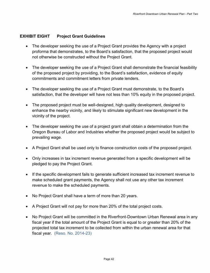
Riverfront Downtown Urban Renewal Plan - Part Two
Page 42
EXHIBIT EIGHT Project Grant Guidelines
The developer seeking the use of a Project Grant provides the Agency with a project proforma that demonstrates, to the Board’s satisfaction, that the proposed project would not otherwise be constructed without the Project Grant.
The developer seeking the use of a Project Grant shall demonstrate the financial feasibility
of the proposed project by providing, to the Board’s satisfaction, evidence of equity commitments and commitment letters from private lenders.
The developer seeking the use of a Project Grant must demonstrate, to the Board’s satisfaction, that the developer will have not less than 10% equity in the proposed project.
The proposed project must be well-designed, high quality development, designed to
enhance the nearby vicinity, and likely to stimulate significant new development in the vicinity of the project.
The developer seeking the use of a project grant shall obtain a determination from the
Oregon Bureau of Labor and Industries whether the proposed project would be subject to prevailing wage.
A Project Grant shall be used only to finance construction costs of the proposed project.
Only increases in tax increment revenue generated from a specific development will be
pledged to pay the Project Grant.
If the specific development fails to generate sufficient increased tax increment revenue to make scheduled grant payments, the Agency shall not use any other tax increment revenue to make the scheduled payments.
No Project Grant shall have a term of more than 20 years.
A Project Grant will not pay for more than 20% of the total project costs.
No Project Grant will be committed in the Riverfront-Downtown Urban Renewal area in any fiscal year if the total amount of the Project Grant is equal to or greater than 20% of the projected total tax increment to be collected from within the urban renewal area for that fiscal year. (Reso. No. 2014-23)