Embed Size (px)
Citation preview
U.S. ENVIRONMENTAL PROTECTION AGENCY SUPERFUND PROGRAM
PROPOSED PLAN
For
RIVERFRONT SUPERFUND SITE OPERABLE UNITS 2 AND 6
NEW HAVEN, MISSOURI
July 2010
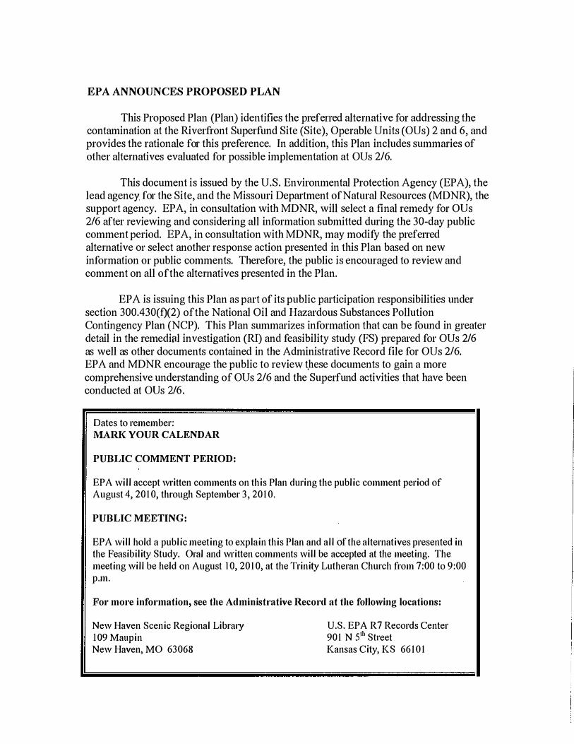
EPA ANNOUNCES PROPOSED PLAN
This Proposed Plan (Plan) identifies the preferred alternative for addressing the contamination at the Riverfront Superfund Site (Site), Operable Units (OUs) 2 and 6, and provides the rationale for this preference. In addition, this Plan includes summaries of other alternatives evaluated for possible implementation at OUs 2/6.
This document is issued by the U.S. Environmental Protection Agency (EPA), the lead agency for the Site, and the Missouri Department of Natural Resources (MDNR), the support agency. EPA, in consultation with MDNR, will select a final remedy for OUs 2/6 after reviewing and considering all information submitted during the 30-day public comment period. EPA, in consultation with MDNR, may modify the preferred alternative 01' select another response action presented in this Plan based on new information 01' public comments. Therefore, the public is encouraged to review and comment on all ofthe alternatives presented in the Plan.
EPA is issuing this Plan as part of its public participation responsibilities under section 300.430(f)(2) ofthe National Oil and Hazardous Substances Pollution Contingency Plan (NCP). This Plan summarizes information that can be found in greater detail in the remedilll investigation (RI) and feasibility study (FS) prepared for OUs 2/6 as well as other documents contained in the Administrative Record file for OUs 2/6. EPA and MDNR encourage the public to review t)lese documents to gain a more comprehensive understanding of OUs 2/6 and the Superfund activities that have been conducted at OUs 2/6.
Dates to remember: MARK YOUR CALENDAR
PUBLIC COMMENT PERIOD:
EPA will accept written comments on this Plan during the public comment period of August 4,20 I 0, through September 3, 20 I O.
PUBLIC MEETING:
EPA will hold a public meeting to explain this Plan and all of the alternatives presented in the Feasibility Study. Oral and written comments will be accepted at the meeting. The meeting will be held on August 10,20 I 0, at the Trinity Lutheran Church from 7:00 to 9:00 p.m.
For more information, see the Administl'8tive Record at the following locations:
New Haven Scenic Regional Library 109 Maupin New Haven, MO 63068
U.S. EPA R7 Records Center 90 I N 5th Sh'eet Kansas City, KS 66 IO I
SITE HISTORY
The Site is located in Franklin County, Missouri, in the town of New Haven. New Haven (population 2,029) is located on the southem bank of the Missouri River approximately 50 miles west of St. Louis, Missouri (Figure 1). The Site encompasses six OUs. Each OU is briefly described below and depicted on Figure 2:
• OU 1 , also referred to as the Front Street Site, involves soil and groundwater contamination located in the Front Street/Cottonwood Street area of downtown New Haven. EPA issued a Record of Decision (ROD) for OU 1 on September 30, 2003.
• OU 2 involves a contaminant source area located at and near the former Kellwood Company (Kellwood) facility located at 202 Industrial Drive in south New Haven.
• OU 3, also referred to as the Old City Dump, involves soil and groundwater contamination located on approximately three acres on the north side of Highway 1 00 in the southeastem part of New Haven. EPA issued a ROD for OU 3 on September 30, 2003.
• OU 4, also referred to as the Maiden Lane Area, involves soil, groundwater, and surface water contamination in an area located south of downtown between Maupin Avenue and Miller Street. EPA issued a ROD for OU 4 on March 26, 2009.
• OU 5, also referred to as the Old Hat Factory, involves groundwater contamination in an area located just south of downtown near the comer of Maupin Avenue and Wall Street. EPA issued a ROD for OU 5 on December 7, 2006.
• OU 6 involves the groundwater contamination emanating from and migrating to the south of OU 2.
The Comprehensive Environmental Response, Compensation, and Liability Information System Identification Number for the Site, which includes OUs 1 through 6, is MOD98 1 720246.
During routine public water supply well testing in 1 986, MDNR detected the volatile organic compound (VOC), tetrachloroethene (PCE), in two public supply wells in the northern part of New Haven. Several environmental investigations were conducted by EPA over the next 1 3 years to find the contaminant source areas and determine the extent of contamination. Following the completion of an Expanded Site Inspection/RI by EPA in early 2000, the PCE-contaminated areas in New Haven were proposed to be included on the National Priorities Lise, and the contaminated areas collectively became known as the Riverfront Superfund Site.
I The National Priorities List is EPA's list of uncontrolled hazardous substance releases in the United States that are priorities for long-term remedial evaluation and response.
2
From approximately 1 973 until September 1 985, Kellwood operated a tube mill at 202 Industrial Drive in New Haven, Missouri. During this period, PCE was used as a cleaning solvent in the tube mill's operations to remove oils from fabricated parts. Kellwood sold the facility in 1 985 and ceased operation of the tube mill. The former Kellwood facility is currently owned by Metalcraft Industries, a subsidiary of Tubular Steel, Incorporated.
Investigations ofVOCs in the area of the former Kellwood facility and the land farm area immediately north of the facility began in 1 989. In 1 990, the state of Missouri informed Kellwood that there were reports of the disposal of cleaning solvents containing PCE 01' trichloroethylene (TCE) on the land farm area adjacent to the former Kellwood facility (Figure 3).
In April 1 994, Kellwood and MDNR entered into an agreement whereby Kellwood agreed to implement a remedial cleanup and groundwater monitoring plan to address PCE contamination in soils adjacent to Kenwood's former facility. Kellwood, with MDNR's oversight, implemented the plan and sent soils known to be contaminated with PCE at levels equal to or in excess of 380,000 micrograms pel' kilogram (/lg/kg) to an off-site incinerator for thermal treatment and disposal. Pursuant to this agreement, the remaining contaminated soils were to be "land farmed until individual levels of PCE and each of its degradation products are reduced to [ 1 ,000 /lg/kg] 01' below."
From 1 994 to 1 996, soil remaining in the land farm area was tilled to maximize the volatilization of residual PCE. However, dense nonaqueous phase liquid (DNAPL) remains present in subsurface areas of the land farm. Since March 2008, approximately six liters ofDNAPL have been removed through periodic recovery operations.
EPA and Kenwood have entered into two Administrative Orders on Consent to address contamination at OUs 2/6. The first Administrative Order on Consent2 required the 'Provision by Kellwood of whole-house water treatment systems to residents whose domestic wells had been contaminated with hazardous substances resulting from Kellwood's former operations at OU 2. The second Administrative Order on Consene
provided for the performance by Kellwood of: (I) an RI to determine the nature and extent of the contamination resulting from Kenwood's former operations at OUs 2/6, and (2) a FS to determine and evaluate remedial action alternatives for responding to such contamination. Kellwood has submitted an RI and FS to EPA for review and approval.
2 EPA Docket No. CERCLA-07-2002-0091, effective date March 25, 2002. 3 EPA Docket No. CERCLA-07-2004-0078, effective date March 16,2004.
3
OU 2/0U 6 CHARACTERISTICS
Surface Features
New Haven is part of the Salem Plateau physiographic subprovince of the Ozark Plateau. The physiographic setting of New Haven is moderate to rugged terrain formed with steep valleys and thin soils characteristic of the Ozark Plateau. In the upland areas, there are loess (wind-blown particle) deposits as thick as 1 5 feet overlying the typical Salem Plateau's cherty, silty clay material. Topography in the New Haven area caused by the gradual uplift of the Ozark Dome and erosion of the uplifted rocks by precipitation, runoff, and stream flow, is accentuated because of its location along the Missouri River. The land surface elevation ranges from 470 feet above mean sea level (AMSL) to 920 feet AMSL. An east-west trending ridge along State Highway 1 00 lies about one mile to the south ofthe Missouri River and divides the Missouri River valley to the north and the Boeuf Creek valley to the south.
Surface Watel' Hydrology
The major body of water in New Haven is the Missouri River which borders the northern edge of the city. There are a number of small creeks and tributaries in the area including Boeuf Creek which lies to the south of OU 2.
A surface water divide between small tributaries that flow north to the Missouri River and tributaries that flow into Boeuf Creek lies along and north of Highway 100. Surface water in the area of OUs 2/6 flows south via unnamed tributaries to Wildcat Creek and to Boeuf Creek, which flows to the east before turning north to empty into the Missouri River. The small tributaries that drain the area of OUs 2/6 and feed Wildcat Creek and Boeuf Creek typically have low flows except following a precipitation event. The upper reaches of these drainages flow seasonally (high rainfall or snow).
Surficial Geology
New Haven is covered by several unconsolidated surficial deposits including Quaternary-Age loess, residual soil deposits of the Buffalo Series, Quaternary-Age alluvium, and Quaternary-Age terrace deposits. The youngest of these is the loess consisting of uniform silt with locally small amounts of clay. The loess is located primarily at topographic highs in the area and ranges from a to greater than 20 feet thick.
The Buffalo Series deposits are residual deposits from the weathering ofthe underlying Powell and Cotter Dolomites and are divided into two subunits-the Buffalo A subunit and the Buffalo 0 subunit. The Buffalo Series deposits are generally found on slopes along the bluff of the Missouri River valley and, therefore, are not likely to be found In OU 2 and OU 6 to any great extent.
The Quaternary-Age alluvium is found in the flood plains of the streams and tends to consist of organic-rich deposits of silt and clay. The area around Boeuf Creek
4
and its tributaries, including Wildcat Creek, contains large alluvial deposits (from running water) with chert gravel. The Quaternary-Age terrace deposits are also found near Boeuf Creek and are similar to the alluvial deposits but are at a higher altitude and were deposited in an earlier stream deposition event.
Bed.·ock Geology
New Haven is underlain by the geologic units ofthe Ozark Aquifer, a marine sedimentary, primarily carbonate rock formation. The Ozark Aquifer is composed of eight lithological units from top to bottom (Figure 4)-the St. Peter Sandstone, Powell Dolomite, Cotter Dolomite, Jefferson City Dolomite, Roudiboux Formation, Gasconade Dolomite, Eminence Dolomite, and the Potosi Dolomite. These formations, based on published literature and observations from the RI, are cherty dolostones of Cambrian and Ordovician Age and can be described as follows:
St. Peter Sandstone
. The St. Peter Sandstone is less than 40 feet thick where present. It is exposed approximately one-third mile to the west of OU 2; and it can be recognized as a fine-grained, cemented quartz sandstone that is generally tan, reddish-tan, or white in color.
Powell Dolomite
The Powell dolomite where present consists of a dolostone with medium to thick bedding which is tan in color and finely crystalline containing little or no chert. The Powell Dolomite contains greenish-gray mudstone/shale beds that are as much as two feet thick in the lower 50 to 70 feet of the formation. The Powell and Cotter Dolomites are the bedrock units most commonly exposed in the New Haven area.
Cotter Dolomite
The upper-most bedrock unit beneath OUs 2 and 6 is the Cotter Dolomite. The thickness of the Cotter Dolomite is variable because of erosion. The Cotter Dolomite also contains scattered, fine-grained, well-cemented sandstone beds that usually are less than two feet thick. Two thicker sandstone beds in the Cotter Dolomite-the upper sandstone and the Swan Creek sandstone-are used as marker beds in the subsurface and at surface exposures. The upper sandstone consists of approximately four to five feet of massively bedded, fine-grained sandstone. It consistently outcrops at an altitude of about 550 feet AMSL in lllany of New Haven's creeks. The Swan Creek sandstone lies approximately 60 feet below the upper sandstone. It is generally an eight to ten-foot layer of fine-grained, wellcemented sandstone within a layer of 1 5 to 20-foot thick sandy dolostone. The Swan Creek sandstone does not outcrop except to the southeast along
5

Boeuf Creek. The Swan Creek sandstone member is present at 36 feet below ground surface (bgs) at monitoring well MW-2SW and at 99 feet bgs at MW-1SW. A distinguishing characteristic of the sandstone beds of the Cotter Dolomite is that they are thicker than sandstone beds in the Powell Dolomite and the Jefferson City Dolomite and contain greater quantities of chert.
Jefferson City Dolomite
Beneath the Cotter Dolomite is the Jefferson City Dolomite which is generally undifferentiated from the overlying Cotter Dolomite. Because of their lithologies, they are grouped together. The Jefferson City Dolomite is a tan to light gray, fine to medium, crystalline dolostone or argillaceous dolostone containing greenish-gray mudstone/shale beds arid several chert-rich zones. It varies between ISO and 1 65 feet thick in the New I-Iaven area and does not outcrop as a surface feature.
Roubidoux Formation
The Roubidoux Formation is frequently used for domestic water supply wells in the New Haven area. It is an approximately l IS-foot layer consisting of sandstone, sandy dolomite, dolostone, mudstone, chert, and cherty dolostone. It can be easily differentiated from the Jefferson City Dolomite by an increase in chert and a change in a more weathered orange-brown color at the top of the formation. The Roubidoux Formation contains a 20 to 30-foot interval of fine-grained, poorly cemented, well-sorted quartzose sandstone approximately 20 to 40 feet from the top of the unit.
These shallow bedrock formations are part of a local groundwater flow system controlled by local topography that is superimposed on the regional groundwater flow system. The shallow flow system in the New Haven area exists primarily within the Cotter-Jefferson City Dolomites.
The shallow groundwater divide is located nOlih of OUs 2/6 in the vicinity of State Highway 1 00. South of State Highway 1 00, shallow groundwater flows south, opposite the regional groundwater flow direction. North of State Highway 1 00, shallow groundwater flows nOlih/northeast beneath the Maiden Lane area mid the topographic divide toward the Missouri River.
Hydrogeology
Groundwater in the Ozark Aquifer is unconfined throughout most of southern Missouri. In the New Haven area, there are two general flow systems within the Ozark
6
Aquifer: ( 1 ) a deep "regional" flow system controlled by regional topography within southern Missouri, and (2) a "local" or shallow (less than 300 to 400 feet deep) flow system controlled by the topography within the New Haven area (Figure 5).
The regional groundwater flow movement generally is from upland areas between major rivers and streams toward valleys where it discharges as base flow into streams. From New Haven, the regional flow system extends for tens of miles and generally is from upland areas more than 90 miles south of New Haven northward toward the Missouri River. The regional flow system generally occurs in the deeper parts of the aquifer (Roubidoux Formation and deeper units) except near regional recharge or discharge areas where flow enters or leaves the aquifer.
Shallow groundwater south of this divide flows south, opposite the regional flow and toward Boeuf Creek. Shallow groundwater north of the divide flows nOlih in the direction of the regional flow toward the Missouri River. Along the shallow groundwater divide near State Highway 100, a downward gradient exists between the shallow and deeper flow systems.
Nature and Extent of Contamination
The results of the RI found that the chemicals of concern (COCs) include PCE; TCE; 1 ,2,-dichloroethene (1 ,2,-DCE); and vinyl chloride (VC). For OU 2, the COCs are present in the soil, fractured bedrock, and groundwater. For OU 6, the COCs are present in the groundwater. PCE was the chemical that was disposed of on the open lot north of the former Kellwood facility. Through reductive dechlorination, PCE can degrade to TCE; 1 ,2,-DCE; and Vc. Detailed descriptions of sampling locations and results of those sampling activities are respectively shown on Figures 2.2a � 2.2c and Figures 2.3 � 2 . 16 of the Rl. Figures 2 . 17 and 2. 1 8 show the distribution of COCs from all available data including data collected prior to the Rl.
Distribution of Dense Nonaqueous Phase Liquid (DNAPL)
PCE was detected as a free-phase Iiquid-DNAPL-in five core holes drilled at OU 2 as part of the DNAPL investigation phase of the Rl. Three of the core holes were located on the land farm area immediately north ofthe former Kellwood facility. DNAPL was detected in two core holes outside the northwest pOliion of the former Kellwood facility. DNAPL was detected at depths ranging from 4 feet to 22 feet bgs. There is no indication that DNAPL is present outside of the land farm area. (See Figure 3.3 of the FS.)
DNAPL located under the land farm area is considered to be a principal threat waste because it is considered a mobile source material that can continue to migrate into the groundwater. In addition, subsurface soils contain high concentrations of COCs that can migrate through the soils to impact groundwater.
7
WHAT IS A "PRINCIPAL THREAT"?
The NCP establishes an expectation that EPA will use treatment to address the principal tlU'eats posed by a site wherever practicable [40 C.F.R. § 300.430(a)(I)(iii)(A)]. The "principal tlU'eat" concept is applied to the characterization of "source materials" at a Superfund site. A source material is material that includes 01' contains hazardous substances, pollutants, or contaminants that acts as a reservoir for migration of contamination to groundwater, surface water, 01' ail' 01' acts as a source for direct exposure. Contaminated groundwater generally is not considered to be a source material, however, nonaqueous phase liquids in groundwater may be viewed as source material.
Chemicals of Concern in G"O\lIldwater
Precipitation infiltrating soil and bedrock that may contain DNAPL as well as groundwater migrating past areas with DNAPL have caused PCE; TCE; and 1 ,2-DCE to move into the groundwater. These contaminants have mobilized into the groundwater from the land farm area located to the nOlih of the former Kellwood facility and have migrated, and will continue to migrate, into the groundwater in the unconsolidated material above the bedrock to the west and south (OU 6) of the former Kellwood facility.
PCE; TCE; and I ,2-DCE have been detected in the following four laterally extensive, transmissive intervals: unconsolidated deposits above the bedrock, the upper sandstone marker bed of the Cotter Dolomite, the Swan Creek sandstone member of the Cotter Dolomite, and in the lower Jefferson City Dolomite/Roubidoux Formation.
The distribution of PCE is widest in the upper sandstone marker bed/upper bedrock permeable zone with PCE present above the 5 micrograms per liteI' (J.1g/L) screening criterion to the west at MW-14US and to the south at MW04A (Figure 6a). Samples collected from the unconsolidated deposits at MW-14US and at MW-04A did not contain PCE. PCE is present at concentrations in the hundreds to low thousands of J.1g/L in the unconsolidated deposits throughout the southern pOliion of the Industrial Park area and southwest of the former Kellwood facility as seen in the direct push borings and in MW-IS. The distribution ofPCE in the Swan Creek sandstone member is much more limited with concentrations generally much lower and below EPA's screening level. PCE in the lower Jefferson City Dolomite/Roubidoux Formation is limited to those locations where private water wells have become contaminated with PCE (Figure 6b). Section 4.4.2 of the RI provides details on the PCE distribution in each of these intervals.
Chemicals of Concern in Sediment and Surface Water
PCE was detected in surface water in several stream segments in OU 6, south and west of the former Kellwood facility (Figures 2 . 14a-d of the FS). PCE was detected at
8
concentrations up to 1 9 Ilg/L at three locations along the 600 tributary, west of Wildcat Creek Estates. PCE was also detected below EPA's screening level at the Boeuf Lutheran Road crossing of the 500 tributary. This creek receives runofffrom the nOlihwestern portion of the Industrial Park including the former Kellwood facility and the Industrial Park's retention basin as well as the area of the New Haven High School and the city park. Samples from the upper portion of the drainage basin did not contain detectable concentrations of PCE.
PCE was detected at a concentration below EPA's screening level in one sediment sample (Figure 2. 1 3 of the FS). No other sediment samples contained PCE.
Chemicals of Concern in Soils
Analytical results of soil samples collected as pad of the RI along with prior sampling by EPA, the U.S. Geological Survey, and others indicate that the extent of the PCE; TCE; and 1 ,2-DCE soil contamination is limited to the land farm area north of the fonner Kellwood facility, beneath the fonner Kellwood facility, beneath Industrial Drive, and at the vacant lot northwest of the former Kellwood facility across Industrial Drive (Figure 4 . 1 of the RI). Analytical results for compounds detected in the samples are presented in Tables 2.3 and 3.2 of the RI.
Soil Vapor Investigation
Based on the detection of PCE in shallow groundwater near the southeastern corner of the New Haven High School building, soil vapor sampling was conducted. The purpose of the sampling was to evaluate whether soil vapors from VOCs detected in the groundwater within the unconsolidated deposits might impact the school building. The locations of the monitoring points are on Figure 3.23 in the RI. This sampling detected no elevated levels ofVOCs in building.
Subslab soil vapor sampling will be conducted under the former Kellwood facility to determine whether the DNAPL source area located under the building presents an indoor air risk.
SCOPE AND ROLE OF OUs 2/6
OUs 2/6 are pmi of the overall cleanup for the Site that includes four other separate OUs in combination with removal actions-typically short-term response measures taken to respond to the release or threat of release of a hazardous substance into the environment-performed under Comprehensive Environmental Response, Compensation, and Liability Act (CERCLA) authority.
Removal actions conducted at the Site have included:
• A time-critical removal action was conducted by EPA at OU I to replace a PCE-contaminated water line that ran beneath Front Street through a PCE
9
source area. The water line was made of polyethylene which is permeable to PCE. The contamination at OU 1 infiltrated the water supply line in this segment and contaminated the water. The polyethylene water line was replaced with a steel line. In addition, as part of this action, approximately 300 cubic yards of PCE-contaminated soil was removed from this area and disposed.
• A time-critical removal action was conducted by Kellwood at OU 6 which involved the installation of whole-house water treatment units at four residences whose water wells had been contaminated by PCE.
• A time-critical removal action was conducted by EPA at OU 4 which involved the injection of a chemical oxidant as a measure to address a PCE source area.
OUs 2/6 are discrete areas of contamination that do not affect and are not affected by other OUs at the Site. OUs 1 , 3, and 5 have remedial actions in place while OU 4 is in the rel11edial design phase.
This Plan proposes EPA's preferred alternative to address soil and groundwater contamination resulting from releases of hazardous substances that have occurred, and are occurring, at and from the former Kellwood facility on Industrial Drive. These releases have resulted in localized areas of soil contamination-at the land farm area and beneath the facility-and have contaminated groundwater that flows to the southsouthwest contaminating private wells.
SUMMARY OF SITE RISKS
CECRLA and NCP require that CERCLA remedial actions provide permanent solutions to protect human health and the environment from hazardous substances. These solutions provide for the removal, treatment, 01' containment of hazardous substances, pollutants, and contaminants so that any remaining contamination does not pose an unacceptable health risk to anyone that might come in contact with them.
As part of the RIfFS, a baseline risk assessment was conducted to determine the current and future effects of OU 2/6 contaminants on human health and the environment.
The following two subsections-Human Health Risk Assessment and Ecological Risk Assessment-summarize and present the conclusions of the baseline risk assessment.
1 0
Human Health Risk Assessment
Step 1 : Chemicals of Concern
The COCs for soils are: PCE; TCE; 1 ,2-DCE (total); and VC. The COCs for groundwater are: PCE; TCE; and J,2-DCE. VC is not a COC for groundwater. The common contaminant for both soil and groundwater is PCE.
WHAT IS A HEALTH RISK AND HOW IS IT CALCULATED?
A Superfund human health risk assessment estimates the "baseline risk." This is an estimate of the likelihood of health problems occurring if no cleanup action is taken at a site. To estimate the risk, the process undertakes foUl' steps:
Step I: Analyze Contamination Step 2: Estimate ExposUl'c Step 3: Assess Potential Health Dangers Step 4: Characterize Site Risks
In Step 1, comparisons are made between site-specific concentrations and health-based standards to determine which contaminants are most likely to pose the greatest threat to human health.
In Step 2, different ways people might be exposed to contaminants are identified. Concentrations, frequency, and duration of exposure are used to calculate the "reasonable maximum exposure" which portrays the highest level of exposure that could reasonably be expected to occur.
In Step 3, information from Step 2 is combined with toxicity information for each chemical to assess potential health risks. EPA considers two types of risk: cancel' and noncancer. The likelihood of any kind of cancel' resulting from exposUl'e to hazardous substances at a site is generally expressed as an upper bound probability; for example, a " 1 in 10,000 chance." In other words, for every J 0,000 people exposed, one extra cancel' may occur. For noncancer effects, a "hazard index" is calculated. The key concept here is that a hazard index less than one predicts no noncancer effects.
In Step 4, the results of the three previous steps are combined, evaluated, and summarized into a total site risk. EPA then determines if the site risks require action to prevent exposures to the contaminants.
Step 2: Estimate Exposure
The exposure assessment uses the site description and contaminant characterization to identify potentially exposed human receptor populations, identifY potential exposure pathways, and calculate estimated daily intakes of the chemicals of potential concern (COPC). Behavioral and physiological factors influencing exposure
1 1
frequency and levels are presented in a series of exposure scenarios as a basis for quantifying contaminant intake levels by receptor populations for each identified exposure pathway.
Site-specific information such as climate, geology, soils, groundwater, surface water, population demographics, land use, water use, agricultural practices, etc., will be incorporated to predict the contaminant levels to which receptors would be exposed. Once these exposure levels are determined, they will be compared with the appropriate health effects criteria to characterize human health risks.
Steps 3 and 4: Assess and Characterize Risk
Risk characterization integrates the results of the exposure and toxicity assessments to derive quantitative and qualitative estimates of the potential cancer risk and noncancer hazards that may occur due to exposure to site-related contaminants.
The following are the primary conclusions of the Human Health Risk Assessment associated with each contaminated medium at OUs 2/6:
• The total cancel' risk and total hazard index (HI) exceed target ranges for potential future residents in au 2 where DNAPL is present and near the former Kellwood facility through incidental ingestion, inhalation, dermal contact with impacted soil, inhalation of indoor air (volatilizing from either soil or groundwater), and ingestion of groundwater from a future drinking water well.
• The total cancel' risk and total HI exceed target ranges for residents in au 6 using groundwater as tap water prior to any treatment. The risk is primarily driven from the ingestion of PCE. Therefore, the whole-house water treatment units must be maintained at the affected residences.
• The total cancer risk is within the target risk range for residents living near the former Kellwood facility breathing indoor air which may contain contaminants volatilizing from the groundwater. The total HI for this exposure pathway is below target levels.
For a more detailed discussion on the conclusions of the Human Health Risk Assessment, see Section 8, Appendix K.
Ecological Risk Assessment
A Baseline Ecological Risk Assessment (BERA) for the Site was conducted in 2002. The assessment included OUs 1 , 3, and 4. The study area of the BERA was defined as all water sheds potentially affected by the Site based on a review of surficial topography. Thus the area of study, evaluated in the 2002 BERA, included au 6 as shown in Figure 3-2 of the aforementioned report. Aquatic habitats in the study area consisted of the Missouri River (adjacent to au 1 ) and several small streams that
12
originate within the study area. The streams in OUs 3 and 4 flow directly into the Missouri River. For OU 2, one small stream flows southward into Boeuf Creek, which flows for approximately eight miles until it discharges into the Missouri River. Most terrestrial habitats within the study area were developed residentially or commercially; however, there was some undeveloped land that included forest areas adjacent to streams 01' flood plains and some agricultural fields. Although there are several state and federal threatened and endangered species reported as occurring in Franklin County, Missouri, none of the species are known to occur within the study area.
Constituents evaluated in the BERA included PCE and related VOCs based on the history and known discharges at the Site. Specifically, the constituents of potential ecological concern (COPECs) were: PCE; TCE; 1 ,2-DCE (total); VC; and benzene. The exposure pathways evaluated included soil and contaminated food ingestion for terrestrial receptors and groundwater discharging to surface waters for aquatic receptors. Media evaluated included flood plain surface soil, sediment, surface water, and plant tissue. None of the COPECs are considered to be bioaccumulative.
Since no site-related COPECs were detected at frequencies or concentrations likely to pose a risk to ecological receptors, the 2002 BERA concluded that no further ecological investigations or assessments were recommended. A more detailed discussion on the Ecological Risk Assessment can be found in Appendix J of the RI.
Ecological Risk Assessment Uptlate
After the 2002 BERA was prepared, additional samples were collected from the streams and tributaries in the study area. In addition, soil, surface water, and sediment samples were collected in association with the RI for OUs 2/6.
The BERA update included the review of applicable screening levels. In the 2002 BERA, a Preliminary Remediation Goal (PRG) of 8.9 llg/L for PCE was established for surface water. This concentration was based on the ecological data quality level (EDQL) developed by EPA RegionS. However in 2003, EPA RegionS updated the EDQLs to ecological screening levels (ESLs); and a new level of 4S llg/L was established for PCE. EPA Region 3 updated its surface water screening benclmlarks in 2006 and established a level of III llg/L for PCE. This updated EPA Region 3 Biological Technical Assistance Grant (BT AG) screening benchmark is now proposed for general EPA use as the new PRG for PCE in surface water.
Ecological Risk Assessment Conclusion
The updated BERA reaffirmed the conclusion of the 2002 assessment that since no Site-related COPECs were detected at frequencies 01' concentrations likely to pose a risk to ecological receptors, no fmiher ecological investigations or assessments were recommended.
1 3
REMEDIAL ACTON OBJECTIVES
Remedial Action Objectives (RAOs) consist of medium-specific goals and/or sitespecific goals for protecting human health and the enviroll1nent. RAOs aimed at protecting human health and the environment should specify:
• COCs
• Exposure route( s) and receptor( s)
• An acceptable level or range oflevels for COCs and each exposure route (i.e., a PRG)
RAOs for protecting human receptors should express both COC levels and an exposure route, rather than COC levels alone, because protectiveness may be achieved by reducing exposure (such as capping an area, limiting access, or providing an alternate water supply) as well as reducing COC levels. Because RAOs for protecting environmental receptors typically seek to preserve or restore a resource (e.g., groundwater), environmental objectives should be expressed in terms of the medium of interest and target cleanup levels whenever possible.
RAOs at OUs 2/6 are required for the media of soil, groundwater, and DNAPL (See Tables 3 . 1 and 3.2) with the associated target concentrations. All of the RAOs are summarized below:
• Protect human health by eliminating exposure (i.e., inhalation, incidental ingestion, dermal contact) to soil in the land farm area with concentrations of COCs in excess of risk-based concentrations (i.e., PCE at 550 Ilg/kg for a residential scenario).
• Protect human health by eliminating exposure (i.e., inhalation) to indoor air containing COCs (as vapors) due to the migration of vapors from soil or shallow groundwater in excess ofrisk-based concentrations (i.e., PCE at 272 Ilg/kg or 423 Ilg/L for an industrial scenario and 35.9 Ilglkg or 44.1 IlgiL for a residential scenario) on the land farm area and under the fonner Kellwood facility.
• Protect human health by preventing exposure (ingestion) to groundwater containing contaminants at concentrations greater than their respective maximum contaminant levels4 (MCLs). MCLs for COCs are: PCE - 5 IlglL; TCE - 5 Ilg/L; cis-l ,2-DCE - 70llg/L; and VC - 2 Ilg/L.
• Protect human health and the environment by minimizing further migration of groundwater containing COCs.
4 MCLs are maximum permissible levels of contaminants in water which are delivered to a user of public water system. MCLs are promulgated by EPA pursuant to the Safe Drinking Water Act.
1 4
• Protect the environment by reducing the COC concentrations in soil or eliminating or mitigating the soil to the groundwater pathway.
• Protect the environment by minimizing the movement ofDNAPL into the groundwater system.
• Protect the environment by mitigating exposure of wildlife to surface water, sediment, and surface soils with concentrations of COCs in excess of ecological risk-based standards and compliance with the Applicable or Relevant and Appropriate Requirements (ARARs) for ecological protection such as the Region 3 BTAG freshwater bencInnarks. All detected concentrations in surface water and sediment at the Site were below current risk-based standards.
SUMMARY OF REMEDIAL ALTERNATIVES
The remedial altel'llatives considered for use at OUs 2/6 combine various technologies to address the DNAPL source and soil and groundwater impacts which result in the RAOs not being achieved. EPA's goals in evaluating the preliminary remedial altel'llatives are to provide both a range of cleanup options and sufficient detail to adequately compare altel'llatives. The following list identifies the main components of each altel'llative. Additional elements of the altel'llatives may be included and are noted in the detailed descriptions in Section 5 of the FS. The altel'llatives evaluated in the FS and considered by EPA were:
1 : 2a:
2b:
2c:
2d:
3a:
3b:
*
**
No Action. DNAPL recovery followed by in situ chemical oxidation, whole-house water treatment units*, institutional controls (rCs), and groundwater monitoring. DNAPL recovery followed by in situ chemical oxidation, altel'llative water supply, whole-house water treatment units (interim**), ICs, and groundwater monitoring. DNAPL recovery followed by in situ chemical oxidation, whole-house water treatment units, ICs, in situ groundwater remediation, and groundwater monitoring. DNAPL recovery followed by in situ chemical oxidation, altel'llative water supply, whole-house water treatment units (interim**), rcs, in situ groundwater remediation, and groundwater monitoring.
'
Thermally enhanced vapor extraction for the DNAPL source area in the land farm area, whole-house water treatment units, ICs, and groundwater monitoring. Thermally enhanced vapor extraction for the DNAPL source area in the land farm area, whole-house water treatment units (interim**), altel'llative water supply, rcs, and groundwater monitoring.
Whole-house water treatment units would consist of point -of-entry carbon filtration systems. Interim whole-house water treatment units would be used until the altel'llate water supply is cOlmected to the affected residence.
1 5
4a: Thermally enhanced vapor extraction for contaminated soil and the DNAPL source area in the land farm area, whole-house water treatment units, ICs, and groundwater monitoring.
4b: Thermally enhanced vapor extraction for contaminated soil and the DNAPL source area in the land farm area, bioremediation of groundwater, whole-house water treatment units, rcs, and groundwater monitoring.
4c: Thermally enhanced vapor extraction for contaminated soil and the DNAPL source area in the land farm area, in situ chemical oxidation for groundwater, whole-house water treatment units, ICs, and groundwater monitoring.
4d: Thermally enhanced vapor extraction for contaminated soil and the DNAPL source area in the land farm area, in situ chemical reduction for groundwater, whole-house water treatment units, ICs, and groundwater monitoring.
5 : In situ chemical oxidation of the DNAPL source area located under the former Kellwood facility (Area 3-A) and the groundwater, whole-house water treatment units, ICs, and groundwater monitoring.
6: In situ chemical reduction of the DNAPL source area located under the former Kellwood facility (Area 3-A) and the groundwater, whole-house water treatment units, ICs, and groundwater monitoring
Alternatives 2b, 2d, and 3b would provide a permanent alternative water supply. However, the absence of an agreement to extend the water supply to the unincorporated area to the south of New Haven renders these options unavailable. Alternatives 2a, 2c, 3a, 4a-4d, 5, and 6 require ongoing operation and maintenance (O&M) of the wholehouse water treatment units at residences with wells contaminated by COCs at levels exceeding their MCLs. Such systems have been operated successfully in four residences for almost eight years.
Alternatives 2c, 2d, 4b, 4c, 4d', 5, and 6 include implementation of groundwater
treatment wells in an area of the upper water bearing zone where the highest concentrations ofCOPCs have been detected outside of the land farm area.
Common Elements
Except for the "no action" alternative (Alternative 1), all alternatives require the use ofICs5 to reduce exposure to contaminated soils and/or groundwater. OUs 2/6 are within a Special Area designation put in place by MDNR pursuant to the Missouri Well Drillers' Act (Figure 7). The Special Area designation results in the imposition of enforceable, stringent well construction standards tln'oughout the OUs 2/6 area. This provides a reliable and durable IC on the groundwater exposure pathway. In the event that soil ICs are required, it is expected that they can readily be implemented through informational 01' educational devices (i.e., notices to area residents) through the imposition of activity and use limitations through environmental covenants or other appropriate mechanisms.
5 Ies are nonengineered controls, such as administrative andlor legal controls, that are intended to help minimize the potential for human exposure to contaminatioll.
1 6
For all alternatives, section 12 1 (c) of CERCLA requires that EPA review remedies every five years to assure that they continue to be protective of human health and the environment. This five-year review would be a site-wide review with the review for OUs 2/6 being conducted at the same time as the other Site's OUs are reviewed. The intent of the review is to evaluate the remedial action to assure that human health and the environment are being protected by the remedial action being implemented. Depending on the results of the evaluation, additional remedial actions could be required.
For cost-estimating purposes, each alternative was standardized to a 30-year time period. All alternatives are required to attain the RAOs. A complete and detailed description of each alternative can be found in Section 5 of the FS.
ALTERNATIVE 1: NO ACTION Estimated Capital Cost: Present Worth O&M Cost: Total Present Worth Cost: Estimated Time to Achieve RAOs:
NONE $152,000 $152,000 Nevel'
Alternative I would not involve any remedial actions, and OUs 2/6 would remain in their present condition. This alternative, required by NCP and CERCLA, is a baseline alternative against which the effectiveness of the other alternatives can be compared. Under this "no action" alternative, no funds would be expended for monitoring, control, or cleanup of the remaining contamination. However, funds would need to be expended to properly abandon all existing groundwater monitoring wells. Also, a five-year review would be required under CERCLA so funds would have to be expended to conduct the review.
ALTERNATIVE 2a: DNAPL RECOVERY followed by IN SITU CHEMICAL OXIDATION TREATMENT, WHOLE-HOUSE WATER TREATMENT UNITS, INSTITUTIONAL CONTROLS, alld GROUNDWATER MONITORING
Estimated Capital Cost: Present Worth O&M Cost: Total Present Worth Cost: Estimated Time to Achieve RAOs:
$990,000 $2,490,000 $3,480,000 >30 years
Alternative 2a would consist of the following:
• DNAPL recovery would continue in existing wells in the land farm area, and additional DNAPL recovery wells would be installed in the north and west (north end) of the fonner Kellwood facility. The use of these wells for continued DNAPL recovery would continue until recovery becomes impractical.
• Once physical DNAPL recovery efforts are complete, DNAPL recovery wells may be utilized for in situ chemical oxidation treatment of the residual contamination within the bedrock on the land farm area. Chemical oxidation
17
treatment will be repeated periodically as needed in the land farm area until nearby and downgradient monitoring wells indicate that COC levels have reached the RAOs or monitoring indicates that further treatment will not continue to effectively reduce the concentrations of COCs.
• Monitoring wells will be installed in the vicinity of the treatment area to evaluate the effectiveness of the treatment.
• Whole-house water treatment units will be provided and maintained for residences with groundwater contaminated with a COC above the MCL.
• lCs will consist of the well construction restrictions described in 10 CSR 23-3 . 1 00, and the Special Area 3 Designation.
• Groundwater monitoring will be conducted to monitor the changes in the concentration of COCs over time within OUs 2/6. This includes the monitoring of residential wells.
ALTERNATIVE 2b: DNAPL RECOVERY followed by CHEMICAL OXIDATION TREA TMENT, ALTERNATE WATER SUPPLY, WHOLE-HOUSE WATER TREATMENT UNITS (Interim), INSTITUTIONAL CONTROLS, (llId
GROUNDWA TER MONITORING
Estimated Capital Cost: Present Worth O&M Cost: Total Present Worth Cost: Estimated Time to Achieve RAOs:
$2, 610,000 $2,000,000 $4,610,000 > 30 years
Alternative 2b consists of the same components as Alternative 2a with the addition of an alternate water supply.
Alternate water supply lines would be installed to provide potable water from the local public water supply system to OU 6 residences where whole-house water treatment units are currently in use. The existing private wells would need to be abandoned upon connection to the public water supply.
ALTERNATIVE 2c: DNAPL RECOVERY followed by IN SITU OXIDA TION TREATMENT, WHOLE-HOUSE WATER TREATMENT UNITS, INSTITUTIONAL CONTROLS, IN SITU GROUNDWATER REMEDIATION, (l1U1 GROUNDWATER MONITORING
Estimated Capital Cost: Present Worth O&M Cost: Total Present Worth Cost: Estimated Time to Achieve RA Os:
$3, 430,000 $2,490,000 $5,920,000 > 30 years
1 8

In addition to the components that are part of Alternative 2a, Alternative 2c would include the following:
• Treatability testing would be preformed to determine the most effective in situ groundwater treatment technology for a line of treatment wells that would be installed in the unconsolidated deposits/upper sandstone marker bed at the southern end ofIndustrial Drive. The treatability testing is to match subsurface conditions with the most effective technology. Technologies that would be evaluated to address the dissolved phase PCE would include bioremediation, chemical oxidation, and chemical reduction.
• Based on the results of the treatability testing, the most effective in situ groundwater treatment technology will be selected. Phase 2 of this alternative would involve the implementation of a pilot test for the recommended alternative followed by the design and implementation of full-scale treatment.
ALTERNATIVE 2d: DNAPL RECOVERY followed by IN SITU CHEMICAL OXIDATION, ALTERNATE WATER SUPPLY, WHOLE-HOUSE WATER TREATMENT UNITS, INSTITUTIONAL CONTROLS, IN SITU GROUNDWATER REMEDIATION, and GROUNDWATER MONITORING
Estimated Capital Cost: Present Worth O&M Cost: Total Present Worth Cost: Estimated Time to Achieve RAOs:
$5,050,000 $2,000,000 $7, 050,000 > 30 years
In addition to the components that are part of Alternative 2b, Alternative 2d would include the additional component from Alternative 2c, in situ groundwater remediation. In this alternative, in situ chemical oxidation will be used to treat the residual DNAPL and groundwater in the land farm area. Chemical oxidation may be accomplished by the injection of persulfate into the bedrock. Multiple injections may be required as the impacted groundwater from OU 2 moves past the area of injection.
ALTERNATIVE 3a: THERMALLY ENHANCED VAPOR EXTRACTION for DNAPLSOURCE, WHOLE-HOUSE WATER TREATMENT UNITS, INSTITUTIONAL CONTROLS, (II/{/ GROUNDWATER MONITORING
Estimated Capital Cost: Present Worth O&M Cost: Total Present Worth Cost: Estimated Time to Achieve RAOs:
$2,120,000 $2, 490,000 $4,610,000 > 30 years
Alternative 3a consists of the following:
1 9
• Thermally enhanced vapor extraction would be conducted in the land farm area. This treatment may also treat the impacted soil above the area being treated to remediate DNAPL.
• Residences with groundwater supplies with COC concentrations above their MCLs would be provided with whole-house water treatment units. If a treatment unit is required at a new residence based on groundwater monitoring, the well would also be inspected to determine if repairs are required to stop migration of impacted groundwater from the upper sand to the lower Jefferson City Dolomite/Roubidoux Formation.
• rcs, potentially in the form of an environmental covenant pursuant to the Missouri Environmental Covenants Act, will be implemented to impose activity and use limitations on the land farm property. This soil was not shown to present a risk except for a hypothetical residential exposure scenario. This type of exposure is highly unlikely as the area is currently zoned for commercial/ industrial use, the surrounding properties are currently used for commercial/ industrial purposes, and the reasonably anticipated future land use for the area is commercial/industrial. Well construction restrictions, codified at 1 0 CSR 23-3 . 1 00, proscribe well construction in the area ofOUs 2/6 and should effectively prevent the installation of wells or other vertical conduits that may allow contamination in the shallow aquifer to migrate into deeper uncontaminated aquifers.
• Groundwater monitoring would assess changes in COC concentrations within OUs 2/6. This would include the monitoring of residential wells.
ALTERNATIVE 3b: THERMALLY ENHANCED VAPOR EXTRACTION/or DNAPL SOURCE, WHOLE-HOUSE WATER TREATMENT UNITS, ALTERNATE WA TER SUPPLY, INSTITUTIONAL CONTROLS, alld GROUNDWATER MONITORING
Estimated Capital Cost: Present Worth G&M Cost: Total Present Worth Cost: Estimated Time to Achieve RAGs:
$3,740, 000 $2,000,000 $5,740,000 > 30years
In addition to the components listed in Alternative 3a, Alternative 3b includes the following:
• The installation of an alternate water supply that would provide potable water from the local public water supply system to residences whose domestic wells have been contaminated with COCs above MCLs.
20
ALTERNATIVE 4a: THERMALLY ENHANCED VAPOR EXTRACTION fol' SOIL and DNAPL, WHOLE-HOUSE WATER TREATMENT UNITS, INSTITUTIONAL CONTROLS, alld GROUNDWATER MONITORING
Estimated Capital Cost: Present Worth O&M Cost: Total Present Worth Cost: Estimated Time to Achieve RAOs:
$2,310,000 $2,490,000 $4,800,000 > 30 years
Alternative 4a consists of the following:
• Thermally enhanced vapor extraction would be conducted in the land farm area to remediate DNAPL. This treatment may also secondarily treat the contaminated soil above the area being treated to remediate DNAPL. Any DNAPL observed during installation of vapor recovery wells would be recovered prior to statiing the thermally enhanced vapor recovery operation.
• Thermally enhanced vapor extraction would be conducted on the contaminated soil at Area A-3 below the former Kellwood facility building slab. A predesign investigation may be required to further delineate the extent of soil contamination in this area.
• Residences with groundwater supplies with COC concentrations above MCLs would be provided with whole-house water treatment units. If groundwater monitoring indicates that a treatment unit is required at a residence, the well would also be inspected to determine if repairs are required to stop migration of impacted groundwater from the upper sand to the lower Jefferson City Dolomite/ Roubidoux Formation.
• The contaminated soil in the land farm area would remain in place, and ICs will be implemented to prevent residential use of the property.
• Well construction restrictions ( 10 CSR 23-3 . 100, Special Area 3 designation) are in place for new wells constructed within the area of OUs 2/6 to prevent the installation of new vetiical conduits that may allow contamination in the shallow aquifers to migrate to the deeper zones via improperly installed wells.
• Groundwater monitoring would assess the changes in COC concentrations over time within OUs 2/6. This will include the monitoring of residential wells.
• Treatability testing would be performed to determine the most effective in situ groundwater treatment technology for a line of treatment wells that would potentially be installed approximately at the southern end of Industrial Drive. Technologies that would be evaluated would include bioremediation, chemical oxidation, and chemical reduction.
2 1
ALTERNATIVE 4b: THERMALLY ENHANCED VAPOR EXTRACTION for SOIL alld DNAPL, BIOREMEDIATION of GROUNDWA TER, WHOLE-HOUSE WATER TREATMENT UNITS, INSTITUTIONAL CONTROLS, alld GROUNDWATER MONITORING
Estimated Capital Cost: Present Worth G&M Cost: Total Present Worth Cost: Estimated Time to Achieve RAGs:
$4,030,000 $2,490, 000 $6,520,000 > 30years
In addition to the components listed for Alternative 4a, Alternative 4b, if selected based on the treatability testing, would include the following:
• A line of treatment wells would be installed at the southern end of Industrial Drive. Treatment of the groundwater in the unconsolidated deposits and the top of the bedrock would be conducted by bioremediation using these treatment wells.
ALTERNA TIVE 4c: THERMALLY ENHANCED VAPOR EXTRACTION for SOIL alld DNAPL, IN SITU CHEMICAL OXIDATIONfor GROUNDWATER, WHOLEHOUSE WATER TREATMENT UNITS, INSTITUTIONAL CONTROLS, amI GROUNDWATER MONITORING
Estimated Capital Cost: Present Worth G&M Cost: Total Present Worth Cost: Estimated Time to Achieve RAGs:
$4, 720,000 $2,490,000 $7,210,000 > 30years
In addition to the components listed for Alternative 4a, Altel'11ative 4c, if selected based on the treatability testing, would include the following:
• A line of treatment wells would be installed at the southern end ofIndustrial Drive. Treatment of the groundwater in the unconsolidated deposits and the top of the bedrock would be conducted by in situ chemical oxidation using these treatment wells.
ALTERNATIVE 4d: THERMALLY ENHANCED VAPOR EXTRACTION for SOIL amI DNAPL, IN SITU CHEMICAL REDUCTION for GROUNDWATER, WHOLEHOUSE WATER TREATMENT UNITS, INSTITUTIONAL CONTROLS, amI GROUNDWATER MONITORING
Estimated Capital Cost: Present Worth G&M Cost: Total Present Worth Cost: Estimated Time to Achieve RAGs:
$3,550, 000 $2, 490,000 $6,040,000 > 30years
22
In addition to the components listed for Alternative 4a, Alternative 4d, if selected based on the treatability testing, would include the following:
• A line of treatment wells would be installed at the southern end ofIndustrial Drive. Treatment of the groundwater in the unconsolidated deposits and the top of the bedrock would be conducted by in situ chemical reduction using these treatment wells.
ALTERNA TIVE 50' IN SITU CHEMICAL OXIDATION (DNAPL, Area 3-A. GROUNDWATER), WHOLE-HOUSE WATER TREA TMENT UNITS, INSTITUTIONAL CONTROLS, and GROUNDWATER MONITORING
Estimated Capital Cost: Present Worth G&M Cost: Total Present Worth Cost: Estimated Time to Achieve RAGs:
$3,680,000 $2,490,000 $6,710,000 > 30 years
Alternative 5 would consist of the following:
• The land farm area would be treated to a depth of approximately 20 feet using in situ chemical oxidation to reduce DNAPL mass.
• The contaminated soil from the area under the former Kellwood facility building (Area A-3) would be treated by in situ chemical oxidation.
• A line of treatment wells would be installed at the southern end of Industrial Drive. Treatment of the groundwater in the unconsolidated deposits and the top of the bedrock would be conducted by in situ chemical oxidation using these treatment wells.
• Residences with groundwater wells having COC concentrations above their MCLs would be provided with whole-house water treatment units. If a treatment unit is required at a new residence based on groundwater monitoring, the well would also be inspected to determine if repairs are required to stop migration of contaminated groundwater from the upper sand to the lower Jefferson City DolomitelRoubidoux Formation.
• The contaminated soil in the land farm area would remain in place, and ICs would be implemented to prevent residential use of the property.
• Well construction restrictions ( 1 0 CSR 23-3.1 00, Special Area 3 designation) are in place for new wells constructed in OUs 2/6 and should be effective to prevent the installation of new vertical conduits that may allow contamination in the shallow aquifers to migrate to the deeper zones via improperly installed wells.
23
• Groundwater monitoring would assess the changes in COC concentrations over time within OUs 2/6. This will include the monitoring of residential wells.
ALTERNATIVE 6: IN SITU REDUCTION (DNAPL, Area -3, GROUNDWATER), WHOLE-HOUSE WATER TREATMENT UNITS, INSTITUTIONAL COMTROLS, GROUNDWATER MONITORING
Estimated Capital Cost: $2,230,000 $2, 490,000 $4, 720,000 > 30years
Present Worth G&M Cost: Total Present Worth Cost: Estimated Time to Achieve RAGs:
•
•
•
The land farm area would be treated to a depth of approximately 20 feet using in situ chemical reduction to reduce DNAPL mass.
The contaminated soil from the area under the former Kellwood facility building (Area A-3) would be treated by in situ chemical reduction.
A line of treatment wells would be installed at the southern end ofIndustrial Drive. Treatment of the groundwater in the unconsolidated deposits and the top of the bedrock would be conducted by in situ chemical reduction using these treatment wells.
• Residences with groundwater supplies with COC concentrations above their MCLs would be provided with whole-house water treatment units. If a treatment unit is required at a new residence based on groundwater monitoring, the well would also be inspected to determine if repairs are required to stop migration of contaminated groundwater from the upper sand to the lower Jefferson City Dolomite/Roubidoux Formation.
• The contaminated soil in the land farm area would remain in place, and ICs would be implemented to prevent residential use of the property.
• Well construction restrictions ( 10 CSR 23-3 . 100, Special Area 3 designation) are in place for new wells constructed in OUs 2/6 to prevent the installation of new vertical conduits that may allow contamination in the shallow aquifer to migrate to the deeper zones via improperly installed wells.
• Groundwater monitoring would assess the changes in concentrations over time within OUs 2/6. This will include the monitoring of residential wells.
EVALUATION OF ALTERNATIVES
In this section, the remedial alternatives developed through the FS process are evaluated in detail to provide enough relevant information about each alternative so that an appropriate remedial action(s) may be selected. Under CERCLA and NCP, nine
24
criteria are used to evaluate remedial alternatives. The first two criteria, referred to as "tlu'eshold criteria," are requirements that an alternative must meet to be selected as the preferred alternative. The next five criteria, referred to as "balancing criteria," are used to weigh major trade-offs among the alternatives. The last two criteria, referred to as "modifying criteria," will be fully evaluated only after public comment is received on this Plan. Because Alternative 1 (No Action) does not meet any of the nine criteria, it was eliminated from consideration for fmiher evaluation.
Ovel'all Pl'otection of Human Health and the Envil'onment - does the altemative adequately protect human health and the environment, in both the short and long term, from unacceptable risks posed by hazardous substances, pollutants, or contaminants present at the Site by eliminating, reducing, 01' controlling exposures?
Alternatives 2 through 6 are all protective of human health and the environment. The contaminated soil in the land farm area (A-I ) (Figure 8) would remain in place and ICs would be implemented to prevent residential use of the property. The soil was not shown to pose a risk except for a hypothetical future resident exposure which would require a change in zoning for the land farm area which is highly unlikely. After remedial activities are completed in the land farm area and the recovery and treatment wells are abandoned, the area will be regraded with top soil and reseeded. There is a contaminant area (Area A-3) located under the former Kellwood facility that is believed to provide a continuing source for the migration of contaminants into the groundwater. That source area (and Area A-I ifthe existing building was to be expanded to the north, see Figure 8) also provides a potential contaminant source for vapor intrusion into the former Kellwood facility. This exposure route is currently being investigated by Kellwood through subslab sampling and an evaluation of the building infrastructure and operating procedures to determine if the theoretical risk correlates to an actual risk. Groundwater samples obtained from the Lower Jefferson City Dolomite/Roubidoux Formation zone, which is the drinking water source for OUs 2/6, have shown the existence of isolated locations of COCs. These localized areas correlate to existing wells which presumably provided the vertical conduit for the downward migration ofDNAPL. However, these isolated areas of contamination are being addressed through the installation ofliners in the affected wells and the provision of whole-house water treatment systems at these locations. This drinking water zone has no discel'llable hydraulic connectivity with the upper nondrinking water zones. The upper nondrinking water zones contain COCs at levels in excess of MCLs. DNAPL recovery/treatment will minimize the dispersion ofDNAPL compounds into the groundwater system.
The Altel'llatives 2c, 2d, 4b, 4c, 5, and 6 that include a line of groundwater treatment wells in the llllconsolidated material at the southern end of Industrial Drive (Area A-4) (Figure 9) will shorten the time period that contaminated water remains in this shallow groundwater zone that could potentially discharge to surface waters above the Missouri surface water standards (but below the risk-based criteria) by approximately 1 0 years.
25
Compliance with Applicable or Relevant and Appropriate Requirements (ARARs)6
- do the alternatives attain ARARs lInderfederal environmental laws and state environmental orfacility siting laws or provide grollnds for invoking a waiver of such requirement?
ARARs are set fOlih in Section 3.3 of the FS. Alternatives 2 tlU'ough 6 are expected to achieve ARARs through DNAPL source removal and/or treatment. Alternatives 2 through 6 all provide drinking water meeting MCLs to the residences in OUs 2/6 through either treatment or an alternate water supply. The isolated locations of contaminated groundwater in the Lower Jefferson City Dolomite/Roubidoux Formation will be cleaned up over time as the water is extracted through domestic water wells and treated by the whole-house water treatment units; or for the alternatives with an alternate water supply, the wells would be abandoned and the contamination would achieve levels below MCLs before it reached another potential receptor.
Alternatives 2 through 6 would accelerate the improvement of the groundwater quality in the upper, nondrinking water zones due to the treatment of the DNAPL source and for Alternatives 2c, 2d, 4b, 4c, 4d, 5, and 6 due to accompanying treatment of groundwater in the unconsolidated material in Area A4 located at the southern end of Industrial Drive. It is unknown whether any of the alternatives, however, will be effective in reducing groundwater contaminant concentrations in the upper, nondrinking water zones to levels below MCLs throughout all areas of OUs 2/6 because none ofthe treatment alternatives are expected to eliminate all DNAPL located in the fractured bedrock, which provides a continuing source of contaminants to this water-bearing zone. The addition of the groundwater treatment wells would lower the concentrations in the upper aquifer sooner than what would occur through DNAPL recovery/treatment alone.
Long-term Effectiveness and Permanence - each alternative must be assessed for the long-term effectiveness that they alfore/' along with the degree of certainty that the alternative will prove to be sllccessfiil.
Alternatives 2 through 6 would provide similar long-term effectiveness as they all include DNAPL recovery and/or treatment. Future monitoring will be required to assess whether the selected alternative is able to attain RAOs throughout OUs 2/6. Regardless of the alternative selected, achieving RAOs will present a near and long-term technical challenge due to the nature ofDNAPL and its presence in a fractured bedrock geologic setting.
6 There are three types of ARARs: (I) Chemical-specific ARARs are health- or risk-based values or methodologies that establish the acceptable amount or concentration of a hazardous substance that may be found in or discharged to the ambient environment, (2) Location-specific ARARs are restrictions placed on the concentration of a hazardous substance or activity solely because they occur in a specific location, and (3) Action-specific ARARs are technology or activity-based requirements pertaining to the treatment or management of hazar dOlls substances.
26
Reduction of Toxicity, Mobility, 01' Volume of Contaminants thl'ough Treatment the degree to which each alternative employs recycling or treatment that reduces toxicity, mobility, or volume shall be assessed, including how treatment is used to address the principal threats posed by the site.
Alternatives 2 through 6 utilize treatment technologies (identified in the Summary of Remedial Alternatives section of this Plan) which result in the reduction but not total elimination of the volume ofDNAPL in the land farm area and, therefore, a reduction but not total elimination of mobility and toxicity of COCs as they dissolve into the groundwater. Alternatives 4a, 4d, 4c, 4d, 5, and 6 also provide a reduction in the toxicity and volume of the impacted soil underneath the former Kellwood facility. Alternatives 2c, 2d, 4b, 4c, 5 , and 6 provide a reduction in the toxicity and volume of contamination in the upper groundwater at the treatment zone located at the southern end ofIndustrial Drive. The reduction in the toxicity and volume in the upper groundwater at the treatment zone at the southern end ofIndustrial Drive would have been observed within approximately 1 0 years due to the recovery and/or treatment ofDNAPL at the land farm area without the additional groundwater treatment provided in Alternatives 2c, 2d, 4b, 4c, 4d, 5, and 6.
Short-term Effectiveness - considers the length of time needed to implement an alternative and the risks the alternative poses to workers, residents, and the environment during implementation.
DNAPL recovery would begin within three to six months with Alternatives 2a, 2b, 2c, or 2d. The full-scale in situ chemical oxidation component of these alternatives would stmi in year five. In Alternatives 5 and 6, DNAPL treatment would start midway through year two. The shortest estimated time frame for completion ofDNAPL recovery/treatment would be 27 months with Alternatives 3 and 4 utilizing thermal treatment in the land farm area.
Alternatives 2 through 6 provide immediate effectiveness for groundwater users as there are already whole-house water treatment units in place at the residences with groundwater sources with COCs above MCLs. Alternative 2a has the shortest predesign investigation, design, and implementation time.
Alternatives 2c, 2d, 4b, 4c, 5, and 6 require installation of treatment wells on a l O-foot center which would require up to three and one-half years for the predesign investigation, treatability testing, pilot testing, design, and installation of the injection wells and an estimated five years for full-scale operation of the system.
Thermal treatment (Alternatives 2c, 2d, 4b, 4c, 4d, 5, and 6) requires a 480 volt power supply, but the individual voltage of the electrodes is low to provide a "step and touch" voltage ofless than 1 5 volts, well below the Occupational Health and Safety Administration standard. Typically, the area would be fenced off to prevent trespassers into the treatment area. The treatment zone is approximately 8 to 20 feet below grade .. Therefore, the heat generated by the treatment system should dissipate before the
27
reaching the surface. As a security measure, the system is designed to shutdown if unauthorized personnel enter the area. The system is operated under a vacuum to prevent the release of vapors to the atmosphere.
Alternative 4b includes the use of hydrogen (as part of the liquid mixture that will release hydrogen in situ). If containerized hydrogen gas is utilized, there would be safety concerns due to the presence of pressured gas cylinders on-site.
The oxidizing chemical-sodium persulfate-and its associated activation compound that are part of Alternatives 4c and 5 require careful attention to various aspects of handling and use.
ImpJementabiJity - considers the technical and administrative feasibility of implementing each alternative, includingfactors such as the relative availability of needed services and materials.
Alternative 2a would be the easiest and fastest alternative to implement. Certain components of this alternative are already in place (whole-house water treatment units in the only residential wells known to contain COCs above MCLs, well construction restrictions on new wells, and groundwater monitoring). DNAPL recovery well installation and operation could begin as soon as a work plan is approved by EPA. After DNAPL recovery is complete, a pilot test for in situ chemical oxidation would be conducted to aid in the design of the injection wells, chemical selection, and chemical injection rate for the full-scale operation. This alternative would be least intrusive and would be the easiest to obtain access agreements to implement.
Alternative 2b would, in addition to the Alternative 2a remedy components, require the design and installation of a water distribution line. The design process of the water line and obtaining approval from the appropriate parties could be time-consuming. Water distribution systems are also part of Alternatives 2d and 3b. However, given Kellwood's inability to obtain the legal right to access an alternative public water supply for OU 6, the alternate water supply option in Alternatives 2b and 2d appears to be unavailable and will be dropped from futlher consideration.
Alternatives 2c and 2d are similar to Alternatives 2a and 2b, respectively, with the addition of groundwater treatment wells. Alternatives 4b, 4c, and 4d include groundwater treatment wells and would be subject to the same procedures for selection, design, installation, and operation. The treatment wells would not be installed until a predesign investigation and treatability testing are conducted to select a preferred tt:eatment method. A pilot test would then be conducted using this treatment technology prior to proceeding with full-scale installation and operation. The proposed location for the treatment wells crosses Industrial Drive, and multiple injection wells are anticipated to be required to be installed within the roadway. This would require some coordination of traffic, but the injection wells would be installed flush to grade and would not interfere with traffic except during construction and during the injection of chemical events.
28

Alternatives 3a, 3b, 4a, 4b, and 4c require installation ofthennal treatment wells for the treatment of DNAPL in the land farm area. These wells would be installed on 1 5 to 20-foot centers for the collocated electrodes and vapor recovery wells. The time required for installation of the wells is estimated to be approximately 180 days. The system could be installed with the wells completed above grade except where it would interfere with vehicular traffic just west of the north end of the former Kellwood facility.
Alternatives 5 and 6 include installation ofDNAPL treatment (Alternative 5 using chemical oxidation, Alternative 6 using chemical reduction) wells in the land farm area and at Area A-3 within the former Kellwood facility. The time required for installation of these wells is estimated to be approximately 1 80 days. These alternatives also include installation ofthe groundwater treatment wells. The installation of these wells (following a pilot test) is estimated to take 180 days. Roads would remain open during the operation of the treatment system. The below-grade wells would take longer to install and would require temporary shutdown or limited traffic on Industrial Drive. The installation of treatment wells within the former Kellwood facility would need to be coordinated with the facility owner/operator and may require installation over weekends. This work is estimated to take 1 0 days for well installation.
The alternatives that require treatability testing for groundwater treatment technology (Alternatives 2c, 2d, 4a, 4c, and 4d) involve the most extensive and longest remedial activity. Alternatives 5 and 6 would be almost as long to implement except treatability testing is not included as the specific treatment technology is specified. It is expected that the alternatives that include groundwater treatment, which will require land owner approval, will be the most difficult to implement.
Cost - includes estimated capital and al1nual O&M costs as well as present net worth cost. Present net worth cost is the total cost of an alternative over time in terms of today 's dollar value. Cost estimates are expected to be accurate within a range of +50 to -30 percent.
The alternatives with lowest to highest estimates of total costs are as follows:
Alternative
2a: DNAPL recovery followed by in situ chemical oxidation, whole-house water treatment units, ICs,
Total Cost
groundwater monitoring $ 3,480,000
3a: Thermal treatment for DNAPL, whole-house treatment units, ICs, groundwater monitoring $ 4,610,000
2b: DNAPL recovery followed by in situ chemical oxidation, alternate water supply, whole-house water treatment units (interim), ICs, groundwater monitoring $ 4,610,000
29
6: In situ chemical reduction (DNAPL, Area A-3, and groundwater), whole-house water treatment units, les, groundwater monitoring $ 4,720,000
4a: Thermal treatment for DNAPL source and soils at Area A-3, whole-house water treatment units, les, groundwater monitoring $ 4,800,000
3b: Thermal treatment ofDNAPL source, whole-house treatment units (interim), alternate water supply, les, groundwater monitoring $ 5,740,000
2c: DNAPL recovery followed by in situ chemical oxidation, whole-house water treatment units, les, in situ groundwater remediation, groundwater $ 5,920,000 monitoring
4d: Thermal treatment ofDNAPL and soil at Area A-3, in situ chemical reduction of groundwater, whole-house treatment units, les, groundwater monitoring $ 6,040,000
5 : In situ chemical oxidation (DNAPL, Area A-3, and groundwater), whole-house water treatment units, les, groundwater monitoring $ 6,170,000
4b: Thermal treatment for DNAPL and soil at Area A-3, bioremediation of groundwater, whole-house water treatment units, les, groundwater monitoring $ 6,520,000
2d: DNAPL recovery followed by in situ chemical oxidation, alternate water supply, whole-house water treatment units (interim), les, in situ groundwater remediation, groundwater monitoring $ 7,050,000
4c: Thermal treatment for DNAPL and soil at Area A-3, in situ chemical oxidation of groundwater, whole-house treatment units, les, groundwater monitoring $7,210,000
The alternatives with the lowest to highest estimates of capital costs are as follows:
30
Alternative
2a: DNAPL recovery followed by in situ chemical oxidation, whole-house water treatment units, ICs, groundwater monitoring
3a: Thermal treatment for DNAPL, whole-house treatment units, ICs, groundwater monitoring
6: In situ chemical oxidation (DNAPL, Area A-3, and groundwater), whole-house water treatment units, ICs, groundwater monitoring
4a: Thermal treatment for DNAPL source and soils at Area A-3, whole-house water treatment units, ICs, groundwater monitoring
2b: DNAPL recovery followed by in situ chemical oxidation, alternate water supply, whole-house water treatment units (interim), ICs, groundwater monitoring
2c: DNAPL recovery followed by in situ chemical oxidation, whole-house water treatment units, ICs, in situ groundwater remediation, groundwater monitoring
4d: Thermal treatment ofDNAPL and soil at Area A-3, in situ chemical reduction of groundwater, whole-house treatment units, ICs, groundwater monitoring
5 : In situ chemical oxidation (DNAPL, Area A-3, and groundwater), whole-house water treatment units, ICs, groundwater monitoring
3b: Thermal treatment ofDNAPL source, whole-house treatment units (interim), alternate water supply, ICs, groundwater monitoring
4b: Thermal treatment for DNAPL and soil at Area A-3, bioremediation of groundwater, whole-house water treatment units, rcs, groundwater monitoring
4c: Thermal treatment for DNAPL and soil at Area A-3, in situ chemical oxidation of groundwater, whole-house treatment units, ICs, and groundwater monitoring
3 1
Capital Costs
$ 990,000
$ 2,120,000
$ 2,230,000
$ 2,31 0,000
$ 2,61 0,000
$ 3,430,000
$ 3,550,000
$ 3,680,000
$ 3,740,000
$ 4,030,000
$ 4,720,000
2d: DNAPL recovery followed by in situ chemical oxidation, alternate water supply, whole-house water treatment units (interim), ICs, in situ groundwater remediation, and groundwater monitoring $ 5,050,000
The cost for the treatment teclmologies involving DNAPL and groundwater treatment wells could vary significantly from what is estimated based on the number and frequency of injections and the volume of chemicals injected. Estimates were made based on the best available information obtained from the RI and preliminary engineering judgments about the efficacy of in situ treatment approaches for groundwater and soil. Information gathered as part of a predesign investigation and from treatability testing would result in a better estimate of the cost. Even following treatability testing, the actual costs may increase substantially if multiple injections are required in an attempt to reduce groundwater contaminant concentrations below MCLs.
O&M costs have a first year annual cost estimate at $200,000. Certain ofthe annual cost elements are included for a limited number of years for some of the alternatives. O&M cost total is calculated using the net present worth for 30 years based on a seven percent discount rate. The total O&M cost for the alternatives with only interim operation of whole-house water treatment units (Alternatives 2b, 2d, and 3b) is $ 1 ,1 93,000. The total O&M cost for the alternatives where the whole-house water treatment units are assumed to operate the full 30 years is $2,482,000.
A complete breakdown of costs for the preferred alternative is shown in Table 3.3. The costs for all other alternatives can be found in Appendix B, Cost Estimate Summary of the FS.
State Acceptance
The state of Missouri is currently reviewing the information regarding the preferred alternative.
Comlllunity Acceptance
Community acceptance of the preferred alternative will be evaluated after the public comment period ends and will be described in the Responsive Summary section of EPA's ROD for OUs 2/6.
SUMMARY OF THE PREFERRED ALTERNATIVE
EPA's preferred alternative for addressing OUs 2/6 is Alternative 2c which includes DNAPL recovery followed by in situ chemical oxidation, whole-house water treatment units, ICs, in situ groundwater remediation, and groundwater monitoring.
32
Alternative 2c was selected over the other alternatives as it meets the requirements for protecting human health and the environment and provides a safe and acceptable drinking water source for affected groundwater users. This alternative includes DNAPL recovery followed by in situ chemical oxidation to address the source area PCE. It also addresses dissolved phase PCE downgradient from the source by the implementation of in situ groundwater remediation. The groundwater treatment technology would be selected following treatability testing. Implementation of the line of treatment wells would be a second phase to Alternative 2c, implemented upon selection of a treatment teclillology that would be effective in achieving the remediation goals.
The preferred alternative can change in response to public comment or new information.
Based on the information currently available, EPA believes the prefel'l'ed alternative meets the threshold criteria and provides the best balance of tradeoffs among the other alternatives with respect to the balancing and modifying criteria. EPA expects the prefel'l'ed alternative to achieve the RAOs, address source materials constituting principal threats, and satisfy the statutory requirements of CERCLA § 12 1 (b). The preferred alternative will also: ( 1 ) be protective of human health and the envirOlllllCnt, (2) comply with ARARs, (3) be cost effective, (4) utilize permanent solutions and alternate treatment technologies to the maximum extent practicable, and (5) satisfy the preference for treatment as a principal element.
COMMUNITY PARTICIPATION
EPA and MDNR will continue to provide information regarding the cleanup of OUs 2/6 at the Site through public meetings, the Administrative Record for the Site, and announcements published in the New Haven Leader Newspaper. EPA and MDNR encourage the public to gain a more comprehensive understanding of the Site and the Superfund activities that have been conducted at the Site.
The dates for the public comment period, the date, location, time of the public meeting, and the locations of the Administrative Record file are provided on the front page of this Plan.
33
GLOSSARY OF TERMS
Specialized terms used in this Plan are defined below:
Administrative Record (AR): The body of documents that "forms the basis" for selection of a particular response at a site. An AR is available at or near the site to permit interested individuals to review the documents and to allow meaningful public participation in the remedy selection process.
Aquifer: An underground layer of rock, sand, or gravel capable of storing water within cracks and pore spaces or between grains. When water contained within an aquifer is of sufficient quantity and quality, it can be used for drinking or other purposes. The water contained in the aquifer is called groundwater.
Applicable 01' Relevant and Appropriate Requirements (ARARs): The federal and state environmental laws that a selected remedy will meet.
Capital Costs: Expenses associated with the initial construction of a project.
Chemical Oxi!lation Treatment: The use of chemicals called "oxidants" to destroy pollution in soil and groundwater. Oxidants help change harmful chemicals into harmless ones.
Comprehensive Environmental, Response, Compensation, and Liability Act (CERCLA): The law enacted by Congress in 1980 to evaluate and clean up abandoned, hazardous waste sites. EPA was charged with the mission to implement and enforce CERCLA.
Groundwater - Underground water that fills pores iii soils or openings in rocks to the point of satumtion. Groundwater is often used as a source of drinking water via municipal or domestic wells.
Groundwater Divide: A ridge in the water table, from which groundwater moves away in both directions.
Maximum Contaminant Levels (MCLs): The maximum permissible level of a contaminant in water that is delivered to any user of a public water system.
Monitoring: Continued collection of information about the environment that helps gauge the effectiveness of a cleanup action.
National Oil and Hazardous Substances Pollution Contingency Plan (NCP): The federal regulations that guide the Superfund progmm.
Operable Unit (OU): Term for each of a number of separate activities undertaken as part of a Superfund site cleanup.
Operation alHl Maintenance (O&M): Activities conducted at a site after the constmction phase to ensure that the cleanup continues to be effective.
Plume: A body of contaminated groundwater flowing from a specific source.
34

Prescnt Worth Analysis: A method of evaluation of expenditures that occurs over different time periods. By discounting all costs to a common base year, the costs for different remedial actions can be compared on the basis of a single figure for each alternative.
Record of Decision (ROD): The decision document in which EPA selects the remedy for a Superfund site.
Superfund: The nickname given by the press for CERCLA because the program was well funded in the beginning.
Toxicity: A measure of degree to which a substance is harmful to human and animal life.
Volatilc Organic Compounds (VOCs): Carbon compounds, such as solvents, which readily volatilize at room temperature and atmospheric pressure. Most are not readily dissolved in water, but their solubility is above health-based standards for potable use. Some VOCs can cause cancer.
35

Figures
36
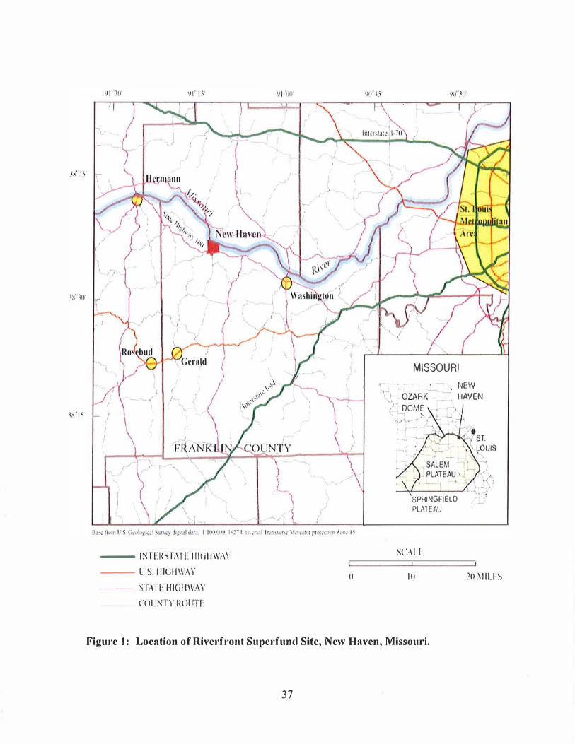
,
( )
--- INTERST,\TE I 11<1 II WAY --- U.S.IIIGH\\'.W o --- STAll HIGIIW/\\,
COI!NTY ROliTE
MISSOURI
� . - NEW .. \ . OZARK::-' HAVEN / DOME .. , ... �.- , ;- ," �
.�
SPRINGFIELD PiJlTEAU
SCALE
10 2U �IILlS
Figure I: Location of Riverfront Superfund Site, New Haven, Missouri.
37
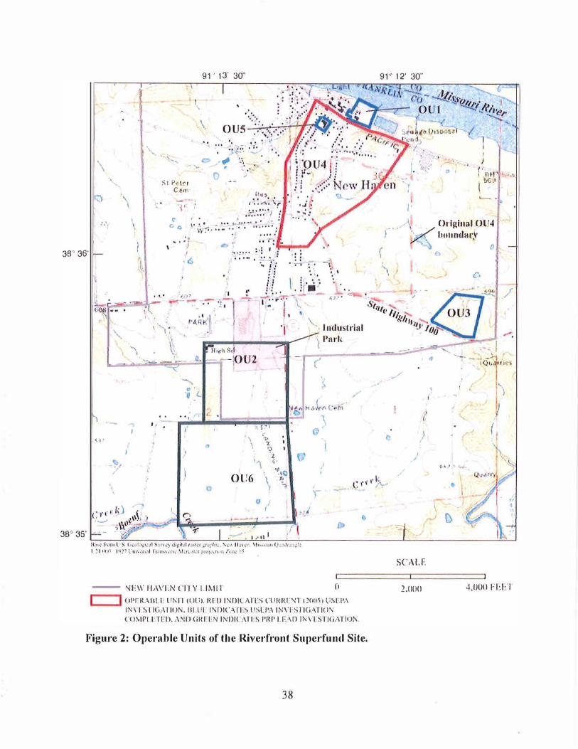
\
'7.
t.'.
38' 36'
< 0 •
\
J
, \
.., I
<
, - ' ,
:'.t P h�1 eel'll
-' ', '
0,
91' 13' 30"
.\ <",
,f/J
','. . :.' , ' .. o '
(/'I.' .. . , '�'''''''-;-\r ,..!.' .... J •
C Go
'" .-' ... �:'::' . ! \, �.;7.· 7.- ' ,: " ...... . : '0
... . 'J I
,iJ
�' "'..!'"
r
\ ',', I. '" \
, . '
" (.
" , . ' i � 1
\ '" " '2 9 l .'
, . ,� . , .
.. .. .-.....
G' ''\
OU6 \�o
\ 'h :', I
u " .'
-� ' ,'II I /\
OJ,
"
\,
•
)-
- :-11'\\' II,WEN CITY 1.I�1I'I 11
I I ()I'I-R.:"ULE UNIT (()I.II. RI:D INDICATES ClJl{RF'fl t.:!()fJ)J lISCI',\ INVI ST1G,\TIOK. BI.U!: 1'1D1CAlES U$L!'A INVESlIGATI(J'I
CO:"IPI ETEIl. r\NI1 (itO'EN INDICATES PRJ> LE .. \D lNV[STI(i,\TrOl\.
Figure 2: Operable Units of the Riverfront Superfund Site.
38
91· 12' 30"
( 0
'I
.'
.
,
/'
I- ' . ) �':, : " , ( ' 0"
l t,4jt.l
I I' \ Ol'iglll.1 OLl4 � bUlllldarl'
\ • 0 "
c,
( "
.. ' • I
� ,I ,'� ( I , \
I / t.·,' . ....
•
D
SCALF.
.: ..
0
2.0nn ·1,01l0 FEET
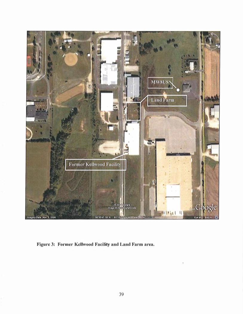
Figurc 3: FOl'IIlel' Kcllwood Facility and Land Fal'lIl area.
39
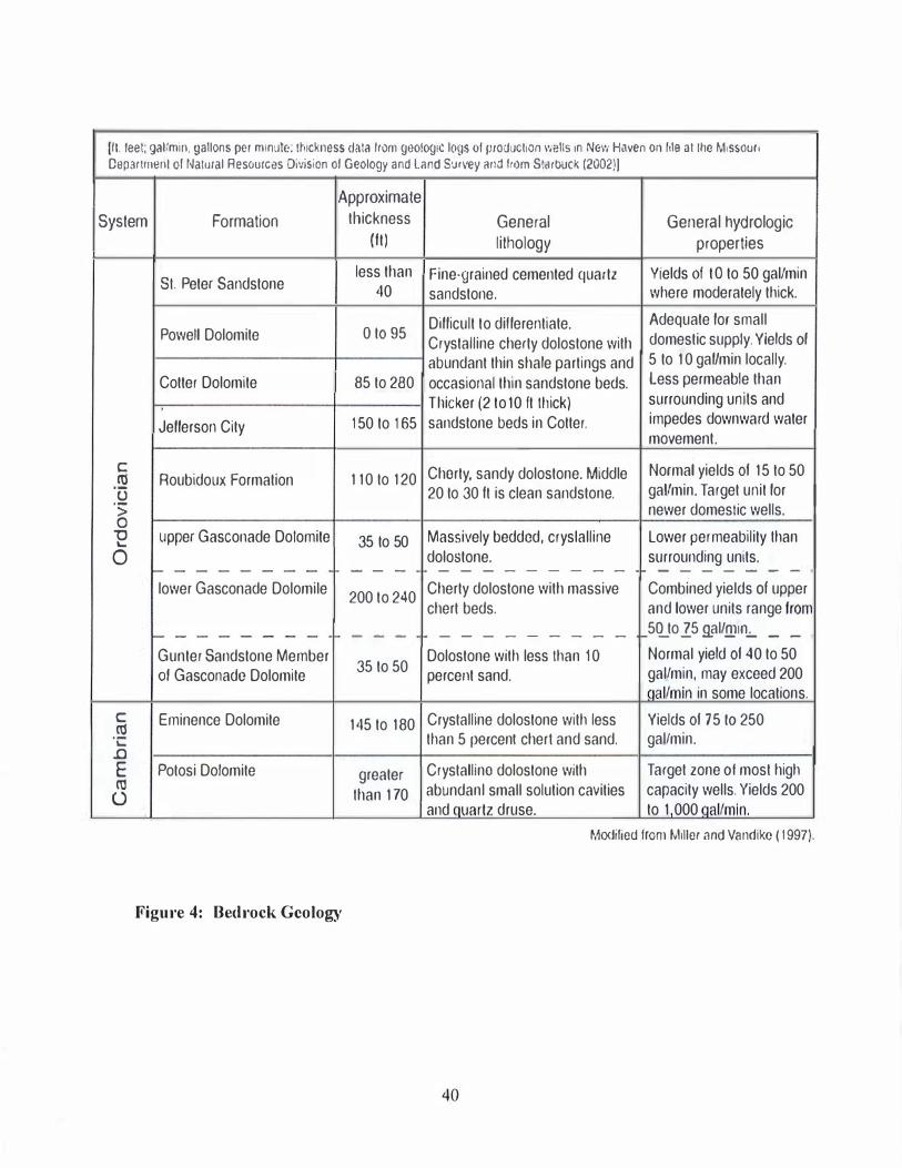
III, leet: gaVmin, gallons p€r mlnu!e: Ihlckness dala Irom geologiC logs 01 produClion l'Iells in New Haven on Ille althe �"ssou" Department of Nalural Resources Division 01 Geology and Land SUI\'8y and trom Slarbuck 12002)1
System Formation
SI. Peter Sandstone
Powell Dolomite
Cotter Dolomite
Jellerson City
c III Roubidoux Formation Ti '> a
-0 upper Gasconade Dotomite ...
0 f- - - - - - - -lower Gasconade Dolomile
f--------Gunter Sandstone Member 01 Gasconade Dolomite
c Eminence Dolomite III ·c .0 E Potosi Dolomite III
U
Approximate thickness
(It)
less than 40
o t095
85 to 280
t50 to 165
110to 120
35 to 50
- - -
200 to 240
- - -
35 to 50
145 to 180
greater Ihan 170
Figure 4: Bedrock Geology
General lithology
Fine·grained cemented quartz sandstone.
Dillicult to dillerentiate, Crystalline cherty dolostone with abundant thin shale partings and occasional thin sandstone beds, TI1icker (2 to 10 It tilick) sandstone beds in Cotter.
Chorty. sandy dolostone, Middle 20 to 30 It is ctean sandstone,
Massively bedded. cryslalline dolostone, ---- - - - --
Cherty dolostone with massive chert beds,
---- - - - --
Dolostone with less than to percent sand,
Crystalline dolostone with less than 5 percenl cheri and sand,
Crystalline dolostone with abundanl small solution cavities and quartz druse,
General hydrologic properties
Yields 01 tOto 50 gat/min where moderately thick,
Adequate lor small domestic supply, Yields 01 5 to 10 gallmin locally,
Less permeable than surrounding units and impedes downward water movement.
Normal yields 01 15 to 50 gallmin, Target unit lor newer domeslic wells,
Lower permeability Ihan surrounding units,
- --- - - -
Combined yields 01 upper and lower units range Irorr 5CLto 25 9.al/.!!)lIl.;.. _ _
Normal yield 01 40 to 50 gal/min. may exceed 200 nal/min in some locations,
Yields 01 75 10 250 gal/min,
Target zone 01 most high capacity wells, Yields 200 to 1 000 Qal/min,
Modified from Miller and Vandike (1997),
40
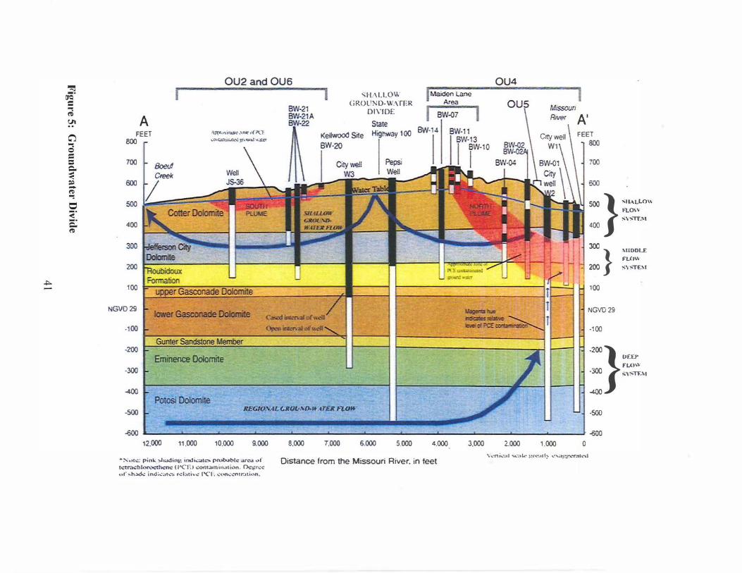
..,.
""l 0<;. = t6 <JI
C'l
g = Q. :; ., � o ::;. Q. '"
A
OU2 and OU6 r . __ n I SII/\LLOW GROU�O·WMER
DIVIDE I f!W'()7 1 FEET
800 o\"'.''''U\.I.IIC: .\JUC'u(ptl �"1JI.:.;m"I.,IIi,:1l j:I'.vo.! ... a:c
Stale Kellwood Site Highway 100 BW· 14
BW·2Q 700
600
80euf Creek
5001" -LE 400 300 l=Ott 1 200 I '" 100
NGVD29 IcMer GasallIIIde £Jo!aniIe
·100
·200
Eminence Dolomite
·300
-4OIl Potosi Dolomite
·500 U"G/(J.,,"- GllOl,,'·o-.... n.. n..otf-
Pepsi
OU4
R"""
Cny well
WI
�
A' FEET
800
700
500
500 } '''ALLO'' fLO\" :->"""TL'\l
400
:}
100
NGVD29
.100
'"DDLF. FU)'\\ �\,""TF-'''I
Or.f..r FU)\\
.200} : _Y<1T."
·500
� • "-600 12.000 11.000 10.000 9.000
·:-.: .. 10:: pin!.; !>hadint-: indiCOlh:" pro.robh::: arc..1 ..... f h . .-�tr':ll;: hlot\X'lh.=no.: (I'CE • .:oot;Uni"�li.>n. Dcltfl:<: QI" ,..h3d.;: ind;';:al..::. r..::I;.tiv..: 1""('1, ..:on...-..:nlr.uk_n.
8.000 7.000 6.000 5.000 4.000 3.000 2.000 1.000 o
Distance from the Missouri River. in feet \. .. 'Tti.:,,1 ""'::01..: ,:ro:':OIt� ..:,; • .,:I-'<-'.-;u ,-d
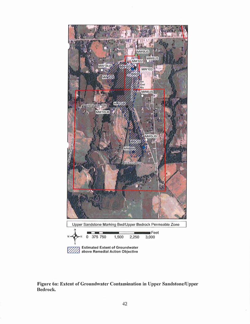
Upper Sandstone Marking Bed/Upper Bedrock Permeable Zone
N
W+" 0---=
37-':-=
75-0--1-,51:
0=
0==
2=,2-5
-0--
3-,0 6;et
s � Estimated Extent of Groundwater � above Remedial Action Objective
Figurc 6a: Extcnt of Groundwatcr Contamination in UppCt' Sandstonc/Uppel' Bedrocl{.
42

Lower Jeff Cily/Roubidoux
Figurc 6b: Extent of Groundwatel' Contamination in Lower Jeffcrson City DolomitelRoubidoux FOI·mations.
43
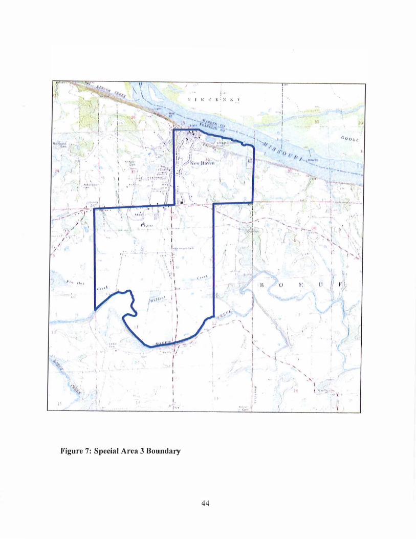
"
"
� . ./IIA -J .. ,
\ ,1 "- I' " I 1, 1
•
I" , I . ,
"
, 1 . "
" .. ,
\ ,
''t(o •
\ 'A, >-\ '. , , 1 "
, , I' 1
", II
I, . ".0. ... ,
"" ...
i
I I
I' t.: t' h' S t, \'
, ,
I .. ,., . .. l.. I,
, ;1 I, 'I
,I"
' ".j "
I , I·
i I.
't· .
t , •• 1
I
Figure 7: Special Area 3 Boundary
44
t
I f"" •
--'-- ..... "J .1 I /I' .... ; J ', � '. "
,,1'\ , - "" -,-', Ii � , . . , I ... , .1 , \ '"
.' \ " , , " f' I' ,
\ "
• j ' , 1\ () I': II , I i" I ,
�
./
\ � , I \ ('
( '/ , " l I ,
l. , ,
I � Co.; . ..... - "': ... \ ,
"
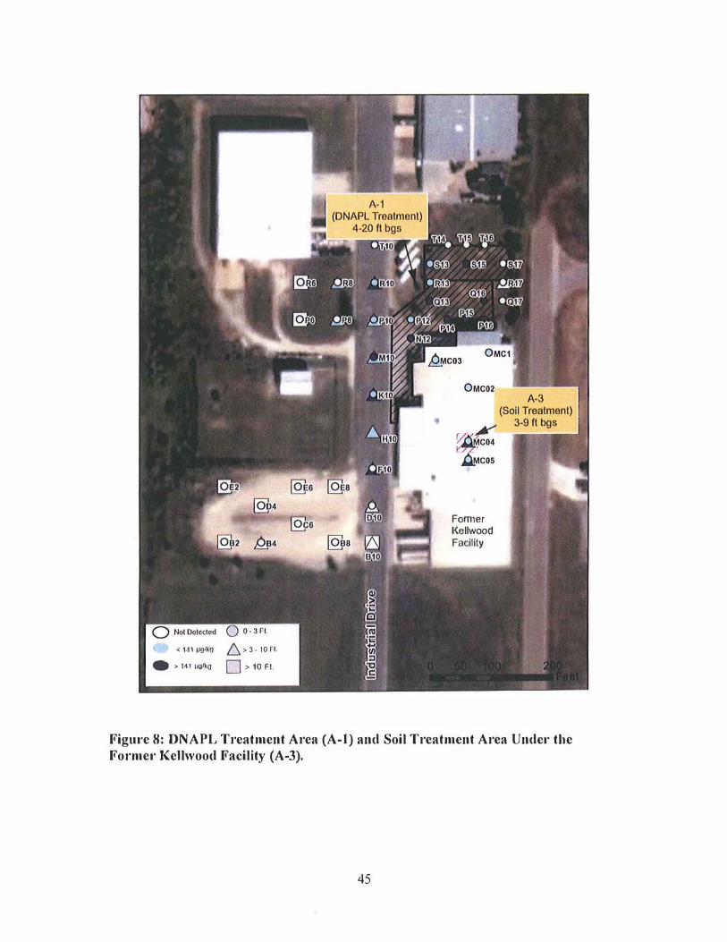
< 1<11 �IkO 6.:.3-10f1. • :. lot' II\VkO D>10FI.
Former I<ellwood Facility
Figm'e 8: DNAPL Treatment Area (A-I) and Soil Treatment Area Undcl' the Formel' Kellwood Facility (A-3),
45
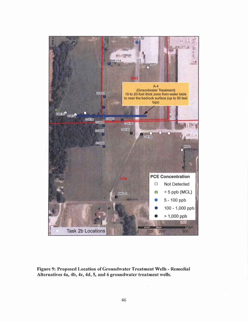
o Not Detected
o < 5 ppb (MeL) • 5 - 100 ppb
••
• 100 - 1,000 ppb
Figure 9: Proposed Location of GroundwateJ" Treatment Wells - Remedial Altel'llutives 4a, 4b, 4e, 4d, 5, and 6 groundwater treatment wells.
46

Tables
47
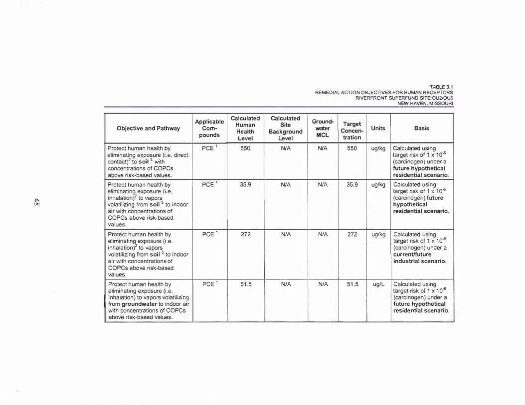
..,.. 00
Objective and Pathway
Protect human health by eliminating exposure (i.e, direct contact)2 to soil 3 with concentrations of copes above risk-based values.
Protect human health by eliminating exposure (i.e. inhalation)2 to vapors volatilizing from soil 3 to indoor air with concentrations of COPCs above risk-based values
Protect human health by eliminating exposure (i.e. inhalation)' to vapors volatilizing from soil 3 to indoor air with concentrations of COPCs above risk-based values
Protect human health by eliminating exposure (i.e. inhalation) to vapors volatilizing from groundwater to indoor air with concentrations of COPCs above risk-based values.
-- ---- ----
Applicable Calculated
Human Com-
Health pounds
level
PCE' 550
PCE' 35.9
PCE' 272
PCE' 51.5
Calculated Site
Background Level
N/A
N/A
N/A
N/A
TABLE 3.1 REMEDIAL ACTION OBJECTIVES FOR HUMAN RECEPTORS
RIVERFRONT SUPERFUND SITE OU2JOU6
NEW HAVEN, MISSOURI
Ground- I Target water Concen- Units Basis I MCl tration I N/A 550 uglkg Calculated using
target risk of 1 x 10" (carcinogen) under a future hypothetical residential scenario,
N/A 35.9 uglkg Calculated using target risk of 1 x 10" (carcinogen) Mure hypothetical residential scenario.
N/A 272 uglkg Calculated using target risk of 1 x 10" (carcinogen) under a currentffuture industrial scenario.
N/A 51.5 ugiL Calculated using target risk of 1 x 10" (carcinogen) under a future hypothetical residential scenario.
'"" '-0
Applicable Calculated Calculated
Human Site Objective and Pathway Com-
Health Background pounds
level level
Protect human health by PCE' 423 N/A eliminating exposure (i.e. inhalation) to vapors volatilizing from groundwater to indoor air with ccncentrations of COPCs above risk-based values
Protect human health by PCE' < MCL N/A eliminating exposure (i.e. ingestion) to groundwater with concentrations of chemicals of COPCs above risk-based values
1 peE is tetrachloroethylene
TABLE 3.1 REMEDIAL ACTION OBJECTIVES FOR HUMAN RECEPTORS
RIVERFRONT SUPERFUND SITE OU2IOU6 NEW HAVEN, MISSOURI
Ground- Target water Concen· Units Basis MCl tration
N/A 423 uglL Calculated using target risk of 1 x 10" (carcinogen) under a current/future industrial scenario.
5 5 ug/L Calculated using target risk of 1 x 10" (carCinogen) and target hazard level of 1 (non-<:arcinogen) under a future hypothetical residential scenario.
2 Direct contact pathway evaluated soils in the 0 to 3 feet depth range. Inhalation pathway evaluated 0 to 10 feet.
3 Limited to Areas A·1 and A-3 (see Figure 3.1)
N/A - Not Applicable
Applicable Compounds
TABLE 3.2 REMEDIAL ACTION OBJECTIVES FOR ECOLOGICAL RECEPTORS
RIVERFRONT SUPERFUND SITE OU2/0U6 NEW HAVEN, MISSOURI
Target Concentration Bas is (Ug/kg)
SURFACE SOIL� - Pathway: Prevent direct contact with impacted surface soils and consumption of impacted food peE 9,920 Region 5 ESL
Applicable Target Level Basis Compounds (ug/L)
SURFACE WATER - Pathwa:t: Prevent direct contact with im�acted surface water peE 111 Region 3 BTAG (Note: detected concentrations of peE at aU2 and aU6 were below the Region 3 BTAG tamet level.)
Applicable Target Level Basis Compounds (ug/kg)
SEDIMENT - Pathway: Prevent direct contact with im�acted sediment
PCE 468 Region 3 BT AG (Note: detected concentrations of peE at aU2 and aUG were below this target level.)
peE = Tetrachloroethylene ESL = Ecological Screening Level
50
Foaslbility Study Cost Estlmato for Altornativo 2c:
DNAPL Rocovery followod by I" Situ Chomlcal Oxidation Troatment, Whole House Wator Treatment, Bonch·Scalo and Pilot Tosting of In Situ Groundwator Troatment Tochnologles, Full Scalo Implomontatlon of III Situ Groundwator Troahnont Tochnology (A·4), Instltullonal Controls, Groundwator Monitoring Job No.: 445737 "Ivo,fronl Supotfund Silo OU2 J Qua
locallon: Now Havon, Mlnoml
"'00
I' ;ru;;;- I
i s and Equlpmonl " ;;
I IS�II I
Sodiment " Coo"�'
. """""'.",, = ,.od I , of H,S R"""ds
, .od "", Ro"". Dmw"",s
= • I I ,,'" Emission Cool'� PI",
"of a S.dlm",,1 a". E,oslon ConllOl PI""
�
I<A·1) ' "" �
" � It i ''''
DNAP� DI 'OO501 A"oooll,) � DNAPl "O<OYOIV 1 V,." �
I II
IDNAP[�(A · '
� I
In ,if" Chom".,' D_dall", T,.,"nonl· Vom � ,I· VO" 2 15% ,om I) �illilionT;"il;",,,'· Vo" 3 (50\\ ,0"' I)
, � 'AI.,
�.",,- , I � ,
ID ... " ond Qv""I,hl
�'" " I" Ch.m D, p","ss
=00"''' �
I I
lOn{, Tom. Moollorino p, .. ",,,,
I
, I
-O,"",S""o I T"II""II" ,
= SlPliMon
PMSONS
ESTIMATE WORK SIIEET
IR'f, 0"001. Unll
Unit Cost
I'
lS $'
lS S, lS S, 000 lS 52,000
lS S10,OOO lS S10,000
lS S5,OOO lS $5,000 lS S5,OOO
S2.., , , 00 S",
SIc' lS S3,OOO lO SIO,OOO
S20,000
�� lS S"' ,>00
2C lS S: ) , 000
Auo SI,5OO 10.000 SV S2
I lS S3O,000 lS S20,000
S20,00<
� lS S50,OOO
Table 3.3: Feasibility Study Cost Estimate rOl' Alternative 2c.
51
Total
S,
S, S, ,000 S2,OOO
S10,OOO SIO,OOO
S5,OOO S5,000 S5,OOO
5204,000 525,
SIO, SI2,OOO SIO,OOO
S26,OOO
� sse ,000 SOC ,000
S3,000 S20,00<
=¥,]� ',000
� �
Feasibility Study Gost Estimate for Alternative 2c:
DNAPL Recovery followed by In 51111 Chomlcal Oxidation Troatment, Whole House Water Treatment, Bench·Scole and Pilot Testing of lu Situ Groundwator Troatmont Tochnologles, Full ScalD Implemontatlon of III 51111 Groundwater Treatment Technology (A.4), Institutional Controls,
Groundwater Monitoring
110m
Job No.: 445137 PARSONS
Riverfront Suporfund Silo DU21 aUG ESTIMATE WORK SHEET
location: Now H3von, Missouri
Ooscrlpllon Ro', Quant. Unll
Unit Cost
Groundwator Trootmont Syst�m (A·4) (Phoso 2) Pilol Study' includos well installntion) 1 LS 560,000
Weliinstniintion • Area A·4 1 LS 5310,000
Arc., A-4 • GW Troatment WolI· Chorn Ox 5 years· 100 "10) 1 LS 51,800,000 In Sito Chem Ox MonilOling (5 limos I year) 25 EA $3,000
III Silu Chomical Oxidation Doslgn 1 LS $25.000
Subtotal Coostruction Costs (Phaso II) Sublolal COllstrucllon Costs wI Contlngoncy WI.)
Q&M Costs (30 years, unless noted othelWiso) Annual OW Monitoring (40 wolls - VOCs) 1 YR S120,000 Annual Sito Inspoctions and Roporting 1 YR S30,000 Whole House Water Treatment Unit O&M 1 YR S50,000
Subtotal O&M Costs (annual) Subtotal O&M Costs (30 yoars@ 7'1.)
TOTAL REMEDIATION CONSTRUCTION & 0 & M COSTS Total
NOTES
Whole·house wator Treatmont Syslem (WHWT) is curronlly opemting at JS·14, JS·36, JS·38, nnd JS·52. 2 OaM Costs for WHWT include periodic replacement of cartxxl units ond qlrartorly mooitoring of tho systems 3 Es\im.,ted Tlmo fralJlOs
DNAPl Rocovory Design · 3 months ONAPl Recovery Well Installation . 3 fIlooths DNAPl Rocovory - 2 years Pro·Ooslgn Investigatioo for Area A·I In Situ Chemical Oxidation · 3 months (ovorl"p with recovery operation) Pilot Sc.11e 0rKlralioo of Area A·l In Situ ChemiCc:1! Oxidatiou - 12 months (after DNAPL rc<:overy) Full Senle AHm A·I III Silll Chemk:al Oxidation Systom Dosign • 3 months (tlfler pitot scato tost) Installalion of nddillonal wolls for Area A·I In Silu Chemical Oxil/tltion . 3 months Operation of Ama A·l/n Situ Chemical Oxidation SysllHll' 3 yoars Pro·Oesign hwostlgation for III Silu Groundwater Technol<XJios - 3 months (overlap with recovery O$>oration) Deneh Scale Testing of III Silu GlOundwaler Technologies· 12 months (ovorlap with recovery operation) Pilot Scate Operotion of III Situ Groundwaler Technology· 12 months Full SC.1!O III Situ Groundwater Tochnology Systom Design - 31110nlhs III Silu GlOundwoter Technology Systorn Well tnstatlatlon- G rnooths
Operation of /11 Situ Groundwator Tochnology System · 5 years
Toiol
560,000 S310,000
51,800,000 575,000 S25,OOO
52,270,000 $3,430,000
5120,000 S30,000 S50,000
S2OO,000 $2,490,000
$5,920,000
4 Bench scale studios would be conducted 10 determino ruost offectivo groundwater remedlotion technology. Cost is based on ill s;lu chomienl ollidtltion
5 Remediatioo T ec.hrlOlogy Costs for materials provided by vendor G Activation chemicnls may vary, resulting in cost variance. Cost is based on besl estimate of volumo roquired, to be determined through
pre·deslgn InvesUgaHon £lnd bonch senlo losting.
7 III Silll Groundwater TechnotO<Jy Systolll woutd bo instatlecl and put In service nltor treatment 01 other area is Implemented. n Present worth 01 O&M Costs bnsed on 7 % interest role for 0 period 01 30 years unless notod otherwise.
Table 3.3: Feasibility Study Cost Estimatc fol' Altcl'llativc 2c.
52