Embed Size (px)
Citation preview
1
USDA – FOREST SERVICE LOLO NATIONAL FOREST
Center Horse Landscape Restoration Project 2015
Project Transportation Analysis
Seeley Ranger District
Prepared by: Kathleen Marks
East Zone Transportation Planner
09/16/2015 (Revised 12/9/2016)
Date Recommended by:
Amber Richardson
Forest Engineer
09/24/2015 (Revised 12/9/2016)
Date
2
Table of Contents
List of Tables ........................................................................................................................................ 4
Introduction ........................................................................................................................................... 5
Purpose of Report ............................................................................................................................. 5
Project Purpose and Background ...................................................................................................... 5
Alternatives ....................................................................................................................................... 5
AFFECTED ENVIRONMENT (Existing Condition) .......................................................................... 6
A. Forest Plan Direction and Regulatory Framework Relating to Roads ......................................... 6
Forest Plan Direction .................................................................................................................... 6
Regulatory Framework -- Laws, Regulations, FSM/FSH, other agency plans ............................ 8
B. Existing Conditions ...................................................................................................................... 8
Land Ownership and Boundary Marking ..................................................................................... 8
Road System ................................................................................................................................. 8
National Forest Road System...................................................................................................... 10
CONSEQUENCES ............................................................................................................................. 21
Analysis Methods and Project Criteria ........................................................................................... 22
Ability to Meet Purpose and Need .............................................................................................. 22
Forest Service Policy -- Travel Analysis .................................................................................... 22
Soil and Water BMPs and Road Maintenance ............................................................................ 23
Affects on Travel Management .................................................................................................. 24
Road Standards and Costs ........................................................................................................... 24
Consistency with the Forest Plan and Regulatory Framework ................................................... 25
Comparison of Alternatives Concerning Roads ............................................................................. 25
Road Actions by Alternative ....................................................................................................... 26
Changes to Travel Management ..................................................................................................... 32
Costs to Implement ......................................................................................................................... 35
Details on Proposed Construction, Reconstruction, and Decommissioning....................................... 39
Governmental Permits Needed by Forest Service .......................................................................... 40
Compatibility of Action Alternatives with Forest Plan ...................................................................... 40
Forest-wide Goals and Objectives .................................................................................................. 40
Forest-wide standards. .................................................................................................................... 41
Management Area Direction. .......................................................................................................... 42
Non-system roads to be added to the official system: ................................................................ 46
Temporary roads: ........................................................................................................................ 46
3
Reconstruct System Road, followed by storage: ........................................................................ 46
Open system roads proposed for decommissioning or storage: .................................................. 46
Travel management. .................................................................................................................... 46
Mitigation. ........................................................................................................................................... 46
Other Analysis Area Transportation System Considerations ............................................................. 47
Timing of Decommission and Storage ........................................................................................... 47
List of Appendices .............................................................................................................................. 48
APPENDIX A – MAPS and Tables................................................................................................ 49
APPENDIX B -- FOREST PLAN DIRECTION RELATING TO THE TRANSPORTATION SYSTEM ....................................................................................................................................... 114
Forest-wide standards (Lolo National Forest Plan, 1986, pages II 8-20) ................................. 114
Management Area Descriptions ................................................................................................ 117
APPENDIX C -- Regulatory Framework ..................................................................................... 130
Laws .......................................................................................................................................... 130
Regulations ............................................................................................................................... 131
Other Authorities ...................................................................................................................... 131
Local Direction ......................................................................................................................... 133
Permits and Licenses................................................................................................................. 134
APPENDIX D – COST ESTIMATING ....................................................................................... 135
AVERAGE COSTS/MILE TO ACCOMPLISH ROAD WORK ............................................ 135
AVERAGE ASSIGNED COSTS TO ACCOMPLISH ROAD WORK- FOR TYPICAL ROADS ..................................................................................................................................... 136
APPENDIX E -- GLOSSARY...................................................................................................... 138
APPENDIX F – CENTER HORSE LANDSCAPE RESTORATION TRAVEL ANALYSIS PROCESS ..................................................................................................................................... 145
4
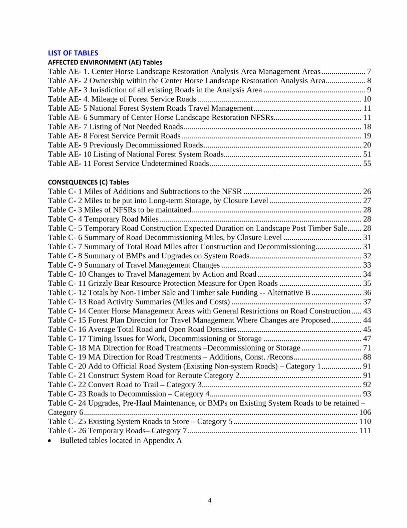
LIST OF TABLES AFFECTED ENVIRONMENT (AE) Tables
Table AE- 1. Center Horse Landscape Restoration Analysis Area Management Areas ...................... 7 Table AE- 2 Ownership within the Center Horse Landscape Restoration Analysis Area .................... 8 Table AE- 3 Jurisdiction of all existing Roads in the Analysis Area ................................................... 9 Table AE- 4. Mileage of Forest Service Roads .................................................................................. 10 Table AE- 5 National Forest System Roads Travel Management ...................................................... 11 Table AE- 6 Summary of Center Horse Landscape Restoration NFSRs ............................................ 11 Table AE- 7 Listing of Not Needed Roads ......................................................................................... 18 Table AE- 8 Forest Service Permit Roads .......................................................................................... 19 Table AE- 9 Previously Decommissioned Roads ............................................................................... 20 Table AE- 10 Listing of National Forest System Roads ..................................................................... 51 Table AE- 11 Forest Service Undetermined Roads ............................................................................ 55 CONSEQUENCES (C) Tables
Table C- 1 Miles of Additions and Subtractions to the NFSR ........................................................... 26 Table C- 2 Miles to be put into Long-term Storage, by Closure Level .............................................. 27 Table C- 3 Miles of NFSRs to be maintained ..................................................................................... 28 Table C- 4 Temporary Road Miles ..................................................................................................... 28 Table C- 5 Temporary Road Construction Expected Duration on Landscape Post Timber Sale ....... 28 Table C- 6 Summary of Road Decommissioning Miles, by Closure Level ....................................... 31 Table C- 7 Summary of Total Road Miles after Construction and Decommissioning ....................... 31 Table C- 8 Summary of BMPs and Upgrades on System Roads ........................................................ 32 Table C- 9 Summary of Travel Management Changes ...................................................................... 33 Table C- 10 Changes to Travel Management by Action and Road .................................................... 34 Table C- 11 Grizzly Bear Resource Protection Measure for Open Roads ......................................... 35 Table C- 12 Totals by Non-Timber Sale and Timber sale Funding -- Alternative B ......................... 36 Table C- 13 Road Activity Summaries (Miles and Costs) ................................................................. 37 Table C- 14 Center Horse Management Areas with General Restrictions on Road Construction ..... 43 Table C- 15 Forest Plan Direction for Travel Management Where Changes are Proposed ............... 44 Table C- 16 Average Total Road and Open Road Densities .............................................................. 45 Table C- 17 Timing Issues for Work, Decommissioning or Storage ................................................. 47 Table C- 18 MA Direction for Road Treatments –Decommissioning or Storage .............................. 71 Table C- 19 MA Direction for Road Treatments – Additions, Const. /Recons .................................. 88 Table C- 20 Add to Official Road System (Existing Non-system Roads) – Category 1 .................... 91 Table C- 21 Construct System Road for Reroute Category 2 ............................................................. 91 Table C- 22 Convert Road to Trail – Category 3 ................................................................................ 92 Table C- 23 Roads to Decommission – Category 4 ............................................................................ 93 Table C- 24 Upgrades, Pre-Haul Maintenance, or BMPs on Existing System Roads to be retained – Category 6 ......................................................................................................................................... 106 Table C- 25 Existing System Roads to Store – Category 5 .............................................................. 110 Table C- 26 Temporary Roads– Category 7 ..................................................................................... 111 Bulleted tables located in Appendix A
5
INTRODUCTION
Purpose of Report This report assesses the road system in the Center Horse Landscape Restoration analysis area for suitability for this project. This report also addresses any proposed travel management changes, including changes to unauthorized roads (also known as non‐system or Undetermined roads…See APPENDIX E – GLOSSARY). Certain limited engineering standards and recommendations are also discussed, as they relate to Transportation Planning and NEPA, for construction, reconstruction, storage, decommissioning, and operations and maintenance for the road system, and displays estimated costs of proposed activities needed to meet project and long‐term management objectives for the area. This report addresses in only a limited fashion the suitability of the road system to future projects, since timing, location, and extent of future projects have not been identified outside of the context of general Management Area intentions. The transportation system assessed in this document includes all National Forest roads in the analysis area, as identified and mapped in the Lolo NF Transportation Atlas, i.e. the INFRA and GIS database, at the time of this report, unless noted otherwise. National Forest roads for the purposes of this document includes National Forest System Roads (NFSR), Undetermined, Not‐Needed, and in some cases previously decommissioned or converted to trail roads. In addition, this document addresses any Forest Service roads outside the analysis area which are proposed as access and haul routes for project related timber removal. Furthermore, due to the private land ownership, and intermingled nature of some of it, and the possible effects of private roads on National Forest access, as well as cumulative resource impacts, some of the private roads are included in the transportation system assessment. Analysis Area (See Project File for Maps) The Center Horse Project Area is located just east of the Seeley Ranger Station in Powell County, roughly 60 miles northwest of Missoula, Montana. The analysis area is 61,300‐acres in size. For the purposes of this report, the analysis area is the same as the project area. The analysis area is primarily accessed by the Cottonwood Lakes Road 477 off of Hwy 83 and Monture Road 89.
Project Purpose and Background General project needs and design considerations include the following:
Improve/restore forest composition, spatial arrangement and structure
Restore fire adapted ecosystems,
Improve water quality, restore or enhance fish and wildlife habitat, and conserve and improve soil resources
Analyze the existing transportation network to meet public and administrative needs while at the same time eliminating unneeded roads and trails.
Alternatives The alternatives developed for this project, with notable consequences to the road system, are described in FEIS Chapter 2.
6
AFFECTED ENVIRONMENT (EXISTING CONDITION)
A. Forest Plan Direction and Regulatory Framework Relating to Roads
Forest Plan Direction The Lolo National Forest Plan (LNFP) (1986) guides all natural resource activities and establishes management standards for the Forest. Besides resource management practices, it describes (1) levels of resource production and (2) the availability and suitability of lands for various resource management activities. Of most pertinence to the Center Horse Landscape Restoration project, and roads in particular, is the latter – the Forest‐wide resource management/land suitability direction in the form of goals, objectives, standards, and specific Management Area directions. The Forest‐wide goals and objectives which are most applicable to roads in the Center Horse Landscape Restoration area are listed below. Forest‐wide Goals (LNFP page II‐1). While the transportation system plays a role in all the Goals, the most applicable Goals relating to transportation for the Center Horse Landscape Restoration project are:
Goal 1. Provide a sustained yield of timber and other outputs at a level that will help support the economic structure of local communities and provide for regional and national needs.
Applicability: A safe, efficient transportation system is necessary for transporting timber from the woods to the highway.
Goal 4. Provide a pleasing and healthy environment, including clear air, clean water, and diverse ecosystems; and Goal 8. Meet or exceed State water quality standards.
Applicability: Roads are often the single biggest impact on water quality. Forest‐wide Objectives (LNFP pages II‐1‐2). The most applicable Objective is:
Roads will be kept to the minimum number and size needed to support resource management; most roads will be closed when projects are completed to protect resource values.
Applicability: Roads are often the single biggest impact on water quality, road locations in relation to terrain and terrain features have a direct impact on harvest efficiency, and roads, especially open roads, can have impacts on other resources, such as big game security.
Forest‐wide Standards (LNFP pages 8‐20). There are 58 Forest‐wide standards in the Forest plan. The Standards that are most applicable, directly and indirectly, to transportation system development and operation are 6(g), 6(o), 8, 11, 13(a), 15, 16, 26, 28, 30, 48, 49, 50, 51, and 52; these are included in APPENDIX B ‐‐ FOREST PLAN DIRECTION RELATING TO THE TRANSPORTATION SYSTEM. Those that are key in guiding the Center Horse Landscape Restoration project, based on existing conditions and issues and opportunities raised during project development, are 15, 28, 48, 49, 50, 51, and 52.
7
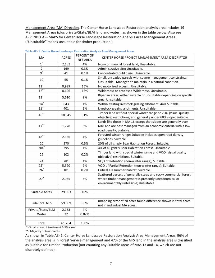
Management Area (MA) Direction. The Center Horse Landscape Restoration analysis area includes 19 Management Areas (plus private/State/BLM land and water), as shown in the table below. Also see APPENDIX A ‐‐ MAPS for Center Horse Landscape Restoration Analysis Area Management Areas. (“Unsuitable” means unsuitable for timber production.)
Table AE‐ 1. Center Horse Landscape Restoration Analysis Area Management Areas
MA ACRES PERCENT OF NFS AREA
CENTER HORSE PROJECT MANAGEMENT AREA DESCRIPTOR
1* 2,152 4% Non‐commercial forest land; Unsuitable.
2 169 0.3% Administrative site; Unsuitable.
9* 41 0.1% Concentrated public use. Unsuitable.
10 55 0.1% Small, unroaded parcels with severe management constraints; Unsuitable. Managed to maintain in a natural condition.
11** 8,989 15% No motorized access… Unsuitable.
12** 8,696 15% Wilderness or proposed Wilderness. Unsuitable.
13** 5,610 9% Riparian areas; either suitable or unsuitable depending on specific area. Unsuitable.
14* 643 1% Within existing livestock grazing allotment. 44% Suitable.
15** 401 1% Livestock grazing allotments. Unsuitable.
16** 18,345 31% Timber land without special winter range or VQO (visual quality objective) restrictions, and generally under 60% slope; Suitable.
17** 1,778 3% Lands like those in MA 16 except that slopes are generally over 60% and are best managed from an economic criteria with a low road density; Suitable.
18** 2,356 4% Forested winter range; Suitable; includes open road densityguidelines. Suitable.
20 270 0.5% 20% of all grizzly Bear Habitat on Forest. Suitable.
20a* 395 1% 4% of all grizzly Bear Habitat on Forest. Unsuitable.
22 102 0.2% Timber land with special winter range and VQO (visual quality objective) restrictions. Suitable.
24 781 1% VQO of Retention (non‐winter range); Suitable.
25** 5,320 9% VQO of Partial Retention (non‐winter range); Suitable.
26* 101 0.2% Critical elk summer habitat; Suitable.
27* 2,935 5% Scattered parcels of generally steep and rocky commercial forest where timber management is presently uneconomical or environmentally unfeasible; Unsuitable.
Suitable Acres 29,053 49%
Sub‐Total NFS 59,069 96% (mapping error of 70 acres found difference shown in total acres not in individual MA acres)
Private/State/BLM 2,163 4%
Water 32 0.02%
Total 61,264 100% *‐ Small areas of treatment 1‐50 acres **‐ Majority of treatments
As shown in Table AE‐ 1. Center Horse Landscape Restoration Analysis Area Management Areas, 96% of the analysis area is in Forest Service management and 47% of the NFS land in the analysis area is classified as Suitable for Timber Production (not counting any Suitable areas of MAs 13 and 14, which are not discretely defined).
8
See APPENDIX B for brief descriptions of the Management Areas in the analysis area including direction regarding road construction and management; see the Forest Plan for complete MA descriptions. Management Areas of proposed road development, decommissioning, storage, or travel management changes are addressed under the CONSEQUENCES section of this report. Forest Plan Amendments. Two of the Forest Plan amendments that have implications for how the road system is to be managed are (1) the Integrated Weed Management Final Environmental Impact Statement (December 2007) and (2) the Inland Native Fish Strategy Environmental Assessment (July 1995).
Regulatory Framework ‐‐ Laws, Regulations, FSM/FSH, other agency plans There are a myriad of laws, regulations, and direction that provide the primary direction for governing the use, management, and funding of transportation facilities on NFS lands and that are applicable in some manner to this project. These are listed in APPENDIX C – REGULATORY FRAMEWORK.
B. Existing Conditions
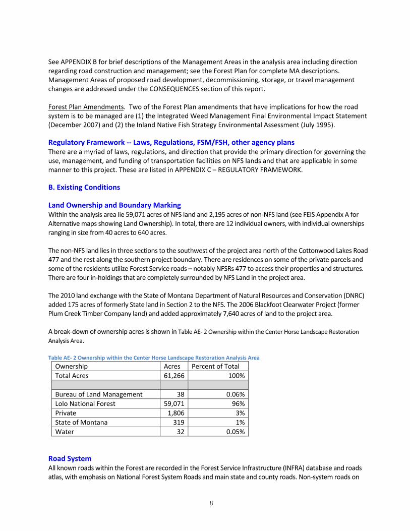
Land Ownership and Boundary Marking Within the analysis area lie 59,071 acres of NFS land and 2,195 acres of non‐NFS land (see FEIS Appendix A for Alternative maps showing Land Ownership). In total, there are 12 individual owners, with individual ownerships ranging in size from 40 acres to 640 acres. The non‐NFS land lies in three sections to the southwest of the project area north of the Cottonwood Lakes Road 477 and the rest along the southern project boundary. There are residences on some of the private parcels and some of the residents utilize Forest Service roads – notably NFSRs 477 to access their properties and structures. There are four in‐holdings that are completely surrounded by NFS Land in the project area. The 2010 land exchange with the State of Montana Department of Natural Resources and Conservation (DNRC) added 175 acres of formerly State land in Section 2 to the NFS. The 2006 Blackfoot Clearwater Project (former Plum Creek Timber Company land) and added approximately 7,640 acres of land to the project area. A break‐down of ownership acres is shown in Table AE‐ 2 Ownership within the Center Horse Landscape Restoration Analysis Area. Table AE‐ 2 Ownership within the Center Horse Landscape Restoration Analysis Area
Ownership Acres Percent of Total
Total Acres 61,266 100%
Bureau of Land Management 38 0.06%
Lolo National Forest 59,071 96%
Private 1,806 3%
State of Montana 319 1%
Water 32 0.05%
Road System All known roads within the Forest are recorded in the Forest Service Infrastructure (INFRA) database and roads atlas, with emphasis on National Forest System Roads and main state and county roads. Non‐system roads on
9
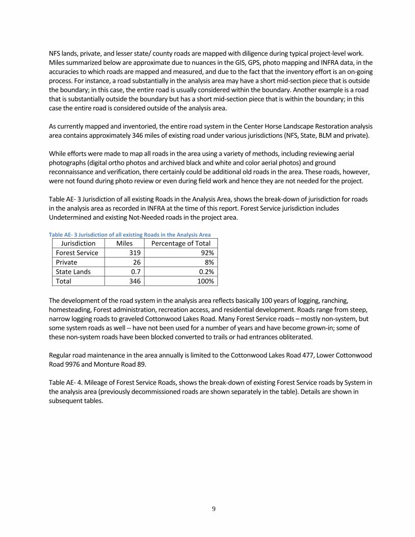
NFS lands, private, and lesser state/ county roads are mapped with diligence during typical project‐level work. Miles summarized below are approximate due to nuances in the GIS, GPS, photo mapping and INFRA data, in the accuracies to which roads are mapped and measured, and due to the fact that the inventory effort is an on‐going process. For instance, a road substantially in the analysis area may have a short mid‐section piece that is outside the boundary; in this case, the entire road is usually considered within the boundary. Another example is a road that is substantially outside the boundary but has a short mid‐section piece that is within the boundary; in this case the entire road is considered outside of the analysis area. As currently mapped and inventoried, the entire road system in the Center Horse Landscape Restoration analysis area contains approximately 346 miles of existing road under various jurisdictions (NFS, State, BLM and private). While efforts were made to map all roads in the area using a variety of methods, including reviewing aerial photographs (digital ortho photos and archived black and white and color aerial photos) and ground reconnaissance and verification, there certainly could be additional old roads in the area. These roads, however, were not found during photo review or even during field work and hence they are not needed for the project. Table AE‐ 3 Jurisdiction of all existing Roads in the Analysis Area, shows the break‐down of jurisdiction for roads in the analysis area as recorded in INFRA at the time of this report. Forest Service jurisdiction includes Undetermined and existing Not‐Needed roads in the project area. Table AE‐ 3 Jurisdiction of all existing Roads in the Analysis Area
Jurisdiction Miles Percentage of Total
Forest Service 319 92%
Private 26 8%
State Lands 0.7 0.2%
Total 346 100%
The development of the road system in the analysis area reflects basically 100 years of logging, ranching, homesteading, Forest administration, recreation access, and residential development. Roads range from steep, narrow logging roads to graveled Cottonwood Lakes Road. Many Forest Service roads – mostly non‐system, but some system roads as well ‐‐ have not been used for a number of years and have become grown‐in; some of these non‐system roads have been blocked converted to trails or had entrances obliterated. Regular road maintenance in the area annually is limited to the Cottonwood Lakes Road 477, Lower Cottonwood Road 9976 and Monture Road 89. Table AE‐ 4. Mileage of Forest Service Roads, shows the break‐down of existing Forest Service roads by System in the analysis area (previously decommissioned roads are shown separately in the table). Details are shown in subsequent tables.
10
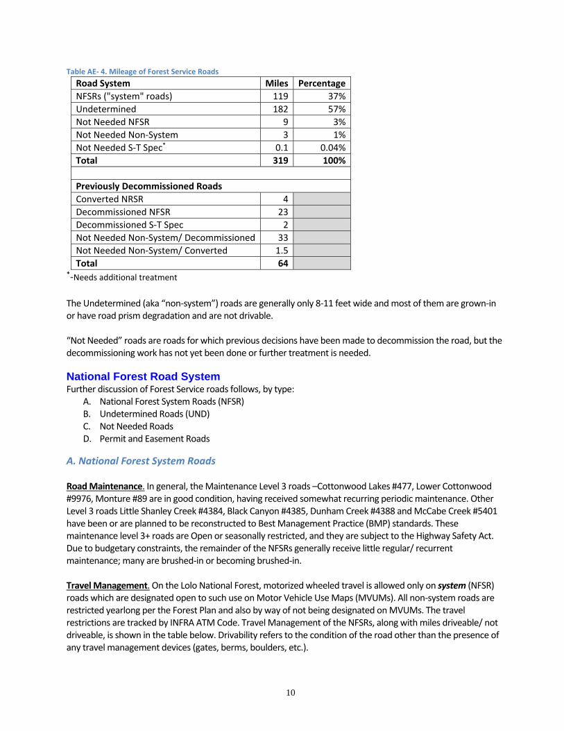
Table AE‐ 4. Mileage of Forest Service Roads
Road System Miles Percentage
NFSRs ("system" roads) 119 37%
Undetermined 182 57%
Not Needed NFSR 9 3%
Not Needed Non‐System 3 1%
Not Needed S‐T Spec* 0.1 0.04%
Total 319 100%
Previously Decommissioned Roads
Converted NRSR 4
Decommissioned NFSR 23
Decommissioned S‐T Spec 2
Not Needed Non‐System/ Decommissioned 33
Not Needed Non‐System/ Converted 1.5
Total 64 *‐Needs additional treatment The Undetermined (aka “non‐system”) roads are generally only 8‐11 feet wide and most of them are grown‐in or have road prism degradation and are not drivable. “Not Needed” roads are roads for which previous decisions have been made to decommission the road, but the decommissioning work has not yet been done or further treatment is needed.
National Forest Road System Further discussion of Forest Service roads follows, by type:
A. National Forest System Roads (NFSR) B. Undetermined Roads (UND) C. Not Needed Roads D. Permit and Easement Roads
A. National Forest System Roads Road Maintenance. In general, the Maintenance Level 3 roads –Cottonwood Lakes #477, Lower Cottonwood #9976, Monture #89 are in good condition, having received somewhat recurring periodic maintenance. Other Level 3 roads Little Shanley Creek #4384, Black Canyon #4385, Dunham Creek #4388 and McCabe Creek #5401 have been or are planned to be reconstructed to Best Management Practice (BMP) standards. These maintenance level 3+ roads are Open or seasonally restricted, and they are subject to the Highway Safety Act. Due to budgetary constraints, the remainder of the NFSRs generally receive little regular/ recurrent maintenance; many are brushed‐in or becoming brushed‐in. Travel Management. On the Lolo National Forest, motorized wheeled travel is allowed only on system (NFSR) roads which are designated open to such use on Motor Vehicle Use Maps (MVUMs). All non‐system roads are restricted yearlong per the Forest Plan and also by way of not being designated on MVUMs. The travel restrictions are tracked by INFRA ATM Code. Travel Management of the NFSRs, along with miles driveable/ not driveable, is shown in the table below. Drivability refers to the condition of the road other than the presence of any travel management devices (gates, berms, boulders, etc.).
11
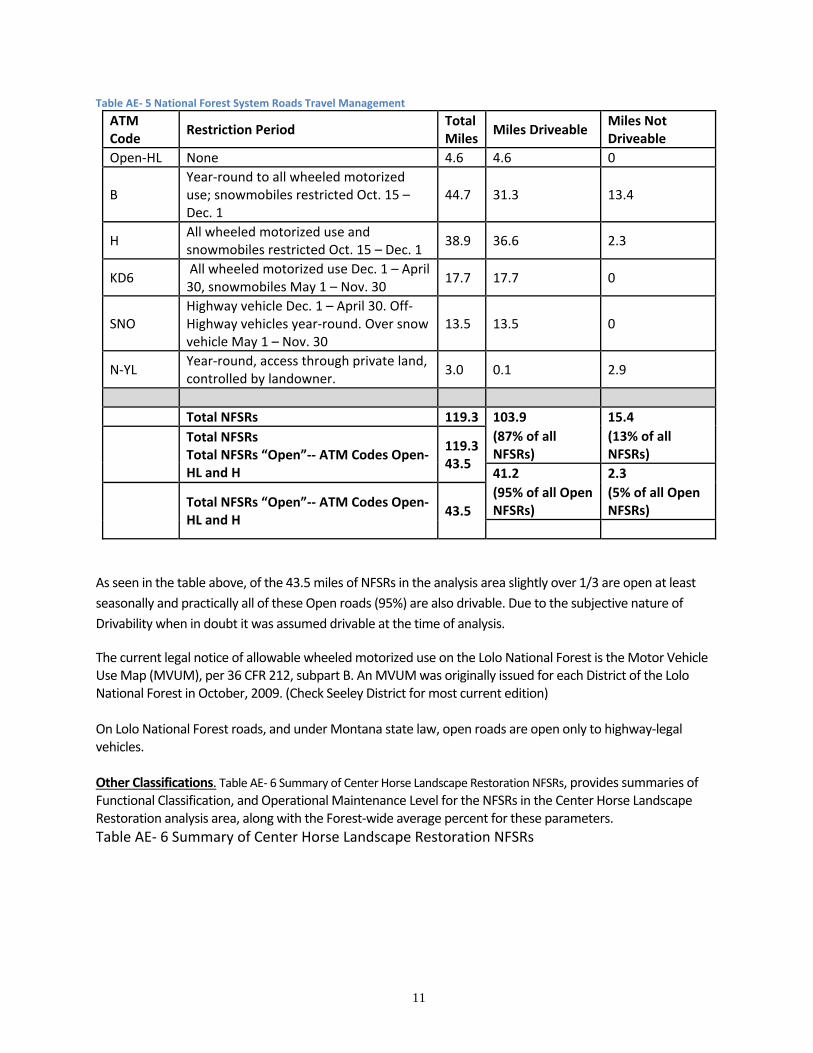
Table AE‐ 5 National Forest System Roads Travel Management
ATM Code
Restriction Period Total Miles
Miles Driveable Miles Not Driveable
Open‐HL None 4.6 4.6 0
B Year‐round to all wheeled motorized use; snowmobiles restricted Oct. 15 – Dec. 1
44.7 31.3 13.4
H All wheeled motorized use and snowmobiles restricted Oct. 15 – Dec. 1
38.9 36.6 2.3
KD6 All wheeled motorized use Dec. 1 – April 30, snowmobiles May 1 – Nov. 30
17.7 17.7 0
SNO Highway vehicle Dec. 1 – April 30. Off‐Highway vehicles year‐round. Over snow vehicle May 1 – Nov. 30
13.5 13.5 0
N‐YL Year‐round, access through private land, controlled by landowner.
3.0 0.1 2.9
Total NFSRs 119.3 103.9 15.4
Total NFSRs Total NFSRs “Open”‐‐ ATM Codes Open‐HL and H
119.343.5
(87% of all NFSRs)
(13% of all NFSRs)
41.2 2.3
Total NFSRs “Open”‐‐ ATM Codes Open‐HL and H
43.5
(95% of all Open NFSRs)
(5% of all Open NFSRs)
As seen in the table above, of the 43.5 miles of NFSRs in the analysis area slightly over 1/3 are open at least
seasonally and practically all of these Open roads (95%) are also drivable. Due to the subjective nature of
Drivability when in doubt it was assumed drivable at the time of analysis.
The current legal notice of allowable wheeled motorized use on the Lolo National Forest is the Motor Vehicle Use Map (MVUM), per 36 CFR 212, subpart B. An MVUM was originally issued for each District of the Lolo National Forest in October, 2009. (Check Seeley District for most current edition) On Lolo National Forest roads, and under Montana state law, open roads are open only to highway‐legal vehicles. Other Classifications. Table AE‐ 6 Summary of Center Horse Landscape Restoration NFSRs, provides summaries of Functional Classification, and Operational Maintenance Level for the NFSRs in the Center Horse Landscape Restoration analysis area, along with the Forest‐wide average percent for these parameters.
Table AE‐ 6 Summary of Center Horse Landscape Restoration NFSRs
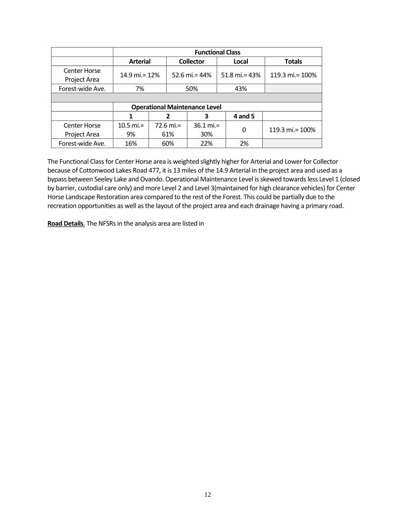
12
Functional Class
Arterial Collector Local Totals
Center Horse Project Area
14.9 mi.= 12% 52.6 mi.= 44% 51.8 mi.= 43% 119.3 mi.= 100%
Forest‐wide Ave. 7% 50% 43%
Operational Maintenance Level
1 2 3 4 and 5
Center Horse Project Area
10.5 mi.= 9%
72.6 mi.= 61%
36.1 mi.= 30%
0 119.3 mi.= 100%
Forest‐wide Ave. 16% 60% 22% 2%
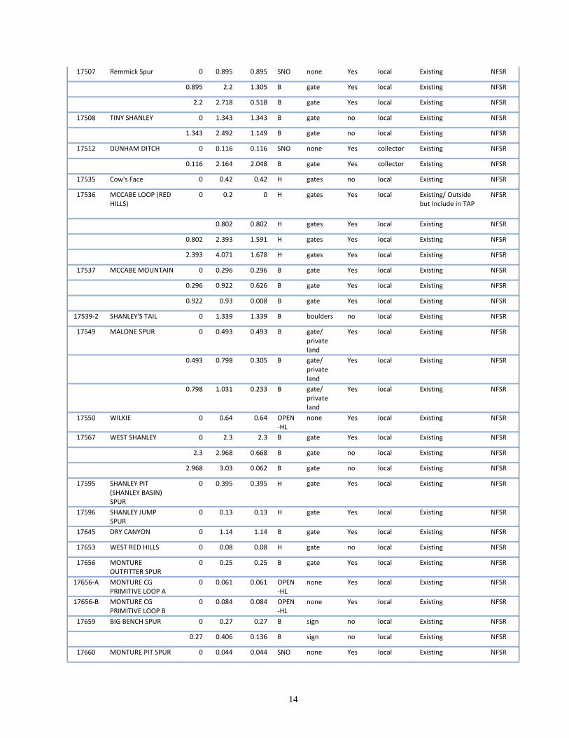
The Functional Class for Center Horse area is weighted slightly higher for Arterial and Lower for Collector because of Cottonwood Lakes Road 477, it is 13 miles of the 14.9 Arterial in the project area and used as a bypass between Seeley Lake and Ovando. Operational Maintenance Level is skewed towards less Level 1 (closed by barrier, custodial care only) and more Level 2 and Level 3(maintained for high clearance vehicles) for Center Horse Landscape Restoration area compared to the rest of the Forest. This could be partially due to the recreation opportunities as well as the layout of the project area and each drainage having a primary road. Road Details. The NFSRs in the analysis area are listed in
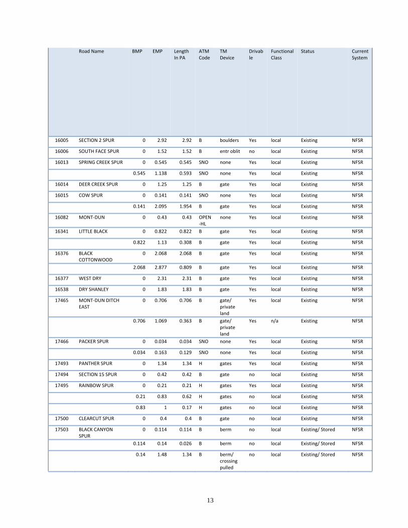
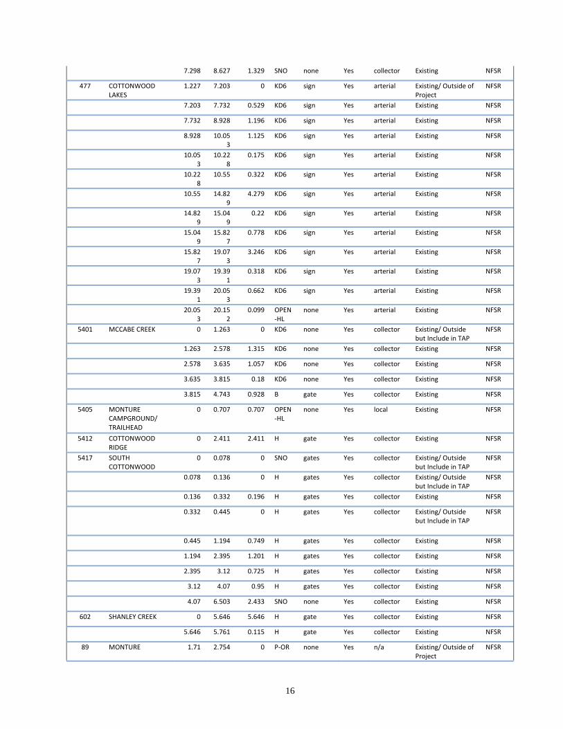
13
Road Name BMP EMP Length In PA
ATM Code
TM Device
Drivable
Functional Class
Status Current System
16005 SECTION 2 SPUR 0 2.92 2.92 B boulders Yes local Existing NFSR
16006 SOUTH FACE SPUR 0 1.52 1.52 B entr oblit no local Existing NFSR
16013 SPRING CREEK SPUR 0 0.545 0.545 SNO none Yes local Existing NFSR
0.545 1.138 0.593 SNO none Yes local Existing NFSR
16014 DEER CREEK SPUR 0 1.25 1.25 B gate Yes local Existing NFSR
16015 COW SPUR 0 0.141 0.141 SNO none Yes local Existing NFSR
0.141 2.095 1.954 B gate Yes local Existing NFSR
16082 MONT‐DUN 0 0.43 0.43 OPEN‐HL
none Yes local Existing NFSR
16341 LITTLE BLACK 0 0.822 0.822 B gate Yes local Existing NFSR
0.822 1.13 0.308 B gate Yes local Existing NFSR
16376 BLACK COTTONWOOD
0 2.068 2.068 B gate Yes local Existing NFSR
2.068 2.877 0.809 B gate Yes local Existing NFSR
16377 WEST DRY 0 2.31 2.31 B gate Yes local Existing NFSR
16538 DRY SHANLEY 0 1.83 1.83 B gate Yes local Existing NFSR
17465 MONT‐DUN DITCH EAST
0 0.706 0.706 B gate/ private land
Yes local Existing NFSR
0.706 1.069 0.363 B gate/
private land
Yes n/a Existing NFSR
17466 PACKER SPUR 0 0.034 0.034 SNO none Yes local Existing NFSR
0.034 0.163 0.129 SNO none Yes local Existing NFSR
17493 PANTHER SPUR 0 1.34 1.34 H gates Yes local Existing NFSR
17494 SECTION 15 SPUR 0 0.42 0.42 B gate no local Existing NFSR
17495 RAINBOW SPUR 0 0.21 0.21 H gates Yes local Existing NFSR
0.21 0.83 0.62 H gates no local Existing NFSR
0.83 1 0.17 H gates no local Existing NFSR
17500 CLEARCUT SPUR 0 0.4 0.4 B gate no local Existing NFSR
17503 BLACK CANYON SPUR
0 0.114 0.114 B berm no local Existing/ Stored NFSR
0.114 0.14 0.026 B berm no local Existing/ Stored NFSR
0.14 1.48 1.34 B berm/ crossing pulled
no local Existing/ Stored NFSR
14
17507 Remmick Spur 0 0.895 0.895 SNO none Yes local Existing NFSR
0.895 2.2 1.305 B gate Yes local Existing NFSR
2.2 2.718 0.518 B gate Yes local Existing NFSR
17508 TINY SHANLEY 0 1.343 1.343 B gate no local Existing NFSR
1.343 2.492 1.149 B gate no local Existing NFSR
17512 DUNHAM DITCH 0 0.116 0.116 SNO none Yes collector Existing NFSR
0.116 2.164 2.048 B gate Yes collector Existing NFSR
17535 Cow's Face 0 0.42 0.42 H gates no local Existing NFSR
17536 MCCABE LOOP (RED HILLS)
0 0.2 0 H gates Yes local Existing/ Outside but Include in TAP
NFSR
0.802 0.802 H gates Yes local Existing NFSR
0.802 2.393 1.591 H gates Yes local Existing NFSR
2.393 4.071 1.678 H gates Yes local Existing NFSR
17537 MCCABE MOUNTAIN 0 0.296 0.296 B gate Yes local Existing NFSR
0.296 0.922 0.626 B gate Yes local Existing NFSR
0.922 0.93 0.008 B gate Yes local Existing NFSR
17539‐2 SHANLEY'S TAIL 0 1.339 1.339 B boulders no local Existing NFSR
17549 MALONE SPUR 0 0.493 0.493 B gate/ private land
Yes local Existing NFSR
0.493 0.798 0.305 B gate/ private land
Yes local Existing NFSR
0.798 1.031 0.233 B gate/ private land
Yes local Existing NFSR
17550 WILKIE 0 0.64 0.64 OPEN‐HL
none Yes local Existing NFSR
17567 WEST SHANLEY 0 2.3 2.3 B gate Yes local Existing NFSR
2.3 2.968 0.668 B gate no local Existing NFSR
2.968 3.03 0.062 B gate no local Existing NFSR
17595 SHANLEY PIT (SHANLEY BASIN) SPUR
0 0.395 0.395 H gate Yes local Existing NFSR
17596 SHANLEY JUMP SPUR
0 0.13 0.13 H gate Yes local Existing NFSR
17645 DRY CANYON 0 1.14 1.14 B gate Yes local Existing NFSR
17653 WEST RED HILLS 0 0.08 0.08 H gate no local Existing NFSR
17656 MONTURE OUTFITTER SPUR
0 0.25 0.25 B gate Yes local Existing NFSR
17656‐A MONTURE CG PRIMITIVE LOOP A
0 0.061 0.061 OPEN‐HL
none Yes local Existing NFSR
17656‐B MONTURE CG PRIMITIVE LOOP B
0 0.084 0.084 OPEN‐HL
none Yes local Existing NFSR
17659 BIG BENCH SPUR 0 0.27 0.27 B sign no local Existing NFSR
0.27 0.406 0.136 B sign no local Existing NFSR
17660 MONTURE PIT SPUR 0 0.044 0.044 SNO none Yes local Existing NFSR
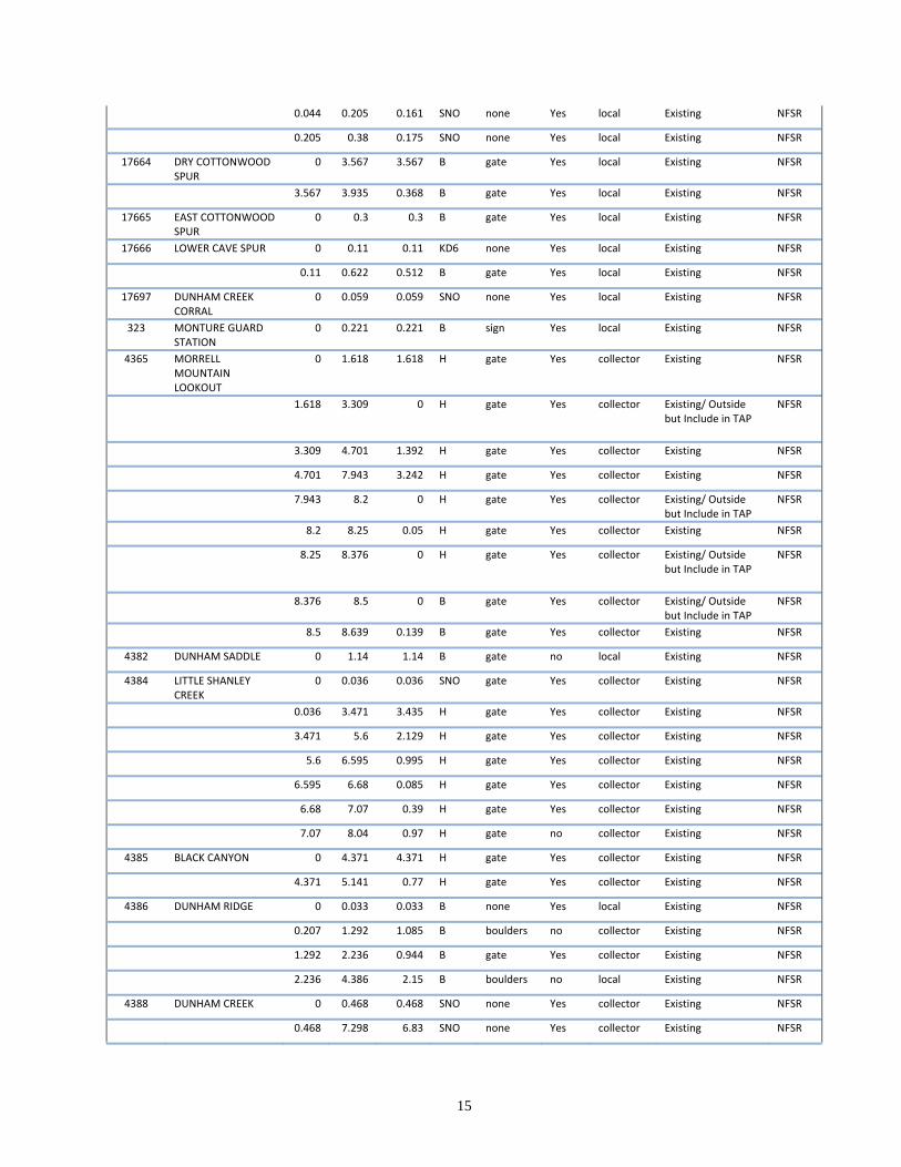
15
0.044 0.205 0.161 SNO none Yes local Existing NFSR
0.205 0.38 0.175 SNO none Yes local Existing NFSR
17664 DRY COTTONWOOD SPUR
0 3.567 3.567 B gate Yes local Existing NFSR
3.567 3.935 0.368 B gate Yes local Existing NFSR
17665 EAST COTTONWOOD SPUR
0 0.3 0.3 B gate Yes local Existing NFSR
17666 LOWER CAVE SPUR 0 0.11 0.11 KD6 none Yes local Existing NFSR
0.11 0.622 0.512 B gate Yes local Existing NFSR
17697 DUNHAM CREEK CORRAL
0 0.059 0.059 SNO none Yes local Existing NFSR
323 MONTURE GUARD STATION
0 0.221 0.221 B sign Yes local Existing NFSR
4365 MORRELL MOUNTAIN LOOKOUT
0 1.618 1.618 H gate Yes collector Existing NFSR
1.618 3.309 0 H gate Yes collector Existing/ Outside but Include in TAP
NFSR
3.309 4.701 1.392 H gate Yes collector Existing NFSR
4.701 7.943 3.242 H gate Yes collector Existing NFSR
7.943 8.2 0 H gate Yes collector Existing/ Outside but Include in TAP
NFSR
8.2 8.25 0.05 H gate Yes collector Existing NFSR
8.25 8.376 0 H gate Yes collector Existing/ Outside but Include in TAP
NFSR
8.376 8.5 0 B gate Yes collector Existing/ Outside but Include in TAP
NFSR
8.5 8.639 0.139 B gate Yes collector Existing NFSR
4382 DUNHAM SADDLE 0 1.14 1.14 B gate no local Existing NFSR
4384 LITTLE SHANLEY CREEK
0 0.036 0.036 SNO gate Yes collector Existing NFSR
0.036 3.471 3.435 H gate Yes collector Existing NFSR
3.471 5.6 2.129 H gate Yes collector Existing NFSR
5.6 6.595 0.995 H gate Yes collector Existing NFSR
6.595 6.68 0.085 H gate Yes collector Existing NFSR
6.68 7.07 0.39 H gate Yes collector Existing NFSR
7.07 8.04 0.97 H gate no collector Existing NFSR
4385 BLACK CANYON 0 4.371 4.371 H gate Yes collector Existing NFSR
4.371 5.141 0.77 H gate Yes collector Existing NFSR
4386 DUNHAM RIDGE 0 0.033 0.033 B none Yes local Existing NFSR
0.207 1.292 1.085 B boulders no collector Existing NFSR
1.292 2.236 0.944 B gate Yes collector Existing NFSR
2.236 4.386 2.15 B boulders no local Existing NFSR
4388 DUNHAM CREEK 0 0.468 0.468 SNO none Yes collector Existing NFSR
0.468 7.298 6.83 SNO none Yes collector Existing NFSR
16
7.298 8.627 1.329 SNO none Yes collector Existing NFSR
477 COTTONWOOD LAKES
1.227 7.203 0 KD6 sign Yes arterial Existing/ Outside of Project
NFSR
7.203 7.732 0.529 KD6 sign Yes arterial Existing NFSR
7.732 8.928 1.196 KD6 sign Yes arterial Existing NFSR
8.928 10.053
1.125 KD6 sign Yes arterial Existing NFSR
10.05
3 10.22
8 0.175 KD6 sign Yes arterial Existing NFSR
10.22
8 10.55 0.322 KD6 sign Yes arterial Existing NFSR
10.55 14.82
9 4.279 KD6 sign Yes arterial Existing NFSR
14.82
9 15.04
9 0.22 KD6 sign Yes arterial Existing NFSR
15.049
15.827
0.778 KD6 sign Yes arterial Existing NFSR
15.827
19.073
3.246 KD6 sign Yes arterial Existing NFSR
19.073
19.391
0.318 KD6 sign Yes arterial Existing NFSR
19.391
20.053
0.662 KD6 sign Yes arterial Existing NFSR
20.053
20.152
0.099 OPEN‐HL
none Yes arterial Existing NFSR
5401 MCCABE CREEK 0 1.263 0 KD6 none Yes collector Existing/ Outside but Include in TAP
NFSR
1.263 2.578 1.315 KD6 none Yes collector Existing NFSR
2.578 3.635 1.057 KD6 none Yes collector Existing NFSR
3.635 3.815 0.18 KD6 none Yes collector Existing NFSR
3.815 4.743 0.928 B gate Yes collector Existing NFSR
5405 MONTURE CAMPGROUND/ TRAILHEAD
0 0.707 0.707 OPEN‐HL
none Yes local Existing NFSR
5412 COTTONWOOD RIDGE
0 2.411 2.411 H gate Yes collector Existing NFSR
5417 SOUTH COTTONWOOD
0 0.078 0 SNO gates Yes collector Existing/ Outside but Include in TAP
NFSR
0.078 0.136 0 H gates Yes collector Existing/ Outside but Include in TAP
NFSR
0.136 0.332 0.196 H gates Yes collector Existing NFSR
0.332 0.445 0 H gates Yes collector Existing/ Outside but Include in TAP
NFSR
0.445 1.194 0.749 H gates Yes collector Existing NFSR
1.194 2.395 1.201 H gates Yes collector Existing NFSR
2.395 3.12 0.725 H gates Yes collector Existing NFSR
3.12 4.07 0.95 H gates Yes collector Existing NFSR
4.07 6.503 2.433 SNO none Yes collector Existing NFSR
602 SHANLEY CREEK 0 5.646 5.646 H gate Yes collector Existing NFSR
5.646 5.761 0.115 H gate Yes collector Existing NFSR
89 MONTURE 1.71 2.754 0 P‐OR none Yes n/a Existing/ Outside of Project
NFSR
17
5.062 7.005 1.943 OPEN
‐HL none Yes arterial Existing NFSR
9976 LOWER COTTONWOOD
0 1.082 0 OPEN‐HL
none Yes collector Existing/ Outside but Include in TAP
NFSR
1.082 3.33 2.248 KD6 none Yes collector Existing NFSR
in APPENDIX A‐ Maps and Tables. Lengths of NFSRs are generally derived from construction plans or calibrated electronic distance measurement instruments (DMI) in vehicles. Many of the roads need work to bring them up to BMP standards; in general, this consists of:
Surface drainage ‐‐ blading and shaping to shed water, surface drainage improvements such as ditch cleaning and additional ditch relief culverts, additional drain dips, open‐tops/ belted waterbars to remove water and also to disconnect road drainage from streams,
Stream crossing culvert upsizing for storm flow capacity and aquatic organism passage. Virtually all perennial, intermittent, and ephemeral draws are in need of culvert upsizing, with the priorities being fish‐bearing reaches in perennial streams, then intermittent streams.
Recurrent maintenance to retain template shapes and keep drainage structures and stream crossings functioning properly.
Some watershed restoration and BMP work in the Center Horse project area has been started as of 2012 due to availability of CFLRP funds. For example a road that has been worked on is 4388 Dunham Creek. Roads that are in process are 4385 Black Canyon and 4384 Little Shanley. Additionally some culverts have been upgraded to Aquatic Organism Passage (AOP) Culverts.
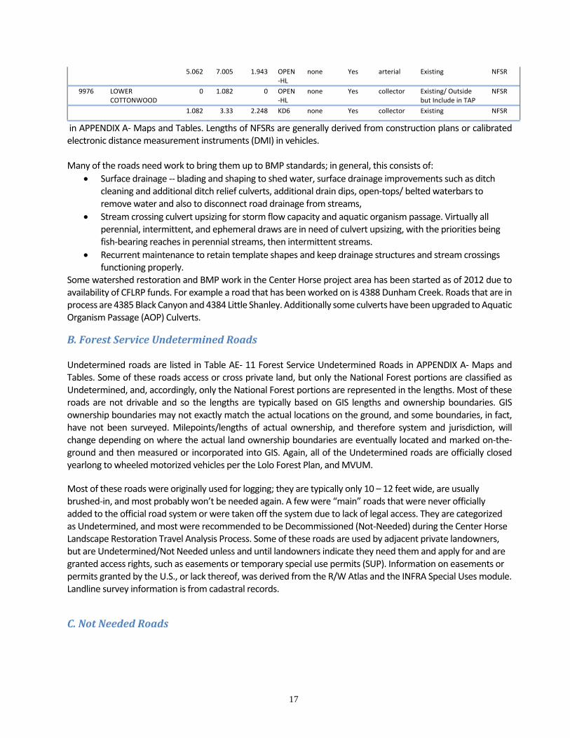
B.ForestServiceUndeterminedRoads Undetermined roads are listed in Table AE‐ 11 Forest Service Undetermined Roads in APPENDIX A‐ Maps and Tables. Some of these roads access or cross private land, but only the National Forest portions are classified as Undetermined, and, accordingly, only the National Forest portions are represented in the lengths. Most of these roads are not drivable and so the lengths are typically based on GIS lengths and ownership boundaries. GIS ownership boundaries may not exactly match the actual locations on the ground, and some boundaries, in fact, have not been surveyed. Milepoints/lengths of actual ownership, and therefore system and jurisdiction, will change depending on where the actual land ownership boundaries are eventually located and marked on‐the‐ground and then measured or incorporated into GIS. Again, all of the Undetermined roads are officially closed yearlong to wheeled motorized vehicles per the Lolo Forest Plan, and MVUM.
Most of these roads were originally used for logging; they are typically only 10 – 12 feet wide, are usually brushed‐in, and most probably won’t be needed again. A few were “main” roads that were never officially added to the official road system or were taken off the system due to lack of legal access. They are categorized as Undetermined, and most were recommended to be Decommissioned (Not‐Needed) during the Center Horse Landscape Restoration Travel Analysis Process. Some of these roads are used by adjacent private landowners, but are Undetermined/Not Needed unless and until landowners indicate they need them and apply for and are granted access rights, such as easements or temporary special use permits (SUP). Information on easements or permits granted by the U.S., or lack thereof, was derived from the R/W Atlas and the INFRA Special Uses module. Landline survey information is from cadastral records.
C.NotNeededRoads
18
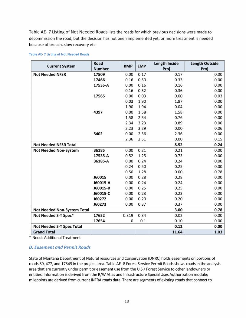
Table AE‐ 7 Listing of Not Needed Roads lists the roads for which previous decisions were made to
decommission the road, but the decision has not been implemented yet, or more treatment is needed
because of breach, slow recovery etc.
Table AE‐ 7 Listing of Not Needed Roads
Current System Road Number
BMP EMPLength Inside
Proj Length Outside
Proj
Not Needed NFSR 17509 0.00 0.17 0.17 0.00 17466 0.16 0.50 0.33 0.00 17535‐A 0.00 0.16 0.16 0.00 0.16 0.52 0.36 0.00 17565 0.00 0.03 0.00 0.03 0.03 1.90 1.87 0.00 1.90 1.94 0.04 0.00 4397 0.00 1.58 1.58 0.00 1.58 2.34 0.76 0.00 2.34 3.23 0.89 0.00 3.23 3.29 0.00 0.06 5402 0.00 2.36 2.36 0.00 2.36 2.51 0.00 0.15
Not Needed NFSR Total 8.52 0.24
Not Needed Non‐System 36185 0.00 0.21 0.21 0.00 17535‐A 0.52 1.25 0.73 0.00 36185‐A 0.00 0.24 0.24 0.00 0.24 0.50 0.25 0.00 0.50 1.28 0.00 0.78 J60015 0.00 0.28 0.28 0.00 J60015‐A 0.00 0.24 0.24 0.00 J60015‐B 0.00 0.25 0.25 0.00 J60015‐C 0.00 0.23 0.23 0.00 J60272 0.00 0.20 0.20 0.00 J60273 0.00 0.37 0.37 0.00
Not Needed Non‐System Total 3.00 0.78
Not Needed S‐T Spec* 17652 0.319 0.34 0.02 0.00 17654 0 0.1 0.10 0.00
Not Needed S‐T Spec Total 0.12 0.00
Grand Total 11.64 1.03
*‐Needs Additional Treatment
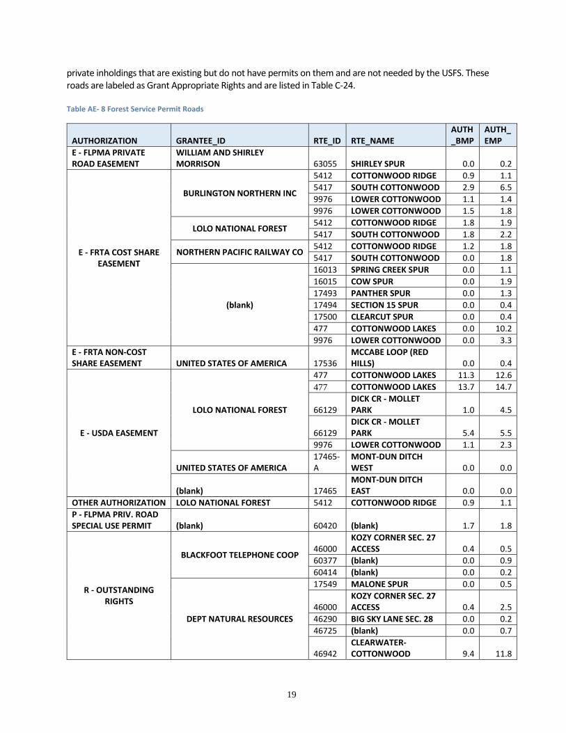
D. Easement and Permit Roads State of Montana Department of Natural resources and Conservation (DNRC) holds easements on portions of roads 89, 477, and 17549 in the project area. Table AE‐ 8 Forest Service Permit Roads shows roads in the analysis area that are currently under permit or easement use from the U.S./ Forest Service to other landowners or entities. Information is derived from the R/W Atlas and Infrastructure Special Uses Authorization module; milepoints are derived from current INFRA roads data. There are segments of existing roads that connect to
19
private inholdings that are existing but do not have permits on them and are not needed by the USFS. These roads are labeled as Grant Appropriate Rights and are listed in Table C‐24. Table AE‐ 8 Forest Service Permit Roads
AUTHORIZATION GRANTEE_ID RTE_ID RTE_NAME AUTH_BMP
AUTH_EMP
E ‐ FLPMA PRIVATE ROAD EASEMENT
WILLIAM AND SHIRLEY MORRISON 63055 SHIRLEY SPUR 0.0 0.2
E ‐ FRTA COST SHARE EASEMENT
BURLINGTON NORTHERN INC
5412 COTTONWOOD RIDGE 0.9 1.1
5417 SOUTH COTTONWOOD 2.9 6.5
9976 LOWER COTTONWOOD 1.1 1.4
9976 LOWER COTTONWOOD 1.5 1.8
LOLO NATIONAL FOREST 5412 COTTONWOOD RIDGE 1.8 1.9
5417 SOUTH COTTONWOOD 1.8 2.2
NORTHERN PACIFIC RAILWAY CO 5412 COTTONWOOD RIDGE 1.2 1.8
5417 SOUTH COTTONWOOD 0.0 1.8
(blank)
16013 SPRING CREEK SPUR 0.0 1.1
16015 COW SPUR 0.0 1.9
17493 PANTHER SPUR 0.0 1.3
17494 SECTION 15 SPUR 0.0 0.4
17500 CLEARCUT SPUR 0.0 0.4
477 COTTONWOOD LAKES 0.0 10.2
9976 LOWER COTTONWOOD 0.0 3.3
E ‐ FRTA NON‐COST SHARE EASEMENT UNITED STATES OF AMERICA 17536
MCCABE LOOP (RED HILLS) 0.0 0.4
E ‐ USDA EASEMENT
LOLO NATIONAL FOREST
477 COTTONWOOD LAKES 11.3 12.6
477 COTTONWOOD LAKES 13.7 14.7
66129 DICK CR ‐MOLLET PARK 1.0 4.5
66129 DICK CR ‐MOLLET PARK 5.4 5.5
9976 LOWER COTTONWOOD 1.1 2.3
UNITED STATES OF AMERICA 17465‐A
MONT‐DUN DITCH WEST 0.0 0.0
(blank) 17465 MONT‐DUN DITCH EAST 0.0 0.0
OTHER AUTHORIZATION LOLO NATIONAL FOREST 5412 COTTONWOOD RIDGE 0.9 1.1
P ‐ FLPMA PRIV. ROAD SPECIAL USE PERMIT (blank) 60420 (blank) 1.7 1.8
R ‐ OUTSTANDING RIGHTS
BLACKFOOT TELEPHONE COOP 46000
KOZY CORNER SEC. 27 ACCESS 0.4 0.5
60377 (blank) 0.0 0.9
60414 (blank) 0.0 0.2
DEPT NATURAL RESOURCES
17549 MALONE SPUR 0.0 0.5
46000 KOZY CORNER SEC. 27 ACCESS 0.4 2.5
46290 BIG SKY LANE SEC. 28 0.0 0.2
46725 (blank) 0.0 0.7
46942 CLEARWATER‐COTTONWOOD 9.4 11.8
20
56071 SPRING CREEK SEC. 15 0.0 1.0
56071 SPRING CREEK SPRING CREEK SEC. 15SEC. 15 0.2 1.0
56079 (blank) 0.0 0.4
56079 (blank) 0.4 3.3
56087 (blank) 0.0 0.2
56089 (blank) 0.0 0.1
56112 (blank) 2.7 2.9
60414 (blank) 0.0 0.2
66112 (blank) 0.0 0.3
LOLO NATIONAL FOREST 46090 (blank) 0.8 1.2
MT DEPT OF NATURAL RESOURCES
46147 SHOUP CREEK DNRC R/W SEC. 25 0.0 0.5
46150 SHOUP LAKE DNRC R/W SEC. 25 0.0 0.3
(blank) 66108
SPRING CR SOUTH LINE SEC. 24 0.0 0.5
R ‐ RESERVATION LOLO NATIONAL FOREST 17465
MONT‐DUN DITCH EAST 0.7 1.1
LEGAL DISCRIPTION USENAME CONTACT_NAME
T16N R14W FEDERAL LAND POLICY & MGMT ACT EASEMENT
WILLIAM MORRISON
T16N R14W FEDERAL LAND POLICY & MGMT ACT PERMIT
ANDREW AND KAREN OBERG
T16N R14W FEDERAL LAND POLICY & MGMT ACT PERMIT
DOUBLE ARROW RANCH LAND OWNER'S ASSOCIATION
T16N R14W FOREST ROAD AND TRAIL ACT EASEMENT
BURLINGTON NORTHERN, INC.
T17N R14W FOREST ROAD AND TRAIL ACT EASEMENT
BURLINGTON NORTHERN, INC.
Other Road System Considerations ‐‐ Decommissioned Roads and Weeds Table AE‐ 9 Previously Decommissioned Roads lists previously decommissioned roads (since they are no longer “roads”, they are not included in project totals). Non‐specified timber sale temporary roads are not included as they are generally not tracked in the road inventory. Table AE‐ 9 Previously Decommissioned Roads
Road Number Current System Closure Level
Length in PA
16004 Decommissioned NFSR 3‐D 3.2
16081 Decommissioned NFSR 3‐D 0.2
17509 Decommissioned NFSR 3‐D 2.7
17509 Decommissioned NFSR 5 0.5
17510 Converted NFSR 3‐D 0.6
21
Road Number Current System Closure Level
Length in PA
17510 Converted NFSR 5 0.9
17510 Decommissioned NFSR 5 2.1
17512‐OLD Decommissioned NFSR 3‐D 0.1
17533 Converted NFSR 3‐D 1.6
17533 Converted NFSR 5 0.6
17533 Decommissioned NFSR 5 1.7
17534 Decommissioned NFSR 3‐D 1.5
17539‐1 Decommissioned NFSR 3‐D 2.5
17539‐1 Decommissioned NFSR 4 0.9
17652 Decommissioned S‐T Spec
5 0.3
17653 Decommissioned S‐T Spec
5 0.4
17655 Decommissioned S‐T Spec
5 0.2
17661 Decommissioned S‐T Spec
5 0.1
17666 Decommissioned NFSR 3‐D 2.1
17667 Decommissioned NFSR 3‐D 0.4
17667 Decommissioned NFSR 5 0.5
20605 Decommissioned S‐T Spec
5 0.5
20606 Decommissioned S‐T Spec
5 0.6
4382 Decommissioned NFSR 3‐D 0.9
4382‐1 Decommissioned NFSR 3‐D 1.1
4386 Decommissioned NFSR 4 2.8
4386 Decommissioned NFSR 5 0.2
Grand Total 29.1
Most of the road system is infested with noxious weeds – namely knapweed and oxeye daisy ‐‐ to various degrees; actual locations and densities of weeds are dependent on specific site characteristics (elevation, aspect, canopy closure, moisture, seed source, previous treatments).
CONSEQUENCES Primary issues relating to the transportation system that were raised during scoping and alternative development and that are now used to evaluate the alternatives are:
Need for access to treatment units to improve forest health; this includes construction of
temporary roads and retention of existing roads, as needed;
Need for access to strategic locations for wildland fire fighting, protection of infrastructure and
private property, and to enhance firefighter safety.
22
Need to improve terrestrial and aquatic habitat and connectivity and watershed health by
reducing adverse road impacts (by road closures, storage, decommissioning, culvert upgrades, and
BMPs);
Need to maintain or improve recreational opportunities;
On‐going road maintenance costs and ability to fund this.
Potential for weed spread.
Economic viability of vegetative treatments and the ability to fund the proposed road treatments.
This report does not necessarily directly address or analyze all these issues, but it provides data and recommendations for synthesis with other specialist reports into the NEPA documents.
Analysis Methods and Project Criteria Consequences or design criteria are portrayed in relation to the following areas:
Ability to meet purpose and need;
Consistency with Forest Service policy regarding Travel Analysis;
Soil and Water BMP and Roads Maintenance;
Effects on Travel Management;
Costs
Consistency with the Forest Plan and Regulatory Framework.
Particular elements of these are described below.
Ability to Meet Purpose and Need By design, all proposed road development and management activities are inherently formulated to fulfill
the project’s purpose and need, as well as to be compatible with long‐term management objectives,
although some elements of the project’s objectives may be better met than others with some proposals.
For example, road decommissioning may meet resource protection and budget objectives better than
meeting long‐term access needs. Preliminary proposals or recommendations that did not fulfill the
project’ objectives or were clearly not in the best long‐term management interest were not carried
forward for analysis.
Forest Service Policy ‐‐ Travel Analysis Travel analysis assesses the current Forest transportation system and identifies issues and assesses benefits, problems, and risks to inform decisions related to: (1) identification of roads needed for long‐term land management and (2) designation of roads, trails, and areas for motor vehicle use. These two purposes are separate, but may be conducted either concurrently or separately (FSM 7712). Travel analysis is not a decision‐making process, but instead informs decisions relating to administration of the forest transportation system and helps to identify proposals for changes in travel management direction. (FSM 7712) Decisions must be informed by travel analysis conducted at an appropriate scale, as well as appropriate site‐specific environmental analysis and public involvement. As discussed earlier the purpose of the Center Horse Landscape Restoration project is improve/restore forest composition, spatial arrangement and structure; restore fire adapted ecosystems; improve water quality, restore or enhance fish and wildlife habitat, and conserve and improve soil resources; and right
23
size the existing transportation network to meet public and administrative needs while at the same time eliminating unneeded roads and trails. To accomplish these objectives, this project involves proposals to:
construct certain new temporary roads;
treat certain existing roads through decommissioning, storage, or stream crossing upgrades to reduce impacts on wildlife and aquatic organism habitat, water quality, and maintenance needs;
to perform reconstruction or maintenance on certain roads to facilitate logging traffic and to improve water quality;
to add certain unauthorized (non‐system/Undetermined) roads to the official system of roads;
construct system road for reroutes: pieces of road 477, 46942 and 56087 to improve water quality.
Travel analysis was used to assess the current transportation system and existing travel management direction in the analysis area and to identify needs, opportunities, and risks. Some of these needs, opportunities, and risks were subsequently carried forward into the NEPA process in the form of proposals. Public involvement in the travel analysis and NEPA process included providing a scoping letter to explain the project and to solicit comments and ideas. The travel analysis process began with data assembly and field assessments and included discussions and ratings of the National Forest roads related to the analysis area. Later, as the project objectives were fine‐tuned and better mapping and field data was obtained, additional roads were analyzed. In the end, almost all known National Forest roads in the analysis area were analyzed for the purpose of identifying the road system needed for safe and efficient travel and for administration, utilization, and protection of NFS lands within the analysis area. This project transportation plan represents an “area plan” in the sense that it is a comprehensive assessment for a fairly large analysis area. (It does not, however, include a logging system/transportation plan for accessing all suitable timber land.)
Soil and Water BMPs and Road Maintenance Forest Service policy requires that roads meet BMPs for soil and water quality protection. For the most part, roads constructed prior to about 1990 were built before the establishment of formal BMP standards. BMP standards have evolved somewhat over the last two decades. By today’s standards, older roads were not built to current BMPs. Furthermore, continually meeting BMPs after initial road construction is a function of on‐going road maintenance practices to keep the road up to BMP standards. The Forest budget for road maintenance, reflecting the national Forest Service roads budget situation, is not nearly adequate to perform road maintenance to standards, including water quality BMP‐related maintenance, on all roads. The result is a backlog of maintenance and reconstruction that needs done in order to meet BMPs, as well as to meet road management objectives (e.g., brush‐free road width, clear sight distance, acceptable road surface roughness, sign installation, etc.). This backlog is systematically addressed through projects such as timber sales, specially funded “capital improvement” projects, as well as specific deferred maintenance projects. Closing or restricting roads to all or certain types of motorized traffic, putting roads into storage, or decommissioning roads are also useful methods of reducing BMP and maintenance backlogs. Conversely, opening closed roads could be expected to increase the maintenance needs – both for meeting BMPs as well as for meeting objectives for the type of use the road is managed for.
24
Meeting surface drainage and construction BMPs on haul routes is a criterion for this project and the project proposals have been formulated to accomplish this by incorporating proper procedures in the preconstruction and construction engineering phases (road location, design, construction, maintenance, storage) and in monitoring practices. Examples of surface drainage activities include maintaining or constructing drainage dips, drainage ditches, and ditch relief culverts, shaping road surfaces to properly drain, and replacing culverts that are past their useful life and are failing. These activities on Local road haul routes would be completed with any resulting timber sale. Activities on Arterial and Collector haul roads will be funded outside the timber sale and non‐haul roads will be funded to the extent other funding is available. Furthermore, improving watershed conditions by (a) meeting non‐surface drainage BMPs (as well as the above‐mentioned BMPs) on haul routes and (b) performing maintenance, reconstruction, and/or restoration activities on non‐haul routes is generally a criterion for this project (in order to meet the objective of enhanced watershed conditions). An example of non‐surface drainage BMPs is upgrading culverts to provide aquatic organism passage (AOP) and to pass design flood flows (typically 100 year events). Maintenance, reconstruction, or restoration activities on non‐haul routes may include the activities listed above, as well as storage and decommissioning. The non‐surface drainage and restoration activities on haul routes are generally not the responsibility of a timber sale and work on non‐haul routes, of course, is also not a responsibility of a traditional timber sale. Non‐surface drainage and non‐haul route BMPs are implemented when funding is available based on Forest prioritizations, although in some cases there may be required mitigations before proceeding with project.
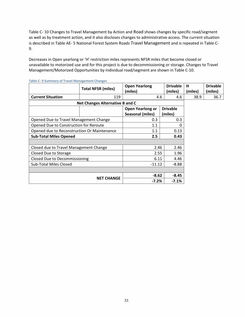
Affects on Travel Management Affects on travel management are measured by comparing miles of legally open road (by travel plan code). Drivability of roads is also considered.
Road Standards and Costs Roads are planned to be constructed for reroute, reconstructed, and maintained to the standard needed for the timber harvest activities, public and administrative use, and to be consistent with Forest Plan direction, environmental regulations, and BMPs. In the case of existing roads or road segments that are 10‐13 feet wide (without ditches), it is proposed that these roads be used for log haul without widening, except for special site‐specific situations such as curve widening. However, it may be found during preconstruction that they may need to be widened to accommodate the log handling and yarding equipment (swing yarders, excaliners, and loaders). This would depend on the particular logging system and associated equipment employed on each road and existing site‐specific road widths and cutslope heights and angles. For instance, it may be feasible to haul on a 10‐foot wide road and only widen the road at the exact spots where a yarder could set‐up. Any widening of existing roads would need to carefully consider disposal or placement of excavated cutslope material. Generally, existing fillslopes are not conducive to adding additional fill material due to vegetation, duff, and the fill slope angle – additional material placed on the fillslope would be unstable unless extensive clearing, grubbing, and keying‐in and compacting of material is conducted. A more environmentally suitable and cost effective scenario is to dispose of excavated cutslope material on the native material roadbed (i.e., essentially building up the roadbed). Sidecasting to dispose of material is generally not acceptable. Furthermore, for long‐term system roads, reconstruction of cutslopes should include stable back slopes. For temporary roads, narrower roadbeds, steeper cut and fillslopes, and narrower clearing widths are more cost effective, would be more conducive to eventual obliteration, and would be less impactive overall.
25
Temporary roads will need to be stable for their life, which could be multiple operating seasons, so a consideration of soil types, slope steepness, groundwater interception and length of service is important. Furthermore, stockpiling or segregation of the topsoil and duff should be considered during construction to facilitate restoration and re‐establishment of vegetation. See the Soils and other specialist’s report for a discussion of proposed temporary roads in the Center Horse Landscape Restoration area. Costs are calculated as unit costs per mile with additional costs added for complexities based on engineering judgement. Costs are presented in Tables C‐19 through C‐25 located in APPENDIX A‐ Maps and Tables. While costs outside of a traditional timber sale cannot be borne by the timber sale, there are some items – notably road storage and decommissioning of roads used for the sale – that could be funded either by the sale or outside of the sale with appropriated funding or stewardship mechanisms. It is assumed here that all closure treatments for any road segment used by the sale are funded by the sale; ultimately, however, appropriated, partner or other funding could be used for certain activities such as decommissioning and storage. Costs were derived from local knowledge, conversations with Lolo NF road engineers, and the following documents: Planning Road Cost Assessment – Estimating Road Costs in Transportation Planning, Lolo National
Forest, March 5, 2004, by Chris Partyka, Rodney Blessing, Joe Hughes, and Eric Barclay, with costs updated 30% by Jim Inness, February, 2010, and corrections and minor edits by R. Gage. Total costing revision by Kathleen Marks 2015.
Costs given are “planning” costs – that is they are intended to be fairly close (roughly within about 15%) to actual implementation costs. They are intended to reflect the contract award amount to a timber sale purchaser, road maintenance contractor, or public works contractor. They inherently include general provisions for location and work season that is typical of this project. They do not include the cost to the government/taxpayer for surveys, design (including consultants), contract administration, or Forest Service overhead, unless specifically stated as included. Furthermore, costs are not detailed enough to specifically differentiate items like insurance and bonding, or Davis‐Bacon wage rates versus non‐Davis‐Bacon rates. See APPENDIX D – COSTS for details and APPENDIX F or G for costing per road. and Haul permit or easement costs are not anticipated to be needed for this project; if it turns out that some access over private roads/land is needed, this should not materially affect the costs since:
It is possible that wherever the Forest Service needs access, there is also a private landowner that needs access rights from the Forest Service; therefore, there is opportunity for reciprocity;
access costs are dependent on whether the access is by one‐time permit or by perpetual easement, and the specific mechanism for each road has not been determined;
and the cost for the length of roads and volume to be hauled over private land (in the case of permit) should be minimal.
Costs are generally shown to the nearest dollar to prevent successive rounding errors; this should not be construed as accurate or precise to the nearest dollar.
Consistency with the Forest Plan and Regulatory Framework Proposals are evaluated in relation to the Lolo NF Plan and the regulatory framework.
Comparison of Alternatives Concerning Roads
26
Alternative A‐ No Action – No new road construction would occur and no storage or decommissioning activities or official designations would occur with this Alternative. Road maintenance BMPs would occur on 40 miles of NFSR; and culvert upgrades would be limited to those that could be done under maintenance, when funding is available. Progress on roads and culverts began approximately 2012. Weed treatments for open and drivable roads would be analyzed in the Forest Small NEPA process, following the protocol in the Lolo NF Integrated Weed Management Environmental Impact Statement (December 2007), so that action could continue. Alternatives B‐Proposed Action – various road treatments are proposed under this alternative relating to both timber haul and BMPs/restoration of haul and non‐haul routes. These activities include:
Adding non‐system roads to the official road system, with and without reconstruction and with and without post‐haul storage. None of these are on private land.
Constructing temporary roads for timber harvest and haul. Only temporary roads on NFS land are planned.
Reconstructing non‐system roads to be used as temporary roads for timber harvest and haul.
Decommissioning, with various closure levels, both system and non‐system roads.
Storing existing system roads, including roads to be used for the timber sale and some not used for the timber sale.
Hauling on existing system roads.
Performing pre‐haul BMP and other maintenance on timber sale roads approximately 100 miles leading to units.
Performing culvert upgrades (“restoration”), both on roads not to be used for the timber sale and roads used for the sale.
Gravel Pit development (Little Shanley and Monture) Alternative C‐ All activities the same except no commercial timber harvest, construction of new temporary roads and Local haul road BMPs.
Road Actions by Alternative The following tables summarize the road actions that are typically of the most interest that are proposed under the proposed action alternatives. These are followed by a summary table of the treatments with total costs, and then followed by tables showing the treatment details (Road #, beginning and ending mile points (BMP/EMP), segment length, and costs by Non‐Timber Sale). The road actions that are within the purpose and need:
Changes to the permanent road system (NFSR) – through construction, addition of non‐system roads, decommissioning, and storage of system roads.
Temporary Road Construction/Reconstruction.
Non‐system Road Decommissioning.
Maintenance and reconstruction (BMPs, etc.) of permanent roads.
Changes to travel management.
Table C‐ 1 Miles of Additions and Subtractions to the lists net changes to the official road system, and
where the changes come from.
Table C‐ 1 Miles of Additions and Subtractions to the NFSR
Miles of Additions and Subtractions to the NFSR Alternative B and C
27
Current NFSRs – (remains the same under No Action) 119
Add Existing Non‐System Roads to NFSR + 31.6
Reconstruction of Non‐System Roads with Addition to NFSR + 1.2
Construction of NFSR (All for proposed reroutes) + 3.3
Decommissioning of NFSR ‐ 17.3
Net Change to NFSR (15%) + 18.8
Total NFSR after Treatments 137.8
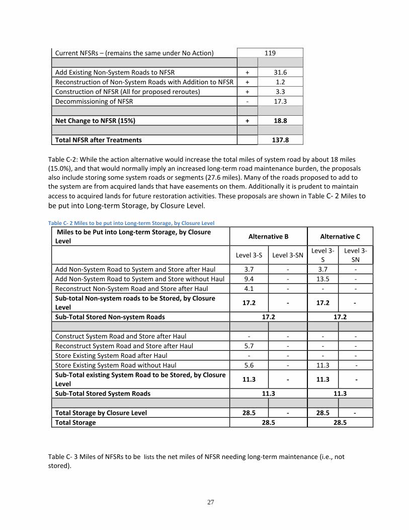
Table C‐2: While the action alternative would increase the total miles of system road by about 18 miles (15.0%), and that would normally imply an increased long‐term road maintenance burden, the proposals also include storing some system roads or segments (27.6 miles). Many of the roads proposed to add to the system are from acquired lands that have easements on them. Additionally it is prudent to maintain
access to acquired lands for future restoration activities. These proposals are shown in Table C‐ 2 Miles to be put into Long‐term Storage, by Closure Level. Table C‐ 2 Miles to be put into Long‐term Storage, by Closure Level
Miles to be Put into Long‐term Storage, by Closure Level
Alternative B Alternative C
Level 3‐S Level 3‐SN Level 3‐
S Level 3‐
SN
Add Non‐System Road to System and Store after Haul 3.7 ‐ 3.7 ‐
Add Non‐System Road to System and Store without Haul 9.4 ‐ 13.5 ‐
Reconstruct Non‐System Road and Store after Haul 4.1 ‐ ‐ ‐
Sub‐total Non‐system roads to be Stored, by Closure Level
17.2 ‐ 17.2 ‐
Sub‐Total Stored Non‐system Roads 17.2 17.2
Construct System Road and Store after Haul ‐ ‐ ‐ ‐
Reconstruct System Road and Store after Haul 5.7 ‐ ‐ ‐
Store Existing System Road after Haul ‐ ‐ ‐ ‐
Store Existing System Road without Haul 5.6 ‐ 11.3 ‐
Sub‐Total existing System Road to be Stored, by Closure Level
11.3 ‐ 11.3 ‐
Sub‐Total Stored System Roads 11.3 11.3
Total Storage by Closure Level 28.5 ‐ 28.5 ‐
Total Storage 28.5 28.5
Table C‐ 3 Miles of NFSRs to be lists the net miles of NFSR needing long‐term maintenance (i.e., not stored).
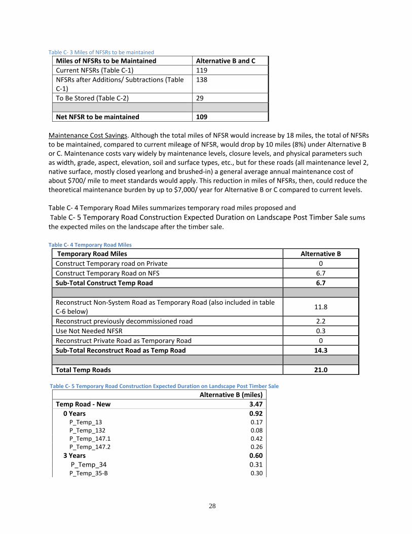
28
Table C‐ 3 Miles of NFSRs to be maintained
Miles of NFSRs to be Maintained Alternative B and C
Current NFSRs (Table C‐1) 119
NFSRs after Additions/ Subtractions (Table C‐1)
138
To Be Stored (Table C‐2) 29
Net NFSR to be maintained 109
Maintenance Cost Savings. Although the total miles of NFSR would increase by 18 miles, the total of NFSRs to be maintained, compared to current mileage of NFSR, would drop by 10 miles (8%) under Alternative B or C. Maintenance costs vary widely by maintenance levels, closure levels, and physical parameters such as width, grade, aspect, elevation, soil and surface types, etc., but for these roads (all maintenance level 2, native surface, mostly closed yearlong and brushed‐in) a general average annual maintenance cost of about $700/ mile to meet standards would apply. This reduction in miles of NFSRs, then, could reduce the theoretical maintenance burden by up to $7,000/ year for Alternative B or C compared to current levels. Table C‐ 4 Temporary Road Miles summarizes temporary road miles proposed and
Table C‐ 5 Temporary Road Construction Expected Duration on Landscape Post Timber Sale sums the expected miles on the landscape after the timber sale.
Table C‐ 4 Temporary Road Miles
Temporary Road Miles Alternative B
Construct Temporary road on Private 0
Construct Temporary Road on NFS 6.7
Sub‐Total Construct Temp Road 6.7
Reconstruct Non‐System Road as Temporary Road (also included in table C‐6 below)
11.8
Reconstruct previously decommissioned road 2.2
Use Not Needed NFSR 0.3
Reconstruct Private Road as Temporary Road 0
Sub‐Total Reconstruct Road as Temp Road 14.3
Total Temp Roads 21.0 Table C‐ 5 Temporary Road Construction Expected Duration on Landscape Post Timber Sale
Alternative B (miles)
Temp Road ‐ New 3.47
0 Years 0.92P_Temp_13 0.17P_Temp_132 0.08P_Temp_147.1 0.42P_Temp_147.2 0.26
3 Years 0.60P_Temp_34 0.31P_Temp_35‐B 0.30
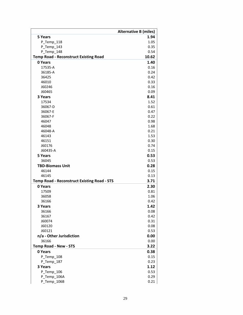
29
Alternative B (miles)5 Years 1.94P_Temp_118 1.05P_Temp_143 0.35P_Temp_148 0.54
Temp Road ‐ Reconstruct Existing Road 10.62
0 Years 1.4017535‐A 0.1636185‐A 0.2436425 0.4246010 0.33J60246 0.16J60465 0.09
3 Years 8.4117534 1.5236067‐D 0.6136067‐E 0.4736067‐F 0.2246047 0.9846048 1.6846048‐A 0.2146143 1.5346151 0.30J60176 0.74J60435‐A 0.15
5 Years 0.5336045 0.53
TBD‐Biomass Unit 0.2846144 0.1546145 0.13
Temp Road ‐ Reconstruct Existing Road ‐ STS 3.71
0 Years 2.3017509 0.8136058 1.0636166 0.42
3 Years 1.4236166 0.0836167 0.42J60074 0.31J60120 0.08J60121 0.53
n/a ‐ Other Jurisdiction 0.0036166 0.00
Temp Road ‐ New ‐ STS 3.22
0 Years 0.38P_Temp_108 0.15P_Temp_187 0.23
3 Years 1.12P_Temp_106 0.53P_Temp_106A 0.29P_Temp_106B 0.21

30
Alternative B (miles)P_Temp_198 0.09
5 Years 1.72P_Temp_127 0.43P_Temp_139.1 1.29
Grand Total 21.02
31
Table C‐ 6 Summary of Road Decommissioning Miles, by Closure Level shows miles of proposed road
decommissioning by closure level. This table does not include new temporary roads or previously
decommissioned roads to be re‐used as temporary roads, shown above in Table C‐4, as those do not result
in a net decrease in roads compared to the existing condition; but the table does include non‐system roads
used as temp roads as they do result in eliminating existing roads. It also includes NOT NEEDED roads which
have not yet been treated or need further treatment, as those are considered as existing roads. Alternative
C increases in decommissioning because existing roads will not be reconstructed then decommissioned with
the timber sale. A complete listing of temporary roads is in APPENDIX A‐ Maps and Tables.
Table C‐ 6 Summary of Road Decommissioning Miles, by Closure Level
Decommissioning
Closure Level
Total Level 2
Level 3-D
Level 3-DN
Level 4 Level 5
System Roads Alt B and C 0 0.5 1.3 0 15.3 17
Non-System Roads Alt B 0 8 47 0 85 140
Non-System Roads Alt C 0 10 48 0 89 147
Total Decommissioning by Closure Level Alt B
0 8.5 48.3 0 100.3 157
Total Decommissioning by Closure Level Alt C
0 10.5 49.3 0 104.3 164
Table C‐ 7 Summary of Total Road Miles after Construction and Decommissioning summarizes the total miles of all roads after construction and decommissioning. Table C‐ 7 Summary of Total Road Miles after Construction and Decommissioning
All Roads (all jurisdictions)
Forest Roads
Alt B Alt C
Existing Roads 346 319 319
Construct System Road for Reroute 3.3 3.3 3.3
Temporary Roads Existing (decom after use)
0.0 10.0 0.0
Decommission 159 159 169
Net Change 155 166 166
Total Roads after Project 191 154 154 Table C‐ 8 Summary of BMPs and Upgrades on System Roads summarizes the mileage of haul and long‐term
BMPs (including stream crossing upgrades) for system roads. Some roads get only haul BMPs (i.e., they are
stored or decommissioned after haul), while some get haul and long‐term BMPs, and others that are neither
used for haul or stored get only long‐term BMPS under the restoration objectives of the project. System
roads to be stored or decommissioned without haul are not included since they would not need either haul
or long‐term maintenance/BMP.
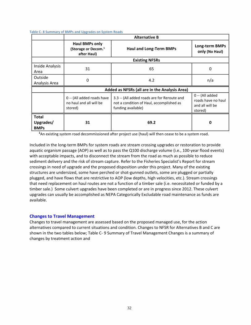
32
Table C‐ 8 Summary of BMPs and Upgrades on System Roads
Alternative B
Haul BMPs only
(Storage or Decom.1 after Haul)
Haul and Long‐Term BMPs Long‐term BMPs only (No Haul)
Existing NFSRs
Inside Analysis Area
31 65 0
Outside Analysis Area
0 4.2 n/a
Added as NFSRs (all are in the Analysis Area)
0 ‐‐ (All added roads have no haul and all will be stored)
3.3 ‐‐ (All added roads are for Reroute and not a condition of Haul, accomplished as funding available)
0 ‐‐ (All added roads have no haul and all will be stored)
Total Upgrades/ BMPs
31 69.2 0
1An existing system road decommissioned after project use (haul) will then cease to be a system road. Included in the long‐term BMPs for system roads are stream crossing upgrades or restoration to provide aquatic organism passage (AOP) as well as to pass the Q100 discharge volume (i.e., 100‐year flood events) with acceptable impacts, and to disconnect the stream from the road as much as possible to reduce sediment delivery and the risk of stream capture. Refer to the Fisheries Specialist’s Report for stream crossings in need of upgrade and the proposed disposition under this project. Many of the existing structures are undersized, some have perched or shot‐gunned outlets, some are plugged or partially plugged, and have flows that are restrictive to AOP (low depths, high velocities, etc.). Stream crossings that need replacement on haul routes are not a function of a timber sale (i.e. necessitated or funded by a timber sale.) Some culvert upgrades have been completed or are in progress since 2012. These culvert upgrades can usually be accomplished as NEPA Categorically Excludable road maintenance as funds are available.
Changes to Travel Management Changes to travel management are assessed based on the proposed managed use, for the action alternatives compared to current situations and condition. Changes to NFSR for Alternatives B and C are shown in the two tables below; Table C‐ 9 Summary of Travel Management Changes is a summary of changes by treatment action and
33
Table C‐ 10 Changes to Travel Management by Action and Road shows changes by specific road/segment as well as by treatment action, and it also discloses changes to administrative access. The current situation
is described in Table AE‐ 5 National Forest System Roads Travel Management and is repeated in Table C‐9. Decreases in Open yearlong or ‘H’ restriction miles represents NFSR miles that become closed or unavailable to motorized use and for this project is due to decommissioning or storage. Changes to Travel Management/Motorized Opportunities by individual road/segment are shown in Table C‐10.
Table C‐ 9 Summary of Travel Management Changes
Total NFSR (miles) Open Yearlong (miles)
Drivable (miles)
H (miles)
Drivable (miles)
Current Situation 119 4.6 4.6 38.9 36.7 Net Changes Alternative B and C
Open Yearlong or Seasonal (miles)
Drivable (miles)
Opened Due to Travel Management Change 0.3 0.3 Opened Due to Construction for Reroute 1.1 0 Opened due to Reconstruction Or Maintenance 1.1 0.13 Sub‐Total Miles Opened 2.5 0.43
Closed due to Travel Management Change 2.46 2.46 Closed Due to Storage 2.55 1.96 Closed Due to Decommissioning 6.11 4.46 Sub‐Total Miles Closed ‐11.12 ‐8.88
NET CHANGE‐8.62 ‐8.45 ‐7.2% ‐7.1%
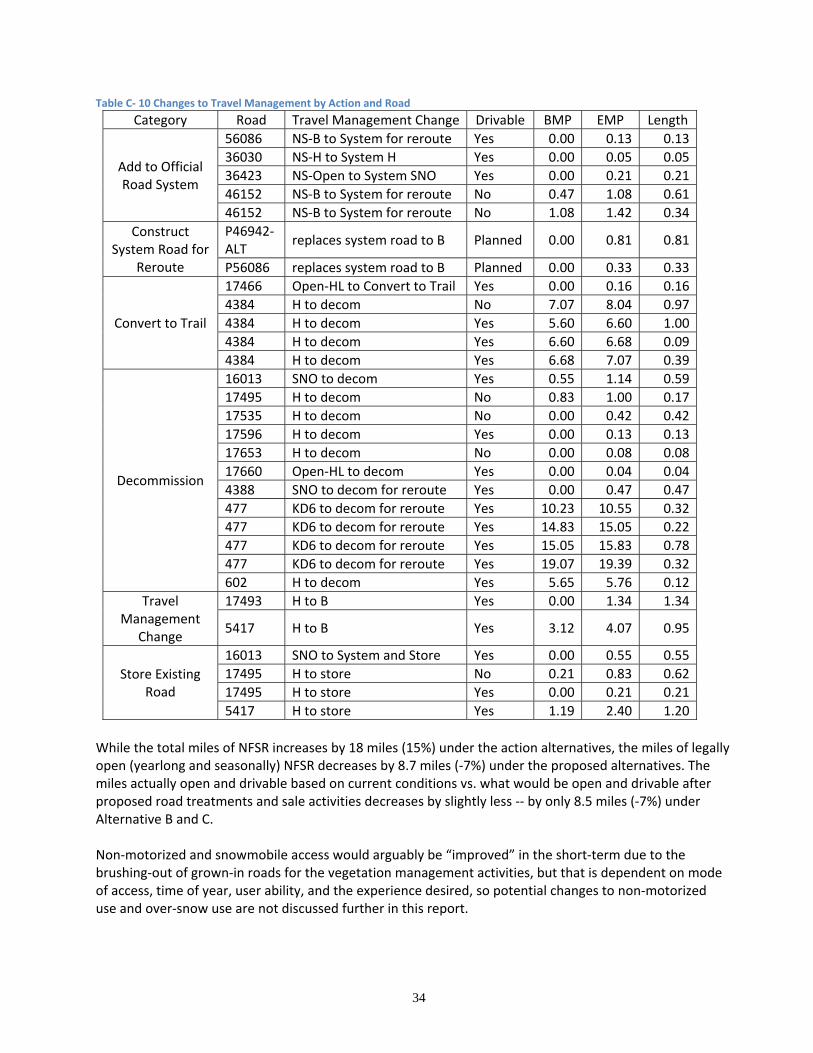
34
Table C‐ 10 Changes to Travel Management by Action and Road
Category Road Travel Management Change Drivable BMP EMP Length
Add to Official Road System
56086 NS‐B to System for reroute Yes 0.00 0.13 0.13
36030 NS‐H to System H Yes 0.00 0.05 0.05
36423 NS‐Open to System SNO Yes 0.00 0.21 0.21
46152 NS‐B to System for reroute No 0.47 1.08 0.61
46152 NS‐B to System for reroute No 1.08 1.42 0.34
Construct System Road for
Reroute
P46942‐ALT
replaces system road to B Planned 0.00 0.81 0.81
P56086 replaces system road to B Planned 0.00 0.33 0.33
Convert to Trail
17466 Open‐HL to Convert to Trail Yes 0.00 0.16 0.16
4384 H to decom No 7.07 8.04 0.97
4384 H to decom Yes 5.60 6.60 1.00
4384 H to decom Yes 6.60 6.68 0.09
4384 H to decom Yes 6.68 7.07 0.39
Decommission
16013 SNO to decom Yes 0.55 1.14 0.59
17495 H to decom No 0.83 1.00 0.17
17535 H to decom No 0.00 0.42 0.42
17596 H to decom Yes 0.00 0.13 0.13
17653 H to decom No 0.00 0.08 0.08
17660 Open‐HL to decom Yes 0.00 0.04 0.04
4388 SNO to decom for reroute Yes 0.00 0.47 0.47
477 KD6 to decom for reroute Yes 10.23 10.55 0.32
477 KD6 to decom for reroute Yes 14.83 15.05 0.22
477 KD6 to decom for reroute Yes 15.05 15.83 0.78
477 KD6 to decom for reroute Yes 19.07 19.39 0.32
602 H to decom Yes 5.65 5.76 0.12
Travel Management
Change
17493 H to B Yes 0.00 1.34 1.34
5417 H to B Yes 3.12 4.07 0.95
Store Existing Road
16013 SNO to System and Store Yes 0.00 0.55 0.55
17495 H to store No 0.21 0.83 0.62
17495 H to store Yes 0.00 0.21 0.21
5417 H to store Yes 1.19 2.40 1.20
While the total miles of NFSR increases by 18 miles (15%) under the action alternatives, the miles of legally open (yearlong and seasonally) NFSR decreases by 8.7 miles (‐7%) under the proposed alternatives. The miles actually open and drivable based on current conditions vs. what would be open and drivable after proposed road treatments and sale activities decreases by slightly less ‐‐ by only 8.5 miles (‐7%) under Alternative B and C. Non‐motorized and snowmobile access would arguably be “improved” in the short‐term due to the brushing‐out of grown‐in roads for the vegetation management activities, but that is dependent on mode of access, time of year, user ability, and the experience desired, so potential changes to non‐motorized use and over‐snow use are not discussed further in this report.
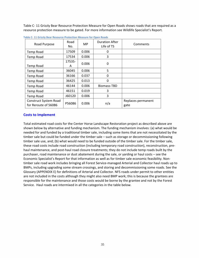
35
Table C‐ 11 Grizzly Bear Resource Protection Measure for Open Roads shows roads that are required as a resource protection measure to be gated. For more information see Wildlife Specialist’s Report.
Table C‐ 11 Grizzly Bear Resource Protection Measure for Open Roads
Road Purpose Road No.
MP Duration After
Life of TS Comments
Temp Road 17509 0.006 0
Temp Road 17534 0.006 3
Temp Road 17535‐
A 0.006 0
Temp Road 36045 0.006 5
Temp Road 36166 0.037 0
Temp Road 36425 0.013 0
Temp Road 46144 0.006 Biomass‐TBD
Temp Road 46151 0.019 3
Temp Road J60120 0.006 3
Construct System Road for Reroute of 56086 P56086 0.006 n/a
Replaces permanent gate
Costs to Implement Total estimated road costs for the Center Horse Landscape Restoration project as described above are shown below by alternative and funding mechanism. The funding mechanism involves: (a) what would be needed for and funded by a traditional timber sale, including some items that are not necessitated by the timber sale but could be funded under the timber sale – such as storage or decommissioning following timber sale use, and; (b) what would need to be funded outside of the timber sale. For the timber sale, these road costs include road construction (including temporary road construction), reconstruction, pre‐haul maintenance, and post‐haul road closure treatments; they do not include temp roads built by the purchaser, road maintenance or dust abatement during the sale, or yarding or haul costs – see the Economic Specialist’s Report for that information as well as for timber sale economic feasibility. Non‐timber sale road work includes bringing all Forest Service‐managed Arterial and Collector haul roads up to BMPs, including upgrading some stream crossings, and storing and decommissioning some roads. See the Glossary (APPENDIX E) for definitions of Arterial and Collector. NFS roads under permit to other entities are not included in the costs although they might also need BMP work; this is because the grantees are responsible for the maintenance and those costs would be borne by the grantee and not by the Forest Service. Haul roads are intermixed in all the categories in the table below.
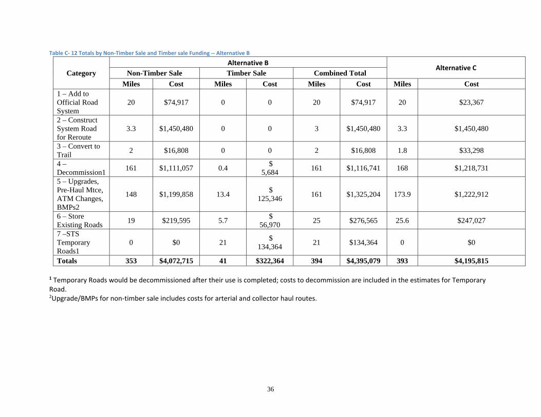
36
Table C‐ 12 Totals by Non‐Timber Sale and Timber sale Funding ‐‐ Alternative B
Category
Alternative B Alternative C
Non-Timber Sale Timber Sale Combined Total
Miles Cost Miles Cost Miles Cost Miles Cost 1 – Add to Official Road System
20 $74,917 0 0 20 $74,917 20 $23,367
2 – Construct System Road for Reroute
3.3 $1,450,480 0 0 3 $1,450,480 3.3 $1,450,480
3 – Convert to Trail
2 $16,808 0 0 2 $16,808 1.8 $33,298
4 – Decommission1
161 $1,111,057 0.4 $
5,684 161 $1,116,741 168 $1,218,731
5 – Upgrades, Pre-Haul Mtce, ATM Changes, BMPs2
148 $1,199,858 13.4 $
125,346 161 $1,325,204 173.9 $1,222,912
6 – Store Existing Roads
19 $219,595 5.7 $
56,970 25 $276,565 25.6 $247,027
7 –STS Temporary Roads1
0 $0 21 $
134,364 21 $134,364 0 $0
Totals 353 $4,072,715 41 $322,364 394 $4,395,079 393 $4,195,815 1 Temporary Roads would be decommissioned after their use is completed; costs to decommission are included in the estimates for Temporary Road. 2Upgrade/BMPs for non‐timber sale includes costs for arterial and collector haul routes.
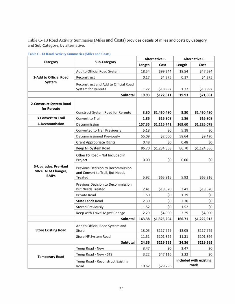
37
Table C- 13 Road Activity Summaries (Miles and Costs) provides details of miles and costs by Category and Sub‐Category, by alternative. Table C- 13 Road Activity Summaries (Miles and Costs)
Category Sub‐Category Alternative B Alternative C
Length Cost Length Cost
1‐Add to Official Road System
Add to Official Road System 18.54 $99,244 18.54 $47,694
Reconstruct 0.17 $4,375 0.17 $4,375
Reconstruct and Add to Official Road System for Reroute 1.22 $18,992 1.22 $18,992
Subtotal 19.93 $122,611 19.93 $71,061
2‐Construct System Road for Reroute
Construct System Road for Reroute 3.30 $1,450,480 3.30 $1,450,480
3‐Convert to Trail Convert to Trail 1.86 $16,808 1.86 $16,808
4‐Decommission Decommission 157.35 $1,116,741 169.60 $1,226,079
5‐Upgrades, Pre‐Haul Mtce, ATM Changes,
BMPs
Converted to Trail Previously 5.18 $0 5.18 $0
Decommissioned Previously 55.09 $2,000 58.64 $9,420
Grant Appropriate Rights 0.48 $0 0.48 $0
Keep NF System Road 86.70 $1,234,368 86.70 $1,124,656
Other FS Road ‐ Not Included in Project 0.00 $0 0.00 $0
Previous Decision to Decommission and Convert to Trail, But Needs Treated 5.92 $65,316 5.92 $65,316
Previous Decision to Decommission But Needs Treated 2.41 $19,520 2.41 $19,520
Private Road 1.50 $0 1.29 $0
State Lands Road 2.30 $0 2.30 $0
Stored Previously 1.52 $0 1.52 $0
Keep with Travel Mgmt Change 2.29 $4,000 2.29 $4,000
Subtotal 163.38 $1,325,204 166.71 $1,222,912
Store Existing Road Add to Official Road System and Store 13.05 $117,729 13.05 $117,729
Store NF System Road 11.31 $101,866 11.31 $101,866
Subtotal 24.36 $219,595 24.36 $219,595
Temporary Road
Temp Road ‐ New 3.47 $0 3.47 $0
Temp Road ‐ New ‐ STS 3.22 $47,116 3.22 $0
Temp Road ‐ Reconstruct Existing Road 10.62 $29,296
included with existing roads
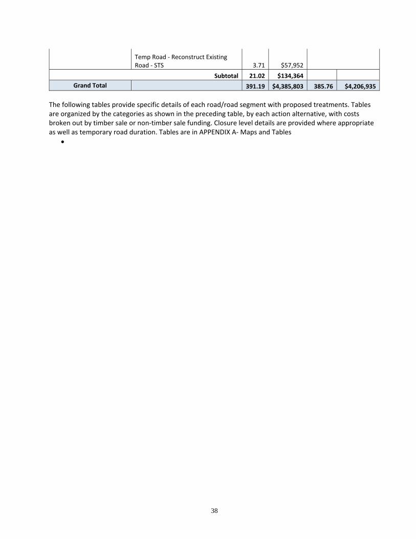
38
Temp Road ‐ Reconstruct Existing Road ‐ STS 3.71 $57,952
Subtotal 21.02 $134,364
Grand Total 391.19 $4,385,803 385.76 $4,206,935
The following tables provide specific details of each road/road segment with proposed treatments. Tables are organized by the categories as shown in the preceding table, by each action alternative, with costs broken out by timber sale or non‐timber sale funding. Closure level details are provided where appropriate as well as temporary road duration. Tables are in APPENDIX A‐ Maps and Tables
39
Table C‐ 20 Add to Official Road System (Existing Non‐system Roads) – Category 1
Table C‐ 21 Construct System Road for Reroute Category 2
Table C‐ 22 Convert Road to Trail – Category 3
Table C‐ 23 Roads to Decommission – Category 4
Table C‐ 25 Existing System Roads to Store – Category 5
Table C‐ 24 Upgrades, Pre‐Haul Maintenance, or BMPs on Existing System Roads to be retained – Category 6
Table C‐ 26 Temporary Roads– Category 7
See the Glossary (APPENDIX E) for Closure Level descriptions. Weed treatments would not be done on 3‐DN or 3‐SN roads; weed infestations on these would be dealt with similarly to general forest weed infestations, with separate NEPA for spraying, etc.
DETAILS ON PROPOSED CONSTRUCTION, RECONSTRUCTION, AND DECOMMISSIONING A brief description of specific planned road construction, reconstruction, and decommissioning follows. (1) Construction of New System Roads – There are 5 reroutes planned for the Center Horse Area listed
below that would be 3.3 miles of Construct system road for reroute and about 2 miles of decommissioning. See Table C‐ 21 Construct System Road for Reroute Category 2 in APPENDIX A‐ Maps and Tables.
(2) Reconstruction of System Roads. No major issues with any reconstruction or heavy maintenance are known, other than following BMPS for water quality protection and following weed management practices.
(3) Proposed Reconstruction of Non‐system roads to Be System Roads. These are typically old logging roads that are generally 10‐14 feet wide, with some narrower sections due to fill or cut slope sloughing or just narrow construction. Some of the roads were actually built to system road standards. Most are currently brushed‐in. There would be a net addition of 17.8 miles of road added to the official road system and reconstructed. Some of which would be specifically for Biomass Haul. However, if the Biomass units do not get accomplished with a Timber Sale the roads would not be reconstructed at that time. When used, besides brushing and grubbing, some would need to be reconstructed in the narrow sections to accommodate logging vehicles. For sections used only for haul, a minimum 10‐foot width is adequate; however, where a yarder must set‐up a minimum of 12‐14 feet would be needed depending on the height of the cutslope. Since these roads would be system roads, any reconstruction of cutslopes would include stable back slopes (typically 1:1); due to vegetative cover and duff on the fill slopes, and the need to avoid loose sliver fills, excavation would need to be placed on the roadbed (or even pushed or end‐hauled) instead of sidecast. Placing cut bank excavation on the roadbed would be cheaper. For the roads to be stored with treatment (3‐S), some brushing may be necessary in order to get equipment in to do the storage work (waterbars, culvert removal, scarification). This would be minor, though, as the equipment can usually walk in on alder, seedlings, and saplings, without much problem.
(4) Non‐system Roads to be used as Temporary Roads. These old logging roads are similar to the non‐system roads described above, except due to the temporary nature, cutslopes could be steeper to reduce excavation. If cutslopes are steepened, it would best if the roads are only used for one season. In other words, the roads need to be stable for their life.
40
(5) Reconstruction of Private Roads to be used for Haul – None Planned
(6) Decommissioning. Most of the non‐system roads to be decommissioned can be decommissioned naturally (level 3‐DN), that is left to continue to grow‐in and “naturalize” on their own. Of these 3‐DN roads, entrance obliterations are not necessary due to the condition of the road (brushed‐in, and/ or bermed) or the condition of the parent road (closed, to be decommissioned or stored). Some of the non‐system roads or segments to be decommissioned are accessed/blocked by private land. The segments are typically very short where they enter NFS land and the prescriptions are closure level 3‐DN. They should be monitored for use and appropriate action taken if use is occurring. Such actions could include requiring SUPs or granting easements on the roads to remain; land conveyance through the Small Tracts Act, obliterating the road entrance with methods that don’t require access across private land, or law enforcement actions. All system roads to be decommissioned would be actively treated, see Closure Level in Appendix E Glossary.
Governmental Permits Needed by Forest Service. Culvert removal or replacement work in live streams would likely require Stream Protection 124 permits and could require Short‐term Turbidity Standard 318 permits from the State of Montana. See APPENDIX C – REGULATORY FRAMEWORK for additional permit information.
COMPATIBILITY OF ACTION ALTERNATIVES WITH FOREST PLAN See APPENDIX B ‐‐ FOREST PLAN DIRECTION RELATING TO THE TRANSPORTATION SYSTEM for Forest Plan Goals and Objectives, Standards, and Management Areas that relate to this project, especially direction regarding road development and management. See the Forest Plan for complete descriptions.
Forest‐wide Goals and Objectives. As discussed earlier in this report, the most applicable Forest‐wide goals and objectives are:
Goal 1. Provide a sustained yield of timber and other outputs at a level that will help support the economic structure of local communities and provide for regional and national needs.
Compatibility of project: The proposed road system has been designed to provide a safe, efficient transportation system for transporting timber as well as providing for public and administrative use.
Goal 4. Provide a pleasing and healthy environment, including clear air, clean water, and diverse ecosystems; and Goal 8. Meet or exceed State water quality standards.
Compatibility of project: The proposed road system, with incorporation of BMPs and engineering recommendations, has been designed to protect or improve the environment, namely water quality.
Objective: Roads will be kept to the minimum number and size needed to support resource management; most roads will be closed when projects are completed to protect resource values. Compatibility of project: The proposed road system has been designed to minimize the amount of roads; many roads were determined to be not needed and are recommended for decommissioning;
41
other roads are identified as temporary roads or roads to be stored to reduce the impact, risk of impact, and the maintenance cost burden from the roads; existing narrow roads to be used would be used without reconstruction to wider roadbeds unless necessary to support the planned vegetative management.
The alternatives specific relationships to Forest‐wide goals and objectives are covered in other specialists’ reports.
Forest‐wide standards. The project has been designed to meet Forest Plan standards for non‐road resources; a brief discussion of the project’s relationship/ compatibility to the most pertinent road standards follows. See other Specialist reports for specific evaluation and quantification.
Standard 15. Following best management practices to protect water quality is a requirement of the project design. Standard 28. Road location, design, construction, maintenance, storage, and decommissioning are proposed and designed to have a minimum impact on the aquatic ecosystem, and most road treatments will enhance the aquatic resource over time. Standard 48. Motorized vehicles are still limited to system roads and trails which are designated open. Standard 49. As described above, the road system is designed to minimize the amount and size of roads while meeting safety, user, and timber access needs. Standard 50. Design recommendations for construction and reconstruction are included to minimize soil disturbance and movement. Best management practices will be incorporated into road design. Standard 51. Cost effective slash treatment will be incorporated, factoring the need for slash filter windrows to protect water ways in disturbed areas. Standard 52. The project is designed to protect resources (namely water and wildlife) while providing administrative access, access specifically for vegetative treatments, and access to landowners and recreationists. The main Arterial and Collector roads will remain open to the public, as well several Local roads. Other roads proposed for storage or decommissioning are generally not open and drivable in their current states. These treatments are proposed in order to meet standards for water quality and wildlife security. Road storage and decommissioning were considered for protection of resources and for reducing maintenance burdens. The public has been involved through public notices and the public will be able to review and comment on the environmental impact statement according to agency policy. This standard includes open road density maximums for highly productive big‐game summer range (1.1 miles of road per section average; values calculated over designated herd‐unit analysis areas), and specifies that all new roads, except arterials, will be closed yearlong in such areas. It also specifies that new roads will be closed to the public yearlong in areas of moderate big‐game summer range, but roads open on the 1984 Travel Plan will remain open.
42
Specific analysis on impacts to elk and other resource values are included in other specialists’ reports.
Management Area Direction. Management Area “road” standards fall into 5 general categories:
General restrictions on roading
Travel management
Forest‐wide estimated average total road densities
Forest‐wide estimated average open road densities
Design and maintenance criteria
General restrictions on roading. MA direction includes guidance on the extent that roads are permitted, such as roads not permitted, roads allowed to pass through the MA to access other areas, or extensive roading of the MA is expected. Table C‐ 14 Center Horse Management Areas with General Restrictions on Road Construction provides information on MAs in the Center Horse Landscape Restoration area that have general roading restrictions. Travel Management. Some Management Areas include general direction on whether roads should be open or closed to the public (for example, arterials will usually remain open while locals will generally be closed). See Table C‐ 15 Forest Plan Direction for Travel Management Where Changes are Proposed Average Total Road Densities. Some of the Management Areas represented in this project – 16, 17, 18, 22, 24, and 25 ‐‐ include standards for estimated Forest‐wide road densities. Such road densities are most appropriately considered in the context of Forest‐wide averages instead of at a project‐level scale, as described in the MA standards. For all these MAs, road construction is permitted as needed to meet the management goals and objectives of the area. Total road densities for the project would decrease, when accomplished, since the total road mileage will decrease by 166 miles due primarily to decommissioning. Average Open Road Densities. Besides Forest‐wide standards for open roads (Standard 50 (c) regarding highly productive big‐game summer range, as described above), one of the represented Management Areas – MA 18 (forested big game winter range) ‐‐ has direction on open roads. As with Forest‐wide road densities, this open road density is most appropriately considered in the context of Forest‐wide averages instead of at a project‐level scale. Nevertheless, for this project, in MA 18, no roads are proposed for construction or addition to the official road system, no roads are proposed for changing from closed to open. Hence, there is no effect on open road density in MA 18. See the Wildlife report for a full discussion of possible effects of the proposals, including effects of open roads in any highly productive summer range that may be present. Design and Maintenance Criteria. Management Area direction generally includes road construction (including location and design) and maintenance practices relating to soil, water, wildlife, and other resource protection; restrictions on the timing of activities is also included. Road decommissioning and storage are not specifically addressed in the MA goals and standards, or elsewhere in the Forest Plan, but can be inferred from references to earthmoving, motorized recreation, resource protection, etc. Hence, decommissioning and storage activities are naturally included as well, particularly when they include actual earthmoving and especially in and around stream and draw crossings. As for water quality protection, the MA direction basically amounts to BMP practices. Travel management guidance is also provided in the MA direction.
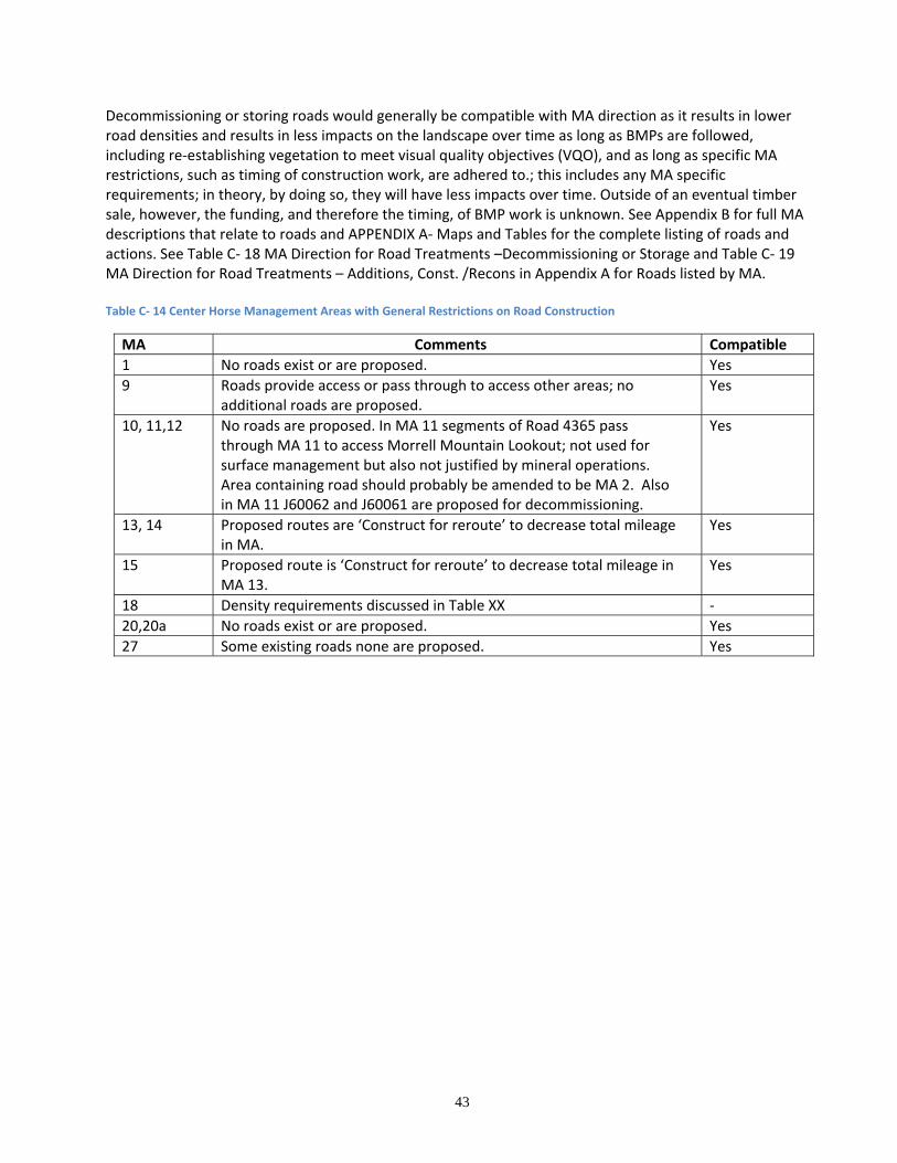
43
Decommissioning or storing roads would generally be compatible with MA direction as it results in lower road densities and results in less impacts on the landscape over time as long as BMPs are followed, including re‐establishing vegetation to meet visual quality objectives (VQO), and as long as specific MA restrictions, such as timing of construction work, are adhered to.; this includes any MA specific requirements; in theory, by doing so, they will have less impacts over time. Outside of an eventual timber sale, however, the funding, and therefore the timing, of BMP work is unknown. See Appendix B for full MA descriptions that relate to roads and APPENDIX A‐ Maps and Tables for the complete listing of roads and actions. See Table C‐ 18 MA Direction for Road Treatments –Decommissioning or Storage and Table C‐ 19 MA Direction for Road Treatments – Additions, Const. /Recons in Appendix A for Roads listed by MA. Table C‐ 14 Center Horse Management Areas with General Restrictions on Road Construction
MA Comments Compatible
1 No roads exist or are proposed. Yes
9 Roads provide access or pass through to access other areas; no additional roads are proposed.
Yes
10, 11,12 No roads are proposed. In MA 11 segments of Road 4365 pass through MA 11 to access Morrell Mountain Lookout; not used for surface management but also not justified by mineral operations. Area containing road should probably be amended to be MA 2. Also in MA 11 J60062 and J60061 are proposed for decommissioning.
Yes
13, 14 Proposed routes are ‘Construct for reroute’ to decrease total mileage in MA.
Yes
15 Proposed route is ‘Construct for reroute’ to decrease total mileage in MA 13.
Yes
18 Density requirements discussed in Table XX ‐
20,20a No roads exist or are proposed. Yes
27 Some existing roads none are proposed. Yes
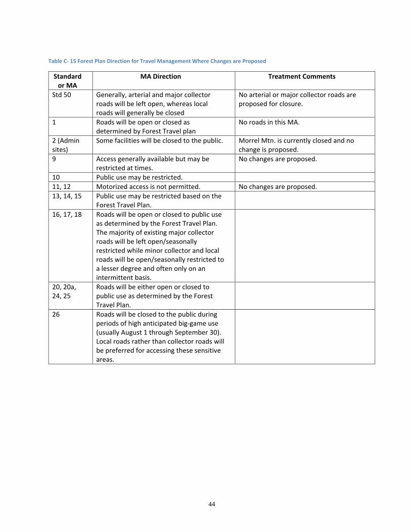
44
Table C‐ 15 Forest Plan Direction for Travel Management Where Changes are Proposed
Standard or MA
MA Direction Treatment Comments
Std 50 Generally, arterial and major collector roads will be left open, whereas local roads will generally be closed
No arterial or major collector roads are proposed for closure.
1 Roads will be open or closed as determined by Forest Travel plan
No roads in this MA.
2 (Admin sites)
Some facilities will be closed to the public. Morrel Mtn. is currently closed and no change is proposed.
9 Access generally available but may be restricted at times.
No changes are proposed.
10 Public use may be restricted.
11, 12 Motorized access is not permitted. No changes are proposed.
13, 14, 15 Public use may be restricted based on the Forest Travel Plan.
16, 17, 18 Roads will be open or closed to public use as determined by the Forest Travel Plan. The majority of existing major collector roads will be left open/seasonally restricted while minor collector and local roads will be open/seasonally restricted to a lesser degree and often only on an intermittent basis.
20, 20a, 24, 25
Roads will be either open or closed to public use as determined by the Forest Travel Plan.
26 Roads will be closed to the public during periods of high anticipated big‐game use (usually August 1 through September 30). Local roads rather than collector roads will be preferred for accessing these sensitive areas.
45
Table C- 16 Average Total Road and Open Road Densities
FOREST LEVEL CENTERHORSE PROJECT
Existing Condition Alternatives
MA ‐ % Slope
Category
AREA (Sq.Miles)
Road Building Forest Plan
Est. (Mi/SqMi)
SYSTEM Roads (Mi)
System Density
(Mi/SqMi)
Winter Range
Open SYS Road (Mi)
Winter Range
Open Road Density
CH MA Area (SqMi)
CH SYSTEM Roads (Mi)
CH SYSTEM Density
(Mi/SqMi)
CH Winter Range
SYS OPEN Roads ‐ (Mi)
(+) SYSTEM Road to be added
(Mi)
(‐) SYSTEM Road to be
decommissioned (Mi)
Net Projected System
Road (Mi)
Net Projected SYSTEM Density
(Mi/SqMi)
1 56.1 Through ‐ 29.0 0.5 ‐ 4.3 0.0 0.0 0.0 0.1 0.0
2 4.0 As Necessary ‐ 15.2 3.8 ‐ 0.3 0.6 2.3 0.6 2.3
9 32.9 As Necessary ‐ 66.5 2.0 ‐ 0.1 0.5 7.5 0.5 7.5
10 18.7 Purpose Dependent ‐ 0.7 0.0 ‐ 0.1 0.0 0.0 0.0
11 272.6 Purpose Dependent ‐ 28.3 0.1 ‐ 17.5 0.6 0.0 0.6 0.0
12 581.0 No ‐ 7.7 0.0 ‐ 90.2 0.0 0.0 0.0
13 225.9 Minimize ‐ 568.5 2.5 ‐ 9.2 20.8 2.3 3.9 ‐4.5 20.2 2.2
14 55.0 Range Improvement ‐ 168.6 3.1 ‐ 1.0 2.2 2.2 0.0 ‐0.4 1.8 1.8
15 1.0 Range Improvement ‐ 1.3 1.3 ‐ 0.6 0.0 1.7 1.7 2.7
16‐0‐40% 496.2 Yes 5.6 1534.1 3.1 ‐ 13.8 34.3 2.5 5.2 ‐3.8 35.8 2.616‐40+% 476.3 Yes 6.7 916.1 1.9 ‐ 15.2 27.9 1.8 1.7 ‐2.7 26.8 1.8
17‐0‐60% 54.0 Yes ‐ Low Density ‐ 124.0 2.3 ‐ 2.3 3.2 1.4 0.0 3.1 1.417‐>60% 25.3 Yes ‐ Low Density 1.5 26.3 1.0 ‐ 0.7 0.1 0.2 0.1 0.2
18‐0‐40% 74.7 Minimize 5.6 292.7 3.9 98.5 1.3 4.3 2.5 0.6 8.7 ‐0.3 11.0 2.518‐>40% 96.4 Minimize 6.7 243.0 2.5 62.5 0.6 0.6 1.0 1.8 1.1 ‐0.2 1.9 3.4
20 100.0 Minimize ‐ 165.8 1.7 ‐ 0.4 0.0 0.0 0.0
20a 43.4 Through ‐ 13.4 0.3 ‐ 0.8 0.0 0.0 0.0
22‐0‐40%* 9.4 As Needed 4.6 31.8 3.4 14.3 1.5 0.14 1.8 12.9 1.8 1.8 12.922‐40‐60%* 5.2 As Needed 4.8 7.9 1.5 2.2 0.4 0.01 0.1 13.0 0.1 0.1 13.022‐>60% 2.7 As Needed 2.8 1.4 0.5 0.3 0.1 0.01 0.0 3.0 0.0 0.0 3.0
24‐0‐40% 36.9 As Needed 4.6 91.4 2.5 ‐ 1.8 0.5 0.3 1.7 ‐0.1 2.2 1.224‐40‐60% 21.6 As Needed 4.8 24.5 1.1 ‐ 0.8 0.6 0.8 2.1 ‐0.4 2.3 3.024‐>60%* 10.3 As Needed 2.8 4.3 0.4 ‐ 0.1 0.2 1.2 0.6 ‐0.2 0.6 4.0
25‐0‐40% 89.2 As Needed 5.6 316.6 3.5 ‐ 6.5 16.6 2.6 6.9 ‐1.3 22.2 3.425‐40‐60% 69.9 As Needed 5.9 119.8 1.7 ‐ 2.5 3.5 1.4 0.6 ‐0.5 3.7 1.525‐>60% 28.1 As Needed 4.2 27.3 1.0 ‐ 1.0 0.5 0.5 0.2 0.6 0.6
26 40.8 Minimize ‐ 79.2 1.9 ‐ 0.2 0.6 3.5 0.6 3.5
27 128.1 Through ‐ 105.0 0.8 ‐ 4.6 2.7 0.6 0.0 2.7 0.6
* -MA 22 and 24 have a disproportionately high system density in the Center Horse project area because they have so little acreage represented in the project area. Of the 61,264 acres there is only 102 acres of MA 22 (0.2%) and 781 acres of MA 24 (1% ).
46
Non‐system roads to be added to the official system: About 16 miles of non‐system roads will be added to the system, 28 miles will be stored; storage by definition includes storm‐proofing, so, as long as BMPs and any applicable timing restrictions are met during storage activities, weeds are treated, and vegetation re‐established, the treatments will be compatible. Closing/ keeping closed these local roads to public motorized use is certainly appropriate for these MAs.
Temporary roads: All new road construction (excluding reroutes) will be temporary and by project design temporary roads will be obliterated (recontoured) after use; again, as long as BMPs, including weed treatments, vegetation re‐establishment, and timing restrictions are met during construction and decommissioning activities, the treatments would be compatible.
Reconstruct System Road, followed by storage: As long as BMPs, including weed treatments and vegetation re‐establishment, are met during reconstruction and storage activities, the treatments would be compatible.
Open system roads proposed for decommissioning or storage: As long as BMPs, including weed treatments and vegetation re‐establishment, are met during treatment activities, the treatments would be compatible with MA standards. Furthermore, these open roads are typically local roads and closing them is appropriate for the MAs; they do not provide access to important destinations.
Travel management. Existing system roads in Center Horse Landscape Restoration are either open or closed based on the Forest Travel Plan. Generally, major collector roads are open and minor collectors and local roads are closed.
MITIGATION. Best Management Practices: Road location, design, construction, and maintenance need to follow best management practices for protecting water quality. For timber haul, this includes providing adequate surface drainage and in some cases replacing culverts that have failed. For restoration activities, this also includes replacing or removing stream crossing structures that are barriers to aquatic organism passage and ensuring that stream crossing structures can adequately pass the design flow (typically Q100) with low risk of failure. Noxious weed control: Ground‐based herbicide treatments are needed along roads currently closed or grown‐in and to be opened for access to treatment areas or for road storage or decommissioning activities. (Herbicide treatments along currently drivable open roads within the analysis area will be done under the Forest Small NEPA procedure, so that weed treatments would be completed prior to implementation of project activities.) Standard weed prevention measures such as washing equipment that will be off‐road and using weed seed‐free fill or gravel also apply.
47
OTHER ANALYSIS AREA TRANSPORTATION SYSTEM CONSIDERATIONS
Timing of Decommission and Storage For some roads, the timing of decommissioning or storage activities in relation to timber sale or other road activities will be important. It is assumed that the timber sale will fund those closure activities on roads that the timber sales uses and that access is not needed later than the end of the timber sale contract (i.e. not used for post‐sale activities). Roads listed below are required as resource protection measures for open road densities for the Grizzly Bear and must be decommissioned prior to any temporary road construction for Alternative B. Table C‐ 17 Timing Issues for Work, Decommissioning or Storage
Road Number
Comments
36047 Prior to opening/utilizing temporary and restricted roads associated with the project for timber harvest, haul or other activities roads would be decommissioned.
36047‐A
36049
36049‐A
602
4397
Work not meeting NCDE‐STD‐AR‐01 on Center Ridge associated with roads would not occur during the same non‐denning grizzly bear season (4/1 – 11/30). Work would not be restricted on these roads during the winter (12/1 – 3/31). See Wildlife Specialist’s report for more information.
17534
48
LIST OF APPENDICES
APPENDIX CONTENT
A MAPS AND TABLES
B FOREST PLAN DIRECTION RELATING TO THE TRANSPORTATION SYSTEM
C REGULATORY FRAMEWORK
D COST ESTIMATING
E GLOSSARY
F CENTER HORSE LANDSCAPE RESTORATION TRAVEL ANALYSIS PROCESS
49
APPENDIX A – MAPS and Tables Maps located in Project File:
Map 1 – 20150417_CenterHorse_TS_Haul_Gates.pdf
Map 2— 20150826_CenterHorse_Haul.pdf Map 3‐‐ 20150826_CenterHorse_MAs.pdf
Tables located in this Appendix:
Table C‐ 18 MA Direction for Road Treatments –Decommissioning or Storage
Table C‐ 19 MA Direction for Road Treatments – Additions, Const. /Recons
Table C‐ 21 Construct System Road for Reroute Category 2
Table C‐ 22 Convert Road to Trail – Category 3
Table C‐ 23 Roads to Decommission – Category 4
Table C‐ 24 Upgrades, Pre‐Haul Maintenance, or BMPs on Existing System Roads to be retained – Category 6
Table C‐ 25 Existing System Roads to Store – Category 5
Table C‐ 26 Temporary Roads– Category 7

50
Table AE‐ 10 Listing of National Forest System Roads
51
Road Number
Road Name BMP EMP Length In PA
ATM Code
TM Device
Drivable
Functional Class
Status Current System
16005 SECTION 2 SPUR 0 2.92 2.92 B boulders Yes local Existing NFSR
16006 SOUTH FACE SPUR 0 1.52 1.52 B entr oblit no local Existing NFSR
16013 SPRING CREEK SPUR 0 0.545 0.545 SNO none Yes local Existing NFSR
0.545 1.138 0.593 SNO none Yes local Existing NFSR
16014 DEER CREEK SPUR 0 1.25 1.25 B gate Yes local Existing NFSR
16015 COW SPUR 0 0.141 0.141 SNO none Yes local Existing NFSR
0.141 2.095 1.954 B gate Yes local Existing NFSR
16082 MONT‐DUN 0 0.43 0.43 OPEN‐HL
none Yes local Existing NFSR
16341 LITTLE BLACK 0 0.822 0.822 B gate Yes local Existing NFSR
0.822 1.13 0.308 B gate Yes local Existing NFSR
16376 BLACK COTTONWOOD
0 2.068 2.068 B gate Yes local Existing NFSR
2.068 2.877 0.809 B gate Yes local Existing NFSR
16377 WEST DRY 0 2.31 2.31 B gate Yes local Existing NFSR
16538 DRY SHANLEY 0 1.83 1.83 B gate Yes local Existing NFSR
17465 MONT‐DUN DITCH EAST
0 0.706 0.706 B gate/ private land
Yes local Existing NFSR
0.706 1.069 0.363 B gate/ private land
Yes n/a Existing NFSR
17466 PACKER SPUR 0 0.034 0.034 SNO none Yes local Existing NFSR
0.034 0.163 0.129 SNO none Yes local Existing NFSR
17493 PANTHER SPUR 0 1.34 1.34 H gates Yes local Existing NFSR
17494 SECTION 15 SPUR 0 0.42 0.42 B gate no local Existing NFSR
17495 RAINBOW SPUR 0 0.21 0.21 H gates Yes local Existing NFSR
0.21 0.83 0.62 H gates no local Existing NFSR
0.83 1 0.17 H gates no local Existing NFSR
17500 CLEARCUT SPUR 0 0.4 0.4 B gate no local Existing NFSR
17503 BLACK CANYON SPUR
0 0.114 0.114 B berm no local Existing/ Stored NFSR
0.114 0.14 0.026 B berm no local Existing/ Stored NFSR
0.14 1.48 1.34 B berm/ crossing pulled
no local Existing/ Stored NFSR
17507 Remmick Spur 0 0.895 0.895 SNO none Yes local Existing NFSR
0.895 2.2 1.305 B gate Yes local Existing NFSR
2.2 2.718 0.518 B gate Yes local Existing NFSR
17508 TINY SHANLEY 0 1.343 1.343 B gate no local Existing NFSR
1.343 2.492 1.149 B gate no local Existing NFSR
17512 DUNHAM DITCH 0 0.116 0.116 SNO none Yes collector Existing NFSR
0.116 2.164 2.048 B gate Yes collector Existing NFSR
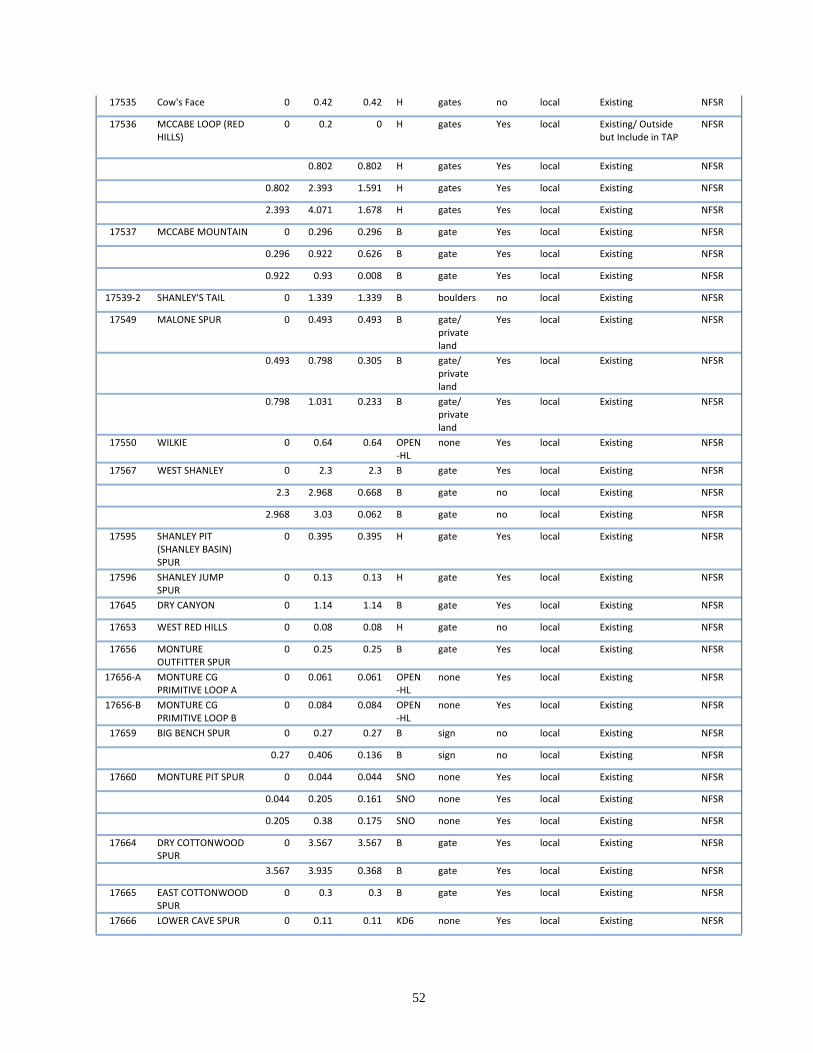
52
17535 Cow's Face 0 0.42 0.42 H gates no local Existing NFSR
17536 MCCABE LOOP (RED HILLS)
0 0.2 0 H gates Yes local Existing/ Outside but Include in TAP
NFSR
0.802 0.802 H gates Yes local Existing NFSR
0.802 2.393 1.591 H gates Yes local Existing NFSR
2.393 4.071 1.678 H gates Yes local Existing NFSR
17537 MCCABE MOUNTAIN 0 0.296 0.296 B gate Yes local Existing NFSR
0.296 0.922 0.626 B gate Yes local Existing NFSR
0.922 0.93 0.008 B gate Yes local Existing NFSR
17539‐2 SHANLEY'S TAIL 0 1.339 1.339 B boulders no local Existing NFSR
17549 MALONE SPUR 0 0.493 0.493 B gate/ private land
Yes local Existing NFSR
0.493 0.798 0.305 B gate/ private land
Yes local Existing NFSR
0.798 1.031 0.233 B gate/ private land
Yes local Existing NFSR
17550 WILKIE 0 0.64 0.64 OPEN‐HL
none Yes local Existing NFSR
17567 WEST SHANLEY 0 2.3 2.3 B gate Yes local Existing NFSR
2.3 2.968 0.668 B gate no local Existing NFSR
2.968 3.03 0.062 B gate no local Existing NFSR
17595 SHANLEY PIT (SHANLEY BASIN) SPUR
0 0.395 0.395 H gate Yes local Existing NFSR
17596 SHANLEY JUMP SPUR
0 0.13 0.13 H gate Yes local Existing NFSR
17645 DRY CANYON 0 1.14 1.14 B gate Yes local Existing NFSR
17653 WEST RED HILLS 0 0.08 0.08 H gate no local Existing NFSR
17656 MONTURE OUTFITTER SPUR
0 0.25 0.25 B gate Yes local Existing NFSR
17656‐A MONTURE CG PRIMITIVE LOOP A
0 0.061 0.061 OPEN‐HL
none Yes local Existing NFSR
17656‐B MONTURE CG PRIMITIVE LOOP B
0 0.084 0.084 OPEN‐HL
none Yes local Existing NFSR
17659 BIG BENCH SPUR 0 0.27 0.27 B sign no local Existing NFSR
0.27 0.406 0.136 B sign no local Existing NFSR
17660 MONTURE PIT SPUR 0 0.044 0.044 SNO none Yes local Existing NFSR
0.044 0.205 0.161 SNO none Yes local Existing NFSR
0.205 0.38 0.175 SNO none Yes local Existing NFSR
17664 DRY COTTONWOOD SPUR
0 3.567 3.567 B gate Yes local Existing NFSR
3.567 3.935 0.368 B gate Yes local Existing NFSR
17665 EAST COTTONWOOD SPUR
0 0.3 0.3 B gate Yes local Existing NFSR
17666 LOWER CAVE SPUR 0 0.11 0.11 KD6 none Yes local Existing NFSR
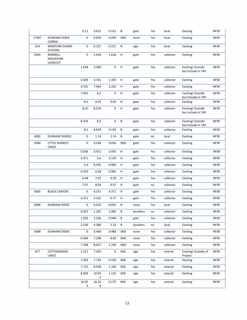
53
0.11 0.622 0.512 B gate Yes local Existing NFSR
17697 DUNHAM CREEK CORRAL
0 0.059 0.059 SNO none Yes local Existing NFSR
323 MONTURE GUARD STATION
0 0.221 0.221 B sign Yes local Existing NFSR
4365 MORRELL MOUNTAIN LOOKOUT
0 1.618 1.618 H gate Yes collector Existing NFSR
1.618 3.309 0 H gate Yes collector Existing/ Outside
but Include in TAP NFSR
3.309 4.701 1.392 H gate Yes collector Existing NFSR
4.701 7.943 3.242 H gate Yes collector Existing NFSR
7.943 8.2 0 H gate Yes collector Existing/ Outside
but Include in TAP NFSR
8.2 8.25 0.05 H gate Yes collector Existing NFSR
8.25 8.376 0 H gate Yes collector Existing/ Outside but Include in TAP
NFSR
8.376 8.5 0 B gate Yes collector Existing/ Outside but Include in TAP
NFSR
8.5 8.639 0.139 B gate Yes collector Existing NFSR
4382 DUNHAM SADDLE 0 1.14 1.14 B gate no local Existing NFSR
4384 LITTLE SHANLEY CREEK
0 0.036 0.036 SNO gate Yes collector Existing NFSR
0.036 3.471 3.435 H gate Yes collector Existing NFSR
3.471 5.6 2.129 H gate Yes collector Existing NFSR
5.6 6.595 0.995 H gate Yes collector Existing NFSR
6.595 6.68 0.085 H gate Yes collector Existing NFSR
6.68 7.07 0.39 H gate Yes collector Existing NFSR
7.07 8.04 0.97 H gate no collector Existing NFSR
4385 BLACK CANYON 0 4.371 4.371 H gate Yes collector Existing NFSR
4.371 5.141 0.77 H gate Yes collector Existing NFSR
4386 DUNHAM RIDGE 0 0.033 0.033 B none Yes local Existing NFSR
0.207 1.292 1.085 B boulders no collector Existing NFSR
1.292 2.236 0.944 B gate Yes collector Existing NFSR
2.236 4.386 2.15 B boulders no local Existing NFSR
4388 DUNHAM CREEK 0 0.468 0.468 SNO none Yes collector Existing NFSR
0.468 7.298 6.83 SNO none Yes collector Existing NFSR
7.298 8.627 1.329 SNO none Yes collector Existing NFSR
477 COTTONWOOD LAKES
1.227 7.203 0 KD6 sign Yes arterial Existing/ Outside of Project
NFSR
7.203 7.732 0.529 KD6 sign Yes arterial Existing NFSR
7.732 8.928 1.196 KD6 sign Yes arterial Existing NFSR
8.928 10.053
1.125 KD6 sign Yes arterial Existing NFSR
10.053
10.228
0.175 KD6 sign Yes arterial Existing NFSR
54
10.22
8 10.55 0.322 KD6 sign Yes arterial Existing NFSR
10.55 14.82
9 4.279 KD6 sign Yes arterial Existing NFSR
14.82
9 15.04
9 0.22 KD6 sign Yes arterial Existing NFSR
15.049
15.827
0.778 KD6 sign Yes arterial Existing NFSR
15.82
7 19.07
3 3.246 KD6 sign Yes arterial Existing NFSR
19.07
3 19.39
1 0.318 KD6 sign Yes arterial Existing NFSR
19.39
1 20.05
3 0.662 KD6 sign Yes arterial Existing NFSR
20.05
3 20.15
2 0.099 OPEN
‐HL none Yes arterial Existing NFSR
5401 MCCABE CREEK 0 1.263 0 KD6 none Yes collector Existing/ Outside but Include in TAP
NFSR
1.263 2.578 1.315 KD6 none Yes collector Existing NFSR
2.578 3.635 1.057 KD6 none Yes collector Existing NFSR
3.635 3.815 0.18 KD6 none Yes collector Existing NFSR
3.815 4.743 0.928 B gate Yes collector Existing NFSR
5405 MONTURE CAMPGROUND/ TRAILHEAD
0 0.707 0.707 OPEN‐HL
none Yes local Existing NFSR
5412 COTTONWOOD RIDGE
0 2.411 2.411 H gate Yes collector Existing NFSR
5417 SOUTH COTTONWOOD
0 0.078 0 SNO gates Yes collector Existing/ Outside but Include in TAP
NFSR
0.078 0.136 0 H gates Yes collector Existing/ Outside but Include in TAP
NFSR
0.136 0.332 0.196 H gates Yes collector Existing NFSR
0.332 0.445 0 H gates Yes collector Existing/ Outside but Include in TAP
NFSR
0.445 1.194 0.749 H gates Yes collector Existing NFSR
1.194 2.395 1.201 H gates Yes collector Existing NFSR
2.395 3.12 0.725 H gates Yes collector Existing NFSR
3.12 4.07 0.95 H gates Yes collector Existing NFSR
4.07 6.503 2.433 SNO none Yes collector Existing NFSR
602 SHANLEY CREEK 0 5.646 5.646 H gate Yes collector Existing NFSR
5.646 5.761 0.115 H gate Yes collector Existing NFSR
89 MONTURE 1.71 2.754 0 P‐OR none Yes n/a Existing/ Outside of Project
NFSR
5.062 7.005 1.943 OPEN‐HL
none Yes arterial Existing NFSR
9976 LOWER COTTONWOOD
0 1.082 0 OPEN‐HL
none Yes collector Existing/ Outside but Include in TAP
NFSR
1.082 3.33 2.248 KD6 none Yes collector Existing NFSR

55
Table AE‐ 11 Forest Service Undetermined Roads
56
Road Number Road Name BMP EMP
Length In PA
ATM Code TM Device
Drivable
Functional Class Status
Current System
16013 SPRING CREEK SPUR 1.138 1.635 0.497 NS‐Open none Yes n/a Existing UND
16082‐A MONT‐DUN "Y" INTERSECTION 0 0.06 0.06 NS‐K sign Yes n/a Existing UND
17465‐A MONT‐DUN DITCH EAST 0 0.223 0.223 NS‐B gate/ private land Yes n/a Existing UND
0.223 0.543 0.32 NS‐B gate/ private land no n/a Existing UND
17465‐B MONT‐DUN DITCH CONNECTION 0 0.048 0.048 NS‐B gate/ private land Yes n/a Existing UND
17493 PANTHER SPUR 1.34 1.61 0.27 NS‐H gates Yes n/a Existing UND
17494 SECTION 15 SPUR 0.42 1.33 0.91 NS‐B gate no n/a Existing UND
17500 CLEARCUT SPUR 0.4 1.53 1.13 NS‐B gate no n/a Existing UND
17507 SEC. 11 N. FK. COTTONWOOD SPUR ("Remmick") 2.718 2.826 0.108 NS‐B gate no n/a Existing UND
17535 Cow's Face 0.42 1.35 0.93 NS‐H gates no n/a Existing UND
17537 MCCABE MOUNTAIN 0.93 1.062 0.132 NS‐B gate no n/a Existing UND
17539‐2 SHANLEY'S TAIL 1.339 1.432 0.093 NS‐B boulders no n/a Existing UND
17659 BIG BENCH SPUR 0.406 0.545 0.139 NS‐B sign no n/a Existing UND
0.545 0.7 0.155 NS‐B sign no n/a Existing UND
17660 MONTURE PIT SPUR 0.38 0.51 0.13 NS‐B log barrier no n/a Existing UND
36011 (blank) 0 0.63 0.63 NS‐H gate no n/a Existing UND
36011‐A Cottonwood Cr Sec. 9 ‐ south of BLM 0 0.21 0.21 NS‐H (blank) no n/a Existing UND
36030 Yurt Road Morrell Mtn Sec. 35 0 0.05 0.05 NS‐H gate Yes n/a Existing UND
0.05 0.692 0.642 NS‐H gate no n/a Existing UND
36031 Morrell Mtn Sec. 35 0 0.598 0.598 NS‐H gate no n/a Existing UND
0.598 0.87 0 NS‐H gate no n/a
Existing/ Outside but Include in TAP UND
36038 Morrell Mtn Sec. 3 0 0.078 0 NS‐H gate/ entr oblit no n/a
Existing/ Outside but Include in TAP UND
0.078 0.313 0.235 NS‐H gate/ entr oblit no n/a Existing UND
36039 Morrell Mtn Sec. 35 0 1.54 1.54 NS‐H gate no n/a Existing UND
36040 Cottonwood Lakes SW 1/4 Sec. 3 0 0.25 0.25 NS‐H gates no n/a Existing UND
36040‐A Cottonwood Lakes SW 1/4 Sec. 3 0 0.146 0.146 NS‐H gates No n/a Existing UND
36041 DISPERSED REC Morrell Mtn 0 0.21 0.21 NS‐B berm both ends no n/a Existing UND
36042 Cottonwood Creek Sec. 2 0 0.102 0.102 NS‐A berm / pvt land no n/a Existing UND
36043 LITTLE SHANLEY SEC. 8 0 0.8 0.8 NS‐H gates no n/a Existing UND
36044 LITTLE SHANLEY SEC. 8 0 0.49 0.49 NS‐H gates no n/a Existing UND
36045 LITTLE SHANLEY SEC. 18 0 0.532 0.532 NS‐H gates no n/a Existing UND
0.532 1.92 1.388 NS‐H gates no n/a Existing UND
36045‐A LITTLE SHANLEY SEC. 18 0 0.05 0.05 NS‐H gates no n/a Existing UND
36047 SHANLEY CR. SEC. 4 0.304 1.285 0.981 NS‐H gate no n/a Existing UND
SHANLEY CR. SEC. 4/ TRAIL 405 0 0.304 0.304 NS‐H gate no n/a Existing UND
36047‐A Shanley Cr Sec. 4 0 0.42 0.42 NS‐H gate no n/a Existing UND
36048 SHANLEY CR. SEC. 4/ TRAIL 405 0 0.91 0.91 NS‐H gate no n/a Existing UND
36049 SHANLEY CR. SEC. 4 0 0.463 0.463 NS‐H gate no n/a Existing UND
57
36049‐A SHANLEY CR. SEC. 4 0 0.315 0.315 NS‐H gate no n/a Existing UND
36058 Dunham Center Ridge Sec. 25 0 1.06 1.06 NS‐B gate no n/a Existing UND
1.06 1.29 0.23 NS‐B (blank) no n/a Existing UND
36058‐A Dunham Center Ridge Sec. 25 0 0.093 0.093 NS‐B (blank) no n/a Existing UND
36059 Dunham Center Ridge Sec. 25 0 0.202 0.202 NS‐B (blank) no n/a Existing UND
36060 Dunham Center Ridge Sec. 36 (Old Lookout Road) 0 1.06 1.06 NS‐B gate no n/a Existing UND
36061 Dunham Center Ridge Sec. 36 0 0.264 0.264 NS‐B gate no n/a Existing UND
0.264 0.392 0.128 NS‐B gate no n/a Existing UND
36062 West Dunham Sec. 2 0 0.37 0.37 NS‐B (blank) no n/a Existing UND
36063 Shanley Creek Sec. 16 0 1.28 1.28 NS‐F entr oblit and Gate no n/a Existing UND
36068 EAST DUNHAM CR SEC. 19 0 0.082 0.082 NS‐Open none no n/a Existing UND
0.082 0.22 0.138 NS‐K none no n/a Existing UND
36069 EAST DUNHAM CR SEC. 19 0 0.067 0.067 NS‐B entr oblit no n/a Existing UND
36069‐A EAST DUNHAM CR SEC. 19 0 0.314 0.314 NS‐B none no n/a Existing UND
36069‐B EAST DUNHAM CR SEC. 19 0 0.468 0.468 NS‐K none no n/a Existing UND
36071 Cottonwood Creek Sec. 11 Disp 0 0.12 0.12 NS‐K (blank) Yes n/a Existing UND
0.12 0.143 0.023 NS‐K (blank) Yes n/a Existing UND
36072 (blank) 0 0.052 0.052 NS‐B (blank) no n/a Existing UND
36074 (blank) 0 0.68 0.68 NS‐B (blank) no n/a Existing UND
36076 (blank) 0 0.21 0.21 NS‐Open none Yes n/a Existing UND
0.21 0.316 0.106 NS‐B berm no n/a Existing UND
36125 (blank) 0 0.185 0.185 NS‐B berm no n/a Existing UND
36166 South Monture Sec. 32 0.034 0.116 0.082 NS‐Open none no n/a Existing UND
0.116 0.54 0.424 NS‐Open none no n/a Existing UND
36167 South Monture Sec. 32 0 0.424 0.424 NS‐Open none Yes n/a Existing UND
0.424 0.44 0.016 NS‐Open none Yes n/a Existing UND
36168 Black Canyon Sec. 20 0 0.651 0.651 NS‐H none no n/a Existing UND
36174 South Monture Sec. 32 0 0.057 0.057 NS‐Open none Yes n/a Existing UND
36177 Spring Cr Sec. 9 South of BLM 0 0.61 0.61 NS‐H (blank) no n/a Existing UND
36190 McCabe Sec. 34 0 0.341 0.341 NS‐B gate/ entr oblit no n/a Existing UND
36190‐C McCabe Mtn 17537 Jammer Sec 34 0 0.163 0.163 NS‐B gate/ entr oblit no n/a Existing UND
36272 Spring/ Cottonwood Cr. Sec. 11 0 0.1 0.1 NS‐B none Yes n/a Existing UND
0.1 0.939 0.839 NS‐B Breached Rocks no n/a Existing UND
36272‐A Spring/ Cottonwood Cr. Sec. 11 0 0.133 0.133 NS‐B boulders no n/a Existing UND
36273 Spring/ Cottonwood Cr. Sec. 13 0 0.504 0.504 NS‐K gate Yes n/a Existing UND
0.504 0.834 0.33 NS‐K gate no n/a Existing UND
0.834 1.033 0.199 NS‐K gate/ berm no n/a Existing UND
1.033 1.618 0.585 NS‐K gate/ berm no n/a Existing UND
36273‐A Spring/ Cottonwood Cr. Sec. 13 0 0.599 0.599 NS‐K gates Yes n/a Existing UND
36273‐B Spring/ Cottonwood Cr. Sec. 13 0 0.303 0.303 NS‐K gates Yes n/a Existing UND
36273‐C Spring Cottonwood Cr. Sec. 13 0 0.222 0.222 NS‐Open none Yes n/a Existing UND
36273‐D Spring/ Cottonwood Cr. Sec. 13 0 0.32 0.32 NS‐K (blank) Yes n/a Existing UND
36274 Spring/ Cottonwood Cr. Sec. 13 0 0.1 0.1 NS‐K (blank) no n/a Existing UND
58
36275 Spring/ Cottonwood Cr. Sec. 13 0 0.467 0.467 NS‐K gate/ berm no n/a Existing UND
36276 N. Fork Cottonwood NW 1/4 Sec. 12 0.128 0.272 0.144 N‐YL (blank) no n/a Existing UND
0.541 0.702 0.161 N‐YL (blank) no n/a Existing UND
0.796 1.005 0.209 N‐YL (blank) no n/a Existing UND
1.12 1.185 0.065 N‐YL (blank) no n/a Existing UND
36276‐A access to pvt 0 0.029 0.029 N‐YL (blank) no n/a Existing UND
36277 McCabe NW 1/4 Sec. 33 0 0.425 0.425 NS‐B gate/ berm no n/a Existing UND
36277‐A McCabe SW 1/4 Sec. 28 0 0.271 0.271 NS‐H gates no n/a Existing UND
36370 Tiny Shanley Sec. 18 0 0.267 0.267 NS‐B gate no n/a Existing UND
36371 Tiny Shanley Sec. 18 0 0.047 0.047 NS‐B gate Yes n/a Existing UND
36371‐A Tiny Shanley Sec. 18 0 0.042 0.042 NS‐B gate no n/a Existing UND
36373 Little Shanley Sec 13 0 0.229 0.229 NS‐B none no n/a Existing UND
36374 Tiny Shanley Sec. 13 0 0.176 0.176 NS‐B gate no n/a Existing UND
36422 McCabe Cr. Sec. 33 0 1.045 1.045 NS‐B
sign, entr oblit, and berm no n/a Existing UND
36423 McCabe Cr. Bench Hunting Camp Sec. 34 0 0.205 0.205 NS‐K none Yes n/a Existing UND
36425 Dry Cottonwood Sec. 21 0 0.418 0.418 NS‐B berm no n/a Existing UND
0.418 0.56 0.142 NS‐B berm no n/a Existing UND
36447 Tiny Shanley Sec. 18 0 0.359 0.359 NS‐B gate no n/a Existing UND
36448 Tiny Shanley Sec. 18 0 0.213 0.213 NS‐B gate no n/a Existing UND
36449 Tiny Shanley Sec. 18 0 0.104 0.104 NS‐B gate no n/a Existing UND
36469 COTTONWOOD LAKE PRIMITIVE BOAT LAUNCH 0 0.037 0.037 NS‐K (blank) Yes n/a Existing UND
36471 McCabe Sec. 34 0 0.112 0.112 NS‐B sign no n/a Existing UND
36471‐A McCabe Sec. 34 0 0.142 0.142 NS‐B sign no n/a Existing UND
36471‐B McCabe Sec. 34 0 0.152 0.152 NS‐B sign no n/a Existing UND
36510 Dunham Center Ridge Sec. 36 0 0.207 0.207 NS‐B gate no n/a Existing UND
36511 Lower Monture Sec. 29 Woodcutters 0 0.158 0.158 N/A (blank) Yes n/a Existing UND
36512 Lower Monture Sec. 29 Woodcutters 0 0.041 0.041 N/A (blank) Yes n/a Existing UND
36515 DISPERSED REC MONTURE CRK 0 0.057 0.057 NS‐Open (blank) Yes n/a Existing UND
0.057 0.193 0.136 NS‐Open (blank) Yes n/a Existing UND
36516 DISPERSED REC MONTURE CRK 0 0.042 0.042 NS‐Open (blank) Yes n/a Existing UND
36999 DISPERSED REC DUNHAM CREEK 0 0.057 0.057 NS‐K (blank) Yes n/a Existing UND
0.057 0.128 0.071 NS‐K (blank) Yes n/a Existing UND
46000 KOZY KORNER SEC. 27 ACCESS 0.381 0.436 0.055 NS‐B none Yes n/a Existing UND
2.5 3.216 0.716 NS‐B gate Yes n/a Existing UND
46010 COTTONWOOD LAKES SEC. 3 0 0.25 0.25 NS‐H gate Yes n/a Existing UND
0.25 0.326 0.076 NS‐H gate no n/a Existing UND
0.326 0.382 0.056 NS‐H gate no n/a Existing UND
46011 (blank) 0 0.725 0.725 NS‐H gate no n/a Existing UND
46011‐A (blank) 0 0.799 0.799 NS‐H gate no n/a Existing UND
46011‐B Cottonwood Creek Sec. 2 0 0.093 0.093 NS‐H gate no n/a Existing UND
46011‐C (blank) 0 0.094 0.094 NS‐H gate no n/a Existing UND
46047 (blank) 0 0.978 0.978 NS‐B gate no n/a Existing UND
46048 (blank) 0 1.1 1.1 NS‐B gate at 46047 Yes n/a Existing UND
1.1 1.23 0.13 NS‐B gate at 46047 Yes n/a Existing UND
59
1.23 1.68 0.45 NS‐B gate at 46047 Yes n/a Existing UND
46048‐A (blank) 0 0.21 0.21 NS‐B gate at 46047 Yes n/a Existing UND
46082 (blank) 1.647 1.695 0.048 N‐YL gate/ private land Yes n/a Existing UND
1.695 3.092 1.397 NS‐B gate/ private land Yes n/a Existing UND
46082‐A McCabe Sec. 35 0 0.3 0.3 NS‐B gate/ private land Yes n/a Existing UND
0.3 0.56 0.26 NS‐B gate/ private land no n/a Existing UND
46082‐B McCabe Sec. 35 0 0.066 0.066 NS‐B gate/ private land Yes n/a Existing UND
46082‐C McCabe Sec. 35 0 0.112 0.112 NS‐B gate/ private land no n/a Existing UND
46083 (blank) 0 1.383 1.383 NS‐B gate/ private land Yes n/a Existing UND
1.383 2.107 0.724 NS‐B gate/ private land Yes n/a Existing UND
46083‐A (blank) 0 0.086 0.086 NS‐B gate/ private land no n/a Existing UND
46084 (blank) 0 0.845 0.845 NS‐B gate/ private land Yes n/a Existing UND
46085 (blank) 0 0.1 0.1 NS‐B gate/ private land Yes n/a Existing UND
0.1 0.2 0.1 NS‐B gate/ private land no n/a Existing UND
0.2 0.27 0.07 NS‐B gate/ private land no n/a Existing UND
0.27 0.389 0.119 NS‐B gate/ private land no n/a Existing UND
46086 (blank) 0 0.255 0.255 NS‐B gate/ private land no n/a Existing UND
46089‐B (blank) 0.442 0.54 0.098 NS‐B gate/ private land no n/a Existing UND
46090 (blank) 0 0.753 0.753 NS‐B gate/ private land Yes n/a Existing UND
46090‐A Mollet Park/ Dick Cr Sec. 34 1.039 1.216 0.177 N‐YL gate/ private land no n/a Existing UND
46090‐B Mollet Park/ Dick Cr Sec. 34 1.071 1.311 0.24 N‐YL gate/ private land no n/a Existing UND
46091 (blank) 0 0.068 0.068 NS‐B gate/ private land Yes n/a Existing UND
46092 (blank) 0 0.131 0.131 NS‐B gate/ private land Yes n/a Existing UND
46093 MCCABE SECTIONS 3/ 34 0.528 1.16 0.632 NS‐B none no n/a Existing UND
46094‐A McCabe Sec. 34 0.057 0.107 0.05 N‐YL gate/ private land Yes n/a Existing UND
46095 (blank) 0.203 0.83 0.627 NS‐B gate/ pvt land/ berm no n/a Existing UND
46095‐A MCCABE SW 1/4 SEC. 34 0 0.271 0.271 NS‐B
berm (1 dir.) and gate on pvt land no n/a Existing UND
46095‐B MCCABE SW 1/4 SEC. 34 0 0.185 0.185 NS‐B
berm (1 dir.) and gate on pvt land no n/a Existing UND
60
46095‐C MCCABE SW 1/4 SEC. 34 0 0.059 0.059 NS‐B
berm (1 dir.) and gate on pvt land no n/a Existing UND
46095‐D MCCABE SW 1/4 SEC. 34 0 0.21 0.21 NS‐B
berm (1 dir.) and gate on pvt land no n/a Existing UND
46099 (blank) 0.846 2.048 1.202 NS‐B none no n/a Existing UND
46099‐A (blank) 0 0.029 0.029 NS‐B none no n/a Existing UND
46100 McCabe Sec. 33 0 0.574 0.574 NS‐B sign no n/a Existing UND
46100‐A McCabe Sec. 33 0 0.1 0.1 NS‐B gate no n/a Existing UND
0.1 0.406 0.306 NS‐B gate no n/a Existing UND
46101 McCabe Sec. 33 0 0.053 0.053 NS‐K none Yes n/a Existing UND
0.053 1.449 1.396 NS‐B gate Yes n/a Existing UND
46101‐A McCabe Sec. 33 0 2.267 2.267 NS‐B gate Yes n/a Existing UND
46101‐B McCabe Sec. 33 0 0.635 0.635 NS‐B berms and sign/ gate no n/a Existing UND
46101‐C McCabe Sec. 33 0 0.483 0.483 NS‐B gate Yes n/a Existing UND
46101‐D McCabe Sec. 33 0 0.339 0.339 NS‐B gate no n/a Existing UND
46124 0.236 0.376 0.14 NS‐B gate/ private land no n/a Existing UND
46124‐A (blank) 0.029 0.046 0.017 NS‐B gate/ private land Yes n/a Existing UND
46125 Mollet Park/ Dick Cr Sec. 34 0.126 0.33 0.204 N‐YL gate/ private land no n/a Existing UND
46128 Mollet Park/ Dick Cr Sec. 34 0.234 0.37 0.136 N‐YL gate/ private land no n/a Existing UND
46129 Mollet Park/ Dick Cr Sec. 34 0 0.135 0.135 N‐YL gate/ private land no n/a Existing UND
46143 Shup Cr Sec. 25 0 1.534 1.534 NS‐B gate Yes n/a Existing UND
46144 Shup Cr Sec. 25 0 0.151 0.151 NS‐B berm no n/a Existing UND
46145 Shup Cr Sec. 25 0 0.126 0.126 NS‐B gate no n/a Existing UND
46146 (blank) 0 2.78 2.78 NS‐B gate at 17549 Yes n/a Existing UND
46148 (blank) 0 0.234 0.234 NS‐B gate at 17549 no n/a Existing UND
46149 (blank) 0 0.284 0.284 NS‐B gate at 17549 no n/a Existing UND
46151 (blank) 0 0.297 0.297 NS‐B berm no n/a Existing UND
46152 (blank) 0 0.06 0.06 NS‐K none Yes n/a Existing UND
0.06 0.466 0.406 NS‐B gate/ cmp removed no n/a Existing UND
0.466 1.078 0.612 NS‐B gate/ cmp removed no n/a Existing UND
1.078 1.42 0.342 NS‐B gate/ cmp removed no n/a Existing UND
1.42 1.845 0.425 NS‐B gate/ cmp removed no n/a Existing UND
46153 (blank) 0 0.985 0.985 NS‐B gate/ cmp removed no n/a Existing UND
46169 (blank) 0.193 1.385 1.192 NS‐B
Gate on Private and EO no n/a Existing UND
46169‐A (blank) 0 0.183 0.183 NS‐B
Gate on Private and EO no n/a Existing UND
46170 (blank) 0 1.026 1.026 NS‐B
Gate on Private and EO no n/a Existing UND
61
1.232 1.529 0.297 N‐YL
Gate on Private and EO no n/a Existing UND
46170‐A (blank) 0 0.356 0.356 NS‐B
Gate on Private and EO no n/a Existing UND
46170‐B (blank) 0 0.16 0.16 NS‐B
Gate on Private and EO no n/a Existing UND
46170‐C (blank) 0 0.12 0.12 NS‐B
Gate on Private and EO no n/a Existing UND
46173 Cottonwood Sec. 10 0 0.3359 0.3359 NS‐H (blank) Yes n/a Existing UND
46291 Kozy Korner Sec. 26 0.347 1.061 0.714 NS‐B
gates at 46000 and 60377 Yes n/a Existing UND
1.061 1.099 0.038 NS‐B
gates at 46000 and 60377 Yes n/a Existing UND
(blank) 0 0.347 0.347 NS‐B
gates at 46000 and 60377 Yes n/a Existing UND
46291‐A Kozy Korner Sec. 26 0 0.192 0.192 NS‐B
gates at 46000 and 60377 Yes n/a Existing UND
46291‐B Kozy Korner Sec. 26 0 0.113 0.113 NS‐B
gates at 46000 and 60377 Yes n/a Existing UND
46291‐C (blank) 0 0.264 0.264 NS‐B
gates at 46000 and 60377 Yes n/a Existing UND
46725 0.703 1.57 0.867 NS‐B gate Yes n/a Existing UND
46725‐A (blank) 0 0.54 0.54 NS‐B gate Yes n/a Existing UND
46725‐B (blank) 0 0.097 0.097 NS‐B (blank) no n/a Existing UND
46742 SPRING CREEK AREA 0 0.35 0.35 NS‐B
gates at 46000 and 60377 Yes n/a Existing UND
46742‐A (blank) 0 0.046 0.046 NS‐B
gates at 46000 and 60377 Yes n/a Existing UND
46942 SPRING CREEK AREA Sec. 23, 24 8.777 10.645 1.868 NS‐B gates Yes n/a Existing UND
10.645 11.325 0.68 NS‐B gates Yes n/a Existing UND
11.325 11.667 0.342 NS‐B gates Yes n/a Existing UND
11.667 11.757 0.09 NS‐K gates Yes n/a Existing UND
46942‐A SPRING CREEK AREA 0 1.015 1.015 NS‐B Gate at 46942 Yes n/a Existing UND
5417‐A (blank) 0 0.761 0.761 NS‐H gates Yes n/a Existing UND
56071 Spring Creek Sec. 15 0 0.981 0.981 NS‐B Gate 16015 no n/a Existing UND
0.981 2.244 1.263 NS‐B Gate 16015 no n/a Existing UND
2.244 2.39 0.146 NS‐B Gate 16015 no n/a Existing UND
56072 Spring Creek Sec. 15 0 0.461 0.461 NS‐B (blank) no n/a Existing UND
56073 Spring Creek Sec. 15 0 0.524 0.524 NS‐B (blank) no n/a Existing UND
56075 (blank) 0 0.522 0.522 NS‐K (blank) Yes n/a Existing UND
56076 (blank) 0 0.606 0.606 NS‐B
Berm on 56080 and Gate on 56079 no n/a Existing UND
56077 (blank) 0 0.44 0.44 NS‐B Gate at 46942 Yes n/a Existing UND
0.44 0.903 0.463 NS‐B Gate at 46942 Yes n/a Existing UND
62
56078 (blank) 0 0.553 0.553 NS‐B gate at 56077 no n/a Existing UND
56079 (blank) 0 2.548 2.548 NS‐B gate at 56079 Yes n/a Existing UND
56079‐A (blank) 0 0.022 0.022 NS‐B gate at 56079 Yes n/a Existing UND
56079‐B (blank) 0 0.225 0.225 NS‐B gate at 56079 no n/a Existing UND
0.548 0.597 0.049 NS‐B gate at 56079 no n/a Existing UND
56080 Southside Spring Creek Sec. 23 0 0.909 0.909 NS‐B
Gate on 46942 and Berm 56080 no n/a Existing UND
56081 SPRING CR AREA 0 0.324 0.324 NS‐B gate at 56079 Yes n/a Existing UND
56082 (blank) 0 0.79 0.79 NS‐B Gate at 46942 Yes n/a Existing UND
56083 (blank) 0 0.318 0.318 NS‐B gate at 56079 Yes n/a Existing UND
56083‐A (blank) 0 0.11 0 NS‐B gate at 56079 Yes n/a
Existing/ Outside but Include in TAP UND
56084 (blank) 0 0.382 0.382 NS‐B gate Yes n/a Existing UND
0.382 1.223 0.841 NS‐B gate at 56079 Yes n/a Existing UND
56085 Tiny Shanley Sec. 19 0 0.332 0.332 NS‐B boulders Yes n/a Existing UND
56085‐A Tiny Shanley Sec. 19 0 0.847 0.847 NS‐B boulders Yes n/a Existing UND
56085‐B Tiny Shanley Sec. 19 0 0.11 0.11 NS‐B boulders Yes n/a Existing UND
56086 Lower Tiny Shanley Sec. 19 0 0.127 0.127 NS‐B private land Yes n/a Existing UND
56087 (blank) 0.216 0.282 0.066 NS‐B gate/ private land Yes n/a Existing UND
0.282 0.531 0.249 NS‐B gate/ private land Yes n/a Existing UND
0.531 1.441 0.91 NS‐B gate/ private land Yes n/a Existing UND
1.441 1.97 0.529 NS‐B gate/ private land Yes n/a Existing UND
56088 (blank) 0 0.379 0.379 NS‐B (blank) no n/a Existing UND
56090 (blank) 0 0.402 0.402 NS‐B gate/ private land Yes n/a Existing UND
0.402 1.065 0.663 NS‐B gate/ private land Yes n/a Existing UND
56090‐A (blank) 0 0.3 0.3 NS‐B gate/ private land Yes n/a Existing UND
56090‐B (blank) 0 0.186 0.186 NS‐B gate/ private land no n/a Existing UND
56091 (blank) 0 0.176 0.176 NS‐B gate/ private land Yes n/a Existing UND
0.176 0.397 0.221 NS‐B gate/ private land Yes n/a Existing UND
56120 (blank) 1.44 2.451 1.011 NS‐B
gate on 56120 and 46942 Yes n/a Existing UND
56127 Drew Creek Sec. 9 0 0.164 0.164 NS‐B gated @.164 Yes n/a Existing UND
0.164 1.6721 1.5081 NS‐B gated @.164 Yes n/a Existing UND
56127‐A Drew Creek Sec. 9 0 0.554 0.554 NS‐B Gated on 56127 Yes n/a Existing UND
63
0.554 0.898 0.344 NS‐B Gated on 56127 Yes n/a Existing UND
56127‐B Drew Creek Sec. 9 0 0.243 0.243 NS‐B Gated on 56127 Yes n/a Existing UND
56127‐C Drew Creek Sec. 9 0 0.294 0.294 NS‐B Gated on 56127 Yes n/a Existing UND
56284 (blank) 0 0.227 0.227 NS‐B Gate 56079 no n/a Existing UND
60250 (blank) 0 0.02 0.02 NS‐H
Gate on Private and EO Yes n/a Existing UND
1.087 1.735 0.648 N‐YL
Gate on Private and EO no n/a Existing UND
60251 (blank) 0.536 0.583 0.047 N‐YL
Gate on Private and EO Yes n/a Existing UND
60251‐G (blank) 0.302 0.339 0.037 N‐YL
Gate on Private and EO Yes n/a Existing UND
60252 (blank) 0.639 0.646 0.007 N‐YL
Gate on Private and EO Yes n/a Existing UND
60252‐A (blank) 0.385 0.397 0.012 N‐YL
Gate on Private and EO Yes n/a Existing UND
60292 (blank) 0 0.148 0.148 NS‐B gate/ private land Yes n/a Existing UND
60298 (blank) 0 0.062 0.062 NS‐B gate/ private land Yes n/a Existing UND
60420 (blank) 0 0.006 0.006 N‐YL (blank) Yes n/a Existing UND
1.747 1.796 0.049 N‐YL (blank) Yes n/a Existing UND
2.129 2.25 0.121 N‐YL (blank) no n/a Existing UND
2.369 2.51 0.141 N‐YL (blank) no n/a Existing UND
66105 (blank) 1.22 1.31 0.09 NS‐B gate Yes n/a Existing UND
1.31 1.573 0.263 NS‐B gate Yes n/a Existing UND
66106 (blank) 0.694 0.815 0.121 NS‐B private land Yes n/a Existing UND
66129 Ovando Road 4.466 5.444 0.978 NS‐B gate/ private land no n/a Existing UND
5.541 6.434 0.893 NS‐B gate/ private land no n/a Existing UND
66129‐B (blank) 0.097 0.119 0.022 N‐YL gate/ private land no n/a Existing UND
J60037 (blank) 0 1.247 1.247 NS‐F Veg barrier EO at 36063 no n/a Existing UND
J60037‐A (blank) 0 0.076 0.076 NS‐F Veg barrier EO at 36063 no n/a Existing UND
J60039 (blank) 0 0.7 0.7 NS‐F (blank) no n/a Existing UND
J60040 (blank) 0 0.604 0.604 NS‐F (blank) no n/a Existing UND
J60041 (blank) 0 0.775 0.775 NS‐F (blank) no n/a Existing UND
J60042 (blank) 0 0.38 0.38 NS‐F (blank) no n/a Existing UND
J60042‐A (blank) 0 0.15 0.15 NS‐F (blank) no n/a Existing UND
J60043 (blank) 0 0.127 0.127 NS‐F (blank) no n/a Existing UND
J60044 (blank) 0 0.908 0.908 NS‐F (blank) no n/a Existing UND
J60045 (blank) 0 0.222 0.222 NS‐F (blank) no n/a Existing UND
J60045‐A (blank) 0 0.154 0.154 NS‐B (blank) no n/a Existing UND
J60046 (blank) 0 0.385 0.385 NS‐F (blank) no n/a Existing UND
J60047 (blank) 0 0.748 0.748 NS‐B (blank) no n/a Existing UND
J60047‐A (blank) 0 0.08 0.08 NS‐B (blank) no n/a Existing UND
J60047‐B (blank) 0 0.276 0.276 NS‐B (blank) no n/a Existing UND
64
J60047‐C (blank) 0 0.2 0.2 NS‐B (blank) no n/a Existing UND
J60050 (blank) 0 0.587 0.587 NS‐B (blank) no n/a Existing UND
J60051 (blank) 0 0.135 0.135 NS‐B (blank) no n/a Existing UND
J60052 (blank) 0 0.247 0.247 NS‐B (blank) no n/a Existing UND
J60053 (blank) 0 0.648 0.648 NS‐B (blank) no n/a Existing UND
J60053‐A (blank) 0 0.166 0.166 NS‐B (blank) no n/a Existing UND
J60053‐B (blank) 0 0.084 0.084 NS‐B (blank) no n/a Existing UND
J60054 (blank) 0 0.606 0.606 NS‐B (blank) no n/a Existing UND
J60054‐A (blank) 0 0.05 0.05 NS‐B (blank) no n/a Existing UND
J60055 (blank) 0 0.444 0.444 NS‐B (blank) no n/a Existing UND
J60055‐A (blank) 0 0.414 0.414 NS‐B (blank) no n/a Existing UND
J60057 (blank) 0 0.338 0.338 NS‐B (blank) no n/a Existing UND
J60061 (blank) 0 0.408 0.408 NS‐K (blank) no n/a Existing UND
J60062 (blank) 0 0.256 0.256 NS‐K (blank) no n/a Existing UND
J60072 (blank) 0 0.125 0.125 NS‐H gate no n/a Existing UND
J60073 Morrell Mtn Sec. 34 0 0.328 0 NS‐H gate no n/a
Existing/ Outside but Include in TAP UND
J60073‐A Morrell Mtn Sec. 34 0 0.107 0 NS‐H gate no n/a
Existing/ Outside but Include in TAP UND
J60073‐B Morrell Mtn Sec. 34 0 0.064 0 NS‐H gate no n/a
Existing/ Outside but Include in TAP UND
J60074 Morrell Mtn Sec. 35 0 0.305 0.305 NS‐H gate no n/a Existing UND
0.305 0.342 0.037 NS‐H gate no n/a Existing UND
J60074‐A Morrell Mtn Sec. 35 0 0.386 0.386 NS‐H gate no n/a Existing UND
0.386 0.411 0 NS‐H gate no n/a
Existing/ Outside but Include in TAP UND
J60074‐B Morrell Mtn Sec. 35 0 0.375 0.375 NS‐H gate no n/a Existing UND
0.375 0.406 0 NS‐H gate no n/a
Existing/ Outside but Include in TAP UND
J60075 Morrell Mtn Sec. 35 0 0.34 0.34 NS‐H gate no n/a Existing UND
J60075‐A Morrell Mtn Sec. 35 0 0.162 0.162 NS‐H gate no n/a Existing UND
J60076 (blank) 0 0.518 0.518 NS‐B gate/ entr oblit no n/a Existing UND
J60076‐A (blank) 0 0.445 0.445 NS‐B gate/ entr oblit no n/a Existing UND
J60076‐B (blank) 0 0.245 0.245 NS‐B gate/ entr oblit no n/a Existing UND
J60076‐C (blank) 0 0.291 0.291 NS‐B gate/ entr oblit no n/a Existing UND
J60076‐D (blank) 0 0.073 0.073 NS‐B gate/ entr oblit no n/a Existing UND
65
J60079 (blank) 0 0.345 0.345 NS‐H Gate on 4365 no n/a Existing UND
J60080 (blank) 0 0.186 0.186 NS‐H Gate on 4365 no n/a Existing UND
J60081 (blank) 0 0.578 0.578 NS‐B Berm at 36272 no n/a Existing UND
J60082 (blank) 0 0.62 0.62 NS‐B Berm at 36272 no n/a Existing UND
J60083 (blank) 0 0.638 0.638 NS‐B Berm at 36272 no n/a Existing UND
J60084 (blank) 0 0.342 0.342 NS‐B Berm at 36272 no n/a Existing UND
J60085 (blank) 0 0.293 0.293 NS‐B Berm at 36272 no n/a Existing UND
J60086 (blank) 0 0.355 0.355 NS‐B Berm at 36272 no n/a Existing UND
J60086‐A (blank) 0 0.115 0.115 NS‐B Berm at 36272 no n/a Existing UND
J60087 (blank) 0 0.228 0.228 NS‐B Berm at 36272 no n/a Existing UND
J60088 Upper Black Canyon Sec. 8 0 0.294 0.294 NS‐H gates 4385 no n/a Existing UND
J60089 Upper Black Canyon Sec. 8 0 0.2 0.2 NS‐H gates 4385 no n/a Existing UND
J60090 Upper Black Canyon Sec. 8 0 0.826 0.826 NS‐H gates no n/a Existing UND
J60091 Upper Black Canyon Sec. 8 0 0.476 0.476 NS‐H gates no n/a Existing UND
J60092 Upper Black Canyon Sec. 8 0 0.139 0.139 NS‐H gates no n/a Existing UND
J60093 Upper Black Canyon Sec. 8 0 0.175 0.175 NS‐B gate Yes n/a Existing UND
J60094 Upper Black Canyon Sec. 8 0 0.96 0.96 NS‐B boulders no n/a Existing UND
J60095 Upper Black Canyon Sec. 8 0 0.189 0.189 NS‐B boulders no n/a Existing UND
J60096 Upper Black Canyon Sec. 8 0 0.375 0.375 NS‐B boulders no n/a Existing UND
J60097 Upper Black Canyon Sec. 8 0 0.603 0.603 NS‐B boulders no n/a Existing UND
J60098 Upper Black Canyon Sec. 8 0 0.51 0.51 NS‐B boulders no n/a Existing UND
J60099 Upper Black Canyon Sec. 9 0 0.294 0.294 NS‐B boulders no n/a Existing UND
J60100 Upper Black Canyon Sec. 9 0 0.164 0.164 NS‐B boulders no n/a Existing UND
J60101 Upper Black Canyon Sec. 9 0 0.152 0.152 NS‐B boulders no n/a Existing UND
J60102 Upper Black Canyon Sec. 9 0 0.107 0.107 NS‐B boulders no n/a Existing UND
J60103 Upper Black Canyon Sec. 9 0 0.075 0.075 NS‐B boulders no n/a Existing UND
J60104 Upper Little Shanley Sec. 8 0 0.502 0.502 NS‐H gate at 4385 no n/a Existing UND
J60105 Upper Little Shanley Sec. 8 0 0.278 0.278 NS‐H gate at 4385 no n/a Existing UND
J60106 Upper Little Shanley Sec. 8 0 0.303 0.303 NS‐H gate at 4385 no n/a Existing UND
J60107 Upper Little Shanley Sec. 8 0 0.221 0.221 NS‐H gate at 4385 no n/a Existing UND
J60108 Upper Little Shanley Sec. 8 0 0.565 0.565 NS‐H gate at 4385 no n/a Existing UND
J60108‐A Upper Little Shanley Sec. 8 0 0.13 0.13 NS‐H gate at 4385 no n/a Existing UND
J60109 Upper Little Shanley Sec. 8 0 0.638 0.638 NS‐H gate at 4385 no n/a Existing UND
J60109‐A Upper Little Shanley Sec. 8 0 0.058 0.058 NS‐H gate at 4385 no n/a Existing UND
J60109‐B Upper Little Shanley Sec. 8 0 0.091 0.091 NS‐H gate at 4385 no n/a Existing UND
J60110 Upper Little Shanley Sec. 8 0 0.368 0.368 NS‐H gate at 4385 no n/a Existing UND
J60111 Upper Little Shanley Sec. 8 0 0.267 0.267 NS‐H gate at 4385 no n/a Existing UND
J60112 Upper Little Shanley Sec. 8 0 0.525 0.525 NS‐H Gate at 4384 no n/a Existing UND
J60113 Upper Little Shanley Sec. 7/ 8 0 0.776 0.776 NS‐H gate no n/a Existing UND
J60114 Upper Little Shanley Sec. 18/ 7 0 0.586 0.586 NS‐H gate no n/a Existing UND
J60115 Upper Little Shanley Sec. 18/ 7 0 0.54 0.54 NS‐H gate no n/a Existing UND
J60116 Upper Little Shanley Sec. 18 0 0.257 0.257 NS‐H gate no n/a Existing UND
J60117 Upper Little Shanley Sec. 18 0 0.409 0.409 NS‐B gate/ entr oblit no n/a Existing UND
J60117‐A Upper Little Shanley Sec. 18 0 0.088 0.088 NS‐B gate/ entr oblit no n/a Existing UND
J60117‐B Upper Little Shanley Sec. 8 0 0.021 0.021 NS‐B gate/ entr oblit no n/a Existing UND
66
J60117‐C Upper Little Shanley Sec. 18 0 0.209 0.209 NS‐B gate/ entr oblit no n/a Existing UND
J60118 Upper Little Shanley Sec. 7/ 8 0 0.591 0.591 NS‐H gate no n/a Existing UND
J60119 (blank) 0 0.287 0.287 NS‐H Gate at 4384 no n/a Existing UND
J60120 NORTH FK COTTONWOOD SEC. 6 0 0.077 0.077 NS‐H Gate on 4384 no n/a Existing UND
0.077 0.532 0.455 NS‐H Gate on 4384 no n/a Existing UND
J60121 NORTH FK COTTONWOOD SEC. 6 0 0.529 0.529 NS‐H Gate on 4384 no n/a Existing UND
J60122 (blank) 0 0.31 0.31 NS‐H Gate on 4384 no n/a Existing UND
J60123 (blank) 0 0.304 0.304 NS‐H Gate on 4384 no n/a Existing UND
J60124 (blank) 0 1.15 1.15 NS‐H Gate on 4384 no n/a Existing UND
J60124‐A (blank) 0 0.45 0.45 NS‐H Gate on 4384 no n/a Existing UND
J60124‐B (blank) 0 0.351 0.351 NS‐H Gate on 4384 no n/a Existing UND
J60124‐C (blank) 0 0.179 0.179 NS‐K Gate on 4384 no n/a Existing UND
J60125 (blank) 0 0.606 0.606 NS‐H Gate on 4384 no n/a Existing UND
J60126 (blank) 0 0.38 0.38 NS‐H Gate on 4384 no n/a Existing UND
J60127 (blank) 0 0.22 0.22 NS‐H Gate on 4384 no n/a Existing UND
J60128 (blank) 0 0.61 0.61 NS‐H Gate on 4384 no n/a Existing UND
J60128‐A (blank) 0 0.35 0.35 NS‐H Gate on 4384 no n/a Existing UND
J60128‐B (blank) 0 0.139 0.139 NS‐H Gate on 4384 no n/a Existing UND
J60129 Little Shanley Sec. 6 0 0.36 0.36 NS‐H Gate on 4384 no n/a Existing UND
J60130 E Fk N Fk Cottonwood Cr Sec 6 0 0.17 0.17 NS‐H gates no n/a Existing UND
J60131 (blank) 0 0.687 0.687 NS‐H Gate on 4384 no n/a Existing UND
J60132 (blank) 0 0.569 0.569 NS‐H Gate on 4384 no n/a Existing UND
J60133 (blank) 0 0.198 0.198 NS‐H Gate on 4384 no n/a Existing UND
J60134 (blank) 0 0.462 0.462 NS‐H Gate on 4384 no n/a Existing UND
J60134‐A (blank) 0 0.097 0.097 NS‐H Gate on 4384 no n/a Existing UND
J60135 (blank) 0 0.365 0.365 NS‐H Gate on 4384 no n/a Existing UND
J60136 E Fk N Fk Cottonwood Cr Sec 6 0 0.376 0.376 NS‐H gates no n/a Existing UND
J60144 (blank) 0 0.749 0.749 NS‐B Gate on 16377 no n/a Existing UND
J60146 (blank) 0 0.239 0.239 NS‐B Gate on 16377 no n/a Existing UND
J60157 Upper Little Shanley Sec. 7 0 0.089 0.089 NS‐H gate no n/a Existing UND
J60157‐A Upper Little Shanley Sec. 7 0 0.063 0.063 NS‐H gate no n/a Existing UND
J60157‐B Upper Little Shanley Sec. 8 0 0.045 0.045 NS‐H gate no n/a Existing UND
J60157‐C Upper Little Shanley Sec. 7 0 0.08 0.08 NS‐B gate/ entr oblit no n/a Existing UND
J60158 Upper Little Shanley Sec. 7 0 0.128 0.128 NS‐B gate/ entr oblit no n/a Existing UND
J60158‐A Upper Little Shanley Sec. 8 0 0.027 0.027 NS‐H gate/ entr oblit no n/a Existing UND
67
J60159 Upper Little Shanley Sec. 8 0 0.275 0.275 NS‐H gate no n/a Existing UND
J60171 (blank) 0 0.338 0.338 NS‐B Gate on 16377 no n/a Existing UND
J60172 (blank) 0 0.21 0.21 NS‐B Gate on 16377 no n/a Existing UND
J60173 (blank) 0 0.31 0.31 NS‐B Gate on 16377 no n/a Existing UND
J60174 (blank) 0 0.194 0.194 NS‐B Gate on 16377 no n/a Existing UND
J60175 (blank) 0 0.115 0.115 NS‐B Gate on 16377 no n/a Existing UND
J60176 (blank) 0 0.738 0.738 NS‐B Gate on 16377 no n/a Existing UND
0.738 1 0.262 NS‐B Gate on 16377 no n/a Existing UND
J60176‐A (blank) 0 0.108 0.108 NS‐B Gate on 16377 no n/a Existing UND
J60177 (blank) 0 0.334 0.334 NS‐B Gate on 16377 no n/a Existing UND
J60177‐A (blank) 0 0.224 0.224 NS‐B Gate on 16377 no n/a Existing UND
J60178 (blank) 0 0.145 0.145 NS‐B Gate on 16377 no n/a Existing UND
J60179 (blank) 0 0.142 0.142 NS‐B Gate on 16377 no n/a Existing UND
J60180 Black Canyon Sec. 20 0.09 0.586 0.496 NS‐H (blank) no n/a Existing UND
J60181 Black Canyon Sec. 20 0 0.12 0.12 NS‐H (blank) no n/a Existing UND
J60182 Black Canyon Sec. 20 0 0.91 0.91 NS‐B berm on 17503 no n/a Existing UND
J60183 Black Canyon Sec. 20 0 0.912 0.912 NS‐B berm on 17503 no n/a Existing UND
J60184 Black Canyon Sec. 20 0 0.197 0.197 NS‐B berm on 17503 no n/a Existing UND
J60185 Black Canyon Sec. 20 0 0.263 0.263 NS‐B berm on 17503 no n/a Existing UND
J60186 Black Canyon Sec. 20 0 0.325 0.325 NS‐B berm on 17503 no n/a Existing UND
J60186‐A Black Canyon Sec. 20 0 0.382 0.382 NS‐B berm on 17503 no n/a Existing UND
J60186‐B Black Canyon Sec. 20 0 0.134 0.134 NS‐B berm on 17504 no n/a Existing UND
J60187 (blank) 0 0.287 0.287 NS‐K (blank) no n/a Existing UND
J60188 (blank) 0 0.198 0.198 NS‐K (blank) no n/a Existing UND
J60189 (blank) 0 0.127 0.127 NS‐K (blank) no n/a Existing UND
J60190 (blank) 0 0.508 0.508 NS‐B
gate on 66105 and 56087 Yes n/a Existing UND
0.508 0.802 0.294 NS‐B
gate on 66105 and 56087 Yes n/a Existing UND
J60193 (blank) 0 0.127 0.127 NS‐H gate no n/a Existing UND
J60195 (blank) 0 0.164 0.164 NS‐H gate/ entr oblit no n/a Existing UND
J60197 (blank) 0 0.297 0.297 NS‐K gate no n/a Existing UND
0.297 0.734 0 NS‐K gate no n/a
Existing/ Outside but Include in TAP UND
J60197‐A (blank) 0 0.255 0.255 NS‐B gate no n/a Existing UND
J60198 (blank) 0 0.686 0.686 NS‐H gate on 5417 no n/a Existing UND
J60199 (blank) 0 0.564 0.564 NS‐H gate on 5417 no n/a Existing UND
68
J60200 (blank) 0 0.44 0.44 NS‐H (blank) no n/a Existing UND
J60201 (blank) 0 0.55 0.55 NS‐H (blank) no n/a Existing UND
0.55 0.998 0.448 NS‐H (blank) no n/a Existing UND
J60202 (blank) 0 0.375 0.375 NS‐H EO on J60201 no n/a Existing UND
J60203 (blank) 0 0.164 0.164 NS‐B berm no n/a Existing UND
J60206 (blank) 0 0.107 0.107 NS‐B (blank) no n/a Existing UND
J60207 (blank) 0 0.2 0.2 NS‐B (blank) no n/a Existing UND
J60218 (blank) 0 0.351 0.351 NS‐B (blank) no n/a Existing UND
J60219 (blank) 0 0.311 0.311 NS‐B (blank) no n/a Existing UND
J60222 Upper Little Shanley Sec. 7 0 0.891 0.891 NS‐H gate no n/a Existing UND
J60241 (blank) 0 0.348 0.348 NS‐K (blank) no n/a Existing UND
J60241‐A (blank) 0 0.023 0.023 NS‐K (blank) no n/a Existing UND
J60242 (blank) 0 0.577 0.577 NS‐K (blank) no n/a Existing UND
J60242‐A (blank) 0 0.77 0.77 NS‐K (blank) no n/a Existing UND
J60243 (blank) 0 0.997 0.997 NS‐K (blank) no n/a Existing UND
J60243‐A (blank) 0 0.432 0.432 NS‐K (blank) no n/a Existing UND
J60243‐B (blank) 0 0.312 0.312 NS‐K (blank) no n/a Existing UND
J60243‐C (blank) 0 0.146 0.146 NS‐K (blank) no n/a Existing UND
J60243‐D (blank) 0 0.313 0.313 NS‐K (blank) no n/a Existing UND
J60243‐E (blank) 0 0.199 0.199 NS‐K (blank) no n/a Existing UND
J60243‐F (blank) 0 0.319 0.319 NS‐K (blank) no n/a Existing UND
J60245 Dunham Ridge Sec. 13 0 0.19 0.19 NS‐B barrier on 4386 Yes n/a Existing UND
J60246 (blank) 0 0.16 0.16 NS‐B entr oblit no n/a Existing UND
J60250 LITTLE SHANLEY SEC. 8 0 0.228 0.228 NS‐H Gate at 4384 no n/a Existing UND
J60251 LITTLE SHANLEY SEC. 8 0 0.111 0.111 NS‐H Gate at 4384 no n/a Existing UND
J60252 LITTLE SHANLEY SEC. 8 0 0.534 0.534 NS‐H Gate at 4384 no n/a Existing UND
J60253 LITTLE SHANLEY SEC. 8 0 0.248 0.248 NS‐H gate no n/a Existing UND
J60255 Upper Little Shanley Sec. 7 0 0.163 0.163 NS‐H gate no n/a Existing UND
J60256 LITTLE SHANLEY SEC. 18 0 0.36 0.36 NS‐H gate no n/a Existing UND
0.36 0.574 0.214 NS‐H gate no n/a Existing UND
J60257 LITTLE SHANLEY SEC. 8 0 0.082 0.082 NS‐H gate no n/a Existing UND
J60258 LITTLE SHANLEY SEC. 18 0 0.272 0.272 NS‐B gate no n/a Existing UND
J60259 LITTLE SHANLEY SEC. 18 0 0.172 0.172 NS‐B gate no n/a Existing UND
J60259‐A LITTLE SHANLEY SEC. 18 0 0.107 0.107 NS‐B gate no n/a Existing UND
J60260 LITTLE SHANLEY SEC. 18 0 0.206 0.206 NS‐B gate no n/a Existing UND
J60260‐A LITTLE SHANLEY SEC. 18 0 0.055 0.055 NS‐B gate no n/a Existing UND
J60261 Shanley Pit Road jammer 0 0.223 0.223 NS‐H gate no n/a Existing UND
J60262 LITTLE SHANLEY SEC. 18 0 0.147 0.147 NS‐B gate no n/a Existing UND
J60263 Tiny Shanley Sec. 18 0 0.152 0.152 NS‐B gate/ berm no n/a Existing UND
J60264 Tiny Shanley Sec. 19 0 0.066 0.066 NS‐K none Yes n/a Existing UND
J60265 Tiny Shanley Sec. 18 0 0.112 0.112 NS‐B gate no n/a Existing UND
J60266 Tiny Shanley Sec. 18 0 0.183 0.183 NS‐B gate no n/a Existing UND
J60266‐A Tiny Shanley Sec. 18 0 0.066 0.066 NS‐B gate no n/a Existing UND
J60266‐B Tiny Shanley Sec. 18 0 0.074 0.074 NS‐B gate no n/a Existing UND
J60267 Tiny Shanley Sec. 18 0 0.238 0.238 NS‐B gate no n/a Existing UND
J60268 Tiny Shanley Sec. 18 0 0.356 0.356 NS‐B gate on 17508 no n/a Existing UND
J60268‐A Tiny Shanley Sec. 18 0 0.382 0.382 NS‐B gate on 17508 no n/a Existing UND
J60269 Tiny Shanley Sec. 18 0 0.161 0.161 NS‐B gate on 17508 no n/a Existing UND
J60269‐A Tiny Shanley Sec. 18 0 0.154 0.154 NS‐B gate on 17508 no n/a Existing UND
J60270 Black Canyon South Sec. 20 0 0.107 0.107 NS‐B berm on 17503 no n/a Existing UND
69
J60270‐A Black Canyon South Sec. 20 0 0.127 0.127 NS‐B berm on 17503 no n/a Existing UND
J60274 SHANLEY CREEK SEC. 22 0 0.79 0.79 NS‐B (blank) Yes n/a Existing UND
J60274‐A SHANLEY CREEK SEC. 22 0 0.187 0.187 NS‐B (blank) no n/a Existing UND
J60274‐B SHANLEY CREEK SEC. 22 0 0.447 0.447 NS‐B (blank) Yes n/a Existing UND
J60284 (blank) 0.058 0.134 0.076 NS‐B private land no n/a Existing UND
J60289 Cottonwood Cr Sec. 4 and 9 ‐ south of BLM 0.065 0.34 0.275 NS‐H (blank) no n/a Existing UND
Cottonwood Cr Sec. 9 ‐ south of BLM 0.34 0.72 0.38 NS‐H (blank) no n/a Existing UND
J60289‐A Cottonwood Cr Sec. 9 ‐ south of BLM 0 0.37 0.37 NS‐H (blank) no n/a Existing UND
J60289‐B Cottonwood Cr Sec. 9 ‐ south of BLM 0 0.32 0.32 NS‐H (blank) no n/a Existing UND
J60302 Cottonwood Cr Sec. 3 and 4 ‐ south of BLM 0 0.283 0.283 NS‐H gate on 5417 no n/a Existing UND
J60306 Cottonwood Cr Sec. 9 ‐ south of BLM 0 0.52 0.52 NS‐H (blank) no n/a Existing UND
J60306‐A Cottonwood Cr Sec. 9 ‐ south of BLM 0 0.43 0.43 NS‐H (blank) no n/a Existing UND
J60307 Cottonwood Cr Sec. 9 ‐ south of BLM 0 0.22 0.22 NS‐H (blank) no n/a Existing UND
0.22 0.46 0.24 NS‐H (blank) no n/a Existing UND
J60308 Cottonwood Cr Sec. 4 and 9 ‐ south of BLM 0 0.23 0.23 NS‐H (blank) no n/a Existing UND
0.23 0.649 0.419 NS‐H (blank) no n/a Existing UND
J60308‐A Cottonwood Cr Sec. 9 ‐ south of BLM 0 0.16 0.16 NS‐H (blank) no n/a Existing UND
J60430 Dunham Center Ridge Sec. 31 0 0.212 0.212 NS‐B gate no n/a Existing UND
J60431 Dunham Center Ridge Sec. 31 0 0.055 0.055 NS‐B gate no n/a Existing UND
0.055 0.106 0 NS‐B gate no n/a
Existing/ Outside but Include in TAP UND
0.106 0.375 0.269 NS‐B gate no n/a Existing UND
J60431‐A Dunham Center Ridge Sec. 31 0 0.081 0 NS‐B gate no n/a
Existing/ Outside but Include in TAP UND
J60431‐B Dunham Center Ridge Sec. 31 0 0.081 0.081 NS‐B gate no n/a Existing UND
J60432 Dunham Center Ridge Sec. 31 0 0.019 0 NS‐B gate no n/a
Existing/ Outside but Include in TAP UND
0.019 0.149 0.13 NS‐B gate no n/a Existing UND
J60434 Dunham Center Ridge Sec. 36 0 0.34 0.34 NS‐B gate no n/a Existing UND
J60435 Dunham Center Ridge Sec. 36 0 0.1 0.1 NS‐B gate no n/a Existing UND
J60435‐A Dunham Center Ridge Sec. 36 0 0.151 0.151 NS‐B gate no n/a Existing UND
J60436 McCabe Sec. 33 0 0.124 0.124 NS‐H gates no n/a Existing UND
J60436‐A McCabe Sec. 29 and 32 0 0.233 0.233 NS‐B gates no n/a Existing UND
J60437 Dunham Ditch Sec. 19 0 0.177 0.177 NS‐B
Cutslope and ditch of Road 17512 no n/a Existing UND
J60438 Dunham Ditch Sec. 13 0 0.107 0.107 NS‐B gate no n/a Existing UND
70
J60464 McCabe Sec. 28 0 0.131 0.131 NS‐H
gates/ waterbar berms no n/a Existing UND
J60464‐A McCabe Sec. 28 0 0.144 0.144 NS‐H
gates/ waterbar berms no n/a Existing UND
J60464‐B McCabe Sec. 28 0 0.08 0.08 NS‐H
gates/ waterbar berms no n/a Existing UND
J60464‐C McCabe Sec. 28 0 0.136 0.136 NS‐H
gates/ waterbar berms no n/a Existing UND
J60466 McCabe Cr. Sec. 34 0 0.328 0.328 NS‐B
berm mp 0.99 / entr oblit mp 1.04 no n/a Existing UND
71
Table C‐ 18 MA Direction for Road Treatments –Decommissioning or Storage
MA Category Road Current Closure Level
Proposed Closure Level
BMP
EMP
Road Standards
1 Decommission
46083 1 5 1.4 2.1
Roads may be constructed through segments of this MA to provide access to other MA. BMP requirements.
2 Decommission 36069‐B 0 3‐DN 0.0 0.5
9 Convert to Trail 17466 none 2 Barrier 0.0 0.2
11 Decommission
36030 1 5 0.1 0.7
J60061 0 5 0.0 0.4
J60062 0 5 0.0 0.3
Add to Official Road System
& Store
46000 1 3‐S 2.5 3.2
46082 1 3‐S 1.7 3.1
46146 0 3‐S 0.0 2.8
46942‐A 1 3‐S 0.0 1.0
56090 1 3‐S 0.4 1.0
56090‐A 1 3‐S 0.0 0.3
56091 1 3‐S 0.0 0.2
56120 0 3‐S 1.4 2.5
J60190 0 3‐S 0.0 0.5
Convert to
Trail
36048 1 5 0.0 0.9
4384 1 5 5.6 6.6
7.1 8.0
16005 2 5 0.0 2.9
16013 none 5 0.5 1.1
1.1 1.6
16014 1 5 0.0 1.3
13 Decommission 16082‐A 1 5 0.0 0.1 BMP requirements
17494 1 5 0.4 1.3
17495 1 5 0.8 1.0
17500 1 5 0.4 1.5
17503 2 5 0.0 0.1
0.1 0.1
3‐S 3‐DN 0.1 1.5
17508 1 5 1.3 2.5
17509 2 5 0.0 0.2
17596 1 5 0.0 0.1
36011 1 5 0.0 0.6
36030 1 5 0.1 0.7
36031 1 5 0.0 0.6
0.6 0.9
36039 1 5 0.0 1.5
36041 2 5 0.0 0.2
36045 1 5 0.5 1.9
36047 1 5 0.3 1.3
36058 0 5 0.0 1.1
72
MA Category Road Current Closure Level
Proposed Closure Level
BMP
EMP
Road Standards
36062 0 3‐DN 0.0 0.4
13 Decommission 36063 0 3‐DN 0.0 1.3 BMP requirements
36071 0 5 0.1 0.1
36125 0 3‐DN 0.0 0.2
36272 2 5 0.1 0.9
none 5 0.0 0.1
36273 2 3‐D 1.0 1.6
36273‐A 2 5 0.0 0.6
36273‐B 1 3‐DN 0.0 0.3
36276 0 3‐D 0.8 1.0
36371 1 3‐DN 0.0 0.0
36371‐A 1 3‐DN 0.0 0.0
36422 2 3‐DN 0.0 1.0
36447 1 3‐DN 0.0 0.4
36515 0 5 0.1 0.2
4386 2 5 0.2 1.3
46011 1 5 0.0 0.7
46011‐A 1 5 0.0 0.8
46011‐B 1 5 0.0 0.1
46048 0 5 0.0 1.1
1.1 1.2
1.2 1.7
46082‐A 1 5 0.3 0.6
46082‐C 1 5 0.0 0.1
13 Decommission 46083 1 5 1.4 2.1 BMP requirements
46084 1 5 0.0 0.8
46085 1 5 0.1 0.2
0.2 0.3
46086 1 5 0.0 0.3
46089‐B 1 5 0.4 0.5
46090‐A 1 3‐DN 1.0 1.2
46090‐B 1 3‐DN 1.1 1.3
46099 none 3‐DN 0.8 2.0
46099‐A none 3‐DN 0.0 0.0
46101‐B 2 5 0.0 0.6
46128 1 3‐DN 0.2 0.4
46129 1 3‐DN 0.0 0.1
46143 1 5 0.0 1.5
46144 2 5 0.0 0.2
46145 1 5 0.0 0.1
46151 2 5 0.0 0.3
46152 0 5 0.0 0.1
2 3‐D 1.4 1.8
5 0.1 0.5
46153 2 3‐D 0.0 1.0
13 Decommission 46169 0 5 0.2 1.4 BMP requirements
46169‐A 0 5 0.0 0.2
46170 0 5 0.0 1.0
73
MA Category Road Current Closure Level
Proposed Closure Level
BMP
EMP
Road Standards
46170‐A 0 5 0.0 0.4
46170‐C 0 5 0.0 0.1
46173 0 5 0.0 0.3
46291 1 5 0.3 1.1
46291‐A 1 5 0.0 0.2
46725 1 5 0.7 1.6
46742 0 5 0.0 0.4
46742‐A 0 5 0.0 0.0
46942 1 5 10.6 11.3
477 none 5 10.2 10.6
13 Decommission 14.8 15.0 BMP requirements
15.0 15.8
56072 0 5 0.0 0.5
56076 0 5 0.0 0.6
56077 0 5 0.0 0.4
0.4 0.9
56078 0 5 0.0 0.6
56080 1 5 0.0 0.9
56081 0 5 0.0 0.3
56082 0 5 0.0 0.8
56083 0 5 0.0 0.3
56085‐B 2 5 0.0 0.1
56087 2 5 0.0 0.2
56088 0 5 0.0 0.4
56091 1 3‐D 0.2 0.4
602 1 5 5.6 5.8
60420 0 5 2.1 2.3
2.4 2.5
J60037 0 3‐DN 0.0 1.2
J60039 0 3‐DN 0.0 0.7
J60041 0 3‐DN 0.0 0.8
J60042 0 3‐DN 0.0 0.4
J60042‐A 0 3‐DN 0.0 0.2
J60044 0 3‐DN 0.0 0.9
J60046 0 3‐DN 0.0 0.4
J60073 1 5 0.0 0.3
J60074 1 5 0.0 0.3
J60074‐A 1 5 0.0 0.4
J60074‐B 1 5 0.0 0.4
J60075 1 5 0.0 0.3
J60075‐A 1 5 0.0 0.2
13 Decommission J60076 2 5 0.0 0.5 BMP requirements
J60076‐A 1 5 0.0 0.4
J60085 0 3‐DN 0.0 0.3
J60086 0 3‐DN 0.0 0.4
J60090 1 5 0.0 0.8
J60091 1 5 0.0 0.5
J60108‐A 1 5 0.0 0.1
74
MA Category Road Current Closure Level
Proposed Closure Level
BMP
EMP
Road Standards
J60109 1 5 0.0 0.6
J60109‐A 1 5 0.0 0.1
J60109‐B 1 5 0.0 0.1
J60111 1 5 0.0 0.3
J60112 1 5 0.0 0.5
J60117 2 5 0.0 0.4
J60117‐A 2 5 0.0 0.1
J60117‐B 2 5 0.0 0.0
J60117‐C 2 5 0.0 0.2
J60122 0 5 0.0 0.3
J60124 0 5 0.0 1.2
J60124‐A 0 5 0.0 0.5
J60124‐B 0 5 0.0 0.4
J60124‐C 0 5 0.0 0.2
J60131 0 5 0.0 0.7
J60157‐B 1 5 0.0 0.0
J60158 2 5 0.0 0.1
13 Decommission J60158‐A 2 5 0.0 0.0 BMP requirements
J60182 0 5 0.0 0.9
J60183 0 5 0.0 0.9
J60184 0 5 0.0 0.2
J60187 0 3‐D 0.0 0.3
J60190 0 3‐D 0.5 0.8
J60197‐A 1 3‐DN 0.0 0.3
J60198 0 3‐D 0.0 0.7
J60199 0 5 0.0 0.6
J60200 0 5 0.0 0.4
J60201 0 3‐DN 0.0 0.6
5 0.6 1.0
J60206 0 3‐DN 0.0 0.1
J60222 1 5 0.0 0.9
J60242‐A 0 3‐DN 0.0 0.8
J60243‐D 0 3‐DN 0.0 0.3
J60243‐E 0 3‐DN 0.0 0.2
J60253 1 5 0.0 0.2
J60259 2 3‐DN 0.0 0.2
J60259‐A 2 3‐DN 0.0 0.1
J60261 1 3‐DN 0.0 0.2
J60262 2 3‐DN 0.0 0.1
J60266 1 3‐DN 0.0 0.2
J60266‐A 1 3‐DN 0.0 0.1
J60266‐B 1 3‐DN 0.0 0.1
J60268 1 3‐DN 0.0 0.4
13 Decommission J60272 2 5 0.0 0.2 BMP requirements
J60273 2 5 0.0 0.4
J60274 0 3‐DN 0.0 0.8
J60274‐A 0 3‐DN 0.0 0.2
J60284 0 5 0.1 0.1
75
MA Category Road Current Closure Level
Proposed Closure Level
BMP
EMP
Road Standards
J60289 0 3‐DN 0.3 0.7
J60289‐A 0 5 0.0 0.4
J60289‐B 0 3‐DN 0.0 0.3
J60302 0 3‐DN 0.0 0.3
J60466 2 3‐DN 0.0 0.3
Store NF System Road
16538 1 3‐S 0.0 1.8
17664 1 3‐S 0.0 3.6
4386 2 3‐S 2.2 4.4
5417 1 3‐S 1.2 2.4
14
Add to Official Road System & Store 46146 0 3‐S 0.0 2.8
Construction timing and BMP requirements
Decommission
17465‐A 1 5 0.0 0.2
0.2 0.5
17465‐B 1 5 0.0 0.0
17549 1 5 0.8 1.0
36076 0 3‐D 0.0 0.2
2 3‐D 0.2 0.3
4388 none 5 0.0 0.5
15
Add to Official Road System & Store 46146 0 3‐S 0.0 2.8 Roads may be constructed
through segments of this MA to provide access to other MA. BMP requirements. Decommission
46148 0 5 0.0 0.2
46149 0 5 0.0 0.3
46152 2 3‐D 1.4 1.8
5 0.1 0.5
46153 2 3‐D 0.0 1.0
Add to Official Road System
& Store
36273 1 3‐S 0.0 0.5
0.5 0.8
2 3‐S 0.8 1.0
46095 1 3‐S 0.2 0.8
56071 0 3‐S 1.0 2.2
56127 0 3‐S 0.2 1.7
1 3‐S 0.0 0.2
Convert to Trail
4384 1 5 5.6 6.6
6.6 6.7
6.7 7.1
7.1 8.0
Decommission 16005 2 5 0.0 2.9
16013 none 5 0.5 1.1
1.1 1.6
16 16014 1 5 0.0 1.3 Construction timing, density and BMP requirements.
17493 1 5 1.3 1.6
17494 1 5 0.4 1.3
17495 1 5 0.8 1.0
17500 1 5 0.4 1.5
17503 3‐S 3‐DN 0.1 1.5
76
MA Category Road Current Closure Level
Proposed Closure Level
BMP
EMP
Road Standards
17507 1 5 2.7 2.8
17508 1 5 1.3 2.5
17539‐2 2 5 0.0 1.3
1.3 1.4
17596 1 5 0.0 0.1
17659 1 3‐DN 0.5 0.7
5 0.0 0.3
0.3 0.4
0.4 0.5
36011 1 5 0.0 0.6
36011‐A 0 3‐DN 0.0 0.2
36040 1 3‐DN 0.0 0.3
36043 1 5 0.0 0.8
36044 1 5 0.0 0.5
36045 1 5 0.0 0.5
0.5 1.9
36045‐A 1 5 0.0 0.1
16 Decommission 36058 0 5 0.0 1.1 Construction timing, density and BMP requirements.
1.1 1.3
36058‐A 0 5 0.0 0.1
36059 0 5 0.0 0.2
36060 1 5 0.0 1.1
36061 1 3‐DN 0.3 0.4
5 0.0 0.3
36062 0 3‐DN 0.0 0.4
36063 0 3‐DN 0.0 1.3
36074 0 3‐DN 0.0 0.7
36177 0 3‐DN 0.0 0.6
36185‐A 2 5 0.5 1.3
36272 2 5 0.1 0.9
36272‐A ? 3‐DN 0.0 0.1
36273 2 3‐D 1.0 1.6
36273‐A 2 5 0.0 0.6
36273‐B 1 3‐DN 0.0 0.3
36273‐C 0 3‐D 0.0 0.2
36273‐D 0 3‐DN 0.0 0.3
36274 0 3‐DN 0.0 0.1
36275 1 3‐D 0.0 0.5
36276 0 3‐D 0.1 0.3
0.5 0.7
0.8 1.0
36276‐A 0 3‐DN 0.0 0.0
36370 1 3‐DN 0.0 0.3
36371 1 3‐DN 0.0 0.0
36371‐A 1 3‐DN 0.0 0.0
36447 1 3‐DN 0.0 0.4
77
MA Category Road Current Closure Level
Proposed Closure Level
BMP
EMP
Road Standards
16 Decommission 36448 1 3‐DN 0.0 0.2 Construction timing, density and BMP requirements.
36449 1 3‐DN 0.0 0.1
36471 1 3‐DN 0.0 0.1
36471‐A 1 3‐DN 0.0 0.1
36471‐B 1 3‐DN 0.0 0.2
36510 1 3‐DN 0.0 0.2
4386 2 5 0.2 1.3
46094‐A 1 5 0.1 0.1
46095‐B 1 3‐DN 0.0 0.2
46095‐C 1 3‐DN 0.0 0.1
46095‐D 1 3‐DN 0.0 0.2
46169 0 5 0.2 1.4
46169‐A 0 5 0.0 0.2
46170 0 5 0.0 1.0
1.2 1.5
46170‐A 0 5 0.0 0.4
46170‐B 0 5 0.0 0.2
46170‐C 0 5 0.0 0.1
46173 0 5 0.0 0.3
56071 0 3‐D 2.2 2.4
56072 0 5 0.0 0.5
56073 0 5 0.0 0.5
56075 0 5 0.0 0.5
56076 0 5 0.0 0.6
56077 0 5 0.0 0.4
0.4 0.9
56078 0 5 0.0 0.6
56079‐B 0 5 0.5 0.6
56083 0 5 0.0 0.3
56084 1 3‐D 1.6 1.7
1.7 1.7
56085‐B 2 5 0.0 0.1
56284 0 5 0.0 0.2
16 Decommission 60251‐G 0 3‐DN 0.3 0.3 Construction timing, density and BMP requirements.
60252 0 3‐DN 0.6 0.6
60252‐A 0 3‐DN 0.4 0.4
60420 0 5 2.4 2.5
66129 1 3‐D 5.5 6.4
66129‐B 1 3‐DN 0.1 0.1
J60037 0 3‐DN 0.0 1.2
J60037‐A 0 3‐DN 0.0 0.1
J60039 0 3‐DN 0.0 0.7
J60040 0 3‐DN 0.0 0.6
J60041 0 3‐DN 0.0 0.8
J60042 0 3‐DN 0.0 0.4
J60042‐A 0 3‐DN 0.0 0.2
78
MA Category Road Current Closure Level
Proposed Closure Level
BMP
EMP
Road Standards
J60043 0 3‐DN 0.0 0.1
J60044 0 3‐DN 0.0 0.9
J60045 0 3‐DN 0.0 0.2
J60045‐A 0 3‐DN 0.0 0.2
J60046 0 3‐DN 0.0 0.4
J60047 0 3‐DN 0.0 0.7
J60047‐A 0 3‐DN 0.0 0.1
J60047‐B 0 3‐DN 0.0 0.3
J60047‐C 0 3‐DN 0.0 0.2
J60050 0 3‐DN 0.0 0.6
J60051 0 3‐DN 0.0 0.1
J60052 0 3‐DN 0.0 0.2
J60053 0 3‐DN 0.0 0.6
J60053‐A 0 3‐DN 0.0 0.2
J60053‐B 0 3‐DN 0.0 0.1
J60054 0 3‐DN 0.0 0.6
J60054‐A 0 3‐DN 0.0 0.1
J60055 0 3‐DN 0.0 0.4
J60055‐A 0 3‐DN 0.0 0.4
J60057 0 3‐DN 0.0 0.3
16 Decommission J60081 0 3‐DN 0.0 0.6 Construction timing, density and BMP requirements.
J60082 0 3‐DN 0.0 0.6
J60083 0 3‐DN 0.0 0.6
J60088 1 5 0.0 0.3
J60089 1 5 0.0 0.2
J60090 1 5 0.0 0.8
J60091 1 5 0.0 0.5
J60092 1 5 0.0 0.1
J60093 1 5 0.0 0.2
J60094 2 5 0.0 1.0
J60095 2 5 0.0 0.2
J60096 2 5 0.0 0.4
J60097 2 5 0.0 0.6
J60098 2 5 0.0 0.5
J60099 2 5 0.0 0.3
J60100 2 5 0.0 0.2
J60101 2 5 0.0 0.2
J60102 2 5 0.0 0.1
J60103 2 5 0.0 0.1
J60104 1 5 0.0 0.5
J60105 1 5 0.0 0.3
J60106 1 5 0.0 0.3
J60107 1 5 0.0 0.2
J60108 1 5 0.0 0.6
J60108‐A 1 5 0.0 0.1
J60109 1 5 0.0 0.6
J60110 1 5 0.0 0.4
79
MA Category Road Current Closure Level
Proposed Closure Level
BMP
EMP
Road Standards
16 Decommission J60111 1 5 0.0 0.3 Construction timing, density and BMP requirements.
J60113 1 5 0.0 0.8
J60114 1 5 0.0 0.6
J60115 1 5 0.0 0.5
J60116 1 5 0.0 0.3
J60117 2 5 0.0 0.4
J60117‐A 2 5 0.0 0.1
J60118 1 5 0.0 0.6
J60119 0 5 0.0 0.3
J60120 0 5 0.0 0.1
0.1 0.5
J60121 0 5 0.0 0.5
J60122 0 5 0.0 0.3
J60123 0 5 0.0 0.3
J60124 0 5 0.0 1.2
J60124‐A 0 5 0.0 0.5
J60124‐B 0 5 0.0 0.4
J60124‐C 0 5 0.0 0.2
J60125 0 5 0.0 0.6
J60126 0 5 0.0 0.4
J60127 0 5 0.0 0.2
J60128 0 5 0.0 0.6
J60128‐A 0 5 0.0 0.4
J60128‐B 0 5 0.0 0.1
J60129 0 5 0.0 0.4
J60130 1 5 0.0 0.2
J60131 0 5 0.0 0.7
J60132 0 5 0.0 0.6
J60133 0 5 0.0 0.2
J60134 0 5 0.0 0.5
J60134‐A 0 5 0.0 0.1
16 Decommission J60135 0 5 0.0 0.4 Construction timing, density and BMP requirements.
J60136 1 5 0.0 0.4
J60159 1 5 0.0 0.3
J60173 0 3‐DN 0.0 0.3
J60174 0 3‐DN 0.0 0.2
J60176 0 3‐DN 0.7 1.0
5 0.0 0.7
J60176‐A 1 5 0.0 0.1
J60177 0 3‐DN 0.0 0.3
J60177‐A 0 3‐DN 0.0 0.2
J60178 0 3‐DN 0.0 0.1
J60179 0 3‐DN 0.0 0.1
J60182 0 5 0.0 0.9
J60183 0 5 0.0 0.9
J60184 0 5 0.0 0.2
80
MA Category Road Current Closure Level
Proposed Closure Level
BMP
EMP
Road Standards
J60185 0 5 0.0 0.3
J60186 0 5 0.0 0.3
J60186‐A 0 5 0.0 0.4
J60199 0 5 0.0 0.6
J60200 0 5 0.0 0.4
J60218 0 3‐DN 0.0 0.4
J60219 0 5 0.0 0.3
J60222 1 5 0.0 0.9
J60243 0 3‐DN 0.0 1.0
J60243‐C 0 3‐DN 0.0 0.1
J60243‐D 0 3‐DN 0.0 0.3
J60245 0 3‐DN 0.0 0.2
J60250 0 5 0.0 0.2
J60251 0 5 0.0 0.1
J60252 0 5 0.0 0.5
16 Decommission J60253 1 5 0.0 0.2 Construction timing, density and BMP requirements.
J60255 1 5 0.0 0.2
J60256 1 5 0.0 0.4
0.4 0.6
J60257 1 5 0.0 0.1
J60258 2 3‐DN 0.0 0.3
J60259 2 3‐DN 0.0 0.2
J60260 2 3‐DN 0.0 0.2
J60260‐A 2 3‐DN 0.0 0.1
J60261 1 3‐DN 0.0 0.2
J60262 2 3‐DN 0.0 0.1
J60263 2 3‐DN 0.0 0.2
J60265 1 3‐DN 0.0 0.1
J60266 1 3‐DN 0.0 0.2
J60266‐A 1 3‐DN 0.0 0.1
J60266‐B 1 3‐DN 0.0 0.1
J60267 1 5 0.0 0.2
J60268 1 3‐DN 0.0 0.4
J60268‐A 1 3‐DN 0.0 0.4
J60269 1 3‐DN 0.0 0.2
J60269‐A 1 3‐DN 0.0 0.2
J60270 2 3‐DN 0.0 0.1
J60270‐A 2 3‐DN 0.0 0.1
J60273 2 5 0.0 0.4
J60274 0 3‐DN 0.0 0.8
J60274‐A 0 3‐DN 0.0 0.2
J60274‐B 0 3‐DN 0.0 0.4
J60289 0 3‐DN 0.3 0.7
5 0.1 0.3
16 Decommission J60289‐A 0 5 0.0 0.4 Construction timing, density and BMP requirements.
J60289‐B 0 3‐DN 0.0 0.3
81
MA Category Road Current Closure Level
Proposed Closure Level
BMP
EMP
Road Standards
J60306 0 5 0.0 0.5
J60306‐A 0 3‐DN 0.0 0.4
J60307 0 3‐DN 0.2 0.5
5 0.0 0.2
J60308 0 3‐DN 0.2 0.6
5 0.0 0.2
J60308‐A 0 3‐DN 0.0 0.2
J60430 1 3‐DN 0.0 0.2
J60431 1 3‐DN 0.0 0.1
0.1 0.1
0.1 0.4
J60431‐B 1 3‐DN 0.0 0.1
J60432 1 3‐DN 0.0 0.0
0.0 0.1
J60434 1 3‐DN 0.0 0.3
J60435 1 3‐DN 0.0 0.1
J60435‐A 1 5 0.0 0.2
J60437 2 3‐DN 0.0 0.2
J60438 1 5 0.0 0.1
Store NF System Road
16013 none 3‐S 0.0 0.5
16538 1 3‐S 0.0 1.8
17495 1 3‐S 0.0 0.2
0.2 0.8
17507 1 3‐S 2.2 2.7
17664 1 3‐S 0.0 3.6
3.6 3.9
17665 1 3‐S 0.0 0.3
4386 2 3‐S 2.2 4.4
5417 1 3‐S 1.2 2.4
17
Convert to Trail 36047 1 5 0.0 0.3
Decommission
17535‐A 2 5 0.0 0.2
0.2 0.5
0.5 1.3
17652 2 5 0.3 0.3
17653 1 5 0.0 0.1
17654 2 5 0.0 0.1
36043 1 5 0.0 0.8
36044 1 5 0.0 0.5
36045 1 5 0.5 1.9
36166 0 5 0.1 0.5
36167 0 5 0.0 0.4
0.4 0.4
36185 2 5 0.0 0.2
36185‐A 2 5 0.0 0.2
0.2 0.5
0.5 1.3
36277 2 3‐DN 0.0 0.4
82
MA Category Road Current Closure Level
Proposed Closure Level
BMP
EMP
Road Standards
36277‐A 1 3‐DN 0.0 0.3
J60015 2 5 0.0 0.3
J60015‐A 2 5 0.0 0.2
J60015‐B 2 5 0.0 0.3
J60015‐C 2 5 0.0 0.2
J60113 1 5 0.0 0.8
J60114 1 5 0.0 0.6
J60115 1 5 0.0 0.5
J60117 2 5 0.0 0.4
J60118 1 5 0.0 0.6
J60157 1 5 0.0 0.1
J60157‐A 1 5 0.0 0.1
J60157‐B 1 5 0.0 0.0
J60157‐C 2 5 0.0 0.1
J60158 2 5 0.0 0.1
J60159 1 5 0.0 0.3
J60222 1 5 0.0 0.9
J60250 0 5 0.0 0.2
J60252 0 5 0.0 0.5
J60253 1 5 0.0 0.2
J60436 1 3‐DN 0.0 0.1
J60436‐A 1 3‐DN 0.0 0.2
18
Add to Official Road System
& Store
46000 1 3‐S 2.5 3.2
Construction timing, density and BMP requirements.
46082 1 3‐S 1.7 3.1
46095 1 3‐S 0.2 0.8
46291 1 3‐S 0.0 0.3
46725‐A 1 3‐S 0.0 0.5
46942‐A 1 3‐S 0.0 1.0
56084 1 3‐S 0.0 0.4
0.4 1.3
Decommission
17535 1 5 0.0 0.4
0.4 1.4
17653 1 5 0.0 0.1
36277 2 3‐DN 0.0 0.4
36422 2 3‐DN 0.0 1.0
46082‐A 1 5 0.0 0.3
46082‐C 1 5 0.0 0.1
46085 1 5 0.0 0.1
0.1 0.2
46090‐A 1 3‐DN 1.0 1.2
46090‐B 1 3‐DN 1.1 1.3
46093 none 5 0.5 1.2
46095‐A 1 3‐DN 0.0 0.3
46095‐B 1 3‐DN 0.0 0.2
46095‐C 1 3‐DN 0.0 0.1
46095‐D 1 3‐DN 0.0 0.2
46099 none 3‐DN 0.8 2.0
46100 1 5 0.0 0.6
83
MA Category Road Current Closure Level
Proposed Closure Level
BMP
EMP
Road Standards
46100‐A 1 3‐DN 0.1 0.4
5 0.0 0.1
46101 1 5 0.1 1.4
46101‐A 1 5 0.0 2.3
46101‐B 2 5 0.0 0.6
46101‐C 1 5 0.0 0.5
46101‐D 1 5 0.0 0.3
46124 1 5 0.2 0.4
46124‐A 1 5 0.0 0.0
46125 1 3‐D 0.1 0.3
46128 1 3‐DN 0.2 0.4
46129 1 3‐DN 0.0 0.1
46291 1 5 0.3 1.1
1.1 1.1
46291‐A 1 5 0.0 0.2
46291‐B 1 5 0.0 0.1
46291‐C 1 5 0.0 0.3
46725 1 5 0.7 1.6
46725‐B 0 5 0.0 0.1
46742 0 5 0.0 0.4
46942 1 5 10.6 11.3
56077 0 5 0.4 0.9
56079‐B 0 5 0.0 0.2
56080 1 5 0.0 0.9
56081 0 5 0.0 0.3
56082 0 5 0.0 0.8
J60436 1 3‐DN 0.0 0.1
J60464 1 3‐DN 0.0 0.1
J60464‐A 1 3‐DN 0.0 0.1
J60464‐B 1 5 0.0 0.1
J60464‐C 1 5 0.0 0.1
J60466 2 3‐DN 0.0 0.3
22 Decommission
36076 0 3‐D 0.0 0.2
36166 0 5 0.0 0.1
0.1 0.5
36167 0 5 0.0 0.4
36515 0 5 0.1 0.2
24
Add to Official Road System
& Store
46082 1 3‐S 1.7 3.1
Construction timing, density and BMP requirements.
46095 1 3‐S 0.2 0.8
56120 0 3‐S 1.4 2.5
56127 0 3‐S 0.2 1.7
1 3‐S 0.0 0.2
56127‐A 0 3‐S 0.0 0.6
Convert to Trail 17660 0 2 Barrier 0.4 0.5
Decommission
17537 1 5 0.3 0.9
2 5 0.9 0.9
0.9 1.1
84
MA Category Road Current Closure Level
Proposed Closure Level
BMP
EMP
Road Standards
36069‐B 0 3‐DN 0.0 0.5
36190 2 3‐DN 0.0 0.3
36190‐C 2 3‐DN 0.0 0.2
46082‐A 1 5 0.0 0.3
0.3 0.6
46082‐B 1 5 0.0 0.1
46083 1 5 1.4 2.1
46083‐A 1 3‐DN 0.0 0.1
46084 1 5 0.0 0.8
46085 1 3‐D 0.3 0.4
5 0.1 0.2
0.2 0.3
46086 1 5 0.0 0.3
46092 1 5 0.0 0.1
56127‐A 0 5 0.6 0.9
56127‐B 0 5 0.0 0.2
56127‐C 0 5 0.0 0.3
Add to Official Road System
& Store
36273 1 3‐S 0.0 0.5
46146 0 3‐S 0.0 2.8
56090 1 3‐S 0.0 0.4
0.4 1.0
56090‐A 1 3‐S 0.0 0.3
56091 1 3‐S 0.0 0.2
J60190 0 3‐S 0.0 0.5
Convert to Trail
17660 0 2 Barrier 0.4 0.5
17666 1 3‐D 0.1 0.6
36047 1 5 0.0 0.3
36048 1 5 0.0 0.9
17465‐A 1 5 0.0 0.2
17503 2 5 0.0 0.1
3‐S 3‐DN 0.1 1.5
17509 2 5 0.0 0.2
17660 none 5 0.0 0.0
36030 1 5 0.1 0.7
36031 1 5 0.0 0.6
0.6 0.9
36038 2 5 0.0 0.1
25 Decommission 0.1 0.3 Construction timing, density and BMP requirements.
36039 1 5 0.0 1.5
36040 1 3‐DN 0.0 0.3
36040‐A 1 3‐DN 0.0 0.1
36041 2 5 0.0 0.2
36042 2 3‐DN 0.0 0.1
36047 1 5 0.3 1.3
36047‐A 1 5 0.0 0.4
36049 1 5 0.0 0.5
36049‐A 1 5 0.0 0.3
85
MA Category Road Current Closure Level
Proposed Closure Level
BMP
EMP
Road Standards
36068 none 3‐DN 0.0 0.1
36069 2 3‐DN 0.0 0.1
36069‐A 1 3‐DN 0.0 0.3
36072 0 3‐DN 0.0 0.1
36125 0 3‐DN 0.0 0.2
36168 none 5 0.0 0.7
36185‐A 2 5 0.5 1.3
36272 2 5 0.1 0.9
none 5 0.0 0.1
36273‐C 0 3‐D 0.0 0.2
36274 0 3‐DN 0.0 0.1
36373 none 3‐DN 0.0 0.2
36374 1 3‐DN 0.0 0.2
36425 0 5 0.0 0.4
0.4 0.6
4388 none 5 0.0 0.5
46010 1 5 0.0 0.3
0.3 0.3
0.3 0.4
46011 1 5 0.0 0.7
46011‐A 1 5 0.0 0.8
25 Decommission 46011‐B 1 5 0.0 0.1 Construction timing, density and BMP requirements.
46011‐C 1 5 0.0 0.1
46047 0 5 0.0 1.0
46048 0 5 0.0 1.1
1.2 1.7
46048‐A 0 5 0.0 0.2
46143 1 5 0.0 1.5
46144 2 5 0.0 0.2
46145 1 5 0.0 0.1
46148 0 5 0.0 0.2
46149 0 5 0.0 0.3
46151 2 5 0.0 0.3
46169 0 5 0.2 1.4
46170 0 5 0.0 1.0
477 none 5 14.8 15.0
15.0 15.8
19.1 19.4
56085 2 5 0.0 0.3
56085‐A 2 5 0.0 0.8
56085‐B 2 5 0.0 0.1
56087 1 5 1.4 2.0
2 5 0.0 0.2
56088 0 5 0.0 0.4
56090‐B 1 3‐D 0.0 0.2
56091 1 3‐D 0.2 0.4
60250 0 3‐DN 1.1 1.7
86
MA Category Road Current Closure Level
Proposed Closure Level
BMP
EMP
Road Standards
J60072 1 5 0.0 0.1
J60073 1 5 0.0 0.3
J60073‐A 1 5 0.0 0.1
J60073‐B 1 5 0.0 0.1
J60074 1 5 0.0 0.3
0.3 0.3
J60074‐A 1 5 0.0 0.4
25 Decommission 0.4 0.4 Construction timing, density and BMP requirements.
J60074‐B 1 5 0.0 0.4
0.4 0.4
J60075 1 5 0.0 0.3
J60075‐A 1 5 0.0 0.2
J60076 2 5 0.0 0.5
J60076‐A 1 5 0.0 0.4
J60076‐B 0 5 0.0 0.2
J60076‐C 0 5 0.0 0.3
J60076‐D 0 5 0.0 0.1
J60079 0 5 0.0 0.3
J60080 0 5 0.0 0.2
J60081 0 3‐DN 0.0 0.6
J60082 0 3‐DN 0.0 0.6
J60083 0 3‐DN 0.0 0.6
J60084 0 3‐DN 0.0 0.3
J60085 0 3‐DN 0.0 0.3
J60086 0 3‐DN 0.0 0.4
J60086‐A 0 3‐DN 0.0 0.1
J60087 0 3‐DN 0.0 0.2
J60144 0 3‐DN 0.0 0.7
J60146 0 3‐DN 0.0 0.2
J60171 0 3‐DN 0.0 0.3
J60172 0 3‐DN 0.0 0.2
J60173 0 3‐DN 0.0 0.3
J60174 0 3‐DN 0.0 0.2
J60175 0 3‐DN 0.0 0.1
J60177 0 3‐DN 0.0 0.3
J60177‐A 0 3‐DN 0.0 0.2
J60180 0 5 0.1 0.6
J60181 0 5 0.0 0.1
J60182 0 5 0.0 0.9
J60187 0 3‐D 0.0 0.3
J60188 0 3‐D 0.0 0.2
J60189 0 3‐D 0.0 0.1
25 Decommission J60190 0 3‐D 0.5 0.8 Construction timing, density and BMP requirements.
J60193 2 3‐DN 0.0 0.1
J60195 2 3‐DN 0.0 0.2
J60197 1 3‐DN 0.0 0.7
87
MA Category Road Current Closure Level
Proposed Closure Level
BMP
EMP
Road Standards
J60197‐A 1 3‐DN 0.0 0.3
J60198 0 3‐D 0.0 0.7
J60199 0 5 0.0 0.6
J60200 0 5 0.0 0.4
J60201 0 3‐DN 0.0 0.6
5 0.6 1.0
J60202 0 3‐DN 0.0 0.4
J60203 0 3‐DN 0.0 0.2
J60206 0 3‐DN 0.0 0.1
J60207 0 3‐DN 0.0 0.2
J60241 0 3‐D 0.0 0.3
J60241‐A 0 3‐DN 0.0 0.0
J60242 0 3‐D 0.0 0.6
J60242‐A 0 3‐DN 0.0 0.8
J60243 0 3‐DN 0.0 1.0
25 Decommission J60243‐A 0 3‐DN 0.0 0.4 Construction timing, density and BMP requirements.
J60243‐B 0 3‐DN 0.0 0.3
J60243‐C 0 3‐DN 0.0 0.1
J60243‐D 0 3‐DN 0.0 0.3
J60243‐E 0 3‐DN 0.0 0.2
J60243‐F 0 3‐DN 0.0 0.3
J60246 0 5 0.0 0.2
J60264 0 5 0.0 0.1
J60272 2 5 0.0 0.2
J60273 2 5 0.0 0.4
J60302 0 3‐DN 0.0 0.3
J60431 1 3‐DN 0.1 0.1
J60431‐A 1 3‐DN 0.0 0.1
J60437 2 3‐DN 0.0 0.2
Store NF
System Road
17507 1 3‐S 2.2 2.7
17664 1 3‐S 0.0 3.6
5417 1 3‐S 1.2 2.4
26 Store NF System Road 17664 1 3‐S 0.0 3.6
27 Decommission
36276 0 3‐D 0.8 1.0
Roads may be constructed through segments of this MA to provide access to other MA. BMP
requirements.
1.1 1.2
36422 2 3‐DN 0.0 1.0
46083 1 5 1.4 2.1
46091 1 5 0.0 0.1
46099 none 3‐DN 0.8 2.0
J60466 2 3‐DN 0.0 0.3
88
Table C‐ 19 MA Direction for Road Treatments – Additions, Const. /Recons
MA Category Road Current Closure Level
Proposed Closure Level
BMP EMP Road Standards
1
Add to Official Road System 46083 1 No Change 0.0 1.4
Roads may be constructed through segments of this MA to provide access to other MA. BMP requirements.
13
Add to Official Road System
36071 0 0 (Open) ‐ SNO 0.0 0.1
BMP requirements
46000 0 No Change 0.4 1.1
46000 1 No Change 1.1 2.5
46083 1 No Change 0.0 1.4
46090 1 No Change 0.0 0.8
46101 none 0 (Open) ‐ SNO 0.0 0.1
46942 1 0 (Open) ‐ SNO 11.7 11.8
46942 1 1 (Gate) ‐ "B" 8.8 10.6
46942 1 2 (Gate) ‐ "B" 11.3 11.7
5417‐A 1 1 (Gate) ‐ "H" 0.0 0.8
56079 1 1 (Gate) ‐ "B" 0.0 2.5
56087 1 No Change 0.2 0.3
56087 1 No Change 0.3 0.5
56087 1 No Change 0.5 1.4
66105 1 No Change 1.2 1.3
66105 1 No Change 1.3 1.6
Construct System Road for Reroute
P46942‐ALT n/a 1 (Gate) ‐ "B" 0.0 0.8
P477‐ALT_NFORK n/a
0 (Open) ‐ KD6 0.0 0.4
P477‐ALT_SHANLEY_EAST 0
0 (Open) ‐ KD6 0.0 0.2
Reconstruct 477 none No Change 10.1 10.2
Reconstruct & Add to Official Road System for Reroute 46152 2
0 (Open) ‐ SNO 0.5 1.1
14 Construct System
P477‐ALT_NFORK n/a
0 (Open) ‐ KD6 0.0 0.4
Construction timing and BMP requirements
89
MA Category Road Current Closure Level
Proposed Closure Level
BMP EMP Road Standards
Road for Reroute
15
Construct System Road for Reroute
P477‐ALT_SHANLEY_EAST 0
0 (Open) ‐ KD6 0.0 0.2
Roads may be constructed through
segments of this MA to provide access to other MA. BMP requirements.
P477‐ALT_SHANLEY_WEST 0
0 (Open) ‐ KD6 0.0 0.6
Reconstruct & Add to Official Road
System for Reroute
46152 2 0 (Open) ‐ SNO 0.5 1.1
2 0 (Open) ‐ SNO 1.1 1.4
16
Add to Official Road System
5417‐A 1 1 (Gate) ‐ "H" 0.0 0.8 Construction timing,
density and BMP requirements.
56071 0 1 (Gate) ‐ "B" 0.0 1.0
56079 1 1 (Gate) ‐ "B" 0.0 2.5
66129 1 No Change 4.5 5.4
18
Add to Official Road System
36423 none No Change 0.0 0.2
Construction timing, density and BMP requirements.
46000 1 No Change 1.1 2.5
46082 1 No Change 1.6 1.7
46090 1 No Change 0.0 0.8
46101 none 0 (Open) ‐ SNO 0.0 0.1
46725 0 No Change 0.0 0.5
46725 1 No Change 0.5 0.5
46942 1 0 (Open) ‐ SNO 11.7 11.8
46942 1 (Gate) ‐ "B" 8.8 10.6
56079 1 1 (Gate) ‐ "B" 0.0 2.5
Construct System Road for Reroute P46942‐ALT n/a 1 (Gate) ‐ "B" 0.0 0.8
24
Add to Official Road System
46083 1 No Change 0.0 1.4Construction timing, density and BMP requirements.
46090 1 No Change 0.0 0.8
25
Add to Official Road System
36030 1 No Change 0.0 0.1
Construction timing, density and BMP requirements.
36071 0 0 (Open) ‐ SNO 0.0 0.1
5417‐A 1 1 (Gate) ‐ "H" 0.0 0.8
90
MA Category Road Current Closure Level
Proposed Closure Level
BMP EMP Road Standards
56087 1 No Change 0.2 0.3
56087 1 No Change 0.3 0.5
56087 1 No Change 0.5 1.4
66105 1 No Change 1.2 1.3
66105 1 No Change 1.3 1.6
Construct System Road for Reroute
P4388‐ALT_DUNHAM 0
0 (Open) ‐ SNO 0.0 0.6
P477‐ALT_DUNHAM 0
0 (Open) ‐ KD6 0.0 0.2
0 0.2 0.4
P477‐ALT_NFORK n/a
0 (Open) ‐ KD6 0.0 0.4
P477‐ALT_SHANLEY_WEST 0
0 (Open) ‐ KD6 0.0 0.6
P56086 n/a 1 (Gate) ‐ "B" 0.0 0.3
Reconstruct & Add to Official Road
System for Reroute
36068 none 0 (Open) ‐ YR 0.1 0.2
56086 1 1 (Gate) ‐ "B" 0.0 0.1
27 Add to Official Road System 46083 1 No Change 0.0 1.4
Roads may be constructed through segments of this MA to provide access to other MA. BMP requirements.
91
Table C‐ 20 Add to Official Road System (Existing Non‐system Roads) – Category 1
Category Sub‐Category Proposed Closure Level
Road Number
BMP EMP Length in PA
Non‐Timber Sale Costs Alt B
Costs Alt C
Add to Official R
oad
System Add to Official
Road System
0 (Open) ‐ SNO
36071 0 0.1 0.1 $0 $0
46101 0 0.1 0.1 $0 $0
46942 11.7 11.8 0.1 $720 $0
1 (Gate) ‐ B restriction
46146 0 2.8 2.8 $22,240 $22,240
46942 8.8 10.6 1.9 $14,944 $0
46942 11.3 11.7 0.3 $2,736 $0
56071 0 1 1 $0 $0
56077 0 0.4 0.4 $11,000 $11,000
56077 0.4 0.9 0.5 $4,630 $4,630
56079 0 2.5 2.5 $0 $0
1 (Gate) ‐ H restriction
5417‐A 0 0.8 0.8 $0 $0
No change 46000 0 0.4 0 $3,048 $0
36030 0 0.1 0.1 $0 $0
No Change Needed/ Planned (Add to NFSR)
36423 0 0.2 0.2 $0 $0
36469 0 0.04 0.04 $5,000 $5,000
46000 0.4 0.4 0.1 $440 $0
46000 0.4 1.1 0.7 $5,648 $0
46000 1.1 2.5 1.4 $10,864 $0
46082 1.6 1.7 0 $0 $0
46083 0 1.4 1.4 $0 $0
46090 0 0.8 0.8 $0 $0
46725 0 0.5 0.5 $3,784 $0
46725 0.5 0.5 0.1 $512 $0
56087 0.2 0.3 0.1 $0 $0
56087 0.3 0.5 0.2 $1,992 $0
56087 0.5 1.4 0.9 $7,280 $0
56090 0 0.4 0.4 $4,824 $4,824
66105 1.2 1.3 0.1 $0 $0
66105 1.3 1.6 0.3 $2,630 $0
66129 4.5 5.4 1 $0 $0
Subtotal 18.5 $99,244 $47,694
Reconstruct No Change to NFSR 477 10.1 10.2 0.2 $4,375 $4,375
Subtotal 0.2 $4,375 $4,375
Reconstruct and Add to Official Road System for Reroute
0 (Open) ‐ SNO 46152 0.5 1.1 0.6 $6,120 $6,120
46152 1.1 1.4 0.3 $4,104 $4,104
0 (Open) ‐ YR 36068 0.1 0.2 0.1 $1,656 $1,656
1 (Gate) ‐ B rest 56086 0 0.1 0.1 $7,112 $7,112
Subtotal 1.2 $18,992 $18,992
Add to Official Road System Total 15.8 $77,965 $23,367
Table C‐ 21 Construct System Road for Reroute Category 2
92
Category
Sub‐Category
Proposed Closure Level
Road Number BMP
EMP
Length in PA
Non‐Timber Sale Costs Alt B and Costs Alt C
Construct System Road
for Reroute
Construct System Road for Reroute
0 (Open) ‐ KD6
P477‐ALT_DUNHAM 0.0 0.2 0.2 $200,000
P477‐ALT_DUNHAM 0.2 0.4 0.2 $200,000
P477‐ALT_NFORK 0.0 0.4 0.4 $550,000
P477‐ALT_SHANLEY_EAST 0.0 0.2 0.2 $100,000
P477‐ALT_SHANLEY_WEST 0.0 0.6 0.6 $100,000
0 (Open) ‐ SNO P4388‐ALT_DUNHAM 0.0 0.6 0.6 $230,000
1 (Gate) ‐ B restriction
P46942‐ALT 0.0 0.8 0.8 $52,000
P56086 0.0 0.3 0.3 $25,000
Construct System Road for Reroute Total 3.3 $ 1,457,000
Table C‐ 22 Convert Road to Trail – Category 3
Category Sub‐Category Proposed Closure Level
Road Number
BMP EMP Length in PA
Non‐Timber Sale Costs Alt B and Costs Alt C
Convert to
Trail
Convert to Trail
2 Barrier 17660 0.4 0.5 0.1 $2,040
3‐D 17666 0.1 0.6 0.5 $4,096
5 ‐ Full Recontour 36047 0.0 0.3 0.3 $3,432
5 ‐ Full Recontour 36048 0.0 0.9 0.9 $8,280
Total 4.5 $33,298
93
Table C‐ 23 Roads to Decommission – Category 4
Category Sub‐Category Proposed Closure Level
Road Number
BMP EMP Length in PA
Non‐Timber Sale Costs Alt B and Costs Alt C
Decommission
Decommission
3‐D
36076 0.0 0.2 0.2 $ 1,680
36076 0.2 0.3 0.1 $ 848
36273 1.0 1.6 0.6 $ 4,680
36273‐C 0.0 0.2 0.2 $ 1,776
36275 0.0 0.5 0.5 $ 3,736
36276 0.1 0.3 0.1 $ 1,152
36276 0.5 0.7 0.2 $ 1,288
36276 0.8 1.0 0.2 $ 1,672
36276 1.1 1.2 0.1 $ 520
36516 0.0 0.0 0.0 $ 2,000
46085 0.3 0.4 0.1 $ 952
46125 0.1 0.3 0.2 $ 1,632
46152 1.4 1.8 0.4 $ 3,400
46153 0.0 1.0 1.0 $ 7,880
56071 2.2 2.4 0.1 $ 1,168
56083‐A 0.0 0.1 0.0 $ 880
56090‐B 0.0 0.2 0.2 $ 1,488
56091 0.2 0.4 0.2 $ 1,768
66129 5.5 6.4 0.9 $ 7,144
J60187 0.0 0.3 0.3 $ 2,296
J60188 0.0 0.2 0.2 $ 1,584
J60189 0.0 0.1 0.1 $ 1,016
J60190 0.5 0.8 0.3 $ 2,352
J60198 0.0 0.7 0.7 $ 5,488
J60241 0.0 0.3 0.3 $ 2,784
J60242 0.0 0.6 0.6 $ 4,616
3‐D Total 7.9 $ 65,800
3‐DN
17503 0.1 1.5 1.3 $ ‐
17659 0.5 0.7 0.2 $ ‐
36011‐A 0.0 0.2 0.2 $ ‐
36040 0.0 0.3 0.3 $ ‐
36040‐A 0.0 0.1 0.1 $ ‐
36042 0.0 0.1 0.1 $ ‐
36061 0.3 0.4 0.1 $ ‐
36062 0.0 0.4 0.4 $ ‐
36063 0.0 1.3 1.3 $ ‐
36068 0.0 0.1 0.1 $ ‐
36069 0.0 0.1 0.1 $ ‐
94
Category Sub‐Category Proposed Closure Level
Road Number
BMP EMP Length in PA
Non‐Timber Sale Costs Alt B and Costs Alt C
36069‐A 0.0 0.3 0.3 $ ‐
36069‐B 0.0 0.5 0.5 $ ‐
36072 0.0 0.1 0.1 $ 1,500
36074 0.0 0.7 0.7 $ 1,500
Decommission
Decommission 3‐DN
36125 0.0 0.2 0.2 $ 1,500
36174 0.0 0.1 0.1 $ ‐
36177 0.0 0.6 0.6 $ ‐
36190 0.0 0.3 0.3 $ ‐
36190‐C 0.0 0.2 0.2 $ ‐
36272‐A 0.0 0.1 0.1 $ ‐
36273‐B 0.0 0.3 0.3 $ ‐
36273‐D 0.0 0.3 0.3 $ ‐
36274 0.0 0.1 0.1 $ ‐
36276‐A 0.0 0.0 0.0 $ ‐
36277 0.0 0.4 0.4 $ ‐
36277‐A 0.0 0.3 0.3 $ ‐
36370 0.0 0.3 0.3 $ ‐
36371 0.0 0.0 0.0 $ ‐
36371‐A 0.0 0.0 0.0 $ ‐
36373 0.0 0.2 0.2 $ ‐
36374 0.0 0.2 0.2 $ ‐
36422 0.0 1.0 1.0 $ ‐
36447 0.0 0.4 0.4 $ 1,500
36448 0.0 0.2 0.2 $ 1,500
36449 0.0 0.1 0.1 $ 1,500
36471 0.0 0.1 0.1 $ ‐
36471‐A 0.0 0.1 0.1 $ ‐
36471‐B 0.0 0.2 0.2 $ ‐
36510 0.0 0.2 0.2 $ ‐
36511 0.0 0.2 0.2 $ ‐
36515 0.0 0.1 0.1 $ ‐
36999 0.0 0.1 0.1 $ ‐
46083‐A 0.0 0.1 0.1 $ ‐
46090‐A 1.0 1.2 0.2 $ ‐
46090‐B 1.1 1.3 0.2 $ ‐
46095‐A 0.0 0.3 0.3 $ ‐
46095‐B 0.0 0.2 0.2 $ ‐
46095‐C 0.0 0.1 0.1 $ ‐
46095‐D 0.0 0.2 0.2 $ ‐
46099 0.8 2.0 1.2 $ ‐
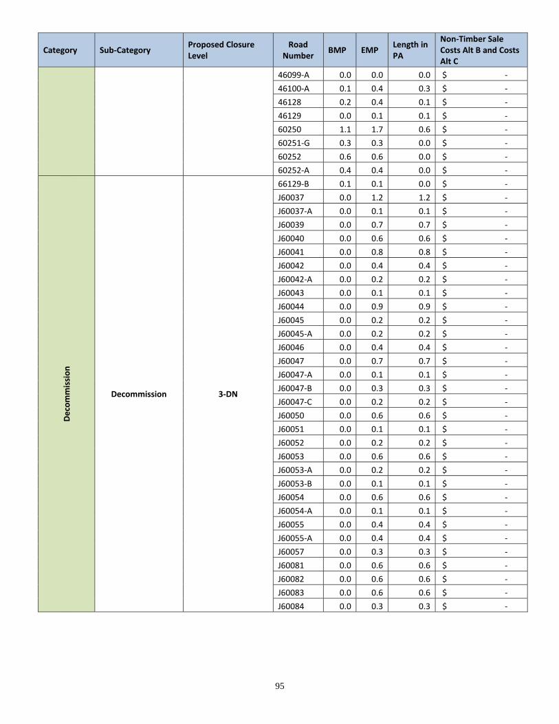
95
Category Sub‐Category Proposed Closure Level
Road Number
BMP EMP Length in PA
Non‐Timber Sale Costs Alt B and Costs Alt C
46099‐A 0.0 0.0 0.0 $ ‐
46100‐A 0.1 0.4 0.3 $ ‐
46128 0.2 0.4 0.1 $ ‐
46129 0.0 0.1 0.1 $ ‐
60250 1.1 1.7 0.6 $ ‐
60251‐G 0.3 0.3 0.0 $ ‐
60252 0.6 0.6 0.0 $ ‐
60252‐A 0.4 0.4 0.0 $ ‐
Decommission
Decommission 3‐DN
66129‐B 0.1 0.1 0.0 $ ‐
J60037 0.0 1.2 1.2 $ ‐
J60037‐A 0.0 0.1 0.1 $ ‐
J60039 0.0 0.7 0.7 $ ‐
J60040 0.0 0.6 0.6 $ ‐
J60041 0.0 0.8 0.8 $ ‐
J60042 0.0 0.4 0.4 $ ‐
J60042‐A 0.0 0.2 0.2 $ ‐
J60043 0.0 0.1 0.1 $ ‐
J60044 0.0 0.9 0.9 $ ‐
J60045 0.0 0.2 0.2 $ ‐
J60045‐A 0.0 0.2 0.2 $ ‐
J60046 0.0 0.4 0.4 $ ‐
J60047 0.0 0.7 0.7 $ ‐
J60047‐A 0.0 0.1 0.1 $ ‐
J60047‐B 0.0 0.3 0.3 $ ‐
J60047‐C 0.0 0.2 0.2 $ ‐
J60050 0.0 0.6 0.6 $ ‐
J60051 0.0 0.1 0.1 $ ‐
J60052 0.0 0.2 0.2 $ ‐
J60053 0.0 0.6 0.6 $ ‐
J60053‐A 0.0 0.2 0.2 $ ‐
J60053‐B 0.0 0.1 0.1 $ ‐
J60054 0.0 0.6 0.6 $ ‐
J60054‐A 0.0 0.1 0.1 $ ‐
J60055 0.0 0.4 0.4 $ ‐
J60055‐A 0.0 0.4 0.4 $ ‐
J60057 0.0 0.3 0.3 $ ‐
J60081 0.0 0.6 0.6 $ ‐
J60082 0.0 0.6 0.6 $ ‐
J60083 0.0 0.6 0.6 $ ‐
J60084 0.0 0.3 0.3 $ ‐
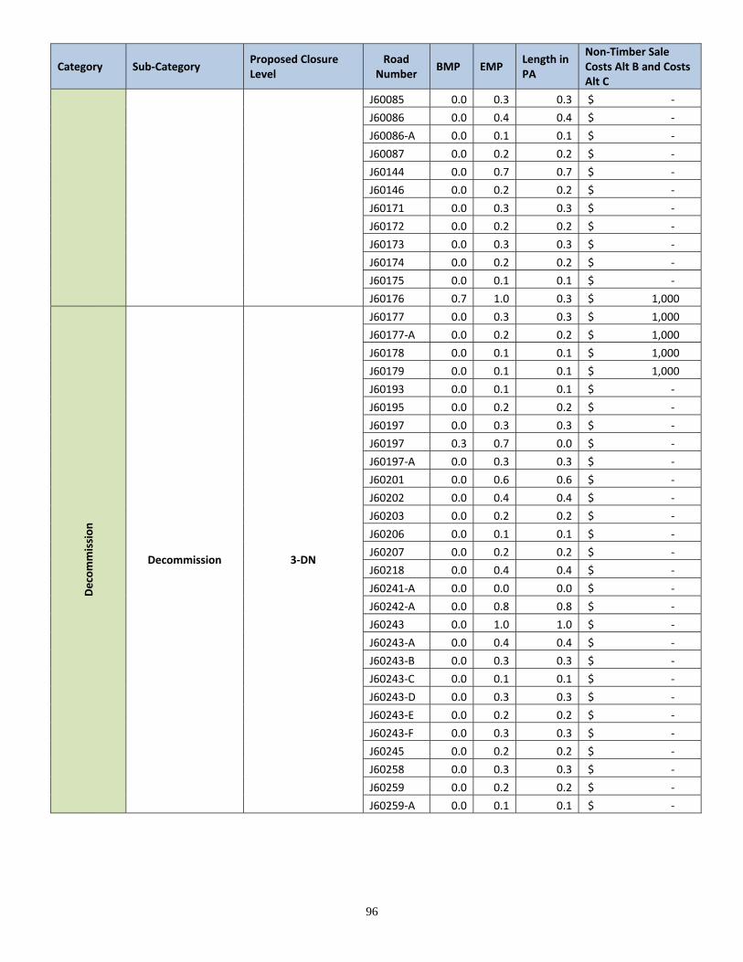
96
Category Sub‐Category Proposed Closure Level
Road Number
BMP EMP Length in PA
Non‐Timber Sale Costs Alt B and Costs Alt C
J60085 0.0 0.3 0.3 $ ‐
J60086 0.0 0.4 0.4 $ ‐
J60086‐A 0.0 0.1 0.1 $ ‐
J60087 0.0 0.2 0.2 $ ‐
J60144 0.0 0.7 0.7 $ ‐
J60146 0.0 0.2 0.2 $ ‐
J60171 0.0 0.3 0.3 $ ‐
J60172 0.0 0.2 0.2 $ ‐
J60173 0.0 0.3 0.3 $ ‐
J60174 0.0 0.2 0.2 $ ‐
J60175 0.0 0.1 0.1 $ ‐
J60176 0.7 1.0 0.3 $ 1,000
Decommission
Decommission 3‐DN
J60177 0.0 0.3 0.3 $ 1,000
J60177‐A 0.0 0.2 0.2 $ 1,000
J60178 0.0 0.1 0.1 $ 1,000
J60179 0.0 0.1 0.1 $ 1,000
J60193 0.0 0.1 0.1 $ ‐
J60195 0.0 0.2 0.2 $ ‐
J60197 0.0 0.3 0.3 $ ‐
J60197 0.3 0.7 0.0 $ ‐
J60197‐A 0.0 0.3 0.3 $ ‐
J60201 0.0 0.6 0.6 $ ‐
J60202 0.0 0.4 0.4 $ ‐
J60203 0.0 0.2 0.2 $ ‐
J60206 0.0 0.1 0.1 $ ‐
J60207 0.0 0.2 0.2 $ ‐
J60218 0.0 0.4 0.4 $ ‐
J60241‐A 0.0 0.0 0.0 $ ‐
J60242‐A 0.0 0.8 0.8 $ ‐
J60243 0.0 1.0 1.0 $ ‐
J60243‐A 0.0 0.4 0.4 $ ‐
J60243‐B 0.0 0.3 0.3 $ ‐
J60243‐C 0.0 0.1 0.1 $ ‐
J60243‐D 0.0 0.3 0.3 $ ‐
J60243‐E 0.0 0.2 0.2 $ ‐
J60243‐F 0.0 0.3 0.3 $ ‐
J60245 0.0 0.2 0.2 $ ‐
J60258 0.0 0.3 0.3 $ ‐
J60259 0.0 0.2 0.2 $ ‐
J60259‐A 0.0 0.1 0.1 $ ‐
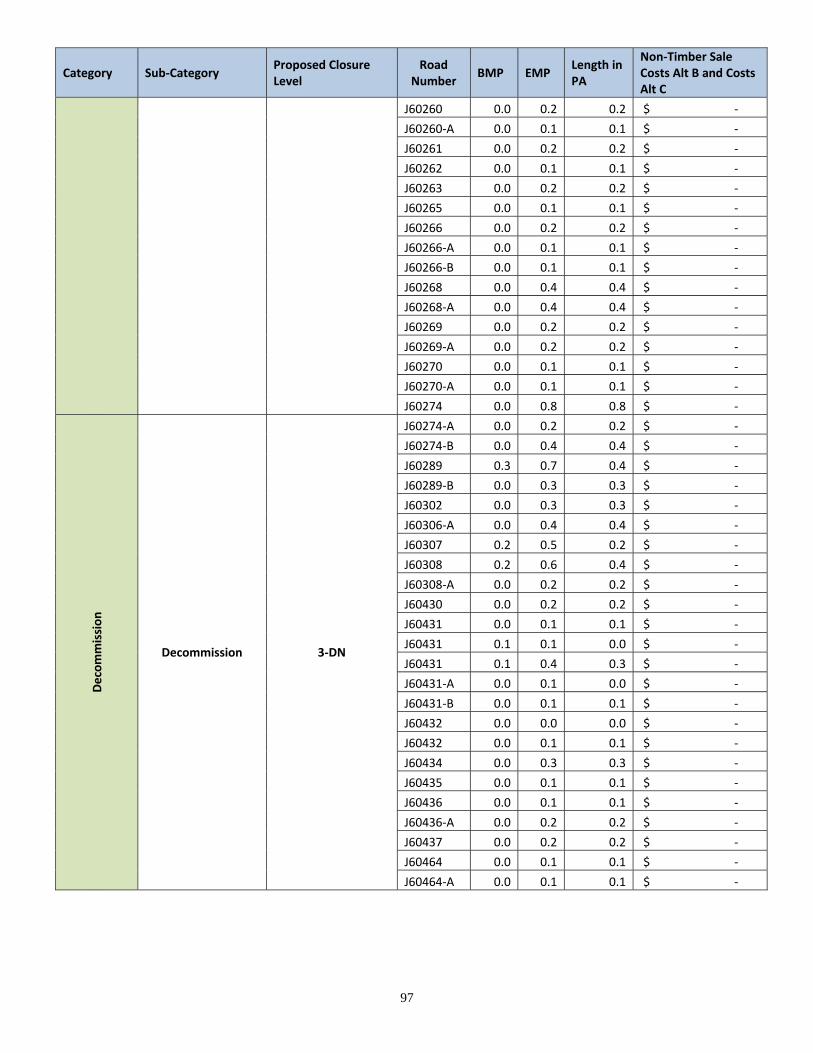
97
Category Sub‐Category Proposed Closure Level
Road Number
BMP EMP Length in PA
Non‐Timber Sale Costs Alt B and Costs Alt C
J60260 0.0 0.2 0.2 $ ‐
J60260‐A 0.0 0.1 0.1 $ ‐
J60261 0.0 0.2 0.2 $ ‐
J60262 0.0 0.1 0.1 $ ‐
J60263 0.0 0.2 0.2 $ ‐
J60265 0.0 0.1 0.1 $ ‐
J60266 0.0 0.2 0.2 $ ‐
J60266‐A 0.0 0.1 0.1 $ ‐
J60266‐B 0.0 0.1 0.1 $ ‐
J60268 0.0 0.4 0.4 $ ‐
J60268‐A 0.0 0.4 0.4 $ ‐
J60269 0.0 0.2 0.2 $ ‐
J60269‐A 0.0 0.2 0.2 $ ‐
J60270 0.0 0.1 0.1 $ ‐
J60270‐A 0.0 0.1 0.1 $ ‐
J60274 0.0 0.8 0.8 $ ‐
Decommission
Decommission 3‐DN
J60274‐A 0.0 0.2 0.2 $ ‐
J60274‐B 0.0 0.4 0.4 $ ‐
J60289 0.3 0.7 0.4 $ ‐
J60289‐B 0.0 0.3 0.3 $ ‐
J60302 0.0 0.3 0.3 $ ‐
J60306‐A 0.0 0.4 0.4 $ ‐
J60307 0.2 0.5 0.2 $ ‐
J60308 0.2 0.6 0.4 $ ‐
J60308‐A 0.0 0.2 0.2 $ ‐
J60430 0.0 0.2 0.2 $ ‐
J60431 0.0 0.1 0.1 $ ‐
J60431 0.1 0.1 0.0 $ ‐
J60431 0.1 0.4 0.3 $ ‐
J60431‐A 0.0 0.1 0.0 $ ‐
J60431‐B 0.0 0.1 0.1 $ ‐
J60432 0.0 0.0 0.0 $ ‐
J60432 0.0 0.1 0.1 $ ‐
J60434 0.0 0.3 0.3 $ ‐
J60435 0.0 0.1 0.1 $ ‐
J60436 0.0 0.1 0.1 $ ‐
J60436‐A 0.0 0.2 0.2 $ ‐
J60437 0.0 0.2 0.2 $ ‐
J60464 0.0 0.1 0.1 $ ‐
J60464‐A 0.0 0.1 0.1 $ ‐
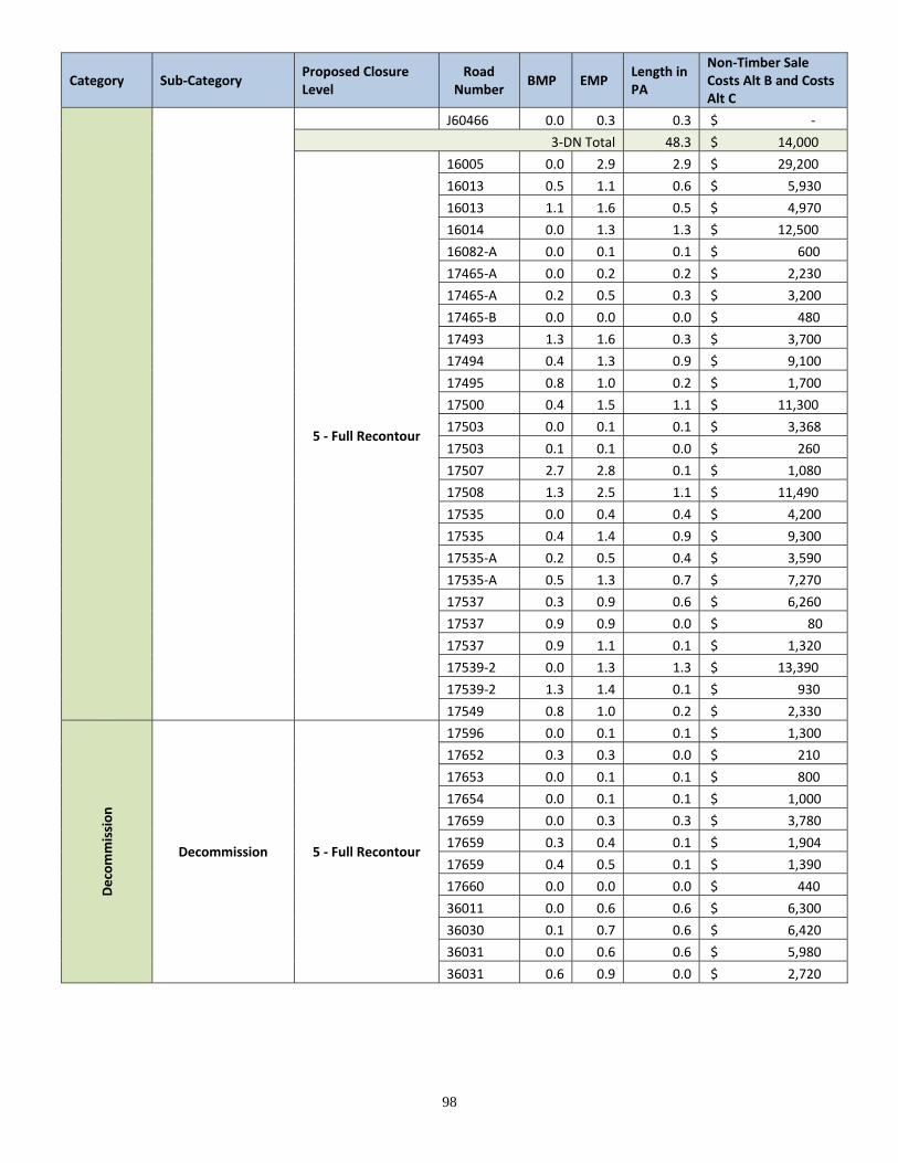
98
Category Sub‐Category Proposed Closure Level
Road Number
BMP EMP Length in PA
Non‐Timber Sale Costs Alt B and Costs Alt C
J60466 0.0 0.3 0.3 $ ‐
3‐DN Total 48.3 $ 14,000
5 ‐ Full Recontour
16005 0.0 2.9 2.9 $ 29,200
16013 0.5 1.1 0.6 $ 5,930
16013 1.1 1.6 0.5 $ 4,970
16014 0.0 1.3 1.3 $ 12,500
16082‐A 0.0 0.1 0.1 $ 600
17465‐A 0.0 0.2 0.2 $ 2,230
17465‐A 0.2 0.5 0.3 $ 3,200
17465‐B 0.0 0.0 0.0 $ 480
17493 1.3 1.6 0.3 $ 3,700
17494 0.4 1.3 0.9 $ 9,100
17495 0.8 1.0 0.2 $ 1,700
17500 0.4 1.5 1.1 $ 11,300
17503 0.0 0.1 0.1 $ 3,368
17503 0.1 0.1 0.0 $ 260
17507 2.7 2.8 0.1 $ 1,080
17508 1.3 2.5 1.1 $ 11,490
17535 0.0 0.4 0.4 $ 4,200
17535 0.4 1.4 0.9 $ 9,300
17535‐A 0.2 0.5 0.4 $ 3,590
17535‐A 0.5 1.3 0.7 $ 7,270
17537 0.3 0.9 0.6 $ 6,260
17537 0.9 0.9 0.0 $ 80
17537 0.9 1.1 0.1 $ 1,320
17539‐2 0.0 1.3 1.3 $ 13,390
17539‐2 1.3 1.4 0.1 $ 930
17549 0.8 1.0 0.2 $ 2,330
Decommission
Decommission 5 ‐ Full Recontour
17596 0.0 0.1 0.1 $ 1,300
17652 0.3 0.3 0.0 $ 210
17653 0.0 0.1 0.1 $ 800
17654 0.0 0.1 0.1 $ 1,000
17659 0.0 0.3 0.3 $ 3,780
17659 0.3 0.4 0.1 $ 1,904
17659 0.4 0.5 0.1 $ 1,390
17660 0.0 0.0 0.0 $ 440
36011 0.0 0.6 0.6 $ 6,300
36030 0.1 0.7 0.6 $ 6,420
36031 0.0 0.6 0.6 $ 5,980
36031 0.6 0.9 0.0 $ 2,720
99
Category Sub‐Category Proposed Closure Level
Road Number
BMP EMP Length in PA
Non‐Timber Sale Costs Alt B and Costs Alt C
36038 0.0 0.1 0.0 $ 780
36038 0.1 0.3 0.2 $ 2,350
36039 0.0 1.5 1.5 $ 15,400
36041 0.0 0.2 0.2 $ 2,100
36043 0.0 0.8 0.8 $ 8,000
36044 0.0 0.5 0.5 $ 4,900
36045 0.5 1.9 1.4 $ 13,880
36045‐A 0.0 0.1 0.1 $ 500
36047 0.3 1.3 1.0 $ 9,810
36047‐A 0.0 0.4 0.4 $ 4,200
36049 0.0 0.5 0.5 $ 4,630
36049‐A 0.0 0.3 0.3 $ 3,150
36058 1.1 1.3 0.2 $ 2,300
36058‐A 0.0 0.1 0.1 $ 930
36059 0.0 0.2 0.2 $ 2,020
36060 0.0 1.1 1.1 $ 10,600
36061 0.0 0.3 0.3 $ 2,640
36071 0.1 0.1 0.0 $ 230
36167 0.4 0.4 0.0 $ 160
36168 0.0 0.7 0.7 $ 6,510
36185 0.0 0.2 0.2 $ 2,070
36185‐A 0.2 0.5 0.3 $ 2,520
36185‐A 0.5 1.3 0.0 $ 7,820
36272 0.0 0.1 0.1 $ 1,000
36272 0.1 0.9 0.8 $ 8,390
36273‐A 0.0 0.6 0.6 $ 5,990
36425 0.4 0.6 0.1 $ 1,420
36515 0.1 0.2 0.1 $ 1,360
36999 0.1 0.1 0.1 $ ‐
4384 5.6 6.6 1.0 $ ‐
4384 6.6 6.7 0.1 $ 850
4384 6.7 7.1 0.4 $ 3,900
Decommission
Decommission 5 ‐ Full Recontour
4384 7.1 8.0 1.0 $ 9,700
4386 0.2 1.3 1.1 $ 10,850
4388 0.0 0.5 0.5 $ 4,680
46010 0.3 0.4 0.1 $ 560
46011 0.0 0.7 0.7 $ 7,250
46011‐A 0.0 0.8 0.8 $ 7,990
46011‐B 0.0 0.1 0.1 $ 930
46011‐C 0.0 0.1 0.1 $ 940
100
Category Sub‐Category Proposed Closure Level
Road Number
BMP EMP Length in PA
Non‐Timber Sale Costs Alt B and Costs Alt C
46082‐A 0.0 0.3 0.3 $ 3,000
46082‐A 0.3 0.6 0.3 $ 2,600
46082‐B 0.0 0.1 0.1 $ 660
46082‐C 0.0 0.1 0.1 $ 1,120
46083 1.4 2.1 0.7 $ 7,240
46084 0.0 0.8 0.8 $ 8,450
46085 0.0 0.1 0.1 $ 1,000
46085 0.1 0.2 0.1 $ 1,000
46085 0.2 0.3 0.1 $ 700
46086 0.0 0.3 0.3 $ 2,550
46089‐B 0.4 0.5 0.1 $ 980
46091 0.0 0.1 0.1 $ 680
46092 0.0 0.1 0.1 $ 1,310
46093 0.5 1.2 0.6 $ 6,320
46094‐A 0.1 0.1 0.1 $ 500
46100 0.0 0.6 0.6 $ 5,740
46100‐A 0.0 0.1 0.1 $ 1,000
46101 0.1 1.4 1.4 $ 13,960
46101‐A 0.0 2.3 2.3 $ 22,670
46101‐B 0.0 0.6 0.6 $ 6,350
46101‐C 0.0 0.5 0.5 $ 4,830
46101‐D 0.0 0.3 0.3 $ 3,390
46124 0.2 0.4 0.1 $ 1,400
46124‐A 0.0 0.0 0.0 $ 170
46148 0.0 0.2 0.2 $ 2,340
46149 0.0 0.3 0.3 $ 2,840
46152 0.0 0.1 0.1 $ 600
46152 0.1 0.5 0.4 $ 4,060
46169 0.2 1.4 1.2 $ 11,920
46169‐A 0.0 0.2 0.2 $ 1,830
46170 0.0 1.0 1.0 $ 10,260
46170 1.2 1.5 0.3 $ 2,970
46170‐A 0.0 0.4 0.4 $ 3,560
46170‐B 0.0 0.2 0.2 $ 1,600
46170‐C 0.0 0.1 0.1 $ 1,200
46173 0.0 0.3 0.3 $ 3,359
Decommissio
n
Decommission 5 ‐ Full Recontour
46291 0.3 1.1 0.7 $ 9,996
46291 1.1 1.1 0.0 $ 380
46291‐A 0.0 0.2 0.2 $ 1,920
46291‐B 0.0 0.1 0.1 $ 1,130
101
Category Sub‐Category Proposed Closure Level
Road Number
BMP EMP Length in PA
Non‐Timber Sale Costs Alt B and Costs Alt C
46291‐C 0.0 0.3 0.3 $ 3,696
46725 0.7 1.6 0.9 $ 8,670
46725‐B 0.0 0.1 0.1 $ 970
46742 0.0 0.4 0.4 $ 3,500
46742‐A 0.0 0.0 0.0 $ 460
46942 10.6 11.3 0.7 $ 6,800
477 10.2 10.6 0.3 $ 3,220
477 14.8 15.0 0.2 $ 2,200
477 15.0 15.8 0.8 $ 7,780
477 19.1 19.4 0.3 $ 3,180
56072 0.0 0.5 0.5 $ 4,610
56073 0.0 0.5 0.5 $ 5,240
56075 0.0 0.5 0.5 $ 5,220
56076 0.0 0.6 0.6 $ 6,060
56078 0.0 0.6 0.6 $ 5,530
56079‐B 0.0 0.2 0.2 $ 2,250
56079‐B 0.5 0.6 0.0 $ 490
56080 0.0 0.9 0.9 $ 9,090
56081 0.0 0.3 0.3 $ 3,240
56082 0.0 0.8 0.8 $ 7,900
56083 0.0 0.3 0.3 $ 3,180
56085 0.0 0.3 0.3 $ 3,320
56085‐A 0.0 0.8 0.8 $ 8,470
56085‐B 0.0 0.1 0.1 $ 1,100
56087 1.4 2.0 0.5 $ 7,406
56088 0.0 0.4 0.4 $ 3,790
56127‐A 0.6 0.9 0.3 $ 3,440
56127‐B 0.0 0.2 0.2 $ 2,430
56127‐C 0.0 0.3 0.3 $ 2,940
56284 0.0 0.2 0.2 $ 2,270
602 5.6 5.8 0.1 $ 1,150
60420 2.1 2.3 0.1 $ 1,210
60420 2.4 2.5 0.1 $ 1,410
J60015 0.0 0.3 0.3 $ 2,830
J60015‐A 0.0 0.2 0.2 $ 2,390
J60015‐B 0.0 0.3 0.3 $ 2,530
J60015‐C 0.0 0.2 0.2 $ 2,270
J60061 0.0 0.4 0.4 $ 4,080
J60062 0.0 0.3 0.3 $ 2,560
J60072 0.0 0.1 0.1 $ 1,250
102
Category Sub‐Category Proposed Closure Level
Road Number
BMP EMP Length in PA
Non‐Timber Sale Costs Alt B and Costs Alt C
Decommission
Decommission 5 ‐ Full Recontour
J60073 0.0 0.3 0.0 $ 3,280
J60073‐A 0.0 0.1 0.0 $ 1,070
J60073‐B 0.0 0.1 0.0 $ 640
J60074 0.3 0.3 0.0 $ 370
J60074‐A 0.0 0.4 0.4 $ 3,860
J60074‐A 0.4 0.4 0.0 $ 250
J60074‐B 0.0 0.4 0.4 $ 3,750
J60074‐B 0.4 0.4 0.0 $ 310
J60075 0.0 0.3 0.3 $ 3,400
J60075‐A 0.0 0.2 0.2 $ 1,620
J60076 0.0 0.5 0.5 $ 5,180
J60076‐A 0.0 0.4 0.4 $ 4,450
J60076‐B 0.0 0.2 0.2 $ 2,450
J60076‐C 0.0 0.3 0.3 $ 2,910
J60076‐D 0.0 0.1 0.1 $ 730
J60079 0.0 0.3 0.3 $ 3,450
J60080 0.0 0.2 0.2 $ 1,860
J60088 0.0 0.3 0.3 $ 2,940
J60089 0.0 0.2 0.2 $ 2,000
J60090 0.0 0.8 0.8 $ 8,260
J60091 0.0 0.5 0.5 $ 4,760
J60092 0.0 0.1 0.1 $ 1,390
J60093 0.0 0.2 0.2 $ 1,750
J60094 0.0 1.0 1.0 $ 9,600
J60095 0.0 0.2 0.2 $ 1,890
J60096 0.0 0.4 0.4 $ 3,750
J60097 0.0 0.6 0.6 $ 6,030
J60098 0.0 0.5 0.5 $ 5,100
J60099 0.0 0.3 0.3 $ 2,940
J60100 0.0 0.2 0.2 $ 1,640
J60101 0.0 0.2 0.2 $ 1,520
J60102 0.0 0.1 0.1 $ 1,070
J60103 0.0 0.1 0.1 $ 750
J60104 0.0 0.5 0.5 $ 5,020
J60105 0.0 0.3 0.3 $ 2,780
J60106 0.0 0.3 0.3 $ 3,030
J60107 0.0 0.2 0.2 $ 2,210
J60108 0.0 0.6 0.6 $ 5,650
J60108‐A 0.0 0.1 0.1 $ 1,300
J60109 0.0 0.6 0.6 $ 6,380
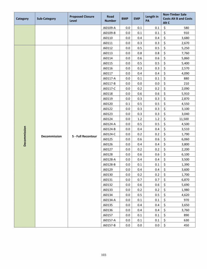
103
Category Sub‐Category Proposed Closure Level
Road Number
BMP EMP Length in PA
Non‐Timber Sale Costs Alt B and Costs Alt C
J60109‐A 0.0 0.1 0.1 $ 580
J60109‐B 0.0 0.1 0.1 $ 910
J60110 0.0 0.4 0.4 $ 3,680
J60111 0.0 0.3 0.3 $ 2,670
Decommission
Decommission 5 ‐ Full Recontour
J60112 0.0 0.5 0.5 $ 5,250
J60113 0.0 0.8 0.8 $ 7,760
J60114 0.0 0.6 0.6 $ 5,860
J60115 0.0 0.5 0.5 $ 5,400
J60116 0.0 0.3 0.3 $ 2,570
J60117 0.0 0.4 0.4 $ 4,090
J60117‐A 0.0 0.1 0.1 $ 880
J60117‐B 0.0 0.0 0.0 $ 210
J60117‐C 0.0 0.2 0.2 $ 2,090
J60118 0.0 0.6 0.6 $ 5,910
J60119 0.0 0.3 0.3 $ 2,870
J60120 0.1 0.5 0.5 $ 4,550
J60122 0.0 0.3 0.3 $ 3,100
J60123 0.0 0.3 0.3 $ 3,040
J60124 0.0 1.2 1.2 $ 11,500
J60124‐A 0.0 0.5 0.5 $ 4,500
J60124‐B 0.0 0.4 0.4 $ 3,510
J60124‐C 0.0 0.2 0.2 $ 1,790
J60125 0.0 0.6 0.6 $ 6,060
J60126 0.0 0.4 0.4 $ 3,800
J60127 0.0 0.2 0.2 $ 2,200
J60128 0.0 0.6 0.6 $ 6,100
J60128‐A 0.0 0.4 0.4 $ 3,500
J60128‐B 0.0 0.1 0.1 $ 1,390
J60129 0.0 0.4 0.4 $ 3,600
J60130 0.0 0.2 0.2 $ 1,700
J60131 0.0 0.7 0.7 $ 6,870
J60132 0.0 0.6 0.6 $ 5,690
J60133 0.0 0.2 0.2 $ 1,980
J60134 0.0 0.5 0.5 $ 4,620
J60134‐A 0.0 0.1 0.1 $ 970
J60135 0.0 0.4 0.4 $ 3,650
J60136 0.0 0.4 0.4 $ 3,760
J60157 0.0 0.1 0.1 $ 890
J60157‐A 0.0 0.1 0.1 $ 630
J60157‐B 0.0 0.0 0.0 $ 450
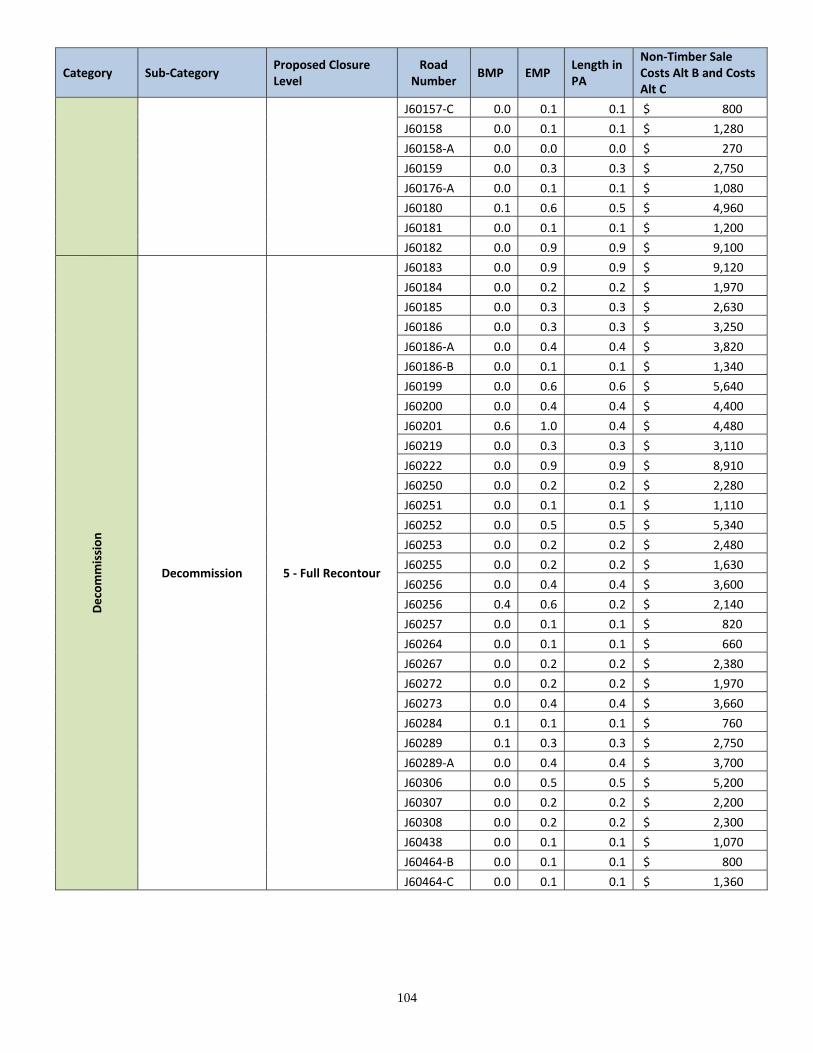
104
Category Sub‐Category Proposed Closure Level
Road Number
BMP EMP Length in PA
Non‐Timber Sale Costs Alt B and Costs Alt C
J60157‐C 0.0 0.1 0.1 $ 800
J60158 0.0 0.1 0.1 $ 1,280
J60158‐A 0.0 0.0 0.0 $ 270
J60159 0.0 0.3 0.3 $ 2,750
J60176‐A 0.0 0.1 0.1 $ 1,080
J60180 0.1 0.6 0.5 $ 4,960
J60181 0.0 0.1 0.1 $ 1,200
J60182 0.0 0.9 0.9 $ 9,100
Decommission
Decommission 5 ‐ Full Recontour
J60183 0.0 0.9 0.9 $ 9,120
J60184 0.0 0.2 0.2 $ 1,970
J60185 0.0 0.3 0.3 $ 2,630
J60186 0.0 0.3 0.3 $ 3,250
J60186‐A 0.0 0.4 0.4 $ 3,820
J60186‐B 0.0 0.1 0.1 $ 1,340
J60199 0.0 0.6 0.6 $ 5,640
J60200 0.0 0.4 0.4 $ 4,400
J60201 0.6 1.0 0.4 $ 4,480
J60219 0.0 0.3 0.3 $ 3,110
J60222 0.0 0.9 0.9 $ 8,910
J60250 0.0 0.2 0.2 $ 2,280
J60251 0.0 0.1 0.1 $ 1,110
J60252 0.0 0.5 0.5 $ 5,340
J60253 0.0 0.2 0.2 $ 2,480
J60255 0.0 0.2 0.2 $ 1,630
J60256 0.0 0.4 0.4 $ 3,600
J60256 0.4 0.6 0.2 $ 2,140
J60257 0.0 0.1 0.1 $ 820
J60264 0.0 0.1 0.1 $ 660
J60267 0.0 0.2 0.2 $ 2,380
J60272 0.0 0.2 0.2 $ 1,970
J60273 0.0 0.4 0.4 $ 3,660
J60284 0.1 0.1 0.1 $ 760
J60289 0.1 0.3 0.3 $ 2,750
J60289‐A 0.0 0.4 0.4 $ 3,700
J60306 0.0 0.5 0.5 $ 5,200
J60307 0.0 0.2 0.2 $ 2,200
J60308 0.0 0.2 0.2 $ 2,300
J60438 0.0 0.1 0.1 $ 1,070
J60464‐B 0.0 0.1 0.1 $ 800
J60464‐C 0.0 0.1 0.1 $ 1,360

105
Category Sub‐Category Proposed Closure Level
Road Number
BMP EMP Length in PA
Non‐Timber Sale Costs Alt B and Costs Alt C
5 ‐ Full Recontour Total 102.6 $ 1,043,289
Decommission Total 158.9 $ 1,124,089
Decommission Total 158.9 $ 1,124,089
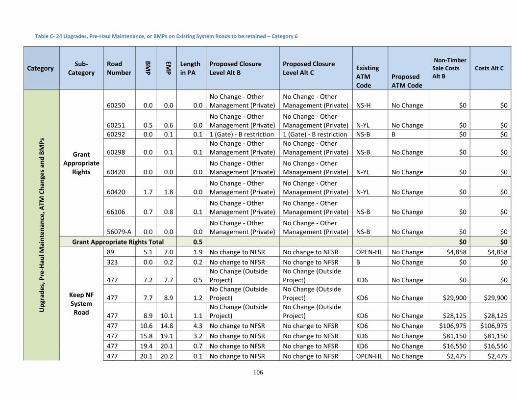
106
Table C‐ 24 Upgrades, Pre‐Haul Maintenance, or BMPs on Existing System Roads to be retained – Category 6
Category Sub‐
Category Road Number
BMP
EMP
Length in PA
Proposed Closure Level Alt B
Proposed Closure Level Alt C
Existing ATM Code
Proposed ATM Code
Non‐Timber Sale Costs Alt B
Costs Alt C
Upgrad
es, Pre‐Hau
l Maintenan
ce, A
TM Chan
ges an
d BMPs
Grant Appropriate
Rights
60250 0.0 0.0 0.0No Change ‐ Other Management (Private)
No Change ‐ Other Management (Private) NS‐H No Change $0 $0
60251 0.5 0.6 0.0No Change ‐ Other Management (Private)
No Change ‐ Other Management (Private) N‐YL No Change $0 $0
60292 0.0 0.1 0.1 1 (Gate) ‐ B restriction 1 (Gate) ‐ B restriction NS‐B B $0 $0
60298 0.0 0.1 0.1No Change ‐ Other Management (Private)
No Change ‐ Other Management (Private) NS‐B No Change $0 $0
60420 0.0 0.0 0.0No Change ‐ Other Management (Private)
No Change ‐ Other Management (Private) N‐YL No Change $0 $0
60420 1.7 1.8 0.0No Change ‐ Other Management (Private)
No Change ‐ Other Management (Private) N‐YL No Change $0 $0
66106 0.7 0.8 0.1No Change ‐ Other Management (Private)
No Change ‐ Other Management (Private) NS‐B No Change $0 $0
56079‐A 0.0 0.0 0.0No Change ‐ Other Management (Private)
No Change ‐ Other Management (Private) NS‐B No Change $0 $0
Grant Appropriate Rights Total 0.5 $0 $0
Keep NF System Road
89 5.1 7.0 1.9 No change to NFSR No change to NFSR OPEN‐HL No Change $4,858 $4,858
323 0.0 0.2 0.2 No change to NFSR No change to NFSR B No Change $0 $0
477 7.2 7.7 0.5No Change (Outside Project)
No Change (Outside Project) KD6 No Change $0 $0
477 7.7 8.9 1.2No Change (Outside Project)
No Change (Outside Project) KD6 No Change $29,900 $29,900
477 8.9 10.1 1.1No Change (Outside Project)
No Change (Outside Project) KD6 No Change $28,125 $28,125
477 10.6 14.8 4.3 No change to NFSR No change to NFSR KD6 No Change $106,975 $106,975
477 15.8 19.1 3.2 No change to NFSR No change to NFSR KD6 No Change $81,150 $81,150
477 19.4 20.1 0.7 No change to NFSR No change to NFSR KD6 No Change $16,550 $16,550
477 20.1 20.2 0.1 No change to NFSR No change to NFSR OPEN‐HL No Change $2,475 $2,475
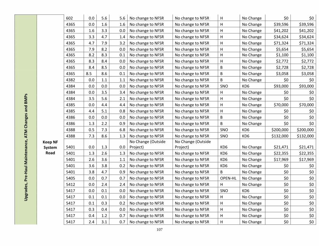
107
602 0.0 5.6 5.6 No change to NFSR No change to NFSR H No Change $0 $0
4365 0.0 1.6 1.6 No change to NFSR No change to NFSR H No Change $39,596 $39,596
4365 1.6 3.3 0.0 No change to NFSR No change to NFSR H No Change $41,202 $41,202
4365 3.3 4.7 1.4 No change to NFSR No change to NFSR H No Change $34,624 $34,624
4365 4.7 7.9 3.2 No change to NFSR No change to NFSR H No Change $71,324 $71,324
4365 7.9 8.2 0.0 No change to NFSR No change to NFSR H No Change $5,654 $5,654
4365 8.2 8.3 0.1 No change to NFSR No change to NFSR H No Change $1,100 $1,100
4365 8.3 8.4 0.0 No change to NFSR No change to NFSR H No Change $2,772 $2,772
4365 8.4 8.5 0.0 No change to NFSR No change to NFSR B No Change $2,728 $2,728
Upgrad
es, Pre‐Hau
l Maintenan
ce, A
TM Chan
ges an
d BMPs
Keep NF System Road
4365 8.5 8.6 0.1 No change to NFSR No change to NFSR B No Change $3,058 $3,058
4382 0.0 1.1 1.1 No change to NFSR No change to NFSR B No Change $0 $0
4384 0.0 0.0 0.0 No change to NFSR No change to NFSR SNO KD6 $93,000 $93,000
4384 0.0 3.5 3.4 No change to NFSR No change to NFSR H No Change $0 $0
4384 3.5 5.6 2.1 No change to NFSR No change to NFSR H No Change $0 $0
4385 0.0 4.4 4.4 No change to NFSR No change to NFSR H No Change $70,000 $70,000
4385 4.4 5.1 0.8 No change to NFSR No change to NFSR H No Change $0 $0
4386 0.0 0.0 0.0 No change to NFSR No change to NFSR B No Change $0 $0
4386 1.3 2.2 0.9 No change to NFSR No change to NFSR B No Change $0 $0
4388 0.5 7.3 6.8 No change to NFSR No change to NFSR SNO KD6 $200,000 $200,000
4388 7.3 8.6 1.3 No change to NFSR No change to NFSR SNO KD6 $132,000 $132,000
5401 0.0 1.3 0.0No Change (Outside Project)
No Change (Outside Project) KD6 No Change $21,471 $21,471
5401 1.3 2.6 1.3 No change to NFSR No change to NFSR KD6 No Change $22,355 $22,355
5401 2.6 3.6 1.1 No change to NFSR No change to NFSR KD6 No Change $17,969 $17,969
5401 3.6 3.8 0.2 No change to NFSR No change to NFSR KD6 No Change $0 $0
5401 3.8 4.7 0.9 No change to NFSR No change to NFSR B No Change $0 $0
5405 0.0 0.7 0.7 No change to NFSR No change to NFSR OPEN‐HL No Change $0 $0
5412 0.0 2.4 2.4 No change to NFSR No change to NFSR H No Change $0 $0
5417 0.0 0.1 0.0 No change to NFSR No change to NFSR SNO KD6 $0 $0
5417 0.1 0.1 0.0 No change to NFSR No change to NFSR H No Change $0 $0
5417 0.1 0.3 0.2 No change to NFSR No change to NFSR H No Change $0 $0
5417 0.3 0.4 0.0 No change to NFSR No change to NFSR H No Change $0 $0
5417 0.4 1.2 0.7 No change to NFSR No change to NFSR H No Change $0 $0
5417 2.4 3.1 0.7 No change to NFSR No change to NFSR H No Change $0 $0
108
5417 4.1 6.5 2.4 No change to NFSR No change to NFSR SNO KD6 $0 $0
9976 0.0 1.1 0.0No Change (Outside Project)
No Change (Outside Project) OPEN‐HL No Change $10,820 $10,820
9976 1.1 3.3 2.2 No change to NFSR No change to NFSR KD6 No Change $22,480 $22,480
16015 0.0 0.1 0.1 No change to NFSR No change to NFSR SNO KD6 $0 $0
16015 0.1 2.1 2.0 No change to NFSR No change to NFSR B No Change $0 $0
16082 0.0 0.4 0.4 No change to NFSR No change to NFSR OPEN‐HL No Change $0 $0
16341 0.0 0.8 0.8 No change to NFSR No change to NFSR B No Change $6,576 $0
16341 0.8 1.1 0.3 No change to NFSR No change to NFSR B No Change $0 $0
16376 0.0 2.1 2.1 No change to NFSR No change to NFSR B No Change $22,544 $0
16376 2.1 2.9 0.8 No change to NFSR No change to NFSR B No Change $6,472 $0
Upgrad
es, Pre‐Hau
l Maintenan
ce, A
TM Chan
ges an
d BMPs
Keep NF System Road
16377 0.0 2.3 2.3 No change to NFSR No change to NFSR B No Change $18,480 $0
17465 0.0 0.7 0.7 No change to NFSR No change to NFSR B No Change $0 $0
17466 0.0 0.0 0.0 No Change No Change SNO KD6 $1,000 $1,000
17494 0.0 0.4 0.4 No change to NFSR No change to NFSR B No Change $0 $0
17500 0.0 0.4 0.4 No change to NFSR No change to NFSR B No Change $0 $0
17507 0.0 0.9 0.9 No change to NFSR No change to NFSR SNO KD6 $0 $0
17507 0.9 2.2 1.3 No change to NFSR No change to NFSR B No Change $0 $0
17508 0.0 1.3 1.3 No change to NFSR No change to NFSR B No Change $0 $0
17512 0.0 0.1 0.1 No change to NFSR No change to NFSR SNO KD6 $0 $0
17512 0.1 2.2 2.0 No change to NFSR No change to NFSR B No Change $0 $0
17536 0.0 0.2 0.0 No change to NFSR No change to NFSR H No Change $1,600 $0
17536 0.2 0.8 0.6 No change to NFSR No change to NFSR H No Change $4,816 $0
17536 0.8 2.4 1.6 No change to NFSR No change to NFSR H No Change $0 $0
17536 2.4 4.1 1.7 No change to NFSR No change to NFSR H No Change $13,424 $0
17537 0.0 0.3 0.3 No change to NFSR No change to NFSR B No Change $0 $0
17549 0.0 0.5 0.5 No change to NFSR No change to NFSR B No Change $0 $0
17549 0.5 0.8 0.3 No change to NFSR No change to NFSR B No Change $0 $0
17550 0.0 0.6 0.6 No change to NFSR No change to NFSR OPEN‐HL No Change $0 $0
17567 0.0 2.3 2.3 No change to NFSR No change to NFSR B No Change $18,400 $0
17567 2.3 3.0 0.7 No change to NFSR No change to NFSR B No Change $6,680 $0
17567 3.0 3.0 0.1 No change to NFSR No change to NFSR B No Change $0 $0
17595 0.0 0.4 0.4 No change to NFSR No change to NFSR H No Change $0 $0
17645 0.0 1.1 1.1 No change to NFSR No change to NFSR B No Change $9,120 $0
109
Keep NF System Road
17656 0.0 0.3 0.3 No change to NFSR No change to NFSR B No Change $0 $0
17660 0.0 0.2 0.2 No change to NFSR No change to NFSR SNO KD6 $0 $0
17660 0.2 0.4 0.2 No change to NFSR No change to NFSR SNO KD6 $0 $0
17666 0.0 0.1 0.1 No change to NFSR No change to NFSR KD6 No Change $0 $0
17697 0.0 0.1 0.1 No change to NFSR No change to NFSR SNO No Change $0 $0
17656‐A 0.0 0.1 0.1 No change to NFSR No change to NFSR OPEN‐HL No Change $0 $0
17656‐B 0.0 0.1 0.1 No change to NFSR No change to NFSR OPEN‐HL No Change $0 $0
Upgrad
es, Pre‐Hau
l Maintenan
ce, A
TM Chan
ges an
d BMPs
Keep NF System Road Total 84.3 $1,172,898 $1,063,186
Other FS Road ‐ Not Included in Project 477 1.2 7.2 0.0
No Change (Outside Project)
No Change (Outside Project) KD6 No Change $0 $0
Other FS Road ‐ Not Included in Project Total 0.0 $0 $0
Previous Decision to Decommissio
n and Convert to Trail, But Needs Treated
17466 0.2 0.5 0.3 3‐DN 3‐DN B No ATM Needed $1,000 $1,000
4397 0.0 1.6 1.6 5 ‐ Full Recontour 5 ‐ Full Recontour B No Change $22,106 $22,106
4397 1.6 2.3 0.8 5 ‐ Full Recontour 5 ‐ Full Recontour B No Change $7,610 $7,610
4397 2.3 3.2 0.9 5 ‐ Full Recontour 5 ‐ Full Recontour B No Change $8,890 $8,890
4397 3.2 3.3 0.0 5 ‐ Full Recontour 5 ‐ Full Recontour B No Change $610 $610
5402 0.0 2.4 2.4 5 ‐ Full Recontour 3‐D B No Change $23,580 $23,580
5402 2.4 2.5 0.0 5 ‐ Full Recontour 3‐D B No Change $1,520 $1,520 Previous Decision to Decommission and Convert
to Trail, But Needs Treated Total 5.9 5 ‐ Full Recontour 3‐D $65,316 $65,316
Previous Decision to
Decommission But Needs Treated
17565 0.0 0.0 0.0 5 ‐ Full Recontour 5 ‐ Full Recontour B No ATM Needed $240 $240
17565 0.0 1.9 1.9 5 ‐ Full Recontour 5 ‐ Full Recontour B No ATM Needed $14,952 $14,952
17565 1.9 1.9 0.0 5 ‐ Full Recontour 5 ‐ Full Recontour B No ATM Needed $328 $328
17592 0.0 0.5 0.5 5 ‐ Full Recontour 5 ‐ Full Recontour NS‐K No ATM Needed $4,000 $4,000
Previous Decision to Decommission But Needs Treated Total 2.4 $19,520 $19,520
Stored Previously 16006 0.0 1.5 1.5 No Change (Stored) No Change (Stored) B No Change $0 $0
Grand Total 98.5 $1,259,894 $1,150,182
110
Table C‐ 25 Existing System Roads to Store – Category 5
Category Sub‐Category
Road Number
Proposed Closure Level Alt A and B
BMP
EMP Existing
ATM Code
Proposed ATM Code
Length in PA
Non‐Timber Sale Costs Alt B and Costs Alt C
Store Existing Road
Add to Official Road System and Store
36273 3‐S 0.0 0.5 NS‐K B 0.5 $4,032
36273 3‐S 0.5 0.8 NS‐K B 0.3 $2,640
36273 3‐S 0.8 1.0 NS‐K B 0.2 $1,592
46000 3‐S 2.5 3.2 NS‐B B 0.7 $8,592
46082 3‐S 1.7 3.1 NS‐B B 1.4 $11,176
46095 3‐S 0.2 0.8 NS‐B B 0.6 $5,016
46291 3‐S 0.0 0.3 NS‐B B 0.3 $4,164
46725‐A 3‐S 0.0 0.5 NS‐B B 0.5 $6,480
46942‐A 3‐S 0.0 1.0 NS‐B B 1.0 $12,180
56071 3‐S 1.0 2.2 NS‐B B 1.3 $10,104
56084 3‐S 0.0 0.4 NS‐B B 0.4 $4,584
56084 3‐S 0.4 1.2 NS‐B B 0.8 $6,728
56090 3‐S 0.4 1.1 NS‐B B 0.7 $5,304
56090‐A 3‐S 0.0 0.3 NS‐B B 0.3 $2,400
56091 3‐S 0.0 0.2 NS‐B B 0.2 $1,760
56120 3‐S 1.4 2.5 NS‐B B 1.0 $8,088
56127 3‐S 0.0 0.2 NS‐B B 0.2 $1,312
56127 3‐S 0.2 1.7 NS‐B B 1.5 $12,065
56127‐A 3‐S 0.0 0.6 NS‐B B 0.6 $4,432
J60190 3‐S 0.0 0.5 NS‐B B 0.5 $5,080
Add to Official Road System and Store Total 13.0 $117,729
Store NF System Road
16013 3‐S 0.0 0.5 SNO B 0.5 $4,360
16538 3‐S 0.0 1.8 B No Change 1.8 $18,300
17495 3‐S 0.0 0.2 H B 0.2 $1,680
17495 3‐S 0.2 0.8 H B 0.6 $4,960
17507 3‐S 2.2 2.7 B No Change 0.5 $4,144
17664 3‐S 0.0 3.6 B No Change 3.6 $35,670
17664 3‐S 3.6 3.9 B No Change 0.4 $2,944
17665 3‐S 0.0 0.3 B No Change 0.3 $3,000
4386 3‐S 2.2 4.4 B No Change 2.2 $17,200
5417 3‐S 1.2 2.4 H B 1.2 $9,608
Store NF System Road Total 11.3 $101,866
Store Existing Road Total 24.4 $219,595
111
Table C‐ 26 Temporary Roads– Category 7
Catego
ry
Sub‐Category Alt B
Proposed Closure
Level Alt B
Sub‐Category Alt C
Proposed Closure Level
Alt C Road Number
BMP
EMP
Length in PA
Non‐Timber
Sale Costs Alt B
Costs Alt C
Temporary Road
Temp Road ‐ New
5 ‐ Full Recontour
non existent non existent
P_Temp_118 0.0 1.0 1.0 $0 $0
P_Temp_13 0.0 0.2 0.2 $0 $0
P_Temp_132 0.0 0.1 0.1 $0 $0
P_Temp_143 0.0 0.3 0.3 $0 $0
P_Temp_147.1 0.0 0.4 0.4 $0 $0
P_Temp_147.2 0.0 0.3 0.3 $0 $0
P_Temp_148 0.0 0.5 0.5 $0 $0
P_Temp_34 0.0 0.3 0.3 $0 $0
P_Temp_35‐B 0.0 0.3 0.3 $0 $0
Temp Road ‐ New Total 3.5 $0 $0
Temp Road ‐ New ‐ STS
5 ‐ Full Recontour
non existent non existent
P_Temp_106 00.53 0.5 $7,392 $0
P_Temp_106A 0.0 0.3 0.3 $4,018 $0
P_Temp_106B 0.0 0.2 0.2 $2,940 $0
P_Temp_108 0.0 0.2 0.2 $2,100 $0
P_Temp_127 0.0 0.4 0.4 $6,012 $0
P_Temp_139.1 0.0 1.3 1.3 $20,102 $0
P_Temp_187 0.0 0.2 0.2 $3,268 $0
P_Temp_198 0.0 0.1 0.1 $1,285 $0
Temp Road ‐ New ‐ STS Total 3.2 $47,116 $0
Temp Road ‐
Reconstruct Existing Road
5 ‐ Full Recontour
Decommission
3‐D
17535‐A 00.16 0.2 $0 $7,824
36045 00.53 0.5 $0 $8,800
36185‐A 0.0 0.2 0.2 $0 $4,500
3‐DN
36425 0.0 0.4 0.4 $0 $0
46010 0.0 0.3 0.3 $0 $0
46010 0.3 0.3 0.1 $0 $0
3‐DN/ E 46047 0.0 1.0 1.0 $0 $500
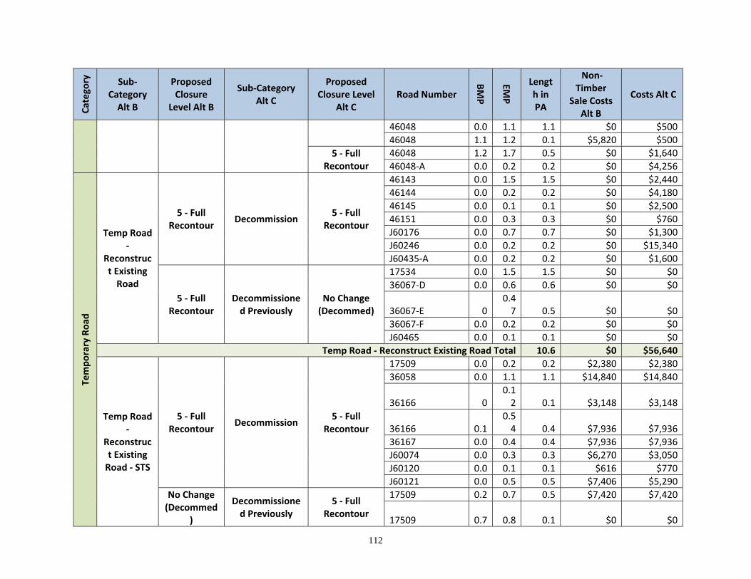
112
Catego
ry
Sub‐Category Alt B
Proposed Closure
Level Alt B
Sub‐Category Alt C
Proposed Closure Level
Alt C Road Number
BMP
EMP
Length in PA
Non‐Timber
Sale Costs Alt B
Costs Alt C
46048 0.0 1.1 1.1 $0 $500
46048 1.1 1.2 0.1 $5,820 $500
5 ‐ Full Recontour
46048 1.2 1.7 0.5 $0 $1,640
46048‐A 0.0 0.2 0.2 $0 $4,256
Temporary Road
Temp Road ‐
Reconstruct Existing Road
5 ‐ Full Recontour
Decommission 5 ‐ Full
Recontour
46143 0.0 1.5 1.5 $0 $2,440
46144 0.0 0.2 0.2 $0 $4,180
46145 0.0 0.1 0.1 $0 $2,500
46151 0.0 0.3 0.3 $0 $760
J60176 0.0 0.7 0.7 $0 $1,300
J60246 0.0 0.2 0.2 $0 $15,340
J60435‐A 0.0 0.2 0.2 $0 $1,600
5 ‐ Full Recontour
Decommissioned Previously
No Change (Decommed)
17534 0.0 1.5 1.5 $0 $0
36067‐D 0.0 0.6 0.6 $0 $0
36067‐E 00.47 0.5 $0 $0
36067‐F 0.0 0.2 0.2 $0 $0
J60465 0.0 0.1 0.1 $0 $0
Temp Road ‐ Reconstruct Existing Road Total 10.6 $0 $56,640
Temp Road ‐
Reconstruct Existing Road ‐ STS
5 ‐ Full Recontour
Decommission 5 ‐ Full
Recontour
17509 0.0 0.2 0.2 $2,380 $2,380
36058 0.0 1.1 1.1 $14,840 $14,840
36166 00.12 0.1 $3,148 $3,148
36166 0.10.54 0.4 $7,936 $7,936
36167 0.0 0.4 0.4 $7,936 $7,936
J60074 0.0 0.3 0.3 $6,270 $3,050
J60120 0.0 0.1 0.1 $616 $770
J60121 0.0 0.5 0.5 $7,406 $5,290
No Change (Decommed
)
Decommissioned Previously
5 ‐ Full Recontour
17509 0.2 0.7 0.5 $7,420 $7,420
17509 0.7 0.8 0.1 $0 $0
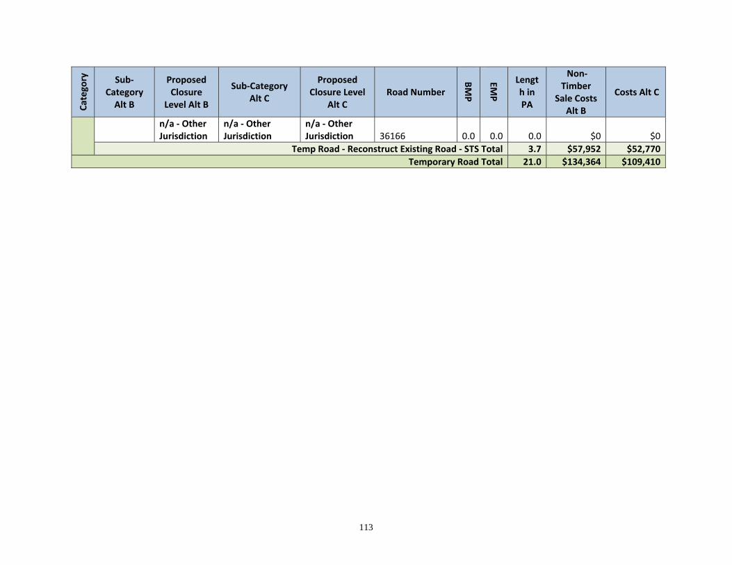
113
Catego
ry
Sub‐Category Alt B
Proposed Closure
Level Alt B
Sub‐Category Alt C
Proposed Closure Level
Alt C Road Number
BMP
EMP
Length in PA
Non‐Timber
Sale Costs Alt B
Costs Alt C
n/a ‐ Other Jurisdiction
n/a ‐ Other Jurisdiction
n/a ‐ Other Jurisdiction 36166 0.0 0.0 0.0 $0 $0
Temp Road ‐ Reconstruct Existing Road ‐ STS Total 3.7 $57,952 $52,770
Temporary Road Total 21.0 $134,364 $109,410
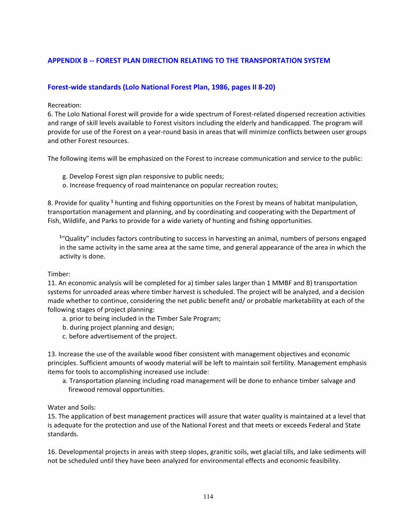
114
APPENDIX B ‐‐ FOREST PLAN DIRECTION RELATING TO THE TRANSPORTATION SYSTEM
Forest‐wide standards (Lolo National Forest Plan, 1986, pages II 8‐20) Recreation: 6. The Lolo National Forest will provide for a wide spectrum of Forest‐related dispersed recreation activities and range of skill levels available to Forest visitors including the elderly and handicapped. The program will provide for use of the Forest on a year‐round basis in areas that will minimize conflicts between user groups and other Forest resources. The following items will be emphasized on the Forest to increase communication and service to the public:
g. Develop Forest sign plan responsive to public needs; o. Increase frequency of road maintenance on popular recreation routes;
8. Provide for quality 1 hunting and fishing opportunities on the Forest by means of habitat manipulation, transportation management and planning, and by coordinating and cooperating with the Department of Fish, Wildlife, and Parks to provide for a wide variety of hunting and fishing opportunities.
1“Quality” includes factors contributing to success in harvesting an animal, numbers of persons engaged in the same activity in the same area at the same time, and general appearance of the area in which the activity is done.
Timber: 11. An economic analysis will be completed for a) timber sales larger than 1 MMBF and B) transportation systems for unroaded areas where timber harvest is scheduled. The project will be analyzed, and a decision made whether to continue, considering the net public benefit and/ or probable marketability at each of the following stages of project planning:
a. prior to being included in the Timber Sale Program; b. during project planning and design; c. before advertisement of the project.
13. Increase the use of the available wood fiber consistent with management objectives and economic principles. Sufficient amounts of woody material will be left to maintain soil fertility. Management emphasis items for tools to accomplishing increased use include:
a. Transportation planning including road management will be done to enhance timber salvage and firewood removal opportunities.
Water and Soils: 15. The application of best management practices will assure that water quality is maintained at a level that is adequate for the protection and use of the National Forest and that meets or exceeds Federal and State standards. 16. Developmental projects in areas with steep slopes, granitic soils, wet glacial tills, and lake sediments will not be scheduled until they have been analyzed for environmental effects and economic feasibility.
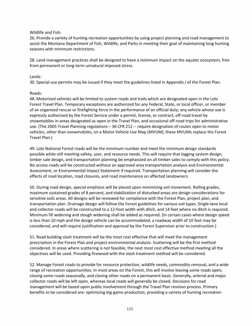
115
Wildlife and Fish: 26. Provide a variety of hunting recreation opportunities by using project planning and road management to assist the Montana Department of Fish, Wildlife, and Parks in meeting their goal of maintaining long hunting seasons with minimum restrictions. 28. Land management practices shall be designed to have a minimum impact on the aquatic ecosystem, free from permanent or long‐term unnatural imposed stress. Lands: 30. Special‐use permits may be issued if they meet the guidelines listed in Appendix J of the Forest Plan. Roads: 48. Motorized vehicles will be limited to system roads and trails which are designated open in the Lolo Forest Travel Plan. Temporary exceptions are authorized for any Federal, State, or local officer, or member of an organized rescue or firefighting force in the performance of an official duty; any vehicle whose use is expressly authorized by the Forest Service under a permit, license, or contract; off‐road travel by snowmobiles in areas designated as open in the Travel Plan, and occasional off‐road trips for administrative use. (The 2005 Travel Planning regulations – 36 CFR 212 ‐‐ require designation of routes open to motor vehicles, other than snowmobiles, on a Motor Vehicle Use Map (MVUM); these MVUMs replace the Forest Travel Plan.) 49. Lolo National Forest roads will be the minimum number and meet the minimum design standards possible while still meeting safety, user, and resource needs. This will require that logging system design, timber sale design, and transportation planning be emphasized on all timber sales to comply with this policy. No access roads will be constructed without an approved area transportation analysis and Environmental Assessment, or Environmental Impact Statement if required. Transportation planning will consider the effects of road location, road closures, and road maintenance on affected landowners. 50. During road design, special emphasis will be placed upon minimizing soil movement. Rolling grades, maximum sustained grades of 8 percent, and stabilization of disturbed areas are design considerations for sensitive soils areas. All designs will be reviewed for compliance with the Forest Plan, project plan, and transportation plan. Drainage design will follow the Forest guidelines for various soil types. Single‐lane local and collector roads will be constructed to a 12‐foot width with ditch, and 14 feet where no ditch is required. Minimum fill widening and slough widening shall be added as required. (In certain cases where design speed is less than 10 mph and the design vehicle can be accommodated, a roadway width of 10 feet may be considered, and will require justification and approval by the Forest Supervisor prior to construction.) 51. Road building slash treatment will be the most cost effective that will meet the management prescription in the Forest Plan and project environmental analysis. Scattering will be the first method considered. In areas where scattering is not feasible, the next most cost effective method meeting all the objectives will be used. Providing firewood with the slash treatment method will be considered. 52. Manage Forest roads to provide for resource protection, wildlife needs, commodity removal, and a wide range of recreation opportunities. In most areas on the Forest, this will involve leaving some roads open, closing some roads seasonally, and closing other roads on a permanent basis. Generally, arterial and major collector roads will be left open, whereas local roads will generally be closed. Decisions for road management will be based upon public involvement through the Travel Plan revision process. Primary benefits to be considered are: optimizing big‐game production, providing a variety of hunting recreation
116
experiences, protecting critical grizzly bear habitat, reducing sediment in streams, reducing road maintenance costs, and providing for firewood and commodity removal. The criteria to be used to analyze the need for road use restrictions are from the 1984 edition of the Forest Travel Plan and are detailed as follow: a. Roads will be closed when necessary to protect the safety of Forest users. Examples include roads with hazards such as avalanche, landslides, forest fires, flooding, and timber harvest operations. b. Roads may be closed when roadway use increases soil movement and adversely affects water quality. On sensitive soil areas, wet season restrictions will be applied unless the road has surfacing or other features to make the road suitable for wet season use. c. On highly productive big‐game summer range, open road densities of existing roads will be restricted to a maximum of 1.1 miles of road per section and all new roads, except arterials, will be closed year‐round (average values calculated over designated herd‐unit analysis areas.)
New roads will be closed to the public year‐round in areas of moderate big‐game summer range, but roads now open (1984 Travel Plan) will remain open. Snowmobiles will be permitted after December 1 unless restricted for other reasons. Roads on low value summer range will remain open unless closed for other reasons.
d. Areas with high potential for walk‐in hunting or fishing experiences will be considered for road closures. Open road density during the hunting season will remain the same as that now existing (1984 Travel Plan) to continue to meet State objectives for big‐game hunting recreation. e. Roads within the grizzly bear habitat may be closed seasonally if it is determined that an open road may be increasing the risk of human‐caused bear mortality. Within designated Essential Habitat spring range, all non‐arterial systems will be closed April 15 to June 15. On summer range, roads that bisect identified critical habitat components will be closed July 15 thru October 15. f. Roads may be closed to help protect known historic or prehistoric sites. g. Temporary closures will be considered for public safety and to mitigate for fire damage, roadway erosion, and similar conditions. h. Road closures will be considered if the cost of road maintenance exceeds the benefits received. i. Road closures and re‐openings will be considered when public support and/ or concern is expressed through normal channels of communication. Such considerations will be included in the normal Travel Plan revision process. j. Road closures will reflect needs of the public in special circumstances and during the different seasons of the year. Emergency events such as fire suppression and search and rescue activities shall be permitted on closed roads. Activities such as firewood gathering, mining, and berrypicking could occur provided the objective of the closure is not compromised.
117
k. The need for protection of administrative or special use facilities will be a consideration for the closure of certain roads. Lookouts, guard stations, and transmission sites are examples of such facilities. l. Roads should be considered for closure when necessary to minimize conflicts between user groups. Examples include conflicts between walk‐in hunters and road hunters, cross‐country skiers and snowmobilers, horseback riders, and motorcyclists. m. The quality of dispersed recreation opportunities will be a factor when considering a road closure (providing for four‐wheeled motorized recreation in some areas and other forms of motorized recreation in others, where both uses in the same area may result in diminished quality of the recreation experience). n. Road closures will not preclude the use by holders of outstanding valid rights. o. Off‐road vehicle use will be limited to those areas designated in the Forest Travel Plan.
Management Area Descriptions
MA 1. Scattered parcels at all elevations in Habitat Groups 0 through 6 that are non-Forest or non-commercial forest land maintained in near-natural conditions with roads allowed to cross to provide access to other management areas; classified as unsuitable for timber production. For Center Horse Landscape Restoration project area this consists of 2152 acres.
Standard 2. A variety of dispersed recreation activities are possible and can be supported by construction of trails and trailhead and sanitation facilities….
Standard 3. Tree removal will be limited to that required to eliminate safety hazards or to
permit road or trail construction and firewood removal adjacent to roads….
Standard 11. Roads will not be constructed for surface management objectives within this management area. Roads may be constructed through segments of this management area to provide access to other management areas. Roads may be permitted for mineral activities provided that the necessity for building the road is justified on the basis of mineral showings or data and it is the next logical step in the development of the mineral resource.
Standard 12. Management practices will follow the guidelines for the Modification visual
quality objective except where visible from viewpoints specifically recognized as sensitive. Maps of these viewpoints and distance zones are on file and must be consulted to determine the visual quality objective. If the visual quality objective is Modification, it will be met from the nearest viewpoints contained in Sensitivity Level maps on file.
MA 2. Sites used in the administration of National Forest system lands, including Ranger Stations, work centers, and lookouts. Most sites will have road access. This MA is classified as unsuitable for timber production. For Center Horse Landscape Restoration project area this consists of 169 acres.
Standard 7. Roads will be constructed to provide access to the areas and within the areas as necessary for administrative purposes.
118
Standard 8. Management practices will follow guidelines for the Modification visual quality objective. The impacts of management activities will be visually assessed from the nearest viewpoints contained in the Sensitivity Level maps on file.
MA 9. Areas of the Forest receiving concentrated public use; located near population centers, popular streams and lakes, or along major highways where a wide variety of recreation opportunities are encouraged, including summer home and resort special uses. For Center Horse Landscape Restoration project area this consists of 41 acres.
Standard 2. Tree removal will be limited to that required to eliminate safety hazards or permit road or trail construction or meet other management objectives…
MA 10. Small, unroaded parcels of land scattered throughout the Forest and at all elevations, having severe physical constraints for management such as steep rocky slopes and/ or erosive soils and classified as unsuitable for timber production; managed to maintain in a natural condition. For Center Horse Landscape Restoration project area this consists of 55 acres.
Standard 2. A variety of dispersed recreation activities are permitted and may be supported by construction of trails and trailhead facilities….
Standard 11. Roads will not be constructed for surface management purposes. Roads may be
permitted for mineral activities provided that the necessity for building the road is justified on the basis of mineral showings or data and it is the next logical step in the development of the mineral resource. Public use may be restricted.
MA 11. Large, roadless blocks of land distinguished primarily by their natural environmental character managed to provide for a wide variety of dispersed recreation activities in a near-natural setting and for old-growth dependent wildlife species; classified as unsuitable for timber production. For Center Horse Landscape Restoration project area this consists of 8989 acres.
Standard 12. Roads will not be constructed for surface land management purposes. Roads will be permitted for mineral activities where construction is justified…
MA 12. Existing/Proposed wilderness as designated after passage of the Rattlesnake National Recreation Area and Wilderness Act of 1980. For Center Horse Landscape Restoration project area this consists of 8696 acres. MA 13. Lakes, lakeside lands, major second-order and larger streams, and the adjoining lands dominated by riparian vegetation; includes floodplains and wetlands; grazing is prohibited and management intent provides for improving water quality standards, aquatic habitats, fishery and recreation values. This MA is classified as Suitable for timber production on those lands accessible and economically productive; remaining lands are classified as Unsuitable for timber production. Many Forest roads are located in this MA; new access will be constrained but may be allowed to cross if total resource needs require. Public access may be restricted based on the Forest Travel Plan. For Center Horse Landscape Restoration project area this consists of 5310 acres.
Standard 2. Encourage and develop opportunities for dispersed recreation. Design trails for wildlife viewing and interpretation. When possible, locate facilities out of the flood plains. Any new development that must be located in these areas will be designed to be flood proof without stream alteration.
119
Standard 10. All management activities, especially those that involve earth moving, will be
designed to minimize impacts on water quality and other riparian values….
Standard 12. Generally, new roads in riparian zones will be minimized. Exceptions would be areas where road systems must obviously cross or traverse these zones or where total resource needs require road access.
Standard 13. Roads will be managed to control use and avoid damage to drainage systems
and resource values. Roads will be constructed and managed in a manner to keep sedimentation hazard low.
Standard 14. Construction equipment service areas will not be located in this MA.
Standard 15. Road drainage features will be inspected and maintained in the fall to insure that
they will be able to handle spring snowmelt.
Standard 16. Roads will be designed to provide low risk of drainage failure and mass failure. The runoff event for which a roadway is designed will vary depending on the length of time the road and its drainage structures and fill embankments at natural drainageways are to be in place before removal.
Standard 23. Roads will be located to cross rather than to parallel streams in this area. Stream
buffer strips will be used as a means of minimizing sediment transport from disturbed areas. Established erosion control methods will be used to control transportable sediment.
Standard 24. Where needed, fish passage will be provided for in stream crossings by
maintaining natural flow velocities and channel gradients existing at the crossing site.
Standard 25. When flow in a streamcourse is temporarily diverted to accommodate construction or other activities, flow will be restored to the natural course as soon as practical prior to a major runoff season.
Standard 27. Management activities will be designed to meet the inventoried visual quality
objective as seen from viewpoints contained on the Sensitivity Level maps. Both Sensitivity Level maps and Inventory maps are on file. Exceptions may be made when an interdisciplinary team identifies the need to protect other resource values and the resulting VQO is no more than one level below the inventoried visual quality objective.
MA 14. Same as MA 13 except that it is within existing livestock grazing allotments; livestock grazing is permitted that is compatible with protection of other resource values. For this MA, 44% is classified as Suitable and 56% is classified as Unsuitable for timber production. Many Forest roads are located in this MA; new access will be constrained but may be allowed to cross if total resource needs require. For Center Horse Landscape Restoration project area this consists of 643 acres.
120
MA 15. Nonriparian lands occurring within livestock grazing allotments, currently providing livestock grazing opportunities while providing for other resource values. For Center Horse Landscape Restoration project area this consists of 401 acres.
Standard 3. Roads may be constructed to provide access to adjacent areas. Roads may be permitted for mineral activities provided that the necessity of building a road is justified…
MA 16. Lands of varying physical environments which are classified as Suitable for timber production; management provides for healthy stands of timber and optimizing timber growing potential and sustained timber production. An extensive road system is in place and will be further developed for Forest management. The roads will be open or closed to public use as determined by the Forest Travel Plan. The majority of existing major collector roads and some future major collector roads will be left open while minor collector and local roads will be open to a lesser degree and often only on an intermittent basis. For Center Horse Landscape Restoration project area this consists of 18,345 acres.
Standard 2. A variety of dispersed recreation activities are permitted and may be supported by construction of trails and trailhead facilities….
Standard 11. Generally, new roads in riparian zones will be minimized. Exceptions would be
areas where road systems must obviously cross or traverse these zones or where total resource needs dictate the necessity for roads.
Standard 12. Logging and/ or construction operations will be conducted in such a way as to
prevent debris from entering stream channels.…
Standard 13. Construction equipment service areas will not be located in riparian zones in this management area.
Standard 14. Roads will be designed to provide low risk of drainage failure and mass failure.
The runoff event for which a roadway is designed will vary depending on the length of time the road and its drainage structures and fill embankments at natural drainageways are to be in place before removal.
Standard 15. Roads will be managed to control use and avoid damage to drainage systems
and resource values. Roads will be constructed and managed in a manner to keep sedimentation hazard low.
Standard 16. Management practices will follow guidelines for the Modification or Maximum
Modification visual quality objective. Modification will normally be assigned to foreground and middleground visible from Sensitivity Level 2 viewpoints. Background and areas not seen from these viewpoints will be assigned Maximum Modification. Maps of these viewpoints, guidelines, and distance zones are on file and must be consulted to determine the visual quality objective.
Standard 22. Roads will be located to cross rather than to parallel streams in riparian areas.
Stream buffer strips will be used as a means of minimizing sediment transport from disturbed areas. Established erosion control methods will be used to control transportable sediment.
121
Standard 23. Where needed, fish passage will be provided for in stream crossings by
maintaining natural flow velocities and channel gradients existing at the crossing site.
Standard 24. Roads will be constructed as needed to meet the management objectives of the area. Estimated average road densities are: 0 to 40% slope = 5.6 miles/ sq. mile; 40% plus slope = 6.7 miles/ sq. mile.
MA 17. Same as MA 16 except that slopes are generally over 60% and management is directed at optimizing timber growing potential while maintaining soil productivity on steeper slopes; these lands are best managed from an economic criteria with a low road density. For Center Horse Landscape Restoration project area this consists of 1,778 acres.
Standard 2. A variety of dispersed recreation activities are permitted and may be supported by construction of trails and trailhead facilities….
Standard 12. Generally, new roads in riparian zones will be minimized. Exceptions would be
areas where road systems must obviously cross or traverse these zones or where total resource needs dictate the necessity for roads.
Standard 13. Roads will be constructed as needed to meet the management objectives of the
area. Estimated average road density will be 1.5 miles per square mile.
Standard 14. Construction equipment service areas will not be located in riparian zones in this management area.
Standard 15. Roads will be designed to provide low risk of drainage failure and mass failure.
The runoff event for which a roadway is designed will vary depending on the length of time the road and its drainage structures and fill embankments at natural drainageways are to be in place before removal.
Standard 16. Roads will be managed to control use and avoid damage to drainage systems
and resource values. Roads will be constructed and managed in a manner to keep sedimentation hazard low.
Standard 21. In third-order watersheds, the rate of new road construction or reconstruction in
any one year will be limited to the rate at which existing roads become stabilized (sediment yield is below first 3-year average yield) either naturally or through project rehabilitation.
Standard 22. In critical situations, such as slumpy areas, steep draw crossings, bogs, seeps, or
other wet areas, no more than 1 acre of erodible and untreated surface area per road project (slope area, exclusive of the road surface itself) will be exposed at one time by excavation, borrow, or fill. Where, due to the need for extensive end hauling, it is not possible to stay within the 1-acre limit, treatment measures will be installed to reduce the vulnerability to high intensity storms.
122
Standard 23. Effective permanent soil surface protection will be installed as soon as practical once the roadway is constructed to grade; however, all treatment will be completed during the same construction season in which the disturbance was created.
Standard 24. Roads will be located to cross rather than to parallel streams in riparian areas.
Stream buffer strips will be used as a means of minimizing sediment transport from disturbed areas. Established erosion control methods will be used to control transportable sediment.
Standard 25. System roads will be designed for at least the 60-year storm or runoff event.
Drainage in nonsystem roads will provide for at least the 50-year storm or runoff event. Natural drainageways will be reopened and road surface outsloped, cross-ditched, and revegetated within 5 years from construction.
Standard 26. Where needed, fish passage will be provided for in stream crossings by
maintaining natural flow velocities and channel gradients existing at the crossing site.
Standard 27. Overland, stream, and subsurface flow of water must be transported across or through the road prisms on the shortest path possible. Water must not be permitted to cause saturation of the road section. Where surface water velocities and concentrations are created that would induce or accelerate surface erosion, dissipation or protective features will be installed.
Standard 28. Roads will be located to avoid intercepting subsurface water when at all
possible.
Standard 29. In those situations where the transportation planning road location encounters areas with mass stability and debris hazards, designs will be approved for construction only after hazard-reducing features or treatments have been included.
Standard 30. Management practices will follow guidelines for the Modification or Maximum
Modification visual quality objective, except where visible from viewpoints specifically recognized as sensitive in the Forest Plan. Modification will normally be assigned to foreground and middleground visible from Sensitivity Level 2 viewpoints. Background and areas not seen from these viewpoints will be assigned a visual quality objective of Maximum Modification. Sensitivity Level maps, guidelines, and distance zones are on file and must be consulted to determine the visual quality objective.
MA 18. “Forested Winter Range”. Lands primarily located at elevations below 5,000 feet on south-facing slopes that are winter range for deer, elk and bighorn sheep, generally including Habitat Groups 1, 2, and 3 with inclusions of Group 4; classified as Suitable for timber production with timber harvest employed to improve or maintain big-game winter range. An extensive road system is in place and may be further developed for Forest management. The roads will be open or closed to public use as determined by the Forest Travel Plan. The majority of existing major collector roads and some future major collector roads will be left open while minor collector and local roads will be open to a lesser degree and often only on an intermittent basis. For Center Horse Landscape Restoration project area this consists of 2,356 acres.
123
Standard 2. A variety of dispersed recreation activities are permitted and may be supported by construction of trails and trailhead facilities….
Standard 4. All logging and road building for normal management activities will generally be
restricted to the summer and fall months. Mitigating measures will be included in work plans associated with road development for locatable minerals.
Standard 5. Logging and/ or construction operations will be conducted in such a way as to
prevent debris from entering stream channels.
Standard 12. Generally, new roads in riparian zones will be minimized. Exceptions would be areas where road systems must obviously cross or traverse these zones or where total resource needs dictate the necessity for roads.
Standard 13. Construction equipment service areas will not be located in riparian zones in
this Management Area.
Standard 14. Roads will be designed to provide low risk of drainage failure and mass failure. The runoff event for which a roadway is designed will vary depending on the length of time the road and its drainage structures and fill embankments at natural drainageways are to be in place before removal.
Standard 15. Road construction techniques that provide low sedimentation hazard will be
used.
Standard 16. Roads will be managed to control use and avoid damage to drainage systems and resource values. Roads will be constructed and managed in a manner to keep sedimentation hazard low.
Standard 24. Maintain roadside vegetation where possible, especially at established game
crossings.
Standard 25. Roads will be located to cross rather than to parallel streams in riparian areas. Stream buffer strips will be used as a means of minimizing sediment transport from disturbed areas. Established erosion control methods will be used to control transportable sediment.
Standard 26. Where needed, fish passage will be provided for instream crossings by
maintaining natural flow velocities and channel gradients existing at the crossing site.
Standard 27. Roads will be constructed as needed to meet the management goals and objectives of the area. Estimated average road densities are: 0 to 40% slope = 5.6 miles/ sq. mile; 40% plus slope = 6.7 miles/ sq. mile. Estimated average road open density will be 0.4 mile or less of open road per square mile.
MA 20. That portion of the Forest designated essential grizzly bear habitat (Management Situation 1 – ref “Interagency Grizzly Bear Guidelines”) managed to maintain and enhance grizzly bear habitat
124
though vegetative manipulation; classified as suitable for timber production with timber harvest employed to improve or maintain grizzly bear habitat. For Center Horse Landscape Restoration project area this consists of 270 acres.
Standard 1. Developed recreation facilities will not be constructed…
Standard 2. Employ logging systems that require minimal amounts and standards of roading.
Standard 4. Logging and/or construction operations will be conducted in such a way as to prevent debris for entering stream channels. Logs will not be yarded through streams.
Standard 5. Construction equipment service areas will not be located in riparian zones in this
MA.
Standard 10. Road construction will be limited to periods during which the grizzly bear would not be expected to use the area.
Standard 11. Roads will be managed to minimize human-caused grizzly bear mortality. In
general, a few roads will be left open to public use within this MA…
Standard 12. Roads will be designed to provide low risk of drainage failure and mass failure. The runoff event for which a roadway is designed will vary depending on the length of time the road and its drainage structures and fill embankments at natural drainageways are to be in place before removal.
Standard 13. Roads will be managed to control use and avoid damage to drainage systems
and resource values. Roads will be constructed and managed in a manner to keep sedimentation hazard low.
Standard 20. Roads will be located to cross rather than to parallel streams in riparian areas.
Stream buffer strips will be used as a means of minimizing sediment transport from disturbed areas. Established erosion control methods will be used to control transportable sediment.
Standard 21. Where needed, fish passage will be provided for in stream crossings by
maintaining natural flow velocities and channel gradients existing at the crossing site. MA 20a. That portion of the Forest designated essential grizzly bear habitat (Management Situation 1 – ref “Interagency Grizzly Bear Guidelines”) managed to maintain and enhance grizzly bear habitat though vegetative manipulation; classified as unsuitable for timber production with prescribed fire employed as the primary tool to improve or maintain grizzly bear habitat. For Center Horse Landscape Restoration project area this consists of 395 acres.
The Forest-wide management direction included in Chapter 2 of the Forest Plan applies to this MA.
Standard 2. Tree removal will be limited to that required to eliminate safety hazards or permit
road or trail construction or meet other management objectives…
125
Standard 5. Existing roads will be managed to minimize human-caused grizzly bear mortality. In general, few roads will be left open to public use within this MA…
MA 22. “Winter Range with Retention”. Lands located primarily at elevations below 5,000 feed on south-facing slopes with high visual sensitivity: adjacent to or visible from major roads, trails, communities, and other high use areas: classified as suitable for timber production with timber harvest employed to improve or maintain big-game winder range with a visual quality objective of Retention. For Center Horse Landscape Restoration project area this consists of 102 acres.
Standard 5. Logging and/or construction operations will be conducted in such a way as to prevent debris for entering stream channels. Logs will not be yarded through streams.
Standard 11. Generally, new roads in riparian zones will be minimized…
Standard 12. Construction equipment service areas will not be located in riparian zones in
this MA.
Standard 13. Roads will be designed to provide low risk of drainage failure and mass failure. The runoff event for which a roadway is designed will vary depending on the length of time the road and its drainage structures and fill embankments at natural drainageways are to be in place before removal.
Standard 14. Roads will be managed to control use and avoid damage to drainage systems
and resource values. Roads will be constructed and managed in a manner to keep sedimentation hazard low.
Standard 21. Maintain roadside vegetation where possible, especially at established game
crossings.
Standard 22. Roads will be located to cross rather than to parallel streams in riparian areas. Stream buffer strips will be used as a means of minimizing sediment transport from disturbed areas. Established erosion control methods will be used to control transportable sediment.
Standard 23 . Where needed, fish passage will be provided for in stream crossings by
maintaining natural flow velocities and channel gradients existing at the crossing site.
Standard 24. Roads will be constructed as needed to meet the management goals and objectives of the area. Estimated average road densities are: 0 to 40% slope = 4.6 miles/ sq. mile; 40 to 60% slope = 4.8 miles/ sq. mile; 60% plus = 2.8 miles/ sq. mile. Actual project-level road densities will vary depending upon the following factors: a) habitat type and associated screening and revegetative recovery time; b) staging of road construction; c) silvicultural systems employed, together with amount of screening removed each entry; d) logging systems used; and e) amount and type of revegetation measures to be taken.
Standard 25. Road construction for normal management activities will generally be limited to
the summer and fall months. Road clearing limits, road widths, and road densities will be minimized as need to meet the visual quality objective…
126
Standard 26. The area will be managed to meet visual quality objective of Retention from the
viewpoints specifically recognized as sensitive… MA 24. “Retention”. Lands with high visual sensitivity and which are available for varying degrees of timber management. These lands are visible from or adjacent to major roads, trails, communities, and other high use areas. The MA is classified as Suitable for timber production with a visual quality objective of Retention. An extensive road system will be developed in this MA but the location and density will be restricted to meet Visual Quality Objectives. Roads will be either open or closed to public use as determined by the Forest Travel Plan. For Center Horse Landscape Restoration project area this consists of 781 acres.
Standard 1. A variety of dispersed recreation activities are permitted and may be supported by construction of trails and trail head facilities….
Standard 4. Logging and/ or construction operations will be conducted in such a way as to
prevent debris from entering stream channels. …
Standard 9. Generally, new roads in riparian zones will be minimized. Exceptions would be areas where road systems must obviously cross or traverse these zones or where total resource needs dictate the necessity for roads.
Standard 10. Construction equipment service areas will not be located in riparian zones in
this Management Area.
Standard 11. Roads will be designed to provide low risk of drainage failure and mass failure. The runoff event for which a roadway is designed will vary depending on the length of time the road and its drainage structures and fill embankments at natural drainageways are to be in place before removal.
Standard 12. Roads will be managed to control use and avoid damage to drainage systems
and resource values. Roads will be constructed and managed in a manner to keep sedimentation hazard low.
Standard 20. Roads will be located to cross rather than to parallel streams in riparian areas.
Stream buffer strips will be used as a means of minimizing sediment transport from disturbed areas. Established erosion control methods will be used to control transportable sediment.
Standard 21. Where needed, fish passage will be provided for in stream crossings by
maintaining natural flow velocities and channel gradients existing at the crossing site.
Standard 22. Roads will be constructed as needed to meet the management goals and objectives of the area. Estimated average road densities are: 0 to 40% slope = 4.6 miles/ sq. mile; 40 to 60% slope = 4.8 miles/ sq. mile; 60% plus = 2.8 miles/ sq. mile. Actual project-level road densities will vary depending upon the following factors: a) habitat type and associated screening and revegetative recovery time; b) staging of road construction; c)
127
silvicultural systems employed, together with amount of screening removed each entry; d) logging systems used; and e) amount and type of revegetation measures to be taken.
Standard 23. Management practices for all resources will follow guidelines for the Retention
visual quality objective from the viewpoints identified as visually sensitive. Maps of these viewpoints are on file in the Supervisor’s Office and on the Ranger Districts and will be consulted to visually assess the impacts of management activities. Temporary departures from this visual quality objective may be acceptable under the following conditions: a) long-term visual values require such an action; or b) essential road access into other management areas is impossible without this temporary departure.
MA 25. “Partial Retention”. Same as MA 24 except that the visual quality objective to be achieved is Partial Retention because of a moderate degree of visual sensitivity. The MA is classified as Suitable for timber production. An extensive road system will be developed in this MA but the location and density will be restricted to meet Visual Quality Objectives. Roads will be either open or closed to public use as determined by the Forest Travel Plan. For Center Horse Landscape Restoration project area this consists of 5,320 acres.
Standard 1. A variety of dispersed recreation activities are permitted and may be supported by construction of trails and trail head facilities. …
Standard 4. Logging and/ or construction operations will be conducted in such a way as to
prevent debris from entering stream channels. …
Standard 9. Generally, new roads in riparian zones will be minimized. Exceptions would be areas where road systems must obviously cross or traverse these zones or where total resource needs dictate the necessity for roads.
Standard 10. Construction equipment service areas will not be located in riparian zones in
this Management Area.
Standard 11. Roads will be designed to provide low risk of drainage failure and mass failure. The runoff event for which a roadway is designed will vary depending on the length of time the road and its drainage structures and fill embankments at natural drainageways are to be in place before removal.
Standard 12. Roads will be managed to control use and avoid damage to drainage systems
and resource values. Roads will be constructed and managed in a manner to keep sedimentation hazard low.
Standard 20. Roads will be located to cross rather than to parallel streams in riparian areas.
Stream buffer strips will be used as a means of minimizing sediment transport from disturbed areas. Established erosion control methods will be used to control transportable sediment.
Standard 21. Where needed, fish passage will be provided for in stream crossings by
maintaining natural flow velocities and channel gradients existing at the crossing site.
128
Standard 22. Roads will be constructed as needed to meet the management goals and objectives of the area. Estimated average road densities are: 0 to 40% slope = 5.6 miles/ sq. mile; 40 to 60% slope = 5.9 miles/ sq. mile; 60% plus = 4.2 miles/ sq. mile. Actual project-level road densities will vary depending upon the following factors: a) habitat type and associated screening and revegetative recovery time; b) staging of road construction; c) silvicultural systems employed, together with amount of screening removed each entry; d) logging systems used; and e) amount and type of revegetation measures to be taken.
Standard 23. Management practices for all resources will follow guidelines for the Partial
Retention visual quality objective from the viewpoints identified [as] visually sensitive. Maps of these viewpoints are on file in the Supervisor’s Office and on the Ranger Districts and will be consulted to visually assess the impacts of management activities. Temporary departures from this visual quality objective may be acceptable under the following conditions: a) long-term visual values require such an action; or b) essential road access into other management areas is impossible without this temporary departure.
MA 26. “Critical Elk Summer Habitat”. Lands identified as critical elk summer habitat lying outside of wilderness and roadless areas, containing concentrations of special features such as wallows, mineral licks, seeps, and trampled areas in close proximity to important forage units, that tend to concentrate animals in relatively small areas. Generally, these features are located on the gentle topography found at mid to upper slopes and in the heads of drainages and cirque basins containing cool and moist habitat types, moist to wet meadows, riparian habitats, and other mesic areas, in association with dense cover and forested slopes. This MA is classified as Suitable for timber production. For Center Horse Landscape Restoration project area this consists of 101 acres.
Standard 2. Dispersed recreation activities are permitted that do not impact elk summer range values. ...
Standard 5. Road construction will be permitted to meet wildlife habitat objectives and to
provide access to adjacent management areas. Roads will be closed to the public during periods of high anticipated big-game use (usually Auguest1 through September 30). Local roads rather than collector roads will be preferred for accessing these sensitive areas.
Standard 6. Construction equipment service areas will not be located in this MA.
Standard 7. Roads will be designed to provide low risk of drainage failure and mass failure.
The runoff event for which a roadway is designed will vary depending on the length of time the road and its drainage structures and fill embankments at natural drainageways are to be in place before removal.
Standard 8. Road drainage features will be inspected and maintained in the fall to insure that
they will be able to handle spring snowmelt.
Standard 12. New trail construction or relocation of existing trails will avoid this MA when practical.
129
Standard 13. Roads will be located to cross rather than to parallel streams in riparian areas. Stream buffer strips will be used as a means of minimizing sediment transport from disturbed areas. Established erosion control methods will be used to control transportable sediment.
Standard 14. When flow in a stream is temporarily diverted to accommodate construction or
other activities, flow will be restored to the natural course as soon as practical prior to a major runoff season.
Standard 15. Management practices will follow the guidelines for the Modification visual
quality objective except where visible from viewpoints specifically recognized as sensitive. Maps of these viewpoints and involved distance zones are on file and must be consulted to determine the visual quality objective. If the visual quality objective is Modification, it will be met from the nearest viewpoints contained in Sensitivity Level maps on file.
MA 27. Scattered parcels of generally steep and rocky commercial forest land in Habitat Groups 2, 3, 4 and 5, where physical features make timber management presently uneconomical or environmentally unfeasible. Roads may pass through this MA for development of mineral resources or to access other areas. Roads will be either open or closed to public use as determined by the Forest Travel Plan. This MA is classified as Unsuitable for timber production. For Center Horse Landscape Restoration project area this consists of 2,935 acres.
Standard 2. A variety of dispersed recreation activities are permitted and can be supported by trails passing through the unit. …
Standard 3. Tree removal will be limited to that required to eliminate safety hazards or to
permit road or trail construction and firewood removal adjacent to roads.
Standard 6. Slash created by any management activity will be disposed of in a manner consistent with the visual quality objective.
Standard 7. Management practices affecting the visual resource will follow the guidelines
provided by maps of viewpoints and distance zones on file and these must be consulted to determine the visual quality objective.
Standard 12. Roads will not be constructed for surface management objectives within this
MA. Roads may be constructed through segments of this MA to provide access to other management areas. Roads will be permitted for mineral activities provided that the necessity for building the road is justified on the basis of mineral showings or data and it is the next logical step in the development of the mineral resource.
130
APPENDIX C ‐‐ Regulatory Framework A brief description of the laws, regulations, agency policy, and other pertinent direction related to National Forest transportation systems and the Center Horse Landscape Restoration project is given below.
Laws Multiple‐Use Sustained Yield Act of 1960 (16 U.S.C 528). This Act declares that the national forests are established and are to be administered for multiple uses – outdoor recreation, range, timber, watershed, and wildlife and fish purposes. National Forest Management Act of 1976 (16 U.S.C. 1608). The Act declares that a transportation system must be installed to meet anticipated needs on an economical and environmentally sound basis. This act directs that roads be designed to standards appropriate for their intended uses and requires revegetation of temporary roads authorized under a contract, permit, lease, or other written authorization within 10 years of termination of the written authorization, unless it is later determined that the road is needed as part of the National Forest transportation system. National Forest Roads and Trails Act (FRTA) of October 13, 1964, as amended (16 U.S.C. 532‐538). This act authorizes road and trail systems for the national forests. It authorizes granting of easements across NFS lands, construction and financing of maximum economy roads (FSM 7705), and imposition of requirements on road users for maintaining and reconstructing roads, including cooperative deposits for that work. Highway Safety Act of 1966 (23 U.S.C. 402). This act authorizes state and local governments and participating federal agencies to identify and survey accident locations; to design, construct, and maintain roads in accordance with safety standards; to apply sound traffic control principles and standards; and to promote pedestrian safety. National Trails System Act of October 2, 1968 (16 U.S.C. 1241‐1249). This act establishes the National Trails System and authorizes planning, right‐of‐way acquisition, and construction of trails established by Congress or the Secretary of Agriculture. Federal Aid Highway Act of 1968, as amended (23 U.S.C. 109(a) and (h), 144, 151, 319, and 351). This act establishes the National Bridge Inspection Standards (23 CFR Part 650, Subpart C) and the requirement that each state have a current inventory of bridges on all public roads, including NFS roads open to public travel (FSM 1535.11). Surface Transportation Assistance Act of 1978, as amended (23 U.S.C. 101a, 201‐205). (This act supersedes the Forest Highway Act of 1958.) This act authorizes appropriations for forest highways and public lands highways. It establishes criteria for forest highways, defines forest roads, forest development roads and forest development trails (referred to as “NFS roads” and “NFS trails” in Forest Service regulations and directives), and limits the size of projects performed by Forest Service employees on forest roads. It also establishes the Federal Lands Highway Program. Annual Department of the Interior, Environment, and Related Agencies Appropriations Act. This act appropriates funds for the Forest Service’s road and trail programs.
131
Organic Administration Act of 1897 (16 U.S.C. 551). This act authorizes the regulation of national forests.
Cooperative Law Enforcement Act of August 10, 1971 (16 U.S.C. 551a). This act authorizes cooperation with States and local governments in the enforcement of State and local laws on NFS lands.
Clean Water Act of 1972. This act gave states the authority to protect the chemical, biological, and physical aspects of the nation’s water bodies; CWA regulates the discharge of pollutants into waters by establishing national standards and permit guidelines. The federal Environmental Protection Agency oversees the act’s implementation.
Regulations 36 CFR Chapter II – Forest Service, Department of Agriculture; Parts 200‐299; July 1, 2010. This document contains regulations affecting the management, use, and maintenance of the National Forest Transportation System. Specific sections are further identified below.
Travel Management (36 CFR Part 212, Subparts A, B, and C). Subpart A of these regulations establishes requirements for administration of the forest transportation system, including roads, trails, and airfields, and contains provisions for acquisition of rights‐of‐way. Subpart A (36 CFR 212.51(b)(1)) also requires identification of the minimum road system needed for safe and efficient travel and for administration, utilization, and protection of NFS lands and use of a science‐based roads analysis at the appropriate scale in determining the minimum road system. Subpart B describes the requirements for designating roads, trails, and areas for motor vehicle use and for identifying designated roads, trails, and areas on a motor vehicle use map (MVUM). Subpart C provides for regulation of use of over‐snow vehicles on NFS roads, on NFS trails, and in areas on NFS lands. Prohibitions (36 CFR Part 261, Subpart A). These regulations establish prohibitions on use of NFS lands, including prohibitions on possession and operation of motor vehicles on NFS roads, on NFS trails, and in areas on NFS lands. Sale and Disposal of National Forest System Timber (36 CFR Part 223). These regulations govern road construction related to Forest Service timber sale appraisals and contracts. Minerals (36 CFR Part 228). These regulations establish access requirements for mining claims. National Bridge Inspection Standards (23 CFR Part 650, Subpart C). These regulations promulgated by the Federal Highway Administration establish national bridge design specifications and guidance and bridge inspection standards and apply to bridges on NFS roads per FSM 7722 and 7736 and FSH 7709.56.
Other Authorities Executive Order 11644 (“Use of Off‐Road Vehicles on the Public Lands”), dated February 8, 1972, as amended by Executive Order 11989, dated May 24, 1977. . This presidential order established policies and provided procedures to ensure that the use of off‐road vehicles on public lands will be controlled and directed so as to protect the resources of those lands, to promote the safety of all users of those lands, and to minimize conflicts among the various uses of those lands. For included public lands, the respective agency head was to develop and publish within one year of the date of the order, regulations prescribing
132
operating conditions for off‐road vehicles on the public lands. The 1977 amendment directs agency heads to immediately close areas or trails to off‐road vehicle use that causes considerable adverse effects on resources. Forest Service Manual (FSM) and Handbook (FSH) Directives, and related documents. The Forest Service manuals and handbooks provide policy and implementation direction and guidance on travel analysis, travel management, designation of roads, trails, and areas for motor vehicle use, and transportation system development, operation, and maintenance. This information resides in the following manual chapters and handbooks: FSM 7700 – Travel Management; Chapter 7700 – Zero Code (Amendment 7700‐2010‐1, effective date August 30, 2010). This chapter enumerates the authority, objectives, policy, responsibility, and definitions for planning, construction, reconstruction, operation, and maintenance of forest transportation facilities and for management of motor vehicle use on National Forest System lands. It includes direction to use a travel analysis process to inform decisions regarding designation of roads, trails, and areas for motor vehicle use, for identification of the minimum road system, and for informing road management decisions. It also addresses management opportunities and provides guidelines for managing the forest transportation system by maintaining and reconstructing needed roads, adding roads to the official transportation system, and decommissioning unneeded roads. Chapter 7710 – Travel Planning (Amendment 7700‐2009‐2, effective date January 8, 2009). This chapter contains objectives, policies, responsibilities, and requirements for:
1. Analyzing transportation needs and issues; 2. Determining the minimum road system needed for safe and efficient travel and for
administration, utilization, and protection of NFS lands; 3. Documenting the forest transportation system; 4. Designating roads, trails, and areas for motor vehicle use; 5. Regulating over‐snow vehicle use.
Chapter 7720 – Development (Amendment 7700‐2005‐1, effective date August 26, 2005). This chapter contains policies and requirements for preconstruction and construction engineering associated with the development of transportation facilities. Chapter 7730 – Road Operation and Maintenance (Amendment 7700‐2008‐3, effective date October 7, 2008). This chapter contains policies and requirements for operation and maintenance associated with National Forest roads. Chapter 7740 – Federal lands highway Programs (Amendment 7700‐2000‐1, effective date August 24, 2000). This chapter contains policy and requirements for the Forest Highway program. FSH 7709.55 Travel Planning Handbook. This handbook describes many of the activities involved in travel planning. Zero Code (Amendment 7709.55‐2010‐1, effective date April 23, 2010). This chapter provides broad objectives and policy for travel planning and the Forest Road Atlas.
133
Chapter 10 – Travel Planning for Designations (Amendment 7709.55‐2009‐1, effective date January 8, 2009). This chapter provides direction on travel planning for the designation of roads, trails, and areas for motor vehicle use. Chapter 20 – Travel Analysis (Amendment 7709.55‐2009‐2, effective date January 8, 2009). This chapter describes the travel analysis process. Travel analysis is used to inform decisions related to identification of the minimum road system needed for safe and efficient travel, for administration, utilization, and protection of National Forest System lands, and to inform decisions related to the designation of roads, trails, and area for motor vehicle use. Chapter 30 – Engineering Analysis (Amendment 7709.55‐2009‐3, effective date January 8, 2009). This chapter provides direction on analysis of risks involved in decisions to designate routes for motorized mixed use. USDA Forest Service, Roads Analysis: Informing Decisions About Managing the National Forest Transportation System, 1999. This document provides guidance and direction to address the project transportation system and the existing and long‐term road management objectives. USDA Forest Service Travel Routes National Data Dictionary, Infrastructure Application, Version 2.0, April 2009. This document provides direction and guidance for utilizing the Infrastructure database for maintaining the Forest Transportation Atlas, as directed in FSM 7711.2.
Related Forest Service Manual and Handbook Direction. Direction on management and maintenance of NFS trails resides in FSM 2350 and FSH 2309.18. Direction on timber management and access for timber sales resides in FSM 2400 and FSH 2409.15. Direction on management of special use permits for roads and road and trail rights‐of‐way grants reside in FSM 2700 and handbooks 2709.11 and 2709.12; direction on road and trail rights‐of‐way acquisition reside in FSM 5460 and handbook 5409.17. Direction on law enforcement activities resides in FSM 5300 and FSH 5309.11.
Executive Order 11990 (“Protection of Wetlands”), dated May 24, 1977. This executive order provides national guidance on protection of wetlands.
Local Direction Lolo National Forest Travel Plan Map / Motor Vehicle use Maps. Current motor vehicle use restrictions/ allowable uses are shown. Lolo National Forest Service Best Management Practices, July 1993. This document outlines Best Management Practices for road construction, reconstruction, and maintenance. It is Forest Service policy to follow state BMPs. Montana Department of Natural Resources and Conservation, Forestry Division, Best Management Practices for Forestry in Montana, 2006. This document outlines Best Management Practices for road location, design, construction, maintenance and stream crossings, as they relate to forestry. BMPs are practices that have been adopted to minimize non‐point source water pollution from forest practices. While not required by regulation, the use of BMPs has been widely accepted by the forest products industry and governmental agencies. See also the booklet Water Quality BMPs for Montana Forests, MSU Extension Service, 2001.
134
Montana statutes Title 23 (Parks, Recreation, Sports, and Gambling) and Title 61 (Motor Vehicles) govern the use of OHVs and motor vehicles in Montana.
Permits and Licenses Many permits administered by the State of Montana may be applicable to projects affecting stream bed, banks, or floodplain areas. For Forest Service transportation systems, these would normally apply to stream crossing structures such as culvert or bridge removals or installations and road construction. The laws and corresponding permits are listed below.
Montana Stream Protection Act (SPA 124 Permit). This permit is required of the Forest Service, through a Memorandum of Understanding with the State, for a project requiring alteration of the bed or banks of any stream, perennial or otherwise. It is commonly used for culvert and bridge work. The permit is administered by Montana Department of Fish, Wildlife and Parks. Clean Water Act (Section 404 Permit). This permit is required for a project that will result in the discharge or placement of dredged or fill material into the waters of the United States. It would normally be needed for placement of road fill associated with stream crossing structures. The permit is administered by the U.S. Army Corps of Engineers. Short‐term Turbidity Standard (318 Permit). This permit is required for projects that initiate a short‐term activity that may cause unavoidable short‐term violations of state surface water quality standards. The major application of this law is related to sediments and turbidity caused by construction or other activities, such as stream crossing structure work. Montana Point Discharge Elimination System (MPDES) Stormwater Permit. This permit, as required under the National Pollutant Discharge Elimination System (NPDES) provision of the Clean Water Act, is required for projects proposing construction, industrial, or mining activity that will discharge stormwater to Montana waters and construction that will disturb more than one acre within 100 feet of streams, rivers, or lakes. Exemptions to the permit requirements for certain silvicultural activities, including logging road construction and maintenance, on the grounds that these contribute to point sources vs. non‐point sources of pollution are being tested in the courts, and these exemptions may be invalidated at some point in the future. State Streamside Management Zone Law (SMZ). This permit is required for any landowner or operator conducting forest practices that will access, harvest, or regenerate trees on a defined land area for commercial purposes on private, state, or federal lands.
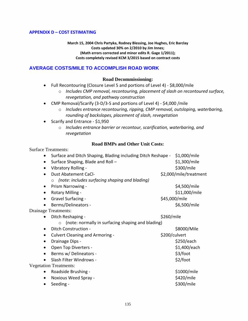
135
APPENDIX D – COST ESTIMATING
March 15, 2004 Chris Partyka, Rodney Blessing, Joe Hughes, Eric Barclay Costs updated 30% on 2/2010 by Jim Innes;
(Math errors corrected and minor edits R. Gage 1/2011); Costs completely revised KCM 3/2015 based on contract costs
AVERAGE COSTS/MILE TO ACCOMPLISH ROAD WORK
Road Decommissioning: Full Recontouring (Closure Level 5 and portions of Level 4) ‐ $8,000/mile
o Includes CMP removal, recontouring, placement of slash on recontoured surface, revegetation, and pathway construction
CMP Removal/Scarify (3‐D/3‐S and portions of Level 4) ‐ $4,000 /mile o Includes entrance recontouring, ripping, CMP removal, outsloping, waterbaring,
rounding of backslopes, placement of slash, revegetation
Scarify and Entrance ‐ $1,950 o Includes entrance barrier or recontour, scarification, waterbaring, and
revegetation
Road BMPs and Other Unit Costs: Surface Treatments:
Surface and Ditch Shaping, Blading including Ditch Reshape ‐ $1,000/mile
Surface Shaping, Blade and Roll – $1,300/mile
Vibratory Rolling ‐ $300/mile
Dust Abatement CaCl‐ $2,000/mile/treatment o (note: includes surfacing shaping and blading)
Prism Narrowing ‐ $4,500/mile
Rotary Milling ‐ $11,000/mile
Gravel Surfacing ‐ $45,000/mile
Berms/Delineators ‐ $6,500/mile Drainage Treatments:
Ditch Reshaping ‐ $260/mile o (note: normally in surfacing shaping and blading)
Ditch Construction ‐ $8000/Mile
Culvert Cleaning and Armoring ‐ $200/culvert
Drainage Dips ‐ $250/each
Open Top Diverters ‐ $1,400/each
Berms w/ Delineators ‐ $3/foot
Slash Filter Windrows ‐ $2/foot Vegetation Treatments:
Roadside Brushing ‐ $1000/mile
Noxious Weed Spray ‐ $420/mile
Seeding ‐ $300/mile
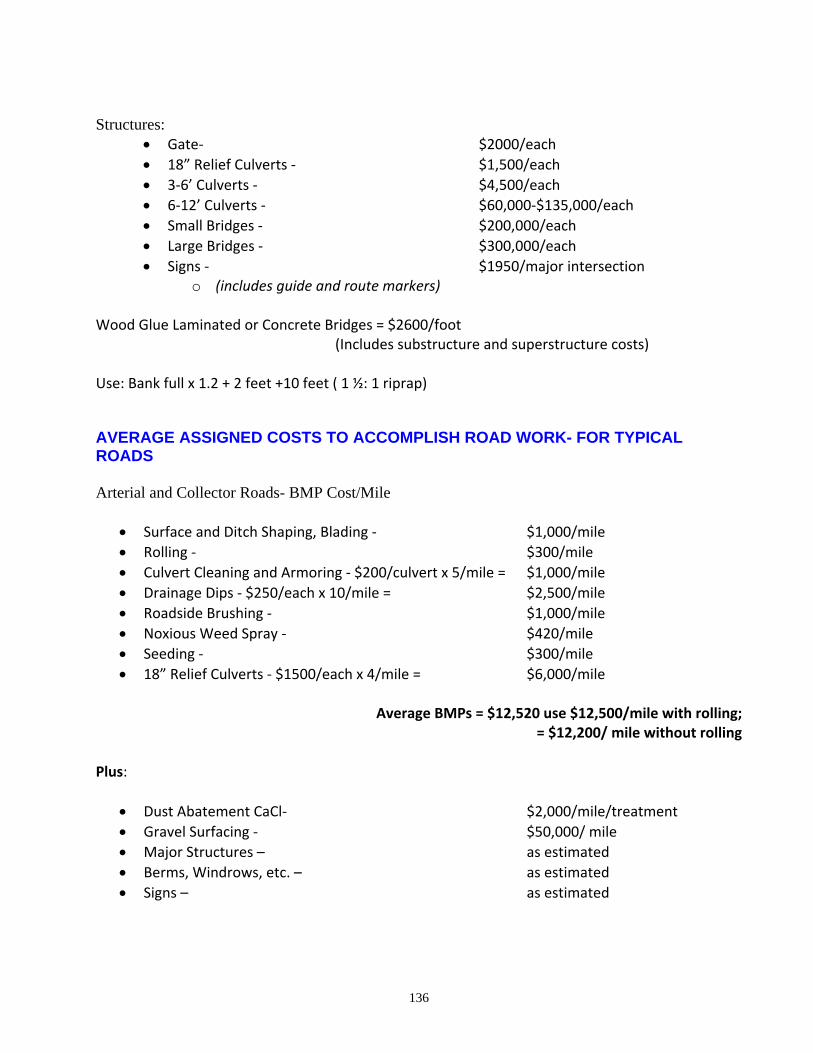
136
Structures:
Gate‐ $2000/each
18” Relief Culverts ‐ $1,500/each
3‐6’ Culverts ‐ $4,500/each
6‐12’ Culverts ‐ $60,000‐$135,000/each
Small Bridges ‐ $200,000/each
Large Bridges ‐ $300,000/each
Signs ‐ $1950/major intersection o (includes guide and route markers)
Wood Glue Laminated or Concrete Bridges = $2600/foot (Includes substructure and superstructure costs) Use: Bank full x 1.2 + 2 feet +10 feet ( 1 ½: 1 riprap)
AVERAGE ASSIGNED COSTS TO ACCOMPLISH ROAD WORK- FOR TYPICAL ROADS Arterial and Collector Roads- BMP Cost/Mile
Surface and Ditch Shaping, Blading ‐ $1,000/mile
Rolling ‐ $300/mile
Culvert Cleaning and Armoring ‐ $200/culvert x 5/mile = $1,000/mile
Drainage Dips ‐ $250/each x 10/mile = $2,500/mile
Roadside Brushing ‐ $1,000/mile
Noxious Weed Spray ‐ $420/mile
Seeding ‐ $300/mile
18” Relief Culverts ‐ $1500/each x 4/mile = $6,000/mile
Average BMPs = $12,520 use $12,500/mile with rolling; = $12,200/ mile without rolling
Plus:
Dust Abatement CaCl‐ $2,000/mile/treatment
Gravel Surfacing ‐ $50,000/ mile
Major Structures – as estimated
Berms, Windrows, etc. – as estimated
Signs – as estimated
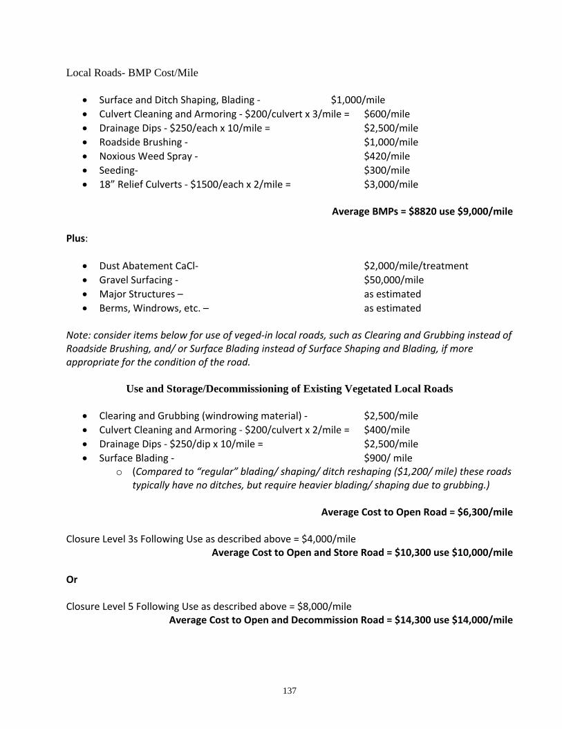
137
Local Roads- BMP Cost/Mile
Surface and Ditch Shaping, Blading ‐ $1,000/mile
Culvert Cleaning and Armoring ‐ $200/culvert x 3/mile = $600/mile
Drainage Dips ‐ $250/each x 10/mile = $2,500/mile
Roadside Brushing ‐ $1,000/mile
Noxious Weed Spray ‐ $420/mile
Seeding‐ $300/mile
18” Relief Culverts ‐ $1500/each x 2/mile = $3,000/mile
Average BMPs = $8820 use $9,000/mile
Plus:
Dust Abatement CaCl‐ $2,000/mile/treatment
Gravel Surfacing ‐ $50,000/mile
Major Structures – as estimated
Berms, Windrows, etc. – as estimated Note: consider items below for use of veged‐in local roads, such as Clearing and Grubbing instead of Roadside Brushing, and/ or Surface Blading instead of Surface Shaping and Blading, if more appropriate for the condition of the road.
Use and Storage/Decommissioning of Existing Vegetated Local Roads
Clearing and Grubbing (windrowing material) ‐ $2,500/mile
Culvert Cleaning and Armoring ‐ $200/culvert x 2/mile = $400/mile
Drainage Dips ‐ $250/dip x 10/mile = $2,500/mile
Surface Blading ‐ $900/ mile o (Compared to “regular” blading/ shaping/ ditch reshaping ($1,200/ mile) these roads
typically have no ditches, but require heavier blading/ shaping due to grubbing.)
Average Cost to Open Road = $6,300/mile Closure Level 3s Following Use as described above = $4,000/mile
Average Cost to Open and Store Road = $10,300 use $10,000/mile Or Closure Level 5 Following Use as described above = $8,000/mile
Average Cost to Open and Decommission Road = $14,300 use $14,000/mile
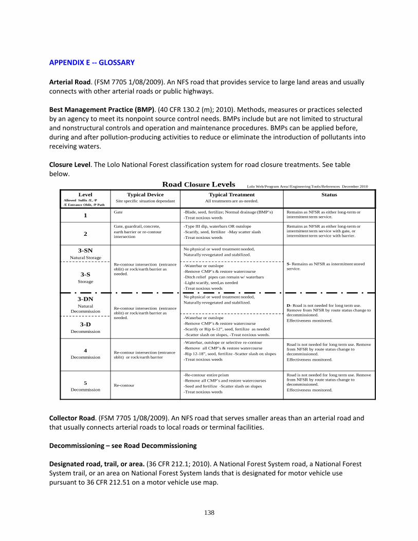
138
APPENDIX E ‐‐ GLOSSARY Arterial Road. (FSM 7705 1/08/2009). An NFS road that provides service to large land areas and usually connects with other arterial roads or public highways. Best Management Practice (BMP). (40 CFR 130.2 (m); 2010). Methods, measures or practices selected by an agency to meet its nonpoint source control needs. BMPs include but are not limited to structural and nonstructural controls and operation and maintenance procedures. BMPs can be applied before, during and after pollution‐producing activities to reduce or eliminate the introduction of pollutants into receiving waters. Closure Level. The Lolo National Forest classification system for road closure treatments. See table below.
LevelAllowed Suffix /E, /P
/E Entrance Oblit, /P Path
Typical DeviceSite specific situation dependant
Typical Treatment All treatments are as-needed.
Status
1Gate -Blade, seed, fertilize; Normal drainage (BMP’s)
-Treat noxious weeds
Remains as NFSR as either long-term or intermittent term service.
2
Gate, guardrail, concrete,
earth barrier or re-contour intersection
-Type III dip, waterbars OR outslope
-Scarify, seed, fertilize -May scatter slash
-Treat noxious weeds
Remains as NFSR as either long-term or intermittent term service with gate, or intermittent term service with barrier.
3-SNNatural Storage
Re-contour intersection (entrance oblit) or rock/earth barrier as needed.
No physical or weed treatment needed,
Naturally revegetated and stabilized.
S- Remains as NFSR as intermittent stored service.
3-SStorage
-Waterbar or outslope
-Remove CMP’s & restore watercourse
-Ditch relief pipes can remain w/ waterbars
-Light scarify, seed,as needed
-Treat noxious weeds
3-DNNatural
DecommissionRe-contour intersection (entrance oblit) or rock/earth barrier as needed.
No physical or weed treatment needed,
Naturally revegetated and stabilized.D- Road is not needed for long term use. Remove from NFSR by route status change to decommissioned.
Effectiveness monitored.-Waterbar or outslope
-Remove CMP’s & restore watercourse
-Scarify or Rip 6-12”, seed, fertilize as needed
-Scatter slash on slopes, -Treat noxious weeds.
3-DDecommission
4Decommission
Re-contour intersection (entrance oblit) or rock/earth barrier
-Waterbar, outslope or selective re-contour
-Remove all CMP’s & restore watercourse
-Rip 12-18”, seed, fertilize -Scatter slash on slopes
-Treat noxious weeds
Road is not needed for long term use. Remove from NFSR by route status change to decommissioned.
Effectiveness monitored.
5Decommission
Re-contour
-Re-contour entire prism
-Remove all CMP’s and restore watercourses
-Seed and fertilize -Scatter slash on slopes
-Treat noxious weeds
Road is not needed for long term use. Remove from NFSR by route status change to decommissioned.
Effectiveness monitored.
Road Closure Levels Lolo Web/Program Area//Engineering Tools/References December 2010
Collector Road. (FSM 7705 1/08/2009). An NFS road that serves smaller areas than an arterial road and that usually connects arterial roads to local roads or terminal facilities. Decommissioning – see Road Decommissioning Designated road, trail, or area. (36 CFR 212.1; 2010). A National Forest System road, a National Forest System trail, or an area on National Forest System lands that is designated for motor vehicle use pursuant to 36 CFR 212.51 on a motor vehicle use map.
139
Forest road or trail. (36 CFR 212.1; 2010). A road or trail wholly or partly within or adjacent to and serving the National Forest System that the Forest Service determines is necessary for the protection, administration, and utilization of the National Forest System and the use and development of its resources. Forest transportation atlas. (36 CFR 212.1; 2010). A display of the system of roads, trails, and airfields of an administrative unit. [The Forest roads atlas is that portion of the transportation atlas that displays roads.] Forest transportation facility. (36 CFR 212.1; 2010). A forest road or trail or an airfield that is displayed in a forest transportation atlas, including bridges, culverts, parking lots, marine access facilities, safety devices, and other improvements appurtenant to the forest transportation system. Forest transportation system. (36 CFR 212.1; 2010). The system of National Forest System roads, National Forest trails, and airfields on National Forest System lands. Highway‐Legal Vehicle. (FSM 7705 1/08/2009). Any motor vehicle that is licensed or certified under state law for general operation on all public roads in the state. Operators of highway‐legal vehicles are subject to state traffic law, including requirements for operator licensing. Jurisdiction Over a Forest Transportation Facility. (FSM 7705 1/08/2009). The legal right to control or regulate use of a forest transportation facility derived from title, an easement, an agreement, or other similar source. Land Systems Inventory (LSI), 1988. The Lolo National Forest comprehensive inventory of soil and vegetation patterns / resources. In the classification system, the first two‐digit number refers to the landform type, the first letter to the right of the number refers to the geology/ parent material, the next letter to the right refers to the vegetation phase.
The following LSI map units are referred to in this report: None ‐‐ for Center Horse Landscape Restoration, the only proposed new road construction is for temporary roads and those are discussed in relation to LSI in the Soils and other specialists’ reports. No issues associated with geology, soils, or landforms where observed that would have a bearing on other road treatments that follow BMPs. See the Soils Report for a description of the Center Horse Landscape Restoration geology, landtypes, LSI, etc.
Local Road. (FSM 7705 1/08/2009). An NFS road that connects a terminal facility with collector roads, arterial roads, or public highways and that usually serves a single purpose involving intermittent use. Maintenance. (36 CFR 212.1; 2010). The upkeep of the entire forest transportation facility including surface and shoulders, parking and side areas, structures, and such traffic‐control devices as are necessary for its safe and efficient utilization. See also “Road Maintenance” below. Maintenance Levels (FSH 7709.59, chapter 60, 62.32, 2/5/2009):
Level 1. These are roads that have been placed in storage between intermittent uses. The period of storage must exceed 1 year. Basic custodial maintenance is performed to prevent damage to adjacent resources and to perpetuate the road for future resource management needs. Emphasis is
140
normally given to maintaining drainage facilities and runoff patterns. Planned road deterioration may occur at this level. Appropriate traffic management strategies are "prohibit" and "eliminate" all traffic. These roads are not shown on motor vehicle use maps. Roads receiving level 1 maintenance may be of any type, class, or construction standard, and may be managed at any other maintenance level during the time they are open for traffic. However, while being maintained at level 1, they are closed to vehicular traffic but may be available and suitable for nonmotorized uses.
Level 2. Assigned to roads open for use by high clearance vehicles. Passenger car traffic, user comfort, and user convenience are not considerations. Warning signs and traffic control devices are not provided with the exception that some signing, such as W‐18‐1 “No Traffic Signs,” may be posted at intersections. Motorists should have no expectations of being alerted to potential hazards while driving these roads. Traffic is normally minor, usually consisting of one or a combination of administrative, permitted, dispersed recreation, or other specialized uses. Log haul may occur at this level. Appropriate traffic management strategies are either to:
a. Discourage or prohibit passenger cars, or b. Accept or discourage high clearance vehicles.
Level 3. Assigned to roads open and maintained for travel by a prudent driver in a standard passenger car. User comfort and convenience are not considered priorities. The Manual on Uniform Traffic Control Devices (MUTCD) is applicable. Warning signs and traffic control devices are provided to alert motorists of situations that may violate expectations. Roads in this maintenance level are typically low speed with single lanes and turnouts. Appropriate traffic management strategies are either "encourage" or "accept." "Discourage" or "prohibit" strategies may be employed for certain classes of vehicles or users. Level 4. Assigned to roads that provide a moderate degree of user comfort and convenience at moderate travel speeds. Most roads are double lane and aggregate surfaced. However, some roads may be single lane. Some roads may be paved and/or dust abated. Manual on Uniform Traffic Control Devices is applicable. The most appropriate traffic management strategy is "encourage." However, the "prohibit" strategy may apply to specific classes of vehicles or users at certain times. Level 5. Assigned to roads that provide a high degree of user comfort and convenience. These roads are normally double lane, paved facilities. Some may be aggregate surfaced and dust abated. Manual on Uniform Traffic Control Devices is applicable. The appropriate traffic management strategy is "encourage."
Minimum road system. (36 CFR 212.5(b) (1)). The road system determined to be needed to meet resource and other management objectives adopted in the relevant land and resource management plan (36 CFR part 219), to meet applicable statutory and regulatory requirements, to reflect long‐term funding expectations, to ensure that the identified system minimizes adverse environmental impacts associated with road construction, reconstruction, decommissioning, and maintenance. Motor vehicle. (36 CFR 212.1; 2010). Any vehicle which is self‐propelled, other than:
1. A vehicle operated on rails; and
141
2. Any wheelchair or mobility device, including one that is battery‐powered, that is designed solely
for use by a mobility‐impaired person for locomotion, and that is suitable for use in an indoor pedestrian
area.
Motor vehicle use map (MVUM). (36 CFR 212.1; 2010). A map reflecting designated roads, trails, and areas on an administrative unit or a Ranger District of the National Forest System. Motorized Mixed Use. (FSM 7705 1/08/2009). Designation of an NFS road for use by both highway‐legal and non‐highway‐legal motor vehicles. National Forest System road. (36 CFR 212.1; 2010). A forest road other than a road which has been authorized by a legally documented right‐of‐way held by a State, county, or other local pubic road authority. National Forest System trail. (36 CFR 212.1; 2010). ). A forest trail other than a trail which has been authorized by a legally documented right‐of‐way held by a State, county, or other local pubic road authority. Natural Recovery Value (NRV). The Lolo National Forest classification system for describing the extent of the natural recovery on a road, including vegetative growth, road soil compaction, and road prism condition. For assessment of travel potential, NRV values describe travel ease. For assessment of resource impact, NRV values describe a variety of resource conditions including road prism stability and sediment delivery. It is generally only recorded for roads under National Forest jurisdiction. See the chart below.
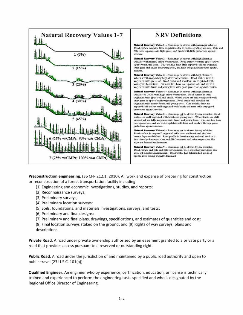
142
Preconstruction engineering. (36 CFR 212.1; 2010). All work and expense of preparing for construction or reconstruction of a forest transportation facility including:
(1) Engineering and economic investigations, studies, and reports; (2) Reconnaissance surveys; (3) Preliminary surveys; (4) Preliminary location surveys; (5) Soils, foundations, and materials investigations, surveys, and tests; (6) Preliminary and final designs; (7) Preliminary and final plans, drawings, specifications, and estimates of quantities and cost; (8) Final location surveys staked on the ground; and (9) Rights of way surveys, plans and descriptions.
Private Road. A road under private ownership authorized by an easement granted to a private party or a road that provides access pursuant to a reserved or outstanding right. Public Road. A road under the jurisdiction of and maintained by a public road authority and open to public travel (23 U.S.C. 101(a)). Qualified Engineer. An engineer who by experience, certification, education, or license is technically trained and experienced to perform the engineering tasks specified and who is designated by the Regional Office Director of Engineering.
143
Road. (36 CFR 212.1; 2010). A motor vehicle route over 50 inches wide, unless identified and managed as a trail. Road construction or reconstruction. (36 CFR 212.1; 2010). Supervising, inspecting, actual building, and incurrence of all costs incidental to the construction or reconstruction of a road. Road Decommissioning. (36 CFR 212.1; 2010). Activities that result in the stabilization and restoration of unneeded roads to a more natural state.
[212.5 (b)(2): Decommissioning roads involves restoring roads to a more natural state. Activities used to decommission a road include, but are not limited to, the following: reestablishing former drainage patterns, stabilizing slopes, restoring vegetation, blocking the entrance to the road, installing water bars, removing culverts, reestablishing drainage‐ways, removing unstable fills, pulling back road shoulders, scattering slash on the roadbed, completely eliminating the roadbed by restoring natural contours and slopes, or other methods designed to meet the specific conditions associated with the unneeded road.]
Road Maintenance. (FSM 7705 1/08/2009). Ongoing upkeep of a road necessary to maintain or restore the road in accordance with its road management objectives (FSM 7714). Road Subject to the Highway Safety Act. (FSM 7705 1/08/2009). An NFS road that is open to public use in a standard passenger car, including a road with access restricted on a seasonal basis and a road closed during extreme weather conditions or for emergencies, but which is otherwise open to public travel. Route. (FSM 2353.05; 11/4/2009). A road or trail. Snowmobile. (FSM 2353.05; 11/4/2009). An over‐snow vehicle that operates on a track, uses one or more skis for steering, and has handle‐bar steering and a seat designed to be straddled by the operator. Stored Road (Travel Routes National Data Dictionary, Infrastructure Application, Version 2.0, April 2009). The road is in a condition that there is little resource risk if maintenance is not performed (self‐maintaining). The maintenance level is 1. Temporary road or trail. (36 CFR 212.1; 2010). A road or trail necessary for emergency operations or authorized by contract, permit, lease, or other written authorization that is not a forest road or trail and that is not included in a forest transportation atlas. Trail. (36 CFR 212.1; 2010). A route 50 inches or less in width or a route over 50 inches wide that is identified and managed as a trail. Travel management atlas. (36 CFR 212.1; 2010). An atlas that consists of a forest transportation atlas and a motor vehicle use map or maps. Unauthorized road or trail. (36 CFR 212.1; 2010). A road or trail that is not a forest road or trail or a temporary road or trail and that is not included in a forest transportation atlas.

144
Unauthorized roads are categorized into two types and recorded in the SYSTEM linear event in the INFRA Travel Routes database. The two types are:
Undetermined (UND). Roads where long‐term purpose and need has yet to be determined.
Not Needed (NOT). Roads not needed for long‐term management of national forest
resources as determined through an appropriate planning document.
For this report, the terms unauthorized, non‐system, and user‐created are synonymous, although user‐created is more logically applied to trails compared to roads.
145
APPENDIX F – CENTER HORSE LANDSCAPE RESTORATION TRAVEL ANALYSIS PROCESS
A travel analysis meeting was held October 6 and 8, 2010, at the Seeley Lake Ranger District office.
Nearly all Forest Service roads within the Center Horse Landscape Restoration Analysis Area that were
mapped at that time were included. This meeting followed the first field season of ground assessments
for Center Horse Landscape Restoration. Interdisciplinary team (IDT) members that participated in the
meeting, with disciplines they represented, are listed below:
Tami Paulsen ‐ IDT leader
Tim Love‐ District Ranger
Scott Tomson‐ Wildlife
Karen Linford‐ Lands
Shane Hendrickson‐ Fisheries
Randy Gage‐ Transportation Planning
Steve Thompson‐ Forestry Tech.
John Errecart‐ Silviculture
Taylor Greenup‐ Hydrologist
Shannon Connolly‐ Noxious weeds, Range, Recreation and Roadless
Phil Shelmerdine‐ Fire and Fuels/Air Quality
Jim Blackburn‐ Noxious weeds, Range, Recreation and Roadless
Lisa Blackburn‐ GIS
The scope of the analysis included all foreseeable travel management actions under the preliminary
project objectives of:
Improve ecosystem function, integrity, and resiliency(by improving forest conditions, reducing
stream sediment sources and improving aquatic habitat, and reducing weeds), and
Provide for social and economic needs of the community (by reducing severity of unplanned
fires, providing an economically viable project for timber and restoration industries, and
enhancing existing recreation developments and opportunities).
For roads, this included the broad range of possible actions (separately or in combination) of
decommissioning and storing (including appropriate closure levels), adding non‐system roads to the
official system, constructing new system roads, constructing temporary roads, retaining system roads
and incorporating BMPs, putting roads under special use permits, recommending specific stream
crossing structures for upgrades, and changes to travel management. These actions relate to both
identifying the minimum road system appropriate for the area and to re‐examining routes designated
for motor vehicle use. (Route designations were part of the Forest Plan in 1986 and were also made in
subsequent project decisions; these have been incorporated in the Forest Travel Plan portion of the
Forest Visitors Map and are now shown on the Motor Vehicle Use Map, published October 1, 2009.)
While the focus of the meeting was on roads, trails were also briefly included in the discussions.
The scale of the analysis was the Center Horse Landscape Restoration Analysis Area.
146
Transportation‐related issues and opportunities that were considered in the analysis were:
High road densities, including stacked jammer roads (water quality issue);
Weeds;
Providing adequate access for vegetation treatments, fire suppression, and recreational use;
Disturbance to wildlife, notably elk, lynx, fisher, goshawk, and flammulated owls;
Opportunities to establish good lynx forage habitat through vegetation treatments as well as
through road management.
Visuals;
Topography;
Impacts from pine beetle outbreaks;
Opportunities for western larch enhancement;
Fisheries opportunities or issues, especially culverts that are barriers.
Data that was used in the analysis included the Forest road and trail GIS layers, tabular road information
in Infrastructure/ I‐web, other discipline’s GIS data, detailed route reconnaissance information collected
by a partner organization (Wildands CPR) in 2010, and personal knowledge of field conditions.
The analysis process involved discussing each road, road segment, or group of roads in terms of access
values and impacts from the road and rating the road by access needed (Fire, Veg, and Human uses) and
by impacts (water and wildlife). Ratings were High, Medium, or Low. Along with comments and ratings,
the team developed a consensus recommendation for the road. In some cases, a 2nd logical
recommendation was made. If information was lacking or road conditions needed field verification, then
that was noted. The comments, ratings, and recommendations were compiled in spreadsheet form that
includes information such as road milepoints, length, travel management, and system/ jurisdiction.
After the initial travel analysis meeting, the travel analysis process continued as map updates were
made, vegetation treatment proposals were refined, and better field information became available. The
travel analysis process report includes this transportation assessment and the master spreadsheet of
road data, comments, ratings, and recommendations. A summary of the master spreadsheet, showing
Forest Service road segments, existing travel management, and recommendations from the travel
analysis process, is included in this appendix. The full spreadsheet is available in the project file. (The
master spreadsheet includes roads of all jurisdictions as it is used for the basis of reporting non‐Forest
Service roads and for generating the GIS symbologies.)
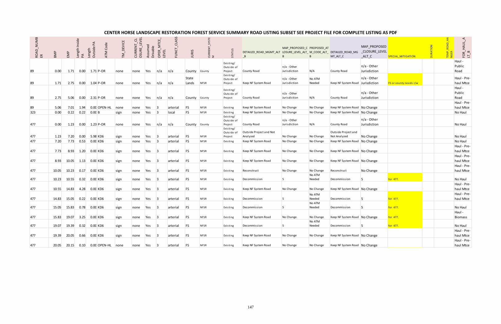
147
CENTER HORSE LANDSCAPE RESTORATION FOREST SERVICE SUMMARY ROAD LISTING SUBSET SEE PROJECT FILE FOR COMPLETE LISTING AS PDF ROAD_NUMB
ER BMP
EMP
Length Inside
PA
Length
Outside PA
ATM
Code
TM_DEV
ICE
CURREN
T_CL
OSU
RE_LEVEL
Assumed
Drivable
OPER_MTCE_
LEVEL
FUNCT_CLASS
JURIS
CURRENT_SYSTE
M STATUS
DETAILED_ROAD_MGMT_ALT
_B
MAP_PROPOSED_C
LOSURE_LEVEL_ALT_
B
PROPOSED_AT
M_CODE_ALT_
B
DETAILED_ROAD_MG
MT_ALT_C
MAP_PROPOSED
_CLOSURE_LEVEL
_ALT_C SPECIAL_MITIGATION DURATION
TEMP_ROAD_HA
NGER
FOR_HAUL_A
LT_B
89 0.00 1.71 0.00 1.71 P‐OR none none Yes n/a n/a County County
Exis ting/
Outs ide of
Project County Road
n/a ‐ Other
Jurisdiction N/A County Road
n/a ‐ Other
Jurisdiction 0 0 0
Haul ‐
Public
Road
89 1.71 2.75 0.00 1.04 P‐OR none none Yes n/a n/a
State
Lands NFSR
Exis ting/
Outs ide of
Project Keep NF System Road
n/a ‐ Other
Jurisdiction
No ATM
Needed Keep NF System Road
n/a ‐ Other
Jurisdiction FS or county needs r/w 0 0
Haul ‐ Pre‐
haul Mtce
89 2.75 5.06 0.00 2.31 P‐OR none none Yes n/a n/a County County
Exis ting/
Outs ide of
Project County Road
n/a ‐ Other
Jurisdiction N/A County Road
n/a ‐ Other
Jurisdiction 0 0 0
Haul ‐
Public
Road
89 5.06 7.01 1.94 0.00 OPEN‐HL none none Yes 3 arterial FS NFSR Exis ting Keep NF System Road No Change No Change Keep NF System Road No Change 0 0 0
Haul ‐ Pre‐
haul Mtce
323 0.00 0.22 0.22 0.00 B sign none Yes 3 local FS NFSR Exis ting Keep NF System Road No Change No Change Keep NF System Road No Change 0 0 0 No Haul
477 0.00 1.23 0.00 1.23 P‐OR none none Yes n/a n/a County County
Exis ting/
Outs ide of
Project County Road
n/a ‐ Other
Jurisdiction N/A County Road
n/a ‐ Other
Jurisdiction 0 0 0 No Haul
477 1.23 7.20 0.00 5.98 KD6 sign none Yes 3 arterial FS NFSR
Exis ting/
Outs ide of
Project
Outside Project and Not
Analyzed No Change No Change
Outside Project and
Not Analyzed No Change 0 0 0 No Haul
477 7.20 7.73 0.53 0.00 KD6 sign none Yes 3 arterial FS NFSR Exis ting Keep NF System Road No Change No Change Keep NF System Road No Change 0 0 0 No Haul
477 7.73 8.93 1.20 0.00 KD6 sign none Yes 3 arterial FS NFSR Exis ting Keep NF System Road No Change No Change Keep NF System Road No Change 0 0 0
Haul ‐ Pre‐
haul Mtce
477 8.93 10.05 1.13 0.00 KD6 sign none Yes 3 arterial FS NFSR Exis ting Keep NF System Road No Change No Change Keep NF System Road No Change 0 0 0
Haul ‐ Pre‐
haul Mtce
477 10.05 10.23 0.17 0.00 KD6 sign none Yes 3 arterial FS NFSR Exis ting Reconstruct No Change No Change Reconstruct No Change 0 0 0
Haul ‐ Pre‐
haul Mtce
477 10.23 10.55 0.32 0.00 KD6 sign none Yes 3 arterial FS NFSR Exis ting Decommission 5
No ATM
Needed Decommission 5 for 477. 0 0 No Haul
477 10.55 14.83 4.28 0.00 KD6 sign none Yes 3 arterial FS NFSR Exis ting Keep NF System Road No Change No Change Keep NF System Road No Change 0 0 0
Haul ‐ Pre‐
haul Mtce
477 14.83 15.05 0.22 0.00 KD6 sign none Yes 3 arterial FS NFSR Exis ting Decommission 5
No ATM
Needed Decommission 5 for 477. 0 0
Haul ‐ Pre‐
haul Mtce
477 15.05 15.83 0.78 0.00 KD6 sign none Yes 3 arterial FS NFSR Exis ting Decommission 5
No ATM
Needed Decommission 5 for 477. 0 0 No Haul
477 15.83 19.07 3.25 0.00 KD6 sign none Yes 3 arterial FS NFSR Exis ting Keep NF System Road No Change No Change Keep NF System Road No Change for 477. 0 0
Haul ‐
Biomass
477 19.07 19.39 0.32 0.00 KD6 sign none Yes 3 arterial FS NFSR Exis ting Decommission 5
No ATM
Needed Decommission 5 for 477. 0 0 No Haul
477 19.39 20.05 0.66 0.00 KD6 sign none Yes 3 arterial FS NFSR Exis ting Keep NF System Road No Change No Change Keep NF System Road No Change 0 0 0
Haul ‐ Pre‐
haul Mtce
477 20.05 20.15 0.10 0.00 OPEN‐HL none none Yes 3 arterial FS NFSR Exis ting Keep NF System Road No Change No Change Keep NF System Road No Change 0 0 0
Haul ‐ Pre‐
haul Mtce

148