Embed Size (px)
Citation preview

UNITED STATES DEPARTMENT OF THE INTERIOR
EROS Data Center
Gravity data for the state of Nevadaon magnetic tape
U.S. Geological Survey Open-File Report 88-433
by
Richard W. SaltusUnited States Geological Survey
P.O. Box 25046, Denver Federal Center, Mail Stop 964Denver, Colorado 80225
July 1988
-AMEMW- in 44-- dnowedIA&M Amwbwa� - - I I- - � am ww -

UNITED STATES DEPARTMENT OF THE INTERIOR
EROS Data Center
Gravity data for the state of Nevadaon magnetic tape
U.S. Geological Survey Open-File Report 88-433
by
Richard W. SaltusUnited States Geological Survey
P.O. Box 25046, Denver Federal Center, Mail Stop 964Denver, Colorado 80225
July 1988
3.
Gravity data for the state of Nevada onmagnetic tape
R. W. SaltusU.S. Geological Survey
Denver, CO
July 26, 1988
Abstract
Gravity data assembled for a state gravity map to be published bythe Nevada Bureau of Mines are available from the EROS data centeron magnetic tape. The first 18 files of the tape contain principal factsfor individual data points, organised by 1 x 2 quadrangle. The approxi-mately 71,000 individual data points are from numerous sources includingthe Defense Mapping Agency data base and U.S. Geological Survey files.Each data record contains geographic position, observed gravity, terraincorrection, Bouguer gravity anomaly (p = 2.67 g/cm'), and isostatic resid-ual anomaly (Airy Heiskanen, T = 25 kIm, Ap = 0.4 g/cm'). The 19thand 20th data files are 2 km square grids of complete Bouguer and iso-static residual gravity values based on the data in the preceding files. The9-track magnetic tape is written at 1,600 bytes-per-inch (BPI) in ASCIIformat with an g0-character record and 4,000-character (50 record) blocksize.
Gravity sources
These Nevada gravity data consist primarily of data from the Defense MappingAgency (DOD) data base (available from the National Geophysical and Solar-Terrestrial Data Center, Boulder, Colorado 80303). Additional data from U.S.Geological Survey (USGS) files in Denver, Colorado and Menlo Park, Californiaare included. Most of the USGS data are documented in published Bouguergravrity anomaly maps and principal facts reports for the following 1 x 2°quadrangles in Nevada (see appendix for source DOD references):
* Caliente (Healey and others, 1981b)
a Death Valley (Healey and others, 1980b)
I
* Ely (Ponce and others, 1984)
* Goldfield (Healey and others, 1980a)
* Kingman (Bracken and Kane, 1983)
* Las Vegas (Kane and others, 1979)
* Lund (Bol and others, 1983)
* Millett (Erwin and Bittleston, 1977)
* Reno (Erwin and Berg, 1977)
* Tonopah (Healey and others, 1981a; Bol and others, 1983)
* Walker Lake (Plouff, 1984)
Gravity reduction
The observed gravity datum is the International Gravity Standardization Net of1971 (IGSN 71; Morelli, 1974). Bouguer gravity anomalies were computed usingthe 1967 Geodetic Reference System (GRS 67) formula for theoretical gravityat sea level (International Association of Geodesy, 1971) as implemented ona computer (Cordell and others, 1982). A Bouguer reduction density of 2.67g/cm3 was used. Terrain corrections were calculated for the region extendingradially to 167 km from each station using a digital terrain model based on a15 second geographic grid (Plouff, 1977). Inner zone terrain corrections fromthe station to a distance of 0.59 km (Hayford zone D; Swick, 1942) were doneby hand for most USGS stations. For stations obtained from the DOD, innerzone corrections were approximated by computer. A curvature correction forthe deviation of the spheroidal Earth from the Bouguer approximation has alsobeen applied. Gravity stations were removed from the data set if their Bougueranomalies varied unrealistically from nearby stations. Most of the Bouguervalues are estimated to be accurate to better than I milligal (mGal; 1 mGal =10-' m/s3 ). However, individual stations in regions of variable topography mayhave errors as great as 4 mGal because of errors in terrain correction.
Isostatic residual gravity anomalies were calculated by removing a regionalfield from the Bouguer anomalies. This isostatic regional was calculated basedon an Airy-Heiskanen model of local isostatic compensation (Heiskanen andMoritz, 1967). The isostatic model is described by the following parameters: acompensation depth of 25 km below sea level, a density contrast at depth of 0.4g/cma, and a surface load density of 2.67 g/cms. These parameters agree withthose used for the isostatic gravity map of California (Jachens and Griscom,1985; Roberts and others, 1981). The utility of the isostatic residual anomalyis discussed by Simpson and others (1986).
2
A shift of approximately -2 mGal occurs between Bouguer values reducedusing the IGSN 71 datum and GRS 67 formula and Bouguer values reducedwith the older Woollard and Rose (1963) datum and 1930 International Gravityformula (Swick, 1942) used for the complete Bouguer gravity map of California(Oliver and others, 1980). Care must be taken if these data are to be combinedwith older data sets of California to prevent a 2 mGal step across the stateboundary. Oliver (1980, page 52) discusses the datum conversion in some detail.All data on this tape are relative to the IGSN 71 datum and GRS 67 formula.
Tape characteristics
Density: 1,600 bytes per inch (BPI)
Record size: 80 characters
Block size: 4,000 characters (50 records)
Format: Ascii, unlabeled
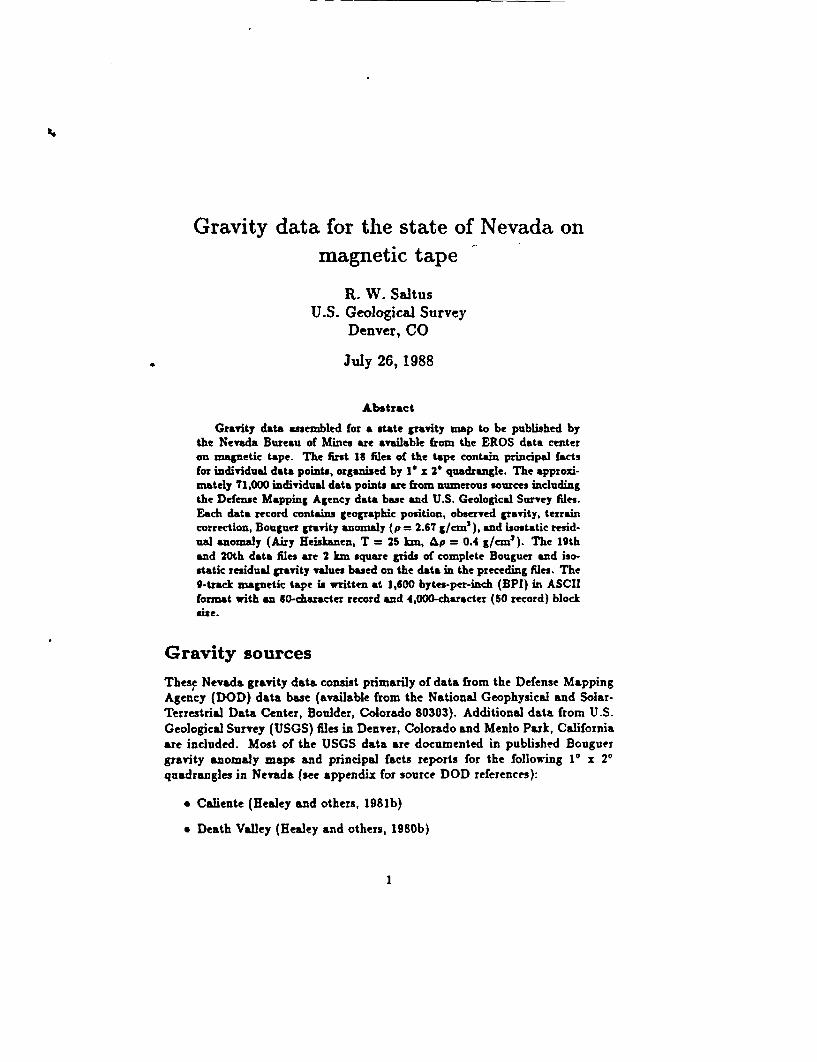
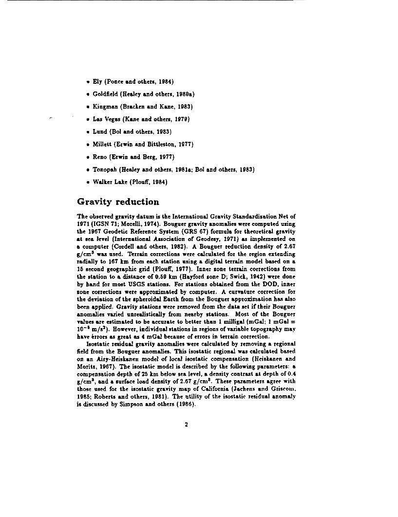
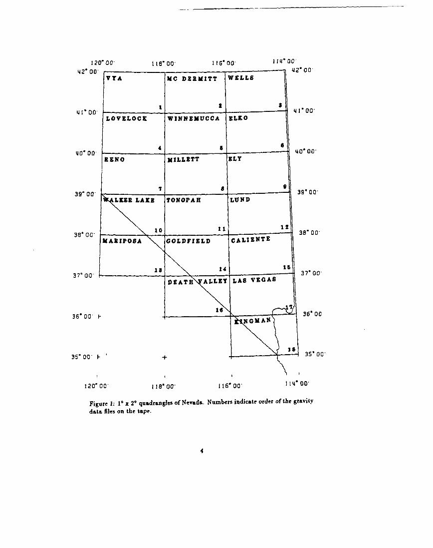
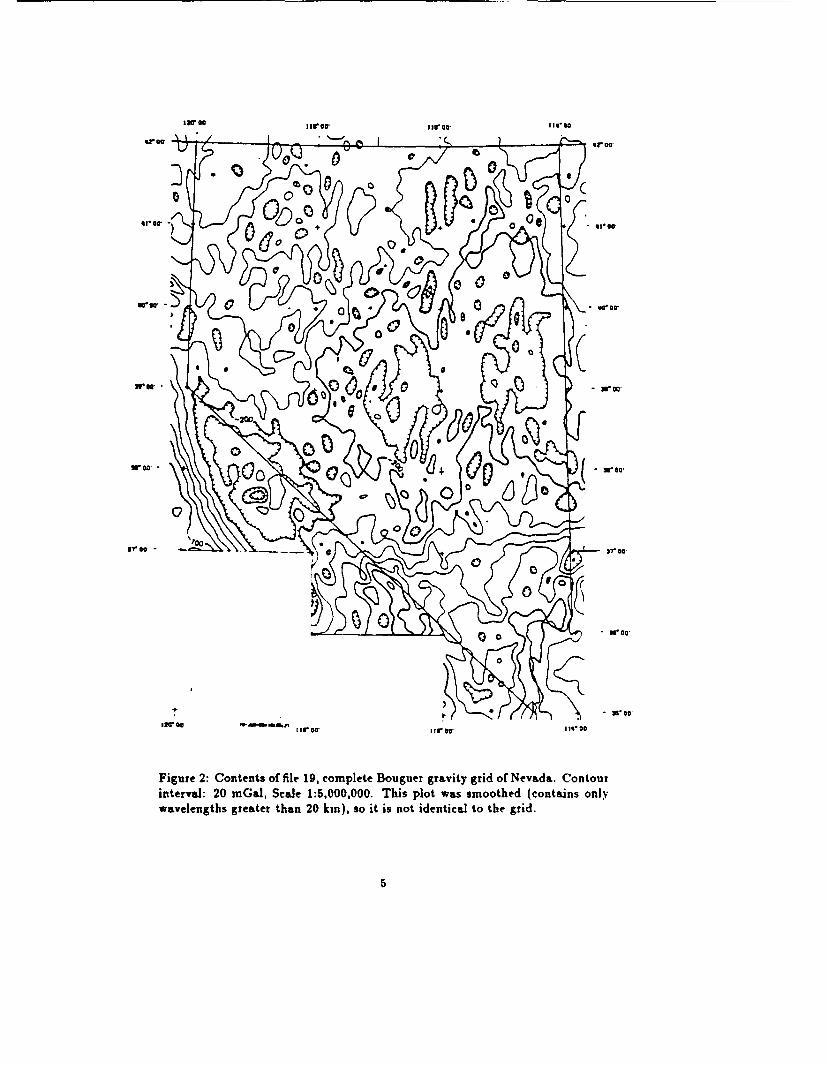
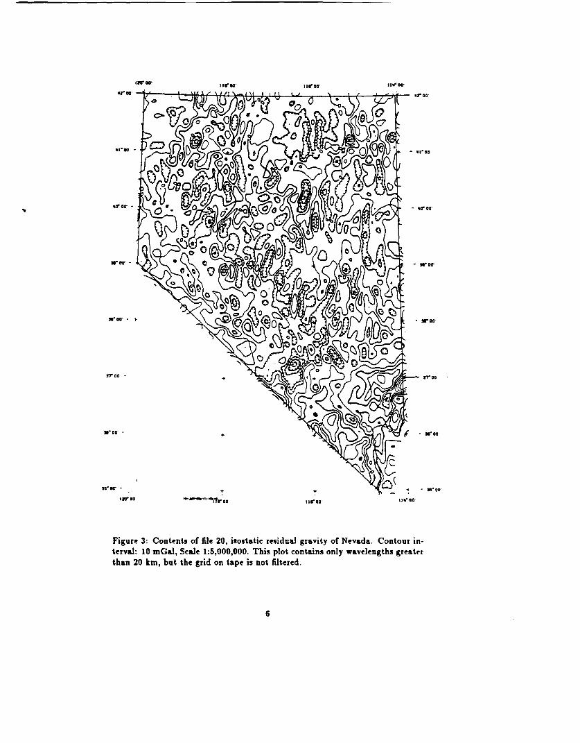
Files: 20 files. File order and contents are given in table 1. The first 18 fileseach contain data from a 1° by 2° quadrangle (see figure 1). The last twofiles contain gridded Bouguer and isostatic residual gravity values (seefigures 2 and 3).
Tape file header
The first 10 lines of each tape file contain descriptive information about the file.The gravity data begin at record (line) number 11 and have the format givenin table 2. A description of the 10 header lines follows:
1. Type of file (I=grid, 7=ASCII) and creation date.
2. Name of the file.
3. Description of file contents.
4. FORTRAN format of each data record.
5. Information on file format.
6. Information on gridded data parameters (for gridded data only).
7. More information about gridded data parameters (for gridded data only).
8. May contain descriptive text.
9. May contain descriptive text.
10. May contain descriptive text.
3
120 0042' 00 -
VI
41I'00.LO
40 00 -
IZ
39' 00
3800 -MAl
3700 co
36* 00 k-
35- 00 -
120- 00
I 1 8 o- I I6' 00 II's 0Q--s &12'00
41-00,
40- 00G
39' 00
38' 0 0
374 00
36- 00
35' 00
118 00* 116' 00D 114' 00
Figure 1: 1° x 2° quadrangles of Nevada. Numbers indicate order of the gravitydata files on the tape.
4
Iar @0 1rea Xmr If at I Ii.@0
or 00
Stir Do, ' 1 W o, '0 ~~~~~~~~0
C I 00llfoe0' °
Figure 2: Contents offic19, complete37 00
0~~~~ 0
hirer I 3rDa 1rat15 ,00
Figure 2: Contents of file 19, complete Bouguer gravity grid of Nevada. Contourinterval: 20 mGal, Scale 1:5,000,000. This plot was smoothed (contains onlywavelengths greater than 20 kin), so it is not identical to the grid.
5
rwW $Irf *° lIsroe r Iee Oa
or Oa
Tr Oa -Ir G
is'o- , x- a ToO
1*O 00 co0 11.,0 0
M roo. -- 'ti .9r. ho
Figure 3: Contents of file 20, isostatic residual gravity of Nevada. Contour in-
terval: 10 mGal, Scale 1:5,000,000. This plot contains only wavelengths greater
than 20 km, but the grid on tape is not filtered.
6

Table I- .| - ^ .
File1
23456789
1011121314151617181920
DescriptionVya quadrangleMcDermitt quadrangleWells quadrangleLovelock quadrangleWinnemucca quadrangleElko quadrangleReno quadrangleMillett quadrangleEly quadrangleWalker Lake quadrangleTonopah quadrangleLund quadrangleMariposa quadrangleGoldfield quadrangleCaliente quadrangleDeathvalley quadrangleLas Vegas quadrangleKingman quadrangleNevada Bouguer 2 km gridIsostatic residual 2 km grid
1TAPE FILESLatitude41 -42N 141 -42 N 141 - 42 N 140-41 N 140-41 N 140-41 N 139 - 40 N 139 - 40 N 139 - 40 N 138 - 39 N 138- 39 N 138- 39 N I37- 38 N 137-38 N 137- 38 N 136 - 37 N 136- 37 N 135- 36 N 135 - 42 N 135 - 42 N I
Longitude18 - 120 W16 - 118 W14- 116 W18 - 120 W16 - 118 W14 - 116 W18 - 120 W16 - 118 W14 - 116 W18 - 120 W16 - 118 W14 - 116 W18 - 120 W16 - 118 W14 - 116 W16 - 118 W14- 116 W14- 116 W14 - 120 W14 - 120 W
Contents1,285 stations2,069 stations1,661 stations2,400 stations2,291 stations
901 stations4,547 stations3,563 stations2,997 stations5,663 stations6,861 stations8,454 stations3,514 stations
14,168 stations4,475 stations8,697 stations3,503 stations2,654 stations
397 rows by 282 columns394 rows by 269 columns
Gravity data format
Beginning with line 11, each of the first 18 data files contains the principal factsfor gravity measurements in Nevada. Each record (line) of the file contains infor-mation for a single gravity measurement (a 'station"). The data are organizedin a columnar format (see table 2).
The final 5 columns indicate the data source according to Table 3. The first4 characters of the station name indicate the original sources of DOD data (seeappendix).
Gravity data example
For example, here are the first twenty lines of the first file (gravity data for theVya quadrangle) on the tape. The "U" indicates a space in the file:
FILETYPE=u uuuC TIOWuDATE:u2T-ROV-19 87ulS:2T:41.12TYI.DArUSGSulevadaugravity:uvyauquadrangleulatu4lu-u42uN .ulonulll8 u-ul 2 OuW
7
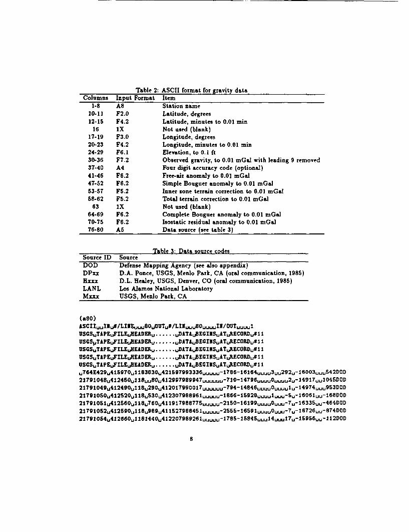
Table 2: ASCII format for gravity dataColumns
1-810-1112-15
1617-1920-2324-2930-3637-404 1-4647-5253-5758-62
6364-6970-7576-80
Input FormatA8F2.0F4.2lxF3.0F4.2F6.1F7.2A4F6.2F6.2F5.2F5.21xF6.2F6.2A5
ItemStation nameLatitude, degreesLatitude, minutes to 0.01 minNot used (blank)Longitude, degreesLongitude, minutes to 0.01 minElevation, to 0.1 ftObserved gravity, to 0.01 mGaJ with leading 9 removedFour digit accuracy code (optional)Free-air anomaly to 0.01 mGalSimple Bouguer anomaly to 0.01 mGalInner zone terrain correction to 0.01 mGalTotal terrain correction to 0.01 mGalNot used (blank)Complete Bouguer anomaly to 0.01 mnGalIsostatic residual anomaly to 0.01 mGalData source (see table 3)
Table 3: Data source codesSource ID SourceDOD Defense Mapping Agency (see also appendix)DPxx D.A. Ponce, USGS, Menlo Park, CA (oral communication, 1985)Krm D.L. Healey, USGS, Denver, CO (oral communication, 1985)LANL Los Alamos National LaboratoryMxxm USGS, Menlo Park, CA
(aBO)ASCII,,I1u#/LINE .. 8OUOUTu#fLhffuu80,uulIN/OUT,,uuIUSGSTAPEuFILEuffEADER ..... uA uE1SAuRCR,1USGSPT1PEFILFXEADE ..... uD1TAuBEG1NSuATuRECORD,#11USGSuTAPEuFILEuREADEILu.....DATABEGINSuATuREC0RtD,*11USGSuTAPEuFILEuKEADER.u....uDATAuBEGIKSATuAEC0RD,#11IUSGSTAPEuFILEuEEADER ..... uDATAuBEG1NSuATuREC0RD,#1 1UT449467uI33,267936....18-66,u3u9,103,62O2179lO48u4l2450ull~uuS0,412997989947u ..... V10I4796u~uuOuuuu2uI14917,,04SD0D21909429U1U9ulOT9~7.. u-9-44 .. 0,Uu194u9302lT9l050u4l2S20ull8uS3Ou4l2 3OT988961,uuuuu1866 -1S92 8uuuulmjuul 6 06 1uu-1 68DOD2I901426U1u6,197875,u,25-69uUO,-,135u44O2 1T9 1052u4 l2 59 0u1l18,989u4 1l2 86uuu2S515lUUU,-U1T6,84O21791054u4l2G66ull8l440u4l2207989261,uuuuu17852l5845u,,14,uul17,u15956,,u 2 DOD
8
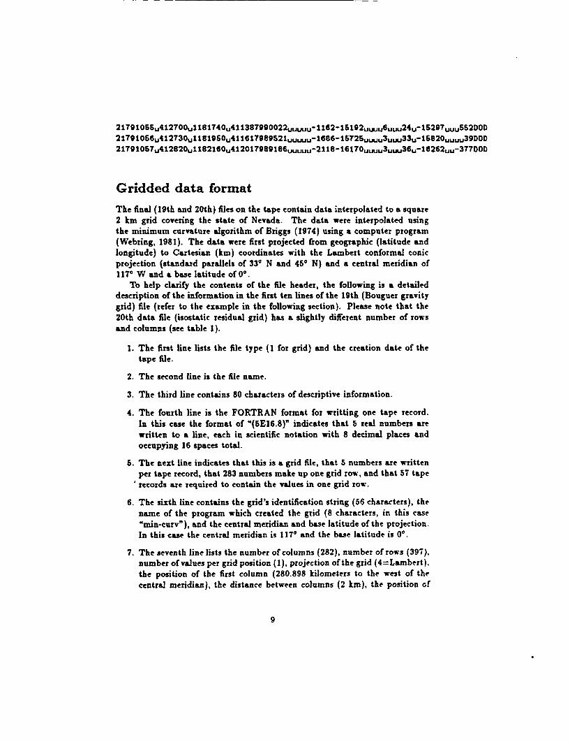
2 lT9lOBSu4 l 2 TO0ul181740u411387 9 900 2 2 uu u-116 2-IS19 2uuuu6uuu2 4 u-iB 2 9 Tuuu552 DOD21791066,412730ul 119SOu41 l6l? 9 8 9 5 2 1uuuu-l 6 8 6 -16725uwu, 3 uuu3 3 u-S820uuuu39 DOD2 lT 9 lOSTu4l 2 82Oull8 2 lGOu 4 l 2OlT989 l86uuuuu-2l 8-1 6 l 7Ouuuu 3 uuu3 6 u-1 6 2 62 uu- 3 7 TDOD
Gridded data format
The final (19th and 20th) files on the tape contain data interpolated to a square2 km grid covering the state of Nevada. The data were interpolated usingthe minimum curvature algorithm of Briggs (1974) using a computer program(Webring, 1981). The data were first projected from geographic (latitude andlongitude) to Cartesian (km) coordinates with the Lambert conformal conicprojection (standard parallels of 33' N and 450 N) and a central meridian of1170 W and a base latitude of 00.
To help clarify the contents of the file header, the following is a detaileddescription of the information in the first ten lines of the 19th (Bouguer gravitygrid) file (refer to the example in the following section). Please note that the20th data file (isostatic residual grid) has a slightly different number of rowsand columns (see table 1).
1. The first line lists the file type (1 for grid) and the creation date of thetape file.
2. The second line is the file name.
3. The third line contains 80 characters of descriptive information.
4. The fourth line is the FORTRAN format for writting one tape record.In this case the format of M(5E16.8)" indicates that 5 real numbers arewritten to a line, each in scientific notation with 8 decimal places andoccupying 16 spaces total.
S. The next line indicates that this is a grid file, that 5 numbers are writtenper tape record, that 283 numbers make up one grid row, and that 57 taperecords are required to contain the values in one grid row.
6. The sixth line contains the grid's identification string (56 characters), thename of the program which created the grid (8 characters, in this case"min-curv"), and the central meridian and base latitude of the projection.In this case the central meridian is 1170 and the base latitude is 00.
7. The seventh line lists the number of columns (282), number of rows (397),number of values per grid position (1), projection of the grid (4=Larnbert).the position of the first column (280.898 kilometers to the west of thecentral meridian), the distance between columns (2 km), the position of
9

the first row (4177. km north of the base latitude), and the distancebetween rows (2 km).
8. The eighth, ninth and tenth lines are just space fillers to keep all the tapeheaders the same length.
So, this file contains (beginning at record 11) the values contained in a 397 x282 matrix. Each row on the tape actually contains 283 values. The first valuein a row is a special value which is used to indicate the row spacing of grids withirregularly spaced rows. For normal evenly spaced grids this value is ignored.Therefore, there are a total of 112,351 (397x283) values in this tape file. Eachrow begins at the begining of a tape record. As indicated in the 4th line of theheader, each grid row occupies 57 tape records. That means there are 22,629(57x397) tape records required for all the rows and columns. Since there areten header records, the total file length is 22,639 records.
The first value in the first row is located at the position indicated by thecolumn and row origin parameters. The second row is north (positive row spac-ings) of the first at the distance indicated by the row spacing (2 kIm). Similarly,the column spacing indicates the direction (positive east) and distance betweencolumns in the grid (also 2 km).
The southwest corner of the grid is in California (see figure 1). This portionof the grid (the 1 x 2° quadrangles not labeled on figure 1) does not containvalid gravity data. The Bouguer grid (file 19) has extrapolated values in thisregion, but they are unconstrained by data outside the labeled quadrangles. Theisostatic residual grid (file 20) is clipped near the Nevada - California border (asindicated by figure 3). The portion of the grid within California contains valuesof 9999.
Gridded data example
Here are the first lines of the 19th file on the tape. As in the previous example,'LI" indicates a space in the tape file.
FILETYPE=uuuuluCREATIO~uDATE:u23-JAN-1988ul2:14:30.44IEVCB .SCCompltou8Ouguesrugravityu-uNevada(SE16.8)CRIDuuuIlu#/LIIEuuu5SuOUTu#/LINuu283uuuuII/OUTuuuS7IEykDAuCBAuGRATITTuuuuuuuuuuuuuuuuuuuuuuuuuuuuuuuuuuuuuunin-curvl-l 7 * 00uu*.000uu282uu397uuulu4u-0.28089783E+03uuO .20000000E+OXuu0 .41770742E+04uuO .20000000E+01THEuTWOuLIIESuSJOVEuCOITAINuGRIDuSPECIFICATIONS.LIUEul:uCURIDIDu(a56) ,uCREATIO~uPROGRAKu(a8),UCUKERID,uBASEuLATLINEu2:u#COLu#RGWu#V&LuPRO3,uluORIG.,uDELuIuTuORIG..UDELUT
10

UuO .OOOOOOOE+OOu-0.12786800E+03-0.127948OOE+03-O . 12802522E+03uO. 12809824E+03u-0.1281661 1E+03uO-. 2822820E+03u-O.12828423E+03uO-.12833400E+03u-O .12837749E.03
U-0 -12841496E+03u-0.12844661E+03u-O.12847260E+03u-0.1284939TE+O3u-0 .12851204E+03
u,-0 12852831E+03u-0.12854398E+03u-0.12855946E+03u-0.12857542E+03u-O0.12859244E.03u-0 12861096E+03u-O .12863162E+03u-0.12866440E+03u-O .12867972E+03u-0.12870723E+03
u-0 -12873651E+03u-O .128T6672E+03u-0. 12879674E+03u-0. 12882667E+03u-0 .12885272E+03
...... .. linei removed to shorten the example
u-0.122007SSE+03u-0.12300253E+03u-0.1 23 90498 E+03uO .OOOOOOOOE+OOuuO .OOOOOOOOE+0OuuO .OOO00000E+0Ou-0. 127908T7E+03u-0.1279809E+03u-0.12804966E+03u-O .12811414E+03u-0.12817342E+03u-0.12822716E+03u-0.12827507E+03u-0.12831737E+03u-0.12835435E+03U-0 . 2838652E+03u-0.12841415E+03u-O.12843748E+03u-0.12845763E+03u-0 .12847600E+03
......File continues on tape, truncated here to shorten the example
Acknowledgements
The gravity data listed here represent many man-years of field work. I thankspecifically Don Healey and Dave Ponce of the USGS for access to their computerdata files. The compilation of gravity data between 360 and 38° north wassupported by the Nevada Operations Office of the U.S. Department of Energyunder Interagency Agreement DFA108-78ET44802.
References
Bol, A. J., Snyder, D. B., Healey, D. L., and Saltus, R. W., 1983, Principalfacts, accuracies, sources, and base station descriptions for 3672 grav-'ity stations in the Lund and Tonopah 1° x 2° quadrangles, Nevada: U.S.Department of Commerce National Technical Information Service, Spring-field, VA 22161, NTIS-PB83-202671.
Bracken, R. E, and Kane, M. F., 1983, Principal facts for gravity stations in theNevada portion of the Kingman 1° x 2° quadrangle: U.S. Department ofCommerce National Technical Information Service, Springfield, VA 22161.NTIS-PB84-103084.
Briggs, I. C., 1974, Machine contouring using minimum curvature: Geophysics,v. 39, no. 1, p. 39-48.
11

Cordell, Lindrith, Keller, G. R., and Hildenbrand, T. G., 1982, Bouguer gravitymap of the Rio Grande Rift, Colorado, New Mexico, and Texas: U.S.Geological Survey Geophysical Investigations Map GP-949.
Erwin, J. W., and Berg, J. C., 1977, Bouguer gravity map of Nevada, RenoSheet: Nevada Bureau of Mines and Geology Map 58, scale 1:250,000.
Erwin, J. W., and Bittleston, E. W., 1977, Bouguer gravity map of Nevada,Millett sheet: Nevada Bureau of Mines and Geology Map 53, scale 1:250,000.
Healey, D. L., Wahl, R. R., and Currey, F. E., 1980a, Bouguer gravity mapof Nevada, Goldfield and Mariposa sheets: Nevada Bureau of Mines andGeology Map 68, scale 1:250,000.
Healey, D. L., Wahl, R. R., and Oliver, H. W., 1980b, Bouguer gravity map ofNevada, Death Valley sheet: Nevada Bureau of Mines and Geology Map69, scale 1:250,000.
Healey, D. L., Snyder, D. B., and Wahl, R. R., 1981a, Bouguer gravity map ofNevada, Tonopah sheet: Nevada Bureau of Mines and Geology Map 73,scale 1:250,000.
Healey, D. L., Snyder, D. B., Wahl, R. R., and Currey, F. E., 1981b, Bouguergravity map of Nevada, Caliente sheet: Nevada Bureau of Mines andGeology Map 70, scale 1:250,000.
Heiskanen, W. A., and Moritz, Helmut, 1967, Physical Geodesy- W. H. Free-man, 364 p.
International Association of Geodesy, 1971, Geodetic Reference System 1967:International Association of Geodesy Special Publication, no. 3, 116 p.
Jachens, R. C., and Griscom, Andrew, 1985, An isostatic residual gravity mapof California - A residual map for interpretation of anomalies from in-tracrustal sources: in Hinze, W. J.,The Utility of Regional Gravity andMagnetic Maps, Society of Exploration Geophysicists, Tulsa Oklahoma
Kane, M. F., Healey, D. L., Peterson, D. L., Kaufmann, H. E., and Reidy, D.,1979, Bouguer gravity map of Nevada, Las Vegas sheet: Nevada Bureauof Mines and Geology Map 61, scale 1:250,000.
Morelli, C., (ed.), 1974, The International Gravity Standardization Net 191: In-ternational Association of Geodesy Special Publication, no. 4, 194 p.
Oliver, H.W., (ed.), 1980, Interpretation of the gravity map of California andits continental margin: California Division of Mines and Geology Bulletyn205, 52 p.
12
Oliver, H.W., Chapman, R.H., Biehler, Shawn, Robbins, S.L., Hanna, W.F.,Griscom, Andrew, Beyer, Larry, and Silver, E.A., 1980, Gravity map ofCalifornia and its continental margin: California Division of Mines andGeology, scale 1:760,000
Plouff, Donald, 1977, Preliminary documentation for a FORTRAN program tocompute computer gravity terrain corrections based on topography digi-tized on a geographic grid: U.S. Geological Survey Open-File Report 77-534, 45 p.
Plouff, Donald, 1984, Bouguer gravity map of Nevada-Walker Lake sheet:Nevada Bureau of Mines and Geology Map 83, scale 1:250,000.
Ponce, D. A., Kohrn, S. B., Saltus, R. W., Spielman, J. B., and Chuchel, B.A., 1984, Preliminary principal facts for gravity stations on the Ely I by2 degree quadrangle, Nevada: U.S. Geological Survey Open-File Report84-387.
Roberts, C. W., Jachens, R. C., and Oliver, H. W., 1981, Isostatic residualgravity map of California: U.S. Geological Survey Open-File Report 81-573, scale 1:750,000.
Simpson, R. W., Jachens, R. C., Blakely, R. J., 1986, A New Isostatic ResidualGravity Map of the Conterminous U.S. With a Discussion on the Signif-icance of Isostatic Residual Anomalies: Journal of Geophysical Research,vol 91, p. 8,348-8,372
Swick, C. H., 1942, Pendulum gravity measurements and isostatic reductions:U.S. Coast and Geodetic Survey Special Publication 232, 82 p.
Webring, Michael, 1981, MINC: A gridding program based on minimum cur-vature: U.S. Geological Survey Open-File Report 81-1224, 41 p.
Woollard, G.P., and Rose, J.C., 1963, International gravity measurements:Society of Exploration Geophysicists, Tulsa, OK, 518 p.
1 Appendix 1: Sources of DOD gravity data
Department of Defense Mapping Agency gravity sources are keyed to the firstfour numbers in the gravity station record on tape. The number of points givenin this list refers to the total number of points in the original DOD data base.not the number in this data file. The sources for DOD gravity data on theaccompanying tape are listed here by id number:
483 Thompson, G. A., Gravity measurements between Hasen and Austin, Nevada,a study of Basin-Range structure: JGR, v. 64, no. 2, Feb. 1959, 98 PTS.
13

704 Bonini, W. E., Gravity anomalies in Idaho, Wyoming, Montana, Wash-ington and Oregon: Idaho Bureau of Mines and Geology, ID, 1963, 5465PTS.
933 U.S. Geological Survey, Gravity observations in Clark County, Nevada in1959: USGS, 864 PTS.
1083 United States Coast and Geodetic Survey, National Gravimeter Base Net-work: USC and GS, NOAA, 3836 PTS.
2078 Wollard, G. P., Tripp SS, Rockies, authority unknown, 1029 PTS.
2149 U.S. Geological Survey, Crustal studies, line seven, Eureka-Fallon NevadaProfile: USGS, NV, 150 PTS.
2179 U.S. Geological Survey, Gravity reductions, Nevada Basin and RangeProject Group 1.
2207 U.S. Geological Survey, Gravity data Owens Valley California: USGS,CA, 1458 PTS.
2231 Mabey, D. R., Death Valley California Gravity Data: USGS, CA 1955,1299 PTS.
2235 U.S. Geological Survey, Gravity data, Carson Sink, Nevada: USGS, NV,456 PTS.
2293 U.S. Geological Survey, Gravity data in Sierra, Nevada: USGS, CA, 1961,543 PTS.
2381 Naval Oceanographic Office, Gravity Data, Channel Islands, California:Navoceano, 1963, 753 PTS.
2493 U.S. Geological Survey, Nevada Test Site Gravity Survey: USGS, 1963,337 PTS.
2515 Bates, R. G., Gravity observations in Pahrurnp, Mesquite and Ivanpah,Yalleys, California and Nevada: USGS, 1964-1965, 382 PTS.
2531 Oregon State University, Oregon State Gravity Data: Oregon State Uni-versity, 3945 PTS.
2049 Gimlett, J. I., The gravimetric method applied to Basin Exploration,Exemplified by a study of Warm Springs Valley, Washoe County, Nevada:Stanford Univ., CA, 1965, 180 PTS.
2680 U.S. Geological Survey, Gravity data: Eureka Valley, California- GoldField, Nevada: USGS, 168 PTS.
14

2656 Chapman, R. H., California Gravity Base Station Network: Div. of Minesand Geology, CA, 357 PTS.
2695 U.S. Geological Survey, Gravity data, Northern Nevada: USGS, 1958,273 PTS.
2096 U.S. Geological Survey, Gravity data, Bull Run, Nevada: USGS, 1959,123 PTS.
2702 U.S. Geological Survey, Grand Canyon Gravity Survey: USGS, 1965, 558PTS.
2716 U.S. Geological Survey, Gravity survey, Madera County, California: USGS,1964, 512 PTS.
2733 Geodetic Survey Squadron, 1st National Gravity Base Net and Excenters,1st GSS, 1967, 252 PTS.
2773 U.S. Geological Survey, Gravity data in Alturas, California area: USGS,1967, 424 PTS.
2774 U.S. Geological Survey, Gravity data in Fresno, California area: USGS,1966, 427 PTS.
2777 U.S. Geological Survey, Gravity data in Mariposa, California area: USGS,1966, 4 PTS.
3046 Erwin, J. W., Gravity data for the Battle Mountain area, Nevada: NevadaBureau of Mines, 1967, 184 PTS.
3047 Erwin, J. W., Gravity data for the Tonopah area, Nevada: Nevada Bureauof Mines, 1965-67, 163 PTS.
3048 Erwin, J. W., Gravity data for the Yerington area, Nevada: Nevada Bu-reau of Mines, 1967, 170 PTS.
3136 Robbins, S. L., USGS Gravity data in California, part 21, Fresno AMS,Sheet: USGS, 1970, 514 PTS.
3236 Robbins, S. L., Gravity data for the Mariposa AMS Sheet: USGS, CA,1969, 571 PTS.
3238 Robbins, S. L., Gravity data in the Mariposa, Sacramento and WalkerLake AMS Sheets: USGS, CA, 1969, 10 PTS.
3260 Rambo, W. L., USGS gravity data in California, part 18, Chico, Reno.Sacramento and Walker Lake AMS Sheets: USGS, 1969, 392 PTS.
15

3277 U.S. Army Topographic Command, Arizona Regional Gravity Survey andBase Network, Preliminary Report: USATOPOCOM, Sept. 1969, 2852PTS.
3358 Montgomery, J. R., Gravity data in Utah: Univ. of Utah, 1970, 822 PTS.
3373 Robbins, S. L., USGS gravity data in California, Part 23, Walker LakeAMS Sheet: USGS, Final Report, Menlo Park, CA 1970, 685 PTS.
3377 Oliver, H. W., Principal facts and plots for gravity stations in southernSierra Nevada and vicinity, California: USGS, 1970, 1753 PTS.
3383 California Division of Mines and Geology, Gravity data for Death ValleyAMS Sheet: CDMG, CA, 1970, 424 PTS.
3385 California Division of Mines and Geology, Gravity data for Trona AMSSheet: CDMG, CA, 1970, 483 PTS.
3483 U.S. Army Topographic Command, Arizona regional gravity survey: US-ATOPOCOM, No. 31, March 1971, 176 PTS.
3502 Pemberton, Trip AD, Series PI, Univ. of Wisconsin, 1964, 820 PTS.
3503 Woollard, G. P., Trip AE, Series B, Princeton Univ., 1939, 573 PTS.
3507 Mack J., and Iverson, R. M., Trip Al, Series M, Univ. of Wisconsin, 1955,435 PTS.
3516 Press, F., Trip AS, Series FP, Univ. of Wisconsin, 212 PTS.
3575 Rose, J. C., Trip TT, Series F, Univ. of Wisconsin, 1949, 913 PTS.
3578 Black, W. E., Trip TW, Series F, Univ. of Wisconsin, 1950, 756 PTS.
3598 Ostenso, N. A., Trip ZZ, Series NI, Univ. of Wisconsin, 1953, 1082 PTS.
3667 Robbins, S. L., Gravity data in California: USGS, CA, 1971, 508 PTS.
3883 U.S. Army Topographic Command, Arizona regional gravity survey: US-ATOPOCOM, Nos. 52 and 31E, Nov. 1971, 169 PTS.
3754 Kane, M. F., and Carlson, J., Gravity observations and Bouguer anomalyvalues for Clark County, Nevada: USGS, PB204144, NV, Oct. 1971, 947PTS.
3816 Defense Mapping Agency Topographic Center, Nevada regional gravitysurvey: DMATC, NV, June. 1972 109 PTS.
3817 Defense Mapping Agency Topographic Center, Nevada gravity base sur-vey: DMATC, NV, May 1972, 12 PTS.
16
3872 Defense Mapping Agency Topographic Center, Nevada regional gravitysurvey 79-B: DMATC, NV, Sept. 1972, 14 PTS.
3891 Gravity data, Winnemucca Sheet: Univ. of Nevada, Mackay School ofMines, 1972.
3915 Defense Mapping Agency Topographic Center, Nevada regional gravitysurvey: DMATC, Report 79-C, NV, 1973, 43 PTS.
3973 Defense Mapping Agency Topographic Center, Idaho regional gravity sur-vey: DMATC, Report 94-B, ID, 5 Apr. 1973, 82 PTS.
4078 Chapman, R. and Bishop C., Source data for Bouguer anomaly map ofCalifornia: Div. of Mines and Geology, CA, 1967, 171 PTS.
4099 Army Map Service (USATOPOCOM), Gravity data in the United States,north-south profiles: Hawaii Institute of Geophysics, 1967, 1651 PTS.
4548 Cogbill, A. H., Gravity data in Mineral County, Nevada: NorthwesternUniv., NV, Aug. 1974, 322 PTS.
4803 Robbins, S. L., and others, Gravity data on the Mariposa and Goldfieldquadrangles, California and Nevada: USGS, CA, NV, 1975, 1931 PTS.
4674 California Division of Mines and Geology, AMS Cosco Peak, MaturangoPeak, and Haiwee Reservoir quadrangles, California: CDMG, CA, 43 PTS.
4675 California Division of Mines and Geology, AMS Lamont, Onyx, CrossMountain, and Haiwee Reservoir quadrangles, California: CDMG, CA, 50PTS.
4735 Chapman, R. H., Gravity data, Alturas area of California (revised withterrain corrections): Div. of Mines and Geology, CA, 50 PTS.
4771 Robbins, S. L., and others, Principal facts for gravity stations on theMariposa and part of the Goldfield 1 x 2 degree quadrangle: USGS, CA,NV, 1964-1974, 1931 PTS.
4781 U.S. Geological Survey, Gravity data, Walker Lake quadrangle, Californiaand Nevada: USGS, CA, NV, 1976, 832 PTS.
4787 U.S. Geological Survey, Principal facts for gravity observations in theCharles Sheldon Antelope Range, Nevada and Oregon: USGS Open- FileReport 76-601, NV, OR, 1976, 269 PTS.
4788 U.S. Geological Survey, Principal facts for gravity observations near Mc-Dermitt, Nevada: USGS Open-File Report 76-599, NV, 1976, 245 PTS.
4832 Peterson, D. L., Principal facts for gravity stations in Steamboat Hillsand Wabuska, Nevada: USGS, NV, 1975, 109 PTS.
17
4834 Peterson, D. L., and Dansereau, D. A., Principal facts for gravity stationsin Gerlach and San Emidio known geothermal resources aera, Nevada:USGS, NV, 1976, 118 p.
4835 Healey, D. L., Principal facts for gravity stations in the western part ofthe Goldfield two degree sheet, Nevada: USGS, NV, 1976, 338 PTS.
4836 Healey, D. L., Principal facts for gravity stations in the Nevada portionof the Mariposa two degree sheet: USGS, NV, 1976, 95 PTS.
4837 Healey, D. L., Principal facts for gravity stations in the western part ofthe Tonopah two degree sheet, Nevada: USGS, NV, 1976, 169 PTS.
4838 Healey, D. L., Principal facts for gravity stations in the Nevada portionof the Walker Lake two degree sheet: USGS, NV, 1976, 619 PTS.
4839 Peterson, D. L., and Dansereau, D. A., Principal facts for gravity stationsin the Elko Hot Springs known geothermal resource area, Nevada: USGS,NV, 1976, 56 PTS.
4852 Geodetic Survey Squadron, 1st gravity data, Dry Lake, Nevada: DMATC/GSSQ,NV, 633 PTS.
4877 Geodetic Survey Squadron, 1st Ralston Valley gravity data: DMATC/GSSQ,NV, 578 PTS.
4932 Wilson, C. W., and Peterson, D. L., Principal facts for Clayton Valley,Nevada: USGS, NV, 1977, 63 PTS.
4935 Peterson, D. L., and Kaufmann, H. E., Principal facts for a gravity surveyof Salt Wells Basin, Churchill County, Nevada: USGS, NV, 1977, 46 PTS.
4936 Healey, D. L., and Currey, F. E., Principal facts for gravity stations incentral Nevada - Nye, Esmeralda, Lander, Eureka, and White Pine Coun-ties: USGS, NV, 1977, 3557 PTS.
4943 Geodetic Survey Squadron, 1st Sacramento gravity data: DMATC/GSSQ,,CA, 1978, 524 PTS.
4944 Geodetic Survey Squadron, 1st Mohave gravity data: DMATC/GSSQ,CA, 1978, 660 PTS.
4965 Isherwood, W. F., and Plouff, D., Coso Area, California: USGS, 1976.
4999 Cogbill, A. H., Regional gravity survey of western Nevada: NorthwesternUniv., NV, Nov. 76, 879 PTS.
6018 Peterson, D. L., and (aufmnann, H. E., Known geothermal resource area,Humboldt County, Nevada: USGS, 1977.
18

5020 Peterson, D. L., and Kaufmann, H. E., Known geothermal resources ar-eas, Pershing County, Nevada: USGS, 1977
5037 Arizona and Nevada gravity data: DMATC/GSSQ 1979.
5068 Erwin, J. W., Millett, Nevada gravity survey: Univ. of Nevada, MackaySchool of Mines, 1978.
5069 Erwin, J. W., Reno, Nevada gravity survey: Univ. of Nevada, MackaySchool of Mines, 1978.
5116 Geodetic Survey Squadron, 1st gravity data, Nevada, 1968, 1st GSS, WY,593 PTS.
5130 Geodetic Survey Squadron, 1st gravity data for Nevada, 1st GSS, 1969,760 PTS.
5144 Geodetic Survey Squadron, 1st gravity data for the State of Nevada, 1stGSS, 1971, 1370 pts.
5163 Geodetic Survey Squadron, 1st, Nevada regional gravity survey, 1st GSS,1972, 81 PTS.
6171 Defense Mapping Agency Aerospace Center, Geodetic Survey Squadron,Nevada regional gravity survey: DMAAC/GSSQ, NV, 1972, 176 PTS.
6241 Kaufmann, H. E., Vegas 1 x 2 degree sheet; 78- 1012, USGS, 1978.
5258 Corry, C. .E, Gravity data in Nevada *2716 etc., Climax Molybdenum.
5271 Whirlwind Valleys, Nevada: DMATC/GSSQ, 1979.
5503 Crewdson, R. A., Geophysical studies in the Black Rock Desert geother-mal prospect, Nevada: Colorado School of Mines, 1976.
5675 Gravity data in Nevada and California: USGS 1980.
6704 Gravity data in the valleys of Utah and Nevada: DMATC/GSSQ, 1980.
5786 Gravity data in the valleys of Utah and Nevada: DMATC/GSSQ, 1980.
5788 Schaefer, D. H., and Maurer, D. K., Principal facts for gravity stationsin Lemmon Valley, Washoe County, Nevada: USGS, 1979.
5829 Regional gravity data in Nevada: DMATC/GSSQ, 1980.
5840 Snyder, D., Gravity data in the Tonopah, Nevada, I x 2 degree quadran-gle: USGS, 1980.
5845 Gravity survey in the Railroad Valley, Nevada: DMATC/GSSQ, 1981.
19

58809 Schaefer, D. H., and Mauer, D. K., Principal facts for gravity stations inthe western arm of the Black Rock Desert, Nevada: USGS 1979.
5870 Gravity data in the Koben and Little Smokey Valleys, Nevada: DMATC/GSSQ,1981.
5871 Gravity data in the Little Smokey and Antelope Valleys, Nevada: DMATC/GSSQ,1981.
5874 Healey, D. L., Wahl, R. R., and Currey, F. E., Complete Bouguer gravitymap of the Tonopah 1 x 2 degree quadrangle, Nevada ' 4936: USGS, 1980.
5893 Penoyer, Coal, Garden, and Reveille: DMATC/GSSQ, 1981.
5907 Gravity data in Monitor Valley and the Grants Range Valley: DMATC/GSSQ,1981.
5918 Gravity data in the southwestern United States and Mexico: Univ. ofArizona.
5982 Schafer, D. Basin and Range gravity data in Nevada: USGS.
5986 Snyder, D. B., and Oliver, H. W., Nevada Test Site, Nye County, Nevada:USGS, 1979.
6050 Ponce, D. A., Nevada Test Site, Nye county, Nevada: USGS, 1981.
6126 Erwin, J. W., Gravity data for the Wells I x 2 degree area in Nevada:Nevada Bureau of Mines and Geology, 1979.
6138 Gravity data in the Mesquite Valley and surrounding areas, Nevada: MIT
6138 (not listed]
6199 Final WSMC area gravity data set ' 5948, 5949, 5952, 5953, 5957, 5961,5987, 5994, 5997, 6017, 6034, 6045, 6046, 6058, 6097, 6133, 6138, 6145,6150, 6168: DMATC/GSSQ, 1982.
6206 HIG gravity data covering the United States: National Geodetic Survey.. HIG.
6235 Final WSMC area gravity data set, California - contractor data a 6190,6198: DMATC/GSSQ, Photogravity Company, Incorporated, 1982.
05266 Gravity data in the vicinity of Lund, California: USGS, 1982.
6267 Gravity data in the vicinity of Tonopah, California: USGS, 1982
6405 Jansma, P. E., Ponce, D. A., Snyder, D. B., Principal facts of gravitystations and magnetic profiles from the southwest Nevada Test Site, NyeCounty, Nevada, as of January, 1982: USGS, 1982.
20


![OFR 2020-1028: Ground-Motion Predictions for California ... · McNamara (U.S. Geological Survey [USGS]) for their reviews, which helped improve the ... Summary of databases, intensity](https://img.pdfslide.net/doc/110x75/60067dca6339f627f5410f1c/ofr-2020-1028-ground-motion-predictions-for-california-mcnamara-us-geological.jpg)