Embed Size (px)
Citation preview

1 Sound Waves December 2002–January 2003
Correction for November issue:The URL for the “Discovery for Recovery”
Web site was inadvertently omitted from the mailed edition of the November 2002 Sound Waves. The URL is http://www.werc.usgs.gov/pinsat/
It should have been the last line of the ar-ticle “Scientists Track Pintail-Duck Migration to Learn More About the Species’ Population Decline.” We apologize for the omission. —Editor
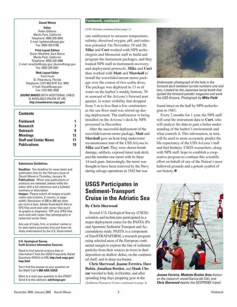
The USS Arizona was one of seven ac-tive battleships attacked and damaged by Japanese aircraft on the morning of Decem-ber 7, 1941, in the first act of World War II against the United States in the Pacific. Six of the battleships were raised to fight again, but the USS Arizona continues to rest in 13 m of water on the fine gray silt of O‘ahu’s Pearl Harbor in Hawai‘i. In 1980, the Na-tional Park Service (NPS) inherited the USS Arizona Memorial and manages the site. As many visitors (more than 1,000 per day) have noticed, black fuel oil leaks from the hull at a rate of about a quart per day, causing a shim-mer of colors on the surface waters. Over the past 6 decades, the hull has undergone sub-stantial deterioration in the harbor’s corrosive environment; bulkheads have collapsed, and many of the ship’s overheads are corroded and weakened. More than half a million gal-lons of fuel oil still trapped in the fractured hull poses a serious environmental risk, with the potential for much of the oil being released into the harbor when the Arizona’s fuel bunkers finally give way. This threat led to a major initiative started in 2000 by the NPS to document the condition of the USS Arizona in order to answer some basic ques-tions: What is happening to the wreck? How long will it remain intact?
Since 2000, archeologists from the NPS’ Submerged Resources Center (SRC) have
USGS Researchers Collaborate with National Park Service Archeologists to Better Predict the Life Expectancy of the USS Arizona By Curt Storlazzi
conducted several sur-veys of the USS Arizona. In addition, engineers from the University of Nebraska have conducted detailed studies of the corrosion rate of the hull’s
ment setup, instrument mounts, sampling routines, and deployment and recovery proto-cols for Marshall Owens, the USS Arizona Memorial’s curator.
In early November, Kevin O’Toole and Walt Olson of the USGS’ Marine Facility in Redwood City, CA, built the mounts for a wave/tide/current-meter package and a sepa-
ñMike Field (left) and Curt Storlazzi on the dock of the USS Arizona Memorial after deploy-ment of an instrument package. Photograph by Matt Russell (NPS).
ñMatt Russell (NPS-SRC, left), Mike Field (center) and Marshall Owens (NPS, Memorial Curator, right) on the dock of the USS Arizona Memorial, discussing the second deployment dive. Photograph by Curt Storlazzi.
ïUnderwater photograph of a drop of No. 6 fuel oil leaking from the starboard midships of the USS Ari-zona. The drop is about 2 cm across. Collapse of the deteriorating fuel bunkers could cause a catastrophic release of this oil into Pearl Harbor. Photograph by Curt Storlazzi.
metal and the present structural integrity of the ship. In fall 2002, Mike Field (USGS, Santa Cruz, CA) was asked by NPS-SRC archeologists Larry Murphy and Matt Rus-sell for advice on deploying oceanographic instruments on the Arizona to make measure-ments of the seawater environment around the ship. Mike brought in Curt Storlazzi (USGS, Santa Cruz, CA) to design an experi-
U.S. Department of the InteriorU.S. Geological Survey
Sound Waves Volume FY 2003, Issue No. 47December 2002–January 2003
Sound Waves C o a s t a l S c i e n c e a n d R e s e a r c h N e w s f r o m A c r o s s t h e U S G S
Fieldwork
http://soundwaves.usgs.gov/
(USS Arizona continued on page 2)
2December 2002–January 2003 Sound Waves 3 Sound Waves December 2002–January 2003
rate multisensor to measure temperature, salinity, dissolved oxygen, pH, and reduc-tion potential. On November 19 and 20, Mike and Curt worked with NPS arche-ologists and Memorial staff to build and program the instrument packages, and they trained NPS staff in instrument-recovery-and-deployment protocols. Mike and Curt then worked with Matt and Marshall to install the wave/tide/current-meter pack-age over the course of two scuba dives. The package was deployed in 13 m of water on the harbor’s muddy bottom, 30 m seaward of the Arizona’s forward port quarter, in water visibility that dropped from 3 m to less than a few centimeters as the sea-floor mud was stirred up dur-ing deployment. The multisensor is being installed on the Arizona’s deck by NPS personnel in December.
After the successful deployment of the wave/tide/current-meter package, Matt and Marshall gave an hour-long underwater reconnaissance tour of the USS Arizona to Mike and Curt. They were shown bomb damage, artifacts, exposed intact teak deck, and the number-one turret with its three 14-inch guns. Interestingly, the turret was thought to have been removed by the Navy during salvage operations in 1942 but was
Underwater photograph of the hole in the forward deck between turrets numbers one and two, created by the Japanese aerial bomb that ignited the forward powder magazine and sank the USS Arizona. Photograph by Mike Field.
found intact on the hull by NPS archeolo-gists in 1983.
Every 2 months for 1 year, the NPS staff will send the instrument data to Curt, who will analyze the data to gain a better under-standing of the harbor’s environment and what controls it. This information, in turn, will be used to more accurately predict the life expectancy of the USS Arizona’s hull and fuel bunkers. USGS researchers, along with NPS staff, hope to establish a coop-erative program to continue this scientific effort on behalf of one of the Nation’s most hallowed grounds and a potent symbol of our history.]
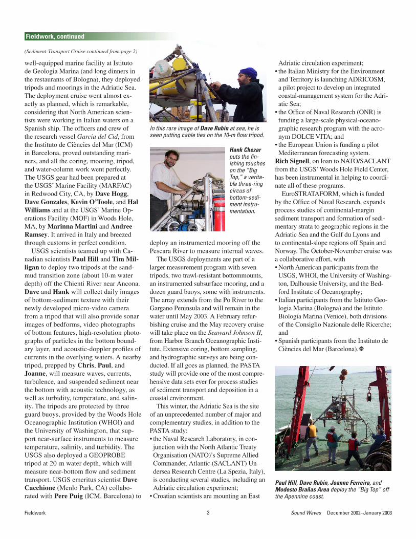
Several U.S. Geological Survey (USGS) scientists and technicians participated in a major deployment cruise for the PASTA (Po and Apennine Sediment Transport and Ac-cumulation) study. PASTA is a component of EuroSTRATAFORM, a research program using selected areas of the European conti-nental margin to explore the fate of sediment particles from their sources in rivers to their deposition on shallow deltas, on the continen-tal shelf, and in deep-sea basins.
Chris Sherwood, Joanne Ferreira, Dave Rubin, Jonathan Borden, and Hank Che-zar traveled to Italy in October, and after spending long days prepping gear at the
USGS Participates in Sediment-Transport Cruise in the Adriatic SeaBy Chris Sherwood
Joanne Ferreira, Modesto Brañas Area (bosun on the research vessel Garcia del Cid), and Chris Sherwood deploy the GEOPROBE tripod.
Sound Waves
EditorHelen Gibbons
Menlo Park, CaliforniaTelephone: (650) 329-5042
E-mail: [email protected]: (650) 329-5198
Print Layout EditorsSusan Mayfield, Sara Boore
Menlo Park, CaliforniaTelephone: (650) 329-5066
E-mail: [email protected]; [email protected]: (650) 329-5051
Web Layout EditorTrent Faust
St. Petersburg, FloridaTelephone: (727) 803-8747 Ext. 3043
E-mail: [email protected]: (727) 803-2030
SOUND WAVES (WITH ADDITIONAL LINKS) IS AVAILABLE ONLINE AT URLhttp://soundwaves.usgs.gov/
Contents
Fieldwork 1Research 7Outreach 9Meetings 13Staff and Center News 17Publications 19
Fieldwork
Fieldwork, continued
(USS Arizona continued from page 1)
Submission Guidelines
Deadline: The deadline for news items and publication lists for the February issue of Sound Waves is Thursday, January 16.Publications: When new publications or products are released, please notify the editor with a full reference and a bulleted summary or description.Images: Please submit all images at publi-cation size (column, 2-column, or page width). Resolution of 200 to 300 dpi (dots per inch) is best. Adobe Illustrator© files or EPS files work well with vector files (such as graphs or diagrams). TIFF and JPEG files work well with raster files (photographs or rasterized vector files).
Any use of trade, firm, or product names is for descriptive purposes only and does not imply endorsement by the U.S. Government.
(Sediment-Transport Cruise continued on page 3)
U.S. Geological Survey Earth Science Information Sources:
Need to find natural-science data orinformation? Visit the USGS Frequently Asked Questions (FAQ’s) at URL http://ask.usgs.gov/faqs.html
Can’t find the answer to your question on the Web? Call 1-888-ASK-USGS
Want to e-mail your question to the USGS?Send it to this address: [email protected]
2December 2002–January 2003 Sound Waves 3 Sound Waves December 2002–January 2003
well-equipped marine facility at Istituto de Geologia Marina (and long dinners in the restaurants of Bologna), they deployed tripods and moorings in the Adriatic Sea. The deployment cruise went almost ex-actly as planned, which is remarkable, considering that North American scien-tists were working in Italian waters on a Spanish ship. The officers and crew of the research vessel Garcia del Cid, from the Instituto de Ciències del Mar (ICM) in Barcelona, proved outstanding mari-ners, and all the coring, mooring, tripod, and water-column work went perfectly. The USGS gear had been prepared at the USGS’ Marine Facility (MARFAC) in Redwood City, CA, by Dave Hogg, Dave Gonzales, Kevin O’Toole, and Hal Williams and at the USGS’ Marine Op-erations Facility (MOF) in Woods Hole, MA, by Marinna Martini and Andree Ramsey. It arrived in Italy and breezed through customs in perfect condition.
USGS scientists teamed up with Ca-nadian scientists Paul Hill and Tim Mil-ligan to deploy two tripods at the sand-mud transition zone (about 10-m water depth) off the Chienti River near Ancona. Dave and Hank will collect daily images of bottom-sediment texture with their newly developed micro-video camera from a tripod that will also provide sonar images of bedforms, video photographs of bottom features, high-resolution photo-graphs of particles in the bottom bound-ary layer, and acoustic-doppler profiles of currents in the overlying waters. A nearby tripod, prepped by Chris, Paul, and Joanne, will measure waves, currents, turbulence, and suspended sediment near the bottom with acoustic technology, as well as turbidity, temperature, and salin-ity. The tripods are protected by three guard buoys, provided by the Woods Hole Oceanographic Institution (WHOI) and the University of Washington, that sup-port near-surface instruments to measure temperature, salinity, and turbidity. The USGS also deployed a GEOPROBE tripod at 20-m water depth, which will measure near-bottom flow and sediment transport. USGS emeritus scientist Dave Cacchione (Menlo Park, CA) collabo-rated with Pere Puig (ICM, Barcelona) to
deploy an instrumented mooring off the Pescara River to measure internal waves.
The USGS deployments are part of a larger measurement program with seven tripods, two trawl-resistant bottommounts, an instrumented subsurface mooring, and a dozen guard buoys, some with instruments. The array extends from the Po River to the Gargano Peninsula and will remain in the water until May 2003. A February refur-bishing cruise and the May recovery cruise will take place on the Seaward Johnson II, from Harbor Branch Oceanographic Insti-tute. Extensive coring, bottom sampling, and hydrographic surveys are being con-ducted. If all goes as planned, the PASTA study will provide one of the most compre-hensive data sets ever for process studies of sediment transport and deposition in a coastal environment.
This winter, the Adriatic Sea is the site of an unprecedented number of major and complementary studies, in addition to the PASTA study:• the Naval Research Laboratory, in con-junction with the North Atlantic Treaty Organisation (NATO)’s Supreme Allied Commander, Atlantic (SACLANT) Un-dersea Research Centre (La Spezia, Italy), is conducting several studies, including an Adriatic circulation experiment;
• Croatian scientists are mounting an East
Adriatic circulation experiment; • the Italian Ministry for the Environment and Territory is launching ADRICOSM, a pilot project to develop an integrated coastal-management system for the Adri-atic Sea;
• the Office of Naval Research (ONR) is funding a large-scale physical-oceano-graphic research program with the acro-nym DOLCE VITA; and
• the European Union is funding a pilot Mediterranean forecasting system.
Rich Signell, on loan to NATO/SACLANT from the USGS’ Woods Hole Field Center, has been instrumental in helping to coordi-nate all of these programs.
EuroSTRATAFORM, which is funded by the Office of Naval Research, expands process studies of continental-margin sediment transport and formation of sedi-mentary strata to geographic regions in the Adriatic Sea and the Gulf du Lyons and to continental-slope regions off Spain and Norway. The October-November cruise was a collaborative effort, with • North American participants from the USGS, WHOI, the University of Washing-ton, Dalhousie University, and the Bed-ford Institute of Oceanography;
• Italian participants from the Istituto Geo-logia Marina (Bologna) and the Istituto Biologia Marina (Venice), both divisions of the Consiglio Nazionale delle Ricerche; and
• Spanish participants from the Instituto de Ciències del Mar (Barcelona).]
Paul Hill, Dave Rubin, Joanne Ferreira, and Modesto Brañas Area deploy the “Big Top” off the Apennine coast.
In this rare image of Dave Rubin at sea, he is seen putting cable ties on the 10-m flow tripod.
Hank Chezar puts the fin-ishing touches on the “Big Top,” a verita-ble three-ring circus of bottom-sedi-ment instru-mentation.
Fieldwork
(Sediment-Transport Cruise continued from page 2)
Fieldwork, continued

4December 2002–January 2003 Sound Waves 5 Sound Waves December 2002–January 2003
A team of researchers from the U.S. Geological Survey (USGS)’s Coastal and Marine Geology Program (CMGP) used sea-floor-mapping technology to map the floor of Bear Lake (Utah and Idaho) in September. Bear Lake is a medium-size (11 by 34 km) lake that occupies an active half-graben at the boundary between the
Sea-Floor Mapping Goes Inland, to Bear Lake in Utah and IdahoBy Steve Colman
Basin and Range Province and the Colo-rado Plateau. The lake is important as a recreational resource, a fisheries habitat, and a source of water for irrigation and power generation.
Since 1996, Steve Colman (USGS, Woods Hole, MA) has been working with scientists from the USGS’ Earth Sur-
The research vessel Raphael heading out onto Bear Lake from the State Park Ma-rina in Garden City, UT, in September 2002. Lake level is about 5 m below the lake datum, exposing much of the marina breakwater.
In addition to Colman, other members of the survey team were Dave Nichols and Jane Denny (USGS, Woods Hole, MA), Dana Wiese (USGS, St. Petersburg, FL), and volunteer Richard Goldberg (Coastal Carolina University). The research vessel Raphael was hauled from Woods Hole to Bear Lake to serve as the data-collection platform. Geophysical systems included a sidescan-sonar (Edgetech DF-1000) sys-tem, a Chirp subbottom (Edgetech 424) profiler, and an interferometric swath-ba-thymetry (Submetrix 2000) system. For the most part, the weather and equipment cooperated, and the results were a high-quality data set. Preliminary interpretation of the data has revealed new insights into the sedimentary environments of the lake, ranging from hemipelagic marl in deep water to debris-flow sand on the fronts of fan deltas. Major fault scarps on the lake floor were clearly imaged, although small-scale fault disturbances visible in subbot-tom data were obscured in the sidescan-sonar data. Many other features related to such things as spring discharge and the distribution of aquatic snail shells were also observed.]
Sidescan-sonar mosaic and new bathymetry for Bear Lake generated from September 2002 operations.
face Dynamics Program in Denver, CO, to study the sediment of Bear Lake as a record of past climate and limnology. The primary scientific goals of this most recent survey were to look for evidence of sublacus-trine spring discharge and to image possible fault scarps that cut the lake floor. Sec-ondary objectives were to produce a sidescan-sonar mosaic and an updated bathymetric map of the lake. The sidescan-sonar mosaic has potential applications ranging from interpreting sedimentary environments to mapping fish habitats.
Fieldwork, continued
Fieldwork
4December 2002–January 2003 Sound Waves 5 Sound Waves December 2002–January 2003
Barrier islands, such as those in Assateague Island National Seashore (in Maryland), are dynamic, responsive entities that are impor-tant and fascinating in terms of their inter-twined geologic and ecologic processes. As part of its resource-management program, the National Park Service (NPS) at Assateague Island requires accurate and detailed topo-graphic maps to study beach dynamics and vegetation communities at periodic intervals.
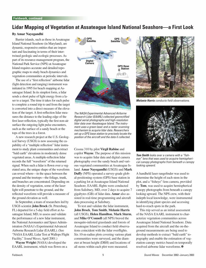
The use of a “first reflection” airborne lidar (light detection and ranging) instrument was initiated in 1995 for beach mapping at As-sateague Island. In its simplest form, a lidar sends a short pulse of light energy from a la-ser to a target. The time it takes for each pulse to complete a round trip to and from the target is converted into a direct measure of the eleva-tion of the target. A first-reflection lidar mea-sures the distance to the leading edge of the first laser reflection, typically the first non-air surface the outgoing light pulse encounters, such as the surface of a sandy beach or the tops of the trees in a forest.
A new research project at the U.S. Geolog-ical Survey (USGS) is now assessing the ca-pability of a “multiple reflection” lidar instru-ment to study plant communities and extract “bald earth” elevations in moderately dense vegetated areas. A multiple-reflection lidar records the full “waveform” of the returned signal. When such a lidar is flown over a veg-etated area, the unique shape of the waveform can reveal where—in the space between the ground and the treetops—the foliage, trunk, and branches are concentrated. Depending on the density of vegetation, some of the laser light will penetrate to the ground, and the reflected waveform will provide a measure of the ground elevation as well.
In September, a team of researchers led by USGS scientist John Brock (St. Petersburg, FL) departed for a 5-day field effort at As-sateague Island, MD, to assess and validate the performance of a new lidar instrument, the National Aeronautics and Space Admin-istration (NASA)’s Experimental Advanced Airborne Research Lidar (EAARL). (See “NASA EAARL Lidar Test at Wallops Flight Facility,” Sound Waves, April 2001.)
Wayne Wright (NASA) developed the EAARL instrument, which was flown on a
Lidar Mapping of Vegetation at Assateague Island National Seashore—a First LookBy Amar Nayegandhi
Cessna 310 by pilot Virgil Rabine and copilot Wayne. The purpose of this mission was to acquire lidar data and digital camera photography over the sandy beach and vari-ous vegetated communities at Assateague Is-land. Amar Nayegandhi (USGS) and Mark Duffy (NPS) operated a survey-grade glob-al-positioning-system (GPS) base station in a parking lot at Assateague Island National Seashore. EAARL flights were conducted from Salisbury, MD, over 2 days to acquire 7 gigabytes (GB) of lidar data. Amar also as-sisted in real-time programming and aircraft data processing at Salisbury.
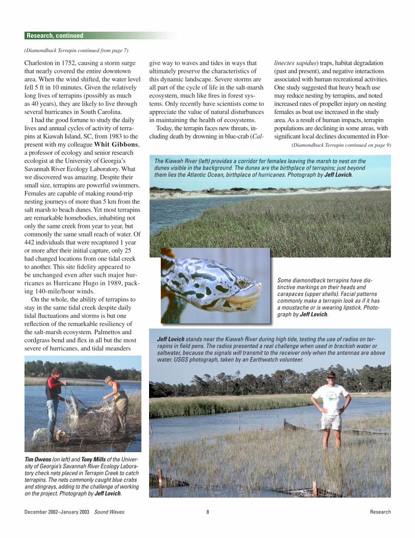
To test and validate the lidar instrument, John Brock, Tom Smith, Melanie Harris (all USGS), Helen Hamilton, Mark Sturm, and Mike O’Connell (all NPS) braved the mosquito-infested grasslands and forests of Assateague Island to conduct field observa-tions coincident with the lidar overflights. Six 10-m-radius plots covering various plant communities were surveyed, and the diam-eter at breast height (DBH) and locations of all stems within each plot were measured.
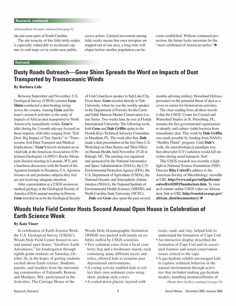
A handheld laser rangefinder was used to determine the height of each stem in the plot, and a “fisheye”-lens camera, provided by Tom, was used to acquire hemispherical canopy photographs from beneath a canopy looking upward. The NPS crew, with their indepth local knowledge, were instrumental in identifying plant species and accessing hard-to-reach spots in the park.
This trip served as an initial assessment of the NASA EAARL instrument to char-acterize vegetation communities across Assateague Island National Seashore. Data acquired from the aircraft and the on-the-ground measurements are being used to develop methods to extract “bald earth” to-pography and enable the estimation of veg-etation-canopy metrics based on temporally resolved airborne lidar waveforms.]
The NASA Experimental Advanced Airborne Research Lidar (EAARL) collected georectified digital aerial photographs and high-resolution lidar data over Assateague Island. The instru-ment uses a green laser and a raster scanning mechanism to acquire lidar data. Researchers set up a GPS base station to precisely locate the position of the aircraft and the data it collected.
Fieldwork
Fieldwork, continued
Melanie Harris conducts field observations.
Tom Smith looks over a camera with a “fish-eye” lens that was used to acquire hemispheri-cal canopy photographs from beneath a canopy looking upward.

6December 2002–January 2003 Sound Waves 7 Sound Waves December 2002–January 2003Fieldwork
Fieldwork, continued
After a year of planning and building, the U.S. Geological Survey (USGS)’s new Por-table Auger Drilling System (PADS) was put into the field to test its capability in collect-ing continuous sediment cores. The coring system consists of a 3-inch-diameter steel barrel with plastic liner that is fixed inside a 3 1/4-inch-diameter hollow stem auger (6-inch outer diameter). The system is entirely hydraulic and is driven by a 31-horsepower gasoline engine. The superstructure is con-structed of reinforced heavy-duty aluminum and is dismantled and placed in a 12-ft-long cargo trailer for transport. The system can be placed on an aluminum barge for work in shallow water or transported with the assis-tance of an all-terrain vehicle (ATV) to hard-to-reach environments.
The inaugural trip for the PADS was to Cocodrie and Port Fourchon, LA, over September 16-23. Phil McCarty and Mike Brown (University of New Orleans) assisted Jack Kindinger (principal investigator), Jim Flocks, Chris Reich, Nick Ferina, and Chandra Dreher (all of USGS) in testing the coring capability of the system. In Co-codrie, the first day was spent working out some of the kinks. On the second day, the PADS reached a depth of 50 ft and obtained near-continuous cores of typical deltaic sedi-ment. The system was moved to Port Four-chon, where only 1 day of coring was con-ducted before having to pack up and leave because of the approach of Hurricane Isidore. All work in Louisiana was conducted from an aluminum barge in 2- to 3-ft water depth.
From October 8 to 17, Chris Reich, Nick Ferina, and Jason Greenwood (USGS) conducted drilling with the PADS at North Island, SC, a heavily wooded sand spit ap-proximately 10 mi long by 1 mi wide, bor-dered by Winyah Bay to the west and the Atlantic Ocean to the east. We worked in cooperation with Eric Wright (assistant pro-fessor of marine science at Coastal Carolina University, Conway, SC) and were assisted in the field by Eric, Scott Harris (also an assistant professor at Coastal Carolina Uni-versity), and five undergraduate students. Because the only access to North Island is by
Field-Testing the New USGS Portable Auger Drilling System (PADS) in Louisiana and South CarolinaBy Chris Reich
boat, the PADS and a four-wheel ATV were transported to the island on an aluminum barge that was driven partly up onto the beach, where the equip-ment and ATV were unloaded.
Site 1 was located along the axis of the island. A depth of approxi-mately 40 ft was reached with the auger; however, no core was recov-ered, owing to running or flowing sands, which tend to plague most other drilling systems, as well as the PADS. Running sands occur when drilling reaches the water table and (Auger Drilling System continued on page 7)
Portable Auger System (PADS) set up on North Island, SC. The power supply, which consists of a 31-horsepower gas-oline engine and a 15-gallon hydraulic reservoir, is in the red frame toward the back half of the large aluminum frame.
The only way to get drilling equip-ment and ATV to North Island, SC, was by barge. Here, Jason Greenwood is driving the ATV onto the barge. The PADS has been dismantled and is lying on the beach in the background.
Auger system set up on an aluminum platform at Cocodrie, LA.

6December 2002–January 2003 Sound Waves 7 Sound Waves December 2002–January 2003Fieldwork, Research
Fieldwork, continued
fluidized sand flows upward into the core barrel. Standard core catchers located at the base of the inner barrel cannot retain these sands. The water table was less than 5 ft deep at site 1. Because we were un-able to take a core, we decided to drill to bedrock (approximately 40 ft down) and sample the sediment on the auger flights as they were withdrawn from the ground. This plan worked well. Sediment texture ranged from green-gray fine sand at the top of the
(Auger Drilling System continued from page 6)
hole to light-cream-colored lime mud with coarse quartz grains at the base. The lime mud is probably a residual product from weathering of the limestone bedrock.
Site 2 on North Island was on the foredune set. It took 1 day to break down the PADS at site 1 and move it over a series of large dunes with the ATV to site 2. Drilling at site 2 proved to be more difficult because the auger pipe stopped at a depth of approximately 25 ft for unknown reasons. Again, running sands
kept us from obtaining any sediment cores. The auger pipe was eventually retrieved, and the PADS was dismantled and hauled back across the island to be loaded on the barge for the long boat ride back to the dock.
Overall, this system has a strong po-tential for work in many environments. The problem with running sands is being addressed, and solutions will be tried and tested. At present, at least five potential projects have a need for the PADS.]
Research
(Diamondback Terrapin continued on page 8)
The salt marshes and barrier islands of South Carolina appear to be tranquil and idyllic to most people who visit those en-chanted shores. Gently waving palmetto trees and stately live oaks grace a landscape punctuated by wind-sculpted maritime for-ests and seemingly endless expanses of cord-grass and tidal creeks. Here, land and water
Diamondback Terrapin Still Vulnerable to Human ActivitiesBy Jeff Lovich
meet intimately, blurring the distinc-tions between the two elements in subtle ways that defy the imagination. Beyond this brackish interface are dunes covered in sea oats and sandy beaches, each molded by winds and waves as the land finally gives way to the embrace of the Atlantic Ocean.
This is the home of the diamond-back terrapin (Malaclemys ter-rapin). Terrapins are small turtles, with females rarely exceeding 9 inches in length. Males in the same population are always smaller than adult females. The terrapin is the only species of turtle in the United States that routinely occupies brack-ish-water habitats, occurring in tidal creeks of estuaries along the Atlan-tic and Gulf coasts from Cape Cod, MA, to Corpus Christi, TX.
Roger Conant, one of America’s most famous herpetologists, called ter-rapins the “most celebrated of Ameri-can turtles.” His comment was based on the fact that terrapins were heavily exploited as a food source for privi-
leged members of society in the 1800s and early 1900s. With increasing demand for ter-rapins by epicures, prices soared, and a mar-ket was born to supply the big eastern cities of Baltimore, Philadelphia, and New York. Thus, the terrapin became one of the most economi-cally important reptiles in the world.
In recognition of the demand for terrapins,
the State of Maryland enacted a law in 1878 providing a closed season and a size limit for the species, but it was almost too late: prices increased with demand, and wild stocks became depleted. In response, the United States Government initiated studies of cap-tive propagation. The terrapin fad finally died out around the time of Prohibition, and
populations recovered from the several decades of exploitation. Human activities, however, are once again causing declines in terrapin populations, as shown by various studies, including a long-term population study by myself and others in South Carolina.
Beneath the apparent calm of the terrapin habitat in South Carolina lies a world in tumult. Each day, water levels fluctuate by almost 6 feet as the creeks flush in and out with the inexo-rable pull of the tide. This fluc-tuation causes profound changes in the direction and speed of tidal flow, water temperature, and salinity. Punctuating these daily changes are hurricanes that brush or hit Charleston, SC, on average once every 5 1/2 years. Hurricanes commonly gener-ate large storm surges on top of already-impressive tides. Accord-ing to one source, a hurricane hit
Diamondback terrapin (Malaclemys terrapin)–the most celebrated of American turtles. Once popular as a gourmet-food item, terra-pin populations were decimated by collectors in the late 19th and early 20th centuries. New threats to the terrapin’s survival include habitat destruction, incidental capture and drowning in crab traps, both commercial and recreational, and death of females on roads when they migrate to nesting sites. “Terrapin” is an Algonquian word that means “turtle.” Photograph by Jeff Lovich.
8December 2002–January 2003 Sound Waves 9 Sound Waves December 2002–January 2003Research
Research, continued
(Diamondback Terrapin continued from page 7)
Charleston in 1752, causing a storm surge that nearly covered the entire downtown area. When the wind shifted, the water level fell 5 ft in 10 minutes. Given the relatively long lives of terrapins (possibly as much as 40 years), they are likely to live through several hurricanes in South Carolina.
I had the good fortune to study the daily lives and annual cycles of activity of terra-pins at Kiawah Island, SC, from 1983 to the present with my colleague Whit Gibbons, a professor of ecology and senior research ecologist at the University of Georgia’s Savannah River Ecology Laboratory. What we discovered was amazing. Despite their small size, terrapins are powerful swimmers. Females are capable of making round-trip nesting journeys of more than 5 km from the salt marsh to beach dunes. Yet most terrapins are remarkable homebodies, inhabiting not only the same creek from year to year, but commonly the same small reach of water. Of 442 individuals that were recaptured 1 year or more after their initial capture, only 25 had changed locations from one tidal creek to another. This site fidelity appeared to be unchanged even after such major hur-ricanes as Hurricane Hugo in 1989, pack-ing 140-mile/hour winds.
On the whole, the ability of terrapins to stay in the same tidal creek despite daily tidal fluctuations and storms is but one reflection of the remarkable resiliency of the salt-marsh ecosystem. Palmettos and cordgrass bend and flex in all but the most severe of hurricanes, and tidal meanders
give way to waves and tides in ways that ultimately preserve the characteristics of this dynamic landscape. Severe storms are all part of the cycle of life in the salt-marsh ecosystem, much like fires in forest sys-tems. Only recently have scientists come to appreciate the value of natural disturbances in maintaining the health of ecosystems.
Today, the terrapin faces new threats, in-cluding death by drowning in blue-crab (Cal-
Some diamondback terrapins have dis-tinctive markings on their heads and carapaces (upper shells). Facial patterns commonly make a terrapin look as if it has a moustache or is wearing lipstick. Photo-graph by Jeff Lovich.
Jeff Lovich stands near the Kiawah River during high tide, testing the use of radios on ter-rapins in field pens. The radios presented a real challenge when used in brackish water or saltwater, because the signals will transmit to the receiver only when the antennas are above water. USGS photograph, taken by an Earthwatch volunteer.
Tim Owens (on left) and Tony Mills of the Univer-sity of Georgia’s Savannah River Ecology Labora-tory check nets placed in Terrapin Creek to catch terrapins. The nets commonly caught blue crabs and stingrays, adding to the challenge of working on the project. Photograph by Jeff Lovich.
The Kiawah River (left) provides a corridor for females leaving the marsh to nest on the dunes visible in the background. The dunes are the birthplace of terrapins; just beyond them lies the Atlantic Ocean, birthplace of hurricanes. Photograph by Jeff Lovich.
linectes sapidus) traps, habitat degradation (past and present), and negative interactions associated with human recreational activities. One study suggested that heavy beach use may reduce nesting by terrapins, and noted increased rates of propeller injury on nesting females as boat use increased in the study area. As a result of human impacts, terrapin populations are declining in some areas, with significant local declines documented in Flor-
(Diamondback Terrapin continued on page 9)
8December 2002–January 2003 Sound Waves 9 Sound Waves December 2002–January 2003Research, Outreach
ida and some parts of South Carolina.The site tenacity of this little turtle makes
it especially vulnerable to incidental cap-ture in crab traps set in creeks near public-
Research, continued
(Diamondback Terrapin continued from page 8)
access points. Limited movement among tidal creeks means that once terrapins are trapped out of one area, a long time will elapse before another population can be-
come established. Without continued pro-tection, the future looks uncertain for the “most celebrated of American turtles.”]
Outreach
Between September and November, U.S. Geological Survey (USGS) scientist Gene Shinn conducted a dust-beating swing across the country. Among Gene and his team’s research activities is the study of impacts of African dust transported to North America by transatlantic winds. Gene’s talks during his 2-month odyssey focused on those impacts, with titles ranging from “Soil Dust: Big Impact of Tiny Specks” to “Trans-oceanic Soil-Dust Transport and Medical Implications.” Gene’s travels included an in-vited talk at the American Association of Pe-troleum Geologists (AAPG)’s Rocky Moun-tains Section meeting in Laramie, WY, and a luncheon discussion with the board of the Agouron Institute in Pasadena, CA. Agouron focuses on and promotes subjects they feel are not receiving adequate attention.
After a presentation at a USGS session on medical geology at the Geological Society of America (GSA) annual meeting in Denver, Gene traveled on to be the Geological Society
Dusty Roads Outreach—Gene Shinn Spreads the Word on Impacts of Dust Transported by Transoceanic WindsBy Barbara Lidz
of Utah’s luncheon speaker in Salt Lake City. From there, Gene traveled directly to Yale University, where he was the weekly speaker in the Department of Forestry for the Curtis and Edith Munson Marine Conservation Lec-ture Series. Two weeks later, he was at Florida International University. The following week, both Gene and Dale Griffin spoke to the Florida Keys Technical Advisory Committee in Marathon, FL. The week after that, Dale made a dust presentation at the first Sino-U.S. Workshop on Dust Storms and Their Effect on Human Health, held November 25-26 in Raleigh, NC. The meeting was organized and sponsored by the National Aeronautics and Space Administration (NASA), the U.S. Environmental Protection Agency (EPA), the U.S. Department of Agriculture (USDA), the National Oceanic and Atmospheric Admin-istration (NOAA), the National Institute of Environmental Health Sciences (NIEHS), and North Carolina State University (NCSU).
Dale and Gene also spent the past several
months advising military Homeland Defense personnel on the potential threat of dust as a cover or carrier for bioterrorism activities.
The clear reading from all these travels is that the USGS’ Center for Coastal and Watershed Studies in St. Petersburg, FL, remains the first governmental organization to identify and culture viable bacteria from transatlantic dust. This work by Dale Griffin was made possible by funding from NASA’s “Healthy Planet” program. Until Dale’s work, the microbiological paradigm was that ultraviolet (UV) radiation would kill mi-crobes during aerial transport. Not!
This USGS research was recently a high-light in National Science Foundation (NSF) Director Rita Colwell’s address to the American Society of Microbiology, viewable at URL http://www.nsf.gov/od/lpa/forum/colwell/rc020519asmlecture.htm. To view an 8-minute online USGS video on African dust, link to URL http://coastal.er.usgs.gov/african_dust/documentary/.]
(Woods Hole GeoFest continued on page 10)
In celebration of Earth Science Week, the U.S. Geological Survey (USGS)’s Woods Hole Field Center hosted its sec-ond annual open house, “GeoFest: Earth Adventures,” for kindergarten through eighth-grade students on Saturday, Oc-tober 26, in the hopes of getting students excited about Earth science. Students, parents, and teachers from the surround-ing communities of Falmouth, Bourne, and Mashpee, MA, participated in the festivities. The Carriage House of the
Woods Hole Field Center Hosts Second Annual Open House in Celebration ofEarth Science WeekBy Kate Visser
Woods Hole Oceanographic Institution (WHOI) was packed with hands-on ex-hibits staffed by USGS scientists:• Two sediment cores from a local cran-
berry bog and a freshwater marsh, each containing many different layers and relics, allowed kids to examine past depositional environments.
• A coring activity enabled kids to col-lect their own sediment cores using short, pushup-style corers.
• A scaled-down glacier, layered with
rocks, sand, and clay, helped kids to understand the formation of Cape Cod.
• An interactive display described the formation of Cape Cod and its associ-ated features and noted conservation issues critical to the cape.
• A gas-hydrate exhibit encouraged kids to explore sediment behavior in the natural environment through activi-ties that included making gas-hydrate models, handling montmorillonite of
10December 2002–January 2003 Sound Waves 11 Sound Waves December 2002–January 2003Outreach
Outreach, continued
(Woods Hole GeoFest continued from page 9)
different moisture contents, examining a particle-suspension/sedimentation model, and watching a video of gas-hydrate “ice cubes” burning.
Kids wash montmorillonite off their hands, thanks to the gas-hydrate group.
Seth Ackerman helps kids explore different seafloor-habitat types at the Habitat Mapping exhibit.
Dirk Koopmans answers questions about the different layers of the wetland cores.
John Bratton and kids delve deep into the glacier model.
Bill Waite en-courages kids to investigate the details of a gas-hydrate molecule.ò
Sandy Baldwin helps a GeoFest participant make a paper nautiloid model.
• A three-dimensional poster of a submarine canyon helped kids learn how 3D glasses work; they also had the opportunity to make their own three-dimensional drawings.
• Fish habitats were created with different bottom-sediment types and vegetation, and kids were invited to stick their hands into a “mystery box” to discover what type of habitat lay within.
• An exhibit of the different types of beach sand in Falmouth showed kids that the sand types look and feel different, and made them think about why.
• Visitors were invited to inspect a collection of rocks and sand from around the world.Two geology walks through the WHOI
campus and along Trunk River Beach taught participants about the geology and formation of Cape Cod, as a nor’easter battered both the beach and the par-ticipants. In preparation for the beach walks, Bob Oldale gave interested USGS employees a vivid and detailed lesson about the glacial, deglacial, and pres-ent-day history of the area.
GeoFest participants in-cluded Seth Ackerman, Sandy Baldwin, Brian Buczkowski, John Bratton, Sarah Kelsey,
Bill Winters. The activities, bountiful information, ask-a-geologist service, and free raffle were enthusiastically received
Dirk Koopmans, Tammie Middleton, Dave Mason, Joanne Sedlock, Kate Visser, Bill Waite, Glynn Williams, and
by all who attended, and everyone walked away from GeoFest excited about geology and science!]

10December 2002–January 2003 Sound Waves 11 Sound Waves December 2002–January 2003Outreach
Outreach, continued
The U.S. Geological Survey (USGS)’s Center for Coastal and Watershed Stud-ies (CCWS) in St. Petersburg, FL, hosted its fourth annual open house on October 9 and 10. The event was tied to the American Geologic Institute’s Earth Science Week, whose theme this year was “Water Is All Around You.” A record number of more than 35 exhibits pre-sented research topics from five USGS offices in Florida, including offices in St. Petersburg, Tampa, Gainesville, Al-tamonte Springs, and Tallahassee.
Fourth Annual Open House in St. Petersburg, FL, Sets New RecordsBy Dennis Krohn
We were especially pleased that ex-hibitors came from afar to help out, including Jane Eggleston from Talla-hassee, Trudy Phelps from Altamonte Springs, and Larry Harvey from the Hubbs-SeaWorld Research Institute in Melbourne, FL. The tour guides were real heroes that day, helping to lead a record 871 4th-graders, teachers, and chaperones through the exhibits. The work of the CCWS Marine Operations group, under Terry Kelley and Dave Wegener, was most commendable; they
Gene’s Shinn’s 24-ft-long blimp designed to sample African dust.
Highlighted among the exhib-its was Gene Shinn’s 24-ft-long blimp designed to sample Afri-can dust. Gene had the USGS visual identifier embossed on the side—as far as we know, the larg-est USGS visual identifier made to date. Also notable was an exhibit assembled by USGS biologists in St. Petersburg to simulate a marsh environment; it included native marsh plants, aquariums, a kid-die pool full of horseshoe crabs, and a cooling mist that sprayed everything and everyone. The mist was well appreciated, because the temperature on October 9 was 89°
at 77-percent relative humidity, for a NOAA Heat Index (apparent temperature) of 109°!
set up and took down a record 13 tents to shade exhibitors, and handled other construction and all the last-minute running of electrical cords for outdoor power. CCWS graphic artists Betsy Boynton and Laurinda Frye made countless posters, signs, manatee bone casts, and more for the event. Fifty new portable exhibit boards built for the “Gulf of Mexico Integrated Science-Tampa Bay Pilot Study 2nd Annual Sci-ence Conference,” held on September 19 in St. Petersburg, proved crucial in
highlighting all the science we had to display.
On the second day, the open house was held for the public, and more than 250 people attended. Feed-back forms showed that no one exhibit was the clear favorite, but many exhibits seemed to be favorites for numerous people. This re-sult suggests that the public has a wide range of inter-ests and that the USGS is well served by offering dis-plays illustrating the large variety of science topics studied here. Thanks to one and all who made this event a success!]
The U.S. Geological Survey (USGS)’s Center for Coastal and Water-shed Studies (CCWS) in St. Petersburg, FL, participated in Pinellas County’s Great American Teach-In on November 20 for the third year in a row. Parents, business partners, and community members were invited to visit local schools on this day and share informa-tion about their jobs, hobbies, and other
experiences. The event is highly pro-moted in Pinellas County, FL, and the USGS generally has numerous requests from teachers for classroom visits.
Dennis Krohn visited McMullen Booth Elementary School and spoke to three classes about hurricanes and making volcano models. Jim Flocks visited Meadowlawn Elementary School and talked to five classes about
rocks and minerals. Volunteer Kathy Krohn demonstrated Ellen Raabe’s “Marshes as Sponges” exhibit at Mc-Mullen Booth school. This exhibit, pop-ular at CCWS’ recent open house (see article “Fourth Annual Open House in St. Petersburg, FL, Sets New Records,” this issue), presents new material that teachers can readily incorporate into their curriculum.]
USGS Participates in Great American Teach-InBy Dennis Krohn

12December 2002–January 2003 Sound Waves 13 Sound Waves December 2002–January 2003Outreach
Outreach, continued
The Trinity School for Children in Tam-pa, FL, visited the U.S. Geological Survey (USGS)’s Center for Coastal and Water-shed Studies (CCWS) in St. Petersburg, FL, on the morning of November 7. Fifty-three 4th-graders took part in the tour, which was requested by Eugene Henry, on the Hillsborough County staff, and ar-ranged through Claire Brooks and Jamie Andrisio, fourth-grade teachers at the Trinity School. The school has about 400 students ranging from preschool through eighth grade.
We divided the large group into three subgroups and had three stations for dem-onstrations. Chris Reich, Noreen Buster, and Chuck Holmes gave 10-minute pre-sentations on coral reefs, analyzing drill cores, and geochronology. Ilsa Kuffner, Karynna Calderon, and Dennis Krohn
4th-Graders Tour USGS’ Center for Coastal and Watershed Studies in St. Petersburg, FLBy Dennis Krohn
led the tours. Dave Wegener and Terry Kelley helped with parking and shop tours. Stacy Merriweather, Marci Marot, and Kate Ciembronowicz helped with goodie bags. As a special treat, Rich Young and Molly McLaughlin helped prepare or-ange drink packaged in 10-ounce scientific
water-sampling containers. As might be expected, the drink containers were the students’ favorite memory of the tour, but Gene Shinn’s famous flushable toilet on top of porous limestone from the Florida Keys was a close second. Thanks are ex-tended to all who participated. ]
On October 26, the U.S. Geological Survey (USGS)’s Center for Coastal and Watershed Studies in St. Petersburg, FL, participated in “Just Imagine,” an event in Tampa, FL, celebrating the 90th an-niversary of the Girl Scouts of the USA. The combined effort of three Girl Scout councils from southwestern Florida, the all-day event drew more than 5,000 at-
USGS Represented at 90th Anniversary of Girl Scouts
Megan Frayer led a group of USGS volunteers to staff a booth at MOSI. The USGS shared the MOSI audito-rium with some expected exhibitors, such as USF’s College of Marine Sci-ence and Tampa Bay’s Busch Gardens adventure park, and some unexpected exhibitors, such as The Ninety-Nines, an organization started by female pilots
Entrance to the Museum of Science and Indus-try (MOSI) in Tampa, FL, showing the Girl Scout banner and theme for the 90 th-anniversary celebration.
Tracy Enright helps a prospective geologist identify sand samples.
tendees. To accom-modate that many participants, the Girl Scouts had exclu-sive use of Tampa’s Museum of Science and Industry (MOSI) and the Univer-sity of South Florida (USF)’s Sundome from 8 a.m. to 4 p.m. An experiment for MOSI, it was the first time that the museum had closed its entire facility to the public for a special event.
in 1929 to promote women in aviation. Thanks go to Tracy Enright, Kathy Pegram, and Iuri Herzfeld, who helped Megan staff the USGS booth.]
12December 2002–January 2003 Sound Waves 13 Sound Waves December 2002–January 2003Outreach, Meetings
Symposium on the Effects of Fishing Activities on Benthic HabitatsBy Peter Barnes
Fishery harvest from the ocean floor can disrupt the marine benthos (seabed communities) in many of the same ways farming and logging disrupt ter-
restrial ecosystems. This disruption was the focus of a meeting entitled “Symposium on Effects of Fishing Activities on Benthic Habitats: Link-
ing Geology, Biology, Socioeconom-ics, and Management,” held in Tampa, FL, from November 11 to 15. The
(Benthic Habitats continued on page 14)
Outreach, continued
On November 20, the U.S. Geologi-cal Survey (USGS)’s National Wetlands Research Center (NWRC) in Lafayette, LA, hosted an open house for the com-munity to celebrate GIS Day and Geog-
National Wetlands Research Center Celebrates GIS DayBy Susan Horton
vasive nutria, a hairy herbivore that is wreaking havoc in Louisiana’s coastal wetlands,
• The impact site in Mexico of the me-teor that changed the Earth’s climate and is believed to be the leading cause of the demise of the dinosaurs,
• A new fiber-optic network developed by a local utility system to improve customer service, and
• How sharks in Louisiana coastal waters are studied.The finale for GIS Day was the pre-
sentation of awards for the “Draw Your World” contest. More than 340 students, from kindergarten through ninth grade, submitted hand-drawn maps of their room, house, classroom, school, neigh-
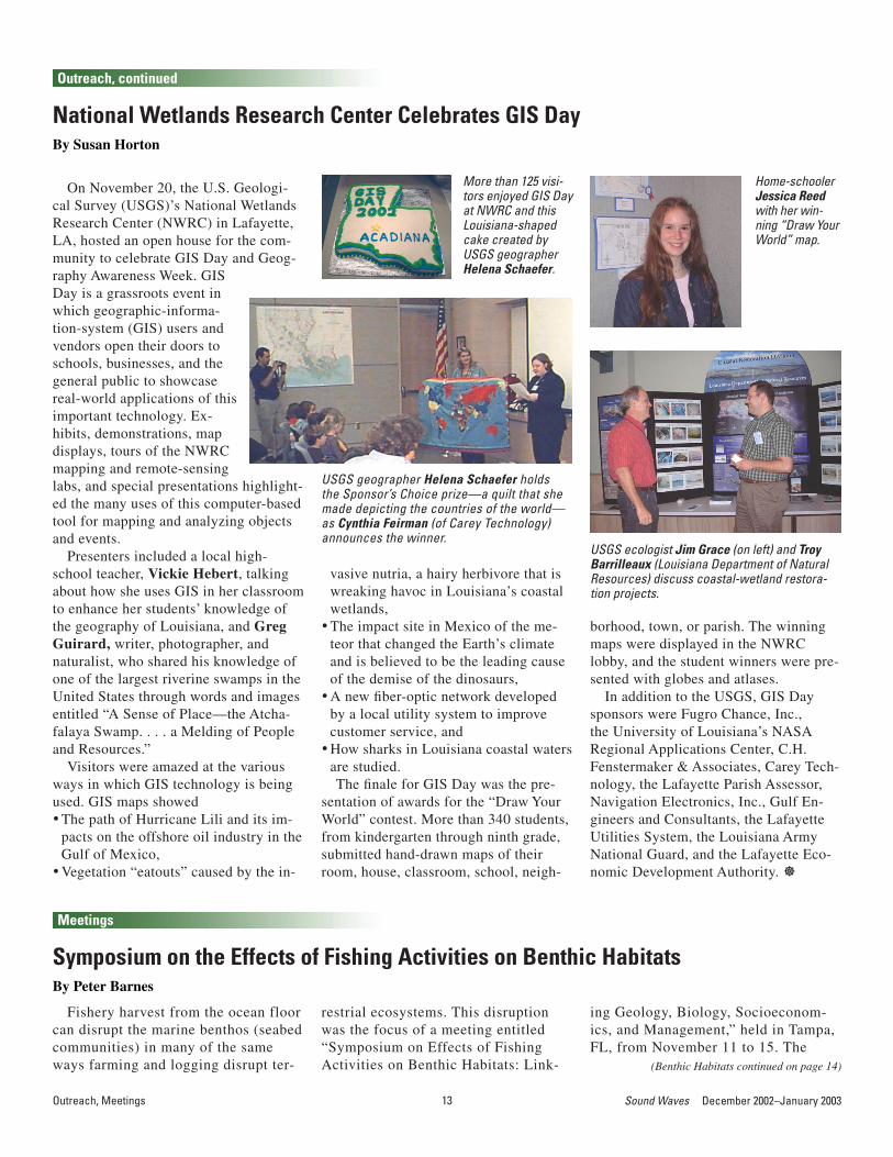
More than 125 visi-tors enjoyed GIS Day at NWRC and this Louisiana-shaped cake created by USGS geographer Helena Schaefer.
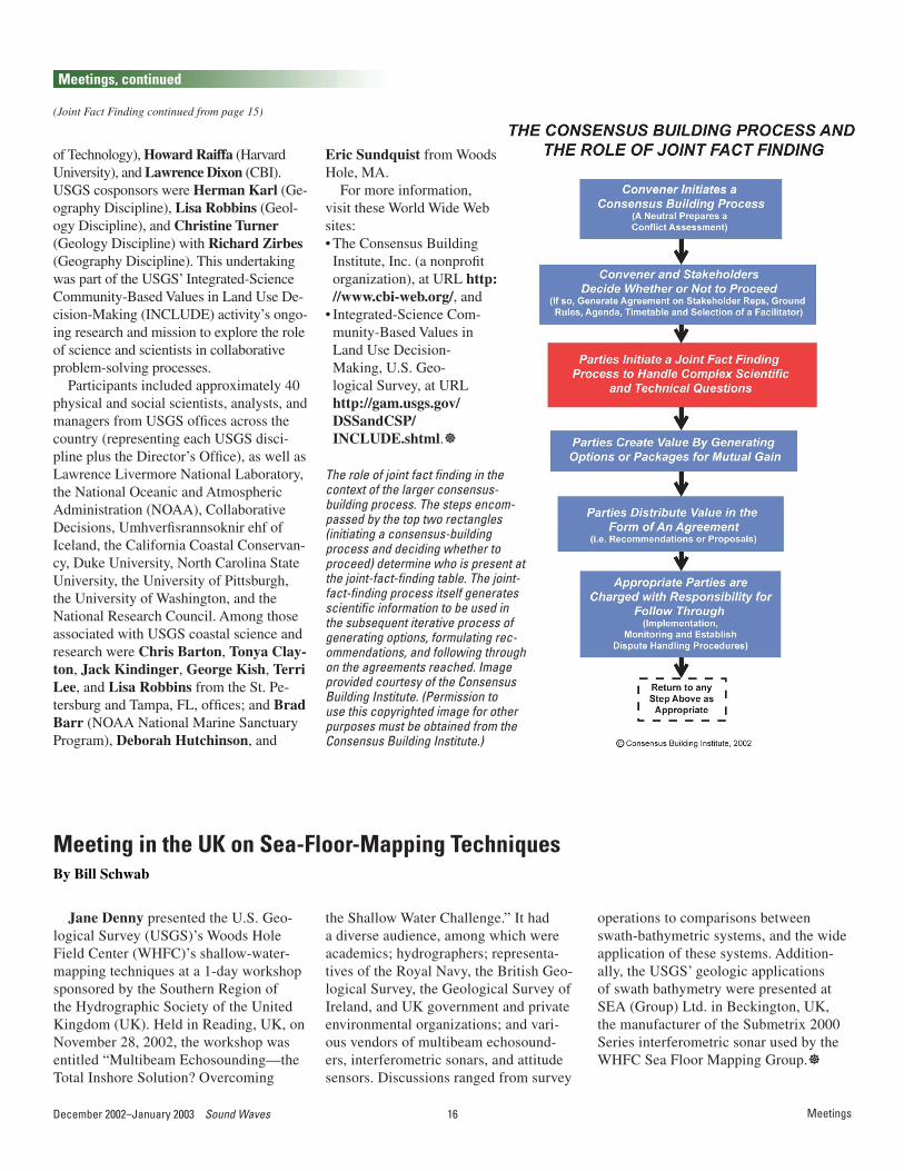
USGS geographer Helena Schaefer holds the Sponsor’s Choice prize—a quilt that she made depicting the countries of the world—as Cynthia Feirman (of Carey Technology) announces the winner.
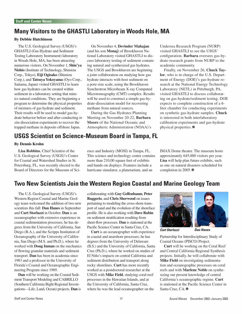
USGS ecologist Jim Grace (on left) and Troy Barrilleaux (Louisiana Department of Natural Resources) discuss coastal-wetland restora-tion projects.
borhood, town, or parish. The winning maps were displayed in the NWRC lobby, and the student winners were pre-sented with globes and atlases.
In addition to the USGS, GIS Day sponsors were Fugro Chance, Inc., the University of Louisiana’s NASA Regional Applications Center, C.H. Fenstermaker & Associates, Carey Tech-nology, the Lafayette Parish Assessor, Navigation Electronics, Inc., Gulf En-gineers and Consultants, the Lafayette Utilities System, the Louisiana Army National Guard, and the Lafayette Eco-nomic Development Authority. ]
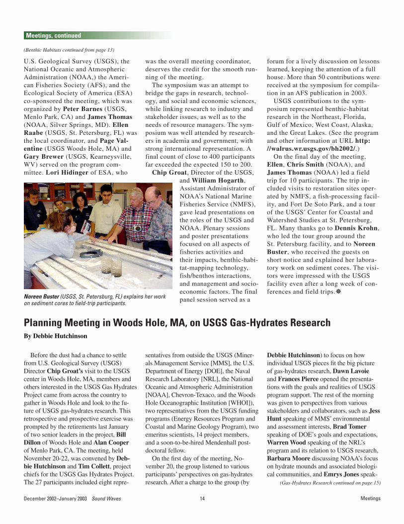
Home-schooler Jessica Reed with her win-ning “Draw Your World” map.
raphy Awareness Week. GIS Day is a grassroots event in which geographic-informa-tion-system (GIS) users and vendors open their doors to schools, businesses, and the general public to showcase real-world applications of this important technology. Ex-hibits, demonstrations, map displays, tours of the NWRC mapping and remote-sensing labs, and special presentations highlight-ed the many uses of this computer-based tool for mapping and analyzing objects and events.
Presenters included a local high-school teacher, Vickie Hebert, talking about how she uses GIS in her classroom to enhance her students’ knowledge of the geography of Louisiana, and Greg Guirard, writer, photographer, and naturalist, who shared his knowledge of one of the largest riverine swamps in the United States through words and images entitled “A Sense of Place—the Atcha-falaya Swamp. . . . a Melding of People and Resources.”
Visitors were amazed at the various ways in which GIS technology is being used. GIS maps showed• The path of Hurricane Lili and its im-
pacts on the offshore oil industry in the Gulf of Mexico,
• Vegetation “eatouts” caused by the in-
Meetings
14December 2002–January 2003 Sound Waves 15 Sound Waves December 2002–January 2003
was the overall meeting coordinator, deserves the credit for the smooth run-ning of the meeting.
The symposium was an attempt to bridge the gaps in research, technol-ogy, and social and economic sciences, while linking research to industry and stakeholder issues, as well as to the needs of resource managers. The sym-posium was well attended by research-ers in academia and government, with strong international representation. A final count of close to 400 participants far exceeded the expected 150 to 200.
Chip Groat, Director of the USGS,
Noreen Buster (USGS, St. Petersburg, FL) explains her work on sediment cores to field-trip participants.
forum for a lively discussion on lessons learned, keeping the attention of a full house. More than 50 contributions were received at the symposium for compila-tion in an AFS publication in 2003.
USGS contributions to the sym-posium represented benthic-habitat research in the Northeast, Florida, Gulf of Mexico, West Coast, Alaska, and the Great Lakes. (See the program and other information at URL http://walrus.wr.usgs.gov/bh2002/.)
On the final day of the meeting, Ellen, Chris Smith (NOAA), and James Thomas (NOAA) led a field trip for 10 participants. The trip in-cluded visits to restoration sites oper-ated by NMFS, a fish-processing facil-ity, and Fort De Soto Park, and a tour of the USGS’ Center for Coastal and Watershed Studies at St. Petersburg, FL. Many thanks go to Dennis Krohn, who led the tour group around the St. Petersburg facility, and to Noreen Buster, who received the guests on short notice and explained her labora-tory work on sediment cores. The visi-tors were impressed with the USGS facility even after a long week of con-ferences and field trips.]
U.S. Geological Survey (USGS), the National Oceanic and Atmospheric Administration (NOAA,) the Ameri-can Fisheries Society (AFS), and the Ecological Society of America (ESA) co-sponsored the meeting, which was organized by Peter Barnes (USGS, Menlo Park, CA) and James Thomas (NOAA, Silver Springs, MD). Ellen Raabe (USGS, St. Petersburg, FL) was the local coordinator, and Page Val-entine (USGS Woods Hole, MA) and Gary Brewer (USGS, Kearneysville, WV) served on the program com-mittee. Lori Hidinger of ESA, who
Meetings
and William Hogarth, Assistant Administrator of NOAA’s National Marine Fisheries Service (NMFS), gave lead presentations on the roles of the USGS and NOAA. Plenary sessions and poster presentations focused on all aspects of fisheries activities and their impacts, benthic-habi-tat-mapping technology, fish/benthos interactions, and management and socio-economic factors. The final panel session served as a
(Gas-Hydrates Research continued on page 15)
(Benthic Habitats continued from page 13)
Meetings, continued
Before the dust had a chance to settle from U.S. Geological Survey (USGS) Director Chip Groat’s visit to the USGS center in Woods Hole, MA, members and others interested in the USGS Gas Hydrates Project came from across the country to gather in Woods Hole and look to the fu-ture of USGS gas-hydrates research. This retrospective and prospective exercise was prompted by the retirements last January of two senior leaders in the project, Bill Dillon of Woods Hole and Alan Cooper of Menlo Park, CA. The meeting, held November 20-22, was convened by Deb-bie Hutchinson and Tim Collett, project chiefs for the USGS Gas Hydrates Project. The 27 participants included eight repre-
Planning Meeting in Woods Hole, MA, on USGS Gas-Hydrates ResearchBy Debbie Hutchinson
sentatives from outside the USGS (Miner-als Management Service [MMS], the U.S. Department of Energy [DOE], the Naval Research Laboratory [NRL], the National Oceanic and Atmospheric Administration [NOAA], Chevron-Texaco, and the Woods Hole Oceanographic Institution [WHOI]), two representatives from the USGS funding programs (Energy Resources Program and Coastal and Marine Geology Program), two emeritus scientists, 14 project members, and a soon-to-be-hired Mendenhall post-doctoral fellow.
On the first day of the meeting, No-vember 20, the group listened to various participants’ perspectives on gas-hydrates research. After a charge to the group (by
Debbie Hutchinson) to focus on how individual USGS pieces fit the big picture of gas-hydrates research, Dawn Lavoie and Frances Pierce opened the presenta-tions with the goals and realities of USGS program support. The rest of the morning was given to perspectives from various stakeholders and collaborators, such as Jess Hunt speaking of MMS’ environmental and assessment interests, Brad Tomer speaking of DOE’s goals and expectations, Warren Wood speaking of the NRL’s program and its relation to USGS research, Barbara Moore discussing NOAA’s focus on hydrate mounds and associated biologi-cal communities, and Emrys Jones speak-

14December 2002–January 2003 Sound Waves 15 Sound Waves December 2002–January 2003Meetings
(Gas-Hydrates Research continued from page 14)
(Joint Fact Finding continued on page 16)
Meetings, continued
ing of the Gulf of Mexico Joint Industry Program. Jean Whelan and Alexei Milkov (both of WHOI) kept all presenters on their toes with penetrating questions and discus-sion points. The day ended with 14 short USGS presentations in which researchers highlighted key accomplishments and their significance to gas-hydrate science. The outcome of this first day was to bring ev-
Participants in the USGS Gas Hydrates Planning Meeting take advantage of the clear fall weather for a group pho-tograph outside of the Carriage House, Woods Hole. From left to right, front row: Dave Mason (Woods Hole [WH]), Bill Winters (WH), Keith Kvenvolden (Menlo Park [MP]), Myung Lee (Denver), Brandon Dugan (new USGS Mendenhall Fel-low, from Penn State), Emrys Jones (Chevron/Texaco), Pat Hart (MP), Tim Collett (Denver), I-Ming Chou (Reston, VA), Warren Wood (NRL), Dawn Lavoie (Reston), Frances Pierce (Reston); back row: Bill Waite (WH), Steve Kirby (MP), Alexei Milkov (WHOI), Dave Scholl (USGS emeritus), John Bratton (WH), Brad Tomer (DOE), Tom Lorenson (MP), Dave Twichell (WH), Bill Dillon (USGS emeritus), Barbara Moore (NOAA), Jean Whelan (WHOI), Bill Gwilliam (DOE), and Jesse Hunt (MMS). Missing are Debbie Hutchinson (WH, the photographer) and VeeAnn Cross (WH).
eryone to a common level of understanding of each other’s work and goals.
The second day of the meeting was for USGS-only participants and consisted of discussions aimed at defining a gas-hy-drates-research agenda for the next 5 to 10 years. Many of the discussions focused on building closer links between laboratory and field experiments, and between labora-
tory and modeling experiments. We also discussed the development of conceptual models and the subsequent development of numerical models for understanding both the behavior of gas hydrates in sediment and the dynamic evolution of gas-water-sediment systems. Both Debbie and Tim have their work cut out for them in develop-ing, reviewing, and implementing a plan.]
Joint Fact Finding: A New Approach to Balancing Science and Politics in Ecosystem- and Resource-Management DecisionsBy Tonya Clayton
On October 16-17, several experts of international renown in the fields of con-sensus-building processes and decision science gathered in St. Pete Beach, FL. Their purpose was to introduce U.S. Geo-logical Survey (USGS) scientists, analysts, and managers to a new view of the role of scientific inquiry in addressing complex ecosystem- and resource-management conflicts. The course, entitled “Joint Fact Finding: A New Approach to Balancing Science and Politics in Ecosystem and Resource Management Decisions,” was sponsored by the USGS and presented by the Consensus Building Institute (CBI) of Cambridge, MA.
A central tenet of the course was that conventional scientific practice can lead to adversarial science, commonly alienat-ing the public as well as elected and ap-pointed decisionmakers. Joint fact finding, one phase of a broader consensus-building
approach, was presented as an alternative strategy—one that is more effective in gen-erating constructive and lasting agreements about contentious environmental issues. In this process, stakeholders representing a wide variety of interests work together to:• Identify and understand the myriad inter-ests and issues at stake;
• Determine, on the basis of financial and technical considerations, whether joint fact finding is appropriate in the given case;
• Plan the joint-fact-finding process, deter-mining, for example, which stakeholders need to be involved, what roles various participants will play, and how severe disparities in participants’ expertise will be addressed;
• Define the precise questions to be ad-dressed, as well as the most appropriate methods of analysis;
• Agree on how to use the joint-fact-find-
ing results, including how to accom-modate conflicting data and interpreta-tions; and
• Communicate the results of the joint-fact-finding process to various constitu-encies and policymakers.In addition to lectures richly textured
with illustrative examples and sprinkled with humor, the fast-moving course (com-plete with a healthy dose of homework!) also included an exploration of two USGS “real-world” case studies, plus various complex role-playing scenarios. One of the highlights of the course was an address by USGS Director Chip Groat, followed by a lively discussion of the USGS’ mis-sion and the role of its scientists in bring-ing policy-relevant research to the joint-fact-finding process.
Lead instructors for the course were Law-rence Susskind (CBI, Massachusetts Institute
16December 2002–January 2003 Sound Waves 17 Sound Waves December 2002–January 2003Meetings
Jane Denny presented the U.S. Geo-logical Survey (USGS)’s Woods Hole Field Center (WHFC)’s shallow-water-mapping techniques at a 1-day workshop sponsored by the Southern Region of the Hydrographic Society of the United Kingdom (UK). Held in Reading, UK, on November 28, 2002, the workshop was entitled “Multibeam Echosounding—the Total Inshore Solution? Overcoming
Meeting in the UK on Sea-Floor-Mapping TechniquesBy Bill Schwab
the Shallow Water Challenge.” It had a diverse audience, among which were academics; hydrographers; representa-tives of the Royal Navy, the British Geo-logical Survey, the Geological Survey of Ireland, and UK government and private environmental organizations; and vari-ous vendors of multibeam echosound-ers, interferometric sonars, and attitude sensors. Discussions ranged from survey
operations to comparisons between swath-bathymetric systems, and the wide application of these systems. Addition-ally, the USGS’ geologic applications of swath bathymetry were presented at SEA (Group) Ltd. in Beckington, UK, the manufacturer of the Submetrix 2000 Series interferometric sonar used by the WHFC Sea Floor Mapping Group.]
(Joint Fact Finding continued from page 15)
Meetings, continued
of Technology), Howard Raiffa (Harvard University), and Lawrence Dixon (CBI). USGS cosponsors were Herman Karl (Ge-ography Discipline), Lisa Robbins (Geol-ogy Discipline), and Christine Turner (Geology Discipline) with Richard Zirbes (Geography Discipline). This undertaking was part of the USGS’ Integrated-Science Community-Based Values in Land Use De-cision-Making (INCLUDE) activity’s ongo-ing research and mission to explore the role of science and scientists in collaborative problem-solving processes.
Participants included approximately 40 physical and social scientists, analysts, and managers from USGS offices across the country (representing each USGS disci-pline plus the Director’s Office), as well as Lawrence Livermore National Laboratory, the National Oceanic and Atmospheric Administration (NOAA), Collaborative Decisions, Umhverfisrannsoknir ehf of Iceland, the California Coastal Conservan-cy, Duke University, North Carolina State University, the University of Pittsburgh, the University of Washington, and the National Research Council. Among those associated with USGS coastal science and research were Chris Barton, Tonya Clay-ton, Jack Kindinger, George Kish, Terri Lee, and Lisa Robbins from the St. Pe-tersburg and Tampa, FL, offices; and Brad Barr (NOAA National Marine Sanctuary Program), Deborah Hutchinson, and
Eric Sundquist from Woods Hole, MA.
For more information, visit these World Wide Web sites: • The Consensus Building Institute, Inc. (a nonprofit organization), at URL http://www.cbi-web.org/, and
• Integrated-Science Com-munity-Based Values in Land Use Decision-Making, U.S. Geo-logical Survey, at URL http://gam.usgs.gov/DSSandCSP/INCLUDE.shtml.]
The role of joint fact finding in the context of the larger consensus-building process. The steps encom-passed by the top two rectangles (initiating a consensus-building process and deciding whether to proceed) determine who is present at the joint-fact-finding table. The joint-fact-finding process itself generates scientific information to be used in the subsequent iterative process of generating options, formulating rec-ommendations, and following through on the agreements reached. Image provided courtesy of the Consensus Building Institute. (Permission to use this copyrighted image for other purposes must be obtained from the Consensus Building Institute.)
16December 2002–January 2003 Sound Waves 17 Sound Waves December 2002–January 2003Staff and Center News
Staff and Center News
The U.S. Geological Survey (USGS)’s GHASTLI (Gas Hydrate and Sediment Testing Laboratory Instrument) laboratory in Woods Hole, MA, has been attracting numerous visitors. On November 1, Shin’ya Nishio (Institute of Technology, Shimizu Corp., Tokyo), Eiji Ogisako (Shimizu Corp.), and Tatsuya Yokoyama (Oyo Corp., Saitama, Japan) visited GHASTLI to learn how gas hydrates can be created within sediment in a laboratory setting that mim-ics natural conditions. They are beginning a program to determine the physical properties of mixtures of gas hydrate and sediment. Their results will be used to model gas-hy-drate behavior before and after conducting in situ dissociation experiments to recover the trapped methane in deposits offshore Japan.
Many Visitors to the GHASTLI Laboratory in Woods Hole, MABy Debbie Hutchinson
On November 4, Devinder Mahajan (and his son Monaj) of Brookhaven Na-tional Laboratory visited GHASTLI to dis-cuss laboratory testing of sediment contain-ing natural and synthesized gas hydrates. The USGS and Brookhaven are beginning a joint collaboration on studying how gas hydrate interacts with host sediment on a pore-size scale, using the Brookhaven Synchrotron Microbeam X-ray Computed Microtomography (CMT) complex. Results will be used to construct a simple gas-hy-drate-dissociation model for recovering methane from natural sources.
During the Gas Hydrates Planning Meeting on November 20-22, Barbara Moore of the National Oceanic and Atmospheric Administration (NOAA)’s
Undersea Research Program (NURP) visited GHASTLI to see the USGS’ configuration. Barbara oversees gas-hy-drate-research grants from NURP to the academic community.
Finally, on November 26, Chuck Tay-lor, who is in charge of the U.S. Depart-ment of Energy (DOE)’s gas-hydrate re-search at the National Energy Technology Laboratory (NETL) in Pittsburgh, PA, visited GHASTLI to discuss collaborat-ing on gas-hydrate/sediment testing. DOE expects to complete construction of a 6-liter chamber for conducting experiments on synthetic gas-hydrate samples. Chuck is interested in both interlaboratory calibration experiments and gas-hydrate physical properties.]
Lisa Robbins, Chief Scientist of the U.S. Geological Survey (USGS)’s Center for Coastal and Watershed Studies in St. Petersburg, FL, was recently elected to the Board of Directors for the Museum of Sci-
USGS Scientist on Science-Museum Board in Tampa, FLBy Dennis Krohn
ence and Industry (MOSI) in Tampa, FL. This science and technology center contains more than 210,00 square feet of exhibits and hands-on displays. Features include a hurricane simulator, a planetarium, and an
IMAX Dome theater. The museum hosts approximately 645,000 visitors per year. Lisa will help plan future exhibits, such as one on natural disasters scheduled for completion in 2005.]
The U.S. Geological Survey (USGS)’s Western Region Coastal and Marine Geol-ogy team welcomed the addition of two new scientists this fall: Dan Hanes in September and Curt Storlazzi in October. Dan is an oceanographer with extensive experience in coastal sedimentation processes; he has de-grees from the University of California, San Diego (B.A.), and the Scripps Institution of Oceanography of the University of Califor-nia, San Diego (M.S. and Ph.D.), where he worked with Doug Inman on the mechanics of flowing granular materials and sediment transport. Dan has been in academia since 1983 and a professor in the University of Florida’s Coastal and Oceanographic Engi-neering Program since 1989.
Dan will be working on the Coastal Sedi-ment Transport Modeling and CABRILLO (Southern California Bight Regional Investi-gations—Life, Land, Ocean) projects. Dan is
Two New Scientists Join the Western Region Coastal and Marine Geology Teamcollaborating with Guy Gelfenbaum, Peter Ruggerio, and Chris Sherwood on issues pertaining to modeling the cross-shore trans-port of sand and the evolution of the shoreface profile. He is also working with Dave Rubin on sediment stratification resulting from sheet-flow processes. Dan is stationed at the Pacific Science Center in Santa Cruz, CA.
Curt is an oceanographer with experience in coastal and nearshore processes; he has degrees from the University of Delaware (B.S.) and the University of California, Santa Cruz (Ph.D.), where he worked on studies of El Niño’s impacts on central California and sediment distribution and transport along rocky shorelines. Curt has more recently worked as a postdoctoral researcher at the USGS with Mike Field, studying coral-reef processes in the Hawaiian Islands, and at the University of California, Santa Cruz, where he was the lead oceanographer on the
Dan HanesCurt Storlazzi
Partnership for Interdisciplinary Study of Coastal Oceans (PISCO) Project.
Curt will be working on the Coral Reef and Central California Regional Synthesis projects. Initially, he will collaborate with Mike Field on investigating sedimenta-tion and oceanographic processes on coral reefs and with Marlene Noble on synthe-sizing our present knowledge of central California’s oceanographic regime. Curt is stationed at the Pacific Science Center in Santa Cruz, CA.]
18December 2002–January 2003 Sound Waves 19 Sound Waves December 2002–January 2003Staff and Center News
(Information Bank continued on page 19)
Staff and Center News, continued
The low-relief Mississippi River delta plain of Louisiana is undergoing the highest rates of barrier-island erosion (approximately 10 meters per year) and wetland loss (ap-proximately 75 square kilometers per year) of any State in the Nation and, likely, any region in the world. Much of this erosion has resulted from natural processes, such as storms, subsidence, and sea-level rise and sediment starvation due to delta cycling by the Mississippi River. Increasingly over the past century, however, anthropogenic activi-ties, such as oil and gas development, flood control, and navigation, are exacerbating land loss and increasing the risks of storm damage and flooding to south-central Louisiana, es-pecially to such urban areas as New Orleans. In an effort to stem the rate of erosion and
Two USGS Coastal Scientists Named to Louisiana Coastal-Restoration Advisory BoardBy Jeff Williams
restore the wetland ecosystem, a Federal-State partnership has produced a $14-billion program plan that recommends massive barrier-island and wetland restoration and re-engineering of the Mississippi River.
Recognizing the critical need for coastal science to guide the restoration efforts, the Louisiana Department of Natural Resources’ Office of Coastal Restoration and Manage-ment has recently formed the Louisiana Gulf Shoreline Restoration Advisory Board, com-posed of nine scientists and engineers. Two of the new science advisors are U.S. Geolog-ical Survey (USGS) scientists Jeff Williams (Woods Hole, MA) and Abby Sallenger (St. Petersburg, FL), who have distinguished ca-reers in coastal research and nearly 40 years combined in studies of geologic framework
and storm effects in Louisiana. As part of the inaugural board meeting on November 20, 2002, in New Orleans, Williams and Sal-lenger participated in a workshop on coastal restoration attended by more than 60 people; they spoke, respectively, on the following topics:• offshore sediment resources, using us-
SEABED digital-map technology, for bar-rier restoration, and
• lidar (light detection and ranging) tech-nology used to map barrier responses to storms, such as recent Tropical Storm Isidore and Hurricane Lilli.More information on Louisiana coastal
restoration is available online at URLs http://www.coast2050.gov/ and http://www.lacoast.gov/.]
After years of watching the nearby heli-copters land and take off, several employees from the U.S. Geological Survey (USGS)’s Center for Coastal and Watershed Studies
USGS Employees Tour Neighboring Air Medical Transport CenterBy Dennis Krohn
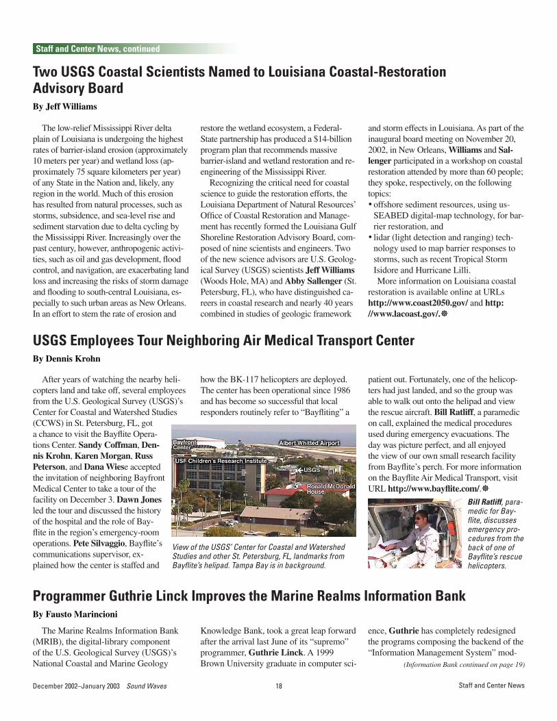
how the BK-117 helicopters are deployed. The center has been operational since 1986 and has become so successful that local responders routinely refer to “Bayfliting” a
Bill Ratliff, para-medic for Bay-flite, discusses emergency pro-cedures from the back of one of Bayflite’s rescue helicopters.
View of the USGS’ Center for Coastal and Watershed Studies and other St. Petersburg, FL, landmarks from Bayflite’s helipad. Tampa Bay is in background.
(CCWS) in St. Petersburg, FL, got a chance to visit the Bayflite Opera-tions Center. Sandy Coffman, Den-nis Krohn, Karen Morgan, Russ Peterson, and Dana Wiese accepted the invitation of neighboring Bayfront Medical Center to take a tour of the facility on December 3. Dawn Jones led the tour and discussed the history of the hospital and the role of Bay-flite in the region’s emergency-room operations. Pete Silvaggio, Bayflite’s communications supervisor, ex-plained how the center is staffed and
The Marine Realms Information Bank (MRIB), the digital-library component of the U.S. Geological Survey (USGS)’s National Coastal and Marine Geology
Programmer Guthrie Linck Improves the Marine Realms Information BankBy Fausto Marincioni
Knowledge Bank, took a great leap forward after the arrival last June of its “supremo” programmer, Guthrie Linck. A 1999 Brown University graduate in computer sci-
ence, Guthrie has completely redesigned the programs composing the backend of the “Information Management System” mod-
patient out. Fortunately, one of the helicop-ters had just landed, and so the group was able to walk out onto the helipad and view the rescue aircraft. Bill Ratliff, a paramedic on call, explained the medical procedures used during emergency evacuations. The day was picture perfect, and all enjoyed the view of our own small research facility from Bayflite’s perch. For more information on the Bayflite Air Medical Transport, visit URL http://www.bayflite.com/.]
18December 2002–January 2003 Sound Waves 19 Sound Waves December 2002–January 2003Staff and Center News, Publications
Staff and Center News, continued
(Information Bank continued from page 18)
Publications
Abramson, I., Varekamp, J.C., and Buchholtz ten Brink , M.R., 2002, Long Island Sound, an urban estuary with benthic foraminifera as indicators of eutrophphication [abs.]: Geological Society of America Abstracts with Programs, v. 34, no. 6, p. 384.
Brock, J., Wright, W., Gesch, D., Crane, M., Hansen, M., and Sallenger, A., 2002, Development of methods for the integration of high resolution topographic and bathymetric lidar surveys of the Tampa Bay region [abs.]: Gulf Coast Association of Geological Societies and SEPM, Gulf Coast Section Annual Convention, 52d, Official Program, p. 73.
Brock, J.C., Wright, C.W., Nayegandhi, A., Clayton, T., Hansen, M., Longenecker, J., Gesch, D., and Crane, M., 2002, Initial results from a test of the NASA EAARL lidar in the Tampa Bay region: Gulf Coast Association of Geological Societies and SEPM, Gulf Coast Section Annual Convention, 52d, Transactions [CD-ROM].
Buster, N.A., Reich, C.D., Holmes, C.W., Shinn, E.A., and Hickey, T.D., 2002, Carbonate storm deposits and varve-like
Recently Published Articlessediments within the Great Blue Hole on Lighthouse Reef atoll, Belize, Central America [abs.]: Geological Society of America Abstracts with Programs, v. 34, no. 6, p. 14.
Calderon, K., Dadisman, S.V., Kindinger, J.L., Wiese, D.S., and Flocks, J.G., 2002, Archive of boomer seismic reflection data collected during USGS field activities 01ASR01, 01ASR02, 02ASR01, and 02ASR02: U.S. Geological Survey Open-File Report 02-408, 2 CD-ROMs.
Capone, M., Hammar-Klose, E.S., Hill, J.C., and Schwab, W.C., 2002, Archive of sidescan-sonar data and Differential Geographic Positioning System navigation data, collected during USGS cruise DIAN 97011 Long Island, New York inner shelf—Fire Island, New York, 5 May-26 May 1997: U.S. Geological Survey Open-File Report 02-120, 6 DVD-ROMs.
Capone, M.K., Thieler, E.R., Nichols, D.R., and O’Brien, T.F., 2002, Archive of boomer subbottom data, collected during USGS cruise ATSV99045, northern North Carolina, October 9-27, 1999: U.S.
Geological Survey Open-File Report 01-380, 2 DVD-ROMs.
Chivas, A.R., García, A., van der Kaars, S., Couapel, M.J.J., Holt, S., Reeves, J.M., Wheeler, D.J., Switzer, A.D., Murray-Wallace, C.V., Banerjee, D., Price, D.M., Wang, S.X., Pearson, G., Edgar, N.T., Beaufort, L., De Deckker, P., Lawson, E., and Cecil, C.B., 2001, Sea-level and environmental changes since the Last Interglacial in the Gulf of Carpentaria, Australia; an overview: Quaternary International, v. 83-85, p. 19-46.
Clayton, T., Brock, J., Wright, C.W., Curry, R., Boss, E., Riegl, B., McIntosh, G., and Dodge, R., 2002, Remote sensing for coral reef studies; testing the waters in Biscayne National Park [abs.]: Geological Society of America Abstracts with Programs, v. 34, no. 6, p. 457.
Colman, S.M., Kelts, K.R., and Dinter, D.A., 2002, Depositional history and neotectonics in Great Salt Lake, Utah, from high-resolution seismic stratigraphy: Sedimentary Geology, v. 148, p. 61-78.
(Recently Published continued on page 20)
ule for the MRIB. His new design offers significant improvements in terms of both scalability and efficiency, with searches running approximately 75 percent faster than in previous versions. Further increases in speed will soon follow as parallel-pro-
cessing algorithms are implemented, taking advantage of the server’s multiple proces-sors. Guthrie also created a fiery new Keyword Search option, not available in previous versions of the MRIB. Finally, the “Browse a Map” feature now offers faster
map-generation routines, multiple-map pro-jections, hemispherical views, shaded-relief maps, and more.
If you have not visited the MRIB recent-ly, please take a look at the new features at URL http://mrib.usgs.gov/.]
On November 4, the Coastal and Marine Geology team (CMG) in the Western Region was pleased to welcome Laura Zink Torresan as the new web-mistress for the team’s Web site (http://walrus.wr.usgs.gov/). Laura is no stranger to CMG, having been affiliated with the team since 1995.
Laura earned her undergraduate degree in geology from Middlebury College (VT) in 1989 and began her career with the U.S. Geological Survey (USGS) in 1990,
New Webmistress for the Western Region Coastal and Marine Geology Team
Laura and son Mario, on the 4th of July 2002. .
working for the now defunct Sedimentary Processes Branch. In 1995, she began work as a contractor for CMG; soon thereafter, she helped launch the “Access USGS—San Francisco Bay and Delta” Web site at URL http://sfbay.wr.usgs.gov/. During the 1997-98 El Niño season, Laura helped Rex Sanders set up a special El Niño Web server. She has provided GIS and graphic-illustration support for various team proj-ects, with a special emphasis in recent years on Web-page creation and Web-site design.
Welcome, Laura!]
20December 2002–January 2003 Sound Waves 21 Sound Waves December 2002–January 2003
Edwards, L.E., Frederiksen, N.O., Self-Trail, J.M., and Poag, C.W., 2002, Paleontology of crater-fill deposits, Chesapeake Bay impact structure, Virginia [abs.]: Geological Society of America Abstracts with Programs, v. 34, no. 6, p. 465.
Elko, N.A., Sallenger, A.H., Jr., Guy, K., and Morgan, K.L.M., 2002, Barrier island elevations relevant to potential storm impacts; 2. South Atlantic: U.S. Geological Survey Open-File Report 02-288, 4 p.
Elko, N.A., Sallenger, A.H., Jr., Guy, K., Stockdon, H.F., and Morgan, K.L.M., 2002, Barrier island elevations relevant to potential storm impacts; 1. Techniques: U.S. Geological Survey Open-File Report 02-287, 6 p.
Flocks, J.G., Kindinger, J.L., Davis, J.B., and Swarzenski, P., 2001, Geophysical investigations of upward-migrating saline water from the Lower to Upper Floridan aquifer, central Indian River region, Florida, in Kuniansky, E.L., ed., U.S. Geological Survey Karst Interest Group Proceedings: U.S. Geological Survey Water Resources Investigations Report 01-4011, p. 135-140 [URL http://water.usgs.gov/ogw/karst/kigconference/jgf_geophysicalinvest.htm].
Flocks, J.G., Kindinger, J.L., Ferina, N., and Dreher, C., 2002, Sediment-hosted contaminants and distribution patterns in the Mississippi and Atchafalaya River systems: Gulf Coast Association of Geological Societies and SEPM, Gulf Coast Section Annual Convention, 52d, Transactions, v. 52, p. 277-290.
Griffin, D.W., 2002, Detection of microbial indicators and human microbial pathogens in artificial recharge studies [abs.], in Aiken, G.R., and Kuniansky, E.L., eds., U.S. Geological Survey Artificial Recharge Workshop Proceedings, Sacramento, CA, April 2-4, 2002: U.S. Geological Survey Open-File Report 02-89, p. 60 [URL http://water.usgs.gov/ogw/pubs/ofr0289/dwg_detection.htm].
Griffin, D.W., 2002, The use of bacteriophage tracers in understanding groundwater transport of pathogenic microorganisms in the State of Florida [abs.]: Geological Society of America Abstracts with Programs, v. 34, no. 6, p. 157.
Griffin, D.W., Garrison, V.H., Herman, J.R.,
and Shinn, E.A., 2001, African desert dust in the Americas and Caribbean; microbiology and public health issues [abs.]: American Public Health Association Annual Conference, Atlanta, GA, abstract 22475 [URL http://apha.confex.com/apha/129am/techprogram/meeting_129am.htm].
Griffin, D.W., Kellogg, C.A., Garrison, G.A., and Shinn, E.A., 2002, Desert dust in Earth’s atmosphere; public and ecosystem health issues [abs.]: Sino-U.S. Workshop on Dust Storms and Their Effect on Human Health, Raleigh, NC, November 25-26, 2002, abstract 24 [URL http://www.gathery.com/nc/caps/abstracts/abstracts_workshop.html].
Griffin, D.W., Kellogg, C.A., Garrison, G.H., and Shinn, E.A., 2002, Long range transport of sediment in the atmosphere and its implications for global public and ecosystem health [abs.]: International Society for Ecosystem Health Conference, Washington, DC, June 6-11, 2002 [URL http://www.ecosystemhealth.com/hehp/papersessions/session1-7.htm].
Halley, R.B., 2002, Eleven things a geologist thinks an engineer should know about carbonate beaches, in Magoon, O., and others, eds., Carbonate Beaches 2000: American Society of Civil Engineers Conference, Key Largo, FL, 2000, Proceedings, p. 1-14.
Halley, R.B., and Yates, K.K., 2001, Productivity measurements of benthic communities in Biscayne National Park as an indication of ecosystem health: U.S. Geological Survey Open-File Report 01-91, 2 p.
Hoare, A.M., Hallock, P., Lidz, B.H., Reich, C., and Shinn, E.A., 2002, Do benthic foraminiferal assemblages reflect trace metal contamination in sediments of Biscayne Bay, Florida, USA? [abs.]: Geological Society of America Abstracts with Programs, v. 34, no. 6, p. 384.
Holmes, C.W., and Miller, R., 2002, The atmospheric transport and deposition of arsenic and other metals in the southeastern United States [abs.]: Geological Society of America Abstracts with Programs, v. 34, no. 6, p. 295.
Jablonski, S., Mecray, E.L., Munson, J., and Blackwood, D., 2002, Geochemical
sediment analysis procedures: U.S. Geological Survey Open-File Report 02-371 [URL http://pubs.usgs.gov/of/2002/of02-371/].
Kindinger, J.L., 2002, Lake Belt study area; high-resolution seismic reflection survey, Miami-Dade County, Florida: U.S. Geological Survey Open-File Report 02-325, 50 p. [CD-ROM].
Marincioni, F., and Lightsom, F.L., 2002, Marine Realms Information Bank, an on-line educational resource [abs.]: Geological Society of America Abstracts with Programs, v. 34, no. 6, p. 455.
Morton, R.A., 2002, Coastal geoindicators of environmental change in the humid tropics: Environmental Geology, v. 42, p. 711-724.
Morton, R.A., Buster, N.A., and Krohn, M.D., 2002, Subsurface controls on subsidence rates and associated wetland loss in southeastern Louisiana: Gulf Coast Association of Geological Societies Transactions, v. 52, p. 767-778.
Peery, G.M., Lidz, B.H., and Wiese, D.S., 2002, Archive of seismic reflection data collected during USGS cruise 97KEY01, upper and middle Florida Keys, 12 October-1 November 1997: U.S. Geological Survey Open-File Report 02-421 [DVD and CD-ROM].
Poag, C.W., 2002, Biospheric consequences of the Chesapeake Bay bolide impact [abs.]: Geological Society of America Abstracts with Programs, v. 34, no. 6, p. 467.
Poag, C.W., 2002, Cored record of impact-derived lithofacies in the Chesapeake Bay impact crater; serendipity versus strategy [abs.]: Geological Society of America Abstracts with Programs, v. 34, no. 6, p. 318.
Poag, C.W., 2002, Structure and morphology of the Chesapeake Bay submarine impact structure [abs.]: Geological Society of America Abstracts with Programs, v. 34, no. 6, p. 318.
Poag, C.W., Gohn, G.S., and Powars, D.S., 2002, Chesapeake Bay impact crater; seismostratigraphy and lithostratigraphy of displaced sedimentary megablocks [abs.]: Lunar and Planetary Science Conference, 31st, Houston, TX, March 13-17, 2001, v. 33, abstract 1019 [CD-ROM].
Poppe, L.J., Knebel, H.J., Lewis, R.S., and DiGiacomo-Cohen, M.L., 2002, Processes
Publications
(Recently Published continued from page 19)
(Recently Published continued on page 21)
Publications, continued
20December 2002–January 2003 Sound Waves 21 Sound Waves December 2002–January 2003Publications
Publications, continued
controlling the remobilization of surficial sediment and formation of sedimentary furrows in north-central Long Island Sound: Journal of Coastal Research, v. 18, no. 4, p. 741-750.
Powars, D.S., Gohn, G.S., Edwards, L.E., Catchings, R.D., Scott, B.T., Johnson, G.H., and Poag, C.W., 2002, Lithostratigraphic framework of the crater-fill deposits; western annular trough, Chesapeake Bay impact crater [abs.]: Geological Society of America Abstracts with Programs, v. 34, no. 6, p. 465.
Reimold, W.U., Po, W., Koeberl, C., and Poag, C.W., 2002, Chesapeake Bay impact crater; petrographic and geochemical investigations of the impact breccia fill [abs.]: Geological Society of America Abstracts with Programs, v. 34, no. 6, p. 466.
Roberts, C.S., Hammar-Klose, E.S., and Schwab, W.C., 2002, Archive of sidescan-sonar and DGPS navigation field data, collected on USGS cruise ATSV99044, South Carolina Coast, 29 October-14 November, 1999: U.S. Geological Survey Open-File Report 02-103, 5 DVD-ROMs.
Rybakow, M., El-Kelani, R., and ten Brink, U.S., 2002, Joint Israeli-Palestinian gravity survey in the Dead Sea Rift Valley: U.S. Geological Survey Open-File Report 00-341.
Shinn, E.A., 2002, Tidal flats in a “daisy” world [abs.]: Geological Society of America Abstracts with Programs, v. 34, no. 6, p. 218.
Shinn, E.A., Seba, D., Griffin, D., Kellogg, C., Holmes, C.W., and Garrison, G., 2002, Transoceanic soil dust transport and medical implications [abs.]: Geological Society of America Abstracts with Programs, v. 34, no. 6, p. 147.
ten Brink, U.S., 2002, Slab deformation at the edge of subduction zones; an example from Cascadia, in Kirby,Stephen, Wang, Kelin, and Dunlop, Susan, eds., The Cascadia subduction zone and related subduction systems—seismic structure, intraslab earthquakes and processes, and earthquake hazards: U.S. Geological Survey Open-File Report 02-328 and Geological Survey of Canada Open File 4350, p. 139-141 [URL http://geopubs.wr.usgs.gov/open-file/of02-328/].
Thieler, E.R., Williams, S.J., and Beavers, R., 2002, Vulnerability of U.S. national parks
to sea-level rise and coastal changes: U.S. Geological Survey Fact Sheet FS-095-02 [URL http://pubs.usgs.gov/fs/fs095-02/].
Williams, R.S., Jr., and Ferrigno, J.G., 2002, Satellite image atlas of glaciers of the world: U.S. Geological Survey Fact Sheet FS-130-02.
Williams, R.S., Jr., and Ferrigno, J.G., eds., 2002, Satellite image atlas of glaciers of the world—North America [exclusive of Alaska]: U.S. Geological Survey Professional Paper 1386-J, 405 p. [URL http://pubs.usgs.gov/prof/p1386j/].
Williams, S.J., Penland, S., Kindinger, J., and Kulp, M., 2002, Understanding the quaternary geologic framework and modern coastal processes of the Mississippi River deltaic region—a key to restoration [abs.]: Geological Society of America Abstracts with Programs, v. 34, no. 6, p. 481.]
(Recently Published continued from page 20)
Baldwin, W.E., Morton, R.A., Denny, J.F., Schwab, W.C., Gayes, P.T., and Driscoll, N.W., Surface and subsurface geologic mapping within South Carolina’s Long Bay, between Little River and Winyah Bay [abs.]: Southeast Coastal Ocean Science Conference and Workshop, Charleston, SC, January 27-31, 2003.
Bradbury, J.P., Colman, S.M., and Dean, W.E., Limnologic and climate environments at Upper Klamath Lake, Oregon, during the past 40,000 years: Journal of Paleolimnology.
Bradbury, J.P., Colman, S.M., and Reynolds, R.L., The history of recent limnologic changes and human impact on Upper Klamath Lake, Oregon: Journal of Paleolimnology.
Buijsman, M.C., Kaminsky, G.M., and Gelfenbaum, Guy, Shoreline change associated with jetty construction, deterioration, and rehabilitation at Grays Harbor, Washington: Shore and Beach.
Capone, M.K., Scanlon, K.M., and Rozycki, J.E., Archive of CHIRP data, collected during USGS cruise Oregon II 00005 northeastern Gulf of Mexico, 15 February-2 March 2000: U.S. Geological Survey
Open-File Report 02-045, 2 DVD-ROMs.Dawes, C., Meads, M., Yates, K.K.,
Fernandez, M., and Kellogg, C., Seagrass restoration in Tampa Bay: poster on World Wide Web.
Denny, J.F., and Danforth, W.W., USGS shallow water mapping surveys using an interferometric sonar system: Hydrographic Society of the United Kingdom, Southern Region workshop, “Multibeam Echosounding—the Total Inshore Solution? Overcoming the Shallow Water Challenge,” Reading, UK, November 28, 2002, Proceedings.
Edwards, B.D., Ponti, D.J., Tinsley, J.C., III, Ehman, K.D., Land, M.T., and Reichard, E.G., Stratigraphic controls on salt-water intrusion in siliciclastic coastal aquifers; Los Angeles, CA, USA [abs.]: International Conference on Salt-Water Intrusion and Coastal Aquifers, 2d—Monitoring, Modeling, Management, Merida, Yucatán, Mexico, March 27-April 2, 2003.
Fernandez, M., Jr., Robb, S., Doan, K., Stephens, J., and Grabe, S., Preliminary findings on the distribution of organic carbon-normalized select polycyclic aromatic hydrocarbons in the bottom sediments of the Alafia River-Kitchen Bay, Feather Sound, Pinellas Point, and the Terra Ceia areas in Tampa Bay, June 2002: U.S. Geological Survey Open-File Report 02-480.
Fisher, M.A., Normark, W.R., Langenheim, V.E., Calvert, A.J., and Sliter, Ray, Marine geology and earthquake hazards of the San Pedro shelf region, southern California: Seismological Society of America Bulletin.
Harris, M.S., Brock, J.C., Duffy, M., Wright, C.W., and Nayegandhi, A., Lidar applications for vital signs monitoring at Assateague Island National Seashore [abs.]: Coast and Estuarine Habitat Restoration Conference, Baltimore, MD, April 13-16, 2003.
Kellogg, C.A., Diversity of Archaea in Caribbean coral mucus [abs.]: American Society for Microbiology 2003 General Meeting, Washington, DC, May 18-23, 2003.
Kellogg, C.A., Griffin, D.W., and Shinn, E.A., Out of Africa; characterization of microbial communities associated with desert dust and their implications for human and ecosystem health [abs.]: Natural Science
Publications Submitted for Director’s Approval
(Publications Submitted continued on page 22)

22December 2002–January 2003 Sound Waves 23 Sound Waves December 2002–January 2003
Publications, continued
(Publications Submitted continued from page 21)
and Public Health; Prescription for a Better Environment, National Conference on USGS Health-Related Research, Reston, VA, April 1-3, 2003.
Kindinger, J.L., and Cunningham, K.J., Shallow karst aquifer system of the Lake Belt study area, Miami-Dade County, Florida [abs.]: International Conference on Salt-Water Intrusion and Coastal Aquifers, 2d—Monitoring, Modeling, Management, Merida, Yucatán, Mexico, March 27-April 2, 2003.
Lee, H.J., Edwards, B.D., Noble, Marlene, and Alexander, Clark, Sediment contamination issues in Santa Monica Bay, California [abs.]: Natural Science and Public Health; Prescription for a Better Environment, National Conference on USGS Health-Related Research, Reston, VA, April 1-3, 2003.
Lyon, C.J., ten Brink, U.S., Danforth, W.W., and Kayen, R.E., Archive of datasonics SIS-1000 CHIRP subbottom data, collected during USGS cruise K-I-95_PS Puget Sound, State of Washington, 1995: U.S. Geological Survey Open-File Report 02-318, 2 CD-ROMs.
McGann, Mary, Johengen, T.H., and Reid, D.F., No-ballast-on-board vessels; potential vector for alien invasive foraminiferal introductions in the Great Lakes [abs.]: International Association of Great Lakes Research Annual Conference, 46th, Chicago, IL, June 22-26, 2003.
Moore, L.J., Kaminsky, G.M., and Jol, H.M., Exploring linkages between coastal progradation rates and the El Niño Southern Oscillation, southwest Washington, USA: Geophysical Research Letters.
Poppe, L.J., Hastings, M.E., and Eliason, A.H., A Visual Basic program to classify sediments based on gravel-sand-silt-clay ratios [abs.]: Geological Society of America, Northeast Section Meeting, Halifax, N.S., Canada, March 27-29, 2003.
Reich, C.D., Shinn, E.A., and Hickey, T.D., Using seepage meters to determine submarine groundwater discharge in the Florida Keys, USA [abs.]: International Conference on Salt-Water Intrusion and Coastal Aquifers, 2d—Monitoring, Modeling, Management, Merida, Yucatán, Mexico, March 27-April 2, 2003.
Richmond, B.M., and Eittreim, S.L., Coastal sedimentation along the tectonically active central California margin [abs.]: Coastal Sediments 2003, Clearwater Beach, FL, May 18-23, 2003.
Sherwood, C.R., Harris, C.K., Geyer, W.R., and Butman, B., Toward a community coastal sediment-transport modeling system; report of the second workshop: Eos (American Geophysical Union Transactions).
ten Brink, U.S., Martin, J.L., Gurrola, H., Dillon, W.P., and Huerfano, V.,
Publications
Block rotation, plate tear, and dynamic topography in the Puerto Rico Trench: Nature.
Thieler, E.R., Schwab, W.C., Cleary, W.J., and Pilkey, O.H., Jr., Sea-level stillstand and rapid rise ~7300 years ago; evidence from Atlantic barrier islands: Science.
Valentine, P.C., Cochrane, G., and Scanlon, K.M., Mapping the seabed and habitats in national marine sanctuaries; examples from the East, Gulf, and West Coasts: Marine Technology Society Journal (MTS), Special Topic Issue on Science and Management in the U.S. National Marine Sanctuary Program.
Xu, Jingping, Noble, Marlene, Jones, Burt, Rosenfeld, Leslie, Largier, John, Hamilton, Peter, and Robertson, George, The Huntington Beach investigation; where are the bacteria from? [abs.]: Natural Science and Public Health; Prescription for a Better Environment, National Conference on USGS Health-Related Research, Reston, VA, April 1-3, 2003.
Yoon, S., Jones, K.W., Feng, H., Winters, W.J., and Mahajan, D., Methane hydrate studies; delineating properties of sediments by computed microtomography (CMT) [abs.]: 2003 American Institute of Chemical Engineers (AICHE) Spring National Meeting, Symposium on Gas Hydrates (TBa05), New Orleans, LA, March 30-April 3, 2003.]

22December 2002–January 2003 Sound Waves 23 Sound Waves December 2002–January 2003Mailing Page
24December 2002–January 2003 Sound Waves
Sound Waves U.S. Geological Survey345 Middlefield Road, MS 999Menlo Park, CA 94025