Embed Size (px)
Citation preview
Using 10Be and 26Al to determine sediment generation rates and
identify sediment source areas in an arid region drainage basin
Erik M. Clapp a,*, Paul R. Bierman a, Marc Caffee b
aSchool of Natural Resources and Department of Geology, University of Vermont, Burlington, VT 05405, USAbCenter for Accelerator Mass Spectrometry, Lawrence Livermore National Laboratory, Livermore, CA 94550, USA
Received 20 September 1999; received in revised form 3 October 2000; accepted 14 October 2001
Abstract
We measured 10Be and 26Al in 64 sediment and bedrock samples collected throughout the arid, 187 km2 Yuma Wash
drainage basin, southwestern Arizona. From the measurements, we determine long-term, time-integrated rates of upland
sediment generation (81F 5 g m� 2 year� 1) and bedrock equivalent lowering (30F 2 m Ma� 1) consistent with other
estimates for regions of similar climate, lithology, and topography. In a small (f 8 km2), upland sub-basin, differences in
nuclide concentrations between bedrock outcrops and hillslope colluvium suggest weathering of bedrock beneath a colluvial
cover is a more significant source of sediment (40� 104 kg year� 1) than weathering of exposed bedrock surfaces (10� 104 kg
year� 1). Mixing models constructed from nuclide concentrations of sediment reservoirs identify important sediment source
areas. Hillslope colluvium is the dominant sediment source to the upper reaches of the sub-basin channel; channel cutting of
alluvial terraces is the dominant source in the lower reaches. Similarities in nuclide concentrations of various sediment
reservoirs indicate short sediment storage times ( < 103 years). Nuclide concentrations, measured in channel sediment from
tributaries of Yuma Wash and in samples collected along the length of the Wash, were used to construct mixing models and
determine sediment sources to the main stem channel. We find an exponential decrease in the channel nuclide concentrations
with distance downstream, suggesting that as much as 40% of sediment discharged from Yuma Wash has been recycled from
storage within basin fill alluvium. Sediment generation and denudation rates determined from the main stem are greater (25%)
than rates determined from upland sub-basins suggesting that, currently, sediment may be exported from the basin more quickly
than it is being generated in the uplands. Independence of nuclide concentration and sediment grain size indicates that channels
transport sediment in discrete pulses before rapidly depositing poorly sorted material, suggesting that differences in transport
times for different size materials are minimal. D 2002 Elsevier Science B.V. All rights reserved.
Keywords: Arid region sediment transport; Cosmogenic dating; Denudation; Desert geomorphology; Sediment mixing models; Sediment yield
1. Introduction
Estimating rates of erosion, sediment generation,
and landscape change is important for understanding
the effects of humans, climate, and tectonics on land-
scapes over both historic and geologic time scales.
Concentrations of in situ-produced cosmogenic 10Be
0169-555X/02/$ - see front matter D 2002 Elsevier Science B.V. All rights reserved.
PII: S0169 -555X(01 )00191 -X
* Corresponding author. Present address: C/O SME, 4 Blan-
chard Road Box 85A, Cumberland Center, Maine 04021, USA.
Tel.: +1-207-829-5016, fax: +1-207-829-5692.
E-mail address: [email protected] (E.M. Clapp).
www.elsevier.com/locate/geomorph
Geomorphology 45 (2002) 89–104
and 26Al, measured in sediment, have been used to
estimate basin-wide rates of erosion and sediment
generation within drainage basins (Brown et al.,
1995a; Bierman and Steig, 1996; Granger et al.,
1996; Small et al., 1999; Clapp et al., 2000, 2001).
These studies generally focus on small (several km2 or
less), lithologically homogenous, geomorphically
uncomplicated basins. Three of these studies included
an independent means of confirming the nuclide-based
erosion rate calculation. Although the rates of sediment
generation determined in these basins appear valid
locally, regional estimates of erosion and denudation
require the investigation of larger ( > 100 km2), gen-
erally more geologically and geomorphically complex
basins. The techniques and interpretation methods
developed in these small, controlled studies have yet
to be tested in larger, more complex basins, where the
processes operating to generate, transport, and store
sediment are likely different than those in small,
simple, upland basins.
We measured 10Be and 26Al in sediment and
bedrock from the 187 km2 Yuma Wash drainage
basin in southwestern Arizona (Fig. 1), to determine
long-term, time-integrated rates of sediment genera-
tion and bedrock-equivalent lowering (denudation),
identify sediment source areas and mechanisms of
sediment delivery, and evaluate the effects of basin
scale on the interpretation of cosmogenic nuclide
concentrations measured in sediment. Long-term
sediment generation and denudation rate estimates
for large-scale basins are usually based on extrapola-
tion, assuming steady-state, of measured short-term
sediment loads (Judson and Ritter, 1964; Judson,
1968; Ahnert, 1970; Saunders and Young, 1983;
Pinet and Souriau, 1988). However, when these
extrapolations are used to infer sediment generation
rates over thousands of years, significant errors in
estimates of long-term rates are inevitable (Meade,
1969, 1988; Trimble, 1977).10Be and 26Al are produced in quartz from the
interaction of secondary cosmic rays (primarily high-
energy neutrons) with Si and O (Lal, 1988). These
cosmogenic radionuclides accumulate most rapidly in
sediment and bedrock residing at or near Earth’s sur-
face ( < 3 m depth); nuclide accumulation or ‘‘produc-
tion’’ rates decrease exponentially with depth (Lal,
1988). An inverse relationship exists between the rate
at which sediment is being generated and transported
from a drainage basin (erosion) and the concentration
of in situ-produced cosmogenic nuclides in that sedi-
ment (Lal, 1991; Brown et al., 1995a; Bierman and
Steig, 1996; Granger et al., 1996). Cosmogenic
nuclides present in sediment inherently integrate ero-
sion rates over long periods of time (z 103 years) and
over large spatial scales. Thus, they are promising
monitoring tools for the estimation of long-term rates
of sediment generation (Brown et al., 1995a; Bierman
and Steig, 1996; Granger et al., 1996; Small et al.,
1999; Clapp et al., 2000, 2001).
In this work, we apply the techniques developed for
determining basin-wide sediment generation rates in
small basins (Brown et al., 1995a; Bierman and Steig,
1996; Granger et al., 1996; Small et al., 1999; Clapp et
al., 2000, 2001), to both the entire Yuma Wash drain-
age and to smaller sub-basins of the Wash. Inconsis-
tencies in rates determined at the two scales reflect
scale-related differences in the relative importance of
sediment generation, transport, and storage processes.
Tracing nuclide concentrations in sediment along the
length of Yuma Wash, we identify significant sediment
source areas. In small-scale, upland channels, alluvium
is supplied primarily from hillslope colluvium and
erosion of bedrock outcrops. Along the main stem,
incised channels derive much of their sediment load
from erosion of basin alluvium stored in terraces, the
beveled toes of long-inactive alluvial fans. Nuclide
concentrations in upland basins represent the produc-
tion rate of sediment from the weathering of bedrock
(sediment generation). Nuclide concentrations in main
stem samples reflect both upland sediment generation
and the long-term effects of sediment storage and
reworking.
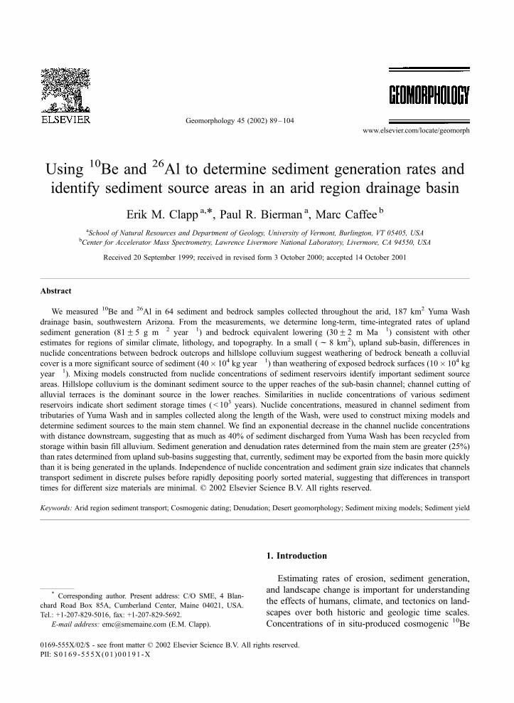
Fig. 1. Yuma Wash drainage basin located along the Colorado River in southwestern Arizona. (A) Sample locations and 10Be concentrations
measured in channel alluvium (enclosed in squares). Average 10Be concentrations (bold) are plotted with sample identification numbers below
in parentheses. Along the main stem, nuclide concentrations decrease closer to the confluence with the Colorado River. Geology adapted from
Reynolds (1988). (B) Map of southwest sub-basin with locations of bedrock, hillslope colluvium, basin fill, and channel alluvium samples.
Contour interval is 100 ft, ranging from 400 to 1200 ft-msl. Base maps adapted from Ayers-Associates (1996).
E.M. Clapp et al. / Geomorphology 45 (2002) 89–10490
E.M. Clapp et al. / Geomorphology 45 (2002) 89–104 91
2. Geomorphic setting
Yuma Wash, an ephemeral tributary to the Colo-
rado River, is located in the Sonoran Desert of south-
western Arizona (Fig. 1). The wash drains a 187-km2
basin that ranges in elevation from 823 m above mean
sea level (m-msl) at Mojave Peak in the north, to 56
m-msl at the confluence with the Colorado River in
the south. The braided channel of Yuma Wash extends
approximately 26 km and reaches a maximum width
of nearly 600 m.
Precipitation in the basin (91 mm year � 1 on
average) is characterized by short but intense, local-
ized, convective storms, during which most of the
sediment transport within the basin occurs (Ayers-
Associates, 1996). Stream flow and sediment transport
within the wash occur as rapidly moving flood waves.
For most runoff events, stream waters quickly infiltrate
the alluvium upon which Yuma Wash flows, rather
than flowing continuously to the Colorado River.
Yuma Wash drainage basin is underlain by Tertiary
volcanic bedrock (primarily rhyolite) in the north and
east, and intrusive Jurassic granites in the south and
west (Reynolds, 1988). The rhyolitic rocks are highly
competent and erosion resistant. Quartz content of the
rhyolite is generally low ( < 5%) yet quartz veins
provide sufficient material for separation of quartz
and chemical isolation of in situ-produced cosmogenic10Be and 26Al. In contrast, the granitic rocks to the
south are highly weathered and generally contain
>10% quartz.
The Yuma Wash drainage basin is bordered by the
Chocolate Mountains to the east and north, and by the
Trigo Mountains to the west (Fig. 1). Between the
Chocolate and Trigo Mountains, large, coalescing and
highly dissected alluvial fans occupy the valley floor
(Fig. 2). The fan deposits (maximum thickness >10 m;
Ayers-Associates, 1996) consist of inter-bedded debris
flows, mudflows, and fluvial gravels, which are
incised by Yuma Wash and its tributaries. These
alluvial deposits cover between 60% and 70% of the
drainage basin. Well-developed desert pavements and
darkly varnished pebbles and cobbles cover parts of
the fans, indicating that some surfaces are stable over
time periods in excess of several thousand years. Fan
deposits in Yuma Wash are believed to correlate with
middle to late Pleistocene surfaces found elsewhere in
the region (Dohrenwend et al., 1991), although no
numerical chronology has been established, and no14C datable material was found during this study.
Some of the fan deposits appear to have been tilted
and beveled, suggesting that they might be much older.
The southwest sub-basin (Figs. 1 and 3) is charac-
terized by the steep (10j to 30j), weathered, graniticslopes of the Trigo Mountains. Elevations in the sub-
basin range from 354 to 122 m-msl. Much of the sub-
basin (f 70%) are slopes mantled with very thin
colluvium (generally < 20 cm). The upper 40% (by
area) of the basin has little sediment storage with the
exception of 2- to 3-m thick colluvial deposits at the
base of some steep slopes; channel sediments of the
upper wash are likely derived directly from down-
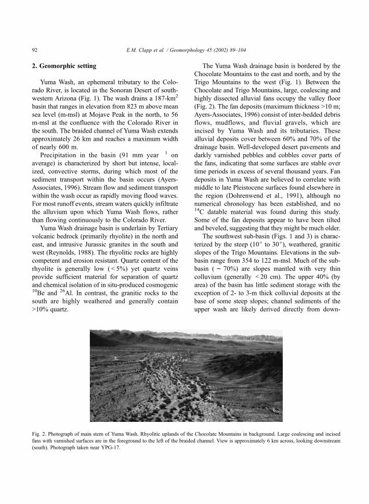
Fig. 2. Photograph of main stem of Yuma Wash. Rhyolitic uplands of the Chocolate Mountains in background. Large coalescing and incised
fans with varnished surfaces are in the foreground to the left of the braided channel. View is approximately 6 km across, looking downstream
(south). Photograph taken near YPG-17.
E.M. Clapp et al. / Geomorphology 45 (2002) 89–10492

slope transport of hillslope colluvium. Lower in the
sub-basin, sediment storage becomes more significant
where a transition from the steep upper basin terrain to
the coalescing fan terrain of the main wash occurs. The
lower reaches of the southwest fork cuts through
poorly consolidated material 2- to 10-m thick. These
materials consist of interbedded deposits of fluvial
gravels from the channel and colluvial deposits from
the hillslopes above.
3. Methods
3.1. Sample collection
Samples were collected to quantify cosmogenic nu-
clide concentrations throughout Yuma Wash and the
southwest fork sub-basin (Table 1). Samples of channel
sediment were collected from immediately above the
junction of eight tributaries to Yuma Wash and at five
locations along the main stem of the wash (Fig. 1). This
sampling strategy allows for an interpretation of rela-
tive sediment contributions from each of the tributaries
through the use of mixing models. Each of the channel
samples is an integration of smaller samples taken atf 1 m intervals across the wash. We collected our
samples from the top 10 cm of the channel sediment.
In the southwest sub-basin, we collected three
samples from upland granitic outcrops, three compo-
site samples of hillslope colluvium, two depth profiles
of the basin alluvium, and five homogenized samples
of the active channel sediments (Fig. 1). The granite
samples were collected from ridges surrounding the
sub-basin. The hillslope colluvium samples were
collected on three different hillslopes; each was an
integration of evenly spaced (f 1 m) samples taken
along f 100 m downslope transects YPG-23, 24, and
25 (Fig. 1). Each of the hillslope transect samples was
also an integration of the total depth (10 to 20 cm) of
hillslope colluvium. We assumed complete mixing of
sediment would occur for such shallow cover.
Two depth profiles were sampled where the south-
west fork cuts through the interbedded alluvial and
colluvial deposits (Fig. 1). Four sediment samples were
collected (each integrated over a 10-cm depth range)
from an 8-m-deep profile at sample location YPG-10.
The profile samples were taken 2, 4, 6, and 8 m below
the ground surface. A similar profile (YPG-26) was
sampled 1400 m down stream. Sediment samples here
were taken 1.5, 2.5, and 3.5 m below the surface of the
3.5-m-deep channel cut.
3.2. Sample preparation
Sediment samples were dry sieved into seven size
fractions ( < 250, < 500, < 1000, < 2000, < 4000,
< 12,700, and >12,700 Am) and weighed. Particles
smaller than 250 Amwere not used for isotopic analysis
in order to minimize the effect of potential aeolian
contributions from outside the basin. Samples YPG-2
and YPG-19 were used for a detailed nuclide versus
grain size evaluation. For sample YPG-2, all six grain-
size fractions greater than 250 Am were analyzed
separately. For YPG-19, the 1000 to 2000 and 2000
to 4000 Am fractions had to be combined to make one
sample and the 4000 to 12,700 and >12,700 Amfractions were combined to make another sample, due
Fig. 3. Photograph of southwest sub-basin illustrating steep,
granitic, upland sections with little sediment storage. View in
photograph is approximately 1 km across, looking upstream (west).
E.M. Clapp et al. / Geomorphology 45 (2002) 89–104 93
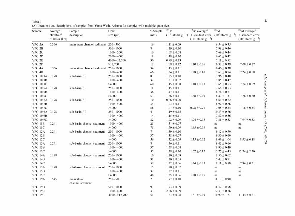
Table 1
(A) Locations and descriptions of samples from Yuma Wash, Arizona for samples with multiple grain sizes
Sample Average
elevationa
of basin (km)
Sample
description
Grain
size (Am)
%Sample
mass
10Be
(105 atoms g� 1)
10Be averageb
F standard error
(105 atoms g� 1)
26Al
(105 atoms g� 1)
26Al averageb
F standard error
(105 atoms g� 1)
YPG 2A 0.366 main stem channel sediment 250–500 16 1.11F 0.09 6.54F 0.35
YPG 2B 500–1000 8 1.39F 0.10 7.98F 0.46
YPG 2C 1000–2000 16 1.08F 0.08 7.69F 0.44
YPG 2D 2000–4000 18 1.18F 0.10 6.62F 0.42
YPG 2E 4000–12,700 30 0.99F 0.13 7.11F 0.52
YPG 2F >12,700 12 1.09F 0.12 1.10F 0.06 6.32F 0.39 7.00F 0.27
YPG 4A 0.366 main stem channel sediment 250–1000 34 1.15F 0.11 6.46F 0.38
YPG 4B 1000–4000 66 1.34F 0.11 1.28F 0.10 7.63F 0.74 7.24F 0.58
YPG 10.3A 0.178 sub-basin fill 250–1000 8 1.25F 0.10 7.96F 0.48
YPG 10.3B 1000–4000 32 1.21F 0.07 7.85F 0.47
YPG 10.3C >4000 60 1.15F 0.08 1.18F 0.03 7.65F 0.53 7.74F 0.09
YPG 10.5A 0.178 sub-basin fill 250–1000 11 1.15F 0.11 7.68F 0.53
YPG 10.5B 1000–4000 36 1.47F 0.11 6.74F 0.71
YPG 10.5C >4000 53 1.36F 0.11 1.38F 0.09 8.47F 1.31 7.76F 0.50
YPG 10.7A 0.178 sub-basin fill 250–1000 10 0.26F 0.20 8.61F 0.72
YPG 10.7B 1000–4000 34 1.03F 0.11 6.92F 0.86
YPG 10.7C >4000 56 1.07F 0.10 0.98F 0.26 7.08F 0.54 7.18F 0.54
YPG 10.9A 0.178 sub-basin fill 250–1000 4 1.19F 0.15 10.33F 0.76
YPG 10.9B 1000–4000 14 1.15F 0.11 7.82F 0.56
YPG 10.9C >4000 82 1.02F 0.09 1.04F 0.05 7.85F 0.53 7.94F 0.83
YPG 11B 0.241 sub-basin channel sediment 1000–4000 25 1.51F 0.07 na na
YPG 11C >4000 75 1.70F 0.09 1.65F 0.09 na na
YPG 12A 0.241 sub-basin channel sediment 250–1000 7 1.39F 0.10 9.12F 0.70
YPG 12B 1000–4000 37 1.38F 0.07 9.30F 0.60
YPG 12C >4000 56 1.32F 0.09 1.35F 0.02 8.69F 1.04 8.95F 0.18
YPG 13A 0.241 sub-basin channel sediment 250–1000 8 1.36F 0.11 9.43F 0.66
YPG 13B 1000–4000 37 1.58F 0.08 8.96F 0.49
YPG 13C >4000 55 1.78F 0.10 1.67F 0.12 15.77F 4.45 12.74F 2.20
YPG 14A 0.178 sub-basin channel sediment 250–1000 10 1.20F 0.08 8.50F 0.62
YPG 14B 1000–4000 31 1.30F 0.05 7.43F 0.71
YPG 14C >4000 59 1.22F 0.06 1.24F 0.03 8.11F 0.50 7.94F 0.31
YPG 15A 0.178 sub-basin channel sediment 250–1000 15 1.20F 0.07 na na
YPG 15B 1000–4000 37 1.22F 0.11 na na
YPG 15C >4000 48 1.35F 0.06 1.28F 0.05 na na
YPG 19A 0.545 main stem
channel sediment
250–500 7 1.77F 0.10 11.19F 0.90
YPG 19B 500–1000 9 1.93F 0.09 11.37F 0.58
YPG 19C 1000–4000 33 2.06F 0.09 12.33F 0.76
YPG 19F 4000–>12,700 51 1.63F 0.08 1.81F 0.09 10.90F 1.21 11.44F 0.31
E.M
.Clappet
al./Geomorphology45(2002)89–104
94
YPG 26.1A 0.178 sub-basin fill 250–1000 5 1.27F 0.08 7.63F 0.41
YPG 26.1B 1000–4000 24 1.22F 0.06 7.66F 0.41
YPG 26.1C >4000 71 1.28F 0.07 1.26F 0.02 7.22F 0.92 7.34F 0.14
YPG 26.2A 0.178 sub-basin fill 250–1000 4 1.23F 0.11 7.96F 0.55
YPG 26.2B 1000–4000 36 1.23F 0.08 7.40F 0.44
YPG 26.2C >4000 60 1.08F 0.06 1.14F 0.05 7.18F 0.42 7.29F 0.23
YPG 26.3A 0.178 sub-basin fill 250–1000 7 1.17F 0.08 6.83F 0.63
YPG 26.3B 1000–4000 25 1.19F 0.07 6.71F 0.40
YPG 26.3C >4000 68 1.15F 0.06 1.16F 0.01 7.65F 0.45 7.36F 0.29
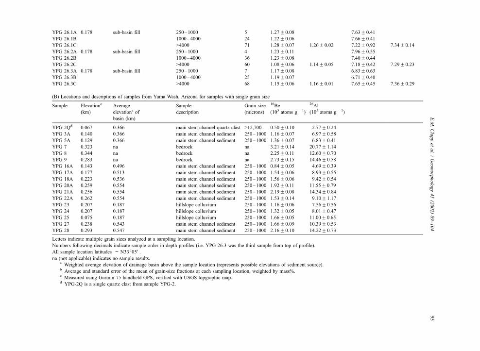
(B) Locations and descriptions of samples from Yuma Wash, Arizona for samples with single grain size
Sample Elevationc
(km)
Average
elevationa of
basin (km)
Sample
description
Grain size
(microns)
10Be
(105 atoms g� 1)
26Al
(105 atoms g� 1)
YPG 2Qd 0.067 0.366 main stem channel quartz clast >12,700 0.50F 0.10 2.77F 0.24
YPG 3A 0.140 0.366 main stem channel sediment 250–1000 1.16F 0.07 6.97F 0.58
YPG 5A 0.129 0.366 main stem channel sediment 250–1000 1.36F 0.07 6.83F 0.41
YPG 7 0.323 na bedrock na 3.21F 0.14 20.77F 1.14
YPG 8 0.344 na bedrock na 2.25F 0.11 12.60F 0.70
YPG 9 0.283 na bedrock na 2.73F 0.15 14.46F 0.58
YPG 16A 0.143 0.496 main stem channel sediment 250–1000 0.84F 0.05 4.69F 0.39
YPG 17A 0.177 0.513 main stem channel sediment 250–1000 1.54F 0.06 8.93F 0.55
YPG 18A 0.223 0.536 main stem channel sediment 250–1000 1.56F 0.06 9.42F 0.54
YPG 20A 0.259 0.554 main stem channel sediment 250–1000 1.92F 0.11 11.55F 0.79
YPG 21A 0.256 0.554 main stem channel sediment 250–1000 2.19F 0.08 14.34F 0.84
YPG 22A 0.262 0.554 main stem channel sediment 250–1000 1.53F 0.14 9.10F 1.17
YPG 23 0.207 0.187 hillslope colluvium 250–1000 1.16F 0.06 7.56F 0.56
YPG 24 0.207 0.187 hillslope colluvium 250–1000 1.32F 0.05 8.01F 0.47
YPG 25 0.075 0.187 hillslope colluvium 250–1000 1.66F 0.05 11.00F 0.65
YPG 27 0.238 0.543 main stem channel sediment 250–1000 1.66F 0.09 10.39F 0.53
YPG 28 0.293 0.547 main stem channel sediment 250–1000 2.16F 0.10 14.22F 0.73
Letters indicate multiple grain sizes analyzed at a sampling location.
Numbers following decimals indicate sample order in depth profiles (i.e. YPG 26.3 was the third sample from top of profile).
All sample location latitudes fN33j05V.na (not applicable) indicates no sample results.
a Weighted average elevation of drainage basin above the sample location (represents possible elevations of sediment source).b Average and standard error of the mean of grain-size fractions at each sampling location, weighted by mass%.c Measured using Garmin 75 handheld GPS, verified with USGS topgraphic map.d YPG-2Q is a single quartz clast from sample YPG-2.
E.M
.Clappet
al./Geomorphology45(2002)89–104
95
to small sample sizes. The size fractions for twelve of
the sediment samples from the southwest sub-basin
were recombined according to their weight percentages
to yield three composite size fractions (250 to 1000,
1000 to 4000, and >4000 Am) to test nuclide concen-
tration dependence on grain size. Bedrock samples and
the previously sieved sediment samples greater than
1000 Am were crushed and sieved to yield optimal
particle sizes for sample processing of 250 to 1000 Am.
The remaining 13 sediment samples were sieved to
yield only the 250 to 1000 Am size fraction that was
used for analysis.
All samples were heated and ultrasonically etched,
once in 6N HCl and then repeatedly in 1% HF and 1%
HNO3 in order to isolate 20 to 30 g of pure quartz and
remove any atmospheric 10Be (Kohl and Nishiizumi,
1992). The samples were then dissolved using HF and
the Be and Al were isolated using ion chromatographic
techniques. For all samples, 250 Ag of Be carrier was
added prior to digestion. 10Be/9Be and 26Al/27Al ratios
were determined by accelerator mass spectrometry at
Lawrence Livermore National Laboratory. 10Be and26Al concentrations were then calculated from known
amounts of 9Be (measured amount added as carrier)
and 27Al (native to the quartz and measured in dupli-
cate aliquots by Inductively Coupled Argon Plasma
Spectrometry–Optical Emission).
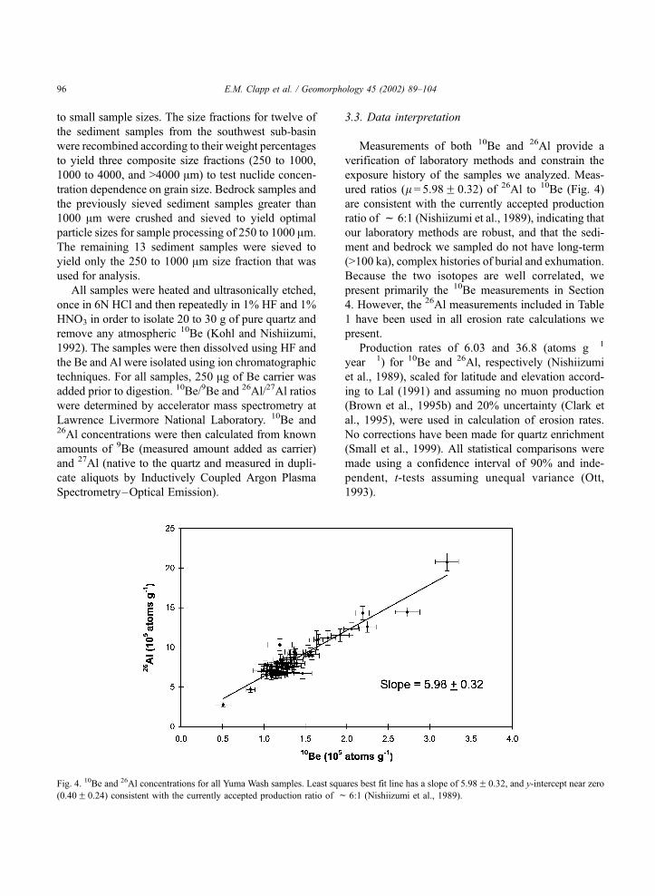
3.3. Data interpretation
Measurements of both 10Be and 26Al provide a
verification of laboratory methods and constrain the
exposure history of the samples we analyzed. Meas-
ured ratios (l = 5.98F 0.32) of 26Al to 10Be (Fig. 4)
are consistent with the currently accepted production
ratio of f 6:1 (Nishiizumi et al., 1989), indicating that
our laboratory methods are robust, and that the sedi-
ment and bedrock we sampled do not have long-term
(>100 ka), complex histories of burial and exhumation.
Because the two isotopes are well correlated, we
present primarily the 10Be measurements in Section
4. However, the 26Al measurements included in Table
1 have been used in all erosion rate calculations we
present.
Production rates of 6.03 and 36.8 (atoms g� 1
year � 1) for 10Be and 26Al, respectively (Nishiizumi
et al., 1989), scaled for latitude and elevation accord-
ing to Lal (1991) and assuming no muon production
(Brown et al., 1995b) and 20% uncertainty (Clark et
al., 1995), were used in calculation of erosion rates.
No corrections have been made for quartz enrichment
(Small et al., 1999). All statistical comparisons were
made using a confidence interval of 90% and inde-
pendent, t-tests assuming unequal variance (Ott,
1993).
Fig. 4. 10Be and 26Al concentrations for all Yuma Wash samples. Least squares best fit line has a slope of 5.98F 0.32, and y-intercept near zero
(0.40F 0.24) consistent with the currently accepted production ratio of f 6:1 (Nishiizumi et al., 1989).
E.M. Clapp et al. / Geomorphology 45 (2002) 89–10496
4. Results and discussion
Analyses of 10Be and 26Al from both the small,
southwest sub-basin and the larger, Yuma Wash drain-
age basin, provide considerable information about
drainage basin dynamics. Southwest sub-basin data
allow us to determine important sources of sediment
and understand better the processes of upland sediment
generation (regolith production) by comparing nuclide
concentrations measured in specific geomorphic fea-
tures. Main stem Yuma Wash data allow us to deter-
mine areas of significant sediment yield, including
entire sub-basins and sediment stored in fans and
terraces. Integration of the data collected at both scales
identifies scale-related differences in basin dynamics.
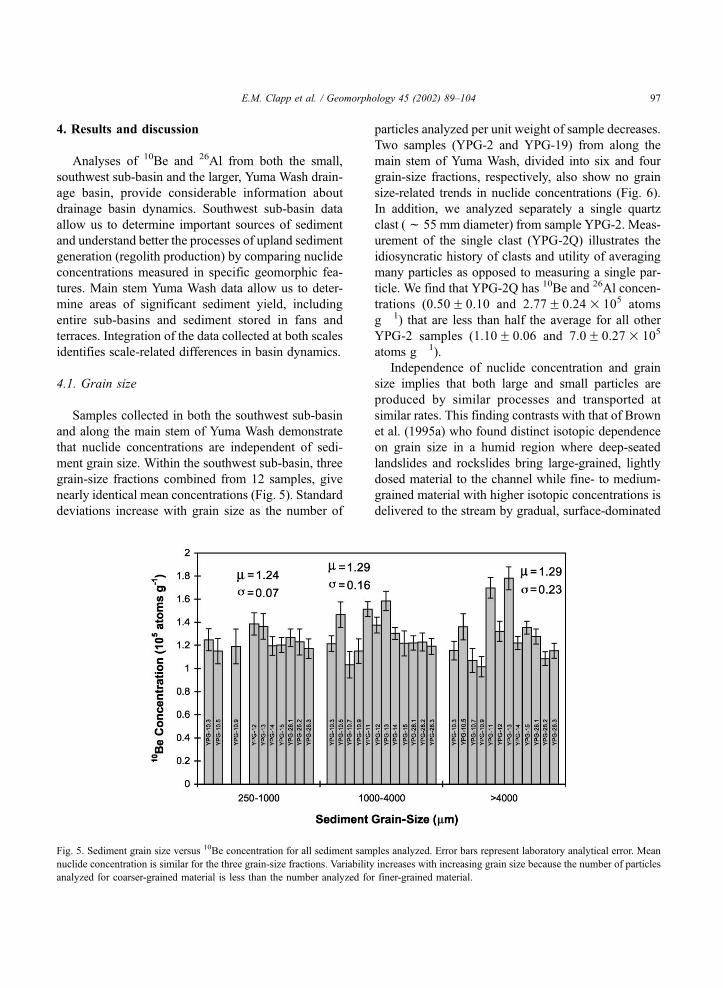
4.1. Grain size
Samples collected in both the southwest sub-basin
and along the main stem of Yuma Wash demonstrate
that nuclide concentrations are independent of sedi-
ment grain size. Within the southwest sub-basin, three
grain-size fractions combined from 12 samples, give
nearly identical mean concentrations (Fig. 5). Standard
deviations increase with grain size as the number of
particles analyzed per unit weight of sample decreases.
Two samples (YPG-2 and YPG-19) from along the
main stem of Yuma Wash, divided into six and four
grain-size fractions, respectively, also show no grain
size-related trends in nuclide concentrations (Fig. 6).
In addition, we analyzed separately a single quartz
clast (f 55 mm diameter) from sample YPG-2. Meas-
urement of the single clast (YPG-2Q) illustrates the
idiosyncratic history of clasts and utility of averaging
many particles as opposed to measuring a single par-
ticle. We find that YPG-2Q has 10Be and 26Al concen-
trations (0.50F 0.10 and 2.77F 0.24� 105 atoms
g� 1) that are less than half the average for all other
YPG-2 samples (1.10F 0.06 and 7.0F 0.27� 105
atoms g� 1).
Independence of nuclide concentration and grain
size implies that both large and small particles are
produced by similar processes and transported at
similar rates. This finding contrasts with that of Brown
et al. (1995a) who found distinct isotopic dependence
on grain size in a humid region where deep-seated
landslides and rockslides bring large-grained, lightly
dosed material to the channel while fine- to medium-
grained material with higher isotopic concentrations is
delivered to the stream by gradual, surface-dominated
Fig. 5. Sediment grain size versus 10Be concentration for all sediment samples analyzed. Error bars represent laboratory analytical error. Mean
nuclide concentration is similar for the three grain-size fractions. Variability increases with increasing grain size because the number of particles
analyzed for coarser-grained material is less than the number analyzed for finer-grained material.
E.M. Clapp et al. / Geomorphology 45 (2002) 89–104 97
processes of weathering, soil creep, and sheet wash. In
Yuma Wash, sediment is generally delivered to the
channel by surficial rather than deep-seated processes.
Consistent with arid-region sediment transport
theory, we observed no dependence of sediment
nuclide concentrations on grain size. Sediment
transport in ephemeral streams of arid regions often
occurs in pulses during infrequent, large, storm
events. The intense nature of these transport events
is characterized by turbulent flows which transport
material of many different sizes at similar rates
(Laronne and Reid, 1993; Laronne et al., 1994;
Reid and Laronne, 1995). These flows often infil-
trate the channel after short distances; flow duration
is insufficient to armor the bed or selectively trans-
port finer grain sizes.
4.2. Southwest sub-basin
Detailed sampling of the southwest sub-basin pro-
vides insight into the generation and transport of sedi-
ment in a small, upland, arid drainage basin. The 10Be
concentrations measured in bedrock outcrops
(2.73F 0.28� 105 atoms g� 1, n = 3) were high (Table
2) compared to those measured in hillslope colluvium
(1.38F 0.15� 105 atoms g � 1, n = 3). This result
suggests that weathering of bedrock beneath a cover
of colluvium is more rapid (less nuclide accumulation)
than weathering of exposed bedrock. This observation
is consistent with that of Small et al. (1999) who found
that in an alpine region of Wyoming, rates of regolith
production beneath a cover of colluvium were nearly
twice as fast as on exposed bedrock surfaces.
Lower nuclide concentrations in the sampled col-
luvium could be the result of cosmic-ray shielding by
material now eroded, as nuclide production rates are
lower at depth than at the surface. However, to
account for the nearly two-fold difference between
nuclide concentrations of the bedrock and the collu-
vium, would require a colluvium depth of f 70 cm,
which is unlikely on the steep slopes of this sub-basin
and far thicker than we observed. More likely, mois-
ture from infrequent precipitation is stored and held in
contact with bedrock for a longer period of time
Fig. 6. Sediment grain size versus 10Be concentration for YPG-2
(six size fractions) and YPG-19 (four size fractions). There are no
grain size-related trends in nuclide concentrations.
Table 2
Concentrations of 10Be and test of statistical differences between concentrations in geomorphic features of southwest sub-basin, Yuma Wash
Geomorphic feature MeanF standard error 10Be Statistical difference at 90% confidence
measured (105 atoms g� 1)n Bedrock
outcrop
Hillslope
colluvium
Basin
fill
All
channel
Upper
channel
Lower
channel
Bedrock outcrops 2.73F 0.28 3 – Yes Yes Yes Yes Yes
Hillslope colluvium 1.38F 0.15 3 Yes – No No No Yes
Basin fill 1.16F 0.07 4 Yes No – Yes Yes Yes
Channel seds (all) 1.44F 0.09 5 Yes No Yes – – –
Upper channel (YPG-11, 12, and 13) 1.56F 0.10 3 Yes No Yes – – Yes
Lower channel (YPG-14 and 15) 1.26F 0.02 2 Yes Yes Yes – Yes –
Average 10Be concentrations calculated by first averaging grain-size fractions of each sample then averaging together the samples representing
each feature.
Statistical differences were determined at 90% confidence using independent t-tests and assuming unequal variances.
E.M. Clapp et al. / Geomorphology 45 (2002) 89–10498
beneath a cover of colluvium than on exposed bed-
rock surfaces. This longer period of contact facilitates
the chemical and mechanical weathering of the sub-
colluvial rock (Gilbert, 1877; Wahrhaftig, 1965; Twi-
dale, 1983; Bull, 1991; Small et al., 1999). More rapid
weathering of sub-colluvial bedrock compounded with
the high percentage of sub-basin area covered with a
thin mantle of colluvium (f 70%), suggest that sub-
colluvial bedrock weathering is the dominant source of
sediment to the southwest fork of Yuma Wash. For all
surfaces covered with colluvium, a basin-wide nuclide-
based sediment generation rate estimate (73F 8 gm� 2
year � 1) multiplied by the basin area with colluvial
cover (f 5.5 km2) yields a yearly sediment generation
rate of 40� 104 kg year � 1 compared to 9.6� 104 kg
year � 1 calculated for bedrock outcrop areas (40F 9 g
m � 2 year� 1 over f 2.4 km2).
Comparison of the average 10Be concentration in
southwest sub-basin channel sediment to concentra-
tions in source areas is consistent with sub-colluvial
weathering and downslope movement of hillslope
colluvium as the dominant source of channel sediment.
The average 10Be concentration in sediment of the
southwest sub-basin channel (1.44F 0.09� 105 atoms
g� 1, n = 5), is indistinguishable (Table 2) from that
measured in the hillslope colluvium (1.38F 0.15�105 atoms g� 1, n = 3), but is significantly lower than
that measured in the bedrock outcrops (2.73F 0.28�105 atoms g� 1, n = 3).
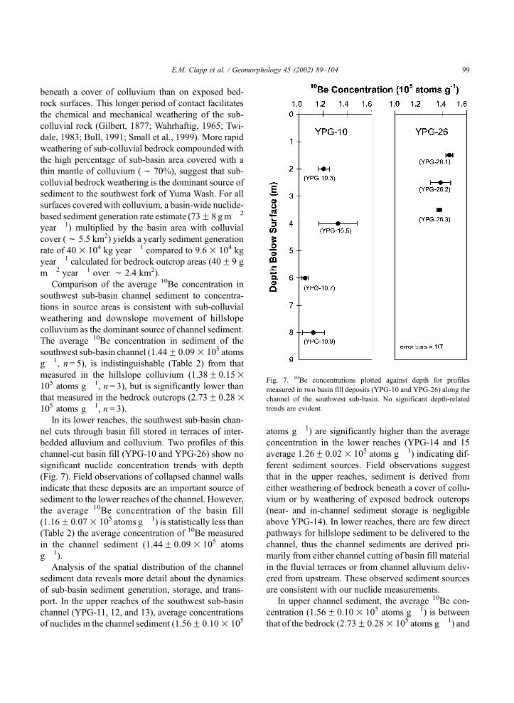
In its lower reaches, the southwest sub-basin chan-
nel cuts through basin fill stored in terraces of inter-
bedded alluvium and colluvium. Two profiles of this
channel-cut basin fill (YPG-10 and YPG-26) show no
significant nuclide concentration trends with depth
(Fig. 7). Field observations of collapsed channel walls
indicate that these deposits are an important source of
sediment to the lower reaches of the channel. However,
the average 10Be concentration of the basin fill
(1.16F 0.07� 105 atoms g� 1) is statistically less than
(Table 2) the average concentration of 10Be measured
in the channel sediment (1.44F 0.09� 105 atoms
g� 1).
Analysis of the spatial distribution of the channel
sediment data reveals more detail about the dynamics
of sub-basin sediment generation, storage, and trans-
port. In the upper reaches of the southwest sub-basin
channel (YPG-11, 12, and 13), average concentrations
of nuclides in the channel sediment (1.56F 0.10� 105
atoms g� 1) are significantly higher than the average
concentration in the lower reaches (YPG-14 and 15
average 1.26F 0.02� 105 atoms g� 1) indicating dif-
ferent sediment sources. Field observations suggest
that in the upper reaches, sediment is derived from
either weathering of bedrock beneath a cover of collu-
vium or by weathering of exposed bedrock outcrops
(near- and in-channel sediment storage is negligible
above YPG-14). In lower reaches, there are few direct
pathways for hillslope sediment to be delivered to the
channel, thus the channel sediments are derived pri-
marily from either channel cutting of basin fill material
in the fluvial terraces or from channel alluvium deliv-
ered from upstream. These observed sediment sources
are consistent with our nuclide measurements.
In upper channel sediment, the average 10Be con-
centration (1.56F 0.10� 105 atoms g� 1) is between
that of the bedrock (2.73F 0.28� 105 atoms g� 1) and
Fig. 7. 10Be concentrations plotted against depth for profiles
measured in two basin fill deposits (YPG-10 and YPG-26) along the
channel of the southwest sub-basin. No significant depth-related
trends are evident.
E.M. Clapp et al. / Geomorphology 45 (2002) 89–104 99
colluvium (1.38F 0.15� 105 atoms g � 1) sources.
From these concentrations we estimate relative con-
tributions of roughly 13% bedrock and 87% colluvium
lto the upper channel alluvium, further supporting
our conclusion that weathering of bedrock beneath
coluvial cover is the dominant source of sediment
to the channel. In the lower reaches, the average10Be concentration (1.26F 0.02� 105 atoms g� 1) is
between that of the upstream channel alluvium
(1.56F 0.10� 105 atoms g� 1) and the channel basin
fill (1.16F 0.07� 105 atoms g� 1) sources. We esti-
mate relative contributions of roughly 25% upstream
alluvium and 75% basin fill to the downstream channel
alluvium.
Although there are statistical differences between
nuclide concentrations of the geomorphic features
throughout the basin, the nuclide concentration of
the lower channel alluvium is within one standard
deviation of all other features excluding the bedrock
outcrops. Additionally, the southwest sub-basin data
illustrate that as sediment is transported through the
basin it is mixed with sediment from different source
areas. This mixing of the southwest fork sediment
reservoirs implies that 10Be and 26Al concentrations
of sediment leaving the sub-basin are representative
of nuclide concentrations from throughout the sub-
basin drainage. From nuclide concentrations meas-
ured near the sub-basin outlet (YPG-15), we calculate
average rates of sediment generation and denudation
for the southwest sub-basin (Table 3). Results from
this sub-basin justify our assumption that channel
sediments leaving small, upland sub-basins through-
out the Yuma Wash Drainage represent average
nuclide concentrations throughout each sub-basin.
4.3. Main drainage basin
By measuring nuclide concentrations from tributa-
ries and along the main stem of Yuma Wash (Fig. 1),
we identify sediment source areas and find evidence
for long-term trends in sediment transport. In the upper
reaches of Yuma Wash (above YPG-19), a simple
mixing model, which scales sediment contribution by
sub-basin drainage area and nuclide-determined sedi-
ment generation rates (Table 4), predicts 10Be and 26Al
concentrations in the main stem of Yuma Wash (1.9
and 12.0� 105 atoms g� 1, respectively) consistent
with the concentrations measured at YPG-19 (1.8F0.09 and 11.4F 1.3� 105 atoms g� 1, respectively).
In the upper reaches of Yuma Wash, where sediment
storage is minimal, our data demonstrate the utility of10Be and 26Al as sediment-source tracers.
In downstream reaches, as sediment storage
increases, our simple mixing model is inconsistent with
Table 3
Sediment generation and denudation rates for Yuma Wash Drainage, Arizona
This study Sediment-cosmogenic based estimates from other regions
Main stema
channel
sediment
SW sub-basina
channel
sediment
Averagea all
sub-basins
Nahal Yael,b
Israel
Arroyoc Chavez,
New Mexico
Fort Saged
Mts (A),
California
Fort Saged
Mts (B),
California
Wind Rivere
Range,
Wyoming
Sediment
generation rate
10Be 101F10 73F 8 81F 5 78F 16 273F 62 162F 38 97F 24 39F 11
(g m� 2 year� 1) 26Al 100F 11 68F 8 81F 8 70F 16 281F 73 – – 35F 11
Denudation rate 10Be 38F 4 27F 3 30F 2 29F 6 101F 23 60F 14 36F 9 14F 4
(m Ma� 1) 26Al 37F 4 25F 3 30F 3 26F 6 104F 27 – – 13F 4
a Denudation rates calculated using formulation of Bierman and Steig (1996) and production rates of Nishiizumi et al. (1989), scaled for
latitude and elevation according to Lal (1991), and not scaled for slope due to small average slopes ( < 20%). Conversion between denudation
and sediment generation based on densities of 2.7 (g cm� 3) for bedrock. Rates for main stem calculated using nuclide concentrations from
samples collected at location YPG-2 weighted by size fraction relative percent by weight. Rates for SW sub-basin calculated using nuclide
concentrations from samples collected at locations YPG-14 and YPG-15 weighted by size fraction relative percent by weight. Average of all
sub-basins calculated from samples collected at YPG-4, -15, -18, -20, -21, -22, and -27 weighted by sub-basin drainage area.b Clapp et al. (2000)— site with similar climate, elevation, and lithologies.c Clapp et al. (1997, 2001)— site with higher elevation (f 2000 m), wetter climate (377 mm), less resistant bedrock.d Granger et al. (1996) used both 10Be and 26Al to calculate erosion rates in two catchments (A and B)—site f 1300 m.e Small et al. (1999)— site with higher elevation (f 3600 m) and thicker colluvial cover (f 90 cm).
E.M. Clapp et al. / Geomorphology 45 (2002) 89–104100
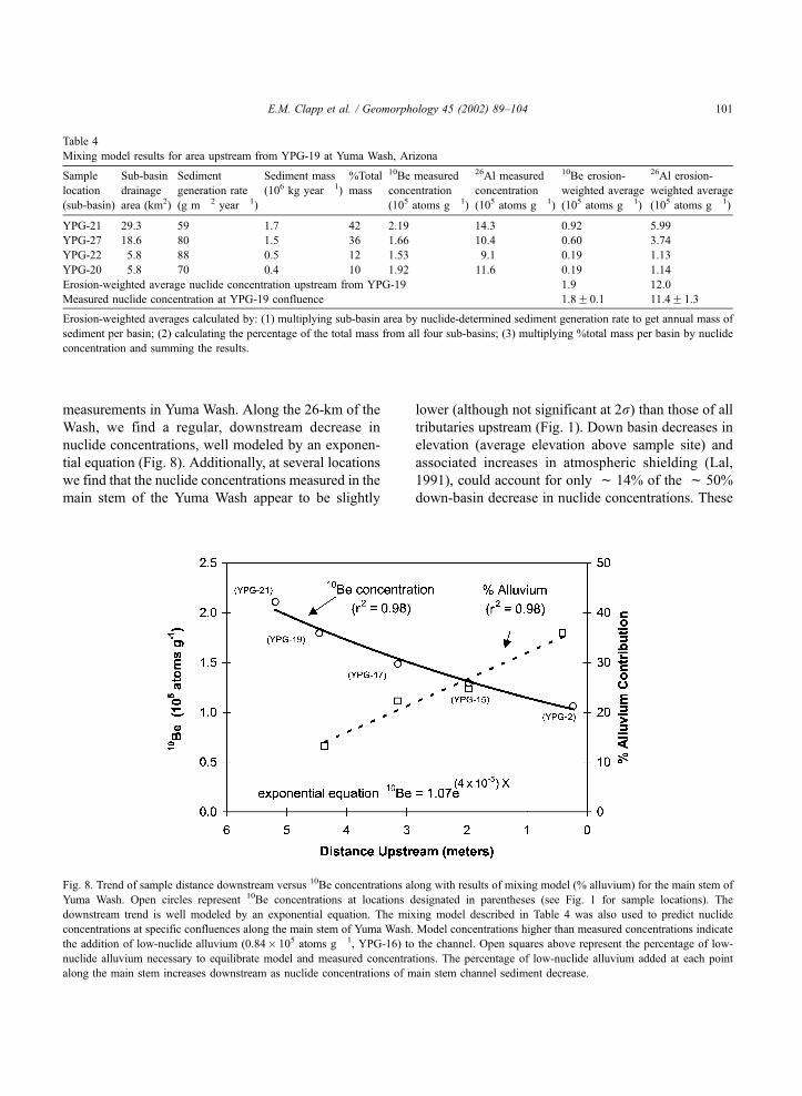
measurements in Yuma Wash. Along the 26-km of the
Wash, we find a regular, downstream decrease in
nuclide concentrations, well modeled by an exponen-
tial equation (Fig. 8). Additionally, at several locations
we find that the nuclide concentrations measured in the
main stem of the Yuma Wash appear to be slightly
lower (although not significant at 2r) than those of all
tributaries upstream (Fig. 1). Down basin decreases in
elevation (average elevation above sample site) and
associated increases in atmospheric shielding (Lal,
1991), could account for only f 14% of the f 50%
down-basin decrease in nuclide concentrations. These
Table 4
Mixing model results for area upstream from YPG-19 at Yuma Wash, Arizona
Sample
location
(sub-basin)
Sub-basin
drainage
area (km2)
Sediment
generation rate
(g m� 2 year� 1)
Sediment mass
(106 kg year� 1)
%Total
mass
10Be measured
concentration
(105 atoms g� 1)
26Al measured
concentration
(105 atoms g� 1)
10Be erosion-
weighted average
(105 atoms g� 1)
26Al erosion-
weighted average
(105 atoms g� 1)
YPG-21 29.3 59 1.7 42 2.19 14.3 0.92 5.99
YPG-27 18.6 80 1.5 36 1.66 10.4 0.60 3.74
YPG-22 5.8 88 0.5 12 1.53 9.1 0.19 1.13
YPG-20 5.8 70 0.4 10 1.92 11.6 0.19 1.14
Erosion-weighted average nuclide concentration upstream from YPG-19 1.9 12.0
Measured nuclide concentration at YPG-19 confluence 1.8F 0.1 11.4F 1.3
Erosion-weighted averages calculated by: (1) multiplying sub-basin area by nuclide-determined sediment generation rate to get annual mass of
sediment per basin; (2) calculating the percentage of the total mass from all four sub-basins; (3) multiplying %total mass per basin by nuclide
concentration and summing the results.
Fig. 8. Trend of sample distance downstream versus 10Be concentrations along with results of mixing model (% alluvium) for the main stem of
Yuma Wash. Open circles represent 10Be concentrations at locations designated in parentheses (see Fig. 1 for sample locations). The
downstream trend is well modeled by an exponential equation. The mixing model described in Table 4 was also used to predict nuclide
concentrations at specific confluences along the main stem of Yuma Wash. Model concentrations higher than measured concentrations indicate
the addition of low-nuclide alluvium (0.84� 105 atoms g� 1, YPG-16) to the channel. Open squares above represent the percentage of low-
nuclide alluvium necessary to equilibrate model and measured concentrations. The percentage of low-nuclide alluvium added at each point
along the main stem increases downstream as nuclide concentrations of main stem channel sediment decrease.
E.M. Clapp et al. / Geomorphology 45 (2002) 89–104 101
observations together, suggest an additional and unac-
counted for source of low-nuclide concentration sedi-
ment to the channel.
Field observations of the Yuma Wash channel
cutting into basin fill sediments stored in terraces
suggest the source of low-nuclide concentration sedi-
ment. To determine the nuclide concentration of this
basin fill, we sampled sediment from a sub-basin that
is wholly contained within the basin-fill alluvium
(YPG-16). This sample provides an integrated meas-
urement of the nuclide concentrations through a
stream-cut cross-section of basin alluvium. The aver-
age 10Be concentration we determine for the basin fill
(0.84F 0.05� 105 atoms g� 1) is substantially lower
than sediment supplied directly from the upland sub-
basins (1.28F 0.05 to 2.19F 0.08� 105 atoms g� 1).
There are several possible explanations for the low-
nuclide abundance in the basin fill. First, if the deposits
are old (>3 to 4 Ma), inherited nuclide abundances
would have decayed to near zero (deposits as great as
10-m thick would shield much of the material from
incoming cosmic rays), and the nuclide concentrations
we measure have accumulated since deposition as the
basin fill eroded. Alternatively, the alluvium may have
been generated at a period of time when the basin was
eroding more quickly and average, basin-wide nuclide
concentrations were lower. The latter scenario would
require sediment generation rates as high as 160F 36
g m2 year � 1 at the time of basin-fill deposition.
We use the basin-fill concentrations measured at
YPG-16 to calculate mixing ratios between highly
dosed sediment coming from resistant highlands and
less-dosed material coming from poorly consolidated
and highly dissected basin fill (Fig. 8). As the valley
fill thickens downstream and sediment storage be-
comes more prevalent, our data suggest a downstream
increase in sediment contribution from channel inci-
sion of the basin fill. Where Yuma Wash dispatches
to the Colorado River, we estimate over 40% of the
sediment it transports has been recycled through the
basin fill.
In addition to low-nuclide concentration sediment
derived from basin fill, it is likely that lower concen-
tration sediment from more rapidly eroding, quartz-
rich, granitic sub-basins contributes to lower nuclide
concentrations of the main-stem alluvium. However,
only the southern third of the Yuma Wash drainage is
influenced by granitic sub-basins and only the lowest of
our main stem sampling locations (YPG-2) could be
influenced. Upstream from YPG-2, YPG-5 receives
sediment from only a few low-order tributaries ema-
nating from granitic terrains while receiving most of its
sediment from the main stem as it leaves the rhyolitic
areas. All other main stem samples are wholly con-
tained within the rhyolitic terrain.
4.4. Rates of sediment generation and denudation
From the Yuma Wash data, we calculate rates of
sediment generation and denudation (Table 3).
Nuclide concentrations measured in the southwest
sub-basin support our assumption that sediment
exported from small, upland drainage basins is well
mixed and representative of sediment generated
throughout those basins. We therefore use an average
of nuclide-determined sediment generation rates from
all sampled basins to estimate the basin-wide sediment
generation and denudation rates (81F 5 g m � 2
year � 1 and 30F 2 m Ma � 1, respectively) for the
entire Yuma Wash drainage basin (Table 3). Our rates
should be considered minimum estimates as dissolu-
tion of non-quartz minerals in regolith can cause
concentration of quartz and under-estimation of sedi-
ment generation rates (Small et al., 1999). However,
quartz enrichment should be minimal in the arid
climate and resistant bedrock of Yuma Wash. We also
determine basin-wide rates using only nuclide con-
centrations measured in sediment from near the mouth
of Yuma Wash (YPG-2) and find the main stem
estimates (101F10 g m � 2 year � 1 or 38F 4 m
Ma � 1) are slightly higher (f 25%) than the esti-
mates from averaging all sub-basins. This dissimilarity
between rates suggests that at the larger scale, where
sediment storage is significant, nuclide concentrations
in alluvium exported from the basin appear to slightly
overestimate basin-wide rates of sediment generation
and denudation. The higher rate of denudation we
calculate from the main channel sediment analysis
suggests that sediment is currently being exported
from the basin more quickly than it is being generated
in the uplands, an assertion supported by field obser-
vations of active stream bank cutting and highly
dissected alluvial fan surfaces throughout the basin.
Although the rates calculated from sub-basins and
the main stem are statistically separable (at 90% con-
fidence), they are within two standard deviations and
E.M. Clapp et al. / Geomorphology 45 (2002) 89–104102
well within an order of magnitude. The similarity
between the two results suggests that at the larger scale,
nuclide concentrations in channel alluvium exported
from the basin may be used as a rough approximation
of basin-wide rates of sediment generation and denu-
dation.
5. Implications
Cosmogenic nuclide concentrations, measured in
samples collected from individual geomorphic fea-
tures in the southwest sub-basin, indicate that sub-
colluvial weathering of bedrock generates sediment
more quickly (73F 8 g m � 2 year � 1) than the weath-
ering of exposed bedrock outcrops (40F 9 g m� 2
year � 1). This difference indicates that the processes
of chemical and mechanical weathering by water, held
in contact with bedrock, speed the conversion of
bedrock to soil in arid environments (Gilbert, 1887;
Twidale, 1983; Bull, 1991; Small et al., 1999).
The basin-wide rates of sediment generation (81F 5
g m � 2 year � 1) and denudation (30F 2 m Ma� 1)
(Table 3) calculated for the uplands supplying sediment
to Yuma Wash, are consistent with rates determined by
other researchers. Judson and Ritter (1964) calculated
denudation rates for 28 major drainages throughout the
United States, generally ranging from 10 to 150 m
Ma � 1. We expect that our rates should fall on the
lower end of this scale because of the arid climate and
erosion-resistant bedrock underlying Yuma Wash.
Rates of sediment generation and denudation at Yuma
Wash are similar to estimates from a basin of similar
climate, elevation and lithology in the Negev Desert of
southern Israel (Clapp et al., 2000) and are slightly
lower than those calculated for a basin at Arroyo
Chavez, New Mexico (Clapp et al., 1997, 2001) and
basins in the Fort Sage Mountains of California
(Granger et al., 1996) where the climates are wetter
and the elevations higher (Table 3). Our rate estimates
are approximately twice those calculated by Small et al.
(1999) in the Wind River Range, Wyoming, where
samples were collected primarily from summit flats
( < 10j slopes) as opposed to the steep slopes (10j to
30j) of the Yuma Wash uplands.
Independence of nuclide concentration and sedi-
ment grain size is indicative of sediment transport and
production processes within arid regions. Arid-region
channels transport sediment in discrete pulses before
rapidly depositing poorly sorted material. Thus, such
channels are likely to leave behind isotopically homo-
genous sediment as differences in transport times for
different size materials are minimal.
Nearly homogenous nuclide concentrations in the
southwest sub-basin sediments imply that average
sediment storage is so short-lived that stored sediment
cannot accumulate detectable amounts of 10Be or 26Al
following deposition. This isotopic homogeneity we
observe in sediment of small, upland basins suggests
that channel sediment nuclide concentrations are rep-
resentative of nuclide concentrations throughout such
basins.
Cosmogenic nuclide concentrations along the
length of the main stem and from individual tributaries
of Yuma Wash can be used to determine significant
sources of sediment to the channel. Mixing models
suggest that in the upper reaches of the wash, sediment
supply is predominantly from low-order tributaries
transporting material generated by erosion of the
uplands. Lower in the basin, where the channel cuts
through poorly consolidated valley alluvium, sediment
incorporated from long-term storage becomes an
increasingly significant component of the channel
load. We use nuclide concentrations to estimate that
as much as 40% of sediment exported from Yuma
Wash is recycled from the stored basin alluvium.
Basin-wide rates of sediment generation and denu-
dation calculated by averaging rates from all sub-
basins are different than rates calculated from nuclides
measured in alluvium near the mouth of Yuma Wash.
The difference between the rates again suggests that
stored sediment is currently being eroded from the
basin. Our data clearly show that the effects of sedi-
ment storage can be detected and may become even
more significant in larger basins with greater storage
than Yuma Wash.
Acknowledgements
Supported by the US Department of Defense, Army
Research Office-Terrestrial Sciences (Grants DAA
G559710180 and DAAH049610036), NSF Grant
EAR-9628559, and Department of Energy contract
#W-7405-ENG-48. We thank V. Morrill, K. Nichols,
M. Abbott, and C. Massey for assistance in the field, S.
E.M. Clapp et al. / Geomorphology 45 (2002) 89–104 103

Nies, J. Southan, and B. Copans for assistance in the
laboratory, and J. Sevee and P. Maher for additional
support.
References
Ahnert, F., 1970. Functional relationships between denudation, re-
lief, and uplift in large mid-latitude drainage basins. Am. J. Sci.
268, 243–263.
Ayers-Associates, 1996. Geomorphic, Hydrologic, and Vegetation
Characterization and Base-Line Conditions of Yuma Wash. U.S.
Army Corps of Engineers Waterways Experimental Station,
Vicksburg, Mississippi and Conservation Program U.S. Army
Yuma Proving Grounds, Yuma, AZ, Rpt. 92-0904.01, 398 pp.
Bierman, P., Steig, E., 1996. Estimating rates of denudation and
sediment transport using cosmogenic isotope concentrations in
sediment. Earth Surf. Processes Landforms 21, 125–139.
Brown, T.B., Stallard, R.F., Larsen, M.C., Raisbeck, G.M.,
Francoise, Y., 1995a. Denudation rates determined from accu-
mulation of in situ-produced 10Be in the Luquillo Experimental
Forest, Puerto Rico. Earth Planet. Sci. Lett. 129, 193–202.
Brown, E.T., Stallard, R.F., Larsen, M.C., Raisbeck, G.M.,
Francoise, Y., 1995b. Evidence for muon-induced production
of 10Be in near surface rocks from the Congo. Geophys. Res.
Lett. 22, 703–706.
Bull, W.B., 1991. Geomorphic Responses to Climate Change. Ox-
ford Univ. Press, New York, 326 pp.
Clapp, E.M., Bierman, P.B., Pavich, M., Caffee, M., 1997. Rates of
erosion determined using in situ-produced cosmogenic isotopes
in a small arroyo basin, northwestern New Mexico. Geol. Soc.
Am. Abstr. Prog. 29, 281.
Clapp, E.M., Bierman, P.R., Schick, A.P., Lekach, J., Enzel, Y.,
Caffee, M., 2000. Sediment yield exceeds sediment production
in arid region drainage basins. Geology 28, 995–998.
Clapp, E.M., Bierman, P.R., Nichols, K.K., Pavich, M., Caffee, M.,
2001. Rates of sediment supply to arroyos from upland erosion
determined using in situ-produced cosmogenic 10Be and 26Al.
Quaternary Research 55, 235–245.
Clark, D.H., Bierman, P.R., Larsen, P., 1995. Improving in situ
cosmogenic chronometers. Quat. Res. 44, 366–376.
Dohrenwend, J.C., Bull, W.B., McFadden, L.D., Smith, G.I., Smith,
R.S.U., Wells, S.G., 1991. Quaternary geology of the basin and
range province in California. In: Morrison, R.B. (Ed.), Quater-
nary Nonglacial Geology, Conterminous U.S. Geol. Soc. Amer-
ica. The Geology of North America, vol. K-2, pp. 353–371.
Gilbert, G.K., 1877. Geology of the Henry Mountains (Utah), U.S.
Geographical and Geological Survey of the Rocky Mountains
Region, 170 pp.
Granger, D.E., Kirchner, J.W., Finkel, R., 1996. Spatially averaged
long-term erosion rates measured from in-situ produced cosmo-
genic nuclides in alluvial sediment. J. Geol. 104, 249–257.
Judson, S., 1968. Erosion of the land, or what’s happening to our
continents? Am. Sci. 56, 356–374.
Judson, S., Ritter, D.F., 1964. Rates of regional denudation in the
United States. J. Geophys. Res. 69, 3395–3401.
Kohl, C.P., Nishiizumi, K., 1992. Chemical isolation of quartz for
measurement of in-situ-produced cosmogenic nuclides. Geo-
chem. Cosmochem. Acta 56, 3583–3587.
Lal, D., 1988. In situ-produced cosmogenic isotopes in terrestrial
rocks. Annu. Rev. Earth Planet. Sci. 16, 355–388.
Lal, D., 1991. Cosmic ray labeling of erosion surfaces: in situ
production rates and erosion models. Earth Planet. Sci. Lett.
104, 424–439.
Laronne, J., Reid, I., 1993. Very high rates of bedload sediment
transport by ephemeral desert rivers. Nature 366, 148–150.
Laronne, J., Reid, I., Yitshak, Y., Frostick, L., 1994. The non-layer-
ing of gravel streambeds under ephemeral flood regimes. J.
Hydrol. 159, 353–363.
Meade, R.H., 1969. Errors in using modern stream-load data to
estimate natural rates of denudation. Geol. Soc. Am. Bull. 80,
1265–1274.
Meade, R.H., 1988. Movement and storage of sediment in river
systems. In: Lerman, A., Meybeck, M. (Eds.), Physical and
Chemical Weathering in Geochemical Cycles. Kluwer Academ-
ic Publishing, Amsterdam, pp. 165–179.
Nishiizumi, K., Winterer, E.L., Kohl, C.P., Klein, J., Middleton, R.,
Lal, D., Arnold, J.R., 1989. Cosmic ray production rates of 10Be
and 26Al in quartz from glacially polished rocks. J. Geophys.
Res. 94, 17907–17915.
Ott, R.L., 1993. An Introduction to Statistical Methods and Data
Analysis. Wadsworth Publishing, Belmont, CA, 1051 pp.
Pinet, P., Souriau, M., 1988. Continental erosion and large-scale
relief. Tectonics 7, 563–582.
Reid, I., Laronne, J., 1995. Bedload sediment transport in an ephem-
eral stream and a comparison with seasonal and perennial coun-
terparts. Water Resour. Res. 31, 733–781.
Reynolds, S.J., 1988. Geologic Map of Arizona. Arizona Geological
Survey.
Saunders, I., Young, A., 1983. Rates of surface processes on slopes,
slope retreat, and denudation. Earth Surf. Processes Landforms
8, 473–501.
Small, E.E., Anderson, R.S., Hancock, G.S., 1999. Estimates of the
rate of regolith production using 10Be and 26Al from an alpine
slope. Geomorphology 27, 131–150.
Trimble, S.W., 1977. The fallacy of stream equilibrium in contem-
porary denudation studies. Am. J. Sci. 277, 876–887.
Twidale, C.R., 1983. The research frontier and beyond: granitic
terrains. Geomorphology 7, 187–223.
Wahrhaftig, C., 1965. Stepped topography of the southern Sierra
Nevada, CA. Geol. Soc. Am. Bull. 76, 1165–1190.
E.M. Clapp et al. / Geomorphology 45 (2002) 89–104104