Embed Size (px)
Citation preview

Reshapingthe planning processusing local experiences:Utilising PPGIS inparticipatoryurbanplanning
Maarit Kahila-Tani

Aalto University publication seriesDOCTORAL DISSERTATION 223/2015
A doctoral dissertation completed for the degree of Doctor of Science (Technology) to be defended, with the permission of the Aalto Univer-sity School of Engineering, at a public examination held at the lecture hall E of the school on 15 January 2016 at 12.
Aalto UniversitySchool of EngineeringDepartment of Real Estate, Planning and Geoinformatics
Reshapingtheplanningprocessusing localexperiences:UtilisingPPGIS inparticipatoryurbanplanning
Maarit Kahila-Tani

THESIS SUPERVISORProfessor Marketta Kyttä, Aalto University
THESIS ADVISORSProfessor Raine Mäntysalo, Aalto UniversityAdjunct professor Liisa Horelli, Aalto UniversitySenior research fellow Aija Staffans, Aalto University
PRELIMINARY EXAMINERS Assistant professor Marco te Brömmelstroet, University of Amsterdam, Netherlands Senior lecturer Christopher Raymond, University of Exeter, Cornwall, United Kingdom
OPPONENTPostdoctoral researcher Pia Bäcklund, University of Tampere
CoverLiisa Tani
Layout Marina Johansson
Language editing Chris Smith
Aalto University publication seriesDOCTORAL DISSERTATIONS 223/2015
© Maarit Kahila-Tani
ISBN 978-952-60-6603-5 (printed)ISBN 978-952-60-6604-2 (pdf)ISSN-L 1799-4934ISSN 1799-4934 (printed)ISSN 1799-4942 (pdf)http://urn.fi/URN:ISBN:978-952-60-6604-2
Unigrafia Oy Helsinki 2015
Finland

ACKNOWLEDGEMENTS
My dissertation process has been something of a roller coaster ride. The ride was certainly long and included some ‘heart in mouth’ moments – the early stage thrill, blind turns where you just hope to survive and the end phase that I thought I would never see. But I have enjoyed it and felt myself very lucky to have a job that allows me to learn something new every day and to get excited about this constant process of discovery. It is luxurious to start the day by asking oneself what is it I want to learn today and then to conclude the day by asking what is it that I have understood? This voyage would not have been possible without a crew – the insight of practitioners and academics – who have both encouraged and questioned me but perhaps, more importantly, who have continued to push me all the way. As such, it now feels extremely good to finally have the chance to thank everyone who has ‘walked the path’ with me and sometimes even co-suffered in the process.
First, I want to thank Pia Bäcklund who accepted the enormous task of being my opponent. I have always admired Pia as an ambitious and forthright researcher who is able to open up the relationship between theory and practice in a clear and concise manner. Throughout my own sojourn I have always kept her dissertation and papers within easy reach. Then I sincerely want to thank the pre-examiners of my work Marco Te Brömmelströet from the University of Amsterdam and Chris Raymond from the University of Exeter (UK). Both offered significant contributions to this dissertation by providing valuable insights into how the argument could be made more coherent. I also want to thank Chris for the in-depth discussions we had during his stay at YTK after the pre-examination, hopefully we will get a chance to collaborate in the future!
Marketta Kyttä as my primary thesis advisor deserves the highest commendations for her endless support in guiding me through the dissertation process. Simply put, words are not enough to describe her encouraging attitude towards a person who on a daily basis questioned even the basic idea and meaning of dissertation work. It is frankly amazing that despite her own enormous workload she always managed to have time for me. In addition to the everyday concerns with my thesis I have also enjoyed our many discussions on interior design, travelling, spas, new project ideas etc. In addition to her wonderful support in an academic sense it has also been marvellous to get to know her family with whom I have experienced the best surfing beaches in Australia among other things.

My secondary advisors, or team of excellence, Liisa Horelli, Raine Mäntysalo and Aija Staffans also deserve to be thanked greatly for the effort they put in on my behalf in terms of reading through and giving valuable feedback on this dissertation. This extra pre-examination round was vital because of the academic insight it gave me. I sincerely value their help in this regard. Raine also contributed to this work at an earlier stage by introducing to me the framework of the ‘trading zone’ during the AESOP summer course on the island of Seili while Aija and Liisa have always been iconic figures for as they possess so much real ‘girl power’ no one else comes close. I am constantly amazed by their endless energy and drive. There is also another very important person to be thanked for the initial push into academia. Thank you Mari Vaattovaara for believing in me during the baby steps I took as a researcher. Steps that encourage me to approach Ari Jolma who became my preliminary supervisor during the years of funding I received from the Doctoral Programme in the Built Environment (RYM). Thank you Ari for your enormous support! Again in connection with RYM I also want to warmly thank Kauko Viitanen.
My dearest and closest colleague both in an academic sense and in the business world, Anna Broberg cannot be thanked enough. She has suffered and enjoyed in equal measure the whole process with me over the years. There is not a day without a call to Anna and though we work a lot together it is always a joy to spend time with her outside the office as well. This work would not have been successfully concluded without the other members of our unofficial sparring ‘tenweek-team’ at YTK, Jonna Kangasoja, Kaisa Schmidt-Thome and Sirkku Wallin have really given me the needed push to finally conclude this journey. Though I am sad, in a way, that the club will soon have achieved its initial goal I believe that we come up with new ideas to keep these energetic sessions alive. Thank you ladies for listening and not only for listening but for seeking solutions to the many problems I faced.
Now it is good moment to thank the whole YTK (Land Use and Urban Studies Group) for the marvellous, both physical and intellectual, working environment they provide. In YTK I have been privileged to see the SoftGIS team blossom and grow. In spite of the divergent research ambitions at the project’s core, we have nevertheless learned from each other and completed our work. It has been wonderful to see new members of the SoftGIS team step in and then pave the way for new insights to be produced. So thank you Tiina Laatikainen, Sarah Gottwald and Kamyar Hasanzadeh for driving this team forward. I would also like to thank all the ‘tech guys’ who throughout these years have supported me in developing various SoftGIS methods. It has also been a great pleasure to have the support of the many research assistants over the years of whom I would particularly like to thank Iiris Pirjola for her work. There are many people from YTK who I would like to thank separately but the list would quickly become unmanageable. Therefore I want to thank you all collectively. From a practical point of view I need to thank Marina Johansson, Maria Söderholm and Arja Viitanen-Aarni for they kind support. Moreover, as I seem to constantly generate all kinds of computer problems Marina has, needless to say, saved me many times.
Within the YTK crew I want to warmly thank Lasse Peltonen who was the first one who really listened to my preliminary ideas for my introduction and introduced the great ‘orange book’ to me that led me to read the mysteries of policy analysis. In addition to Lasse there are a whole bunch of people who have, seemingly, appeared

all of sudden to provide me with some significant insight or other. These people have all shared one thing in common – they have wanted to understand my thinking and this is something that you do not often encounter in academia. Some of these insights I have already alluded to above, but there are a few more I really must mention here. Stan Geertman from Utrecht University has provided important backup for me during this period. Through him I got excited about the PSS field while it was Greg Brown form the University of Queensland that showed me the inherent possibilities of PPGIS.
Though the thesis produced here is of course mine alone I did not, do all the leg work by myself as a significant part of the content was initially produced in relation to article projects where I have been happy to collaborate with range of wonderful people. Huge thanks to Anne-Marie Sanvig-Knudsen, Susa Eräranta, Pilvi Nummi-Sund and Taylor Tyger. There have been several projects that have also funded my dissertation project. OPUS, Urbaani Onni, and Urbaani Arki have, besides giving funding, introduced me to many wonderful people during the life of my own project. It was actually Heli Rantanen who initially guided me into the field of PGIS and PPGIS by co-authoring my first scientific paper. In OPUS I respected the work of Erja Väyrynen with whom I got the chance to collaborate later in the Urbaani arki –project. In addition to the academic insight given, these projects have made it possible for me to get to know the practitioners in the field of urban planning. So my sincere thanks go to all of these cities and their representatives who have shared with me their time and knowledge, so thank you collectively: Turku, Vaasa, Järvenpää, Kerava, Nurmijärvi, Mäntsälä, Lahti, Helsinki and Espoo. I cannot however simply leave my thanks at the institutional level alone and thus I must thank in particular those persons with whom I have worked most during these projects: Jaana Solasvuo, Juhani Hallasmaa, Ilkka Holmila, Johanna Palomäki, Tero Santaoja and Maija Mattila. You guys are the real super planners who can make the turn! And Samuli Laita thank you for your contribution in disseminating the research results further – something that seems to be awfully hard for the researcher themselves to achieve. Another valuable asset has been Chris Smith, who caught me when I stumbled with my English grammar – thank you for understanding my thoughts and clarifying them, where necessary, in this text.
I also need to thank my most recent project, CODSGI, for giving me the opportunity to meet so many wonderful people who have spurred me on during the final stages of my project. Thanks Mikko Villi for your support during my stay at the University of Tokyo. I also need to thank our Japanese team members, especially Shin Mizukozi from the University of Tokyo who made me understand the meaning of storytelling – placemakers rock! Through this project it has also been wonderful to meet once again Joanna Saad-Sulonen who I was happy to meet previously during the initial stages of my dissertation project. It was a good start and a nice ‘kick off ’ for the dissertation to be able to spend a few weeks in mysterious Bratislava through the funding available from the EU joint programme for doctoral students: Future Urban Research in Europe, FUTURE. I also need to send my thanks to faraway places such as Melbourne, where I had the opportunity to stay at the University of Melbourne and to meet and share my ideas with the local PhD students; thank you Julie Rudner, Crystal Legacy and Tim Petersen. This is also a good point at which to thank Alan March and Clare Mouat for our interesting theoretical discussions.

In addition to all of the academic people who have supported me during my project it is also important that I now turn my attention to my amazing friends and family who have been there for me throughout this process. Though these crazy and fast-paced years of my life have loosened some of the connections I am happy to have remained in every-day contact with many dear friends, from my early childhood days to my newest neighbours. For the wonderful occasions we have enjoyed together I want to thank the ladys from Inkoo – Inkoo power simply rocks! Student-hood at the Department of Geography gave me a home where I found many dear friends with a similar mindset and way of thinking. I have the fondest memories of those days. The sharing of concerns and joys has also connected us in the Hannuksenkuja neighbourhood – thank you, all my wonderfully energetic friends; you have given me and my family the best everyday surroundings ever, we could not simply manage somewhere else.
As it is with friends so it is with family. They have all seen the other side of this project. As such, I need also to thank a few relatives separately. My great uncle Petri has always pushed me further and quite naturally it has been easy to follow the older geographers’ steps, at least I have not faced that many questions as to why I choose geography in the first place. I also want to thank Jaana for being interested of my work. Then I am happy to have a great amount of aunts, uncles and cousins who have many times marvelled at my doings and encouraged me to follow my own path. Thank you Kirsi and Pekka who have kindly offered their help to pick up the kids from day care and thus made my everyday life a little bit easier. And thanks also to Liisa for her support of this work with her graphic impressions which I greatly value. I also want to thank my granny Meeri for her kind support and respect the memory of Sirkka whom I admired hugely for her great positive attitude. Thanks also to my brother Juha-Matti and Jenni for taking me to other spheres of life. And then my mom, Tellervo, and dad, Pertti, to whom I could easily dedicate this work. You have for many times questioned my work and challenged me but you have always supported me greatly. When I was struggling with the question of what to study after high school my father said, “do what you want but keep reading as long as possible”. I think this advice has somehow stuck with me. I sincerely value a lot of your sixth sense while you always know exactly when the time to step in is, and there have been many such times. It is always wonderful to get the call from my dad saying, “your mother and I have decided to come and pick up the kids” and when they arrive the fridge is full of food and the house is cleaned and yes the kids are having fun.
Last but not least I need to thank my superb family of whom I care most. This work would not have been possible without my husband Alpo who has always been able to say the right words at the right times. Without your belief and encouragement I would not have had enough faith in myself. I have to admit that it has also been valuable to have at home a real urban planner with whom I have been able to test my thoughts. Especially important for me in this regard have been the lazy summer days spent on our sailing boat. And then my dearest children Aarni and Seela you are the ones behind this work, so this is for you guys.
Hannuksenkuja, Espoo, 11.11.2015Maarit Kahila-Tani

x
Abstract Aalto University, P.O. Box 11000, FI-00076 Aalto www.aalto.fi
Author Maarit Kahila-Tani Name of the doctoral dissertation Reshaping the planning process using local experiences: Utilising PPGIS in participatory urban planning
Publisher School of Engineering Unit Department of Real Estate, Planning and Geoinformatics Series Aalto University publication series DOCTORAL DISSERTATIONS 223/2015 Field of research Urban planning and public participation Manuscript submitted 5 June 2015 Date of the defence 15 January 2016 Permission to publish granted (date) 16 November 2015 Language English
Monograph Article dissertation (summary + original articles)
Abstract
The existing methods used in participatory planning do not enable multifaceted and truly
inclusive public involvement. Despite the advanced technological data collection methods now available, the role of experiential knowledge remains marginal in planning practice. The utilisation of digital tools in participatory planning remains effectively additional to and detached from the core planning tasks. Many different actors, developers and researchers have created separate GIS-based data harnessing tools, such as planning support systems (PSS), public participation geographic information systems (PPGIS) and tools gathering volunteered geographic information (VGI). Despite the innovative technological work undertaken, challenges remain in adapting these tools on a profound and permanent level to the support of participatory planning practices. The planning technology literature focused on the development of forward-looking technology is rarely linked to the theoretical discussions occurring in the participatory planning literature. This dissertation aims to build a bridge between these two distinct discussions.
The object of this thesis is to study the potential of these tools to support participatory urban planning. The research analyses a set of SoftGIS and other PPGIS studies conducted during the period 2004-2015 in varying research and urban planning projects in Finland. The thesis adopts a normative approach to the question of how various PPGIS tools could be embedded more securely into the urban planning process. The thesis constructs a heuristic conceptual model for a participatory planning support system (PPSS), based on the experiences of applying PPGIS tools.
The central observations of this thesis reflect the numerous ways in which PPGIS tools and experiential knowledge can support planning during the different stages of the planning process and in relation to different planning tasks. At best, PPGIS methods can produce multifaceted information, especially in the early phases of the planning process. Data gathering however remains effectively characterised as singular interventions to harness specific information for the direct purposes of the ongoing planning task. Embedding this experiential knowledge more fully into the planning system currently rests almost exclusively on the shoulders of individual planners. Grafting PPSS onto the planning system requires a rather more strategic approach to participation.
Keywords SoftGIS, PPGIS, PSS, PPSS, public participation, local experiences, urban planning, planning process, trading zone
ISBN (printed) 978-952-60-6603-5 ISBN (pdf) 978-952-60-6604-2 ISSN-L 1799-4934 ISSN (printed) 1799-4934 ISSN (pdf) 1799-4942 Location of publisher Helsinki Location of printing Helsinki Year 2015 Pages urn http://urn.fi/URN:ISBN:000-000-00-0000-0 http://urn.fi/URN:ISBN:978-952-60-6604-2240


x
Tiivistelmä Aalto-yliopisto, PL 11000, 00076 Aalto www.aalto.fi
Tekijä Maarit Kahila-Tani Väitöskirjan nimi Paikallinen kokemustieto suunnitteluprosessin uudistajana: PPGIS:n hyödyntäminen osallistuvan suunnittelun tukena Julkaisija Insinööritieteiden korkeakoulu Yksikkö Maankäyttötieteiden laitos Sarja Aalto University publication series DOCTORAL DISSERTATIONS 0/2015 Tutkimusala Kaupunkisuunnittelu ja asukasosallistuminen Käsikirjoituksen pvm 5.6.2015 Väitöspäivä 15.1.2016 Julkaisuluvan myöntämispäivä 16.11.2015 Kieli Englanti
Monografia Yhdistelmäväitöskirja (yhteenveto-osa + erillisartikkelit)
Tiivistelmä
Osallistuvan suunnittelun nykykäytännöt eivät mahdollista kattavan ja monipuolisen vuorovaikutuksen toteutumista. Teknisesti edistyneistä tiedonkeruumenetelmistä huolimatta kokemuksellisen tiedon rooli on yhä marginaalinen suunnittelussa. Digitaalisten työkalujen hyödyntäminen osallistuvan suunnittelun tukena onkin hajanaista ja suunnittelutehtävistä irrallaan. Monet eri toimijat, kehittäjät ja tutkijat ovat kehittäneet erillisiä paikkatietopohjaisia työkaluja, kuten suunnittelun tukijärjestelmiä (PSS), osallistuvia paikkatietojärjestelmiä (PPGIS) ja vapaaehtoisesti tuotettua paikkatietoa (VGI) kerääviä menetelmiä. Haasteeksi jää sopeuttaa nämä kehitetyt työkalut pysyvämmin suunnittelukäytännön tueksi. Edistyksellisten suunnittelu- ja paikkatietoteknologioiden kehittämiseen keskittynyt tutkimus yhdyskuntasuunnittelukentällä linkittyy harvoin osallistuvaa suunnittelua koskevaan teoreettiseen keskusteluun. Tämä väitöskirja pyrkii rakentamaan tällaisen sillan.
Väitöskirjan tavoitteena on tutkia näiden työkalujen mahdollisuuksia tukea osallistuvaa kaupunkisuunnittelua. Väitöskirjassa on tarkasteltu PehmoGIS- ja PPGIS menetelmien kehittämistä ja hyödyntämistä sekä tutkimuksessa että suunnittelussa Suomessa vuosina 2004–2015. Työ on lähtökohdaltaan normatiivinen, se pyrkii ohjaamaan ja etsimään vastauksia siihen, miten paikkatietopohjaiset osallistuvan suunnittelun työkalut voitaisiin paremmin sitoa suunnitteluprosessin tueksi. Työ rakentaa käsitteellisen mallin osallistuvan suunnittelun heuristisesta tukijärjestelmästä, joka perustuu kokemuksiin PPGIS työkalujen hyödyntämisestä.
Väitöskirjan keskeiset havainnot liittyvät PPGIS työkalujen ja paikallisen kokemustiedon moninaiseen tarpeeseen suunnitteluprosessin eri vaiheissa ja erilaisissa suunnittelu- tehtävissä. Parhaimmillaan PPGIS-menetelmät voivat tuottaa hyvin moniulotteista tietoa ja erityisesti varhaisessa vaiheessa prosessia. Silti tiedonkeruut jäävät nykyisellään helposti yksittäiseksi interventioksi, joilla kerätään suunnittelutehtävää suoraan tukevaa tietoa ja tiedon juurtuminen yksittäisten suunnittelijoiden varaan. Kehitetyn osallistuvan suunnittelun tukijärjestelmän (participatory planning support system, PPSS) käyttöönotto edellyttääkin strategista näkökulmaa osallistumiseen.
Avainsanat PehmoGIS, PPGIS, PSS, PPSS, asukasosallistuminen, paikallinen kokemustieto, kaupunkisuunnittelu, suunnitteluprosessi, trading zone ISBN (painettu) 978-952-60-6603-5 ISBN (pdf) 978-952-60-6604-2
ISSN (painettu) 1799-4934 ISSN (pdf) 1799-4942 Painopaikka Helsinki Vuosi 2015 urn http://urn.fi/URN:ISBN:000-000-00-0000-0 http://urn.fi/URN:ISBN:978-952-60-6604-2
ISSN-L 1799-4934 Julkaisupaikka Helsinki Sivumäärä 240


LIST OF ARTICLES
This thesis is based on the six peer-reviewed articles listed below. The articles are referred to by their Roman numerals in the text. Papers are reprinted here with the kind permission of the respective publishers.
Article IRantanen, Heli & Kahila, Maarit (2009). The SoftGIS approach to local knowledge. Journal of environmental management 90 (6), 1981-1990. DOI: 10.1016/j.jenvman.2007.08.025
Article II Kahila, Maarit & Kyttä, Marketta (2009). SoftGIS as a Bridge-Builder in Collaborative Urban Planning. In Geertman, S. & Stillwell, J. (Eds.) Planning support systems bestpractice and new methods. GeoJournal Library 95, Springer, Netherlands, pp. 389–411.DOI: 10.1007/978-1-4020-8952-7_19
Article III Kyttä, Marketta; Kahila, Maarit & Broberg, Anna. (2011). Perceived environmental quality as an input to urban infill policy-making. Urban Design International 16 (1), 19-35.DOI: 10.1057/udi.2010.19
Article IV Sanving-Knudsen, Anne-Marie & Kahila, Maarit (2012). The role of Volunteered Geographic Information in participatory planning. Examples from Denmark and Finland. Geoforum Perspektiv 11 (21).DOI: http://dx.doi.org/10.5278/ojs.persk..v11i21.488
Article V Eräranta, Susa; Kahila-Tani, Maarit & Nummi-Sund, Pilvi (2015). Web-based Public Participation in Urban Planning Competitions. International Journal of E-Planning Research (IJEPR) 4 (1). DOI: 10.4018/ijepr.2015010101

Article VI Kahila-Tani, Maarit; Broberg, Anna; Kyttä, Marketta & Tyger, Taylor (2015). Let the citizens map – Public participation GIS as a planning support system in the Helsinki 2050 master planning process. Planning Practice & Research. Published online: 15 Dec 2015.DOI: 10.1080/02697459.2015.1104203
AUTHOR’S CONTRIBUTION TO THE ARTICLES
no
Iapproach to local knowledge
Author has been responsible --
thor has been closely involved
based experiences and local
Second Author was not involved in the case study on the Develop-
Espoon keskus
IIbridge-builder
urban planning
Author was responsible for the --
Corresponding writer
Author was not closely involved
of chapter
III Perceived environ-
an input to urban
Author was involved in the
-
--
Second Author was not responsible
-
analysis of the
IV The role of volun-teered geographic
planning
Author produced the case -
Second Author was not involved in producing the case study on
V Web-based public
urban planning
Author was in charge of the ar-
produced the case study on
Corresponding writer (writers
Author was not involved in the case study on the River Valley
VI
as a planning
process
Author was responsible for the design of the structure of
of the data and the develop-
Corresponding writer
Author did not
responsibility
analysis of the

Contents
Acknowledgements
Abstract
Tiivistelmä
List of articles
Author’s contribution to the articles
1 INTRODUCTION 19
1.1 PPGIS as a research object and a method 21 1.2 Articles and methods 25
2 THE CHALLENGE OF PLURALISTIC AND EXTENSIVE PUBLIC PARTICIPATION 37
2.1 Outlining the disposition of public participation 37 2.2 Reaching the voice of crowds 45 2.3 The idea of continuous and cyclical planning process 51
3 EXTENDING THE PALETTE OF PARTICIPATION TOOLS 57
3.1 Volunteered or not – exploring the nature of the PPGIS, VGI and PSS 57 3.2 The development process as a profound learning process – Reflecting the SoftGIS development process through the trading zone concept 63
3.2.1 Phase 1: Enforced trading zones – from prototypes to functioning SoftGIS-methods 67 3.2.2 Phase 2: Fractionated trading zone – SoftGIS surveys as boundary objects 69 3.2.3 Phase 3: Fractionated trading zone – towards a participatory planning support system 71
4 REGENERATING THE PARTICIPATORY PLANNING SUPPORT SYSTEM 79
4.1 The planning system as a ’loop’ 80 4.2 Complementing the planning process with local experiences 83 4.3 Illustrating PPSS – The potential for participation to support the process from idea formulation to maintenance 88

5 CONCLUDING REMARKS 101
5.1 The interplay between instrumental and deliberative action – How to advance the idea of PPSS further 104 5.2 Implications for urban planning and policy-making 108 5.3 Recommendations for future research 111
6 REFERENCES 115
APPENDIX Research activity and the data trail
ORIGINAL PUBLICATIONS

Society grows great when old men plant trees
whose shade they know they shall never sit in.
– Anonymous Greek Proverb


1
Introduction


191 Introduction
Introduction
The immediate living environment we experience every day in going to work, taking our children to day care, meeting friends or doing exercise, plays a pivotal role in attaching us to a particular place. These places then become bound up with the cultural, physical, political and social mores that are manifest through our localised experiences. The experiential landscapes (Thwaites, 2001) that we are attached to grow out of our individual experiences. Though part of these individual experiences is hidden and more difficult to reach, another part is easier to express. Almost every one of us can describe a place that they like and enjoy, where they would like to spend more time and what enables them to relax. Immediate living environments are not instant; these places only become significantly important through the memories of these places we store up. As such, these places are not static artefacts but should rather be conceptualised as existing in a state of becoming (Dovey, 2009).
Places are shaped by single individuals such as residents but more drastically through changes in the physical environment brought about by urban planning actions. The changes people confront in their living environment are often viewed as threats that may destroy the existing value system of the place. Urban planning is a challenging field constantly seeking a balance between how to develop and change existing living environments while maintaining their valuable character. Though urban planning is considered a top-down action that aims to ensure the common good for all, its application requires sensitivity as the action is always realised in places that individuals consider meaningful through their experiential landscape. This challenge has become acute in many growing cities around the world. These cities share the same concern, namely, how to shape the existing city structure without reducing the very qualities of the living environment people value most.

20 Maarit Kahila-Tani: Reshaping the planning process using local experiences
Urban planners now need to be multi-skilled professionals as the questions planners focus on are closely bound up with a host of societal and value questions like the ageing society and climate change. Planners often work in large networks of experts each tackling different thematic questions bound up with the evolution of the future living environment. Moreover, cities are simultaneously becoming smarter through the different digital layers that aim to support their growth, sustainability and usability. This intellectualisation process of the physical environment has demanded actors such as planners to learn and govern this new and still evolving smart structure. In these new smart cities the primary future challenge will revolve around constructing the linkages between these different layers and the dialog between different actors about the common utilisation of different smart components. As such, the role of the urban planner in the smart network society is turning into that of the facilitator who understands the ongoing development patterns while overseeing the creation of the possibilities enabling the implementation of these innovations locally.
The working environment planners currently inhabit in has also thrown up new demands from the perspective of civic society. Digitalisation has had a significant impact on participation mechanisms and on the possibility to integrate the differing voices of plural society more efficiently into current planning practices. The old infrastructure that has enabled the face-to-face participation of inhabitants’ has taken new forms through social media and other information and communication technologies (ICT) like web-based geographic information systems (webGIS). Though some people want to retain the traditional channels of influence many others are now seeking to create their own ways of influencing the situation. Participation often takes an informal form through various self-organising activities. These informal practices are, in addition to the traditional more formal routes of influence, becoming increasingly common in the planning culture (Horelli et al., 2015). Besides the question of the formal or informal character of participation, questions are now emerging in respect of the locus of participation in planning culture. In the future it is now broadly recognised that there will be a need to bind more closely together these formal and informal structures. Namely, individually, where a person participates as a community member and collectively e.g. through a local association or movement. To plan cities wisely existing processes should include a broader group of actors but above all enhance knowledge-informed planning that adapts and interprets – learns and

211 Introduction
creates – diverse and plural information more comprehensively. Finally, the primary question is not who organises the participation process but rather how the different participation practices can be linked together and the information produced adapted more specifically to the planning process (cf. Saad-Sulonen, 2014; Faehnle, 2014). Therefore planners need to be able to construct dialogue between the differing layers of civil society and link them to the digitalisation process and the smart city structure.
In this dissertation participation is manifest through the trans-formative influence of new PPGIS tools upon existing participatory structures and planning processes in Finnish cities. The thesis describes the story of the development process of SoftGIS-methods in the field of participatory urban planning. The meaning of this long journey has been to understand the current status of participation in Finnish cities, challenge existing participation practices with new public participation GIS (PPGIS) tools and knowledge creation and explore the possibilities of embedding these into urban planning practices. It has been inspiring though also challenging to face planners concerns about how participatory planning could and should be carried out in specific contexts. The following observations made by Hillier have guided my work and continue to intrigue me: “A basic tenet of my work is my belief that spatial planning decisions,
particularly those which involve consideration of issues of ‘public space’
cannot be understood separately from the socially constructed, subjective
territorial identities, meanings and values of the various actants, including
the planners concerned. Planning cannot achieve empirical reality through
the work of planners alone. It is essentially intertwined with a whole range of
other participants and their networks, each bringing to the process a variety
of discourse types, lifeworlds, values, images, identities and emotions” (Hillier, 2002, 4).
1.1 PPGIS as a research object and a method
The ongoing process of digitalisation has accelerated the development of new ICT-based tools that aim to foster urban development with plan making or communications tools. A vast array of new participation tools and variations of these tools for use in urban planning practices already exist. The problem is not the lack of new ICT and webGIS supported tools but rather the adaptability of these tools to the existing planning culture (cf. Brown, 2012). Moreover, the problem remains how to strengthen the supportive factor of the planning support systems (PSS) (Pelzer et al.,

22 Maarit Kahila-Tani: Reshaping the planning process using local experiences
2015; Schrijnen, 2010; Vonk et al., 2005). In participatory urban planning practices the use of digital tools is more often based on a single and temporal intervention rather than on the more systematic use of different kinds of tools and methods during the various phases of the process. Thus more systematic and strategic consideration is required to understand when and why such tools are usable and which combination of tools would better enhance public participation in a specific project (cf. Saad-Sulonen, 2014). Otherwise the rapid development work of new tools leaves unaddressed some of the basic questions in respect of the goal of participation. Though the social media and different map-based mash-up tools have accelerated data gathering from residents, questions remain over how this data and the tools used have been received in planning organisations; how has the data been utilised in planning practices, how will this influence the existing planning system and existing planning traditions and eventually how will this be organised into becoming part of the participation practices. This thesis has a twofold goal. On the one hand it unravels the evolutionary trail of the public participation GIS (PPGIS) tool called SoftGIS in respect of participatory planning theory and practice. And on the other, it introduces notions regarding the challenges and potentiality of using PPGIS tools in participatory planning practices. Therefore the conceptual model of this thesis is not the model of participation but rather it is a model of how PPGIS tools are used in it.
In Finland the current Land Use and Building Act (MRL 132/1999) allows for a functioning framework for public participation. In practice however participants often argue that they have not really been able to influence decision making usually because they are only involved at a very late stage in the process. On the other hand, existing participatory practices are undoubtedly still undeveloped and planners often lack the necessary skills to fully utilise the information gathered from residents (Staffans, 2012). These observations are designed to help us analyse the current challenges in respect of public participation in the planning process. Over time, participants should play a fuller and more inclusive role in the planning process; they should understand more profoundly how their knowledge has been utilised during the different phases of the process and above all understand the meaning and object of the different stages of planning. The experiential knowledge participants share should become more visible in the planning regime (Bäcklund, 2007). Generally, the benefits of public participation should be better understood and discussed. While participation enhances learning, it can also lead to the promotion

231 Introduction
of innovative solutions and to the building of trust among stakeholders. Further, the motivation for participation comes through the legitimacy and effectiveness of governance (Hogl et al., 2012). Therefore to develop more transparent participation processes it is important to unravel the whole planning process and to study the participation mechanisms throughout this process cycle.
When I started my research I had a naïve assumption that the pitfalls of public participation could relatively easily be addressed via the possibilities provided by the new digital technology and especially via the use of web-based GIS technology. During my journey I came to realise that the idea of strengthening participatory urban planning with new and innovative tools remains a challenging enterprise as the accomplishment of this task requires a strong interplay between the development process of technological tools and existing participatory planning practices (Geertman et al., 2015; Vonk & Geertman, 2008). While it is challenging to encourage planning organisations to try new tools it is as demanding to motivate planners and institutions to redesign participatory processes to make them more adaptive and interpretative platforms for the new knowledge production and trade that different kinds of participatory tools support.
The focus in this thesis is on PPGIS tools and especially on the SoftGIS1 tools that enable the creation of new knowledge from participants through research and participation in urban planning practices. During the early phases of the SoftGIS development work (see articles I and II) the PPGIS field was still quite immature and many scholars used different abbreviations for similar tools (see section 3.1.). As such, our SoftGIS team decided to differentiate our work from that of other scholars by using the term SoftGIS. Subsequently, once the technical development work became easier and contact had been made with other groups the term PPGIS was used with SoftGIS referred to as one of the PPGIS tools. Though SoftGIS tools were originally designed to be used as empirical research tools it was evident that these tools also display significant potential in respect of participatory planning usage. In addition to the research results received from the empirical studies (see articles III and IV) using SoftGIS, urban planners have acknowledged the potentiality of the tool to grasp new
1 SoftGIS is a Public participation geographic information system (PPGIS) -tool that originates from the innovative work of Professor Marketta Kyttä on the study of residents’ locality-based experiences of their living environment. These Internet-based tools have been developed since 2004 at Aalto University in the Land Use Planning and Urban Studies group. SoftGIS-methods have been used in a variety of research studies that have focused on different research themes (see e.g. Article III).

24 Maarit Kahila-Tani: Reshaping the planning process using local experiences
information in a GIS-mode that is easy to transfer to planning practices (see articles V and VI). Though the development work is continuous and has not ended2 I have been able to follow the process to one intermediate conclusion. From separate tools developed at Aalto University I have been able to follow the development work at Mapita Ltd where work on the editor tool has taken place. This intermediate conclusion defines a phase where the SoftGIS-method has taken on a more stable character via the Maptionnaire3 tool in the field of participatory urban planning. The conceptual development work of Maptionnaire began in the research projects realised in Vaasa and Järvenpää (see article V and section 3.2.3) but the technological development work of the editor tool was finalised at Mapita Ltd. Maptionnaire enables the creation of PPGIS tools but it also provides a more systematic and ongoing support system for planners to develop different kinds of participatory actions. Nevertheless, this phase in the development work in itself should only be considered as a developmental phase which is adaptive to newly emerging variants.
Therefore the PPGIS tools presented in this thesis should not be understood as compensatory but rather as supplementary tools to be added to the palette of current participation methods. Through the observations made herein, this thesis aims to bridge, both conceptually and empirically, the gap between the conventional idea of PPGIS tools as information producers and planning support systems (PSS) designed for specific planning tasks to enhance the concept of the participatory planning support system (PPSS) that embeds a variety of tools during the different phases of the planning process in a more inclusive way.
In this thesis the research object centres on the challenge posed to current participatory urban planning by the need to adapt to the new participatory web-based GIS tools. Solving the puzzle presented by the development work associated with PPGIS tools has helped to tie me into the existing planning systems in several Finnish cities. On a very general level this study strives to amplify discussion regarding the suitability of existing participatory planning practices by asking how well public
2 The SoftGIS team run by Professor Marketta Kyttä undertakes continuous research focusing on methodological development work in respect of the SoftGIS method and on varying themes of studies relating to the physical urban environment that integrates experiential knowledge with statistics and GIS. 3 Maptionnaire is a cloud-service that enables anyone to design and implement a PPGIS study and analyse the received results. Maptionnaire is owned by Mapita Ltd a company that has grown out of work done at Aalto University. The development work in respect of the editor tool has enabled practitioners in the field of land use planning and development to use the PPGIS tool in their projects. For more information: http://maptionnaire.com/

251 Introduction
participation is linked to current planning processes, how efficient current participation procedures are and how profoundly existing practices are able to reflect the extensive and plural voice(s) of people. These topics are studied in the light of the possibilities inherent in PPGIS-methods such as SoftGIS and Maptionnaire. This study concentrates on the utilisation of the above-mentioned PPGIS-methods in several research projects and participatory planning practices among urban planners in Finland. The ultimate aim is to consider critically whether PPGIS tools have the potential to support the participatory planning process and then to reflect these notions in respect of participatory planning theory.
The structure of this thesis follows the above-mentioned research questions. The basic questions are unravelled in section 2 through the presentation of a literature review. The second question is addressed in section 3 where the evolution of SoftGIS tools into PPGIS tools and beyond is described. The third question will be explored in section 4. This section studies the results in respect of participatory planning support system (PPSS). Research is structured through the following themes and research questions:
1. How can public participation be conceptualised through the planning theory debate?
a) What kind of knowledge creation can PPGIS tools support? b) What kinds of linkages exist between participation and the planning process? 2. How has the development work in respect of SoftGIS affected the formulation of the developed PPGIS tools? 3. How well do the PPGIS tools ‘perform’ in a participatory
planning process – can single tools evolve into a more permanent participatory support system?
1.2 Articles and methods
This dissertation highlights a number of different viewpoints in the study of the PPGIS approach to participatory planning practices. It consists of the six individual articles and this introductory chapter. The papers explore the case studies which are methodological, empirical and procedural in nature. The introduction is divided into five sections and seeks to construct a comprehensive framework for the study while also including new data. This first section clarifies the starting point of the

26 Maarit Kahila-Tani: Reshaping the planning process using local experiences
study (section 1.). The second section explores the theoretical premise of the study through a literature review (section 2). The planning theory and participatory planning discussions highlight the perspectives of knowledge utilisation, the modes of collaboration and the procedural character of planning. In the third section (section 3.) the primary methodological questions are addressed by describing, firstly, the evolution of the varying PPGIS/VGI/PSS tools and secondly the development process of SoftGIS and Maptionnaire through the concept of the trading zone. Section four combines these theoretical, methodological and empirical considerations by laying out the model for an interpretative and adaptive participatory planning support system (section 4.). This participatory planning support system (PPSS) model aims to embed both the various theoretical views and tools used more profoundly in to the different phases of the planning process. Finally, in concluding section (section 5.), the discussion turns to the identification of some key points and learnings which may be useful for practitioners as well as for researchers in the field of PPGIS, PSS and participatory urban planning.
The production of the data used in this dissertation is an assemblage of different case studies, research methods and research projects that intertwine together through the development work of SoftGIS-methods and other PPGIS tools during the period 2004–2015. The research data was collected in connection with a number of case studies during the period 2004–2015 conducted in eight Finnish cities: Järvenpää, Kerava, Nurmijärvi, Mäntsälä, Espoo, Helsinki, Turku and Vaasa. Table 1 describes the articles, research aim, year of development work and data collection, the planning situation and the name of the research project. In Appendix I have clarified in detail the collected data trail by indicating when, how and from whom the data has been collected throughout this process. The close development work carried out with the urban planners involved in the various projects and with other research team members has enabled me to study the possibilities urban planning organisations have to adapt, embed and root new participation tools in to their existing planning processes. In this study the action research approach and participatory observation methods have been used to follow up on the interplay between the development work in respect of SoftGIS-methods and planning practices. Data collection was complemented by expert interviews, the saving of email-discussions and by implementing surveys for a selected group of experts (see Appendix).
271 Introduction
Action research should not be viewed as a research method but rather as a research approach. Action research tries to achieve practical benefits and generate practical information. This pragmatic premise is evident in action research that is based on intervention, practicality, participation, reflection and social process (Heikkinen, 2006). In this dissertation the action research approach covers the long study of the development process of the PPGIS tools. During this long period different phases have existed. Using the trading zone concept the differing development processes in these cities are described and analysed (see section 3.). Participatory observation as a way of understanding outlines well the generic way in which the data gathering was implemented for this study4. Observation should not be viewed as a result in itself; rather, it is simply a starting point (Vilkka, 2006). The collected research data as such is not the answer to the research problem. Indeed, this data is not even particularly interesting when compared to the silent data that emerges after the analysis of the raw data gathered.
In data collection it is natural to combine quantitative and qualitative methods while this mixed methods approach aims to guarantee the creation of a diverse data set in respect of the research object studied (see Appendix). Therefore the data handling has also been accomplished via qualitative and quantitative analysis. For example, the parts of the articles (e.g. articles III and VI) that focus on the empirical research in respect of the collected survey data are based on the quantitative analysis. Namely, the experience-based data produced and collected by means of SoftGIS-methods was analysed with GIS-methods and software (SPSS) for statistical analysis. These analyses have focused on studying the diversity of residents’ place-based experiential knowledge through different analysis and visualisation methods with a view to better understanding the applicability of the visualisations and analysis to urban planning practices. Moreover, the object was to understand the varying characters of the living environment through the experiences residents have. These cases describe SoftGIS in terms of its research use.
4 Participatory observation can be used as a tool for collecting data about people, processes and cultures in research. This data also consists of those documents that contain written and published texts, archives, stories, letters, memos etc. The research object is always multi-level when each of these levels opens up to the researcher differently. At some levels data can be collected e.g. through interviews or by participant observation in workshops. Different data sets validate the observations made and the interpretations placed on them. (Vilkka, 2006). In this study data has been collected by utilising SoftGIS-methods as well as interviews, email surveys and through participant observation in seminars and workshops.

28 Maarit Kahila-Tani: Reshaping the planning process using local experiences
Whereas for the data concerning the development work and the use of the tools in participatory planning practises qualitative methods have been more appropriate. In qualitative analysis the data collection is based on discretionary sampling, this means that instead of collecting a large data set a more focused and precise data set is sought. These qualitative data sets have been analysed by means of content analysis which aims to classify the content by looking for thematic similarities and disparities within it. Through the analysis different observations are grouped and combined into clues which help to produce the interpretation. The reduction of the data means the generalisation of the research results. This means that interests turn from single observations to more generalisable ones. Therefore the condensation of the textual data leads to a description that is possible to embed into a more comprehensive context (Tuomi et al., 2009; Alasuutari, 1999).
In addition to the use of the SoftGIS method in empirical research cases the aim has also, from the beginning, been to utilise PPGIS tools in participatory planning practices in order to understand the benefits and challenges these tools generate. This development work started from the development of single and separate tools and led to the creation of a more continuously open interface. During the 2011–2014 period in Vaasa the SoftGIS tools began to evolve from single tools into more continuous participatory planning support systems (termed the Sinun Vaasasi -platform). This innovation opened up first conceptually and then instrumentally a new development path focusing on the creation of an editor tool that would enable planners to independently design and implement PPGIS tools without the help of an external expert. The development work on this editor tool, which was drafted in Vaasa during the ‘Everyday urbanity’ project, subsequently evolved into the Maptionnaire5 tool.
The research data used in this dissertation thus consists of three different data sets: (1) survey data collected with the help of SoftGIS-methods, (2) data that the development processes have produced and (3) follow-up data on how the Maptionnaire tool has been used in various Finnish cities. The dataset on how Maptionnaire has been utilised in urban planning practices was collected via an email-survey (Lahti, Vaasa, Kouvola, Metsähallitus, Riihimäki and Turku) in 2015 (see Appendix). The
5 Mapita Ltd is a spin-off company formed by the YTK Land Use Planning and Urban Studies Group at Aalto University. The idea for the establishment of the company came when Finnish cities started to ask about the use of SoftGIS in their projects. Mapita Ltd has taken responsibility for the systematic development work of the editor tool. Currently Maptionnaire (http://maptionnaire.com/) is a cloud service that enables planners and other practitioners to design and implement their own PPGIS platform.

291 Introduction
Table 1. Description of the articles: year of the data collection, research aim, study areas and key concepts
Article no
Name of the publication
Study areas Research aim Year Planning situation
Research project
Key concepts
I The SoftGIS approach to local knowledge
Järvenpää Method: The positioning of the SoftGIS approach to the field of participatory planning
2004/2005
General interest towards new participatory tool and concept (post-occupancy evaluation)
OPUSTEKES
SoftGIS in research, experiential and local knowledge
II SoftGIS as a bridge-builder in collaborative urban planning
Mäntsälä KeravaNurmijärviTurkuTampere (Muotiala)
Method: The study of varying SoftGIS tools and its positioning as a planning support system
2006/2007
General interest in introducing a SoftGIS toolbox into participatory planning
OPUSTEKES
PPGIS, PSS, critical GIS, enabling tools
III Perceived environmental quality as an input to urban infill policy-making
Järvenpää MäntsäläKerava Nurmijärvi
Data: To study the localised experiences according to varying urban environments (quantitative)
2004/2007
Interest in the results on the relationship between experienced quality and urban infill policy
OPUSTEKES
perceived environmental quality, urban infill policy, SoftGIS in research
IV The role of Volunteered Geographic Information in participatory planning
Helsinki (Kannelmäki) Espoo (Leppävaara)
Data: To study locally the neighbourhood character (quantitative and qualitative)
2009/2010
Different urban infill and redevelopment projects in suburbs of Helsinki and Espoo (e.g. Esikaupunkien renesanssi)
Urban Happi-ness projectTEKES
VGI, neigh-bourhood character
V Web-based Public Participation in Urban Planning Competitions
Vaasa (Palosaari)
Process: The development of the continuously open SoftGIS platform and the integration of SoftGIS into the idea competition process
2010/2011
To support the ideas competition process in the Strait of Palosaari, in Vaasa
Everyday UrbanityTEKES
planning process, urban planning competitions
VI Let the citizens map – Public participation GIS as a planning support system in the Helsinki 2050 master planning process
Helsinki Process and data: To study the utilisation of the PPGIS tool during the planning process and the influence of the data on the master plan proposal
2013/2014
Helsinki 2050 master plan
– master plan, infill policy,

30 Maarit Kahila-Tani: Reshaping the planning process using local experiences
cities that were otherwice included in this study are: Helsinki, Hyvinkää, Kirkkonummi, Porvoo and Joensuu (see Table 4).
This dissertation highlights the various and often contradictory challenges posed by the development of public participation practices in the field of urban planning. This research aims to contribute to the ongoing discussion related to the development and use of web-based GIS tools in participatory urban planning practices. The concept of the trading zone offers a plausible concept for the analysis of the development process of the PPGIS tools as a zone of information exchange and coordination. Beyond the descriptive narrative this study reveals that the development process of PPGIS tools as SoftGIS can also become normatively applicable by allowing a way to get feedback from the different user groups (Galison, 2013). This notion studied in detail in section 3.2–3.2.3 suggests the varying ways in which PPGIS tools can support participatory planning processes.
As such, PPGIS tools are applicable (1) in producing empirical and scientifically valid research results e.g. about the relationship between the perceived quality of the environment and the densification degree of the physical urban structure while they also, (2) open up varying ways for planners to establish more ongoing place-related communication channels. The distillation of the outcomes is presented as a heuristic model of the participatory planning support system (PPSS) (see section 4). Though this model is more conceptual it is an intriguing approach for practitioners, enabling them to better understand the possibilities and limitations that different PPGIS tools have in respect of supporting participation in the various phases of the planning process. This heuristic model is a simplified picture of reality, highlighting some aspects and disregarding others while aiming to inspire and encourage users to try out new PPGIS tools during the planning process. In general, the outcomes bridge the perceived dualism between the procedural and substantive characteristics of planning and highlight the evolving and staged participation during different phases of a process that is both cyclical and ongoing. In the construction of the model a policy cycle framework that does not only offer a yardstick for the evaluation of the success or failure of a policy was used. It also offers a perspective against which the democratic quality of these processes can be assessed by asking whether PPGIS tools can further support the goal of creating a more transparent, large-scale, inclusive, reflective and trustful participatory planning process.

311 Introduction
My understanding of science and research is pragmatic. I believe that the meaning of science is to guide and learn from theories and practice. Therefore my scientific approach comes close to pragmatism that emphasises the meaning of theories and knowledge only through practices (Healey, 2009). This notion has guided me strongly through this research. I have constantly attempted to subordinate all research ideas and findings to the rigours of actual practice. This ongoing discussion has framed my thinking and the observations made. To be able to fully understand the nature of the practices involved and to reflect on the research outcomes through the prism of practice has necessarily demanded a long period of observation. On the other hand, the fact that I have myself worked for only a few months as a planner could be viewed as something of a weakness in terms of the validity of this study. Many times I have asked myself whether I am even able to conclude my thoughts fully without this understanding. This coin is however two-sided. To be credibly able to adopt the role of the outsider can also be considered a strength, as I harboured no fixed thoughts on the planning system beforehand.
During the research process under the umbrella of the action research approach different methods were used as this was felt to be the only way to address this research theme which stretches, on the one hand, from PPGIS tools in the technology and development studies to more empirical studies on experiential data and policy analysis based on observations gained in co-operation with planners and other experts, on the other. This approach clearly has strengths where, in part, the research results have been validated via different methods (cf. Heikkinen & Syrjälä, 2006). A few additional matters now need to be unravelled in order to consider whether it would have been possible to increase the quality and validity of this study. If I could take a few steps back I would definitely try to lay out more clearly at the beginning a more comprehensive and thorough research plan that would indicate in detail and more clearly the research questions and methods following one another that would seek to collect data for these questions. It would also have been beneficial to consider more critically the possibilities in respect of withdrawing myself from the restrictions set by the various project goals I was working with. This would have enabled me to absorb in detail the processes of a few cities instead of studying rather more fleetingly so many cities. And when it comes to understanding the practices it would have been valuable to spend even more time with planners by observing them in action and discussing their choices with them.
32 Maarit Kahila-Tani: Reshaping the planning process using local experiences
Short description of the articles:
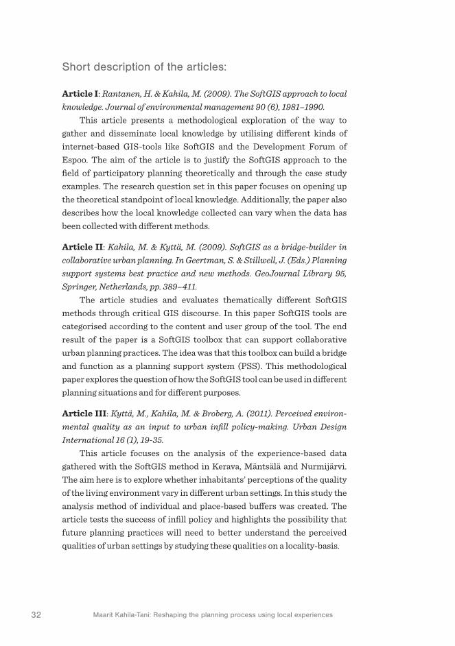
Article I: Rantanen, H. & Kahila, M. (2009). The SoftGIS approach to local
knowledge. Journal of environmental management 90 (6), 1981–1990. This article presents a methodological exploration of the way to
gather and disseminate local knowledge by utilising different kinds of internet-based GIS-tools like SoftGIS and the Development Forum of Espoo. The aim of the article is to justify the SoftGIS approach to the field of participatory planning theoretically and through the case study examples. The research question set in this paper focuses on opening up the theoretical standpoint of local knowledge. Additionally, the paper also describes how the local knowledge collected can vary when the data has been collected with different methods.
Article II: Kahila, M. & Kyttä, M. (2009). SoftGIS as a bridge-builder in
collaborative urban planning. In Geertman, S. & Stillwell, J. (Eds.) Planning
support systems best practice and new methods. GeoJournal Library 95,
Springer, Netherlands, pp. 389–411.
The article studies and evaluates thematically different SoftGIS methods through critical GIS discourse. In this paper SoftGIS tools are categorised according to the content and user group of the tool. The end result of the paper is a SoftGIS toolbox that can support collaborative urban planning practices. The idea was that this toolbox can build a bridge and function as a planning support system (PSS). This methodological paper explores the question of how the SoftGIS tool can be used in different planning situations and for different purposes.
Article III: Kyttä, M., Kahila, M. & Broberg, A. (2011). Perceived environ-
mental quality as an input to urban infill policy-making. Urban Design
International 16 (1), 19-35. This article focuses on the analysis of the experience-based data
gathered with the SoftGIS method in Kerava, Mäntsälä and Nurmijärvi. The aim here is to explore whether inhabitants’ perceptions of the quality of the living environment vary in different urban settings. In this study the analysis method of individual and place-based buffers was created. The article tests the success of infill policy and highlights the possibility that future planning practices will need to better understand the perceived qualities of urban settings by studying these qualities on a locality-basis.

331 Introduction
Article IV: Sanving-Knudsen, A-M. & Kahila, M. (2012). The role of
Volunteered Geographic Information in participatory planning. Examples
from Denmark and Finland. Geoforum Perspektiv 11 (21). This article explores the possibilities inherent in applying the
volunteered geographic information (VGI) concept to a participatory planning context through two case studies. The paper describes a rather more qualitative approach to compressing the perceived experiences into a model that formulates the neighbourhood character by indicating to planners the location of sensitive places and those places that residents would like to change.
Article V: Eräranta, S., Kahila-Tani, M. & Nummi-Sund, P. (2015). Web-
based Public Participation in Urban Planning Competitions. International
Journal of E-Planning Research (IJEPR) 4 (1). The paper provides a procedural analysis of how public participation
can ‘perform’ in planning competitions with the help of web-based tools. The article explores two case studies one from Vaasa and the other from Sipoo. The paper reveals the possibilities in respect of a more open and collaborative planning competition. As a result, the authors highlight the importance of early phase participation and the more systematic design of the participatory process.
Article VI: Kahila-Tani, M., Broberg, A., Kyttä, M., Tyger, T. (2015). Let the
citizens map – Public participation GIS as a planning support system in
the Helsinki 2050 master planning process. Planning Practice & Research.
Published online: 15 Dec 2015.
This article studies the critical conditions for the successful use of PPGIS tools to support the making of a master plan in Helsinki. The paper is descriptive, revealing an analysis of the effectiveness of the residents’ data on the plan proposal made. Findings highlight that residents were in favour of retrofitting their surroundings and the infill areas in the master plan proposal aligned in great detail with the residents’ suggestions for infill and greenspace protection. Even though planners found the collected data and the developed tools valuable they nevertheless felt that the data was not fully utilised.
Excluded book chapter, though still very relevant:
Kahila, M. (2013). SoftGIS Development Process as a Trading Zone: Challenges in Implementing a Participatory Planning Support System. In Balducci, A. & Mäntysalo, R. (Eds.) Urban Planning as a Trading Zone. Urban and Landscape Perspectives 13, Springer, Dordrecht

34 Maarit Kahila-Tani: Reshaping the planning process using local experiences
As articles III, IV and VI describe the quantitative and qualitative analyses made, the focus in this introduction is on exploring the validity of the study more broadly through the empirical considerations which come together through the participatory observations and action research. This observation and action practice, based on social interaction and cultural meanings, has proved challenging forcing the need to continuously estimate whether one single observation is valid and representative in relation to the whole research phenomena. Throughout the process I have been in an ongoing relationship with the research object and thus have also created the research object with other actors (cf. Vilkka, 2006). At the beginning of the process observations were made intuitively, leaning on personal experience. By the end of the process these small individual steps were, as a whole, much better understood. As such, the focus of this introduction is to draw together this fragmentary information into a more coherent whole. While the research data used consists of the survey data generated by the SoftGIS tool this data is, in part, a result of my ongoing collaboration with the other actors involved in the process through different projects.
Interpretation of the results is based on understanding them. To be able to understand it, the researcher needs to be able to provide reasons which substantiate the research data. But because understanding is also affected by the other roles the researcher has, as a citizen and as a human being for instance, the researcher has to be able to separate those observations made as a researcher from those made as a human being. As such, during the research process specific attention was given to identifying situations where the observations made were intuitive rather than rigorously scientific. Observation errors like this can still occur quite easily but it is perhaps more important simply to be able to identify them when they occur and thus learn from such errors.
2
The challenge of pluralistic and extensive public particapation


372 The challenge of pluralistic and extensive public participation
2 The challenge of pluralistic and extensive public participation
To understand the current state of the theoretical discussion in the field of urban planning and particularly in the field of participatory planning a little retracing of steps in order to explore the path that has led to the current situation will be necessary. In general terms, scholars in the field of participatory planning have acknowledged the more collaborative, communicative and dialogic aim of urban planning. Though the meaning of participation is commonly shared the ways in which the desired level of participation is reached remains something of an ongoing discussion. This chapter does not focus exclusively on one theoretical framework and, as such, draws on different viewpoints emphasising the value of each. Understanding the varying theoretical standpoints as an assemblage thus enables us to construct a framework that is open to both rational and instrumental thinking and communicative and deliberative approaches to urban planning.
2.1 Outlining the disposition of public participation
The comprehensive-rationalistic planning paradigm (Bäcklund & Mänty-salo, 2010) identifies and stresses the planners’ expertise while ignoring the role of lay people and the collaborative approach to plan making (see Figure 1). Before the rationalistic era took hold in urban planning the field was occupied by individual visionaries who paved the way for the post war planning era. One such visionary was Patrick Geddes who highlighted the necessity of exploring in detail the local conditions. He also created the survey-analysis-plan (SAP) concept (Taylor, 1998). Though this concept

38 Maarit Kahila-Tani: Reshaping the planning process using local experiences
sounds like a rational and linear way to approach planning, emphasising evidence-based61 information, it nevertheless differs significantly from the rationalistic planning approach (Davoudi, 2006; Davoudi & Strange, 2008). Geddes’s approach has been criticised as the evidence gathered by this type of survey method was limited to physical description. On the other hand, the visionary position of the planner allowed them to judge and decide how to continue from the analysis to the plan. Therefore the actual planning was based more on intuition and on the aesthetic conceptions of urban form while the outcome was understood as one single plan not as several alternative strategies (Taylor, 1998). This era had a major effect on planning norms even after World War II by emphasising the linear view of planning as a physical, design-based, activity (Fainstein, 2000).
Even though the comprehensive-rationalistic approach to urban planning raised the importance of evidence it has been severely criticised because it considers the ‘planners as experts’ (see Figure 1) to be able to formulate a well-defined approach to any problem particularly in relation to accessing the information required to solve the problem. Comprehensive-rationalistic planning has also gained critique of the centralistic model of planning where the planner is assumed to be able to analyse and identify the common good and create solutions by using special techniques and technology. The criticism firstly highlighted by Herbert Simon following John Forester was partly addressed with a definition of ‘bounded rationality’ (Forester, 1984; Forester, 1993b). This emphasises the meaning of “practical, situated, rational action as
an alternative to the common instrumental view of rationality as means-
ends calculation” (Forrester, 1993b, 67). This kind of situated and bounded rational action – an account of practical rationality – enhances planners’ ability to understand uncertainty and the ambiguity of information (cf. Forester, 1993b).
Substantive planning approach concentrates on the object of planning instead of the procedural character of planning describing what is, or at least what should, form the evidence base for planning (Faludi, 1973). While planning can be viewed as a procedure that demands and creates new data, information and knowledge the question of who produces the knowledge for planning practices and how the knowledge is utilised during the planning process remains effectively unaddressed. Planning practice
61 Evidence should be understood as different from knowledge. Whereas evidence strives to be objectively produced e.g. through scientific methods, knowledge formulates through interpretation and understanding. Data as well as information is something that has not been processed either socially or technically.

392 The challenge of pluralistic and extensive public participation
such as evidence-based planning recognises the uncertainty of information and targets for evidence that is more analytical than descriptive and more sophisticated that the simple survey work advocated by Geddes. In evidence-based planning various methods are used to measure and monitor specific activities to support and deepen the existing statistics making the information base more versatile (see Figure 1). Herein two planning views – instrumental and enlightenment – can be identified (Davoudi, 2006). The instrumental view assumes that the relationship between evidence and policy is unproblematic, linear and direct. In practical terms the instrumental view considers that either research leads policy, making policy evidence-driven, or research follows policy, making research policy-driven. The focus on narrow instrumentalism clearly has some problems while it simplifies the process whereas the enlightenment model describes how research may affect policy differently, highlighting the indirect benefits of research. Instead of producing clear policy messages the idea is to ‘illuminate the landscape’ within which decisions have to be made. Evidence-based practice emerged during the 1980s and 1990s, when the debate in planning theory focused predominantly on distinguishing the planning process as something separate from ‘what is planned’. During this era attention moved away from developing the substantive evidence base of planning about how cities function (knowing what) to developing new ideas, such as communicative planning, about the process of planning (knowing how). (ibid.).
Moreover, the means-end rationality of the comprehensive planning approach began to attract a lot of criticism when it was argued that its narrow perspective focused too strongly on the outcome which was, in reality, already laid out at the beginning of the process. This powerful critique received, at least in part, a response in relation to the ‘incremental model’ which came to general prominence through the article ‘Muddling through’ published by Charles Lindblom (Lindblom, 1959). This view emphasised the incremental accumulation of experiences where the former understanding supports incoming practice. Though incrementalism can be viewed as a step towards a process that acknowledges the existence of residents as a factor in the planning process it essentially continued to offer more of a reactive than a proactive approach to communication with a rather small number of people (Mäntysalo et al., 2011). Compared to the incremental approach, the transactive planning model was among the first to attempt to embed public participation in the aims of the planning process. This approach was introduced by Friedman (1973) who viewed

40 Maarit Kahila-Tani: Reshaping the planning process using local experiences
transactive planning as a way to pull residents into the planning process already at an early stage when the problems are defined (Friedman, 1993). Transactive planning is most effective with small groups. On the contrary, advocacy planning reshaped the position of ‘planners as experts’ who were now no longer viewed as specific experts but instead as advocates who determined the problem to be solved and mediated between different views and interests. Planners were no longer viewed as ‘value neutral’ actors conveying an objective understanding of matters. (Davidoff, 1965). Though planners were already sensitive to the value-laden and political nature of planning aiming to improve democracy as a whole they still sought to promote those forms of participatory planning they considered most desirable (Horelli, 2002). These approaches helped to change the role of citizens as they came to be understood as a vital stakeholder group contributing to planning aims and goals. Residents as well as various agencies were involved in planning processes and planning as a top down rationality exercise came increasingly under challenge.
Communicative planning is usually associated with the postmodern ‘turn’ in planning which emphasised the role of collaboration and communicative rationalism and highlighted flexibility, diversity, collaboration and learning (Fainstein, 2000). In recent decades numerous planning theorists have focused on the various aspects of communicative rationality with a view to transposing the concepts of Habermasian critical theory into planning: ‘argumentative planning’ (Fischer & Forester, 1987; Forester, 1993a), ‘planning through debate’ (Healey, 1992) and ‘collaborative planning’ (Healey, 1997). Basically, this communicative rationality highlights the ideal of communication between different stakeholder groups and experts with the aim of reaching consensus. Though it is clearly highly collaborative it can still be questioned whether this approach restricts and filters the knowledge-base through the selected group of participants narrowing the information-premise generally (see Figure 1). The Habermasian theory of communicative action is often criticised because of the weakness of the basic idea of the ideal speech situation, which should enable all of the participants to express their opinions and viewpoints in a manner which is free of their interest and value premises (cf. Fainstein, 2000; Flyvbjerg, 1998; Tewdwr-Jones & Allmendinger, 1998; Forester, 1993b).
Patsy Healey (1997) has underlined the significance of the institutional approach by separating institutions from organisations and emphasising the given framework of norms, rules and practices that structure action in

412 The challenge of pluralistic and extensive public participation
its social context. These are expressed as formal but also as informal rules and structures of collective and shared life. This informal layer constructs the ‘soft infrastructure’ that arises in interactional processes in which the preferences and interests are argued out and decided (Healey, 2007). This appreciation is articulated in collaborative planning by emphasising situatedness and locality as well as the human life that inevitably weaves its way into all planning processes (Healey, 1997). As such, Healey argues for planning systems that will encourage more collaborative and inclusionary forms of planning practice (Horelli, 2002). Communicative planning can be viewed as a learning process where different parties are supported in a way that helps them to understand each other’s viewpoints. Ideally, each party has the ability and opportunity to express their views meaning that no one party can push through solutions opposed by others (Leino, 2006). Compared to individual learning processes the process should embrace the social and joint learning model of planning arguing for an open process that has two main characteristics: critical feedback and a strong institutional memory (Friedmann, 1993).
Whereas the communicative turn emphasises idealistically the equal notification of each participant and the goal of consensus (Tewdwr-Jones & Allmendinger, 1998), the agonistic planning orientation highlights the diversity of opinions and the conflicting manner of urban planning. Recognition of the agonistic approach to planning is highly relevant while it should be recognised that disagreement and strife are always likely to be present in planning discussions which are, in effect, knowledge-driven but also value-based discussions. Even though planners and other experts have generally recognised the emergence of agonism the need to learn how to respect and work with it remains (Hillier, 2007). More recently, deliberative democracy theory has also affected the agonistic planning orientation while it emphasises a form of practical reason where participants can bring together their suggestions on how to solve problems in a legitimate manner (Young, 2000). This notion resembles the so called third generation of deliberative democracy theory that draws on the pragmatic approach and focus on situated agreement in intense negotiations (Mäntysalo & Jarenko, 2014). In these situations systemic methods that move between parts and wholes are relevant by challenging the accepted frames of reference with new ideas and evidence (Healey, 2009). This encouragement of critical inquiry enriches the capacity of polities emphasising human potentiality (ibid.). Critical pragmatism introduced by John Forester (1993b) links the pragmatic approach to the

42 Maarit Kahila-Tani: Reshaping the planning process using local experiences
critical exploration of the practices and potentials of social action. This enhances the ability of planners to challenge inequities and oppressions and helps them to build humane and richly informed democratic practices. In order to emerge as a practical alternative however, deliberative practice must take a stand on how such deliberation can function within existing democratic institutions at a sufficient scale (Innes, 2004).
Explicitly urban planning practices vary in respect of the existing knowledge base and the procedural matters emphasising the role and commitment of the actors, and the ways in which they have to deploy their knowledge. The variation is inherently constructed through the situated and local surroundings where the practices take place. This knowledge and these values, ratings, rankings and spatially located experiences are imported into planning practice through the instrumental paradigm emphasising survey-based techniques (Raymond et al., 2014). Equally and just as often, the various knowledge systems, as well as ways of identifying values and experiences, are deployed through the deliberative paradigm in discussions (ibid.). The pragmatic standpoint of planning offers an intriguing theoretical foundation from which to synthesise these two approaches. As Raymond et al. (2014) highlights “it is rarely asked
explicitly whether or not instrumental and deliberative planning paradigms
can be synthesised in a meaningful way”. Therefore the planning theory approaches should see the knowledge-informed model diverge away from the evidence-based ones (see Figure 1) while evidence-based policy can be strictly defined to view evidence as a direct justification for policy emphasising the rational process of decision making (Krizek et al., 2009).
These varying theoretical approaches offer valuable insight into the discussion of the status and aim – the disposition of public participation – in the field of planning theory. In Figure 1 these theoretical approaches have been viewed in relation to the position they take in the collaborative process and in the utilisation and acknowledgement of diverse knowledge created for planning purposes. In the fourfold (see Figure 1) the participatory planning approach is discovered through the planning theory debate in which the procedural and knowledge-based discussions establish the focal axes. The horizontal axis separates the restricted and filtered information premises from the information premises that acknowledge more plural and diverse source of information. The vertical axis separates the process from the collaborative one to one that is driven by individual planners.
The placement of the comprehensive-rationalistic planning approach in Figure 1 defines its tendency to comprehend the needed information for

432 The challenge of pluralistic and extensive public participation
planning through the experts selected to run the process. The emphasis here is on the before set end solutions that the experts aim to justify through their own knowledge premise. Whereas the communicative-consensus planning approach is highly collaborative the knowledge used in the decision making process is filtered through a selected group of people comprised of experts as well as other actors. Though this planning approach is evidently relevant and necessary it should nevertheless elaborate more clearly the selection process of the people who are allowed to seek the consensus and consider the potentiality to embody information and knowledge more comprehensively in the process. As such, the left side of the axis is based on a restricted information premise that can be viewed as information that can quickly become more unbalanced and subjectively enhanced either by experts as in the rationalistic approach or by non-governmental organisations or resident’s associations as collective bodies obtaining certain norms as in consensus-oriented planning. The evidence-based planning approach embraces scientific ‘objectively’ harvested knowledge comprehending that this knowledge has to be formulated ‘outside’ the decision making process and has to cover different perspectives. At the same time this knowledge cannot as such illuminate the decisions instead it should feed the further deployment of the knowledge in the process. Experts should not hold onto particular and separate results received but subordinate these to deliberative action. Accordingly this kind of knowledge-informed planning acknowledges the need to attain diverse and plural information that have to be further processed through the decision-making. Knowledge-informed planning combines the instrumental and deliberative planning paradigm while it acknowledges the tools and technical ways of obtaining valid and even contradictory information for planning it simultaneously understands the need to further elaborate this knowledge through deliberative actions. Still it has to be emphasised that this is an ongoing process where the deliberative actions taken also produce new knowledge.
As Healey (2009) notes: “The great value of the pragmatist tradition
lies in its focus on acting in the world and in the methods it suggests for
thinking through complex claims as these arise in specific situations.”. Therefore participatory urban planning practices should acknowledge more fully the interpretative approach to urban planning where knowledge is seen as a matter of understanding rather than of explanation. Through understanding, attention is simultaneously paid to the objective and physical matters of place and to the subjective and social concerns of place.

44 Maarit Kahila-Tani: Reshaping the planning process using local experiences
The interpretative approach can also turn the traditional ‘will to order’ into the ‘will to connect’ existing multiple overlapping networks among planning practices (Davoudi, 2012). These networks consist of continuous flows of people, resources and knowledge (ibid.). Hence the problems and conditions planning confronts are not the same everywhere, therefore our understanding of the processes should always be reflected on the characters of the place (Friedmann, 1993).
To conclude: whereas communicative urban planning tends to exclude the plural and diverse voices of society remaining elitist and ideal action the knowledge-informed planning emphasizes the dissenting understandings of people – the ambiguity of information. Evidence-based planning as such adopts too narrow a viewpoint on planning, but when supported with the interpretative framework it evolves into a knowledge-informed approach. Deliberative action should not only be understood as information processing but also as a practical social and political action. At the end planner’s work has to be meaningful to others: “it has to ‘make
sense’ to other people, no matter how technically rigorous or correct it may be
on its own technical merits.” (Forester, 1993b, 25).
Figure 1. Framing the knowledge-informed planning through a fourfold of urban planning approaches

452 The challenge of pluralistic and extensive public participation
The next section will reflect on the current status of, and challenges posed by, participation in respect of the possibilities of knowledge creation through the knowledge-informed approach to urban planning processes. As already highlighted in the discussions above, in contemporary planning, two kinds of information – or knowledge-premises are present: expert and experiential knowledge. Dualistically, planners usually focus on expert knowledge whereas the residents and people impacted by a building focus on the other. Because planning seeks to find solutions for the people who are outside these decision making processes it should acknowledge that solutions might occur through the more effective linkage between expert and experiential knowledge (Friedmann, 1993). Therefore the goal of the next section is to reflect through the literature review undertaken the benefits and the justification as well as the ambitions and challenges of participation by highlighting explicitly the mechanisms in respect of individual and group participation.
2.2 Reaching the voice of crowds
Most Western democracies have already accepted that public participation is a democratic right and support the aim of extending the role of participation significantly. Over time, the arrangement of public participation has become an elemental part of urban planning practices in many countries. Therefore the motives in respect of participation have been transformed from an emancipatory impulse into a discussion over the effectiveness and legitimacy of decisions in respect of participation (Newig & Kvarda, 2012). Public participation can be justified by the actual effectiveness of participation by challenging the influence of participation to policy outcome and process (Rydin & Pennington, 2000). Innes (2004) has identified five reasons justifying the right of participation. Firstly, decision makers are able to discover what the public’s preferences are and how to embed these more easily in their decisions. Secondly, participation improves the quality of decisions by incorporating citizens’ local knowledge into the decision calculus. Thirdly, participation advances fairness and justice. Fourthly, participation legitimates decisions and finally it is required by the law in many countries. Moreover, participation fosters not only individual but also collective social learning and even inter-organizational learning (cf. Mäntysalo, 2000). As such, participatory processes focus not only on the exchange of information but also on the enhancement of mutual understanding between different stakeholders (Newig & Kvarda, 2012).

46 Maarit Kahila-Tani: Reshaping the planning process using local experiences
Participation is understood as a collective and joint decision-makingprocess, public involvement, civil society engagement and as com-munication among groups including the meaning of sharing power. Participation means involving persons or groups that do not routinely take decisions (Newig & Kvarda, 2012). Participation should entail and ensure that all those persons and/or groups with legitimate interests are sufficiently represented (ibid.). In an ideal situation democracy would entail the total and continued participation of all society’s members (Fagence, 1977). Verba (1969) however focuses on the reality of the situation, namely that participatory democracy cannot be all-encompassing without making society unworkable (in Fagence, 1977). Society cannot function by giving everyone an absolutely equal right to participate. Notwithstanding this, one of the main aims of participation is to broadly encompass the plural voices of society (Innes & Booher, 1998) to ensure a broad range of public involvement. Involving only particular or restricted interest groups or persons can, on the other hand, be labelled as lobbyism (Newig & Kvarda, 2012). As Innes (2004) highlights, pluralistic thinking and existing participation models coexist uneasily in theory and practice while the first lacks legitimacy with citizens, but is often effective the second is seldom effective, but has considerably more legitimacy.
Therefore the vibrant discussions around participation, democratic decision-making, equality and consensus-making are relevant as they point to the increased importance of citizen participation in public decision making and to the importance of developing forms of participation other than those occurring within the context of representative democracy (Monno & Khakee, 2012). Though the importance of participation practices is widely acknowledged these practices are always closely bound up with the societal context that defines the position of participation and the realisation of these participation practices. In Finland72 the situatedness of 72 Urban planning in this thesis is interpreted through the Finnish context which is normative and multilevel system strongly bound to physical land-use planning (Hirvonen-Kantola & Mäntysalo, 2014). In Finland since 1980s the role of participation has been legally acknowledged in various parliamentary Acts. These incremental steps led to the Land use and planning Act which improved on the process of informing local people of decisions on land use planning (1990) and then highlighted the two-way communication and collaboration between residents and officials (1999). Since 2000 the existing Land use and building Act has been amended several times while in 2013 the Act was completely overhauled. This Act emphasises the role of participation, collaboration and transparency in planning practices throughout the process (MRL 132/1999, 1999). It aims to ensure the involvement and interaction of all relevant participants in the preparation of plans guaranteeing also the quality of the planning outcome (ibid.).
The existing planning systems in the Anglo-American, central European and Nordic societal contexts share some similarities but differ significantly e.g. in the way in which

472 The challenge of pluralistic and extensive public participation
the participatory approach in the field of urban planning varies from city to city (Bäcklund & Mäntysalo, 2010). This local variation in the arrangement of participatory planning can be identified as something of an institutional ambiguity. This also emphasises a tension at the local administrative level that conditions the role of participation. This tension appears between the changes in the operational environment and the procedures governed by law. (ibid.).
Public participation cannot be mentioned without acknowledging the work of Sherry Arnstein (1969) who constructed the aim of participation through the ladders of participation. Arnstein’s work is however now considered quite outdated representing as it does US conditions in late 1960s during the emergence and development phase of the civil rights movement. The model has, moreover, been criticised for portraying power arrangements as rather dualistic and one-dimensional while the final steps of the ladder encompass the empowerment of people as the main objective of participation. Nor does it open the information flow between experts and residents (Saad-Sulonen, 2014). What does remain highly relevant however is the basic model of the ladder of partnership; moreover, as numerous recent studies show, urban planners and residents consider partnership to be a vital stage of participation (Bailey & Grossardt, 2010). Godschalk et al. (1966) defines citizen participation, not as an alternative to the conventional decision-making process pursued by the public planning agencies in the institutionalised framework of modern government, but as a decision-forming partnership, an exercise in collaboration. Partnership emphasises the practices of shared working and decision making with the authorities (Horelli, 2002).
The decision to participate in a planning process is always made at the individual level (Laurian, 2004). In decision-forming participation citizens should not only be heard but they should also have a creative input into matters affecting their interests and concerns (Douglass & Friedmann, 1998). This creative input can be a result of individual participation when a person participates in her/his capacity as a community member or collective participation through membership in a local association or
public participation possibilities have been strengthened. In Finland the local government is responsible for most basic services like social and health services, as well as the educational, cultural, environmental and technical infrastructure (including planning) services (Bäck-lund & Mäntysalo, 2010). This Nordic welfare state model however also creates challenges for the implementation of participatory planning because of the strong municipal self-gov-ernment which is presumed to exist for its citizens and their well-being (e.g. Haveri, 2006). This weakens the need for a strong civil society to emerge while the lay people are often simply used to the way representative democracy has traditionally functioned.

48 Maarit Kahila-Tani: Reshaping the planning process using local experiences
popular movement. These differ from each other as in the former, a resident as an individual has certain rights but not necessarily the possibility to intervene in a policy process while in the latter case, a non-governmental organisation or an association as a collective body has certain norms with regard to membership, social and political ties and loyalties (Burby, 2003; Day, 1997). Therefore individual participation can be considered more as a quantitative phenomenon – the more the better whereas collective participation is more qualitative (Monno & Khakee, 2012). On the other hand, the importance of informal participation which planners often do not consider to be part of the official procedures is often neglected: ”As
a result, even when public planners are actively committed to promoting new
participatory planning processes they tend to ignore the existing informal
participative practices. The paradox here is in promoting a competition
between invited and invented spaces of participation” (Monno & Khakee, 2012, 297).
Participation is also always a question of those who remain silent by not participating while they presumably still have preferences and opinions that can differ from the alternative propositions being proposed (Hoinville, 1971). Sandercock (1995) speaks about the epistemology of multiplicity denying the validity of the view that those who remain silent by not participating in inquiries do not have preferences or are indifferent to alternative propositions. This is further elaborated by critical pragmatists’ such as Forester that claim the full range of human capacities, material, moral, and aesthetic, have the potential to enter into public policy practices (in Healey, 2009). As Albrechts (2004) notes, the empowerment of the ‘ordinary’ residents and ‘deprived’ groups is necessary. Though many techniques exists to deal with large groups of citizens, including town meetings, interactive web-dialogues, citizen panels, workshops and focus groups (Innes, 2004) the kind of pluralistic thinking that would bring forward the diversity of interests to support the creation of more innovative planning proposals is still neglected in planning discussions (Godschalk, 1971). When participatory practices concentrate on harnessing the transformative power of dialogue described by Innes (Innes & Booher, 2004, 428) this creates a powerful mechanism for change where an “inclusive set of citizens can engage in authentic dialogue where
all are equally empowered and informed and where they listen and are heard
respectfully and when they are working on a task of interest to all.”. Such a group is, generally, limited to a set of people which emphasises the elitist model and where the voice of crowds is generally excluded.

492 The challenge of pluralistic and extensive public participation
Accessing ‘the voices of crowds’ should not be considered only as a way to collect opinions on certain matters. As the character of planning is future orientated, information on current developments at the city level should be given greater prominence. This information should form a central part of the interpretative information framework in planning projects that tackle current problems which need to be solved by changing the living environment of inhabitants. Current planning practices then need to strengthen the capacity to listen to peoples’ complaints and therefore to effectively address what is important to them (Albrechts, 2004). The traditional approach to human geography emphasises experiences, awareness and knowledge of the individuals and their conditions, without forgetting physical places (Kwan, 2004). Evidently places are meaningful, as they have identities and meanings for their inhabitants (Relph, 1976). Residents are strongly attached to the places where they live. As Healey (1997) has described: “The place where we live is ‘our’ place – something
we identify with at a feeling level. As somewhere laden with memories,
associations, hopes, even family history, it imparts layers of meaning
no outsider could even guess at. The best way to access all this is through
the people who already live there. The knowledge they hold is invaluable.
Invaluable both for living in places and for forming them.” In addition, Healey (1997) also notes that the progressive challenge is therefore to find ways of acknowledging different ways of experiencing and understanding in seeking to ‘make sense together’.
Clearly large groups can develop visions, understanding of desired direction and priorities (Innes, 2004). The voices of crowds can be turned to the wisdom of crowds and even to evidence. Surowiecki (2004) describes a phenomenon where a group’s collective answer to a question or solution to a problem is found to be as good as and sometimes even better than any of the individuals in the group or an expert in the field. The members of the group need not even be exceptionally well-informed or rational to reach these wise decisions. Though a crowd can comprise any group of people (the larger the better) they still need to have the ability to act collectively to make decisions and solve problems. This view, that crowds can contain collective wisdom, contradicts stereotypical views of crowds as thoughtless or irrational. Surowiecki (2004, 10) outlines four conditions that are necessary for a wise crowd: (1) diversity of opinion (each person should have some private information), (2) independence (peoples’ opinions are not determined by those around them), (3) decentralisation (people are able to specialise and draw on local knowledge), and (4) aggregation (there is some

50 Maarit Kahila-Tani: Reshaping the planning process using local experiences
mechanism for turning private judgments into a collective decision) (see Table 2). The wisdom of crowds becomes valuable for planning decisions by producing public judgment (Brown, 2015). It is however important to separate public judgment from mere mass opinion. Mass opinion defined by Yankelovich (1991) is often reported by the media as focused views about a particular subject or topic. Mass opinion is formulated through using convenience sampling often with leading or biased questions. The distinction between mass opinion and public judgment is the quality of the opinion. He cites three factors that determine the quality of opinion: (1) whether the individual takes responsibility for the consequences of holding the opinion; (2) the firmness with which the individual holds the opinion; and (3) the consistency of the opinion. Brown (2015) suggests that adding the place component to the knowledge produced by participants makes the knowledge potentially more usable and influential in planning practices.
Table 2. Comparisons between individual participation and collective participation (modified after Brown, 2015)
Individual participation Collective participation
Diversity of opinion
Each person should have the opportunity to share their private information
The private information of different persons’ is filtered through groups aims
Independence Peoples’ opinions are not determined by those around them
Peoples’ opinions form part of the joint understanding of the group
Decentralisation People are able to specialise and draw on local knowledge
Combines and acknowledges local knowledge from different sources
Aggregation Some mechanisms exist for turning private judgements into public judgement
More effective mechanisms for turning private judgements into public judgement
The comparison between individual and collective participation highlights the ways in which these approaches support the goal of diverse knowledge creation for planning purposes and also clarifies why the creation of individual participation should be fostered further (see Table 2). In the future, public participation practices should be better at acknowledging individual and collective participation in order to produce plural views of the people. As participation can be considered a situational procedure it is worth noting that no single participation strategy fits every planning situation. Though this section has mainly highlighted the benefits of

512 The challenge of pluralistic and extensive public participation
participation it should also be noted that several questions remain which challenge the meaning of participation. As addressed in the field of environmental governance it is also relevant in the field of urban planning to ask whether participation contributes to the enhanced legitimacy and/or effectiveness of the process and the outcome (e.g. Newig & Kvarda, 2012). Regarding Newig & Kvarda (2012) these critical questions remain conceptually and theoretically contested while empirical studies have yet to achieve convincing results in this regard, remaining fragmented and often producing non-comparative or even partly conflicting evidence. As such, the individual knowledge that can accumulate in the wisdom of crowds through formal or informal procedures – making participation more effective – can be better reached through the knowledge-informed, by connecting the instrumental and deliberative action planning approaches. The next section therefore considers the procedural character of planning. One interesting question for the future will be how precise we have to be in the formulation of the timing and place of participation and whether it would be possible to foster a more fluid interaction process which could function continuously through a series of ongoing and linked processes.
2.3 The idea of a continuous and cyclical planning process
The way in which urban planning is realised in practice is procedural. Despite this researchers in the field still often ignore procedural planning theory as something rationalistic and outdated. Nevertheless, in practical terms planning remains highly procedural. As such, the procedural character of planning should be viewed as a starting point when aiming to understand current planning procedures more comprehensively rather than as a theoretical framework. Herein the procedural character of planning becomes apparent through the challenge of exploring the linkages between the varying participatory planning actions in relation to the various phases of the planning process. In policy analysis the process is divided into discrete phases. The policy cycle is a framework of policy processes helping us to comprehend more clearly the different components of the process.
Lasswell (1956) was among the first to promote the idea of modelling the policy process (in Jann & Wegrich, 2006). His linear model includes seven stages: intelligence, promotion, prescription, invocation, appli-cation, termination and appraisal. This model has drawn much praise
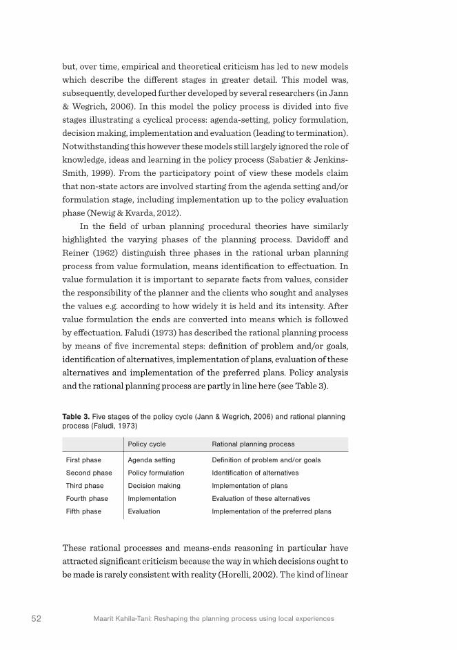
52 Maarit Kahila-Tani: Reshaping the planning process using local experiences
but, over time, empirical and theoretical criticism has led to new models which describe the different stages in greater detail. This model was, subsequently, developed further developed by several researchers (in Jann & Wegrich, 2006). In this model the policy process is divided into five stages illustrating a cyclical process: agenda-setting, policy formulation, decision making, implementation and evaluation (leading to termination). Notwithstanding this however these models still largely ignored the role of knowledge, ideas and learning in the policy process (Sabatier & Jenkins-Smith, 1999). From the participatory point of view these models claim that non-state actors are involved starting from the agenda setting and/or formulation stage, including implementation up to the policy evaluation phase (Newig & Kvarda, 2012).
In the field of urban planning procedural theories have similarly highlighted the varying phases of the planning process. Davidoff and Reiner (1962) distinguish three phases in the rational urban planning process from value formulation, means identification to effectuation. In value formulation it is important to separate facts from values, consider the responsibility of the planner and the clients who sought and analyses the values e.g. according to how widely it is held and its intensity. After value formulation the ends are converted into means which is followed by effectuation. Faludi (1973) has described the rational planning process by means of five incremental steps: definition of problem and/or goals, identification of alternatives, implementation of plans, evaluation of these alternatives and implementation of the preferred plans. Policy analysis and the rational planning process are partly in line here (see Table 3).
Table 3. Five stages of the policy cycle (Jann & Wegrich, 2006) and rational planning process (Faludi, 1973)
Policy cycle Rational planning process
First phase Agenda setting Definition of problem and/or goals
Second phase Policy formulation Identification of alternatives
Third phase Decision making Implementation of plans
Fourth phase Implementation Evaluation of these alternatives
Fifth phase Evaluation Implementation of the preferred plans
These rational processes and means-ends reasoning in particular have attracted significant criticism because the way in which decisions ought to be made is rarely consistent with reality (Horelli, 2002). The kind of linear

532 The challenge of pluralistic and extensive public participation
SPIRAL OF PLANNING AND DEVELOPMENT
process does not cover the versatility of differing phases, the continuity of the process, knowledge creation or the way in which actions are realised. Liisa Horelli’s model (Horelli, 2002; Horelli, 2006) focuses on the purpose of planning through the support of the communicative transactions of the participants (see Figure 2). These communicative transactions take place and are related to the surrounding context of the environment, economics, organisations and society and culture. In this model the phases are described as overlapping and iterative, where the transaction enables the connections between varying phases. This versatile model also includes the enabling tools that support the communicative transaction between different phases. These tools include both enabling methods (consensus building and other heuristic instruments) and traditional research methods. In this model the effectiveness of participation is validated through an ongoing process of monitoring, self-evaluation and action research. These methods guarantee feedback on the quality of the process and the validity of its results. The model is divided into five phases: initiation, planning and design, implementation, evaluation/research and maintenance. (ibid.).
Figure 2 presents Horelli’s model which offers a very promising standpoint from which to understand the situational complexity of
Figure 2. Planning process cycle illustrated by Liisa Horelli (2002)

54 Maarit Kahila-Tani: Reshaping the planning process using local experiences
participation throughout the process cycle at a general level. Nevertheless, despite the advances made, these models require further empirical testing in order to deepen the content of the varying phases. In addition, the models need also to be updated with relevant participation tools that support the communicative transaction more efficiently during the process. The process should also be understood as contingent and evolving and as something that can even re-cycle or reinterpret the goals as new things are learned (Innes & Booher, 2010).
The literature review presented in section 2 explored the participation viewpoint first from the perspective of planning theory, secondly through the justification of participation and thirdly by emphasising the meaning of the procedural character of planning. This broad discussion is necessarily however approached through interaction with a limited set of scholars who are active in the current debate on public participation. Because the aim in this introduction is to study and bring forth the conjunction between the instrumental and deliberative planning paradigms the focus in following sections turns to the role of PPGIS tools. This study is elaborated in relation to the trading zone concept which offers a valuable tool to understanding cooperation between different actors who are not trying to overcome the self-regarded interests of the other actors, but rather are trying to find mutually acceptable solutions through mutual communication (Mäntysalo & Jarenko, 2014).

Extending the palette of participation tools
3


573 Extending the palette of participation tools
3 Extending the palette of participation tools
This methodological section will begin by reflecting on the vast ICT field from the perspective of the digitalization of participatory planning tools. Then the current suite of webGIS tools, namely PPGIS and VGI tools, are explored with the aim of identifying the varying character of the tools as well as their background. Following this, the development process in respect of the evolution of SoftGIS methods into a participatory planning support system (PPSS) is described by utilising the concept of the trading zone. This section discusses first the background to the PPGIS tools, then explores the development trail of one PPGIS tool, namely SoftGIS, by e mphasising the methodological turn from single research tools to a system that encompasses a broad variety of possibilities with a view to implementing participation tools and more ongoing support in planning practice.
3.1 Volunteered or not – exploring the nature of the PPGIS, VGI and PSS
In modern society public participation has taken different forms and employed various mechanisms. The list of traditional participation tools like public hearings and meetings, information documentation, questionnaire surveys, exhibitions, town meetings and focus group sessions has been enlarged with a variety of information and communications technology (ICT) tools like social media and GIS-based tools (Luna-Reyes et al., 2012). In the field of participatory urban planning ICT tools have been rapidly developed over the past 10 years (Brown & Kyttä, 2014;

58 Maarit Kahila-Tani: Reshaping the planning process using local experiences
Ramasubramanian, 2008; Sieber, 2006). Nevertheless, the dispersed development work of these digital tools should be better acknowledged by research and practice while none of these tools are sufficient in themselves. Participation should be treated as a hybrid infrastructure of communication and organised by using the concept ecology of tools in the specific context of planning (Wallin et al., 2010). Saad-Sulonen (2014, 171) uses the term ICT-mediated citizen participation in urban issues that acknowledges different aspects that support the relationship between participation and technology. This approach includes areas such as governance, urban planning, information systems and interaction design, geography, citizen activism and community development. Generally, these digital tools have been broadly accepted and widely used to support a more diverse approach to the preparation of plans that focus on more efficient, transparent and democratic processes and a more comprehensive and reliable approach to data collection.
The ecology of tools approach comprises a rather large number of tools and therefore some form of classification is required to separate the basic characteristics of these tools. The tools can be separated into so-called ‘informing tools’ focusing on increasing interaction and the sharing of information among different stakeholders and ‘data gathering tools’ that emphasise the value, quality and validity of the information gathered, analysed and further delivered (Wallin et al., 2010). This separation is valuable while the informing tools, though interactive, cannot replace the need for tools that provide reliable analysis and the translation of the data into a format that can be easily used by planners. As already noted, a great deal of the gathered information can be left unexploited without systematic processing of the information (Wallin et al., 2010). Horelli (2002) divides participation tools to enabling tools and traditional research methods like surveys. She describes enabling tools as all those tools that: “enhance the
transactions and knowledge creation of the stakeholders during the phases
of participatory planning” (Horelli, 2002, 614). Moreover, as she further notes, we need different kinds of tools to support the communicative transactions of participants during the planning process.
Geographical Information System (GIS) is generally accepted as a useful tool with which to create maps and analyse spatial data. GIS is an effective tool in producing and visualising so-called institutional, official and fact-based geo-referenced statistical spatial data (Kraak & Brown, 2003). Many local government agencies have a long history of using GIS and spatial information in their urban planning procedures (Geertman,

593 Extending the palette of participation tools
2002; Sieber, 2006). Latterly the use of GIS and especially the use of web-based GIS by community groups, non-governmental organisations and researchers have emerged. Firstly, webGIS initiatives have increased the opportunities for lay people to access geographic information and secondly, participatory approaches to use and produce GIS-based information (Ghose & Elwood, 2003). GIS is, moreover, increasingly employed in research and development projects incorporating community participation e.g. how can GIS merge with community participation in the context of neighbourhood revitalisation and urban planning (Weiner et al., 2002), how can different groups be organised and involved in decision making processes (Nyerges, 2005), how can an issue be spatially investigated to yield positive returns in terms of group dynamics, consensus building and joint planning (Schlossberg & Shuford, 2005), how can land use conflicts be addressed using participatory mapping (Brown & Raymond, 2014), how landscape values can be turned into explicit knowledge (Brown, 2012), how webGIS enhances collaboration and public participation in strategic planning (Simao et al., 2009), how to manifest the local knowledge in to urban regeneration processes (Schmidt-Thomé, 2015), or to map the inde-pendent mobility of children (Broberg, 2015). These tools have emerged from the need to enable lay people to produce, explore and analyse geo-coordinated information, local experiences, in participatory processes via participatory tools.
Tools that encourage participation have been labelled ’parti ci -patory GIS’ (PGIS), ‘public participation GIS’ (PPGIS), ‘community integrated GIS’ (CIGIS) (Harris & Weiner, 1998), ‘bottom-up GIS’ (BUGIS) (Talen, 2000) or ‘SoftGIS’ (Kahila & Kyttä, 2009). In addition, other labels have however been used such as ‘volunteered geographic information’ (VGI) (Goodchild, 2007) or the notion of �‘structured public involvement’ (SPI) (Bailey et al., 2001) to widen the geospatial/geovisual decision support systems (GDSS) in a more collaborative direction (C-GDSS) in order to achieve large-scale and reflective public participation (Bailey & Grossardt, 2010). Though the field has stabilised usage over the term PPGIS to describe a web-based GIS system that enables information gathering from lay people (Sieber, 2006) a distinction needs to be made especially between VGI and PPGIS tools that are also present in this thesis. Whereas the VGI tools are described as tools that can be harnessed to collect a large variety of geographic information, for example from information regarding base maps (e.g. Open street maps) to information regarding community engagement (e.g. bush fire preparation maps), these
60 Maarit Kahila-Tani: Reshaping the planning process using local experiences
tools tend to focus on some sort of local need that could not otherwise be addressed via geographic information. On the other hand, PPGIS tools originate from the need to collect objective data regarding some specific topic for the purposes of research or to facilitate a decision making process. Raymond et al. (2014) reflect on PPGIS tools as an instrumental paradigm that involves an objective assessment of the distribution, type and/or intensity of values that individuals deliver. Currently there are a wide range of practical examples of PPGIS in use that support the validation of the theoretical view and the definition of PPGIS. Moreover, the number of PPGIS tools has increased significantly over the last decade (Brown & Raymond, 2014) especially due to the effort made at the Landscape Values & PPGIS Institute18. Evidently a rich seam of different kinds of tools has emerged while their use and content is always bound to a certain place and time.
PPGIS has a rich and diverse conceptual history that draws upon several intellectual traditions including political economy and critical theory, participatory planning and community development, democracy and social justice, anthropology and ethnography, political ecology and philosophies of science. PPGIS is then a rather broad tent with multiple meanings and a global reach (Weiner et al., 2002). Tulloch (2008) describes PPGIS as a field within geographic information science that focuses on the ways in which the public uses various forms of geospatial technologies to participate in different processes. PPGIS also enables communication to take place on maps and models in an intelligible visual form to those who have no expertise in its technical basis (Carver et al., 2001). Both PPGIS and VGI are related terms that define a process for gathering and using non-expert spatial information (Brown & Kyttä, 2014). While PPGIS tools are often web-based, originating from the hands of researchers, VGI tools are generally developed by lay people to create, assemble, and disseminate voluntarily produced geographic data (Goodchild, 2007; Hall et al., 2010). VGI has led to the ‘crowd-sourcing’ of spatial information where the user-generated content is produced by a large group of people through an online community (Sui et al., 2012). In many cases however these relatively young VGI projects have not targeted joint decision making, understood as an object of crowd-sourcing, but instead concentrated more on geographical information gathering and the visualisation of a certain topic or more broadly in respect of big data. In both PPGIS and VGI, the dimensions
81 See the papers of� Landscape Values & PPGIS Institute: http://www.landscapemap2.org/publicationsv1.html

613 Extending the palette of participation tools
of purpose, geographic context, data quality, sampling approaches, data collection, data ownership and dominant mapping technology vary depending on the project (Brown & Kyttä, 2014). Unlike PPGIS projects however data validation through sampling has not been at the core of VGI projects. Though both PPGIS and VGI tools can be considered as tools that can promote data collection from a broad group of people it should be noted that this does not happen automatically. In many PPGIS projects the reach has been quite limited serving only a small subset of public (Schlossberg & Shuford, 2005).
PPGIS turns the traditional use of GIS on its head allowing residents’ to characterise their local environment in a ‘bottom-up’ manner (Talen, 2000). Nevertheless, it is important to avoid the dualistic separation between the ‘hard’ and ‘soft’ uses of GIS as these different information sources should rather be understood as essentially complementary. Carver et al. (2001) suggests that a place and a particular local context play an important role in shaping participatory approaches to spatial decision making and therefore PPGIS projects tend to be highly contingent on, and strongly shaped by, the local context in which they are situated. PPGIS tools allow people to make comments and express their views in a relatively anonymous and (usually) non-confrontational manner. Therefore these tools should be interpreted as intelligent interfaces into specific problem areas. This intelligence still often exists in a one-sided way, while PPGIS in practice supports, in the main, top-down practices such as data collection, arranged by experts, from lay people whereas VGI has a more bottom-up approach. In PPGIS practices the criticism has targeted the instrumental character that neglects the deliberative action needed to deliver and process the information further. VGI has often faced criticism regarding the validity of the data. Both are viewed as instrumental tools whereas interaction between different people has remained on quite a narrow level meaning traditionally the promotion of dialogue after the data collection phase conducted separately in face-to-face settings. Some PPGIS practices have also taken steps towards assisting communication inside the PPGIS. These experiments turn the traditional data collection task into the form of argumentation maps (Balram & Dragicevic, 2006; Rinner, 2001, 2006). It is however important to note that PPGIS practices should concentrate not only on the extensive nature of information production but also consider more carefully the post-collection phase when the information is sorted and the deliberation should occur.
The goal of this thesis is to explore the mainstreaming of PPGIS in the field of urban planning. Traditionally the PPGIS and VGI tools have their

62 Maarit Kahila-Tani: Reshaping the planning process using local experiences
backgrounds either in research or community activism (Tulloch, 2008) whereas planning support systems (PSS) have always been closely tied to existing urban planning practices (Brail & Klosterman, 2001; Geertman & Stillwell, 2003; Geertman et al., 2015; Klosterman, 1997). PSSs are not highly structured; they are rather more loosely coupled assemblages of mainly computer-based techniques that aim to facilitate different phases of the planning process and consist of a rich variety of computer-aided techniques designed for experts to support their decision making and to enable more efficient planning practices (Batty, 2007). PSSs can also be described as an infrastructure that systematically introduces relevant and new spatial information into the process (Klosterman, 1997). Although participation has not been focal to PSS studies the development of PPS is based on the assumption that a greater degree of access to relevant information leads to the consideration of a greater number of alternative scenarios, which results in better public debate (Geertman, 2002; Geertman et al., 2015).
More systematic and critical thinking in terms of the usage of the developed web-based tools would clarify the whole ecosystem of these tools. This understanding is required in order to more deeply embed this colourful palette of tools in the complex institutional framework of urban planning in order that it may support a more structural and reflective approach to public involvement and staged participation. One important factor behind the historically weak assimilation of PPGIS and PSS to planning practice is that the tools are usually developed in isolation by researchers or by industry with the developers often having only a limited knowledge of the end-users’, such as urban planners and residents, actual needs (cf. Vonk et al., 2005; Vonk & Geertman, 2008). This creates a problem in terms of an implementation gap, which refers to the mismatch between the supply of, and the demand for, planning support tools (Schrijnen, 2010). To narrow the implementation gap a more user-sensitive and iterative development process is required. The next section will go into greater detail on the development process of the SoftGIS-method in various Finnish cities emphasising the character of the development work by means of the trading zone concept. This technological evolution trail reflects the changes in how planners have confronted the SoftGIS tool and how these notions have influenced the methodological turn that has extended the use of SoftGIS as the PPGIS tool into a system that enables the implementation of different kinds of participatory tools. This development work shifts the understanding of PPGIS as a merely instrumental paradigm towards a conception that entails deliberative actions.

633 Extending the palette of participation tools
3.2 The development process as a profound learning process – Reflecting the SoftGIS development process through the trading zone concept
The development processes behind the existing web-based participation tools should receive more academic attention in order that a better understanding of how the multi-voiced and multi-layered systems of different stakeholders’ shape the outcome of the process and affect their use – through, for instance, support for participatory planning practices. For this to happen, the main focus should shift from technical development work to the form of social process, towards consideration of a more continuous learning process from the development phase to implementation. This shift of understanding requires new tools that enable us to open up the multi-actor development processes, the engagements and roles of different actors and the trade of information. The trading zone concept offers plausible tools to describe the different forms of cooperation during the development process providing insight into how the outcome of the process is reached. Trading zones can thus be viewed as intersections of discursive and material practice (Galison, 2010) between different actors during the development process. Ultimately, the aim of the development process relates to the ability to engender and promote trust among different actor groups. Trust needs to be created in the development phase of totally new and still evolving methods even though, at the beginning of such a process, there is no guarantee of its effectiveness or usability. In the field of participatory planning the question of openness during the development process in respect of new participatory tools is relevant. The question is who benefits most from an open development process? A more open development process might lead to a more creative process where the end result can differ significantly from the initial idea.
The trading zone concept introduced by Peter Galison has offered a useful instrument for understanding innovation processes in the field of science. Many scholars have subsequently become interested in utilising the concept in the field of architecture and planning (Balducci & Mäntysalo, 2013). This concept helps to open up the different forms and stages of collaboration in multidisciplinary teamwork while in a trading zone; trading partners confront each other in order to trade information to create something new and innovative in multidisciplinary collaboration. According to Galison (2010), trading zones have a dynamic character, where concepts, ideas and instruments evolve through different stages of

64 Maarit Kahila-Tani: Reshaping the planning process using local experiences
the process. Trading zones can be described as intersections of discursive and material practice, which are partially but not completely shared. Following Kanninen et al. (2013) and Galison (2010), trading zones can be identified by the following characteristics: trading zones should have interpretive thinness, provide a possibility for a platform where the symmetric exchange of information between disciplines or professional cultures can evolve and be locally bound in the sense of a context-specific, socio-spatial and verbal-material language game. Hence, the trading zone describes the process where ideally the symmetrical trading partners aim to develop something in collaboration without knowing or even sharing, at the initial stage, a consensus in terms of the outcome. On the other hand the concept of boundary object (Star & Griesemer, 1989) provides a heuristic instrument to understand the opportunities for creating projects and temporary agreements between actors who can have conflicting interests and viewpoints (Balducci & Mäntysalo, 2013). Here this concept is used to explain the use of SoftGIS as a material medium during one phase of the development process.
Before collaboration between the partners takes place, the traders involved in the trade need to be identified. After this selection has been made, the fact that there is an agreement to share information is more important than what is actually shared. Trading zones are not static but dynamic in that they shift, shape and frame collaboration over time. Trading zones can vary from being very homogenous to rather heterogeneous in nature and in addition, the level of cooperation can vary from coercion to collaboration. In terms of scientific conversation it is even possible to reach an interlanguage, a shared way of communication that each trader understands at different stages of the process. Hence this shapes the character of the trading zone in the direction of homogeneity leaving the possibility to incorporate the plural and diverse viewpoints of the actors that support the understanding of planning as an ambiguity arena of information (see section 2.1). The evolution of this interlanguage is characterised by change over time and locality. In the trading zone literature, the emergence of this interlanguage is often seen as a final step in trading zone types (Figure 3).
Figure 3 visualises the forms of different trading zone types. This model originates from the fourfold model by Collins et al. (2007). The black and grey circles have been added to clarify the type of trading zone in each corner. The space between different trading zones is defined through two axes. The ends of the horizontal axis are homogeneity and

653 Extending the palette of participation tools
heterogeneity and the vertical axis, coercion and collaboration. The variation between these defines the four basic types of trading zones as enforced, fractionated, interlanguage and subversive. These trading zone types function as the main categories which might also include some other trading zones as sub-categories. The subversive trading zone is highly coercive but still very homogenous. In this kind of trading zone, actors are forced to utilise one available system even though they might like to use something else. The enforced trading zone occurs when there are high levels of coercion and heterogeneity. In the collaboration zone, some of the traders utilise their power over the others to carry on their interests. Even though traders share the same aim in terms of the achieved outcome, they are not collaborating equally. The fractionated trading zone is highly collaborative but still heterogeneous. In this trading zone two sub-categories are identified (Collins et al., 2007), namely, boundary object trading zones and interactional expertise trading zones. In boundary object trading zones, there exists an operative medium that may hold different meanings for the various parties involved in the trade. The medium is a physical item rather than a linguistic exchange of information,
Figure 3. The different types of trading zones (model reshaped after Collins et al., 2007). Black circles with a solid line identify the existing trading zones and the dashed line the future zones. Grey circles identify the traders in the trading zone
HETEROGENEITY
COLLABORATION
COERCION
HOMOGENEITY
Interlanguage Fractionated
EnforcedSubversive

66 Maarit Kahila-Tani: Reshaping the planning process using local experiences
whereas the interactional expertise trading zone lacks the physical item and focuses more on the exchanged language. In both of these fractionated trading zones, traders collaborate through some common denominator without fully communicating with each other. Interlanguage trading zones are again highly collaborative but also highly homogenous. In this type of trading zone, for example, two different scientific fields can be joined together to generate new fields like biochemistry and nanoscience. When something totally new is being developed, the traders need to put a lot of effort into the actual communication process. Compared to participatory planning practices the aim of reaching a trading zone of interactional expertise would support the idea of partnership offering a plausible goal for participation.
The following sections will explore the development process of PPGIS tools by using the trading zone approach to lay out the terrain where this development work has taken place. In addition the aim here is to consider the influence of the development work in respect of participation. The aim is to point to the pros and cons during the development processes that have affected the formulation and use of the PPGIS tools as a research method and to the assimilation of these methods into participatory planning practices. The development process consists of three stages: (1) the development phase of the methods, (2) the actual use and testing of the methods and (3) the ex-post-evaluation of the methods after they have been utilised for a time in real planning projects.
During the development work on the first SoftGIS methods, the observation of non-reciprocity became evident directing cooperation in more open and transparent direction. This can be seen as an important contribution to the trading zone concept in a planning context while it emphasises the normative use of the trading zone encouraging expert groups to build the tools by incorporating an acknowledgement of the usefulness of non-planners (Galison, 2013, 204). As such, the object of studying the development process in respect of PPGIS tools is twofold. On the one hand, the goal is to describe this development path and reflect the lessons learned, while on the other, the focus is placed squarely on the normative application that is possible through the feedback received and utilised during the development process. As Gorman (2010, 75) state: “A good working definition of service is the co-creation of value via client-
provider interactions”. This emphasises the level of collaboration because the service systems are socio-technological networks where human beings, technologies and organisations are closely coupled (Elzen et al., 1996).

673 Extending the palette of participation tools
Jenkins (2010) has noted that if the development work of a new product is made without fully integrating all the required partners, the end result is not going to achieve a high quality and normative applicability.
3.2.1 Phase 1: Enforced trading zones – from prototypes to functioning SoftGIS-methods
Development work on the SoftGIS-method started in 2004 together with the city of Järvenpää. Several additional projects followed this preliminary endeavour which concentrated on developing a research tool to study residents’ perceived environmental quality locally (e.g. Kyttä et al., 2013). These preliminary SoftGIS studies, described in articles I and III, were realised in the cities of Järvenpää, Kerava, Mäntsälä and Nurmijärvi in Southern Finland during the period 2004-2007. In each of these cities planners were involved in the development process but their interest in this work remained at general level as they did not have any specific need to utilise the method or the data in other ongoing planning projects. The development processes in these towns as well as that in the city of Järvenpää all experienced problems with the prototypes and preliminary versions. Article I describes the implementation and development of these prototype tools with reference to the Järvenpää case study.
When developing prototypes, the traders might share the aim and the understanding of the need to share information but lack the shared language or material medium. This poses a challenge in terms of the communication and collaboration channels between the traders and leaves the trading zone in a very heterogeneous state where the traders and the aim of trading can be identified but the traders are not able to work jointly and coordination is incomplete (Figure 4). At this point, researchers, city officials, IT specialists and residents, as trading partners, remained heterogeneous and were encouraged to collaborate though none of the groups felt a significant need for extensive collaboration. The traders did however reach an agreement to share information and the overall goal but the collaboration did not attain its ultimate form due to the incompetent selection process of the traders and the lack of a material medium to ease communication. As such then development work here is best characterised in terms of an enforced trading zone (see Figure 4).
In the city of Turku, where a SoftGIS research method for children was developed, described shortly in article II, a broader actor group of local actors, city authorities and schools was active during the method

68 Maarit Kahila-Tani: Reshaping the planning process using local experiences
development phase and eager to receive the results. Urban planners and researchers were important but not the only potential utilisers of the knowledge gathered. Compared to the previous case, the traders were more interested in and willing to collaborate during the early stages and were not coerced by administrative facts like the selection process. The actors also had many initiative projects of their own where they were willing to use the data. For these reasons, collaboration was more homogenous while the trading partners involved shared the same aim and trusted each other (Figure 4).
Figure 4. In the enforced trading zone traders (small circles) have the pressure to collaborate though coordination and collaboration between different traders is incomplete.
Nevertheless, coercion still existed since the researchers had set the research questions and aims. In an enforced trading zone, the role of researchers can be analysed through the institutional power they held. Herein the identified expertise of an established discipline has the authority to decree whether or not certain knowledge can be included within the discipline or group (Collins et al., 2007). In the case of Turku as well as in the other cases mentioned previously, researchers dominated and held the power to decide what information was and what was not relevant. Therefore researchers functioned as an elite participant by dominating the zone. The researchers’
HETEROGENEITY
COLLABORATION
COERCION
HOMOGENEITY
Interlanguage Fractionated
EnforcedSubversive
Researchersdominate
Pressure to collaborateCooperation
framed byresearch interests

693 Extending the palette of participation tools
interest firmly framed and affected (see Figure 4) the collaboration in the trading zone while the methods and the collected data were formulated in relation to scientific principles. When researchers firmly frame the aim of the development process beforehand by the set research interest it is not possible to achieve a balance between the researcher’s ambitions and those of the other traders. Thus, while scientifically based information can be particularly interesting for planners the question remains as to whether it is reasonable to try to create an innovative and homogenous development process in relation to a new product or service when researchers still need to guarantee the scientific validity of the data. This observation is often also applicable to participation where residents are viewed as informants rather than as partners when planners through their expertise enforce certain participatory functions. Therefore the participation process should become more adaptable enabling the residents’ role to vary from the evidence-based approach to that of the knowledge-informed (see section 2.1.)
3.2.2 Phase 2: Fractionated trading zone – SoftGIS surveys as boundary objects
After these preliminary projects the SoftGIS-method was further developed in the cities of Helsinki and Espoo during the period 2009. In these projects few changes can be identified in the basic composition of the trading partners although IT specialists now formed a more permanent part of the research team. This change in their role from an outsider group to actual members of the research team affected the development work by intensifying the collaboration. The transition from an enforced trading zone towards a fractionated one happened when researchers wanted to allow more space for urban planners to influence the content of the SoftGIS-method. Planners seized hold of this possibility while retaining clear aims about how they would like to use the data in their ongoing planning project (see article IV). Urban planners and researchers shared the same motivation and had a clearer understanding of the other’s aims. They were keener to discuss and develop the method further towards a participation
tool that could be used alongside traditional planning processes. During this development phase the traders were able to use the
existing versions of the SoftGIS-method as a material medium and as a boundary object that allowed them to communicate and exchange ideas in a boundary object trading zone (Figure 5). The boundary object functions

70 Maarit Kahila-Tani: Reshaping the planning process using local experiences
as a more static, shared space, where the object already exists, but the development of the object is still derived from action between different actors (Star & Griesemer 1989). In the boundary object trading zone collaboration occurred almost without linguistic interchange by utilising the existing surveys as a material medium. During this phase it would have been intriguing to incorporate residents more profoundly rather than relying on their indirect influence alone. Nevertheless, collaboration was framed by the parallel aims of the traders, which did not merge even at the end of the project. In the SoftGIS-method development processes in Helsinki and Espoo, it became apparent, as noted previously by Jenkins (in Gorman, 2010, 165) that: ‘Often the participants in this type of trading
zone interpret the meaning and significance of the object differently, perhaps
even obscuring the role of other parties. However, products that the exchange
yields are valuable enough to keep the parties engaged in the trade’.
Figure 5. The boundary object trading zone where existing SoftGIS-methods operated as a material medium.
During this development phase the researchers wanted to construct a firm base for the SoftGIS methodology through a set of individual SoftGIS-methods, theories, concepts and ideas. As summarised in article II SoftGIS-methods were seen as individual tools as a) methods for capturing the general perceived quality of the environment, b) methods concentrating on a specific theme and c) methods for use with a special
HETEROGENEITY
COLLABORATION
COERCION
HOMOGENEITY
Interlanguage Fractionated
EnforcedSubversive
Cooperationframed byparallel interestsset by plannersand researchers
Existing surveysas material medium in boundary object tradingzone

713 Extending the palette of participation tools
user group (i.e. children). The aim was to construct, thematically and conceptually, different PPGIS tools that would enable the extensive collection of experience-based knowledge for urban planning practices from individuals. The idea here was to offer planners a contextually ready-to-use toolbox to capture local knowledge. This line of thinking emphasises the knowledge-informed approach to participatory planning practices which seeks to strengthen the information flow of the perceived level of environmental quality with qualified tools. Subsequently this thought had to be re-evaluated when it became clear that planners were eager to construct the PPGIS tools by themselves (see following section). In the end it was this notion that in practice transformed SoftGIS from a research tool into an effective participatory tool and shaped the character of the tool in respect of the planning support system. As such, it is important to reaffirm the point that planning practices are open to the knowledge gained via SoftGIS research methods but in common participation practices they grasped the opportunity to decide the content of the tools for themselves.
In all of the above-mentioned cases the defined research objectives were present (described in articles I, III, IV) and dominated the devel-opment processes yet at the same time it was considered important to design services or more concrete tools to support participatory urban planning practices. Obviously these two aims are too large to handle equally in the same projects. Therefore it is important to understand the purpose and the aim of each particular phase and task of the planning project. Clearly some planning phases require more evidence-based infor-mation while others more elementary information. The following section explains the next phases of the development processes which concentrate specifically on the design of participatory tools rather than survey tools. These processes have demanded a more iterative and open process leaving more space for the traders in the trading zone to decide on the goal of the project together.
3.2.3 Phase 3: Fractionated trading zone – towards a participatory planning support system
When the development process began with Vaasa in 2009 the aim was to develop a SoftGIS-platform that would allow for ongoing data collection from the residents. The idea was to create a way to guarantee a continuous information flow about perceived quality factors from residents to planners. This meant that a more comprehensive and technologically

72 Maarit Kahila-Tani: Reshaping the planning process using local experiences
ambitious platform was required where residents could create but also explore and comment on the suggestions made by other respondents and where planners could implement new surveys and analyse the collected information. Article V studies the development process of this first continuously open SoftGIS service in the city of Vaasa. This change in the objective of the research and development led to the transition from a boundary object trading zone to a boundary organisation. The change of the objectives compared to the boundary object trading zone could no longer adequately serve the new goal of the development of the service. For this reason, the new boundary organisation trading zone diverged from the boundary object trading zone (Figure 6).
Figure 6. The interactional trading zone is framed by more equal traders who are willing to share understanding and views with the other traders.
The change in the development objective from individual PPGIS tools towards a continuously open service, or more correctly, platform affected the dynamics between the traders. It quickly became clear that more information was required in order to better understand the existing planning culture meaning the processes and practices but also the prevailing technical possibilities in respect of adapting a new service to the existing structures. This entailed a lot of work for IT specialists and graphic designers who needed to think through the whole technical structure and
HETEROGENEITY
COLLABORATION
COERCION
HOMOGENEITY
Interlanguage Fractionated
EnforcedSubversive
Interactional expertisetrading zone to supportcollaboration betweentraders
Trading zoneframed by
equal traders

733 Extending the palette of participation tools
platform of the SoftGIS again. Traders in this new situation were more equal when compared to previous incarnations, but more expertise and understanding was undoubtedly required. Collins and Evans (2002) place interactional expertise on a continuum between having no expertise in a domain and having contributory expertise. Starting from no expertise, it is possible to reach contributory expertise after a while. Even though the expert would not be able to have exactly the same skills, he/she would be able to discuss the substance professionally. Therefore in the city of Vaasa the development process can be identified as an interactional trading zone (see Figure 6), though traders faced many problems throughout the process in terms of their openness and willingness to understand other traders’ viewpoints. Contributory expertise was at least in part achieved while, for example, researchers began to utilise tools that were familiar to IT developers while the IT specialists tried to gain a better understanding of the field of participatory urban planning.
The development process that took place in Vaasa paved the way for the more systematic development process that continued at Mapita Ltd. Mapita was established because the researchers wanted to allow cities to use SoftGIS in their urban planning practices more frequently. In Vaasa the research findings revealed that residents were not eager to use a continuously open platform where they could update the information about their experiences but instead preferred to participate only when the planning project physically started (see article V). For this reason then a more systematic development process in respect of the editor tool for SoftGIS or PPGIS tools was put in place, subsequently named Maptionnaire. This development phase can be described through the interactional trading zone while urban planners have significantly impacted the development of the service. Many iteration rounds have shaped the editor tool and indeed continue to do so. At the very beginning of this journey the developers thought it would be important to provide the editor tool with ready-to-use thematically varying survey contents. It was however quickly noticed that the planners themselves wanted to design their own tailor made contents. This development phase led eventually to a situation where Maptionnaire could be used as a research tool but also as a participatory tool (PPGIS). Though Maptionnaire is now much more user-friendly and technologically advanced compared to the preliminary ideas laid out in the research project in Vaasa the basic idea has remained the same. The basic difference is that planners can now also use the tool as a more permanent participatory planning support system

74 Maarit Kahila-Tani: Reshaping the planning process using local experiences
(see section 4). Table 4 lists those projects where Maptionnaire has been used independently by planners. The information gathering with PPGIS in these processes is project-based meaning that this can occur several times during the various phases of one project.
In part, the development work at Mapita has taken the form of an interlanguage trading zone because of the more stable and ongoing relationship between the developers and the customers that has enabled the co-evolution of a new technology (Gorman, 2010). As is widely recognised in the fields of PPGIS and PSS (cf. Geertman & Stillwell, 2002; Schrijnen, 2010) the development work often leads to interesting experiments and prototypes which do not in the end support the establishment of new methods in planning practices. The observations made above, in respect of the development process which remains at the level of an enforced trading zone or boundary object trading zone, however suggest that the possibility of successfully turning the prototypes into more supportive systems is reduced. It is therefore important to note that researchers working in this field should be more open to the needs raised by practitioners, residents and other actors in the field. Ideally, it would be intriguing to see these separately developed systems as components of a single ecosystem that could be built incrementally through the possibilities new interfaces offer in an open developer community.
City Name of the project Respondents/ map markings
Year Aim of the project
Helsinki Helsinki 2050 (master plan) 4700/33 000 2014 Background material of the future proposals
Lahti The best and worst places in Lahti, development project of urban areas
580/986 2014 Perceived environmental quality of the youth
Salpauskunta: municipal division report of land use areas
58/80 2014 Background information from the experts of different land use areas and public transportation routes
Survey regarding kindergartens’ immediate nature surroundings
56/1077 2014 Evaluation of the important nature values and the development suggestions for different planning purposes.
My Lahti: Master planning workshops
-/400 2014 Background data collection first in workshops and after these online
My Lahti: child friendly city evaluation
292/3190 2014 Survey for students on 5th and 6th grade
Tuusula Detail plan of Rykmentinpuisto (osayleiskaava)
864/1146 2014 Background information of residents’ experiences and later feedback of the plan proposals
Table 4. Planning projects where town and urban planners have used Maptionnaire more independently to design and create their own tools and survey questions

753 Extending the palette of participation tools
Hyvinkää Detail plan of Hangonsilta 167/247 2012 Background information of residents’ perceived environmental quality for the idea competition
Kouvola Vision work of the city centre 108/2343 2012 Background information of residents’ experiences and later feedback of the plan proposals
Master plan of Niskala-Tervakangas
64/375 2013 The data collection of the current use of the area
Environment report of the city character of Kaunisnurmi
54/427 2013 To collect data of the urban infill potential
Master plan of Koria Pioneeripuisto
36/299 2013 Background information
Master plan of the city centre 43/43 2014 Opinion of the plan proposal
Detail plan of the city blocks in the centre
155/483 2014 To collect background material for the planning competition
Metsä-hallitus
Maintenance and usage plan for Sipoonkorpi national park
2012-2013
Background information of residents’ experiences and later feedback of the plan proposals
Turku Areal development project of Kauppatori (Tule mukaan kehittämään Kauppatoria)
1100/- 2015 Background material of the current use and future development proposals
Master plan of Turku (Rakenna Turkua 2029)
-/415 2014 Background information for the vision work (survey also for the companies)
Riihimäki Evaluation of the seven structure models for the city (master plan)
163/360 2014 Thematic questions and feedback of the designed structure models
Survey for the park programme (viheralueohjelma)
223/1736 2014 Background information for the park programme
Survey for different associations of the exercise places (part of the park programme)
28 asso-ciations/60
2015 Background information for the park programme from sport clubs
Cosiness and development proposals of Peltosaari
75/- 2014 To collect residents’ opinions from Peltosaari and find out their ideas for the future collaboration to enhance the attractiveness of the area. The aim is to increase the informal activity on the area.
Survey of the energy and climate objects
30/- 2014 Part of the Energy and Climate seminar held to the decision makers and practitioners.
Map your cycling route! 20/- 2014 Survey for the city’s employees
Kirkko- nummi
Master plan of the city centre 164/926 2013 Background information about favourite places, liked, disliked places and important places and development proposals
Architectural policy program (strategic plan)
77/325 2013 Residents’ experiences and obser-vations of atmosphere and future ideas
Detail plan of Länsi-Jorvas 115/1191 2013 Background information about favourite places, used routes and unsecure places
Porvoo Kevätlaakso (master plan) 201/780 2012 Daily routes and important places and better transport connections
Joensuu Ideas for a park plan (master plan)
856/3780 2012/ 2013
Important green spaces: experiences, ideas and improvement suggestions


Regenerating the participatory planning support system
4


794 Regenerating the participatory planning support system
4 Regenerating the participatory planning support system
While the previous section describes the evolutionary trail of the design and development of SoftGIS tools as they were developed into more adaptable and fluid PPGIS tools, the following sections seek to build a bridge between theory and practice by reflecting on the empirical findings of this study in order to produce a number of theoretical statements and conceptual models. Herein the focus moves from instrumental aspects such as the development of participatory tools to the development of participatory planning practices which enhance participatory action by incorporating different kinds of PPGIS tools into the process. This analysis here, drawing on the policy analysis and rational urban planning fields, illustrates a heuristic model of participatory urban planning that acknowledges planning as a multilevel system consisting of various intertwined fibres in continuous interaction with each other. The starting point is normative and is designed to comprehensively clarify the ways in which different kinds of PPGIS tools could be more profoundly embedded in the planning process with the goal of producing a more continuous participatory planning support system (PPSS). This system leans on the knowledge-informed planning approach (see section 2.1) being more open to different forms of knowledge and accepting the conflicting perspectives of actors and trying to adapt and integrate different participatory tools and practices more profoundly into the process, still being situated in respect of urban planning in local practices. The participatory planning support system illustrated here is a fluid assemblage of theories, practices, tools, knowledge and norms – that acknowledge the instrumental approach but embrace deliberative action to support the construction of collaborative

80 Maarit Kahila-Tani: Reshaping the planning process using local experiences
understanding further. While in the traditional view of urban planning expert knowledge has been dominant this model emphasises the importance of rich experience-based knowledge production by lay people – the wisdom of crowds – alongside expert knowledge. Both should be valued and both should be available and visible as only when taken together can they effectively support wiser city making.
4.1 The planning system as a ‘loop’
Many academics have characterised the planning process as a dynamic and continuous space (Friedmann, 1973; Horelli, 2002; Innes & Booher, 1999). Friedmann, for instance, (1973) defined planning as an ongoing process where the continuous interpretation of real life functions as a starting point leading to action and again to feedback. In this model public participation forms a solid part of the action that creates the feedback used in the expert analysis. This analysis re-shapes the action visualising the planning process as a continuous loop. This process is not however a value-free technocratic exercise. The planning process cannot be under-stood as a simple procedural procession from the provision of means to the attainment of ends. Rather, it is as much about power relations and competition over agenda setting as it is about finding the truth and solving the problems at the end (Davoudi, 2006). On the other hand, evidence, knowledge or prior information are not the only factors affecting the policy process with at least four other powerful competitors identified: ideology, interests, institutional norms and practices (Weiss, 2001).
Participatory planning is an inherent part of the planning system consisting of several processes which, in part, overlap. Before concentrating on procedural matters however, it is relevant to highlight the fibres that structure the system on a meta-level. Each of these fibres can be identified as a more general process each containing a series of more detailed processes. The aim of the fibres analogy (see Figure 7) is to clarify the various parts of the continuous participatory planning system that are closely linked through the interactions taking place between different actors and courses of action. As Friedmann (1993) notes, knowledge and action are so tightly fused together that they cannot be understood as separate. Figure 7. acknowledges this by highlighting three different fibres that together construct the planning process cycle ‘loop’: (1) knowledge creation, (2) interpretation, learning and understanding, and (3) planning practice. Participatory planning is framed by the guiding regulations and

814 Regenerating the participatory planning support system
norms that implicitly guide planning practice and justify the decisions made as do the local characteristics to which planning is always bound. On a meta-level this loop describes the logic of public participation. Regardless of the participation methods used, this loop drives the way in which participation occurs. As fluid and impossible to separate, these fibres construct the continuous interplay where new knowledge arises and is then further processed via interpretation, learning and understanding to become part of planning practice.
Figure 7. The fibres of the planning process cycle – the planning process as a ‘loop’
In this model knowledge creation emphasises the need to be open to knowledge creation that accumulates through several streams, takes different forms and is represented by different actors. The fibre of knowledge creation is a continuously updating assemblage of data, information, evidence, knowledge and even wisdom. Knowledge creation reaches the experiential landscape of the people but it also acknowledges expert information as well as scientific research results. Sorting the knowledge in relation to the actor producing it is, however, not as important as ensuring that the process is fed from different data sources, and that this information is then further adapted through understanding – deliberative action – to produce knowledge. As Innes (Innes & Booher, 2010, 5) notes: “There are facts to be explored in the effort to create a shared understanding
of reality that can be the basis for action”. This point should however be further elaborated in order to question whether planning based on mutual
82 Maarit Kahila-Tani: Reshaping the planning process using local experiences
dialogue supports the encounter of the extensive, plural and versatile voice of people or whether it only allows the more active and exclusive group of people to effectively participate. The basic critique of evidence-based planning is relevant as well while planning cannot be based on single facts but should instead be viewed as knowledge-informed action. In Figure 7. knowledge creation is placed at the bottom of the loop emphasising the flaw, still evident, in the existing planning debate which ignores the need for more plural and diverse knowledge.
Between the fibres of knowledge creation and planning practice we find understanding, learning and interpretation. This fibre could also be illustrated as a spiral that pulls together knowledge and action. It is nevertheless valuable to highlight understanding, learning and interpretation separately at least conceptually as together they encompass the process that compresses and structures the enormous amount of knowledge into shared understanding. The goal of this fibre is not to produce any ready outcomes or fixed understandings but instead to filter data for the fibre of practice. In essence, this fibre demands that urban planning take on a more interpretative role in order to fulfil the extended information flow from participants. Ultimately, planning is a practical process of argumentation though it should not be restricted to argumentative practice (Forester, 1993a).
Within the fibre of planning practice the existing and locally varying action models affect the way participation is carried out and the tools selected to support and realise participation practices. Experts such as urban planners, residents and other actors need to understand in detail the character of the planning phase or task to be able to set the eligible goal for participation. Only through these incremental considerations made during every phase can more effective collaboration and communication be achieved (see section 4.3.). In relation to these three illustrated fibres of the participatory planning loop the following section identifies the varying planning phases applicable for this study by supporting the made empirical findings of the PPGIS studies.
The participatory planning support system (PPSS) presented herein should be understood as a theoretical and conceptual approach and as a strategic device that can be utilised to support planning practices with a varying set of participation tools and actions. More importantly however this system emphasises participation as a solid and continuous part of the planning and decision making system. Therefore this system should focus on coherence through the interpretation of different forms of knowledge

834 Regenerating the participatory planning support system
and in the adaptation of new tools. The following sections explore in detail the different phases aiming to clarify the participatory planning context and knowledge creation during the different phases that PPGIS initiatives can support. As identified in the PPGIS and PSS fields the challenge is to embed the concepts, ideas and tools in everyday practices. As such, the aim is to narrow this gap by indicating the locus of these innovations throughout the planning process.
4.2 Complementing the planning process with local experiences
Urban planning has taken a number of useful steps towards interpretative action by acknowledging the place-based values and perceptions in social, economic, psychological, aesthetic and physical terms because land use is no longer seen as only relating to physical structures describing physical conditions. Questions however remain over how effectively different values are taken into consideration and realised in urban planning outcomes (Davidoff, 1965). Urban planning and policy-making should therefore take greater account of different types of knowledge. Knowledge that relies on statistical and technical data but also knowledge that is based on the individual perceptions that accumulate through the continuous interaction with our living environment (Kyttä, 2003) as well as that based on phenomenological accounts of life emerging at the intersection of politico-economic and aesthetic-cultural considerations (Madanipour & Hull, 2001). Each knowledge type entails dimension of facts (something that is known), a method that reaches these facts and a normative framework because the previous dimensions rely on social interpretation (Bamberg, 2013). This section explores these theoretical notions; produced from observations from planning practice combined with the empirical findings received via SoftGIS-based PPGIS studies from the perspective of knowledge creation of local experiences. Knowledge creation concentrates here on the ways in which localised and experience-based information from individuals can shape planning practices further and how experience-based information can be combined with statistical data. The information that can be gained via PPGIS tools varies from empirical evidence validated with random samples to more descriptive feedback and comments collected voluntarily from residents. These different knowledge types should not be viewed as being in opposition but rather as parallel data sets that support different phases of the planning process.

84 Maarit Kahila-Tani: Reshaping the planning process using local experiences
In urban planning processes planners are used to utilising information in various forms. Knowledge produced by different stakeholders and organisations is gathered and managed to support decision-making and planning. Knowledge of the residents’ perceived quality and use of their living environment may be particularly useful though this sort of knowledge is still not normally given credit by professional planners. Traditionally, this local knowledge is often considered to be ‘opinion’ or ‘belief ’ and thereby dismissed, since the planning system still relies mostly on ‘hard’ technical knowledge and professional expertise (Fischer, 2000; Puustinen, 2006).
The PPGIS studies prove that the data these methods can evoke is both rich and versatile (see Table 5). The empirical findings suggest (see article I, III, IV, VI) that the data collected can strengthen the already existing understanding of some specific phenomena, produce information about things that planning should address in the future or even produce totally new and unexpected information. Seemingly rather small points, such as that described in article I where residents located almost the same amount of positive and negative quality factors on the map; something which was repeated later on in a project where the respondents located even more positive than negative experiences (article IV). This is rather intriguing for planners who are used to handling more negative feedback from residents. Clearly the traditional participatory methods planners are utilising seem less attuned to capturing positive feedback from residents.
Urban planning has traditionally been evidence-based, furthermore, it is actually a very thin base of evidence that is used to justify already pre-existing positions. Even though all forms of evidence have utility it is nevertheless crucial to understand their limitations. One problem related to this is that when a policy action is justified with reference to a single source of evidence this is termed cherry-picking (Krizek et al., 2009). In the process of cherry-picking some pieces of information or evidence are used while others are disregarded or marginalised. Cherry-picking is however open to different interpretations depending on one’s value system. For this reason it has been argued that the evidence-based approach is ideological as it supports particular beliefs and values compatible with the dominant cultural paradigms (Davoudi, 2006). In our case studies we have also recognised the process of cherry-picking where, for example, in the case of Vaasa described in article V, the applicants that took part in the idea competition preferred to use the collected data from the perspective that was most applicable for them. For this reason in the early phases of the

854 Regenerating the participatory planning support system
SoftGIS development process we pushed for more accumulative research data creation. This data collection with certain scientific premises would guarantee some general outcomes in respect of the data but cannot offer validated insight of every street corner. Therefore the possibility of cherry-picking is always present as is the planners’ assumptions that they want to collect data to verify their own preliminary thoughts. Evidently these issues are dependent on the planners’ expertise. The accumulation of research evidence as a result of numerous studies is however required to be able to reach a more general understanding of the perceived living environment.
It is however also relevant to recognise the other side of cherry-picking as described by March (1994: 226), “decision makers gather information
and do not use it; ask for more information and ignore it, make decisions and
look for relevant information afterwards; and, collect and process a great
deal of information that has little or no direct relevance to decisions.” (in Krizek et al., 2009). This is something that has also been experienced in the reported studies. Even though planners have by themselves designed and implemented the study the use of the gathered data has remained at a low level (see article VI). This is partly a consequence of institutional barriers meaning that public participation is still sometimes used to confirm political legitimacy and valued only as a means that needs to be taken care of during the planning process rather than as part of the end of the planning process. The increasing number of development projects relating to new participatory tools and planning support systems can support this notion further by providing planners with new toys withouth clearly setting out their actual aims. Therefore the layer of understanding, interpretation and learning needs to be emphasised while it enables the subordination of the collected data to public discussion to hinder the possibilities of cherry-picking or the ignoring or misusing of the collected data.
Even though many errors can be identified in the effective utilisation of experience-based local knowledge in planning processes it is also worth highlighting those cases where the collected data has enabled a planner to, for example, find potential locations for infill projects (Kyttä et al., 2013), to identify the existing negative spiral of development (article IV), to map the existing everyday network (article I) and to reach a broader group of residents than would have been possible with traditional participatory methods (article VI). According to architects (thesis required for a diploma Ikonen, 2010) who tested the usefulness of the collected localisedexperiential knowledge in the Helsinki metropolitan area, the SoftGIS

86 Maarit Kahila-Tani: Reshaping the planning process using local experiences
data provided the planner with context-sensitive information the like of which is not normally available (article IV). These above-mentioned observations increase the understanding of the versatile experiential landscapes (Thwaites, 2001) individual people have that can be further processed into collective wisdom in order to better appreciate the neighbourhood’s character. In article IV this approach was used in the study of two neighbourhoods to synthesise the different observations and to help more clearly to understand the so-called places of becoming (Dovey, 2009). This kind of synthesis of the individually produced information creates an ‘interpretative framework’ (Van Herzele, 2004) formulating a communicative platform to support deliberation in future planning debates. As Van Herzele (2004) notes, the formulation of structural categories is however required as it gives places a role in the planning concept, which again adds importance and even necessity to the displayed elements.
While most of the planning domains are informed by planning ’experts’, so-called cognitive planning problems involving location and appropriate land use in particular may benefit from the localised crowd wisdom that can discover creative solutions for a specific planning context (Brabham, 2009). As such, planning practices should much more highly value the public judgment to embody thoughtful consideration about the current importance of places as well as future options in respect of land use. This judgment would reflect the collective values the public has for the places under consideration as well as their preferences for future use. The combination of place-based values (Why is the place important to the crowd?) and land use preferences (What future land use appears most desirable to the crowd?) provide a powerful, operational type of public judgment about place for the purposes of planning (Brown, 2015). PPGIS tools are powerful because they can collect extensive information from individuals, which through crowdsourcing and analysis can be turned into collective wisdom. Understanding that crowdsourced information can be turned to collective wisdom enables planners and other experts in the field to redefine the concept of evidence-based information as solely scientific information into a concept containing heterogeneous information consisting of feelings, values, experiences and suggestions. The wisdom of crowds (Surowiecki, 2004) should be supplemented with expert knowledge and transferred to planning in various formats to support the knowledge-informed planning approach. For example in relation to potentially conflictual themes such as urban infill it is beneficial to supplement the data

874 Regenerating the participatory planning support system
gathering that takes place in workshops and public meetings with PPGIS tools in order to access this collective wisdom (see article VI). Indeed, it should be noted that data received through a dialogue has often proved to differ from the data collected via PPGIS tools (Brown et al., 2014).
The PPGIS studies show that this combination of experiences and preferences functions as the core of most of the PPGIS surveys planners have implemented (see also articles I, III, IV, V, VI). In the implemented cases where planners have been able to decide on the content of the survey they have generally been interested in undertaking a study once the project has been officially started (see following section). In the surveys implemented by planners themselves the content has focused on improvement proposals, experiences related to current land use and feedback gathered on plan proposals. Direct information is considered more useful in relation to planning practices. Compared to PPGIS studies which have generally been research-oriented the knowledge received more effectively supports the evaluation phase of the planning process where more general information is valued.
The data gathered via PPGIS methods is often criticised as regards its representativeness. This is more of an issue in the planning cases where the data is often collected voluntarily without random samples. Rarely is this kind of criticism towards data collection confronted in workshops or public meetings even though few people actually attend such events. To counter the criticism in respect of data representativeness planners should therefore collect the data voluntarily but also via random samples. Especially at the strategic and master planning levels where the data needs to be understood in relation to more generic results, data collection should be based on random samples supported with the VGI component. In detailed planning data collection is suitable to implement on a voluntary basis. Planners have often ignored the possibility of implementing a random sample emphasising the openness of the system to everyone. This approach should in future be more fully supported, particularly as it is demanded by the Land Use and Building Act. These two approaches in respect of the approach to data collection should be viewed as supplementary. The collected data should also be justified and further elaborated through public discussion to produce a kind of public validation process.
Routine data collection and the statistical monitoring of trends is important but this should be connected to the wider debate about the conceptualisation of space and place (Davoudi, 2006). As Krizek et al. (2009) notes, good research evidence is not sufficient in itself, but instead

88 Maarit Kahila-Tani: Reshaping the planning process using local experiences
needs to coincide with organisational culture and political goals. Still it is worth highlighting that the quality of information collected in the participation process is as important as the level of collaboration, fairness, citizen empowerment, or other key variables often cited in the literature (Brown, 2015). Knowledge creation from the public should be intertwined with the actual data collection phase as knowledge is shaped in our communications through exchanging perceptions and understanding, through life experiences and through the cultural and moral knowledge available to participants (Healey, 1997). The collected facts can be considered subject to re-examination and revision because of the tentative nature of knowledge (Innes & Booher, 2010).
Clearly then it is important to understand that the actual aim of the assimilation of public knowledge into planning practice is to transform the practice (Bamberg, 2012). To support the process of knowledge creation and adaptation in future planning processes this experiential knowledge should be more fully included in the process. The following section thus illustrates the participatory planning process as it moves through its varying phases, emphasising the empirical results produced. Following Krizek’s et al. (2009) observation this knowledge transfer could be supported by (1) distinguishing certain general findings and those findings that are difficult to summarise, (2) translation of the key research findings into measurable criteria (includes also the creation of new tools), (3) arranging events for different actors and (4) informing different actors via different channels. Naturally the development of new PPGIS tools could support more profoundly this step of the process. Ultimately, the growth of knowledge creation supports learning and the quantifiable and qualitative information gained on these everyday uses helps to inform the ongoing deliberations regarding design and planning solutions for the neighbourhood in question (cf. Friedmann, 1973).
4.3 Illustrating PPSS – The potential for participation to support the process from idea formulation to maintenance
This section constructs a model, a sort of ‘heuristic device’ of the process cycle that defines the fibre of planning practice. This description of the planning cycle as one with varying phases does not justify the process of real world decision-making though it formulates the ideal that “appeals
as a normative model for ideal-type, rational, evidence-based policy

894 Regenerating the participatory planning support system
making” (Jann & Wegrich, 2006, 44). This normative model challenges the procedural theory of planning to explain how participation and collaboration could be organised in such a way that the planning cycle evolves into an arena for learning and capacity building for citizens, experts and decision makers (Horelli, 2006).
The planning practice constructs the planning process through seven phases each of which draws on the planning and policy analysis tradition (see Figure 8). The aim here has been to adapt and modify the model described by (Jann & Wegrich, 2006) for use in the urban planning context by using the notions previously suggested by Horelli (2006). I have defined the process of knowledge-informed planning practice through seven phases as: early initiation, initiation, formulation of alternatives, decision making, implementation, evaluation and maintenance. In reality these phases are difficult to separate as they often either overlap or are blurred. The process can move forwards or backwards while some steps can be left untaken. Naturally however a universal model of the practice cycle remains, essentially, an intellectual exercise as planning practices vary contextually in relation to the pertaining political, economic, societal, environmental and organisational circumstances. In Figure 8 the dash line framing the loop indicates the empirical results produced in relation to strength of the PPGIS projects during the appointed phase. The thickness of the line implies the planners’ ability to decide upon the use of the PPGIS tool on the specified planning phase. Table 5 describes the knowledge type via varying planning phases (explored in detail in the previous section 4.2.). This table aims to highlight the versatile possibilities of knowledge types produced by lay people during the different planning phases.
The early initiation phase 1 includes problem recognition and issue selection before the decision to launch a new process or project has been made (Jann & Wegrich, 2006). This phase explores the mechanisms behind the decision to start a new process and allows for consideration of the possibilities to integrate and involve the public more profoundly already at this step in the process. This phase is characterised by different patterns of agenda setting in terms of actor composition, the role of the public and knowledge creation. The institutional agenda that this phase aims to produce should be distinguished from the aims of the wider media and the general public. When, during this step the process comes to the agenda setting phase the mechanisms of problem recognition and issue selection are tightly connected with the way in which social problems are recognised and perceived. The result of the agenda setting phase is a selection of diverse problems and issues.(ibid.).

90 Maarit Kahila-Tani: Reshaping the planning process using local experiences
The selection of various problems and issues as the end result of the early initiation phase should be better supported by the participation of and knowledge production from residents, something that does not currently happen in urban planning. This phase should acknowledge the role of informal knowledge creation through public discussions supported by
Planning project phases
Knowledge type Aim Supported planning approach
Examples of PPGIS tools
Phase 1: Early initiation
From single feedback and suggestions to collective opinion by e.g. interest groups or more systematically collected evaluation knowledge
Promote new topics which participants find relevant in their living environment to affect agenda setting before initiation.
Agonistic, deliberative
PPGIS (data validation with sampling and data collection voluntarily) OR Argumentation maps
Phase 2:Initiation
From more thematically structured surveys to value discussions
Supplement the existing background information of the project, test and gain understanding of collective opinion
Evidence-based PPGIS (data validation with random sample and data collection voluntarily)
Phase 3: Formulation of alternatives
From ideas and specific feedback on alternatives to common understanding
Increase the transparency of the process, validate the alternatives, support the understanding of the experts and bring in those residents that are more interested in influencing actual plan making phase
Communicative and deliberative
PPGIS workshop setting and broader data collection voluntarily about plan alternatives
Phase 4: Decision making
Experts’ and lay peoples’ statements on the plan proposal
Validate the official decision making process
Communicative, deliberative and evidence-based
PPGIS with person identification
Phase 5: Implementation
Feedback Informing the residents about the construction phases
Communicative PPGIS as a feedback channel for informing
Phase 6: Evaluation
Research-based data collection on specific theme during specific time of the process (ex-post/ex-ante) or more continuously
Collect evidence on how the changes have affected the quality of the environment
Evidence-based PPGIS (data validation with random sample and data collection voluntarily)
Phase 7: Maintenance
Feedback Collect continuous and systematic feedback about the state of the environment
Communicative PPGIS as continuously open feedback channel
Table 5. Different knowledge types produced by residents during each planning phase

914 Regenerating the participatory planning support system
digital tools but also the role of the more formal knowledge that different studies can evoke. As such, this phase can often blur into the evaluation phase (see below). The role of the public varies according to the character of the democratic decision making process to realise formal participation as well as to adapt the informal activities. City authorities and other actors can also initiate an issue where public support is already high. One specific use of the PPGIS methods approach here is to supplement the issue initiation made by city authorities or decision makers. During this phase the interaction between different variables such as different actors, institutions, ideas and material conditions is contingently dependent on the specific situation. Of central importance here are the constellation of interests between the relevant actors, the capacity of the institutions in charge to act effectively and the public problem evaluation as well as the solutions that are connected to different problems. Clearly, agenda setting is far removed from a rational selection of issues in terms of their relevance in respect of broader societal problems (Jann & Wegrich, 2006). Currently, in the field of urban planning, this phase is narrowly studied from the public participation perspective. Decision makers as members of the city planning board, planning authorities, interest groups such as resident unions and even individual residents can have a say and eventually affect the process of problem recognition leading to the initiation of a new planning process. Unfortunately, this more extensive form of participation, something which has the potential to further impact problem recognition by highlighting the plural nature of values held across society, rarely occurs.
Observation reveals that PPGIS tools like SoftGIS and Maptionnaire can prove useful during this phase (Figure 8). The results indicate that these tools have been utilised in relation broader data collection in respect of the varying themes to be further used in different planning projects or in more strategic projects where the aim is to initiate more detailed processes. Though the methods and the data have proved useful during this phase there is no evidence that the data collected would have significantly impacted the agenda setting phase or led to the initiation of other projects. The support of plural and diverse participation during this phase demands a more agonistic and deliberative planning approach which allows for open and transparent value discussions between different actor groups. This kind of process could be supported by different kinds of VGI tools that aim to crowdsource voluntarily or argumentation maps that support capacity building and trust. Methodologically, a multi-stream approach would eventually guarantee the broad collection of ideas and initiatives.

92 Maarit Kahila-Tani: Reshaping the planning process using local experiences
While loose idea creation can be increased during this phase with the help of new tools it is more challenging to find new ways to link these individual or collective ideas into a more formal process that could, eventually, lead to initiation. This demands more transparency and intense communication between planners, decision makers and residents.
During the initiation phase 2 the contextual analysis and problem definition takes place leading to the conceptualisation of problems, proposals and demands that are again transformed into administrative programmes or plans through policy formulation (Jann & Wegrich, 2006). This phase describes the ‘actual’ beginning of the planning process (see Figure 8) where the preliminary clarification of the context, the definition of the participants, the choice of the level of participation and the preliminary selection of the tools are made (Horelli, 2002). In the initiation pattern the general public can either adopt an outside-initiation pattern, where social actors force governments to place an issue on the agenda by gaining public support, or an inside-initiation pattern where the interest group has direct access to government agencies and is able to put topics on the agenda without major interference from or even recognition by the general public (Jann & Wegrich, 2006). In both patterns these actors may be individuals but more often they are collective actors. From the participatory planning perspective the initiation phase demands at least that the general public and the media are informed of the project and that comprehensive background data is gathered. Evidence is now emerging that, over time, public participation has become more established at this phase and thus can no longer be viewed as a one-directional flow of information towards the residents but instead as a phase where participants should become inclusively bound to the process.
The empirical findings from the SoftGIS studies support the involvement of the participants during this phase where planners have also, in the main, adapted to the use of PPGIS tools (see Figure 8). PPGIS supported participation should shape more comprehensively this part of the process allowing residents to act as information producers while also giving them the opportunity to react and communicate with the understanding received from other respondents. This would lay out the versatile experiential landscape that could emphasise locally even the controversial views and agonism (see articles V and VI). Additionally this data gathering and analysis could be supported with face-to-face collaboration and communication to validate and supplement the data gathering. This multi-stream model of different methods confirms the

934 Regenerating the participatory planning support system
initiation and demands a more thorough participatory approach. Though empirical findings prove (articles V and VI) that PPGIS tools are capable of supporting the early stages of the planning process well there is also evidence to suggest that even though planners value data collection the actual use of the data after this phase has not been as effective as it could be. A number of reasons for this have been forwarded: (1) planners still lack the necessary skills to analyse the data, (2) planners are more interested in legitimating the participatory process by arranging possibilities for participation than in ensuring that the actual data collected is used effectively and (3) those charged with the data gathering task are usually not responsible for the actual plan making and thus are not that interested in precisely how the data is utilised.
As such, the formulation of alternatives should be removed from the initiation phase as it is highly relevant for planning practice from the perspective of participation. Phase 3 then consists of different sub-stages such as the formulation of alternatives for action, final adoption and the formal decision to take on the policy (Jann & Wegrich, 2006). It is however necessary to separate these phases in the light of the need here also to formulate the approach to public participation. During the formulation of alternatives interaction between the administrative level and the wider society often exists without being strictly separated but still this interaction is often organised through stable patterns of relationships such as policy networks. In urban planning practices the first drafts of the plan proposals are made at this stage. Currently, the formulation of alternatives is, at least in Finland, held strictly among experts while lay people are generally only able to comment on different versions or more often than not on only one of the versions. Ideally, the participants should be able to study and compare different alternatives, affect the formulation of the alternatives and even produce their own alternatives with the support of planners. This interaction step with the wider public is however often discarded during the formulation of alternatives in urban planning. This phase would therefore benefit from the communicative and deliberative planning approach as this phase aims to describe what makes for a ‘good environment’ and to evolve matters towards this aim. This is the phase where the content of the plans is shaped, negotiated and decided. Therefore this phase demands more inclusive participation to support the element of democracy further.
94 Maarit Kahila-Tani: Reshaping the planning process using local experiences
In some of the completed PPGIS projects residents have been allowed to evaluate different plan alternatives while the PPGIS allows for a more dynamic visualisation of the plan proposals and enables respondents to mark comments and opinions on a map. Empirical findings support the use of PPGIS during this phase of the process though the possibility of bringing plan materials outside the system needs to be further developed. This phase would become even more efficient if the alternatives outlined could support transparency by highlighting how data collected previously may have affected plan proposals. This aim is not however simple to implement as it is difficult to prove how such data has impacted some proposals. Articles V and VI highlight different ways in which the transparency of the data utilisation during plan making processes can be supported. To adapt the PPGIS more broadly to current planning practices more evidence is however required to show how the gathered information proceeds along the process and how it influences outputs and eventually influences the outcome of the process as a whole.
Phase 4 as the final decision making phase remains in the realm of the responsible institution where the decision is always preceded by a more or less informal process of negotiated policy formation. Notably those processes that have been addressed previously tend to have a signifi-cant impact on the final outcome and often even shape the policy to a larger extent than the final decision making processes (Jann & Wegrich, 2006). This highlights the importance of early stage participation in the planning process. During this phase those networks that shape the discussion are often long-established policy networks such as established relationships with interest groups. Again we can see that in planning processes critical consideration should be given to whether existing policy networks are really representative of a broad enough range of residents’ views. Moreover, the role of the established relationships should be problematised and the possibility to broaden the group of the participants considered further.
In only a few of the projects have planners wanted to use PPGIS tools during this phase (see Figure 8). In Finland during this step all officially expressed opinions should include personal data as planners are required to provide feedback to every opinion. This phase often delays the process as, depending on the case in question, planners can receive a significant number of opinions with each having to be carefully studied. Understandably, planners are not eager to push the use of the PPGIS tools ahead during this phase as it would undoubtedly increase still further the number of opinions generated. Experts are afraid of information overflow
954 Regenerating the participatory planning support system
where more information could lead to “further confusion; obscuring, rather
than clarifying the policy choices which could otherwise be made more easily
under conditions of relative ignorance” (Young et al., 2002, 218). Phase 5 implementation means the execution of the project through
the construction of the buildings, installing the infrastructure, or the putting in place of some training or social programmes (Horelli, 2002). Implementation takes place and evidently the decision on a specific course of action though the adoption of a programme does not guarantee that the action on the ground will strictly follow policy makers’ aims and objectives. Therefore participants should also be present during this phase, at least through information. Empirical evidence does not however currently support the use of PPGIS during this phase. Nevertheless PPGIS is applicable for use as it could be used to support the information process or perhaps the collection of feedback in respect of the arrangements pertaining to the construction site.
Phase 6 evaluation consists of the analysis and assessment of the monitored data gathered throughout the project. It also however covers the evaluation of the implemented physical structure and the changes through ex-post evaluation. Horelli (2002) emphasises ongoing evaluation throughout the entire planning cycle in order to better understand how participation has actually taken place during the process. Thus it should be strongly emphasised that evaluation studies are not restricted only to a particular stage in the policy cycle, instead the perspective is applied to the whole policy-making process from different perspectives and different timing (ex-ante, ex-post etc). Notwithstanding this the situational character needs to be emphasised while currently urban planning practices do not acknowledge ex-post evaluation.
The research cases completed with the SoftGIS-tools present well this sort of ex-post evaluation which is something that should be more systematically valued in planning. Though the use of PPGIS has great, so far, hidden potential, this kind of evaluation should play a more permanent role as a regular and embedded practice during the planning process and accompanying debate. Evaluation should also cover many different actor groups in addition to the media and the general public. Evaluation could then function as a tool to validate the effectiveness of public participation by testing the generated quality of the process and the quality of the received output and outcome. The actual effectiveness of public participation however remains hard to pinpoint as most of the criteria discussed in literature are procedural rather than substantive in that they relate to

96 Maarit Kahila-Tani: Reshaping the planning process using local experiences
what makes for an effective process, rather than how to measure effective outcomes (e.g. the quality of final decisions) (Rowe & Frewer, 2004). For example Koontz et al. (2006) highlight the following research challenges in studying environmental outcomes of collaboration: data availability of required long time horizon and measurement of the collaboration outputs to changed environmental conditions.
PPGIS tools offer a valuable way to accomplish ex-ante or ex-post evaluation. The research cases that have concentrated on the validity of the data collection, for example with regard to the quality factors of the living environment, by using random samples can effectively be viewed as ex-post/ex-ante evaluation surveys (articles I and III). Though the use of PPGIS tools is highlighted in Figure 8 it needs to be clarified here that if this phase and these tools are eventually to become more highly valued in an urban planning context the question sets should be standardised in order to better enable comparison between data sets in different places and cities. During the early steps of the SoftGIS development work our aim was to support the idea of evaluation (see article II). Additionally, generalised knowledge that tests the quality of the living environment through residents’ experiences and values offers a good way to generate a more systematic approach to the question of post occupancy evaluation and the state of the living environment (Kyttä, 2012).
Figure 8. The participatory planning support system as a continuous process cycle of practice. Dash line in the figure illustrate the strength of the use of PPGIS tools in Finnish cities.
Phase 2: Initiation Phase 3: Formulation
of the alternativesv
Phase 1:Early initiation
Phase 6: Evaluation Phase 5: Implementation Phase 4: Decision making
Phase 7: Maintenance

974 Regenerating the participatory planning support system
Phase 7 maintenance means the transference of results and their nurturing/transformation into a long-term perspective (Horelli, 2002).The residents’ role here can be more passive turning them into commentators on the current state of the environment. This regularly given feedback, such as e.g. Fix my street -service, could have an important role in raising awareness of the notifications made of the state of the living environment. Eventually either this or the former phase can feed into the understanding that connects the process back to the problem definition stage completing the planning process loop. The maintenance phase differs from the evaluation phase in the way in which data is collected. In the evaluation phase it is important to use random samples to validate the data while in the maintenance phase data collection can occur on a more voluntary basis.
The empirical findings suggest that different kinds of PPGIS tools are required to complete the different phases of the planning process allowing for new ways to grasp residents’ views, experiences and opinions etc. Further knowledge is however required from those processes where PPGIS tools are consistently used during different phases during same project, moreover it would also be interesting to study the data transformation from raw data to planning proposals through the interpretation that shapes the collective understanding. Though the empirical findings reveal that PPGISs are relevant tools in terms of their use during the various phases, these tools should be used to support more broadly the different phases of one process as one planning project. To anchor the tools and knowledge into the everyday routines of both the residents and experts it is not new tools and innovative concepts that are required but rather that the existing planning culture should be more open to the embedding of these ideas more profoundly into current practice. The findings highlight the important role played by the ‘super planners’ who are willing to transform existing practice. As such, in order to overcome these institutional barriers in the future we cannot simply continue to rest on the shoulders of individual experts.


Concluding remarks
5


1015 Concluding remarks
5 Concluding remarks
The focus of this dissertation has been on understanding the value that PPGIS can bring to the practice of urban planning. Interest was initially generated in studying PPGIS in combination with participatory urban planning practice during and after the development period for the SoftGIS tool which took place in relation to various planning practices and tasks. The notions discussed in this thesis have emerged during the development work on SoftGIS methods which we now term PPGIS tools and, subsequently, through the studies undertaken on how these tools have been put to use. As previous studies have highlighted, interest in supporting the use of experiential knowledge in planning focuses, primarily, on the question of visibility (cf. Bäcklund, 2007). As such, the starting point of this dissertation project focused on the question of how the local experiences people embody through their everyday encounters with the living environment could be made both visible and usable in urban planning practices. Currently, practitioners and decision makers in the field of urban planning and development generally under-appreciate this kind of knowledge. The rationality of participation confronts residents in separate and temporary projects and therefore the knowledge residents share scatters and disintegrates inside the official and formal planning system. The observations made herein emphasise the possibility for a concept that is based on the interplay between technology and mutual dialogue – learning and interpretation that is actualised between knowledge creation and planning practices (see Figure 7) – as a continuous collab-oration concept. As Aija Staffans (2004) notes, public participation should focus on the creation of new knowledge, be innovative but especially raise the experiential knowledge of the people to a focal position. Continuity is

102 Maarit Kahila-Tani: Reshaping the planning process using local experiences
the key word here enabling the construction of trust, and trust can feed both the democratic and innovative objectives of planning (Staffans, 2004).
This dissertation was structured through following research questions with the aim of unravelling the potentiality of PPGIS tools to be embedded more comprehensively into participatory planning practices. The main research questions were addressed as follows:
1. How can public participation be conceptualised through the planning theory debate?
a) What kind of knowledge creation can PPGIS tools support? b) What kinds of linkages exist between participation and the planning process? 2. How has the development work of SoftGIS affected the
formulation of the PPGIS tools developed? 3. How well do the PPGIS tools ‘perform’ in a participatory
planning process – can single tools evolve into a more permanent participatory support system?
These research questions have been unravelled and studied through various theoretical, methodological and practical lenses. While the published journal articles included in this thesis focus rather more on empirical questions relating to the introduction of the SoftGIS method, the analysis and visualisation of local experiences and on the linkages between SoftGIS and urban planning processes, the introduction has sought to piece together the meta-level theoretical framework and the analysis associated with it for this broader study.
The main conclusions regarding the research questions posed above will thus be summarised here. The results of the literature review on the components of participation through the linkages of experiential knowledge creation and participatory planning processes in the planning theory debate revealed that, in theoretical terms, the participatory planning debate could benefit from a knowledge-informed planning approach that addresses participation pragmatically and more efficiently from the knowledge construction point of view. This is achieved by outlining the ways in which planning should be continually fed through various knowledge sources in the overlapping networks among planning practices (Davoudi, 2012). Knowledge-informed planning approach provide sufficient space to support both instrumental and deliberative notions of planning with an understanding of planning as a practice that should be more open to

1035 Concluding remarks
the broad and often contradictory understandings of people. Currently in the planning theory debate the instrumental and deliberative approaches are often discussed separately. This dualistic exercise is not however able to combine the advances attained in these separate fields. Therefore the knowledge-informed planning approach studied in this dissertation is seen as a valuable starting point in its attempt to combine these approaches – the technical and the communicative planning discussion.
Secondly, I reflect on the development work in respect of SoftGIS methods and the evolution of this approach into PPGIS tools using the concept of the trading zone (cf. Galison, 2010). From the development work perspective the results herein indicate that the interplay between the scholars and developers and the practitioners as well as the residents should be understood and its significance should be emphasised during the development work. The development processes need to be seen as complex and fluid where many interests clash. At best, an inclusive development process produces new tools that can be embedded into the existing planning system. The results herein confirm the earlier notions that the tools and models created have the greatest level of usefulness for practitioners if the users are themselves deeply involved in to the development phase (e.g. Pelzer, 2015) and are able to understand each other. As already noted in relation to the results of this dissertation, the usefulness of the developed tools for practitioners and researchers increases if they are able to share the aims, trade the information and work equally. The development work is based on information trading. Thus, if information sharing between the traders remains unbalanced and traders are unable to reach joint understanding, the usefulness and usability of the produced outcomes will be considerably reduced.
Thirdly, the level at which PPGIS performs in a planning process is related to the timing, situation and need in respect of that planning project. Therefore the validity of the tools and knowledge creation process needs to be understood through selection. When practitioners have the ability to be selective in the use of PPGIS tools, the tools are better able to intertwine the instrumental and deliberative benefits produced. The discoveries of this thesis confirm the utility of seeking to bind residents to the planning process at an early stage when the basic planning problems are defined (cf. Friedman, 1993) while practitioners have increasingly opted to use PPGIS tools in the early phases of participation. In current practice, participation tends to be most prominent during the decision making phase which tends to occur only late in the process. Simultaneously, the

104 Maarit Kahila-Tani: Reshaping the planning process using local experiences
use of PPGIS tools extends participation into the evaluation phase (e.g. post occupancy evaluation) which has thus far been rather neglected in terms of its implications for planning processes. For this phase the PPGIS tools can produce highly empirical research results that test the successfulness of planning outcomes. The conceptual model of the participatory planning support system (PPSS) presented in this thesis reflects the varying phases of participatory planning. These various phases with their numerous planning tasks should be studied carefully in order to provide a set of selectable PPGIS tools for planning practitioners. Clearly then participatory urban planning needs a more strategic course of action to become more effective.
The concluding discussion that follows will discuss these themes in greater detail.
5.1 The interplay between instrumental and deliberative action – How to advance the idea of PPSS further
In as much as a planning system fundamentally represents a form of top-down rational action this is not to say that it cannot evolve, over time, in the direction of an interpretative framework. Here, local experiences from the general public would be better integrated with current knowledge-informed planning practices without neglecting the role and importance of experts. An interpretative framework is an open and adaptive system that compiles versatile and diverse expert and resident-based knowledge, and makes the results visible through a broad set of digital and non-digital channels. A participatory planning support system (PPSS) is a continuous model constructed of intertwined fibres of practice, knowledge creation, learning, understanding and interpretation.
Patsy Healey (1997) has considered how the substance of planning, places and quality of life, can be internalised into the processes of planning and governance – the challenge for her is to identify ways of understanding and interpreting together. The knowledge-informed planning practice presented in this thesis is based on pragmatic planning theory and on critical pragmatism. In the pragmatist tradition a core concern is the need to consider critically what is being done during planning work (Healey, 2008). This requires that the planning system recognises the social context where people build and evaluate their ideas, give meaning and share their thoughts in respect of the physical environment in which they constantly

1055 Concluding remarks
interact (Kyttä, 2003). Behind this premise, critical pragmatism raises the notion of the diversity of people’s thoughts and ideas. Contemporary planning should better address this diversity, even more so as the growing number and variety of digital tools creates more diverse channels for people to connect and express their opinions both informally and formally (Horelli et al., 2015). Planning is an exercise in bounded rationality where the uncertainty and ambiguity of knowledge is constantly present (cf. Forester, 1984). The decisions made pragmatically are, instead of objectively found truth, built on the linkages that are constructed through the process between ideas and thoughts without neglecting the different sources that produce knowledge.
The participatory planning support system (PPSS) is based on these theoretical notions, where the instrumental and deliberative planning paradigms alternate (cf. Raymond, 2014). PPSS should thus be intertwined with the existing planning process enabling more reflective and transformative action to take place. Participatory practice cannot be put into a single ‘mould’ but should rather be viewed in the context of a framework that acknowledges different views, actors, tools and ideas. Currently the existing tendency to separate participatory planners from ‘proper’ planners can easily lead to a model that fails to enhance the capacity of partnership or inclusive participation but instead simply creates parallel processes. Hence PPSS should be understood as a model that integrates both different forms of knowledge and different approaches to planning enquiry. Furthermore PPSS underlines the different phases of the planning process in order to emphasise the varying need for participation during each phase – the selective and continuous process of instruments and deliberation.
PPGIS offers plausible participation tools when planners are able to decide and design – to select the tools independently. My results show that PPGIS tools enable planners to generate the information they require from the early phases of the planning process. In early initiation or during the initiation phase these tools can be used, in a voluntary manner, to collect valid research data through sampling – using PPGIS with a VGI component. Deliberation should occur before the planning task has been formulated. Hence, when the content of the tools is designed, residents should have their say and offer their insight during the very earliest steps. Clearly when the planning problem is sensitive, a greater level of concentration should be placed on data collection manners such that the validity of the data is justified. The collected data should be analysed and further debated in

106 Maarit Kahila-Tani: Reshaping the planning process using local experiences
the phase where the plans are formulated and even more importantly its meaning should be made visible to the participants. As such, during this phase the use of the PPGIS tool can also be turned to better addressing the deliberative needs of the process allowing the participants to argue over and discuss the potential outcomes. In the decision making phase PPGIS tools can also be deployed, but the case studies presented here strongly suggest that planners have not been so eager to use PPGIS tools during this step. Presumably this indicates, in structural terms, how participation is directed in this phase when, according to Finnish Land use and planning act, participation is supposed to be activated during this step. It is possible that carefully implemented participation in the early phases of a project could reduce the need for participation in the decision making phase – the early adaptation of participation inherently produces trust among different partners.
Implementation, evaluation and maintenance are rarely visible in respect of common participatory actions. As implementation rests on the shoulders of the construction firms, the planning system is not used to collect information systematically through evaluation. This sort of post-occupancy evaluation should be imported into planning as it would test and give the necessary feedback for planners on the ‘usability’ of the living environment. The planning system should be more critical of the produced outcome – asking whether the actual end users as residents, not the architects or other experts, are satisfied with the ‘end product’. Moreover, in additional to being critical the system should also adapt to this information received as feedback, interpret it and learn from it. Through this kind of process we would be able to argue for participatory action that can foster a more effective planning process through the creation of people-driven living environment solutions. As such, PPGIS as research and participatory tools represent a valid element of this process. In terms of maintenance the PPGIS tools can be harnessed for use as continuous feedback channels collecting place-based comments from residents. In this kind of continuous action and collaboration environment every planning process phase should integrate citizen insight making it possible to accumulate this knowledge from the early initiation phase onwards of any given project. This action both illustrates and concretely formulates the shape of the participatory planning process as a loop.
Although the deliberative actions are highlighted herein, the varying ways in which these mechanisms could be integrated into the multiple stages of the planning process should also be discussed (cf. Innes, 2004).

1075 Concluding remarks
Instrumental and deliberative action should be understood as a dialogue where the outcome of the former constructs the basis for the next phase. Deliberation can, in part, be fostered inside the PPGIS tools by allowing residents to argue over and comment on the comments received from other residents or by asking them to comment on some specific points on the map that planners find relevant. In addition to this instrumental form of deliberation, communication and discussion should occur outside these tools in face-to-face settings such as meetings, workshops and panels. These deliberative actions outside the instrument should however continue to acknowledge and further process the knowledge collected instrumentally.
The communicative-consensus planning approach narrows the perspective of planning into a condition where a selected group of people seek to find solutions through mutual understanding (e.g. Innes & Booher, 2010). Planning practice, where all of the affected interests can jointly and equally engage in an open dialogue to deliberate over the particular problems faced, is impossible to attain. Therefore, participation should be more profoundly established through a variety of tools designed to directly address topical questions during the ongoing planning phase. Different participation forms, the ecology of participation tools, are needed, but more importantly these should better encompass the varying planning interests to avoid the danger of encouraging elitist participation that rests on those representatives that are willing and able to use power over others. Therefore the implementation of participatory actions demands more systematic and strategic thinking in order to produce more effective planning processes.
Nevertheless, the ongoing and booming smart city infrastructure that fosters the development of new digital tools demands that scholars construct a more comprehensive theoretical background that combines a technological discussion with a discussion of planning theory. The knowledge-informed planning approach understands planning as a procedural and continuous model that is nurtured through the rich knowledge premise deployed into planning practices through understanding, learning and interpretation. More importantly, it considers planning as an ongoing process that acknowledges both instrumental and deliberative actions. Despite the dichotomous thinking these various approaches should be better intertwined in participatory planning practises. Though normatively guided, the planning system should give planners the possibility to redesign, change and modify the

108 Maarit Kahila-Tani: Reshaping the planning process using local experiences
existing modus operandi in respect of participation. Defining a system of innovative planning ethics cannot be left in the hands of individual ‘super’ planners. Innovative planning should be understood as an approach that looks towards creative solutions being more focused than comprehensive, present – than future-oriented and concerned with the appropriate proce-dural changes to the case (Friedmann, 1993).
PPGIS tools have the transformative power to value the voice of difference by emphasising the varying opinions available locally (Brown & Kyttä, 2014) by allowing larger group of people to answer to a question or seek a solution together (Surowiecki, 2004). PPGIS tools are effective in clarifying uncertainty by creating and aggregating evidence related to residents’ experiences and further supporting knowledge-informed planning practice (cf. Ramasubramanian, 2008). To realise this, the institutional context, i.e. the planning system, the experts and other actors, should be willing to use new knowledge and tools. The existing ‘transformative barriers’ can however potentially reduce the possible benefits by turning the participatory steps taken into cursory and ultimately rather shallow ones, which pay lip-service only to the broader ideals.
5.2 Implications for urban planning and policy-making
The current debate in the field of participatory planning research is highly critical of a top-down model of the planning system that does not leave space for genuine participation – a participation that emerges from the individuals’ experiences rather than from the understanding of selected representatives. Researchers and activists in the field ask who is allowed to define existing planning problems, who is behind the decisions on when participation is to take place, who ‘designs’ the participatory process and, whether, in the end, the participation process is deemed effective. Thus, after all the developments witnessed in the field of participation, a few questions nevertheless remain: Are we only playing around and keeping the participants at a ‘safe’ distance from actual decision making? Is the reason for this to be found in the context of the top-down planning system, where residents are mainly present through the structures of representative democracy? The question thus remains, can the current planning system be transformed or do we need another model to guide planning? The results presented in this thesis propose that it is possible

1095 Concluding remarks
to argue either for or against the existing system. The existing system presents both institutional and individual obstacles to benefitting fully from digitalisation. These barriers are however surmountable and current practises are actually quite flexible facilitating the learning of new modes of operation.
The new era of digitalisation has aroused a new wave of actors keen to have a say through the development or use of the new channels of influence. Even in Finland planners have noticed that it is no longer possible to simply ride roughshod over people’s opinions as if they do there will soon be a Facebook campaign and an alternative idea from a group of activists with supporting comments. In this light, planning has to become more open and more transparent – otherwise it will end up being a never ending battle between contradictory opinions.
Planners often seem to be looking for more ways and new tools to promote a locally sensitive participation process, but clearly they currently lack the ability to utilise new methods and the collected data more effectively. For example, according to the results of this thesis, planners seem to face significant challenges in formulating the questions and in analysing the data. PPGIS tools alone do not make planning better. The tools can be misused e.g. in those cases where planners just want to emphasise new participation methods rather than a more effective and influential participation process. The data can be misused e.g. in cases where planners want to garner support for their own ideas, something which can even cumulate in the imposition of the value system of one planner, or when planners pick from the received data only the juiciest ‘cherries’ (cf. Krizek et al., 2009). A knowledge-informed planning approach requires wise tools but even more so, wise planners. Nevertheless, it is hoped that, in the future, planners will be even more eager to try new tools and learn from the capacity of the tools by exchanging their ideas with other planners as well as with residents.
More effective use of the PPGIS tools and, even more importantly, the more effective use of experience-based information demands more interpretative and flexible institutional structures and experts who are willing, able and open minded enough to push further new ideas and to try out new innovations. On the other hand, the challenges faced during the development processes of participation tools could be better addressed by emphasising the incremental and more agile nature of development work. Evidently this sort of interactive development work is still rather unfamiliar to urban planners. The question should not be which

110 Maarit Kahila-Tani: Reshaping the planning process using local experiences
technological tool to use – PPGIS, VGI, or PSS etc., – but rather, what kind of information is required and how will it be used throughout the process. Efficient participation demands the use of an extensive set of tools – it is, in essence, an assemblage of values, practices, tools and norms but also of more systematic thinking about how to master and govern knowledge
To illustrate the concept of PPSS, I introduce a case where knowledge-informed planning has been embedded into the urban planning and management system. In the city of Lahti, planners began to use the Maptionnaire system in 2014. Since then, planners have implemented several different kinds of PPGIS projects (altogether 5 projects, during 2014) in their planning practices and tasks. For example, they have collected data from day care managers about the nearby forests children go to in face-to-face interviews using Maptionnaire as the data management tool. They have also used the system at a fair to collect data on youths’ favourite spots in Lahti. In addition, they asked decision makers to share their understandings of the process of municipal consolidation in the municipalities surrounding Lahti. As well as collecting, analysing and visualising data in Lahti the collected data sets have also been imported into the online GIS systems used in the city to enable all the city’s workers to utilise the data. Nearly 300 users have access via this webGIS program to the data collected on residents’ experiences. Planners have used the data in the ongoing master plan process and in the preparation of detailed plans. Forest officers acknowledge the information received from the day care centres about the importance of nearby forests for children in their decisions on forestry and maintenance work.
Examples such as these clearly indicate how planners, as well as other city sectors, can benefit from such experience-based information when it is not treated as temporal project information but rather as part of a continuous information flow that many actors can utilise. To render the experiential knowledge visible, the information needs to be managed (cf. Bäcklund, 2007). Structures are required for information gathering, storage, and utilisation so that the information can be turned into useful knowledge for practitioners and decision makers. This example also illustrates well the inherent possibilities here to break the existing dualism between the informal and formal character of information while the informal knowledge gathered from residents can be turned into formal information, primarily when it is placed into the city’s GI system alongside traditional ‘formal’ information.

1115 Concluding remarks
5.3 Recommendations for future research
It would be inspiring to study further the linkages that would better combine the in depth theoretical discussions in the discipline of planning theory to fields that actively push the more practical aspects of participation by developing new PPGIS, VGI and PSS tools and vice versa. This study has revealed a number of points where this kind of collaboration could be further elaborated. Currently there seems to be a drive to constantly design and create new tools and toolboxes. One of the primary recommendations of this thesis is a call to reduce the rush to create new tools and instead study and learn more carefully how existing tools are being utilised and whether these tools actually make participation more efficient and create trust among different actors. Additional empirical evidence is required to clarify whether these tools make participation processes more transparent, effective, support learning and produce innovative solutions and, in the end, effectively enable the creation of high quality living environments.
Therefore it would be both interesting and potentially informative to study in detail settings where varying sets of PPGIS tools as well as other digital tools are more systematically employed throughout the whole planning process. It is in area of deliberative action in particular, in both the electronic and the face-to-face realms where these information gathering tools could perhaps most fruitfully be studied in greater detail. The concept of the trading zone could offer a plausible tool in this context as it emphasises how, in addition to producing new information for planning, the existence of participation is bound up in the trade of this information. However, in the prevailing urban planning framework the idea of symmetrical actors or traders remains rather infeasible. A symmetry in terms of interactional expertise can perhaps be reached to some extent, but participation should be understood through a diverse set of actors each having their own value-system. Naturally, this kind of ‘in depth’ analysis of the contradictory value-systems at play here is difficult to undertake successfully, but it would nevertheless be intriguing to introduce some new technical elements and tools into the existing tool set in order to support the more effective and balanced use of PPSS.
Though this thesis has highlighted residents’ experiences and the perceived quality of their living environment – citizen insight – the citizens themselves have, in part, been neglected in the development work of these PPGIS tools. This is a weakness that should be more fully addressed in future research. In future work residents could be more thoroughly integrated

112 Maarit Kahila-Tani: Reshaping the planning process using local experiences
into the development process of new participatory tools. Furthermore, how participants see and value the planning processes supported by PPGIS is another issue deserving of further study. Additionally, it would also be intriguing to study the mechanisms behind the mainstreaming process in respect of those PPGIS tools that have already come to the market in the Finnish context.
Finally, although this thesis has occasionally taken an approach that could be defined as dualistic (informal – formal, and expert – non-expert) it must nevertheless be emphasised that in order to achieve a more pragmatic standpoint in respect of urban planning – moving towards a participatory planning support system nurtured via knowledge-informed planning – this dualism should ultimately be transformed in the process of laying out the foundations for a proper partnership where residents and practitioners can jointly engage in a real process of collaboration. As recent studies show, urban planners and resident groups both consider partnership to be a necessary stage in any real participation process (cf. Bailey & Grossardt, 2010).

References
6


1156 References
6 References
Alasuutari, P. (1999). Laadullinen tutkimus. Vastapaino, Tampere.Albrechts, L. (2004). Strategic (spatial) planning reexamined. Environment and
Planning B, 31, 743-758. Arnstein, S. R. (1969). A ladder of citizen participation. Journal of the American
Institute of Planners, 35(4), 216-224. Bailey, K., Brumm, J., & Grossardt, T. (2001). Towards structured public involvement
in highway design: A comparative study of visualization methods and preference modeling using CAVE (casewise visual evaluation). Journal of Geographic Information and Decision Analysis, 5(1), 1–15.
Bailey, K., & Grossardt, T. (2010). Toward structured public involvement: Justice, geography and collaborative geospatial/geovisual decision support systems. Annals of the Association of American Geographers, 100(1), 57–86.
Balducci, A., & Mäntysalo, R. (2013). Introduction. In Balducci, A. & Mäntysalo, R. (Eds.) Urban planning as a trading zone. Springer, Dordrecht, pp 1–5.
Balram, S. & Dragicevic, S. (2006). Collaborative Geographic Information Systems: Origins, Boundaries, and Structures. Collaborative geographic information systems. IGI Global, Hershey, pp. 1–23.
Bamberg, J. (2012). Shaping Places Online: Exploring the Potential of the Internet for Public Engagement in Spatial Local Governance. Doctoral dissertation. Acta Universitatis Tamperensis; 1717, Tampere University Press, Tampere.
Bamberg, J. (2013). Engaging the public with online discussion and spatial annotations: The generation and transformation of public knowledge. Planning Theory and Practice, 14(1), 39–56.
Batty, M. (2007). Planning support systems: Progress, predictions, and speculations on the shape of things to come. UCL Working Papers Series, 122, 7.
Brabham, D. C. (2009). Crowdsourcing the public participation process for planning projects. Planning Theory, 8(3), 242–262.
Brail, R. K., & Klosterman, R. E. (2001). Planning support systems: Integrating geographic information systems, models, and visualization tools. Esri Press.
Broberg, A. (2015). They’ll never walk alone? The multiple settings of children’s active transportation and independent mobility. Aalto University publication series Doctoral Dissertation, 94/2015, Espoo.
Brown, G. (2015). Engaging the wisdom of crowds and public judgment for land use planning using public participation geographic information systems. Australian Planner, 52(3), 199–209.
Brown, G. (2012). Public participation GIS (PPGIS) for regional and environmental planning: Reflections on a decade of empirical research. URISA Journal, 24(2), 7–18.
Brown, G., Donovan, S., Pullar, D., Pocewicz, A., Toohey, R., & Ballesteros-Lopez, R. (2014). An empirical evaluation of workshop versus survey PPGIS methods. Applied Geography, 48, 42–51.
Brown, G., & Raymond, C. M. (2014). Methods for identifying land use conflict potential using participatory mapping. Landscape and Urban Planning, 122, 196–208.
Brown, G., & Kyttä, M. (2014). Key issues and research priorities for public participation GIS (PPGIS): A synthesis based on empirical research. Applied Geography, 46, 126–136.
Burby, R. J. (2003). Making plans that matter: Citizen involvement and government action. Journal of the American Planning Association, 69(1), 33–49.
116 Maarit Kahila-Tani: Reshaping the planning process using local experiences
Bäcklund, P. (2007). Tietämisen politiikka. Kokemuksellinen tieto kunnan hallinnassa (Politics of knowing. Experiental knowledge in municipal governance). Doctoral dissertation. City of Helsinki Urban Facts, Helsinki. (In Finnish)
Bäcklund, P., & Mäntysalo, R. (2010). Agonism and institutional ambiguity: Ideas on democracy and the role of participation in the development of planning theory and practice – the case of Finland. Planning Theory, 9(4), 333–350.
Carver, S., Evans, A., Kingston, R., & Turton, I. (2001). Public participation, GIS, and cyberdemocracy: Evaluating on-line spatial decision support systems. Environment and Planning B, 28(6), 907–922.
Collins, H. M., & Evans, R. (2002). The third wave of science studies studies of expertise and experience. Social Studies of Science, 32(2), 235–296.
Collins, H., Evans, R., & Gorman, M. (2007). Trading zones and interactional expertise. Studies in History and Philosophy of Science Part A, 38(4), 657–666.
Davidoff, P. (1965). Advocacy and pluralism in planning. Journal of the American Institute of Planners, 31(4), 331–338.
Davidoff, P., & Reiner, T. A. (1962). A choice theory of planning. Journal of the American Institute of Planners, 28(2), 103–115.
Davoudi, S. (2006). Evidence-based planning: Rhetoric and reality. disP–the Planning Review, 42(165), 14–24.
Davoudi, S. (2012). The legacy of positivism and the emergence of interpretive tradition in spatial planning. Regional Studies, 46(4), 429–441.
Davoudi, S., & Strange, I. (2008). Conceptions of space and place in strategic spatial planning. Routledge.
Day, D. (1997). Citizen participation in the planning process: An essentially contested concept? Journal of Planning Literature, 11(3), 421–434.
Douglass, M., & Friedmann, J. (1998). Cities for citizens: Planning and the rise of civil society in a global age. John Wiley & Sons, New York.
Dovey, K. (2009). Becoming places: Urbanism/architecture/identity/power. Routledge.
Elzen, B., Enserink, B., & Smit, W. A. (1996). Socio-technical networks: How a technology studies approach may help to solve problems related to technical change. Social Studies of Science, 26(1), 95–141.
Eräranta, S., Kahila-Tani, M. & Nummi-Sund, P. (2015). Web-based Public Participation in Urban Planning Competitions. International Journal of E-Planning Research (IJEPR), 4(1).
Faehnle, M. (2014). Collaborative planning of urban green infrastructure: Need, quality, evaluation, and design. Doctoral dissertation. Department of Geosciences and Geography A26, Helsinki.
Fagence, M. (1977). Citizen participation in planning. Pergamon Press, England.Fainstein, S. S. (2000). New directions in planning theory. Urban Affairs Review,
35(4), 451–478. Faludi, A. (1973). A reader in planning theory. Pergamon Press, Oxford.Fischer, F. (2000). Citizens, experts, and the environment: The politics of local
knowledge. University Press, Duke.Fischer, F., & Forester, J. (1987). Confronting values in policy analysis: The politics
of criteria. Sage, Newbury Park, CA.Flyvbjerg, B. (1998). Habermas and Foucault: Thinkers for civil society? The British
Journal of Sociology, 49(2), 210–233. Forester, J. (1984). Bounded rationality and the politics of muddling through. Public
Administration Review, 23–31. Forester, J. (1993a). The argumentative turn in policy analysis and planning.
University Press, Duke.

1176 References
Forester, J. (1993b). Critical theory, public policy, and planning practice: Toward a critical pragmatism. SUNY Press, Albany, NY.
Friedmann, J. (1973). Retracking America. A Theory of Transactive Planning. Anchor Press, Ny.
Friedmann, J. (1993). Toward a Non-Euclidian Mode of Planning. Journal of the American Planning Association, 59(4), 482–485.
Galison, P. (2010). Trading with the enemy. In Gorman M.E. (Ed.) Trading zones and interactional expertise: creating new kinds of collaboration. The MIT Press, Cambridge, pp 25–52.
Galison, P. (2013). Trading plans. In Balducci, A. & Mäntysalo, R. (Eds.) Urban planning as a trading zone. Springer, Dordrecht, pp. 195–207.
Geertman, S. (2002). Participatory planning and GIS: A PSS to bridge the gap. Environment and Planning B, 29(1), 21–36.
Geertman, S., & Stillwell, J. (2003). Planning Support Systems: An Introduction. In Geertman, S. & Stillwell, J. (Eds.) Planning Support Systems in Practice. Springer, Heidelberg, pp. 3–22.
Geertman, S., Ferreira, J., Goodspeed, R. & Stillwell, J. (2015). Introduction to ‘Planning Support Systems and Smart Cities’. In Geertman, S., Ferreira, J., Goodspeed, R. & Stillwell, J. (Eds.) Planning Support Systems and Smart Cities, Springer International Publishing, pp. 1–20.
Ghose, R., & Elwood, S. (2003). Public participation GIS and local political context: Propositions and research directions. URISA Journal, 15(2), 17–22.
Godschalk, D. R., & Mills, W. E. (1966). A collaborative approach to planning through urban activities. Journal of the American Institute of Planners, 32(2), 86–95.
Godschalk, D. (1971). Collaborative planning: A theoretical framework. Eleven View. Goodchild, M. F. (2007). Citizens as sensors: The world of volunteered geography.
GeoJournal, 69(4), 211–221. Gorman, M. E. (2010). Trading zones and interactional expertise: Creating new kinds
of collaboration. In Gorman, M.E. (Ed.) Trading zones and interactional expertise: creating new kinds of collaboration. The MIT Press, Cambridge, pp. 25–52.
Hall, G. B., Chipeniuk, R., Feick, R. D., Leahy, M. G., & Deparday, V. (2010). Community-based production of geographic information using open source software and web 2.0. International Journal of Geographical Information Science, 24(5), 761–781.
Harris, T., & Weiner, D. (1998). Empowerment, marginalization, and” community-integrated” and GIS. Cartography and Geographic Information Systems, 25(2), 67–76.
Haveri, A. (2006). Complexity in local government change: Limits to rational reforming. Public Management Review, 8(1), 31–46.
Healey, P. (1992). Planning through debate: The communicative turn in planning theory. Town Planning Review, 63(2), 143.
Healey, P. (1997). Collaborative planning: Shaping places in fragmented societies. UBC Press, Vancouver.
Healey, P. (2007). The New Institutionalism and the Transformative Goals of Planning. In Verma, N. (Ed.) Institutions and Planning. Current research in urban and regional studies. Elsevier.
Healey, P. (2009). The pragmatic tradition in planning thought. Journal of Planning Education and Research, 28(3), 277–292.
Heikkinen, H.L. (2006). Tutkiva ote toimintaan. Teoksessa Heikkinen, H. L., Rovio, E., & Syrjälä, L. (toim.). Toiminnasta tietoon. Toimintatutkimuksen menetelmät ja lähestymistavat. Kansanvalistusseura, Helsinki, pp. 15–38.

118 Maarit Kahila-Tani: Reshaping the planning process using local experiences
Heikkinen, H.L. & Syrjälä, L. (2006). Tiede, totuus ja toimintatutkimus. Teoksessa Heikkinen, H. L., Rovio, E., & Syrjälä, L. (toim.). Toiminnasta tietoon. Toimintatutkimuksen menetelmät ja lähestymistavat. Kansanvalistusseura, Helsinki, pp. 143–162.
Hillier, J. (2002). Shadows of power: An allegory of prudence in land-use planning. Psychology Press.
Hillier, J. (2007). Stretching beyond the horizon: A multiplanar theory of spatial planning and governance. Ashgate Publishing Ltd.
Hirvonen-Kantola, S. & Mäntysalo, R. (2014). The recent development of the Finnish planning system. The City of Vantaa as an executor, fighter and independent actor. In Reimer, M., Getimes, P., Blotevogel, H. H., (Eds.) Spatial planning systems and practices in Europe. Akademie für Raumforschung und Landesplanung. Routledge, New York, 42–60.
Hogl, K., Kvarda, E., Nordbeck, R. & Pregernig, M. (2012). Legitimacy and effectiveness of environmental governance. In Hogl, K., Kvarda, E., Nordbeck, R. & Pregernig, M. (Eds.) Environmental governance: the challenge of legitimacy and effectiveness. Edward Elgar Publishing, Cheltenham, Glos.
Hoinville, G. (1971). Evaluating community preferences. Environment and Planning, 3(1), 33–50.
Horelli, L. (2002). A methodology of participatory planning. In Bechtel, R.B., Churchman, A. (Eds.) Handbook of Environmental Psychology, John Wiley & Sons, Inc., New York, pp. 607–628.
Horelli, L. (2006). Environmental human-friendliness as a contextual determinant for quality of life. Revue Européenne De Psychologie Appliquée/European Review of Applied Psychology, 56(1), 15–22.
Horelli,L., Saad-Sulonen, J., Wallin, S. & Botero, A. (2015). When Self-Organization Intersects with Urban Planning: Two Cases from Helsinki. Planning Practice & Research, 30(3), 286–302.
Ikonen, N. (2010) Tiivistä ja hyvää? Esikaupungin täydennystä kokemusperäistä paikkatietoa hyödyntäen. Master’s theses. Department of Architecture, Helsinki University of Technology.
Innes, J. E. (2004). Consensus building: Clarifications for the critics. Planning Theory, 3(1), 5–20.
Innes, J. E., & Booher, D. E. (1999). Consensus building and complex adaptive systems: A framework for evaluating collaborative planning. Journal of the American Planning Association, 65(4), 412–423.
Innes, J. E., & Booher, D. E. (2004). Reframing public participation: Strategies for the 21st century. Planning Theory & Practice, 5(4), 419–436.
Innes, J. E., & Booher, D. E. (2010). Planning with complexity: An introduction to collaborative rationality for public policy. Routledge.
Jann, W., & Wegrich, K. (2006). Theories of the policy cycle. In Fischer, F., Miller, G. J. & Sidney, M., S. (Eds.) Handbook of Public Policy Analysis. Theory, Politics, and Methods. CRC Press, Boca Raton, pp. 43–63.
Jenkins, L. D. (2010). The evolution of a trading zone: A case study of the turtle excluder device. Studies in History and Philosophy of Science Part A, 41(1), 75–85.
Kahila, M. (2013). SoftGIS Development Process as a Trading Zone: Challenges in Implementing a Participatory Planning Support System. In Balducci, A. & Mäntysalo, R. (Eds.) Urban planning as a trading zone. Springer, Dordrecht, pp. 75–93.
Kahila-Tani, M., Broberg, A., Kyttä, M., Tyger, T. (2015). Let the citizens map – Public participation GIS as a planning support system in the Helsinki 2050 master planning process. Planning Practice & Research. Published online: 15 Dec 2015.

1196 References
Kahila, M., & Kyttä, M. (2009). SoftGIS as a bridge-builder in collaborative urban planning. In Geertman, S. & Stillwell, J. (Eds.) Planning support systems best practice and new methods. GeoJournal Library 95, Springer, Netherlands, pp. 389–411.
Kanninen, V., Bäcklund, P., & Mäntysalo, R. (2013). Trading zone and the complexity of planning. In Balducci, A. & Mäntysalo, R. (Eds.) Urban planning as a trading zone. Springer, Dordrecht, pp. 159–177.
Klosterman, R. E. (1997). Planning support systems: A new perspective on computer-aided planning. Journal of Planning Education and Research, 17(1), 45–54.
Koontz, T. M., & Thomas, C. W. (2006). What do we know and need to know about the environmental outcomes of collaborative management? Public Administration Review, 66(s1), 111–121.
Kraak, J., & Brown, A. (2003). Web cartography. CRC Press.Krizek, K., Forysth, A., & Slotterback, C. S. (2009). Is there a role for evidence-based
practice in urban planning and policy? Planning Theory & Practice, 10(4), 459–478. Kwan, M. (2004). Beyond difference: From canonical geography to hybrid geographies.
Annals of the Association of American Geographers, 94(4), 756–763. Kyttä, M. (2003). Children in outdoor contexts. Affordances and Independent Mobility
in The Assessment of Environmental Child Friendliness. Doctoral dissertation. Yhdyskuntasuunnittelun tutkimus- ja koulutuskeskuksen julkaisuja / Teknillinen korkeakoulu. A, 28, Espoo.
Kyttä, M. (2012). SoftGIS methods in planning evaluation. In Hull, A., Alexander, E.R., Khakee, A. & Woltjer, J. (Eds.) Evaluation for Sustainability and Participation in Planning, Routledge, pp. 334–353.
Kyttä, M., Broberg, A., Tzoulas, T., & Snabb, K. (2013). Towards contextually sensitive urban densification: Location-based softGIS knowledge revealing perceived residential environmental quality. Landscape and Urban Planning, 113, 30–46.
Kyttä, M., Kahila, M. & Broberg, A. (2011). Perceived environmental quality as an input to urban infill policy-making. Urban Design International 16 (1), 19–35.
Laurian, L. (2004). Public participation in environmental decision making: Findings from communities facing toxic waste cleanup. Journal of the American Planning Association, 70(1), 53–65.
Leino, H. (2006). Kansalaisosallistuminen ja kaupunkisuunnittelun dynamiikka: Tutkimus Tampereen Vuoreksesta. Doctoral dissertation. Acta Universitatis Tamperensis, 1134. Tampere University Press.
Lindblom, C. E. (1959). The science of ” muddling through”. Public Administration Review, 79–88.
Luna-Reyes, L., Chun, S. A., & Cho, J. (2012). E-participation and transparent policy decision making. Information Polity: The International Journal of Government & Democracy in the Information Age, 17(2), 129–145.
Madanipour, A., & Hull, A. (2001). The governance of place: Space and planning processes. Ashgate.
Mäntysalo, R. (2000). Land-use planning as inter-organizational learning. Doctoral dissertation. Oulu University Press, Oulu.
Mäntysalo, R., Balducci, A., & Kangasoja, J. (2011). Planning as agonistic communication in a trading zone: Re-examining lindblom’s partisan mutual adjustment. Planning Theory, 10(3), 257–272.
Mäntysalo, R., & Jarenko, K. (2014). Communicative planning theory following deliberative democracy theory: Critical pragmatism and the trading zone concept. International Journal of E-Planning Research (IJEPR), 3(1), 38–50.

120 Maarit Kahila-Tani: Reshaping the planning process using local experiences
Monno, V., & Khakee, A. (2012). More of the same or just right and robust? In Hull, A., Alexander, E.R., Khakee, A. & Woltjer, J. (Eds.) Evaluation for Sustainability and Participation in Planning. Routledge.
MRL (1999). Maankäyttö- ja rakennuslaki 28.5.2015. https://Www.finlex.fi/fi/laki/ajantasa/1999/19990132, (1999).
Newig, J. & Kvarda, E. (2012). Participation in environmental governance: legitimate and effective? In Hogl, K., Kvarda, E., Nordbeck, R. & Pregernig, M. (Eds.) Environmental Governance. The Challenges of Legitimacy and Effectiveness. Edward Elgar Publishing, Cheltenham, Glos, pp. 29–41.
Nyerges, T. (2005). Scaling-up as a grand challenge for public participation GIS. Directions Magazine, 20.
Pelzer, P. (2015). Usefulness of Planning Support Systems. Conceptual perspectives and practitioners’ experiences. PhD Series InPlanning, book 3, Groningen.
Pelzer, P., Arciniegas, G., Geertman, S., & Lenferink, S. (2015). Planning support systems and task-technology fit: A comparative case study. Applied Spatial Analysis and Policy, 1–21.
Puustinen, S. (2006). Suomalainen kaavoittajaprofessio ja suunnittelun kommunikatiivinen käänne: Vuorovaikutukseen liittyvät ongelmat ja mahdollisuudet suurten kaupunkien kaavoittajien näkökulmasta. YTK:n julkaisuja A 34, Teknillinen korkeakoulu.
Ramasubramanian, L. (2008). Geographic Information Science and Public Participation. Advances in Geographic Information Science. Springer-Verlag Berlin Heidelberg.
Rantanen, H. & Kahila, M. (2009). The SoftGIS approach to local knowledge. Journal of environmental management 90 (6), 1981–1990.
Raymond, C., M., Kenter, J., O., Plieninger, T., Turner, N., J. & Alexander, K., A. (2014). Methodological and Ideological options. Comparing instrumental and deliberative paradigms underpinning the assessment of social values for cultural ecosystem services. Ecological Economics, 107, 145–156.
Relph, E. (1976). Place and placelessness. Pion, London.Rinner, C. (2001). Argumentation maps: GIS-based discussion support for on-line
planning. Environment and Planning B: Planning and Design, 28(6), 847–863. Rinner, C. (2006). Argumentation Mapping in Collaborative Spatial Decision Making.
In Balram, S. & Dragicevic, S. (Eds.) Collaborative Geographic Information Systems. IGI Global, Hershey, pp. 85–102.
Rowe, G., & Frewer, L. J. (2004). Evaluating public-participation exercises: A research agenda. Science, Technology & Human Values, 29(4), 512–556.
Rydin, Y., & Pennington, M. (2000). Public participation and local environmental planning: The collective action problem and the potential of social capital. Local Environment, 5(2), 153–169.
Saad-Sulonen, J. (2014). Combining Participations. Expanding the locus of participatory E-Planning by combining participatory approaches in the design of digital technology and in urban planning. Doctoral dissertation. Aalto University.
Sabatier, P. A., & Jenkins-Smith, H. C. (1999). The advocacy coalition framework: An assessment. Theories of the Policy Process, 118, 188.
Sandercock, L. (1995). Voices from the borderlands: A meditation on a metaphor. Journal of Planning Education and Research, 14(2), 77–88.
Sanving-Knudsen, A-M. & Kahila, M. (2012). The role of Volunteered Geographic Information in participatory planning. Examples from Denmark and Finland. Geoforum Perspektiv, 11 (21).
Schlossberg, M., & Shuford, E. (2005). Delineating “ public” and” participation” in PPGIS. URISA Journal, 16(2), 15.

1216 References
Schmidt-Thomé, K. (2015). Between fulfilment and vitiation – Discerning incapacitation in urban regeneration. Aalto University publication series Doctoral dissertations, 176/2015, Espoo.
Schrijnen, P. M. (2010). From planning support systems to mediated planning support: A structured dialogue to overcome the implementation gap. Environment and Planning B: Planning and Design, 37(1), 3–20.
Sieber, R. (2006). Public participation geographic information systems: A literature review and framework. Annals of the Association of American Geographers, 96(3), 491–507.
Simao, A., Densham, P. J., & Haklay, M. M. (2009). Web-based GIS for collaborative planning and public participation: An application to the strategic planning of wind farm sites. Journal of Environmental Management, 90(6), 2 027–2 040.
Staffans, A. (2004). Vaikuttavat asukkaat. Vuorovaikutus ja paikallinen tieto kaupunkisuunnittelun haasteina (Influencial Residents. Interaction and Local Knowledge Challenging Urban Planning and Design). Doctoral dissertation. Centre for Urban and Regional Studies Publications A 29. Helsinki University of Technology, Espoo. (In Finnish)
Staffans, A. (2012). MRL ja kansalaisten osallistuminen (The Land Use and Building Act and citizen participation). In Airaksinen, M., Hentilä, H.-L., Jauhiainen, J.S., Mäntysalo, R., Jarenko, K., Määttä, T., Pentti, M., Similä, J. & Staffans, A. (Eds.) Katsauksia maankäyttö- ja rakennuslain toimivuuteen (Reviews on functioning of the Land Use and Building Act). Ympäristöministeriön raportteja 4/2012. Ministry of the Environment, Helsinki, 63–72. (In Finnish)
Star, S. L., & Griesemer, J. R. (1989). Institutional ecology,translations’ and boundary objects: Amateurs and professionals in Berkeley’s Museum of vertebrate zoology, 1 907–39. Social Studies of Science, 19(3), 387–420.
Sui, D., Goodchild, M. & Elwood, S. (2012). Volunteered Geographic Information, the Exaflood, and the Growing Digital Divide. In Sui, D., Elwood, S. & Goodchild, M. (Eds.) Crowdsourcing geographic knowledge: Volunteered geographic information (VGI) in theory and practice. Springer Science & Business Media.
Surowiecki, J. (2004). The wisdom of crowds: Why the many are smarter than the few and how collective wisdom shapes business. Economies, Societies and Nations , 296.
Talen, E. (2000). Bottom-up GIS: A new tool for individual and group expression in participatory planning. Journal of the American Planning Association, 66(3), 279–294.
Taylor, N. (1998). Urban planning theory since 1945. SAGE, London.te Brömmelstroet, M., & Bertolini, L. (2008). Developing land use and transport
PSS: Meaningful information through a dialogue between modelers and planners. Transport Policy, 15(4), 251–259.
Tewdwr-Jones, M., & Allmendinger, P. (1998). Deconstructing communicative rationality: A critique of Habermasian collaborative planning. Environment and Planning A, 30(11), 1 975–1 989.
Thwaites, K. (2001). Experiential landscape place: An exploration of space and experience in neighbourhood landscape architecture. Landscape Research, 26(3), 245–255.
Tulloch, D. L. (2008). Is VGI participation? From vernal pools to video games. GeoJournal, 72(3–4), 161–171.
Tuomi, J. & Sarajärvi, A. (2009). Laadullinen tutkimus ja sisällönanalyysi. Tammi, Helsinki.
Wallin, S., Horelli, L. & Saad-Sulonen, J. (2010). ICTs Changing the Research and Practice of Participatory Urban Planning. In Wallin, S., Horelli, L. & Saad-Sulonen, J. (Eds.) Digital Tools in Participatory Planning. Centre for Urban and Regional Studies Publications C 79, Espoo.

122 Maarit Kahila-Tani: Reshaping the planning process using local experiences
Van Herzele, A. (2004). Local knowledge in action valuing nonprofessional reasoning in the planning process. Journal of Planning Education and Research, 24(2), 197–212.
Vilkka, H. (2006). Tutki ja havainnoi. Tammi, Helsinki.Vonk, G., & Geertman, S. (2008). Improving the adoption and use of planning support
systems in practice. Applied Spatial Analysis and Policy, 1(3), 153–173. Vonk, G., Geertman, S., & Schot, P. (2005). Bottlenecks blocking widespread usage
of planning support systems. Environment and Planning A, 37(5), 909–924. Weiner, D., Harris, T. M., & Craig, W. J. (2002). Community participation and
geographic information systems. Community Participation and Geographic Information Systems, 3–16.
Weiss, C. H. (2001). What kind of evidence in evidence-based policy. Keynote Paper Presented at the Third International, Interdisciplinatry Evidence-Based Policies and Indicator Systems Conference, University of Durham, United Kingdom. Available at: Http://www. Cemcentre. Org/Documents/CEM% 20Extra/EBE/EBE2, 1 P284–291.
Yankelovich, D. (1991). Coming to public judgment: Making democracy work in a complex world. Syracuse University Press.
Young, I. M. (2000). Inclusion and democracy. Oxford University Press.Young, K., Ashby, D., Boaz, A., & Grayson, L. (2002). Social science and the evidence-
based policy movement. Social Policy and Society, 1(3), 215–224.

APPENDIXResearch activity and the data trail
Activity City Year Method Participants DataData gathering Järvenpää 2005 SoftGIS Residents Survey data for
the researchersand planners,written report
Meeting Järvenpää 2006 Participantobservation
Urban planners/GISexperts
Field notes
Data gathering Järvenpää 1.11.2006–15.11.2006
Email survey Planners and thedecision makers fromJärvenpää (N 13)
Survey data
Using experientialknowledge in planningnetwork meetings
Helsinki 2007 2009 Participantobservation
Researchers Field notes
SoftGIS survey design(OPUS project)
Turku 28.8.2008 E mail exchange Urban planners andother officials
E mails
Data gathering Turku 5.1.2008–30.3.2008
SoftGIS Residents Survey data
Dissemination of theSoftGIS results (OPUSproject)
Turku 1.10.2008 E mail exchange Librarian E mails
Dissemination of theSoftGIS results (OPUSproject)
Turku 13.10.2008 E mail exchange Regional partnershipprogram
E mails
Dissemination of theSoftGIS results (OPUSproject)
Turku 20.8.2008,21.8.2008
E mail exchange Health care E mails
Dissemination of theSoftGIS results (OPUSproject)
Turku 26.9.2008,29.8.2008,1.12.2008
E mail exchange Education and healthcare
E mails
End meeting, reflectionsfrom the practitioners(OPUS project)
Helsinki 4.12.2008 Participantobservation
Researchers and cityrepresentatives
Memo and fieldnotes
End meeting, reflectionsfrom the practitioners(OPUS project)
Turku 8.12.2008 Participantobservation
Researchers and cityofficials
Memo and fieldnotes
Board meeting (UrbaaniOnni)
Helsinki 30.1.2009 Participantobservation
Researchers and cityofficials
Memo and fieldnotes
Dissemination of theSoftGIS survey results(OPUS project)
Turku 2.2.2009,3.2.2009,13.2.2009,16.2.2009,19.2.2009
E mail exchange Urban planners/Hirvensalomaster plan
E mails
Dissemination of theSoftGIS survey results(OPUS project)
Turku 16.3.2009,19.3.2009
E mail exchange Recreation routeplanners
E mails
Board meeting(Urbaani Onni)
Helsinki 3.4.2009 Participantobservation
Researchers and cityofficials
Memo and fieldnotes
Board meeting(Urbaani Onni)
Helsinki 17.6.2009 Participantobservation
Researchers and cityofficials
Memo and fieldnotes
Data Gathering(Urbaani Onni)
Helsinki/Tammisalo
12.9.2009–16.11.2009
SoftGIS Residents Survey data
Sinun Vaasasi –platformpreliminary kick offmeeting
Vaasa 1.10.2009 Participantobservation(19 experts)
Researchers and cityofficials
Memo and fieldnotes
Board meeting(Urbaani Onni)
Helsinki 16.10.2009 Participantobservation
Researchers and cityofficials
Memo and fieldnotes
Data Gathering(Urbaani Onni)
Helsinki 16.10.–1.12.2009
SoftGIS Residents Survey data

Utilisation of the SoftGISmethod and data(OPUS project)
Turku 26.10.2009 Interview(postevaluation)
City official Field notes,audio recording
Utilisation of the SoftGISmethod and data(OPUS project)
Turku 26.10.2009 Interview(postevaluation)
City official Field notes,audio recording
Utilisation of the SoftGISmethod and data(OPUS project)
Turku 26.10.2009 Interview(postevaluation)
City official Field notes,audio recording
Utilisation of the SoftGISmethod and data(OPUS project)
Turku 26.10.2009 Interview(postevaluation)
City official Field notes,audio recording
Utilisation of the SoftGISmethod and data(OPUS project)
Turku 27.10.2009 Interview(postevaluation)
City official Field notes,audio recording
Utilisation of the SoftGISmethod and data(OPUS project)
Turku 27.10.2009 Interview(postevaluation)
City official Field notes,audio recording
Utilisation of the SoftGISmethod and data(OPUS project)
Turku 27.10.2009 Interview(postevaluation)
City official Field notes,audio recording
Utilisation of the SoftGISmethod and data(OPUS project)
Turku 27.10.2009 Interview(postevaluation)
City official Field notes,audio recording
Utilisation of the SoftGISmethod and data(OPUS project)
Turku 27.10.2009 Interview(postevaluation)
City official Field notes,audio recording
Utilisation of the SoftGISmethod and data(OPUS project)
Turku 29.10.2009 Interview(postevaluation)
City official Field notes,audio recording
Board meeting(Urbaani Onni)
Helsinki 11.12.2009 Participantobservation
Researchers and cityofficials
Memo and fieldnotes
Data Gathering(Urbaani Onni)
Espoo 23.11.2009–11.12.2009
SoftGIS Residents Survey data
Board meeting(Urbaani Onni)
Helsinki 18.1.2010 Participantobservation
Researchers and cityofficials
Memo and fieldnotes
Meeting regarding theusability study, SinunVaasasi platform(Urbaani arki)
Espoo 20.1.2010 Participantobservation
Researchers and cityofficials
Memo and fieldnotes
Data gathering regardingthe context of SinunVaasasi platform(Urbaani arki)
Vaasa 30.1.2010 E mail interview Urban planners(3 expert interviews)
E mails andmemo
Development meetingSinun Vaasasi –platform(Residents’ onlineanalysis tool)
Espoo 5.2.2010 Participantobservation
Researchers Memo and fieldnotes
Data gathering Helsinki andEspoo
5.3.2010 E mail survey Urban planners anddecision makers
Survey data
Sinun Vaasasi platformscript design(Urbaani arki)
Espoo 22.3.2010 Participantobservation
Researchers Report
Residents’ meeting inKannelmäki
Helsinki 12.4.2010 Participantobservation
Residents and urbanplanners
Audio records
Residents’ meeting inPohjois Haaga
Helsinki 14.4.2010 Participantobservation
Residents and urbanplanners
Audio records
Board meeting(Urbaani Onni)
Helsinki 15.6.2010 Participantobservation
Researchers and cityofficials
Memo and fieldnotes

Data gathering regardingthe functionality of SinunVaasasi platform(Urbaani arki)
Vaasa 20.6.2010 E mail interview Urban planners(2 expert interviews)
Memo and emails
Meeting regarding thecontext and functionalityof the Sinun Vaasasi –platform (Urbaani arki)
Vaasa 24.6.2010 Participantobservation
Researchers and cityofficials
Memo and fieldnotes
Development meeting ofthe architecturecompetition websites(Urbaani arki)
Espoo 2.7.2015 Participantobservation
Researchers Memo and fieldnotes
Data gathering SinunVaasasi – platform, alpha
Vaasa 16.8.2010 SoftGIS Residents Survey data
Launching seminar of theSinun Vaasasi – platform(Urbaani arki)
Vaasa 31.8.2010 Participantobservation,presentation
Residents and urbanplanners
Memo and fieldnotes
First release of theanalysis tool, SinunVaasasi –platform, alpha(Urbaani arki)
Vaasa 17.9.2010 Participantobservation
Urban planners Field notes
Work meeting of theSinun Vaasasi platformand Palosaariarchitecture competition(Urbaani arki)
Vaasa 4.10.2010 Participantobservation
Researchers and urbanplanners
Memo and fieldnotes
Public seminar (UrbaaniOnni project)
Helsinki 7.10.2010 Participantobservation andpresentation
Public seminar Field notes
Work meeting of theSinun Vaasasi platformand Palosaariarchitecture competition(Urbaani arki)
Helsinki 7.10.2010 Participantobservation
Researchers and urbanplanners
Memo and fieldnotes
Board meeting(Urbaani Onni)
Helsinki 19.10.2010 Participantobservation
Researchers and cityofficials
Memo and fieldnotes
Suvela visio, residentevening
Espoo 25.10.2010 Participantobservation andpresentation
Residents and urbanplanners
Memo and fieldnotes
Public seminar(Esikaupungit 20X0)
Helsinki 27.10.2010 Presentationand participantobservation
Residents and urbanplanners
Field notes
Board meeting(Urbaani arki)
Espoo 5.11.2010 Participantobservation
Researchers and cityofficials
Memo and fieldnotes
Work meeting(Urbaani arki)
Espoo 14.12.2010 Participantobservation
Researchers Memo
Work meeting(Urbaani arki)
Järvenpää 17.12.2010 Participantobservation
Urban planners andresearchers
Memo and fieldnotes
Result report Helsinki/Kontula
7.1.2011 Report andanalysis
Public www report Power report
Result report Helsinki/Kannelmäki
7.1.2011 Report andanalysis
Public www report Power report
Result report Espoo/Leppävaara
7.1.2011 Report andanalysis
Public www report Power report
Result report Espoo/Matinkylä
10.1.2011 Report andanalysis
Public www report Power report
Result report Espoo/Suvela
12.1.2011 Report andanalysis
Public www report Power report
Result report Helsinki/Mellunmäki
13.1.2011 Report andanalysis
Public www report Power report
Result report Helsinki/Töölö
13.1.2011 Report andanalysis
Public www report Power report

Resesult report Espoo/Soukka
13.1.2011 Report andanalysis
Public www report Power report
Board meeting(Urbaani arki)
Espoo 21.1.2011 Participantobservation
Researchers and cityofficials
Memo and fieldnotes
Work meeting(Urbaani arki)
Espoo 11.2.2011 Participantobservation
Urban planners fromJärvenpää and Vaasa
Memo and fieldnotes
Work meeting(Urbaani arki)
Järvenpää 17.3.2011 Participantobservation
Urban planners Memo and fieldnotes
Work meeting(Urbaani arki)
Helsinki 18.3.2011 Participantobservation
Urban planners Memo and fieldnotes
Presentation of theSoftGIS study results(Urbaani Onni)
Espoo 22.3.2011 Presentationand participantobservation
Urban planners Field notes
Presentation of theSoftGIS study results(Urbaani Onni)
Helsinki 22.3.2011 Presentationand participantobservation
Urban planners Field notes
Workshop,Suunnittelijan arkihallussa – mistä työkalutasukasvuorovaikutukseen(Urbaani arki)
Helsinki 24.3.2011 Participantobservation
Urban planners andresearchers
Memo and fieldnotes
Work meeting(Urbaani arki)
Espoo 28.4.2011 Participantobservation
Researchers Memo
Meeting and seminarregarding architecturecompetition
Vaasa 3.5.2011 Presentationand participantobservation
Residents and urbanplanners
Memo and fieldnotes
Board meeting(Urbaani arki)
Vantaa 10.5.2011 Participantobservation
Researchers and cityofficials
Memo and fieldnotes
Data gathering (enddate), architecturecompetition
Vaasa 25.5.2011 SoftGIS survey Residents Survey data
Work meeting(Urbaani arki)
Espoo 30.5.2011 Participantobservation
Researchers Memo
Preparation of the ideacompetition program(Urbaani arki)
1.4.2011 E mail Urban planners andresearchers
Program for theideacompetition
Work meeting Espoo 1.6.2011 Participantobservation
Researchers Field notes
Result report SinunVaasasi platform
Vaasa 7.6.2011 Report andanalysis
Public www report Power report
Data gathering regardingthe architecturecompetition pages
7.6.2011 E maildiscussion
Urban planners andresearchers
E mails andmemo
Press release for thearchitecture officeregarding the Palosaaricompetition
7.6.2011 E maildiscussion
Urban planners andresearchers
E mails
Development meetingSinun Vaasasi platform(planners’ and residents’analysis tool)
Espoo 10.8.2011 Participantobservation
Researchers Field notes andmemo
Opening of the Ideacompetition pages, alpha
21.9.2011 Participantobservation
Urban planners andresearchers
Field notes
Opening of the ideacompetition pages, beta
3.11.2011 Participantobservation
Urban planners andresearchers
Field notes
Board meeting(Urbaani arki)
Helsinki 17.10.2011 Participantobservation
Researchers and cityofficials
Memo and fieldnotes
Work meeting(Urbaani arki)
Espoo 17.10.2011 Participantobservation
Researchers and urbanplanners
Memo and fieldnotes
Public seminar, regardingthe architecturecompetition,
Vaasa 17.11.2011 Participantobservation
Researchers and urbanplanners
Field notes

Preparation of the planproposal material for theproject (Urbaani arki)
Espoo 24.11.2011 Participantobservation
Urban planners PDF and PPTfiles
Work meeting andrelease of the websitesfor the architecturecompetition
Espoo 5.12.2011 Participantobservation
Researchers and urbanplanners
Field notes
Work meeting(Urbaani arki)
Espoo 8.12.2011 Participantobservation
Researchers Field notes
Board meeting(Urbaani arki)
Helsinki 5.3.2012 Participantobservation
Researchers and cityofficials
Memo and fieldnotes
Board meeting(Urbaani arki)
Helsinki 24.9.2012 Meeting Researchers and cityofficials
Memo and fieldnotes
Expert interview Helsinki 24.9.2012 Semi structuredinterview aboutthe architecturecompetition
Urban planner Audio record
Result report, regardingthe technicaldevelopment work
Vaasa 18.1.2013 Report andanalysis
Public www report Power report
Result report, Palosaarensalmi architecture ideacompetition
Vaasa 21.1.2013 Report andanalysis
Public www report Power report
Result report, SinunVaasasi platform
Vaasa 21.1.2013 Report andanalysis
Public www report Power report
Board meeting(Urbaani arki)
Espoo 30.1.2013 Participantobservation
Researchers and cityofficials
Memo and fieldnotes
Expert meeting Helsinki 10.4.2013 Participantobservation
Urban planners Field notes
Public seminar(Urbaani arki)
Helsinki 3.10.2013 Participantobservation
Researchers, residents,urban planners
Memo and fieldnotes
Workshop (drafting thethe Helsinki 2050 survey)
Helsinki 9.10.2013 Participantobservation
Researchers and urbanplanners
Memo and fieldnotes
Data gathering (Helsinki2050 survey)
Helsinki 4.11.–9.12.2013
SoftGIS Residents Survey data
Meeting with urbanplanners, disseminationof the results, Helsinki2050 survey
Helsinki 23.1.2014 Participantobservation
Urban planners Memo and fieldnotes
Public seminar,dissemination of theresults, Helsinki 2050survey
Helsinki 10.2.2014 Participantobservation
Residents Memo and fieldnotes
Workshops for residents Helsinki 26.–27.2.2014
Participantobservation
Residents Memo and fieldnotes
Data gathering Helsinki 10.6.2014 E mail survey Urban planners Survey dataData gathering
Lahti,Vaasa,Riihimäki,Turku &Kouvola,Metsähallitus
3.3.2015 E mail survey Maptionnaire use cases Survey data

�����
����� ��
������������ ��� ������������������������ ��� ����!������"����� �� ��������� �� ������������������ � ���!����������� ������������������ ������ ���������������������������������� ������������������
BUSINESS +ECONOMY
ART +DESIGN +ARCHITECTURE
SCIENCE +TECHNOLOGY
CROSSOVER
DOCTORALDISSERTATIONS
���������� ��