Embed Size (px)
Citation preview
VMD0015: Version 2.1
VCS MODULE VMD0015
REDD METHODOLOGICAL MODULE:
METHODS FOR MONITORING OF GHG EMISSIONS AND REMOVALS
(M-MON)
Version 2.1
20 November 2012
Sectoral Scope 14

M-MON - 2
Methodology developed by:
Revision prepared by Winrock International and TerraCarbon

M-MON - 3
Table of Contents
1. Sources ................................................................................................................................................. 4
2. Summary Description of the Module ..................................................................................................... 4
3. Definitions .............................................................................................................................................. 4
4. Applicability Conditions ......................................................................................................................... 5
5. Procedures ............................................................................................................................................ 5
6. Parameters .......................................................................................................................................... 24
7. References and Other Information ...................................................................................................... 47
Annex I Default Logging Damage Factor .................................................................................................... 49
Annex II Optional method to calculate stratum specific Logging Damage Factor ...................................... 52

M-MON - 4
1 SOURCES
This module is one of numerous modules that comprise the VCS approved methodology VM0007: REDD Methodology Modules.
2 SUMMARY DESCRIPTION OF THE MODULE
This module provides methods for monitoring ex post emissions and removals of GHGs due to deforestation, forest degradation, and carbon stock enhancement that has been induced as a result of project implementation within the project area and leakage belt and as a result of natural disturbances. Hereafter in this module, “planned deforestation” refers to both planned deforestation and planned degradation.
The module shall also be used for developing an ex-ante estimate of the respective output parameters.1
This module must be used to define and periodically revisit the baseline of a REDD project activity and to monitor changes for the revisiting of the baseline at the end of each baseline period.
This methodology module monitors:
a. The area of forest land converted to non-forest land and associated changes in carbon stocks;
b. The area of forest land undergoing loss in carbon stock from degradation activities and associated changes in carbon stocks;
c. The area of forest land undergoing gain in carbon stock from enhancement activities and associated changes in carbon stocks.
d. The greenhouse gas emissions associated with project implementation.
e. The area of forest land undergoing loss in carbon stocks resulting from natural disturbances and associated changes in carbon stocks.
3 DEFINITIONS
Selective Logging: The harvesting of individually selected trees that result in logged areas remaining above an internationally accepted definition of a forest.
Logging Gap: The location in the forest that encompasses trees (larger than 10 cm DBH) impacted by the felling of one or more timber trees at that location. This location is where measurements should be conducted to develop carbon emission factors.
Logging Slash: Branches, other dead wood residues, and foliage left on the forest floor after timber removal
List of acronyms
FSC Forest Stewardship Council
1 Guidance on values for ex-ante parameters can be found in the parameter tables
M-MON - 5
4 APPLICABILITY CONDITIONS
Strata as defined in the relevant baseline modules are fixed and may not be changed without baseline revision.
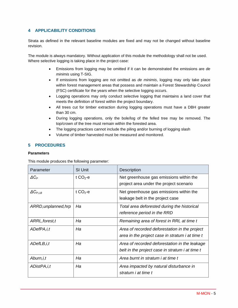
The module is always mandatory. Without application of this module the methodology shall not be used. Where selective logging is taking place in the project case:
• Emissions from logging may be omitted if it can be demonstrated the emissions are de minimis using T-SIG.
• If emissions from logging are not omitted as de minimis, logging may only take place within forest management areas that possess and maintain a Forest Stewardship Council (FSC) certificate for the years when the selective logging occurs.
• Logging operations may only conduct selective logging that maintains a land cover that meets the definition of forest within the project boundary.
• All trees cut for timber extraction during logging operations must have a DBH greater than 30 cm.
• During logging operations, only the bole/log of the felled tree may be removed. The top/crown of the tree must remain within the forested area.
• The logging practices cannot include the piling and/or burning of logging slash • Volume of timber harvested must be measured and monitored.
5 PROCEDURES
Parameters
This module produces the following parameter:
Parameter SI Unit Description
ΔCP t CO2-e Net greenhouse gas emissions within the project area under the project scenario
ΔCP,LB t CO2-e Net greenhouse gas emissions within the leakage belt in the project case
ARRD,unplanned,hrp Ha Total area deforested during the historical reference period in the RRD
ARRL,forest,t Ha Remaining area of forest in RRL at time t
ADefPA,i,t Ha Area of recorded deforestation in the project area in the project case in stratum i at time t
ADefLB,i,t Ha Area of recorded deforestation in the leakage belt in the project case in stratum i at time t
Aburn,i,t Ha Area burnt in stratum i at time t
ADistPA,i,t Ha Area impacted by natural disturbance in stratum i at time t

M-MON - 6
For the project area the net greenhouse gas emissions in the project case is equal to the sum of stock changes due to deforestation and degradation plus the total greenhouse gas emissions minus any eligible forest carbon stock enhancement:
( )∑∑= =
− ∆−+∆+∆+∆=∆*
1 1,,,,,,,,,,,,,,
t
t
M
itiEnhPtiEPtiDistPAPtiDegPtiDefPAPP CGHGCCCC
(1)
Where:
ΔCP Net greenhouse gas emissions within the project area under the project scenario; t CO2-e
ΔCP,DefPA,i,t Net carbon stock change as a result of deforestation in the project area in the project case in stratum i at time t; t CO2-e
ΔCP,Deg,i,t Net carbon stock change as a result of degradation in the project area in the project case in stratum i at time t; t CO2-e
ΔCP,DistPA,i,t Net carbon stock change as a result of natural disturbance in the project area in the project case in stratum i at time t; t CO2-e
GHGP-E,i,t Greenhouse gas emissions as a result of deforestation and degradation activities within the project area in the project case in stratum i in year t; t CO2-e
ΔCP,Enh,i,t Net carbon stock change as a result of forest growth and sequestration during the project in areas projected to be deforested in the baseline2 in stratum i at time t; t CO2-e
i 1, 2, 3 …M strata
t 1, 2, 3, … t* years elapsed since the start of the REDD project activity
For the leakage belt the net greenhouse gas emissions in the project case is equal to the sum of stock changes due to deforestation in the leakage belt:
∑∑= =
∆=∆t
t
M
itiDefLBPLBP CC
1 1,,,,
(2)
Where:
ΔCP,LB Net greenhouse gas emissions in the leakage belt in the project case; t CO2-e
ΔCP,DefLB,i,t Net carbon stock change as a result of deforestation in the leakage belt the project case in stratum i at time t; t CO2-e
i 1, 2, 3 …M strata in the project scenario
t 1, 2, 3, … t* years elapsed since the projected start of the REDD project activity
The calculation procedure is implemented by applying the following 3 steps:
STEP 1. Selection and analyses of sources of land-use and land-cover (LU/LC) change data
STEP 2. Interpretation and analyses
STEP 3. Documentation 2 For areas with a degradation baseline (i.e. using BL-DFW) this parameter shall be set to zero, for areas with
baseline set by BL-UP and BL-PL this parameter may be conservatively set to zero.

M-MON - 7
STEP 1. Selection and analyses of sources of land-use and land-cover (LU/LC) change data
Medium resolution remotely sensed spatial data shall be used3 (30m x 30m resolution or less, such as Landsat, Resourcesat-1 or Spot sensor data). In general, the same source of remotely sensed data and data analysis techniques must be used within the period for which the baseline is fixed. If remotely sensed data have become available from new and higher resolution sources (e.g. from a different sensor system) during this period then it is possible to change the source of the remotely sensed data. Equally if the same source is no longer available (e.g. due to satellites or sensors going out of service) an alternate source may be used. A change in source data may only occur if the images based on interpretation of the new data overlap the images based on interpretation of the old data by at least 1 year and they cross calibrate to acceptable levels based on commonly used methods in the remote sensing community.
The data collected and analyzed must cover:
• The entire reference region: data shall be available for the year of baseline renewal or no further in the past than the year prior to baseline renewal.
• The entire project area: data shall be available for the year in which monitoring and verification is occurring
• The entire leakage belt, where required: data shall be available for the year in which monitoring and verification is occurring
Processing LU/LC Change Data
The remotely sensed data collected must be prepared for analysis. Minimum pre-processing involves geometric correction and geo-referencing and cloud and shadow detection and removal. Guidance for interpretation of remote sensing imagery is given in the GOFC-GOLD 20084 Sourcebook for REDD and shall be followed as appropriate.
Post-processing and accuracy assessment
Post-processing is required to:
1. Map area change detected in the imagery.
2. Calculate the area of each category of change within the project area and, where required, the leakage belt. For periodical revisiting of the baseline, do this also for the reference region.
For the calculation of each category of change:
a) At the end of each monitoring period:
3 Guidance on the selection of data sources (such as remotely sensed data) can be found in Chapter 3A.2.4 of the
IPCC 2006 GL AFOLU and in GOFC-GOLD. (2008), Reducing greenhouse gas emissions from deforestation and degradation in developing countries: a sourcebook of methods and procedures for monitoring, measuring and reporting, GOFC-GOLD Report version COP13-2, (GOFC-GOLD Project Office, Natural Resources Canada, Alberta, Canada) – available at: http://www.gofc-gold.uni-jena.de/redd/sourcebook/Sourcebook_Version_June_2008_COP13.pdf (Section 3.2.4).
4 GOFC-GOLD, 2008, Reducing greenhouse gas emissions from deforestation and degradation in developing countries: a sourcebook of methods and procedures for monitoring, measuring and reporting, GOFC-GOLD Report version COP13-2, (GOFC-GOLD Project Office, Natural Resources Canada, Alberta, Canada) – available at: http://www.gofc-gold.uni-jena.de/redd/sourcebook/Sourcebook_Version_June_2008_COP13.pdf

M-MON - 8
• Calculate the area of each category within the project area and, where required, the leakage belt.
• Update the Forest Cover Benchmark Maps for the project area and leakage belt.
• Update the remaining area of forest in RRL (ARRL,forest,t)
b) Every 10 years (when the project baseline must be revisited) or every five years where conditions trigger more frequent baseline renewal:
• Calculate the area of each category within the reference region, project area and, where required, the leakage belt.
• Update the Forest Cover Benchmark Maps for the reference region, project area and leakage belt.
• Estimate the total area deforested during the historical reference period in the reference region for rate - RRD (ARRD,unplanned,hrp).
c) Estimating land-use and land-cover (LU/LC) change data in cloud-obscured areas:
Calculating the rate of deforestation when maps have gaps due to cloud cover is a challenge. As described in module BL-UP (Part 2, section 2.2.3) multi-date images must be used to reduce cloud cover to no more than 10% of any image. If the areas with 10% cloud cover in either date in question do not overlap exactly, then the rate must come from areas that were cloud free in both dates in question. This must be estimated in % per year. Then, a maximum possible forest cover map must be made for the most recent time period. The historical rate in % must be multiplied by the maximum forest cover area at the start of the period for estimating the total area of deforestation during the period.
The overall classification accuracy of the outcome of the previous steps must be 90% or more.
STEP 2. Interpretation and analyses
Monitoring deforestation
This step will produce an estimate of the emissions resulting from any deforestation that occurs within the project area and leakage belt (ΔCP,Def,i,t).
Many methods exist to detect and map deforestation using remotely sensed data. The method selected must be based on common good practice in the remote sensing field and will depend on available resources and the availability of image processing software. The same method must be used for the entire period for which the baseline is fixed. The key is that the method of analysis results in estimates of any deforestation that may occur in the project and leakage areas. See IPCC 2006 GL AFOLU, Chapter 3A.2.4 and the GOFC-GOLD 2008 Sourcebook for REDD for additional guidance.
The net carbon stock change as a result of deforestation is equal to the area deforested multiplied by the emission per unit area.
( )∑=
∆=∆U
utiuDefPpoolstiuDefPAtiDefPAP CAC
1,,,,,,,,,,, *
(3)

M-MON - 9
( )∑=
∆=∆U
utiuDefPpoolstiuDefLBtiDefLBP CAC
1,,,,,,,,,,, *
(4)
Where:
ΔCP,DefPA,i,t Net carbon stock change as a result of deforestation in the project case in the project area in stratum i at time t; t CO2-e
ΔCP,DefLB,i,t Net carbon stock change as a result of deforestation in the project case in the leakage belt in stratum i at time t; t CO2-e
ADefPA,u,i,t Area of recorded deforestation in the project area stratum i converted to land use u at time t; ha
ADefLB,u,i,t Area of recorded deforestation in the leakage belt stratum i converted to land use u at time t; ha
ΔCpools,Def,u,i,t Net carbon stock changes in all pools in the project case in land use u in stratum i at time t; t CO2-e ha-1
u 1,2,3,…U post-deforestation land uses
i 1, 2, 3 …M strata
t 1, 2, 3, … t* years elapsed since the start of the REDD project activity
The emission per unit area is equal to the difference between the stocks before and after deforestation minus any wood products created from timber extraction in the process of deforestation:
iWPipostPiBSLtiDefpools CCCC ,,,,,,, −−=∆
(5)
Where:
ΔCpools,Def,u,i,t Net carbon stock changes in all pools as a result of deforestation in the project case in land use u in stratum i at time t; t CO2-e ha-1
CBSL,i Carbon stock in all pools in the baseline case in stratum i; t CO2-e ha-1
CP,post,u,i Carbon stock in all pools in post-deforestation land use u in stratum i; t CO2-e ha-1
CWP,i Carbon stock sequestered in wood products from harvests in stratum i; t CO2-e ha-1
u 1,2,3,…U post-deforestation land uses
i 1, 2, 3 …M strata
t 1, 2, 3, … t* years elapsed since the start of the REDD project activity
For calculation of carbon stock sequestered in wood products, see the Module “Estimation of carbon stocks and changes in carbon stocks in the harvested wood products carbon pool in REDD project activities” (CP-W). It is conservative in the project case to assume no wood products are produced.
Instead of tracking annual emissions through burning and/or decomposition, this methodology employs the simplifying assumption that all carbon stocks are emitted in the year deforested and that no stocks are permanently sequestered (beyond 100 years after deforestation). This assumption applies regardless of

M-MON - 10
whether burning is employed as part of the forest conversion process or as part of post conversion land use activities.
For each post-deforestation land use (u) estimate the long-term carbon stock. Carbon stocks in the selected pools (must be the same as those used in the baseline modules) must be measured and estimated using the methods given in modules CP-AB, CP-D, CP-L, CP-S.
iBSLPDSOCiLIiDWitreenonBBitreenonABitreeBBitreeABiupost CCCCCCCC ,,,,,_,_,_,_,, −−− ++++++= (6)
Where:
CP,post,u,i Carbon stock in all pools in post-deforestation land use u in stratum i; t CO2-e ha-1
CAB_tree,i Carbon stock in aboveground tree biomass in stratum i; t CO2-e ha-1
CBB_tree,i Carbon stock in belowground tree biomass in stratum i; t CO2-e ha-1
CAB_non-tree,i Carbon stock in aboveground non-tree vegetation in stratum i; t CO2-e ha-1
CBB_non-tree,i Carbon stock in belowground non-tree vegetation in stratum i; t CO2-e ha-1
CDW,i Carbon stock in dead wood in stratum i; t CO2-e ha-1
CLI,i Carbon stock in litter in stratum i; t CO2-e ha-1
CSOC,PD-BSL,i Mean post-deforestation stock in soil organic carbon in the post deforestation stratum i; t CO2-e ha-1
u 1,2,3,…U post-deforestation land uses
i 1, 2, 3 …M strata in the in the project case
Carbon pools excluded from the project can be accounted as zero. Herbaceous non-tree vegetation is considered to be de minimis in all instances. For the determination which carbon pools must be included in the calculations as a minimum, use Tool T-SIG.
Monitoring degradation
At the time of methodology approval, remote sensing technology using optical sensors is not capable of direct measurements of biomass and changes thereof5 but has some capability to identify forest strata that have undergone a change in biomass6.
The key is that the monitoring method results in estimates of any emissions from degradation that may occur in the project area (ΔCP,Deg,i,t). This degradation and thus reduction of forest carbon stocks will result from either selective logging from forest management areas holding a FSC certificate or illegal extraction of trees for timber or for fuel and charcoal. As remote methods for monitoring degradation are not available at the time of methodology approval, the following ground-based methods must be used.
5 However, technology is developing rapidly, including techniques such as RADAR, SAR, or LiDAR. 6 For example, a multi-temporal set of remotely sensed data can be used to detect changes in the structure of the
forest canopy. A variety of techniques, such as Spectral Mixture Analysis (Souza et al. 2005), SAR or LiDAR, can be used under this approach but no specific technology is prescribed here. Some of the newer technologies can estimate carbon contents of forest types, if supported by field information such as sample plots to calibrate the technology and fieldwork leading to allometric equations of key species. Project proponents must use techniques that are suitable to their specific situation and that have been published in peer-reviewed papers.

M-MON - 11
For the project area, the net greenhouse gas emissions resulting from degradation is equal to the sum of stock changes due to degradation through extraction of trees for illegal timber or fuelwood and charcoal, and extraction of trees for selective logging from forest management areas possessing a FSC certificate:
tiSelLogPtiDegWPtiDegP CCC ,,,,,,,,, ∆+∆=∆
(7)
Where:
ΔCP,Deg,i,t Net carbon stock change as a result of degradation in the project area in the project case in stratum i at time t; t CO2-e
ΔCP,DegW,i,t Net carbon stock change as a result of degradation through extraction of trees for illegal timber or fuelwood and charcoal in the project area in the project case in stratum i at time t; t CO2-e
ΔCP,SelLog,i,t Net carbon stock change as a result of degradation through selective logging of FSC certified forest management areas in the project area in the project case in stratum i at time t; t CO2-e
i 1, 2, 3 …M strata
t 1, 2, 3, … t* years elapsed since the start of the REDD project activity
Degradation through extraction of trees for illegal timber or fuelwood and charcoal
The first step in addressing forest degradation is to complete a participatory rural appraisal (PRA) of the communities inside and surrounding the project area to determine if there is the potential for illegal extraction of trees to occur. If this assessment finds no potential pressure for these activities then degradation (ΔCP,DegW,i,t) can be assumed to be zero and no monitoring is needed. The PRA must to be repeated every 2 years.
If the results of the PRA suggest that there is a potential for degradation activities, then limited field sampling must be undertaken. First, the area that is potentially subject to degradation needs to be delineated (ADeg,i). An output of the PRA shall be a distance of degradation penetration from all access points (access buffer), such as roads and rivers or previously cleared areas, to the project area. The distance of degradation penetration will vary by form of degradation with a deeper penetration likely for illegal logging than for fuelwood/charcoal.
The area subject to degradation shall be delineated (ADegW,i) based on an access buffer from all access points, such as roads and rivers or previously cleared areas, to the project area, with a width equal to the distance of degradation penetration. ADegW,i shall be sampled by surveying several transects of known length and width across the access-buffer area (equal in area to at least 1% of ADegW,i ) to check whether new tree stumps are evident or not. If there is little to no evidence that trees are being harvested (see next paragraph on how to estimate emissions and use tool T-SIG to determine if significant or not) then degradation can be assumed to be zero and no monitoring is needed. This limited sampling must to be repeated each time the PRA indicates a potential for degradation.
If the limited sampling does provide evidence that trees are being removed in the buffer area, then a more systematic sampling must be implemented. The sampling plan must be designed using plots systematically placed over the buffer zone so that they sample at least 3% of the area of the buffer zone (ADegW,i). The diameter of all tree stumps will be measured and conservatively assumed to be the same as the DBH. If the stump is a large buttress, identify several individuals of the same species nearby and determine a ratio of the diameter at DBH to the diameter of buttress at the same height above ground as the measured stumps. This ratio will be applied to the measured stumps to estimate the likely DBH of the cut tree. The above and below ground carbon stock of each harvested tree must be estimated using the

M-MON - 12
same allometric regression equation and root to shoot ratio used in the module for estimating the carbon pool in trees (CP-AB) in the baseline scenario7. The mean above and below ground carbon stock of the harvested trees is conservatively estimated to be the total emissions and to all enter the atmosphere. This sampling procedure shall be repeated every 5 years and the results annualized by dividing the total emissions by five.
Where the PRA or the limited sampling indicate no degradation occurring:
0,,W, =∆ tiDegPC
Where the PRA and the limited sampling indicate degradation is occurring:
i
tiDegWiDegWtiDegWP AP
CAC ,,
,,,, *=∆
(8)
Where:
ΔCP,DegW,i,t Net carbon stock changes as a result of degradation in stratum i in the project area at time t; t CO2-e
ADegW,i Area potentially impacted by degradation processes in stratum i; ha
CDegW,i,t Biomass carbon of trees cut and removed through degradation process from plots measured in stratum i at time t; t CO2-e
APi Total area of degradation sample plots in stratum i; ha
i 1, 2, 3 …M strata
t 1, 2, 3, … t* years elapsed since the start of the REDD project activity
Monitoring degradation due to selective logging of forest management areas possessing a FSC certificate
The calculation procedure for estimating net ex post emissions and removals related to selective logging activities in the project case will be equal to the summed emissions arising from selective logging operations. Emissions resulting from selective logging may be omitted if they are deemed de minimis through the use of the module T-SIG.
The net emissions in the project case are estimated by combining:
• Emissions arising from logging gap: encompass emissions from felling timber tree and emissions from incidental damage caused by falling timber tree,
• Emissions from infrastructure: from constructing logging infrastructure for removal of timber, such as haul roads, skid trails and logging decks,
• Removals from long term wood products resulting from timber extraction
7 If species-specific equations are used in the baseline and species cannot be identified from stumps then it shall
be assumed that the harvested species is the species most commonly harvested for the specific degradation purpose (e.g. fuelwood, charcoal or timber). A PRA shall be used to determine the most commonly harvested species

M-MON - 13
( )∑=
−+=∆t
ttiWPtiLRtiLGtiSelLogP CCCC
1,,,,,,,,, (9)
Where
ΔCP,SelLog,i,t Net carbon stock change as a result of degradation through selective logging of FSC certified forest management areas in the project area in the project case in stratum i at time t; t CO2-e
CLG,i,t Actual net project emissions arising in the logging gap in stratum i at time t; t CO2-e
CLR,i,t Actual net project emissions arising from logging infrastructure in stratum i at time t; t CO2-e
CWP i,t Carbon stock in wood products pool from stratum i, at time t; t CO2-e
t 1, 2, 3 … t years elapsed since the start of the project activity
Emissions arising in the logging gap
In the project case, emissions occur as a direct result of the death of the timber tree and due to the death of trees killed when the timber tree is felled.
Where the logging operations and management techniques vary across the project area, or where logging will take place in both broadleaf/ mixed forests and coniferous forests stratification shall occur. The net emission in the project case is equal to the biomass of the wood extracted plus the logging damage factor multiplied by the extracted volume, summed across strata:
))1244**((
1,,,,,,,,, ∑
=
+=Z
ztizEXTiztizEXTtiLG VLDFCC (10)
Where
CLG,i,t Actual net project emissions arising in the logging gap , in stratum i at time t; t CO2-e
CEXT, z,i,t Biomass carbon stock of timber extracted within the project boundary for logging stratum z, in stratum i at time t; t CO2-e
LDFz,i Logging damage factor for logging stratum z, in stratum i; t C m-3
VEXT,z,i,t Volume extracted from logging stratum z, in stratum i at time t; m3
Z 1,2,3…Z logging strata
i 1, 2, 3 … M strata
t 1, 2, 3 … t years elapsed since the start of the project activity

M-MON - 14
Calculate the biomass of the total volume extracted from within each logging stratum:
)1244***(
1,,,,,,, j
S
jjtizjEXTtizEXT CFDVC ∑
=
= (11)
Where:
CEXT,z,i,t Biomass carbon stock of timber extracted within the project boundary for logging stratum z, in stratum i at time t; t CO2-e
VEXT,j,z,i,t The volume of timber extracted of species j for logging stratum z, in stratum i at time t; m3
Dj Basic wood density of species j; t d.m.m-3
CFj Carbon fraction of biomass for tree species j; t C t-1 d.m.
z 1,2,3…Z logging strata
j 1, 2, 3 … SPS tree species
t 1, 2, 3 … t years elapsed since the start of the project activity
The logging damage factor (LDF) is a representation of the quantity of emissions that will ultimately arise per unit of extracted timber (m3). These emissions arise from the noncommercial portion of the felled trees (the branched and stump) and trees incidentally killed during felling.
For broadleaf and mixed forests a default value of 0.67 t C m-3 may be used8.
For coniferous forests in the country of Mexico a default value of 0.28 t C m-3 may be used9.
For all other forest types, field measurements must be taken for each logging stratum z following the methods delineated in Annex II.
Emissions arising through logging infrastructure
The net emission in the project case is equal to the sum of emissions resulting from skid trails, roads, and logging decks created for selective logging operations.
tiDECKStiROADtiSKIDtiLR CCCC ,,,,,,,, ∆+∆+∆= (12)
Where
CLR,i,t Actual net project emissions arising from logging infrastructure in stratum i at time t; t CO2-e
∆CSKID,i,t Change in carbon stock resulting from skid trail creation in stratum i at time t; t CO2-e
8 These default values come from the slope of the regression equation between carbon damaged and volume extracted based on 774 logging gaps measured by Winrock International in Bolivia, Belize, the Republic of Congo, Brazil, and Indonesia (Annex I). 9 These default values come from the slope of the regression equation between carbon damaged and volume extracted based on 134 logging gaps in Mexico (Annex I).

M-MON - 15
∆CROAD,i,t Change in carbon stock resulting from logging road creation in stratum i at time t; t CO2-e
∆CDECKS,i,t Change in carbon stock resulting from logging deck creation in stratum i at time t; t CO2-e
i 1, 2, 3 … M strata
t 1, 2, 3 … t years elapsed since the start of the project activity
Skid Trails:
The emissions from the creation of skid trails is estimated by multiplying the total length of skid trails created and a skid trail emission factor.
itiSKIDtiSKID SKLC *,,,, =∆ (13)
Where
∆CSKID,i,t Change in carbon stock resulting from skid trail creation in stratum i at time t; t CO2-e
LSKID,i,t Length of skid trails in stratum i at time t; m
SKi Skid trail emissions factor (Average emissions resulting from dead wood created in the process of skid trail creation per length of skid trail) in stratum i; t CO2-e m-1
t 1, 2, 3 … t years elapsed since the start of the project activity
It is assumed that the machinery used to create the skid trail kills all aboveground and belowground tree and non-tree biomass located within the path of the skid trail. This biomass becomes deadwood and is assumed to be immediately emitted.
Under this method, the maximum diameter tree that can be within the path of a skid trail and therefore destroyed when the bulldozer, skidder, or other machinery used creates the skid trail must be known and documented. The average carbon stock of trees below this maximum size is then estimated using a subset of baseline field measurements. Alternatively, it can be assumed that all diameter trees are destroyed and therefore the aboveground and belowground tree biomass destroyed by the skidder equates to the mean aboveground biomass carbon stock of trees in the stratum. The uncertainty in carbon stocks estimates and resulting emissions must be included in the estimation of with-project scenario uncertainty calculations performed using the module X-UNC (VMD0017) during each verification event unless indisputably conservative estimates are used10.
SKIDiskSOCidesti WCCSK *000,101*)( ,,, ∆+=
(14)
itreenonBBitreenonABidesttreeBBidesttreeABidest CCCCC ,_,_,__,__, −− +++= (15)
10 Based on verifiable literature sources or expert judgment.

M-MON - 16
Where:
SK,i Skid trail emission factor (Average emissions resulting from dead wood created in the process of skid trail creation per length of skid trail) in stratum i; t t CO2-e m-1
Cdest, i Mean live carbon stock of trees and non-tree biomass assumed to be killed per unit area in creation of skid trail in stratum i; t CO2-e ha-1
∆CSOC_sk,i Carbon stock change in organic carbon resulting from skid trail creation in stratum i; t CO2-e ha-1
WSKID Mean width of skid trails in stratum i; m
CAB_tree_dest,i Carbon stock in aboveground tree biomass assumed to be killed per unit area resulting from the creation of the skid trail in stratum i; t CO2-e ha-1
CBB_tree_dest,i Carbon stock in belowground tree biomass assumed to be killed per unit area resulting from the creation of the skid trail in stratum i; t CO2-e ha-1
CAB_non-tree,i Carbon stock in aboveground non-tree biomass in stratum i; t CO2-e ha-1
CBB_non-tree,i Carbon stock in belowground non-tree biomass in stratum i; t CO2-e ha-1
1/10,000 Conversion of units from hectares to m2
i 1, 2, 3 … M strata
Emissions from the soil pool due to the creation of the skid trail are conservatively estimated based on the methods defined in the IPCC 2006GL11:
( )iMGLUtiSOCtiSOCiskSOC FFFCCC ***0,,0,,,_ == −=∆ (16)
Where:
∆CSOC_sk,i Carbon stock change in soil organic carbon resulting from skid trail creation in stratum i; t CO2-e ha-1
CSOC,i,t=0 Mean carbon stock in soil organic carbon for stratum i, at time t=0; t CO2-e ha-1
FLU land use factor before or after conversion; dimensionless
FMG management factor before or after conversion; dimensionless
FI input factor before or after conversion; dimensionless
i 1, 2, 3, … M strata
t 1, 2, 3, …t* years elapsed since the projected start of the REDD project activity
Logging Roads:
The emissions resulting from the creation of roads is determined by multiplying the area of roads created in each stratum by the carbon stock. Methods to estimate the area of roads are delineated in the parameter tables. The uncertainty in carbon stocks estimates and resulting emissions must be included in
11 http://www.ipcc-nggip.iges.or.jp/public/2006gl/pdf/4_Volume4/V4_05_Ch5_Cropland.pdf

M-MON - 17
the estimation of with-project scenario uncertainty calculations performed using the module X-UNC (VMD0017) during each verification event unless indisputably conservative estimates are used12.
iBSLtiROADtiROAD CAC ,,,,, *=∆ (17)
Where
∆CROAD,i,t Change in carbon stock resulting from logging road creation in stratum i at time t; t CO2-e
AROAD,i,t Area of roads in stratum i at time t; ha
CBSL,i Carbon stock in all pools in the baseline case in stratum i; t CO2-e ha-1
i 1, 2, 3 … M strata
t 1, 2, 3 … t years elapsed since the start of the project activity
Logging Decks:
The emissions per unit of extraction from logging decks is determined by measuring the area of logging decks created in each stratum. The area is multiplied by the carbon stock. Methods to estimate the area of logging decks are delineated in the parameter tables. The uncertainty in carbon stocks estimates and resulting emissions must be included in the estimation of with-project scenario uncertainty calculations performed using the module X-UNC (VMD0017) during each verification event unless indisputably conservative estimates are used13.
iBSLtiDECKStiDECKS CAC ,,,,, *=∆ (18)
Where
∆CDECKS,i,t Change in carbon stock resulting from logging deck creation in stratum i at time t; t CO2-e
ADECKS,i,t Area of logging decks in stratum i at time t; ha
CBSL,i Carbon stock in all pools in the baseline case in stratum i; t CO2-e ha-1
i 1, 2, 3 … M strata
t 1, 2, 3 … t years elapsed since the start of the project activity
Emissions from Harvested Wood Products
To calculate the carbon stock in wood products pool for each stratum, apply the most recent version of the approved VCS Module: “VMD0005 REDD Methodological Module: Estimation of carbon stocks in the long-term wood products pool (CP-W)”.
Monitoring areas undergoing natural disturbance
Where natural disturbances occur ex-post in the project area such as tectonic activity (earthquake, landslide, volcano), extreme weather (hurricane), pest, drought, or fire that result in a degradation of
12 Based on verifiable literature sources or expert judgment. 13 Based on verifiable literature sources or expert judgment.

M-MON - 18
forest carbon stocks, the area disturbed shall be delineated and the resulting emissions estimated. Emissions resulting from natural disturbances may be omitted if they are deemed de minimis through the use of the module T-SIG.
The net carbon stock change as a result of the disturbance is equal to the area disturbed multiplied by the emission per unit area. In situations where the impact of disturbances on forest carbon stocks in a stratum varies spatially, the stratum may be further stratified based on post-natural disturbance carbon stocks14. Where this occurs, such stratification by carbon stocks shall be maintained for the project life.
Where the disturbance event occur ex-post in the project area, the area disturbed shall be delineated and the area of each post-disturbance stratum must be delineated. The area disturbed in the with-project scenario shall be tracked directly using the guidance provided in Step 1 of this methodology.
For planned deforestation the sum of ADistPA,q,i,t shall be equal to the area of overlap between the delineated area of the disturbance and the summed area of planned deforestation in the project area (D%planned,i,t * Aplanned,i), summed to the year in which the disturbance occurred.
For unplanned deforestation the sum of ADistPA,q,i,t shall be equal to the area of overlap between the delineated area of the disturbance and the summed area of unplanned deforestation in the project area (ABSL,PA,unplanned,t), summed to the year in which the disturbance occurred.
For degradation through firewood/charcoal extraction only a proportion of baseline carbon stocks are removed from the forest in the baseline. The impact of the project on emissions from subsequent disturbance is therefore equal to the difference in stocks between the baseline before and after fuelwood harvest. Thus the delineated area of the sum of disturbance (ADistPA,q,i,t) shall be proportionally reduced to reflect the less than complete impact of the baseline activity on available stocks to be disturbed in the baseline case. The reduction factor shall be equal to:
( )( )( ) ( )iBSLimntiBSL CACFDFGtorductionFaccenDisturbanDegradatio ,,, *12/44**9.0*Re =
(19)
Where:
DegradationDisturbanceReductionFactor
Factor by which Adist,q,i,t is reduced to reflect the impact of the baseline degradation on available stocks for reduction due to disturbance; dimensionless
FGBSL,i,t Average projected volume of fuelwood to be gathered in the project area in the baseline scenario in stratum i in year t; m3
Dmn Mean wood density of species harvested for fuelwood or charcoal production; t d.m.m-3
CF Carbon fraction of dry matter; t C t d.m.-1
Ai Area of stratum i; ha
CBSL,i Carbon stock in all pools in the baseline in stratum i; t CO2-e ha-1
i 1, 2, 3 …M strata

M-MON - 19
t 1, 2, 3, … t* years elapsed since the projected start of the REDD project activity
( )∑=
∆=∆Q
qtiqDistPtiqDisPAtiDistPAP CAC
1,,,,,,,,,, *
(20)
Where:
ΔCP,DistPA,i,t Net carbon stock change as a result of natural disturbance in the project case in the project area in stratum i at time t; t CO2-e
ADistPA,q,i,t Area impacted by natural disturbance in post-natural disturbance stratum q in stratum i, at time t; ha
ΔCP,Dist,q,i,t Net carbon stock changes in pools as a result of natural disturbance in post-natural disturbance stratum q in stratum i at time t; t CO2-e ha-1
q 1,2,3,…Q post-natural disturbance strata
i 1, 2, 3 …M strata
t 1, 2, 3, … t* years elapsed since the start of the REDD project activity
Where the natural disturbance that took place in post-natural disturbance stratum q included fire, the area burned shall be assumed to be equal to the area impacted by natural disturbance in post-natural disturbance stratum q. Therefore:
∑=
=Q
qtiqburntiburn AA
1,,,,,
(21)
tiqDisPAtiqburn AA ,,,,,, = for stratum where the natural disturbance included fire
(22)
Where:
ADistPA,q,i,t Area impacted by natural disturbance in post-natural disturbance stratum q in stratum i, at time t; ha
Aburn,q,i,t Area burnt in post-natural disturbance stratum q in stratum i, at time t; ha
q 1,2,3,…Q post-natural disturbance strata where the natural disturbance included fire
i 1, 2, 3 …M strata
t 1, 2, 3, … t* years elapsed since the start of the REDD project activity
Emissions from any fires shall be calculated using E-BB and included calculated in ‘Section 5.2.5 Monitoring project emissions’.
The emission per unit area is equal to the difference between the stocks before and the stocks after the natural disturbance minus any wood products created from timber extraction following the natural disturbance:
iqWPiqDistPiBSLtiqDistP CCCC ,,,,,,,,,, −−=∆
(23)
M-MON - 20
Where:
ΔCP,Dist,q,i,t Net carbon stock changes in pools as a result of natural disturbance in the project case in post-natural disturbance stratum q in stratum i at time t; t CO2-e ha-1
CBSL,i Carbon stock in all pools in the baseline case in stratum i; t CO2-e ha-1
CP,Dist,q,i Carbon stock in pools in post-natural disturbance strata q in stratum i; t CO2-e ha-1
CDist, WP,q,i Carbon stock sequestered in wood products from harvests following natural disturbance in post-natural disturbance stratum q, in stratum i; t CO2-e ha-1
q 1,2,3,…Q post-natural disturbance strata
i 1, 2, 3 …M strata
t 1, 2, 3, … t* years elapsed since the start of the REDD project activity
For calculation of carbon stock sequestered in wood products, see the Module “Estimation of carbon stocks and changes in carbon stocks in the harvested wood products carbon pool in REDD project activities” (CP-W). It is conservative in the project case to assume no wood products are produced.
Instead of tracking annual emissions through burning and/or decomposition, this methodology employs the simplifying assumption that all carbon stocks are emitted in the year the natural disturbance occurs and that no stocks are permanently sequestered (beyond 100 years after deforestation).
For each post-natural disturbance stratum (q) estimate the carbon stock following the natural disturbance. Carbon stocks must be measured and estimated using the methods given in module CP-AB, CP-D, CP-L, and CP-S. The uncertainty in carbon stocks estimates and resulting emissions must be included in the estimation of with-project scenario uncertainty calculations performed using the module X-UNC (VMD0017) during each verification event unless indisputably conservative estimates are used15. Alternatively, it can be conservatively assumed that a post-natural disturbance live and dead vegetation pool is equal to zero. Where the natural disturbance does not result in the conversion of forest to non-forest land cover and where the land use will not change as a result of the natural disturbance, soil carbon stocks following the natural disturbance can be assumed to equal baseline soil carbon stocks (CSOC,BSL,i = CSOC,q,i). Where the natural disturbance does result in the conversion of forest to non-forest land cover , the mean post-natural disturbance soil organic may be assumed to equal post-deforestation soil organic carbon and estimated using the methods given in the module CP-S. Alternatively, the post-natural disturbance soil organic carbon pool can be assumed to equal zero.
iSOCiLIiDWitreenonBBitreenonABitreeBBitreeABiqDistP CCCCCCCC ,,,,_,_,_,_,,, ++++++= −− (24)
Where:
CP,Dist,q,i Carbon stock in all pools in post-natural disturbance q in baseline stratum i; t CO2-e ha-1
CAB_tree,i Carbon stock in aboveground tree biomass in stratum i; t CO2-e ha-1
CBB_tree,i Carbon stock in belowground tree biomass in stratum i; t CO2-e ha-1
CAB_non-tree,i Carbon stock in aboveground non-tree vegetation in stratum i; t CO2-e ha-1
CBB_non-tree,i Carbon stock in belowground non-tree vegetation in stratum i; t CO2-e ha-1
CDW,i Carbon stock in dead wood in stratum i; t CO2-e ha-1 15 Based on verifiable literature sources or expert judgment.

M-MON - 21
CLI,i Carbon stock in litter in stratum i; t CO2-e ha-1
CSOC,i Mean stock in soil organic carbon in stratum i; t CO2-e ha-1
q 1,2,3,…Q post-natural disturbance strata
i 1, 2, 3 …M strata
Carbon pools excluded from the project can be accounted as zero. Herbaceous non-tree vegetation is considered to be de minimis in all instances. For the determination which carbon pools must be included in the calculations as a minimum, use Tool T-SIG.
Monitoring areas undergoing carbon stock enhancement
This sub-step is only applicable for project areas with a deforestation baseline (planned or unplanned).
If during initial stratification (using X-STR) the project contains forest areas that are both deforested in the baseline and assumed to be accumulating carbon, then their geographic boundaries will be known—this will be one or more of the strata. The system in place for monitoring the project area will be used for monitoring any changes that occur in this stratum (or strata). Ground measurements will be used to monitor the change in carbon stocks through time as given in the carbon pool modules.
It is conservative to assume that no carbon stock enhancement is occurring. Projects may elect to set ∆CP,Enh,i,t = 0.
If any of the strata identified as accumulating carbon are subject to degrading activities described in 5.2.2 above, the emissions from these activities will be estimated according to the methods given in 5.2.2 and deducted from the amount estimated to be sequestered in the accumulation areas to generate a net estimation of carbon sequestration or emission.
For a planned deforestation baseline:
( )( )∑∑= =
−=∆t
t
M
itiPLEnhiBSLtiPtiEnhP ACCC
1 1,,,,,,,,, *
(25)
Where:
ΔCP,Enh,i,t Net carbon stock changes as a result of forest carbon stock enhancement in stratum i in the project area at time t; t CO2-e
CP,i,t Carbon stock in all pools in the project case in stratum i at time t; t CO2-e
CBSL,i Carbon stock in all pools in the baseline in stratum i; t CO2-e ha-1
AEnh,PL,i,t Project area in stratum i in which carbon stocks are accumulating but that would have undergone planned deforestation in the baseline scenario at time t; ha
i 1, 2, 3 …M strata
t 1, 2, 3, … t* years elapsed since the start of the REDD project activity
The eligible area is determined from area due to be deforested in each year of the baseline (see BL-PL).

M-MON - 22
tiplannedtiplannedtiPLEnh ADA ,,,,,,, *%=
(26)
Where:
AEnh,PL,i,t Project area in stratum i in which carbon stocks are accumulating but that would have undergone planned deforestation in the baseline scenario at time t; ha
D%planned,i,t Projected annual proportion of land that will be deforested in stratum i at time t; %
Aplanned,i, Total area of planned deforestation over the entire project lifetime for stratum i; ha
i 1, 2, 3 …M strata
t 1, 2, 3, … t* years elapsed since the projected start of the REDD project activity
For an unplanned deforestation baseline:
( )( )∑∑= =
−=∆t
t
M
itiUPEnhiBSLtiPtiEnhP ACCC
1 1,,,,,,,,, *
(27)
Where:
ΔCP,Enh,i,t Net carbon stock changes as a result of forest carbon stock enhancement in stratum i at time t; t CO2-e
CP,I,t Carbon stock in all pools in the project case in stratum i at time t; t CO2-e
CBSL,i Carbon stock in all carbon pools in stratum i; t CO2-e ha-1
AEnh,UP,i,t Project area in stratum i in which carbon stocks are accumulating but that would have undergone unplanned deforestation in the baseline scenario at time t; ha
i 1, 2, 3 …M strata
t 1, 2, 3, … t* years elapsed since the projected start of the REDD project activity
The eligible area is determined from area due to be deforested in each year of the baseline (see BL-UP).
tunplannedPABSLtiUPEnh AA ,,,,,, =
(28)
Where:
AEnh,UP,i,t Project area in stratum i in which carbon stocks are accumulating but that would have undergone unplanned deforestation in the baseline scenario at time t; ha
ABSL,PA,unplanned,t Annual area of unplanned baseline deforestation in the Project Area at time t; ha yr-1
i 1, 2, 3 …M strata
t 1, 2, 3, … t* years elapsed since the start of the REDD project activity

M-MON - 23
For both planned and unplanned baselines the carbon stock in the with-project case is equal to:
iSOCiLIiDWitreenonBBitreenonABitreeBBitreeABtiP CCCCCCCC ,,,,_,_,_,_,, ++++++= −− (29)
Where:
CP,i,t Carbon stock in all pools in the project case in stratum i at time t; t CO2-e
CAB_tree,i Carbon stock in aboveground tree biomass in the project case in stratum i; t CO2-e ha-1
CBB_tree,i Carbon stock in belowground tree biomass in the project case in stratum i; t CO2-e ha-1
CAB_non-tree,i Carbon stock in aboveground non-tree vegetation in stratum i; t CO2-e ha-1
CBB_non-tree,i Carbon stock in belowground non-tree vegetation in stratum i; t CO2-e ha-1
CDW,i Carbon stock in dead wood in the project case in stratum i; t CO2-e ha-1
CLI,i Carbon stock in litter in the project case in stratum i; t CO2-e ha-1
CSOC,i Carbon stock in soil organic carbon in the project case in stratum i; t CO2-e ha-1
i 1, 2, 3 …M strata
t 1, 2, 3, … t* years elapsed since the start of the REDD project activity
Carbon pools excluded from the project can be accounted as zero. Herbaceous non-tree vegetation is considered to be de minimis in all instances. For the determination which carbon pools must be included in the calculations as a minimum, see Tool T-SIG.
Monitoring project emissions
Where significant, non-CO2 gas greenhouse emissions occurring within the project boundary must be evaluated. For example, where deforestation or degradation occur within the project boundaries or in the leakage belt and fire is used as a means of forest clearance the non-CO2 emissions may be significant. For the determination which emissions must be included in the calculations as a minimum, see Tool T-SIG. Emissions are calculated through applying E-BB, E-FCC and E-NA.
tiNdirecttinBiomassBurtiFCtiEP ONEEGHG ,,2,,,,,,, −++= (30)
Where:
GHGP,E,i,t Greenhouse gas emissions as a result of deforestation activities within the project area in the project case in stratum i in year t; t CO2-e
EFC,i,t Emission from fossil fuel combustion in stratum i within the project area in year t; t CO2-e
EBiomassBurn,i,t Non-CO2 emissions due to biomass burning in stratum i in year t; t CO2-e
N2Odirect-N,i,t Direct N2O emission as a result of nitrogen application on the alternative land use in stratum i within the project area in year t; t CO2-e
i 1, 2, 3 …M strata
t 1, 2, 3 …t* years elapsed since the start of the REDD VCS project activity

M-MON - 24
STEP 3. Documentation
A consistent time-series of data on land use-change, and emissions and removals of CO2 must emerge from periodic monitoring. This is only possible if a consistent methodology is applied over time.
The methodological procedures used in steps 1-2 above must be documented. In particular, the following information must be provided when remotely sensed data are used:
a. Data sources and pre-processing: Type, resolution, source and acquisition date of the remotely sensed data (and other data) used; geometric, radiometric and other corrections performed, if any; spectral bands and indexes used (such as NDVI); projection and parameters used to geo-reference the images; error estimate of the geometric correction; software and software version used to perform tasks; etc.
b. Data classification: Definition of the classes and categories; classification approach and classification algorithms; coordinates and description of the ground-truth data collected for training purposes; ancillary data used in the classification, if any; software and software version used to perform the classification; additional spatial data and analysis used for post-classification analysis, including class subdivisions using non-spectral criteria, if any; etc.
c. Classification accuracy assessment: Accuracy assessment technique used; coordinates and description of the ground-truth data collected for classification accuracy assessment; and final classification accuracy assessment.
d. Changes in Data sources and pre-processing / Data classification: If in subsequent periods changes will be made to the original data or use of data:
• Each change and its justification must be explained and recorded; and
• When data from new satellites are used documentation must follow a) to c) above
6 PARAMETERS
6.1. Data and Parameters Not Monitored
Data / Parameter: Regional Forest Cover / Non-Forest Cover Benchmark Map
Data Unit:
Description: Map showing the location of forest land within the reference region at the beginning of the project crediting period
Source of data: Remote sensing in combination with GPS data collected during ground truthing
Justification of choice of data or description of measurement methods and procedures applied:
The minimum map accuracy must be 90% for the classification of forest/non-forest in the remote sensing imagery If the classification accuracy is less than 90% then the map is not acceptable for further analysis. More remote sensing data and ground truthing data will be needed to produce a product that reaches the 90% minimum mapping accuracy.
Frequency: At a minimum three times over the ten years leading up to baseline renewal
Any comment:
Used in equations: 3
M-MON - 25
Data / Parameter: Project Forest Cover Benchmark Map
Data Unit:
Description: Map showing the location of forest land within the project area at the beginning of each monitoring period. If within the Project Area some forest land is cleared, the benchmark map must show the deforested areas at each monitoring event
Source of data: Remote sensing in combination with GPS data collected during ground truthing
Justification of choice of data or description of measurement methods and procedures applied:
The minimum map accuracy must be 90% for the classification of forest/non-forest in the remote sensing imagery. If the classification accuracy is less than 90% then the map is not acceptable for further analysis. More remote sensing data and ground truthing data will be needed to produce a product that reaches the 90% minimum mapping accuracy.
Frequency: At a minimum every ten years prior to baseline renewal
Any comment: Where forest land contains more than one forest class, the map must be stratified into forest classes using module X-STR.
Used in equations: 3, 8
Data / Parameter: Leakage Belt Forest Cover Benchmark Map
Data Unit:
Description: Map showing the location of forest land within the leakage belt area at the beginning of each monitoring period. Only applicable where leakage is to be monitored in a leakage belt
Source of data: Remote sensing in combination with GPS data collected during ground truthing.
Justification of choice of data or description of measurement methods and procedures applied:
The minimum map accuracy must be 90% for the classification of forest/non-forest in the remote sensing imagery.
If the classification accuracy is less than 90% then the map is not acceptable for further analysis. More remote sensing data and ground truthing data will be needed to produce a product that reaches the 90% minimum mapping accuracy.
Frequency: At a minimum every ten years prior to baseline renewal
Any comment: Where forest land contains more than one forest class, the map must be stratified into forest classes using module X-STR.
Used in equations: 3
Data / Parameter: Ai
Data Unit: ha
Description: Area of stratum i
Source of data:

M-MON - 26
Justification of choice of data or description of measurement methods and procedures applied:
Frequency: At a minimum every ten years prior to baseline renewal
Any comment: Ex-ante it shall be assumed that strata area will remain constant
Used in equations: 19
Data / Parameter: ARRD,unplanned,hrp
Data Unit: Ha
Description: Total area deforested during the historical reference period in the RRD
Source of data: Remote sensing imagery
Justification of choice of data or description of measurement methods and procedures applied:
Frequency: At a minimum every ten years prior to baseline renewal
Any comment: Monitored for the purpose of baseline revisions
Used in equations:
Data / Parameter: CF
Data Unit: t C t-1 d.m.
Description: Carbon fraction of dry matter
Source of data: Default value 0.47 t C t-1 d.m. can be used, or species specific values from the literature (e.g. IPCC 2006 INV GLs AFOLU Chapter 4 Table 4.3)
Justification of choice of data or description of measurement methods and procedures applied:
Any comment:
Used in equations: 19
Data / Parameter: CFj
Data Unit: t C t-1 d.m.
Description: Carbon fraction of biomass for tree species j
Source of data: Species- or family-specific values from the literature (e.g. IPCC 2006 INV GLs AFOLU Chapter 4 Table 4.3) shall be used if available, otherwise default value of 0.47 t C t-1 d.m. can be used.
Justification of choice of data or description of measurement methods and procedures applied:
Any comment: Where new species are encountered in the course of monitoring, new carbon fraction values must be sourced from the literature or otherwise use the default value.

M-MON - 27
Used in equations: 11, 35, 37
Data / Parameter: Dj
Data Unit: t d.m. m-3
Description: Basic wood density in t d.m. m-3 for species j
Source of data: The source of data shall be chosen with priority from higher to lower preference as follows:
(a) National species-specific or group of species-specific (e.g. from National GHG inventory);
(b) Species-specific or group of species-specific from neighboring countries with similar conditions. Sometimes (b) may be preferable to (a);
(c) Global species-specific or group of species-specific (e.g. IPCC 2006 INV GLs AFOLU Chapter 4 Tables 4.13 and 4.14).
Species-specific wood densities may not always be available, and may be difficult to apply with certainty in the typically species rich forests of the humid tropics, hence it is acceptable practice to use wood densities developed for forest types or plant families or species groups.
Justification of choice of data or description of measurement methods and procedures applied:
N/A
Any comment: Where using wood densities developed outside of the project country (cases (b) and (c) above under Source of data), wood densities must be validated with either limited destructive sampling or direct measurement of wood hardness (e.g. with a Pilodyn wood tester) in the field and correlating with wood density. Samples or measurements must be from 20-30 trees. For validation of mean forest type or species group wood densities, representation of species in the sample must be proportional to their occurrence in terms of basal area or volume in the project area (not abundance or stem density). Samples must provide representation across the length of the tree. Wood samples are cut in discs and thickness and diameter measured to calculate green volume. Samples are oven dried (70o C) to a constant weight in the laboratory, and density calculated as dry weight (g) per unit green volume (cm3). If the density of the samples/measurements (or mean density in the case of forest type or species group means) is within ±10% of the selected density values, then the selected density values may be used. Otherwise, a new density value must be developed with more extensive sampling, using the validation samples as a base. Where new species are encountered in the course of monitoring, new wood density values must be sourced from the literature and validated, if necessary, as per requirements and procedures above.
Used in equations: 11, 37

M-MON - 28
Data / Parameter: Dmn
Data Unit: t d.m.m-3
Description: Mean wood density of commercially harvested species
Source of data: The source of data shall be chosen with priority from higher to lower preference as follows:
(a) Averaged national and commercial species-specific (e.g. from National GHG inventory or site specific measurements);
(b) Averaged commercial species-specific from neighboring countries with similar conditions. Sometimes (b) may be preferable to (a).
(c) Averaged regional commercial species-specific (e.g. Table 4.13 IPCC National Guidance for Greenhouse Gas Inventories AFOLU Section).
(d) Regional average (0.58 t d.m.m-3- tropical Africa; 0.60 t d.m.m-3- tropical America; 0.57 d.m.m-3- tropical Asia) from Brown, S. 1997. Estimating Biomass and Biomass Change of Tropical Forests: a Primer. For the Food and Agriculture Organization of the United Nations. Rome, 1997. FAO Forestry Paper - 134. ISBN 92-5-103955-0.
Justification of choice of data or description of measurement methods and procedures applied:
Any comment:
Used in equations: 19
Data / Parameter: fj (X,Y)
Data Unit: t d.m. tree-1
Description: Allometric equation for species j linking measured tree variable(s) to aboveground biomass of living trees, expressed as t d.m. tree-1
Source of data: Allometric equation for species j linking measured tree variable(s) to aboveground biomass of living trees, expressed as t d.m. tree-1 Equations must have been derived using a wide range of measured variables (e.g. DBH, Height, etc.) based on datasets that comprise at least 30 trees. Equations must be based on statistically significant regressions and must have an r2 that is ≥ 0.8.
The source of equation(s) shall be chosen with priority from higher to lower preference, as available, as follows:
(a) National species-, genus-, family-specific;
(b) Species-, genus-, family-specific from neighboring countries with similar conditions (i.e. broad continental regions);
(c) National forest-type specific;
(d) Forest-type specific from neighboring countries with similar conditions (i.e. broad continental regions);

M-MON - 29
(e) Pan-tropical forest type-specific
such as those provided Tables 4.A.1 to 4.A.3 of the GPG-LULUCF (IPCC 2003) or in Pearson, T., Walker, S. and Brown, S. 2005. Sourcebook for Land Use, Land-Use Change and Forestry Projects. Winrock International and the World Bank Biocarbon Fund. 57pp. Available at: http://www.winrock.org/Ecosystems/files/Winrock-BioCarbon_Fund_Sourcebook-compressed.pdf
or in
Chave, J., C. Andalo, S. Brown, M. A. Cairns, J. Q. Chambers, D. Eamus, H. Folster, F. Fromard, N. Higuchi, T. Kira, J.-P. Lescure, B. W. Nelson, H. Ogawa, H. Puig, B. Riera, T. Yamakura. 2005. Tree allometry and improved estimation of carbon stocks and balance in tropical forests. Oecologia 145: 87-99.
Species-, genus- and family-specific allometric equations may not always be available, and may be difficult to apply with certainty in the typically species rich forests of the humid tropics, hence it is acceptable practice to use equations developed for regional or pantropical forest types, provided that their accuracy has been validated with direct site-specific data (per guidance below). If a forest-type specific equation is used, it must not be used in combination with species-specific equation(s) (i.e. it must be used for all tree species ).
Justification of choice of data or description of measurement methods and procedures applied:
M-MON - 30
Any comment: It is necessary to validate the applicability of equations used. Source data from which equation was derived must be reviewed and confirmed to be representative of the forest type/species and conditions in the project and covering the range of potential independent variable values.
Allometric equations can be validated either by:
1. Limited Measurements
• Select at least 30 trees (if validating forest type-specific equation, selection must be representative of the species composition in the project area, i.e. species representation in roughly in proportion to relative basal area). Minimum diameter of measured trees shall be 20cm and maximum diameter shall reflect the largest trees present or potentially present in the future in the project area (and/or leakage belt)
• Measure DBH, and height to a 10 cm diameter top or to the first branch.
• Calculate stem volume from measurements and multiplying by species-specific density to gain biomass of bole.
• Apply a biomass expansion factor to estimate total aboveground biomass from stem biomass. For broadleaf tropical trees this factor shall be:
o 1.38 for trees 20-40cm o 1.33 for trees 40-80cm o 1.25 for trees ≥ 80cm
• Plot all the estimated biomass of all the measured trees along with the curve of biomass against diameter as predicted by the allometric equation. If the estimated biomass of the measured trees are distributed both above and below the curve (as predicted by the allometric equation) the equation may be used. The equation may also be used if the measured individuals have a biomass consistently higher than predicted by the equation. If plotting the biomass of the measured trees indicates a systematic bias to overestimation of biomass (>75% of the trees above the predicted curve) then destructive sampling must be undertaken, or another equation selected. or
2. Destructive Sampling
• Select at least five trees (if validating forest type-specific equation, selection must be representative of the species composition in the project area, i.e. species representation in roughly in proportion to relative basal area) at the upper end of the range of independent variable values existing in the project area
• Measure DBH and commercial height and calculate volume using the same procedures/equations used to generate commercial volumes to which BCEFs will be applied • Fell and weigh the aboveground biomass to determine the total (wet) mass of the stem, branch, twig, leaves, etc. Extract and immediately weigh subsamples from each of the wet stem and branch components, followed by oven drying at 70 degrees C to determine dry biomass;

M-MON - 31
• Determine the total dry weight of each tree from the wet weights and the averaged ratios of wet and dry weights of the stem and branch components.
• Plot the biomass of all the harvested trees along with the curve of biomass against diameter as predicted by the allometric equation. If the biomass of the harvested trees are distributed both above and below the curve (as predicted by the allometric equation) the equation may be used. The equation may also be used if the harvested individuals have a biomass consistently higher than predicted by the equation. If plotting the biomass of the harvested trees indicates a systematic bias to overestimation of biomass (>75% of the trees below the predicted curve) then additional destructive sampling must be undertaken, or another equation selected.
Details of destructive sampling measurements are given in:
Brown, S. 1997. Estimating biomass and biomass change of tropical forests: a primer. FAO Forestry Paper 134, Rome, Italy.
Available at http://www.fao.org/docrep/W4095E/W4095E00.htm If using species-specific equations, and new species are encountered in the course of monitoring, new allometric equations must be sourced from the literature and validated, if necessary, as per requirements and procedures above.
Used in equations: 35
6.2 Data and Parameters Monitored for Verification
Data / Parameter: Project Forest Cover Monitoring Map
Data Unit:
Description: Map showing the location of forest land within the project area at the beginning of each monitoring period. If within the Project Area some forest land is cleared, the benchmark map must show the deforested areas at each monitoring event
Source of data: Remote sensing in combination with GPS data collected during ground truthing

M-MON - 32
Justification of choice of data or description of measurement methods and procedures applied:
The minimum map accuracy must be 90% for the classification of forest/non-forest in the remote sensing imagery.
If the classification accuracy is less than 90% then the map is not acceptable for further analysis. More remote sensing data and ground truthing data will be needed to produce a product that reaches the 90% minimum mapping accuracy.
Frequency: Must be monitored at least every 5 years or if verification occurs on a frequency of less than every 5 years examination must occur prior to any verification event
Any comment: Where forest land contains more than one forest class, the map must be stratified into forest classes using module X-STR.
Used in equations: 3
Data / Parameter: Leakage Belt Forest Cover Monitoring Map
Data Unit:
Description: Map showing the location of forest land within the leakage belt area at the beginning of each monitoring period. Only applicable where leakage is to be monitored in a leakage belt
Source of data: Remote sensing in combination with GPS data collected during ground truthing
Justification of choice of data or description of measurement methods and procedures applied:
The minimum map accuracy must be 90% for the classification of forest/non-forest in the remote sensing imagery.
If the classification accuracy is less than 90% then the map is not acceptable for further analysis. More remote sensing data and ground truthing data will be needed to produce a product that reaches the 90% minimum mapping accuracy.
Frequency: Must be monitored at least every 5 years or if verification occurs on a frequency of less than every 5 years examination must occur prior to any verification event
Any comment: Where forest land contains more than one forest class, the map must be stratified into forest classes using module X-STR.
Used in equations: 3, 8
Data / Parameter: Degradation PRA Results
Data Unit:
Description:
Source of data: PRA

M-MON - 33
Justification of choice of data or description of measurement methods and procedures applied:
The PRA shall consist of semi-structured interviews / questionnaires.
The PRA shall evaluate whether the following activities may be occurring in the project area:
-harvesting of fuel wood
-harvesting of wood for charcoal production
-timber harvest
If ≥ 10% of those interviewed/surveyed believe that degradation may be occurring within the project boundary then the limited on-the-ground degradation survey shall be triggered
An additional output of the PRA shall be a depth of penetration of degradation pressure. A maximum distance shall be recorded for penetration into the forest from access points (such as roads, rivers, already cleared areas) for the purpose of harvesting fuel wood, charcoal and/or timber. It is likely that differing distances shall exist for each degradation pressure. If multiple pressures exist in the same stratum the deepest depth of penetration shall be used to define Adeg,i
Frequency: every two years
Any comment: Ex-ante, an estimation shall be made of degradation in the with-project case. If the belief is that zero degradation will occur within the project boundaries then this parameter may be set to zero if clear infrastructure, hiring and policies are in place to prevent deforestation.
Used in equations: Section 5.2.2.1
Data / Parameter: Result of Limited Degradation Survey
Data Unit:
Description:
Source of data:
Justification of choice of data or description of measurement methods and procedures applied:
Sampled by surveying several transects of known length and width across the access-buffer area (equal in area to at least 1% of ADeg,i) to check whether new tree stumps are evident or not.
Frequency: Must be repeatead each time the PRA indicates a potential for degradation
Any comment: Ex-ante, an estimation shall be made of degradation in the with-project case. If the belief is that zero degradation will occur within the project boundaries then this parameter may be set to zero if clear infrastructure, hiring and policies are in place to prevent deforestation.
Used in equations: Section 5.2.2.1

M-MON - 34
Data / Parameter: ADefPA,i,u,t
Data Unit: Ha
Description: Area of recorded deforestation in the project area in stratum i converted to land use u at time t
Source of data: Remote sensing imagery
Justification of choice of data or description of measurement methods and procedures applied:
Frequency: Must be monitored at least every 5 years or if verification occurs on a frequency of less than every 5 years examination must occur prior to any verification event
Any comment: Ex-ante, an estimation shall be made of deforestation in the with-project case. If the belief is that zero deforestation will occur within the project boundaries then this parameter may be set to zero if clear infrastructure, hiring and policies are in place to prevent deforestation.
Used in equations: 3
Data / Parameter: ADefLB,i,u,t
Data Unit: Ha
Description: Area of recorded deforestation in the leakage belt in stratum i converted to land use u at time t
Source of data: Remote sensing imagery
Justification of choice of data or description of measurement methods and procedures applied:
Frequency: Must be monitored at least every 5 years or if verification occurs on a frequency of less than every 5 years examination must occur prior to any verification event
Any comment: Ex-ante, an estimation shall be made of deforestation in the leakage belt in the with-project case. The area of deforestation shall be made conservatively equal to:
( ) ( )LPA
t
ttunplannedLKBSLIMM PROPAPROP −
−∑
=
1**11
,,, Where:
PROPIMM Estimated proportion of baseline deforestation caused by immigrating population; proportion (Calculated in LK-ASU)
ABSL,LK,unplanned,t Project rate of unplanned baseline deforestation in the Leakage Belt Area at year t; ha. yr-1 (Output parameter from BL-UP)
PROPLPA Estimated proportion of baseline deforestation agents given the opportunity to participate in leakage prevention activities; proportion (proportion shall be conservatively estimated and justifiable. Leakage prevention activities must be planned to fully replace income, product generation and livelihood. Projects have the option ex-ante to conservatively set PROPLPA as equal to 1).
t 1, 2, 3 …t years elapsed since the start of the

M-MON - 35
project activity
Used in equations: 4
Data / Parameter: ADegW,i
Data Unit: Ha
Description: Area potentially impacted by degradation processes in stratum i
Source of data: GIS delineation and ground truthing
Justification of choice of data or description of measurement methods and procedures applied:
ADegW,i shall be composed of a buffer from all access points (access buffer), such as roads and rivers or previously cleared areas. The width of the buffer shall be determined by the depth of degradation penetration as defined as a PRA output.
Frequency: Must to be repeated each time the PRA indicates a potential for degradation
Any comment: Ex-ante, a limited survey can be used to determine a likely depth of degradation penetration
Used in equations: 8
Data / Parameter: ADECKS,I,t
Data Unit: Ha
Description: Area of logging decks in stratum i at time t
Source of data: Field measurements or reported measurements such as post-harvest assessment reports and post-harvest maps that are based on field measurements
Justification of choice of data or description of measurement methods and procedures applied:
Systematic sampling must take place to ensure all decks within the area logged are identified and a conservative estimate of area produced.
Frequency: Must be monitored at least every 5 years or if verification occurs on a frequency of less than every 5 years examination must occur prior to any verification event
Any comment: Ex-ante, estimations of emissions from deck creation shall be based on logging management plans or average size of decks and number of decks produced due to logging in the region
Used in equations: 18
Data / Parameter: ADistPA,q,i,t
Data Unit: Ha
Description: Area impacted by natural disturbance in the project stratum i converted to natural disturbance stratum q at time t; ha
Source of data: Remote Sensing imagery combined with ground verification or GPS coordinates

M-MON - 36
Justification of choice of data or description of measurement methods and procedures applied:
Minimum monitoring unit shall be equal to a minimum of 11 Landsat pixels or one hectare.
Frequency: Must be monitored at least every 5 years or if verification occurs on a frequency of less than every 5 years examination must occur prior to any verification event
Any comment: Ex-ante, estimations of emissions from natural disturbances shall be based on historic incidence of such event in the Project region
Used in equations: 20
Data / Parameter: AROAD,i,t
Data Unit: Ha
Description: Area of roads in stratum i at time t
Source of data: Field measurements or reported measurements such as post-harvest assessment reports and post-harvest maps that are based on field measurements
Justification of choice of data or description of measurement methods and procedures applied:
The area of roads created may be based on the length of roads multiplied by the average width of roads. The length of all roads created during selective logging within a stratum i at time t must be measured through systematically sampling the entire area logged to produce a conservative estimate of the length of roads created.
The average width of the roads may be estimated through systematically sampling road width. Sufficient number of measurements of road width shall be measured to achieve a precision of equal or less than 15% of the mean at the 95% confidence interval. Where different categories of roads exist, different average road widths must be used.
Frequency: Must be monitored at least every 5 years or if verification occurs on a frequency of less than every 5 years examination must occur prior to any verification event
Any comment: Ex-ante, estimations of emissions from road creation shall be based on logging management plans or average length of roads produced per unit area due to logging in the region
Used in equations: 17
Data / Parameter: ARRL,forest,t
Data Unit: Ha
Description: Remaining area of forest in RRL at time t
Source of data: Remote sensing imagery
Justification of choice of data or description of measurement methods and procedures applied:
Frequency: Must be monitored at least every 5 years or if verification occurs on a frequency of less than every 5 years examination must occur prior to any verification event
Any comment: Ex-ante, an estimation shall be made of likely deforestation in the with-project case.
Used in equations:

M-MON - 37
Data / Parameter: APi
Data Unit: Ha
Description: Total area of degradation sample plots in stratum i
Source of data: Ground measurement
Justification of choice of data or description of measurement methods and procedures applied:
The sampling plan must be designed using plots systematically placed over the buffer zone so that they sample at least 3% of the area of the buffer zone.
Frequency: Must be monitored at least every 5 years or if verification occurs on a frequency of less than every 5 years examination must occur prior to any verification event
Any comment: Ex-ante an estimation must be made of area of plots. This must be set to exactly 3% of the buffer zone ADeg,i
Used in equations: 8
Data / Parameter: CDegW,i,t
Data Unit: t CO2-e
Description: Biomass carbon of trees cut and removed through illegal logging and fuelwood and charcoal extraction degradation process from plots measured in stratum i at time t
Source of data: Field measurement
Justification of choice of data or description of measurement methods and procedures applied:
The diameter of all tree stumps is the designated plots will be measured and conservatively assumed to be the same as the DBH. If the stump is a large buttress, identify several individuals of the same species nearby and determine a ratio of the diameter at DBH to the diameter of buttress at the same height above ground as the measured stumps. This ratio will be applied to the measured stumps to estimate the likely DBH of the cut tree. The above and below ground carbon stock of each harvested tree must be estimated using the same allometric regression equation and root to shoot ratio used in the module for estimating the carbon pool in trees (CP-AB) in the baseline scenario. See detailed guidance in CP-AB for aboveground biomass estimation.
Frequency: Must be monitored at least every 5 years or if verification occurs on a frequency of less than every 5 years examination must occur prior to any verification event
Any comment: Ex-ante an estimation shall be made of likely degradation in the with-project case. Such an estimation shall be based on rates of degradation in surrounding areas and the degree of protection that will be in place (e.g. forest guards) in the with-project case.
Used in equations: 8
Data Unit / parameter: CAB_tree_dest, i
Data Unit: t CO2-e ha-1

M-MON - 38
Description: Carbon stock in aboveground tree biomass assumed to be killed per unit area resulting from the creation of the skid trail in stratum i
Source of data: CP-AB and documentation stating maximum size tree able to be killed during skid trail creation
Justification of choice of data or description of measurement methods and procedures applied:
To calculate the aboveground tree biomass assumed to be killed, a subset of the field measurements collected to calculate the baseline CAB_tree,i shall be created. This subset shall include all trees below the maximum size tree assumed to be killed during the skid trail creation.
The methods in CP-AB shall then be used to estimate the biomass of trees able to be killed during skid trail creation. Documentation must be provided to determine the maximum sized tree (based on the variables used to calculate aboveground biomass for a species in CP-AB, such as DBH) that are able to be destroyed during the creation of the skid trail.
Documentation may include management plans or documented evidence of the maximum size tree the machinery used to create the skid trail is able to push over and kill.
Alternatively, it can be assumed that Ctree_AB_dest,i = Ctree_AB,i in the baseline
Frequency: the maximum size tree assumed to be killed during skid trail creation must be monitored at least every 5 years or if verification occurs on a frequency of less than every 5 years examination must occur prior to any verification event
Any comment:
Used in equations: 15
Data Unit / parameter: CBB_tree_dest, i
Data Unit: t CO2-e ha-1
Description: Carbon stock in belowground tree biomass assumed to be killed per unit area resulting from the creation of the d trail in stratum i
Source of data: Ctree_AB_dest,i
Justification of choice of data or description of measurement methods and procedures applied:
See guidance in CP-AB for belowground biomass estimation. The same root-to-shoot ratio that is used in baseline carbon stock calculations shall used together with Ctree_AB_dest,i
Frequency: Must be monitored at least every 5 years or if verification occurs on a frequency of less than every 5 years examination must occur prior to any verification event
Any comment:
Used in equations: 15

M-MON - 39
Data / Parameter: CS/U,lg
Data Unit: t C
Description: Carbon stock of trees snapped, leaning, or uprooted in logging gap lg
Source of data: Field measurements in logging gap sample plots
Justification of choice of data or description of measurement methods and procedures applied:
Measurements (e.g. DBH, H) shall be taken on all trees (>10 cm DBH) that have been significantly damaged and are assumed to be killed by the felling of the timber tree. This shall include all trees where the bark of the stem has been damaged, where the stem has been snapped off, where the stem has been pushed over, and those trees that have been uprooted. The above and belowground carbon stock of each tree must be estimated using the same allometric regression equation and root to shoot ratio used in the module for estimating the carbon pool in trees (CP-AB) in the baseline scenario. See detailed guidance in CP-AB for aboveground and belowground biomass estimation.
Frequency: Measurement shall take place one time prior to any verification event.
Any comment:
Used in equations: 39
Data / Parameter: CB,lg
Data Unit: t C
Description: Carbon stock of branches knocked to the ground as a direct consequence of tree felling in logging gap lg
Source of data: Field measurements in logging gap sample plots
Justification of choice of data or description of measurement methods and procedures applied:
Field measurements shall be made on all branches (>10 cm diameter at point of breakage) that have been knocked to ground as a result of the felling of the timber tree(s). The biomass of such branches shall be estimated by measuring the volume of the tree branch and the wood density of the tree species. The wood density of the tree may either be measured through field sampling or published estimates of wood density for species j may be used. Measurements of tree branch carbon stocks and volume shall be made to result in a conservative and overestimation of tree branch volume through assuming that each branch is shaped like a frustum:
∑=
+
+
=BR
brjj
izbrizbr
izbrizbr
izbrB CFD
DIADIA
DIADIA
LENGHC1 2
,lg,,2,lg,,1
2,lg,2
2,lg,,1
,lg,,lg, **
200*
200
200200***
31 π
Where:
CB,lg Carbon stock of branches knocked to the ground as a direct consequence of tree felling in logging

M-MON - 40
gap lg
DIA1,br Basal diameter of branch br knocked to the ground as a direct consequence of tree felling in logging gap lg; cm
DIA2,br Top diameter of branch br knocked to the ground as a direct consequence of tree felling in logging gap lg, logging stratum z, stratum i; cm (minimum conservatively assumed to be 5 cm)
LENGTHbr Length of branch br (defined as the length of branch, following one main stem from point of breakage to the end of the stem) knocked to the ground as a direct consequence of tree felling in logging gap lg, logging stratum z, stratum i; m
Dj Basic wood density of species j; t d.m.m-3.
CFj Carbon fraction of biomass for tree species j; t C t-1 d.m. (IPCC default value = 0.47 t C t-1 d.m.)
br 1,2,3,…BR branches knocked to the ground as a direct consequence of tree felling in logging gap lg
lg 1,2,3,…LG logging gaps measured to derive factors in stratum i
z 1, 2, 3 … Z logging strata
I 1, 2, 3 … M strata
Frequency: Measurement shall take place one time prior to any verification event.
Any comment:
Used in equations: 39
Data / Parameter: FLU
Data Unit: Dimensionless
Description: Land use factor before or after conversion
Source of data: Stock Change Factors are provided in Tables 5.5, 5.10, and 6.2 of the IPCC 2006GL Volume 4
Justification of choice of data or description of measurement methods and procedures applied:
Stock Change Factors as defined in IPCC 2006GL are equal to the carbon stock in the altered condition as a proportion of the reference carbon stock.
The land use factor after conversion can be conservatively assumed to equate the default value for idle land that is set aside.
Any comment:
Used in equations: 16
Data / Parameter: FMG

M-MON - 41
Data Unit: Dimensionless
Description: Management factor before or after conversion
Source of data: Stock Change Factors are provided in Tables 5.5, 5.10, and 6.2 of the IPCC 2006GL Volume 4
Justification of choice of data or description of measurement methods and procedures applied:
Stock Change Factors as defined in IPCC 2006GL are equal to the carbon stock in the altered condition as a proportion of the reference carbon stock.
The management factor after conversion can be conservatively assumed to equate to 1.0, the default value for full tillage.
Any comment:
Used in equations: 16
Data / Parameter: FI
Data Unit: Dimensionless
Description: Input factor before or after conversion
Source of data: Stock Change Factors are provided in Tables 5.5, 5.10, and 6.2 of the IPCC 2006GL Volume 4
Justification of choice of data or description of measurement methods and procedures applied:
Stock Change Factors as defined in IPCC 2006GL are equal to the carbon stock in the altered condition as a proportion of the reference carbon stock.
The land use factor after conversion can be conservatively assumed to equate 1, the default value for meduim input.
Any comment:
Used in equations: 16
Data / Parameter: ),(,, BAf iztr
Data Unit: m3
Description: Equation linking measured tree variable(s) to volume extracted from timber tree tr for logging stratum z, in stratum i
Source of data: Forest or harvest management plan for stratum z in stratum i
Justification of choice of data or description of measurement methods and procedures applied:
The equation used to calculate volume of extracted wood within the felled tree tr shall be the same equation used to estimate the volume of wood extracted of each timber tree logged during selective logging of stratum z during the project scenario. To employ this equation the same field measurements and calculations must be undertaken on the same tree variables and using the same methods as delineated in the documentation used to estimate VEXT,z,i,t.
Any comment: The tree variables to estimate the volume of wood generally include the length of the log and the diameter of the log.
Used in equations: 38

M-MON - 42
Data / Parameter: Lsk
Data Unit: m
Description: Length of skid trail sk
Source of data: Field measurements or reported measurements such as post-harvest assessment reports and post-harvest maps that are based on field measurements
Justification of choice of data or description of measurement methods and procedures applied:
The length of all skid trails within a stratum i at time t may be estimated through using systematic sampling with a random start of the entire area logged or within a sampled known logged area within the project boundary to produce a conservative estimate of the length of skid trails created. Where sampling is used, the total length of all skid trails can then be equal to the mean length of skid trails per unit area multiplied by the total area logged.
Frequency: Must be monitored at least every 5 years or if verification occurs on a frequency of less than every 5 years examination must occur prior to any verification event
Any comment:
Used in equations: 13
Data / Parameter: VEXT,z,i,t
Data Unit: m3
Description: Volume extracted from logging stratum z in stratum i at time t
Source of data: Records and reports documenting amount of wood extracted within project boundary. Records must be based on field measurements to calculate this volume.
Justification of choice of data or description of measurement methods and procedures applied:
Documentation on the amount of wood extracted must include a delineation of the location and total area where logging took place within the project boundary each year. Documentation must provide a detailed description of the methods used to quantify the amount of wood extracted and how the volume of wood that is felled and extracted is calculated and cataloged.
Frequency: Must be monitored at least every 5 years or if verification occurs on a frequency of less than every 5 years examination must occur prior to any verification event
Any comment: Supplementary documentation, such as government records, financial records, proof of timber sale may be presented as additional documentation of volume extracted.
Used in equations: 10
Data / Parameter: VEXT,j,z,i,t
Data Unit: m3
Description: The volume of timber extracted of species j for logging stratum z, in stratum i at time t;
Source of data: Logging records of wood extracted

M-MON - 43
Justification of choice of data or description of measurement methods and procedures applied:
Frequency: Must be monitored at least every 5 years or if verification occurs on a frequency of less than every 5 years examination must occur prior to any verification event
Any comment:
Used in equations: 11
Data / Parameter: WSKID
Data Unit: m
Description: Mean width of skid trails
Source of data: Field measurements or reported measurements
Justification of choice of data or description of measurement methods and procedures applied:
The average width of skid trails created within a stratum i can be based on reported widths; a conservative estimate based on machinery used; or additional field measurements.
Reported width: the average width of field measured skid trails within FSC Post Harvest Assessment reports from logging that has taken place within the project area;
Conservative estimate: Width edge of tires on largest skidder type * 140% can only be used where skidder type(s) is known and used to create all skid trails. (skidder defined as heavy vehicle used in logging operation to create path and pull cut trees to logging road);
Field measurements: average of field sampling based on systematic sampling with a random start. The width of the skid trail shall be equal to the distance between trees undamaged by skid trail creation on one side to trees undamaged by skid trail creation on the other side. Sufficient number of measurements of road width shall be measured to achieve a precision of equal or less than 15% of the mean at the 95% confidence interval.
Frequency: The estimated mean width of skid trails shall be monitored and updated prior to each verification report.
Any comment: Ex ante estimates may use the conservative estimate based on the width of the logging machinery wheels.
Used in equations: 14
6.3. Parameters originating in other Modules
Data Unit / parameter: ABSL,PA,unplanned,t Data Unit: Ha Description: Annual area of unplanned baseline deforestation in
the Project Area at year t Module parameter originates in: BL-UP Any comment: Corresponding information shall be included in the
VCS PD Used in equations: 28
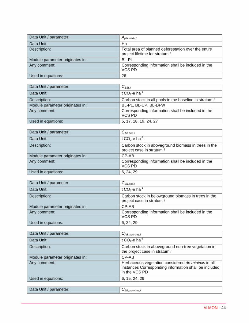
M-MON - 44
Data Unit / parameter: Aplanned,i,t Data Unit: Ha Description: Total area of planned deforestation over the entire
project lifetime for stratum i Module parameter originates in: BL-PL Any comment: Corresponding information shall be included in the
VCS PD Used in equations: 26
Data Unit / parameter: CBSL,i Data Unit: t CO2-e ha-1 Description: Carbon stock in all pools in the baseline in stratum i Module parameter originates in: BL-PL, BL-UP, BL-DFW Any comment: Corresponding information shall be included in the
VCS PD Used in equations: 5, 17, 18, 19, 24, 27
Data Unit / parameter: CAB,tree,i Data Unit: t CO2-e ha-1 Description: Carbon stock in aboveground biomass in trees in the
project case in stratum i Module parameter originates in: CP-AB Any comment: Corresponding information shall be included in the
VCS PD Used in equations: 6, 24, 29
Data Unit / parameter: CBB,tree,i Data Unit: t CO2-e ha-1 Description: Carbon stock in belowground biomass in trees in the
project case in stratum i Module parameter originates in: CP-AB Any comment: Corresponding information shall be included in the
VCS PD Used in equations: 6, 24, 29
Data Unit / parameter: CAB_non-tree,i Data Unit: t CO2-e ha-1 Description: Carbon stock in aboveground non-tree vegetation in
the project case in stratum i Module parameter originates in: CP-AB Any comment: Herbaceous vegetation considered de minimis in all
instances Corresponding information shall be included in the VCS PD
Used in equations: 6, 15, 24, 29
Data Unit / parameter: CBB_non-tree,i
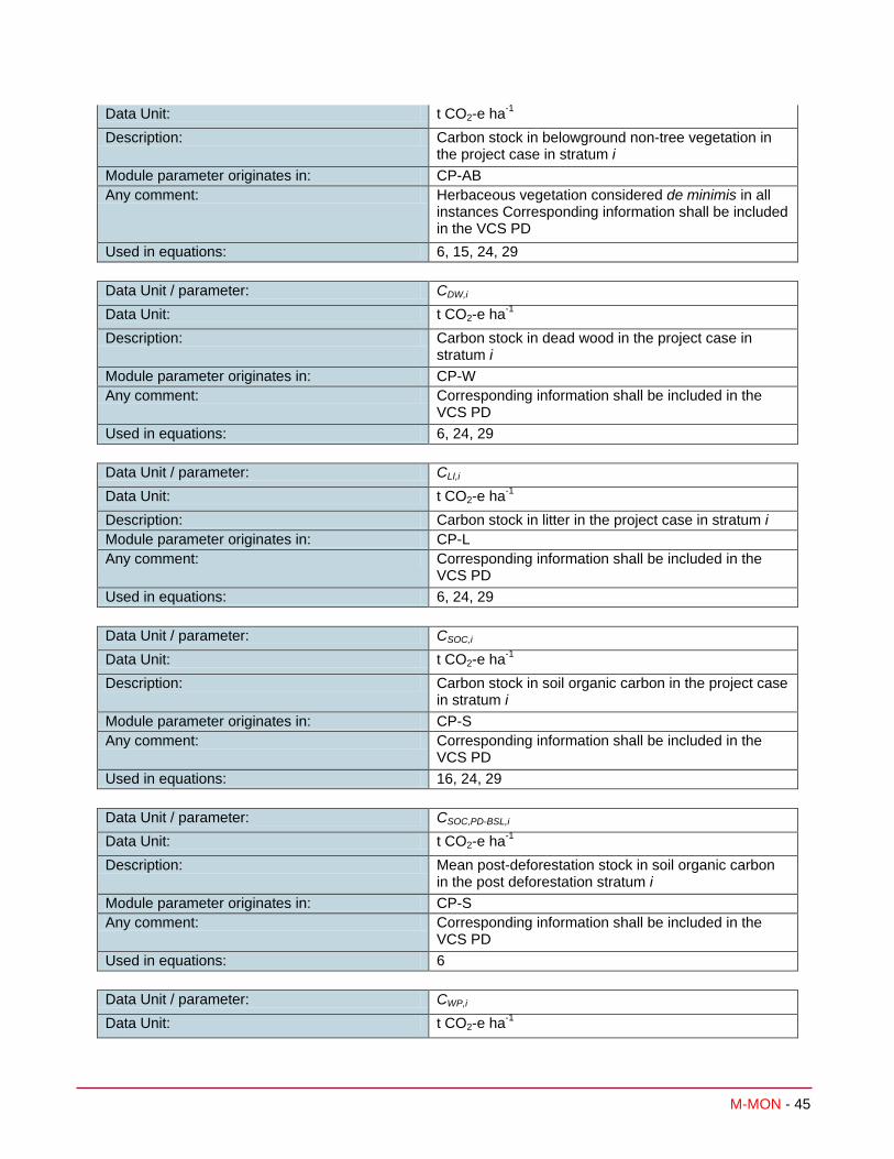
M-MON - 45
Data Unit: t CO2-e ha-1 Description: Carbon stock in belowground non-tree vegetation in
the project case in stratum i Module parameter originates in: CP-AB Any comment: Herbaceous vegetation considered de minimis in all
instances Corresponding information shall be included in the VCS PD
Used in equations: 6, 15, 24, 29
Data Unit / parameter: CDW,i Data Unit: t CO2-e ha-1 Description: Carbon stock in dead wood in the project case in
stratum i Module parameter originates in: CP-W Any comment: Corresponding information shall be included in the
VCS PD Used in equations: 6, 24, 29
Data Unit / parameter: CLI,i Data Unit: t CO2-e ha-1 Description: Carbon stock in litter in the project case in stratum i Module parameter originates in: CP-L Any comment: Corresponding information shall be included in the
VCS PD Used in equations: 6, 24, 29
Data Unit / parameter: CSOC,i Data Unit: t CO2-e ha-1 Description: Carbon stock in soil organic carbon in the project case
in stratum i Module parameter originates in: CP-S Any comment: Corresponding information shall be included in the
VCS PD Used in equations: 16, 24, 29
Data Unit / parameter: CSOC,PD-BSL,i Data Unit: t CO2-e ha-1 Description: Mean post-deforestation stock in soil organic carbon
in the post deforestation stratum i Module parameter originates in: CP-S Any comment: Corresponding information shall be included in the
VCS PD Used in equations: 6
Data Unit / parameter: CWP,i Data Unit: t CO2-e ha-1

M-MON - 46
Description: Carbon stock in wood products in the project case in stratum i
Module parameter originates in: CP-W Any comment: Corresponding information shall be included in the
VCS PD Used in equations: 5, 9, 24
Data Unit / parameter: D%planned,i,t Data Unit: % Description: Projected annual proportion of land that will be
deforested in stratum i at year t Module parameter originates in: BL-PL Any comment: Corresponding information shall be included in the
VCS-PD Used in equations: 26
Data / Parameter: EBiomassBurn,i,t Data Unit: t CO2-e Description: Non-CO2 emissions due to biomass burning in stratum
i in year t
Module parameter originates in: E-BB Any comment: Corresponding information shall be included in the
VCS PD Used in equations: 30
Data / Parameter: EFC,i,t Data Unit: t CO2-e Description: Emission from fuel combustion (fossil and biofuel) in
stratum i in year t Module parameter originates in: E-FFC Any comment: Corresponding information shall be included in the
VCS PD Used in equations: 30
Data / Parameter: FGBSL,i,t Data Unit: m3 Description: Average projected volume of wood gathered in the
project area for fuel and/or charcoal production in the baseline scenario in stratum i in year t
Module parameter originates in: BL-DFW Any comment: Updated at every baseline renewal Used in equations: 19
Data / Parameter: N2Odirect-N,i,t Data Unit: t CO2-e

M-MON - 47
Description: Direct N2O emission as a result of nitrogen application on the alternative land use within the project boundary in stratum i in year t
Module parameter originates in: E-NA Any comment: Corresponding information shall be included in the
VCS PD Used in equations: 30
Data Unit / parameter: R Data Unit: t root d.m. t-1 shoot d.m. Description: Root to shoot ratio appropriate to species or forest
type / biome; note that as defined here, root to shoot ratio is applied as belowground biomass per unit area:aboveground biomass per unit area (not on a per stem basis)
Module parameter originates in: CP-AB Any comment: Corresponding information shall be included in the
VCS PD Used in equations: 36
7 REFERENCES AND OTHER INFORMATION
Brown, S. 1997. Estimating Biomass and Biomass Change of Tropical Forests: a Primer. For the Food and Agriculture Organization of the United Nations. Rome, 1997. FAO Forestry Paper - 134. ISBN 92-5-103955-0 http://www.fao.org/docrep/W4095E/W4095E00.htm
Casarim, F.M., S.K. Grimland, and S. Brown. 2010. Carbon Impacts from Selective Logging of Forests in Berau, East Kalimantan, Indonesia, report by Winrock International to The Nature Conservancy http://www.winrock.org/Ecosystems/publications.asp?BU=9086
Chave, J., C. Andalo, S. Brown, M. A. Cairns, J. Q. Chambers, D. Eamus, H. Folster, F. Fromard, N. Higuchi, T. Kira, J.-P. Lescure, B. W. Nelson, H. Ogawa, H. Puig, B. Riera, T. Yamakura. 2005. Tree allometry and improved estimation of carbon stocks and balance in tropical forests. Oecologia 145: 87-99
Deliverables 9,10, 13a,17,21,24 of Carbon and Co-Benefits from Sustainable Land-Use Management project: Cooperative Agreement No. EEM-A-00-03-00006-00 http://www.winrock.org/Ecosystems/publications.asp?BU=9086
GOFC-GOLD, 2008, Reducing greenhouse gas emissions from deforestation and degradation in developing countries: a sourcebook of methods and procedures for monitoring, measuring and reporting, GOFC-GOLD Report version COP13-2, (GOFC-GOLD Project Office, Natural Resources Canada, Alberta, Canada) http://www.gofc-gold.uni-jena.de/redd/sourcebook/Sourcebook_Version_June_2008_COP13.pdf

M-MON - 48
IPCC 2006 Guidelines for National Greenhouse Gas Inventories, Volume 4 Agriculture, Forestry and Other Land Use, Chapter 4 Forestland http://www.ipcc-
nggip.iges.or.jp/public/2006gl/pdf/4_Volume4/V4_04_Ch4_Forest_Land.pdf
IPCC 2006 Guidelines for National Greenhouse Gas Inventories, Volume 4 Agriculture, Forestry and Other Land Use, Chapter 5 Cropland http://www.ipcc-nggip.iges.or.jp/public/2006gl/pdf/4_Volume4/V4_05_Ch5_Cropland.pdf
IPCC 2006 Guidelines for National Greenhouse Gas Inventories, Volume 4 Agriculture, Forestry and Other Land Use, Chapter 6 Grassland http://www.ipcc-
nggip.iges.or.jp/public/2006gl/pdf/4_Volume4/V4_06_Ch6_Grassland.pdf
Pearson, T., Walker, S. and Brown, S. 2005. Sourcebook for Land Use, Land-Use Change and Forestry Projects. Winrock International and the World Bank Biocarbon Fund. 57pp. Available at: http://www.winrock.org/Ecosystems/files/Winrock-BioCarbon_Fund_Sourcebook-compressed.pdf

M-MON - 49
8 ANNEX I DEFAULT LOGGING DAMAGE FACTOR
Default values were derived from the slope of the regression equation between carbon damaged and volume extracted based on 774 logging gaps measured by Winrock International in Bolivia, Belize, the Republic of Congo, Brazil, and Indonesia and 134 logging gaps in Mexico.
The logging damage factor (LDF) is a representation of the quantity of emissions that will ultimately arise per unit of extracted timber (m3). These emissions arise from the noncommercial portion of the felled trees (the branched and stump) and trees incidentally killed during felling.
To ensure a conservative estimate, for broadleaf and mixed forests a default value of 0.67 t C m-3 may be used16.
To ensure a conservative estimate, for coniferous forests in the country of Mexico a default value of 0.28 t C m-3 may be used17.
For all other forest types, field measurements must be taken for each logging stratum z following the methods delineated in Annex II.
For Broadleaf and Mixed Broadleaf/Conifer Forests:
16 These default values come from the slope of the regression equation between carbon damaged and volume extracted based on 774 logging gaps measured by Winrock International in Bolivia, Belize, the Republic of Congo, Brazil, and Indonesia (Annex I). 17 These default values come from the slope of the regression equation between carbon damaged and volume extracted based on 134 logging gaps in Mexico (Annex I).

M-MON - 50
For Conifer Forests:
Methods used by Winrock are described in the following reports to USAID:
Deliverable 9: Use of Aerial Digital Imagery to measure the impact of selective logging on carbon stocks of tropical forests in Republic of Congo
Deliverable 10: Quantification of carbon benefits in conservation project activities through spatial modeling: Republic of Congo as a case study
Deliverable 13a: Impact of logging on carbon stocks of forests: Chihuahua, Mexico as a case study
Deliverable 17: Impact of logging on carbon stocks of forests: The Brazilian Amazon as a case study
Deliverable 21: Use of aerial digital imagery to measure the impact of selective logging on carbon stocks of tropical forest in Brazilian Amazon
Deliverable 24: Impact of selective logging on carbon stocks of tropical forests in East Kalimantan, Indonesia
Under Carbon and Co-Benefits from Sustainable Land-Use Management project: Cooperative Agreement No. EEM-A-00-03-00006-00
And the following report to the Nature Conservancy:
Casarim, F.M., S.K. Grimland, and S. Brown. 2010. Carbon Impacts from Selective Logging of Forests in Berau, East Kalimantan, Indonesia
And in the following manuscript being prepared for peer-reviewed publication:
Pearson, TRH and Brown, S. 2009. Impact of selective logging on the carbon stocks of tropical forests: case studies from Belize, Bolivia, Brazil, Indonesia, Mexico and the Republic of Congo.

M-MON - 51
Results are from uneven forest management practices. Application to even-aged forest management practices is conservative as under even-aged practices the emissions are solely from the non-extracted proportion of the timber trees while in uneven-aged practices emissions also come from trees incidentally damaged and killed during the felling of timber trees.

M-MON - 52
9 ANNEX II OPTIONAL METHOD TO CALCULATE STRATUM SPECIFIC LOGGING DAMAGE FACTOR
The logging damage factor for each logging stratum z shall be created through taking field measurements at locations of selective logging within the project boundary where the logging stratum z management practices have been employed. Logging management practices include the procedures and techniques for inventory creation, planning, timber felling practices, and extraction of logs. This can be demonstrated through documentation such as inventory and harvesting management plans and post-harvest assessment reports. To ensure that all damage resulting from the logging can be clearly identified, field measurements to create the logging damage factor must take place within four months of the felling of timber trees where field measurements will take place. In addition, the logs to be extracted must have already been cut at the top and the bottom of the bole(s), and the log(s) must still be present at the logging site.
A logging gap is the location where one or more timber tree has been felled, resulting in the killing of the timber tree(s) and potentially causing death or damage to other trees surrounding the timber tree(s). Where the damage caused by one timber tree cannot be distinguished from the damage caused by another timber tree, all damage shall be accounted for within one logging gap. Sites for logging damage factor creation shall be determined using representative random sampling or systematic sampling with a random initiation point. Sampling may take place within one logging season or created over several logging seasons.
The logging damage factor for each logging practice stratum is assumed to be constant over the project crediting period. If a new logging practice is initiated during the project crediting period, an additional logging stratum may be added and logging damage factor created.
The emissions resulting directly from logging are calculated by estimating the emissions resulting from dead wood created in each logging gap measured divided by the volume of wood created. This quantity of dead wood per volume of wood created is then averaged over all the gaps measured. This average emission per volume extracted is referred to as the Logging Damage Factor. Sufficient gaps shall be measured in each logging stratum to achieve a precision of equal or less than 15% of the mean at the 95% confidence interval in the estimate of LDF.
( ) iz
LG
izEXTizDWiz LGVCLDFiz
,1lg
,,lg,,,lg,,
,
∆= ∑
=
(31)
Where
LDFz,i Logging damage factor for logging stratum z, in stratum i; t CO2-e m-3
∆CDW,lg,z,i Dead wood created as a direct result of tree felling within logging gap lg for logging stratum z, in stratum i; t CO2-e
VEXT,lg,z,i Volume extracted from logging gap lg for logging stratum z, in stratum i; m3
lg 1,2,3,… LGz,i logging gaps measured to derive factors for logging stratum z, in stratum i
z 1,2,3…Z logging strata in stratum i
i 1, 2, 3 … M strata

M-MON - 53
The dead wood created as a result of timber harvest is the sum of the biomass not extracted from the timber tree plus dead wood incidentally created in the process of felling the harvested tree.
( )1244*,,lg,,,,lg,,,,lg, izDamageIncidentalDWizFelledTreeDWizDW CCC ∆+∆=∆ (32)
Where
∆CDW,lg,z,i Dead wood created as a direct result of tree felling within logging gap lg for logging stratum z, in stratum i; t CO2-e
∆CDW,FelledTree,lg,z,i Dead wood derived from the felled tree or trees within logging gap lg for logging stratum z, in stratum i; t C
∆CDW,IncidentalDamage,lg,z,i Dead wood derived from trees incidentally killed or damaged during the process of tree felling within logging gap lg for logging stratum z, in stratum i; t C
lg 1,2,3,…LGz,i logging gaps measured to derive factors for logging stratum z in stratum i
z 1,2,3…Z logging strata in stratum i
i 1, 2, 3 … M strata
44/12 Ratio of molecular weight of CO2 to carbon, t CO2-e t C-1
Dead wood resulting from felled tree
The dead wood derived directly from the felled tree is equal to total aboveground tree biomass minus the biomass of the extracted log.
( )∑=
−=∆Tr
triztrEXTiztrTREEizFelledTreeDW CCC
1,,lg,,,,lg,,,,lg,, (33)
Where
∆CDW,FelledTree,lg,z,i Dead wood derived from the felled tree or trees within logging gap lg for logging stratum z, in stratum i; t C
CTREE,tr,lg,z,i The biomass carbon of tree tr in logging gap lg; for logging stratum z, in stratum i t C
CEXT,tr,lg,z,i The biomass carbon in logs extracted from tree tr in logging gap lg for logging stratum z, in stratum i; t C
tr 1,2,3,…Tr trees felled
lg 1,2,3,…LGz,i logging gaps measured to derive factors for logging stratum z in stratum i
z 1,2,3…Z logging strata in stratum i
i 1, 2, 3 … M strata
iztrTREEBBiztrTREEABiztrTREE CCC ,,lg,,_,,lg,,_,,lg,, += (34)
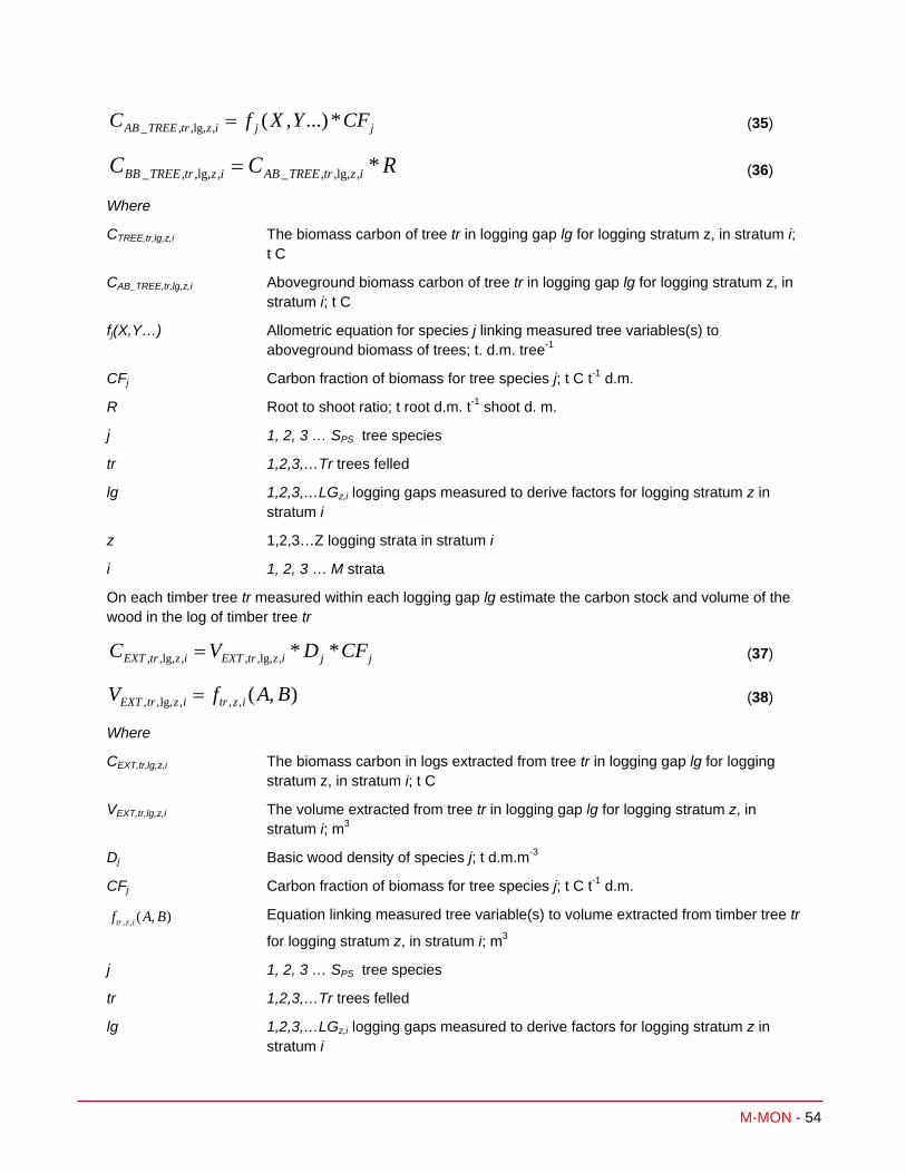
M-MON - 54
jjiztrTREEAB CFYXfC *...),(,,lg,,_ = (35)
RCC iztrTREEABiztrTREEBB *,,lg,,_,,lg,,_ = (36)
Where
CTREE,tr,lg,z,i The biomass carbon of tree tr in logging gap lg for logging stratum z, in stratum i; t C
CAB_TREE,tr,lg,z,i Aboveground biomass carbon of tree tr in logging gap lg for logging stratum z, in stratum i; t C
fj(X,Y…) Allometric equation for species j linking measured tree variables(s) to aboveground biomass of trees; t. d.m. tree-1
CFj Carbon fraction of biomass for tree species j; t C t-1 d.m.
R Root to shoot ratio; t root d.m. t-1 shoot d. m.
j 1, 2, 3 … SPS tree species
tr 1,2,3,…Tr trees felled
lg 1,2,3,…LGz,i logging gaps measured to derive factors for logging stratum z in stratum i
z 1,2,3…Z logging strata in stratum i
i 1, 2, 3 … M strata
On each timber tree tr measured within each logging gap lg estimate the carbon stock and volume of the wood in the log of timber tree tr
jjiztrEXTiztrEXT CFDVC **,,lg,,,,lg,, = (37)
),(,,,lg,,, BAfV iztriztrEXT = (38)
Where
CEXT,tr,lg,z,i The biomass carbon in logs extracted from tree tr in logging gap lg for logging stratum z, in stratum i; t C
VEXT,tr,lg,z,i The volume extracted from tree tr in logging gap lg for logging stratum z, in stratum i; m3
Dj Basic wood density of species j; t d.m.m-3
CFj Carbon fraction of biomass for tree species j; t C t-1 d.m.
),(,, BAf iztr Equation linking measured tree variable(s) to volume extracted from timber tree tr
for logging stratum z, in stratum i; m3
j 1, 2, 3 … SPS tree species
tr 1,2,3,…Tr trees felled
lg 1,2,3,…LGz,i logging gaps measured to derive factors for logging stratum z in stratum i

M-MON - 55
z 1,2,3…Z logging strata in stratum i
i 1, 2, 3 … M strata
Incidental damage
The incidental damage is the sum of the biomass of trees damaged (trunk snapped, leaning over, uprooted, bark damaged) in the process of tree felling plus the biomass of branches knocked to the ground during tree fall. It is conservatively assumed that trees (>10 cm DBH) damaged (trunk snapped, leaning over, uprooted, bark damaged) are killed and result in emissions. Care shall be taken to identify and measure all trees (>10 cm DBH) damaged as a result of the felling of the timber tree(s). Methods for measuring the carbon stock of damaged trees and branches knocked to the ground are described in the parameter tables.
izBizUSizDamageIncidentalDW CCC ,,lg,,,lg,/,,lg,, +=∆ (39)
Where
∆CDW,IncidentalDamage,lg,z,i Dead wood derived from trees incidentally killed or damaged during the process of tree felling within logging gap lg for logging stratum z, in stratum i; t C
CS/U,lg,z,i Carbon stock of trees damaged (snapped, leaning, uprooted, bark damaged) in logging gap lg for logging stratum z, in stratum i; t C
CB,lg,z,i Carbon stock of branches knocked to the ground as a direct consequence of tree felling in logging gap lg for logging stratum z, in stratum i; t C
lg 1,2,3,…LGz,i logging gaps measured to derive factors for logging stratum z in stratum i z 1,2,3…Z logging strata
i 1, 2, 3 … M strata

M-MON - 56
DOCUMENT HISTORY Version Date Comment
v1.0 3 Dec 2010 Initial version released
v1.1 9 Sep 2011 In accordance with VCS Version 3 AFOLU Requirements document, procedures for monitoring and quantifying emissions from deforestation caused by natural disturbance were added in Section 2.1.1.
v2.0 23 Nov 2011 Monitoring methods for degradation from natural disturbance and degradation from FSC certified selective logging was added
v2.1 20 Nov 2012 Renamed “planned deforestation” to “planned deforestation and planned degradation”