Embed Size (px)
Citation preview

VCS VALIDATION REPORT
THE CHOCO-DARIEN
CONSERVATION CORRIDOR
REDD PROJECT
REPORT Nº2012-9699 REVISION NO. 1

VALIDATION REPORT: VCS Version 3.2
v3.0
i
Project Title The Choco-Darien Conservation Corridor REDD Project
Version 1
Report ID 9699
Report Title Validation Report for The Choco-Darien Conservation Corridor REDD Project
DNV Ref: PRJC-390040-2012-CCS-USA
Client Anthrotect S.A.S. and Eco-Partners
Pages 45
Date of Issue 27 August 2012
Prepared By DNV Climate Change Services AS
Contact 155 Grand Avenue, 5th Floor
Oakland, CA 94612
Tel: +1 510 891 0446
Approved By Weidong Yang
Work Carried Out By
Edwin Aalders, Pablo Reed, Peter Kelly
Technical review by:
Misheck C Kapambwe

VALIDATION REPORT: VCS Version 3.2
v3.0
ii
Summary:
DNV Climate Change Services AS (DNV) has performed a validation of the project activity “The Choco-Darien Conservation Corridor REDD Project ” in Colombia to confirm that the project design, as documented, is sound and reasonable and meets the identified criteria. The validation was performed on the basis of VCSA requirements for the VCS project, as well as criteria given to provide for consistent project operations, monitoring and reporting.
The validation was conducted by means of document review, follow-up interviews and site inspection, and the resolution of outstanding issues. The review of the project design documentation and the subsequent follow-up interviews and site inspection have provided DNV with sufficient evidence to determine the fulfillment of stated criteria.
The project activity is to leverage carbon finance to avoid mosaic conversion of tropical forests, and therefore reduce greenhouse gas emissions. The project employs a Reduced Emissions from Deforestation and Degradation (REDD) project methodology to determine the magnitude of these emissions reductions. Through a combination of forest protection and sustainable development activities, this project is estimated to avoid the emission of 2.8 Million metric tonnes of CO2e over the project lifetime that would have resulted from deforestation of approximately 50% of the project area over the next thirty years. The project has applied the VCS methodology “Methodology for Avoided Mosaic Deforestation of Tropical Forests (VM0009)”, version 2.0.
In summary, it is DNV’s opinion that the project activity “The Choco-Darien Conservation Corridor REDD Project ” as described in the VCS PD, dated 16 July 2012, meets all relevant VCSA requirements for the VCS project and correctly applies the VCS methodology “Methodology for Avoided Mosaic Deforestation of Tropical Forests (VM0009)”, version 2.0. Hence, DNV recommends the registration of the project as a VCS project activity.

VALIDATION REPORT: VCS Version 3.2
v3.0
iii
Table of Contents
1 INTRODUCTION .............................................................................................................................................. 1
1.1 OBJECTIVE ......................................................................................................................................................... 1
1.2 SCOPE AND CRITERIA ........................................................................................................................................... 1
1.3 LEVEL OF ASSURANCE ........................................................................................................................................... 1
1.4 SUMMARY DESCRIPTION OF THE PROJECT ................................................................................................................ 1
2 VALIDATION PROCESS .................................................................................................................................... 2
2.1 METHOD AND CRITERIA ........................................................................................................................................ 2
2.2 DOCUMENT REVIEW ............................................................................................................................................ 3
2.3 INTERVIEWS ....................................................................................................................................................... 4
2.4 SITE INSPECTIONS ................................................................................................................................................ 5
2.5 RESOLUTION OF ANY MATERIAL DISCREPANCY .......................................................................................................... 5
3 VALIDATION FINDINGS ................................................................................................................................... 6
3.1 PROJECT DESIGN ................................................................................................................................................. 6
3.2 APPLICATION OF METHODOLOGY ......................................................................................................................... 11
3.3 ENVIRONMENTAL IMPACT ................................................................................................................................... 25
3.4 COMMENTS BY STAKEHOLDERS ............................................................................................................................ 25
4 VALIDATION CONCLUSION ........................................................................................................................... 26
APPENDIX A VCS VALIDATION PROTOCOL

VALIDATION REPORT: VCS Version 3.2
v3.0
1
1 INTRODUCTION
Anthrotect S.A.S. and Eco-Partners has commissioned DNV Climate Change Services AS (DNV) to perform a validation of The Choco-Darien Conservation Corridor REDD Project in Colombia . This report summarizes the findings of the validation of the project, performed on the basis of VCSA criteria for the VCS project, as well as criteria given to provide for consistent project operations, monitoring and reporting. VCSA criteria refer to VCS program documents and policy announcements.
1.1 Objective
The purpose of a validation is to have an independent third party assess the project design. In particular, the project's baseline, monitoring plan, and compliance with relevant VCSA criteria are validated in order to confirm that the project design, as documented, is sound and reasonable and meets the identified criteria. Validation is a requirement for all VCS projects and is necessary to provide assurance to stakeholders of the quality of the project and its intended generation of the Verified Carbon Units (VCUs).
1.2 Scope and Criteria
The validation scope is defined as an independent and objective review of the VCS project document (VCS PD). The VCS PD is reviewed against the criteria stated in the VCS Version 3.3 and the relevant documents and policy announcements made by the VCSA, including the VCS methodology “Methodology for Avoided Mosaic Deforestation of Tropical Forests (VM0009)”, version 2.0.
The validation does not include project consulting. However, requests for clarifications and/or corrective actions may have provided input for improvement of the project design.
1.3 Level of assurance
DNV provides reasonable assurance that the “The Choco-Darien Conservation Corridor REDD Project ” meets VCSA criteria. To ensure complete transparency, a validation protocol check list is included in Appendix A. The validation protocol check list addresses all of the criteria that must be met for the VCS project. Any clarification or corrective actions raised have been included in the validation protocol.
In addition, DNV applies materiality of 5 per cent in accordance with the requirements in VCS Version 3.3
1.4 Summary Description of the Project
Project Proponents (Parties): Anthrotect; Calle 7D #43C-23 Medellin, Colombia (+57 (4) 266-1250. EcoPartners: PO 4665 Berkeley, CA 94704 USA (+1 415-634-4650).
Title of project activity: The Choco-Darien Conservation Corridor REDD Project

VALIDATION REPORT: VCS Version 3.2
v3.0
2
Baseline and monitoring methodology
VM0009 Version 2.0
Location of the project activity The project is located in the Darien region of Northwest Colombia within the administrative jurisdictions of the department of Choco and the Municipality of Acandi. The project is approximately 250KM northwest of Bogota and 10km southwest of the town of Acandi, and is adjacent to the Colombia-Panama border.
Project’s crediting period: 18 October 2010 to October 17 2040
2 VALIDATION PROCESS
2.1 Method and Criteria
The validation consisted of the following three phases:
• A desk review of the project documents.
• Follow-up interviews with project stakeholders and site inspection where necessary.
• The resolution of outstanding issues and the issuance of the validation report and opinion.
The following sections outline each step in more detail.
Validation team The validation team is in accordance with the internal qualification procedures of DNV Climate Change Services AS:
Role Last Name First Name Country
Type of involvement
Des
k re
view
Site
vis
it / I
nter
view
s
Rep
ortin
g
Sup
ervi
sion
of w
ork
Tec
hnic
al r
evie
w
TA
14.
1 C
ompe
tenc
e
Team leader (Validator / Verifier)
Aalders Edwin Norway � � � �
Program Manager/Site Visit Validator / Verifier
Reed Pablo Eduardo
USA � � � �
Field Assistant / Auditor in Training
Kelly Peter USA �

VALIDATION REPORT: VCS Version 3.2
v3.0
3
Misheck C. Kapambwe
� �
2.2 Document Review
The following tables list the documentation that was reviewed during the validation.
2.3.1 Documentation provided by the project participants
/1/ Anthrotect and EcoPartners: VCS PD for project activity “The Choco-Darien Conservation Corridor REDD Project ” in Colombia , version 1.60 dated 8 June 2012 reviewed during the desk review and version 1.88 dated 16 July 2012
/2/ Anthrotect and Eco-Partners: VCS Monitoring Report (MR) for project activity “The Choco-Darien Conservation Corridor REDD Project ” in /1/, version 2.24 dated 8 June 2012 reviewed during the desk review and version 2.35 dated 16 July 2012 validated by DNV.
/3/ Anthrotect: Non-permanence risk report: VCS version 3 – The Choco-Darien Conservation Corridor REDD Project, version Non-Permanence Risk Worksheet v1.3.xlsm
/4/ Anthrotect and EcoPartners: Monitoring Plan, Version 1, June 11, 2012
/5/ Anthrotect and EcoPartners: Data and Parameters Monitored, Version 1, June 11, 2012
/6/ Anthrotect and EcoPartners: Data and parameters available at Validation, Version 1, June 11, 2012
/7/ Anthrotect and EcoPartners: Forest Measurement Protocol, Version 1, June 11, 2012
/8/ Anthrotect and EcoPartners: Leakage Plot Sampling Protocol, Version 1, June 11, 2012
/9/ Anthrotect and EcoPartners: Data and parameters available at Validation, Version 1, June 11, 2012
/10/ Anthrotect and EcoPartners: Participatory Rural Appraisal Results, Version 1, June 11, 2012
/11/ Anthrotect and EcoPartners: Participatory Rural Appraisal Questionnaire, Version 1, June 11, 2012
/12/ SCS: CCBA Standard Validation Report, Final Versions, February 9, 2012
/13/ Anthrotect and EcoPartners: , Map of Project Area Boundary Version 1, June 11, 2012
/14/ Anthrotect and EcoPartners: , Landsat Imagery Version 1, June 11, 2012
/15/ Anthrotect and EcoPartners: , Map of Accounting Area 2001 Version 1, June 11, 2012
/16/ Anthrotect and EcoPartners: , Map of Accounting Area 2010 Version 1, June 11, 2012
/17/ Anthrotect and EcoPartners: , Map of Double Coverage Version 1, June 11, 2012
/18/ Anthrotect and EcoPartners: , Map of Point Interpretation Version 1, June 11, 2012

VALIDATION REPORT: VCS Version 3.2
v3.0
4
/19/ Anthrotect and EcoPartners: , Map of Aspect Version 1, June 11, 2012
/20/ Anthrotect and EcoPartners: , Map of Slope Version 1, June 11, 2012
/21/ Anthrotect and EcoPartners: , Map of DEM Version 1, June 11, 2012
/22/ Anthrotect and EcoPartners: , Map of Land Cover Version 1, June 11, 2012
/23/ Anthrotect and EcoPartners: , Map of Project Area Version 1, June 11, 2012
2.3.2 Standards, methodologies, and other guidance by the VCSA; other documentation used by DNV to validate / cross-check the information provided by the project participants
/24/ Wildlife Works Carbon LLC: Approved VCS Methodology VM0009 ‘Methodology for Avoided Mosaic Deforestation of Tropical Forests’’, Version 2.0
/25/ VCSA: VCS standards: VCS Version 3.3., 4 October 2012
/26/ VCSA: AFOLU Non-Permanence Risk tool: VCS Version 3.2, 4 October 2012
/27/ VCSA: Program Definitions: VCS Version 3.4, 4 October 2012
/28/ VCSA: AFOLU requirements: VCS Version 3.3, 4 October 2012
/29/ VCSA: AFOLU requirements: VCS Monitoring Report Template 3.0, 1 February 2012
/30/ VCSA: VCS Tool for the Demonstration and Assessment of Additionality in VCS Agriculture, Forestry and Other Land Use (AFOLU) Project Activities (Version 3.0) 1 February 2012
/31/ INCODER (Instituto Colombiano de Desarrollo Rural): Resolución 1502 (Collective Title to Cocomasur Communities. August 14, 2005
/32/ Government of Colombia. LEY 70 DE 1993. Diario Oficial No. 41.013, de 31 de agosto de 1993. Por la cual se desarrolla el artículo transitorio 55 de la Constitución Política. (agosto 27).
2.3 Interviews
Persons interviewed during the initial validation or persons who contributed with other information that are not included in the documents listed above.
Date Name Organization Title
/33/ June 22-28, 2012 Emeryldis Cordoba Cocomasur Coordinator
/34/ June 22-28, 2012 Eusebio Guisao Cocomasur Social Coordinator
/35/ June 22-28, 2012 Aurelio C Cocomasur Representative
/36/ June 22-28, 2012 Jennifer Vidal Anafadora Representative
/37/ June 22-28, 2012 Adriano Torres Cocomasur Vocal
VALIDATION REPORT: VCS Version 3.2
v3.0
5
/38/ June 22-28, 2012 Fernei Caicedor Cocomasur Technician
/39/ June 22-28, 2012 Etiel Cordoba Cocomasur Community Technician
/40/ June 22-28, 2012 Rosana Cordoba Cocomasur Contadora
/41/ June 22-28, 2012 Brodie Ferguson Anthrotect Director
/42/ June 22-28, 2012 Kyle Holland EcoPartners Director
/43/ June 22-28, 2012 Fraizer Guisao Cocomasur Techniccian
/44/ June 22-28, 2012 Encarnacion Chu Cocomasur Auxiliar
/45/ June 22-28, 2012 Mauricio Salazar Anthrotect Forest Engineer
/46/ June 22-28, 2012 Diana Ibarra Cocomasur Personell
/47/ June 22-28, 2012 Xiomara Moreno Cocomasur Logistics
2.4 Site Inspections
On June 22-28 2012, a site inspection was carried out in the project area which is part of the project activity. As part of this inspection the following activities were performed:
� An assessment of the design, implementation and operation of the proposed project activity through visual inspection and through interviews with the project proponent’s staff.
� An assessment of the project boundaries and the stratum information were assessed using geographical datasets, maps, GPS receivers, and physical field checks.
� Revisiting of randomly selected 2 inventory, 2 leakage, and destructive sampling plots which were part of the carbon stock inventory of the first monitoring period and/or of the ex-ante emissions reductions calculations, which were re-measured by the project proponent’s staff under observation of DNV. While the project proponent was carrying out the re-measurement, DNV verified that the operational and data collection procedures were implemented in accordance with the SOP’s /5/6//7//8/ indicated in the VCS PD /1/ and verified the information flows for generating, aggregating and reporting the monitoring parameters. Furthermore, the monitoring methods were checked in order to confirm that the monitoring practices followed the requirements of the applicable methodology /24/. Furthermore, DNV performed a consistency check in order to verify the consistency of the previous measurement and the re-measurement, and to verify the correctness of the reported stand volumes.
� Confirmation that the quality control and quality assurance procedures were in place;
2.5 Resolution of Any Material Discrepancy
A corrective action request (CAR) is issued, where:
i. Non-conformities with the monitoring plan or methodology are found in monitoring and reporting, or if the evidence provided to prove conformity is insufficient;

VALIDATION REPORT: VCS Version 3.2
v3.0
6
ii. Mistakes have been made in applying assumptions, data or calculations of emission reductions which will impair the estimate of emission reductions;
iii. Issues identified in a FAR during validation to be verified during verification have not been resolved by the project participants.
A clarification request (CL) shall be raised if information is insufficient or not clear enough to determine whether the applicable VCS requirements have been met.
A forward action request (FAR) is issued for actions if the monitoring and reporting require attention and/or adjustment for the next monitoring period.
As part of the project validation 9 CARs were raised. The CARs were satisfactorily addressed by the project proponent by revising the net anthropogenic removals calculation and the monitoring report.
18 clarification requests (CL) were identified and were satisfactorily addressed by the project proponent by revising the monitoring report. No forward action requests (FAR) were identified (refer to Appendix D).
3 VALIDATION FINDINGS
3.1 Project Design
3.3.1 Project Proponent
The project proponent is Anthrotect, a Colombian organization dedicated to making conservation a viable alternative to economic opportunities that result in land degradation. Anthrotect works with community landholders to implement payment for ecosystem services projects that connect communities with emerging markets for carbon and biodiversity. In addition to Anthrotect the project is working with a number of other organizations which support the implementation of the project listed below.
Organization Capacity
Cocomasur Implementing Organization Fund for Environmental Action Implementing Partner ecoPartners Technical Partner Carnegie Institution for Science Technical Partner Strategic Environmental Management Legal Advisor Medellin Botanical Garden Technical Partner
3.3.2 Project Activity and Eligibility of the Project
This project leverages carbon finance in order to avoid mosaic conversion of tropical forests and therefore reduce greenhouse gas emissions. The project employs a Reduced Emissions from Deforestation and Degradation (REDD) project methodology to determine the magnitude of these emissions reductions. Through a combination of forest protection and sustainable development activities, this project is estimated to avoid the emission of 2.8 Million metric tonnes of CO2e over the project lifetime that would have resulted from deforestation of approximately 50% of the project area over the next thirty years. The project start date is 18 October 2010 and it applies the VCS methodology “VM0009”, version 2 /24/.

VALIDATION REPORT: VCS Version 3.2
v3.0
7
The project is located in the Darién region of northwest Colombia within the administrative jurisdictions of the Department of Chocó and the Municipality of Acandí. The coordinates of the approximate center of the project area are 8.405559, -77.330833. The project is approximately 250km northwest of Bogota and 10km southwest of the town of Acandí, and is adjacent to the Colombia-Panama border. The main project activities as outlines in the PD /1/ are provided in the table below. Project Activity Description Start Date
Governance
Community territory
awareness and land
dispute resolution
Review of local councils and families belonging to the community
organization in order to update and strengthen membership criteria,
policies, and procedures.
Community events will educate, inform, and build awareness
regarding the suite of collective rights and benefits (including common
pool natural resources) afforded by the land title.
October 2010
Governance
education and
communication
Regular reporting and feedback to project beneficiaries and other
local stakeholders according to international best practices for
organizational development and governance.
October 2010
Internal transparency
and accountability Regular monitoring of implementation activities and expenses by the
Fund for Environmental Action in addition to an annual financial
review by an independent auditor.
January 2012
Land use planning Land management plans will be prepared to guide land use and
activities in areas of particular social and environmental importance.
Zoning exercises will establish permissible activities, with an emphasis
on the conservation and enhancement of areas of high conservation
value.
October 2012
Enforcement and Management
Territorial
demarcation
Community teams carry out workshops, field assessments, legal
reviews, and participatory mapping exercises to strengthen
recognition of project boundaries and consolidate land titles.
August 2010
Forest patrols Community teams perform regular patrols designed to prevent,
detect, and document illegal encroachment into the territory as well
as community violations of the territorial management plan.
August 2010
Monitoring of forest
carbon stocks
Community members receive comprehensive training to carry out
tree and soil measurements, ground -truthing in the reference area,
development of allometric equations, and field surveys to establish
baselines for monitoring leakage.
October 2011
Administrative and
financial best
practices
External advisors help to assess current local administrative and
financial capacity and design measures to ensure effective project
governance.
April 2012
Economic Alternatives and Incentives
Access to health and
educational
resources
New community clinics and health insurance will increase health
access for project beneficiaries.
Access to education will expand via curriculum development, teaching
materials, and continued learning through higher education grants.
July 2011
Education and
awareness of
ecosystem service
values
Community members will participate in and learn about new
knowledge and experience gained through biodiversity inventory and
other monitoring.
October 2012

VALIDATION REPORT: VCS Version 3.2
v3.0
8
Project Activity Description Start Date
Sustainable timber
harvesting
Community-led forest management plan will seek to balance
environmental service values with sustainable harvesting of timber
and non-timber forest products.
Community cooperative will be formed to leverage existing
knowledge, skills and resources within Cocomasur.
January 2013
Reforestation Activity will employ native species at risk of extinction and species of
high value to communities and wildlife.
Priority areas will include areas facing high conversion threat and
areas of high conservation value.
January 2013
Improved agricultural
and silvopastoral
practices
Community members will receive information and training on state of
the art techniques to improve land productivity.
July 2013
Access to credit and
markets for non-
timber goods and
services
Project funding will be leveraged to establish semi-formal community
financial institutions to finance sustainable microenterprises and
other income-generating activities.
Multi-stakeholder research on new economic and livelihood
alternatives will be based on fair and sustainable resource use.
July 2013
The project will be implemented incrementally according to the strategic plan, which was developed by Cocomasur with technical guidance from Anthrotect. (Refer to Annex L – Project Proponent Strategic Plan.) Foundational activities such as territorial demarcation, land use planning, and strengthening local governance have been prioritized.
Community-led forest patrols are intended to monitor, detect, prevent, and mitigate unauthorized activities within the forests titled to COCOMASUR. Such activities may include: (1) illegal activities, especially logging and encroachment by non-members, as well as (2) legal but prohibited activities carried out by members of COCOMASUR without the express authorization of the Governing Council. Forest patrols may also be granted other related responsibilities, such as participation in ongoing measurement of the permanent plots, or assisted regeneration in previously occupied or degraded areas. (Refer to Annex Y – Monitoring Plan.) These activities build on traditional surveillance practices that the community calls "territorial reconnaissance." Due to the armed conflict taking place in the 1990s, this custom became less and less frequent and was nearly abandoned. One of the first actions of the project was to reinvigorate the practice by meeting with the Local Council in each village to establish protocols for communication with the Central Council. Teams of five persons were selected to informally monitor different lowland areas of the territory, and communicate any evidence of encroachment via the new system. This approach is effective because Local Councils maintain constant communication with the inhabitants in their respective regions, and thereby notice any activity going on in the forest. Soon, these teams will be formally trained in GPS-based techniques for gathering evidence as well as appropriate measures for responding to encroachment. The forest patrols shall be carried out according to the protocols and requirements prescribed in Annex Y – Monitoring Plan.

VALIDATION REPORT: VCS Version 3.2
v3.0
9
Cocomasur completed at least five field trips during 2010-2011 to borders and other high-risk areas for more focused surveillance. Additional surveillance activities were completed during December to June of 2012 by teams conducting taxonomic identification and carbon stocks assessments, which detected and documented several instances of encroachment during their field surveys.
3.3.3 Project Scale and Crediting Period
The Choco-Darien Conservation Corridor REDD Project is classed as a normal VCS projects as with its expected annual tCO2e of 91 242 does not fall under the micro scale (<5 000 tCO2e/yr), nor the small scale (between 5 000 & 16 000 tCO2e/year) nor the mega scale project (>1 000 000 tCO2e/yr) as defined under the VCS Standard & VCS Programme Definitions.
The project has elected for a 30 year crediting period starting on the 18th of October 2010 and ending on 17th of October 2040. This is in line with the VCS Standard on crediting period where AFOLU projects have a minimum crediting period of 20 year and a maximum crediting period of 100 years./25/ In line with the methodology /24/ the baseline of the project is re-evaluated at least once every 10 years.
3.3.4 Project compliance with applicable laws, statutes and other regulatory frameworks
The audit team conducted an extensive review of documentation and held several interviews during the site visit to confirm that the project proponents have and will continue to comply with all the applicable international treaties, agreements, and national laws relevant to the project. The following is a review of the most pertinent legislation affecting and/or influencing this project, as also provided by the project proponents in their project documentation:
Law 52 of 1994
This represents the law that most affects the structuring and implementation of sustainable development in the Colombian Darien. In this sense, and although the program stems from a national initiative, departmental and municipal authorities are called on to harmonize their programs, plans and projects for local investment, to be established as part of this protocol. Through document review and onsite inspection and interviews, DNV can verify that the project is carried out in accordance to this applicable law.
Law 388 of 1997
By this standard, the national government established the mechanisms for municipalities to advance the management of their territories, guiding actions to rational and equitable use of land, the preservation and protection of ecological and cultural heritage, and disaster prevention. DNV can verify that the project proponents have coordinated their policies, guidelines and strategies for physical and territorial management through the adoption of appropriate adopting management plans and in conjunction with the relevant municipal and district authorities.
Agrarian Reform

VALIDATION REPORT: VCS Version 3.2
v3.0
10
The Agrarian Reform Act (Law 160 of 1994) for example, partially regulated by Decree 1031 of 1994 defines procedures for voluntary negotiation between farmers and land owners so as to facilitate negotiations and diminish conflict. For events that cannot be voluntarily negotiated, Decree 2666 of 1994 establishes procedures for rural land acquisitions by INCORA. DNV can confirm that the project proponents have adhered to this law whenever its use is demanded by law (such as instances of land disputes or conflicts), and that their respective land title was also developed and extended with these principles in mind /30/.
National Parks
Resolution 1426 of December 1996 contains important legislation with respect to regional planning and development of the region given that Los Katíos National Park is included within the Darién Special Management Area. This legislation is an important legal instrument for the reorganization and restriction of activities to prevent colonization as well as monitor forestry activities. However, the development and implementation of these instruments first requires strengthening of regional environmental corporations (Corpourabá and Codechocó) and secondly, from a prior process of consultation and public participation, through which, on the basis of a clear understanding of the possibilities and constraints that characterize the region, defined by consensus strategies for the preservation and protection of natural and cultural heritage, and options for social and economic development to enable communities to achieve a decent standard of living. Through onsite inspection and interviews with relevant stakeholders, DNV can confirm that the project proponents are working in compliance with this legislation, and that they are actively working towards an organizational development that will further aid them to preserve and protect their forested lands.
Frontier Zones
The Congress of the Republic passed Law 191 of 1995 that enacts provisions on "Border Zones", seeking primarily to protect human rights and improve the living conditions of communities living in these areas. In the case of the Sustainable Development Program of the Colombian Darién, this law provides the tools necessary to strengthen integration and cooperation with Panama, with the prior consent of the Chocó Department Assembly and Council of the four municipalities. DNV can confirm that none of the project activities carried out by the respective project proponents would cause them to come into violation of this legislation/initiative.
In this brief summary of some of the most relevant laws and regulations, it is also important to transmit that there are currently no formal laws regarding the execution of REDD projects within in Colombia, and that a relevant legal framework for these types of projects is still being developed at the time of writing this report. Verifications conducted in the future should be made aware of any developments of laws and regulations developed in this respect.
3.3.5 Ownership and other programs
The project land (13 465 ha) is owned by Cocomasur (The Council of Black Afro-Colombian Communities of the Tolo River Basin and Southern Coastal Zone) Which is the local community who have both the land title /31/ and the user right of the land /30/ that is managed under The Choco-Darien Conservation
VALIDATION REPORT: VCS Version 3.2
v3.0
11
Corridor REDD Project In addition, and in line with the methodology requirement, they also have access rights to the reference plots needed to determine the baseline and project leakage.
The Validation Team found no evidence that the project has applied or intend to apply for another GHG Programme nor does the project fall under a binding Emission Trading Scheme. At present the only GHG programme active in Colombia is Colombia’s participation in the CDM under the UNFCCC and under this programme REDD activities are excluded. The project has however been validated under the Climate, Community & Biodiversity (CCB) Standards (Second Edition, Gold Level) on February 9, 2012 by Scientific Certification Systems. /12/
3.3.6 Additional information relevant to the project
The project is considered a singular project and as such the eligibility criteria for grouped projects is not applicable. The project will implement an elaborate leakage mitigation programme which provides viable alternatives to the communities in relation to alternative agricultural practices which introduce the more effective us of land, new sources of firewood (tree planting) and continued access to the project area (silvopasture practices as well as non-timber services).
The VCS PD has clearly identified which information is considered to be confidential and which is not. All confidential information pertains to annexes to the VCS PD and is related to the different maps that the project uses, internal procedures and the monitoring plan. All information that is to be provided publically from these documents is provided within the VCS PD in a summarized format
Application of Methodology
3.3.7 Title and Reference
The project has applied VCS methodology “Methodology for Avoided Mosaic Deforestation of Tropical Forests (VM0009)”, version 2.0 /24/.
3.3.8 Applicability
In line with the methodology ‘Methodology for Avoided Mosaic Deforestation of Tropical Forests’’ VM0009 Version 2.0 /24/ the project applicability conditions are:
1. The methodology is applicable when the project is related to avoided deforestation where it is assumed that the degradation and deforestation result in land-use conversion to non-forest and as such the baseline scenario would be non-forest
2. Land in all project accounting areas has qualified as forest as defined by FAO 2010 or that of the definition of forest set by the residing national authority (DNA) for the project country of a minimum of 10 years prior to the project start date
3. In the case of baseline types that are type U, unplanned deforestation, deforestation exists at some point within 120 metres of the perimeter of the project accounting areas such that without the implementation of the project activity the project accounting area would immediately be threatened by the agenda of deforestation as of the project start date

VALIDATION REPORT: VCS Version 3.2
v3.0
12
4. In the case of baseline type U1 at least 25% of the project boundary is within 120 meters of deforestation
5. In case of baseline type U2, at least 25% of the project boundary is within 120 meters of deforestation and at least 25% of the reference area is adjacent to the project area.
6. If foreign agents have been identified as an agent of deforestation, they are unlikely to shift their activities outside the activity-shifting leakage area
7. The project accounting area(s) shall not contain organic or peat soil 8. For each baseline scenario, a reference area can be delineated for each baseline scenario that
meets the requirements of section 6.6.1 of this methodology including the minimum size requirement
9. As of the project start date, historic imagery of the reference area exists with sufficient coverage to meet the requirement of section 6.6.4. of this methodology
10. Project activities are planned or implemented to mitigate deforestation by addressing the agents and drivers of deforestation as described in section 8.3.1 of this methodology
11. The project proponent has access to the activity-shifting leakage area(s) and proxy area(s) to implement monitoring (see section 8.3.2.1 and 6.15), or has access to monitoring data from these areas for every monitoring event.
12. If logging is included in the baseline scenario and a market-effect leakage is required per section 8.3 of the methodology, then the project proponent has access to the market-effect leakage area (see section 8.3.3. of the methodology).
AD 1) Based on the findings of the Participatory Rural Appraisal performed by the project it can be concluded that the project areas are under threat of deforestation which would lead to the project being non-forested in the absence of the project as has been demonstrated also in the reference areas. AD2) Images of the project areas pre-1986 show that the project area is considered to meet the forest definition of areas greater than 0.5 has, trees higher than 5 meters and a canopy cover greater than 10%. Based on the Global Forest Resources Assessment of 2010 more than 85% of the project area has met this definition. The pre-1986 data showed that a similar percentage of forest cover can be found within the project area. AD3) The project is facing considerable deforestation within the vicinity of the project area, which was confirmed during the field work of the audit team. Since all the deforested areas were deliberately excluded from the project accounting areas in the project area the immediate threat and evidence of deforestation can be expected to be close to the actual project area. AD4) 5.3% of the project area boundary is adjacent to the reference area therefore in line with Methodology section 6.3 and Figure 2 of the methodology the project baseline type is not a U1 AD5) 44.37% of the project area boundary is within 120 meters of deforestation, therefore in line with Methodology section 6.3 and Figure 2 of the methodology the project baseline type is U2 AD6) During the Participatory Rural Appraisal there were no foreign agents identified of the deforestation and only the local Embera-Katio and Kuna people were identified to undertake the deforestation action such as ranching, logging and subsistence and small-scale agriculture. As such no leakage exists from activity shift by foreign agents. AD7) The project is situated on land that does not contain organic soils and/or peat soil

VALIDATION REPORT: VCS Version 3.2
v3.0
13
AD8) The PP has defined for each project accounting area appropriate reference areas which are situated within the same area in which the project is located and are subject to the same deforestation agents that the project area is facing. DNV has verified this during the field trip and interviews with local communities. AD9) The project PP has collected images of the reference areas and found that only 41 out of 1531 observation points had fewer than two observations over time which is less than 3% of the total observation points, which is in line with the requirements of 6.7.4 of the methodology. Ad10) The project’s focus and objectives are in relation to providing alternative land use options from the current practices that lead to deforestation, as part of the project capacity is being build up to assure land title rights, local community governance, enforcement, monitoring capacity as well as developing alternative solutions to the current economic practices that lead to deforestation. Ad11) DNV has been able to confirm during the audit that the project has access to both the activity-shift leakage and proxy area, which allows the collection of monitor data defined under the methodology Ad12) The logging activities currently defined within the area are limited to selective logging aimed to provide building material for local construction within the community. The same is true for the local agricultural practices and cattle industry which will be addressed predominantly by the project activities and the communities participation within the project. DNV confirms that the project meets all the applicability requirements of the methodology
3.3.9 Project Boundary
The project is applying the following project boundary
Pool Source Inclusion Justification
CO2 (Carbon Dioxide) Flux in carbon
pools
Yes Major pool considered in the
project scenario
CH4 (Methane) Burning of biomass No Conservatively excluded
N2O (Nitrous Oxide) Burning of biomass No Conservatively excluded
Pool Required Included in
Project?
Justification
Above-ground
merchantable tree
Required Yes Pool considered
Above-ground non-
merchantable tree
Required Yes Major pool considered
Above-ground non-
tree
Optional No Conservatively excluded
Below-ground
merchantable tree
Optional Yes Major pool considered
Below-ground non-
merchantable tree
Optional Yes Major pool considered
Below-ground non-
tree
Optional No Conservatively excluded

VALIDATION REPORT: VCS Version 3.2
v3.0
14
Below-ground biomass Required Yes Major pool considered
Litter No No Conservatively excluded
Dead wood Optional No Conservatively excluded
Standing deadwood Optional No Conservatively excluded
Lying deadwood Optional No Conservatively excluded
Soil organic carbon Optional Yes Major pool considered
Wood products Required No de minimis
DNV considers the selected project boundaries to be conservative and appropriate to the project activity.
3.3.10 Baseline Scenario
In line with the methodology ‘Methodology for Avoided Mosaic Deforestation of Tropical Forests’’ VM0009 Version 2.0 /24/ the project proponent has identified the different agents for deforestation, which can be classified into three groups.
Agent of Deforestation
Associated Driver Constraints to agent mobility
Ranchers Cattle ranching Moderately steep slopes, limited activity near
the Colombia-Panama border
Sawyers and builders Selective logging Steep slopes, limited activity near the Colombia-
Panama border
Farmers Subsistence and
small-scale
agriculture
Moderately steep slopes, limited activity near
the Colombia-Panama border
Although these three agents have been identified they do not necessary represent three different groups. Most of these activities are initiated by the local communities and form part of their subsistence living style where by a strong focus is on providing income and materials for their own use as well as the local market. These concerns drive the current trends. However, current practices and the increase in populations have led to an unsustainable level of usage of the natural resources, leading to deforestation and degradation. These conditions are then further amplified by the past remoteness and lack of security of the region, which in recent decades and years have been steadily improving. Access to the area, while still difficult, has become more accessible to outsiders in recent years, and the bulk of paramilitary and illicit drug cultivation activities have diminished considerably from the levels presented during the mid-1990’s, opening up a vast new amount of lands to new possible owners and changing land market dynamics where standing forest has simply not been able to compete. Furthermore, traditional means of installing cattle operations have often left little to no forest behind, even in those areas where slopes might prohibit cattle incursions, even those areas of forest are also destroyed by fire. In line with the methodology the project determines the baseline types using the steps in figure 3 of the methodology /24/.

VALIDATION REPORT: VCS Version 3.2
v3.0
15
Figure 1 “Figure 3 Of Methodology VM0009 version2.0 ”: Decision tree to determine baseline types.
The project is not a planned deforestation and as such project proponent has correctly excluded baseline types P1 and P2 from the baseline. On the basis that deforestation occurs within 120 meters of the project area the project proponent has correctly excluded baseline type U3 from the baseline. Leaving U1 and U2 as the two baseline types since 25% of the perimeter does not border the reference area the project proponent has correctly identified U2 as the correct baseline type.
DNV confirms that the project has correctly applied the baseline identification tool of the methodology and that U2 is the baseline type valid for this project.
3.3.11 Additionality
In order to demonstrate additionality the project uses the VCS Tool for the Demonstration and Assessment of Additionality in VCS Agriculture, Forestry and Other Land Use (AFOLU) Project Activities (Version 3.0) /29b/. As a first check, the audit team made sure that the project complied with the applicability conditions in order to use the aforementioned tool. These applicability conditions are as follows:
a) AFOLU activities the same or similar to the proposed project activity on the land within the proposed project boundary performed with or without being registered as the VCS AFOLU project shall not lead to violation of any applicable law even if the law is not enforced;

VALIDATION REPORT: VCS Version 3.2
v3.0
16
b) The use of this tool to determine additionality requires the baseline methodology to provide for a stepwise approach justifying the determination of the most plausible baseline scenario. Project proponent(s) proposing new baseline methodologies shall ensure consistency between the determination of a baseline scenario and the determination of additionality of a project activity. DNV can confirm that no similar project, without being registered as a VCS AFOLU project and that shall lead to violation of any applicable law, even if not enforced exists within the Choco-Darien region. This was further confirmed through interviews conducted with project stakeholders and project personnel during on-site inspection, as well as through an analysis of all applicable laws similar to the one conducted in section 3.3.4 of this report. In addition, as is evidenced in section 3.3.10 of this report as well, a stepwise approach is used in justifying the determination of the most plausible baseline scenario. It was thus determined that the applicability conditions for the employment of the pertinent additionality tool /29b/ were met. The tool next requires the project proponents to carry out the following four steps to determine if their project is additional: a) STEP 1. Identification of alternative land use scenarios to the AFOLU project activity;
b) STEP 2. Investment analysis to determine that the proposed project activity is not the most economically or financially attractive of the identified land use scenarios; or
c) STEP 3. Barriers analysis; and
d) STEP 4. Common practice analysis. In line with the methodology and the aforementioned tool, the VCS PD has identified one alternative land use scenario. Under this scenario the use of the forest results in clear felling of the land for the rearing of cattle. This alternative was established by the PP through a Participatory Rural Appraisal (PRA) which outlined that a number of land uses initiate the clearing of the land following a pattern of different initiators i.e. slash and burn, logging followed by slash and burn. The slash and burn agriculture is predominantly for domestic usage however some local commercialization of main crops (rise, cassava and plantain) occurs in the region. When the area is cleared by the agricultural practices the local communities consequently allow their cattle to enter the plots for the cattle rearing. The PRA also indicated that the local communities have little to no alternative sources of income and consequently their current cultivation practices are expected to continue as they form their primary source of income and food. As part of step 2, the project proponents were able to justify that the costs associated with the VCS AFOLU project demonstrate that the activity produces no financial benefits other than VCS related income. As part of the project, communities are helped with the setting up of new sources of income which will assist the project to be operational in the long-term; however, these sources of income are still considered to be non-income, as the investments needed to develop the start-up capital for the micro-enterprises are to be financed from the carbon revenue of the project. Without these sources of finance, there will be no projects to assist the local communities with the development of new sources of income. According to the tool in use, these arguments thus also allowed the project proponents to apply a simple cost analysis (option 1) and to conclude that the proposed VCS AFOLU project produces no financial benefits other than VCS related income. This information was confirmed through on-site inspection,

VALIDATION REPORT: VCS Version 3.2
v3.0
17
interviews with local stakeholders, as well as revision of financial documents provided for by the project proponents for their risk buffer determination /26/ as well as the results presented from the carried out PRA /10/. According to the tool in use, project proponents can thus skip step 3 and move towards the common practice analysis. As part of this common practice analysis, the project proponents were able to demonstrate that no project or activities similar to those proposed by the REDD project were underway in the Choco-Darien region. This claim was further substantiated by the uniqueness of the land title /30/ /31/ that the project lands are under as well as onsite inspection and interviews conducted with local stakeholders and authorities. In conclusion, DNV can verify that the project proponents have employed the correct use of the VCS Tool for the Demonstration and Assessment of Additionality in VCS Agriculture, Forestry and Other Land Use (AFOLU) Project Activities (Version 3.0), that they have followed all of its respective steps correctly, and that thus their project can be considered to be additional.
3.3.12 Quantification of GHG Emission Reductions and Removals
For the quantification the project has estimated by using equation F.15 of the Methodology /24/
������ = ������ + ���� ���� − ������� − �������� − ���� ���� − ��������
Whereby:
• C������� - the estimated Baseline Emissions from Biomass
• E�������� - the estimated Baseline Emissions from SOC
• C�������� - the estimated Carbon Not Decayed in BGB
• c������� - the estimated Carbon Not Decayed in SOC
• C������� - the estimated Cumulative Emissions from AGMT
• C������� - the determent Carbon Stored in WP
Both the estimate of AGMT and WP were set at zero since the estimated amount of emission is below the threshold of 5% set by the VCS in order to be able to exclude emissions from the emission calculations. The baseline module will be updated every 10 years in line with the requirements of the methodology. The Project emissions are calculated by using equation F.41 of the Methodology
������ = ��� !��� − �������� + "�##$%���&'� − %����( Whereby:
• A�** - Area project accounting area
• E���+,��� - the measured emissions from burned areas
• C������� - the measured carbon stock in wood Products

VALIDATION REPORT: VCS Version 3.2
v3.0
18
• c���-'�- the measured project carbon stock at the beginning of the monitoring period
• c����- the measured project carbon stock at the end of the monitoring period
3.3.13 Methodology Deviations
The project has applied two deviations from the methodology:
• Sample design in the project area: The methodology assumes that the sampling is based on a simple random sample. However the project applied clustered sample plot transects in order to reduce travel times to and from measurement plots. In order to ensure that this strategy still meets the required principles in the methodology, the project proponents were able to showcase to the verifiers that special consideration to the standard errors for this inventory design were calculated using a cluster sample modified to include plot allocation with a probability proportional to slope. Estimators for the complex design were taken from Lohr 1999.; and
• Finite Population: The estimators provided in the selected methodology assume that the carbon stocks are finite and hence include a finite population correction factor. The finite population correction factor was not to estimate carbon stocks or degradation. The project proponents have found this strategy conservative because estimators based on infinite populations are relatively less efficient than those based on assumptions of finite population. DNV agrees with this assessment.
DNV confirms that these deviations are in line with the VCS programme requirements /25//27/
3.3.14 Monitoring Plan
The monitoring plan correctly identifies all the parameters that have to be monitored as defined under the methodology /24/. As required under the methodology the parameters that are needed for the quantification of the baseline type within the module are measured at the beginning of the project at validation and consequently every 10 years they will be updated by reassessing each individual parameter and collecting the respective data needed for the parameters. For the project emissions the parameters are measured on a yearly basis using a sampling plan valued for each of the project areas. However some of the other monitoring activities are being done at different intervals and can be found in the table below.
Activity Frequency Method Forest Patrols and Perimeter
Observation
Twice per year Patrol team inspects perimeter of
project area
Plot Measurements Once per year Sampling teams visit a portion of plots
in project, proxy, and leakage areas
Identification of Significant
Disturbance
Once every 2-3 years or
after major disturbance
event
Periodic inspection of aerial imagery or
videography, with ground inspection
when necessary
Recordation of Log Production When biomass harvest
occurs in the project area
Data recordation and reporting at time
of verification

VALIDATION REPORT: VCS Version 3.2
v3.0
19
In order to undertake the monitoring effectively the project has set up a number of different internal procedures which address:
• Forest Measurement Protocol
• Leakage Plot Sampling Protocol
• Destructive Sampling Protocol - Palms
• Destructive Sampling Protocol – Trees
In addition the project uses different mapping material and supporting tools which facilitate the final calculations and modeling of the project
• Species Allometry
• Allometry Sampling Map
• Allometry Sampling Plot List
The monitoring plan defines clearly which of the monitoring requirements are applicable to the project and consequently being monitored as part of the project implementation
Table of Monitoring Report Requirements
MR Requirement Applicability
MR.1 A digital (GIS-based) map of the project area with at least the above
minimum requirements for delineation of the geographic boundaries.
Applicable
MR.2 The project start date. Applicable
MR.3 The project crediting period start date, end date and length. Applicable
MR.4 A list and descriptions of all instances in the group. Not applicable. Not a group
project.
MR.5 A map of the locations or boundaries of all instances in the group
indicating that all instances are in the same region.
Not applicable. Not a group
project.
MR.6 A digital (GIS-based) map of the accounting areas with at least the above
minimum requirements for delineation of the geographic boundaries.
Applicable
MR.7 For each project activity instance in the group, its project activity
instance start date.
Not applicable. Not a
grouped project.
MR.8 For each project accounting area, the value of Not applicable. Not a
grouped project.
MR.9 A table of covariate values as of the project activity instance start dates
and a description of how the values were determined including any
interpolation or extrapolation methods.
Not applicable. Not a
grouped project.
MR.10 Calculations of current baseline emissions �B�0�
as of the current
monitoring period.
Applicable

VALIDATION REPORT: VCS Version 3.2
v3.0
20
MR Requirement Applicability
MR.11 Calculations of baseline emissions �BΔ�0−1�
from prior monitoring
periods.
Not applicable. First
monitoring period.
MR.12 Calculations of cumulative baseline emissions for each selected pool
(�B23�0�
and �B45��0�
) and undecayed carbon (�B262�0�
, �B78�0�
, �B45��0�
and
�B89�0�
), as of the current monitoring period.
Applicable
MR.13 Calculations of cumulative baseline emissions from biomass �223
�0� for
the current monitoring period.
Applicable
MR.14 Calculations of cumulative baseline emissions from biomass �223
�0� for
all prior monitoring periods.
Not applicable. First
monitoring period.
MR.15 The order of strata from lowest carbon stocks to highest carbon stocks
based on the average across all pools.
Not applicable. Not Type
U3.
MR.16 Calculations for each step which are carried through from monitoring
period to monitoring period.
Not applicable. Not Type
U3.
MR.17 Calculations of cumulative baseline emissions from biomass �223
�0� for
prior monitoring periods.
Not applicable. Not Type
U3.
MR.18 An estimate of current baseline emissions from biomass �BΔ45�
�0� as of
the current monitoring period.
Not applicable. Not Type P1
or P2.
MR.19 An estimate of cumulative baseline emissions from biomass �245�
�0� for
the current monitoring period.
Not applicable. Not Type P1
or P2.
MR.20 Calculations of cumulative baseline emissions from biomass �245�
�0� for
all prior monitoring periods.
Not applicable. Not Type P1
or P2.
MR.21 An estimate of current baseline emissions from biomass �BΔ45�
�0� as of
the current monitoring period.
Not applicable. Not Type
U1.
MR.22 An estimate of cumulative baseline emissions from biomass �245�
�0� for
the current monitoring period.
Not applicable. Not Type
U1.
MR.23 Calculations of cumulative baseline emissions from biomass �245�
�0� for
all prior monitoring periods.
Not applicable. Not Type
U1.
MR.24 An estimate of current baseline emissions from biomass �BΔ45�
�0� as of
the current monitoring period.
Applicable
MR.25 An estimate of cumulative baseline emissions from biomass �245�
�0� for
the current monitoring period.
Applicable
MR.26 Calculations of cumulative baseline emissions from biomass �245�
�0� for
all prior monitoring periods.
Not applicable. First
monitoring period.
MR.27 An estimate of carbon stored in non-decayed DW �BΔ78�0� for the
current monitoring period.
Not applicable. Not a
selected carbon pool.

VALIDATION REPORT: VCS Version 3.2
v3.0
21
MR Requirement Applicability
MR.28 An estimate of cumulative baseline emissions from DW �278�0�
for the
current monitoring period.
Not applicable. Not a
selected carbon pool.
MR.29 An estimate of cumulative baseline emissions from AGMT �2"63:
�0� for
the current monitoring period.
Not applicable, de minimus
in the baseline and
combined with AGOT.
MR.30 Calculations of cumulative baseline emissions from DW �278�0�
for all
prior monitoring periods.
Not applicable. Not a
selected carbon pool.
MR.31 Calculations of cumulative baseline emissions from AGMT �2"63:
�0� for
all prior monitoring periods.
Not applicable. Not a
selected carbon pool.
MR.32 An estimate of carbon stored in non-decayed BGB �BΔ262�0� for the
current monitoring period.
Applicable
MR.33 An estimate of cumulative baseline emissions from BGB �2262
�0� for the
current monitoring period.
Applicable
MR.34 Calculations of cumulative baseline emissions from BGB �2262
�0� for all
prior monitoring periods.
Not applicable. First
monitoring period.
MR.35 An estimate of carbon stored in non-decayed SOC �BΔ45��0� for the
current monitoring period.
Applicable
MR.36 Carbon stored in long-lived wood products �2Δ89�0�
after 100 years. Not applicable, de minimus
in the baseline
MR.37
Calculations to determine �2Δ89�0�
.
Not applicable, de minimus
in the baseline.
MR.38 A map of the boundaries of any significant disturbance in the project
accounting areas during the monitoring period.
Not applicable. No
emissions events during the
monitoring period.
MR.39 Evidence that plots were installed into these disturbed areas and were
measured per section 9.
Not applicable. No
emissions events during the
monitoring period.
MR.40 A table of events when woody biomass was burned during the
monitoring period, showing the weight of woody biomass in tonnes and
the date consumed.
Not applicable. No biomass
burning from project
activities.
MR.41 Carbon stored in long-lived wood products �9Δ89�0�
after 100 years. Not applicable, de minimus
in the baseline.
MR.42 Scale reports or records to of carbon in long-lived wood products by
wood product type �9;<�0�
.
Not applicable, de minimus
in the baseline.
MR.43 Calculations to determine �9Δ89�0�
. Not applicable, de minimus
in the baseline.
MR.44 A description of project activities that have been implemented since the
project start date and the estimated effects of these activities on
Applicable

VALIDATION REPORT: VCS Version 3.2
v3.0
22
MR Requirement Applicability
leakage mitigation.
MR.45 Calculated cumulative baseline emissions from activity-shifting leakage
for the current monitoring period �="4�0�
and supporting calculations.
Applicable
MR.46 Calculated cumulative baseline emissions from activity-shifting leakage
for the prior monitoring periods �>#����
.
Not applicable. First
monitoring period.
MR.47 A description and justification of the change to the activity-shifting
leakage area.
Not applicable. First
monitoring period.
MR.48 A map of the delineated boundaries. Not applicable. First
monitoring period.
MR.49 Maps of the landscape configuration, including: a) topography
(elevation, slope, aspect); b) recent land use and land cover (either a
thematic map created by the project proponent or publicly available
map); c) access points; d) soil class maps (if available); e) locations of
important markets; f) locations of important resources like waterways or
roads; and g) land ownership /tenure boundaries.
Not applicable. First
monitoring period.
MR.50 A narrative describing the rationale for selection of activity-shifting
leakage area boundaries. If the activity-shifting leakage area is smaller
than the project accounting area or cannot be defined, justification for
the size of the area.
Not applicable. First
monitoring period.
MR.51 Results of a spatial analysis to demonstrate the activity-shifting leakage
area is entirely forested as of the project start date.
Not applicable. First
monitoring period.
MR.52 Results of a spatial analysis to demonstrate the activity-shifting leakage
area is as large or larger than the project accounting area.
Not applicable. First
monitoring period.
MR.53 A map of the delineated boundaries. Not applicable. First
monitoring period.
MR.54 The estimated value ?@=7�6�0�
for the current monitoring period and
supporting calculations.
Applicable
MR.55 The calculated value ?@=7�6�0=0�
calculated for the first monitoring period. Applicable
MR.56 Estimated cumulative baseline emissions from market-effects leakage
for the current monitoring period �=3��0�
and supporting calculations.
Not applicable. No market-
effects leakage.
MR.57 Calculated cumulative baseline emissions from market-effects leakage
for the prior monitoring periods �=3��0�
.
Not applicable. No market-
effects leakage.
MR.58 Provide evidence in the form of GIS imagery, PRA evidence, or the
baseline operator’s management plan that management plans or land-
use designations have not changed in the baseline operator’s other
lands.
Not applicable. Not Type P1
or P2.
MR.59 Quantified GERs for the current monitoring period including references
to calculations.
Applicable
MR.60 Quantified GERs for the prior monitoring period. Not applicable. First

VALIDATION REPORT: VCS Version 3.2
v3.0
23
MR Requirement Applicability
monitoring period.
MR.61 A graph of GERs by monitoring period for all monitoring periods to date Applicable
MR.62 The confidence deduction �B�0�
and estimated standard errors used to
determine the confidence deduction.
Applicable
MR.63 Reference to calculations used to determine the confidence deduction. Applicable
MR.64 The linear model used to generate GERs for the current monitoring
period.
Not applicable. Linear model
not used.
MR.65 A graph of GERs from the linear model by monitoring period for all
monitoring periods to date that used a linear model.
Not applicable. Linear model
not used.
MR.66 A description of the reversal including which pools contributed to the
reversal and reasons for its occurrence.
Not applicable. No reversals
in this monitoring period.
MR.67 A description of the reversal including a summary of new data obtained
in the reference area.
Not applicable. No reversals
in this monitoring period.
MR.68 Quantified NERs for the current monitoring period including references
to calculations.
Applicable
MR.69 Quantified NERs for the prior monitoring period. Not applicable. First
monitoring period.
MR.70 A graph of NERs by monitoring period for all monitoring periods to date. Applicable
MR.71 Reference to the VCS requirements used to determine the buffer
account allocation.
Applicable
MR.72 Reference to calculations used to determine the buffer account
allocation.
Applicable
MR.73 Quantified NERs for the current monitoring period including references
to calculations.
Not applicable. Only one
accounting area.
MR.74 Quantified NERs for the prior monitoring period. Not applicable. Only one
accounting area.
MR.75 A graph of NERs by monitoring period for all monitoring periods to date. Not applicable. Only one
accounting area.
MR.76 Quantified NERs by vintage year for the current monitoring period
including references to calculations.
Applicable.
MR.77 Comparison of NERs presented for verification relative to NERs from ex-
ante estimates.
Not applicable. No ex ante
estimates for first
monitoring period.
MR.78 Description of the cause and effect of deviations from ex-ante estimates. Not applicable. No ex ante
estimates for first
monitoring period.
MR.79 List of parameters from Appendix H, their values and the time last
measured.
Applicable
MR.80 Quality assurance and quality control measures employed for each. Applicable
MR.81 Description of the accuracy of each. Applicable
MR.82 Documentation of training for field crews. Applicable

VALIDATION REPORT: VCS Version 3.2
v3.0
24
MR Requirement Applicability
MR.83 If included in project activities, a description of procedures used to
estimate the rate of biomass burning and charcoal production and
demonstration that these estimates are conservative.
Not applicable. No biomass
burning or charcoal
production in project
activities.
MR.84 Documentation of data quality assessment such as a check cruise and
plots of the data such as diameter distributions by strata or plot.
Applicable
MR.85 Maps of a stratification (if any) and references to plot allocation. Not applicable. No
stratification.
MR.86 List of plot GPS coordinates. Applicable
MR.87 Description of plot size and layout (such as the use of nests and their
sizes) for each carbon pool.
Applicable
MR.88 If applicable, a detailed description of the process used to develop
allometric equations, to include: a) Sample size b) Distribution (e.g.
diameter) of the sample c) Model fitting procedure d) Model selection
Applicable
MR.89 The estimated carbon stock, standard error of the total for each stock,
and the sample size for each stratum in the area selected.
Applicable
MR.90 Log export monitoring records and standard operating procedure in the
project area, if there is commercial harvest in the project scenario.
Not applicable. No
commercial harvest in the
project scenario.
MR.91 Deviations from the measurement methods set out in Appendix B or the
monitoring plan, per current VCS requirement.
Applicable
MR.92 The frequency of monitoring for each plot for all plots – all plots should
be measured for the first verification. All leakage plots should be
measured every verification, and all proxy and project accounting area
plots at least every 5-10 years, or after a significant event that changes
stocks.
Applicable
MR.93 A list of all selected allometric equations used to estimate biomass for
trees and non-trees.
Applicable
MR.94 For each selected allometric equation, a list of species to which it being
applied and the proportion of the total carbon stocks predicted by the
equation.
Applicable
MR.95 For each selected allometric equation, indication of when it was first
employed to estimate carbon stocks in the project area (monitoring
period number and year of monitoring event).
Applicable
MR.96 For each selected allometric equation, indication of whether was
validated per methodology sections 9.3.1.1 or 9.3.1.2.
Applicable
MR.97 Documentation of the source of each selected allometric equation and
justification for their applicability to the project area considering
climatic, edaphic, geographical and taxonomic similarities between the
project location and the location in which the equation was derived.
Applicable
MR.98 A list of allometric equations validated by destructive sampling. Applicable

VALIDATION REPORT: VCS Version 3.2
v3.0
25
MR Requirement Applicability
MR.99 For each, the number of trees (or non-trees) destructively sampled and
the location where the measurement were made relative to the project
area.
Applicable
MR.100 A field protocol used to measure destructively sampled trees (or non-
trees).
Applicable
MR.101 Justification that the field protocol for the destructive measurement
method is conservatively estimates biomass.
Applicable
MR.102 For each allometric equation in the list, a figure showing all the
descriptive measurements of biomass compared to predicted values
from its selected allometric equation.
Applicable
MR.103 A list of allometric equations cross validated. Applicable
MR.104 For each, the number of trees (or non-trees) destructively sampled to
build the equation and the location where the measurement were made
relative to the project area.
Applicable
MR.105 A field protocol used to measure trees (or non-trees) when developing
the equation.
Applicable
MR.106 Justification that the field protocol for the measurement method to
build the equation conservatively estimates biomass.
Applicable
MR.107 For each allometric equation in the list, the value of �C. Applicable
3.2 Environmental Impact
As part of the project design the project has applied and obtained Gold Level Climate, Community & Biodiversity certification of the CCBS. As part of this certification the project was required to do an extensive assessment of both the social and environmental impacts of the project. Based on this assessment and its consequent certification the environmental impacts were considered to be not significant and those impacts that were identified in the process are being addressed and controlled in line with the CCBS requirements and surveillance visits. The nature and stipulations of the project activity serve as further corroboration to the audit team in ensuring that the project activities will result in positive environmental impacts rather than negative ones.
3.3 Comments by stakeholders
As part of its application to the CCBS certification the project undertook a stakeholder consultation process which can be found at http://www.climate-standrds.org/projects/index.html. Following this consultative process no comments were received by the project. In addition to this stakeholder process the project undertook an extensive Participatory Rural Appraisal with the aim of identifying current and past practices of the communities as well as their expectations of the project.

VALIDATION REPORT: VCS Version 3.2
v3.0
26
4 VALIDATION CONCLUSION
DNV Climate Change Services AS (DNV) has performed a validation of the project activity “The Choco-Darien Conservation Corridor REDD Project ” in Colombia . The validation was performed on the basis of VCSA criteria for the VCS project as well as criteria given to provide for consistent project operations, monitoring and reporting.
The review of the project design documentation and the subsequent follow-up interviews have provided DNV with sufficient evidence to determine the fulfillment of stated criteria.
The project correctly applies the methodology “Methodology for Avoided Mosaic Deforestation of Tropical Forests (VM0009)”, version 2.0.
The project activity is to leverage carbon finance to avoid mosaic conversion of tropical forests and therefore reduce greenhouse gas emissions. The project employs a Reduced Emissions from Deforestation and Degradation (REDD) project methodology to determine the magnitude of these emissions reductions. Through a combination of forest protection and sustainable development activities, this project is estimated to avoid the emission of 2.8 Million metric tonnes of CO2e over the project lifetime that would have resulted from deforestation of approximately 50% of the project area over the next thirty years.
As a result, the project results in reductions of CO2 emissions which are real, measurable and give long-term benefits to the mitigation of climate change. It is demonstrated that the project is not a likely baseline scenario. Emission reductions attributable to the project are hence additional to any that would occur in the absence of the project activity.
The total emission reductions from the project are estimated to be on average 91 557 tCO2e per year over the selected 30 year renewable crediting period. The emission reduction forecast has been checked and it is deemed likely that the stated amount will be achieved given that the underlying assumptions do not change.
The monitoring plan provides for the monitoring of the project’s emission reductions. The monitoring arrangements described in the monitoring plan are feasible within the project design and it is DNV’s opinion that the project participants are able to implement the monitoring plan.
In summary, it is DNV’s opinion that the project activity “The Choco-Darien Conservation Corridor REDD Project ” in Colombia , as described in the VCS PD, version 1.88 dated 16 July 2012, meets all relevant VCSA requirements for the VCS project and correctly applies the VCS methodology “Methodology for Avoided Mosaic Deforestation of Tropical Forests (VM0009)”, version 2.0. Hence, DNV recommends the registration of the project as a VCS project activity.
VALIDATION REPORT: VCS Version 3.2
MoV = Means of Verification, DR= Document Review, I= Interview, CC= Cross-Checking A-27 Appendix A: VCS Validation Protocol
APPENDIX A CORRECTIVE ACTION REQUESTS, CLARIFICATION REQUESTS
AND FORWARD ACTION REQUESTS

VALIDATION REPORT: VCS Version 3.2
MoV = Means of Verification, DR= Document Review, I= Interview, CC= Cross-Checking A-28 Appendix A: VCS Validation Protocol
Corrective action requests and clarification reques ts
CAR ID Corrective action request Response by project proponents DNV’s assessment of response by project proponents
CAR1
Requirement
“Start Date: Date on which the project began reducing or removing GHG emissions.” (page 7,
VCSA: VCS standards: VCS Version 3.2, 1
February 2012)
Evidence
According to the current PD (page 14, table 2), the project proponents claim a start date of 18 October 2012, when COCOMASUR approved the project. However, this table also states that legal documentation that enables the council to operate under the national legal framework was
not completed until September of 2011. During the site visit, DNV confirmed that this latter date
corresponds to a mistake made on the VCS PD.
Failure
This VCS PD does not properly define the start
date.
Corrected date that Council re-organized in order to be compliant with national legal framework, which occurred on 16 September 2009. Documentation
included as Annex Z – Community Council Certificate.
DNV has checked the updated PD and confirms the new date of 18 October 2012 to be correct
CAR1 is closed.
CAR2
Requirement
“Projects must include activities designed to reduce deforestation that results from at least one of the drivers identified in Section 6.5.2. The types of activities most appropriate vary based on the specific drivers identified, as well as local socio-economic conditions.” (c.f. Section 8.3.1 VM0009 Version 2.0)
Removed health and education resources from section
1.13.1, Table 5.
The VCS PD is revised to include only indicators that clearly have a relation to leakage
management.
CAR2 is closed.

VALIDATION REPORT: VCS Version 3.2
MoV = Means of Verification, DR= Document Review, I= Interview, CC= Cross-Checking A-29 Appendix A: VCS Validation Protocol
CAR ID Corrective action request Response by project proponents DNV’s assessment of response by project proponents
Evidence and failure
Section 1.13.1 of the VCS PD refers to health and education resources as leakage mitigation activities. While such activities may be welcome ones for project beneficiaries, the PP does not outline how these would impact the leakage
effect.
CAR3
Requirement Per VM0009 Version 2.0, a decision tree is used to determine the baseline type the project is to use, “The baseline type is determined first by whether the specific agent of deforestation is known. If known, then the type is either P1 if deforestation incorporates a commercial component, and P2 if otherwise. If the specific agent is unknown, and the perimeter requirement is met, it is U1, or U2 if the reference area proximity requirement is met. If the perimeter
requirement is not met, then it is U3.” (figure 1)
Evidence and Failure
Although the VCS PD currently argues the applicability of U1 and U2 as baseline types for the project, it does not make any statement on
the fact that U3 is not relevant for this project.
Clarified language in section 2.4.3 to more clearly demonstrate why baseline type U3 does not apply to
this project.
DNV has checked updated PD and found modified statement that project is not U3
satisfactory
CAR3 is closed.
CAR4
Evidence and failure
The paragraph on page 27, point 10 of the VCS PD, beginning with, “Project proponents have implemented a wide range of …” is worded in a premature matter, as most of the activities that
Clarified language in section 2.2, point 10. Now states: “Project proponents have implemented and will
implement activities to mitigate deforestation and degradation by addressing the agents and drivers of
deforestation.”
DNV has checked the updated VCS PD and the provided clarified text and found it to be in line
with the requirements as it now reflects both actions undertaken as well as those planned in
the future.

VALIDATION REPORT: VCS Version 3.2
MoV = Means of Verification, DR= Document Review, I= Interview, CC= Cross-Checking A-30 Appendix A: VCS Validation Protocol
CAR ID Corrective action request Response by project proponents DNV’s assessment of response by project proponents
fall under this paragraph have not yet started or have only just been implemented if you compare
them to table 4 of the same document.
CAR4 is closed
CAR5
Requirement
On page 28, pdr3 of the VCS PD, the project proponent claims that it, “used the Colombia designated national authority’s definition for forest, which requires a land area of greater than 1 ha, a tree canopy cover of more than 30%, and
minimum tree height of 5 m.”
Evidence and Failure
No objective evidence is given that the DNA
accepted definition of forest accepted.
The Colombia DNA’s definition of forest is found on a website which lacks a web address that is easily referenced in the PD. The project proponent revised the analysis and PD to use the FAO definition of forest. Revised section 2.2 (point 2 and PDR 3) and
provided reference in section 7.
DNV accepts the change of the new definition
that is provided by the PP.
CAR5 is closed.
CAR6
Requirement
According to the VCS PD /1/, page 28, pdr 11, the project proponents, when referring to the GHG methane and nitrous oxide, claim that “.. neither are presented to a significant degree in
the region.”
Evidence and failure
The VCS PD does not define what is considered
“significant degree” as required by the VCS
rules on when these sources can be excluded.
Clarified language in section 2.3.1. Now states: "Although methane (CH4) and nitrous oxide (N2O) are eligible for crediting (CH4 and N2O eligible
because baseline scenario includes livestock grazing; CH4 also eligible because fire would have been used to clear land in the baseline scenario), both gases are
conservatively excluded."
DNV has checked the updated VCS PD and finds the clarifying text to be in line with the VCS
requirements
CAR6 is Closed.
CAR7
Requirement
The VCS PD, on page 30, pdr. 18, reads, “Cattle ranching: Cattle ranching in Colombia is largely extensive and uses very small inputs of labor and capital relative to the land requirements.
Inserted references to cattle population data sources in
section 2.4.1.
DNV has checked the updated VCS PD and cross checked with the reference and found the
statement to be correct

VALIDATION REPORT: VCS Version 3.2
MoV = Means of Verification, DR= Document Review, I= Interview, CC= Cross-Checking A-31 Appendix A: VCS Validation Protocol
CAR ID Corrective action request Response by project proponents DNV’s assessment of response by project proponents
Colombia has over 24 million head of cattle, of which an estimated 47,000 head are in the vicinity of the project area. Evidence and failure
PDP does not have the source of the figures
included in the above bullet point.
CAR7 is Close.
CAR8
Requirement:
PDR4 requires the PP to have a digital (GIS-
based) map of the project area.
Evidence and failure:
VCS PD page 20 provides the information on the areas total surface and the title holder however it fails to provide evidence that a GIS-based digital
map is available
We have added reference to Annex A – Map of Project Area, under PDR.4.
CAR 8 is closed.
CAR9
Requirement: VCS PD report Section 4.3 (Description of Monitoring Plan)
Non-Compliance: Information provided is
incomplete or absent
Objective evidence:
• Section 4.3: The VCS PD provided reference to the Monitoring Plan however the Monitoring Plan is classified as confidential, so there is no
summary publically available.
We revised the PD to include more information about the monitoring plan, as you suggested. Also, we realized that the only confidential information in the monitoring plan is the map of plot locations, so we removed that map (it's now a separate annex). Thus, we now consider the monitoring plan to be 'public' meaning that it can be posted on the VCS website along with the other publicly available documents. (FYI, there's a table on page 5 of the PD which indicates which annexes are public and which are
confidential.)
CAR 9 is now closed.

VALIDATION REPORT: VCS Version 3.2
MoV = Means of Verification, DR= Document Review, I= Interview, CC= Cross-Checking A-32 Appendix A: VCS Validation Protocol
Clarification requests
CL ID Clarification request Response by project proponents DNV’s assessment of response by project proponents
CL1
Evidence
According to section 1.7 of the VCS PD /1/ , the
project claims emissions reductions of 110 681 VCUs for 2012, while it claims considerably less reductions for the following 12 years of the project.
Failure
Clarification is sought on whether these claimed reductions for 2012 should be considered a “vintage” for that specific year, or whether this amount actually refers to the amount being
claimed during the first monitoring/verification period (Oct. 18, 2010 to 15 June 2012). The question of whether the rest of this section of the VCS PD refers to vintages and/or monitoring
periods also applies to this clarification.
Reductions in the first monitoring period were intended to be allocated by vintage year. Analysis was revised accordingly and is reflected in section 1.7
Table 3 and section 3.4.4 Table 21.
CL1 is closed.
CL2
Evidence
According to section 1.8 and table 4 of the VCS PD, a forest patrol group would be trained in July
2012 to patrol the project accounting areas.
Clarification
In light of this statement made, clarification is sought on how and whom has protected and patrolled the project accounting area to date and
Clarified description of forest patrols in Table 4 and with two additional paragraphs at the end of section 1.8. Multiple forest patrols have occurred in
conjunction with territorial demarcation field trips.
CL2 is Closed.

VALIDATION REPORT: VCS Version 3.2
MoV = Means of Verification, DR= Document Review, I= Interview, CC= Cross-Checking A-33 Appendix A: VCS Validation Protocol
CL ID Clarification request Response by project proponents DNV’s assessment of response by project proponents
until the forest patrol training is carried out.
CL3
Evidence
Sections 2.4.1, 2.4.2, and table 13 claim that
some deforestation agents on the Panamanian
side of the border and project area operate there.
Clarification
Clarification is sought on whether these agents
operate legally or illegally, and what
repercussions this may have for the project.
The logging performed in Panama by agents based in Colombia is illegal. It is illegal for any Colombian to cross the border into Panama for any reason, including logging. Colombian citizens cannot legally cross the border except through designated international check
points.
2nd Response
Logging that may occur in Panama by Colombian agents was not considered in the analysis of leakage because the VCS definition of leakage only includes activities that occur within the same country. (See VCS AFOLU Requirements section 4.6.1.) Any logging that were to occur would be minimal due to access issues, i.e. three days of travel on game trails by
mule.
First response:
Although it is clear what is considered illegal and
legal when it comes to Colombians operating in Panama and Panamese in Colombia it is not yet clear whether the project considers the logging activities within Panama by Panamese operators
legal or illegal.
CL3 is now closed.
CL4
Clarification
Clarification is sought on the importance of
selective logging practice in the project context. Through the PD, there is conflicting text whereby on the one hand the logging is considered to be minor but at the same time also as a major
activity.
Most references to logging in the PD characterize logging as a major activity, as evidenced in section 2.4.1 (agents and drivers of deforestation – logging is an important source of income and employment; participatory rural appraisal – sawyers are most frequently cited agent of deforestation), section 2.5 (alternative land use scenarios – selective logging
known to occur in the region; barrier analysis – logging enjoys low investment and institutional
CL4 is Closed.

VALIDATION REPORT: VCS Version 3.2
MoV = Means of Verification, DR= Document Review, I= Interview, CC= Cross-Checking A-34 Appendix A: VCS Validation Protocol
CL ID Clarification request Response by project proponents DNV’s assessment of response by project proponents
barriers relative to project activities). Thus, selective logging is an important component of the cascade of deforestation observed in the region and predicted in the baseline scenario. The references to logging as a minor activity reflect the project proponent’s conservative accounting of emissions from selective
logging. In section 2.3.2 (Selected Carbon Pools), a small logging concession was excluded from the project area, while biomass harvested for fence posts was determined to be de minimus. Also, in section (determination of q parameter), degradation from selective logging was conservatively excluded even though selective logging is known to occur in advance
of land-clearing for ranching or agriculture.
CL5
Clarification
Clarification is sought as to the reference to section 6.6.1.2 in page 26, point 8, of the VCS PD. It is not clear whether this is a reference to the document itself, to the methodology, or to
something else entirely.
Corrected reference in section 2.2, point 8. Reference
now refers to section 2.4.5.1 of the PD.
CL5 is closed.
CL6
Evidence
In various sections of the VCS PD (page 27, point 12; page 29, pdr 13; page 37 pdr 13) there is reference to a 200 ha area that is being excluded from the project accounting area due to a
previous logging license the community has
obtained for the area.
Logging permits could be granted within the community-owned lands (i.e., the project area) to agents who have the authorization of the Community Council and conduct a free, prior and informed consent process with community members. If these criteria are met, the agent must then register with and submit a sustainable forestry plan to CODECHECO in
CL6 is Closed.

VALIDATION REPORT: VCS Version 3.2
MoV = Means of Verification, DR= Document Review, I= Interview, CC= Cross-Checking A-35 Appendix A: VCS Validation Protocol
CL ID Clarification request Response by project proponents DNV’s assessment of response by project proponents
Clarification
Clarification is sought on the process by which logging licenses are extended in the area, if the 200 ha mentioned are part of a larger felling license, and what significance does this license and exclusion of the mentioned 200 ha has for the
project.
accordance with decree 1791 (established in 1996).
The permit for the aforementioned 200 ha has expired because Cocomasur did not carry on the authorized logging activities. In order to resume logging, Cocomasur would need to submit a new application to CODECHECO. Cocomasur does not plan or expect to resume logging. Further, there is no evidence of other
logging permits in the project area.
Documentation of decree 1791 and the logging permit for the 200 ha have been provided to the auditor (see ‘Logging Documentation’ folder in shared Dropbox
folder).
CL7
Evidence
On page 32, table 12 of the VCS PD /1/, there is
currently a gap between the 60% and 65% of the
slope classification analysis that was made.
Clarification
As this gap of 5 % now represents a class of terrain not included in the constraints, DNV seeks a clarification of how this terrain will be dealt
with or if in fact this is a typo of some sorts.
Corrected range of slopes specified in second to last
row of Table 12 (section 2.4.1).
CL7 is Closed.
CL8
Clarification
Regarding the information present in table 13 on page 33 of the VCS PD, DNV seeks clarification on whether the logging operators that work in Panama are considered to be operating there
illegally or under some form of license.
Logging agents who may cross the Panamanian border would be doing so illegally. See response to CL3 above.
2nd response:
The project proponent manages illegal practices by
First response:
As per comments on CL 3, a wider assessment needs to be done on the impacts and the ability to
“manage” current illegal practices.

VALIDATION REPORT: VCS Version 3.2
MoV = Means of Verification, DR= Document Review, I= Interview, CC= Cross-Checking A-36 Appendix A: VCS Validation Protocol
CL ID Clarification request Response by project proponents DNV’s assessment of response by project proponents
means of forest patrols, territorial demarcation, land dispute resolution, and the other project activities listed in the PD, as well as general awareness built in the community regarding the goals and rules of the project. In addition to forest patrols, the project proponent will also monitor the project area via aerial
and satellite imagery.
Under the agreement between the project proponent and Cocomasur, local communities are allowed to harvest 20 m3 of wood per household per year for domestic uses (e.g., fuel, building materials). Timber
harvests beyond this limit are considered illegal. The domestic harvest allowance is stipulated in Decree
1791 of 1996, which has been provided to the auditor.
It should be noted that the likelihood of logging in Panama is extremely low compared to logging in the
project area and the leakage area, as Panama is 2-3 days’ hike over rough terrain. In the event that forest patrols suspect illegal activity is occurring, they will be in contact with the relevant border police in Colombia and Panama. In any case, as per our response in CL 3, VCS AFOLU does not account for international leakage.
CL8 is Closed
CL9
Clarification
DNV seeks clarification on page 37, pdr 42 of the PD, whether the project proponents considered other types of imagery pre 1986 and whether any
The project proponent did not consider pre-1986 imagery because Landsat imagery was not available prior to 1986, and the resolution of non-Landsat imagery was deemed to be inadequate for the purposes
CL9 is Closed.
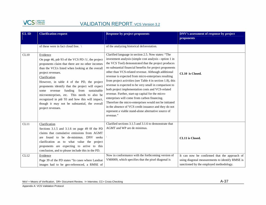
VALIDATION REPORT: VCS Version 3.2
MoV = Means of Verification, DR= Document Review, I= Interview, CC= Cross-Checking A-37 Appendix A: VCS Validation Protocol
CL ID Clarification request Response by project proponents DNV’s assessment of response by project proponents
of these were in fact cloud free. \ of the analyzing historical deforestation.
CL10
Evidence
On page 46, pdr 93 of the VCS PD /1/, the project proponents claim that there are no other incomes than the VCUs listed when looking at the overall
project revenues.
Clarification
However, in table 4 of the PD, the project
proponents identify that the project will expect some revenue funding from sustainable microenterprises, etc. This needs to also be recognized in pdr 93 and how this will impact, though it may not be substantial, the overall
project revenues.
Clarified language in section 2.5. Now states: “The investment analysis (simple cost analysis - option 1 in the VCS Tool) demonstrated that the project produces no substantial financial benefits for project proponents other than VCS-related revenue. Although additional revenue is expected from micro-enterprises resulting from project activities (see Table 4 in section 1.8), this
revenue is expected to be very small in comparison to both project implementation costs and VCS-related revenue. Further, start-up capital for the micro-enterprises will come from carbon financing. Therefore the micro-enterprises would not be initiated in the absence of VCS credit issuance and they do not represent a viable stand-alone alternative source of revenue.”
CL10 is Closed.
CL11
Clarification
Sections 3.1.5 and 3.1.6 on page 49 0f the PD claims that cumulative emissions from AGMT are found to be de-minimus. DNV seeks clarification as to what value the project
proponents are expecting to arrive to this
conclusion, and to please include this in the PD.
Clarified sections 3.1.5 and 3.1.6 to demonstrate that AGMT and WP are de minimus.
.
CL11 is Closed.
CL12
Evidence
Page 39 of the PD states “In cases where Landsat images had to be geo-referenced, a RMSE of
Now in conformance with the forthcoming version of VM0009, which specifies that the pixel diagonal is
It can now be confirmed that the approach of using diagonal measurements to identify RMSE is
sanctioned by the employed methodology.

VALIDATION REPORT: VCS Version 3.2
MoV = Means of Verification, DR= Document Review, I= Interview, CC= Cross-Checking A-38 Appendix A: VCS Validation Protocol
CL ID Clarification request Response by project proponents DNV’s assessment of response by project proponents
5.5% was achieved. The average error was 1.3 meters beyond the pixel diagonal and the average RMSE was 2.3 meters beyond the pixel
diagonal."
Clarification
DNV seeks clarification with the approach of
using diagonal measurements to identify RMSE.
used to determine the RMSE. Clarified section 2.4.5.3
CL 12 is closed.
CL13
Evidence
Page 39 of the PD states "A pilot sample of 204 interpretation points was analyzed to determine
rough estimate of the population variance."
Clarification
DNV seeks clarification as to whether it was 204
points from each year or 204 points in total.
Clarified language. Now states: “A pilot sample of 204 points in each of five years (for a total of 1020 observations) was analyzed to determine a rough
CL 13 is Closed
CL14
Evidence
Page 42 of the PD states "The accuracy of the point interpretation was verified by performing an independent check of 50 classified points from each of the eight years. Of these 400 observations (50 points over 8 years), six were found to be incorrectly identified. Another 12 observations
could not be checked because of cloud cover or Landsat 7 band striping, and were conservatively designated as incorrect interpretations. The resulting error rate for the point interpretation is 4.5%. We concluded that there were no systematic errors in how the point interpretation
Corrected calculation and clarified language. Now states: “The accuracy of the point interpretation was verified by performing an independent check of 50 points in each of the eight years of historical imagery (for a total of 400 observations). Of these 400 observations, 12 observations could not be checked because of cloud cover or Landsat 7 band striping. Of
the remaining observations, 6 observations were found to be incorrectly identified. The resulting error rate for the point interpretation is 1.5% (6 incorrect out of 388 observations). We concluded that there were no systematic errors in how the point interpretation was performed.”
CL 14 is Closed.

VALIDATION REPORT: VCS Version 3.2
MoV = Means of Verification, DR= Document Review, I= Interview, CC= Cross-Checking A-39 Appendix A: VCS Validation Protocol
CL ID Clarification request Response by project proponents DNV’s assessment of response by project proponents
was performed."
Clarification
DNV seeks clarification as to what percent of points were found to be incorrectly identified, and as to the calculation that resulted in 4.5%, please clarify how the check was performed and how
discrepancies were resolved.
CL15
Evidence
Page 33 of the Project Document states the results of the PRA, which indicate that no ranchers are active beyond the border, with only 5%
suggesting activity up to the border.
Clarification
DNV seeks clarification of whether this statement is in agreement with what is present in the
Landsat images and analysis.
Clarified language in section 2.4.1 PDR 19. Now states: "Anecdotal evidence also suggested that agents are repelled to some extent from the Colombia-Panama border by security concerns. The PRA therefore included questions about the level of activity of agents in the border region, the results of which are presented
in Table 13 (below). Because some agents are known to be active up to and beyond the border, it was determined that the border itself does not constrain agents of deforestation. However, given the steep terrain along the border, agents are of courses subject to the slope constraint described previously."
In addition, Annex H – Map of Accounting Area 2010 was revised to better demonstrate that the project accounting area is largely not adjacent to the border (due mainly to slope constraints).
With the new map of the accounting area that has been provided, the statements summarizing the PRA conducted by the project proponents can
now be corroborated.
CL 15 is closed.
CL16
Evidence
Page 39 of the Project Document, in Section 2.4.5.5, states that 1188 points were included in
Clarified language in section 2.4.5.6 to more clearly describe the total number of observations which were included in the point interpretation but ultimately
DNV finds the response adequate as it now clears up the discrepancy revolving around this issue of
number of points examined.

VALIDATION REPORT: VCS Version 3.2
MoV = Means of Verification, DR= Document Review, I= Interview, CC= Cross-Checking A-40 Appendix A: VCS Validation Protocol
CL ID Clarification request Response by project proponents DNV’s assessment of response by project proponents
the model. Interviews indicated that more than 1188 points were included in the statistical
analysis.
Clarification
DNV seeks clarifications as to the number of points included in the model and the steps taken
to arrive at that final number from the initial 1531 points that were indicated in section 2.4.5.4
excluded from the Biomass Emissions Model (and why they were excluded).
CL 16 is closed.
CL17
Evidence
Page 54 of the Project Document, in the section discussing non-permanence risks, states that “Management team engaged technical consultant EcoPartners to lead AFOLU project design and implementation and carbon accounting and
reporting. ecoPartners has successfully managed projects through validation, verification and
issuance of GHG credits.”
Clarification
DNV seeks clarification as to the exact role of EcoPartners, especially moving forward during
the project’s lifetime.
Anthrotect has retained the services of ecoPartners to support the technical development of the project, including remote sensing analysis, application of the VM0009 methodology, and forest biometrics. As the project moves from design to implementation,
ecoPartners will work to develop and refine innovative and cost-effective approaches to monitoring that combine remote sensing and GIS with a community-oriented approach. ecoPartners will continue to provide technical services throughout the life cycle of the project, ranging from forest management strategies to audit oversight and support.
The role of ecoPartners has now been better defined and explained. Their role in the future of
the project is now clear.
CL 17 is closed.
CL18
VCS PD report in section 1.2 states that “This project is categorized as Type U3 (AUDD mosaic deforestation) by the…” where the VCS PD in page 25 -26 section 2 concludes that the project should be categorized as U2. DNV seeks
clarification on this inconsistency within the VCS
U2 is the correct baseline type. VCS PD section 1.2 now states U2.
CL 18 is closed.

VALIDATION REPORT: VCS Version 3.2
MoV = Means of Verification, DR= Document Review, I= Interview, CC= Cross-Checking A-41 Appendix A: VCS Validation Protocol
CL ID Clarification request Response by project proponents DNV’s assessment of response by project proponents
PD.