Embed Size (px)
Citation preview

National Park Service U.S. Department of the Interior Northeast Region Philadelphia, Pennsylvania
Vegetation of Shenandoah National Park in Relation to Environmental Gradients, Version 2.0 Technical Report NPS/NER/NRTR—2009/142

USGS-NPS Vegetation Mapping Program Shenandoah National Park
Cover photo: Forest cover, Shenandoah National Park, 2001. Photograph by: John Young.
2
USGS-NPS Vegetation Mapping Program Shenandoah National Park
Vegetation of Shenandoah National Park in Relation to Environmental Gradients, Version 2.0 Technical Report NPS/NER/NRTR—2009/142 John Young1, Gary Fleming2, Wendy Cass3, Chris Lea4
1 U.S. Geological Survey Leetown Science Center Kearneysville, West Virginia 2 Virginia Natural Heritage Program Department of Conservation and Recreation Richmond, Virginia 3 National Park Service Shenandoah National Park Luray, Virginia 4 National Park Service Inventory and Monitoring Program Denver, Colorado
December 2009 U.S. Department of the Interior National Park Service Northeast Region Philadelphia, PA
3

USGS-NPS Vegetation Mapping Program Shenandoah National Park
The Northeast Region of the National Park Service (NPS) comprises national parks and related areas in 13 New England and Mid-Atlantic states. The diversity of parks and their resources are reflected in their designations as national parks, seashores, historic sites, recreation areas, military parks, memorials, and rivers and trails. Biological, physical, and social science research results, natural resource inventory and monitoring data, scientific literature reviews, bibliographies, and proceedings of technical workshops and conferences related to these park units are disseminated through the NPS/NER Technical Report (NRTR) and Natural Resources Report (NRR) series. The reports are a continuation of series with previous acronyms of NPS/PHSO, NPS/MAR, NPS/BSO-RNR, and NPS/NERBOST. Individual parks may also disseminate information through their own report series. Natural Resources Reports are the designated medium for information on technologies and resource management methods; “how to” resource management papers; proceedings of resource management workshops or conferences; and natural resource program descriptions and resource action plans. Technical Reports are the designated medium for initially disseminating data and results of biological, physical, and social science research that addresses natural resource management issues; natural resource inventories and monitoring activities; scientific literature reviews; bibliographies; and peer-reviewed proceedings of technical workshops, conferences, or symposia. Mention of trade names or commercial products does not constitute endorsement or recommendation for use by the National Park Service. This report was accomplished with assistance from the NPS. The statements, findings, conclusions, recommendations, and data in this report are solely those of the author(s), and do not necessarily reflect the views of the U.S. Department of the Interior, National Park Service. Print copies of reports in these series, produced in limited quantity and only available as long as the supply lasts, or preferably, file copies on CD, may be obtained by sending a request to the address on the front cover. Print copies also may be requested from the NPS Technical Information Center (TIC), Denver Service Center, PO Box 25287, Denver, CO 80225-0287. A copy charge may be involved. To order from TIC, refer to document 134/100756. Please cite this publication as: Young, J., G. Fleming, W. Cass, and C. Lea. 2009. Vegetation of Shenandoah National Park in Relation to
Environmental Gradients, Version 2.0. Technical Report NPS/NER/NRTR—2009/142. National Park Service. Philadelphia, PA.
NPS 134/100756 December 2009
4
USGS-NPS Vegetation Mapping Program Shenandoah National Park
Table of Contents
Page
Table of Contents............................................................................................................................ 5
Figures............................................................................................................................................. 6
Tables.............................................................................................................................................. 8
Appendixes ..................................................................................................................................... 9
Acknowledgements....................................................................................................................... 10
Abbreviations and Acronyms ....................................................................................................... 11
Executive Summary ...................................................................................................................... 12
1 Introduction............................................................................................................................... 15
1.1 Background..................................................................................................................................................15
1. 2 Scope of Work.............................................................................................................................................16
2 Methods..................................................................................................................................... 17
2.1 Environmental Gradient Modeling............................................................................................................17
2.2 Sample Site Selection...................................................................................................................................19
2.3 Field Survey Methods..................................................................................................................................19
2.4 Plot Data Analysis and Classification Methods ........................................................................................23
2.5 Image Processing and Classification..........................................................................................................28
2.6 Accuracy Assessment Design......................................................................................................................33
3 Results....................................................................................................................................... 37
3.1 Accuracy Assessment Plots .........................................................................................................................37
3.2 Vegetation Classification Scheme...............................................................................................................37
3.3 Vegetation Map............................................................................................................................................61
3.4 Accuracy Assessment ..................................................................................................................................62
4 Discussion ................................................................................................................................. 74
5 Conclusion ................................................................................................................................ 82
6 Literature Cited ......................................................................................................................... 83
5
USGS-NPS Vegetation Mapping Program Shenandoah National Park
Figures
Page
Figure 2.1. Example ASTER imagery (5 September 2002) and North sub-district “a” boundary. ................................................................................................................................ 30
Figure 3.1a. Shenandoah National Park vegetation map, v 2.0 output, north district, subdistrict (a). See Figure 3.1g for legend...................................................................... 63
Figure 3.1b. Shenandoah National Park vegetation map, v 2.0 output, north district, subdistrict (b). See Figure 3.1g for legend...................................................................... 64
Figure 3.1c. Shenandoah National Park vegetation map, v 2.0 output, central district, subdistrict (a). See Figure 3.1g for legend...................................................................... 65
Figure 3.1d. Shenandoah National Park vegetation map, v 2.0 output, central district, subdistrict (b). See Figure 3.1g for legend...................................................................... 66
Figure 3.1e. Shenandoah National Park vegetation map, v 2.0 output, south district, subdistrict (a). See Figure 3.1g for legend...................................................................... 67
Figure 3.1f. Shenandoah National Park vegetation map, v 2.0 output, south district, subdistrict (b). See Figure 3.1g for legend...................................................................... 68
Figure 3.1g. Legend for 35 community types mapped in Shenandoah National Park (SHEN), v 2.0 output. Refer to section 3.2.1 for community descriptions. Note that while 40 types were defined, only 35 were actually mapped. ...................................... 69
Figure 3.2. Example of issues suggesting consideration of accuracy using “fuzzy” summary methods as described in Congalton and Green (1999). Area in green shading is the predicted vegetation association boundary for map class F8 (Hemlock - Northern Hardwood Forest) from the v2.0 vegetation map. Highlighted AA plots (red circles) were assigned a primary vegetation type (map class) of F3 or F15, with a secondary assignment of F8. In a discrete accuracy assessment, these primary calls would be counted as errors, but consideration of secondary and tertiary calls in a “fuzzy” assessment allows for counting these plots as “reasonably correct”. ....................................................................................................... 73
Figure 4.1. Example class probability map for map class F23 for a section of Shenandoah National Park near Thornton Gap. Shown are high probability areas in shades of green, low probability areas in shades of red, final polygon areas from combined map outlined in purple, training data points for class F23, and AA points. These individual probability maps underlie our mapping and could be further evaluated to adjust map class assignments, although this might result in invalidating the AA campaign. ..................................................................................................... 76
6
USGS-NPS Vegetation Mapping Program Shenandoah National Park
7
Figure 4.2. Illustration of close proximity of map classes F8, F12, and F24 in both field plots (classification training plots and AA plots) and mapped community boundaries.................................................................................................................. 79
Figure 4.3. Illustration of close proximity of map classes F14 and F16 in both field plots (classification training plots and AA plots) and mapped community boundaries. Circled plots have both primary and secondary field calls as F16 and F14. ............................................................................................................................................... 79
Figure 4.4. Illustration of close proximity of map classes F4 and F18 in both field plots (classification training plots and AA plots) and mapped community boundaries. .................................................................................................................................... 81
USGS-NPS Vegetation Mapping Program Shenandoah National Park
Tables
Page
Table 2.1. Aggregate geological classes used as dummy variables in data analysis.......................................................................................................................................... 18
Table 2.2. Environmental gradient GIS layers used in vegetation community mapping......................................................................................................................................... 19
Table 2.3. Cover class scores used in field sampling and data analysis (400 m2 plot). .............................................................................................................................................. 21
Table 2.4. Topographic / hydrologic environmental indices recorded at each plot-sampling site (from protocol established by VANHP). ................................................................ 22
Table 2.5. Ordinal variables used in analysis for scalar topographic and soil moisture variables estimated in the field. ..................................................................................... 24
Table 2.6. Image and topographic datasets for Maxent model runs to predict vegetation community types. ........................................................................................................ 33
Table 3.1. Comparison of vegetation community types changed since v 1.1 mapping effort. ROMP refers to the Rock Outcrop Management Project which included additional field surveys of rock outcrop areas in the park during 2005-2007. While 40 types were defined for the v 2.0 effort, only 35 types were actually mapped. ........................................................................................................................... 60
Table 3.2. Summary of map classes, training points used, accuracy assessment points collected, and user’s and producer’s accuracies using standard (discrete) summary methods. Highlighted cells are accuracies greater than or equal to 50%..................... 70
Table 3.3. Summary of map classes, training points used, accuracy assessment points collected, user’s and producer’s accuracies using “fuzzy” summary methods as described in Congalton and Green (1999). Highlighted cells are accuracies greater than or equal to 50%. ...................................................................................... 72
8
USGS-NPS Vegetation Mapping Program Shenandoah National Park
Appendixes
Page
Appendix A. Plants observed in Shenandoah National Park during vegetation plot and thematic accuracy assessment sampling. ............................................................................... 87
Appendix B. Cluster dendrograms and ordination diagrams supporting the classification of ecological communities at Shenandoah National Park. ................................... 104
Appendix C. Dichotomous key to map classes of Shenandoah National Park vegetation map 2.0. ..................................................................................................................... 137
Appendix D. Accuracy assessment procedures and results. ...................................................... 159
Appendix E. Shenandoah National Park vgetation mapping project accuracy assessment field form.................................................................................................................. 176
Appendix F. U.S. National Vegetation Classification for Shenandoah National Park. ............................................................................................................................................ 178
Appendix G. Shenandoah National Park Vegetation Map, v 2.0: Accuracy Assessment Matrix - Discrete Case. ........................................................................................... 386
Appendix H. Shenandoah National Park Vegetation Map, v 2.0: Accuracy Assessment Matrix - "Fuzzy" Case............................................................................................. 387
9

USGS-NPS Vegetation Mapping Program Shenandoah National Park
Acknowledgements
The worked described in this report was built on previous efforts and includes reinterpretation of AVIRIS hyperspectral data developed by Phil Townsend and Jane Foster of the University of Wisconsin. Dan Hurlbert provided updated base map data for Shenandoah National Park. Alan Williams of Shenandoah National Park provided database and GIS support to this effort. We thank Karen Patterson of Virginia Natural Heritage and Lesley Sneddon of NatureServe for vegetation classification support. We also thank the following individuals for accuracy assessment field data collection: Katherine Caldwell, Becky Carmichael, Jodi Cohen, Rodney Dever, James Eaton, Nicholas Fisichelli, Lance Glassgow, Wendy Hochstedler, Nicola McGoff, Corrie Pedro, and Katherine Taylor.
10

USGS-NPS Vegetation Mapping Program Shenandoah National Park
Abbreviations and Acronyms
AA Accuracy Assessment ASCII American Standard Code for Information Interchange AVIRIS Advanced Visible and Infra-Red Imaging Sensor ASTER Advanced Spaceborne Thermal Emission and Reflection radiometer CART Classification and Regression Tree CLDA Canonical Linear Discriminant Analysis CTI Compound Topographic Index DEM Digital Elevation Model DOQQ Digital Ortho-Photograph Quarter Quadrangle ELU Ecological Land Unit GCP Ground Control Point GIS Geographic Information System GPS Global Positioning System LSC Leetown Science Center Landsat TM Landsat Thematic Mapper Maxent Maximum Entropy modeling NAD North American Datum NASA National Aeronautic and Space Administration NMDS Non-Metric Multidimensional Scaling NPS National Park Service RMI Relative Moisture Index RMSE Root Mean Square Error SAF Society of American Foresters SHEN Shenandoah National Park TCI Topographic Convergence Index TRMI Topographic Relative Moisture Index USGS United States Geological Survey USNVC United States National Vegetation Classification System UTM Universal Transverse Mercator VAGAP Virginia Gap Analysis Project VANHP Virginia Natural Heritage Program WGS World Geodetic System
11
USGS-NPS Vegetation Mapping Program Shenandoah National Park
Executive Summary
A project was initiated in 2000 by the USGS Leetown Science Center (USGS-LSC), the Virginia Natural Heritage Program (VANHP), and Shenandoah National Park (SHEN) to map the park’s vegetation communities through a combination of remote sensing, spatial modeling, field data collection, and vegetation community ordination. This project was originally intended and funded as a USGS/VANHP research project to investigate newly available remote sensing methods (e.g. hyperspectral imagery) and GIS-based environmental gradient modeling (e.g. topographic moisture and light regimes) for mapping vegetation communities to the FGDC vegetation classification standard. This project was completed in 2005 (v 1.0) and revised in 2006 (v 1.1). The final report was reviewed, revised, and made available on the USGS-LSC Web site. Findings of the project included description of 35 USNVC vegetation associations found in the park through field investigations and vegetation community ordination using data from 311 field plots collected by VANHP and USGS using an “ecological land units” sample stratification process. Vegetation community distribution was modeled using hyperspectral and multispectral imagery, GIS-based environmental gradient maps, and canonical linear discriminant analysis statistical approaches. Internal cross validation accuracy measured through resubstitution of training data suggested 88% overall accuracy and no less than 60% accuracy for any given mapped community. Subsequently, independent field-based accuracy assessment (AA) campaigns were conducted at 224 field plots in 2004 and 68 field plots in 2005. Overall field validation accuracy for the 2004 accuracy assessment campaign was 64%, while overall field validation accuracy from the 2005 accuracy assessment campaign was 51%.
While this research project was not originally a part of the USGS-NPS Vegetation Mapping Program, there has been a strong interest in including the resulting vegetation map for SHEN in the national program. As such, the accuracy assessment techniques we employed did not comply with the protocols established for the national mapping effort. In essence, not enough field samples were collected at all representative communities to ascribe accuracy estimates at the required confidence intervals. This was primarily a result of logistical limitations in accessing portions of the park that are exceedingly difficult to sample due to rough terrain and disturbed vegetation. However, our accuracy assessment design also was too focused on the larger, more representative communities at the expense of smaller, rarer communities. In addition, we summarized the accuracy using a “percent plots correct” format common in the modeling literature, but we did not summarize our accuracy results in a “confusion matrix” format common in the remote sensing literature and used by the USGS-NPS Vegetation Mapping Program as a standard reporting format.
In 2007, an opportunity was presented by the NPS to fund additional accuracy assessment field work to bring the Shenandoah National Park mapping effort in to compliance with the national program. At the same time, it was recognized by VANHP ecologists that the vegetation classification scheme developed at Shenandoah National Park could be updated to include revised vegetation community descriptions developed subsequent to the original effort. Additionally, this presented an opportunity to revise the mapping methods to account for revised community descriptions, to exploit additional plot data developed subsequent to the original
12
USGS-NPS Vegetation Mapping Program Shenandoah National Park
effort, and to attempt to correct deficiencies in the original mapping outputs. It was agreed that USGS-LSC, VANHP, and NPS personnel would conduct a one-year effort to modify and assess vegetation mapping products for a v 2.0 vegetation map that would meet the standards of the USGS-NPS Vegetation Mapping Program.
Results of this new project are described in a v 2.0 report that focuses on the methods and findings of this additional effort. The revision of the v 1.1 map products to a v 2.0 data set resulted in the following products: 1) A new vegetation classification scheme describing 40 vegetation community types (35 natural, 3 successional, and 2 disturbed types). While the classification scheme is similar to the v 1.1 effort, some changes are evident. Nine new classification types were added to the classification scheme; four community types were redefined from a re-analysis of plot data, three types were newly defined from additional plot data collected during the Rock Outcrop Management Project subsequent to the original vegetation mapping project, and two broad disturbance classes were added. Two types from the original effort were subsumed into other types. 2) A new map of predicted vegetation community distribution of 35 vegetation community types was produced based on 1,160 training plots and maximum entropy statistical modeling with five sets of nine-band ASTER multispectral imagery, two sets of 34 MNF-transformed bands of AVIRIS hyperspectral imagery, and 15 environmental gradient model variables. During mapping, five wetland types were dropped as they were too small relative to the minimum mapping unit (0.5 ha) to map reliably. 3) A statistically valid accuracy assessment campaign was implemented to sample all mapped vegetation classes at the required level of effort and field AA data was collected at 703 plots.
We summarized field collected AA data in two ways; in a discrete tabulation comparing the primary field assigned class to the mapped class, and a “fuzzy” tabulation that considered secondary and tertiary calls of vegetation type that were recorded in the field at plots where observed vegetation could not be easily assigned to a single vegetation class using the field key. Results of the discrete tabulation for the 35 vegetation classes mapped were an overall accuracy of 48.9% (user’s accuracy of 50.5%, and producer’s accuracy of 55.9%). Results of the fuzzy tabulation were an overall accuracy of 54.8% (user’s accuracy of 62.3%, producer’s accuracy of 76.9%). At first blush, accuracy of the v 2.0 map appears lower than the v 1.1 map, but due to different tabulation and summary methods, results are not directly comparable, and the accuracy assessment of the v 2.0 map should be considered more restrictive and robust.
Overall results were lower than anticipated, but not out of line with other recent efforts using similar methods. Most errors can be explained as confusion between vegetation association types that may vary subtly along gradients of canopy composition and density, understory species, substrate type, or disturbance. We found that overall accuracy could be improved without invalidating the accuracy assessment campaign by grouping vegetation classes that are similar in overstory canopy composition and topographic environment, that occur in close geographical proximity, or that were at adjacent terminal nodes of the field key. Merging these classes together would result in a vegetation community map with 25 classes, an overall discrete accuracy of 60.5%, and a fuzzy accuracy of 65.1%. Recently, efforts have been made to revise the U.S. National Vegetation Classification Standard to include “groups” and “macrogroups” in the middle of the classification hierarchy in an implicit recognition of the difficulty of mapping vegetation classes at the fine floristic detail of the association and alliance.
13

USGS-NPS Vegetation Mapping Program Shenandoah National Park
14
While meaningful from an ecological perspective, many of the defined vegetation community associations are difficult to discriminate and map. The inability to discriminate subtle differences in species composition is indicative of the limits of using moderate resolution satellite and aerial imagery (even hyperspectral imagery) and digital elevation-derived topographic gradient models for mapping to the fine specificity of the USNVC association level. Since aerial and satellite imagery view aggregates of vegetation from the top-down, and vegetation associations are defined from the ground up based on individual plants, finding a method that can accurately represent both perspectives is challenging. Future research should be aimed at better ways to link ground-based ecological concepts with vegetation patterns observable from readily available aerial imagery and spatial data.
USGS-NPS Vegetation Mapping Program Shenandoah National Park
1 Introduction
This project served as an update and addendum to the initial project (v 1.1) to classify and map the vegetation of Shenandoah National Park (SHEN) in relation to environmental gradients (Young et al. 2006). This report describes revised vegetation classification conducted by the Virginia Natural Heritage Program (VANHP), revised vegetation community distribution modeling and mapping conducted by the US Geological Survey Leetown Science Center(USGS-LSC), and a revised accuracy assessment campaign directed by the National Park Service (NPS) Inventory and Monitoring Program and staff of Shenandoah National Park to create an updated map of vegetation communities for the park (v 2.0) that complies with requirements of the USGS-NPS National Vegetation Mapping Program.
1.1 Background
While the original project was conceived and conducted as a research project rather than a project of the USGS-NPS Vegetation Mapping Program <http://biology.usgs.gov/npsveg/>, there has been a strong interest to include the results for Shenandoah National Park in the national program. As such, the accuracy assessment (AA) techniques we initially employed did not fully comply with the protocols established for the national mapping effort. In essence, not enough field samples were collected at all representative communities to ascribe accuracy estimates at the required confidence intervals (ESRI et al. 1994). This was primarily a result of logistical limitations in accessing portions of the park that are exceedingly difficult to sample due to rough terrain and disturbed vegetation. However, our accuracy assessment design also was too focused on the larger, more representative communities at the expense of smaller, rarer communities, and we did not summarize our results in a contingency table format as is common for other parks. Additional issues uncovered in our initial mapping and AA efforts were:
Models fit the training data well, but not the field-collected AA data, suggesting that the training data were either not representative of the actual variation in the park, or our statistical routine over-fitted models to the data.
As many as three possible vegetation communities were recorded at AA plots, suggesting difficulty in assigning field plots to natural vegetation community “archetypes.”
Training data used in our mapping effort were placed to sample and describe natural vegetation communities; disturbed communities were avoided. Therefore, there was likely more disturbance encountered in the AA data collection than in the data used for mapping.
Our mapping classes did not account for all potential community types that might be encountered in the field (especially disturbed or managed vegetation). Since our mapping technique was essentially a supervised classification technique, all image pixels had to be assigned to an a priori class. Therefore, noise was introduced into the resulting models by areas that did not closely fit pre-determined community types.
In 2007, an opportunity was presented by the NPS to fund additional accuracy assessment field work to bring the Shenandoah National Park mapping effort in compliance with the national program. At the same time, it was recognized by VANHP ecologists that the vegetation classification scheme developed at Shenandoah National Park could be updated to include revised vegetation community descriptions developed subsequent to the original effort.
15

USGS-NPS Vegetation Mapping Program Shenandoah National Park
16
Additionally, this presented an opportunity to revise the mapping methods to account for revised community descriptions, and to attempt to correct some of the deficiencies in the original mapping outputs detailed above. It was agreed that USGS-LSC, VANHP, and NPS personnel would conduct a one-year effort to modify and assess vegetation mapping products for a v 2.0 vegetation map that would meet the standards of the USGS-NPS National Vegetation Mapping Program.
1. 2 Scope of Work
This project addendum consisted of the following objectives:
1. Revise the vegetation community classification and field key to incorporate new and redefined classes of natural vegetation and define additional classes of disturbed/successional vegetation. a. Review all previous plot data containing sufficient vegetation community attributes to
assist in revising vegetation community classes. Attribute plot data with high or low confidence in describing the vegetation community at field sites.
b. Use knowledge gained in previous efforts and other regional vegetation community classifications to revise community descriptions.
2. Use new community classification and compiled plot data tagged with vegetation community type to revise mapping and modeling. a. Review and revise image and topographic inputs to modeling. b. Review and revise statistical routines used to extrapolate vegetation communities (i.e.
U.S. National Vegetation Classification “associations”) from field plots to unsampled areas.
c. Produce a map of updated community distributions for use in selection of accuracy assessment field points.
3. Using the revised map, design an accuracy assessment strategy for field sampling consistent with USGS-NPS Vegetation Mapping Program standards.
4. Conduct accuracy assessment field data collection in summer of 2008 using the revised vegetation classification field key.
5. Summarize results of accuracy assessment with contingency tables and by-class assessments.
USGS-NPS Vegetation Mapping Program Shenandoah National Park
2 Methods
2.1 Environmental Gradient Modeling
We used GIS-based environmental gradient models as described in Young et al. (2006) to assist image classification and vegetation community distribution modeling. While we did not revise the original landform and ecological land unit modeling, we did review and revise ecological gradient models used for image processing and classification. We based our topographically based gradient models on a 15-meter digital elevation model (DEM), similar to the initial effort (Young et al. 2006). However, the 15-meter DEM developed for the original vegetation mapping effort was derived from a combination of 10-meter DEM’s for all of the park except for the Front Royal, Virginia USGS 7.5’ quadrangle, and a 30-meter resolution DEM for the Front Royal, Virginia quadrangle. Subsequent to the original mapping effort, a 10-meter DEM became available for the Front Royal, Virginia quadrangle, allowing for complete coverage of the park at finer spatial resolution. For this effort, however, we still re-sampled the 10-meter DEM to 15-meter resolution to approximate the resolution of the satellite imagery used for classification.
We recomputed the original gradient models of Young et al. (2006) using the newly derived 15-meter DEM to describe gradients of elevation, topographic shape, solar illumination, and topographic moisture. Gradients were computed in GIS using raster-based processing in ArcGIS (ESRI, Inc.). We used correlation analysis to determine which variables were redundant and we eliminated from further processing those variables that did not add unique information. We also computed a topographically based variable for each image date to approximate the solar position and topographic shading at the time of image acquisition by computing the cosine of the solar incidence angle (cos i). This helps to reduce differential illumination influences evident in satellite imagery due to the low sun angle at the time of most satellite image acquisitions (usually ~10:00 a.m. local time) (Ekstrand 1996).
We reviewed the surficial and bedrock geology map used in the initial (v 1.1) mapping effort (Morgan et al 2004) and recoded the map units to more closely match the geologic classes used in the vegetation community ordination and classification (Table 2.1). This resulted in a recoded geology map with four classes: 1) alluvium; 2) acidic sedimentary rocks; 3) granitic rocks; and 4) mafic rocks. For modeling, recoded geologic unit maps were converted into binary (0,1) maps for use as dummy variables in statistical analysis. Since only three of four dummy variables are needed to represent the full range of variation in class variables, we left the alluvium class out of further modeling.
17

USGS-NPS Vegetation Mapping Program Shenandoah National Park
Table 2.1. Aggregate geological classes used as dummy variables in data analysis.
Group
Aggregate Geological Class
Definition and relationship to formations as defined and mapped by Rader and Evans (1993)1
1 Alluvium Heterogeneous, bouldery and cobbly stream-bottom alluvium derived from and underlain by various formations
2 Acidic Sedimentary Outcrops and debris of quartzite, metasandstone, metasiltstone, and phyllite prevalent in Cch and Zsr
3 Granitic Outcrops and debris of charnockite, charnockite gneiss, granite, leucogranite, granulite, and related rocks in Yal, Yc, Ycm, Yor, and Ypg
4 Mafic Outcrops and debris of metabasalt prevalent in Czc 1 Names of formations:
Cch –Chilhowee Group (Antietam, Harpers, and Weaverton Formations) Czc – Catoctin Formation Yal – Leucogranite Yc – Charnockite Ycm – Chanockite Gneiss Yor – Old Rag Granite Ypg – Layered Pyroxene Granulite Zsr – Swift Run Formation
We also incorporated two additional layers into the modeling in an effort to represent potential disturbance influences on vegetation communities. The first was a GIS data layer representing fire return interval developed at SHEN from mapped fire boundaries. This map represents the number of years since areas were last burned, with a base year of 1925 (Dan Hurlbert, Shenandoah National Park, personal communication). The original polygon layer was converted into a 15-meter resolution raster image, with each pixel numerically coded with fire return interval in years. The second layer is a GIS map of canopy disturbance from 1984 to 2002. This layer was computed by conducting a change analysis on normalized difference vegetation indices (NDVI) calculated from visible and near infrared spectral bands of early September 1984 and early September 2002 Landsat 5 satellite imagery (30-meter pixel resolution). We applied a threshold to the resulting change image to capture significant tree canopy change (loss) from 1984 to 2002. The resulting binary image was used as a mask in subsequent modeling.
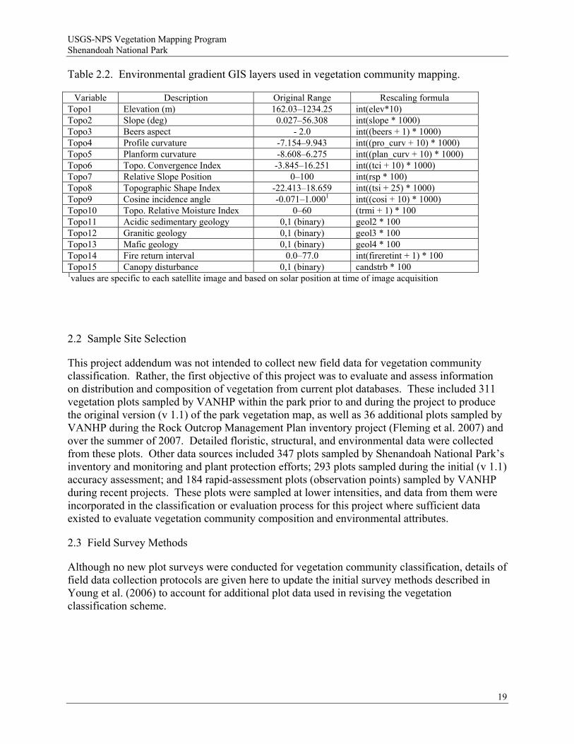
All resulting environmental gradient layers were output as raster GIS data layers, aligned to the same geographic grid (e.g. the same number of rows and columns, the same 15-meter cell size, and the same origin). All mapping was conducted in UTM, zone 17, NAD83 map projection. In order to combine environmental gradient layers with image data (described below) for modeling, raster GIS data layers had to be rescaled to 16-bit, unsigned integer. This was accomplished by multiplying floating point raster layers by an appropriate increment to rescale values between 0 and 65,535. This process retains the same relative data scaling, but converts data from floating point values to integer. Table 2.2 lists the final set of 15 environmental gradient layers used in modeling, and the formula used for rescaling each layer.
18
USGS-NPS Vegetation Mapping Program Shenandoah National Park
Table 2.2. Environmental gradient GIS layers used in vegetation community mapping.
Variable Description Original Range Rescaling formula Topo1 Elevation (m) 162.03–1234.25 int(elev*10) Topo2 Slope (deg) 0.027–56.308 int(slope * 1000) Topo3 Beers aspect - 2.0 int((beers + 1) * 1000) Topo4 Profile curvature -7.154–9.943 int((pro_curv + 10) * 1000) Topo5 Planform curvature -8.608–6.275 int((plan_curv + 10) * 1000) Topo6 Topo. Convergence Index -3.845–16.251 int((tci + 10) * 1000) Topo7 Relative Slope Position 0–100 int(rsp * 100) Topo8 Topographic Shape Index -22.413–18.659 int((tsi + 25) * 1000) Topo9 Cosine incidence angle -0.071–1.0001 int((cosi + 10) * 1000) Topo10 Topo. Relative Moisture Index 0–60 (trmi + 1) * 100 Topo11 Acidic sedimentary geology 0,1 (binary) geol2 * 100 Topo12 Granitic geology 0,1 (binary) geol3 * 100 Topo13 Mafic geology 0,1 (binary) geol4 * 100 Topo14 Fire return interval 0.0–77.0 int(fireretint + 1) * 100 Topo15 Canopy disturbance 0,1 (binary) candstrb * 100 1values are specific to each satellite image and based on solar position at time of image acquisition
2.2 Sample Site Selection
This project addendum was not intended to collect new field data for vegetation community classification. Rather, the first objective of this project was to evaluate and assess information on distribution and composition of vegetation from current plot databases. These included 311 vegetation plots sampled by VANHP within the park prior to and during the project to produce the original version (v 1.1) of the park vegetation map, as well as 36 additional plots sampled by VANHP during the Rock Outcrop Management Plan inventory project (Fleming et al. 2007) and over the summer of 2007. Detailed floristic, structural, and environmental data were collected from these plots. Other data sources included 347 plots sampled by Shenandoah National Park’s inventory and monitoring and plant protection efforts; 293 plots sampled during the initial (v 1.1) accuracy assessment; and 184 rapid-assessment plots (observation points) sampled by VANHP during recent projects. These plots were sampled at lower intensities, and data from them were incorporated in the classification or evaluation process for this project where sufficient data existed to evaluate vegetation community composition and environmental attributes.
2.3 Field Survey Methods
Although no new plot surveys were conducted for vegetation community classification, details of field data collection protocols are given here to update the initial survey methods described in Young et al. (2006) to account for additional plot data used in revising the vegetation classification scheme.
19
USGS-NPS Vegetation Mapping Program Shenandoah National Park
2.3.1 Field Data Collection
Plots used in the quantitative analysis for the original project, and, subsequently, in this project addendum, were sampled using the relevé method (sensu Peet et al. 1998) following standard VANHP procedures. As a rule, 400 m2 quadrats with 20×20 m configurations were employed in forest and woodland vegetation, while 100 m2 quadrats with 10×10 m configurations were used in shrubland and herbaceous vegetation. At some plots, however, rectangular configurations (e.g., 16×20 m, 10×40 m, or 5×20 m) were used to conform with narrow vegetation zones of cliffs, ridge crests, ravines, and stream bottoms. In several cases, rocks, downfalls, and other impediments made it impractical to sample anything larger than a 200 m2 plot. The majority of plot data (208 plots) used in the analysis were collected from 2001–2003 under the project plan for the initial (v 1.1) park vegetation map. Data from 14 plots sampled during the summer of 2007, 27 plots sampled during the Rock Outcrop Management Plan inventory project (2005–2007), and 103 plots sampled by VANHP during the period 1990–2000 were also utilized in the project.
2.3.2 Vegetation Measurements
To the extent possible, plots were placed in homogeneous stands of vegetation. Within each plot, the percent cover of each vascular plant taxon was visually estimated as a vertical projection of above-ground biomass onto the full plot area and assigned to one of nine numerical cover classes (Table 2.3). In addition to this total cover value, cover was estimated for each species in the following height classes:
herb layer (woody stems <0.5 m in height and all herbaceous plants) shrub layer (>0.5–6 m in height) tree layer (>6–10 m in height) tree layer (>10–20 m in height) tree layer (>20–35 m in height) tree layer (>35 m in height) The overall cover of mosses, lichens, and liverworts was estimated, but the individual covers of non-vascular taxa were not estimated. Vascular plants thought to be characteristic of the sampled community, but located outside the plot, were recorded parenthetically if visible from the boundary, and assigned a cover class score of “p.” The total vegetative cover in each stratum was also estimated using the same nine-point cover-class scale used to estimate species cover (Table 2.3).
In addition to recording presence and cover for all species, stand structure was quantified by measuring the size distribution and vertical stratification of woody plants. Each woody stem (trees, shrubs, lianas) ≥2.5 cm dbh and <40 cm dbh was tallied within 5 cm diameter classes, using the measurement of the stem at breast height (1.4 m). Diameter at breast height (dbh) classes used were 2.5–5, >5–10, >10–15, >15–20, >20–25, >25–30, >30–35, and >35–40 cm. Stems >40 cm dbh were individually measured to the nearest 1 cm. The maximum canopy height was measured using a clinometer.
20

USGS-NPS Vegetation Mapping Program Shenandoah National Park
Table 2.3. Cover class scores used in field sampling and data analysis (400 m2 plot).
Cover Class Percent Cover Range Area of Coverage Cover Class Midpoint (%) (p) present outside plot - - 1 <0.1% <20 cm2 0.05 2 0.1%–1% 20 cm2–4 m2 0.55 3 1–<2% 4 m2–8 m2 1.50 4 2–<5% 8 m2–20 m2 3.50 5 5–<10% 20 m2–40 m2 7.50 6 10–<25% 40 m2–100 m2 17.50 7 25–<50% 100 m2–200 m2 37.50 8 50–<75% 200 m2–300 m2 62.50 9 75–<100% 300 m2–400 m2 87.50
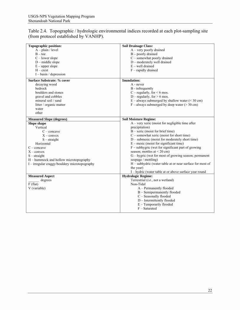
2.3.3 Environmental Measurements
A standard set of environmental data was measured or estimated at each plot (Table 2.4). Slope inclination and aspect were measured to the nearest degree from plot center. In plots with variable microtopography, slope was measured at several points and averaged. Elevation was determined to the nearest 10 ft (~3 m) using a topographic map or altimeter. The percent cover of different surface substrates was estimated visually, with precision varying such that values summed to 100%. Topographic position, slope shape (both horizontally and vertically), soil drainage class, soil moisture regime, and inundation were assessed using scalar values. Bedrock geology was determined to the greatest precision possible by using existing geological maps, while the characteristics of surface rocks present in a plot were recorded in the field.
Soil samples were collected from the top 10 cm of mineral soil (below the surficial litter and humus) at 318 plots. Mineral soil was absent, or not possible to collect, at 34 plots located on rock outcrops or boulderfields. As a rule, soil was collected from several locations within a plot and mixed into a composite sample. Depth of surface duff, soil color, and texture were evaluated in the field and recorded on the plot forms. Soil samples were oven-dried, sieved (2 mm), and analyzed for pH, phosphorus (P), soluble sulfur (S), exchangeable cations (calcium [Ca], magnesium [Mg], potassium [K], and sodium [Na] in ppm), extractable micronutrients (boron [B], iron [Fe], manganese [Mn], copper [Cu], zinc [Zn], and aluminum [Al], in ppm), total exchange capacity (CEC; m.e.q./100g), total base saturation (%TBS), and percent organic matter (%OM). Chemical analyses were conducted by Brookside Laboratories, Inc., New Knoxville, Ohio. Extractions were carried out using the Mehlich III method (Mehlich 1984) and percent organic matter was determined by loss on ignition.
Evidence of any past or ongoing disturbances, including but not limited to logging, fire, exotic plants, erosion, grazing/browsing, wind or ice damage, hydrologic alterations, chestnut blight, dogwood anthracnose, southern pine beetle, gypsy moth, and hemlock woolly adelgid, was recorded from each sampling site.
21
USGS-NPS Vegetation Mapping Program Shenandoah National Park
Table 2.4. Topographic / hydrologic environmental indices recorded at each plot-sampling site (from protocol established by VANHP).
Topographic position: A – plain / level B – toe C – lower slope D – middle slope E – upper slope H – crest I – basin / depression
Soil Drainage Class: A – very poorly drained B – poorly drained C – somewhat poorly drained D – moderately well drained E – well drained F – rapidly drained
Surface Substrate: % cover decaying wood bedrock boulders and stones gravel and cobbles mineral soil / sand litter / organic matter water other
Inundation: A - never B - infrequently C – regularly, for < 6 mos. D – regularly, for > 6 mos. E – always submerged by shallow water (< 30 cm) F – always submerged by deep water (> 30 cm)
Measured Slope (degrees) Slope shape
Vertical C – concave X – convex S – straight
Horizontal C – concave X – convex S – straight H – hummock and hollow microtopography I – irregular craggy/bouldery microtopography
Soil Moisture Regime: A – very xeric (moist for negligible time after precipitation) B – xeric (moist for brief time) C – somewhat xeric (moist for short time) D – submesic (moist for moderately short time) E – mesic (moist for significant time) F – subhygric (wet for significant part of growing season; mottles at < 20 cm) G – hygric (wet for most of growing season; permanent seepage / mottling) H – subhydric (water table at or near surface for most of the year) I – hydric (water table at or above surface year round
Measured Aspect ______ degrees F (flat) V (variable)
Hydrologic Regime: Terrestrial (i.e., not a wetland) Non-Tidal
A – Permanently flooded B – Semipermanently flooded C – Seasonally flooded D – Intermittently flooded E – Temporarily flooded F – Saturated
22
USGS-NPS Vegetation Mapping Program Shenandoah National Park
2.3.4 Sampling Site Metadata
Standard metadata, or information regarding the implementation of the sampling protocol, were recorded at each plot. These included plot numbers, date(s) of sampling, participants, geopolitical locality (county/city), survey site name, USGS quadrangle, plot size and configuration, photographic documentation, and a written description of the plot location. Plots were assigned unique alpha-numeric codes. A global positioning system (GPS) unit was routinely used to record locational data with greater precision. For plots established prior to 2000, the UTM (Universal Trans Mercator) coordinates of each plot location were determined to 10 m (~33 ft) precision using either GPS or by using ArcView GIS (Version 3.2; ESRI 1999), and all plot locations were mapped as precisely as possible on USGS 7.5’ quadrangle maps. Plots established in 2000 or afterwards were mapped in the field using GPS receivers. Plot coordinates were either differentially corrected or averaged from 30 or more non-differentially corrected positions. Accuracy of post-2000 plot coordinates is estimated to be <10 m (~33 ft).
2.4 Plot Data Analysis and Classification Methods
2.4.1 Data Preparation and Transformation
Stem diameter measurements were used to compute density (stems/ha) and basal area (m2/ha) for all woody plants at each sampling site. Basal area was calculated by multiplying the geometric mean of each diameter class by the density of stems within that class. Density and basal area were used to calculate importance value, defined as the average of relative density and relative basal area for each species.
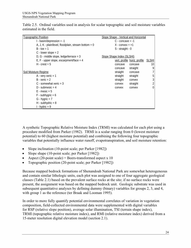
Prior to analysis, most environmental variables were transformed, either to normalize frequency distributions or to assign numeric values to categorical variables. Topographic position, slope shape in vertical and horizontal directions, and soil moisture regime were converted to ordinal variables (Table 2.5). While the resulting absolute values of these variables are arbitrary, the rank orders of values correspond to putative underlying environmental gradients. Aspect was transformed using the cosine method of Beers et al. (1966), using the formula A'=cos(45º-A)+1, where A' = transformed aspect and A = aspect in degrees.
This transformation standardizes aspect to a linear variable from 0 (225º; SW, dry, solar-exposed) to 2 (45º; NE, moist, sheltered), and can be used as a surrogate variable for topographic moisture and solar exposure.
Surface substrate values were converted to decimals and arcsine square-root transformed to normalize their distributions. Since the values for all substrate classes sum to 100 and, thus, each can be defined as a linear combination of the others, a non-vascular (bryophyte and lichen) substrate cover was added to eliminate collinearity in surface substrate for most plots. Values for all soil chemistry variables except pH were natural log-transformed to normalize their distributions and make the values more biologically interpretable (Palmer 1993). Values for percent organic matter and percent base saturation were converted to decimals and arcsine square-root transformed. A synthetic soil fertility index (CEC x TBS/100) was also calculated for each plot. Horizontal and vertical slope shape were converted to a single ordinal variable (scale = 0 to 10) using a modification of Parker (1982) (Table 2.5).
23
USGS-NPS Vegetation Mapping Program Shenandoah National Park
Table 2.5. Ordinal variables used in analysis for scalar topographic and soil moisture variables estimated in the field.
Topographic Position Slope Shape - Vertical and HorizontalI - basin/depression = -1 C - concave = -1A, J, K - plain/level, floodplain, stream bottom = 0 X - convex = +1B - toe = 1 S - straight - 0C - lower slope = 2D, G - middle slope, ledge/terrace = 3 Slope Shape Index (SLSHI)E, F - upper slope, escarpment/face = 4 vert. profile horiz. profile SLSHIH - crest = 5 concave concave 10
concave straight 9Soil Moisture Regime straight concave 7
A - very xeric = 1 straight straight 5B - xeric = 2 straight convex 3C - somewhat xeric = 3 convex straight 2D - submesic = 4 convex convex 0E - mesic = 5F - subhygric = 6G - hygric = 7H - subhydric = 8I - hydric = 9
A synthetic Topographic Relative Moisture Index (TRMI) was calculated for each plot using a procedure modified from Parker (1982). TRMI is a scalar ranging from 0 (lowest moisture potential) to 60 (highest moisture potential) and combining the following four topographic variables that potentially influence water runoff, evapotranspiration, and soil moisture retention:
Slope inclination (10-point scale; per Parker [1982]) Slope shape (10-point scale; per Parker [1982]) Aspect (20-point scale) = Beers-transformed aspect x 10 Topographic position (20-point scale; per Parker [1982]) Because mapped bedrock formations of Shenandoah National Park are somewhat heterogeneous and contain similar lithologic units, each plot was assigned to one of four aggregate geological classes (Table 2.1) based on the prevalent surface rocks at the site; if no surface rocks were present, the assignment was based on the mapped bedrock unit. Geologic substrate was used in subsequent quantitative analyses by defining dummy (binary) variables for groups 2, 3, and 4, with group 1 as the reference (ter Braak and Looman 1995).
In order to more fully quantify potential environmental correlates of variation in vegetation composition, field-collected environmental data were supplemented with digital variables for RSP (relative slope position), average solar illumination, TSI (terrain shape index), TRMI (topographic relative moisture index), and RMI (relative moisture index) derived from a 15-meter resolution digital elevation model (section 2.1).
24
USGS-NPS Vegetation Mapping Program Shenandoah National Park
Botanical nomenclature generally follows The PLANTS Database, Version 3.5, (United States Department of Agriculture and Natural Resources Conservation Service 2004), except for 13 species for which The PLANTS Database standard differs from the U.S. National Vegetation Classification (USNVC) standard. As a rule, taxa were treated at the highest level of resolution possible, but the identification of varieties and subspecies was not always possible. A few taxa identified only at generic or higher levels (e.g., “Carex sp.” or “unidentified woody seedling”) were deleted prior to analysis. A list of all vascular plant taxa recorded in plot sampling is provided in Appendix A.
2.4.2 Cluster Analysis
Hierarchical, agglomerative cluster analysis, implemented in the software program PC-ORD (version 5.04; McCune and Mefford 1999), was employed to identify compositionally similar groups and generate a classification from the combined 347-plot data set. During preliminary analyses, the Lance-Williams Flexible-Beta linkage method (Lance and Williams 1966, 1967) was used in conjunction with the Bray-Curtis coefficient of community (Bray and Curtis 1957) to identify major groups in the dataset. Based on these analyses, the full dataset was divided into six subsets containing, roughly, plots of 1) acidic forests, 2) high-elevation forests, 3) rich mesic forests and rich oak-hickory forests, 4) rock outcrops, 5) alluvial and non-alluvial wetlands, and 6) early-successional (modified) forests. Plots of early-successional forests were not clearly separable from alluvial forest plots but were segregated into their own group. Additionally, nine compositionally unique or heterogeneous plots were identified as outliers and removed from further analysis.
Subsequent cluster analyses were conducted on the five subsets of natural vegetation (the sixth subset, consisting of modified successional vegetation, was not analyzed further) and smaller groups thereof using three data treatments: 1) raw cover class scores, 2) cover class scores relativized by site totals, and 3) cover class scores relativized by species maxima. Moreover, analyses using each data treatment were run with two different dissimilarity measures: the Bray-Curtis coefficient and Chord Distance (relativized Euclidian distance; McCune and Grace 2002). A beta setting of −0.5 was used in all analyses. All six combinations of data treatments and clustering strategies performed similarly in the analyses of each subset, producing dendrograms with similar major divisions and plot groupings and a high percentage of plots with the same finer-level group memberships. After examining the results from all six protocols, the most ecologically interpretable dendrogram for each subset and smaller group was accepted (Appendix B).
2.4.3 Compositional Summary Statistics
Compositional statistics were calculated to evaluate the adequacy of groups recognized in cluster analysis and, ultimately, to assist in naming and describing the community types. Initially, total mean cover and total frequency across all plots of three major compositional groups (acidic forests [subset 1], basic and high-elevation forests [subsets 2 and 3], and rock outcrops and wetlands [subsets 4 and 5]) were determined for every taxon. Cover class scores were converted to the midpoints of their respective percent ranges, the midpoints were averaged, and resulting values were back-transformed to cover class scores. For each taxon in each group of plots being evaluated as a potential community type, the following summary statistics were then calculated:
25
USGS-NPS Vegetation Mapping Program Shenandoah National Park
Frequency – the number of samples in a group in which a species occurs. Mean Cover – back-transformed cover class value corresponding to mean percent cover
calculated from midpoint values of cover class ranges. All samples assigned to a group were considered when calculating mean cover, not just those in which a taxon was present; absences were assigned a cover value of 0.
Relative Cover – the arithmetic difference between mean cover (for a given group of samples) and total mean cover (for the major compositional subset) (= Mean Cover – Total Mean Cover). Expressed by plus or minus symbols, this value provides a relative approximation of how much more, or less, abundant a particular species is in a community type compared to the larger subset.
Constancy – the proportion of samples in a group in which a species occurs, expressed as a percentage (= [Frequency / Number of samples in group] × 100). Because they are scaled to 100, constancy values can be compared across community types with unequal numbers of plots.
Fidelity – the degree to which a species is restricted to a group, expressed as the proportion of total frequency that frequency in a given group constitutes (= [Frequency / Total Frequency] × 100). An accidental or exotic species can have maximal (100) fidelity to a type if it occurs in only one sample in the larger group. As a result, fidelity alone can perform poorly as a criterion for identifying characteristic species and distinguishing among types.
Diagnostic Value (DV) (= [Constancy × Fidelity] / 100). A synthetic value indicating species that are both frequent within and relatively restricted to a group of plots.
Diagnostic Value Adjusted by Cover, Scaled (Scaled Adj DV) (= [Diagnostic Value × Mean Cover] / 9). By dividing DV by 9, the maximum possible cover value, this statistic synthesizes information about frequency, diagnostic value, and mean abundance. A species entirely restricted to a particular community type, occurring in every sample of that type, and attaining maximum mean cover will have a Scaled Adjusted DV of 100 for that type. Empirically, taxa with Scaled Adjusted DVs ≥ 15 are almost always those most characteristic of a type, although the exact range of values in any given type or data set may vary considerably.
Diagnostic Value Adjusted by Cover, Unscaled (Unscaled Adj DV) (= Diagnostic Value x 2relative cover ). An alternative, unscaled synthetic measure of adjusted DV, using relative cover as the modifier of DV. Since cover classes form a logarithmic, rather than linear scale of values, Unscaled Adjusted DV is a statistically more legitimate means of incorporating information on cover, and has the advantage of not favoring only dominant species and better identifying species that are considerably more abundant within a given type than in the data set as a whole. This statistic is sensitive, however, to vegetation types containing few samples and to species with low overall frequency.
Additionally, the following statistics were generated for each group under consideration:
Mean Species Richness – the average number of species present per plot (S ); only species rooted inside plot boundaries were included in this calculation.
Homoteneity – the mean constancy of the S most constant species, expressed as a fraction. This value (sensu Curtis 1959) can be considered the constancy of the average species in a community type; higher values for homoteneity indicate greater uniformity in species composition among plots. Although homoteneity is not independent of group size, often
26
USGS-NPS Vegetation Mapping Program Shenandoah National Park
increasing as the number of group members decreases, it can be used to evaluate whether community types have been defined at an appropriate level.
These procedures were used to efficiently evaluate a sizeable number of groups in the competing dendrograms generated by different cluster analysis protocols. Several problematic plots, which shifted among multiple groups depending on the clustering protocol used, were ultimately assigned to one group by evaluating the statistical interpretability of each affected group with and without the questionable plot, and by examining the position of the plot on the axes of non-metric multidimensional scaling ordinations (see below).
2.4.4 Community Type Structural Characterization
The standard forestry statistics calculated for each plot (see section 2.3.2) representing a community type were averaged to obtain a composite characterization of woody vegetation for that type. In addition, the typical vertical structure of each community type was determined by averaging cover class scores of all woody species in each stratum across all plots representing the type. Similarly, mean canopy height for a community type was obtained by averaging the canopy height measurements from all representative plots.
2.4.5 Environmental Summary Statistics
Mean values for continuous and ordinal environmental variables were calculated for each group to aid in describing the units and identifying the differences between them. These calculations were performed with raw (untransformed) values, which were averaged across all plots representing a given group. Mean aspect was calculated as the average position along an arc defined by the range of aspect values.
2.4.6 Ordination
The ordination method “non-metric multidimensional scaling” (NMS; Kruskal 1964) was used to validate the classification, detect compositional variation and trends that are obscured in cluster analysis, and aid in identifying the environmental gradients along which vegetation classes and community types are distributed. NMS is a type of indirect gradient analysis that assigns samples to coordinates in ordination space in a way that maximizes, to the extent possible, the rank-order (i.e., non-parametric) correlation between inter-sample distance in ordination space and inter-sample dissimilarity (i.e., ecological distance; Minchin 1987). Ordination studies of each major compositional group identified in cluster analysis, as well as of selected smaller groups of closely related community types, were conducted (Appendix B). NMS was implemented in PC-ORD (version 5.04; McCune and Mefford 1999). The Bray-Curtis index was used to calculate dissimilarity and VARIMAX rotation was employed to optimize axis placement in all ordination studies for this project. Each ordination was computed using 50 random starting configurations, and configurations with the lowest stress levels were used for interpretation.
Based on preliminary plots of stress vs. dimensionality, most ordinations were extracted in three dimensions. Two-dimensional ordinations were used to examine compositional variation within a few of the smaller groups. Pearson correlations between environmental variables and sample
27
USGS-NPS Vegetation Mapping Program Shenandoah National Park
coordinates on each axis were calculated, and significant correlations were displayed through joint plot overlays. Environmental variables derived from field-measured data used in ordination analyses were: ordinal variables for slope shape; continuous variables for arcsine-transformed surface substrate values, Beers-transformed aspect, slope, elevation, raw and natural log-transformed soil chemistry values; topographic relative moisture index (TRMI); and dummy variables for geologic substrate. Digitally-derived variables for average solar illumination, relative slope position (RSP), terrain shape index (TSI), and relative moisture index (RMI) were also used.
2.4.7 Assignment of Classified Vegetation Types to the National Vegetation Classification System
Once the classification was finalized, the classified vegetation types were subjectively compared to existing units of the USNVC (Anderson et al. 1998; Grossman et al. 1998; NatureServe 2002). All Shenandoah National Park types were assigned to a conceptually similar USNVC type. The global USNVC descriptions for existing types were edited, and local park descriptions were written for all classified types. During this process, the global and state conservation ranks of each existing type were re-evaluated and modified if needed.
In addition, data from 818 supplementary plots (SHEN inventory and monitoring and plant protection programs, initial [v1.1] vegetation map accuracy assessment, and rapid assessment observation points) were reviewed, and 804 were subjectively assigned to USNVC types based on their floristic composition and environmental setting. The remainder were assigned to one of two broad disturbance classes: 1) catastrophically disturbed forest, or 2) cultural meadow.
2.4.8 Development of Field Key to Shenandoah National Park Vegetation Types
A dichotomous key for field identification of classified types was prepared by by VANHP, and the final key (Appendix C) was produced after four days of field-testing in the park by VANHP and Shenandoah National Park biological technicians.
2.5 Image Processing and Classification
2.5.1 Hyperspectral Imagery
We used the same hyperspectral imagery as in the initial (v 1.1) mapping effort (Young et al. 2006); two 224 band AVIRIS hyperspectral scenes of the park acquired on 14 May 2000 and 13 July 2001. This imagery had been corrected for atmospheric effects, the spectral values were converted to reflectance, and the imagery was referenced to UTM map coordinates. Image bands that fell in atmospheric spectral absorption windows were removed from further processing resulting in 181 useable spectral image bands. AVIRIS images were acquired in two strips that when combined covered all of the park except for small sections of the extreme northern, extreme southern, and extreme western portions of the boundary.
In order to enhance spectral processing and compress the data for use in statistical modeling, we computed a “minimum noise fraction” (MNF) transformation of the 181 spectral bands in ENVI (ITT Visual Information Solutions) image processing software. This technique uses the high data redundancy inherent in hyperspectral imagery and principal components analysis to create
28
USGS-NPS Vegetation Mapping Program Shenandoah National Park
new image bands that are separated into coherent signal components and noise components (Greene et al. 1988). After the transform, only the coherent image components are retained for modeling. This resulted in reducing the 181 bands of spectral data from the original imagery to 35 MNF transformed image bands.
2.5.2 ASTER Multispectral Imagery
For the v 1.1 mapping effort, we used 30-meter resolution Landsat TM satellite imagery to fill in areas at the extreme south and west of the park not covered by AVIRIS imagery. For v 2.0 mapping, we replaced Landsat imagery with ASTER satellite image data in an attempt to increase spectral and spatial resolution. ASTER (Advanced Spaceborne Thermal Emission and Reflection Radiometer) is a 15-band imaging sensor flown aboard NASA’s TERRA satellite, launched in 1999. The sensor consists of three separate imaging subsystems, one that images four bands of visible reflectance at 15-meter resolution (one rearward looking for stereo imagery), a second subsystem that images six bands of shortwave infrared reflectance at 30-meter resolution, and a third subsystem that images five bands of thermal infrared emission at 60-meter resolution <http://asterweb.jpl.nasa.gov/index.asp>.
We acquired ASTER imagery covering Shenandoah National Park for four dates to represent vegetation conditions in spring, summer, and fall: 24 May 2002, 5 September 2002, 13 September 2002, and 5 November 2004. Each image date consisted of two to three sub-images that were joined together to create one complete image for each date. Imagery was acquired from NASA in reflectance units, so no further atmospheric correction was applied. We used orthorectification procedures in ENVI image processing software to assure images were georeferenced and properly aligned with each other and with GIS data.
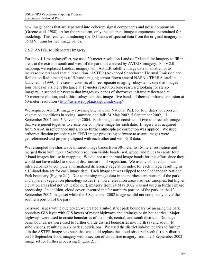
We resampled the shortwave infrared image bands from 30-meter to 15-meter resolution and merged them with three 15-meter resolution visible bands (red, green, and blue) to create four 9-band images for use in mapping. We did not use thermal image bands for this effort since they would not have added to spectral discrimination of vegetation. We used visible red and near infrared bands to compute a normalized difference vegetation index for each image, resulting in a 10-band data set for each image date. Each image set was clipped to the Shenandoah National Park boundary (Figure 2.1). Due to missing image data in the northeastern portion of the park, and apparent vegetation phenology issues (i.e. lower elevation areas had leaf canopies, but higher elevation areas had not yet leafed out), imagery from 24 May 2002 was not used in further image processing. In addition, cloud cover obscured the far northern portion of the park on the 13 September 2002 image set while the 5 September 2002 image set did not completely cover the southern portion of the park.
To avoid issues with cloud cover, we created a sub-district park boundary by merging the park boundary GIS layer with GIS layers of major highways and drainage basin boundaries. Major highways were used to create boundaries of the north, central, and south districts. Drainage basin boundaries were used to further divide district boundaries into north (a) and south (b) subdivisions, resulting in six park subdivisions. We used the district sub-boundaries to further clip the ASTER image sets such that we could replace the cloud obscured north (a) sub-district on 13 September 2002 imagery with a section of cloud free imagery from the 5 September 2002 image set for further processing (Figure 2.1).
29
USGS-NPS Vegetation Mapping Program Shenandoah National Park
Figure 2.1. Example ASTER imagery (5 September 2002) and North sub-district “a” boundary.
2.5.3 Aerial Photography
Aerial photography used for this mapping was the same as described for the original mapping effort (Young et al. 2006). As in the previous effort, these data were used for reference and for photointerpretation of additional training points to use in the revised classification.
2.5.4 Plot Data Available for Image Processing and Classification
After classification and ordination, plot data with appropriate vegetation community information were assigned USNVC types. These plots were then provided in ESRI shapefile format to USGS-LSC to use in image processing and vegetation community mapping as potential classification training data. This included 347 plots from vegetation community plots conducted by VANHP and partners (311 of which were used as training data for the initial [v 1.1] mapping effort), 184 VAHNP observation points, 293 points collected as accuracy assessment points for
30
USGS-NPS Vegetation Mapping Program Shenandoah National Park
the initial vegetation map, and 341 plots from Shenandoah National Park inventorying and monitoring and plant protection programs for a total of 1,165 plots. In addition to the USNVC type assigned to each plot, the VAHNP attributed 40 plots as “low confidence” in classification based on uncharacteristic vegetation or floristic disturbance (not canopy disturbance). To minimize confusion in the training data, these 40 points were removed from the dataset used for mapping, resulting in a dataset of 1,125 vegetation plot points.
We used aerial photography to manually locate additional training points in easily identifiable areas to capture more training data for image interpretation. We placed 14 points in areas easily identifiable as catastrophically disturbed, 16 points in cultural meadows and maintained grass fields adjacent to Skyline Drive, and five points in outcrops that were known from previous field work. These 35 additional points resulted in a training dataset of 1,160 points for use in mapping; 3.7 times the training data used in the initial effort.
We used the dataset of 1,160 training data points to overlay and sample the image bands from image processing such that we had image spectral data variables that corresponded to locations of plot points for each image type and date. This resulted in 35 image (MNF) spectral band values for each of two hyperspectral image dates, and 10 spectral band values for each of three ASTER image dates sampled and stored as attributes for each plot point location. Plot points sampled for AVIRIS imagery were reduced slightly because we could not sample image data in some cloud obscured areas, or in areas within the park outside of the AVIRIS image boundaries.
2.5.5 Topographic Gradients
Topographic gradients described in Table 2.2 were sampled using the 1,160 training data points in a manner identical to that described for image data. This resulted in a set of 15 environmental gradient attribute variables at each training data point location.
2.5.6 Statistical Modeling Using Maxent
In the initial (v 1.1) mapping we used “canonical linear discriminant analysis” (CLDA) to develop statistical models for community distribution from image and topographic variables. Essentially, this technique transforms the image and topographic values sampled at each plot location into canonical axes to find the underlying structure of the data and to maximize separation between groups (e.g. associations), then uses discriminant analysis to define linear functions to predict group membership based on canonical scores. These linear functions are then projected onto geographic space using imagery and topographic map layers to produce probability values for each community at each pixel. We smoothed these probability values (using a local mean operator equivalent in size to a 0.5 ha minimum mapping unit to reduce the “salt and pepper” effect) and overlaid them to find the vegetation class type with the maximum predicted probability value at each pixel. The resulting raster map has pixels coded with predicted vegetation class. Adjacent pixels coded with the same class type form mapped blocks of vegetation communities which were turned into polygons.
While the procedure worked reasonably well to predict communities based on image and topographic values at plot locations, it is difficult to implement, requiring specialized scripts and multiple steps to interact with image processing, statistical, and GIS software. In addition, the
31
USGS-NPS Vegetation Mapping Program Shenandoah National Park
technique appeared to over-fit the training data, and appeared to over predict several community types. In order to reduce the likelihood of over fitting and to ease the processing burden of CLDA implementation, for this updated (v 2.0) effort we used a statistical approach based on “maximum entropy” to predict vegetation community distributions from image and topographic values sampled at plot locations.
Maximum entropy is a statistical machine learning technique that estimates an unknown probability distribution (e.g. a vegetation community distribution) that best conforms to known constraints (e.g. topography, moisture, soil minerals, incident radiation) as provided by training data (Phillips et al. 2006). A maximum entropy distribution is one that is closest to a uniform distribution given the set of constraints (Guisan et al. 2007). This approach has been used for pattern recognition and image analysis, and was recently developed into a software package called “Maxent” (described in Phillips et al. 2006, and extensions in Phillips and Dudik 2008) specifically for use in species distribution modeling.
Recent exhaustive evaluations of Maxent against other statistical prediction routines for species distribution modeling demonstrate that it out performs other methods in prediction accuracy (Elith et al. 2006; Guisan et al. 2007). Other advantages are 1) it uses a “relaxation” technique to avoid overfitting to limited training samples, 2) as a free, stand-alone package, it is easily implemented and interfaces well with GIS packages, 3) it has excellent diagnostic routines on prediction success and variable importance and produces easily interpretable output, 4) it produces probabilities of class membership for each pixel in a study area (as in CLDA), and 5) it can produce predictions on data sampled at plot locations stored in a spreadsheet (as a CSV file), and then project these predictions onto GIS layers, greatly enhancing computer speed, memory usage, and flexibility.
Disadvantages of using Maxent are: 1) while the statistical routine fares well against other methods in recent tests, its subtleties and limits are not as well known and it is therefore somewhat of a “black box,” 2) it is designed to work with presence-only data, but it can be set up to use pseudo-absences to contrast attributes of predicted classes against attributes of the “background” environment, 3) it is relatively untested using satellite image data as an input variable, although this is beginning to change (Peterson and Papes 2006), and 4) it doesn’t specifically exploit hyperspectral imagery as “spectra,” but neither do other variance partitioning techniques such as CLDA and CART. Overall, Maxent represented an attractive and more easily implemented alternative to our previous methods, while maintaining our basic approach of using image and environmental gradient data to drive statistical prediction of vegetation community distribution from data collected at field plots.
We developed Maxent predictions for each vegetation community class using the plot location data described above. Predictor variables were the set of ASTER multispectral and MNF-transformed AVIRIS hyperspectral image bands and the set of topographic and environmental gradient maps (Table 2.2). We developed predictions for each vegetation association, and each image type and date separately, resulting in five separate runs of Maxent for each community type (Table 2.6). We combined predicted probability maps for each vegetation association from each image set first (e.g. ASTER or AVIRIS), then we combined predictions from image sets together giving preference to predictions from the AVIRIS hyperspectral data sets. The result is
32
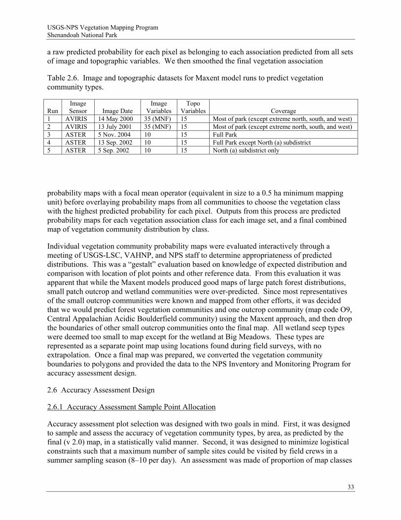
USGS-NPS Vegetation Mapping Program Shenandoah National Park
a raw predicted probability for each pixel as belonging to each association predicted from all sets of image and topographic variables. We then smoothed the final vegetation association
Table 2.6. Image and topographic datasets for Maxent model runs to predict vegetation community types.
Run
Image Sensor
Image Date
Image Variables
Topo Variables
Coverage
1 AVIRIS 14 May 2000 35 (MNF) 15 Most of park (except extreme north, south, and west) 2 AVIRIS 13 July 2001 35 (MNF) 15 Most of park (except extreme north, south, and west) 3 ASTER 5 Nov. 2004 10 15 Full Park 4 ASTER 13 Sep. 2002 10 15 Full Park except North (a) subdistrict 5 ASTER 5 Sep. 2002 10 15 North (a) subdistrict only
probability maps with a focal mean operator (equivalent in size to a 0.5 ha minimum mapping unit) before overlaying probability maps from all communities to choose the vegetation class with the highest predicted probability for each pixel. Outputs from this process are predicted probability maps for each vegetation association class for each image set, and a final combined map of vegetation community distribution by class.
Individual vegetation community probability maps were evaluated interactively through a meeting of USGS-LSC, VAHNP, and NPS staff to determine appropriateness of predicted distributions. This was a “gestalt” evaluation based on knowledge of expected distribution and comparison with location of plot points and other reference data. From this evaluation it was apparent that while the Maxent models produced good maps of large patch forest distributions, small patch outcrop and wetland communities were over-predicted. Since most representatives of the small outcrop communities were known and mapped from other efforts, it was decided that we would predict forest vegetation communities and one outcrop community (map code O9, Central Appalachian Acidic Boulderfield community) using the Maxent approach, and then drop the boundaries of other small outcrop communities onto the final map. All wetland seep types were deemed too small to map except for the wetland at Big Meadows. These types are represented as a separate point map using locations found during field surveys, with no extrapolation. Once a final map was prepared, we converted the vegetation community boundaries to polygons and provided the data to the NPS Inventory and Monitoring Program for accuracy assessment design.
2.6 Accuracy Assessment Design
2.6.1 Accuracy Assessment Sample Point Allocation
Accuracy assessment plot selection was designed with two goals in mind. First, it was designed to sample and assess the accuracy of vegetation community types, by area, as predicted by the final (v 2.0) map, in a statistically valid manner. Second, it was designed to minimize logistical constraints such that a maximum number of sample sites could be visited by field crews in a summer sampling season (8–10 per day). An assessment was made of proportion of map classes
33

USGS-NPS Vegetation Mapping Program Shenandoah National Park
within distance to roads and trails, and it was determined that for almost all map classes, 50% or greater of the class area was within 300 m of a road or trail. The NPS Inventory and Monitoring Program typically uses a “cost surface” approach to laying out sample plots such that areas of disturbance, steep slopes, and impassable understory are avoided while minimizing access time. In addition, a “contagious” approach to sample site selection is implemented such that points to sample are clustered together or laid out in a chain fashion to minimize travel time.
To allocate points, the largest classes by area (>50 ha in total area) are sampled with 30 points per class, while smaller classes (<50 ha in total area) are sampled with 1.67 points/ha. Points are intended to be independent reflections of ground conditions and are therefore spatially distributed to reflect the minimum mapping unit of the mapping effort. In this case, the minimum mapping unit is 0.5 ha, but for smaller classes a 0.25 ha minimum mapping unit was adopted to allow for sampling with the necessary intensity. Given these design goals, points were randomly located within a 300-m buffer of roads and trails, such that each map class was represented with enough points to adequately assess accuracy. Point selection for this effort resulted in 779 accuracy assessment points being generated for field sampling. These points were transferred to biologists at Shenandoah National Park and were loaded into GPS units with Wide Area Augmentation System (WAAS) real time correction capabilities for navigation in the field. Additional details on AA sample point allocation may be found in Appendix D.
2.6.2 Accuracy Assessment Field Data Collection
Lists of random plot coordinates and maps showing locations of plots to visit were delivered to NPS-SHEN for use by field personnel. A set of accuracy assessment (AA) protocols and a customized AA field data collection form (Appendix E) consistent with the USGS-NPS National Vegetation Mapping Program were developed in consultation with VANHP and NatureServe. Subsequently, data were collected in the field by NPS biological technicians with no prior involvement with the project. Field training was conducted by VANHP and NPS staff to familiarize AA technicians with field key use and plant community characteristics prior to commencing AA field data collection. Field training was particularly rigorous in 2008 and included 40 hours of field instruction in field key use and plant community identification.
The general procedure for this task was to navigate as closely as possible to the pre-selected point using a “wide area augmentation system” (WAAS)-enabled Garmin GPS unit. At the point, a new GPS waypoint was collected. A circular or rectangular plot was then established, and required environmental and floristic data were collected within the plot. Plot size and shape varied depending on the size and shape of the polygon being assessed. The majority of AA points were evaluated using a 0.5 ha circular plot, however, in heterogeneous areas a 0.5 ha (or occasionally smaller) rectangular plot was used. Points occurring within smaller map polygons were assessed using 0.25 ha circles or rectangles, 0.50 ha rectangles, or occasionally, a plotless assessment. The size and shape of plots to be examined at each AA point was pre-assigned by the NPS Inventory and Monitoring Program prior to field data collection. Additional details on plot shape and placement used in AA may be found in Appendix D.
Using the field key to park vegetation types (Appendix C) and vegetation community descriptions (Appendix F), AA field crews identified the community type at each sample point using the environmental setting and composition of vegetation within the sample plot as their
34
USGS-NPS Vegetation Mapping Program Shenandoah National Park
guide. Sufficient data on vegetation structure, floristic composition, and environmental setting were recorded to evaluate the degree to which vegetation at sample sites was representative of a classified type. Where an exact match was not found between observed vegetation and the vegetation community described in the key, the closest matching types were recorded (up to three community types were recorded at some plots). Notes were collected describing any inconsistencies between the observed vegetation and the key choices. Additionally, if predetermined plot locations could not be reached because of cliffs or impassable vegetation, the distance and bearing to the original plot location was recorded from the location where vegetation was assessed.
2.6.3 Accuracy Assessment Data Summary
Accuracy assessment data were compiled into a “confusion matrix,” or contingency table listing mapped community types in rows and field assessed community types in columns (Congalton and Green 1999). While the confusion matrix is the standard reporting format for remote sensing-based land cover classifications, the initial (v. 1.1) effort summarized accuracy using a cross-validated “percent plots correct” approach more typical in species distribution modeling research. The confusion matrix is summarized by dividing the number of occurrences in agreement between the map and field assessed plots (the diagonal of the matrix) by the row or column totals. If there is perfect agreement between map and field collected data, all occurrences will be tabulated in the diagonal of the matrix. Occurrences off the diagonal are traditionally assessed as errors. Errors tabulated by columns are referred to as “producer’s accuracy” and represent errors of omission, while errors tabulated by rows are referred to as “users’s accuracy” and represent errors of commission. As explained by Congalton and Green (1999, pg. 45), “A commission error is simply defined as including an area into a category when it does not belong to that category. An omission error is excluding that area from the category in which it truly does belong.” Overall accuracy is assessed by summing occurrences in the diagonal (correct occurrences) and dividing by the total number of plots assessed.
While the traditional accuracy assessment accepts as correct only one discrete call between mapped classes and field assessed classes, there are occasions when more than one call in the field might reasonably be accepted as correct. For example, if classes assessed represent a continuum rather than a discrete class, or if an observer can correctly place a field plot in more than one class due to broad class definitions, then more than one field assigned type might reasonably be called “correct” (Congalton and Green 1999). In these cases, acceptance of only one “correct” class will underestimate the accuracy of the map. Methods are available to assess this “fuzzy” definition of accuracy by counting as correct reasonable calls in the off diagonal areas of the confusion matrix along with the absolutely correct calls in the diagonal (Congalton and Green 1999).
In this mapping effort, assessing accuracy as a “fuzzy” concept is appropriate because both the vegetation classification methods and the mapping methods assess vegetation communities as gradients. In the case of the vegetation classification, field (training) plots are assigned to association classes according to their position along gradients of species composition and environment (moisture, light, mineral nutrients, etc.) derived from statistical ordination. Mapping methods assign pixels to vegetation classes along a probability gradient based on a predictive statistical model using image spectral responses and modeled environmental factors
35
USGS-NPS Vegetation Mapping Program Shenandoah National Park
36
(which are gradients as well). In both cases, any given plot or pixel is assigned to the (statistically) closest class. Dichotomous keys developed for AA field crews attempt to mirror this assignment using vegetation composition and environmental factors that can be interpreted in the field. However, only those plots that are clearly on one end or the other of the compositional or environmental gradient can be easily assigned to a single class in the field. Those plots that are intermediate in composition cannot always be confidently assigned to only one class, so multiple possible classes are recorded.
To account for this difficulty, we computed accuracy using both the traditional “discrete,” or single class error matrix, as well as the “fuzzy,” or “reasonably correct” off-diagonal summary method as discussed in Congalton and Green (1999). Information for “reasonable” alternative class assignments came from the secondary and tertiary classes assigned in the field by AA field crews and stored in the AA plot database and tagged as “vegetation problem.” In addition, since we incorporated previously defined boundaries of rock outcrop communities into the final vegetation community map, and these communities were classified with detailed field investigation, we considered these polygons as “ground truth.” Therefore, any AA field calls within these community boundaries that differed from the community type assigned in the NPS/VANHP “Rock Outcrop Management Plan” effort were ignored and were instead counted using the fuzzy method as “reasonably correct.”
USGS-NPS Vegetation Mapping Program Shenandoah National Park
3 Results
3.1 Accuracy Assessment Plots
A total of 703 AA points were visited in the field in the summer of 2008. Data from the AA campaign were input into an Access database by Shenandoah National Park personnel. This database includes information on the 703 points sampled, information on vegetation communities and species found, notes on up to three other potential community types that could reasonably be called at those locations, problems with vegetation found, and problems associated with plot location. Plot locations and field vegetation community assignments from the database were overlaid on mapped community types to generate contingency tables depicting mapping accuracy statistics by class.
3.2 Vegetation Classification Scheme
Based on the combined results of cluster analysis, summary statistical analysis, ordination studies, and subjective evaluation of supplementary plots, 35 natural community types, three modified/successional community types, and two broad modified/disturbed vegetation classes were recognized in the classification of Shenandoah National Park data. Three hundred and forty-three intensive sampling sites and 820 vascular plant taxa were used in this classification. Nine sampling sites of the original 347 intensively sampled sites were dropped due to missing or incomplete data, or because they were outliers in the resulting classification and did not represent existing or unique vegetation associations. Membership in community types ranged from one to 26 intensively sampled plots, and from one to 124 total data points (including the subjectively assigned supplementary plots). All 35 natural community types and the three modified/successional types were assigned to existing USNVC units. In addition, two USNVC units representing non-vascular (lichen) vegetation of exposed boulderfields were included in the classification based on data collected during the rock outcrop inventory project (Fleming et al. 2007). However, these two lichen community types were not suitable for mapping and are not considered further in this report.
The basic unit of classification is equivalent to the “association” recognized in traditional vegetation studies (Mueller-Dombois and Ellenberg 1974; Barbour et al. 1987) and the U.S. National Vegetation Classification (USNVC; Grossman et al. 1998), representing stands of vegetation of relatively homogeneous composition that share a set of characteristic species and recur on the landscape under similar environmental conditions. Protocols of the USNVC were followed in naming the community types, using the scientific names of up to six characteristic species, with distinct vertical strata indicated. As a rule, species are listed by descending order of importance and structural position, i.e., canopy species are listed first, followed by understory species, shrubs, and herbs. Nominal species in the same stratum are separated by a dash (-), while different strata are separated by a slash (/). Redundant varietal and subspecific epithets (e.g., Quercus rubra var. rubra) are not used in community names. The characteristic physiognomy (i.e., forest, woodland, shrubland, etc.) of a type is listed at the end of its name.
37
USGS-NPS Vegetation Mapping Program Shenandoah National Park
For convenience, community types are aggregated into the ecological classes and ecological groups of Fleming et al. (2006) representing natural groups of vegetation types sharing gross climatic, topographic, edaphic, physiognomic, and floristic similarities.
Despite encompassing an inevitable degree of variation, the community types defined in this study are generally recognizable in the field and potentially mappable. However, because the classification is based on composition in all layers, not just the tallest, these community types differ considerably from “cover types” (sensu Eyre 1980) used in forestry and large-scale vegetation mapping. Since our purpose is to define ecological units, all plants at a site are considered. In forests, for instance, shrubs and herbs often respond to more subtle environmental gradients and may reveal more about local site conditions and associated animal species than do trees, which tend to be more broadly distributed and exhibit less environmental specificity. Likewise, herbaceous species occurring with low cover may be more restricted to certain site conditions and thus far more diagnostic of a community type than more widespread, dominant shrubs and trees. Moreover, in recent years, there has been a greater recognition of the herb and shrub flora of forests as an ecological filter that influences the composition and structure of the tree layers, as well as contributes to nutrient-cycling and other ecosystem-level processes (Anderson 2003; George and Bazzaz 2003; Muller 2003).
The species used as nominals may be characteristic of a type because of their abundance, constancy, or relative restriction to the type. Although they can never be surrogates for descriptions, the names of communities are constructed so that one can distinguish among types, identify types readily in the field, and assign new stands to previously classified types. In order to meet the first objective, an emphasis has been placed on diagnostic species (e.g., those with high adjusted DV values). However, in the prevailing mixed forests of this area and other regions in the eastern United States, characteristic canopy trees are usually not restricted to a particular type. Many forested types, despite having distinctive total floristic compositions, have variable overstories composed of wide-ranging tree species with low fidelity and indicator value. Exclusion of such species from a community name altogether is not desirable and obfuscates the ready identification of the type in the field. Hence, the approach typically taken by VANHP and other natural heritage network ecologists in naming forest community types involves the combined use of indicator, constant, and dominant species, with nominal species of the tree strata often common to multiple types and nominal species of the shrub and herb strata contributing more diagnostic value.
3.2.1 Hierarchical Classification of Ecological Groups and Associations
The hierarchical classification of 40 community types (35 natural types, three modified / successional community types, and two broad modified / disturbed types) of Shenandoah National Park are summarized in this section for the v 2.0 vegetation map. Hierarchy follows Fleming et al. (2006), with minor modifications. The scientific and common names of each community are those used in the U.S. National Vegetation Classification (USNVC). The USNVC global element code (CEGL00) for each type is listed, along with the map code (used as a class label in image processing and map production), number of intensive plot samples, and total number of data points (intensive plus supplementary plots) assigned to the type. Detailed descriptions of each community type, including local and global descriptions, are provided in Appendix F.
38
USGS-NPS Vegetation Mapping Program Shenandoah National Park
I. HIGH-ELEVATION COMMUNITIES 1. Northern Hardwood Forests
a. Betula alleghaniensis - Quercus rubra / Acer (pensylvanicum, spicatum) / Dryopteris intermedia - Oclemena acuminata Forest
Central Appalachian Northern Hardwood Forest (Yellow Birch - Northern Red Oak Type)
(USNVC CEGL008502, map code F7, 10 intensive plots, 25 total data points) This association occurs in small to large patches in the higher portion of the Central
District (Marys Rock to Hawksbill), with outliers on North Marshall in the North District, Bush Mt / Bearfence in the Central District, and on Loft Mountain in the South District. It is restricted to metabasaltic and granitic substrates at the highest elevations (range 900 to 1,225 m [2,980 to 4,020 ft]), particularly on bouldery, west to north-facing slopes; small patches occur in gentler topography in the highest portion of the Central District (Hawksbill-Stony Man). Soils are extremely acidic with low base status and very high organic matter content. Dominant overstory trees are typically somewhat stunted and gnarled from repeated ice and wind damage. The type is somewhat transitional between high-elevation northern red oak forests (CEGL008506) and high-elevation boulderfield woodlands dominated by Betula alleghaniensis (CEGL008504), intergrading with both along topographic gradients.
2. High-Elevation Boulderfield Forests and Woodlands
a. Betula alleghaniensis / Sorbus americana - Acer spicatum / Polypodium appalachianum Forest
Central Appalachian High-Elevation Boulderfield Forest (USNVC CEGL008504, map code O4, 4 intensive plots, 7 total data points) This distinctive, small-patch association is rare at high elevations (990 to 1,200 m
[3,260 to 3,930 ft]) of North Marshall, South Marshall, Marys Rock, The Pinnacle, Stony Man, Hawksbill, and Blackrock (Central District). It is restricted to west to north-facing, minimally weathered boulderfields of both metabasalt and granitic debris. The physiognomy is mostly that of a woodland, and overstory trees are typically stunted and gnarled from frequent ice and wind damage. Betula alleghaniensis is the overwhelming canopy dominant, and community floristics are characterized by northern and high-elevation species. High cover of diverse lichens and bryophytes is also typical. Surface substrate averages >75% cover of loose boulders and stones; mineral soil could not be extracted from sampling sites. The largest and most outstanding examples occur on the north flanks of Hawksbill and Stony Man. This vegetation type intergrades with the Central Appalachian Northern Hardwood Forest (CEGL008502), which occupies adjacent sites with somewhat lower boulder cover and greater soil development.
39

USGS-NPS Vegetation Mapping Program Shenandoah National Park
3. Northern Red Oak Forests
a. Quercus rubra - Quercus alba / Ilex montana / Dennstaedtia punctilobula - Carex pensylvanica - Deschampsia flexuosa Forest
Northern Red Oak Forest (Pennsylvania Sedge - Wavy Hairgrass Type) (USNVC CEGL008506, map code F9, 22 plots, 56 total data points) In the park, this association is limited to gentle, mostly convex slopes and crests on
the higher metabasalt and granitic ridges from Hightop in the South District to North Marshall in the North District. It forms an extensive, almost continuous patch in the Central District from the vicinity of Big Meadows north to the vicinity of The Pinnacle and Marys Rock. Elevation of data points ranges from is 860 to 1,225 m (2,830 to 4,020 ft), but the type is very rare below 915 m (3,000 ft). Soils are extremely acidic and infertile, sometimes bouldery but usually with relatively low surface cover of rocks. The vegetation is typically an open, stunted forest dominated by somewhat gnarled Quercus rubra and containing moderately diverse understory and herbaceous layers. Herb-layer patch dominance by Dennstaedtia punctilobula, Carex pensylvanica, and Deschampsia flexuosa is typical.
4. High-Elevation Outcrop Barrens
a. Kalmia latifolia - Gaylussacia baccata - Vaccinium (angustifolium, pallidum) - Menziesia pilosa Shrubland
Central Appalachian Heath Barren (USNVC CEGL003939, map code O2, 5 intensive plots, 5 total data points) This globally rare (G2) shrubland association is known in the park only from high-
elevation cliffs and outcrops of granitic rocks. The elevation range of occurrences is 950 to 1,120 m (3,120 to 3,680 ft). Exposed rock cover averages 75% and mineral soil is generally absent. Total vegetation cover is typically <25% in a 100 m2 plot sample and is characterized by ericaceous shrub thickets with scattered, severely stunted trees. Patches are extremely small (≤0.2 ha), and little if any suitable habitat exists in the park.
b. Photinia melanocarpa - Gaylussacia baccata / Carex pensylvanica Shrubland High-Elevation Outcrop Barren (Black Chokeberry Igneous/Metamorphic Type) (USNVC CEGL008508, map code O3, 8 intensive plots, 18 total data points) In the park, this globally rare (G1) association occupies high-elevation metabasalt.
Habitats are generally west-facing and range from 875 to 1,120 m (2,880 to 3,680 ft elevation). The largest known patch size is ca. 0.5 ha. Soils (very sparse) are extremely infertile and high in organic matter. The vegetation is characterized by shrub thickets (particularly of Photinia melanocarpa and/or Gaylussacia baccata), sparse herbaceous patches, and lichens. Although the known occurrences are on metabasalt, additional examples of this type could occur on the pyroxene-bearing granitic rocks in the park.
40

USGS-NPS Vegetation Mapping Program Shenandoah National Park
c. Diervilla lonicera - Solidago simplex var. randii - Deschampsia flexuosa - Hylotelephium telephioides - Saxifraga michauxii Herbaceous Vegetation
High-Elevation Greenstone Barren (USNVC CEGL008536, map code O1, 15 intensive plots, 41 total data points) This globally rare (G1) community type represents high-elevation metabasalt outcrop
barrens. The vegetation occupies massive, wind- and ice-blasted metabasalt exposures on upper, west- to north-facing ridge flanks. The elevation range of known stands is 870 to 1,230 m (2,860 to 4,040 ft), and exposed rock cover averages 65%. Soils (very limited) are extremely acidic and infertile. The vegetation is characterized by a patchwork of shrub thickets (typically <25% cover in 100 m2 plot samples), herbaceous mats (typically <40% cover), and lichen colonies on exposed rock surfaces. Maximum patch size is ca. 0.6 ha. Northern and high-elevation species predominate and ten state-rare plant species are associated, including several long-range boreal disjuncts. This community type is endemic to Shenandoah National Park, and there are probably less than 20 discrete outcrops supporting it.
41

USGS-NPS Vegetation Mapping Program Shenandoah National Park
II. LOW- TO MIDDLE-ELEVATION MESIC FORESTS 1. Rich Cove and Slope Forests
a. Acer saccharum - Fraxinus americana - Tilia americana - Liriodendron tulipifera / Actaea racemosa Forest
Central Appalachian Rich Cove Forest (USNVC CEGL006237, map code F15, 10 intensive plots, 41 total data points) A lush mesophytic forest community of lower to middle elevations (427 to 1,070 m,
1,400–3,500 feet) on fertile substrates. All but one data point are on Catoctin metabasalt, suggesting a strong positive correlation with mafic rock. Patches are locally distributed in the North District (eastern flank), Central District (both flanks), and around Loft Mountain in the South District. Habitats are typically fertile coves and concave north slopes; at lower elevations, it tends to occupy steep, sheltered ravine slopes and bottoms. Soils are extremely acidic, but have moderately high base cation levels. In the park, this association is characterized by dominance or co-dominance of Acer saccharum and a suite of characteristic, nutrient-demanding mesophytic forbs, including Caulophyllum thalictroides, Aconitum reclinatum, and Viola canadensis. Liriodendron tulipifera is less characteristic of this type than of the park’s other rich cove forest (CEGL007710), and is absent from stands over 915 m (3,000 ft). However, the type may intergrade with CEGL007710 along a seral gradient that has followed clearing and cutting disturbances that removed Acer saccharum.
b. Liriodendron tulipifera - Aesculus flava - (Fraxinus americana, Tilia americana) /
Actaea racemosa - Laportea canadensis Forest Southern Appalachian Cove Forest (Typic Montane Type) (USNVC CEGL007710, map code F10, 11 intensive plots, 60 total data points) This is a more widespread rich cove forest in the park, occurring at lower elevations
(mostly 300 to 760 m [1,000 to 2,500 ft] rarely up to 915 m [3,000 ft]) on substrates weathered from metabasalt and pyroxene-bearing granites. Many or all sites supporting this vegetation were cleared or cut-over in the past. Most sites have relatively high moisture potential (TRMI), with slopes concave in one or both directions. Soil samples are moderately acidic with moderately high Ca, Mg, Mn, and TBS levels. The herb layer of this association is very lush with patch-clonal forbs such as Laportea canadensis, Actaea racemosa, and Osmorhiza claytonii. Species characteristic of higher elevations are mostly lacking from this type. The current vegetation is more or less the result of secondary succession. However, it probably represents more or less climax vegetation on rich lower elevation sites that have always lacked Acer saccharum. The abundance of understory Acer saccharum in other stands is probably an indicator of slow but ongoing successional changes and eventual replacement by CEGL006237 (see above). This community also intergrades with nearly monospecific, early-successional forests of Liriodendron tulipifera (CEGL007220) along a seral gradient.
42
USGS-NPS Vegetation Mapping Program Shenandoah National Park
2. Acidic Cove Forests
a. Liriodendron tulipifera - Pinus strobus - Tsuga canadensis - Quercus (rubra, alba) / Polystichum acrostichoides Forest
Central Appalachian Acidic Cove Forest (White Pine - Hemlock - Mixed Hardwoods Type)
(USNVC CEGL006304, map code F12, 13 plots, 33 total data points) This mixed hardwood-white pine-hemlock forest community was documented from
lower- and middle-elevation coves, primarily in the Central and North Districts. It occupies mesic lower slopes, ravines, and flats with moderately infertile soils, from the lowest elevations up to ca. 800 m (2,620 ft). Most sites are underlain by granitic rocks or covered by granitic colluvium and alluvium. A few sites evidently are underlain by metabasalt or metasedimentary rocks. Soils are intermediate in base status. Expressions of this vegetation in the park are typically well-developed, moderately diverse forests. Composition is quite variable, with Pinus strobus most diagnostic, although it ranges in abundance from widely scattered to dominant over small areas.
b. Tsuga canadensis - Quercus prinus - Liriodendron tulipifera / Kalmia latifolia -
(Rhododendron catawbiense) Forest Central Appalachian Acidic Cove Forest (Hemlock - Hardwood / Mountain-Laurel
Type) (USNVC CEGL008512, map code F24, 11 intensive plots, 17 total data points) This association is strongly associated with coves and ravines with very infertile soils,
most frequently on metasedimentary substrates and acidic granites of the South and Central Districts. The elevation range of known stands in the park is 305 to 915 m (1,000–3,000 feet). The type is under-represented by data points and is likely to be most frequent on the western flank of the South District, where it forms small to large, usually linear patches in coves developed in quartzite. This vegetation appears to be restricted to the extreme lower slopes and bottoms of such coves due to moisture restrictions. Soils are often poorly developed in the interstices of deeply piled bouldery colluvium and covered by a thick, root-rich organic horizon. Tsuga canadensis was formerly a dominant overstory and/or understory tree at most sites but has been devastated in recent decades by outbreaks of the hemlock woolly adelgid. This community has a less diverse overstory, a more prominent ericaceous component, and much lower species richness than the preceding type (CEGL006304).
3. Eastern Hemlock-Hardwood Forests
a. Tsuga canadensis - Betula alleghaniensis - Acer saccharum / Dryopteris intermedia Forest
Hemlock - Northern Hardwood Forest (USNVC CEGL006109, map code F8, 4 intensive plots, 6 total data points) This hemlock-hardwood forest occupies deep, sheltered coves and gentler mesic
slopes and flats at middle to high elevations (760 to 1,000 m [2,500 to 3,300 ft]). This rather locally distributed community is somewhat under-represented by data
43
USGS-NPS Vegetation Mapping Program Shenandoah National Park
points and occurs primarily in the Central District. Surface substrate is often characterized by abundant boulder cover and soils are extremely acidic, but with moderately high Ca and Mg levels, probably reflecting the influence of materials weathered from Catoctin metabasalt or pyroxene-rich granites. Sites supporting this vegetation often have a mixed hydrology, i.e., they are essentially "uplands" with small seep or stream inclusions. This type represents hemlock-northern hardwood vegetation with northern affinities. It co-occurs with the High-Elevation Seepage Swamp (CEGL008533) type, and may grade into it as site conditions become more generally saturated. Stands of this community are undergoing phyiognomic and compositional changes due to extensive, adelgid-related mortality of Tsuga canadensis.
44
USGS-NPS Vegetation Mapping Program Shenandoah National Park
III. LOW- TO MIDDLE-ELEVATION DRY AND DRY MESIC FORESTS AND WOODLANDS 1. Basic Oak-Hickory Forests
a. Quercus rubra - Quercus prinus - Carya ovalis / (Cercis canadensis) / Solidago caesia Forest
Central Appalachian Basic Oak-Hickory Forest (Submontane/Foothills Type) (USNVC CEGL008514, map code F19, 10 intensive plots, 89 total data points) In the park, this forest community is generally distributed at lower elevations
throughout the North District and on the eastern flank of the Central and South Districts. Its distribution is strongly correlated with metabasalt substrates, but also occupies areas underlain by pryoxene-bearing granites. The type is most prevalent from 365 to 760 m (1,200 to 2,500 ft), occasionally ranging up to 850 m (2,800 ft), on various middle and upper slopes with fertile soils. This community is most common in the western Piedmont and is elevation-limited on the main Blue Ridge in Virginia. It has a very diverse overstory with several Carya spp., Quercus spp., Liriodendron tulipifera, and Fraxinus americana prominent in variable proportions. It grades into CEGL008518 (F16) in the elevation range 700 to 850 m (2,300 to 2,800 ft). The elevation at which the transition occurs is influenced by aspect and probably other topographic conditions; CEGL008514 extends higher on southerly aspects, while CEGL008518 extends lower on northerly aspects.
2. Acidic Oak-Hickory Forests
a. Quercus alba - Quercus prinus - Carya glabra / Cornus florida / Vaccinium pallidum / Carex pensylvanica Forest
Central Appalachian Acidic Oak-Hickory Forest (USNVC CEGL008515, map code F18, 11 intensive plots, 22 total data points) This forest community is apparently restricted (or nearly so) in the park to low-
elevation (<485 m [1,600 ft]) slopes of the metasedimentary terrain on the park's western flank. In most cases, geologic substrate is presumed to be metasiltstone or phyllite of the Harpers Formation (weathered in place or colluvial). The type occurs on dry, moderate to gentle slopes of low-elevation ravines and knobs, as well as dry floodplain terraces along streams underlain by quartzitic alluvial fan material along the foot of the western slope. Most stands occupying valley bottoms contain a large component of Pinus strobus but are otherwise similar to the slope variant. The park represents the eastern margin of this type's distribution, which is centered in the shale districts of the Ridge and Valley province to the west. Strong compositional differences between this community and the two oak/heath types cannot be explained by topography or soil chemistry, and are assumed to be related to soil texture, depth, and moisture-holding capacity. This vegetation is more or less a low-elevation analogue of the montane oak-hickory forest (see CEGL008516 below) that occupies shaley soils of the park's higher elevations.
45

USGS-NPS Vegetation Mapping Program Shenandoah National Park
3. Montane Mixed Oak and Oak-Hickory Forests
a. Quercus prinus - Quercus rubra / Hamamelis virginiana Forest Central Appalachian Dry-Mesic Chestnut Oak - Northern Red Oak Forest (USNVC CEGL006057, map code F5, 8 intensive plots, 63 total data points) This association is a large-patch vegetation type that is widespread at lower and
middle elevations of the park, on all geological substrates. Elevation ranges from 300 to 1,020 m (980 to 3,340 ft), but stands appear to be rather rare above 915 m (3,000 ft). Sites are generally submesic, often very bouldery or stony middle slopes. On mafic and plutonic substrates, the type occurs on all aspects; on metasedimentary substrates it appears to be more restricted to northerly aspects. Soils have slightly higher base status than those of the area's oak / heath forests. This community type intergrades with many of the park's other oak and oak-hickory forests along topographic, moisture, and soil fertility gradients.
b. Quercus prinus - Quercus rubra - Carya ovalis / Solidago (ulmifolia, arguta) -
Galium latifolium Forest Central Appalachian Montane Oak-Hickory Forest (Acidic Type) (USNVC CEGL008516, map code F17, 12 intensive plots, 19 total data points) This small- to medium-patch, rather dry but diverse oak-hickory forest occurs
primarily on shaley units (metasiltstone, phyllite) of the Chilhowee Group at middle elevations in the southern section. It occurs most frequently on narrow, stony, convex crests and upper east-facing slopes. The elevation range of data points is 680 to 1,015 m (2,240 to 3,330 ft). Surface substrate is usually somewhat stony and often contains large areas of exposed mineral soil. Soil samples had low to intermediate base status, except for high mean Mn, but appear to have slightly higher fertility and better moisture-holding capacity than soils occupied by co-occurring oak/heath forest types. Overstory composition of this community is similar to CEGL008514 (in Basic Oak-Hickory Forests group) but the shrub and herbaceous vegetation is significantly different and reflects the drier, more montane habitats.
c. Quercus rubra - Quercus alba - Fraxinus americana - Carya (ovata, ovalis) /
Actaea racemosa Forest Central Appalachian Montane Oak-Hickory Forest (Basic Type) (USNVC CEGL008518, map code F16, 17 intensive plots, 82 total data points) This association comprises “rich" oak-hickory forests that form large patches on
middle- to high-elevation ridge crests and gentle upper slopes, mostly over metabasaltic substrates (one plot each was located on charnockite and metasiltstone / phyllite). The elevation range of data points is 685 to 1,165 m (2,250 to 3,820 ft), but the type is most prevalent in the 760 to 1,065 m (2,500 to 3,500 ft) range, especially in the Central District. Soils are apparently deep, often lack substantial rock cover, and are intermediate in fertility. This very distinctive type has an overstory of oaks, hickories, and white ash, along with a lush, forb-rich herb layer that resembles that of a rich cove forest. It covers fairly extensive areas in the park and grades into Northern Red Oak Forests (F9) at higher elevations and into other oak and oak-hickory types at middle elevations.
46
USGS-NPS Vegetation Mapping Program Shenandoah National Park
4. Oak / Heath Forests
a. Quercus prinus - (Quercus coccinea, Quercus rubra) / Kalmia latifolia / Vaccinium pallidum Forest
Central Appalachian / Northern Piedmont Chestnut Oak Forest (USNVC CEGL006299, map code F3, 26 intensive plots, 124 total data points) This association occurs on dry, rocky or shallow-soiled, infertile slopes at lower to
middle elevations (250 to 1,020 m [820 to 3,340 ft]) throughout the park, but is particularly extensive and forms the forest matrix on the dry, acidic metasedimentary substrates of the western Blue Ridge flank in the South District. It is typical of crests and side slopes of various aspects, but is most common on south to west exposures. Soils collected from plots are extremely acidic and infertile, with high Fe levels. This is the park’s characteristic dry-site forest dominated by Quercus prinus and typically an evergreen shrub layer of Kalmia latifolia, although variants with mostly deciduous ericads also occur. Many sites supporting this community have a demostrable history of fire, which is likely an important disturbance regime that encourages oak recruitment and periodic regeneration of ericads.
b. Quercus alba - Quercus (coccinea, velutina, prinus) / Gaylussacia baccata Forest Low-Elevation Mixed Oak / Heath Forest (USNVC CEGL008521, map code F4, 10 intensive plots, 25 total data points) This association forms the principal forest cover on the low-elevation alluvial fan
terrain at the western foot of the park, mostly in the south district. The co-dominance of Quercus alba with other Quercus spp. is distinctive among the three oak/heath types in the park, and the shrub layer is typically dominated by Gaylussacia baccata and other deciduous ericads. Sites are gentle (0 to 12-degree slope) lower slopes and flats at very low elevations (<570 m [<1,860 ft]) at the foot of the park's western flank. Underlying bedrock (principally shale and limestone of the Waynesboro Formation) is well covered by deep colluvial and alluvial fan deposits weathered from upslope Chilhowee Group quartzite. Soil chemistry and ecological dynamics are similar to the preceding type. Evidence of past fires is abundant at most sites. This community type is most abundant on similar, rolling terrain of the Piedmont Plateau east of the mountains.
c. Quercus prinus - Quercus rubra / Vaccinium pallidum - (Rhododendron
periclymenoides) Forest Central Appalachian Dry Chestnut Oak - Northern Red Oak Forest (USNVC CEGL008523, map code F23, 16 intensive plots, 53 total data points) This association occurs throughout the park on all geologic substrates but forms
particularly large patches on the metasedimentary terrain of the South District. It ranges from 260 to 1,060 m (850-3,480 ft) elevation, although occurrences over 915 m (3,000 ft) appear to be rare. The type tends to occur on moderately steep to gentle, usually straight or convex upper slopes with infertile soils and warm aspects. It occupies the middle portion of the environmental gradient between the shallow, very infertile soils occupied by Central Appalachian / Northern Piedmont Chestnut Oak Forest (CEGL006299) and the more mesic and/or fertile soils occupied by several
47
USGS-NPS Vegetation Mapping Program Shenandoah National Park
other oak and oak-hickory forests. As in the park's other oak/heath forests, periodic fires have been important ecological factors in maintaining oak recruitment and dominance in this vegetation type.
5. Pine-Oak / Heath Woodlands
a. Pinus (pungens, rigida) - Quercus prinus / (Quercus ilicifolia) / Gaylussacia baccata Woodland
Central Appalachian Pine - Oak / Heath Woodland (USNVC CEGL004996, map code F1, 7 intensive plots, 37 total data points) This association is widely distributed and forms large patches on the metasedimentary
substrates of the South District. Elsewhere in the park, it is more locally scattered on granitic and metabasalt substrates. Stands typically occur on south- to west-facing, convex, upper slopes, ridge crests, and cliff-tops from 470 to 970 m (1,550 to 3,180 ft) elevation. These sites are among the most xeric and infertile habitats in the park, and most have a demonstrable history of catastrophic, often stand-replacing fires. The most characteristic physiognomic expression is an open, floristically depauperate woodland of stunted Quercus prinus, Pinus rigida, and/or Pinus pungens, with dense shrub thickets of Quercus ilicifolia and ericads. To a great extent, the dominant pines of this vegetation require occasional burning for regeneration, and some stands from which fire has been absent for long periods have become nearly closed forests and heavily invaded by tree oaks. Because of recent depredations by the southern pine beetle, many stands in the park have rather low pine cover, even though they clearly represent the type.
6. Mountain / Piedmont Acidic Woodlands
a. Pinus virginiana - Quercus prinus - (Pinus pungens) / Schizachyrium scoparium - Dichanthelium depauperatum Woodland
Central Appalachian Xeric Chestnut Oak - Virginia Pine Woodland (USNVC CEGL008540, map code O8, 7 intensive plots, 10 total data points) This globally rare association is widely scattered in the park, although probably
under-represented by data points. It occurs on all the major geologic substrates at elevations from 285 to 1,015 m (940 to 3,330 ft). Habitats are typically steep, solar-exposed, middle- and upper-slope outcrops with areas of shallow, infertile soil. The largest known patch size is ca. 2.0 ha. This type is characterized by the co-dominance of Pinus virginiana and a suite of herbaceous xerophytes that are generally rare or absent from the more widespread Central Appalachian Pine - Oak / Heath Woodland (CEGL004996). However, environmental differences between lithophytic variants of the latter and this type are somewhat obscure.
48
USGS-NPS Vegetation Mapping Program Shenandoah National Park
7. Mountain / Piedmont Basic Woodlands
a. Fraxinus americana - Carya glabra / Muhlenbergia sobolifera - Helianthus divaricatus - Solidago ulmifolia Woodland
Central Appalachian Basic Woodland (USNVC CEGL003683, map code O5, 17 intensive plots, 31 total data points) This low-elevation (425 to 790 m [1,400 to 2,600 ft]) dry, species-rich woodland
occurs primarily on metabasalt but is also known from two sites on pyroxene-bearing granitic rocks. It is typical of steep, rocky, south- to west-facing slopes, forming a woodland "matrix" around exposed cliffs and outcrops, locally in the North District and on the eastern flank in the Central and South Districts. Maximum known patch size is between 5 and 10 ha. Bedrock and boulder cover in plot samples averages >45%. Levels of pH, Ca, Mg, and TBS in soil samples from plots are among the highest documented in the park. Open, stunted overstories tend to be dominated by Fraxinus americana and Carya spp.; a diversity of dry-mesophytic and xerophytic shrubs and herbs is associated.
8. Low-Elevation Boulderfield Forests and Woodlands
a. Betula lenta - Quercus prinus / Parthenocissus quinquefolia Talus Woodland Sweet Birch - Chestnut Oak Talus Woodland (USNVC CEGL006565, map code F2, 7 intensive plots, 19 total data points) Although under-represented by data points, this community type is widespread in the
park on boulderfields and bouldery colluvial slopes weathered from resistant quartzites of the Chilhowee Group in the South District. Scattered occurrences occupy similar habitats on granitic terrain and, rarely, metabasalt. This association ranges from the lowest elevations to ca. 1,000 m (3,300 ft). Typical sites are on steep, middle or lower side slopes, often below cliffs and outcrops. Northerly slopes prevail among plot samples, but this is probably an artifact of limited sampling. Soils could not be extracted from all plots; those that could were extremely acidic and infertile, with high Fe levels. These habitats are extremely difficult to plot-sample, which is why the type is under-sampled in the park. Physiognomy is quite variable, ranging from very open woodlands of gnarled Betula lenta to more closed stands of mixed Betula and Quercus prinus. Betula lenta is generally a pioneer woody invader of open boulderfield edges. As boulderfields weather and soil material fills the interstitial spaces, oaks and other species become established. This type grades into other forest communities (particularly oak/heath forests) along topographic gradients.
b. Tilia americana - Fraxinus americana / Acer pensylvanicum - Ostrya virginiana /
Parthenocissus quinquefolia - Impatiens pallida Woodland Central Appalachian Basic Boulderfield Forest (Montane Basswood - White Ash
Type) (USNVC CEGL008528, map code F14, 15 intensive plots, 48 total data points) This association is widespread in the park on boulderfields and bouldery colluvial
slopes weathered from Catoctin metabasalt and, less frequently, pyroxene-bearing granitic rocks. It usually occupies steep middle slopes, often below rock outcrops,
49

USGS-NPS Vegetation Mapping Program Shenandoah National Park
and is especially extensive in the elevation zone from 610 to 915 m (2,000 to 3,000 ft), less commonly extending to 485 m (1,500 ft) and 1,035 m (3400 ft). Patches are commonly small, but locally are quite extensive. Boulder cover in plot samples averages >50% and soils have moderately high to high Ca, Mg, and Mn. Distribution of this type is centered in the elevation zone where Liriodendron tulipifera drops out as a dominant tree of coves and mesic slopes. Because of constraints imposed by the Alliance level of the USNVC, this type is formally classified (in the USNVC) as a woodland, but is better characterized as an open forest. Tilia americana, Fraxinus americana, and Quercus rubra are the usual overstory dominants in varying proportions; shrub and herb-layer densities, as well as overall species-richness, vary considerably with the relative abundances of rock cover and interstitial soil material.
50

USGS-NPS Vegetation Mapping Program Shenandoah National Park
IV. LOW- TO MIDDLE-ELEVATION ROCK OUTCROPS AND BARRENS 1. Low-Elevation Basic Outcrop Barrens
a. Juniperus virginiana - Fraxinus americana / Carex pensylvanica - Cheilanthes lanosa Wooded Herbaceous Vegetation
Central Appalachian Circumneutral Barren (USNVC CEGL006037, map code O7, 10 intensive plots, 15 total data points) This globally rare community type comprises low-elevation (<720 m [<2,360 ft])
outcrop barrens on Catoctin metabasalt. Sites are typically on steep (~27 degree), solar-exposed, middle-slope outcrops with south or west aspects. Surface cover of bedrock and loose rocks in plots averages >60%. Mean pH, Ca, Mg, and TBS levels in soil samples were among the highest of classified vegetation types in the park. Stands usually occur in small patches and have locally dense cover of graminoids (e.g., Schizachyrium scoparium, Carex pensylvanica, Bouteloua curtipendula) and xerophytic forbs; widely scattered, stunted trees and shrubs are intermingled. Maximum patch size is ca. 0.5 ha. Although confined to metabasalt in the park, this association also occupies sites underlain by calcareous shales and sandstones in the adjacent Ridge and Valley province.
b. Fraxinus americana / Physocarpus opulifolius / Carex pensylvanica - Allium
cernuum - (Phacelia dubia) Wooded Herbaceous Vegetation Central Appalachian Mafic Barren (Ninebark / Pennsylvania Sedge Type) (USNVC CEGL008529, map code O6, 9 intensive plots, 18 total data points) This is the "middle-elevation" (550 to 1,050 m [1,820 to 3,450 ft]) rock outcrop
barren of metabasalt and pyroxene-bearing granites in the park. Most sites are on steep (mean = 30-degree), westerly, middle to upper-slope, convex outcrops. Surface cover of bedrock and loose rocks in plots averages >60%. Soil samples have intermediate base status. Physiognomy of stands is similar to the preceding type. Compositionally, this association lacks many typical low-elevation species present in CEGL006037 and contains a number of distinctly montane species. Maximum patch size is <0.5 ha.
2. Lichen / Bryophyte Boulderfields
a. Lasallia (papulosa, pensylvanica) - Dimelaena oreina - (Melanelia culbersonii) Nonvascular Vegetation
Central Appalachian Acidic Boulderfield (USNVC CEGL004142, map code O9, 0 intensive plots, 4 total data points) This association occupies exposed, minimally weathered, large-block quartzite
boulderfields on steep side slopes from the lowest elevations of the park to about 945 m (3,100 ft) at Blackrock in the South District. It is mostly, if not entirely, restricted to the western flank of the South District, where discrete patches up to about 4 ha in size are plainly visible from Skyline Drive and other vantage points. Small patches of this vegetation may be present on large-block granitic talus on the slopes of Old Rag Mountain. The association is dominated by lichens and occasional bryophytes, with
51

USGS-NPS Vegetation Mapping Program Shenandoah National Park
vascular plants generally absent. The umbilicate "rock tripes" Lasallia papulosa and Lasallia pensylvanica, along with the large crustose species Dimelaena oreina, are among the most abundant and conspicuous lichens forming this community type.
b. Lasallia papulosa - Stereocaulon glaucescens - Chrysothrix chlorina Nonvascular
Vegetation Central Appalachian Mafic Boulderfield (USNVC CEGL004143, map code O10, 0 intensive plots, 6 total data points) Because metabasalt is less resistant to weathering than quartzite, this boulderfield
community is much rarer than Central Appalachian Acidic Boulderfield (CEGL004142) and is endemic to Shenandoah National Park. All known occurrences are in the Central and North districts within an elevational range of 640 to 1,200 m (2,100 to 3,960 feet), although the majority of occurrences are above 915 m (3,000 ft). This community is characterized by a distinctive assemblage of umbilicate, foliose, and crustose lichens that include a significant number of geographically disjunct northern and boreal species. Among the more conspicuous and diagnostic species are Stereocaulon glaucescens, Chrysothrix chlorina, Parmelia omphaloides, and Psilolechia lucida.
52
USGS-NPS Vegetation Mapping Program Shenandoah National Park
V. ALLUVIAL FLOODPLAIN COMMUNITIES 1. Piedmont / Low Mountain Alluvial Forests
a. Liriodendron tulipifera - Platanus occidentalis - Betula lenta / Lindera benzoin / Circaea lutetiana ssp. canadensis Forest
Northern Blue Ridge Montane Alluvial Forest (USNVC CEGL006255, map code F11, 13 intensive plots, 20 total data points) This forest community is apparently confined to the larger, mountain-foot floodplains
with relatively fertile alluvial deposits. It is therefore more frequent on the eastern flank of the park. At the foot of the western flank, this type does not occur in sterile floodplains filled with acidic alluvium from Chilhowee Group quartzite, but is restricted to local floodplains filled with metabasalt alluvium (e.g., Jeremy's Run). Habitats are nearly flat, bouldery, and well-drained, with moderately fertile alluvium derived from metabasalt, pyroxene-rich granites, or metasiltstone/phyllite. Many of these sites were probably cleared and subjected to multiple disturbances during the historical period in which the park area was heavily populated.
53
USGS-NPS Vegetation Mapping Program Shenandoah National Park
VI. NON-ALLUVIAL WETLANDS 1. Mountain / Piedmont Basic Seepage Swamps
a. Acer rubrum - Fraxinus americana - Fraxinus nigra - Betula alleghaniensis / Veratrum viride - Carex bromoides Forest
Central Appalachian Basic Seepage Swamp (USNVC CEGL008416, not mapped, 10 intensive plots, 11 total data points) This association is a lower- to middle-elevation forest occurring in linear patches
along groundwater-saturated bottoms of streams and in headwaters seepage areas. Plot-sampled sites range from 415 to 985 m (1,370 to 3,240 ft) elevation and are confined to substrates weathered from metabasalt and base-rich granites. Habitats are generally very bouldery and gravelly, with pronounced hummock-and-hollow microtopography and braided streams. Soils collected from plots have relatively high pH, Ca, Mg, Fe, and TBS levels. This type clearly represents a basic forested seepage wetland type conceptually similar to CEGL008416, but exhibits compositional variation related to topography (particularly increased importance of Betula alleghaniensis and Tsuga canadensis as elevation increases). At middle elevations, it grades into the High-Elevation Hemlock - Yellow Birch Seepage Swamp (CEGL008533), and several plots could be assigned equally well to either type. Fraxinus nigra, which is considered "diagnostic" of these wetlands, reaches its southern limits in VA and is quite sporadic in the park (it is present in only half of the plots). Similar topographic gradation, as well as gradation apparently related to soil chemistry, has been noted on a regional level.
2. Mountain / Piedmont Acidic Seepage Swamps
a. Acer rubrum - Nyssa sylvatica / Ilex verticillata - Vaccinium fuscatum / Osmunda
cinnamomea Forest Central Appalachian Acidic Seepage Swamp (USNVC CEGL007853, not mapped, 3 intensive plots, 3 total data points) This saturated forest community is very rare in the park, occurring along headwaters
streams on the acidic, metasedimentary terrain of the western flank. The few known stands are at very low elevations (<520 m [<1,700 ft) on ancient alluvial fans bordering the Shenandoah Valley in the South District. Habitats typically feature braided streams with Sphagnum-covered hummocks. Soils are extremely acidic and infertile, with high Fe levels. Occurrences in the park conform closely to the USNVC description, although plot SHNP632 is a marginal, somewhat disturbed example.
54
USGS-NPS Vegetation Mapping Program Shenandoah National Park
3. High-Elevation Seepage Swamps
a. Tsuga canadensis - Betula alleghaniensis / Veratrum viride - Carex scabrata - Oclemena acuminata Forest
High-Elevation Hemlock - Yellow Birch Seepage Swamp (USNVC CEGL008533, not mapped, 8 intensive plots, 8 total data points) This association is a middle- to high-elevation forest that is rather rare in the park and
apparently confined to the Central District. It occurs in linear patches along groundwater-saturated bottoms of streams and in headwaters seepage areas. Plot-sampled sites range from 690 to 1,040 m (2,270 to 3,420 ft) elevation, although most are above 915 m (3000 ft). Sites and are restricted to substrates weathered from metabasalt and base-rich granites. Habitats are generally less rocky than those of the Mountain / Piedmont basic seepage swamp (CEGL008416), but have similar hummock-and-hollow microtopography and braided streams. Soils have low to intermediate base status. This type intergrades with CEGL008416 above 850 m (2800 ft), and several plots could be assigned equally well to either type. Stands of this community are undergoing physiognomic and compositional changes due to extensive, adelgid-related mortality of Tsuga canadensis.
4. Montane Woodland Seeps
a. Caltha palustris - Impatiens capensis - Viola cucullata Herbaceous Vegetation [Provisional]
Central Appalachian Woodland Seep (USNVC CEGL006258, not mapped, 2 intensive plots, 2 total data points) This
provisional vegetation type is represented by two plot samples located in narrow, groundwater-saturated seeps that are closely bordered by upland vegetation. The two samples are quite different and do not form a strongly homogeneous group. Similar habitats and vegetation are scattered throughout the park. CEGL006258 is a relatively new USNVC type defined to cover this vegetation. More inventory and data collection in the Central Appalachians is needed to make this classification unit more robust. Similar communities from the southern Blue Ridge have been classified. Occurrences in the park are generally in linear patches and much smaller than the minimum mapping unit size (0.5 ha).
5. Montane Depression Wetlands
a. Quercus palustris / Panicum rigidulum var. rigidulum - Panicum verrucosum - Eleocharis acicularis Herbaceous Vegetation
Shenandoah Valley Sinkhole Pond (Typic Type) (USNVC CEGL007858, not mapped, 1 intensive plot, 1 total data point) The park boundary runs through a single small but representative example of a
Shenandoah Valley sinkhole pond. The habitat is seasonally flooded, with aluminum-rich clay soils. Many stands of this community type occur just outside the western park boundary in Augusta, Rockingham, and Page Counties. They occupy seasonal ponds developed on the massive alluvial fans deposited along the base of the
55
USGS-NPS Vegetation Mapping Program Shenandoah National Park
Blue Ridge over former karst terrain. This association is endemic to a three-county area of the Shenandoah Valley in Virginia.
6. Mafic Fens and Seeps
a. Spiraea alba var. latifolia - Cornus racemosa / Calamagrostis canadensis - Sanguisorba canadensis - Carex scoparia Shrub Herbaceous Vegetation
Northern Blue Ridge Mafic Fen (USNVC CEGL006249, map code W1, 4 intensive plots, 4 total data points) This globally rare community appears to be endemic to Shenandoah National Park,
where it is confined to groundwater-saturated, high-elevation stream-head wetlands. All stands have been disturbed by hydrologic alterations, excessive deer grazing, and probably fire exclusion. It is similar to another shrubland of mafic seeps in the southern Blue Ridge of VA and NC. CEGL006249 is a relatively new USNVC type defined to cover this vegetation (Young et al. 2006). It is a demonstrably rare vegetation type of considerable conservation concern.
56
USGS-NPS Vegetation Mapping Program Shenandoah National Park
V. EARLY-SUCCESSIONAL AND DISTURBED VEGETATION TYPES
a. Liriodendron tulipifera / (Cercis canadensis) / (Lindera benzoin) Forest Successional Tuliptree Forest (Circumneutral Type) (USNVC CEGL007220, map code F13, 4 intensive plots, 66 total data points) This association represents nearly monospecific successional forests that grew up on
fields abandoned in the early 20th century. It occupies mesic, lower or middle slopes from the lowest elevations commonly up to ca. 760 m (2,500 ft), and rarely up to 880 m (2,900 ft). Underlying bedrock is metabasalt or pyroxene-rich granite and soils are relatively fertile. In cluster analysis, the plots forming this type were not separable from plots of the Northern Blue Ridge Montane Alluvial Forest (F11) and had to be segregated using other analytical methods. The environmental context of these two communities is distinctly different, although both share a diversity of weedy species and have similar histories of extensive anthropogenic disturbance. In the park, this type appears to be a precursor of, and often transitional with, the Southern Appalachian Cove Forest (CEGL007710), and is consistently characterized by almost monospecific overstory dominance by Liriodendron tulipifera and a dense Lindera benzoin shrub layer. The sites supporting this type may have been disturbed more heavily, more recently, or for a longer period than those supporting rich cove forests.
b. Prunus serotina - Liriodendron tulipifera - Acer rubrum - Fraxinus americana -
(Robinia pseudoacacia) Forest Northeastern Modified Successional Forest (USNVC CEGL006599, map code F21, 5 intensive plots, 64 total data points) This is an early-successional forest community associated with abandoned fields and
areas around old home sites. This type is scattered in many small patches and a few large ones throughout the park, but extends to higher topographic positions and higher elevations than does the ecologically similar Successional Tuliptree Forest (CEGL007220). Underlying bedrock is mostly metabasalt or granitic, and soils are intermediate in fertility. The largest patches are on gentle ridgetops that were formerly cleared and used as pastures, e.g., Milam Gap, Big Meadows, South River picnic area, Loft Mountain, etc. Current stands in the park probably represent vegetation successionally transitional between pioneering forests once dominated by Robinia pseudoacacia and one or more of the montane or basic oak-hickory forests. This vegetation has a prominent component of invasive exotics such as Alliaria petiolata and is characterized by highly variable mixtures of early-successional weedy trees.
c. Pinus virginiana Successional Forest Virginia Pine Succesional Forest (USNVC CEGL002591, map code F22, 0 intensive plots, 4 total data points) This association is apparently rare in the park at lower and middle elevations. The
most sizeable patches occur at the south end near Beagle Gap. It is a pioneering forest on dry, eroded, and/or depleted soils of old fields and pastures Most of these areas are underlain by the more base-rich metabasaltic and granitic rocks, and are located both on broad crests and relatively gentle side slopes. This type
57
USGS-NPS Vegetation Mapping Program Shenandoah National Park
58
accommodates both monospecific stands of Pinus virginiana and decadent stands in which P. virginiana is co-dominant with emergent hardwoods. Various Quercus spp., Carya spp., Liriodendron tulipifera, and Acer rubrum appear to be the most frequent tree associates; understory and herbaceous species vary widely with site conditions and land-use history. This community type was not plot-sampled, but was documented in several locations by observations and accuracy assessment procedures.
d. Catastrophically Disturbed Forest (USNVC CEGL006669, map code M1, 0 intensive plots, 7 total data points) This unit represents former forests that have had 50% or more of their canopy
removed by recent disturbance from insect and fungal pathogens, drought, wind storms, and crown fires. Catastrophically disturbed forests are present under a wide range of environmental conditions in the park but are particularly extensive in two settings: (1) on subxeric to xeric slopes that were impacted in the 1990s by heavy gypsy moth infestations in combination with prolonged drought stress; and (2) mesic coves and ravines that have suffered major outbreaks of the insect pathogen hemlock woolly adelgid (Adelges tsugae) within the past 20 years. In other areas, extensive mortality of overstory trees has been caused by hot wildfires that burned into the canopy.
e. Cultural Meadow (USNVC CEGL006670, map code M2, 1 intensive plot, 1 total data point) This unit occurs primarily in the vicinity of Big Meadows in the central district.
Smaller patches occur along Skyline Drive and around developed facilities elsewhere. Cultural meadows occur only where cleared areas have been maintained by repeated mowing and/or burning. Meadow vegetation is highly variable and is dominated by variable combinations of native and introduced herbaceous plants. Scattered trees, invading saplings, or shrubs may be present in the larger patches.
USGS-NPS Vegetation Mapping Program Shenandoah National Park
3.2.2 Comparison of Vegetation Classification for v 1.1 and v 2.0 of the Shenandoah National Park Vegetation Map
The vegetation classification scheme developed for v 2.0 is very similar to the one used in v 1.1 (Table 3.1). The few differences are evolutionary and resulted from changes and refinements to the USNVC over the past three years, as well as from the use of more robust data sets of intensive and supplementary plots in v 2.0. Compared to that of v 1.1, the current classification incorporates seven new classification units (map codes F23, F24, O8, O9, O10, M1, M2): four natural community types based on field data collected since v 1.1 was completed (map codes F23, F24, O9, O10); one natural community type based on a new interpretation of plot data (map code 08); and two broad disturbance classes designed to cover modified vegetation that is difficult to assign to a natural community type (map codes M1, M2). In addition, the conceptual characterization of four community types was slightly broader or narrower in v 2.0 than it was in v 1.1 because of conceptual changes in the USNVC or differences in the analysis and interpretation of plot data (map codes F12, F19, F8, F5). Two community types that are conceptually comparable in v 1.1 and v 2.0 are treated under different names because of revisions to the USNVC type descriptions (map codes F21, O2). Two natural community types recognized in v 1.1 (map codes F6, F20) were subsumed into other types in the v 2.0 classification (map codes F12, F19). Each of these units was represented by only one or a few polygons in the v 1.1 map and was reassigned based on re-interpretation of plot data in the more recent v 2.0 analysis. Note also that two community types were inadvertently switched CEGL and map codes since v 1.1 (map codes O6, O7).
In summary, 40 community types were defined in v 2.0 vegetation plot analysis (35 natural types, three successional, and two disturbed types). However, five natural wetland community types were dropped from the v 2.0 map (map codes W2, W3, W4, W5, and W6 that we attempted to map in the v 1.1 effort) due to the difficulty in mapping these small natural wetland communities relative to the minimum mapping unit of this project (0.5 ha). Therefore, only 35 types were actually mapped for the v 2.0 effort (30 natural types, three successional, and two disturbed types). We did not consider or attempt to map the additional two lichen community types defined in the Rock Outcrop Management Plan effort.
3.3.3 Relationship of Vegetation to Environmental Gradients
The relationship between compositional groups and environmental gradients was examined for this addendum (v 2.0) project in a series of NMS ordinations (Appendix B). Because NMS ordinations are sensitive to plots of unusual or unique composition, outliers (average within-group distance >2.0 standard deviations) were removed from each dataset to avoid distorting patterns of relationship in the diagram. Additionally, plots from which soil could not be collected required special treatment. Ordinations of the larger groups were conducted after eliminating plots without soil data. Smaller groups that contained a sizeable number of these plots were ordinated using only topographic variables. Smaller groups that contained only one or two plots without soil data were ordinated using the full suite of environmental variables after populating the missing soil variables with average values for the group.
59
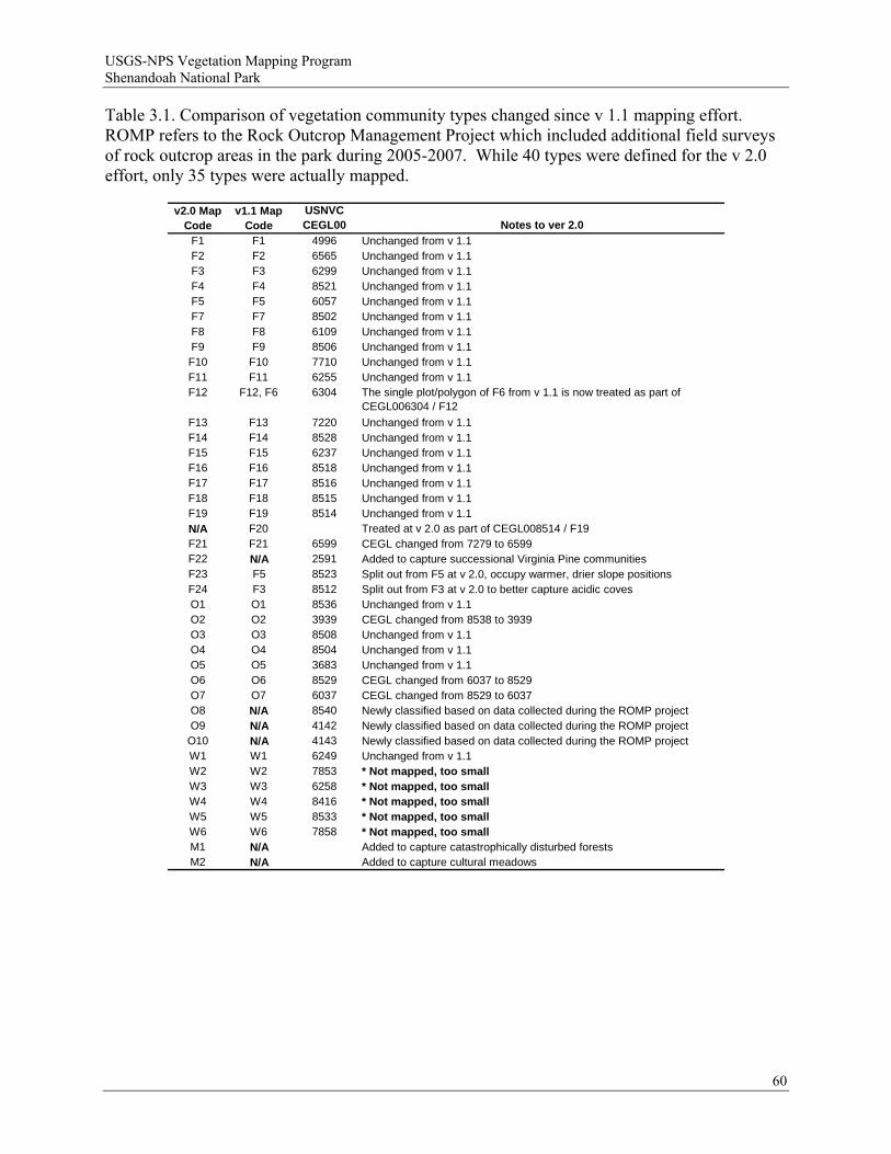
USGS-NPS Vegetation Mapping Program Shenandoah National Park
Table 3.1. Comparison of vegetation community types changed since v 1.1 mapping effort. ROMP refers to the Rock Outcrop Management Project which included additional field surveys of rock outcrop areas in the park during 2005-2007. While 40 types were defined for the v 2.0 effort, only 35 types were actually mapped.
v2.0 Map Code
v1.1 Map Code
USNVC CEGL00 Notes to ver 2.0
F1 F1 4996 Unchanged from v 1.1F2 F2 6565 Unchanged from v 1.1F3 F3 6299 Unchanged from v 1.1F4 F4 8521 Unchanged from v 1.1F5 F5 6057 Unchanged from v 1.1F7 F7 8502 Unchanged from v 1.1F8 F8 6109 Unchanged from v 1.1F9 F9 8506 Unchanged from v 1.1F10 F10 7710 Unchanged from v 1.1F11 F11 6255 Unchanged from v 1.1F12 F12, F6 6304 The single plot/polygon of F6 from v 1.1 is now treated as part of
CEGL006304 / F12
F13 F13 7220 Unchanged from v 1.1F14 F14 8528 Unchanged from v 1.1F15 F15 6237 Unchanged from v 1.1F16 F16 8518 Unchanged from v 1.1F17 F17 8516 Unchanged from v 1.1F18 F18 8515 Unchanged from v 1.1F19 F19 8514 Unchanged from v 1.1N/A F20 Treated at v 2.0 as part of CEGL008514 / F19F21 F21 6599 CEGL changed from 7279 to 6599F22 N/A 2591 Added to capture successional Virginia Pine communitiesF23 F5 8523 Split out from F5 at v 2.0, occupy warmer, drier slope positionsF24 F3 8512 Split out from F3 at v 2.0 to better capture acidic covesO1 O1 8536 Unchanged from v 1.1O2 O2 3939 CEGL changed from 8538 to 3939O3 O3 8508 Unchanged from v 1.1O4 O4 8504 Unchanged from v 1.1O5 O5 3683 Unchanged from v 1.1O6 O6 8529 CEGL changed from 6037 to 8529O7 O7 6037 CEGL changed from 8529 to 6037O8 N/A 8540 Newly classified based on data collected during the ROMP projectO9 N/A 4142 Newly classified based on data collected during the ROMP project
O10 N/A 4143 Newly classified based on data collected during the ROMP projectW1 W1 6249 Unchanged from v 1.1W2 W2 7853 * Not mapped, too smallW3 W3 6258 * Not mapped, too smallW4 W4 8416 * Not mapped, too smallW5 W5 8533 * Not mapped, too smallW6 W6 7858 * Not mapped, too smallM1 N/A Added to capture catastrophically disturbed forestsM2 N/A Added to capture cultural meadows
60
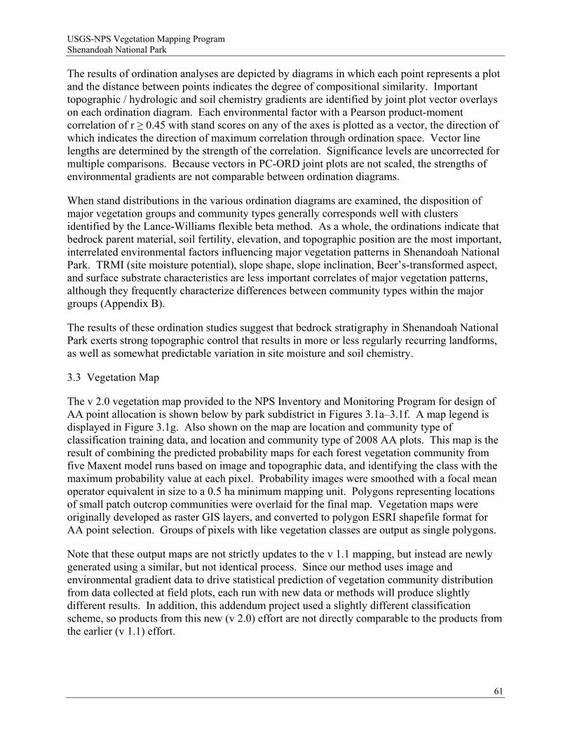
USGS-NPS Vegetation Mapping Program Shenandoah National Park
The results of ordination analyses are depicted by diagrams in which each point represents a plot and the distance between points indicates the degree of compositional similarity. Important topographic / hydrologic and soil chemistry gradients are identified by joint plot vector overlays on each ordination diagram. Each environmental factor with a Pearson product-moment correlation of r ≥ 0.45 with stand scores on any of the axes is plotted as a vector, the direction of which indicates the direction of maximum correlation through ordination space. Vector line lengths are determined by the strength of the correlation. Significance levels are uncorrected for multiple comparisons. Because vectors in PC-ORD joint plots are not scaled, the strengths of environmental gradients are not comparable between ordination diagrams.
When stand distributions in the various ordination diagrams are examined, the disposition of major vegetation groups and community types generally corresponds well with clusters identified by the Lance-Williams flexible beta method. As a whole, the ordinations indicate that bedrock parent material, soil fertility, elevation, and topographic position are the most important, interrelated environmental factors influencing major vegetation patterns in Shenandoah National Park. TRMI (site moisture potential), slope shape, slope inclination, Beer’s-transformed aspect, and surface substrate characteristics are less important correlates of major vegetation patterns, although they frequently characterize differences between community types within the major groups (Appendix B).
The results of these ordination studies suggest that bedrock stratigraphy in Shenandoah National Park exerts strong topographic control that results in more or less regularly recurring landforms, as well as somewhat predictable variation in site moisture and soil chemistry.
3.3 Vegetation Map
The v 2.0 vegetation map provided to the NPS Inventory and Monitoring Program for design of AA point allocation is shown below by park subdistrict in Figures 3.1a–3.1f. A map legend is displayed in Figure 3.1g. Also shown on the map are location and community type of classification training data, and location and community type of 2008 AA plots. This map is the result of combining the predicted probability maps for each forest vegetation community from five Maxent model runs based on image and topographic data, and identifying the class with the maximum probability value at each pixel. Probability images were smoothed with a focal mean operator equivalent in size to a 0.5 ha minimum mapping unit. Polygons representing locations of small patch outcrop communities were overlaid for the final map. Vegetation maps were originally developed as raster GIS layers, and converted to polygon ESRI shapefile format for AA point selection. Groups of pixels with like vegetation classes are output as single polygons.
Note that these output maps are not strictly updates to the v 1.1 mapping, but instead are newly generated using a similar, but not identical process. Since our method uses image and environmental gradient data to drive statistical prediction of vegetation community distribution from data collected at field plots, each run with new data or methods will produce slightly different results. In addition, this addendum project used a slightly different classification scheme, so products from this new (v 2.0) effort are not directly comparable to the products from the earlier (v 1.1) effort.
61

USGS-NPS Vegetation Mapping Program Shenandoah National Park
3.4 Accuracy Assessment
Of the 779 AA field plot locations generated for field survey, 703 (90%) were sampled in the field in the summer of 2008. Twenty-four plots were tagged as having a “location problem” where the target plot could not be reached due to terrain or vegetation obstruction. These plots were assessed 22.5 m on average (± 22.1 m, maximum of 90 m) from the targeted location. Each of these plot locations were inspected in GIS to determine if the actual location sampled differed in predicted vegetation type from the originally targeted location, and no problems of this type were found. One hundred seventeen (117) field AA plots were tagged as having “vegetation problems” where the vegetation found on the ground did not coincide perfectly with expectations using the field key, leading to difficulties assigning the plot to a discrete class. One hundred nine (109) of these had a secondary association type recorded, and eight (8) plots had secondary and tertiary associations recorded. We assessed the accuracy of the v 2.0 vegetation map using standard methods that only consider data from the primary calls, but we also assessed possible field assignment difficulties by incorporating the secondary and tertiary calls in a “fuzzy accuracy” assessment (sensu Congalton and Green 1999).
Accuracy assessment data collected in the field were organized in a standard “confusion matrix” that tabulates discrete map errors as compared to field collected AA data (Appendix G). Rows in the table represent map classes evaluated, and columns represent the field calls for the primary vegetation association type found only. Accuracy rate (percentages) to the right are “user’s accuracy” (1 – error of commission), while accuracy rate (percentages) along the bottom are “producer’s accuracy” (1 – errors of omission). Overall accuracy for this map as evaluated by the 2008 AA field calls is 48.9%. By-class accuracy ranges from 0–100% for both user’s and producer’s accuracy. Numbers of AA points collected in each map class are shown to the right of the table, and numbers of points called for each vegetation type are shown along the bottom (Appendix G). Mapping accuracy was also estimated for pooled classes by aggregating classes up in the USNVC hierarchy (not shown). Pooling classes to alliance, group, macrogroup, and ecological system improves overall (discrete) accuracy to 50.2 %, 56.8%, 70.6%, and 58.0%, respectively.
A summary of user’s and producer’s accuracy for the discrete confusion matrix (Appendix G) is given in Table 3.2. Classes mapped with greater than or equal to 50% accuracy are highlighted for both user’s and producer’s accuracy. Seventeen classes had user’s accuracy higher than 50%, and twenty-one classes had producer’s accuracy greater than or equal to 50%. Average by-class user’s accuracy was 50.5%, and average by-class producer’s accuracy was 55.9% (Table 3.2). Both user’s and producer’s accuracy were below 50%, for nine classes, even though there was sufficient training data for most classes. For example, map class F14 (Central Appalachian Basic Boulderfield Forest) had low user’s and producer’s accuracies, even though there were sufficient training points (48) and AA points (27) to represent the class. This class was substantially over-mapped, and was most often confused with map class F16 (Central Appalachian Montane Oak-Hickory Forest - Basic type). This suggests that training sample characteristics, as captured by the image and environmental gradient data, were not specific enough to separate these classes. Similarly, map class F23 (Central Appalachian Dry Chestnut Oak - Northern Red Oak /Heath Forest) was mapped with poor accuracy although 53 training points were available to represent the class. Map class F23 was most often confused with map class F3 (Central Appalachian / Northern Piedmont Chestnut Oak Forest). Map class F22 (Virginia Pine Successional Forest) had
62
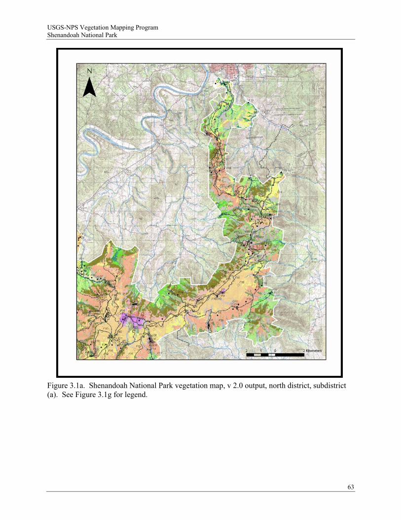
USGS-NPS Vegetation Mapping Program Shenandoah National Park
Figure 3.1a. Shenandoah National Park vegetation map, v 2.0 output, north district, subdistrict (a). See Figure 3.1g for legend.
63
USGS-NPS Vegetation Mapping Program Shenandoah National Park
Figure 3.1b. Shenandoah National Park vegetation map, v 2.0 output, north district, subdistrict (b). See Figure 3.1g for legend.
64

USGS-NPS Vegetation Mapping Program Shenandoah National Park
Figure 3.1c. Shenandoah National Park vegetation map, v 2.0 output, central district, subdistrict (a). See Figure 3.1g for legend.
65
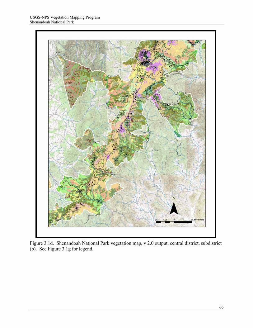
USGS-NPS Vegetation Mapping Program Shenandoah National Park
Figure 3.1d. Shenandoah National Park vegetation map, v 2.0 output, central district, subdistrict (b). See Figure 3.1g for legend.
66
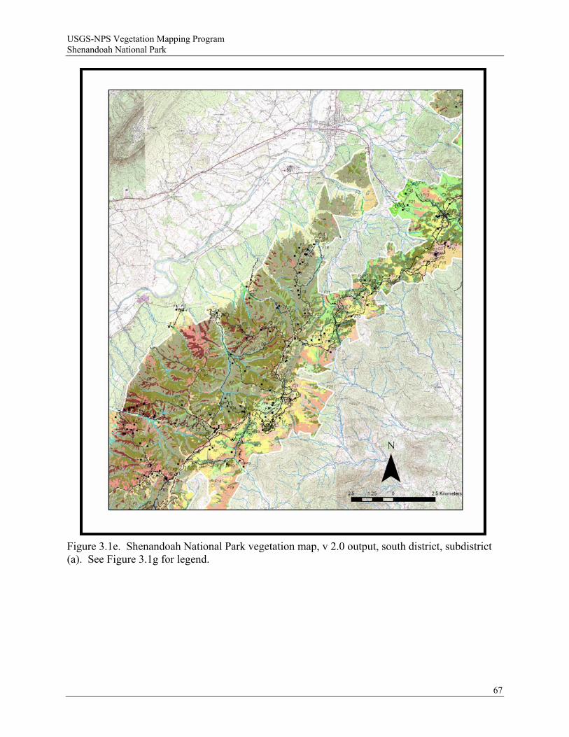
USGS-NPS Vegetation Mapping Program Shenandoah National Park
Figure 3.1e. Shenandoah National Park vegetation map, v 2.0 output, south district, subdistrict (a). See Figure 3.1g for legend.
67
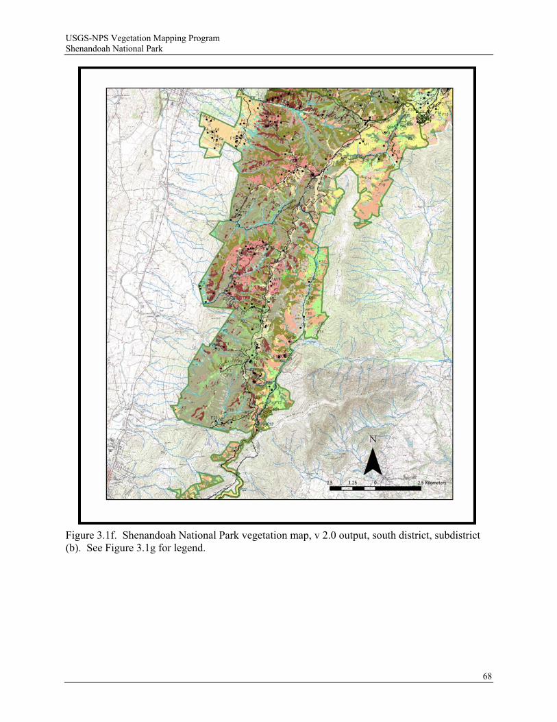
USGS-NPS Vegetation Mapping Program Shenandoah National Park
Figure 3.1f. Shenandoah National Park vegetation map, v 2.0 output, south district, subdistrict (b). See Figure 3.1g for legend.
68
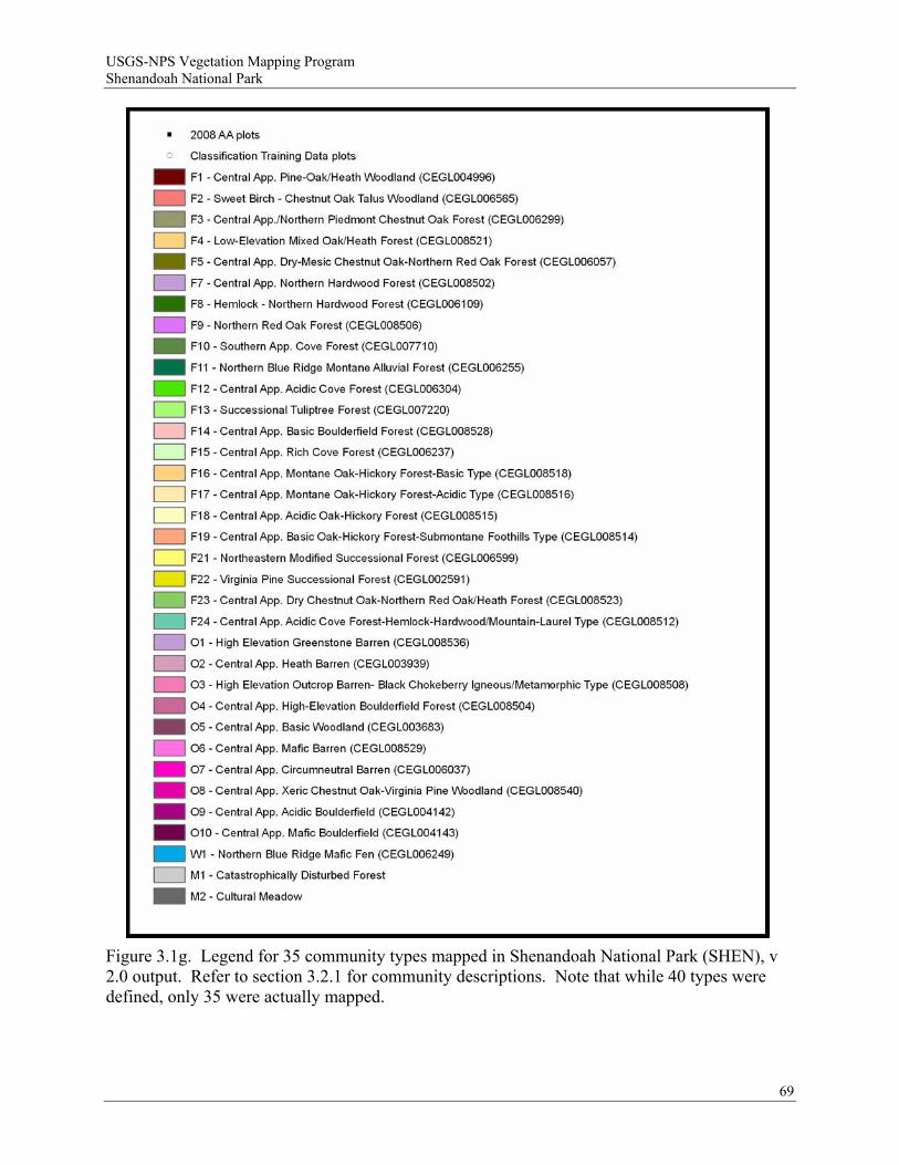
USGS-NPS Vegetation Mapping Program Shenandoah National Park
Figure 3.1g. Legend for 35 community types mapped in Shenandoah National Park (SHEN), v 2.0 output. Refer to section 3.2.1 for community descriptions. Note that while 40 types were defined, only 35 were actually mapped.
69
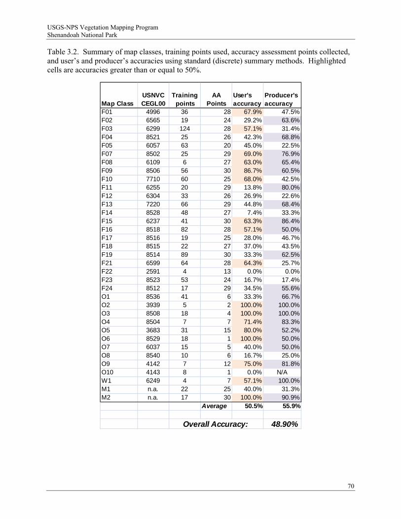
USGS-NPS Vegetation Mapping Program Shenandoah National Park
Table 3.2. Summary of map classes, training points used, accuracy assessment points collected, and user’s and producer’s accuracies using standard (discrete) summary methods. Highlighted cells are accuracies greater than or equal to 50%.
Map ClassUSNVC CEGL00
Training points
AA Points
User's accuracy
Producer's accuracy
F01 4996 36 28 67.9% 47.5%F02 6565 19 24 29.2% 63.6%F03 6299 124 28 57.1% 31.4%F04 8521 25 26 42.3% 68.8%F05 6057 63 20 45.0% 22.5%F07 8502 25 29 69.0% 76.9%F08 6109 6 27 63.0% 65.4%F09 8506 56 30 86.7% 60.5%F10 7710 60 25 68.0% 42.5%F11 6255 20 29 13.8% 80.0%F12 6304 33 26 26.9% 22.6%F13 7220 66 29 44.8% 68.4%F14 8528 48 27 7.4% 33.3%F15 6237 41 30 63.3% 86.4%F16 8518 82 28 57.1% 50.0%F17 8516 19 25 28.0% 46.7%F18 8515 22 27 37.0% 43.5%F19 8514 89 30 33.3% 62.5%F21 6599 64 28 64.3% 25.7%F22 2591 4 13 0.0% 0.0%F23 8523 53 24 16.7% 17.4%F24 8512 17 29 34.5% 55.6%O1 8536 41 6 33.3% 66.7%O2 3939 5 2 100.0% 100.0%O3 8508 18 4 100.0% 100.0%O4 8504 7 7 71.4% 83.3%O5 3683 31 15 80.0% 52.2%O6 8529 18 1 100.0% 50.0%O7 6037 15 5 40.0% 50.0%O8 8540 10 6 16.7% 25.0%O9 4142 7 12 75.0% 81.8%O10 4143 8 1 0.0% N/AW1 6249 4 7 57.1% 100.0%M1 n.a. 22 25 40.0% 31.3%M2 n.a. 17 30 100.0% 90.9%
Average 50.5% 55.9%
48.90%Overall Accuracy:
70

USGS-NPS Vegetation Mapping Program Shenandoah National Park
very low accuracies and was most often confused with F21 (Northeastern Modified Successional Forest), but there was very little training data for mapping this class.
Some classes were mapped accurately, even though there were very little training data to guide the classifications. For instance, map class F8 (Hemlock / Northern Hardwood Forest) was well mapped even though there were only eight training samples. Because of the decline of eastern hemlock due to the hemlock woolly adelgid, this community has a very distinctive “signature” on imagery, and occupies a fairly well-defined environmental niche. However, nine field calls confused class F8 with class F24 (Central Appalachian Acidic Cove Forest - Hemlock/Hardwood/Mountain-Laurel Type). Most outcrop classes are well defined, but this is generally due to the mapped boundaries of outcrop classes that were available to overlay in the final step of mapping. Curiously, map class O8 (Central Appalachian Xeric Chestnut Oak - Virginia Pine Woodland) appears to be poorly mapped, even though boundaries from previous studies were used to define this class. Of the sites mapped as O8 visited during AA, most were classified as F1 (Central Appalachian Pine - Oak / Heath Woodland) by AA field crews.
Results from the “fuzzy” accuracy assessment, where secondary and tertiary community types recorded from field calls are considered as “reasonably correct” (Congalton and Green 1999), are given as a “confusion matrix” in Appendix H, and summarized in Table 3.3. In this slightly relaxed view of the confusion matrix, overall accuracy is boosted to 54.8%, with average by-class user’s accuracy of 62.3% and average by-class producer’s accuracy of 76.9%. The validity of considering accuracy of this mapping effort in a “fuzzy” context is illustrated in Figure 3.2. In the area shown (Limberlost), three AA plots were given a primary field classification of F3 (Central Appalachian/Northern Piedmont Chestnut Oak Forest), and one plot was given a primary classification of F15 (Central Appalachian Rich Cove Forest), while all four plots were assigned a secondary classification of F8 (Hemlock-Northern Hardwood Forest). Although this area is well known as an eastern hemlock stand, recent defoliation from hemlock wooly adelgid may have made field classification of vegetation at these plots difficult using a dichotomous key, even though nearby plots were classified as F8. Considering these plots in a discrete context where only the primary call is tabulated, these plots would be recorded as errors in mapping. A “fuzzy” assessment allows a more realistic and reasonable accounting of mapping and field classification subtleties. In a “fuzzy” accuracy assessment, 41 additional plots in the off-diagonal areas of the confusion matrix would be counted as “reasonably correct” (Appendix H).
71
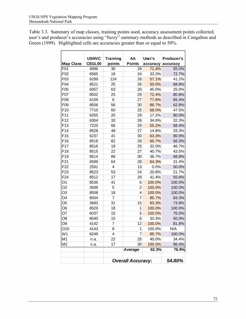
USGS-NPS Vegetation Mapping Program Shenandoah National Park
Table 3.3. Summary of map classes, training points used, accuracy assessment points collected, user’s and producer’s accuracies using “fuzzy” summary methods as described in Congalton and Green (1999). Highlighted cells are accuracies greater than or equal to 50%.
Map ClassUSNVC CEGL00
Training points
AA Points
User's accuracy
Producer's accuracy
F01 4996 36 28 71.4% 55.0%F02 6565 19 24 33.3% 72.7%F03 6299 124 28 57.1% 41.2%F04 8521 25 26 50.0% 68.8%F05 6057 63 20 45.0% 25.0%F07 8502 25 29 72.4% 80.8%F08 6109 6 27 77.8% 65.4%F09 8506 56 30 86.7% 62.8%F10 7710 60 25 68.0% 47.5%F11 6255 20 29 17.2% 80.0%F12 6304 33 26 34.6% 32.3%F13 7220 66 29 55.2% 68.4%F14 8528 48 27 14.8% 33.3%F15 6237 41 30 63.3% 90.9%F16 8518 82 28 60.7% 56.3%F17 8516 19 25 32.0% 46.7%F18 8515 22 27 40.7% 43.5%F19 8514 89 30 36.7% 68.8%F21 6599 64 28 64.3% 31.4%F22 2591 4 13 0.0% 50.0%F23 8523 53 24 20.8% 21.7%F24 8512 17 29 41.4% 55.6%O1 8536 41 6 100.0% 100.0%O2 3939 5 2 100.0% 100.0%O3 8508 18 4 100.0% 100.0%O4 8504 7 7 85.7% 83.3%O5 3683 31 15 93.3% 73.9%O6 8529 18 1 100.0% 100.0%O7 6037 15 5 100.0% 75.0%O8 8540 10 6 33.3% 50.0%O9 4142 7 12 100.0% 81.8%O10 4143 8 1 100.0% N/AW1 6249 4 7 85.7% 100.0%M1 n.a. 22 25 40.0% 34.4%M2 n.a. 17 30 100.0% 96.4%
Average 62.3% 76.9%
54.80%Overall Accuracy:
72
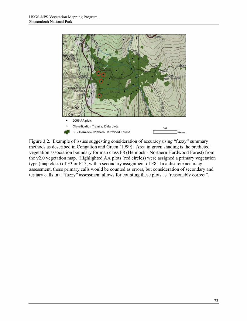
USGS-NPS Vegetation Mapping Program Shenandoah National Park
Figure 3.2. Example of issues suggesting consideration of accuracy using “fuzzy” summary methods as described in Congalton and Green (1999). Area in green shading is the predicted vegetation association boundary for map class F8 (Hemlock - Northern Hardwood Forest) from the v2.0 vegetation map. Highlighted AA plots (red circles) were assigned a primary vegetation type (map class) of F3 or F15, with a secondary assignment of F8. In a discrete accuracy assessment, these primary calls would be counted as errors, but consideration of secondary and tertiary calls in a “fuzzy” assessment allows for counting these plots as “reasonably correct”.
73
USGS-NPS Vegetation Mapping Program Shenandoah National Park
4 Discussion
Mapping accuracy as determined by the 2008 AA field collection was lower than anticipated or desired. While the original goal for the USGS-NPS National Vegetation Mapping Program was overall accuracy of 80% or greater, it is now generally recognized that, for large, environmentally complex parks, this level is seldom achieved, and 60% overall accuracy is probably a more realistic target. Similar recent efforts employing remote sensing and species distribution modeling to map vegetation communities in a USNVC hierarchy (Grossman et al. 1998) report overall accuracies at or below 60% (Dobrowski et al. 2006; Greenberg et al 2006). Partly, this is due to the difficulty in mapping detailed ecological communities (i.e. vegetation associations) defined on the basis of floristics using currently available imagery and topographic data. Since aerial and satellite imagery view aggregates of vegetation from the top-down, and vegetation associations are defined from the ground up based on individual plants, finding a method that can accurately represent both perspectives is challenging. That being said, the overall level of accuracy found in the v2.0 map (48.9%) is lower than acceptable, although considering the relaxed assumptions of the “fuzzy” accuracy assessment methods raises the overall accuracy (54.8%) closer to the relaxed USGS-NPS National Vegetation Mapping Program goals of 60% overall accuracy. While it at first appears that overall accuracy declined from the v 1.1 mapping effort (64%), these results are not directly comparable since the tabulation and summary of data using the “confusion matrix” approach is more restrictive than the “percent plots correct” approach used in the original effort. The v 2.0 accuracy assessment results should be considered to be more robust and reliable than the v 1.1 efforts owing to the greater numbers of points assessed, and the more restrictive summary methods.
The USGS-NPS National Vegetation Mapping Program recognizes general “rules of thumb” when interpreting results of accuracy assessment campaigns based on previous experience in evaluating accuracy of USNVC association maps for national parks. When there is a high one-way accuracy (for example, high user’s accuracy but low producer’s accuracy, or vice versa), this is generally an indication that the ecological concept is valid, but there may be a problem in modeling (mapping) the association, or in recognizing the vegetation community type in the field using a dichotomous key. This was apparent in eleven community types in the discrete accuracy assessment (Table 3.2) and nine community types in the “fuzzy” accuracy assessment (Table 3.3), not counting map class O10, which had only 1 AA point. Low accuracies both ways (i.e. both user’s and producer’s accuracy are low) indicate that the ecological concept itself may not be that distinct, and therefore may not be keyed reliably in the field, mapped reliably from imagery, or both. This was apparent in nine community types in the discrete accuracy assessment (Table 3.2) and six community types in the fuzzy accuracy assessment (Table 3.3), again not counting map class O10.
The v 2.0 map was created in an attempt to capitalize on new training data, a newly refined classification scheme, and much more effort at accuracy assessment than in the v 1.1 mapping. Indeed, we used 3.7 times more training data than the previous effort. However, introduction of new data and mapping methods may have introduced new complexities into the mapping methodology, and may have potentially led to new sources of error. In particular, there were five separate models run from different sets of imagery (although common sets of topographic variables and training points were used). Each run produced similar, but slightly different
74

USGS-NPS Vegetation Mapping Program Shenandoah National Park
probability maps for a given vegetation class distribution. It is possible that some classes may have been over-predicted because either an individual predicted model or a set of models for a particular class may have had overly-broad probability assignments that overwhelmed other classes in the final combination of classes and selection of maximum probabilities. Classes that may have had lower probabilities overall may have been overwhelmed, even though their individual distribution was reasonable. This may be why the “gestalt” evaluation of by-class prediction did not raise any red flags, except for the small patch outcrop and wetland types. It was only on the final combination that problems deciding between classes became apparent.
Another possibility is that map classes were over or under predicted because of a mismatch between the ecological concept underpinning the association description and the ability to discriminate compositional or environmental factors defining the concept using the satellite or aerial imagery and topographic gradient models we had available for this project. Spectral reflectance of canopy composition or values of mapped environmental parameters may not have been specific enough to separate some map classes from each other based on differences that may seem obvious from the ground but are much more subtle at the scale of mapping. Close inspection of the accuracy assessment matrices (Appendixes G and H) reveal significant confusion between types that have similar canopy species, similar environmental characteristics, or types that are mapped in close proximity to one another (based primarily on canopy reflectance and environmental variables). All of these issues are suggestive of methodological difficulties in defining and parsing the compositional and environmental limits of types in ways that are easily transferable to mapping.
For example, classes F14 (Central Appalachian Basic Boulderfield Forest) and F16 (Central Appalachian Montane Oak-Hickory Forest) have similar canopy species (Fraxinus americana, Quercus rubra, and Carya spp.), the same geologic substrate (metabasalt), and topographic regimes in close proximity (steep upper slopes versus slope crests), but have subtle differences in canopy composition (dominated by F. americana versus F. americana as a co-dominant), tree density (woodland versus forest), substrate composition (piled talus versus rocky), and herbaceous cover (limited versus continuous). Additionally, difficulty in representing the ecological concept may have also been reflected in difficulty in discriminating between vegetation classes during field AA campaigns. In the example given, F14 and F16 are adjacent terminal leaves in the dichotomous field key (Appendix C); working through the key results in a possible choice between these two types. Nine plots that were mapped as F14 were keyed as F16 in the field, with two of these plots having F14 as a secondary type (Appendix H). Class F14 was significantly overmapped, perhaps owing to a broad range of spectral and environmental values found at field plots. This class was also confused with other generalist types; F21 (Northeastern Modified Successional Forest) and F5 (Central Appalachian Dry-Mesic Chestnut Oak, Northern Red Oak Forest), suggesting considerable confusion between types that have broad or overlapping compositional or environmental characteristics.
Due to the nature of the modeling, it is possible to review and re-combine map classes to fine tune the final map. Figure 4.1 demonstrates the probability maps produced for the Central Appalachian Dry Chestnut Oak - Northern Red Oak/Heath Forest vegetation community (map code F23) from our modeling, and shows the training data used, boundaries of the final polygons (in purple), and AA plot calls. Detailed evaluation of this data could assist in determining where individual predicted community probability maps might be in error. By determining the
75

USGS-NPS Vegetation Mapping Program Shenandoah National Park
Figure 4.1. Example class probability map for map class F23 for a section of Shenandoah National Park near Thornton Gap. Shown are high probability areas in shades of green, low probability areas in shades of red, final polygon areas from combined map outlined in purple, training data points for class F23, and AA points. These individual probability maps underlie our mapping and could be further evaluated to adjust map class assignments, although this might result in invalidating the AA campaign.
76
USGS-NPS Vegetation Mapping Program Shenandoah National Park
probability predicted for each class at training points relative to that predicted at AA points, it is feasible to fine tune the predicted distribution. Diagnostics are also provided in Maxent that include suggested threshold values to use to convert each community probability map to a binary class map based, for example, on criteria of balancing errors of omission and commission.
However, since the AA design was tied to the v 2.0 map (i.e. AA point allocation was determined relative to map class representation), changing the proportional map class representation by recombination of models would invalidate the statistical design of the AA campaign, and the accuracy determination by class. So while modifying and recombining the individual probability maps to re-compute the final map is possible and might produce a more accurate and useful final product, it would likely require additional field validation to be acceptable under the NPS I&M National Vegetation Mapping Program map accuracy guidelines. Currently, the most feasible alternative for increasing map accuracy while maintaining the validity of the accuracy assessment design is to lump most often confused, but compositionally and environmentally similar, map types together (maintaining the vegetation classification scheme as is) into “groups”. Recent revisions to the USNVC hierarchy (Faber-Langendoen et al. 2009) recognize three new middle-levels of classification (division, macrogroup, and group) that fall between the previous alliance and formation levels to bridge the conceptual gap between floristic and physionomic classifications. One goal of this new hierarchy is to ease the difficulty in mapping to the fine floristic detail of the association and alliance levels of the USNVC by grouping communities with similar composition and growth forms that “reflect regional mesoclimate, geology, substrates, hydrology, and disturbance regimes” (Faber-Langendoen et al. 2009). However, the group and macrogroup levels are still under active development at the time of writing this report and have not been finalized for the Blue Ridge Mountains. In the interim, we propose implementing a temporary grouping structure to improve accuracy of the vegetation community mapping at Shenandoah National Park. Suggested interim group names were defined by combining the major compositional elements from the original community names.
Close inspection of the confusion matrix determined that only 80 of 703 AA calls would have to be corrected to get the overall mapping to 60% accuracy. Therefore, we make the following recommendations that, while reducing the specificity of the map, would improve overall map accuracy to a level acceptable to the USGS-NPS National Vegetation Mapping Program without requiring additional AA field data collection. Accuracy gains (listed as “points,” or number of correct plots) and justifications are given for each proposed class combination and are reflected in the “fuzzy” accuracy confusion matrix (Appendix H).
1) Combine map classes F12 (Central Appalachian Acidic Cove Forest [White Pine-Hemlock-Mixed Hardwoods Type], F24 (Central Appalachian Acidic Cove Forest [Hemlock-Hardwood-Mountain Laurel Type], and F8 (Hemlock-Northern Hardwood Forest) into a “Central Appalachian Acidic Cove / Hemlock-Northern Hardwood Forest” interim group, encompassing CEGL006304, CEGL008512, and CEGL006109. Accuracy gain: 16 points Justification: These community types all have (or had) eastern hemlock as a significant canopy component, they are difficult to separate and map based on spectral and/or
77
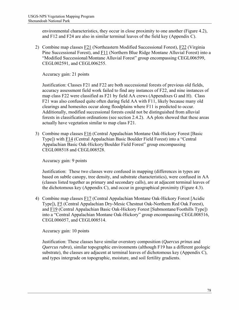
USGS-NPS Vegetation Mapping Program Shenandoah National Park
environmental characteristics, they occur in close proximity to one another (Figure 4.2), and F12 and F24 are also in similar terminal leaves of the field key (Appendix C).
2) Combine map classes F21 (Northeastern Modified Successional Forest), F22 (Virginia Pine Successional Forest), and F11 (Northern Blue Ridge Montane Alluvial Forest) into a “Modified Successional/Montane Alluvial Forest” group encompassing CEGL006599, CEGL002591, and CEGL006255. Accuracy gain: 21 points Justification: Classes F21 and F22 are both successional forests of previous old fields, accuracy assessment field work failed to find any instances of F22, and nine instances of map class F22 were classified as F21 by field AA crews (Appendixes G and H). Class F21 was also confused quite often during field AA with F11, likely because many old clearings and homesites occur along floodplains where F11 is predicted to occur. Additionally, modified successional forests could not be distinguished from alluvial forests in classification ordinations (see section 2.4.2). AA plots showed that these areas actually have vegetation similar to map class F21.
3) Combine map classes F16 (Central Appalachian Montane Oak-Hickory Forest [Basic Type]) with F14 (Central Appalachian Basic Boulder Field Forest) into a “Central Appalachian Basic Oak-Hickory/Boulder Field Forest” group encompassing CEGL008518 and CEGL008528. Accuracy gain: 9 points Justification: These two classes were confused in mapping (differences in types are based on subtle canopy, tree density, and substrate characteristics), were confused in AA (classes listed together as primary and secondary calls), are at adjacent terminal leaves of the dichotomous key (Appendix C), and occur in geographical proximity (Figure 4.3).
4) Combine map classes F17 (Central Appalachian Montane Oak-Hickory Forest [Acidic Type]), F5 (Central Appalachian Dry-Mesic Chestnut Oak-Northern Red Oak Forest), and F19 (Central Appalachian Basic Oak-Hickory Forest [Submontane/Foothills Type]) into a “Central Appalachian Montane Oak-Hickory” group encompassing CEGL008516, CEGL006057, and CEGL008514. Accuracy gain: 10 points Justification: These classes have similar overstory composition (Quercus prinus and Quercus rubra), similar topographic environments (although F19 has a different geologic substrate), the classes are adjacent at terminal leaves of dichotomous key (Appendix C), and types intergrade on topographic, moisture, and soil fertility gradients.
78
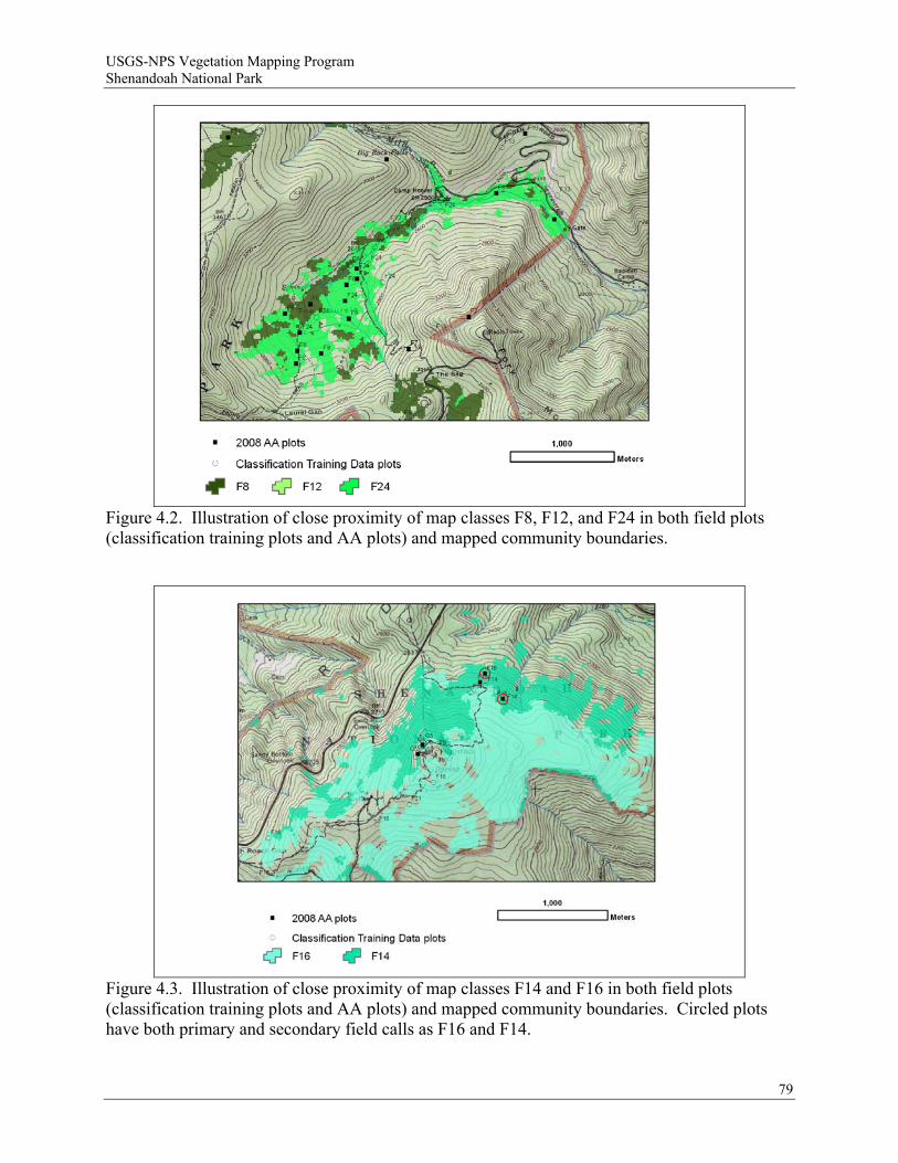
USGS-NPS Vegetation Mapping Program Shenandoah National Park
Figure 4.2. Illustration of close proximity of map classes F8, F12, and F24 in both field plots (classification training plots and AA plots) and mapped community boundaries.
Figure 4.3. Illustration of close proximity of map classes F14 and F16 in both field plots (classification training plots and AA plots) and mapped community boundaries. Circled plots have both primary and secondary field calls as F16 and F14.
79
USGS-NPS Vegetation Mapping Program Shenandoah National Park
5) Combine classes F18 (Central Appalachian Acidic Oak-Hickory Forest ) and F4 (Low Elevation Mixed Oak/Heath Forest) together into a “Central Appalachian Acidic Oak-Hickory/Heath Forest” group encompassing CEGL008515 and CEGL008521. Accuracy gain: 12 points Justification: These classes are similar in overstory compostion (Quercus alba important in both, but F18 may include pine species), occupy similar environments (low elevation flats), were confused in mapping and in AA, and occur in geographical proximity (Figure 4.4).
6) Combine classes F3 (Central Appalachian/Northern Piedmont Chestnut Oak Forest) and F23 (Central Appalachian Dry Chestnut Oak-Northern Red Oak/Heath Forest) into a “Central Appalachian/Northern Piedmont Dry Chestnut Oak/Red Oak/Heath Forest” encompassing CEGL006299 and CEGL008523. Accuracy gain: 8 points Justification: These classes have similar overstory (Quercus prinus) and understory (Kalmia latifolia and deciduous ericads) composition, classes are adjacent at terminal leaves of the dichotomous key (Appendix C), are in close geographical proximity, were confused in mapping and in AA, and have similar fire history.
7) Combine classes F1 (Central Appalachian Pine Oak Heath Woodland) and O8 (Central Appalachian Xeric Chestnut Oak-Virginia Pine Woodland) into a “Central Appalachian Xeric Pine Oak Heath Woodland” group encompassing CEGL004996 and CEGL008540. Accuracy gain: 6 points Justification: These classes are similar in overstory composition (excepting different species of pine), have similar tree density (woodland), are similar in environment, are adjacent at terminal nodes of the dichotomous key (Appendix C), and were confused in mapping and in AA.
Merging these classes together on the map into the above suggested groups would boost overall (discrete) accuracy by 82 points to 60.5% ((344+82)/703), while not affecting the validity of the accuracy assessment statistical design, and not significantly affecting the overall utility of the map. Considering off-diagonal elements of the confusion matrix as “reasonably correct” in a fuzzy assessment (Appendix H) with these grouped map classes would result in 65.1% overall accuracy ((344+82+32)/703). The resulting map would be representative of 25 map classes rather than 35 map classes. Merging map classes is a simple reclassification in GIS, with no loss or change in original class boundaries. A reclassified v 2.0b vegetation map with these suggested grouped map classes is provided in the map data sets accompanying this report.
80
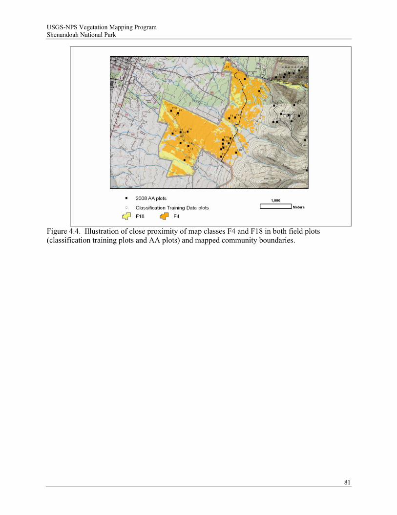
USGS-NPS Vegetation Mapping Program Shenandoah National Park
Figure 4.4. Illustration of close proximity of map classes F4 and F18 in both field plots (classification training plots and AA plots) and mapped community boundaries.
81
USGS-NPS Vegetation Mapping Program Shenandoah National Park
5 Conclusion
The revision of the v 1.1 map products to a v 2.0 data set resulted in the following products: a new vegetation classification scheme; a new map of predicted vegetation community distribution based on 1,160 training plots and Maxent statistical modeling with five sets of nine-band ASTER multispectral imagery, 34 MNF- compressed bands of AVIRIS hyperspectral imagery, and 15 environmental gradient model variables; and a statistically valid accuracy assessment campaign using data collected at 703 plots. Overall results were lower than anticipated, but most errors can be explained as confusion between vegetation association types that are often subtly different in canopy composition and density, understory species, or substrate type. At first blush, accuracy of the v 2.0 map appears to be lower than the v 1.1 map, but due to different tabulation and summary methods, results are not directly comparable, and the accuracy assessment of the v 2.0 map should be considered more robust. While meaningful from an ecological perspective, many of these associations are difficult to discriminate and map. The inability to discriminate subtle differences in species composition is indicative of the limits of using moderate resolution satellite and aerial imagery (even hyperspectral imagery) and digital elevation-derived topographic gradient models for ”top-down” mapping to the fine specificity of the USNVC association level. Future research should be aimed at better ways to link ground-based ecological concepts with vegetation patterns observable from readily available aerial imagery and spatial data.
82
USGS-NPS Vegetation Mapping Program Shenandoah National Park
6 Literature Cited
Anderson, M., P. Bourgeron, M. T. Bryer, R. Crawford, L. Engelking, D. Faber-Langendoen, M. Gallyoun, K. Goodin, D. H. Grossman, S. Landaal, K. Metzler, K. D. Patterson, M. Pyne, M. Reid, L. Sneddon, and A. S. Weakley. 1998. Terrestrial vegetation of the United States. Volume II: List of vegetation types. The Nature Conservancy. Arlington, VA.
Anderson, W. B. 2003. Interactions of nutrient effects with other biotic factors in the herbaceous layer. Pages 91–104 in F. S. Gilliam and M. R. Roberts, eds. The herbaceous layer in forests of eastern North America. Oxford University Press. New York, NY.
Barbour, M. G., J. H. Burk, and W. D. Pitts. 1987. Terrestrial plant ecology. The Benjamin/Cummings Publishing Co., Inc. Menlo Park, CA. 634 pp.
Beers, T. W., P. E. Dress, and L. C. Wensel. 1966. Aspect transformation in site productivity research. Journal of Forestry 64:691–692.
Bray, J. R., and J. T. Curtis. 1957. An ordination of the upland forest communities of southern Wisconsin. Ecological Monographs 27:325–349.
Curtis, J. T. 1959. The vegetation of Wisconsin: an ordination of plant communities. University of Wisconsin Press. Madison, WI. 657 pp.
Dobrowski, S. Z., J. A. Greenberg, C. M. Ramirez, and S. L. Ustin. 2006. Improving image derived vegetation maps with regression based distribution modeling. Ecological Modelling 192 (1–2):126–142.
Ekstrand, S. 1996. Landsat TM-Based Forest Damage Assessment: Correction for Topographic Effects. PE&RS 62(2):151–161.
Elith, J., C. H. Graham, R. P. Anderson, M. Dudik, S. Ferrier, A. Guisan, R. Hijmans, F. Huettmann, J. P. Leathwick, A. Lehmann, J. Li, L. G. Lohman, B. A. Loiselle, G. Manion, C. Moritz, M. Nakamura, Y. Nakazawa, J. McC. Overton, A. T. Peterson, S. J. Phillips, K. Richardson, R. Scachetti-Pereira, R. E. Schapire, J. Soberon, S. Williams, M. S. Wisz, and N. E. Zimmerman. 2006. Novel methods improve prediction of species’ distributions from occurrence data. Ecography 29:129–151.
Environmental Systems Research Institute (ESRI), Inc. 1999. ArcView GIS, Version 3.2. ESRI. Redlands, CA.
Environmental Systems Research Institute, Inc., National Center for Geographic Information and Analysis, and the Nature Conservancy. 1994. Final Draft. Accuracy Assessment Procedures. NBS/NPS Vegetation Mapping Program. http://biology.usgs.gov/npsveg/aarpt.pdf.
83
USGS-NPS Vegetation Mapping Program Shenandoah National Park
Eyre, F. H., ed. 1980. Forest cover types of the United States and Canada. Society of American Foresters. Washington, DC. 148 pp.
Faber-Langendoen, D., D. L. Tart, and R. H. Crawford. 2009. Contours of the revised U.S. National Vegetation Classification System. Bulletin of the Ecological Society of America 90(1):87–93.
Fleming, G. P., A. Belden, Jr., K. E. Heffernan, A. C. Chazal, N. E. Van Alstine, and E. M. Butler. 2007. A natural heritage inventory of the rock outcrops of Shenandoah National Park. Unpublished report submitted to the National Park Service. Natural Heritage Technical Report 07-01. Virginia Department of Conservation and Recreation. Division of Natural Heritage. Richmond, VA. 365 pp.
Fleming, G. P., P. P. Coulling, K. D. Patterson, and K. Taverna. 2006. The natural communities of Virginia: classification of ecological community groups. Second approximation. Version 2.2. Virginia Department of Conservation and Recreation. Division of Natural Heritage. Richmond, VA. http://www.dcr.virginia.gov/dnh/ncintro.htm. Last accessed October 5, 2006.
George, L. O., and F. A. Bazzaz. 2003. The herbaceous layer as a filter determining spatial patterns in forest tree regeneration. Pages 265–282 in F. S. Gilliam and M. R. Roberts, eds. The herbaceous layer in forests of eastern North America. Oxford University Press. New York, NY.
Green, A. A., M. Berman, P. Switzer, and M. D. Craig. 1988. A transformation for ordering multispectral data in terms of image quality with implications for noise removal: IEEE Transactions on Geoscience and Remote Sensing. v. 26. no. 1. Pp. 65–74.
Greenberg, J. A., S. Z. Dobrowski, C. M. Ramirez, J. L. Tuil, and S. L. Ustin. 2006. A bottom-up approach to vegetation mapping of the Lake Tahoe Basin using hyperspatial image analysis. Photogrammetric Engineering and Remote Sensing 72(5):581–589.
Grossman, D. H., D. Faber-Langendoen, A. S. Weakley, M. Anderson, P. Bourgeron, R. Crawford, K. Goodin, S. Landaal, K. Metzler, K. Patterson, M. Pyne, M. Reid, and L. Sneddon. 1998. International classification of ecological communities: terrestrial vegetation of the United States. Volume I. The national vegetation classification system: development, status, and applications. The Nature Conservancy. Arlington, VA. 126 pp.
Guisan, A., N. E. Zimmerman, J. Elith, C. H. Graham, S. Phillips, and A. T. Peterson. 2007. What matters for predicting the occurrence of trees: techniques, data, or species characteristics? Ecological Monographs 77(4):615–630.
Kruskal, J. B. 1964. Nonmetric multidimensional scaling: a numerical method. Psychometrika 29:115–129.
Lance, G. N., and W. T. Williams. 1966. A generalized sorting strategy for computer classifications. Nature 212:218.
84
USGS-NPS Vegetation Mapping Program Shenandoah National Park
Lance, G. N., and W. T. Williams. 1967. A general theory of classification sorting strategies. I. Hierarchical systems. Computer Journal 9:373–380.
McCune, B., and J. B. Grace. 2002. Analysis of ecological communities. MjM Software Design. Gleneden Beach, CA. 300 pp.
McCune, B., and M. J. Mefford. 1999. PC-ORD. Multivariate analysis of ecological data. Version 4.16. MjM Software Design. Gleneden Beach, CA.
Mehlich, A. 1984. Mehlich III soil test extraction modification of Mehlich II extractant. Communications in Soil Science and Plant Analysis 15:1409–1416.
Minchin, P. R. 1987. An evaluation of the relative robustness of techniques for ecological ordination. Vegetatio 69:89–107.
Morgan, B. A., L. S. Eaton, and G. F. Wieczorek. 2004. Pleistocene and Holocene Colluvial Fans and Terraces in the Blue Ridge Region of Shenandoah National Park, Virginia. U.S. Geological Survey Open File Report 03-410 (Online Only). http://pubs.usgs.gov/of/2003/of03-410/. Last accessed October 5, 2006.
Mueller-Dombois, D., and H. Ellenberg. 1974. Aims and methods of vegetation ecology. John Wiley & Sons, Inc. New York, NY. 574 pp.
Muller, R. N. 2003. Nutrient relations of the herbaceous layer in deciduous forest ecosytems. Pages 15–37 in F. S. Gilliam and M. R. Roberts, eds. The herbaceous layer in forests of eastern North America. Oxford University Press. New York, NY.
NatureServe. 2002. International Classification of Ecological Communities: Terrestrial Vegetation. Natural Heritage Central Databases. NatureServe. Arlington, VA.
Palmer, M. W. 1993. Putting things in even better order: the advantages of canonical correspondence analysis. Ecology 74:2215–2230.
Parker, A. J. 1982. The topographic relative moisture index: an approach to soil-moisture assessment in mountain terrain. Physical Geography 3(2):160–168.
Peet, R. K., T. R. Wentworth, and P. S. White. 1998. A flexible, multipurpose method for recording vegetation composition and structure. Castanea 63:262–274.
Peterson, A. T., and M. Papes. 2006. Potential geographic distribution of the Bugun Liocichla Liocichla bugunorum, a poorly-known species from north-eastern India. Indian Birds 2(6):146–149.
Phillips, S. J., R. P. Anderson, and R. E. Schapire. 2006. Maximum entropy modeling of species geographic distributions. Ecological Modeling 190:231–259.
Phillips, S. J., and M. Dudik. 2008. Modeling of species distribution with Maxent: new extensions and a comprehensive evaluation. Ecography 31:161–175.
85
USGS-NPS Vegetation Mapping Program Shenandoah National Park
86
Rader, E. K., and N. H. Evans. 1993. Geologic map of Virginia – expanded explanation. Virginia Division of Mineral Resources. Charlottesville, VA. 80 pp.
ter Braak, C. J. F., and C. W. N. Looman. 1995. Regression. Pages 29–77 in R. H. G. Jongman, C. J. F. ter Braak, and O. F. R. van Tongeren (eds.). Data analysis in community and landscape ecology. Cambridge University Press. Cambridge.
United States Department of Agriculture, Natural Resources Conservation Service (USDA, NRCS). 2004. The PLANTS Database, Version 3.5. http://plants.usda.gov. Data compiled from various sources by Mark W. Skinner. National Plant Data Center. Baton Rouge, LA.
Young, J., G. Fleming, P. Townsend, and J. Foster. 2006. Vegetation of Shenandoah National Park in relation to environmental gradients. Final Report v. 1.1. Unpublished report submitted to the U.S. Dept. of the Interior, National Park Service. USGS Leetown Science Center. Kearneysville, WV. 103 pp. http://www.lsc.usgs.gov/gis/shen/shenveg/FinalReport/SHEN_FinalRep_rev1.1_reviewed.pdf.
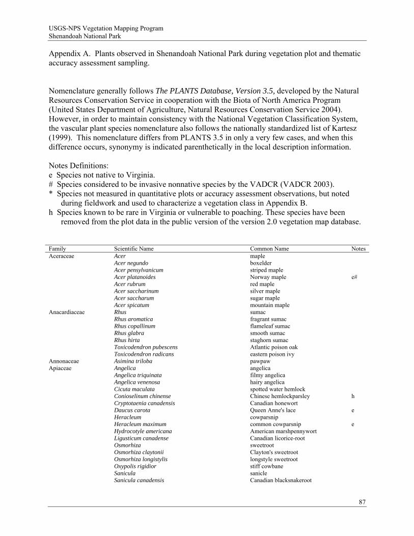
USGS-NPS Vegetation Mapping Program Shenandoah National Park
Appendix A. Plants observed in Shenandoah National Park during vegetation plot and thematic accuracy assessment sampling. Nomenclature generally follows The PLANTS Database, Version 3.5, developed by the Natural Resources Conservation Service in cooperation with the Biota of North America Program (United States Department of Agriculture, Natural Resources Conservation Service 2004). However, in order to maintain consistency with the National Vegetation Classification System, the vascular plant species nomenclature also follows the nationally standardized list of Kartesz (1999). This nomenclature differs from PLANTS 3.5 in only a very few cases, and when this difference occurs, synonymy is indicated parenthetically in the local description information. Notes Definitions: e Species not native to Virginia. # Species considered to be invasive nonnative species by the VADCR (VADCR 2003). * Species not measured in quantitative plots or accuracy assessment observations, but noted
during fieldwork and used to characterize a vegetation class in Appendix B. h Species known to be rare in Virginia or vulnerable to poaching. These species have been
removed from the plot data in the public version of the version 2.0 vegetation map database. Family Scientific Name Common Name Notes Aceraceae Acer maple Acer negundo boxelder Acer pensylvanicum striped maple Acer platanoides Norway maple e# Acer rubrum red maple Acer saccharinum silver maple Acer saccharum sugar maple Acer spicatum mountain maple Anacardiaceae Rhus sumac Rhus aromatica fragrant sumac Rhus copallinum flameleaf sumac Rhus glabra smooth sumac Rhus hirta staghorn sumac Toxicodendron pubescens Atlantic poison oak Toxicodendron radicans eastern poison ivy Annonaceae Asimina triloba pawpaw Apiaceae Angelica angelica Angelica triquinata filmy angelica Angelica venenosa hairy angelica Cicuta maculata spotted water hemlock Conioselinum chinense Chinese hemlockparsley h Cryptotaenia canadensis Canadian honewort Daucus carota Queen Anne's lace e Heracleum cowparsnip Heracleum maximum common cowparsnip e Hydrocotyle americana American marshpennywort Ligusticum canadense Canadian licorice-root Osmorhiza sweetroot Osmorhiza claytonii Clayton's sweetroot Osmorhiza longistylis longstyle sweetroot Oxypolis rigidior stiff cowbane Sanicula sanicle Sanicula canadensis Canadian blacksnakeroot
87
USGS-NPS Vegetation Mapping Program Shenandoah National Park
88
Family Scientific Name Common Name Notes Apiaceae (cont) Sanicula marilandica Maryland sanicle Sanicula odorata clustered blacksnakeroot Sanicula trifoliata largefruit blacksnakeroot h Taenidia integerrima yellow pimpernel Taenidia montana mountain pimpernel Thaspium barbinode hairyjoint meadowparsnip Thaspium trifoliatum purple meadowparsnip Thaspium trifoliatum var. aureum purple meadowparsnip Zizia zizia Zizia aptera meadow zizia Apocynaceae Apocynum androsaemifolium spreading dogbane Apocynum cannabinum Indianhemp Aquifoliaceae Ilex montana mountain holly Ilex opaca American holly Ilex verticillata common winterberry Araceae Arisaema triphyllum Jack in the pulpit Araliaceae Aralia aralia Aralia hispida bristly sarsaparilla h Aralia nudicaulis wild sarsaparilla Aralia racemosa American spikenard Panax quinquefolius American ginseng h Panax trifolius dwarf ginseng Aristolochiaceae Aristolochia macrophylla pipevine Aristolochia serpentaria Virginia snakeroot Asarum canadense Canadian wildginger Hexastylis virginica Virginia heartleaf Asclepiadaceae Asclepias amplexicaulis clasping milkweed Asclepias exaltata poke milkweed Asclepias quadrifolia fourleaf milkweed Asclepias syriaca common milkweed Asclepias tuberosa butterfly milkweed Asclepias verticillata whorled milkweed Aspleniaceae Asplenium montanum mountain spleenwort Asplenium platyneuron ebony spleenwort Asplenium trichomanes maidenhair spleenwort Asteraceae Achillea millefolium common yarrow e Ageratina altissima white snakeroot Ambrosia ragweed Ambrosia artemisiifolia annual ragweed Antennaria pussytoes Antennaria howellii ssp. neodioica Howell's pussytoes Antennaria parlinii ssp. parlinii Parlin's pussytoes Antennaria plantaginifolia woman's tobacco Arctium minus lesser burrdock e Arnoglossum atriplicifolium pale Indian plaintain Bidens bipinnata Spanish needles Bidens frondosa devil's beggartick Carduus acanthoides spiny plumeless thistle e Centaurea knapweed Centaurea biebersteinii spotted knapweed e# Cirsium muticum swamp thistle Cirsium vulgare bull thistle e Conyza canadensis Canadian horseweed Coreopsis verticillata whorled tickseed Doellingeria infirma cornel-leaf whitetop Doellingeria umbellata parasol whitetop Erechtites burnweed Erechtites hieraciifolia American burnweed Erigeron annuus eastern daisy fleabane Erigeron philadelphicus var. philadelphicus Philadelphia fleabane Erigeron strigosus prairie fleabane
USGS-NPS Vegetation Mapping Program Shenandoah National Park
89
Family Scientific Name Common Name Notes Asteraceae (cont) Eupatorium thoroughwort Eupatorium perfoliatum common boneset Eupatorium purpureum sweetscented joepyeweed Eupatorium sessilifolium upland boneset Eurybia aster Eurybia divaricata white wood aster Eurybia macrophylla bigleaf aster Eurybia radula low rough aster h Eurybia schreberi Schreber's aster Galinsoga gallant-soldier Gamochaeta purpurea spoonleaf purple everlasting Helianthus sunflower Helianthus decapetalus thinleaf sunflower Helianthus divaricatus woodland sunflower Helianthus strumosus paleleaf woodland sunflower Hieracium hawkweed Hieracium caespitosum meadow hawkweed e Hieracium paniculatum Allegheny hawkweed Hieracium venosum rattlesnakeweed Ionactis linariifolius flaxleaf whitetop aster Krigia virginica Virginia dwarfdandelion Lactuca lettuce Lactuca biennis tall blue lettuce Lactuca canadensis Canada lettuce Lactuca floridana woodland lettuce Lapsana communis common nipplewort e# Leucanthemum vulgare oxeye daisy e Liatris pilosa shaggy blazing star Liatris scariosa devil's bite Liatris turgida turgid blazing star Oclemena acuminata whorled wood aster Oligoneuron rigidum var. rigidum stiff goldenrod h Packera anonyma Small's ragwort Packera aurea golden ragwort Packera obovata roundleaf ragwort Parthenium integrifolium wild quinine Polymnia canadensis whiteflower leafcup Prenanthes rattlesnakeroot Prenanthes alba white rattlesnakeroot Prenanthes altissima tall rattlesnakeroot Prenanthes serpentaria cankerweed Prenanthes trifoliolata gall of the earth Pseudognaphalium obtusifolium rabbittobacco Rudbeckia laciniata cutleaf coneflower Sericocarpus asteroides toothed whitetop aster Silphium trifoliatum whorled rosinweed Smallanthus uvedalius hairy leafcup Solidago goldenrod Solidago arguta Atlantic goldenrod Solidago arguta var. arguta Atlantic goldenrod Solidago arguta var. caroliniana Atlantic goldenrod Solidago arguta var. harrisii Harris' goldenrod Solidago bicolor white goldenrod Solidago caesia wreath goldenrod Solidago caesia var. curtisii mountain decumbent goldenrod Solidago flexicaulis zigzag goldenrod Solidago juncea early goldenrod Solidago nemoralis gray goldenrod Solidago odora anisescented goldenrod Solidago puberula var. puberula downy goldenrod Solidago roanensis Roan Mountain goldenrod

USGS-NPS Vegetation Mapping Program Shenandoah National Park
90
Family Scientific Name Common Name Notes Asteraceae (cont) Solidago rugosa wrinkleleaf goldenrod Solidago simplex ssp. randii var. randii Rand's goldenrod h Solidago speciosa var. erecta showy goldenrod Solidago squarrosa stout goldenrod Solidago ulmifolia elmleaf goldenrod Symphyotrichum aster Symphyotrichum cordifolium common blue wood aster Symphyotrichum divaricatum southern annual saltmarsh aster Symphyotrichum dumosum rice button aster Symphyotrichum laeve var. concinnum smooth blue aster Symphyotrichum laeve var. laeve smooth blue aster Symphyotrichum lanceolatum white panicle aster Symphyotrichum lateriflorum calico aster Symphyotrichum lowrieanum Lowrie's blue wood aster Symphyotrichum oblongifolium aromatic aster Symphyotrichum patens var. patens late purple aster Symphyotrichum phlogifolium thinleaf late purple aster Symphyotrichum pilosum hairy white oldfield aster Symphyotrichum prenanthoides crookedstem aster Symphyotrichum puniceum purplestem aster Symphyotrichum racemosum smooth white oldfield aster Symphyotrichum undulatum waxyleaf aster Tanacetum vulgare common tansy e Taraxacum officinale common dandelion e Verbesina alternifolia wingstem Verbesina occidentalis yellow crownbeard Vernonia glauca broadleaf ironweed Vernonia noveboracensis New York ironweed Balsaminaceae Impatiens jewelweed Impatiens capensis jewelweed Impatiens pallida pale touch-me-not Berberidaceae Berberis thunbergii Japanese barberry e# Caulophyllum thalictroides blue cohosh Podophyllum peltatum mayapple Betulaceae Alnus incana ssp. rugosa speckled alder h Alnus serrulata hazel alder Betula birch Betula alleghaniensis yellow birch Betula lenta sweet birch Betula nigra river birch Betula papyrifera var. cordifolia mountain paper birch h Betula populifolia gray birch h Carpinus caroliniana American hornbeam Corylus hazelnut Corylus americana American hazelnut Corylus cornuta beaked hazelnut Ostrya virginiana hophornbeam Boraginaceae Cynoglossum virginianum wild comfrey Hackelia virginiana beggarslice Lithospermum canescens hoary puccoon Brassicaceae Alliaria petiolata garlic mustard e# Arabis rockcress Arabis canadensis sicklepod Arabis laevigata smooth rockcress Arabis lyrata lyrate rockcress Barbarea vulgaris garden yellowrocket e Cardamine bulbosa bulbous bittercress Cardamine concatenata cutleaf toothwort Cardamine parviflora var. arenicola sand bittercress Cardamine pensylvanica Pennsylvania bittercress Draba ramosissima branched draba
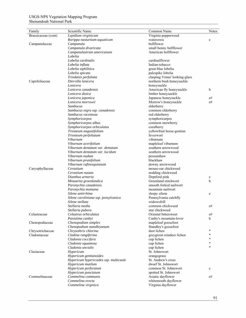
USGS-NPS Vegetation Mapping Program Shenandoah National Park
Family Scientific Name Common Name Notes Brassicaceae (cont) Lepidium virginicum Virginia pepperweed Rorippa nasturtium-aquaticum watercress eCampanulaceae Campanula bellflower Campanula divaricata small bonny bellflower Campanulastrum americanum American bellflower Lobelia Lobelia cardinalis cardinalflower Lobelia inflata Indian-tobacco Lobelia siphilitica great blue lobelia Lobelia spicata palespike lobelia Triodanis perfoliata clasping Venus' looking-glass Caprifoliaceae Diervilla lonicera northern bush honeysuckle Lonicera honeysuckle Lonicera canadensis American fly honeysuckle h Lonicera dioica limber honeysuckle Lonicera japonica Japanese honeysuckle e# Lonicera morrowii Morrow's honeysuckle e# Sambucus elderberry Sambucus nigra ssp. canadensis common elderberry Sambucus racemosa red elderberry Symphoricarpos symphoricarpos Symphoricarpos albus common snowberry Symphoricarpos orbiculatus coralberry Triosteum angustifolium yellowfruit horse-gentian Triosteum perfoliatum feverwort Viburnum viburnum Viburnum acerifolium mapleleaf viburnum Viburnum dentatum var. dentatum southern arrowwood Viburnum dentatum var. lucidum southern arrowwood Viburnum nudum possumhaw Viburnum prunifolium blackhaw Viburnum rafinesquianum downy arrowwood Caryophyllaceae Cerastium mouse-ear chickweed Cerastium nutans nodding chickweed Dianthus armeria Deptford pink e Minuartia groenlandica Greenland stitchwort h Paronychia canadensis smooth forked nailwort Paronychia montana mountain nailwort Silene antirrhina sleepy silene e Silene caroliniana ssp. pensylvanica Pennsylvania catchfly Silene stellata widowsfrill Stellaria media common chickweed e# Stellaria pubera star chickweed Celastraceae Celastrus orbiculatus Oriental bittersweet e# Paxistima canbyi Canby's mountain-lover h Chenopodiaceae Chenopodium simplex mapleleaf goosefoot Chenopodium standleyanum Standley's goosefoot Chrysotrichaceae Chrysothrix chlorina dust lichen * Cladoniaceae Cladina rangiferina greygreen reindeer lichen *
Cladonia coccifera Cladonia squamosa Cladonia uncialis
cup lichen cup lichen cup lichen
* * *
Clusiaceae Hypericum St. Johnswort Hypericum gentianoides orangegrass Hypericum hypericoides ssp. multicaule St. Andrew's cross Hypericum mutilum dwarf St. Johnswort Hypericum perforatum common St. Johnswort e Hypericum punctatum spotted St. Johnswort Commelinaceae Commelina communis Asiatic dayflower e# Commelina erecta whitemouth dayflower Commelina virginica Virginia dayflower
91

USGS-NPS Vegetation Mapping Program Shenandoah National Park
Family Scientific Name Common Name Notes Commelinaceae (cont) Tradescantia virginiana Virginia spiderwort Convolvulaceae Calystegia spithamaea ssp. spithamaea low false bindweed Ipomoea pandurata man of the earth Cornaceae Cornus dogwood Cornus alternifolia alternateleaf dogwood Cornus canadensis bunchberry dogwood h Cornus florida flowering dogwood Cornus racemosa gray dogwood Cornus rugosa roundleaf dogwood h* Crassulaceae Hylotelephium telephioides Allegheny stonecrop Sedum glaucophyllum cliff stonecrop Sedum ternatum woodland stonecrop Cupressaceae Juniperus virginiana eastern redcedar Cuscutaceae Cuscuta dodder Cuscuta coryli hazel dodder h Cuscuta pentagona fiveangled dodder Cyperaceae Bulbostylis capillaris densetuft hairsedge Carex sedge Carex aestivalis summer sedge Carex albicans whitetinge sedge Carex albursina white bear sedge Carex amphibola eastern narrowleaf sedge Carex annectens yellowfruit sedge Carex appalachica Appalachian sedge Carex argyrantha hay sedge Carex atlantica ssp. atlantica prickly bog sedge Carex bebbii Bebb's sedge h* Carex blanda eastern woodland sedge Carex bromoides bromelike sedge Carex brunnescens ssp. sphaerostachya brownish sedge Carex buxbaumii Buxbaum's sedge h Carex cephalophora oval-leaf sedge Carex communis fibrousroot sedge Carex complanata hirsute sedge Carex conoidea openfield sedge h Carex debilis var. debilis white edge sedge Carex debilis var. rudgei white edge sedge Carex digitalis slender woodland sedge Carex echinata star sedge Carex glaucodea blue sedge Carex gracilescens slender looseflower sedge Carex gracillima graceful sedge Carex gynandra nodding sedge Carex hirsutella fuzzy wuzzy sedge Carex intumescens greater bladder sedge Carex laxiculmis spreading sedge Carex laxiflora var. laxiflora broad looseflower sedge Carex leptalea bristlystalked sedge Carex leptonervia nerveless woodland sedge Carex lurida shallow sedge Carex molesta troublesome sedge Carex muehlenbergii Muhlenberg's sedge Carex nigromarginata black edge sedge Carex pensylvanica Pennsylvania sedge Carex platyphylla broadleaf sedge Carex prasina drooping sedge Carex rosea rosy sedge Carex scabrata eastern rough sedge Carex scoparia broom sedge Carex stipata var. stipata owlfruit sedge Carex striatula lined sedge
92
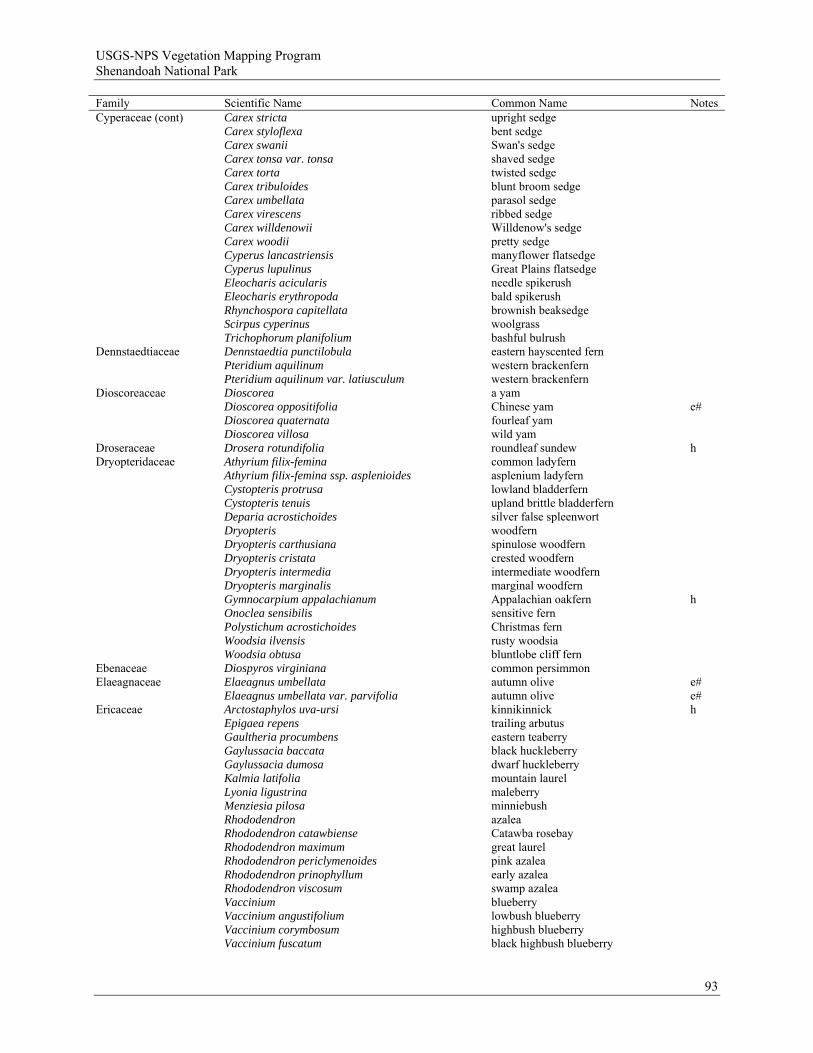
USGS-NPS Vegetation Mapping Program Shenandoah National Park
Family Scientific Name Common Name Notes Cyperaceae (cont) Carex stricta upright sedge Carex styloflexa bent sedge Carex swanii Swan's sedge Carex tonsa var. tonsa shaved sedge Carex torta twisted sedge Carex tribuloides blunt broom sedge Carex umbellata parasol sedge Carex virescens ribbed sedge Carex willdenowii Willdenow's sedge Carex woodii pretty sedge Cyperus lancastriensis manyflower flatsedge Cyperus lupulinus Great Plains flatsedge Eleocharis acicularis needle spikerush Eleocharis erythropoda bald spikerush Rhynchospora capitellata brownish beaksedge Scirpus cyperinus woolgrass Trichophorum planifolium bashful bulrush Dennstaedtiaceae Dennstaedtia punctilobula eastern hayscented fern Pteridium aquilinum western brackenfern Pteridium aquilinum var. latiusculum western brackenfern Dioscoreaceae Dioscorea a yam Dioscorea oppositifolia Chinese yam e# Dioscorea quaternata fourleaf yam Dioscorea villosa wild yam Droseraceae Drosera rotundifolia roundleaf sundew h Dryopteridaceae Athyrium filix-femina common ladyfern Athyrium filix-femina ssp. asplenioides asplenium ladyfern Cystopteris protrusa lowland bladderfern Cystopteris tenuis upland brittle bladderfern Deparia acrostichoides silver false spleenwort Dryopteris woodfern Dryopteris carthusiana spinulose woodfern Dryopteris cristata crested woodfern Dryopteris intermedia intermediate woodfern Dryopteris marginalis marginal woodfern Gymnocarpium appalachianum Appalachian oakfern h Onoclea sensibilis sensitive fern Polystichum acrostichoides Christmas fern Woodsia ilvensis rusty woodsia Woodsia obtusa bluntlobe cliff fern Ebenaceae Diospyros virginiana common persimmon Elaeagnaceae Elaeagnus umbellata autumn olive e# Elaeagnus umbellata var. parvifolia autumn olive e# Ericaceae Arctostaphylos uva-ursi kinnikinnick h Epigaea repens trailing arbutus Gaultheria procumbens eastern teaberry Gaylussacia baccata black huckleberry Gaylussacia dumosa dwarf huckleberry Kalmia latifolia mountain laurel Lyonia ligustrina maleberry Menziesia pilosa minniebush Rhododendron azalea Rhododendron catawbiense Catawba rosebay Rhododendron maximum great laurel Rhododendron periclymenoides pink azalea Rhododendron prinophyllum early azalea Rhododendron viscosum swamp azalea Vaccinium blueberry Vaccinium angustifolium lowbush blueberry Vaccinium corymbosum highbush blueberry Vaccinium fuscatum black highbush blueberry
93
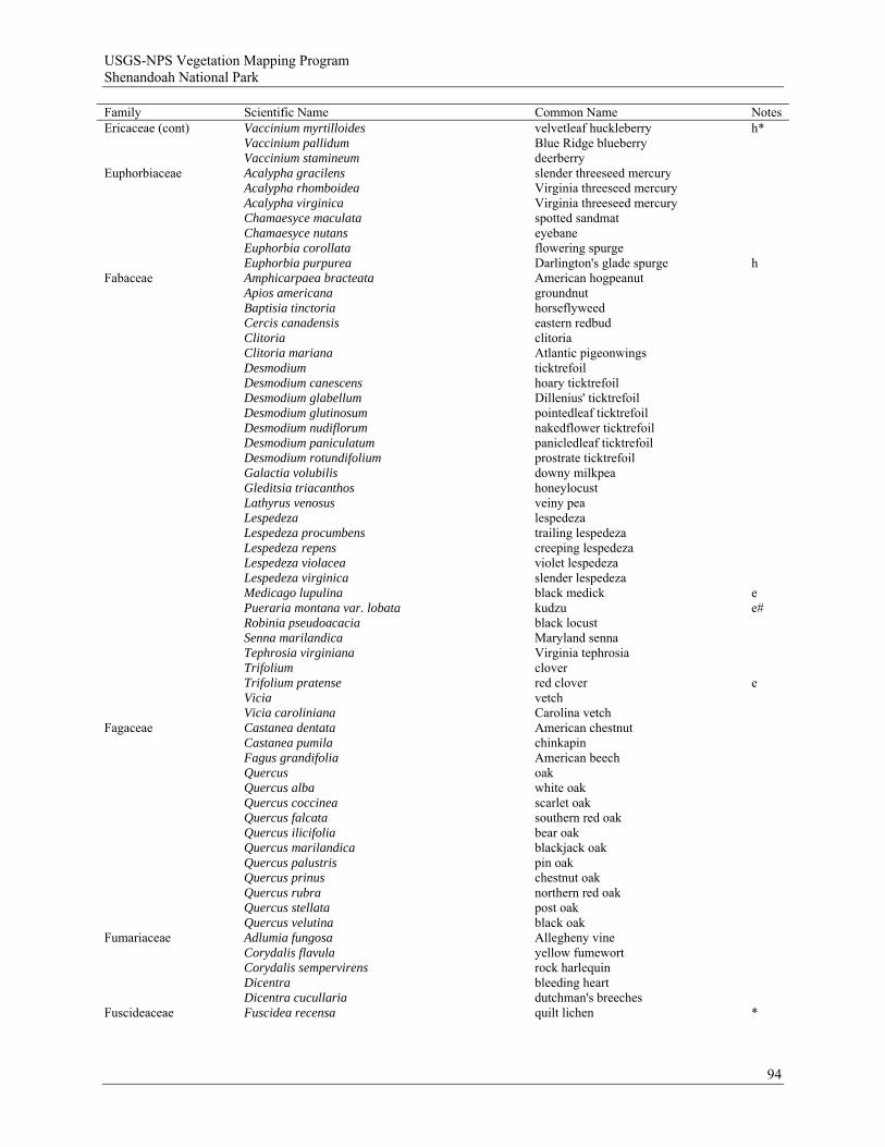
USGS-NPS Vegetation Mapping Program Shenandoah National Park
Family Scientific Name Common Name Notes Ericaceae (cont) Vaccinium myrtilloides velvetleaf huckleberry h* Vaccinium pallidum Blue Ridge blueberry Vaccinium stamineum deerberry Euphorbiaceae Acalypha gracilens slender threeseed mercury Acalypha rhomboidea Virginia threeseed mercury Acalypha virginica Virginia threeseed mercury Chamaesyce maculata spotted sandmat Chamaesyce nutans eyebane Euphorbia corollata flowering spurge Euphorbia purpurea Darlington's glade spurge h Fabaceae Amphicarpaea bracteata American hogpeanut Apios americana groundnut Baptisia tinctoria horseflyweed Cercis canadensis eastern redbud Clitoria clitoria Clitoria mariana Atlantic pigeonwings Desmodium ticktrefoil Desmodium canescens hoary ticktrefoil Desmodium glabellum Dillenius' ticktrefoil Desmodium glutinosum pointedleaf ticktrefoil Desmodium nudiflorum nakedflower ticktrefoil Desmodium paniculatum panicledleaf ticktrefoil Desmodium rotundifolium prostrate ticktrefoil Galactia volubilis downy milkpea Gleditsia triacanthos honeylocust Lathyrus venosus veiny pea Lespedeza lespedeza Lespedeza procumbens trailing lespedeza Lespedeza repens creeping lespedeza Lespedeza violacea violet lespedeza Lespedeza virginica slender lespedeza Medicago lupulina black medick e Pueraria montana var. lobata kudzu e# Robinia pseudoacacia black locust Senna marilandica Maryland senna Tephrosia virginiana Virginia tephrosia Trifolium clover Trifolium pratense red clover e Vicia vetch Vicia caroliniana Carolina vetch Fagaceae Castanea dentata American chestnut Castanea pumila chinkapin Fagus grandifolia American beech Quercus oak Quercus alba white oak Quercus coccinea scarlet oak Quercus falcata southern red oak Quercus ilicifolia bear oak Quercus marilandica blackjack oak Quercus palustris pin oak Quercus prinus chestnut oak Quercus rubra northern red oak Quercus stellata post oak Quercus velutina black oak Fumariaceae Adlumia fungosa Allegheny vine Corydalis flavula yellow fumewort Corydalis sempervirens rock harlequin Dicentra bleeding heart Dicentra cucullaria dutchman's breeches Fuscideaceae Fuscidea recensa quilt lichen *
94
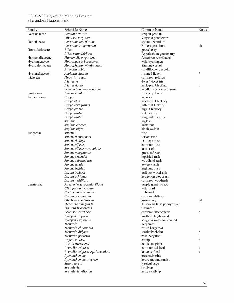
USGS-NPS Vegetation Mapping Program Shenandoah National Park
Family Scientific Name Common Name Notes Gentianaceae Gentiana villosa striped gentian Obolaria virginica Virginia pennywort Geraniaceae Geranium maculatum spotted geranium Geranium robertianum Robert geranium eh Grossulariaceae Ribes gooseberry Ribes rotundifolium Appalachian gooseberry Hamamelidaceae Hamamelis virginiana American witchhazel Hydrangeaceae Hydrangea arborescens wild hydrangea Hydrophyllaceae Hydrophyllum virginianum Shawnee salad Phacelia dubia smallflower phacelia Hymeneliaceae Aspicilia cinerea rimmed lichen * Iridaceae Hypoxis hirsuta common goldstar Iris verna dwarf violet iris Iris versicolor harlequin blueflag h Sisyrinchium mucronatum needletip blue-eyed grass Isoetaceae Isoetes valida strong quillwort Juglandaceae Carya hickory Carya alba mockernut hickory Carya cordiformis bitternut hickory Carya glabra pignut hickory Carya ovalis red hickory Carya ovata shagbark hickory Juglans juglans Juglans cinerea butternut Juglans nigra black walnut Juncaceae Juncus rush Juncus dichotomus forked rush Juncus dudleyi Dudley's rush Juncus effusus common rush Juncus effusus var. solutus lamp rush Juncus marginatus grassleaf rush Juncus secundus lopsided rush Juncus subcaudatus woodland rush Juncus tenuis poverty rush Juncus trifidus highland rush h Luzula bulbosa bulbous woodrush Luzula echinata hedgehog woodrush Luzula multiflora common woodrush Lamiaceae Agastache scrophulariifolia purple giant hyssop Clinopodium vulgare wild basil Collinsonia canadensis richweed Cunila origanoides common dittany Glechoma hederacea ground ivy e# Hedeoma pulegioides American false pennyroyal Isanthus brachiatus fluxweed Leonurus cardiaca common motherwort e Lycopus uniflorus northern bugleweed Lycopus virginicus Virginia water horehound Monarda bergamot Monarda clinopodia white bergamot Monarda didyma scarlet beebalm e Monarda fistulosa wild bergamot Nepeta cataria catnip e Perilla frutescens beefsteak plant Prunella vulgaris common selfheal e Prunella vulgaris ssp. lanceolata lance selfheal e Pycnanthemum mountainmint Pycnanthemum incanum hoary mountainmint Salvia lyrata lyreleaf sage Scutellaria skullcap Scutellaria elliptica hairy skullcap
95
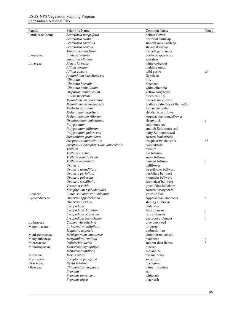
USGS-NPS Vegetation Mapping Program Shenandoah National Park
Family Scientific Name Common Name Notes Lamiaceae (cont) Scutellaria integrifolia helmet flower Scutellaria ovata heartleaf skullcap Scutellaria saxatilis smooth rock skullcap Scutellaria serrata showy skullcap Teucrium canadense Canada germander Lauraceae Lindera benzoin northern spicebush Sassafras albidum sassafras Liliaceae Aletris farinosa white colicroot Allium cernuum nodding onion Allium vineale wild garlic e# Amianthium muscitoxicum flypoison Clintonia lilly Clintonia borealis bluebead Clintonia umbellulata white clintonia Disporum lanuginosum yellow fairybells Lilium superbum turk's-cap lily Maianthemum canadense Canada mayflower Maianthemum racemosum feathery false lily of the valley Medeola virginiana Indian cucumber Melanthium latifolium slender bunchflower Melanthium parviflorum Appalachian bunchflower Ornithogalum umbellatum sleepydick e Polygonatum solomon's seal Polygonatum biflorum smooth Solomon's seal Polygonatum pubescens hairy Solomon's seal Stenanthium gramineum eastern featherbells Streptopus amplexifolius claspleaf twistedstalk h* Streptopus lanceolatus var. lanceolatus twistedstalk Trillium trillium Trillium erectum red trillium Trillium grandiflorum snow trillium Trillium undulatum painted trillium h Uvularia bellflower Uvularia grandiflora largeflower bellwort Uvularia perfoliata perfoliate bellwort Uvularia puberula mountain bellwort Uvularia sessilifolia sessileleaf bellwort Veratrum viride green false hellebore Xerophyllum asphodeloides eastern turkeybeard Linaceae Linum sulcatum var. sulcatum grooved flax Lycopodiaceae Huperzia appalachiana Appalachian clubmoss h Huperzia lucidula shining clubmoss Lycopodium clubmoss Lycopodium digitatum fan clubmoss h Lycopodium obscurum rare clubmoss h Lycopodium tristachyum deeproot clubmoss h Lythraceae Cuphea viscosissima blue waxweed Magnoliaceae Liriodendron tulipifera tuliptree Magnolia tripetala umbrella-tree Menispermaceae Menispermum canadense common moonseed Menyanthaceae Menyanthes trifoliata buckbean hMicareaceae Psilolechia lucida sulphur dust lichen * Monotropaceae Monotropa hypopithys pinesap Monotropa uniflora Indianpipe Moraceae Morus rubra red mulberry Myricaceae Comptonia peregrina sweet fern Nyssaceae Nyssa sylvatica blackgum Oleaceae Chionanthus virginicus white fringetree Fraxinus ash Fraxinus americana white ash Fraxinus nigra black ash
96
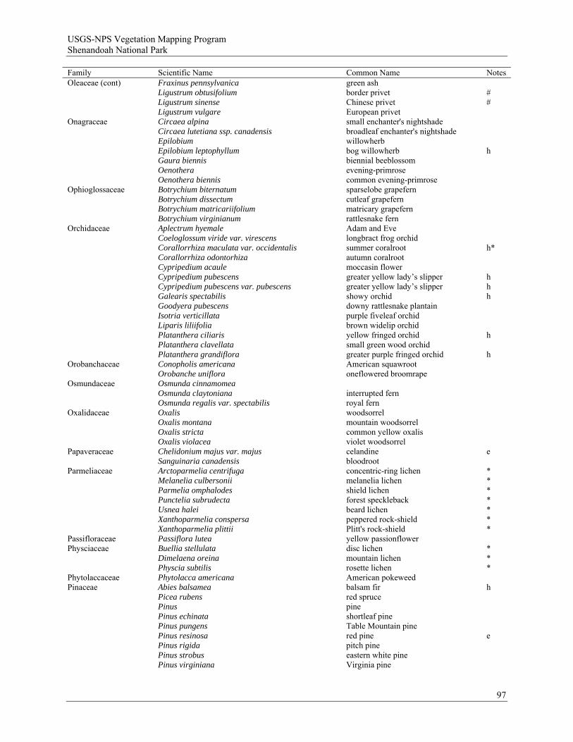
USGS-NPS Vegetation Mapping Program Shenandoah National Park
Family Scientific Name Common Name Notes Oleaceae (cont) Fraxinus pennsylvanica green ash Ligustrum obtusifolium border privet # Ligustrum sinense Chinese privet # Ligustrum vulgare European privet Onagraceae Circaea alpina small enchanter's nightshade Circaea lutetiana ssp. canadensis broadleaf enchanter's nightshade Epilobium willowherb Epilobium leptophyllum bog willowherb h Gaura biennis biennial beeblossom Oenothera evening-primrose Oenothera biennis common evening-primrose Ophioglossaceae Botrychium biternatum sparselobe grapefern Botrychium dissectum cutleaf grapefern Botrychium matricariifolium matricary grapefern Botrychium virginianum rattlesnake fern Orchidaceae Aplectrum hyemale Adam and Eve Coeloglossum viride var. virescens longbract frog orchid Corallorrhiza maculata var. occidentalis summer coralroot h* Corallorrhiza odontorhiza autumn coralroot Cypripedium acaule moccasin flower Cypripedium pubescens greater yellow lady’s slipper h Cypripedium pubescens var. pubescens greater yellow lady’s slipper h Galearis spectabilis showy orchid h Goodyera pubescens downy rattlesnake plantain Isotria verticillata purple fiveleaf orchid Liparis liliifolia brown widelip orchid Platanthera ciliaris yellow fringed orchid h Platanthera clavellata small green wood orchid Platanthera grandiflora greater purple fringed orchid h Orobanchaceae Conopholis americana American squawroot Orobanche uniflora oneflowered broomrape Osmundaceae Osmunda cinnamomea Osmunda claytoniana interrupted fern Osmunda regalis var. spectabilis royal fern Oxalidaceae Oxalis woodsorrel Oxalis montana mountain woodsorrel Oxalis stricta common yellow oxalis Oxalis violacea violet woodsorrel Papaveraceae Chelidonium majus var. majus celandine e Sanguinaria canadensis bloodroot Parmeliaceae
Arctoparmelia centrifuga Melanelia culbersonii
concentric-ring lichen melanelia lichen
* *
Parmelia omphalodes Punctelia subrudecta Usnea halei
shield lichen forest speckleback beard lichen
* * *
Xanthoparmelia conspersa Xanthoparmelia plittii
peppered rock-shield Plitt's rock-shield
* *
Passifloraceae Passiflora lutea yellow passionflower Physciaceae
Buellia stellulata Dimelaena oreina
disc lichen mountain lichen
* *
Physcia subtilis rosette lichen * Phytolaccaceae Phytolacca americana American pokeweed Pinaceae Abies balsamea balsam fir h Picea rubens red spruce Pinus pine Pinus echinata shortleaf pine Pinus pungens Table Mountain pine Pinus resinosa red pine e Pinus rigida pitch pine Pinus strobus eastern white pine Pinus virginiana Virginia pine
97
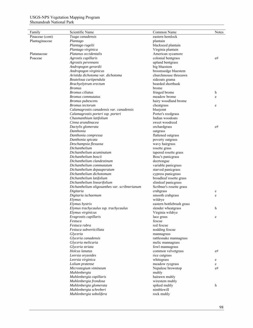
USGS-NPS Vegetation Mapping Program Shenandoah National Park
Family Scientific Name Common Name Notes Pinaceae (cont) Tsuga canadensis eastern hemlock Plantaginaceae Plantago plantain Plantago rugelii blackseed plantain Plantago virginica Virginia plantain Platanaceae Platanus occidentalis American sycamore Poaceae Agrostis capillaris colonial bentgrass e# Agrostis perennans upland bentgrass Andropogon gerardii big bluestem Andropogon virginicus broomsedge bluestem Aristida dichotoma var. dichotoma churchmouse threeawn Bouteloua curtipendula sideoats grama Brachyelytrum erectum bearded shorthusk Bromus brome Bromus ciliatus fringed brome h Bromus commutatus meadow brome e Bromus pubescens hairy woodland brome Bromus tectorum cheatgrass e Calamagrostis canadensis var. canadensis bluejoint Calamagrostis porteri ssp. porteri Porter's reedgrass Chasmanthium latifolium Indian woodoats Cinna arundinacea sweet woodreed Dactylis glomerata orchardgrass e# Danthonia oatgrass Danthonia compressa flattened oatgrass Danthonia spicata poverty oatgrass Deschampsia flexuosa wavy hairgrass Dichanthelium rosette grass Dichanthelium acuminatum tapered rosette grass Dichanthelium boscii Bosc's panicgrass Dichanthelium clandestinum deertongue Dichanthelium commutatum variable panicgrass Dichanthelium depauperatum starved panicgrass Dichanthelium dichotomum cypress panicgrass Dichanthelium latifolium broadleaf rosette grass Dichanthelium linearifolium slimleaf panicgrass Dichanthelium oligosanthes var. scribnerianum Scribner's rosette grass Digitaria crabgrass e Digitaria ischaemum smooth crabgrass e Elymus wildrye Elymus hystrix eastern bottlebrush grass Elymus trachycaulus ssp. trachycaulus slender wheatgrass h Elymus virginicus Virginia wildrye Eragrostis capillaris lace grass e Festuca fescue Festuca rubra red fescue Festuca subverticillata nodding fescue Glyceria mannagrass Glyceria canadensis rattlesnake mannagrass Glyceria melicaria melic mannagrass Glyceria striata fowl mannagrass Holcus lanatus common velvetgrass e# Leersia oryzoides rice cutgrass Leersia virginica whitegrass e Lolium pratense meadow ryegrass e Microstegium vimineum Nepalese browntop e# Muhlenbergia muhly Muhlenbergia capillaris hairawn muhly Muhlenbergia frondosa wirestem muhly Muhlenbergia glomerata spiked muhly h Muhlenbergia schreberi nimblewill Muhlenbergia sobolifera rock muhly
98
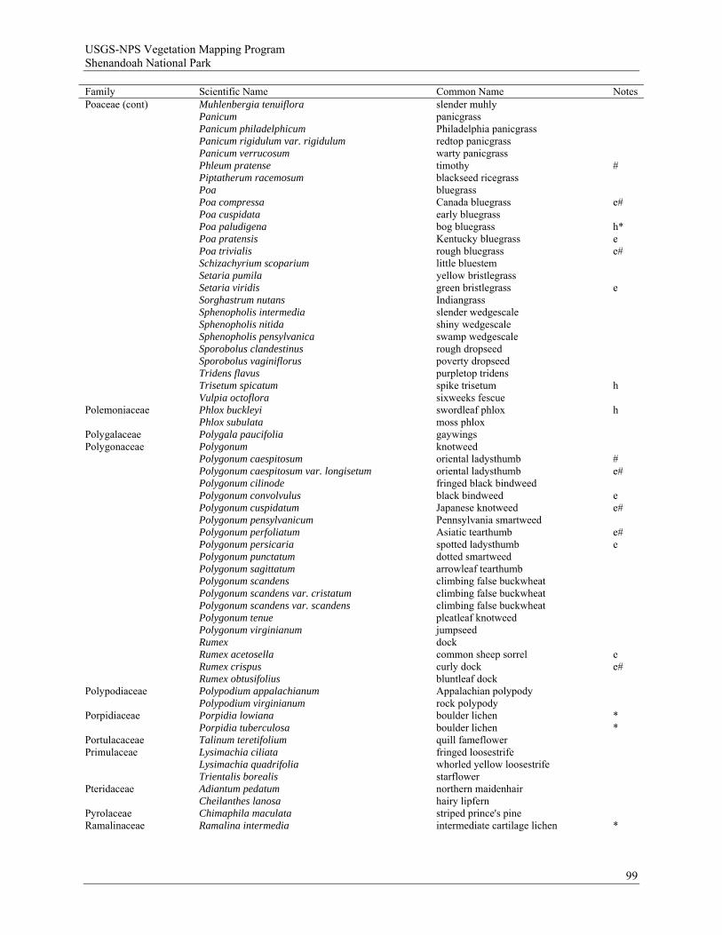
USGS-NPS Vegetation Mapping Program Shenandoah National Park
Family Scientific Name Common Name Notes Poaceae (cont) Muhlenbergia tenuiflora slender muhly Panicum panicgrass Panicum philadelphicum Philadelphia panicgrass Panicum rigidulum var. rigidulum redtop panicgrass Panicum verrucosum warty panicgrass Phleum pratense timothy # Piptatherum racemosum blackseed ricegrass Poa bluegrass Poa compressa Canada bluegrass e# Poa cuspidata early bluegrass Poa paludigena bog bluegrass h* Poa pratensis Kentucky bluegrass e Poa trivialis rough bluegrass e# Schizachyrium scoparium little bluestem Setaria pumila yellow bristlegrass Setaria viridis green bristlegrass e Sorghastrum nutans Indiangrass Sphenopholis intermedia slender wedgescale Sphenopholis nitida shiny wedgescale Sphenopholis pensylvanica swamp wedgescale Sporobolus clandestinus rough dropseed Sporobolus vaginiflorus poverty dropseed Tridens flavus purpletop tridens Trisetum spicatum spike trisetum h Vulpia octoflora sixweeks fescue Polemoniaceae Phlox buckleyi swordleaf phlox h Phlox subulata moss phlox Polygalaceae Polygala paucifolia gaywings Polygonaceae Polygonum knotweed Polygonum caespitosum oriental ladysthumb # Polygonum caespitosum var. longisetum oriental ladysthumb e# Polygonum cilinode fringed black bindweed Polygonum convolvulus black bindweed e Polygonum cuspidatum Japanese knotweed e# Polygonum pensylvanicum Pennsylvania smartweed Polygonum perfoliatum Asiatic tearthumb e# Polygonum persicaria spotted ladysthumb e Polygonum punctatum dotted smartweed Polygonum sagittatum arrowleaf tearthumb Polygonum scandens climbing false buckwheat Polygonum scandens var. cristatum climbing false buckwheat Polygonum scandens var. scandens climbing false buckwheat Polygonum tenue pleatleaf knotweed Polygonum virginianum jumpseed Rumex dock Rumex acetosella common sheep sorrel e Rumex crispus curly dock e# Rumex obtusifolius bluntleaf dock Polypodiaceae Polypodium appalachianum Appalachian polypody Polypodium virginianum rock polypody Porpidiaceae Porpidia lowiana boulder lichen * Porpidia tuberculosa boulder lichen * Portulacaceae Talinum teretifolium quill fameflower Primulaceae Lysimachia ciliata fringed loosestrife Lysimachia quadrifolia whorled yellow loosestrife Trientalis borealis starflower Pteridaceae Adiantum pedatum northern maidenhair Cheilanthes lanosa hairy lipfern Pyrolaceae Chimaphila maculata striped prince's pine Ramalinaceae Ramalina intermedia intermediate cartilage lichen *
99

USGS-NPS Vegetation Mapping Program Shenandoah National Park
Family Scientific Name Common Name Notes Ranunculaceae Aconitum reclinatum trailing white monkshood Actaea pachypoda white baneberry Anemone anemone Anemone lancifolia mountain thimbleweed Anemone quinquefolia var. quinquefolia nightcaps Anemone virginiana tall thimbleweed Aquilegia canadensis red columbine Caltha palustris yellow marsh marigold Cimicifuga bugbane Cimicifuga racemosa black bugbane h Clematis clematis Clematis occidentalis western blue virginsbower h Clematis viorna vasevine Clematis virginiana devil's darning needles Hepatica nobilis hepatica Hepatica nobilis var. obtusa roundlobe hepatica Ranunculus buttercup Ranunculus abortivus littleleaf buttercup Ranunculus allegheniensis Allegheny Mountain buttercup Ranunculus hispidus var. caricetorum bristly buttercup Ranunculus hispidus var. hispidus bristly buttercup Ranunculus recurvatus blisterwort Thalictrum meadow-rue Thalictrum coriaceum maid of the mist Thalictrum dioicum early meadow-rue Thalictrum pubescens king of the meadow Thalictrum revolutum waxyleaf meadow-rue Thalictrum thalictroides rue anemone Trautvetteria caroliniensis Carolina bugbane Rhamnaceae Ceanothus americanus New Jersey tea Rhamnus alnifolia alderleaf buckthorn h* Rosaceae Agrimonia agrimony Agrimonia gryposepala tall hairy agrimony Agrimonia pubescens soft agrimony Agrimonia rostellata beaked agrimony Amelanchier serviceberry Amelanchier arborea common serviceberry Amelanchier laevis Allegheny serviceberry Amelanchier sanguinea roundleaf serviceberry Crataegus hawthorn Crataegus chrysocarpa fireberry hawthorn Crataegus crus-galli cockspur hawthorn Crataegus flabellata fanleaf hawthorn Crataegus intricata Copenhagen hawthorn Crataegus uniflora dwarf hawthorn Fragaria strawberry Fragaria virginiana Virginia strawberry Geum avens Geum canadense white avens Geum virginianum cream avens Malus apple Malus coronaria sweet crabapple Photinia chokeberry Photinia melanocarpa black chokeberry Photinia pyrifolia red chokeberry Physocarpus opulifolius common ninebark Porteranthus trifoliatus Bowman's root Potentilla cinquefoil Potentilla canadensis dwarf cinquefoil Potentilla simplex common cinquefoil Prunus prunus
100
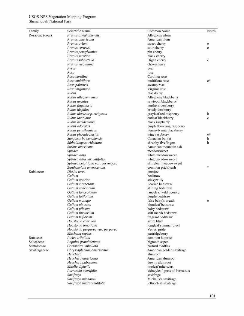
USGS-NPS Vegetation Mapping Program Shenandoah National Park
Family Scientific Name Common Name Notes Rosaceae (cont) Prunus alleghaniensis Allegheny plum Prunus americana American plum Prunus avium sweet cherry e Prunus cerasus sour cherry e Prunus pensylvanica pin cherry Prunus serotina black cherry Prunus subhirtella Higan cherry e Prunus virginiana chokecherry Pyrus pear Rosa rose Rosa carolina Carolina rose Rosa multiflora multiflora rose e# Rosa palustris swamp rose Rosa virginiana Virginia rose Rubus blackberry Rubus allegheniensis Allegheny blackberry Rubus argutus sawtooth blackberry Rubus flagellaris northern dewberry Rubus hispidus bristly dewberry Rubus idaeus ssp. strigosus grayleaf red raspberry h Rubus laciniatus cutleaf blackberry e Rubus occidentalis black raspberry Rubus odoratus purpleflowering raspberry Rubus pensilvanicus Pennsylvania blackberry Rubus phoenicolasius wine raspberry e# Sanguisorba canadensis Canadian burnet h Sibbaldiopsis tridentata shrubby fivefingers h Sorbus americana American mountain ash Spiraea meadowsweet Spiraea alba white meadowsweet Spiraea alba var. latifolia white meadowsweet
Spiraea betulifolia var. corymbosa Zanthoxylum americanum
shinyleaf meadowsweet common pricklyash
*
Rubiaceae Diodia teres poorjoe Galium bedstraw Galium aparine stickywilly Galium circaezans licorice bedstraw Galium concinnum shining bedstraw Galium lanceolatum lanceleaf wild licorice Galium latifolium purple bedstraw Galium mollugo false baby’s breath e Galium obtusum bluntleaf bedstraw Galium pilosum hairy bedstraw Galium tinctorium stiff marsh bedstraw Galium triflorum fragrant bedstraw Houstonia caerulea azure bluet Houstonia longifolia longleaf summer bluet Houstonia purpurea var. purpurea Venus' pride Mitchella repens partridgeberry Rutaceae Ptelea trifoliata common hoptree Salicaceae Populus grandidentata bigtooth aspen Santalaceae Comandra umbellata bastard toadflax Saxifragaceae Chrysosplenium americanum American golden saxifrage Heuchera alumroot Heuchera americana American alumroot Heuchera pubescens downy alumroot Mitella diphylla twoleaf miterwort Parnassia asarifolia kidneyleaf grass of Parnassus Saxifraga saxifrage Saxifraga michauxii Michaux's saxifrage Saxifraga micranthidifolia lettuceleaf saxifrage
101
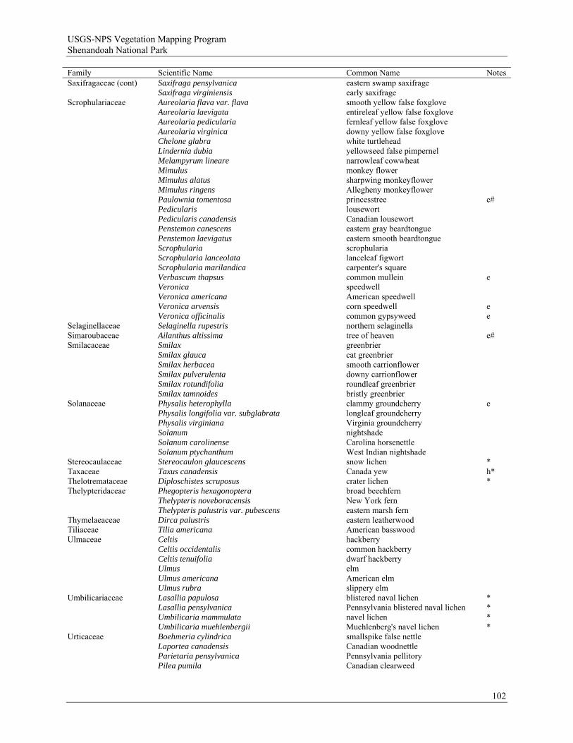
USGS-NPS Vegetation Mapping Program Shenandoah National Park
Family Scientific Name Common Name Notes Saxifragaceae (cont) Saxifraga pensylvanica eastern swamp saxifrage Saxifraga virginiensis early saxifrage Scrophulariaceae Aureolaria flava var. flava smooth yellow false foxglove Aureolaria laevigata entireleaf yellow false foxglove Aureolaria pedicularia fernleaf yellow false foxglove Aureolaria virginica downy yellow false foxglove Chelone glabra white turtlehead Lindernia dubia yellowseed false pimpernel Melampyrum lineare narrowleaf cowwheat Mimulus monkey flower Mimulus alatus sharpwing monkeyflower Mimulus ringens Allegheny monkeyflower Paulownia tomentosa princesstree e# Pedicularis lousewort Pedicularis canadensis Canadian lousewort Penstemon canescens eastern gray beardtongue Penstemon laevigatus eastern smooth beardtongue Scrophularia scrophularia Scrophularia lanceolata lanceleaf figwort Scrophularia marilandica carpenter's square Verbascum thapsus common mullein e Veronica speedwell Veronica americana American speedwell Veronica arvensis corn speedwell e Veronica officinalis common gypsyweed e Selaginellaceae Selaginella rupestris northern selaginella Simaroubaceae Ailanthus altissima tree of heaven e# Smilacaceae Smilax greenbrier Smilax glauca cat greenbrier Smilax herbacea smooth carrionflower Smilax pulverulenta downy carrionflower Smilax rotundifolia roundleaf greenbrier Smilax tamnoides bristly greenbrier Solanaceae Physalis heterophylla clammy groundcherry e Physalis longifolia var. subglabrata longleaf groundcherry Physalis virginiana Virginia groundcherry Solanum nightshade Solanum carolinense Carolina horsenettle Solanum ptychanthum West Indian nightshade Stereocaulaceae Stereocaulon glaucescens snow lichen * Taxaceae Taxus canadensis Canada yew h* Thelotremataceae Diploschistes scruposus crater lichen * Thelypteridaceae Phegopteris hexagonoptera broad beechfern Thelypteris noveboracensis New York fern Thelypteris palustris var. pubescens eastern marsh fern Thymelaeaceae Dirca palustris eastern leatherwood Tiliaceae Tilia americana American basswood Ulmaceae Celtis hackberry Celtis occidentalis common hackberry Celtis tenuifolia dwarf hackberry Ulmus elm Ulmus americana American elm Ulmus rubra slippery elm Umbilicariaceae
Lasallia papulosa Lasallia pensylvanica Umbilicaria mammulata
blistered naval lichen Pennsylvania blistered naval lichen navel lichen
* * *
Umbilicaria muehlenbergii Muehlenberg's navel lichen * Urticaceae Boehmeria cylindrica smallspike false nettle Laportea canadensis Canadian woodnettle Parietaria pensylvanica Pennsylvania pellitory Pilea pumila Canadian clearweed
102
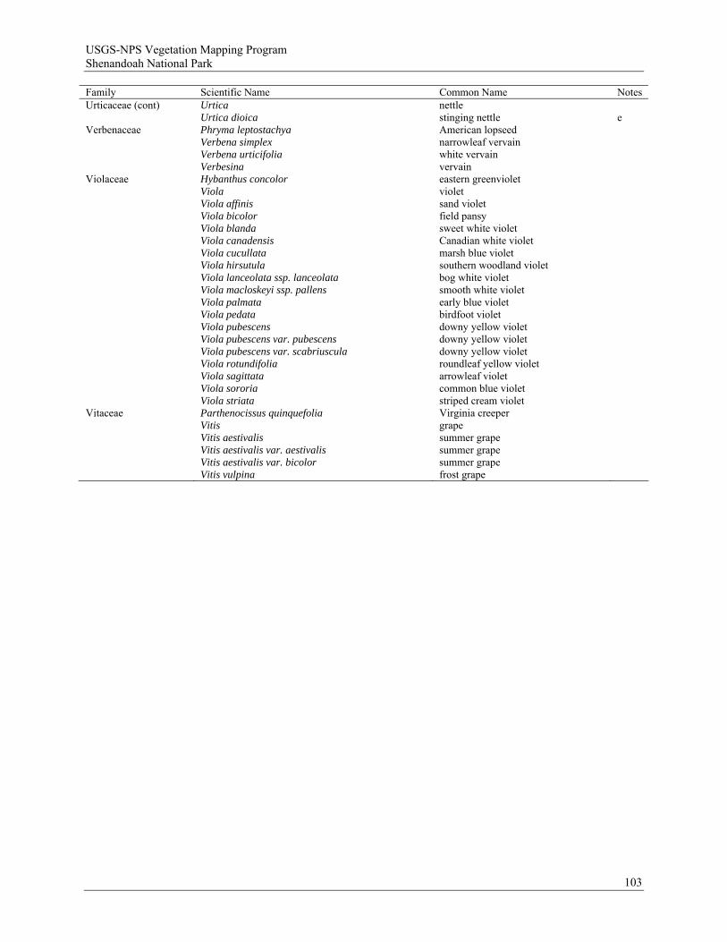
USGS-NPS Vegetation Mapping Program Shenandoah National Park
103
Family Scientific Name Common Name Notes Urticaceae (cont) Urtica nettle Urtica dioica stinging nettle e Verbenaceae Phryma leptostachya American lopseed Verbena simplex narrowleaf vervain Verbena urticifolia white vervain Verbesina vervain Violaceae Hybanthus concolor eastern greenviolet Viola violet Viola affinis sand violet Viola bicolor field pansy Viola blanda sweet white violet Viola canadensis Canadian white violet Viola cucullata marsh blue violet Viola hirsutula southern woodland violet Viola lanceolata ssp. lanceolata bog white violet Viola macloskeyi ssp. pallens smooth white violet Viola palmata early blue violet Viola pedata birdfoot violet Viola pubescens downy yellow violet Viola pubescens var. pubescens downy yellow violet Viola pubescens var. scabriuscula downy yellow violet Viola rotundifolia roundleaf yellow violet Viola sagittata arrowleaf violet Viola sororia common blue violet Viola striata striped cream violet Vitaceae Parthenocissus quinquefolia Virginia creeper Vitis grape Vitis aestivalis summer grape Vitis aestivalis var. aestivalis summer grape Vitis aestivalis var. bicolor summer grape Vitis vulpina frost grape

USGS-NPS Vegetation Mapping Program Shenandoah National Park
Appendix B. Cluster dendrograms and ordination diagrams supporting the classification of ecological communities at Shenandoah National Park. Cluster dendrograms and ordination diagrams illustrating the classification of major groups and smaller subgroups of Shenandoah National Park plot data are shown on the following pages. The cluster dendrogram of each group or subgroup is followed by one or more ordination diagrams of the same unit on the next page. See section 2.4.2 for elaboration of protocols used in clustering the major groups. Protocols used for each subgroup are included in the title of the dendrogram. Refer to section 2.4.6 for discussion of ordination methodologies employed in this project.
104
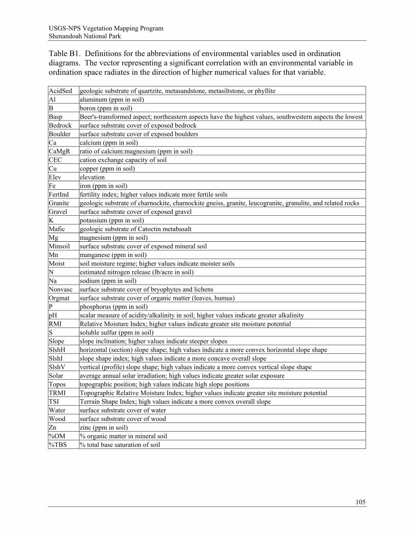
USGS-NPS Vegetation Mapping Program Shenandoah National Park
Table B1. Definitions for the abbreviations of environmental variables used in ordination diagrams. The vector representing a significant correlation with an environmental variable in ordination space radiates in the direction of higher numerical values for that variable. AcidSed geologic substrate of quartzite, metasandstone, metasiltstone, or phyllite Al aluminum (ppm in soil) B boron (ppm in soil) Basp Beer's-transformed aspect; northeastern aspects have the highest values, southwestern aspects the lowestBedrock surface substrate cover of exposed bedrock Boulder surface substrate cover of exposed boulders Ca calcium (ppm in soil) CaMgR ratio of calcium:magnesium (ppm in soil) CEC cation exchange capacity of soil Cu copper (ppm in soil) Elev elevation Fe iron (ppm in soil) FertInd fertility index; higher values indicate more fertile soils Granite geologic substrate of charnockite, charnockite gneiss, granite, leucogranite, granulite, and related rocks Gravel surface substrate cover of exposed gravel K potassium (ppm in soil) Mafic geologic substrate of Catoctin metabasalt Mg magnesium (ppm in soil) Minsoil surface substrate cover of exposed mineral soil Mn manganese (ppm in soil) Moist soil moisture regime; higher values indicate moister soils N estimated nitrogen release (lb/acre in soil) Na sodium (ppm in soil) Nonvasc surface substrate cover of bryophytes and lichens Orgmat surface substrate cover of organic matter (leaves, humus) P phosphorus (ppm in soil) pH scalar measure of acidity/alkalinity in soil; higher values indicate greater alkalinity RMI Relative Moisture Index; higher values indicate greater site moisture potential S soluble sulfur (ppm in soil) Slope slope inclination; higher values indicate steeper slopes SlshH horizontal (section) slope shape; high values indicate a more convex horizontal slope shape SlshI slope shape index; high values indicate a more concave overall slope SlshV vertical (profile) slope shape; high values indicate a more convex vertical slope shape Solar average annual solar irradiation; high values indicate greater solar exposure Topos topographic position; high values indicate high slope positions TRMI Topographic Relative Moisture Index; higher values indicate greater site moisture potential TSI Terrain Shape Index; high values indicate a more convex overall slope Water surface substrate cover of water Wood surface substrate cover of wood Zn zinc (ppm in soil) %OM % organic matter in mineral soil %TBS % total base saturation of soil
105

USGS-NPS Vegetation Mapping Program Shenandoah National Park
106
Information Remaining (%)0 25 50 75 100
SHNP001SHNP633SHNP648SHNP501SHNP504SHNP502SHNP575SHNP569SHNP562SHNP597SHNP598SHNP595SHNP673SHNP579SHNP582SHNP584SHNP095SHNP651SHNP006SHNP547SHNP566SHNP570SHNP507SHNP671SHNP560SHNP561SHNP503SHNP539SHNP552SHNP565SHNP583SHNP567SHNP170SHNP174SHNP589SHNP594SHNP658SHNP550SHNP571SHNP555SHNP614SHNP657SHNP667SHNP083SHNP091SHNP679SHNP508SHNP649SHNP084SHNP646SHNP672SHNP089SHNP599SHNP677SHNP564SHNP581SHNP675SHNP537SHNP538SHNP611SHNP635SHNP674SHNP676SHNP540SHNP551SHNP131SHNP161SHNP171SHNP634SHNP670SHNP519SHNP544SHNP546SHNP563SHNP163SHNP173SHNP601SHNP165SHNP167SHNP169SHNP162SHNP164SHNP168SHNP172SHNP166SHNP655SHNP664SHNP665SHNP669SHNP678SHNP656SHNP668SHNP545SHNP556SHNP647SHNP541SHNP542SHNP580SHNP596SHNP558
SHNP666SHNP052SHNP585SHNP132SHNP553SHNP554SHNP528SHNP533
SHNP048
SHNP559
SHNP549SHNP534SHNP028SHNP088SHNP079SHNP087SHNP548SHNP663SHNP661SHNP129SHNP605SHNP111SHNP516SHNP518SHNP077SHNP650SHNP659SHNP619SHNP004SHNP044SHNP054SHNP514SHNP577SHNP654SHNP027SHNP050SHNP045SHNP040SHNP041SHNP042SHNP051SHNP014SHNP031SHNP020SHNP026SHNP016SHNP097SHNP099SHNP523SHNP574SHNP652SHNP526SHNP631SHNP590SHNP557SHNP593SHNP644SHNP576SHNP630SHNP572SHNP640SHNP587SHNP626SHNP047SHNP130SHNP125SHNP096SHNP124SHNP127SHNP126SHNP128SHNP081SHNP092SHNP101SHNP102SHNP103SHNP085SHNP086SHNP094SHNP133SHNP093SHNP591SHNP613SHNP098SHNP509SHNP002SHNP104SHNP108SHNP109SHNP105SHNP106SHNP107SHNP115SHNP118SHNP568SHNP110SHNP113SHNP114SHNP120SHNP121SHNP123SHNP122SHNP116SHNP517SHNP522SHNP119SHNP543SHNP022SHNP036
SHNP606SHNP046SHNP531SHNP621SHNP602SHNP603SHNP604SHNP029SHNP608SHNP660SHNP030
Group 1: Acidic Forests
Group 2: Basic Forests
Group 3: High-Elevation Forests
SHNP532
Figure B1. Cluster dendrogram showing the major group membership of 221 upland forest plots from Shenandoah National Park.
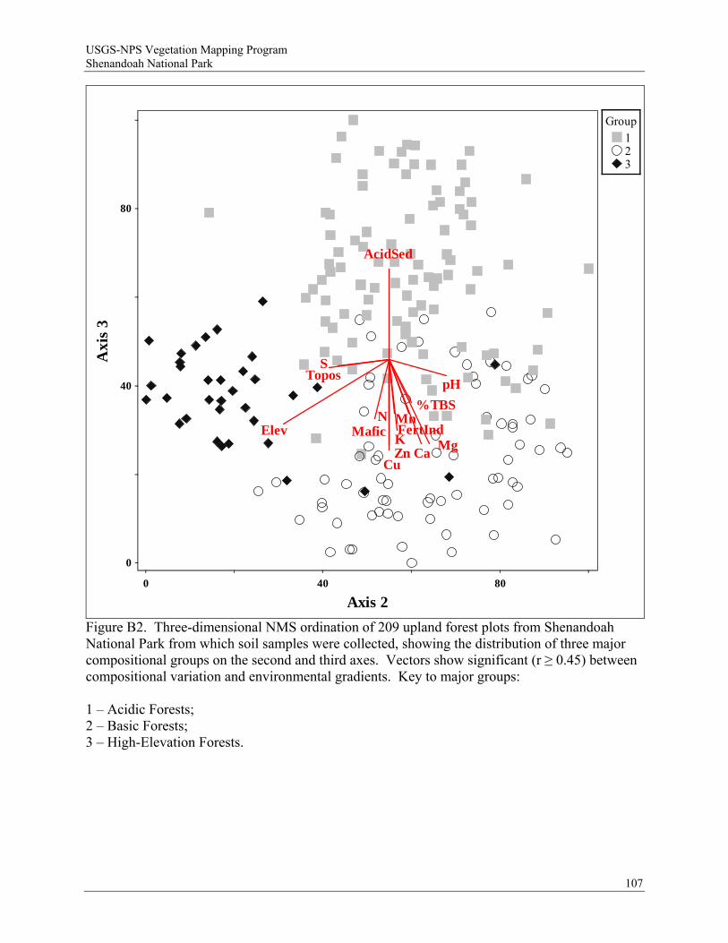
USGS-NPS Vegetation Mapping Program Shenandoah National Park
107
Topos
Elev Mafic
AcidSed
pH
CaMg
Mn
S
KZn
Cu
N%TBS
FertInd
0
0
40 80
40
80
Axis 2
Axi
s 3
Group123
Figure B2. Three-dimensional NMS ordination of 209 upland forest plots from Shenandoah National Park from which soil samples were collected, showing the distribution of three major compositional groups on the second and third axes. Vectors show significant (r ≥ 0.45) between compositional variation and environmental gradients. Key to major groups: 1 – Acidic Forests; 2 – Basic Forests; 3 – High-Elevation Forests.

USGS-NPS Vegetation Mapping Program Shenandoah National Park
108
Information Remaining (%)0 25 50 75 100
SHNP003SHNP008SHNP007SHNP152SHNP153SHNP023SHNP144SHNP032SHNP033SHNP037SHNP049SHNP013SHNP145SHNP021SHNP112SHNP019SHNP138SHNP075SHNP015SHNP024SHNP035SHNP147SHNP141SHNP142SHNP039SHNP134SHNP135SHNP136SHNP139SHNP137SHNP140SHNP662SHNP005SHNP156SHNP043SHNP063SHNP058SHNP053SHNP143SHNP066SHNP154SHNP155SHNP009SHNP100SHNP070SHNP072SHNP069SHNP055SHNP056SHNP159SHNP057SHNP060SHNP059SHNP061SHNP062SHNP064SHNP065SHNP071SHNP080SHNP148SHNP067SHNP149SHNP068SHNP076SHNP073SHNP074SHNP160SHNP025SHNP157SHNP158SHNP038SHNP151SHNP146SHNP150SHNP578
0797822201948035093722488673157
SHNP01SHNP11SHNP60SHNP01SHNP01SHNP08SHNP63SHNP61SHNP09SHNP01SHNP63SHNP03SHNP07SHNP62SHNP62SHNP62SHNP60SHNP62SHNP65SHNP61SHNP62SHNP01SHNP62SHNP63SHNP61SHNP63SHNP63SHNP57SHNP52SHNP52SHNP62SHNP615SHNP536SHNP628SHNP592SHNP616SHNP643SHNP645SHNP641SHNP642SHNP610
Group 1: Rock Outcrops
Group 2: Alluvial and Non-Alluvial Wetlands
Figure B3. Cluster dendrogram showing the major group membership of 116 rock outcrop and wetland plots from Shenandoah National Park.
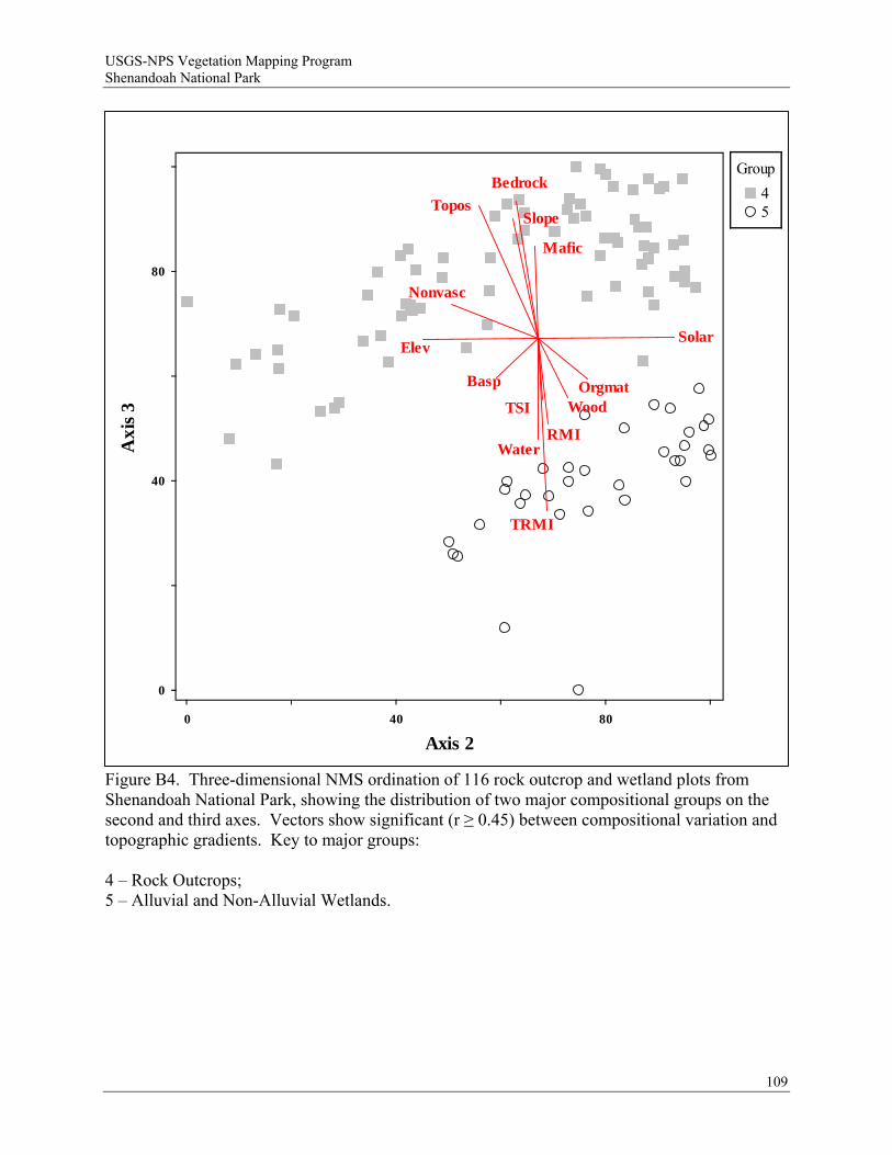
USGS-NPS Vegetation Mapping Program Shenandoah National Park
109
Figure B4. Three-dimensional NMS ordination of 116 rock outcrop and wetland plots from Shenandoah National Park, showing the distribution of two major compositional groups on the second and third axes. Vectors show significant (r ≥ 0.45) between compositional variation and topographic gradients. Key to major groups: 4 – Rock Outcrops; 5 – Alluvial and Non-Alluvial Wetlands.
Slope
Basp
Topos
SolarElev
TSI
TRMI
RMI
Bedrock
OrgmatWood
Water
Nonvasc
Mafic
0
0
40 80
40
80
Axis 2
Axi
s 3
Group
45
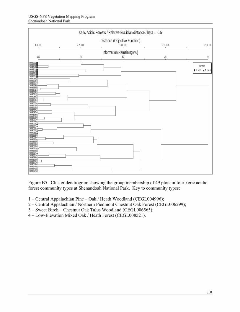
USGS-NPS Vegetation Mapping Program Shenandoah National Park
Xeric Acidic Forests / Relative Euclidian distance / beta = -0.5
Distance (Objective Function)
Information Remaining (%)
1.3E-01
100
7.2E+00
75
1.4E+01
50
2.1E+01
25
2.8E+01
0
SHNP001SHNP633SHNP648SHNP501SHNP504SHNP095SHNP651SHNP083SHNP508SHNP091SHNP679SHNP595SHNP673SHNP084SHNP581SHNP089SHNP646SHNP672SHNP502SHNP575SHNP569SHNP562SHNP597SHNP598SHNP579SHNP582SHNP584SHNP006SHNP547SHNP566SHNP570SHNP052SHNP503SHNP539SHNP552SHNP565SHNP583SHNP560SHNP561SHNP563SHNP507SHNP671SHNP596SHNP599SHNP677SHNP519SHNP544SHNP546SHNP567
Comtype
1 2 3 4
Figure B5. Cluster dendrogram showing the group membership of 49 plots in four xeric acidic forest community types at Shenandoah National Park. Key to community types: 1 – Central Appalachian Pine – Oak / Heath Woodland (CEGL004996); 2 – Central Appalachian / Northern Piedmont Chestnut Oak Forest (CEGL006299); 3 – Sweet Birch – Chestnut Oak Talus Woodland (CEGL006565); 4 – Low-Elevation Mixed Oak / Heath Forest (CEGL008521).
110
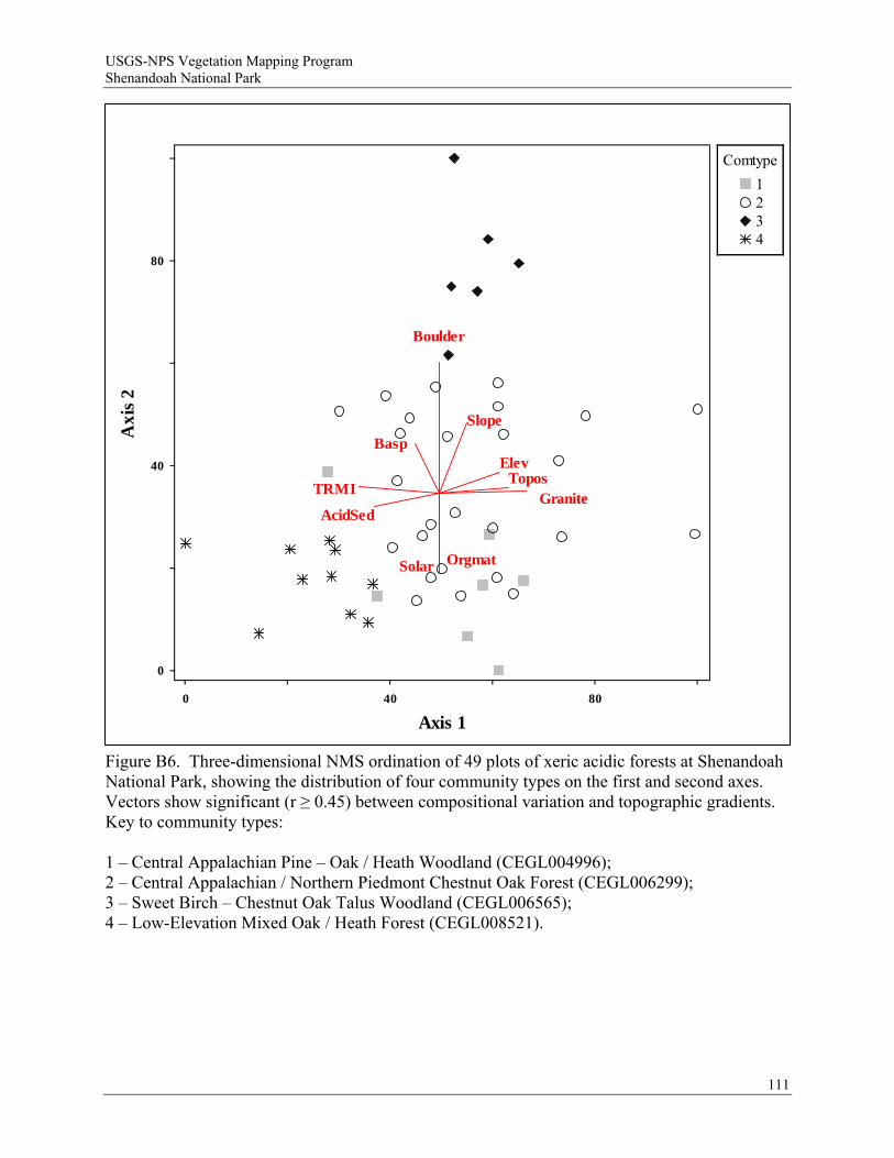
USGS-NPS Vegetation Mapping Program Shenandoah National Park
111
Slope
Basp
Topos
Solar
Elev
TRMI
Boulder
Orgmat
GraniteAcidSed
0
0
40 80
40
80
Axis 1
Axi
s 2
Comtype
1234
Figure B6. Three-dimensional NMS ordination of 49 plots of xeric acidic forests at Shenandoah National Park, showing the distribution of four community types on the first and second axes. Vectors show significant (r ≥ 0.45) between compositional variation and topographic gradients. Key to community types: 1 – Central Appalachian Pine – Oak / Heath Woodland (CEGL004996); 2 – Central Appalachian / Northern Piedmont Chestnut Oak Forest (CEGL006299); 3 – Sweet Birch – Chestnut Oak Talus Woodland (CEGL006565); 4 – Low-Elevation Mixed Oak / Heath Forest (CEGL008521).
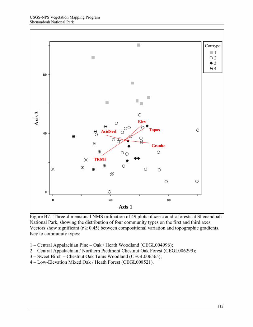
USGS-NPS Vegetation Mapping Program Shenandoah National Park
112
Topos
Elev
TRMI
Granite
AcidSed
0
0
40 80
40
80
Axis 1
Axi
s 3
Comtype
1234
Figure B7. Three-dimensional NMS ordination of 49 plots of xeric acidic forests at Shenandoah National Park, showing the distribution of four community types on the first and third axes. Vectors show significant (r ≥ 0.45) between compositional variation and topographic gradients. Key to community types: 1 – Central Appalachian Pine – Oak / Heath Woodland (CEGL004996); 2 – Central Appalachian / Northern Piedmont Chestnut Oak Forest (CEGL006299); 3 – Sweet Birch – Chestnut Oak Talus Woodland (CEGL006565); 4 – Low-Elevation Mixed Oak / Heath Forest (CEGL008521).
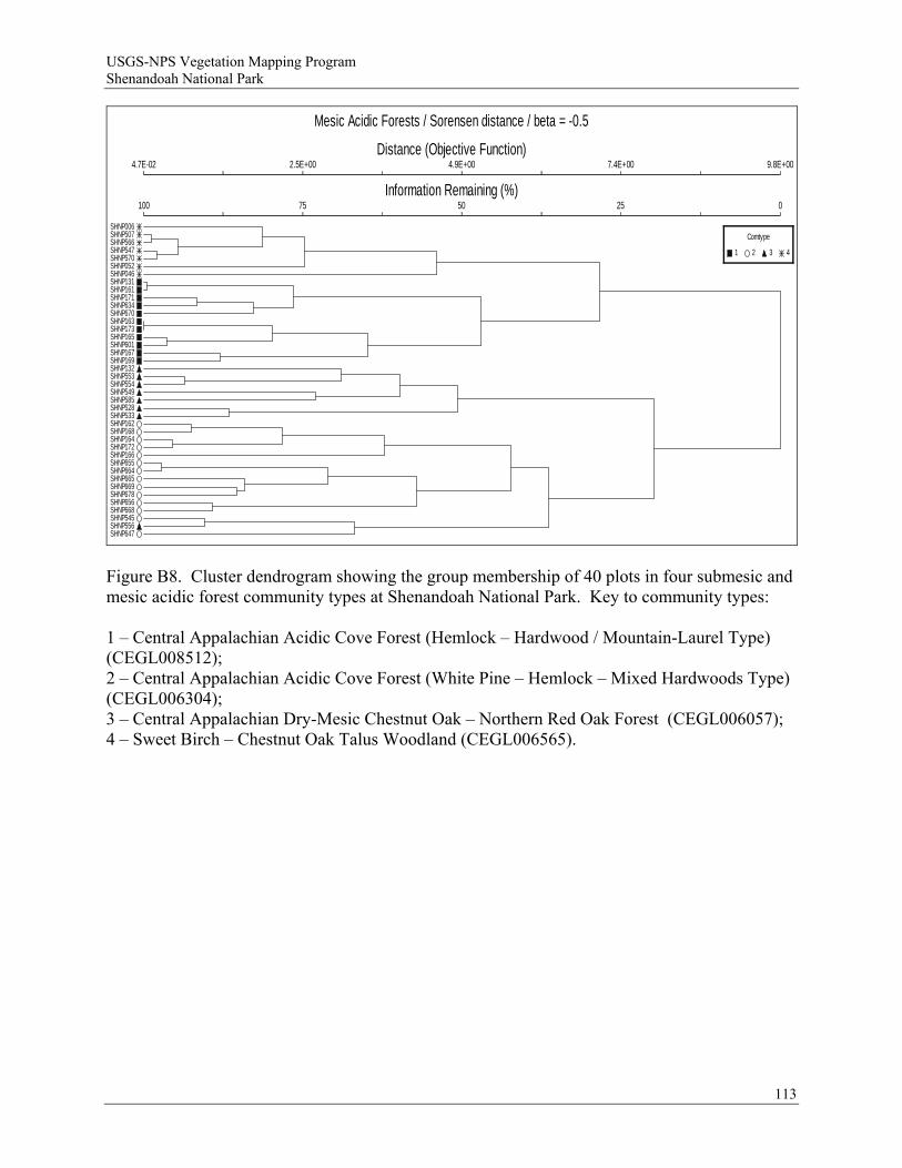
USGS-NPS Vegetation Mapping Program Shenandoah National Park
Mesic Acidic Forests / Sorensen distance / beta = -0.5
Distance (Objective Function)
Information Remaining (%)
4.7E-02
100
2.5E+00
75
4.9E+00
50
7.4E+00
25
9.8E+00
0
SHNP006SHNP507SHNP566SHNP547SHNP570SHNP052SHNP046SHNP131SHNP161SHNP171SHNP634SHNP670SHNP163SHNP173SHNP165SHNP601SHNP167SHNP169SHNP132SHNP553SHNP554SHNP549SHNP585SHNP528SHNP533SHNP162SHNP168SHNP164SHNP172SHNP166SHNP655SHNP664SHNP665SHNP669SHNP678SHNP656SHNP668SHNP545SHNP556SHNP647
Comtype
1 2 3 4
Figure B8. Cluster dendrogram showing the group membership of 40 plots in four submesic and mesic acidic forest community types at Shenandoah National Park. Key to community types: 1 – Central Appalachian Acidic Cove Forest (Hemlock – Hardwood / Mountain-Laurel Type) (CEGL008512); 2 – Central Appalachian Acidic Cove Forest (White Pine – Hemlock – Mixed Hardwoods Type) (CEGL006304); 3 – Central Appalachian Dry-Mesic Chestnut Oak – Northern Red Oak Forest (CEGL006057); 4 – Sweet Birch – Chestnut Oak Talus Woodland (CEGL006565).
113
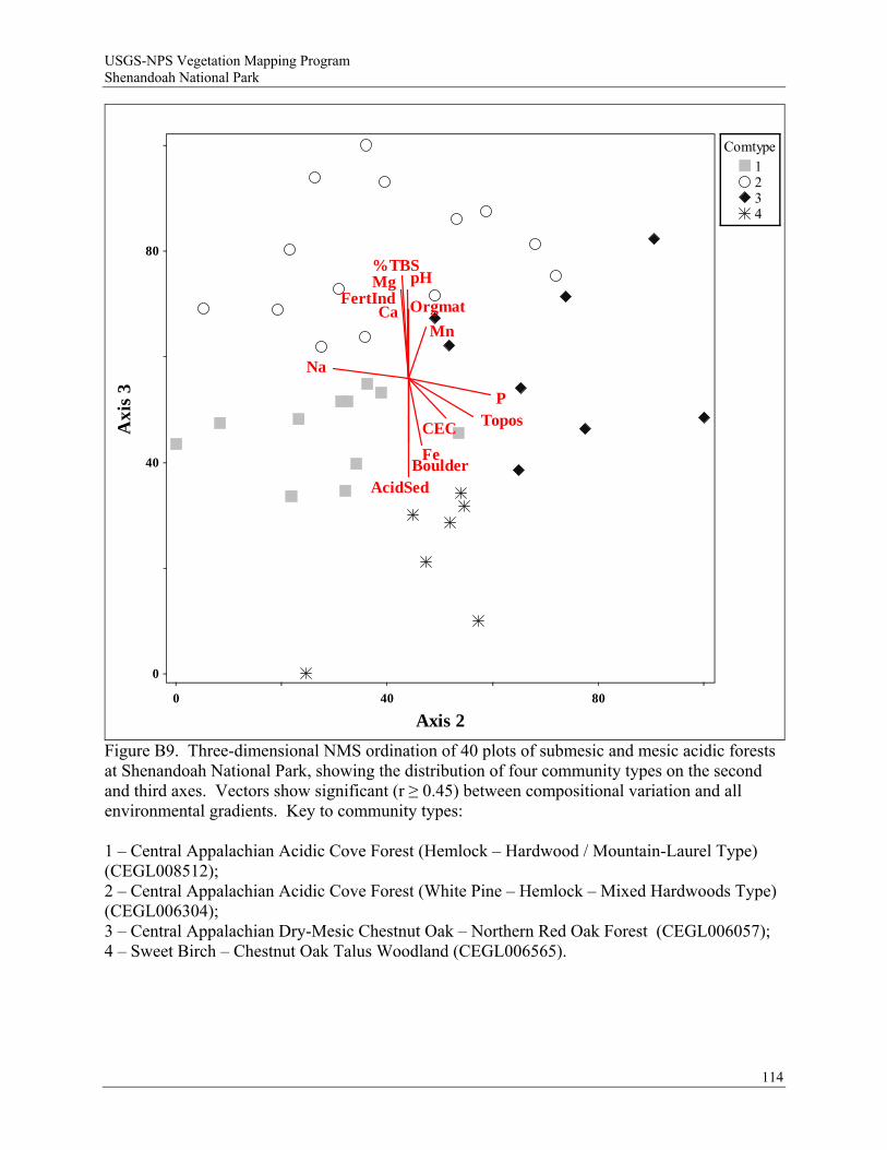
USGS-NPS Vegetation Mapping Program Shenandoah National Park
114
Topos
Boulder
Orgmat
AcidSed
pH
Ca
Mg
Fe
Mn
P
Na
%TBS
CEC
FertInd
0
0
40 80
40
80
Axis 2
Axi
s 3
Comtype1234
Figure B9. Three-dimensional NMS ordination of 40 plots of submesic and mesic acidic forests at Shenandoah National Park, showing the distribution of four community types on the second and third axes. Vectors show significant (r ≥ 0.45) between compositional variation and all environmental gradients. Key to community types: 1 – Central Appalachian Acidic Cove Forest (Hemlock – Hardwood / Mountain-Laurel Type) (CEGL008512); 2 – Central Appalachian Acidic Cove Forest (White Pine – Hemlock – Mixed Hardwoods Type) (CEGL006304); 3 – Central Appalachian Dry-Mesic Chestnut Oak – Northern Red Oak Forest (CEGL006057); 4 – Sweet Birch – Chestnut Oak Talus Woodland (CEGL006565).
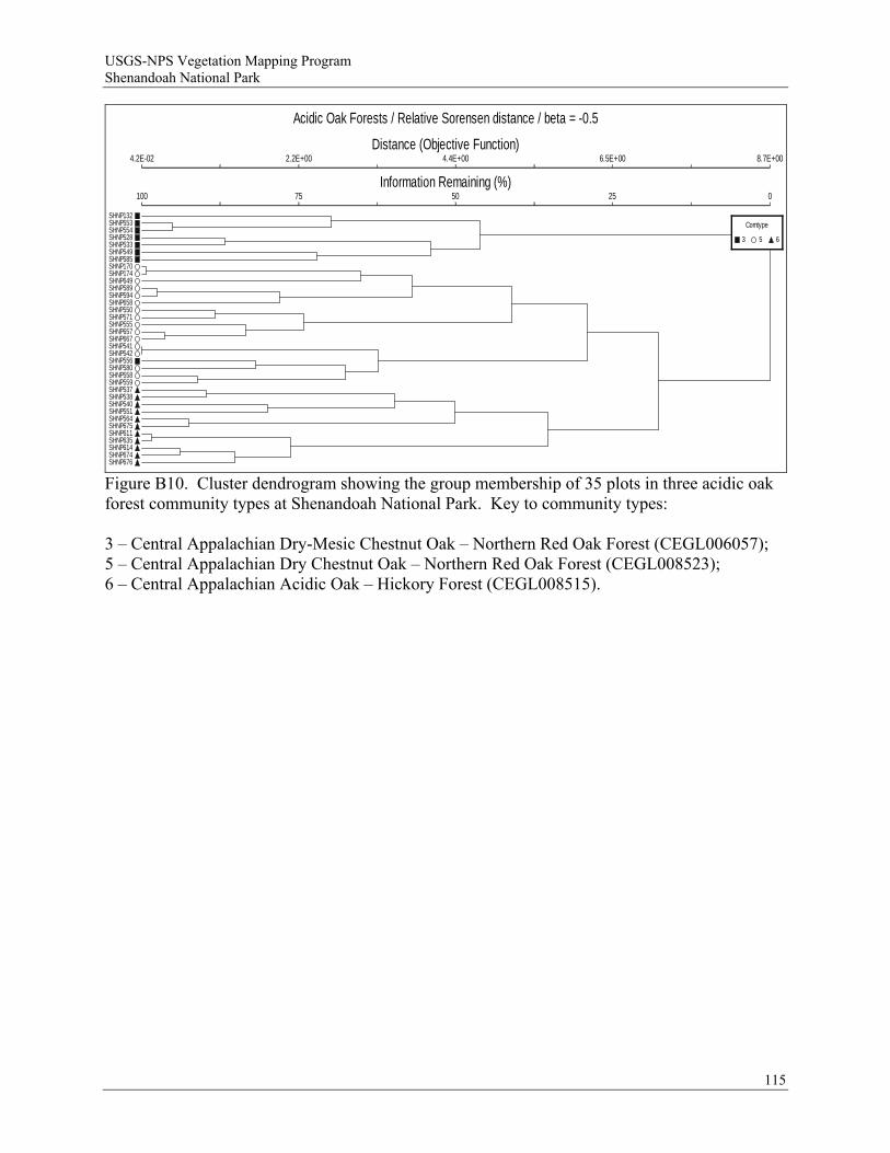
USGS-NPS Vegetation Mapping Program Shenandoah National Park
Acidic Oak Forests / Relative Sorensen distance / beta = -0.5
Distance (Objective Function)
Information Remaining (%)
4.2E-02
100
2.2E+00
75
4.4E+00
50
6.5E+00
25
8.7E+00
0
SHNP132SHNP553SHNP554SHNP528SHNP533SHNP549SHNP585SHNP170SHNP174SHNP649SHNP589SHNP594SHNP658SHNP550SHNP571SHNP555SHNP657SHNP667SHNP541SHNP542SHNP556SHNP580SHNP558SHNP559SHNP537SHNP538SHNP540SHNP551SHNP564SHNP675SHNP611SHNP635SHNP614SHNP674SHNP676
Comtype
3 5 6
Figure B10. Cluster dendrogram showing the group membership of 35 plots in three acidic oak forest community types at Shenandoah National Park. Key to community types: 3 – Central Appalachian Dry-Mesic Chestnut Oak – Northern Red Oak Forest (CEGL006057); 5 – Central Appalachian Dry Chestnut Oak – Northern Red Oak Forest (CEGL008523); 6 – Central Appalachian Acidic Oak – Hickory Forest (CEGL008515).
115
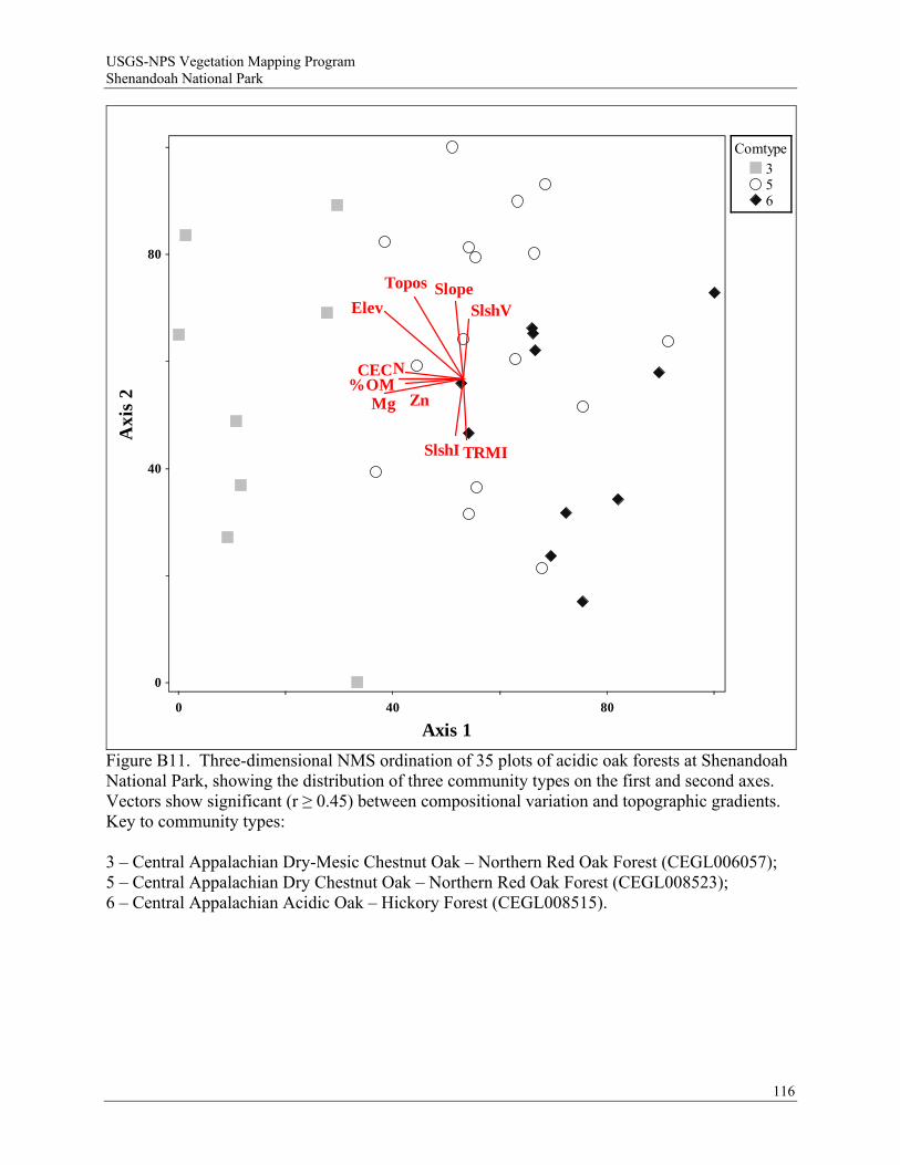
USGS-NPS Vegetation Mapping Program Shenandoah National Park
116
SlopeTopos
Elev SlshV
SlshI TRMI
Mg Zn
N%OM
CEC
0
0
40 80
40
80
Axis 1
Axi
s 2
Comtype356
Figure B11. Three-dimensional NMS ordination of 35 plots of acidic oak forests at Shenandoah National Park, showing the distribution of three community types on the first and second axes. Vectors show significant (r ≥ 0.45) between compositional variation and topographic gradients. Key to community types: 3 – Central Appalachian Dry-Mesic Chestnut Oak – Northern Red Oak Forest (CEGL006057); 5 – Central Appalachian Dry Chestnut Oak – Northern Red Oak Forest (CEGL008523); 6 – Central Appalachian Acidic Oak – Hickory Forest (CEGL008515).
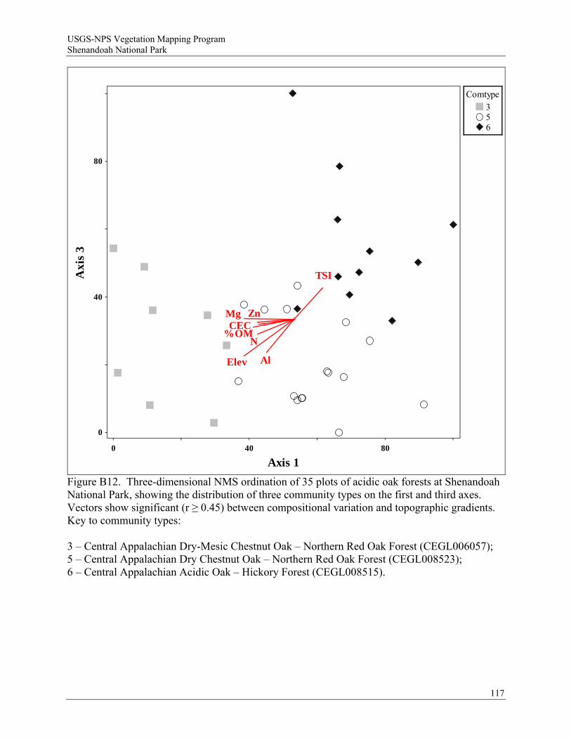
USGS-NPS Vegetation Mapping Program Shenandoah National Park
117
Elev
TSI
Mg Zn
Al
N%OM
CEC
0
0
40 80
40
80
Axis 1
Axi
s 3
Comtype356
Figure B12. Three-dimensional NMS ordination of 35 plots of acidic oak forests at Shenandoah National Park, showing the distribution of three community types on the first and third axes. Vectors show significant (r ≥ 0.45) between compositional variation and topographic gradients. Key to community types: 3 – Central Appalachian Dry-Mesic Chestnut Oak – Northern Red Oak Forest (CEGL006057); 5 – Central Appalachian Dry Chestnut Oak – Northern Red Oak Forest (CEGL008523); 6 – Central Appalachian Acidic Oak – Hickory Forest (CEGL008515).
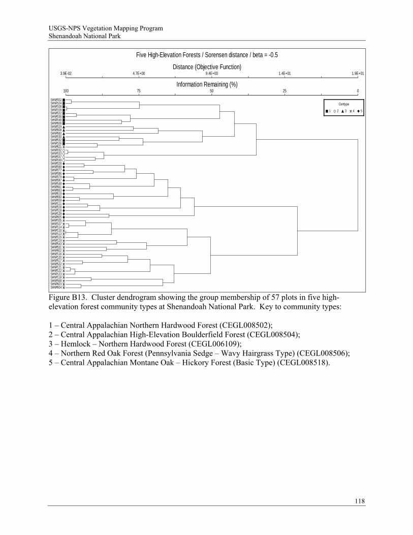
USGS-NPS Vegetation Mapping Program Shenandoah National Park
Five High-Elevation Forests / Sorensen distance / beta = -0.5
Distance (Objective Function)
Information Remaining (%)
3.9E-02
100
4.7E+00
75
9.4E+00
50
1.4E+01
25
1.9E+01
0
SHNP002SHNP104SHNP108SHNP109SHNP022SHNP036SHNP048SHNP606SHNP029SHNP608SHNP660SHNP030SHNP532SHNP106SHNP621SHNP032SHNP033SHNP037SHNP049SHNP028SHNP088SHNP077SHNP086SHNP079SHNP087SHNP548SHNP661SHNP663SHNP619SHNP650SHNP659SHNP111SHNP516SHNP518SHNP129SHNP605SHNP105SHNP107SHNP114SHNP110SHNP113SHNP115SHNP119SHNP543SHNP531SHNP602SHNP116SHNP120SHNP517SHNP522SHNP121SHNP122SHNP123SHNP118SHNP568SHNP603SHNP604
Comtype
1 2 3 4 5
Figure B13. Cluster dendrogram showing the group membership of 57 plots in five high-elevation forest community types at Shenandoah National Park. Key to community types: 1 – Central Appalachian Northern Hardwood Forest (CEGL008502); 2 – Central Appalachian High-Elevation Boulderfield Forest (CEGL008504); 3 – Hemlock – Northern Hardwood Forest (CEGL006109); 4 – Northern Red Oak Forest (Pennsylvania Sedge – Wavy Hairgrass Type) (CEGL008506); 5 – Central Appalachian Montane Oak – Hickory Forest (Basic Type) (CEGL008518).
118
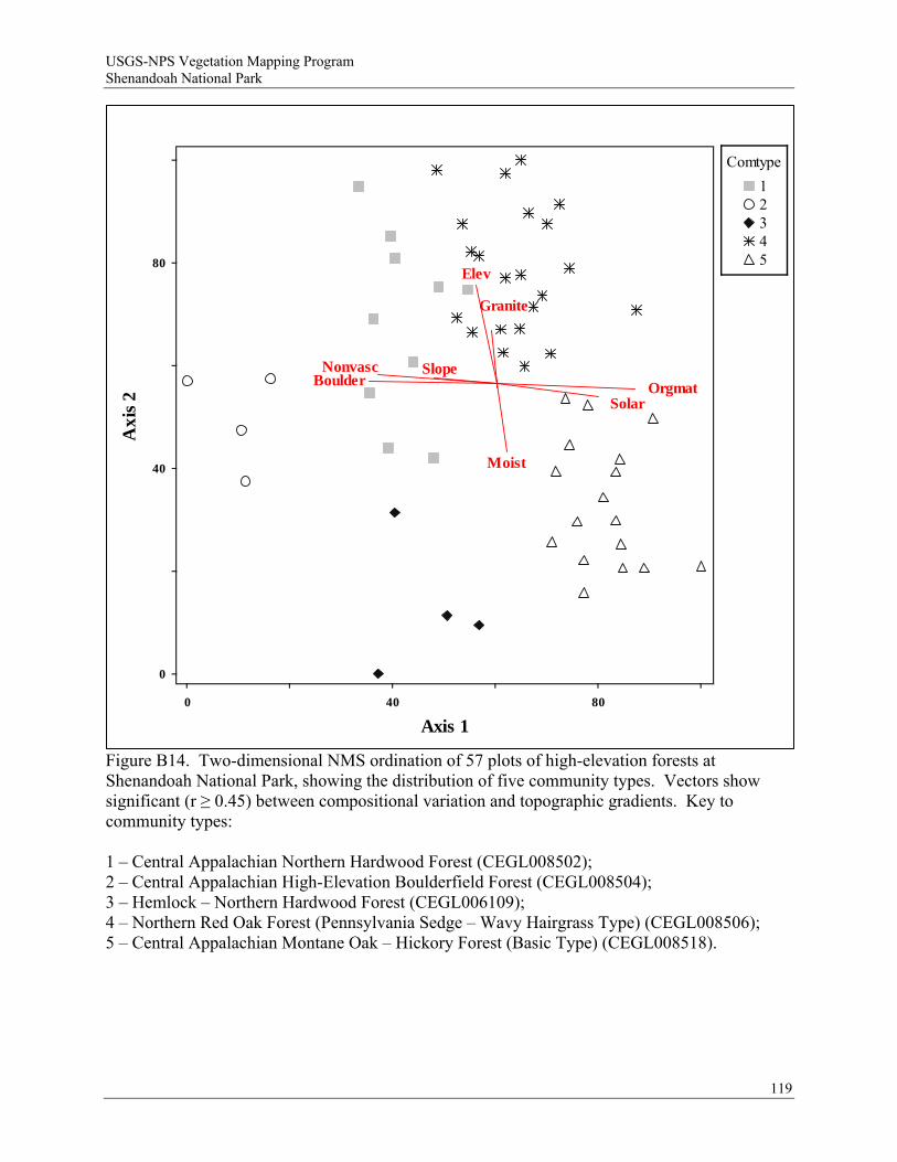
USGS-NPS Vegetation Mapping Program Shenandoah National Park
119
Slope
Solar
Elev
Moist
Boulder OrgmatNonvasc
Granite
0
0
40 80
40
80
Axis 1
Axi
s 2
Comtype
12345
Figure B14. Two-dimensional NMS ordination of 57 plots of high-elevation forests at Shenandoah National Park, showing the distribution of five community types. Vectors show significant (r ≥ 0.45) between compositional variation and topographic gradients. Key to community types: 1 – Central Appalachian Northern Hardwood Forest (CEGL008502); 2 – Central Appalachian High-Elevation Boulderfield Forest (CEGL008504); 3 – Hemlock – Northern Hardwood Forest (CEGL006109); 4 – Northern Red Oak Forest (Pennsylvania Sedge – Wavy Hairgrass Type) (CEGL008506); 5 – Central Appalachian Montane Oak – Hickory Forest (Basic Type) (CEGL008518).
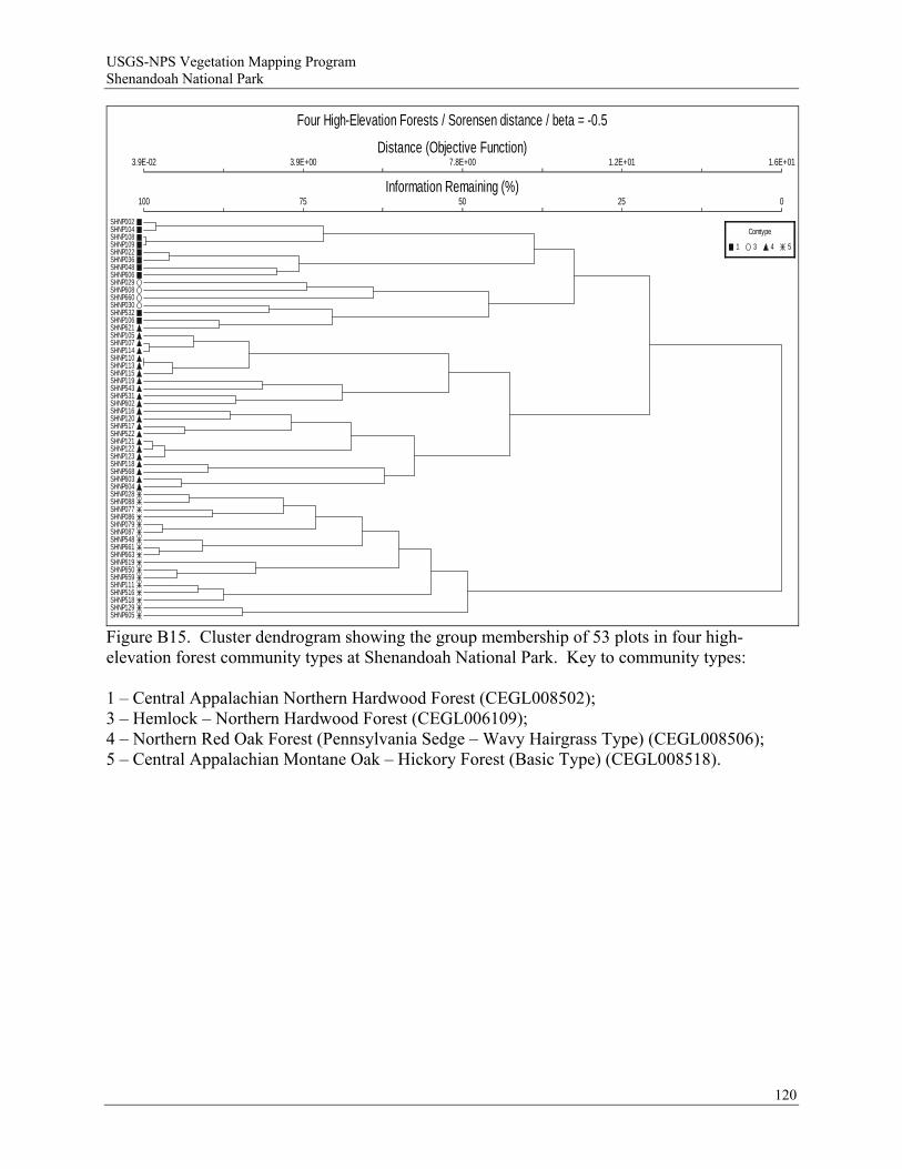
USGS-NPS Vegetation Mapping Program Shenandoah National Park
Four High-Elevation Forests / Sorensen distance / beta = -0.5
Distance (Objective Function)
Information Remaining (%)
3.9E-02
100
3.9E+00
75
7.8E+00
50
1.2E+01
25
1.6E+01
0
SHNP002SHNP104SHNP108SHNP109SHNP022SHNP036SHNP048SHNP606SHNP029SHNP608SHNP660SHNP030SHNP532SHNP106SHNP621SHNP105SHNP107SHNP114SHNP110SHNP113SHNP115SHNP119SHNP543SHNP531SHNP602SHNP116SHNP120SHNP517SHNP522SHNP121SHNP122SHNP123SHNP118SHNP568SHNP603SHNP604SHNP028SHNP088SHNP077SHNP086SHNP079SHNP087SHNP548SHNP661SHNP663SHNP619SHNP650SHNP659SHNP111SHNP516SHNP518SHNP129SHNP605
Comtype
1 3 4 5
Figure B15. Cluster dendrogram showing the group membership of 53 plots in four high-elevation forest community types at Shenandoah National Park. Key to community types: 1 – Central Appalachian Northern Hardwood Forest (CEGL008502); 3 – Hemlock – Northern Hardwood Forest (CEGL006109); 4 – Northern Red Oak Forest (Pennsylvania Sedge – Wavy Hairgrass Type) (CEGL008506); 5 – Central Appalachian Montane Oak – Hickory Forest (Basic Type) (CEGL008518).
120
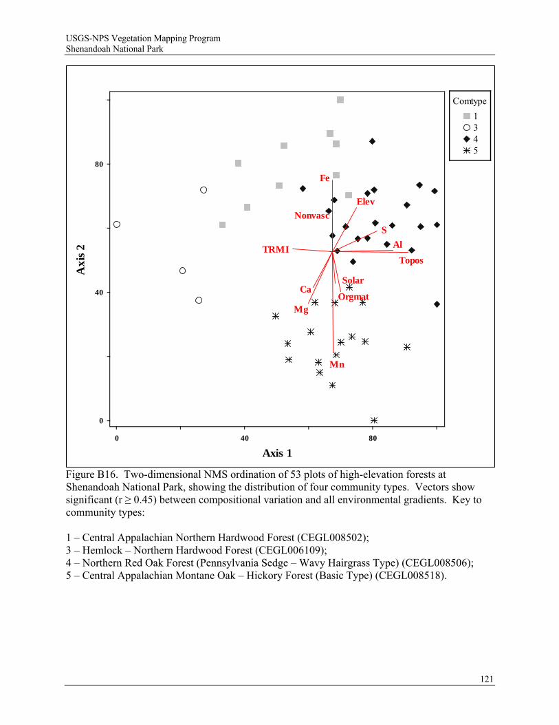
USGS-NPS Vegetation Mapping Program Shenandoah National Park
121
Topos
Solar
Elev
TRMI
Orgmat
Nonvasc
Ca
Mg
Fe
Mn
S
Al
0
0
40 80
40
80
Axis 1
Axi
s 2
Comtype
1345
Figure B16. Two-dimensional NMS ordination of 53 plots of high-elevation forests at Shenandoah National Park, showing the distribution of four community types. Vectors show significant (r ≥ 0.45) between compositional variation and all environmental gradients. Key to community types: 1 – Central Appalachian Northern Hardwood Forest (CEGL008502); 3 – Hemlock – Northern Hardwood Forest (CEGL006109); 4 – Northern Red Oak Forest (Pennsylvania Sedge – Wavy Hairgrass Type) (CEGL008506); 5 – Central Appalachian Montane Oak – Hickory Forest (Basic Type) (CEGL008518).

USGS-NPS Vegetation Mapping Program Shenandoah National Park
Rich Mesic Forests / Relative Euclidian distance / beta = -0.4
Distance (Objective Function)
Information Remaining (%)
1.9E-01
100
4.5E+00
75
8.8E+00
50
1.3E+01
25
1.7E+01
0
SHNP004SHNP044SHNP054SHNP514SHNP577SHNP654SHNP534SHNP027SHNP050SHNP045SHNP040SHNP041SHNP042SHNP051SHNP014SHNP031SHNP020SHNP026SHNP016SHNP097SHNP099SHNP523SHNP574SHNP652SHNP526SHNP631SHNP590SHNP557SHNP593SHNP644SHNP576SHNP630SHNP572SHNP640SHNP587SHNP626
Comtype
1 2 3
Figure B17. Cluster dendrogram showing the group membership of 36 plots in three rich mesic forest community types at Shenandoah National Park. Key to community types: 1 – Central Appalachian Rich Cove Forest (CEGL006237); 2 – Southern Appalachian Cove Forest (Typic Montane Type) (CEGL007711); 3 – Central Appalachian Basic Boulderfield Forest (CEGL008528).
122
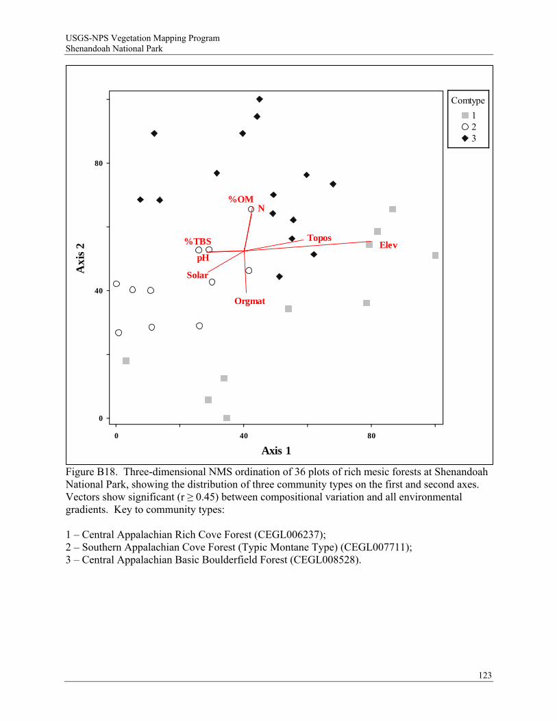
USGS-NPS Vegetation Mapping Program Shenandoah National Park
123
Topos
Solar
Elev
Orgmat
pH
N%OM
%TBS
0
0
40 80
40
80
Axis 1
Axi
s 2
Comtype
123
Figure B18. Three-dimensional NMS ordination of 36 plots of rich mesic forests at Shenandoah National Park, showing the distribution of three community types on the first and second axes. Vectors show significant (r ≥ 0.45) between compositional variation and all environmental gradients. Key to community types: 1 – Central Appalachian Rich Cove Forest (CEGL006237); 2 – Southern Appalachian Cove Forest (Typic Montane Type) (CEGL007711); 3 – Central Appalachian Basic Boulderfield Forest (CEGL008528).
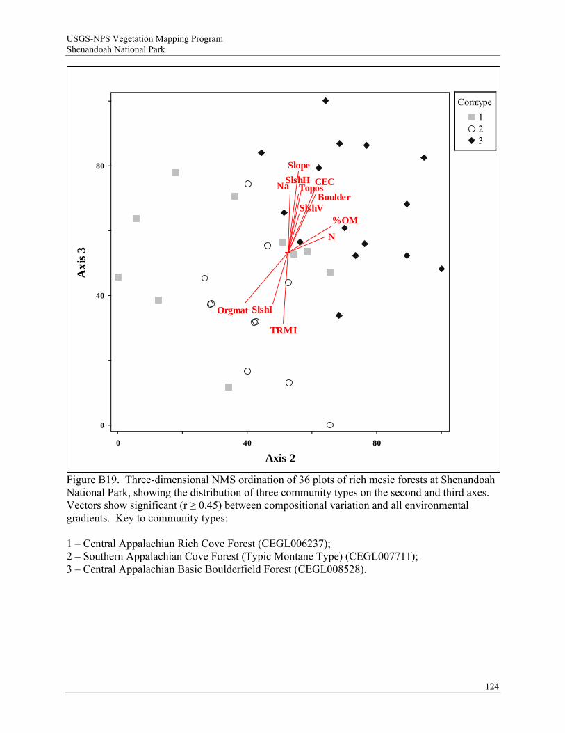
USGS-NPS Vegetation Mapping Program Shenandoah National Park
124
Slope
Topos
SlshV
SlshH
SlshI
TRMI
Boulder
Orgmat
Na
N
%OM
CEC
80
3siA
x
40
0
0 40 80
Axis 2
Comtype
123
Figure B19. Three-dimensional NMS ordination of 36 plots of rich mesic forests at Shenandoah National Park, showing the distribution of three community types on the second and third axes. Vectors show significant (r ≥ 0.45) between compositional variation and all environmental gradients. Key to community types: 1 – Central Appalachian Rich Cove Forest (CEGL006237); 2 – Southern Appalachian Cove Forest (Typic Montane Type) (CEGL007711); 3 – Central Appalachian Basic Boulderfield Forest (CEGL008528).
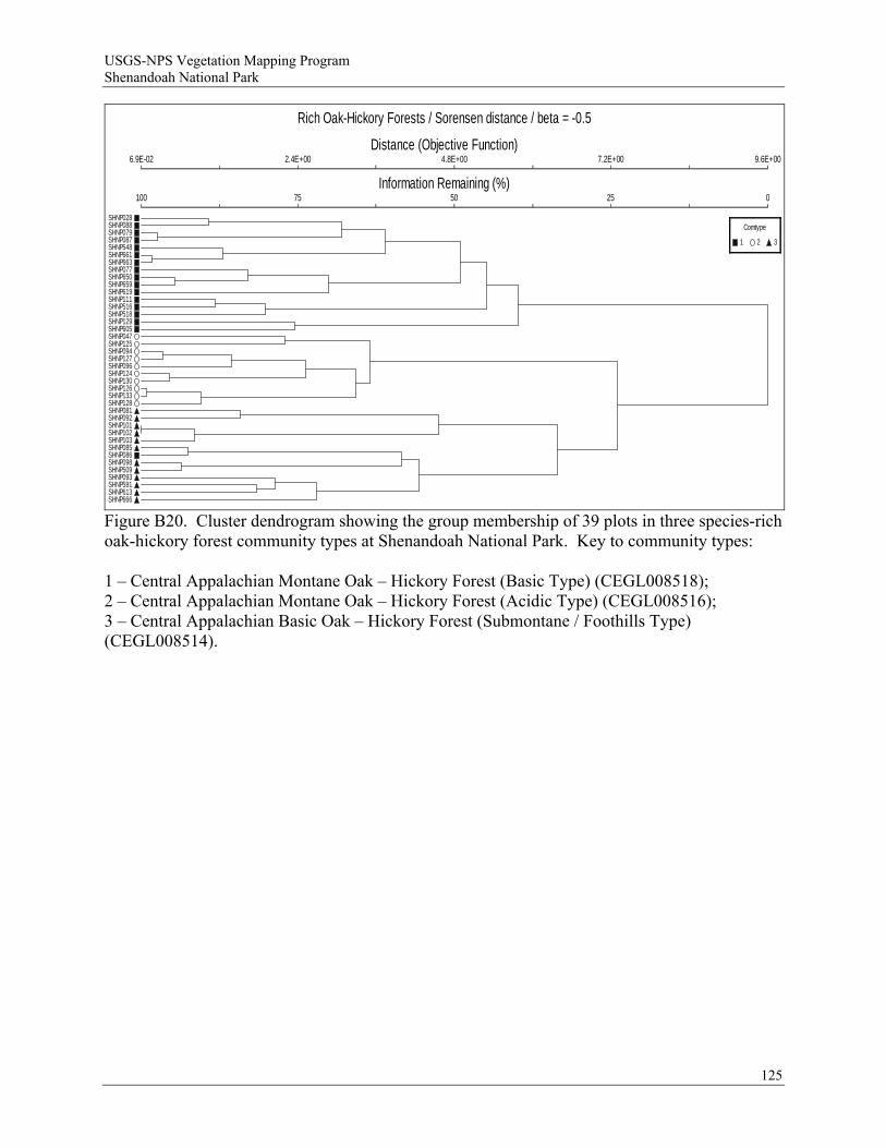
USGS-NPS Vegetation Mapping Program Shenandoah National Park
Rich Oak-Hickory Forests / Sorensen distance / beta = -0.5
Distance (Objective Function)
Information Remaining (%)
6.9E-02
100
2.4E+00
75
4.8E+00
50
7.2E+00
25
9.6E+00
0
SHNP028SHNP088SHNP079SHNP087SHNP548SHNP661SHNP663SHNP077SHNP650SHNP659SHNP619SHNP111SHNP516SHNP518SHNP129SHNP605SHNP047SHNP125SHNP094SHNP127SHNP096SHNP124SHNP130SHNP126SHNP133SHNP128SHNP081SHNP092SHNP101SHNP102SHNP103SHNP085SHNP086SHNP098SHNP509SHNP093SHNP591SHNP613SHNP666
Comtype
1 2 3
Figure B20. Cluster dendrogram showing the group membership of 39 plots in three species-rich oak-hickory forest community types at Shenandoah National Park. Key to community types: 1 – Central Appalachian Montane Oak – Hickory Forest (Basic Type) (CEGL008518); 2 – Central Appalachian Montane Oak – Hickory Forest (Acidic Type) (CEGL008516); 3 – Central Appalachian Basic Oak – Hickory Forest (Submontane / Foothills Type) (CEGL008514).
125
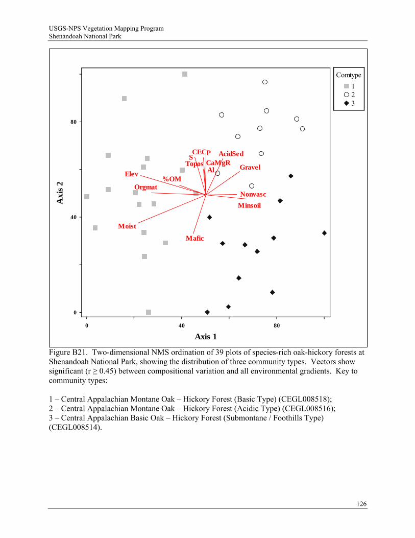
USGS-NPS Vegetation Mapping Program Shenandoah National Park
126
Figure B21. Two-dimensional NMS ordination of 39 plots of species-rich oak-hickory forests at Shenandoah National Park, showing the distribution of three community types. Vectors show significant (r ≥ 0.45) between compositional variation and all environmental gradients. Key to community types: 1 – Central Appalachian Montane Oak – Hickory Forest (Basic Type) (CEGL008518); 2 – Central Appalachian Montane Oak – Hickory Forest (Acidic Type) (CEGL008516); 3 – Central Appalachian Basic Oak – Hickory Forest (Submontane / Foothills Type) (CEGL008514).
Topos
Elev
Moist
Gravel
Orgmat
Minsoil
Nonvasc
Mafic
AcidSedSP
Al%OM
CEC
CaMgR
0
0
40 80
40
80
Axis 1
Axi
s 2
Comtype
123
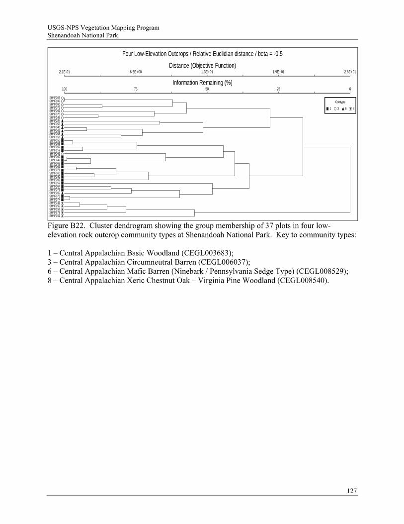
USGS-NPS Vegetation Mapping Program Shenandoah National Park
Four Low-Elevation Outcrops / Relative Euclidian distance / beta = -0.5
Distance (Objective Function)
Information Remaining (%)
2.1E-01
100
6.5E+00
75
1.3E+01
50
1.9E+01
25
2.6E+01
0
SHNP009SHNP100SHNP060SHNP072SHNP069SHNP070SHNP148SHNP024SHNP053SHNP043SHNP063SHNP058SHNP156SHNP055SHNP056SHNP057SHNP159SHNP066SHNP067SHNP149SHNP068SHNP061SHNP071SHNP065SHNP080SHNP062SHNP059SHNP064SHNP076SHNP160SHNP073SHNP074SHNP146SHNP150SHNP157SHNP578SHNP151
Comtype
1 3 6 8
Figure B22. Cluster dendrogram showing the group membership of 37 plots in four low-elevation rock outcrop community types at Shenandoah National Park. Key to community types: 1 – Central Appalachian Basic Woodland (CEGL003683); 3 – Central Appalachian Circumneutral Barren (CEGL006037); 6 – Central Appalachian Mafic Barren (Ninebark / Pennsylvania Sedge Type) (CEGL008529); 8 – Central Appalachian Xeric Chestnut Oak – Virginia Pine Woodland (CEGL008540).
127
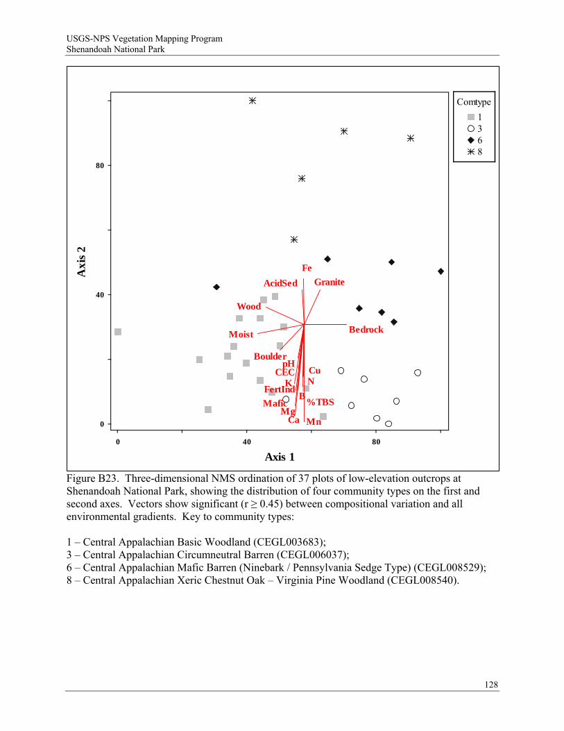
USGS-NPS Vegetation Mapping Program Shenandoah National Park
128
Moist Bedrock
Boulder
Wood
Mafic
GraniteAcidSed
pH
CaMg
Fe
Mn
KCu
B
N
%TBS
CEC
FertInd
0
0
40 80
40
80
Axis 1
Axi
s 2
Comtype
1368
Figure B23. Three-dimensional NMS ordination of 37 plots of low-elevation outcrops at Shenandoah National Park, showing the distribution of four community types on the first and second axes. Vectors show significant (r ≥ 0.45) between compositional variation and all environmental gradients. Key to community types: 1 – Central Appalachian Basic Woodland (CEGL003683); 3 – Central Appalachian Circumneutral Barren (CEGL006037); 6 – Central Appalachian Mafic Barren (Ninebark / Pennsylvania Sedge Type) (CEGL008529); 8 – Central Appalachian Xeric Chestnut Oak – Virginia Pine Woodland (CEGL008540).

USGS-NPS Vegetation Mapping Program Shenandoah National Park
Three Low-Elevation Outcrops / Relative Euclidian distance / beta = -0.5
Distance (Objective Function)
Information Remaining (%)
2.1E-01
100
5E+00
75
9.9E+00
50
1.5E+01
25
2E+01
0
SHNP009SHNP100SHNP060SHNP072SHNP069SHNP070SHNP148SHNP024SHNP053SHNP043SHNP063SHNP058SHNP156SHNP055SHNP056SHNP057SHNP159SHNP066SHNP067SHNP149SHNP068SHNP061SHNP071SHNP065SHNP080SHNP062SHNP059SHNP064SHNP076SHNP160SHNP073SHNP074
Comtype
1 3 6
Figure B24. Cluster dendrogram showing the group membership of 32 plots in three low-elevation rock outcrop community types at Shenandoah National Park. Key to community types: 1 – Central Appalachian Basic Woodland (CEGL003683); 3 – Central Appalachian Circumneutral Barren (CEGL006037); 6 – Central Appalachian Mafic Barren (Ninebark / Pennsylvania Sedge Type) (CEGL008529).
129
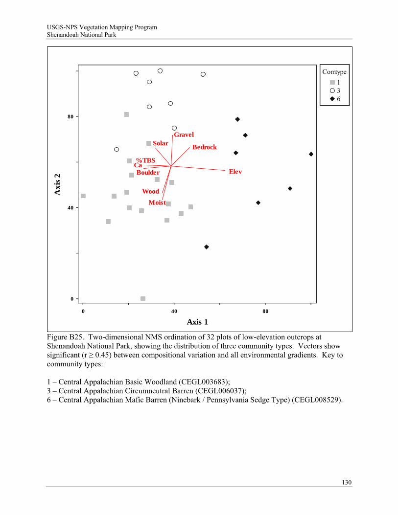
USGS-NPS Vegetation Mapping Program Shenandoah National Park
130
Figure B25. Two-dimensional NMS ordination of 32 plots of low-elevation outcrops at Shenandoah National Park, showing the distribution of three community types. Vectors show significant (r ≥ 0.45) between compositional variation and all environmental gradients. Key to community types: 1 – Central Appalachian Basic Woodland (CEGL003683); 3 – Central Appalachian Circumneutral Barren (CEGL006037); 6 – Central Appalachian Mafic Barren (Ninebark / Pennsylvania Sedge Type) (CEGL008529).
Solar
Elev
Moist
Bedrock
Boulder
Gravel
Wood
Ca%TBS
0
0
40 80
40
80
Axis 1
Axi
s 2
Comtype
136
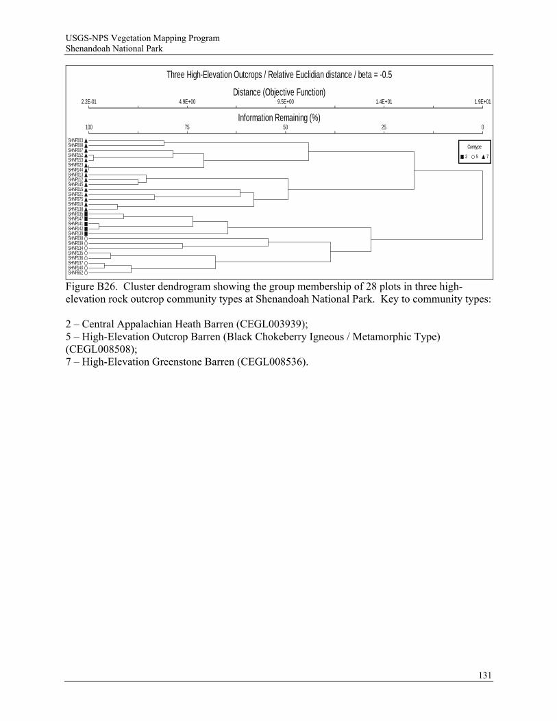
USGS-NPS Vegetation Mapping Program Shenandoah National Park
Three High-Elevation Outcrops / Relative Euclidian distance / beta = -0.5
Distance (Objective Function)
Information Remaining (%)
2.2E-01
100
4.9E+00
75
9.5E+00
50
1.4E+01
25
1.9E+01
0
SHNP003SHNP008SHNP007SHNP152SHNP153SHNP023SHNP144SHNP013SHNP112SHNP145SHNP015SHNP021SHNP075SHNP019SHNP138SHNP035SHNP147SHNP141SHNP142SHNP139SHNP038SHNP039SHNP134SHNP135SHNP136SHNP137SHNP140SHNP662
Comtype
2 5 7
Figure B26. Cluster dendrogram showing the group membership of 28 plots in three high-elevation rock outcrop community types at Shenandoah National Park. Key to community types: 2 – Central Appalachian Heath Barren (CEGL003939); 5 – High-Elevation Outcrop Barren (Black Chokeberry Igneous / Metamorphic Type) (CEGL008508); 7 – High-Elevation Greenstone Barren (CEGL008536).
131
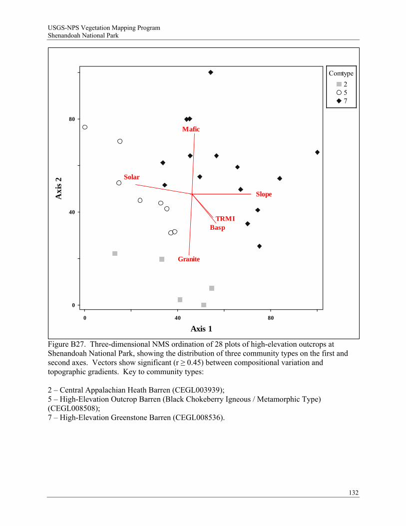
USGS-NPS Vegetation Mapping Program Shenandoah National Park
132
Slope
Basp
Solar
TRMI
Mafic
Granite
0
0
40 80
40
80
Axis 1
Axi
s 2
Comtype
257
Figure B27. Three-dimensional NMS ordination of 28 plots of high-elevation outcrops at Shenandoah National Park, showing the distribution of three community types on the first and second axes. Vectors show significant (r ≥ 0.45) between compositional variation and topographic gradients. Key to community types: 2 – Central Appalachian Heath Barren (CEGL003939); 5 – High-Elevation Outcrop Barren (Black Chokeberry Igneous / Metamorphic Type) (CEGL008508); 7 – High-Elevation Greenstone Barren (CEGL008536).
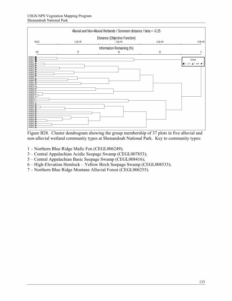
USGS-NPS Vegetation Mapping Program Shenandoah National Park
Alluvial and Non-Alluvial Wetlands / Sorensen distance / beta = -0.25
Distance (Objective Function)
Information Remaining (%)
6E-02
100
2.1E+00
75
4.2E+00
50
6.2E+00
25
8.3E+00
0
SHNP010SHNP117SHNP017SHNP011SHNP639SHNP034SHNP078SHNP620SHNP623SHNP625SHNP600SHNP629SHNP653SHNP617SHNP622SHNP012SHNP624SHNP638SHNP618SHNP636SHNP637SHNP082SHNP632SHNP612SHNP521SHNP525SHNP627SHNP615SHNP536SHNP628SHNP592SHNP616SHNP643SHNP645SHNP641SHNP642SHNP610
Comtype
1 3 5 6 7
Figure B28. Cluster dendrogram showing the group membership of 37 plots in five alluvial and non-alluvial wetland community types at Shenandoah National Park. Key to community types: 1 – Northern Blue Ridge Mafic Fen (CEGL006249); 3 – Central Appalachian Acidic Seepage Swamp (CEGL007853); 5 – Central Appalachian Basic Seepage Swamp (CEGL008416); 6 – High-Elevation Hemlock – Yellow Birch Seepage Swamp (CEGL008533); 7 – Northern Blue Ridge Montane Alluvial Forest (CEGL006255).
133
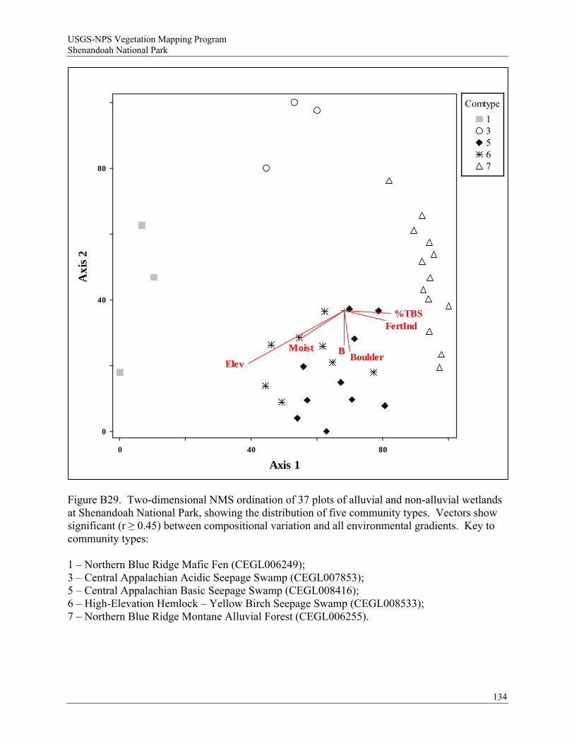
USGS-NPS Vegetation Mapping Program Shenandoah National Park
134
Elev
MoistBoulder
B
%TBSFertInd
0
0
40 80
40
80
Axis 1
Axi
s 2
Comtype
13567
Figure B29. Two-dimensional NMS ordination of 37 plots of alluvial and non-alluvial wetlands at Shenandoah National Park, showing the distribution of five community types. Vectors show significant (r ≥ 0.45) between compositional variation and all environmental gradients. Key to community types: 1 – Northern Blue Ridge Mafic Fen (CEGL006249); 3 – Central Appalachian Acidic Seepage Swamp (CEGL007853); 5 – Central Appalachian Basic Seepage Swamp (CEGL008416); 6 – High-Elevation Hemlock – Yellow Birch Seepage Swamp (CEGL008533); 7 – Northern Blue Ridge Montane Alluvial Forest (CEGL006255).
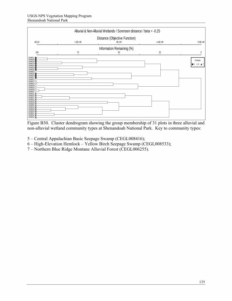
USGS-NPS Vegetation Mapping Program Shenandoah National Park
Alluvial & Non-Alluvial Wetlands / Sorensen distance / beta = -0.25
Distance (Objective Function)
Information Remaining (%)
6E-02
100
1.5E+00
75
3E+00
50
4.4E+00
25
5.9E+00
0
SHNP011SHNP639SHNP034SHNP078SHNP620SHNP623SHNP625SHNP600SHNP629SHNP653SHNP617SHNP622SHNP012SHNP624SHNP638SHNP618SHNP636SHNP637SHNP521SHNP525SHNP627SHNP615SHNP536SHNP628SHNP592SHNP616SHNP643SHNP645SHNP641SHNP642SHNP610
Comtype
5 6 7
Figure B30. Cluster dendrogram showing the group membership of 31 plots in three alluvial and non-alluvial wetland community types at Shenandoah National Park. Key to community types: 5 – Central Appalachian Basic Seepage Swamp (CEGL008416); 6 – High-Elevation Hemlock – Yellow Birch Seepage Swamp (CEGL008533); 7 – Northern Blue Ridge Montane Alluvial Forest (CEGL006255).
135
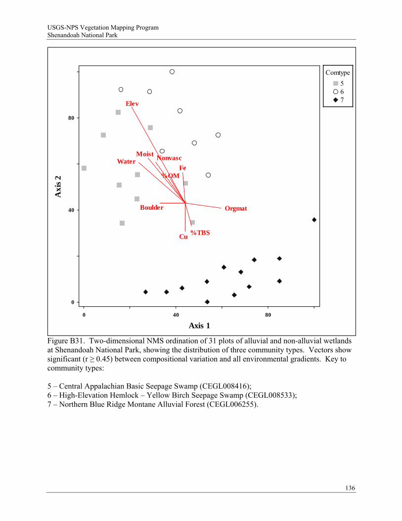
USGS-NPS Vegetation Mapping Program Shenandoah National Park
136
Elev
Moist
Boulder Orgmat
Water Nonvasc
Fe
Cu
%OM
%TBS
Comtype
567
0
0
40 80
40
80
Axis 1
Axi
s 2
Figure B31. Two-dimensional NMS ordination of 31 plots of alluvial and non-alluvial wetlands at Shenandoah National Park, showing the distribution of three community types. Vectors show significant (r ≥ 0.45) between compositional variation and all environmental gradients. Key to community types: 5 – Central Appalachian Basic Seepage Swamp (CEGL008416); 6 – High-Elevation Hemlock – Yellow Birch Seepage Swamp (CEGL008533); 7 – Northern Blue Ridge Montane Alluvial Forest (CEGL006255).
USGS-NPS Vegetation Mapping Program Shenandoah National Park
Appendix C. Dichotomous key to map classes of Shenandoah National Park vegetation map 2.0.
INSTRUCTIONS FOR USE OF DICHOTOMOUS KEY TO MAP CLASSES OF SHENANDOAH NATIONAL PARK VEGETATION MAP 2.0
The following dichotomous key to the map classes of the Shenandoah National Park Vegetation Map ver. 2.0 was created for use by park natural resource managers and personnel conducting map accuracy assessment. A dichotomous key is a tool for identifying unknown entities, in this case vegetation types. It is structured by a series of couplets, two statements that describe different, mutually exclusive characteristics of the vegetation. The overall key, as well as discrete portions, begin with couplets identifying larger vegetation patterns and groups (e.g., upland vegetation vs. wetland vegetation; see Figure 1) and work progressively toward identifying the finer-scale vegetation types that constitute the map classes. The key is based on a comprehensive quantitative classification of vegetation that was produced for this project, and represents a major revision of the ver. 1.0 key, which was extensively field tested. For convenience, major segments of the key that deal with specific vegetation groups (e.g., "forests and woodlands with > 25% coniferous tree cover" or "vegetation of rock outcrops and nonvascular boulderfields") are identified with bold headers. Environmental information, as well as floristic and structural characteristics are used in the key. Geology, in particular, is an important variable controlling the distribution of some vegetation types in the Park. It is recommended that users of this key become familiar with the three major geologic suites (metabasaltic, granitic, and metasedimentary) of the northern Blue Ridge and, if necessary, carry a geologic map of the park in the field. To some extent, the use of individual herbaceous species has been reduced by utilizing groups of ecologically similar herbaceous plants (e.g., "mesophytic nutrient-requiring herbs"). The characteristic species of these groups (Table 1), as well as a glossary of some commonly used technical terms, are included at the end of these instructions. The recommended procedure for using this key is to start at the beginning and progressively work through a series of couplets until a satisfactory identification of the vegetation being examined is reached. Once a user is thoroughly familiar with the key through extensive field use, it will often be possible to skip directly to the appropriate, major leg of the key. In most cases, choosing the statement that best fits the vegetation and environmental characteristics in question at each couplet will lead the user to the correct vegetation type. However, it is important to recognize that no key to vegetation is infallible or perfect. Natural vegetation is frequently gradational on the landscape, resulting in stands that are transitional between classified types. In addition, natural or human disturbance may obscure typical characteristics of a vegetation type, and introduce atypical ones. In some cases, it may be necessary to run a stand through two different legs of the key if uncertainties about how to resolve a couplet exist. To make it easier for users to make choices based on the preponderance of evidence, multiple characters (environmental, floristic, and/or structural) are often used in the key. In addition, certain types are redundantly included in two or more legs of the key to account for their natural variability. The dichotomous key should be used in conjunction with the detailed vegetation map class descriptions to confirm that the vegetation type selected with the key is appropriate.
137

USGS-NPS Vegetation Mapping Program Shenandoah National Park
138
The scale of observation may influence the performance of this key in the field, especially if the assessment of vegetation is based on prescribed observation points within polygons of the vegetation map (e.g., as in accuracy assessment procedures). The key characters may not be accurate in delineating vegetation types unless areas of sufficient size and homogeneity are considered. In forests and woodlands, a minimum of 0.5 hectare (5000 square meters) of contiguous area should be assessed. This represents the minimum map unit size for vegetation under the USGS-NPS vegetation mapping program, and translates into a circle with a 40-meter radius, or a rectangle 50 x 100 meters. In cases where an observation area falls in an ecotone or contains two distinctly different vegetation types, it is essential to observe as large an area as possible in order to determine which type is the prevalent type within the polygon. However, many small-patch community types (primarily wetlands and rock outcrops) may be mapped with polygons less than 0.5 ha. In these cases, assessment of the entire polygon is recommended.

USGS-NPS Vegetation Mapping Program Shenandoah National Park
Meadows and lawnsModified/disturbed vegetation with < 50% tree canopy
Catastrophically disturbed forests
Forests and Woodlands
with > 25% Coniferous Tree Cover
Terrestrial Forest and Woodland Vegetation
With a prevalent
ericaceous shrub component
Forests and Woodlands with < 25% Coniferous Tree Cover
Upland VegetationWithout a prevalent ericaceous shrub component
Vegetation of Nonvascular Boulderfields
Natural/seminatural vegetation with or without tree canopy
Non-Forested Upland Vegetation
Vegetation of Rock
Outcrops and Nonvascular Boulderfields
Vegetation of Rock Outcrops
Forested Wetlands
Wetland Vegetation
Non-Forested Wetlands
Figure C1. Key structure and major groups.
139
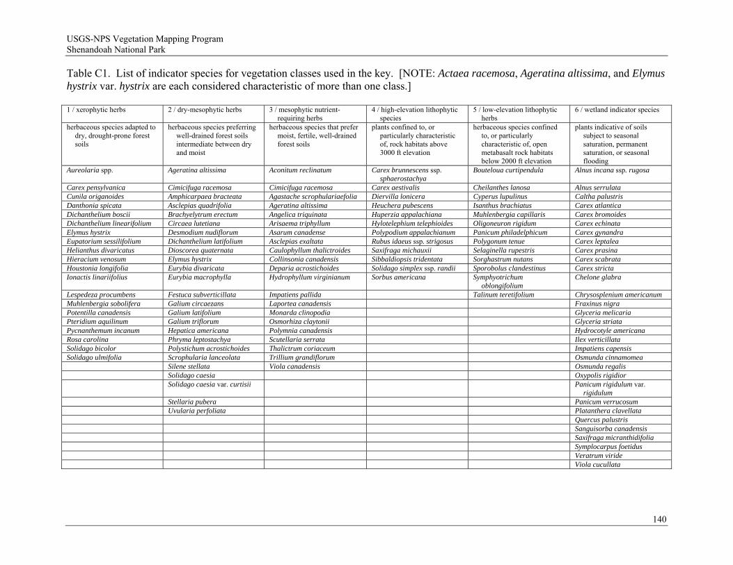
USGS-NPS Vegetation Mapping Program Shenandoah National Park
140
Table C1. List of indicator species for vegetation classes used in the key. [NOTE: Actaea racemosa, Ageratina altissima, and Elymus hystrix var. hystrix are each considered characteristic of more than one class.] 1 / xerophytic herbs 2 / dry-mesophytic herbs 3 / mesophytic nutrient-
requiring herbs 4 / high-elevation lithophytic
species 5 / low-elevation lithophytic
herbs 6 / wetland indicator species
herbaceous species adapted to dry, drought-prone forest soils
herbaceous species preferring well-drained forest soils intermediate between dry and moist
herbaceous species that prefer moist, fertile, well-drained forest soils
plants confined to, or particularly characteristic of, rock habitats above 3000 ft elevation
herbaceous species confined to, or particularly characteristic of, open metabasalt rock habitats below 2000 ft elevation
plants indicative of soils subject to seasonal saturation, permanent saturation, or seasonal flooding
Aureolaria spp. Ageratina altissima Aconitum reclinatum Carex brunnescens ssp. sphaerostachya
Bouteloua curtipendula Alnus incana ssp. rugosa
Carex pensylvanica Cimicifuga racemosa Cimicifuga racemosa Carex aestivalis Cheilanthes lanosa Alnus serrulata Cunila origanoides Amphicarpaea bracteata Agastache scrophulariaefolia Diervilla lonicera Cyperus lupulinus Caltha palustris Danthonia spicata Asclepias quadrifolia Ageratina altissima Heuchera pubescens Isanthus brachiatus Carex atlantica Dichanthelium boscii Brachyelytrum erectum Angelica triquinata Huperzia appalachiana Muhlenbergia capillaris Carex bromoides Dichanthelium linearifolium Circaea lutetiana Arisaema triphyllum Hylotelephium telephioides Oligoneuron rigidum Carex echinata Elymus hystrix Desmodium nudiflorum Asarum canadense Polypodium appalachianum Panicum philadelphicum Carex gynandra Eupatorium sessilifolium Dichanthelium latifolium Asclepias exaltata Rubus idaeus ssp. strigosus Polygonum tenue Carex leptalea Helianthus divaricatus Dioscorea quaternata Caulophyllum thalictroides Saxifraga michauxii Selaginella rupestris Carex prasina Hieracium venosum Elymus hystrix Collinsonia canadensis Sibbaldiopsis tridentata Sorghastrum nutans Carex scabrata Houstonia longifolia Eurybia divaricata Deparia acrostichoides Solidago simplex ssp. randii Sporobolus clandestinus Carex stricta Ionactis linariifolius Eurybia macrophylla Hydrophyllum virginianum Sorbus americana Symphyotrichum
oblongifolium Chelone glabra
Lespedeza procumbens Festuca subverticillata Impatiens pallida Talinum teretifolium Chrysosplenium americanum Muhlenbergia sobolifera Galium circaezans Laportea canadensis Fraxinus nigra Potentilla canadensis Galium latifolium Monarda clinopodia Glyceria melicaria Pteridium aquilinum Galium triflorum Osmorhiza claytonii Glyceria striata Pycnanthemum incanum Hepatica americana Polymnia canadensis Hydrocotyle americana Rosa carolina Phryma leptostachya Scutellaria serrata Ilex verticillata Solidago bicolor Polystichum acrostichoides Thalictrum coriaceum Impatiens capensis Solidago ulmifolia Scrophularia lanceolata Trillium grandiflorum Osmunda cinnamomea Silene stellata Viola canadensis Osmunda regalis Solidago caesia Oxypolis rigidior Solidago caesia var. curtisii Panicum rigidulum var.
rigidulum Stellaria pubera Panicum verrucosum Uvularia perfoliata Platanthera clavellata Quercus palustris Sanguisorba canadensis Saxifraga micranthidifolia Symplocarpus foetidus Veratrum viride Viola cucullata
USGS-NPS Vegetation Mapping Program Shenandoah National Park
GLOSSARY OF SELECTED TECHNICAL TERMS Co-dominant – pertaining to a plant (usually in the uppermost stratum) that is one of two or more species sharing high cover and abundance in a stand. Dominant – pertaining to a plant (usually in the uppermost stratum) that has the highest cover and abundance in a stand. Dry-Mesophytic – descriptor of plants that prefer soil conditions intermediate between dry and moist but well drained; such conditions are widespread on average slopes in the Park. Early-successional – descriptor for forest vegetation that has regenerated on formerly cleared land; typically consists of fast-growing, light-demanding species which, in time, will be replaced by longer-lived, shade-tolerant species (i.e., later-successional vegetation). Ericad, Ericaceous species – a plant of the Heath Family (Ericaceae), e.g., Kalmia latifolia (mountain laurel), Rhododendron (rhododendron) spp., Gaylussacia baccata (black huckleberry), Vaccinium (blueberry) spp., Menziesia pilosa (minniebush), Lyonia ligustrina (maleberry). Forest – vegetation dominated by trees at least 6 meters tall producing a more or less closed canopy, typically with 60-100% cover; some forests may temporarily have < 60% canopy cover following disturbances such as windthrow, disease, etc. Herb – a vascular plant lacking woody tissue at or above ground level; includes Forbs (broad-leaved herbaceous plants) and Graminoids (grasses, sedges, and rushes). Herb layer – the lowest vascular vegetation stratum, including woody plants < 0.5m tall and all herbaceous plants regardless of height. Nonvascular vegetation – vegetation dominated by lichens, mosses, and liverworts, i.e., biota lacking a structural system of tissue that conducts water and soluble nutrients. Lithophytic – descriptor of a vascular plant that is confined to, or particularly characteristic of, rock habitats (outcrop crevices, shelves, ledges). Mesophytic – descriptor of plants that prefer moist but well drained soil conditions; such conditions are typically found on lower slopes, in ravines, and in coves. Nutrient-requiring – descriptor of plants that require relatively high levels of soluble nutrients (particularly calcium and magnesium) for successful growth; such species are generally restricted to fertile soils. Overstory – the uppermost layer of trees forming the canopy of a forest or woodland. Tree – a single-stemmed woody plant routinely attaining heights greater than 6 meters.
141
USGS-NPS Vegetation Mapping Program Shenandoah National Park
Shrub – a multi-stemmed woody plant routinely attaining heights between 0.5 and 6 meters. Understory – collective term for the small trees and shrubs growing beneath the canopy in a forest or woodland. Woodland – vegetation dominated by trees at least 6 meters tall producing an open canopy, typically with 5-60% cover; some woodlands may have > 60% canopy cover following elimination or reduction of natural disturbances (e.g., fire). Xerophytic – desciptor of plants adapted to dry, drought-prone soil environments; such soils are common in the park on areas with abundant exposed or shallow bedrock, and on convex upper slopes and spur ridges, particularly in areas underlain by metasedimentary rocks.
142

USGS-NPS Vegetation Mapping Program Shenandoah National Park
KEY TO MAP CLASSES 1a Modified vegetation with < 50% tree canopy, originating directly from recent disturbance (e.g. gypsy moth) or major human landscape alterations (e.g., clearing) ......................................................................................................................................... 2
1b Natural and seminatural vegetation with or without a tree canopy, often influenced by past disturbance but largely shaped by natural successional processes and disturbance regimes ................................................................................................ 3
2a Meadows, lawns, and roadsides dominated by herbaceous vegetation; trees and shrubs may be scattered; low (< 0.5 m tall) patches of Vaccinium (blueberry) spp. may be common in some areas; confined to areas around developed facilities, road edges, and the general vicinity of Big Meadows ... Cultural Meadow (M2, CEGL006670)
2b Former forests, with abundant snags and fallen trunks of trees killed by gypsy moth, hemlock adelgid, pine beetle, drought, and/or fire; vegetation commonly of thick shrub and sapling regeneration; widespread in Park .................................................... Catastrophically Disturbed Forest (M1, CEGL006669)
3a Vegetation of uplands, not influenced by overland flooding or groundwater seepage ...................................................................................................................... 4
3b Vegetation of wetlands, e.g., floodplains, ponds, and groundwater-saturated habitats; surface water or signs of overland flooding (scoured areas, debris piles, etc.) present; at least a few wetland indicator species6 usually present ....................................... 58
4a Trees (> 6 m tall) forming an open to closed canopy; forest and woodland vegetation ....................................................................................................................................... 5
4b Tree canopy absent; trees, if present, few and usually < 6 m tall; surficial rock generally abundant; shrub, herbaceous, and nonvascular vegetation of exposed outcrops and talus ........................................................................................................................ 51
TERRESTRIAL FOREST AND WOODLAND VEGETATION
5a Conifers contributing at least 25% cover to the tree layers (overstory and understory) ..................................................................................................................................... 6
5b Conifers absent or contributing < 25% cover to the tree layers ............................................. 24
143
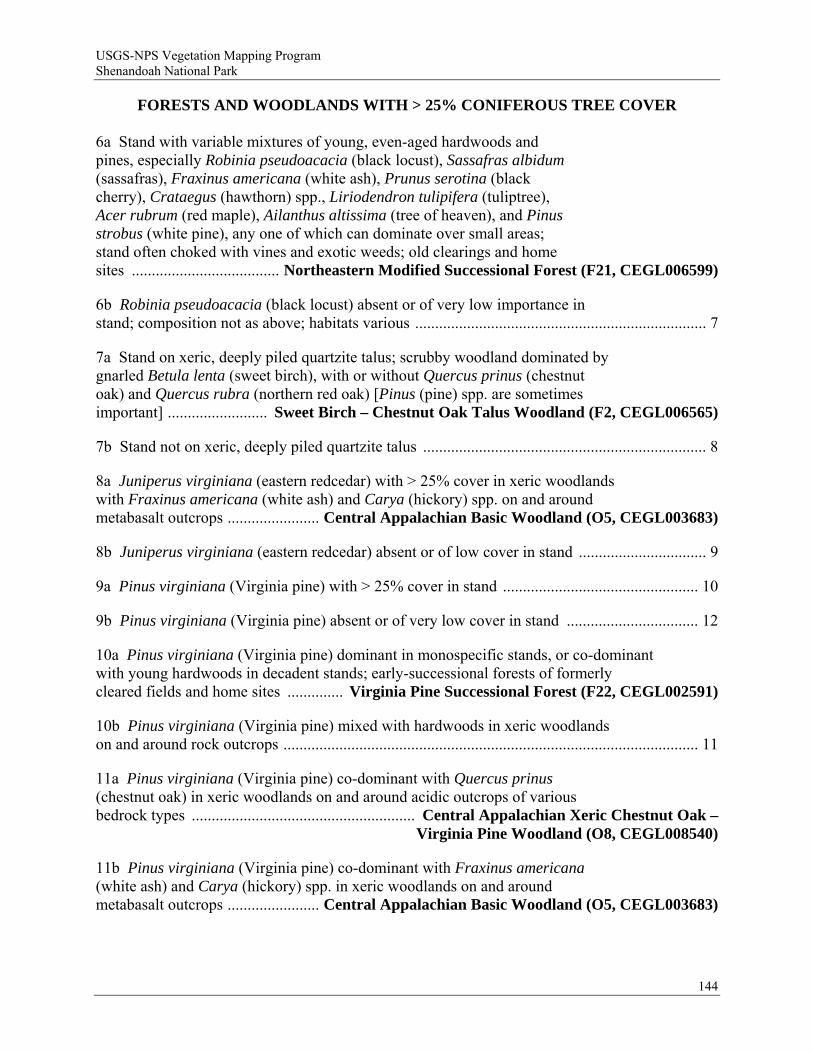
USGS-NPS Vegetation Mapping Program Shenandoah National Park
FORESTS AND WOODLANDS WITH > 25% CONIFEROUS TREE COVER 6a Stand with variable mixtures of young, even-aged hardwoods and pines, especially Robinia pseudoacacia (black locust), Sassafras albidum (sassafras), Fraxinus americana (white ash), Prunus serotina (black cherry), Crataegus (hawthorn) spp., Liriodendron tulipifera (tuliptree), Acer rubrum (red maple), Ailanthus altissima (tree of heaven), and Pinus strobus (white pine), any one of which can dominate over small areas; stand often choked with vines and exotic weeds; old clearings and home sites ..................................... Northeastern Modified Successional Forest (F21, CEGL006599)
6b Robinia pseudoacacia (black locust) absent or of very low importance in stand; composition not as above; habitats various ......................................................................... 7
7a Stand on xeric, deeply piled quartzite talus; scrubby woodland dominated by gnarled Betula lenta (sweet birch), with or without Quercus prinus (chestnut oak) and Quercus rubra (northern red oak) [Pinus (pine) spp. are sometimes important] ......................... Sweet Birch – Chestnut Oak Talus Woodland (F2, CEGL006565)
7b Stand not on xeric, deeply piled quartzite talus ....................................................................... 8
8a Juniperus virginiana (eastern redcedar) with > 25% cover in xeric woodlands with Fraxinus americana (white ash) and Carya (hickory) spp. on and around metabasalt outcrops ....................... Central Appalachian Basic Woodland (O5, CEGL003683)
8b Juniperus virginiana (eastern redcedar) absent or of low cover in stand ................................ 9
9a Pinus virginiana (Virginia pine) with > 25% cover in stand ................................................. 10
9b Pinus virginiana (Virginia pine) absent or of very low cover in stand ................................. 12
10a Pinus virginiana (Virginia pine) dominant in monospecific stands, or co-dominant with young hardwoods in decadent stands; early-successional forests of formerly cleared fields and home sites .............. Virginia Pine Successional Forest (F22, CEGL002591)
10b Pinus virginiana (Virginia pine) mixed with hardwoods in xeric woodlands on and around rock outcrops ........................................................................................................ 11
11a Pinus virginiana (Virginia pine) co-dominant with Quercus prinus (chestnut oak) in xeric woodlands on and around acidic outcrops of various bedrock types ........................................................ Central Appalachian Xeric Chestnut Oak –
Virginia Pine Woodland (O8, CEGL008540)
11b Pinus virginiana (Virginia pine) co-dominant with Fraxinus americana (white ash) and Carya (hickory) spp. in xeric woodlands on and around metabasalt outcrops ....................... Central Appalachian Basic Woodland (O5, CEGL003683)
144
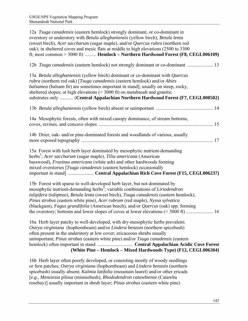
USGS-NPS Vegetation Mapping Program Shenandoah National Park
12a Tsuga canadensis (eastern hemlock) strongly dominant, or co-dominant in overstory or understory with Betula alleghaniensis (yellow birch), Betula lenta (sweet birch), Acer saccharum (sugar maple), and/or Quercus rubra (northern red oak); in sheltered coves and mesic flats at middle to high elevations (2500 to 3300 ft; most common > 3000 ft) ......... Hemlock – Northern Hardwood Forest (F8, CEGL006109)
12b Tsuga canadensis (eastern hemlock) not strongly dominant or co-dominant ..................... 13
13a Betula alleghaniensis (yellow birch) dominant or co-dominant with Quercus rubra (northern red oak) [Tsuga canadensis (eastern hemlock) and/or Abies balsamea (balsam fir) are sometimes important in stand]; usually on steep, rocky, sheltered slopes; at high elevations (> 3000 ft) on metabasalt and granitic substrates only ........... (Central Appalachian Northern Hardwood Forest (F7, CEGL008502)
13b Betula alleghaniensis (yellow birch) absent or unimportant ............................................... 14
14a Mesophytic forests, often with mixed canopy dominance, of stream bottoms, coves, ravines, and concave slopes .............................................................................................. 15
14b Drier, oak- and/or pine-dominated forests and woodlands of various, usually more exposed topography ............................................................................................................ 17
15a Forest with lush herb layer dominated by mesophytic nutrient-demanding herbs3; Acer saccharum (sugar maple), Tilia americana (American basswood), Fraxinus americana (white ash) and other hardwoods forming mixed overstories [Tsuga canadensis (eastern hemlock) occasionally important in stand] ..................... Central Appalachian Rich Cove Forest (F15, CEGL006237)
15b Forest with sparse to well-developed herb layer, but not dominated by mesophytic nutrient-demanding herbs3; variable combinations of Liriodendron tulipifera (tuliptree), Betula lenta (sweet birch), Tsuga canadensis (eastern hemlock), Pinus strobus (eastern white pine), Acer rubrum (red maple), Nyssa sylvatica (blackgum), Fagus grandifolia (American beech), and/or Quercus (oak) spp. forming the overstory; bottoms and lower slopes of coves at lower elevations (< 3000 ft) ...................... 16
16a Herb layer patchy to well-developed, with dry-mesophytic herbs prevalent; Ostrya virginiana (hophornbeam) and/or Lindera benzoin (northern spicebush) often present in the understory at low cover; ericaceous shrubs usually unimportant; Pinus strobus (eastern white pine) and/or Tsuga canadensis (eastern hemlock) often important in stand ............................. Central Appalachian Acidic Cove Forest
(White Pine – Hemlock – Mixed Hardwoods Type) (F12, CEGL006304)
16b Herb layer often poorly developed, or consisting mostly of woody seedlings or fern patches; Ostrya virginiana (hophornbeam) and Lindera benzoin (northern spicebush) usually absent; Kalmia latifolia (mountain laurel) and/or other ericads [e.g., Menziesia pilosa (minniebush), Rhododendron catawbiense (Catawba rosebay)] usually important in shrub layer; Pinus strobus (eastern white pine)
145
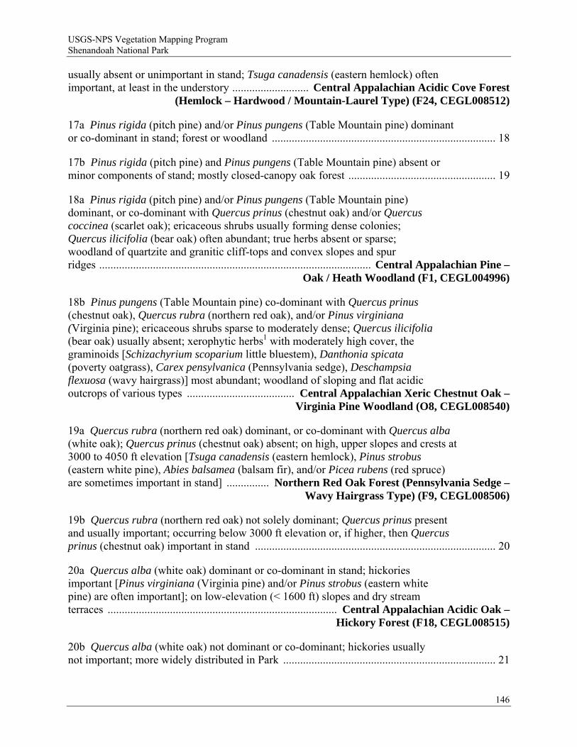
USGS-NPS Vegetation Mapping Program Shenandoah National Park
usually absent or unimportant in stand; Tsuga canadensis (eastern hemlock) often important, at least in the understory ........................... Central Appalachian Acidic Cove Forest
(Hemlock – Hardwood / Mountain-Laurel Type) (F24, CEGL008512)
17a Pinus rigida (pitch pine) and/or Pinus pungens (Table Mountain pine) dominant or co-dominant in stand; forest or woodland ............................................................................... 18
17b Pinus rigida (pitch pine) and Pinus pungens (Table Mountain pine) absent or minor components of stand; mostly closed-canopy oak forest .................................................... 19
18a Pinus rigida (pitch pine) and/or Pinus pungens (Table Mountain pine) dominant, or co-dominant with Quercus prinus (chestnut oak) and/or Quercus coccinea (scarlet oak); ericaceous shrubs usually forming dense colonies; Quercus ilicifolia (bear oak) often abundant; true herbs absent or sparse; woodland of quartzite and granitic cliff-tops and convex slopes and spur ridges ................................................................................................ Central Appalachian Pine –
Oak / Heath Woodland (F1, CEGL004996)
18b Pinus pungens (Table Mountain pine) co-dominant with Quercus prinus (chestnut oak), Quercus rubra (northern red oak), and/or Pinus virginiana (Virginia pine); ericaceous shrubs sparse to moderately dense; Quercus ilicifolia (bear oak) usually absent; xerophytic herbs1 with moderately high cover, the graminoids [Schizachyrium scoparium little bluestem), Danthonia spicata (poverty oatgrass), Carex pensylvanica (Pennsylvania sedge), Deschampsia flexuosa (wavy hairgrass)] most abundant; woodland of sloping and flat acidic outcrops of various types ...................................... Central Appalachian Xeric Chestnut Oak –
Virginia Pine Woodland (O8, CEGL008540)
19a Quercus rubra (northern red oak) dominant, or co-dominant with Quercus alba (white oak); Quercus prinus (chestnut oak) absent; on high, upper slopes and crests at 3000 to 4050 ft elevation [Tsuga canadensis (eastern hemlock), Pinus strobus (eastern white pine), Abies balsamea (balsam fir), and/or Picea rubens (red spruce) are sometimes important in stand] ............... Northern Red Oak Forest (Pennsylvania Sedge –
Wavy Hairgrass Type) (F9, CEGL008506)
19b Quercus rubra (northern red oak) not solely dominant; Quercus prinus present and usually important; occurring below 3000 ft elevation or, if higher, then Quercus prinus (chestnut oak) important in stand ..................................................................................... 20
20a Quercus alba (white oak) dominant or co-dominant in stand; hickories important [Pinus virginiana (Virginia pine) and/or Pinus strobus (eastern white pine) are often important]; on low-elevation (< 1600 ft) slopes and dry stream terraces ................................................................................. Central Appalachian Acidic Oak –
Hickory Forest (F18, CEGL008515)
20b Quercus alba (white oak) not dominant or co-dominant; hickories usually not important; more widely distributed in Park ........................................................................... 21
146
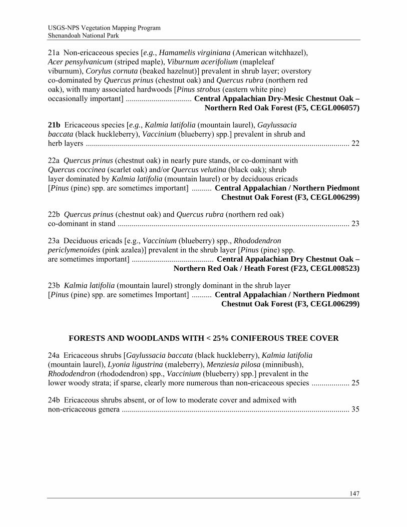
USGS-NPS Vegetation Mapping Program Shenandoah National Park
21a Non-ericaceous species [e.g., Hamamelis virginiana (American witchhazel), Acer pensylvanicum (striped maple), Viburnum acerifolium (mapleleaf viburnum), Corylus cornuta (beaked hazelnut)] prevalent in shrub layer; overstory co-dominated by Quercus prinus (chestnut oak) and Quercus rubra (northern red oak), with many associated hardwoods [Pinus strobus (eastern white pine) occasionally important] ................................. Central Appalachian Dry-Mesic Chestnut Oak –
Northern Red Oak Forest (F5, CEGL006057)
21b Ericaceous species [e.g., Kalmia latifolia (mountain laurel), Gaylussacia baccata (black huckleberry), Vaccinium (blueberry) spp.] prevalent in shrub and herb layers .................................................................................................................................... 22
22a Quercus prinus (chestnut oak) in nearly pure stands, or co-dominant with Quercus coccinea (scarlet oak) and/or Quercus velutina (black oak); shrub layer dominated by Kalmia latifolia (mountain laurel) or by deciduous ericads [Pinus (pine) spp. are sometimes important] .......... Central Appalachian / Northern Piedmont
Chestnut Oak Forest (F3, CEGL006299)
22b Quercus prinus (chestnut oak) and Quercus rubra (northern red oak) co-dominant in stand .................................................................................................................... 23
23a Deciduous ericads [e.g., Vaccinium (blueberry) spp., Rhododendron periclymenoides (pink azalea)] prevalent in the shrub layer [Pinus (pine) spp. are sometimes important] ......................................... Central Appalachian Dry Chestnut Oak –
Northern Red Oak / Heath Forest (F23, CEGL008523)
23b Kalmia latifolia (mountain laurel) strongly dominant in the shrub layer [Pinus (pine) spp. are sometimes Important] .......... Central Appalachian / Northern Piedmont
Chestnut Oak Forest (F3, CEGL006299)
FORESTS AND WOODLANDS WITH < 25% CONIFEROUS TREE COVER
24a Ericaceous shrubs [Gaylussacia baccata (black huckleberry), Kalmia latifolia (mountain laurel), Lyonia ligustrina (maleberry), Menziesia pilosa (minnibush), Rhododendron (rhododendron) spp., Vaccinium (blueberry) spp.] prevalent in the lower woody strata; if sparse, clearly more numerous than non-ericaceous species ................... 25
24b Ericaceous shrubs absent, or of low to moderate cover and admixed with non-ericaceous genera .................................................................................................................. 35
147
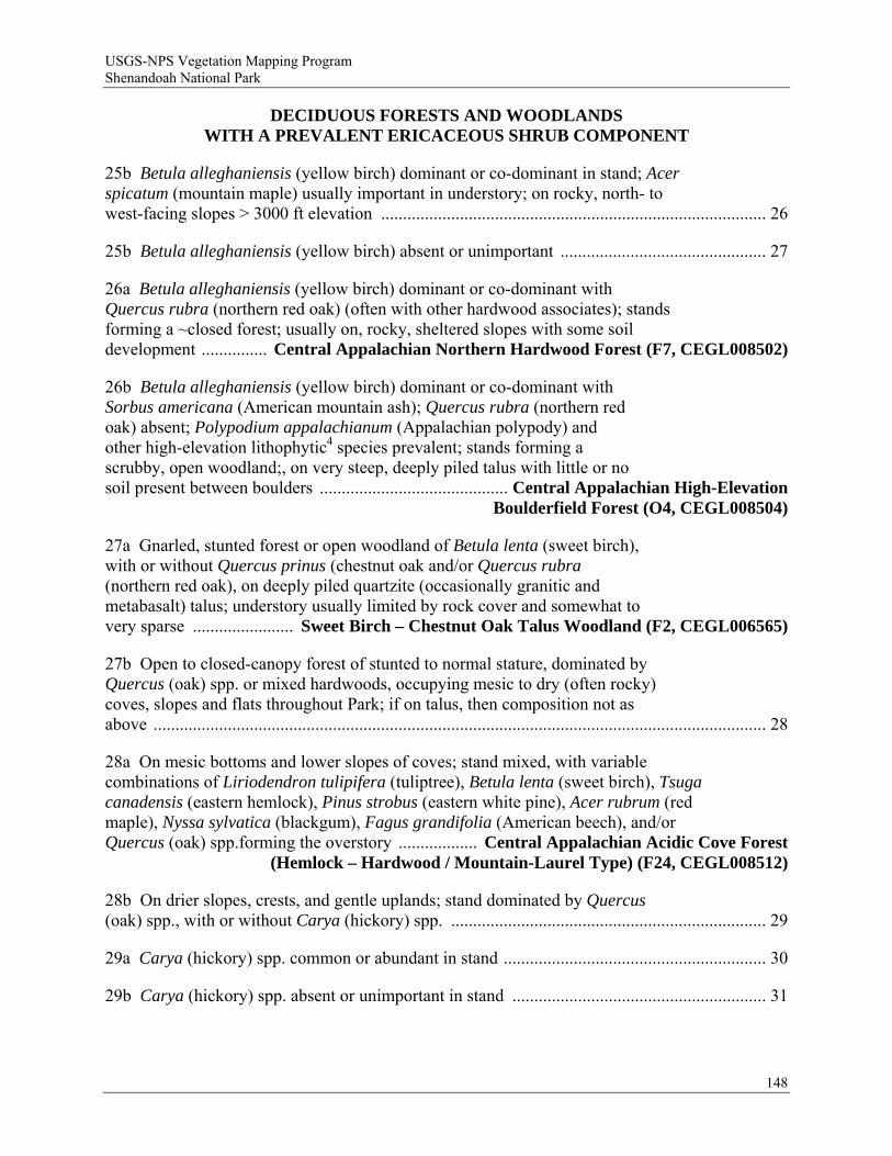
USGS-NPS Vegetation Mapping Program Shenandoah National Park
DECIDUOUS FORESTS AND WOODLANDS WITH A PREVALENT ERICACEOUS SHRUB COMPONENT
25b Betula alleghaniensis (yellow birch) dominant or co-dominant in stand; Acer spicatum (mountain maple) usually important in understory; on rocky, north- to west-facing slopes > 3000 ft elevation ........................................................................................ 26
25b Betula alleghaniensis (yellow birch) absent or unimportant ............................................... 27
26a Betula alleghaniensis (yellow birch) dominant or co-dominant with Quercus rubra (northern red oak) (often with other hardwood associates); stands forming a ~closed forest; usually on, rocky, sheltered slopes with some soil development ............... Central Appalachian Northern Hardwood Forest (F7, CEGL008502)
26b Betula alleghaniensis (yellow birch) dominant or co-dominant with Sorbus americana (American mountain ash); Quercus rubra (northern red oak) absent; Polypodium appalachianum (Appalachian polypody) and other high-elevation lithophytic4 species prevalent; stands forming a scrubby, open woodland;, on very steep, deeply piled talus with little or no soil present between boulders ........................................... Central Appalachian High-Elevation
Boulderfield Forest (O4, CEGL008504)
27a Gnarled, stunted forest or open woodland of Betula lenta (sweet birch), with or without Quercus prinus (chestnut oak and/or Quercus rubra (northern red oak), on deeply piled quartzite (occasionally granitic and metabasalt) talus; understory usually limited by rock cover and somewhat to very sparse ....................... Sweet Birch – Chestnut Oak Talus Woodland (F2, CEGL006565)
27b Open to closed-canopy forest of stunted to normal stature, dominated by Quercus (oak) spp. or mixed hardwoods, occupying mesic to dry (often rocky) coves, slopes and flats throughout Park; if on talus, then composition not as above ............................................................................................................................................ 28
28a On mesic bottoms and lower slopes of coves; stand mixed, with variable combinations of Liriodendron tulipifera (tuliptree), Betula lenta (sweet birch), Tsuga canadensis (eastern hemlock), Pinus strobus (eastern white pine), Acer rubrum (red maple), Nyssa sylvatica (blackgum), Fagus grandifolia (American beech), and/or Quercus (oak) spp.forming the overstory .................. Central Appalachian Acidic Cove Forest
(Hemlock – Hardwood / Mountain-Laurel Type) (F24, CEGL008512)
28b On drier slopes, crests, and gentle uplands; stand dominated by Quercus (oak) spp., with or without Carya (hickory) spp. ........................................................................ 29
29a Carya (hickory) spp. common or abundant in stand ............................................................ 30
29b Carya (hickory) spp. absent or unimportant in stand .......................................................... 31
148
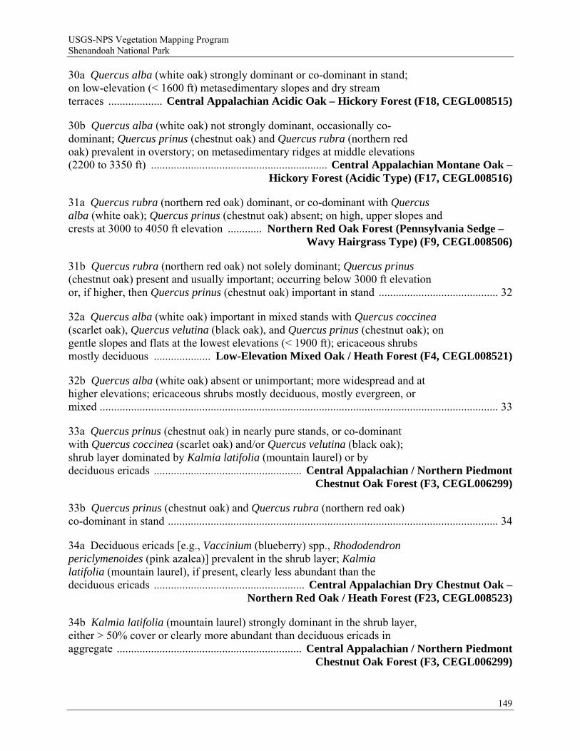
USGS-NPS Vegetation Mapping Program Shenandoah National Park
30a Quercus alba (white oak) strongly dominant or co-dominant in stand; on low-elevation (< 1600 ft) metasedimentary slopes and dry stream terraces ................... Central Appalachian Acidic Oak – Hickory Forest (F18, CEGL008515)
30b Quercus alba (white oak) not strongly dominant, occasionally co-dominant; Quercus prinus (chestnut oak) and Quercus rubra (northern red oak) prevalent in overstory; on metasedimentary ridges at middle elevations (2200 to 3350 ft) .............................................................. Central Appalachian Montane Oak –
Hickory Forest (Acidic Type) (F17, CEGL008516)
31a Quercus rubra (northern red oak) dominant, or co-dominant with Quercus alba (white oak); Quercus prinus (chestnut oak) absent; on high, upper slopes and crests at 3000 to 4050 ft elevation ............ Northern Red Oak Forest (Pennsylvania Sedge –
Wavy Hairgrass Type) (F9, CEGL008506)
31b Quercus rubra (northern red oak) not solely dominant; Quercus prinus (chestnut oak) present and usually important; occurring below 3000 ft elevation or, if higher, then Quercus prinus (chestnut oak) important in stand .......................................... 32
32a Quercus alba (white oak) important in mixed stands with Quercus coccinea (scarlet oak), Quercus velutina (black oak), and Quercus prinus (chestnut oak); on gentle slopes and flats at the lowest elevations (< 1900 ft); ericaceous shrubs mostly deciduous .................... Low-Elevation Mixed Oak / Heath Forest (F4, CEGL008521)
32b Quercus alba (white oak) absent or unimportant; more widespread and at higher elevations; ericaceous shrubs mostly deciduous, mostly evergreen, or mixed ............................................................................................................................................ 33
33a Quercus prinus (chestnut oak) in nearly pure stands, or co-dominant with Quercus coccinea (scarlet oak) and/or Quercus velutina (black oak); shrub layer dominated by Kalmia latifolia (mountain laurel) or by deciduous ericads .................................................... Central Appalachian / Northern Piedmont
Chestnut Oak Forest (F3, CEGL006299)
33b Quercus prinus (chestnut oak) and Quercus rubra (northern red oak) co-dominant in stand .................................................................................................................... 34
34a Deciduous ericads [e.g., Vaccinium (blueberry) spp., Rhododendron periclymenoides (pink azalea)] prevalent in the shrub layer; Kalmia latifolia (mountain laurel), if present, clearly less abundant than the deciduous ericads ..................................................... Central Appalachian Dry Chestnut Oak –
Northern Red Oak / Heath Forest (F23, CEGL008523)
34b Kalmia latifolia (mountain laurel) strongly dominant in the shrub layer, either > 50% cover or clearly more abundant than deciduous ericads in aggregate ................................................................. Central Appalachian / Northern Piedmont
Chestnut Oak Forest (F3, CEGL006299)
149
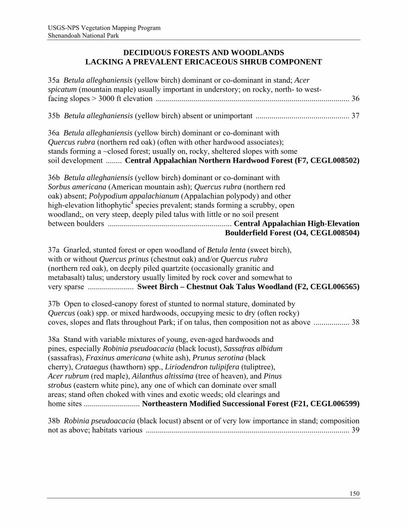
USGS-NPS Vegetation Mapping Program Shenandoah National Park
DECIDUOUS FORESTS AND WOODLANDS LACKING A PREVALENT ERICACEOUS SHRUB COMPONENT
35a Betula alleghaniensis (yellow birch) dominant or co-dominant in stand; Acer spicatum (mountain maple) usually important in understory; on rocky, north- to west-facing slopes > 3000 ft elevation ................................................................................................. 36
35b Betula alleghaniensis (yellow birch) absent or unimportant ............................................... 37
36a Betula alleghaniensis (yellow birch) dominant or co-dominant with Quercus rubra (northern red oak) (often with other hardwood associates); stands forming a ~closed forest; usually on, rocky, sheltered slopes with some soil development ........ Central Appalachian Northern Hardwood Forest (F7, CEGL008502)
36b Betula alleghaniensis (yellow birch) dominant or co-dominant with Sorbus americana (American mountain ash); Quercus rubra (northern red oak) absent; Polypodium appalachianum (Appalachian polypody) and other high-elevation lithophytic4 species prevalent; stands forming a scrubby, open woodland;, on very steep, deeply piled talus with little or no soil present between boulders .............................................................. Central Appalachian High-Elevation
Boulderfield Forest (O4, CEGL008504)
37a Gnarled, stunted forest or open woodland of Betula lenta (sweet birch), with or without Quercus prinus (chestnut oak) and/or Quercus rubra (northern red oak), on deeply piled quartzite (occasionally granitic and metabasalt) talus; understory usually limited by rock cover and somewhat to very sparse ....................... Sweet Birch – Chestnut Oak Talus Woodland (F2, CEGL006565)
37b Open to closed-canopy forest of stunted to normal stature, dominated by Quercus (oak) spp. or mixed hardwoods, occupying mesic to dry (often rocky) coves, slopes and flats throughout Park; if on talus, then composition not as above .................. 38
38a Stand with variable mixtures of young, even-aged hardwoods and pines, especially Robinia pseudoacacia (black locust), Sassafras albidum (sassafras), Fraxinus americana (white ash), Prunus serotina (black cherry), Crataegus (hawthorn) spp., Liriodendron tulipifera (tuliptree), Acer rubrum (red maple), Ailanthus altissima (tree of heaven), and Pinus strobus (eastern white pine), any one of which can dominate over small areas; stand often choked with vines and exotic weeds; old clearings and home sites ............................ Northeastern Modified Successional Forest (F21, CEGL006599)
38b Robinia pseudoacacia (black locust) absent or of very low importance in stand; composition not as above; habitats various ...................................................................................................... 39
150

USGS-NPS Vegetation Mapping Program Shenandoah National Park
39a Liriodendron tulipifera (tuliptree) dominant in a monospecific, even-aged stand; herb layer often weedy and dominated by exotic species [e.g., Alliaria petiolata (garlic mustard), Polygonum caespitosum (oriental ladysthumb); early-successional forest of formerly cleared coves, ravines, and fertile slopes, mostly below 2,600 ft elevation .............. Successional Tuliptree Forest (Circumneutral Type) (F13, CEGL007220)
39b Overstory more mixed and/or uneven-aged; later-successional forest; habitats various ............................................................................................................................ 40
40a Forest with lush herb layer dominated by mesophytic nutrient-demanding herbs3 ......................................................................................................................... 41
40b Forest with sparse to well-developed herb layer, but not dominated by mesophytic nutrient-demanding herbs3 ........................................................................................ 44
41a Forest (sometimes very open) on deeply piled metabasalt or granitic talus with ample interstitial soil development; surface cover of boulders and stones usually > 50%; overstory dominated by Fraxinus americana (white ash)and/or Tilia americana (American basswood), often with Quercus rubra (northern red oak), Carya (hickory)spp. and Betula lenta (sweet birch); Ostrya virginiana (hophornbeam) and/or Acer pensylvanicum (striped maple) important in understory; scrambling lianas [Parthenocissus quinquefolia (Virginia creeper), Toxicodendron radicans (eastern poison ivy), Vitis (grape) spp.] often abundant; mesophytic nutrient-demanding herbs3 characteristic but often somewhat limited by the rock substrate ....................... Central Appalachian Basic Boulderfield Forest (F14, CEGL008528)
41b Forests of various habitats, often rocky but not of deeply piled talus; surface cover of loose rocks usually < 50%; woody composition not as above; cover of mesophytic nutrient-demanding herbs3 usually more continuous ............................................... 42
42a Forest of middle to upper slopes and gentle crests, mostly above 2500 ft elevation; Quercus rubra (northern red oak) dominant, or co-dominant with Quercus alba (white oak), Carya (hickory) spp., and/or Fraxinus americana (white ash) ........................................................................ Central Appalachian Montane Oak –
Hickory Forest (Basic Type) (F16, CEGL008518)
42b Forest of middle to lower, often concave slopes, ravines, and coves; mesophytic trees e.g., Liriodendron tulipifera (tuliptree), Tilia americana (American basswood), Acer saccharum (sugar maple), Fraxinus americana (white ash)] dominant .................................................................................................................. 43
43a Acer saccharum (sugar maple) important in the overstory, or abundant in the understory .................................. Central Appalachian Rich Cove Forest (F15, CEGL006237)
43b Acer saccharum (sugar maple) absent, or sparse in understory only ........................... Southern Appalachian Cove Forest (Typic Type) (F10, CEGL007710)
151
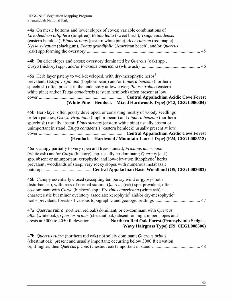
USGS-NPS Vegetation Mapping Program Shenandoah National Park
44a On mesic bottoms and lower slopes of coves; variable combinations of Liriodendron tulipifera (tuliptree), Betula lenta (sweet birch), Tsuga canadensis (eastern hemlock), Pinus strobus (eastern white pine), Acer rubrum (red maple), Nyssa sylvatica (blackgum), Fagus grandifolia (American beech), and/or Quercus (oak) spp.forming the overstory ................................................................................................... 45
44b On drier slopes and crests; overstory dominated by Quercus (oak) spp., Carya (hickory) spp., and/or Fraxinus americana (white ash) ................................................... 46
45a Herb layer patchy to well-developed, with dry-mesophytic herbs2 prevalent; Ostrya virginiana (hophornbeam) and/or Lindera benzoin (northern spicebush) often present in the understory at low cover; Pinus strobus (eastern white pine) and/or Tsuga canadensis (eastern hemlock) often present at low cover ........................................................................... Central Appalachian Acidic Cove Forest
(White Pine – Hemlock – Mixed Hardwoods Type) (F12, CEGL006304)
45b Herb layer often poorly developed, or consisting mostly of woody seedlings or fern patches; Ostrya virginiana (hophornbeam) and Lindera benzoin (northern spicebush) usually absent; Pinus strobus (eastern white pine) usually absent or unimportant in stand; Tsuga canadensis (eastern hemlock) usually present at low cover ........................................................................... Central Appalachian Acidic Cove Forest
(Hemlock – Hardwood / Mountain-Laurel Type) (F24, CEGL008512)
46a Canopy partially to very open and trees stunted; Fraxinus americana (white ash) and/or Carya (hickory) spp. usually co-dominant; Quercus (oak) spp. absent or unimportant; xerophytic1 and low-elevation lithophytic5 herbs prevalent; woodlands of steep, very rocky slopes with numerous metabasalt outcrops ......................................... Central Appalachian Basic Woodland (O5, CEGL003683)
46b Canopy essentially closed (excepting temporary wind or gypsy-moth disturbances), with trees of normal stature; Quercus (oak) spp. prevalent, often co-dominant with Carya (hickory) spp.; Fraxinus americana (white ash) a characteristic but minor overstory associate; xerophytic1 and/or dry-mesophytic2 herbs prevalent; forests of various topographic and geologic setttings ....................................... 47
47a Quercus rubra (northern red oak) dominant, or co-dominant with Quercus alba (white oak); Quercus prinus (chestnut oak) absent; on high, upper slopes and crests at 3000 to 4050 ft elevation ............... Northern Red Oak Forest (Pennsylvania Sedge –
Wavy Hairgrass Type) (F9, CEGL008506)
47b Quercus rubra (northern red oak) not solely dominant; Quercus prinus (chestnut oak) present and usually important; occurring below 3000 ft elevation or, if higher, then Quercus prinus (chestnut oak) important in stand .......................................... 48
152
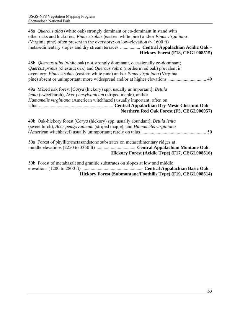
USGS-NPS Vegetation Mapping Program Shenandoah National Park
48a Quercus alba (white oak) strongly dominant or co-dominant in stand with other oaks and hickories; Pinus strobus (eastern white pine) and/or Pinus virginiana (Virginia pine) often present in the overstory; on low-elevation (< 1600 ft) metasedimentary slopes and dry stream terraces ................. Central Appalachian Acidic Oak –
Hickory Forest (F18, CEGL008515)
48b Quercus alba (white oak) not strongly dominant, occasionally co-dominant; Quercus prinus (chestnut oak) and Quercus rubra (northern red oak) prevalent in overstory; Pinus strobus (eastern white pine) and/or Pinus virginiana (Virginia pine) absent or unimportant; more widespread and/or at higher elevations ................................ 49
49a Mixed oak forest [Carya (hickory) spp. usually unimportant]; Betula lenta (sweet birch), Acer pensylvanicum (striped maple), and/or Hamamelis virginiana (American witchhazel) usually important; often on talus ............................................................... Central Appalachian Dry-Mesic Chestnut Oak –
Northern Red Oak Forest (F5, CEGL006057)
49b Oak-hickory forest [Carya (hickory) spp. usually abundant]; Betula lenta (sweet birch), Acer pensylvanicum (striped maple), and Hamamelis virginiana (American witchhazel) usually unimportant; rarely on talus ....................................................... 50
50a Forest of phyllite/metasandstone substrates on metasedimentary ridges at middle elevations (2250 to 3350 ft) ................................. Central Appalachian Montane Oak –
Hickory Forest (Acidic Type) (F17, CEGL008516)
50b Forest of metabasalt and granitic substrates on slopes at low and middle elevations (1200 to 2800 ft) ................................................... Central Appalachian Basic Oak –
Hickory Forest (Submontane/Foothills Type) (F19, CEGL008514)
153
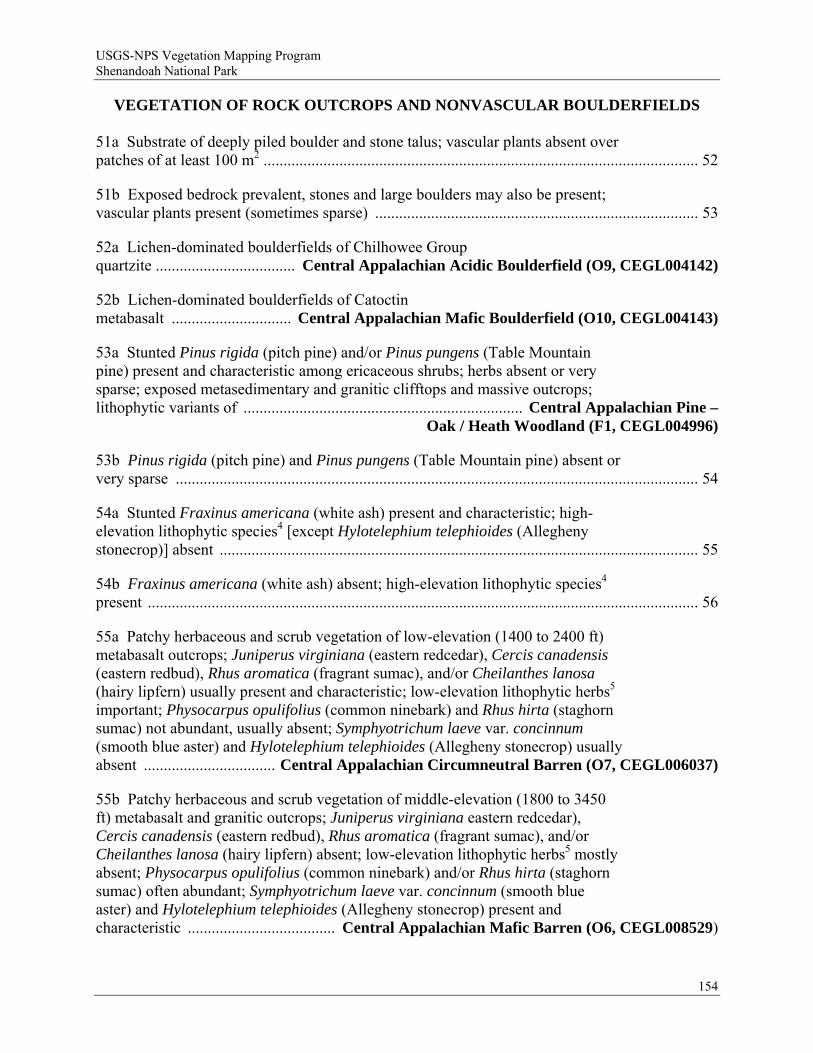
USGS-NPS Vegetation Mapping Program Shenandoah National Park
VEGETATION OF ROCK OUTCROPS AND NONVASCULAR BOULDERFIELDS 51a Substrate of deeply piled boulder and stone talus; vascular plants absent over patches of at least 100 m2 ............................................................................................................. 52
51b Exposed bedrock prevalent, stones and large boulders may also be present; vascular plants present (sometimes sparse) ................................................................................. 53
52a Lichen-dominated boulderfields of Chilhowee Group quartzite ................................... Central Appalachian Acidic Boulderfield (O9, CEGL004142)
52b Lichen-dominated boulderfields of Catoctin metabasalt .............................. Central Appalachian Mafic Boulderfield (O10, CEGL004143)
53a Stunted Pinus rigida (pitch pine) and/or Pinus pungens (Table Mountain pine) present and characteristic among ericaceous shrubs; herbs absent or very sparse; exposed metasedimentary and granitic clifftops and massive outcrops; lithophytic variants of ...................................................................... Central Appalachian Pine –
Oak / Heath Woodland (F1, CEGL004996)
53b Pinus rigida (pitch pine) and Pinus pungens (Table Mountain pine) absent or very sparse ................................................................................................................................... 54
54a Stunted Fraxinus americana (white ash) present and characteristic; high-elevation lithophytic species4 [except Hylotelephium telephioides (Allegheny stonecrop)] absent ........................................................................................................................ 55
54b Fraxinus americana (white ash) absent; high-elevation lithophytic species4 present .......................................................................................................................................... 56
55a Patchy herbaceous and scrub vegetation of low-elevation (1400 to 2400 ft) metabasalt outcrops; Juniperus virginiana (eastern redcedar), Cercis canadensis (eastern redbud), Rhus aromatica (fragrant sumac), and/or Cheilanthes lanosa (hairy lipfern) usually present and characteristic; low-elevation lithophytic herbs5 important; Physocarpus opulifolius (common ninebark) and Rhus hirta (staghorn sumac) not abundant, usually absent; Symphyotrichum laeve var. concinnum (smooth blue aster) and Hylotelephium telephioides (Allegheny stonecrop) usually absent ................................. Central Appalachian Circumneutral Barren (O7, CEGL006037)
55b Patchy herbaceous and scrub vegetation of middle-elevation (1800 to 3450 ft) metabasalt and granitic outcrops; Juniperus virginiana eastern redcedar), Cercis canadensis (eastern redbud), Rhus aromatica (fragrant sumac), and/or Cheilanthes lanosa (hairy lipfern) absent; low-elevation lithophytic herbs5 mostly absent; Physocarpus opulifolius (common ninebark) and/or Rhus hirta (staghorn sumac) often abundant; Symphyotrichum laeve var. concinnum (smooth blue aster) and Hylotelephium telephioides (Allegheny stonecrop) present and characteristic ..................................... Central Appalachian Mafic Barren (O6, CEGL008529)
154
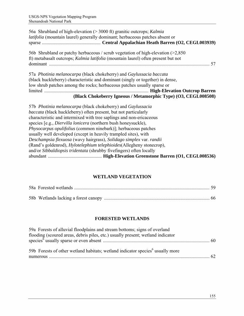
USGS-NPS Vegetation Mapping Program Shenandoah National Park
56a Shrubland of high-elevation (> 3000 ft) granitic outcrops; Kalmia latifolia (mountain laurel) generally dominant; herbaceous patches absent or sparse ................................................. Central Appalachian Heath Barren (O2, CEGL003939)
56b Shrubland or patchy herbaceous / scrub vegetation of high-elevation (>2,850 ft) metabasalt outcrops; Kalmia latifolia (mountain laurel) often present but not dominant ...................................................................................................................................... 57
57a Photinia melanocarpa (black chokeberry) and Gaylussacia baccata (black huckleberry) characteristic and dominant (singly or together) in dense, low shrub patches among the rocks; herbaceous patches usually sparse or limited ....................................................................................... High-Elevation Outcrop Barren
(Black Chokeberry Igneous / Metamorphic Type) (O3, CEGL008508)
57b Photinia melanocarpa (black chokeberry) and Gaylussacia baccata (black huckleberry) often present, but not particularly characteristic and intermixed with tree saplings and non-ericaceous species [e.g., Diervilla lonicera (northern bush honeysuckle), Physocarpus opulifolius (common ninebark)]; herbaceous patches usually well developed (except in heavily trampled sites), with Deschampsia flexuosa (wavy hairgrass), Solidago simplex var. randii (Rand’s goldenrod), Hylotelephium telephioides(Allegheny stonecrop), and/or Sibbaldiopsis tridentata (shrubby fivefingers) often locally abundant ............................................. High-Elevation Greenstone Barren (O1, CEGL008536)
WETLAND VEGETATION 58a Forested wetlands ................................................................................................................. 59
58b Wetlands lacking a forest canopy ........................................................................................ 66
FORESTED WETLANDS 59a Forests of alluvial floodplains and stream bottoms; signs of overland flooding (scoured areas, debris piles, etc.) usually present; wetland indicator species6 usually sparse or even absent ......................................................................................... 60
59b Forests of other wetland habitats; wetland indicator species6 usually more numerous ...................................................................................................................................... 62
155
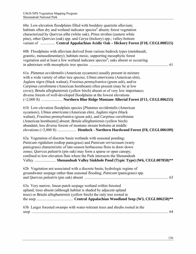
USGS-NPS Vegetation Mapping Program Shenandoah National Park
60a Low-elevation floodplains filled with bouldery quartzite alluvium; habitats often dry and wetland indicator species6 absent; forest vegetation characterized by Quercus alba (white oak), Pinus strobus (eastern white pine), other Quercus (oak) spp. and Carya (hickory) spp.; valley-bottom variant of ............... Central Appalachian Acidic Oak – Hickory Forest (F18, CEGL008515)
60b Floodplains with alluvium derived from various bedrock types (metabasalt, granitic, metasedimentary); habitats mesic, supporting mesophytic forest vegetation and at least a few wetland indicator species6; oaks absent or occurring in admixture with mesophytic tree species .................................................................................. 61
61a Platanus occidentalis (American sycamore) usually present in mixture with a wide variety of other tree species; Ulmus americana (American elm), Juglans nigra (black walnut), Fraxinus pennsylvanica (green ash), and/or Carpinus caroliniana (American hornbeam) often present (may be at low cover); Betula alleghaniensis (yellow birch) absent or of very low importance; diverse forests of well-developed floodplains at the lowest elevations (<2,000 ft) ...................... Northern Blue Ridge Montane Alluvial Forest (F11, CEGL006255)
61b Low-elevation floodplain species [Platanus occidentalis (American sycamore), Ulmus americana (American elm), Juglans nigra (black walnut), Fraxinus pennsylvanica (green ash), and Carpinus caroliniana (American hornbeam)] absent; Betula alleghaniensis (yellow birch) abundant; less diverse forests of montane stream bottoms at middle elevations (>2,000 ft) ................... Hemlock - Northern Hardwood Forest (F8, CEGL006109)
62a Vegetation of discrete basin wetlands with seasonal ponding; Panicum rigidulum (redtop panicgrass) and Panicum verrucosum (warty panicgrass) characteristic of late-season herbaceous flora in draw-down zones; Quercus palustris (pin oak) may form a sparse or open canopy; confined to low-elevation flats where the Park intersects the Shenandoah Valley ...................... Shenandoah Valley Sinkhole Pond (Typic Type) (W6, CEGL007858)**
62b Vegetation not associated with a discrete basin; hydrologic regime of groundwater seepage rather than seasonal flooding; Panicum (panicgrass) spp. and Quercus palustris (pin oak) absent ....................................................................................... 63
63a Very narrow, linear-patch seepage wetland within forested upland; trees absent (although habitat is shaded by adjacent upland trees) or Betula alleghaniensis (yellow birch) the only tree rooted in the seep ...................................... Central Appalachian Woodland Seep (W3, CEGL006258)**
63b Larger forested swamps with water-tolerant trees and shrubs rooted in the seep .............................................................................................................................................. 64
156

USGS-NPS Vegetation Mapping Program Shenandoah National Park
64a Tsuga canadensis (eastern hemlock) and Fraxinus (ash) spp. absent; Nyssa sylvatica (blackgum) abundant; Vaccinium corymbosum (highbush blueberry) and/or Vaccinium fuscatum (black highbush blueberry) present and characteristic; sphagnous swamps on metasedimentary substrates at very low elevations (<1,800 ft) .................... Central Appalachian Acidic Seepage Swamp (W2, CEGL007853)**
64b Tsuga canadensis (eastern hemlock) and/or Fraxinus (ash) spp. often common or abundant; Nyssa sylvatica (blackgum) usually absent; Vaccinium corymbosum (highbush blueberry) and Vaccinium fuscatum (black highbush blueberry) absent; swamps on metabasalt and granitic substrates at low to middle elevations (1,400 to 3,400 ft) ....................................................................................................... 65
65a Tsuga canadensis (eastern hemlock) absent or present; Fraxinus nigra (black ash) often important in the overstory and/or understory; Pinus strobus (eastern white pine), Kalmia latifolia (mountain laurel) and Ilex montana (mountain holly) generally absent; Carex bromoides (bromelike sedge), Carex prasina (drooping sedge), Deparia acrostichoides (silver false spleenwort), and Glyceria striata (fowl mannagrass) usually present and characteristic; Osmunda cinnamomea (cinnamon fern) and Glyceria melicaria (melic mannagrass) not abundant ......................... Central Appalachian Basic Seepage Swamp (W4, CEGL008416)**
65b Tsuga canadensis (eastern hemlock) often characteristic in overstory (formerly abundant prior to adelgid outbreaks); Fraxinus nigra (black ash) absent or unimportant; Pinus strobus (eastern white pine), Kalmia latifolia (mountain laurel) and Ilex montana (mountain holly) often present; Carex bromoides (bromelike sedge), Carex prasina (drooping sedge), Deparia acrostichoides (silver false spleenwort), and Glyceria striata (fowl mannagrass) absent or unimportant; Osmunda cinnamomea (cinnamon fern) and Glyceria melicaria (melic mannagrass) usually abundant ................................................. High-Elevation Hemlock -
Yellow Birch Seepage Swamp (W5, CEGL008533)**
NON-FORESTED WETLANDS 66a Herbaceous vegetation of discrete basin wetlands with seasonal ponding; Panicum rigidulum (redtop panicgrass) and Panicum verrucosum ( warty panicgrass) characteristic of late-season herbaceous flora in draw-down zones; Quercus palustris (pin oak) and/or shrubs may occur on the periphery; confined to low-elevation flats where the Park intersects the Shenandoah Valley ...................... Shenandoah Valley Sinkhole Pond (Typic Type) (W6, CEGL007858)**
66b Vegetation not associated with a descrete basin; hydrologic regime of groundwater seepage rather than seasonal flooding; Panicum (panicgrass) spp. And Quercus palustris (pin oak) absent ..................................................................................... 67
157
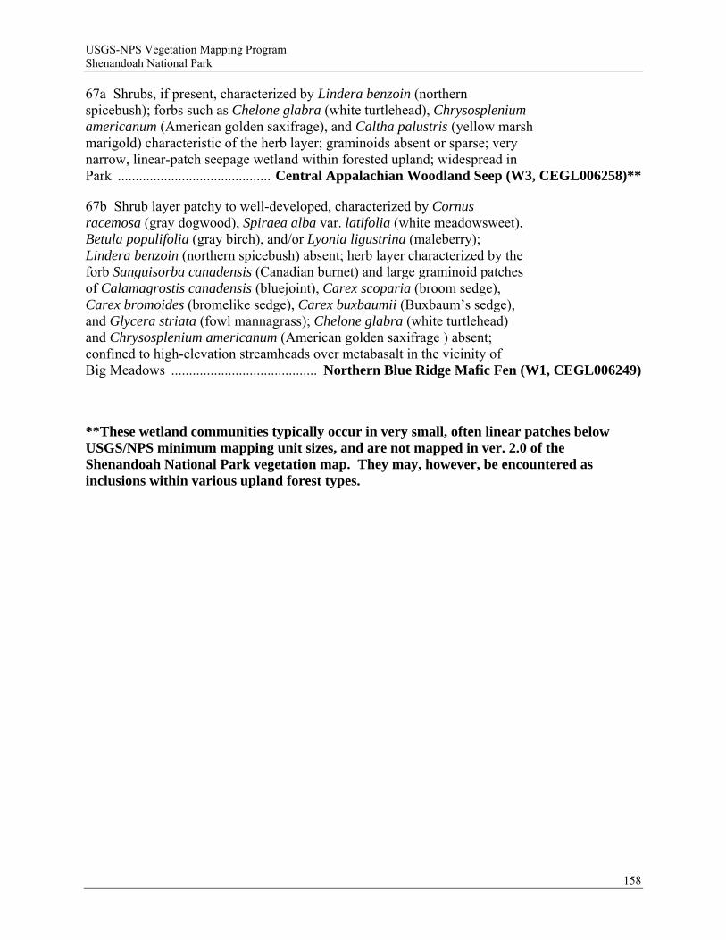
USGS-NPS Vegetation Mapping Program Shenandoah National Park
158
67a Shrubs, if present, characterized by Lindera benzoin (northern spicebush); forbs such as Chelone glabra (white turtlehead), Chrysosplenium americanum (American golden saxifrage), and Caltha palustris (yellow marsh marigold) characteristic of the herb layer; graminoids absent or sparse; very narrow, linear-patch seepage wetland within forested upland; widespread in Park ........................................... Central Appalachian Woodland Seep (W3, CEGL006258)**
67b Shrub layer patchy to well-developed, characterized by Cornus racemosa (gray dogwood), Spiraea alba var. latifolia (white meadowsweet), Betula populifolia (gray birch), and/or Lyonia ligustrina (maleberry); Lindera benzoin (northern spicebush) absent; herb layer characterized by the forb Sanguisorba canadensis (Canadian burnet) and large graminoid patches of Calamagrostis canadensis (bluejoint), Carex scoparia (broom sedge), Carex bromoides (bromelike sedge), Carex buxbaumii (Buxbaum’s sedge), and Glycera striata (fowl mannagrass); Chelone glabra (white turtlehead) and Chrysosplenium americanum (American golden saxifrage ) absent; confined to high-elevation streamheads over metabasalt in the vicinity of Big Meadows ......................................... Northern Blue Ridge Mafic Fen (W1, CEGL006249)
**These wetland communities typically occur in very small, often linear patches below USGS/NPS minimum mapping unit sizes, and are not mapped in ver. 2.0 of the Shenandoah National Park vegetation map. They may, however, be encountered as inclusions within various upland forest types.

USGS-NPS Vegetation Mapping Program Shenandoah National Park
Appendix D. Accuracy assessment procedures and results.
Purpose and Description of Accuracy Assessment
The purpose of the accuracy assessment is to assess the reliability of the map by identifying representative sites of sufficient, but manageable, size within each remotely-sensed/modeled vegetation map class and independently assessing the vegetation class identity of these sites by field observation. Matches between map class and field call identities for an individual site are considered “correctly” mapped sites. They indicate a correspondence between the mapper’s interpretation and a competent field observer’s interpretation of vegetation class.
A representative sample of multiple sites is selected and visited in order to derive a point estimate and confidence interval of map class accuracy (or reliability) for each map class and also to indicate patterns of frequent confusion between map classes, for sites that lack correspondence between the mapper’s assertion of class and a field observer’s assertion of class. User’s and producer’s (Environmental Systems Research Institute et al. 1994) accuracies are calculated for each class to inform the user as to whether individual error patterns involve commission, omission, or both.
Accuracy Assessment Methods
The accuracy assessment methods and analyses for Shenandoah National Park (SHEN) vegetation mapping followed the current National Park Service program standards (Environmental Systems Research Institute et al. 1994).
Accuracy Assessment Site Selection:
Three modifications were made to adapt the standards to the SHEN project:
(1) We modified the number of accuracy assessment (AA) sites to be allocated to each map class (Table 6 of Section 8.2.1.2 of Environmental Systems Research Institute et al. (1994)). We allocated 30 accuracy assessment (AA) sites (sample units) to each map class that occupied more than 50 hectares in total area (scenario “A” of Table 6). A site is a specific location (point) defined by a set of x (easting) and y (northing) coordinates. For map classes with 50 hectares or less of total area, we allocated AA sites equal to the total map class area (in hectares) divided by 1.67. This formula allocates sites (sample units) per map class at the same ratio as the 30 site per 50 hectares requirement (Environmental Systems Research Institute et al. 1994). The map class area was calculated prior to buffering for field positioning error although the buffered areas of a map class were not considered for site placement. Buffering for field positioning error, means that land area near the edge of each polygon is not available for AA site placement. This ensures that when AA sites are located using GPS in the field that the entire AA site will fall within the correct polygon, even if the site center point falls at the edge of the area available for AA site placement, and/or there is GPS error. In the cases of very small map classes, the entire polygon was available for accuracy assessment site placement, however the requirement of sampling without replacement was used, and the AA crew was instructed on how to orient their plot (s) to fit within the polygon being assessed. This allowed observers to keep individual AA site observations independent. In some cases the mapped area for a particular map class were
159
USGS-NPS Vegetation Mapping Program Shenandoah National Park
fragmented into greater than 30 polygons. In such cases we did not allocate additional sites to some map classes in order to account for the fragmentation (eg, less than 50 hectares total area, but more than 30 polygons – scenario “B” of Table 6).
(2) We used a 0.5 hectare observation area (usually a circular plot, 40 meters in radius), centered around each AA site (point) for large patch or matrix-forming map classes (Table 1). For small patch and linear map classes, a 0.25 hectare observation area (usually a circular plot, 30 meters in radius) was used (Table 1). The area reduction from the normative 0.5 hectare observation area (Environmental Systems Research Institute et al. 1994) was necessary in order to accommodate multiple AA observation plots within stands mapped as small or narrow polygons. It was also justified because it is often desirable for the minimum mapping unit to vary in size by class (Environmental Systems Research Institute et al. 1994). Finally, the vegetation representing most of these map classes are primarily nonvascular and herbaceous vegetation, in which smaller observation areas can capture an adequate number of attributes to establish class (vegetation type).
(3) We did not use the polygon level stratification suggested by in Figure (Table 6 of Section 8.2.1.2 of Environmental Systems Research Institute et al. 1994). AA sites were allocated by simple random sampling within each map class (as reduced due to buffering for access and field positioning error – see below).
160

USGS-NPS Vegetation Mapping Program Shenandoah National Park
Table D1. Accuracy Assessment observation area size and results of access buffer application for individual SHEN map classes.
Vegetation Identifier
Map Class
Map Class Observation Area Size (hectares)
Map Class Access Buffer
in meters 1
Percentile of Map Class
Considered 2 CEGL002591 122 0.25 300 51.1% CEGL008536 301 0.25 250 88.1% CEGL003939 302 0.25 250 92.4% CEGL008508 303 0.25 250 100.0% CEGL008504 304 0.25 250 100.0% CEGL003683 305 0.25 250 100.0% CEGL008529 306 0.25 300 68.1% CEGL006037 307 0.25 250 72.0% CEGL008540 308 0.25 300 77.7% CEGL004142 309 0.25 250 65.8% CEGL004143 310 0.25 300 62.5% CEGL006249 401 0.25 250 100.0%
n.a. 992 0.25 250 81.2% CEGL008502 107 0.50 250 71.6% CEGL006255 111 0.50 250 87.9% CEGL004996 101 0.50 250 68.4% CEGL006565 102 0.50 300 52.6% CEGL006299 103 0.50 250 51.5% CEGL008521 104 0.50 300 53.7% CEGL006057 105 0.50 300 56.4% CEGL006109 108 0.50 300 55.5% CEGL008506 109 0.50 250 76.7% CEGL007710 110 0.50 250 76.8% CEGL006304 112 0.50 300 58.5% CEGL007220 113 0.50 250 65.5% CEGL008528 114 0.50 250 53.5% CEGL006237 115 0.50 250 51.0% CEGL008518 116 0.50 250 54.4% CEGL008516 117 0.50 250 63.1% CEGL008515 118 0.50 250 75.0% CEGL008514 119 0.50 250 53.2% CEGL006599 121 0.50 250 56.0% CEGL008523 123 0.50 250 63.3% CEGL008512 124 0.50 300 57.9%
n.a. 991 0.50 250 63.1% 1 Buffer distance from road or trail that was applied to the map class to constrain sampling to more accessible areas. 2 Resulting percentile of entire map class area at SHEN that was considered for sampling, using the buffer distance applied (250 or 300 meters).
161
USGS-NPS Vegetation Mapping Program Shenandoah National Park
To prepare the mapping units (polygons) for site selection:
First, the raster file representing the vegetation map was converted to a polygon (shape) file, suitable for geoprocessing and buffering.
To calculate the number of sites for each map class:
(1) Using ArcView ® 3.2 ((Environmental Systems Research Institute 1991), we measured the total area of each map class, by summing all individual polygon areas. (2) We assigned 30 AA sites per 1.67 hectares of the map class total area, up to a maximum allocation of 30 AA plots per map class. We assigned numbers of AA sites per map class on the basis of total map class area (we did not subtract the areas within each map class that was subsequently eliminated from consideration for site assignments, due to the needs of (1) buffering for field navigation/positioning error and of (2) access convenience (see below)).
We used ArcView ® 3.2 geoprocessing wizard to prepare the sampling population for each map class, as follows:
Cost surface (access buffer): Although about 98% of the area of SHEN is within 600 meters of a road or a trail, road and trail travel is often time-consuming due to the size and length of the park, and off-trail travel is often arduous and time-consuming due to steep and rocky slopes and thick vegetation. In order to collect a sufficient sample size within a field season at reasonable cost, areas to be considered for sampling were limited to more accessible sites. Prior experience indicated that restricting travel to within 250 meters of a road or trail would allow reasonable progress (approximately, 8 sites per field team per day). However, for purposes of map class representativeness, we also wanted to ensure that our sampling population covered a reasonably large percentage of each map class and also that no individual map classes were underrepresented. Vegetation types that typically occur on steep middle slopes would tend to occur away from where roads and trails are routed, whereas some vegetation types tend to occur along routes selected for trail access (eg, riparian vegetation) or road access (eg, high elevation vegetation near the Skyline Drive).
(1) Using the roads and trails line theme from the NPS database for SHEN [http://www.nps.gov/gis], we created a buffer theme consisting of 12 progressively more remote areas buffered from any road or trail, with buffers in increments of 50 meter distances. This produced a polygon theme with map classes consisting of areas within 50 meters of a road or trail, from 50 to 100 meters from a road or trail, from 100 to 150 meters from a road or trail, etc., up to from 550 to 600 meters from a road or trail. (2) We created a union of this theme and the vegetation theme, so that each vegetation map class was divided into 12 classes, each represented that portion that occurred within each 50 meter buffer increments, and a 13th class that represented that portion that was more remote than 600 meters (600 to 2000 meters) from a road or trail. This theme had fields of buffer distance and vegetation type (map class).
162

USGS-NPS Vegetation Mapping Program Shenandoah National Park
(3) We imported the attribute (.dbf) table from this union theme into Microsoft Excel®. We created a pivot table of the buffer distance class membership (in columns) against the vegetation class membership (in rows), and the cell values the sum of the total map areas for each combination of these vegetation classes and buffer distance classes. The cell values were first converted to a percentage of the [row] total for each vegetation class. These percentages were converted to cumulative percentiles (beginning with buffer distance class of 0 to 50 meters) of the vegetation class that occurred within each buffer distance class or all less remote buffer distance classes. (4) In order to ensure that, minimally, the most accessible 50th percentile of each vegetation map class would be included in the sampling population, we found that a 250 meter buffer would satisfy this condition for 29 of the 35 vegetation map classes and that a 300 meter buffer would satisfy this condition for the other six vegetation map classes. We designated a 300 meter buffer to be used to constrain sampling for these six classes plus four additional classes that were limited in overall area and would be further reduced in area by edge buffering. Most of these classes represented small patch types that, in total, would receive a very small proportion of all AA sites. A 250 meter buffer was designated for all other (25) vegetation map classes. The percentiles considered for each vegetation map class ranged from 51% to 100% (Table 1). Approximately 56% of the area of SHEN occurs within 250 meters of a road or a trail, while about 65% occurs within 300 meters of at least one of these features.
A minimum buffer distance from the edge of all polygons is needed in order to ensure that global positioning system (GPS) navigation and positional recording area does not create uncertainty about the map class membership of individual AA sites.
(1) We created a 40 meter buffer inside the boundary of all polygons. (2) We created a union theme of the original map classes and this buffer theme. (3) We selected the portions of all polygons that were within the 40 meter buffer and deleted them from this union theme. The result of this geoprocessing step was a polygon theme (sampling population) that was comprised of the interiors of all polygons (all areas more than 40 meters from a boundary with a different map class). This buffer was to be applied to all map classes of sufficient abundance, and with polygons of sufficient size to be observed in the field at the scale of 0.5 hectare. (4) We repeated the above process using a 30 meter buffer. The result of this geoprocessing step was a polygon theme (sampling population) that was comprised of the interiors of all polygons (all areas more than 30 meters from a boundary with a different map class). This buffer was to be applied to all map classes to be observed in the field at the scale of 0.25 hectare. This narrower 30 meter buffer was required to allow AA sampling in map classes represented by polygons too small or narrow to be observed at the 0.5 hectare level.
163
USGS-NPS Vegetation Mapping Program Shenandoah National Park
To apply the appropriate access buffer to these edge buffer themes:
We created (1) a buffer theme of all SHEN areas within 300 meters of any road or trail and (2) a buffer theme of all SHEN areas within 250 meters of any road or trail.
To create the final inference area (sampling population) for each individual vegetation map class:
We used the intersection (geoprocessing) command was used with each combination of the two road/trail access buffer themes (250 meters and 300 meters) with each vegetation polygon edge buffer theme (30 meters and 40 meters) to create four themes representing the sampling population to be applied to the vegetation map classes. The third and fourth columns of Table 1 list which combination of access and polygon edge buffer distance was used for each map class.
To select individual AA sites from the map:
(1) Using the appropriate inference area for each map class (Table 1), individual AA sites (plot centers) were located by allocating the specified number of points for each map class to the modified union theme derived from the operations above, using the “Select Random Features” function in the National Park Service Alaskapak tools package for ArcView® 3.2 (National Park Service 2002). This achieves the method of simple random sampling within each map class, which is appropriate for the statistical analysis of Environmental Systems Research Institute et al. (1994). (2) When two or more AA sites were near enough to one another to produce overlapping observation areas (ie, within 80 meters of one another for classes to be observed at the 0.5 hectare scale or within 60 meters of one another for classes to be observed at the 0.25 hectare scale), one site at a time was selected randomly (using the random numbers function in Microsoft® Excel) and deleted. A replacement site was generated for each site so deleted, using the “Select Random Features” function (as above). If the replacement site were near enough to a previously located site, so as to produce overlapping observation areas (as above), it was rejected, and the process repeated, until either (1) the full complement of sites for the map class was assigned or (2) it was determined that the map class was saturated (could accommodate no more sites without observation area overlap between one or more AA plots).
Accuracy Assessment Field Methods:
We employed three teams (of one to two persons) to conduct the accuracy assessment. At least one person on each team was required to be familiar with all plant species mentioned in the field key and similar species (potential “look-alikes” that might cause erroneous key decisions).
Immediately prior to the accuracy assessment, teams were trained in the field at SHEN in order to calibrate the individual teams’ interpretation of field key, cover estimates, species identification, and field observation methods. Accuracy assessment field observations were conducted from June 1 to September 30, 2008.
164
USGS-NPS Vegetation Mapping Program Shenandoah National Park
The site locations and unique identifiers were loaded into Garmin® 76CSX or Garmin® 76S global positioning system (GPS) units. Teams navigated to each assigned site (plot center), usually in a sequence of proximity.
The teams were not informed as to location of the map boundaries. Revealing map class boundaries can introduce biases in the field calls. Where multiple sites occur within the same polygon of a map class, field observers (knowing this) may be influenced toward making calls so that the multiple sites coincide). Similarly, where sites occur in adjoining polygons, observers (seeing the map class change) may be influenced toward making different calls.
Field keys are designed to work in observation areas of relatively homogeneous (ecologically and floristically) stands of vegetation. While gradual transition zones within the observed area are acceptable (to test the key across the full gradient of described types), sharp boundaries with two or more very different vegetation types (eg, natural/semi-natural versus cultural vegetation, vegetation versus non-vegetated land cover, forests versus non-forested types, or wetlands versus uplands) occurring in the observation area often will yield spurious key results and should be avoided. It is possible for such sharp transitions to occur within an area mapped as a single class (an error of omission). To mitigate this situation, field crews were instructed to assess whether one of more such boundary occurred within the circular (0.5 or 0.25 hectare) observation area. The general criteria for recognizing a boundary was a transition at the Formation level of the National Vegetation Classification (Federal Geographic Data Committee 1997); transitions between different alliances or associations within same Formation are generally too subtle for an observer to reliably and precisely locate on the ground; such boundaries are usually best ignored and the vegetation keyed in place.
If a sharp (Formation or higher) vegetation boundary were detected in the observation area from the AA site center point, the observer decided what vegetation type occupied the majority of the observation area. (Figure 1A). The plot center was then moved the minimal distance into the majority type along a path perpendicular to an imaginary line tangent to the ecological boundary between the most abundant type and all other types, until one association appeared to dominate the plot (Figures 1B and IC). At this point, the observer stopped and evaluated a circular observation area of 18 meters radius (0.5 ha) from this new position.
If, while moving the plot center, a new ecological boundary appeared on another side of the circular plot, the observer stopped and attempted to implement the second option , a 0.5 hectare (50 x 100 meter) rectangular observation plot (Figure 2A).
To implement a rectangular plot, the observer located the point in the majority vegetation type along the path attempted above that is equidistant between the original boundary detected and the second boundary encountered when trying to move the circular plot (Figure 2A). From this position, a 50 meter x 100 meter rectangular plot (for a 0.5 hectare site) or a 36 meter x 70 meter rectangular plot (for a 0.25 hectare site), with its short axis along the perpendicular path described above and centered on this point, was attempted (Figure 2B). If the plot was reasonably homogeneous as to NVC Association, the field call was made from this [first choice] rectangular plot. If a sharp vegetation boundary, as described above, still existed in the first choice of dimensions for a rectangular plot, so that the area was not homogeneous , the plot was rotated around the center point, and/ or slightly shifted horizontally until the plot was
165

USGS-NPS Vegetation Mapping Program Shenandoah National Park
homogeneous (Figure 2B,C). If rotating the plot and/or implementing a slight horizontal shift did nor produce a homogeneous observation area, a 40 meter x 125 meter plot (for a 0.5 hectare site) or a 25 meter x 100 meter rectangular plot (for a 0.25 hectare site)was attempted. If the 20 meter x 50 meter plot failed to produce internal homogeneity, a 10 meter x 100 meter plot was attempted. If the 10 meter x 100 meter plot failed to produce homogeneity, data from the site were not recorded.
166
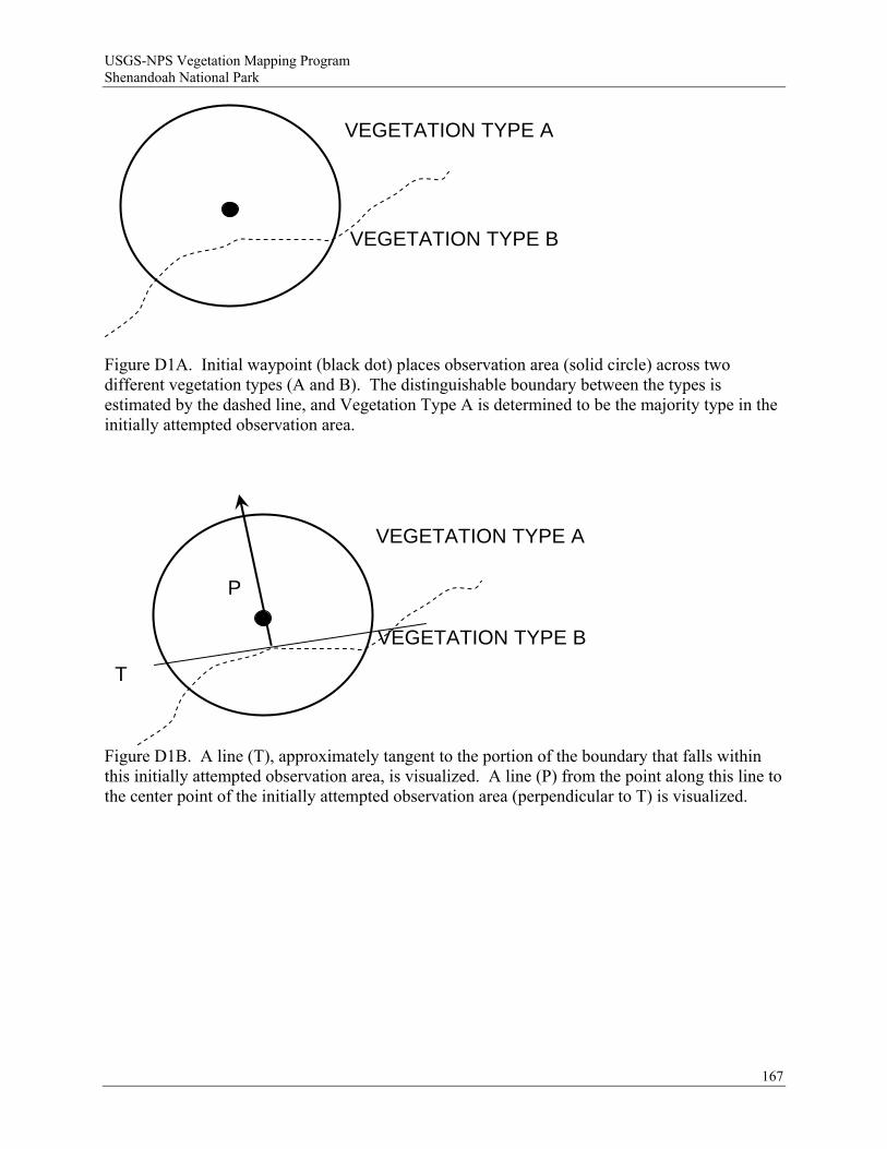
USGS-NPS Vegetation Mapping Program Shenandoah National Park
VEGETATION TYPE A
VEGETATION TYPE B
Figure D1A. Initial waypoint (black dot) places observation area (solid circle) across two different vegetation types (A and B). The distinguishable boundary between the types is estimated by the dashed line, and Vegetation Type A is determined to be the majority type in the initially attempted observation area.
T
P
VEGETATION TYPE A
VEGETATION TYPE B
Figure D1B. A line (T), approximately tangent to the portion of the boundary that falls within this initially attempted observation area, is visualized. A line (P) from the point along this line to the center point of the initially attempted observation area (perpendicular to T) is visualized.
167
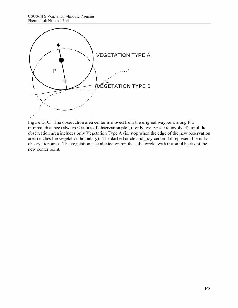
USGS-NPS Vegetation Mapping Program Shenandoah National Park
P
VEGETATION TYPE A
VEGETATION TYPE B
168
Figure D1C. The observation area center is moved from the original waypoint along P a minimal distance (always < radius of observation plot, if only two types are involved), until the observation area includes only Vegetation Type A (ie, stop when the edge of the new observation area reaches the vegetation boundary). The dashed circle and gray center dot represent the initial observation area. The vegetation is evaluated within the solid circle, with the solid back dot the new center point.
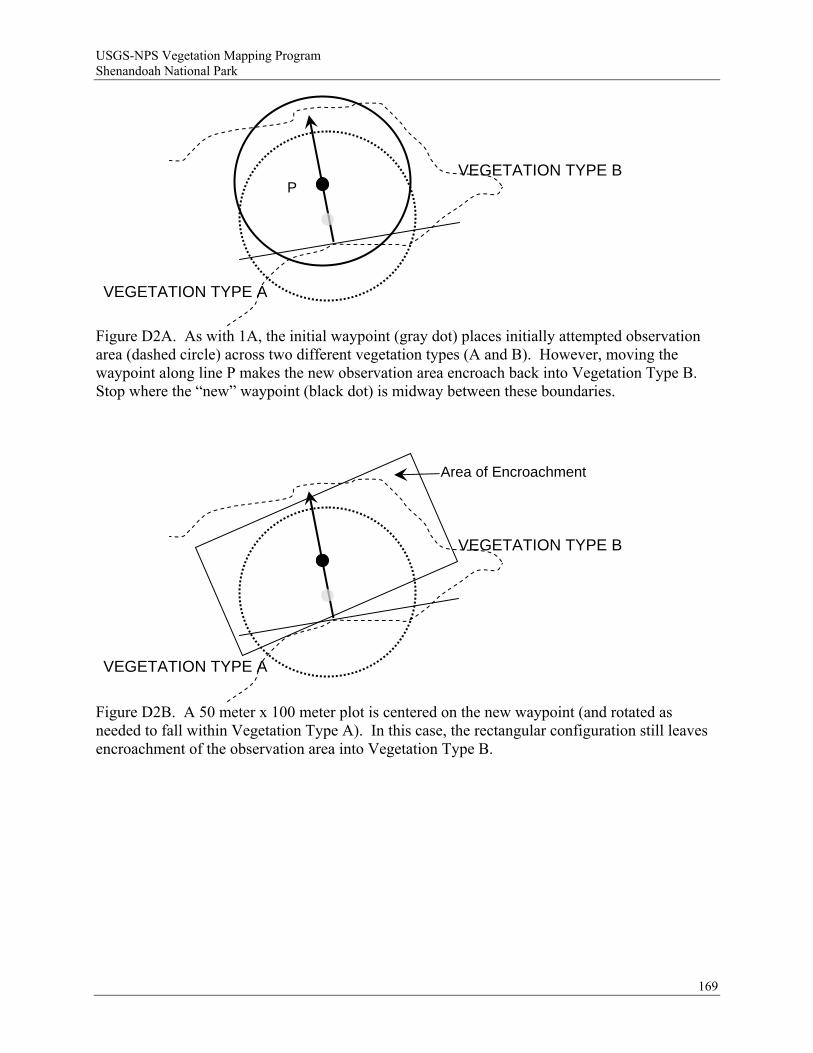
USGS-NPS Vegetation Mapping Program Shenandoah National Park
VEGETATION TYPE B P
VEGETATION TYPE A
Figure D2A. As with 1A, the initial waypoint (gray dot) places initially attempted observation area (dashed circle) across two different vegetation types (A and B). However, moving the waypoint along line P makes the new observation area encroach back into Vegetation Type B. Stop where the “new” waypoint (black dot) is midway between these boundaries.
Area of Encroachment
VEGETATION TYPE B
VEGETATION TYPE A
Figure D2B. A 50 meter x 100 meter plot is centered on the new waypoint (and rotated as needed to fall within Vegetation Type A). In this case, the rectangular configuration still leaves encroachment of the observation area into Vegetation Type B.
169

USGS-NPS Vegetation Mapping Program Shenandoah National Park
170
VEGETATION TYPE A
VEGETATION TYPE B
Figure D2C. The center of the 50 meter x 100 meter plot is moved (represented by the arrow) a minimal distance into Vegetation Type A, so that the observation area is entirely within Vegetation Type A.
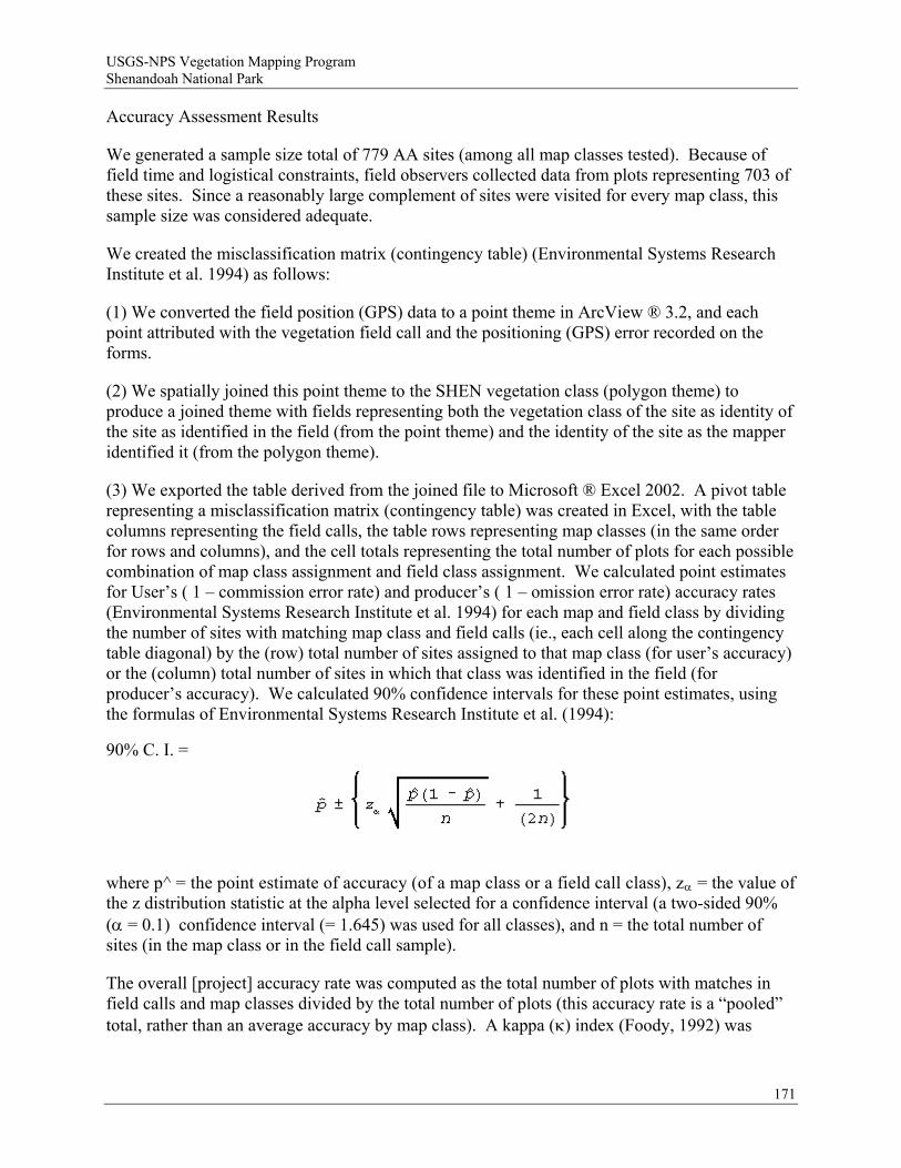
USGS-NPS Vegetation Mapping Program Shenandoah National Park
Accuracy Assessment Results
We generated a sample size total of 779 AA sites (among all map classes tested). Because of field time and logistical constraints, field observers collected data from plots representing 703 of these sites. Since a reasonably large complement of sites were visited for every map class, this sample size was considered adequate.
We created the misclassification matrix (contingency table) (Environmental Systems Research Institute et al. 1994) as follows:
(1) We converted the field position (GPS) data to a point theme in ArcView ® 3.2, and each point attributed with the vegetation field call and the positioning (GPS) error recorded on the forms.
(2) We spatially joined this point theme to the SHEN vegetation class (polygon theme) to produce a joined theme with fields representing both the vegetation class of the site as identity of the site as identified in the field (from the point theme) and the identity of the site as the mapper identified it (from the polygon theme).
(3) We exported the table derived from the joined file to Microsoft ® Excel 2002. A pivot table representing a misclassification matrix (contingency table) was created in Excel, with the table columns representing the field calls, the table rows representing map classes (in the same order for rows and columns), and the cell totals representing the total number of plots for each possible combination of map class assignment and field class assignment. We calculated point estimates for User’s ( 1 – commission error rate) and producer’s ( 1 – omission error rate) accuracy rates (Environmental Systems Research Institute et al. 1994) for each map and field class by dividing the number of sites with matching map class and field calls (ie., each cell along the contingency table diagonal) by the (row) total number of sites assigned to that map class (for user’s accuracy) or the (column) total number of sites in which that class was identified in the field (for producer’s accuracy). We calculated 90% confidence intervals for these point estimates, using the formulas of Environmental Systems Research Institute et al. (1994):
90% C. I. =
where p^ = the point estimate of accuracy (of a map class or a field call class), z = the value of the z distribution statistic at the alpha level selected for a confidence interval (a two-sided 90% ( = 0.1) confidence interval (= 1.645) was used for all classes), and n = the total number of sites (in the map class or in the field call sample).
The overall [project] accuracy rate was computed as the total number of plots with matches in field calls and map classes divided by the total number of plots (this accuracy rate is a “pooled” total, rather than an average accuracy by map class). A kappa () index (Foody, 1992) was
171
USGS-NPS Vegetation Mapping Program Shenandoah National Park
172
calculated for the overall accuracy. The overall accuracy of the SHEN vegetation map at the National Vegetation Classification level of Association is 48.9% (=47.0%) (Table 2).
We used Appendix H of the version 2 of the National Vegetation Classification standard (Federal Geographic Data Committee 2008) to aggregate association level map classes to provisional Group and MacroGroup map classes (Alliance level accuracy and resolution is similar to that of the Association level) Tables 3 and 4 are contingency tables showing these results. The overall accuracy of the SHEN vegetation map at the National Vegetation Classification level of Group is 56.5% (=51.1%) (Table 3), and at MacroGroup is 70.6% (=57.9%) (Table 4).
Literature Cited
Environmental Systems Research Institute. 1991. ArcView GIS 3.2 ®. (application). Redlands, CA.
Environmental Systems Research Institute, National Center for Geographic Information and Analysis (University of California), and The Nature Conservancy. 1994. Accuracy Assessment Procedures. Report prepared for: United States Department of Interior National Biological Survey and National Park Service. Redlands, CA, Santa Barbara, CA, and Arlington, VA. Available: http://biology.usgs.gov/npsveg/aarpt.pdf.
Federal Geographic Data Committee. 1997. Vegetation classification standard. FGDC-STD-005. Federal Geographic Data Committee. Reston, VA. Available: http://biology.usgs.gov/fgdc.veg/standards/vegstd.htm.
Federal Geographic Data Committee (FGDC). 2008. Vegetation classification standard, version 2. FGDC-STD-005-2008 (version 2). Federal Geographic Data Committee. Reston, VA. Available: http://www.fgdc.gov/standards/projects/FGDC-standards-projects/vegetation/index_html.
Foody, G. M. 1992. On the Compensation for Chance Agreement in Image Classification Accuracy Assessment. Photogrammetric Engineering and Remote Sensing, 58(10):1459-1460.
National Park Service. 2002. NPS AlaskaPak Toolkit for ArcView 3.x (application). Available: http://science.nature.nps.gov/nrgis/applications/gisapps/gis_tools/3x/alaskapak3.aspx.
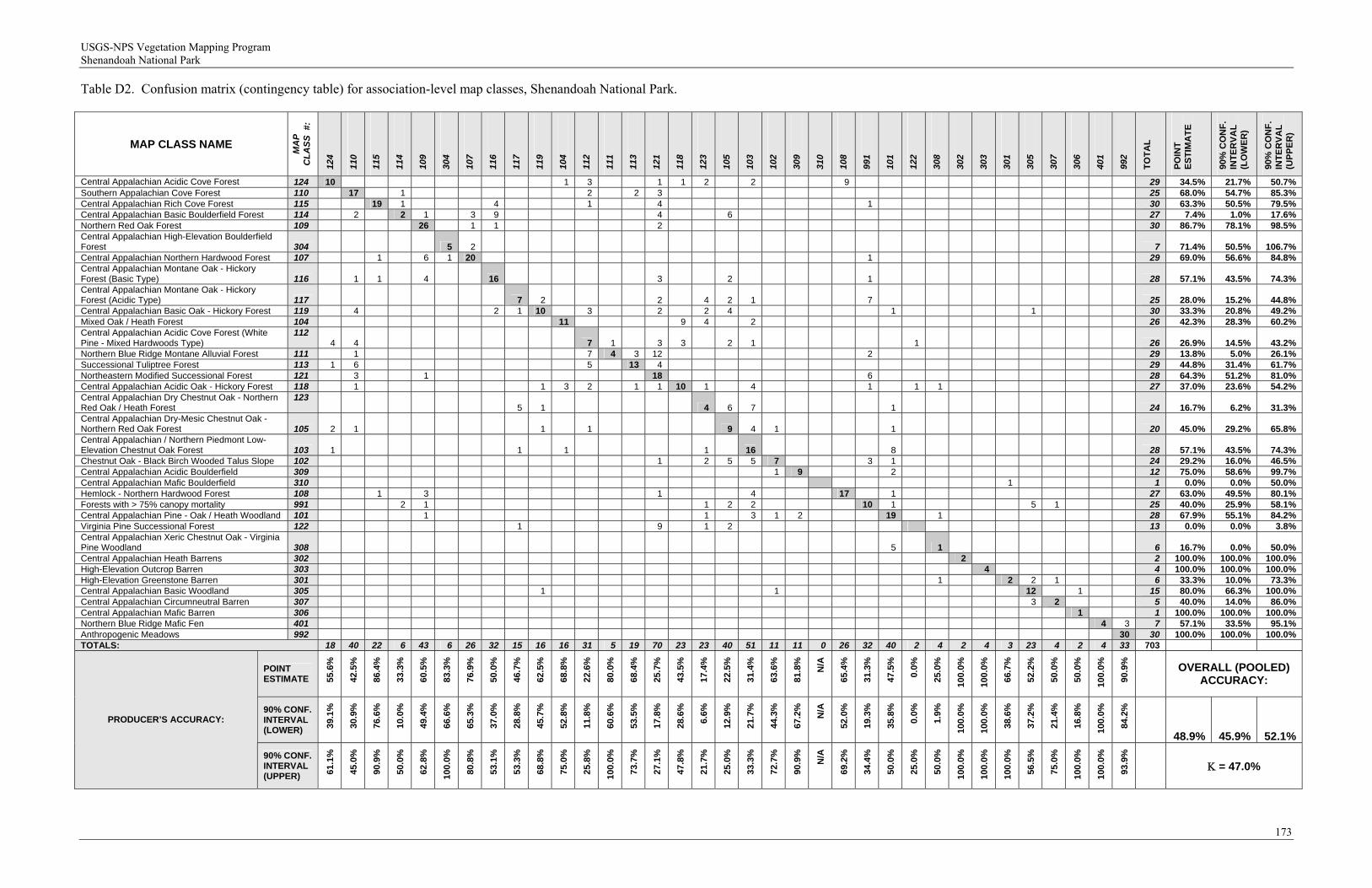
USGS-NPS Vegetation Mapping Program Shenandoah National Park
173
Table D2. Confusion matrix (contingency table) for association-level map classes, Shenandoah National Park.
MAP CLASS NAME
MA
P
CL
AS
S #
:
124
110
115
114
109
304
107
116
117
119
104
112
111
113
121
118
123
105
103
102
309
310
108
991
101
122
308
302
303
301
305
307
306
401
992
TO
TA
L
PO
INT
E
ST
IMA
TE
90%
CO
NF
. IN
TE
RV
AL
(L
OW
ER
)
90%
CO
NF
. IN
TE
RV
AL
(U
PP
ER
)
Central Appalachian Acidic Cove Forest 124 10 1 3 1 1 2 2 9 29 34.5% 21.7% 50.7% Southern Appalachian Cove Forest 110 17 1 2 2 3 25 68.0% 54.7% 85.3% Central Appalachian Rich Cove Forest 115 19 1 4 1 4 1 30 63.3% 50.5% 79.5% Central Appalachian Basic Boulderfield Forest 114 2 2 1 3 9 4 6 27 7.4% 1.0% 17.6% Northern Red Oak Forest 109 26 1 1 2 30 86.7% 78.1% 98.5% Central Appalachian High-Elevation Boulderfield Forest 304 5 2 7 71.4% 50.5% 106.7% Central Appalachian Northern Hardwood Forest 107 1 6 1 20 1 29 69.0% 56.6% 84.8% Central Appalachian Montane Oak - Hickory Forest (Basic Type) 116 1 1 4 16 3 2 1 28 57.1% 43.5% 74.3% Central Appalachian Montane Oak - Hickory Forest (Acidic Type) 117 7 2 2 4 2 1 7 25 28.0% 15.2% 44.8% Central Appalachian Basic Oak - Hickory Forest 119 4 2 1 10 3 2 2 4 1 1 30 33.3% 20.8% 49.2% Mixed Oak / Heath Forest 104 11 9 4 2 26 42.3% 28.3% 60.2% Central Appalachian Acidic Cove Forest (White Pine - Mixed Hardwoods Type)
112 4 4 7 1 3 3 2 1 1 26 26.9% 14.5% 43.2%
Northern Blue Ridge Montane Alluvial Forest 111 1 7 4 3 2 2 1 29 13.8% 5.0% 26.1% Successional Tuliptree Forest 113 1 6 5 13 4 29 44.8% 31.4% 61.7% Northeastern Modified Successional Forest 121 3 1 18 6 28 64.3% 51.2% 81.0% Central Appalachian Acidic Oak - Hickory Forest 118 1 1 3 2 1 1 10 1 4 1 1 1 27 37.0% 23.6% 54.2% Central Appalachian Dry Chestnut Oak - Northern Red Oak / Heath Forest
123 5 1 4 6 7 1 24 16.7% 6.2% 31.3%
Central Appalachian Dry-Mesic Chestnut Oak - Northern Red Oak Forest 105 2 1 1 1 9 4 1 1 20 45.0% 29.2% 65.8% Central Appalachian / Northern Piedmont Low-Elevation Chestnut Oak Forest 103 1 1 1 1 16 8 28 57.1% 43.5% 74.3% Chestnut Oak - Black Birch Wooded Talus Slope 102 1 2 5 5 7 3 1 24 29.2% 16.0% 46.5% Central Appalachian Acidic Boulderfield 309 1 9 2 12 75.0% 58.6% 99.7% Central Appalachian Mafic Boulderfield 310 1 1 0.0% 0.0% 50.0% Hemlock - Northern Hardwood Forest 108 1 3 1 4 17 1 27 63.0% 49.5% 80.1% Forests with > 75% canopy mortality 991 2 1 1 2 2 10 1 5 1 25 40.0% 25.9% 58.1% Central Appalachian Pine - Oak / Heath Woodland 101 1 1 3 1 2 19 1 28 67.9% 55.1% 84.2% Virginia Pine Successional Forest 122 1 9 1 2 13 0.0% 0.0% 3.8% Central Appalachian Xeric Chestnut Oak - Virginia Pine Woodland 308 5 1 6 16.7% 0.0% 50.0% Central Appalachian Heath Barrens 302 2 2 100.0% 100.0% 100.0% High-Elevation Outcrop Barren 303 4 4 100.0% 100.0% 100.0% High-Elevation Greenstone Barren 301 1 2 2 1 6 33.3% 10.0% 73.3% Central Appalachian Basic Woodland 305 1 1 12 1 15 80.0% 66.3% 100.0% Central Appalachian Circumneutral Barren 307 3 2 5 40.0% 14.0% 86.0% Central Appalachian Mafic Barren 306 1 1 100.0% 100.0% 100.0% Northern Blue Ridge Mafic Fen 401 4 3 7 57.1% 33.5% 95.1% Anthropogenic Meadows 992 30 30 100.0% 100.0% 100.0% TOTALS: 18 40 22 6 43 6 26 32 15 16 16 31 5 19 70 23 23 40 51 11 11 0 26 32 40 2 4 2 4 3 23 4 2 4 33 703
POINT ESTIMATE 55
.6%
42.5
%
86.4
%
33.3
%
60.5
%
83.3
%
76.9
%
50.0
%
46.7
%
62.5
%
68.8
%
22.6
%
80.0
%
68.4
%
25.7
%
43.5
%
17.4
%
22.5
%
31.4
%
63.6
%
81.8
%
N/A
65.4
%
31.3
%
47.5
%
0.0%
25.0
%
100.
0%
100.
0%
66.7
%
52.2
%
50.0
%
50.0
%
100.
0%
90.9
%
OVERALL (POOLED) ACCURACY:
90% CONF. INTERVAL (LOWER) 39
.1%
30.9
%
76.6
%
10.0
%
49.4
%
66.6
%
65.3
%
37.0
%
28.8
%
45.7
%
52.8
%
11.8
%
60.6
%
53.5
%
17.8
%
28.6
%
6.6%
12.9
%
21.7
%
44.3
%
67.2
%
N/A
52.0
%
19.3
%
35.8
%
0.0%
1.9%
100.
0%
100.
0%
38.6
%
37.2
%
21.4
%
16.8
%
100.
0%
84.2
%
48.9% 45.9% 52.1%
PRODUCER’S ACCURACY:
90% CONF. INTERVAL (UPPER) 61
.1%
45.0
%
90.9
%
50.0
%
62.8
%
100.
0%
80.8
%
53.1
%
53.3
%
68.8
%
75.0
%
25.8
%
100.
0%
73.7
%
27.1
%
47.8
%
21.7
%
25.0
%
33.3
%
72.7
%
90.9
%
N/A
69.2
%
34.4
%
50.0
%
25.0
%
50.0
%
100.
0%
100.
0%
100.
0%
56.5
%
75.0
%
100.
0%
100.
0%
93.9
%
= 47.0%
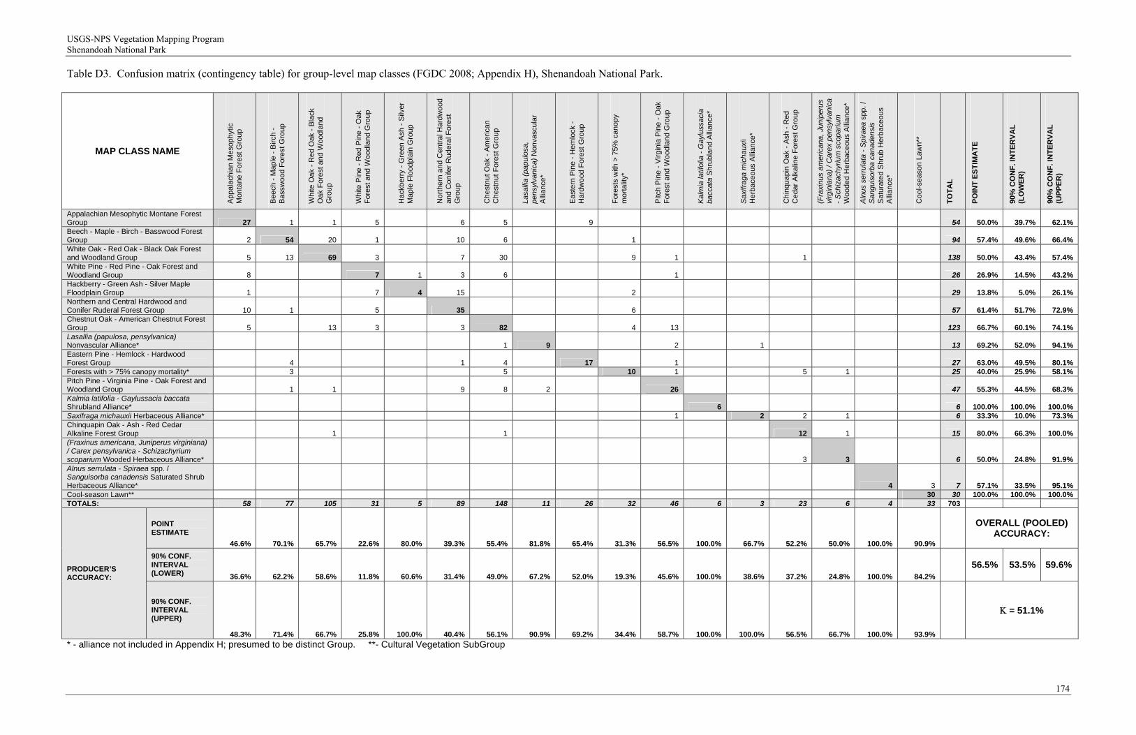
USGS-NPS Vegetation Mapping Program Shenandoah National Park
174
Table D3. Confusion matrix (contingency table) for group-level map classes (FGDC 2008; Appendix H), Shenandoah National Park.
MAP CLASS NAME
Ap
pa
lach
ian
Me
sop
hyt
ic
Monta
ne F
ore
st G
rou
p
Be
ech
- M
ap
le -
Birch
-
Ba
ssw
oo
d F
ore
st G
rou
p
Wh
ite O
ak
- R
ed
Oak
- B
lack
O
ak
Fo
rest
an
d W
oo
dla
nd
G
rou
p
Wh
ite P
ine
- R
ed
Pin
e -
Oa
k F
ore
st a
nd
Wo
od
lan
d G
rou
p
Ha
ckb
err
y -
Gre
en
Ash
- S
ilve
r M
ap
le F
loo
dp
lain
Gro
up
Nort
he
rn a
nd C
entr
al H
ard
wood
an
d C
on
ifer
Ru
de
ral F
ore
st
Gro
up
Ch
est
nu
t O
ak
- A
me
rica
n
Chest
nut
Fo
rest
Gro
up
Lasa
llia
(pap
ulos
a,
pens
ylva
nica
) No
nva
scu
lar
Alli
an
ce*
Ea
ste
rn P
ine
- H
em
lock
-
Hard
wo
od F
ore
st G
rou
p
Fo
rest
s w
ith >
75
% c
an
op
y m
ort
alit
y*
Pitc
h P
ine
- V
irg
inia
Pin
e -
Oa
k F
ore
st a
nd
Wo
od
lan
d G
rou
p
Kal
mia
latif
olia
- G
aylu
ssac
ia
bacc
ata
Sh
rub
lan
d A
llia
nce
*
Sax
ifrag
a m
icha
uxii
He
rba
ceo
us
Alli
an
ce*
Ch
inq
ua
pin
Oa
k -
Ash
- R
ed
C
ed
ar
Alk
alin
e F
ore
st G
rou
p
(Fra
xinu
s am
eric
ana,
Jun
iper
us
virg
inia
na) /
Car
ex p
ensy
lvan
ica
- Sch
izac
hyriu
m s
copa
rium
W
oo
de
d H
erb
ace
ou
s A
llia
nce
*
Aln
us s
erru
lata
- S
pira
ea s
pp
. /
San
guis
orba
can
aden
sis
Sa
tura
ted
Sh
rub
He
rba
ceo
us
Alli
an
ce*
Co
ol-
sea
son
La
wn
**
TO
TA
L
PO
INT
ES
TIM
AT
E
90%
CO
NF
. IN
TE
RV
AL
(L
OW
ER
)
90%
CO
NF
. IN
TE
RV
AL
(U
PP
ER
)
Appalachian Mesophytic Montane Forest Group 27 1 1 5 6 5 9 54 50.0% 39.7% 62.1% Beech - Maple - Birch - Basswood Forest Group 2 54 20 1 10 6 1 94 57.4% 49.6% 66.4% White Oak - Red Oak - Black Oak Forest and Woodland Group 5 13 69 3 7 30 9 1 1 138 50.0% 43.4% 57.4% White Pine - Red Pine - Oak Forest and Woodland Group 8 7 1 3 6 1 26 26.9% 14.5% 43.2% Hackberry - Green Ash - Silver Maple Floodplain Group 1 7 4 15 2 29 13.8% 5.0% 26.1% Northern and Central Hardwood and Conifer Ruderal Forest Group 10 1 5 35 6 57 61.4% 51.7% 72.9% Chestnut Oak - American Chestnut Forest Group 5 13 3 3 82 4 13 123 66.7% 60.1% 74.1% Lasallia (papulosa, pensylvanica) Nonvascular Alliance* 1 9 2 1 13 69.2% 52.0% 94.1% Eastern Pine - Hemlock - Hardwood Forest Group 4 1 4 17 1 27 63.0% 49.5% 80.1% Forests with > 75% canopy mortality* 3 5 10 1 5 1 25 40.0% 25.9% 58.1% Pitch Pine - Virginia Pine - Oak Forest and Woodland Group 1 1 9 8 2 26 47 55.3% 44.5% 68.3% Kalmia latifolia - Gaylussacia baccata Shrubland Alliance* 6 6 100.0% 100.0% 100.0% Saxifraga michauxii Herbaceous Alliance* 1 2 2 1 6 33.3% 10.0% 73.3% Chinquapin Oak - Ash - Red Cedar Alkaline Forest Group 1 1 12 1 15 80.0% 66.3% 100.0% (Fraxinus americana, Juniperus virginiana) / Carex pensylvanica - Schizachyrium scoparium Wooded Herbaceous Alliance* 3 3 6 50.0% 24.8% 91.9% Alnus serrulata - Spiraea spp. / Sanguisorba canadensis Saturated Shrub Herbaceous Alliance* 4 3 7 57.1% 33.5% 95.1% Cool-season Lawn** 30 30 100.0% 100.0% 100.0% TOTALS: 58 77 105 31 5 89 148 11 26 32 46 6 3 23 6 4 33 703
POINT ESTIMATE
46.6% 70.1% 65.7% 22.6% 80.0% 39.3% 55.4% 81.8% 65.4% 31.3% 56.5% 100.0% 66.7% 52.2% 50.0% 100.0% 90.9%
OVERALL (POOLED) ACCURACY:
90% CONF. INTERVAL (LOWER) 36.6% 62.2% 58.6% 11.8% 60.6% 31.4% 49.0% 67.2% 52.0% 19.3% 45.6% 100.0% 38.6% 37.2% 24.8% 100.0% 84.2%
56.5% 53.5% 59.6% PRODUCER’S ACCURACY:
90% CONF. INTERVAL (UPPER)
48.3% 71.4% 66.7% 25.8% 100.0% 40.4% 56.1% 90.9% 69.2% 34.4% 58.7% 100.0% 100.0% 56.5% 66.7% 100.0% 93.9%
= 51.1%
* - alliance not included in Appendix H; presumed to be distinct Group. **- Cultural Vegetation SubGroup
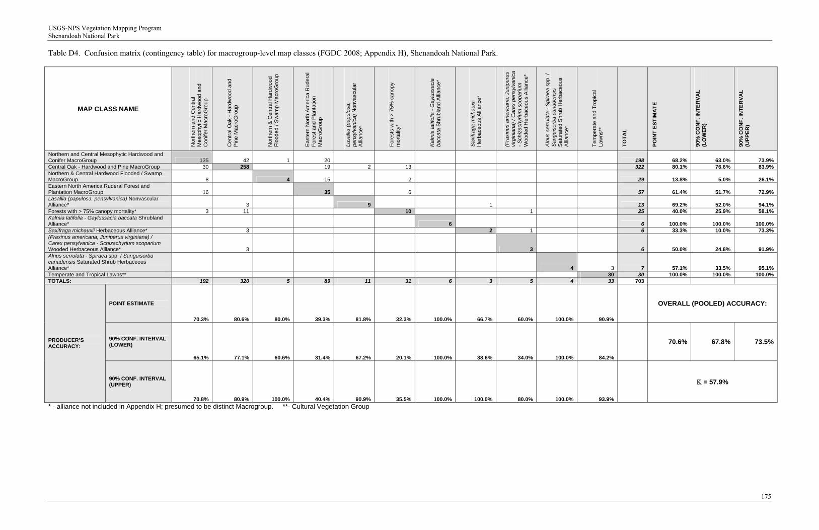
USGS-NPS Vegetation Mapping Program Shenandoah National Park
175
Table D4. Confusion matrix (contingency table) for macrogroup-level map classes (FGDC 2008; Appendix H), Shenandoah National Park.
MAP CLASS NAME
No
rth
ern
an
d C
en
tra
l M
eso
ph
ytic
Ha
rdw
oo
d a
nd
C
on
ifer
Ma
cro
Gro
up
Ce
ntr
al O
ak
- H
ard
wo
od
an
d
Pin
e M
acr
oG
rou
p
No
rth
ern
& C
en
tra
l Ha
rdw
oo
d
Flo
od
ed
/ S
wa
mp
Ma
cro
Gro
up
Ea
ste
rn N
ort
h A
me
rica
Ru
de
ral
Fo
rest
an
d P
lan
tatio
n
Ma
cro
Gro
up
Lasa
llia
(pap
ulos
a,
pens
ylva
nica
) No
nva
scu
lar
Alli
an
ce*
Fo
rest
s w
ith >
75
% c
an
op
y m
ort
alit
y*
Kal
mia
latif
olia
- G
aylu
ssac
ia
bacc
ata
Sh
rub
lan
d A
llia
nce
*
Sax
ifrag
a m
icha
uxii
He
rba
ceo
us
Alli
an
ce*
(Fra
xinu
s am
eric
ana,
Jun
iper
us
virg
inia
na) /
Car
ex p
ensy
lvan
ica
- Sch
izac
hyriu
m s
copa
rium
W
oo
de
d H
erb
ace
ou
s A
llia
nce
*
Aln
us s
erru
lata
- S
pira
ea s
pp
. /
San
guis
orba
can
aden
sis
Sa
tura
ted
Sh
rub
He
rba
ceo
us
Alli
an
ce*
Te
mp
era
te a
nd
Tro
pic
al
La
wn
s**
TO
TA
L
PO
INT
ES
TIM
AT
E
90%
CO
NF
. IN
TE
RV
AL
(L
OW
ER
)
90%
CO
NF
. IN
TE
RV
AL
(U
PP
ER
)
Northern and Central Mesophytic Hardwood and Conifer MacroGroup 135 42 1 20 198 68.2% 63.0% 73.9% Central Oak - Hardwood and Pine MacroGroup 30 258 19 2 13 322 80.1% 76.6% 83.9% Northern & Central Hardwood Flooded / Swamp MacroGroup 8 4 15 2 29 13.8% 5.0% 26.1% Eastern North America Ruderal Forest and Plantation MacroGroup 16 35 6 57 61.4% 51.7% 72.9% Lasallia (papulosa, pensylvanica) Nonvascular Alliance* 3 9 1 13 69.2% 52.0% 94.1% Forests with > 75% canopy mortality* 3 11 10 1 25 40.0% 25.9% 58.1% Kalmia latifolia - Gaylussacia baccata Shrubland Alliance* 6 6 100.0% 100.0% 100.0% Saxifraga michauxii Herbaceous Alliance* 3 2 1 6 33.3% 10.0% 73.3% (Fraxinus americana, Juniperus virginiana) / Carex pensylvanica - Schizachyrium scoparium Wooded Herbaceous Alliance* 3 3 6 50.0% 24.8% 91.9% Alnus serrulata - Spiraea spp. / Sanguisorba canadensis Saturated Shrub Herbaceous Alliance* 4 3 7 57.1% 33.5% 95.1% Temperate and Tropical Lawns** 30 30 100.0% 100.0% 100.0% TOTALS: 192 320 5 89 11 31 6 3 5 4 33 703
POINT ESTIMATE
70.3% 80.6% 80.0% 39.3% 81.8% 32.3% 100.0% 66.7% 60.0% 100.0% 90.9%
OVERALL (POOLED) ACCURACY:
90% CONF. INTERVAL (LOWER)
65.1% 77.1% 60.6% 31.4% 67.2% 20.1% 100.0% 38.6% 34.0% 100.0% 84.2%
70.6% 67.8% 73.5%PRODUCER’S ACCURACY:
90% CONF. INTERVAL (UPPER)
70.8% 80.9% 100.0% 40.4% 90.9% 35.5% 100.0% 100.0% 80.0% 100.0% 93.9%
= 57.9%
* - alliance not included in Appendix H; presumed to be distinct Macrogroup. **- Cultural Vegetation Group
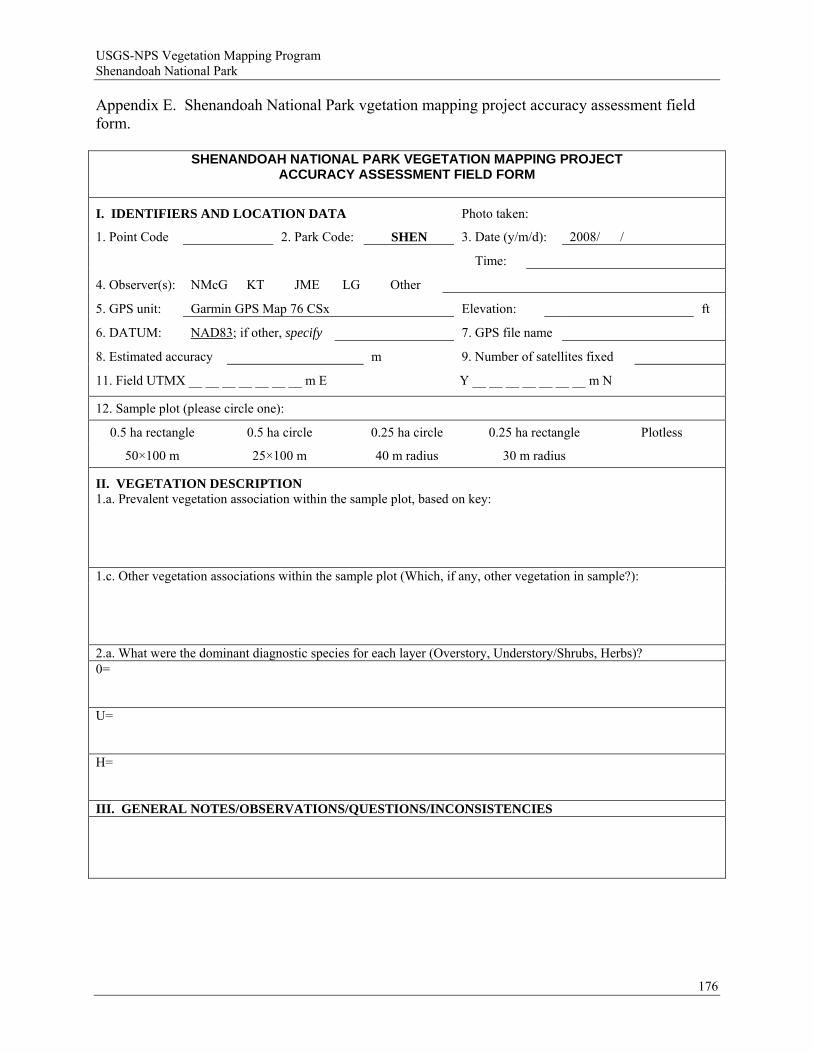
USGS-NPS Vegetation Mapping Program Shenandoah National Park
Appendix E. Shenandoah National Park vgetation mapping project accuracy assessment field form.
SHENANDOAH NATIONAL PARK VEGETATION MAPPING PROJECT ACCURACY ASSESSMENT FIELD FORM
I. IDENTIFIERS AND LOCATION DATA Photo taken:
1. Point Code 2. Park Code: SHEN 3. Date (y/m/d): 2008/ /
Time:
4. Observer(s): NMcG KT JME LG Other
5. GPS unit: Garmin GPS Map 76 CSx Elevation: ft
6. DATUM: NAD83; if other, specify 7. GPS file name
8. Estimated accuracy m 9. Number of satellites fixed
11. Field UTMX __ __ __ __ __ __ __ m E Y __ __ __ __ __ __ __ m N
12. Sample plot (please circle one):
0.5 ha rectangle 0.5 ha circle 0.25 ha circle 0.25 ha rectangle Plotless
50×100 m 25×100 m 40 m radius 30 m radius
II. VEGETATION DESCRIPTION 1.a. Prevalent vegetation association within the sample plot, based on key: 1.c. Other vegetation associations within the sample plot (Which, if any, other vegetation in sample?): 2.a. What were the dominant diagnostic species for each layer (Overstory, Understory/Shrubs, Herbs)? 0= U= H= III. GENERAL NOTES/OBSERVATIONS/QUESTIONS/INCONSISTENCIES
176
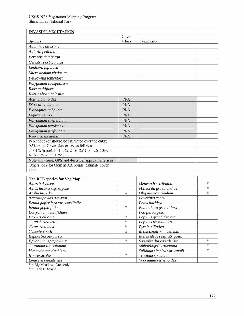
USGS-NPS Vegetation Mapping Program Shenandoah National Park
INVASIVE VEGETATION
Species Cover Class Comments
Ailanthus altissima Alliaria petiolata Berberis thunbergii Celastrus orbiculatus Lonicera japonica Microstegium vimineum Paulownia tomentosa Polygonum caespitosum Rosa multiflora Rubus phoenicolasius Acer platanoides N/A Dioscorea batatas N/A Elaeagnus umbellata N/A Ligustrum spp. N/A Polygonum cuspidatum N/A Polygonum persicaria N/A Polygonum perfoliatum N/A Pueraria montana N/A Percent cover should be estimated over the entire 0.5ha plot. Cover classes are as follows: t= <1% (trace);1= 1–5%; 2= 6–25%; 3= 26–50%; 4= 51–75%; 5= >75% Note anywhere, GPS and describe, approximate area Others look for them at AA points, estimate cover class Top RTE species for Veg Map Abies balsamea Menyanthes trifoliata * Alnus incana ssp. rugosa Minuartia groenlandica # Aralia hispida # Oligoneuron rigidum # Arctostaphylos uva-ursi Paxistima canbyi Betula papyrifera var. cordifolia Phlox buckleyi Betula populifolia * Platanthera grandiflora Botrychium multifidium Poa paludigena Bromus ciliatus * Populus grandidentata Carex buxbaumii * Populus tremuloides Carex conoidea * Pyrola elliptica Cuscuta coryli # Rhododendron maximum Euphorbia purpurea Rubus ideaus ssp. strigosus Epilobium leptophyllum * Sanguisorba canadensis * Geranium robertianum Sibbaldiopsis tridentata # Huperzia appalachiana Solidago simplex var. randii # Iris versicolor * Trisetum spicatum Lonicera canadensis Vaccinium myrtilloides * = Big Meadows Area only # = Rock Outcrops
177

USGS-NPS Vegetation Mapping Program Shenandoah National Park
Appendix F. U.S. National Vegetation Classification for Shenandoah National Park.
178
USGS-NPS Vegetation Mapping Program Shenandoah National Park
U.S. NATIONAL VEGETATION CLASSIFICATION
Shenandoah National Park
Associations of Shenandoah National Park
6 June 2008
by
NatureServe
1101 Wilson Blvd., 15th floor Arlington, VA 22209
11 Avenue de Lafayette, 5th Floor
Boston, MA 02111-1736 This subset of the International Ecological Classification Standard covers vegetation associations attributed to Shenandoah National Park. This classification has been developed in consultation with many individuals and agencies and incorporates information from a variety of publications and other classifications. Comments and suggestions regarding the contents of this subset should be directed to Mary J. Russo, Central Ecology Data Manager, Durham, NC <[email protected]> and Lesley A. Sneddon, Senior Regional Ecologist, Boston, MA <[email protected]>.
179
USGS-NPS Vegetation Mapping Program Shenandoah National Park
180
Copyright © 2008 NatureServe, 1101 Wilson Blvd, 15th floor Arlington, VA 22209, U.S.A. All Rights Reserved.
Citations: The following citation should be used in any published materials which reference ecological system and/or
International Vegetation Classification (IVC hierarchy) and association data:
NatureServe. 2008. International Ecological Classification Standard: Terrestrial Ecological Classifications. NatureServe Central Databases. Arlington, VA. U.S.A. Data current as of 11 March 2008.
Restrictions on Use: Permission to use, copy and distribute these data is hereby granted under the following conditions:
1. The above copyright notice must appear in all documents and reports; 2. Any use must be for informational purposes only and in no instance for commercial purposes; 3. Some data may be altered in format for analytical purposes, however the data should still be referenced using
the citation above. Any rights not expressly granted herein are reserved by NatureServe. Except as expressly provided above, nothing contained herein shall be construed as conferring any license or right under any NatureServe copyright. Information Warranty Disclaimer: All data are provided as is without warranty as to the currentness, completeness, or accuracy of any specific data. The absence of data in any particular geographic area does not necessarily mean that species or ecological communities of concern are not present. NatureServe hereby disclaims all warranties and conditions with regard to these data, including but not limited to all implied warranties and conditions of merchantability, fitness for a particular purpose, and non-infringement. In no event shall NatureServe be liable for any special, indirect, incidental, consequential damages, or for damages of any kind arising out of or in connection with the use of these data. Because the data in the NatureServe Central Databases are continually being updated, it is advisable to refresh data at least once a year after receipt.
NatureServe 1101 Wilson Blvd, 15th floor
Arlington, VA 22209
_____________________________________________________________ These data are extracted from:
NatureServe. 2008. International Ecological Classification Standard: Terrestrial Ecological Classifications. NatureServe Central Databases. Arlington, VA. U.S.A. Data current as of 11 March 2008. _____________________________________________________________ This document may be generally cited as follows:
NatureServe1. 2008. U.S. National Vegetation Classification. Shenandoah National Park. NatureServe Central Databases. Arlington, VA. Data current as of 11 March 2008.
USGS-NPS Vegetation Mapping Program Shenandoah National Park
1 NatureServe is an international organization including NatureServe regional offices, a NatureServe central office, U.S. State Natural Heritage Programs, and Conservation Data Centres (CDC) in Canada and Latin America and the Caribbean. Ecologists from the following organizations have contributed the development of the ecological systems classification: United States Central NatureServe Office, Arlington, VA; Eastern Regional Office, Boston, MA; Midwestern Regional Office, Minneapolis, MN; Southeastern Regional Office, Durham, NC; Western Regional Office, Boulder, CO; Alabama Natural Heritage Program, Montgomery AL; Alaska Natural Heritage Program, Anchorage, AK; Arizona Heritage Data Management Center, Phoenix AZ; Arkansas Natural Heritage Commission Little Rock, AR; Blue Ridge Parkway, Asheville, NC; California Natural Heritage Program, Sacramento, CA; Colorado Natural Heritage Program, Fort Collins, CO; Connecticut Natural Diversity Database, Hartford, CT; Delaware Natural Heritage Program, Smyrna, DE; District of Columbia Natural Heritage Program/National Capital Region Conservation Data Center, Washington DC; Florida Natural Areas Inventory, Tallahassee, FL; Georgia Natural Heritage Program, Social Circle, GA; Great Smoky Mountains National Park, Gatlinburg, TN; Gulf Islands National Seashore, Gulf Breeze, FL; Hawaii Natural Heritage Program, Honolulu, Hawaii; Idaho Conservation Data Center, Boise, ID; Illinois Natural Heritage Division/Illinois Natural Heritage Database Program, Springfield, IL; Indiana Natural Heritage Data Center, Indianapolis, IN; Iowa Natural Areas Inventory, Des Moines, IA; Kansas Natural Heritage Inventory, Lawrence, KS; Kentucky Natural Heritage Program, Frankfort, KY; Louisiana Natural Heritage Program, Baton Rouge, LA; Maine Natural Areas Program, Augusta, ME; Mammoth Cave National Park, Mammoth Cave, KY; Maryland Wildlife & Heritage Division, Annapolis, MD; Massachusetts Natural Heritage & Endangered Species Program, Westborough, MA; Michigan Natural Features Inventory, Lansing, MI; Minnesota Natural Heritage & Nongame Research and Minnesota County Biological Survey, St. Paul, MN; Mississippi Natural Heritage Program, Jackson, MI; Missouri Natural Heritage Database, Jefferson City, MO; Montana Natural Heritage Program, Helena, MT; National Forest in North Carolina, Asheville, NC; National Forests in Florida, Tallahassee, FL; National Park Service, Southeastern Regional Office, Atlanta, GA; Navajo Natural Heritage Program, Window Rock, AZ; Nebraska Natural Heritage Program, Lincoln, NE; Nevada Natural Heritage Program, Carson City, NV; New Hampshire Natural Heritage Inventory, Concord, NH; New Jersey Natural Heritage Program, Trenton, NJ; New Mexico Natural Heritage Program, Albuquerque , NM; New York Natural Heritage Program, Latham, NY; North Carolina Natural Heritage Program, Raleigh, NC; North Dakota Natural Heritage Inventory, Bismarck, ND; Ohio Natural Heritage Database, Columbus, OH; Oklahoma Natural Heritage Inventory, Norman, OK; Oregon Natural Heritage Program, Portland, OR; Pennsylvania Natural Diversity Inventory, PA; Rhode Island Natural Heritage Program, Providence, RI; South Carolina Heritage Trust, Columbia, SC; South Dakota Natural Heritage Data Base, Pierre, SD; Tennessee Division of Natural Heritage, Nashville, TN; Tennessee Valley Authority Heritage Program, Norris, TN; Texas Conservation Data Center, San Antonio, TX; Utah Natural Heritage Program, Salt Lake City, UT; Vermont Nongame & Natural Heritage Program, Waterbury, VT; Virginia Division of Natural Heritage, Richmond, VA; Washington Natural Heritage Program, Olympia, WA; West Virginia Natural Heritage Program, Elkins, WV; Wisconsin Natural Heritage Program, Madison, WI; Wyoming Natural Diversity Database, Laramie, WY Canada Alberta Natural Heritage Information Centre, Edmonton, AB, Canada; Atlantic Canada Conservation Data Centre, Sackville, New Brunswick, Canada; British Columbia Conservation Data Centre, Victoria, BC, Canada; Manitoba Conservation Data Centre. Winnipeg, MB, Canada; Ontario Natural Heritage Information Centre, Peterborough, ON, Canada; Quebec Conservation Data Centre, Quebec, QC, Canada; Saskatchewan Conservation Data Centre, Regina, SK, Canada; Yukon Conservation Data Centre, Yukon, Canada Latin American and Caribbean Centro de Datos para la Conservacion de Bolivia, La Paz , Bolivia; Centro de Datos para la Conservacion de Colombia, Cali,Valle, Columbia; Centro de Datos para la Conservacion de Ecuador, Quito, Ecuador; Centro de Datos para la Conservacion de Guatemala, Ciudad de Guatemala , Guatemala; Centro de Datos para la Conservacion de Panama, Querry Heights , Panama; Centro de Datos para la Conservacion de Paraguay, San Lorenzo , Paraguay; Centro de Datos para la Conservacion de Peru, Lima, Peru; Centro de Datos para la Conservacion de Sonora, Hermosillo, Sonora , Mexico; Netherlands Antilles Natural Heritage Program, Curacao , Netherlands Antilles; Puerto Rico-Departmento De Recursos Naturales Y Ambientales, Puerto Rico; Virgin Islands Conservation Data Center, St. Thomas, Virgin Islands. NatureServe also has partnered with many International and United States Federal and State organizations, which have also contributed significantly to the development of the International Classification. Partners include the following The Nature Conservancy; Provincial Forest Ecosystem Classification Groups in Canada; Canadian Forest Service; Parks Canada; United States Forest Service; National GAP Analysis Program; United States National Park Service; United States Fish and Wildlife Service; United States Geological Survey; United States Department of Defense; Ecological Society of America; Environmental Protection Agency; Natural Resource Conservation Services; United States Department of Energy; and the Tennessee Valley Authority. Many individual state organizations and people from academic institutions have also contributed to the development of this classification.
181

USGS-NPS Vegetation Mapping Program Shenandoah National Park
Table of Contents
CEGL002591: Virginia Pine Successional Forest ................................................................................. 183 CEGL003683: Central Appalachian Basic Woodland ........................................................................... 301 CEGL003939: Central Appalachian Heath Barren ................................................................................ 328 CEGL004142: Central Appalachian Acidic Boulderfield ..................................................................... 362 CEGL004143: Central Appalachian Mafic Boulderfield ...................................................................... 366 CEGL004996: Central Appalachian Pine - Oak / Heath Woodland ...................................................... 316 CEGL006037: Central Appalachian Circumneutral Barren .................................................................. 345 CEGL006057: Central Appalachian Dry-Mesic Chestnut Oak - Northern Red Oak Forest ................. 239 CEGL006109: Hemlock - Northern Hardwood Forest .......................................................................... 286 CEGL006237: Central Appalachian Rich Cove Forest ......................................................................... 192 CEGL006249: Northern Blue Ridge Mafic Fen .................................................................................... 350 CEGL006255: Northern Blue Ridge Montane Alluvial Forest ............................................................. 263 CEGL006258: Central Appalachian Woodland Seep ............................................................................ 359 CEGL006299: Central Appalachian / Northern Piedmont Chestnut Oak Forest ................................... 229 CEGL006304: Central Appalachian Acidic Cove Forest (White Pine - Hemlock - Mixed
Hardwoods Type) ......................................................................................................... 281 CEGL006565: Sweet Birch - Chestnut Oak Talus Woodland ............................................................... 306 CEGL006599: Northeastern Modified Successional Forest .................................................................. 218 CEGL007220: Successional Tuliptree Forest (Circumneutral Type) .................................................... 231 CEGL007710: Southern Appalachian Cove Forest (Typic Montane Type) .......................................... 207 CEGL007853: Central Appalachian Acidic Seepage Swamp ............................................................... 267 CEGL007858: Shenandoah Valley Sinkhole Pond (Typic Type) ......................................................... 336 CEGL008416: Central Appalachian Basic Seepage Swamp ................................................................. 274 CEGL008502: Central Appalachian Northern Hardwood Forest (Yellow Birch - Northern
Red Oak Type) .............................................................................................................. 250 CEGL008504: Central Appalachian High-Elevation Boulderfield Forest ............................................ 188 CEGL008506: Northern Red Oak Forest (Pennsylvania Sedge - Wavy Hairgrass Type) ..................... 254 CEGL008508: High-Elevation Outcrop Barren (Black Chokeberry Igneous / Metamorphic
Type) ............................................................................................................................. 332 CEGL008512: Central Appalachian Acidic Cove Forest (Hemlock - Hardwood / Mountain
Laurel Type) ................................................................................................................. 291 CEGL008514: Central Appalachian Basic Oak - Hickory Foreest (Submontane / Foothills
Type) ............................................................................................................................. 202 CEGL008515: Central Appalachian Acidic Oak - Hickory Forest ........................................................ 234 CEGL008516: Central Appalachian Montane Oak - Hickory Forest (Acidic Type) ............................ 198 CEGL008518: Central Appalachian Montane Oak - Hickory Forest (Basic Type) .............................. 223 CEGL008521: Low-Elevation Mixed Oak / Heath Forest .................................................................... 258 CEGL008523: Central Appalachian Dry Chestnut Oak - Northern Red Oak / Heath Forest ................ 244 CEGL008528: Central Appalachian Basic Boulderfield Forest (Montane Basswood -
White Ash Type) ........................................................................................................... 311 CEGL008529: Central Appalachian Mafic Barren (Ninebark / Pennsylvania Sedge Type) ................. 340 CEGL008533: High-Elevation Hemlock - Yellow Birch Seepage Swamp ........................................... 296 CEGL008536: High-Elevation Greenstone Barren ............................................................................... 354 CEGL008540: Central Appalachian Xeric Chestnut Oak - Virginia Pine Woodland ........................... 322 CEGL006669: Catastrophically Disturbed Forest ................................................................................. 370 CEGL006670: Cultural Meadow ........................................................................................................... 372
182
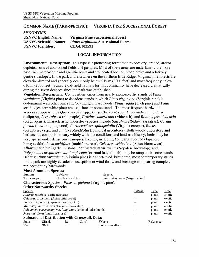
USGS-NPS Vegetation Mapping Program Shenandoah National Park
COMMON NAME (PARK-SPECIFIC): VIRGINIA PINE SUCCESSIONAL FOREST
SYNONYMS USNVC English Name: Virginia Pine Successional Forest USNVC Scientific Name: Pinus virginiana Successional Forest USNVC Identifier: CEGL002591
LOCAL INFORMATION
Environmental Description: This type is a pioneering forest that invades dry, eroded, and/or depleted soils of abandoned fields and pastures. Most of these areas are underlain by the more base-rich metabasaltic and granitic rocks and are located both on broad crests and relatively gentle sideslopes. In the park and elsewhere on the northern Blue Ridge, Virginia pine forests are elevation-limited and generally occur only below 915 m (3000 feet) and most frequently below 610 m (2000 feet). Suitable old-field habitats for this community have decreased dramatically during the seven decades since the park was established. Vegetation Description: Composition varies from nearly monospecific stands of Pinus virginiana (Virginia pine) to decadent stands in which Pinus virginiana (Virginia pine) is codominant with other pines and/or emergent hardwoods. Pinus rigida (pitch pine) and Pinus strobus (eastern white pine) are associates in some stands. The most frequent hardwood associates appear to be Quercus (oak) spp., Carya (hickory) spp., Liriodendron tulipifera (tuliptree), Acer rubrum (red maple), Fraxinus americana (white ash), and Robinia pseudoacacia (black locust). Characteristic understory species include Sassafras albidum (sassafras), Cornus florida (flowering dogwood), Parthenocissus quinquefolia (Virginia creeper), Rubus (blackberry) spp., and Smilax rotundifolia (roundleaf greenbrier). Both woody understory and herbaceous composition vary widely with site conditions and land-use history; herbs may be very sparse under dense pine canopies. Exotics, including Lonicera japonica (Japanese honeysuckle), Rosa multiflora (multiflora rose), Celastrus orbiculata (Asian bittersweet), Alliaria petiolata (garlic mustard), Microstegium vimineum (Nepalese browntop), and Polygonum caespitosum var. longisetum (oriental ladysthumb), may be rampant in some stands. Because Pinus virginiana (Virginia pine) is a short-lived, brittle tree, most contemporary stands in the park are highly decadent, susceptible to wind-throw and breakage and nearing complete replacement by hardwoods. Most Abundant Species: Stratum Lifeform Species Tree canopy Needle-leaved tree Pinus virginiana (Virginia pine) Characteristic Species: Pinus virginiana (Virginia pine). Other Noteworthy Species: Species GRank Type Note Alliaria petiolata (garlic mustard) - plant exotic Celastrus orbiculata (Asian bittersweet) - plant exotic Lonicera japonica (Japanese honeysuckle) - plant exotic Microstegium vimineum (Nepalese browntop) - plant exotic Polygonum caespitosum var. longisetum (oriental ladysthumb) - plant exotic Rosa multiflora (multiflora rose) - plant exotic Subnational Distribution with Crosswalk Data: State SRank Rel Conf SName Reference VA SNA . . [not crosswalked] .
183

USGS-NPS Vegetation Mapping Program Shenandoah National Park
Local Range: This community occurs very locally in the park at low to middle elevations. Stands are widely scattered and have been documented in both the north and south districts. Classification Comments: This type is the least common of the three early-successional communities defined for the park. It was not encountered during field data collection for the vegetation mapping project but is described from subsequent qualitative observations and NPS plot data that were used in accuracy assessment procedures. Other Comments: Information not available. Local Description Authors: G. P. Fleming. Plots: Not applicable. Shenandoah National Park Inventory Notes: Information not available.
GLOBAL INFORMATION
USNVC CLASSIFICATION Physiognomic Class Forest (I) Physiognomic Subclass Evergreen forest (I.A.) Physiognomic Group Temperate or subpolar needle-leaved evergreen forest (I.A.8.) Physiognomic Subgroup Natural/Semi-natural temperate or subpolar needle-leaved evergreen forest (I.A.8.N.) Formation Rounded-crowned temperate or subpolar needle-leaved evergreen forest (I.A.8.N.b.) Alliance Pinus virginiana Forest Alliance (A.131) Alliance (English name) Virginia Pine Forest Alliance Association Pinus virginiana Successional Forest Association (English name) Virginia Pine Successional Forest Ecological System(s): Central Appalachian Dry Oak-Pine Forest (CES202.591) Northeastern Interior Dry-Mesic Oak Forest (CES202.592) Southern Appalachian Low-Elevation Pine Forest (CES202.332).
GLOBAL DESCRIPTION Concept Summary: This successional Virginia pine forest of the southeastern states occurs in areas where canopy removal has created dry, open conditions and bare mineral soil, allowing for the establishment of Pinus virginiana (Virginia pine). These habitats include old fields, old pastures, clearcuts, and burned or eroded areas; soils are typically dry, acidic, and infertile. This forest typically has a very dense canopy of Pinus virginiana (Virginia pine) and little understory vegetation. The dense canopy may also include admixtures of other Pinus (pine) species (e.g., Pinus taeda (loblolly pine), Pinus echinata (shortleaf pine), Pinus strobus (eastern white pine)) or other early-successional deciduous trees (e.g., Acer rubrum (red maple), Liquidambar styraciflua (sweetgum), Prunus serotina (black cherry), Liriodendron tulipifera (tuliptree), Fraxinus americana (white ash), Nyssa sylvatica (blackgum)). Associated woody and herbaceous species vary with geography but are typically ruderal or exotic species. Shrub and herb layers are frequently very sparse. Stands are short-lived, generally less than 75 years. Environmental Description: This community occurs in areas where canopy removal has created open conditions and bare mineral soil, allowing for the establishment of Pinus virginiana (Virginia pine). These conditions can include old fields, old pastures, clearcuts, and burned or eroded areas. In the Ridge and Valley of Tennessee, northeastern Monroe County, early successional forests with Pinus virginiana (Virginia pine) dominance were found on low slopes in areas that were cleared for agriculture prior to the 1970s, when Tellico Lake was created (Andreu and Tukman 1995). In the Central Appalachians, this vegetation occurs where soft shales have been farmed (in valleys or on plateaus), resulting in stands with nothing but successional species in the understory. Soils underlying these communities are of two general
184
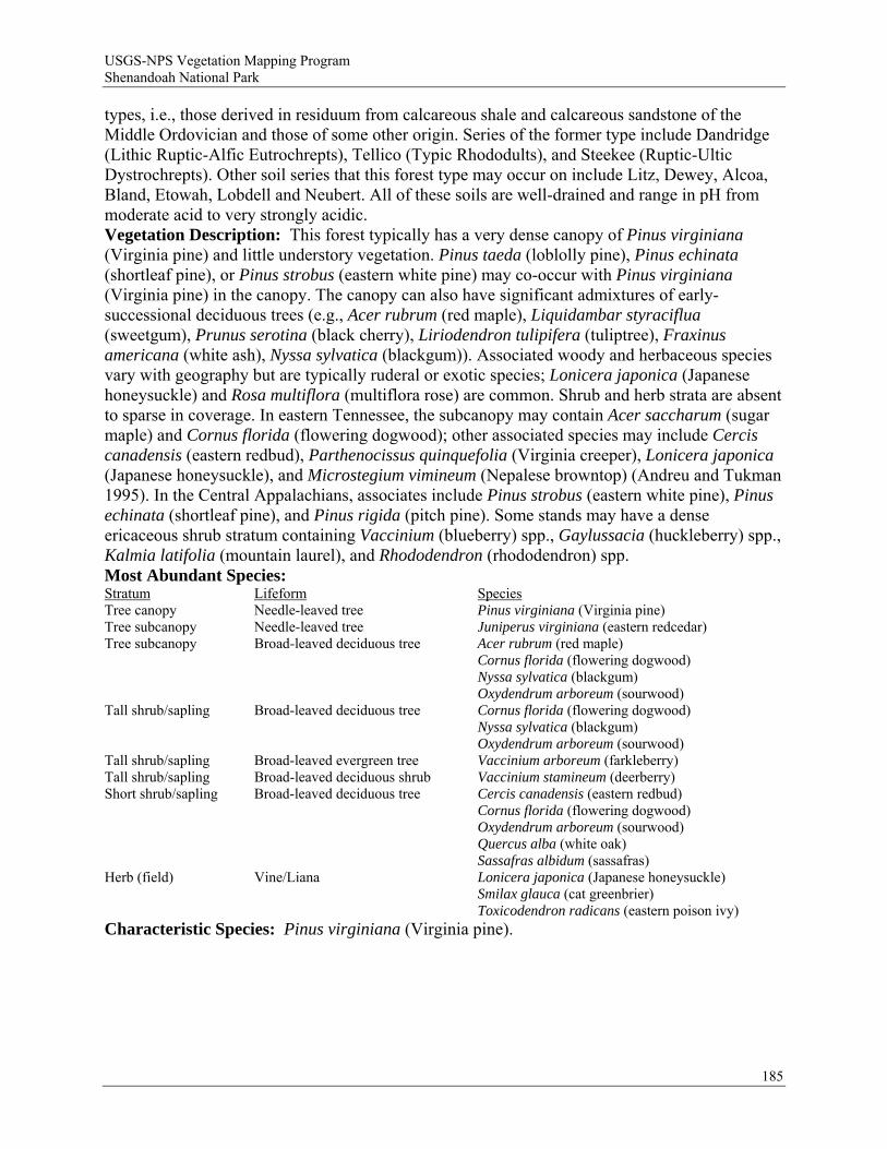
USGS-NPS Vegetation Mapping Program Shenandoah National Park
types, i.e., those derived in residuum from calcareous shale and calcareous sandstone of the Middle Ordovician and those of some other origin. Series of the former type include Dandridge (Lithic Ruptic-Alfic Eutrochrepts), Tellico (Typic Rhododults), and Steekee (Ruptic-Ultic Dystrochrepts). Other soil series that this forest type may occur on include Litz, Dewey, Alcoa, Bland, Etowah, Lobdell and Neubert. All of these soils are well-drained and range in pH from moderate acid to very strongly acidic. Vegetation Description: This forest typically has a very dense canopy of Pinus virginiana (Virginia pine) and little understory vegetation. Pinus taeda (loblolly pine), Pinus echinata (shortleaf pine), or Pinus strobus (eastern white pine) may co-occur with Pinus virginiana (Virginia pine) in the canopy. The canopy can also have significant admixtures of early-successional deciduous trees (e.g., Acer rubrum (red maple), Liquidambar styraciflua (sweetgum), Prunus serotina (black cherry), Liriodendron tulipifera (tuliptree), Fraxinus americana (white ash), Nyssa sylvatica (blackgum)). Associated woody and herbaceous species vary with geography but are typically ruderal or exotic species; Lonicera japonica (Japanese honeysuckle) and Rosa multiflora (multiflora rose) are common. Shrub and herb strata are absent to sparse in coverage. In eastern Tennessee, the subcanopy may contain Acer saccharum (sugar maple) and Cornus florida (flowering dogwood); other associated species may include Cercis canadensis (eastern redbud), Parthenocissus quinquefolia (Virginia creeper), Lonicera japonica (Japanese honeysuckle), and Microstegium vimineum (Nepalese browntop) (Andreu and Tukman 1995). In the Central Appalachians, associates include Pinus strobus (eastern white pine), Pinus echinata (shortleaf pine), and Pinus rigida (pitch pine). Some stands may have a dense ericaceous shrub stratum containing Vaccinium (blueberry) spp., Gaylussacia (huckleberry) spp., Kalmia latifolia (mountain laurel), and Rhododendron (rhododendron) spp. Most Abundant Species: Stratum Lifeform Species Tree canopy Needle-leaved tree Pinus virginiana (Virginia pine) Tree subcanopy Needle-leaved tree Juniperus virginiana (eastern redcedar) Tree subcanopy Broad-leaved deciduous tree Acer rubrum (red maple) Cornus florida (flowering dogwood) Nyssa sylvatica (blackgum) Oxydendrum arboreum (sourwood) Tall shrub/sapling Broad-leaved deciduous tree Cornus florida (flowering dogwood) Nyssa sylvatica (blackgum) Oxydendrum arboreum (sourwood) Tall shrub/sapling Broad-leaved evergreen tree Vaccinium arboreum (farkleberry) Tall shrub/sapling Broad-leaved deciduous shrub Vaccinium stamineum (deerberry) Short shrub/sapling Broad-leaved deciduous tree Cercis canadensis (eastern redbud) Cornus florida (flowering dogwood) Oxydendrum arboreum (sourwood) Quercus alba (white oak) Sassafras albidum (sassafras) Herb (field) Vine/Liana Lonicera japonica (Japanese honeysuckle) Smilax glauca (cat greenbrier) Toxicodendron radicans (eastern poison ivy) Characteristic Species: Pinus virginiana (Virginia pine).
185
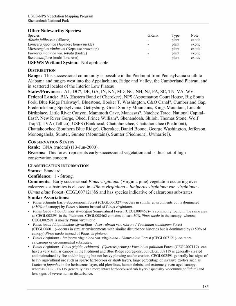
USGS-NPS Vegetation Mapping Program Shenandoah National Park
Other Noteworthy Species: Species GRank Type Note Albizia julibrissin (silktree) - plant exotic Lonicera japonica (Japanese honeysuckle) - plant exotic Microstegium vimineum (Nepalese browntop) - plant exotic Pueraria montana var. lobata (kudzu) - plant exotic Rosa multiflora (multiflora rose) - plant exotic USFWS Wetland System: Not applicable.
DISTRIBUTION Range: This successional community is possible in the Piedmont from Pennsylvania south to Alabama and ranges west into the Appalachians, Ridge and Valley, the Cumberland Plateau, and in scattered locales of the Interior Low Plateau. States/Provinces: AL, DC?, DE, GA, IN, KY, MD, NC, NH, NJ, PA, SC, TN, VA, WV. Federal Lands: BIA (Eastern Band of Cherokee); NPS (Appomattox Court House, Big South Fork, Blue Ridge Parkway?, Bluestone, Booker T. Washington, C&O Canal?, Cumberland Gap, Fredericksburg-Spotsylvania, Gettysburg, Great Smoky Mountains, Kings Mountain, Lincoln Birthplace, Little River Canyon, Mammoth Cave, Manassas?, Natchez Trace, National Capital-East?, New River Gorge, Obed, Prince William?, Shenandoah, Shiloh, Thomas Stone, Wolf Trap?); TVA (Tellico); USFS (Bankhead, Chattahoochee, Chattahoochee (Piedmont), Chattahoochee (Southern Blue Ridge), Cherokee, Daniel Boone, George Washington, Jefferson, Monongahela, Sumter, Sumter (Mountains), Sumter (Piedmont), Uwharrie?).
CONSERVATION STATUS Rank: GNA (ruderal) (13-Jun-2000). Reasons: This forest represents early-successional vegetation and is thus not of high conservation concern.
CLASSIFICATION INFORMATION Status: Standard. Confidence: 1 - Strong. Comments: Early successional Pinus virginiana (Virginia pine) vegetation occurring over calcareous substrates is classed in ~Pinus virginiana - Juniperus virginiana var. virginiana - Ulmus alata Forest (CEGL007121)$$ and has species indicative of calcareous substrates. Similar Associations: • Pinus echinata Early-Successional Forest (CEGL006327)--occurs in similar environments but is dominated
(>50% of canopy) by Pinus echinata instead of Pinus virginiana. • Pinus taeda - Liquidambar styraciflua Semi-natural Forest (CEGL008462)--is commonly found in the same area
as CEGL002591 in the Piedmont. CEGL008462 contains at least 50% Pinus taeda in the canopy, whereas CEGL002591 is mostly Pinus virginiana.
• Pinus taeda / Liquidambar styraciflua - Acer rubrum var. rubrum / Vaccinium stamineum Forest (CEGL006011)--occurs in similar environments with similar disturbance histories but is dominated by (>50% of canopy) Pinus taeda instead of Pinus virginiana.
• Pinus virginiana - Juniperus virginiana var. virginiana - Ulmus alata Forest (CEGL007121)--on more calcareous or circumneutral substrates.
• Pinus virginiana - Pinus (rigida, echinata) - (Quercus prinus) / Vaccinium pallidum Forest (CEGL007119)--can have a very similar canopy in the Piedmont and Blue Ridge ecoregions, but CEGL007119 is generally created and maintained by fire and/or logging but not heavy plowing and/or erosion. CEGL002591 generally has signs of heavy agricultural use such as sparse herbaceous or shrub layers, large percentage of invasive exotics such as Lonicera japonica in the herbaceous layer, old plowlines, human debris, and extremely even-aged canopy, whereas CEGL007119 generally has a more intact herbaceous/shrub layer (especially Vaccinium pallidum) and less signs of severe human disturbance.
186
USGS-NPS Vegetation Mapping Program Shenandoah National Park
187
Related Concepts: • Pinus virginiana forest (Vanderhorst 2001b) = • IA7c. Xeric Virginia Pine Ridge Forest (Allard 1990) B • Pine-Oak Association of the Western Shore District (Shreve et al. 1910) B • Unclassified Old-Field Successional Forest (Fleming and Moorhead 2000) ? • Virginia Pine - Oak: 78 (Eyre 1980) B • Virginia Pine Type (Schmalzer and DeSelm 1982) B • Virginia Pine, RV (Pyne 1994) B • Virginia Pine: 79 (Eyre 1980) B • Virginia pine successional forest (Collins and Anderson 1994) = • Xeric Pine Forest (Ambrose 1990a) B
SOURCES Description Authors: M. Andreu and M. Tukman, mod. K. D. Patterson and S. C. Gawler. References: Allard 1990, Ambrose 1990a, Andreu and Tukman 1995, Collins and Anderson 1994, Coxe 2007, Eyre 1980, Fike 1999, Fleming and Coulling 2001, Fleming and Moorhead 2000, Hall and Mathews 1974, Nelson 1986, Patterson et al. 1999, Pyne 1994, Schmalzer and DeSelm 1982, Schotz pers. comm., Shreve et al. 1910, Southeastern Ecology Working Group n.d., TDNH unpubl. data, TNC 1998, Vanderhorst 2001b, Vanderhorst et al. 2007, Vanderhorst et al. 2008, Young et al. 2006.
USGS-NPS Vegetation Mapping Program Shenandoah National Park
COMMON NAME (PARK-SPECIFIC): CENTRAL APPALACHIAN HIGH-ELEVATION
BOULDERFIELD FOREST
SYNONYMS USNVC English Name: Yellow Birch / American Mountain-ash - Mountain Maple /
Appalachian Rockcap Fern Forest USNVC Scientific Name: Betula alleghaniensis / Sorbus americana - Acer spicatum /
Polypodium appalachianum Forest USNVC Identifier: CEGL008504
LOCAL INFORMATION
Environmental Description: See Global Environmental Description. In Shenandoah National Park, this community occurs only on metabasalt (greenstone) and granitic boulderfields from about 990 to 1200 m (3260-3930 feet) elevation. Mean elevation of stands plot-sampled in the park is about 1070 m (3500 feet). Vegetation Description: See Global Vegetation Description. This is a small-patch community in the park, occurring in discrete patches up to about four hectares in size. Most Abundant Species: Stratum Lifeform Species Tree canopy Broad-leaved deciduous tree Betula alleghaniensis (yellow birch) Sorbus americana (American mountain ash) Tree subcanopy Broad-leaved deciduous tree Acer spicatum (mountain maple) Shrub/sapling (tall & short) Broad-leaved deciduous shrub Acer spicatum (mountain maple) Characteristic Species: Acer spicatum (mountain maple), Betula alleghaniensis (yellow birch), Carex brunnescens ssp. sphaerostachya (brownish sedge), Dryopteris marginalis (marginal woodfern), Hylotelephium telephioides (Allegheny stonecrop), Menziesia pilosa (minniebush), Oclemena acuminata (whorled wood aster), Polypodium appalachianum (Appalachian polypody), Prunus pensylvanica (pin cherry), Rubus idaeus ssp. strigosus (grayleaf red raspberry), Sambucus racemosa (red elderberry), Sorbus americana (American mountain ash). Other Noteworthy Species: Species GRank Type Note Gymnocarpium appalachianum (Appalachian oakfern) G3 plant globally and state-vulnerable Rubus idaeus ssp. strigosus (grayleaf red raspberry) - plant VA state-imperiled Subnational Distribution with Crosswalk Data: State SRank Rel Conf SName Reference VA SNR* B 1 High-elevation Boulderfield Forest / Woodland Fleming et al. 2006 Local Range: This very distinct type is restricted to high-elevation, mostly west- to north-facing boulderfields of both metabasalt and granitic rubble. The physiognomy is mostly that of a woodland. Large, outstanding examples occur on the north flanks of Hawksbill, Stony Man, and The Pinnacle. Smaller patches occur on the upper flanks of North and South Marshall, Marys Rock, and below Blackrock near Big Meadows. Classification Comments: This type intergrades with Central Appalachian Northern Hardwood Forest (CEGL008502), which occurs in the same elevation zone but occupies habitats with somewhat lower boulder cover and greater soil development. This is a small-patch community type; maximum patch size is about 4 ha. Other Comments: Information not available. Local Description Authors: G. P. Fleming. Plots: NH Plots: SHNP032, SHNP033, SHNP037, SHNP049.
188
USGS-NPS Vegetation Mapping Program Shenandoah National Park
Shenandoah National Park Inventory Notes: Represented by four plots from the park and qualitative observations from three additional sites.
GLOBAL INFORMATION
USNVC CLASSIFICATION Physiognomic Class Forest (I) Physiognomic Subclass Deciduous forest (I.B.) Physiognomic Group Cold-deciduous forest (I.B.2.) Physiognomic Subgroup Natural/Semi-natural cold-deciduous forest (I.B.2.N.) Formation Lowland or submontane cold-deciduous forest (I.B.2.N.a.) Alliance Acer saccharum - Betula alleghaniensis - (Fagus grandifolia) Forest Alliance
(A.216) Alliance (English name) Sugar Maple - Yellow Birch - (American Beech) Forest Alliance Association Betula alleghaniensis / Sorbus americana - Acer spicatum / Polypodium
appalachianum Forest Association (English name) Yellow Birch / American Mountain-ash - Mountain Maple / Appalachian Rockcap
Fern Forest Ecological System(s): Central and Southern Appalachian Montane Oak Forest (CES202.596).
GLOBAL DESCRIPTION Concept Summary: This community is known from high elevations of the northern Blue Ridge, Ridge and Valley, and Allegheny Mountains in Virginia and West Virginia. It occupies steep, boulder-strewn slopes at elevations from 975 m (3200 feet) to over 1250 m (4100 feet). The type is most frequent and extensive on straight or concave, middle to upper slopes with northerly aspects, but is found occasionally on slopes with other aspects. Surface substrate is characterized by a surface cover of angular boulders weathered from granite, metabasalt (greenstone), quartzite, or sandstone. This vegetation type has a closed to open canopy overwhelmingly dominated by Betula alleghaniensis (yellow birch). The canopy trees are usually stunted and gnarled, exhibiting the effects of frequent ice and wind damage. Tree density is typically less than that of the surrounding forests. Sorbus americana (American mountain ash) and Prunus pensylvanica (pin cherry) are minor canopy associates. Small tree and shrub densities are variable; Sorbus americana (American mountain ash) and Acer spicatum (mountain maple) often have high cover in these layers. Menziesia pilosa (minniebush), Sambucus racemosa (red elderberry), Rubus idaeus ssp. strigosus (grayleaf red raspberry), and Ribes cynosbati (eastern prickly gooseberry) are frequent shrubs. Herbaceous cover is often limited by the rocky substrate. Environmental Description: This community occupies steep (up to 38 degrees), boulder-strewn slopes at elevations from 975 m (3200 feet) to over 1250 m (4100 feet). Mean elevation of plot-sampled Virginia sites is 1119 m (3672 feet). The type is most frequent and extensive on straight or concave, middle to upper slopes with northerly aspects, but is found occasionally on slopes with other aspects. Surface substrate is characterized by surface cover >75% of angular boulders weathered from granite, metabasalt (greenstone), quartzite, and sandstone. Surface cover of bryophytes and lichens on rocks is typically >60%. Mineral soil samples could not be extracted from any of the Virginia plot-sampling sites. Surficial groundwater seepage is very rare in these habitats, although perched, subsurface groundwater may be present in some localities. Extreme winter temperatures, high winds, and ice storms are frequent, and strongly influence the physiognomy of forests on the boulderfields.
189
USGS-NPS Vegetation Mapping Program Shenandoah National Park
Vegetation Description: This vegetation type has a closed to open canopy overwhelmingly dominated by Betula alleghaniensis (yellow birch). The canopy trees are usually stunted and gnarled, exhibiting the effects of frequent ice and wind damage. Tree density is typically less than that of the surrounding forests. Sorbus americana (American mountain ash) and Prunus pensylvanica (pin cherry) are minor canopy associates. Small tree and shrub densities are variable; Sorbus americana (American mountain ash) and Acer spicatum (mountain maple) often have high cover in these layers. Menziesia pilosa (minniebush), Sambucus racemosa (red elderberry), Rubus idaeus ssp. strigosus (grayleaf red raspberry), and Ribes cynosbati (eastern prickly gooseberry) are frequent shrubs. Herbaceous cover is often limited by the rocky substrate, but lithophytic species such as Polypodium appalachianum (Appalachian polypody) may abundantly cover mossy rock surfaces. Additional characteristic herbs include Oclemena acuminata (whorled wood aster), Dryopteris marginalis (marginal woodfern), Hylotelephium telephioides (Allegheny stonecrop), Carex brunnescens ssp. sphaerostachya (brownish sedge), Carex aestivalis (summer sedge), Arisaema triphyllum (Jack in the pulpit), Dryopteris intermedia (intermediate woodfern), Gymnocarpium appalachianum (Appalachian oakfern), Maianthemum canadense (Canada mayflower), and Polygonatum pubescens (hairy Solomon's seal). Mean species richness of plot-sampled stands is 17 taxa per 400 square meters. Most Abundant Species: Information not available. Characteristic Species: Acer spicatum (mountain maple), Betula alleghaniensis (yellow birch), Menziesia pilosa (minniebush), Oclemena acuminata (whorled wood aster), Polypodium appalachianum (Appalachian polypody), Rubus idaeus ssp. strigosus (grayleaf red raspberry), Sorbus americana (American mountain ash). Other Noteworthy Species: Species GRank Type Note Gymnocarpium appalachianum (Appalachian oakfern) G3 plant Plethodon shenandoah (shenandoah salamander) G1 animal Scutellaria saxatilis (smooth rock skullcap) G3 plant vulnerable USFWS Wetland System: Not applicable.
DISTRIBUTION Range: This community type is known from high elevations of the northern Blue Ridge, Ridge and Valley, and Allegheny Mountains in Virginia and West Virginia. States/Provinces: VA:S2, WV. Federal Lands: NPS (Blue Ridge Parkway, Shenandoah); USFS (George Washington).
CONSERVATION STATUS Rank: G2 (21-Jun-2001). Reasons: This is a small-patch community type occupying very restricted habitats within a narrow geographic range. There are less than 20 known occurrences of the type in Virginia.
CLASSIFICATION INFORMATION Status: Standard. Confidence: 2 - Moderate. Comments: On the landscape, Betula alleghaniensis / Sorbus americana - Acer spicatum / Polypodium appalachianum Forest (CEGL008504) grades into fully exposed, lichen-dominated boulderfields at one extreme, and into rocky northern hardwood, red oak, or cove forests at the other. It has not been formally documented from West Virginia but has been observed by Virginia DCR-DNH ecologists at several sites, including Reddish Knob and Panther Knob, Pendleton County, and Black Mountain, Pocahontas County. It is probably widely but locally
190
USGS-NPS Vegetation Mapping Program Shenandoah National Park
191
distributed at high elevations throughout the extreme western Ridge and Valley and Allegheny Mountains of West Virginia. Similar Associations: • Betula alleghaniensis - Quercus rubra / Acer (pensylvanicum, spicatum) / Dryopteris intermedia - Oclemena
acuminata Forest (CEGL008502)--a closed-canopy northern hardwood forest of the same region, occurring on more weathered substrates with better soil development.
• Betula alleghaniensis / Ribes glandulosum / Polypodium appalachianum Forest (CEGL006124)--has a number of typical southern Appalachian species and occupies more mesic boulderfields.
Related Concepts: • Betula alleghaniensis / Sorbus americana - Acer spicatum / Polypodium appalachianum Forest (Fleming and
Coulling 2001) =
SOURCES Description Authors: G. P. Fleming. References: Fleming and Coulling 2001, Fleming and Moorhead 1996, Fleming et al. 2001, Fleming et al. 2004, Fleming et al. 2007, Young et al. 2006.
USGS-NPS Vegetation Mapping Program Shenandoah National Park
COMMON NAME (PARK-SPECIFIC): CENTRAL APPALACHIAN RICH COVE
FOREST
SYNONYMS USNVC English Name: Sugar Maple - White Ash - American Basswood - Tuliptree /
Black Cohosh Forest USNVC Scientific Name: Acer saccharum - Fraxinus americana - Tilia americana -
Liriodendron tulipifera / Actaea racemosa Forest USNVC Identifier: CEGL006237
LOCAL INFORMATION
Environmental Description: Habitats supporting this community in Shenandoah National Park occupy an elevational range from about 427 to 1070 m (1400-3500 feet). All but one known stand are located on sites underlain by Catoctin metabasalt (greenstone), indicating a strong positive correlation with basic rocks and soils. Habitats in the park include steep, bouldery slopes and bottoms of protected coves and deep-soiled, upper-slope ravine heads. Slope inclination averages 17 degrees in plot samples, and aspects range from north-northwest to northeast. Soil samples collected from plots are extremely acidic but have moderately high calcium, magnesium, and manganese levels. Vegetation Description: The overstory of most stands in the park tends to have mixed dominance by Acer saccharum (sugar maple), Tilia americana (American basswood), Fraxinus americana (white ash), and Quercus rubra (northern red oak), varying occasionally to nearly pure stands of Acer saccharum (sugar maple). Acer saccharum (sugar maple) is usually dominant in the subcanopy. Liriodendron tulipifera (tuliptree) is an important overstory tree in some lower-elevation stands, while Betula alleghaniensis (yellow birch) is important at higher elevations. Minor tree associates include Carya cordiformis (bitternut hickory), Carya ovalis (red hickory), Carya ovata (shagbark hickory), Betula lenta (sweet birch), and Prunus serotina (black cherry). Acer pensylvanicum (striped maple) tends to be the most common understory species, with frequent associates of Ostrya virginiana (hophornbeam) and Lindera benzoin (northern spicebush). The herb layer is very lush and patch-dominated by forbs, primarily Laportea canadensis (Canadian woodnettle), Impatiens pallida (pale touch-me-not), Caulophyllum thalictroides (blue cohosh), Hydrophyllum virginianum (Shawnee salad), and Osmorhiza claytonii (Clayton's sweetroot). Other characteristic or locally abundant herbs include Adiantum pedatum (northern maidenhair), Angelica triquinata (filmy angelica), Aconitum reclinatum (trailing white monkshood), Viola canadensis (Canadian white violet), Asarum canadense (Canadian wildginger), Thalictrum coriaceum (maid of the mist), Actaea racemosa (= Cimicifuga racemosa, black bugbane), Ageratina altissima (white snakeroot), Galium triflorum (fragrant bedstraw), Trillium grandiflorum (snow trillium), and Deparia acrostichoides (silver false spleenwort). Alliaria petiolata (garlic mustard) is a significant invasive herb that has high cover in some stands. Species richness ranges from 39 to 69 taxa per 400 square meters (mean = 53) in 10 park plots. Most Abundant Species: Stratum Lifeform Species Tree (canopy & subcanopy) Broad-leaved deciduous tree Acer saccharum (sugar maple) Tree canopy Broad-leaved deciduous tree Fraxinus americana (white ash) Tilia americana (American basswood) Shrub/sapling (tall & short) Broad-leaved deciduous shrub Acer pensylvanicum (striped maple)
192
USGS-NPS Vegetation Mapping Program Shenandoah National Park
Characteristic Species: Acer pensylvanicum (striped maple), Acer saccharum (sugar maple), Aconitum reclinatum (trailing white monkshood), Actaea racemosa (= Cimicifuga racemosa, black bugbane), Ageratina altissima (white snakeroot), Angelica triquinata (filmy angelica), Asarum canadense (Canadian wildginger), Betula alleghaniensis (yellow birch), Caulophyllum thalictroides (blue cohosh), Fraxinus americana (white ash), Hydrophyllum virginianum (Shawnee salad), Impatiens pallida (pale touch-me-not), Laportea canadensis (Canadian woodnettle), Lindera benzoin (northern spicebush), Liriodendron tulipifera (tuliptree), Osmorhiza claytonii (Clayton's sweetroot), Tilia americana (American basswood). Other Noteworthy Species: Species GRank Type Note Aconitum reclinatum (trailing white monkshood) G3 plant globally and state-vulnerable Alliaria petiolata (garlic mustard) - plant invasive exotic Panax quinquefolius (American ginseng) G3G4 plant globally and state-vulnerable Subnational Distribution with Crosswalk Data: State SRank Rel Conf SName Reference VA SNR* B 1 High-elevation Cove Forest Fleming et al. 2006 VA SNR* B 1 Rich Cove / Slope Forest Fleming et al. 2006 Local Range: Sampled or qualitatively documented primarily in coves of the central district of the park (on both flanks) and near Loft Mountain in the south district; a few stands also occur in deep coves of the north district (e.g., Little Devils Stairs). Classification Comments: Compared to examples of this vegetation type found over most of the Central Appalachians, many stands in Shenandoah National Park contain a component of higher-elevation species such as Betula alleghaniensis (yellow birch), Acer pensylvanicum (striped maple), and Angelica triquinata (filmy angelica). Some stands also occur above the elevational limits of common, low-elevation components such as Liriodendron tulipifera (tuliptree) and Lindera benzoin (northern spicebush). Nevertheless, this community overlaps and intergrades with a lower-elevation rich cove forest in the park, Southern Appalachian Cove Forest (Typic Montane Type) (CEGL007710), at intermediate elevations or along a seral gradient. Other Comments: Information not available. Local Description Authors: G. P. Fleming. Plots: NH Plots: SHNP014, SHNP016, SHNP020, SHNP026, SHNP031, SHNP099, SHNP523, SHNP574, SHNP587, SHNP652. Shenandoah National Park Inventory Notes: Represented by 10 plots and qualitative observations from 31 sites in the park.
GLOBAL INFORMATION
USNVC CLASSIFICATION Physiognomic Class Forest (I) Physiognomic Subclass Deciduous forest (I.B.) Physiognomic Group Cold-deciduous forest (I.B.2.) Physiognomic Subgroup Natural/Semi-natural cold-deciduous forest (I.B.2.N.) Formation Lowland or submontane cold-deciduous forest (I.B.2.N.a.) Alliance Acer saccharum - Fraxinus americana - Tilia americana Forest Alliance (A.217) Alliance (English name) Sugar Maple - White Ash - American Basswood Forest Alliance Association Acer saccharum - Fraxinus americana - Tilia americana - Liriodendron tulipifera /
Actaea racemosa Forest Association (English name) Sugar Maple - White Ash - American Basswood - Tuliptree / Black Cohosh Forest
193

USGS-NPS Vegetation Mapping Program Shenandoah National Park
Ecological System(s): Southern and Central Appalachian Cove Forest (CES202.373) South-Central Interior Mesophytic Forest (CES202.887).
GLOBAL DESCRIPTION Concept Summary: This is a rich mesic, deciduous forest of the High Alleghenies, Western Allegheny Plateau, and Central Appalachians south to the Cumberlands of eastern Kentucky. Stands occur in coves, slope bases, lower slopes, and moderate slopes. Soils are typically deep, fertile, moderately to well-drained and are often derived from calcareous parent materials, with textures including sands, loams, and silt loams. The canopy is dominated by Acer saccharum (sugar maple) with Fraxinus americana (white ash), Liriodendron tulipifera (tuliptree), and Tilia americana (American basswood) being very characteristic. Associated canopy trees include Quercus rubra (northern red oak), Ostrya virginiana (hophornbeam), Ulmus rubra (slippery elm), Acer rubrum (red maple), Betula alleghaniensis (yellow birch), Betula lenta (sweet birch), Fagus grandifolia (American beech), Juglans nigra (black walnut), Carya cordiformis (bitternut hickory), and Prunus serotina (black cherry). The shrub layer is of variable composition, characterized by Cornus alternifolia (alternateleaf dogwood), Hamamelis virginiana (American witchhazel), Lindera benzoin (northern spicebush), Asimina triloba (pawpaw), Lonicera canadensis (American fly honeysuckle), Rhododendron periclymenoides (pink azalea), and Viburnum acerifolium (mapleleaf viburnum). The herb layer is diverse and made up of Adiantum pedatum (northern maidenhair), Asarum canadense (Canadian wildginger), Actaea racemosa (black bugbane), Cardamine (bittercress) spp., Hepatica nobilis var. obtusa (roundlobe hepatica), Hydrophyllum virginianum (Shawnee salad), Elymus hystrix (eastern bottlebrush grass), Osmorhiza (sweetroot) spp., Trillium grandiflorum (snow trillium), Viola (violet) spp., Dryopteris marginalis (marginal woodfern), Botrychium virginianum (rattlesnake fern), Anemone quinquefolia (nightcaps), Geranium maculatum (spotted geranium), Caulophyllum thalictroides (blue cohosh), Sanguinaria canadensis (bloodroot), Claytonia virginica (Virginia springbeauty), Allium tricoccum (wild leek), Cardamine concatenata (cutleaf toothwort), Arisaema triphyllum (Jack in the pulpit), and Laportea canadensis (Canadian woodnettle). Environmental Description: This community type occupies cool (northwest- to east-facing), mesic, lower to middle slopes, ravines, and coves at elevations from 425 to about 1050 m (1400-3450 feet). Sites may be underlain by a number of bedrock types, including limestone, dolomite, metabasalt (greenstone), granitic rocks, and sandstone. Slopes are typically steep (mean in plots = 23 degrees) and concave in at least one direction. Soils are deep, dark, and fertile, although frequently stony or bouldery. Samples collected from plots range from very strongly acidic to circumneutral (pH range = 4.2-6.8, mean pH = 5.3) but consistently have high calcium levels (mean = 1978 ppm) and moderately high magnesium and manganese levels. Vegetation Description: The canopy is dominated by Acer saccharum (sugar maple) with Fraxinus americana (white ash) and Tilia americana (American basswood) being very characteristic. Associated canopy trees include Quercus rubra (northern red oak), Ostrya virginiana (hophornbeam), Ulmus rubra (slippery elm), Acer rubrum (red maple), Betula alleghaniensis (yellow birch), Betula lenta (sweet birch), Fagus grandifolia (American beech), Juglans nigra (black walnut), Liriodendron tulipifera (tuliptree), Magnolia acuminata (cucumber-tree), Carya cordiformis (bitternut hickory), and Prunus serotina (black cherry). The shrub layer is of variable composition, characterized by Cornus alternifolia (alternateleaf dogwood), Hamamelis virginiana (American witchhazel), Lindera benzoin (northern spicebush), Asimina triloba (pawpaw), Lonicera canadensis (American fly honeysuckle), Rhododendron periclymenoides (pink azalea), and Viburnum acerifolium (mapleleaf viburnum). The herb layer
194
USGS-NPS Vegetation Mapping Program Shenandoah National Park
is diverse and made up of Adiantum pedatum (northern maidenhair), Asarum canadense (Canadian wildginger), Actaea racemosa (black bugbane), Cardamine (bittercress) spp., Hepatica nobilis var. obtusa (roundlobe hepatica), Hydrophyllum virginianum (Shawnee salad), Elymus hystrix (eastern bottlebrush grass), Osmorhiza (sweetroot) spp., Trillium grandiflorum (snow trillium), Viola (violet) spp., Dryopteris marginalis (marginal woodfern), Botrychium virginianum (rattlesnake fern), Anemone quinquefolia (nightcaps), Geranium maculatum (spotted geranium), Caulophyllum thalictroides (blue cohosh), Sanguinaria canadensis (bloodroot), Claytonia virginica (Virginia springbeauty), Allium tricoccum (wild leek), Cardamine concatenata (cutleaf toothwort), Arisaema triphyllum (Jack in the pulpit), and Laportea canadensis (Canadian woodnettle). More eastern stands in Kentucky contain Aesculus flava (yellow buckeye), Aesculus glabra (Ohio buckeye), or Tilia americana var. heterophylla (American basswood) (Campbell 2001). In 15 plot-sampled Virginia stands, Acer saccharum (sugar maple) and Tilia americana (American basswood) (including both var. americana and var. heterophylla) are consistently the most important canopy trees in mixed stands with Fraxinus americana (white ash), Carya cordiformis (bitternut hickory), Quercus rubra (northern red oak), and Liriodendron tulipifera (tuliptree) (lower elevations only). Minor canopy associates vary with site conditions and geography. South of the James River, Aesculus flava (yellow buckeye) is an occasional canopy tree. On higher and cooler sites, Betula lenta (sweet birch), Fagus grandifolia (American beech), and Tsuga canadensis (eastern hemlock) may be present. Juglans nigra (black walnut) and Ulmus rubra (slippery elm) occur occasionally at lower elevations. Understory layers usually contain a good representation of the canopy species, particularly Acer saccharum (sugar maple). The shrub layer is typically sparse to absent and no shrub species attained a constancy >47% or mean cover >5% in plots. The herb layer is lush and often exhibits patch dominance by a small number of species, particularly the spring-flowering forbs Caulophyllum thalictroides (blue cohosh) and Osmorhiza claytonii (Clayton's sweetroot). Other characteristic aestival herbs include Arisaema triphyllum (Jack in the pulpit), Asarum canadense (Canadian wildginger), Dicentra (bleeding heart) spp., Galearis spectabilis (showy orchid), Hydrophyllum virginianum (Shawnee salad), Maianthemum racemosum (feathery false lily of the valley), Podophyllum peltatum (mayapple), Prosartes lanuginosa (yellow fairybells), Sanguinaria canadensis (bloodroot), Trillium grandiflorum (snow trillium), Uvularia grandiflora (largeflower bellwort), and Viola canadensis (Canadian white violet). The summer aspect is often dominated by large colonies of Actaea racemosa (black bugbane), Impatiens pallida (pale touch-me-not), and/or Laportea canadensis (Canadian woodnettle). Most Abundant Species: Stratum Lifeform Species Tree (canopy & subcanopy) Broad-leaved deciduous tree Acer saccharum (sugar maple) Tree canopy Broad-leaved deciduous tree Fraxinus americana (white ash) Shrub/sapling (tall & short) Broad-leaved deciduous shrub Cornus alternifolia (alternateleaf dogwood) Hamamelis virginiana (American witchhazel) Characteristic Species: Acer saccharum (sugar maple), Actaea racemosa (black bugbane), Adiantum pedatum (northern maidenhair), Asarum canadense (Canadian wildginger), Carya cordiformis (bitternut hickory), Caulophyllum thalictroides (blue cohosh), Cornus alternifolia (alternateleaf dogwood), Dicentra cucullaria (Dutchman's breeches), Fraxinus americana (white ash), Hamamelis virginiana (American witchhazel), Hydrophyllum virginianum (Shawnee salad), Impatiens pallida (pale touch-me-not), Laportea canadensis (Canadian woodnettle), Lindera benzoin (northern spicebush), Liriodendron tulipifera (tuliptree), Osmorhiza claytonii (Clayton's sweetroot), Sanicula trifoliata (largefruit blacksnakeroot), Tilia americana (American
195
USGS-NPS Vegetation Mapping Program Shenandoah National Park
basswood), Uvularia grandiflora (largeflower bellwort), Viola canadensis (Canadian white violet). Other Noteworthy Species: Species GRank Type Note Aconitum reclinatum (trailing white monkshood) G3 plant vulnerable USFWS Wetland System: Not applicable.
DISTRIBUTION Range: This forest is found in the High Alleghenies, Western Allegheny Plateau, Central Appalachians, and Cumberlands from New York and New Jersey south to West Virginia, Virginia, and eastern Kentucky. States/Provinces: KY, MD, NJ, NY, OH?, PA, VA, WV. Federal Lands: NPS (Blue Ridge Parkway, Fort Necessity, Shenandoah); USFS (Daniel Boone, George Washington, Jefferson).
CONSERVATION STATUS Rank: G4? (28-Sep-2001). Reasons: This unit has a fairly wide geographic range, within which it is regularly distributed as a small- to large-patch vegetation type in suitably fertile habitats. Because of excellent site conditions for tree growth, stands are very vulnerable to logging and are further threatened by shade-tolerant exotic weeds.
CLASSIFICATION INFORMATION Status: Standard. Confidence: 2 - Moderate. Comments: Despite considerable compositional variation, this unit appears to be a widespread and robust vegetation type. Damman and Kershner (1977) describe similar vegetation from gneissic areas of western Connecticut, with key species including Acer saccharum (sugar maple), Tilia americana (American basswood), Fraxinus americana (white ash), Liriodendron tulipifera (tuliptree), Lindera benzoin (northern spicebush), Carpinus caroliniana (American hornbeam), Ulmus rubra (slippery elm), Carya cordiformis (bitternut hickory), Osmorhiza claytonii (Clayton's sweetroot), Asarum canadense (Canadian wildginger), Caulophyllum thalictroides (blue cohosh), Hepatica nobilis var. obtusa (roundlobe hepatica), Galearis spectabilis (showy orchid), Viola pubescens (downy yellow violet), and Deparia acrostichoides (silver false spleenwort). The Sugar Maple - Basswood - Tulip Poplar Community described by Martin (1975) from southeastern Kentucky, and the Acer saccharum - Liriodendron tulipifera - Fraxinus americana Community described by Andreu and Tuckman (1995) from the Tellico Lake area of eastern Tennessee are similar, but not fully comparable because only woody vegetation was analyzed in these studies. In extreme southwestern Virginia, this community type is gradational to Aesculus flava - Acer saccharum - (Fraxinus americana, Tilia americana var. heterophylla) / Hydrophyllum canadense - Solidago flexicaulis Forest (CEGL007695) of high-elevation coves in the Southern Appalachians. However, CEGL006237 may be distinguished by generally occurring at much lower elevations, having lower species richness, and lacking (or nearly lacking) a number of primarily southern species prominent in CEGL007695, including Actaea podocarpa (mountain bugbane), Aesculus flava (yellow buckeye), Hydrophyllum canadense (bluntleaf waterleaf), Phacelia fimbriata (fringed phacelia), Phlox stolonifera (creeping phlox), Sanicula odorata
196
USGS-NPS Vegetation Mapping Program Shenandoah National Park
197
(clustered blacksnakeroot), Stachys nuttallii (heartleaf hedgenettle), and Trillium sulcatum (furrowed wakerobin). A few occurring frequently in CEGL006237 (especially its high-elevation subtype), including Aconitum reclinatum (trailing white monkshood), Betula alleghaniensis (yellow birch), Piptatherum racemosum (blackseed ricegrass), and Sanicula trifoliata (largefruit blacksnakeroot), are absent or uncommon in CEGL007695. The exotic weed Alliaria petiolata (garlic mustard) is a rampant invader of some stands of this vegetation on the Northern Blue Ridge. Similar Associations: • Acer saccharum - Liriodendron tulipifera - Fraxinus americana / Staphylea trifolia Forest (CEGL006201). • Aesculus flava - Acer saccharum - (Fraxinus americana, Tilia americana var. heterophylla) / Hydrophyllum
canadense - Solidago flexicaulis Forest (CEGL007695). • Liriodendron tulipifera - Aesculus flava - (Fraxinus americana, Tilia americana) / Actaea racemosa - Laportea
canadensis Forest (CEGL007710). Related Concepts: • Acer saccharum - Betula alleghaniensis / Acer pensylvanicum / Laportea canadensis - Angelica triquinata Forest
(Fleming and Coulling 2001) F • Acer saccharum - Tilia americana / Caulophyllum thalictroides - Laportea canadensis - Osmorhiza claytonii
Forest (Fleming and Coulling 2001) F • Acer saccharum - Tilia americana / Laportea canadensis - Caulophyllum thalictroides - Deparia acrostichoides
Forest (Coulling and Rawinski 1999) F • Acer saccharum var. saccharum - Tilia americana / Laportea canadensis - Caulophyllum thalictroides - Trillium
grandiflorum Forest (type 1.3) (Fleming 1999) F • Liriodendron tulipifera - Acer saccharum - Tilia americana / Laportea canadensis - Impatiens pallida
Association, pro parte (Rawinski et al. 1996) F • Sugar Maple - Basswood: 26 (Eyre 1980) B • Sugar maple-white ash-basswood cove forest (matrix/large patch) (CAP pers. comm. 1998) ?
SOURCES Description Authors: G. Fleming and P. Coulling. References: Anderson et al. 1998, Breden et al. 2001, CAP pers. comm. 1998, Campbell 2001, Coulling and Rawinski 1999, Damman and Kershner 1977, Eastern Ecology Working Group n.d., Edinger et al. 2002, Eyre 1980, Fike 1999, Fleming 1999, Fleming and Coulling 2001, Fleming et al. 2001, Harrison 2004, Lundgren 2000, Martin 1975, Rawinski et al. 1996, Young et al. 2006.

USGS-NPS Vegetation Mapping Program Shenandoah National Park
COMMON NAME (PARK-SPECIFIC): CENTRAL APPALACHIAN MONTANE OAK -
HICKORY FOREST (ACIDIC TYPE)
SYNONYMS USNVC English Name: Chestnut Oak - Northern Red Oak - Red Hickory / (Elmleaf
Goldenrod, Atlantic Goldenrod) - Purple Bedstraw Forest USNVC Scientific Name: Quercus prinus - Quercus rubra - Carya ovalis / Solidago
(ulmifolia, arguta) - Galium latifolium Forest USNVC Identifier: CEGL008516
LOCAL INFORMATION
Environmental Description: See Global Environmental Description. Vegetation Description: See Global Vegetation Description. Most Abundant Species: Stratum Lifeform Species Tree canopy Broad-leaved deciduous tree Carya ovalis (red hickory) Quercus prinus (chestnut oak) Short shrub/sapling Broad-leaved deciduous shrub Vaccinium pallidum (Blue Ridge blueberry) Vaccinium stamineum (deerberry) Herb (field) Forb Houstonia longifolia (longleaf summer bluet) Solidago arguta (Atlantic goldenrod) Solidago ulmifolia (elmleaf goldenrod) Characteristic Species: Carya ovalis (red hickory), Galium latifolium (purple bedstraw), Helianthus divaricatus (woodland sunflower), Houstonia longifolia (longleaf summer bluet), Ostrya virginiana (hophornbeam), Paronychia canadensis (smooth forked nailwort), Penstemon canescens (eastern gray beardtongue), Polygonum scandens var. cristatum (climbing false buckwheat), Quercus prinus (chestnut oak), Quercus rubra (northern red oak), Scrophularia lanceolata (lanceleaf figwort), Solidago arguta (Atlantic goldenrod), Solidago ulmifolia (elmleaf goldenrod), Symphyotrichum undulatum (waxyleaf aster), Vaccinium pallidum (Blue Ridge blueberry), Vaccinium stamineum (deerberry). Other Noteworthy Species: Species GRank Type Note Elymus trachycaulus ssp. trachycaulus (slender wheatgrass) - plant state-imperiled Phlox buckleyi (swordleaf phlox) G2 plant globally and state-imperiled Subnational Distribution with Crosswalk Data: State SRank Rel Conf SName Reference VA SNR* B 1 Basic Oak - Hickory Forest Fleming et al. 2006 VA SNR* B 1 Montane Mixed Oak / Oak - Hickory Forest Fleming et al. 2006 Local Range: This forest community is restricted to the upper flanks and crests of ridges in the south district underlain by the phyllite / metasiltstone member of the Harpers Formation and the similar Swift Run Formation. Known elevational range is 680 to 1015 m (2240-3330 feet). It may form sizeable patches in some areas (e.g., on Trayfoot Mountain). Classification Comments: This association is similar to Central Appalachian Basic Oak-Hickory Forest (Submontane/Foothills Type) (CEGL008514), which occurs at somewhat lower elevations on Catoctin metabasalt, but the two types are strictly segregated by substrate. It is also similar to Central Appalachian Acidic Oak-Hickory Forest (CEGL008515), which occurs at much lower elevations in the park (<610 m [2000 feet]). Other Comments: Information not available.
198
USGS-NPS Vegetation Mapping Program Shenandoah National Park
Local Description Authors: G. P. Fleming. Plots: NH Plots: SHNP047, SHNP094, SHNP096, SHNP124, SHNP125, SHNP126, SHNP127, SHNP128, SHNP130, SHNP133. Shenandoah National Park Inventory Notes: Represented by 10 plots and qualitative observations from seven additional sites in the park.
GLOBAL INFORMATION
USNVC CLASSIFICATION Physiognomic Class Forest (I) Physiognomic Subclass Deciduous forest (I.B.) Physiognomic Group Cold-deciduous forest (I.B.2.) Physiognomic Subgroup Natural/Semi-natural cold-deciduous forest (I.B.2.N.) Formation Lowland or submontane cold-deciduous forest (I.B.2.N.a.) Alliance Carya (glabra, ovata) - Fraxinus americana - Quercus (alba, rubra) Forest Alliance
(A.258) Alliance (English name) (Pignut Hickory, Shagbark Hickory) - White Ash - (White Oak, Northern Red Oak)
Forest Alliance Association Quercus prinus - Quercus rubra - Carya ovalis / Solidago (ulmifolia, arguta) -
Galium latifolium Forest Association (English name) Chestnut Oak - Northern Red Oak - Red Hickory / (Elmleaf Goldenrod, Atlantic
Goldenrod) - Purple Bedstraw Forest Ecological System(s): Northeastern Interior Dry-Mesic Oak Forest (CES202.592).
GLOBAL DESCRIPTION Concept Summary: This community is currently known from scattered locations on the northern Virginia Blue Ridge. Occurrences on the Maryland Blue Ridge and in the Ridge and Valley of Virginia, West Virginia, and Maryland are possible. Known occurrences are restricted to middle-elevation mountain slopes and summits underlain by metasiltstone and phyllite of the Harper's Formation. Elevation ranges from 390-995 m (1280-3260 feet), but the type is most common between 700 and 900 m (2400-3000 feet). The type usually occupies middle to upper slopes and narrow ridge crests. The moisture potential of plot-sampling sites was assessed as submesic or subxeric. Slopes vary from steep to sublevel, with aspects ranging from northeast to west. This association has an open, mixed canopy dominated by several oaks and hickories. Trees tend to be slightly stunted (often <20 m tall) on the drier and more exposed sites. Quercus prinus (chestnut oak) and Carya ovalis (red hickory) are the most abundant canopy species, but Quercus rubra (northern red oak) is a constant, sometimes codominant associate. Carya ovata (shagbark hickory), Carya glabra (pignut hickory), and Quercus alba (white oak) each attain codominance in a subset of stands. Fraxinus americana (white ash) and Quercus velutina (black oak) are minor overstory associates. Understory layers tend to be open or sparse with scattered Ostrya virginiana (hophornbeam), Crataegus flabellata (fanleaf hawthorn), and tree saplings. Vaccinium stamineum (deerberry), Vaccinium pallidum (Blue Ridge blueberry), Rosa carolina (Carolina rose), and Spiraea betulifolia var. corymbosa (shinyleaf meadowsweet) commonly form a patchy low-shrub layer. The herb layer is open but moderately diverse with drought-tolerant graminoids and forbs. Environmental Description: Known occurrences are restricted to middle-elevation mountain slopes and summits underlain by metasiltstone and phyllite of the Harper's Formation. Elevation ranges from 390 to 1015 m (1280-3330 feet), but the type is most common between 700 and 900 m (2400-3000 feet). The type usually occupies middle to upper slopes and narrow ridge crests. The moisture potential of plot-sampling sites was assessed as submesic or subxeric. Slopes vary
199
USGS-NPS Vegetation Mapping Program Shenandoah National Park
from steep to sublevel (mean = 14 degrees), with aspects ranging from northeast to west. Surface cover of outcrops and boulders averages about 10%, and loose channery is abundant at sites underlain by metasiltstone. Substantial areas of exposed mineral soil are often present. Soil samples collected from plots are strongly to very strongly acidic, with moderately low base cation levels, except manganese. Vegetation Description: This association has an open, mixed canopy dominated by several oaks and hickories. Trees tend to be slightly stunted (often <20 m tall) on the drier and more exposed sites. Quercus prinus (chestnut oak) and Carya ovalis (red hickory) are the most abundant canopy species, but Quercus rubra (northern red oak) is a constant, sometimes codominant associate. Carya ovata (shagbark hickory), Carya glabra (pignut hickory), and Quercus alba (white oak) each attain codominance in a subset of stands. Fraxinus americana (white ash) and Quercus velutina (black oak) are minor overstory associates. Understory layers tend to be open or sparse with scattered Ostrya virginiana (hophornbeam), Crataegus flabellata (fanleaf hawthorn), and tree saplings. Vaccinium stamineum (deerberry), Vaccinium pallidum (Blue Ridge blueberry), Rosa carolina (Carolina rose), and Spiraea betulifolia var. corymbosa (shinyleaf meadowsweet) commonly form a patchy, low-shrub layer. The herb layer is open but moderately diverse with drought-tolerant graminoids and forbs. Among the most abundant forbs are Solidago ulmifolia (elmleaf goldenrod), Solidago arguta var. arguta (Atlantic goldenrod), Houstonia longifolia (longleaf summer bluet), and Galium latifolium (purple bedstraw), while Carex pensylvanica (Pennsylvania sedge) is the most characteristic graminoid. Actaea racemosa (black bugbane) is occasionally an abundant herb but is absent from many stands. Additional herbs occurring more-or-less frequently include Symphyotrichum undulatum (waxyleaf aster), Eurybia macrophylla (bigleaf aster), Agrostis perennans (upland bentgrass), Helianthus divaricatus (woodland sunflower), Heuchera americana (American alumroot), Scrophularia lanceolata (lanceleaf figwort), Doellingeria infirma (cornel-leaf whitetop), Eupatorium sessilifolium (upland boneset), Asclepias quadrifolia (fourleaf milkweed), Penstemon canescens (eastern gray beardtongue), Arabis laevigata (smooth rockcress), Cunila origanoides (common dittany), Carex virescens (ribbed sedge), Silene stellata (widowsfrill), Carex laxiflora (broad looseflower sedge), Festuca subverticillata (nodding fescue), Polygonatum biflorum (smooth Solomon's seal), Paronychia canadensis (smooth forked nailwort), Thalictrum coriaceum (maid of the mist), Pycnanthemum incanum (hoary mountainmint), Potentilla canadensis (dwarf cinquefoil), Symphyotrichum cordifolium (common blue wood aster), Ageratina altissima (white snakeroot), Muhlenbergia sobolifera (rock muhly), Muhlenbergia tenuiflora (slender muhly), and Taenidia integerrima (yellow pimpernel). Many other herbs occur at low constancy and cover. Species richness of plot-sampled stands ranges from 48 to 103 taxa per 400 square meters (mean = 70). Most Abundant Species: Information not available. Characteristic Species: Carya ovalis (red hickory), Galium latifolium (purple bedstraw), Helianthus divaricatus (woodland sunflower), Houstonia longifolia (longleaf summer bluet), Ostrya virginiana (hophornbeam), Penstemon canescens (eastern gray beardtongue), Quercus prinus (chestnut oak), Quercus rubra (northern red oak), Scrophularia lanceolata (lanceleaf figwort), Solidago arguta (Atlantic goldenrod), Solidago ulmifolia (elmleaf goldenrod), Vaccinium stamineum (deerberry). Other Noteworthy Species: Species GRank Type Note Elymus trachycaulus (slender wheatgrass) - plant VA state-imperiled USFWS Wetland System: Not applicable.
200
USGS-NPS Vegetation Mapping Program Shenandoah National Park
201
DISTRIBUTION Range: This community is currently known from scattered locations on the northern Virginia Blue Ridge, from Albemarle County south to Bedford County. Occurrences on the Maryland Blue Ridge and in the Ridge and Valley of Virginia, West Virginia, and Maryland are possible and should be sought. Within the known range, this unit can be a large-patch or matrix community type in localities of optimal habitat. States/Provinces: MD?, VA:S3?, WV? Federal Lands: NPS (Blue Ridge Parkway, Shenandoah); USFS (George Washington).
CONSERVATION STATUS Rank: G3G4 (21-Sep-2001). Reasons: Although currently known from a relatively small geographic range, this community type covers substantial areas at low to middle elevations on the northern Blue Ridge.
CLASSIFICATION INFORMATION Status: Standard. Confidence: 2 - Moderate. Comments: Although it has a similar canopy, this association differs significantly from Quercus rubra - Quercus prinus - Carya ovalis / (Cercis canadensis) / Solidago caesia Forest (CEGL008514) in its understory and herbaceous composition. It occupies drier, steeper sites and lacks (or nearly so) many characteristic low-elevation and mesophytic species of CEGL008514, e.g., Liriodendron tulipifera (tuliptree), Quercus alba (white oak), Cercis canadensis (eastern redbud), Asimina triloba (pawpaw), Actaea racemosa (black bugbane), Solidago caesia (wreath goldenrod), Desmodium glutinosum (pointedleaf ticktrefoil), etc. Conversely, this type contains a number of montane and xerophytic species that are absent or unimportant in CEGL008514. Similar Associations: • Quercus alba - Carya glabra - Fraxinus americana / Cercis canadensis / Muhlenbergia sobolifera - Elymus
hystrix Forest (CEGL006216). • Quercus alba - Quercus prinus - Carya glabra / Cornus florida / Vaccinium pallidum / Carex pensylvanica
Forest (CEGL008515). • Quercus rubra - Quercus prinus - Carya ovalis / (Cercis canadensis) / Solidago caesia Forest (CEGL008514). Related Concepts: • Quercus prinus - Quercus rubra - Carya ovalis / Cornus florida / Desmodium nudiflorum Association:
Helianthus divaricatus - Carex pensylvanica - Dichanthelium boscii - Arabis laevigata Subassociation, pro parte (Rawinski et al. 1996) ?
• Quercus prinus - Quercus rubra - Carya ovalis / Solidago (ulmifolia, arguta) - Galium latifolium Forest (Fleming and Coulling 2001) =
• White Oak - Black Oak - Northern Red Oak: 52 (Eyre 1980) B
SOURCES Description Authors: G. P. Fleming. References: Eyre 1980, Fleming and Coulling 2001, Fleming et al. 2001, Fleming et al. 2004, Fleming pers. comm., Harrison 2004, Rawinski et al. 1996, Young et al. 2006.
USGS-NPS Vegetation Mapping Program Shenandoah National Park
COMMON NAME (PARK-SPECIFIC): CENTRAL APPALACHIAN BASIC OAK -
HICKORY FOREST (SUBMONTANE / FOOTHILLS TYPE)
SYNONYMS USNVC English Name: Northern Red Oak - Chestnut Oak - Red Hickory / (Redbud) /
Wreath Goldenrod Forest USNVC Scientific Name: Quercus rubra - Quercus prinus - Carya ovalis / (Cercis
canadensis) / Solidago caesia Forest USNVC Identifier: CEGL008514
LOCAL INFORMATION
Environmental Description: Shenandoah National Park stands of this association occur on lower- to middle-elevation slopes from 365 to 850 m (1200-2800 feet) elevation. Middle-slope topographic positions are typical, but stands occasionally occur on lower and upper slopes. Geologic substrate at most sites is Catoctin metabasalt, but the type is also scattered on sites underlain by pyroxene-bearing granitic rocks. An anomalous stand occurs in a mesic mountain-base floodplain on colluvium and alluvium derived from Chilhowee Group metasedimentary rocks. Plot-sampled sites were assessed as submesic or mesic and averaged about 10% surface cover of loose boulders and stones. Soil samples collected from plots were strongly acidic but had moderately high calcium, magnesium, manganese, and total base saturation levels, along with high iron and aluminum. Vegetation Description: Composition of Shenandoah National Park stands is very similar to that described in the Global Vegetation Description. However, because these stands are located in the upper elevational range of the type, they often lack Cercis canadensis (eastern redbud) and other elevation-limited species such as Asimina triloba (pawpaw). Such species are most common at lower elevations of the north district. On the other hand, a few species typical of montane habitats, e.g., Acer pensylvanicum (striped maple) and Solidago curtisii (Curtis' goldenrod)(= Solidago caesia var. curtisii, mountain decumbent goldenrod), may be present, though rarely important. Plot samples of this type in the park have fairly high species richness, ranging from 49 to 91 taxa per 400 square meters (mean = 70). Most Abundant Species: Stratum Lifeform Species Tree canopy Broad-leaved deciduous tree Carya ovalis (red hickory) Quercus prinus (chestnut oak) Quercus rubra (northern red oak) Characteristic Species: Amphicarpaea bracteata (American hogpeanut), Carya ovalis (red hickory), Cercis canadensis (eastern redbud), Cornus florida (flowering dogwood), Desmodium nudiflorum (nakedflower ticktrefoil), Elymus hystrix (eastern bottlebrush grass), Fraxinus americana (white ash), Galium circaezans (licorice bedstraw), Muhlenbergia sobolifera (rock muhly), Ostrya virginiana (hophornbeam), Quercus prinus (chestnut oak), Quercus rubra (northern red oak), Sassafras albidum (sassafras), Solidago caesia (wreath goldenrod), Stellaria pubera (star chickweed), Ulmus rubra (slippery elm), Uvularia perfoliata (perfoliate bellwort), Viburnum acerifolium (mapleleaf viburnum). Other Noteworthy Species: Species GRank Type Note Panax quinquefolius (American ginseng) G3G4 plant globally and state-vulnerable
202
USGS-NPS Vegetation Mapping Program Shenandoah National Park
Subnational Distribution with Crosswalk Data: State SRank Rel Conf SName Reference VA SNR* B 1 Basic Oak - Hickory Forest Fleming et al. 2006 Local Range: This association forms large patches on submesic or subxeric lower- and middle-elevation sites underlain by Catoctin metabasalt (greenstone) and sometimes by other substrates. It is generally distributed in the north district and on the eastern flank of the park in the central and south districts. Classification Comments: This community is similar to Central Appalachian Montane Oak-Hickory Forest (Acidic Type) (CEGL008516) of subxeric metasiltstone and phyllite substrates on upper slopes and crests of the south district. However, the two types are strictly segregated by substrate. This community does transition into Central Appalachian Montane Oak-Hickory Forest (Basic Type) (CEGL008518) along an elevational gradient, with the transition taking place at around 730 to 760 m (2400-2500 feet) elevation on north and east slopes, and around 790 to 850 m (2600-2800 feet) on south and west slopes. Other Comments: Information not available. Local Description Authors: G. P. Fleming. Plots: NH Plots: SHNP081, SHNP085, SHNP092, SHNP093, SHNP098, SHNP101, SHNP102, SHNP103, SHNP509, SHNP591, SHNP613, SHNP666. Shenandoah National Park Inventory Notes: Represented by 12 plots and qualitative observations from 79 additional sites in the park.
GLOBAL INFORMATION
USNVC CLASSIFICATION Physiognomic Class Forest (I) Physiognomic Subclass Deciduous forest (I.B.) Physiognomic Group Cold-deciduous forest (I.B.2.) Physiognomic Subgroup Natural/Semi-natural cold-deciduous forest (I.B.2.N.) Formation Lowland or submontane cold-deciduous forest (I.B.2.N.a.) Alliance Carya (glabra, ovata) - Fraxinus americana - Quercus (alba, rubra) Forest Alliance
(A.258) Alliance (English name) (Pignut Hickory, Shagbark Hickory) - White Ash - (White Oak, Northern Red Oak)
Forest Alliance Association Quercus rubra - Quercus prinus - Carya ovalis / (Cercis canadensis) / Solidago
caesia Forest Association (English name) Northern Red Oak - Chestnut Oak - Red Hickory / (Redbud) / Wreath Goldenrod
Forest Ecological System(s): Northeastern Interior Dry-Mesic Oak Forest (CES202.592).
GLOBAL DESCRIPTION Concept Summary: This community is currently known from a narrow range in the northern Blue Ridge and adjacent inner Piedmont of Virginia, Maryland, and West Virginia. It is restricted to the western Piedmont foothills and lower-elevation slopes and spurs of the main Blue Ridge. Elevation ranges from 104 to 853 m (340-2800 feet). Habitats are more-or-less rocky, gentle to steep, submesic slopes with a wide range of aspects. Midslope topographic positions are typical, but stands occasionally occur on lower or upper slopes and crests. This association is a true oak-hickory forest with mixed canopy dominance by several Quercus (oak) spp. and Carya (hickory) spp. Carya ovalis (red hickory), Quercus rubra (northern red oak), and Quercus prinus (chestnut oak) are consistent codominants and have the highest importance values based on standard forestry statistics generated from stem-diameter measurements.
203

USGS-NPS Vegetation Mapping Program Shenandoah National Park
Quercus alba (white oak), Quercus velutina (black oak), Carya alba (mockernut hickory), Carya glabra (pignut hickory), Fraxinus americana (white ash), and Liriodendron tulipifera (tuliptree) are less constant canopy species but achieve codominance in some stands. Carya (hickory) spp., Quercus (oak) spp., Acer rubrum (red maple), Nyssa sylvatica (blackgum), Fraxinus americana (white ash), and Sassafras albidum (sassafras) are well-represented in lower tree strata. Cercis canadensis (eastern redbud) and, to a lesser extent, Cornus florida (flowering dogwood) dominate the shrub and lowest tree layers, while Viburnum acerifolium (mapleleaf viburnum) is a common low shrub. A large number of herbaceous species occur in the type. Environmental Description: This association is restricted to the western Piedmont foothills and lower-elevation slopes and spurs of the main Blue Ridge. Most stands are associated with metabasalt substrates of the Catoctin Formation, but the type has also been documented on granitic substrates and metasiltstone, phyllite, and flaggy quartzite of the adjacent Weaverton Formation. In 51 plot-sampled stands, elevation ranges from 104 to 853 m (340-2800 feet), with a mean of 346 m (1135 feet). Habitats are more-or-less rocky, gentle to steep (mean = 17 degrees), submesic slopes with a wide range of aspects. Middle-slope topographic positions are typical, but stands occasionally occur on lower or upper slopes and crests. Surficial cover of outcrops and boulders in plots averages about 15%. Soils are dark, very stony, clay loams or silty-clay loams. Although pH ranges from very strongly acidic to moderately acidic, these soils have moderately high levels of calcium, magnesium, and manganese. Vegetation Description: This association is a true oak-hickory forest with variable mixed canopy dominance by several Quercus (oak) spp. and Carya (hickory) spp. Carya ovalis (red hickory), Quercus rubra (northern red oak), and Quercus prinus (chestnut oak) are consistent codominants and have the highest importance values (IV) based on standard forestry statistics generated from stem-diameter measurements. Quercus alba (white oak), Quercus velutina (black oak), Carya alba (mockernut hickory), Carya glabra (pignut hickory), Fraxinus americana (white ash), and Liriodendron tulipifera (tuliptree) are less constant canopy species but achieve codominance in some stands. Carya (hickory) spp., Quercus (oak) spp., Acer rubrum (red maple), Nyssa sylvatica (blackgum), Fraxinus americana (white ash), and Sassafras albidum (sassafras) are well-represented in lower tree strata. Cercis canadensis (eastern redbud) and, to a lesser extent, Cornus florida (flowering dogwood) dominate the shrub and lowest tree layers, while Viburnum acerifolium (mapleleaf viburnum) is a common low shrub. Cercis canadensis (eastern redbud), however, is elevation-limited in this region and is commonly absent from stands on the main Blue Ridge. Small patches of Vaccinium pallidum (Blue Ridge blueberry) and Vaccinium stamineum (deerberry) may be present, but as a rule, ericads are sparse. Additional shrubs and small trees of irregular but local importance include Ostrya virginiana (hophornbeam), Asimina triloba (pawpaw), Ulmus rubra (slippery elm), Amelanchier arborea (common serviceberry), and Hamamelis virginiana (American witchhazel). Climbing lianas of Toxicodendron radicans (eastern poison ivy), Parthenocissus quinquefolia (Virginia creeper), and Vitis (grape) spp. are common. The herb layer varies from somewhat sparse to fairly dense. A large number of herbaceous species occur in the type, but Desmodium nudiflorum (nakedflower ticktrefoil), Solidago caesia (wreath goldenrod), Dioscorea quaternata (fourleaf yam), Galium circaezans (licorice bedstraw), Circaea lutetiana ssp. canadensis (broadleaf enchanter's nightshade), Amphicarpaea bracteata (American hogpeanut), Botrychium virginianum (rattlesnake fern), Geum virginianum (cream avens), Phryma leptostachya (American lopseed), Actaea racemosa (black bugbane), Aristolochia serpentaria (Virginia snakeroot), and Cardamine concatenata (cutleaf toothwort) are particularly characteristic. The
204
USGS-NPS Vegetation Mapping Program Shenandoah National Park
latter species, Thalictrum thalictroides (rue anemone), and Claytonia virginica (Virginia springbeauty) completely dominate the early spring herbaceous aspect, carpeting the ground with their small white flowers. Herbs that may be locally common or abundant include Dryopteris marginalis (marginal woodfern), Desmodium glutinosum (pointedleaf ticktrefoil), and Aralia nudicaulis (wild sarsaparilla). Species richness of plot-sampled stands ranges from 33 to 92 taxa per 400 square meters (mean = 66). Most Abundant Species: Information not available. Characteristic Species: Actaea racemosa (black bugbane), Amphicarpaea bracteata (American hogpeanut), Aristolochia serpentaria (Virginia snakeroot), Carya alba (mockernut hickory), Carya glabra (pignut hickory), Carya ovalis (red hickory), Cercis canadensis (eastern redbud), Cornus florida (flowering dogwood), Desmodium nudiflorum (nakedflower ticktrefoil), Fraxinus americana (white ash), Galium circaezans (licorice bedstraw), Liriodendron tulipifera (tuliptree), Maianthemum racemosum (feathery false lily of the valley), Phryma leptostachya (American lopseed), Quercus prinus (chestnut oak), Quercus rubra (northern red oak), Solidago caesia (wreath goldenrod), Uvularia perfoliata (perfoliate bellwort), Viburnum acerifolium (mapleleaf viburnum). Other Noteworthy Species: Information not available. USFWS Wetland System: Not applicable.
DISTRIBUTION Range: This community type is currently known from a narrow range in the northern Blue Ridge and adjacent inner Piedmont of Virginia, Maryland, and West Virginia. The type appears to be co-extensive with Catoctin Formation metabasalt (greenstone), a mafic metamorphic rock, but also occurs on granitic substrates and metasiltstone, phyllite, and flaggy quartzite of the adjacent Weaverton Formation. States/Provinces: MD, VA:S3S4, WV. Federal Lands: NPS (Blue Ridge Parkway, C&O Canal?, Catoctin Mountain, Harpers Ferry, Monocacy, Shenandoah); USFS (George Washington).
CONSERVATION STATUS Rank: G3G4 (23-Feb-2004). Reasons: Although currently known from a relatively small geographic range, this community type covers large areas at low elevations on the northern Blue Ridge and some of its Piedmont foothills. In recent years, the abundance of Cornus florida (flowering dogwood) has been significantly reduced by mortality resulting from dogwood anthracnose. Stands are threatened by removal of commercially valuable timber species (e.g., Quercus rubra (northern red oak), Quercus prinus (chestnut oak), Quercus alba (white oak), Carya (hickory) spp.). Some stands of this association have been modified by repeated cutting and are now heavily dominated by Liriodendron tulipifera (tuliptree). Symphoricarpos orbiculatus (coralberry), Polygonum caespitosum var. longisetum (oriental ladysthumb), and exotics such as Ailanthus altissima (tree of heaven), Rubus phoenicolasius (wine raspberry), and Celastrus orbiculata (Asian bittersweet) often become established in canopy gaps following timber harvests or gypsy moth damage.
CLASSIFICATION INFORMATION Status: Standard. Confidence: 2 - Moderate. Comments: In the context of the VDNH George Washington / Jefferson National Forest dataset (VDNH unpubl. data), Desmodium nudiflorum (nakedflower ticktrefoil) has the highest unscaled
205

USGS-NPS Vegetation Mapping Program Shenandoah National Park
206
adjusted Indicator Value among herbs of this community type. However, plots representing this association were also analyzed in a 477-plot dataset of Piedmont and Inner Coastal Plain vegetation, where Desmodium nudiflorum (nakedflower ticktrefoil) attained much higher indicator status in other vegetation types. Because of these results, Solidago caesia (wreath goldenrod) was chosen as a nominal herb for this community, instead of Desmodium nudiflorum (nakedflower ticktrefoil). Similar Associations: • Quercus alba - Carya glabra - Fraxinus americana / Cercis canadensis / Muhlenbergia sobolifera - Elymus
hystrix Forest (CEGL006216)--mostly in the Piedmont in more xeric habitats with shallow or hardpan soils. • Quercus alba - Quercus prinus - Carya glabra / Cornus florida / Vaccinium pallidum / Carex pensylvanica
Forest (CEGL008515). • Quercus prinus - Quercus rubra - Carya ovalis / Solidago (ulmifolia, arguta) - Galium latifolium Forest
(CEGL008516)--restricted to phyllitic and metasiltstone substrates and occupies drier sites at somewhat higher elevations; usually lacks Liriodendron tulipifera, Cercis canadensis, and other low-elevation species.
Related Concepts: • Quercus rubra - Quercus prinus - Carya ovalis / Cercis canadensis / Solidago caesia Forest (Fleming and
Coulling 2001) = • White Oak - Black Oak - Northern Red Oak: 52 (Eyre 1980) B
SOURCES Description Authors: G. P. Fleming. References: Eyre 1980, Fleming 2002a, Fleming and Coulling 2001, Fleming et al. 2001, Fleming et al. 2004, Harrison 2004, Lea 2003, Young et al. 2006.
USGS-NPS Vegetation Mapping Program Shenandoah National Park
COMMON NAME (PARK-SPECIFIC): SOUTHERN APPALACHIAN COVE FOREST
(TYPIC MONTANE TYPE)
SYNONYMS USNVC English Name: Tuliptree - Yellow Buckeye - (White Ash, American Basswood)
/ Black Cohosh - Canadian Wood-nettle Forest USNVC Scientific Name: Liriodendron tulipifera - Aesculus flava - (Fraxinus americana,
Tilia americana) / Actaea racemosa - Laportea canadensis Forest
USNVC Identifier: CEGL007710
LOCAL INFORMATION
Environmental Description: This community type occurs at lower to middle elevations of Shenandoah National Park, primarily on substrates weathered from metabasalt and pyroxene-bearing granites (rarely metasedimentary rocks). Many or all sites supporting this vegetation were cleared or cut-over in the past. Elevational range of plots and qualitative observation sites is 300 to 900 m (1000-3000 feet), with lower-slope topographic positions and easterly aspects prevalent. Slopes are typically concave in one or both directions, and sites have relatively high moisture potential (TRMI). Soil samples are moderately acidic with moderately high calcium, magnesium, manganese, and total base saturation levels. Vegetation Description: Shenandoah National Park expressions of this type are lush mesophytic forests with mixed overstories of Liriodendron tulipifera (tuliptree), Fraxinus americana (white ash), and Tilia americana (American basswood). Less frequent or abundant overstory species include Carya cordiformis (bitternut hickory), Carya ovalis (red hickory), Quercus rubra (northern red oak), Ulmus rubra (slippery elm), Juglans nigra (black walnut), and Betula lenta (sweet birch). Characteristic understory and shrub species are Lindera benzoin (northern spicebush) (usually dominant), Acer rubrum (red maple), Ostrya virginiana (hophornbeam), Acer pensylvanicum (striped maple), Ulmus rubra (slippery elm), and Cornus alternifolia (alternateleaf dogwood). Acer saccharum (sugar maple) occasionally occurs at low cover in the understory, perhaps indicating future successional changes. The herb layer of this community is lush with patch-clonal forbs, especially Actaea racemosa (= Cimicifuga racemosa, black bugbane), Laportea canadensis (Canadian woodnettle), and Osmorhiza claytonii (Clayton's sweetroot). Other herbs that may be important include Arisaema triphyllum (Jack in the pulpit), Circaea lutetiana ssp. canadensis (broadleaf enchanter's nightshade), Amphicarpaea bracteata (American hogpeanut), Galearis spectabilis (showy orchid), Hydrophyllum virginianum (Shawnee salad), Viola canadensis (Canadian white violet), and Caulophyllum thalictroides (blue cohosh). Many other herbs occur at low cover and/or constancy. Alliaria petiolata (garlic mustard) is a problematic invasive weed in many stands. Species richness of plot-sampled stands in the park ranges from 39 to 88 taxa per 400 square meters (mean = 56). Most Abundant Species: Stratum Lifeform Species Tree canopy Broad-leaved deciduous tree Fraxinus americana (white ash) Liriodendron tulipifera (tuliptree) Shrub/sapling (tall & short) Broad-leaved deciduous shrub Lindera benzoin (northern spicebush) Actaea racemosa (= Cimicifuga racemosa, black
bug) Laportea canadensis (Canadian woodnettle)
207
USGS-NPS Vegetation Mapping Program Shenandoah National Park
Characteristic Species: Actaea racemosa (= Cimicifuga racemosa, black bugbane), Arisaema triphyllum (Jack in the pulpit), Carya cordiformis (bitternut hickory), Caulophyllum thalictroides (blue cohosh), Circaea lutetiana ssp. canadensis (broadleaf enchanter's nightshade), Fraxinus americana (white ash), Galearis spectabilis (showy orchid), Hydrophyllum virginianum (Shawnee salad), Laportea canadensis (Canadian woodnettle), Lindera benzoin (northern spicebush), Liriodendron tulipifera (tuliptree), Osmorhiza claytonii (Clayton's sweetroot), Tilia americana (American basswood), Ulmus rubra (slippery elm), Viola pubescens (downy yellow violet). Other Noteworthy Species: Species GRank Type Note Alliaria petiolata (garlic mustard) - plant invasive exotic Panax quinquefolius (American ginseng) G3G4 plant globally and state-vulnerable Subnational Distribution with Crosswalk Data: State SRank Rel Conf SName Reference VA SNR* B 1 Rich Cove / Slope Forest Fleming et al. 2006 Local Range: This community is widely but somewhat locally distributed in the park below 760 m (2500 feet) elevation and occasionally higher, but is rather scarce throughout much of the central and southern parts of the south district. Classification Comments: The assignment of this vegetation to the primarily southern CEGL007710 is a bit problematic, but it seems to fit fairly well, if a gradual shift in species composition and elevation is accepted. In the park, this community intergrades with nearly monospecific successional forests of Liriodendron tulipifera (tuliptree) along a seral gradient. It also overlaps and intergrades with the park's other rich cove forest, Central Appalachian Rich Cove Forest (CEGL006237), which occurs in a somewhat higher mean elevational range. CEGL007710 differs from the latter in its generally lower-elevation, east-facing (vs. north-facing) habitats; by the greater abundance of Liriodendron tulipifera (tuliptree) and Lindera benzoin (northern spicebush); by the absence of Acer saccharum (sugar maple) in the overstory; and by the absence or rarity of species most closely associated with higher, cooler habitats [e.g., Betula alleghaniensis (yellow birch)], Angelica triquinata (filmy angelica), Aconitum reclinatum (trailing white monkshood)). On sites where Acer saccharum (sugar maple) is absent, this type is likely the climax rich cove forest. However, over time, it will clearly succeed to Central Appalachian Rich Cove Forest (CEGL006237) if Acer saccharum (sugar maple) is present. Other Comments: Information not available. Local Description Authors: G. P. Fleming. Plots: NH Plots: SHNP097, SHNP526, SHNP557, SHNP572, SHNP576, SHNP590, SHNP593, SHNP626, SHNP630, SHNP631, SHNP640. Shenandoah National Park Inventory Notes: Represented by 11 plots and qualitative observations from 49 additional sites in the park.
GLOBAL INFORMATION
USNVC CLASSIFICATION Physiognomic Class Forest (I) Physiognomic Subclass Deciduous forest (I.B.) Physiognomic Group Cold-deciduous forest (I.B.2.) Physiognomic Subgroup Natural/Semi-natural cold-deciduous forest (I.B.2.N.) Formation Lowland or submontane cold-deciduous forest (I.B.2.N.a.) Alliance Liriodendron tulipifera - Tilia americana var. heterophylla - Aesculus flava - Acer
saccharum Forest Alliance (A.235)
208

USGS-NPS Vegetation Mapping Program Shenandoah National Park
Alliance (English name) Tuliptree - Appalachian Basswood - Yellow Buckeye - Sugar Maple Forest Alliance Association Liriodendron tulipifera - Aesculus flava - (Fraxinus americana, Tilia americana) /
Actaea racemosa - Laportea canadensis Forest Association (English name) Tuliptree - Yellow Buckeye - (White Ash, American Basswood) / Black Cohosh -
Canadian Wood-nettle Forest Ecological System(s): Southern and Central Appalachian Cove Forest (CES202.373).
GLOBAL DESCRIPTION Concept Summary: This association represents deciduous forests of concave lower slopes and flats at middle elevations (600-1370 m [2000-4500 feet]) in the southern Blue Ridge and at low to middle elevations (300 to 900 m [1000-3000 feet]) in the northern Blue Ridge and adjacent Ridge and Valley. The canopy is dominated by some mixture of rich-site mesophytic species such as Aesculus flava (yellow buckeye), Fraxinus americana (white ash), Tilia americana var. heterophylla (American basswood), and Magnolia acuminata (cucumber-tree), occurring with more widely tolerant tree species such as Liriodendron tulipifera (tuliptree), Acer rubrum (red maple), Tsuga canadensis (eastern hemlock), and Betula lenta (sweet birch). In stands that have been impacted by the last cycle of industrial logging (70-80 years BP), Liriodendron tulipifera (tuliptree) may dominate. The herbaceous stratum is diverse and often very lush. Typical herbaceous species include Actaea racemosa (black bugbane), Caulophyllum thalictroides (blue cohosh), Prosartes lanuginosa (yellow fairybells), Aruncus dioicus (bride's feathers), Adiantum pedatum (northern maidenhair), Collinsonia canadensis (richweed), Osmorhiza claytonii (Clayton's sweetroot), and Laportea canadensis (Canadian woodnettle). This association is distinguished by the absence or scarcity of calciphilic species, such as Diplazium pycnocarpon (glade fern), Asplenium rhizophyllum (walking fern), Dryopteris goldiana (Goldie's woodfern), Aquilegia canadensis (red columbine), Solidago flexicaulis (zigzag goldenrod), Deparia acrostichoides (silver false spleenwort), and Cystopteris protrusa (lowland bladderfern), by generally occurring at elevations above 600 m (2000 feet) (300 m at the northern end of the range), and by lacking species typical of lower elevation forests. Environmental Description: This association is characteristic of concave lower slopes and flats at middle elevations (600-1200 m [2000-4500 feet]) in the southern Blue Ridge and at low to middle elevations (300-900 m) in the northern Blue Ridge and adjacent Ridge and Valley. At the northern end of the range in Virginia, elevation decreases from 760 m (2500 feet) in the southern Blue Ridge to as low as 300 m (1000 feet) at the extreme north end of the Blue Ridge in Clarke and Loudoun counties. In Virginia, stands occupy sites underlain by base-rich substrates, including metabasalt (greenstone), pyroxene-bearing granites, amphibolite, limestone, and dolomite. These sites are mostly situated on moderately steep (mean slope = 17 degrees), straight or concave slopes with east to northeast aspects. Soils are deep, dark, and fertile, with high mean pH, calcium, and magnesium levels. Vegetation Description: In the heart of its southern Blue Ridge range, canopies of this community type are dominated by variable mixtures of nutrient-demanding mesophytic species such as Aesculus flava (yellow buckeye), Fraxinus americana (white ash), and Tilia americana var. heterophylla (American basswood), in association with more wide-ranging tree species such as Liriodendron tulipifera (tuliptree), Acer rubrum (red maple), Tsuga canadensis (eastern hemlock), and Betula lenta (sweet birch). Herb layers are diverse and often very lush. Typical herbaceous species include Actaea racemosa (black bugbane), Caulophyllum thalictroides (blue cohosh), Aruncus dioicus (bride's feathers), Adiantum pedatum (northern maidenhair), Collinsonia canadensis (richweed), Laportea canadensis (Canadian woodnettle), Osmorhiza
209

USGS-NPS Vegetation Mapping Program Shenandoah National Park
claytonii (Clayton's sweetroot), and Prosartes lanuginosa (yellow fairybells). In the southern Blue Ridge, this association is distinguished by the scarcity of calciphilic species such as Diplazium pycnocarpon (glade fern), Asplenium rhizophyllum (walking fern), Dryopteris goldiana (Goldie's woodfern), Aquilegia canadensis (red columbine), Solidago flexicaulis (zigzag goldenrod), Deparia acrostichoides (silver false spleenwort), and Cystopteris protrusa (lowland bladderfern); by generally occurring at elevations above 600 m (2000 feet); and by lacking species typical of lower elevation forests. Virginia examples may represent somewhat transitional variants at the northern end of the association's range. Aesculus sylvatica (painted buckeye) is entirely absent from stands north of the James River, in which Liriodendron tulipifera (tuliptree), Fraxinus americana (white ash), Tilia americana (American basswood), and Quercus rubra (northern red oak) are the most important canopy species. Acer saccharum (sugar maple), Betula lenta (sweet birch), Carya glabra (pignut hickory), and Carya cordiformis (bitternut hickory) are minor canopy associates. Ulmus rubra (slippery elm) is a constant understory tree that occasionally reaches the overstory. All occurrences have a moderately dense shrub layer dominated exclusively by Lindera benzoin (northern spicebush) (25-50% cover in plots). The herbaceous flora is extremely lush and forb-rich throughout the entire growing season, with constantly changing suites of patch-dominants flowering, fruiting, and evanescing. At some sites, Trillium grandiflorum (snow trillium) is characteristically abundant in the vernal herbaceous complex, which also includes Arisaema triphyllum (Jack in the pulpit), Maianthemum racemosum (feathery false lily of the valley), Galearis spectabilis (showy orchid), Viola pubescens (downy yellow violet), Sanguinaria canadensis (bloodroot), Stellaria pubera (star chickweed), Podophyllum peltatum (mayapple), Asarum canadense (Canadian wildginger), Hybanthus concolor (eastern greenviolet), and Thalictrum dioicum (early meadow-rue). During the summer, prevalent herbs are Actaea racemosa (black bugbane), Osmorhiza claytonii (Clayton's sweetroot), Impatiens pallida (pale touch-me-not), Circaea lutetiana ssp. canadensis (broadleaf enchanter's nightshade), Monarda clinopodia (white bergamot), Sanicula odorata (clustered blacksnakeroot), and Collinsonia canadensis (richweed). Most Abundant Species: Information not available. Characteristic Species: Information not available. Other Noteworthy Species: Species GRank Type Note Aconitum reclinatum (trailing white monkshood) G3 plant vulerable Ageratina altissima var. roanensis (white snakeroot) G5T3T4 plant vulerable Cardamine flagellifera (Blue Ridge bittercress) G3 plant vulerable Trillium rugelii (illscented wakerobin) G3 plant vulnerable USFWS Wetland System: Not applicable.
DISTRIBUTION Range: This association occurs in the southern Appalachian Mountains of eastern Tennessee, western North Carolina, northeastern Georgia, and southwestern Virginia, with scattered outliers in the southwestern Virginia Ridge and Valley region adjacent to the Blue Ridge. The type is frequent on the northern Blue Ridge in Virginia, with the northernmost occurrence at Harpers Ferry in Loudoun County. States/Provinces: GA, NC, TN, VA:S3. Federal Lands: BIA (Eastern Band of Cherokee); NPS (Blue Ridge Parkway, Great Smoky Mountains, Harpers Ferry, Shenandoah); USFS (Chattahoochee, Chattahoochee (Southern Blue Ridge), Cherokee, Jefferson, Nantahala, Pisgah).
210

USGS-NPS Vegetation Mapping Program Shenandoah National Park
CONSERVATION STATUS Rank: G4 (30-Apr-1998). Reasons: This community is uncommon due to specialized habitat requirements, but it is not rare. It is secure throughout its range, but susceptible to impacts by logging due to its location in accessible topographic positions.
CLASSIFICATION INFORMATION Status: Standard. Confidence: 2 - Moderate. Comments: Deciduous cove forests are perhaps the most complex group of communities to classify in the Southern Blue Ridge, due to a combination of wide environmental range, high species richness, and high biogeographic variability. The recognition of associations based on fertility and elevation is provisional and will likely need further refinement. This association is distinguished by the absence or scarcity of calciphilic species, such as Diplazium pycnocarpon (glade fern), Asplenium rhizophyllum (walking fern), Dryopteris goldiana (Goldie's woodfern), Aquilegia canadensis (red columbine), Solidago flexicaulis (zigzag goldenrod), Deparia acrostichoides (silver false spleenwort), and Cystopteris protrusa (lowland bladderfern), by generally occurring at elevations above 610 m (2000 feet), and by lacking species typical of lower elevation forests. Although lacking Aesculus flava (yellow buckeye) north of the James River, this community type is well-represented and seems to have a remarkably consistent composition over nearly the entire length of the Blue Ridge in Virginia. These stands have all recovered from logging in the past, but remain threatened by future timber harvests because of excellent site productivity. Shade-tolerant, invasive exotics, especially Alliaria petiolata (garlic mustard), pose a serious threat to the integrity of this community's herbaceous flora. Similar Associations: • Acer saccharum - Fraxinus americana - Tilia americana - Liriodendron tulipifera / Actaea racemosa Forest
(CEGL006237)--principal rich cove forest of the Central Appalachians, particularly in the Ridge and Valley and Allegheny Mountains; usually codominated by Acer saccharum.
• Betula alleghaniensis - Tilia americana var. heterophylla / Acer spicatum / Ribes cynosbati / Dryopteris marginalis Forest (CEGL004982).
• Liriodendron tulipifera - Quercus rubra - Fraxinus americana / Asimina triloba / Actaea racemosa - Uvularia perfoliata Forest (CEGL006186)--occurs at lower elevations and lacks many montane species.
• Liriodendron tulipifera - Tilia americana var. heterophylla - Aesculus flava - Acer saccharum / (Magnolia tripetala) Forest (CEGL005222).
• Quercus rubra - Tilia americana var. heterophylla - Halesia tetraptera var. monticola / Collinsonia canadensis - Tradescantia subaspera Forest (CEGL007878)--is strongly dominated by Quercus rubra.
• Tilia americana var. heterophylla - Acer saccharum - Aesculus flava / Cystopteris bulbifera Forest (CEGL006472).
Related Concepts: • Liriodendron tulipifera - Fraxinus americana - Tilia americana / Lindera benzoin / Actaea racemosa - Laportea
canadensis Forest (Fleming pers. comm.) = • Liriodendron tulipifera - Tilia americana - Fraxinus americana / Lindera benzoin / Actaea racemosa - Trillium
grandiflorum Forest (VDNH 2003) = • Liriodendron tulipifera - Tilia americana - Fraxinus americana / Lindera benzoin / Trillium grandiflorum -
Impatiens pallida Forest (Fleming and Coulling 2001) = • Rich Cove Forest (Montane Intermediate Subtype) (Schafale 1998b) ? • Yellow-Poplar - White Oak - Northern Red Oak: 59 (Eyre 1980) B
211

USGS-NPS Vegetation Mapping Program Shenandoah National Park
212
SOURCES Description Authors: G. Fleming and P. Coulling, mod. T. Govus. References: Eyre 1980, Fleming and Coulling 2001, Fleming et al. 2001, Fleming pers. comm., Major et al. 1999, NatureServe Ecology - Southeastern U.S. unpubl. data, Peet et al. unpubl. data 2002, Schafale 1998b, Schafale and Weakley 1990, Schafale pers. comm., Southeastern Ecology Working Group n.d., TDNH unpubl. data, VDNH 2003, Young et al. 2006.

USGS-NPS Vegetation Mapping Program Shenandoah National Park
COMMON NAME (PARK-SPECIFIC): SUCCESSIONAL TULIPTREE FOREST
(CIRCUMNEUTRAL TYPE)
SYNONYMS USNVC English Name: Tuliptree / (Eastern Redbud) / (Northern Spicebush) Forest USNVC Scientific Name: Liriodendron tulipifera / (Cercis canadensis) / (Lindera benzoin)
Forest USNVC Identifier: CEGL007220
LOCAL INFORMATION
Environmental Description: In Shenandoah National Park, this vegetation type occupies low- to middle-elevation (<880 m [2900 feet]) mesic ravines and lower slopes that were cleared prior to 1936. Underlying bedrock at most documented sites is either Catoctin metabasalt or a member of the pyroxene-bearing granitic complex. Slopes are often moderate or gentle, and aspects variable. Rock piles indicative of past clearing are often present. Soil samples collected from plots are moderately acidic, with moderately high calcium, magnesium, and total base saturation levels. Vegetation Description: In Shenandoah National Park, and elsewhere in the mid-Atlantic region, this type is characterized by monospecific or heavily dominant, even-aged Liriodendron tulipifera (tuliptree) overstories, and usually by dense shrub layers dominated by Lindera benzoin (northern spicebush). Cercis canadensis (eastern redbud), Acer rubrum (red maple), Cornus florida (flowering dogwood), Fraxinus americana (white ash), Carya (hickory) spp., Magnolia tripetala (umbrella-tree), and Carpinus caroliniana (American hornbeam) are also common in the understory, at least at some sites. Vines such as Parthenocissus quinquefolia (Virginia creeper), Toxicodendron radicans (eastern poison ivy), and Smilax rotundifolia (roundleaf greenbrier) are common. Stands contain a wide variety of nutrient-demanding herbs, among the most frequent of which are Galium triflorum (fragrant bedstraw), Arisaema triphyllum (Jack in the pulpit), Polystichum acrostichoides (Christmas fern), Phryma leptostachya (American lopseed), and Dioscorea quaternata (fourleaf yam). Invasive exotics such as Rubus phoenicolasius (wine raspberry), Celastrus orbiculata (Asian bittersweet), Lonicera japonica (Japanese honeysuckle), Alliaria petiolata (garlic mustard), Microstegium vimineum (Nepalese browntop), and Veronica hederifolia (ivyleaf speedwell) are often abundant. Most Abundant Species: Stratum Lifeform Species Shrub/sapling (tall & short) Broad-leaved deciduous shrub Lindera benzoin (northern spicebush) Characteristic Species: Acer rubrum (red maple), Alliaria petiolata (garlic mustard), Arisaema triphyllum (Jack in the pulpit), Cercis canadensis (eastern redbud), Cornus florida (flowering dogwood), Lindera benzoin (northern spicebush), Liriodendron tulipifera (tuliptree). Other Noteworthy Species: Species GRank Type Note Alliaria petiolata (garlic mustard) - plant exotic Celastrus orbiculata (Asian bittersweet) - plant exotic Lonicera japonica (Japanese honeysuckle) - plant exotic Microstegium vimineum (Nepalese browntop) - plant exotic Rubus phoenicolasius (wine raspberry) - plant exotic Veronica hederifolia (ivyleaf speedwell) - plant exotic
213

USGS-NPS Vegetation Mapping Program Shenandoah National Park
Subnational Distribution with Crosswalk Data: State SRank Rel Conf SName Reference VA SNA . . [not crosswalked] . Local Range: Occurs locally throughout the park in suitable habitats at lower and middle elevations. However, because it favors the relatively base-rich metabasalt and granitic substrates, it is far more common on the eastern flank of the park than the western flank. Classification Comments: In Shenandoah National Park, this successional forest, though long-lived, appears to be a precursor of rich cove forests with a similar but more mixed composition [see Southern Appalachian Cove Forest (Typic Montane Type) (CEGL007710)]. Other Comments: Information not available. Local Description Authors: G. P. Fleming. Plots: NH Plots: SHNP511, SHNP520, SHNP535, SHNP588. Shenandoah National Park Inventory Notes: Represented by four plots and qualitative observations from 62 additional sites in the park.
GLOBAL INFORMATION
USNVC CLASSIFICATION Physiognomic Class Forest (I) Physiognomic Subclass Deciduous forest (I.B.) Physiognomic Group Cold-deciduous forest (I.B.2.) Physiognomic Subgroup Natural/Semi-natural cold-deciduous forest (I.B.2.N.) Formation Lowland or submontane cold-deciduous forest (I.B.2.N.a.) Alliance Liriodendron tulipifera Forest Alliance (A.236) Alliance (English name) Tuliptree Forest Alliance Association Liriodendron tulipifera / (Cercis canadensis) / (Lindera benzoin) Forest Association (English name) Tuliptree / (Eastern Redbud) / (Northern Spicebush) Forest Ecological System(s): Appalachian (Hemlock)-Northern Hardwood Forest (CES202.593) Southern Interior Low Plateau Dry-Mesic Oak Forest (CES202.898) South-Central Interior Mesophytic Forest (CES202.887).
GLOBAL DESCRIPTION Concept Summary: This semi-natural or successional community dominated by Liriodendron tulipifera (tuliptree) occurs in the Ridge and Valley of Tennessee and Virginia, the Interior Low Plateau of Kentucky, and the Central Appalachians, Piedmont and inner Coastal Plain regions of Virginia, West Virginia, and Maryland. It may also occur in similar regions of Pennsylvania and Delaware. It is distinguished from other upland communities dominated by Liriodendron tulipifera (tuliptree) by the presence of species associated with soils with moderately high base saturation levels (rich soils). Species found in stands attributable to this type may be fairly diverse and result in a varied composition. In addition to Liriodendron tulipifera (tuliptree), other canopy species may include Liquidambar styraciflua (sweetgum), Acer saccharum (sugar maple), Aesculus flava (yellow buckeye), Platanus occidentalis (American sycamore), Quercus rubra (northern red oak), Acer rubrum (red maple), Robinia pseudoacacia (black locust), Juglans nigra (black walnut), Halesia tetraptera (mountain silverbell), Fraxinus americana (white ash), Fagus grandifolia (American beech), Magnolia acuminata (cucumber-tree), Ulmus rubra (slippery elm), Quercus imbricaria (shingle oak), Quercus muehlenbergii (chinkapin oak), and Carya ovata (shagbark hickory). Species often found in the subcanopy include Acer saccharum (sugar maple), Cercis canadensis (eastern redbud), Ulmus alata (winged elm), Fraxinus americana (white ash), Morus rubra (red mulberry), and Cornus florida (flowering dogwood). Shrubs include saplings of the subcanopy and canopy species, as well as Lindera
214
USGS-NPS Vegetation Mapping Program Shenandoah National Park
benzoin (northern spicebush), Symphoricarpos orbiculatus (coralberry), Asimina triloba (pawpaw), Staphylea trifolia (American bladdernut), Acer negundo (boxelder), and Juniperus virginiana var. virginiana (eastern redcedar). Exotic shrubs, including Rosa multiflora (multiflora rose), Rubus phoenicolasius (wine raspberry), and Lonicera japonica (Japanese honeysuckle), are present at some sites. Herb-layer species include the exotics Microstegium vimineum (Nepalese browntop), Alliaria petiolata (garlic mustard), and Veronica hederifolia (ivyleaf speedwell), as well as Toxicodendron radicans (eastern poison ivy), Parthenocissus quinquefolia (Virginia creeper), Smilax tamnoides (bristly greenbrier), Actaea racemosa (black bugbane), Caulophyllum thalictroides (blue cohosh), Laportea canadensis (Canadian woodnettle), Impatiens pallida (pale touch-me-not), Hydrophyllum canadense (bluntleaf waterleaf), Adiantum pedatum (northern maidenhair), Polygonatum pubescens (hairy Solomon's seal), Verbesina alternifolia (wingstem), Amphicarpaea bracteata (American hogpeanut), and Polystichum acrostichoides (Christmas fern). Environmental Description: These forests are found on disturbed mesic areas underlain by rich soils with moderately high base saturation levels. It occurs on abandoned farmland and townsites, old strip mines, old clearcuts, burned areas, and other areas where the canopy was removed or heavily disturbed in the past. Small patches may occur in areas where canopy disturbance has resulted from natural causes such as windfall or landslides. Soils may be underlain by a variety of geologic strata that weather to base-rich soils including limestone, dolomite, calcareous shale, shell deposits, metabasalts and granitic complexes. In Kentucky this association may occur on calcareous substrates in the Dripping Springs Escarpment. At Shenandoah National Park in Virginia, this community is underlain by Catoctin metabasalt or a pyroxene-bearing granitic complex. In West Virginia, parent materials include sandstone, shale, and alluvium. Soils in plots were described as moderately well-drained to well-drained clay, silt loam, and sandy loam with pH ranging from 5.0 to 7.5, with relatively high levels of organic matter, estimated N release, Ca, Cu, K, Mg, and Mn, and relatively low levels of S, Al, B, Fe, P, and Zn compared to average values in the area. Vegetation Description: Stands are dominated by Liriodendron tulipifera (tuliptree) but also include various other species, including ones indicative of nutrient-rich or circumneutral environments. Other species include Liquidambar styraciflua (sweetgum), Acer saccharum (sugar maple), Aesculus flava (yellow buckeye), Platanus occidentalis (American sycamore), Quercus rubra (northern red oak), Acer rubrum (red maple), Robinia pseudoacacia (black locust), Juglans nigra (black walnut), Halesia tetraptera (mountain silverbell), Fraxinus americana (white ash), Fagus grandifolia (American beech), Magnolia acuminata (cucumber-tree), Ulmus rubra (slippery elm), Quercus imbricaria (shingle oak), Quercus muehlenbergii (chinkapin oak), and Carya ovata (shagbark hickory) (NatureServe Ecology unpubl. data, VDNH unpubl. data, WVNHP unpubl. data.). Species often found in the subcanopy include Acer saccharum (sugar maple), Cercis canadensis (eastern redbud), Ulmus alata (winged elm), Morus rubra (red mulberry), Sassafras albidum (sassafras), and Cornus florida (flowering dogwood). Cercis canadensis (eastern redbud) is often abundant on soils underlain by carbonate strata. Shrubs include saplings of the subcanopy and canopy species, as well as Symphoricarpos orbiculatus (coralberry), Lindera benzoin (northern spicebush), Asimina triloba (pawpaw), and Juniperus virginiana var. virginiana (eastern redcedar). Lindera benzoin (northern spicebush) is often abundant in occurrences of this community in the Central Appalachians, Piedmont and inner Coastal Plain regions of Virginia, West Virginia, and Maryland. Exotic shrubs, including Rosa multiflora (multiflora rose), Rubus phoenicolasius (wine raspberry), and Lonicera japonica
215
USGS-NPS Vegetation Mapping Program Shenandoah National Park
(Japanese honeysuckle), are present at some sites. Vines, which may be abundant, include Aristolochia macrophylla (pipevine), Toxicodendron radicans (eastern poison ivy), Parthenocissus quinquefolia (Virginia creeper), Smilax tamnoides (bristly greenbrier), and Vitis aestivalis var. bicolor (summer grape). Herbaceous species include the exotics Microstegium vimineum (Nepalese browntop), Alliaria petiolata (garlic mustard), and Veronica hederifolia (ivyleaf speedwell), as well as Actaea racemosa (black bugbane), Ageratina altissima (white snakeroot), Arisaema triphyllum (Jack in the pulpit), Asarum canadense (Canadian wildginger), Caulophyllum thalictroides (blue cohosh), Cryptotaenia canadensis (Canadian honewort), Galium triflorum (fragrant bedstraw), Laportea canadensis (Canadian woodnettle), Impatiens pallida (pale touch-me-not), Hydrophyllum canadense (bluntleaf waterleaf), Osmorhiza longistylis (longstyle sweetroot), Adiantum pedatum (northern maidenhair), Polygonatum pubescens (hairy Solomon's seal), Polystichum acrostichoides (Christmas fern), Verbesina alternifolia (wingstem), Amphicarpaea bracteata (American hogpeanut), Solidago caesia (wreath goldenrod), and Polystichum acrostichoides (Christmas fern). (Andreu and Tukman 1995, NatureServe Ecology unpubl. data, VDNH unpubl. data, WVNHP unpubl. data). Examples at Fort Donelson that have been very heavily disturbed may have local dominance by Celtis laevigata (sugarberry) and Juglans nigra (black walnut). Most Abundant Species: Stratum Lifeform Species Tree (canopy & subcanopy) Broad-leaved deciduous tree Liriodendron tulipifera (tuliptree) Characteristic Species: Acer saccharum (sugar maple), Aesculus flava (yellow buckeye), Ageratina altissima (white snakeroot), Arisaema triphyllum (Jack in the pulpit), Aristolochia macrophylla (pipevine), Asarum canadense (Canadian wildginger), Asimina triloba (pawpaw), Carya ovata (shagbark hickory), Cercis canadensis (eastern redbud), Cryptotaenia canadensis (Canadian honewort), Galium triflorum (fragrant bedstraw), Lindera benzoin (northern spicebush), Osmorhiza longistylis (longstyle sweetroot), Parthenocissus quinquefolia (Virginia creeper), Polystichum acrostichoides (Christmas fern), Toxicodendron radicans (eastern poison ivy), Ulmus rubra (slippery elm). Other Noteworthy Species: Species GRank Type Note Alliaria petiolata (garlic mustard) - plant exotic Lonicera japonica (Japanese honeysuckle) - plant exotic Microstegium vimineum (Nepalese browntop) - plant exotic Rosa multiflora (multiflora rose) - plant exotic Rubus phoenicolasius (wine raspberry) - plant exotic Veronica hederifolia (ivyleaf speedwell) - plant exotic USFWS Wetland System: Not applicable.
DISTRIBUTION Range: This type occurs in the Ridge and Valley and Cumberland Plateau of Tennessee, the Interior Low Plateau of Kentucky, the Upper East Gulf Coastal Plain of Mississippi, and the Central Appalachian, Piedmont and Inner Coastal Plain regions of Virginia, West Virginia, Maryland and possibly Pennsylvania and Delaware. Its full range has not been documented. States/Provinces: DC, DE?, KY, MD, MS, PA?, TN, VA, WV. Federal Lands: NPS (Antietam, Big South Fork, Blue Ridge Parkway, Bluestone, C&O Canal, Catoctin Mountain, Chickamauga-Chattanooga, Cumberland Gap, Fort Donelson, George Washington Parkway, Harpers Ferry, Lincoln Birthplace, Mammoth Cave, Monocacy?, Natchez Trace, National Capital-East, New River Gorge, Obed, Rock Creek, Shenandoah, Thomas Stone, Vicksburg); TVA (Tellico); USFS (Cherokee?, Monongahela).
216
USGS-NPS Vegetation Mapping Program Shenandoah National Park
217
CONSERVATION STATUS Rank: GNA (ruderal) (28-Oct-2003). Reasons: This forest represents successional vegetation and is thus not of high conservation concern. It is composed largely of native species, though exotics may be locally abundant. Its conservation value is limited, but mature examples could provide buffer for communities of greater conservation value.
CLASSIFICATION INFORMATION Status: Standard. Confidence: 3 - Weak. Comments: This type was originally described from the work of Andreu and Tukman (1995) but was later modified to emphasize stands with moderately high base saturation levels. It is apparently a widespread successional forest of relatively fertile substrates in all provinces of the Mid-Atlantic states and in parts of the Southeast. Similar Associations: • Liriodendron tulipifera - Pinus taeda Forest (CEGL007521)--supports a significant pine component. • Liriodendron tulipifera - Quercus rubra - Fraxinus americana / Asimina triloba / Actaea racemosa - Uvularia
perfoliata Forest (CEGL006186). • Liriodendron tulipifera - Quercus spp. Forest (CEGL007221)--lacks species affiliated with circumneutral
conditions. • Liriodendron tulipifera Forest (CEGL007218)--is less diverse and earlier successional. Related Concepts: • Liriodendron tulipifera / Lindera benzoin Forest (Lea 2000) F • Oak-Hickory Association of the Western Shore District (Shreve et al. 1910) B • Successional forest of low-elevation plateaus (Vanderhorst 2001a) B • Tulip Poplar Type (Schmalzer and DeSelm 1982) B • Yellow Poplar - Sugar Maple - Cucumber (Rentch et al. 2005) ?
SOURCES Description Authors: R. E. Evans, mod. M. Pyne, J. Teague, C. W. Nordman, R. White, S. C. Gawler. References: Andreu and Tukman 1995, Hall and Mathews 1974, Lea 2000, Lea 2003, Martin 1989, NatureServe Ecology - Southeastern U.S. unpubl. data, Rentch et al. 2005, Schmalzer and DeSelm 1982, Shreve et al. 1910, Southeastern Ecology Working Group n.d., TDNH unpubl. data, VDNH unpubl. data, Vanderhorst 2001a, Vanderhorst et al. 2007, Vanderhorst et al. 2008, WVNHP unpubl. data b, Young et al. 2006.
USGS-NPS Vegetation Mapping Program Shenandoah National Park
COMMON NAME (PARK-SPECIFIC): NORTHEASTERN MODIFIED SUCCESSIONAL
FOREST
SYNONYMS USNVC English Name: Black Cherry - Tuliptree - Red Maple - White Ash - (Black
Locust) Forest USNVC Scientific Name: Prunus serotina - Liriodendron tulipifera - Acer rubrum -
Fraxinus americana - (Robinia pseudoacacia) Forest USNVC Identifier: CEGL006599
LOCAL INFORMATION
Environmental Description: This semi-natural forest is found in formerly cleared pastures and old homesites throughout the park. Although it is scattered at all elevations, this type extends to higher topographic positions and higher elevations (up to at least 1070 m [3500 feet]) than Liriodendron tulipifera (tuliptree)-dominated successional forests of the lower slopes. Underlying bedrock is mostly metabasalt or granitic, and soils are intermediate or high in fertility. Vegetation Description: Most Shenandoah National Park stands represent decadent successional forests that were once dominated by Robinia pseudoacacia (black locust) but are now more or less even-aged, mixed forests of Fraxinus americana (white ash), Robinia pseudoacacia (black locust), Prunus serotina (black cherry), Liriodendron tulipifera (tuliptree), Acer rubrum (red maple), Pinus strobus (eastern white pine), Ailanthus altissima (tree-of-heaven), Acer negundo (boxelder), Crataegus (hawthorn) spp., Betula populifolia (gray birch), and/or Sassafras albidum (sassafras), any one of which can dominate over small areas. Later-successional trees such as Quercus rubra (northern red oak), and Carya (hickory) spp. are also often established in the stands. Shrub growth can be dense and contain native species, such as Lindera benzoin (northern spicebush) and Rubus allegheniensis (Allegheny blackberry), but is often dominated by exotics such as Lonicera morrowii (Morrow's honeysuckle), Celastrus orbiculata (Asian bittersweet), and Rubus phoenicolasius (wine raspberry). A wide variety of more-or-less mesophytic forest herbs occur, but the invasive exotics Alliaria petiolata (garlic mustard) and/or Polygonum caespitosum var. longisetum (oriental ladysthumb) frequently dominate. Most Abundant Species: Stratum Lifeform Species Tree canopy Needle-leaved tree Pinus strobus (eastern white pine) Tree canopy Broad-leaved deciduous tree Acer rubrum (red maple) Liriodendron tulipifera (tuliptree) Robinia pseudoacacia (black locust) Sassafras albidum (sassafras) Characteristic Species: Acer rubrum (red maple), Alliaria petiolata (garlic mustard), Fraxinus americana (white ash), Lindera benzoin (northern spicebush), Liriodendron tulipifera (tuliptree), Osmorhiza claytonii (Clayton's sweetroot), Pinus strobus (eastern white pine), Polygonum caespitosum var. longisetum (oriental ladysthumb), Robinia pseudoacacia (black locust), Rubus allegheniensis (Allegheny blackberry), Sassafras albidum (sassafras).
218

USGS-NPS Vegetation Mapping Program Shenandoah National Park
Other Noteworthy Species: Species GRank Type Note Alliaria petiolata (garlic mustard) - plant exotic Celastrus orbiculata (Asian bittersweet) - plant exotic Lonicera morrowii (Morrow's honeysuckle) - plant exotic Rubus phoenicolasius (wine raspberry) - plant exotic Subnational Distribution with Crosswalk Data: State SRank Rel Conf SName Reference VA SNA . . [not crosswalked] . Local Range: Although plot samples are basically from just two sites in the park, similar vegetation has been documented by qualitative data from numerous old homesites and some larger areas on and near the crest of the Blue Ridge that once had extensive pastures, e.g., Milam Gap, Big Meadows, South River picnic area, Loft Mountain, Piney Ridge, etc. Classification Comments: Most Shenandoah National Park examples represent vegetation successionally transitional between pioneering forests once dominated by Robinia pseudoacacia (black locust) and one or more of the montane or basic oak-hickory forests. This vegetation extends to middle to higher elevations where Liriodendron tulipifera (tuliptree) is absent (or at least not dominant) and has a prominent component of invasive exotics such as Alliaria petiolata (garlic mustard). This community was classified and mapped as Robinia pseudoacacia (black locust) Forest (CEGL007279) in version 1.0 of the Shenandoah National Park Vegetation Map, but treatment as a more mixed type now seems more appropriate. Other Comments: Information not available. Local Description Authors: G. P. Fleming. Plots: NH Plots: SHNP510, SHNP513SHNP524, SHNP527, SHNP529. Shenandoah National Park Inventory Notes: Represented by five plots and qualitative observations from 59 additional sites in the park.
GLOBAL INFORMATION
USNVC CLASSIFICATION Physiognomic Class Forest (I) Physiognomic Subclass Deciduous forest (I.B.) Physiognomic Group Cold-deciduous forest (I.B.2.) Physiognomic Subgroup Natural/Semi-natural cold-deciduous forest (I.B.2.N.) Formation Lowland or submontane cold-deciduous forest (I.B.2.N.a.) Alliance Prunus serotina - Acer rubrum - Amelanchier canadensis - Quercus spp. Forest
Alliance (A.237) Alliance (English name) Black Cherry - Red Maple - Canada Serviceberry - Oak species Forest Alliance Association Prunus serotina - Liriodendron tulipifera - Acer rubrum - Fraxinus americana -
(Robinia pseudoacacia) Forest Association (English name) Black Cherry - Tuliptree - Red Maple - White Ash - (Black Locust) Forest Ecological System(s): Central Appalachian Dry Oak-Pine Forest (CES202.591) Northeastern Interior Dry-Mesic Oak Forest (CES202.592).
GLOBAL DESCRIPTION Concept Summary: This early-successional woody vegetation of the northeastern United States occurs on sites that are becoming reforested after having been cleared for agriculture. Environmental setting varies, but generally sites are dry-mesic to mesic, with small seepage inclusions in some examples. Physiognomy of this vegetation is highly variable, ranging from closed forest, open forest, tall dense shrubland, to more open tall shrubland. Early-successional woody species dominate the canopy in a widely variable mix, depending on geographic location.
219
USGS-NPS Vegetation Mapping Program Shenandoah National Park
In the Central Appalachians and Mid-Atlantic Piedmont, many stands represent decadent forests that were once dominated by Robinia pseudoacacia (black locust) but are now mixed with various mid-successional hardwoods; other stands in this region regenerated as mixed stands. Tree species often include some combination of Prunus serotina (black cherry), Liriodendron tulipifera (tuliptree), Fraxinus (ash) americana, Robinia pseudoacacia (black locust), and Acer rubrum (red maple). Other associates can include Juglans nigra (black walnut), Sassafras albidum (sassafras), Betula populifolia (gray birch), Juniperus virginiana (eastern redcedar), Acer negundo (boxelder), Acer saccharinum (silver maple), Ailanthus altissima (tree of heaven), Ulmus americana (American elm), Quercus (oak) spp., Betula lenta (sweet birch), Amelanchier (serviceberry) spp., Pinus strobus (eastern white pine), and Populus grandidentata (bigtooth aspen). Other woody species may contribute to the canopy or form a tall-shrub layer, including Lindera benzoin (northern spicebush) and Carpinus caroliniana (American hornbeam). The low-shrub layer, if present, is usually characterized by the presence of Rubus (blackberry) spp. such as Rubus flagellaris (northern dewberry), Rubus allegheniensis (Allegheny blackberry), Rubus phoenicolasius (wine raspberry), or Rubus hispidus (bristly dewberry). This layer is often dominated by exotic species such as Lonicera tatarica (Tatarian honeysuckle), Lonicera morrowii (Morrow's honeysuckle), Rhamnus cathartica (common buckthorn), Crataegus (hawthorn) spp., Rosa multiflora (multiflora rose), and Berberis thunbergii (Japanese barberry). The herbaceous layer is variable, often containing grasses and forbs of both native and exotic origin. Common species include Ageratina altissima var. altissima (white snakeroot), Polygonum persicaria (spotted ladysthumb), Impatiens capensis (jewelweed), Glechoma hederacea (ground ivy), Polystichum acrostichoides (Christmas fern), Calystegia sepium ssp. sepium (hedge false bindweed), Galium aparine (stickywilly), Oxalis stricta (common yellow oxalis), Polygonum virginianum (jumpseed), Dennstaedtia punctilobula (eastern hayscented fern), Arisaema triphyllum (Jack in the pulpit), Allium vineale (wild garlic), and Veronica officinalis (common gypsyweed), among many others. The invasive species Alliaria petiolata (garlic mustard), Microstegium vimineum (Nepalese browntop), and Polygonum caespitosum (oriental ladysthumb) can be abundant in this disturbed forest type. Vines can be absent or abundant. In stands with high vine cover, the vegetation structure can be altered by the weight of the vines pulling down trees and shrubs. Common vines include Parthenocissus quinquefolia (Virginia creeper), Toxicodendron radicans (eastern poison ivy), Vitis labrusca (fox grape), and the invasive vines Celastrus orbiculata (Asian bittersweet) and Lonicera japonica (Japanese honeysuckle). These forests are often young and resulted from the colonization of old agricultural fields by woody species. Recent disturbance or abundant invasive species give these forest stands a weedy character. It is unlikely that these stands will succeed to a natural plant community dominated by native species. Environmental Description: This vegetation occurs on sites that have been cleared for agriculture or otherwise heavily modified in the past. Generally sites are dry-mesic and may have small seepage inclusions in some examples. Occasionally this type may occur in formerly agricultural bottomlands, in which case the soils may be temporarily flooded or saturated. Vegetation Description: Early-successional woody species dominate the canopy in a widely variable mix, depending on geographic location. In the Central Appalachians and Mid-Atlantic Piedmont, many stands represent decadent forests that were once dominated by Robinia pseudoacacia (black locust) but are now mixed with various mid-successional hardwoods; other stands in this region regenerated as mixed stands. Tree species often include some combination of Prunus serotina (black cherry), Liriodendron tulipifera (tuliptree), Fraxinus americana (white
220
USGS-NPS Vegetation Mapping Program Shenandoah National Park
ash), Robinia pseudoacacia (black locust), and Acer rubrum (red maple). Other associates can include Juglans nigra (black walnut), Sassafras albidum (sassafras), Betula populifolia (gray birch), Juniperus virginiana (eastern redcedar), Acer negundo (boxelder), Acer saccharinum (silver maple), Ailanthus altissima (tree of heaven), Ulmus americana (American elm), Quercus (oak) spp., Betula lenta (sweet birch), Amelanchier (serviceberry) spp., Pinus strobus (eastern white pine), and Populus grandidentata (bigtooth aspen). Other woody species may contribute to the canopy or form a tall-shrub layer, including Lindera benzoin (northern spicebush) and Carpinus caroliniana (American hornbeam). The low-shrub layer, if present, is usually characterized by the presence of Rubus (blackberry) spp. such as Rubus flagellaris (northern dewberry), Rubus allegheniensis (Allegheny blackberry), Rubus phoenicolasius (wine raspberry), or Rubus hispidus (bristly dewberry). This layer is often dominated by exotic species such as Lonicera tatarica (Tatarian honeysuckle), Lonicera morrowii (Morrow's honeysuckle), Rhamnus cathartica (common buckthorn), Crataegus (hawthorn) spp., Rosa multiflora (multiflora rose), and Berberis thunbergii (Japanese barberry). The herbaceous layer is variable, often containing grasses and forbs of both native and exotic origin. Common species include Ageratina altissima var. altissima (white snakeroot), Polygonum persicaria (spotted ladysthumb), Impatiens capensis (jewelweed), Glechoma hederacea (ground ivy), Polystichum acrostichoides (Christmas fern), Calystegia sepium ssp. sepium (hedge false bindweed), Galium aparine (stickywilly), Oxalis stricta (common yellow oxalis), Polygonum virginianum (jumpseed), Dennstaedtia punctilobula (eastern hayscented fern), Arisaema triphyllum (Jack in the pulpit), Allium vineale (wild garlic), and Veronica officinalis (common gypsyweed), among many others. The invasive species Alliaria petiolata (garlic mustard), Microstegium vimineum (Nepalese browntop), and Polygonum caespitosum (oriental ladysthumb) can be abundant in this disturbed forest type. Vines can be absent or abundant. In stands with high vine cover, the vegetation structure can be altered by the weight of the vines pulling down trees and shrubs. Common vines include Parthenocissus quinquefolia (Virginia creeper), Toxicodendron radicans (eastern poison ivy), Vitis labrusca (fox grape), and the invasive vines Celastrus orbiculata (Asian bittersweet) and Lonicera japonica (Japanese honeysuckle). Most Abundant Species: Stratum Lifeform Species Tree canopy Broad-leaved deciduous tree Acer rubrum (red maple) Fraxinus americana (white ash) Liriodendron tulipifera (tuliptree) Prunus serotina (black cherry) Robinia pseudoacacia (black locust) Tree subcanopy Broad-leaved deciduous tree Acer rubrum (red maple) Tall shrub/sapling Broad-leaved deciduous tree Carpinus caroliniana (American hornbeam) Tall shrub/sapling Broad-leaved deciduous shrub Lindera benzoin (northern spicebush) Rosa multiflora (multiflora rose) Herb (field) Forb Alliaria petiolata (garlic mustard) Polygonum persicaria (spotted ladysthumb) Herb (field) Graminoid Microstegium vimineum (Nepalese browntop) Characteristic Species: Acer rubrum (red maple), Alliaria petiolata (garlic mustard), Berberis thunbergii (Japanese barberry), Elaeagnus umbellata (autumn olive), Fraxinus americana (white ash), Juglans nigra (black walnut), Liriodendron tulipifera (tuliptree), Microstegium vimineum (Nepalese browntop), Polygonum persicaria (spotted ladysthumb), Prunus serotina (black cherry), Robinia pseudoacacia (black locust), Rosa multiflora (multiflora rose), Rubus allegheniensis (Allegheny blackberry). Other Noteworthy Species: Information not available.
221
USGS-NPS Vegetation Mapping Program Shenandoah National Park
222
USFWS Wetland System: Not applicable.
DISTRIBUTION Range: This vegetation is currently described from Pennsylvania, New York, and New Jersey but is of broader distribution in the northeastern U.S. States/Provinces: CT, DE, MA, NJ, NY, PA, VA. Federal Lands: NPS (Allegheny Portage Railroad, Boston Harbor Islands, Delaware Water Gap, Fort Necessity, Friendship Hill, Gateway, Gettysburg, Johnstown Flood, Morristown, Sagamore Hill, Saratoga, Saugus Iron Works, Shenandoah, Upper Delaware, Valley Forge, Weir Farm); USFWS (Erie, Great Meadows?, Prime Hook).
CONSERVATION STATUS Rank: GNA (ruderal) (29-Nov-2004). Reasons: This vegetation is modified by human activity and not of conservation concern.
CLASSIFICATION INFORMATION Status: Standard. Confidence: 2 - Moderate. Comments: This vegetation is broadly defined and varies widely in composition across its range, presenting a classification challenge at the alliance level. Similar Associations: • Juglans nigra / Verbesina alternifolia Forest (CEGL007879). • Liriodendron tulipifera - Quercus spp. Forest (CEGL007221)--is more strongly dominated by Liriodendron and
is generally in a later successional state as evidenced by taller trees and more closed canopy. • Prunus serotina - Sassafras albidum - (Fraxinus americana) / Juniperus virginiana Forest (CEGL004133). • Robinia pseudoacacia Forest (CEGL007279). Related Concepts: Information not available.
SOURCES Description Authors: L. A. Sneddon, mod. S. C. Gawler, E. Largay, G. P. Fleming. References: Eastern Ecology Working Group n.d., Ehrenfeld 1977, Fike 1999, NRCS 2001b, NRCS 2004, Perles et al. 2006c, Perles et al. 2007, Soil Conservation Service 1987, Young et al. 2006.
USGS-NPS Vegetation Mapping Program Shenandoah National Park
COMMON NAME (PARK-SPECIFIC): CENTRAL APPALACHIAN MONTANE OAK -
HICKORY FOREST (BASIC TYPE)
SYNONYMS USNVC English Name: Northern Red Oak - White Oak - White Ash - (Shagbark
Hickory, Red Hickory) / Black Cohosh Forest USNVC Scientific Name: Quercus rubra - Quercus alba - Fraxinus americana - Carya
(ovata, ovalis) / Actaea racemosa Forest USNVC Identifier: CEGL008518
LOCAL INFORMATION
Environmental Description: This community occupies relatively gentle upper slopes and ridge crests at elevations from about 685 to 1165 m (2250-3820 feet). It is an extensive forest community at 820 to 1020 m (2700-3300 feet) elevation on sites underlain by Catoctin metabasalt (greenstone). A few exceptional sites in the park are underlain by charnockite and metasiltstone. Slope averages less than 15 degrees in plot samples. Aspect is variable, and sites were subjectively assessed as mesic in most cases. At 18 plot-sampling sites, surface substrate consists primarily of leaf litter, with an average of only 3% cover of boulders and stones. Soil samples collected from these sites were very strongly to extremely acidic, with moderately high calcium and magnesium levels, and notably high manganese levels. Vegetation Description: The typical expression of this community in the park is that of an oak or oak-hickory forest with an herb layer that resembles that of a rich cove forest. Quercus rubra (northern red oak) is the most constant and important overstory tree. Fraxinus americana (white ash), Quercus alba (white oak), and Carya ovalis (red hickory) are the most constant overstory associates. Carya ovata (shagbark hickory), Carya cordiformis (bitternut hickory), Betula lenta (sweet birch), and Tilia americana (American basswood) are less constant but may be locally important overstory associates in various combinations. The overstories of young stands may be heavily dominated by Fraxinus americana (white ash). Understory and shrub layers are typically sparse but usually contain young Carya (hickory) spp. and Fraxinus americana (white ash), along with Acer pensylvanicum (striped maple), Prunus virginiana (chokecherry), Ostrya virginiana (hophornbeam), Ribes rotundifolium (Appalachian gooseberry), Rubus allegheniensis (Allegheny blackberry), Rubus occidentalis (black raspberry), Hamamelis virginiana (American witchhazel), and occasionally Acer saccharum (sugar maple). The herb layer is characteristically lush and continuous, with patch-dominance by one or more large, leafy, clonal forbs. The most constant and abundant species of this layer in the park are Ageratina altissima (white snakeroot), Actaea racemosa (= Cimicifuga racemosa, black bugbane), Thalictrum coriaceum (maid of the mist), Asclepias exaltata (poke milkweed), and Hydrophyllum virginianum (Shawnee salad). Relatively constant, low-cover herbaceous associates include Galium triflorum (fragrant bedstraw), Viola X palmata (= Viola palmata, early blue violet), Festuca subverticillata (nodding fescue), Circaea lutetiana ssp. canadensis (broadleaf enchanter's nightshade), Geranium maculatum (spotted geranium), Stellaria pubera (star chickweed), Uvularia perfoliata (perfoliate bellwort), Osmorhiza claytonii (Clayton's sweetroot), and Monarda clinopodia (white bergamot). Additional herbs that may be locally abundant include Caulophyllum thalictroides (blue cohosh), Laportea canadensis (Canadian woodnettle), Collinsonia canadensis (richweed), Asarum canadense (Canadian wildginger), Eurybia macrophylla (bigleaf aster), and Osmunda
223
USGS-NPS Vegetation Mapping Program Shenandoah National Park
claytoniana (interrupted fern). Many other species occur at low cover and constancy. Species richness of 17 park plots ranges from 40 to 93 taxa per 400 square meters (mean = 64). Most Abundant Species: Stratum Lifeform Species Tree (canopy & subcanopy) Broad-leaved deciduous tree Fraxinus americana (white ash) Tree canopy Broad-leaved deciduous tree Quercus rubra (northern red oak) Herb (field) Forb Actaea racemosa (= Cimicifuga racemosa, black
bug) Ageratina altissima (white snakeroot) Thalictrum coriaceum (maid of the mist) Characteristic Species: Acer pensylvanicum (striped maple), Actaea racemosa (= Cimicifuga racemosa, black bugbane), Ageratina altissima (white snakeroot), Carya cordiformis (bitternut hickory), Carya ovalis (red hickory), Carya ovata (shagbark hickory), Fraxinus americana (white ash), Hydrophyllum virginianum (Shawnee salad), Prunus virginiana (chokecherry), Quercus alba (white oak), Quercus rubra (northern red oak), Rubus allegheniensis (Allegheny blackberry), Thalictrum coriaceum (maid of the mist). Other Noteworthy Species: Species GRank Type Note Euphorbia purpurea (Darlington's glade spurge) G3 plant state-imperiled Panax quinquefolius (American ginseng) G3G4 plant globally and state-vulnerable Subnational Distribution with Crosswalk Data: State SRank Rel Conf SName Reference VA SNR* B 1 Montane Mixed Oak / Oak - Hickory Forest Fleming et al. 2006 Local Range: Widespread on middle- to high-elevation upper slopes and ridge crests, primarily over Catoctin metabasalt, in the central district of the park, and suitable portions of the north and south districts. Classification Comments: Good-quality stands are not likely to be confused with other community types in the park. At the highest elevations, this type grades into the more depauperate and much less lush Northern Red Oak Forest (Pennsylvania Sedge - Wavy Hairgrass Type) (CEGL008506). At lower elevations it grades into other oak and oak-hickory communities, all of which occupy less mesic sites and lack the continuous, lush herb layer characteristic of this type. Other Comments: Information not available. Local Description Authors: G. P. Fleming. Plots: NH Plots: SHNP028, SHNP077, SHNP079, SHNP086, SHNP087, SHNP088, SHNP111, SHNP129, SHNP516, SHNP518, SHNP548, SHNP605, SHNP619, SHNP650, SHNP659, SHNP661, SHNP663. Shenandoah National Park Inventory Notes: Represented by 17 plots and qualitative observations from 62 additional sites in the park.
GLOBAL INFORMATION
USNVC CLASSIFICATION Physiognomic Class Forest (I) Physiognomic Subclass Deciduous forest (I.B.) Physiognomic Group Cold-deciduous forest (I.B.2.) Physiognomic Subgroup Natural/Semi-natural cold-deciduous forest (I.B.2.N.) Formation Lowland or submontane cold-deciduous forest (I.B.2.N.a.) Alliance Quercus alba - (Quercus rubra, Carya spp.) Forest Alliance (A.239) Alliance (English name) White Oak - (Northern Red Oak, Hickory species) Forest Alliance
224
USGS-NPS Vegetation Mapping Program Shenandoah National Park
Association Quercus rubra - Quercus alba - Fraxinus americana - Carya (ovata, ovalis) / Actaea racemosa Forest
Association (English name) Northern Red Oak - White Oak - White Ash - (Shagbark Hickory, Red Hickory) / Black Cohosh Forest
Ecological System(s): Central and Southern Appalachian Montane Oak Forest (CES202.596) Northeastern Interior Dry-Mesic Oak Forest (CES202.592).
GLOBAL DESCRIPTION Concept Summary: This community is known primarily from the northern Blue Ridge, where it occupies extensive areas on upper slopes and ridge crests underlain by mafic parent material. Additional, outlying occurrences have been documented from the northern part of the southern Blue Ridge and two sites in the western Ridge and Valley. This community type occurs under two rather different sets of site conditions. In the Blue Ridge stands occupy gentle to moderately steep, upper slopes and ridge crests, primarily over Catoctin metabasalt (greenstone) or, in the southern Blue Ridge occurrences, amphibolite. Occurrences span a broad range of elevations, from 680-1160 m (2250-3820 feet). Aspect varies considerably, but a majority of stands are located on sites with southwestern to northwestern exposures. In the Ridge and Valley, mesic, low-relief crests are underlain by clastic sedimentary and metasedimentary parent material, comprising sandstone, siltstone, shale and quartzite. The characteristic expression of this community is that of an oak or oak-hickory forest with an herb layer that resembles that of a rich cove forest. Quercus rubra (northern red oak) is the single constant member of the overstory. It often shares dominance with Quercus alba (white oak) and Fraxinus americana (white ash), but both of these species, while present in nearly all stands, are occasionally confined to the understory. Carya (hickory) spp. are virtually absent from the Ridge and Valley stands, but either Carya ovalis (red hickory) or Carya ovata (shagbark hickory) (and frequently both) typically attain importance in the canopy or subcanopy in the Blue Ridge. Associate tree species include Betula lenta (sweet birch), Carya cordiformis (bitternut hickory), Prunus serotina (black cherry), Acer rubrum (red maple), Quercus prinus (chestnut oak), and Tilia americana (American basswood). The shrub layer is typically sparse. A consistent feature is a lush and generally diverse herb layer, dominated by leafy, colonial forbs such as Actaea racemosa (black bugbane), Ageratina altissima (white snakeroot), Collinsonia canadensis (richweed), Caulophyllum thalictroides (blue cohosh), Laportea canadensis (Canadian woodnettle), Thalictrum coriaceum (maid of the mist), and Asclepias exaltata (poke milkweed). Environmental Description: This community occurs under two rather different sets of site conditions. In the Blue Ridge, stands occupy gentle to moderately steep, upper slopes and ridge crests, over Catoctin metabasalt (greenstone) or, in the Southern Blue Ridge occurrences, amphibolite. Occurrences span a broad range of elevations, from 680-1160 m (2250-3820 feet), but are most extensive above 820 m (2700 feet). Aspect varies considerably, but a majority of stands are located on sites with southwestern to northwestern exposures. Soils are moderately to strongly acidic, with varying base status (calcium concentrations range from 316-2033 ppm, with a mean of 1157 ppm) but uniformly high manganese levels (mean = 216 ppm). In Alleghany County, in the Ridge and Valley, mesic, low-relief crests are underlain by clastic sedimentary and metasedimentary parent material, comprising sandstone, siltstone, shale and quartzite. Soils here, while similarly acidic and rich in manganese, have much lower base status overall (mean calcium = 368 ppm), reflecting the absence of mafic minerals. Blue Ridge sites tend to have somewhat rockier soils and higher cover of exposed boulders. All stands have likely experienced a long history of disturbance, including the loss of Castanea dentata (American chestnut) as an overstory constituent in the early 20th century, logging, and occasional fire and wind and ice
225
USGS-NPS Vegetation Mapping Program Shenandoah National Park
storms. Many occurrences also experienced moderate to severe defoliation by gypsy moth (Lymantria dispar) during the last two decades. Vegetation Description: The characteristic expression of this community is that of an oak or oak-hickory forest with an herb layer that resembles that of a rich cove forest. Quercus rubra (northern red oak) is the single constant member of the overstory. It often shares dominance with Quercus alba (white oak) and Fraxinus americana (white ash), but both of these species, while present in nearly all stands, are occasionally confined to the understory. Carya (hickory) spp. are virtually absent from the Ridge and Valley stands, but either Carya ovalis (red hickory) or Carya ovata (shagbark hickory) (and frequently both) typically attain importance in the canopy or subcanopy in the Blue Ridge. Associate tree species include Betula lenta (sweet birch), Carya cordiformis (bitternut hickory), Prunus serotina (black cherry), Acer rubrum (red maple), Quercus prinus (chestnut oak), and Tilia americana (American basswood). The shrub layer is typically sparse; Ostrya virginiana (hophornbeam), Acer pensylvanicum (striped maple), Prunus virginiana (chokecherry), Sassafras albidum (sassafras), and Cornus florida (flowering dogwood) attain high cover in at least one stand, but none is characteristic of this type. A consistent feature is a lush and generally diverse herb layer, although the richness of the Blue Ridge stands (mean = 72 taxa per 400 square meters) is more than twice that of the Ridge and Valley occurrences (mean = 33 taxa). Leafy, colonial forbs are characteristic and variably patch-dominant. Although Actaea racemosa (black bugbane), Ageratina altissima (white snakeroot), Festuca subverticillata (nodding fescue), and Geranium maculatum (spotted geranium) are the most frequent herbs, several other species (in addition to the first two) abound (cover >10%) in one or more stands, including Collinsonia canadensis (richweed), Caulophyllum thalictroides (blue cohosh), Laportea canadensis (Canadian woodnettle), Thalictrum coriaceum (maid of the mist), Asclepias exaltata (poke milkweed), Osmunda claytoniana (interrupted fern), Impatiens pallida (pale touch-me-not), and Solidago caesia (wreath goldenrod). Actaea racemosa (black bugbane), Ageratina altissima (white snakeroot), and Osmunda claytoniana (interrupted fern) are the only high-cover herbaceous species in the Ridge and Valley occurrences. Most Abundant Species: Stratum Lifeform Species Herb (field) Forb Actaea racemosa (black bugbane) Characteristic Species: Actaea racemosa (black bugbane), Ageratina altissima (white snakeroot), Carya cordiformis (bitternut hickory), Carya ovalis (red hickory), Carya ovata (shagbark hickory), Fraxinus americana (white ash), Quercus alba (white oak), Quercus rubra (northern red oak), Thalictrum coriaceum (maid of the mist). Other Noteworthy Species: Species GRank Type Note Euphorbia purpurea (Darlington's glade spurge) G3 plant VA state-imperiled USFWS Wetland System: Not applicable.
DISTRIBUTION Range: This community type is known primarily from the northern Blue Ridge, where it occupies extensive areas on upper slopes and ridge crests underlain by mafic parent material. Additional, outlying occurrences have been documented from the northern part of the southern Blue Ridge and two sites in the western Ridge and Valley in Alleghany County, Virginia. Additional stands may occur on base-rich sandstone ridges in the Ridge and Valley. It is possible that this type may extend into Maryland on the Catoctin Formation, but low relief almost certainly limits, if not precludes, its distribution north of Virginia. States/Provinces: MD?, VA:S3.
226
USGS-NPS Vegetation Mapping Program Shenandoah National Park
Federal Lands: NPS (Blue Ridge Parkway, Shenandoah); USFS (George Washington).
CONSERVATION STATUS Rank: G3 (21-Sep-2001). Reasons: This vegetation type appears to be largely restricted to metabasalt in the Northern Blue Ridge, where it constitutes a large-patch community, and to likely few unusually base-rich sedimentary ridges in the Ridge and Valley. Extensive occurrences north of Virginia are unlikely.
CLASSIFICATION INFORMATION Status: Standard. Confidence: 2 - Moderate. Comments: Canopy composition suggests similarity to Carya (glabra, ovata) - Fraxinus americana - Quercus spp. Forest (CEGL006236), which ostensibly ranges from New York south to Virginia and West Virginia. The concept of this type, however, is poorly developed and does not seem to represent a single, cohesive vegetation type. The Blue Ridge and Ridge and Valley occurrences emerged as separate groups in cluster analysis but were merged, somewhat uncomfortably, because the latter were clearly not related to any other vegetation type represented by quantitative data from the Virginia mountains, and the recognition of a unique but compositionally similar unit from only two sites in a single landscape seemed unwarranted. As noted above, a common characteristic of all occurrences is relatively high concentrations of soil manganese. Several recent studies of montane forest vegetation (Newell and Peet 1996, Newell 1997, Coulling and Rawinski 1999) have identified a strong positive relationship between manganese levels and species richness. In this community type, however, abundant manganese may explain the total cover and, in part, the composition of the herb layer, but total herb diversity may be more a function of total base saturation and the abundance of other soil cations. The higher base status of the Blue Ridge sites on greenstone likely explains the greater importance of Carya (hickory) spp. in these stands. The unusually high manganese concentrations of the Ridge and Valley stands are unexplained. Additional examples of this type on sandstone and other clastic substrates with relatively high base status should be priorities for further inventory. The strong association of this type with metabasalt in the northern Blue Ridge is likely a real phenomenon and reflects the considerably higher base status of soils derived from this mafic parent material than from felsic granitic (principally charnockite and granulite gneiss) rock. Oak and oak-hickory forests underlain by the latter type of substrate contain less substantial components of Fraxinus americana (white ash) and support generally lower total species richness. Although exceptions occur on extraordinarily fertile sites on porphyritic leucocharnockite and charnockite gneiss in Amherst and Rockbridge counties, Virginia, where Quercus rubra (northern red oak) and Carya ovalis (red hickory) codominate over a diverse herb layer, even these stands consistently contain fewer species than the richest forests underlain by metabasalt. Moreover, Quercus alba (white oak) is seldom a dominant species in montane oak-hickory stands at moderate to high elevations in the granitic Blue Ridge. Its importance on metabasalt sites may be a function of the low local relief caused by weathering of this parent material, which tends to form narrow but distinct benches and flat columnar features.
227

USGS-NPS Vegetation Mapping Program Shenandoah National Park
228
Several stands of this type, particularly those in northern Shenandoah National Park, experienced severe oak mortality following sustained defoliation by gypsy moth and coincident drought in the late 1980s and early 1990s. Similar Associations: • Carya (glabra, ovata) - Fraxinus americana - Quercus spp. Forest (CEGL006236). • Quercus rubra - Carya ovalis / Collinsonia canadensis - Impatiens pallida Forest (CEGL008519)--occurs in
similar topographic settings of the Virginia Blue Ridge but on substrates weathered from base-rich granitic rocks. • Quercus rubra - Fraxinus americana - Acer saccharum / Actaea racemosa - Caulophyllum thalictroides -
Collinsonia canadensis Forest (CEGL004256). • Quercus rubra - Quercus alba / Ilex montana / Dennstaedtia punctilobula - Carex pensylvanica - Deschampsia
flexuosa Forest (CEGL008506)--occupies higher-elevation sites with infertile soils. Related Concepts: • Quercus rubra - Quercus alba - Fraxinus americana - Carya (ovata, ovalis) / Actaea racemosa Forest (Fleming
and Coulling 2001) = • Quercus rubra - Quercus alba / Cimicifuga racemosa - Hydrophyllum virginianum Forest (Fleming and
Moorhead 2000) ? • White Oak - Black Oak - Northern Red Oak: 52 (Eyre 1980) B
SOURCES Description Authors: G. P. Fleming and P. P. Coulling. References: Coulling and Rawinski 1999, Eyre 1980, Fleming and Coulling 2001, Fleming and Moorhead 2000, Fleming et al. 2001, Fleming et al. 2004, Newell 1997, Newell and Peet 1996b, Young et al. 2006.
USGS-NPS Vegetation Mapping Program Shenandoah National Park
COMMON NAME (PARK-SPECIFIC): CENTRAL APPALACHIAN / NORTHERN
PIEDMONT CHESTNUT OAK FOREST
SYNONYMS USNVC English Name: Chestnut Oak - (Scarlet Oak, Northern Red Oak) / Mountain
Laurel / Hillside Blueberry Forest USNVC Scientific Name: Quercus prinus - (Quercus coccinea, Quercus rubra) / Kalmia
latifolia / Vaccinium pallidum Forest USNVC Identifier: CEGL006299
LOCAL INFORMATION
Environmental Description: In Shenandoah National Park, this community is generally associated with dry, infertile slopes from the lowest elevations commonly up to about 915 m (3000 feet), and more locally to 1020 m (3350 feet). Although it may occur on all geological substrates, topographic positions and aspects, midslope positions with south to west aspects and quartzite substrates prevail among 26 plot samples. Slopes range from moderate to very steep (mean = 19 degrees) and average about 10% cover of bedrock and loose rocks. Occasional sites may have much higher boulder cover. Soil samples collected from plots are moderately organic-rich (mean %OM = 19%) and extremely acidic with low levels of calcium and magnesium and high levels of iron. Evidence of past fires (e.g., charcoal, burn scars on trees) was noted at several sites. Vegetation Description: Shenandoah National Park stands have overstories that vary from very open to closed. Overstory trees are often somewhat stunted and gnarled. Quercus prinus (chestnut oak) is generally the sole canopy dominant, often in nearly pure stands. Less frequent mixed stands may be codominated by Quercus coccinea (scarlet oak), Quercus velutina (black oak), and/or Quercus rubra (northern red oak). Minor overstory associates include Betula lenta (sweet birch), Pinus strobus (eastern white pine), and Pinus rigida (pitch pine). Understory tree layers are usually dominated by Acer rubrum (red maple) and/or Nyssa sylvatica (blackgum), along with Sassafras albidum (sassafras), small trees of the overstory species and Carya (hickory) spp., and root-sprouts of Castanea dentata (American chestnut). The high frequency and occasional abundance of the latter is indicative of its importance in these forests prior to the arrival of the chestnut blight fungus in the early years of the 20th century. The ericaceous species Kalmia latifolia (mountain laurel), Gaylussacia baccata (black huckleberry), and Vaccinium pallidum (Blue Ridge blueberry) heavily dominate the shrub layer in variable combinations, usually covering 25-75% (occasionally nearly 100%) of a given area. Additional shrub species occurring less constantly but sometimes abundantly include Vaccinium stamineum (deerberry), Lyonia ligustrina (maleberry), Quercus ilicifolia (bear oak), Hamamelis virginiana (American witchhazel), Menziesia pilosa (minniebush), Rhododendron periclymenoides (pink azalea), Rhododendron prinophyllum (early azalea), and Rhododendron catawbiense (Catawba rosebay). The herb layer is generally sparse but usually contains scattered individuals or patches of Chimaphila maculata (striped prince's pine), Epigaea repens (trailing arbutus), Gaultheria procumbens (eastern teaberry), Pteridium aquilinum var. latiusculum (western brackenfern), Dioscorea quaternata (fourleaf yam), Iris verna (dwarf violet iris), Polypodium appalachianum (Appalachian polypody) (on rocks), Cypripedium acaule (moccasin flower), Baptisia tinctoria (horseflyweed), and a few other species. Mean species richness of 26 plot-sampled stands in the park was 23 taxa per 400 square meters.
229

USGS-NPS Vegetation Mapping Program Shenandoah National Park
Most Abundant Species: Stratum Lifeform Species Tree canopy Broad-leaved deciduous tree Quercus coccinea (scarlet oak) Quercus prinus (chestnut oak) Shrub/sapling (tall & short) Broad-leaved deciduous shrub Gaylussacia baccata (black huckleberry) Shrub/sapling (tall & short) Broad-leaved evergreen shrub Kalmia latifolia (mountain laurel) Characteristic Species: Acer rubrum (red maple), Amelanchier arborea (common serviceberry), Castanea dentata (American chestnut), Chimaphila maculata (striped prince's pine), Epigaea repens (trailing arbutus), Gaylussacia baccata (black huckleberry), Kalmia latifolia (mountain laurel), Nyssa sylvatica (blackgum), Pteridium aquilinum var. latiusculum (western brackenfern), Quercus coccinea (scarlet oak), Quercus prinus (chestnut oak), Sassafras albidum (sassafras), Vaccinium pallidum (Blue Ridge blueberry). Other Noteworthy Species: Species GRank Type Note Carex polymorpha (variable sedge) G3 plant globally vulnerable and state-imperiled Monotropsis odorata (pygmypipes) G3 plant globally and state-vulnerable Subnational Distribution with Crosswalk Data: State SRank Rel Conf SName Reference VA SNR* B 1 Oak / Heath Forest Fleming et al. 2006 Local Range: The type occurs in suitable habitats throughout the park but is especially prevalent from Smith Mountain southward on the metasedimentary ridges that form the western flank of the Blue Ridge. Classification Comments: As site moisture and/or soil fertility increase, this type can intergrade with Central Appalachian Dry Chestnut Oak - Northern Red Oak / Heath Forest (CEGL008523), which generally has Quercus rubra (northern red oak) as a codominant, a greater number of tree and shrub associates, a more patchy ericad component, and significantly higher herb richness. A few stands at higher elevations are also transitional to the more northern Quercus prinus - Quercus (rubra, velutina) / Vaccinium angustifolium Forest (CEGL006282) but are best retained in CEGL006299. At the xeric end of the site gradient, it may intergrade with Pinus (pungens, rigida) / Quercus ilicifolia / Gaylussacia baccata Woodland (CEGL004996). Other Comments: Information not available. Local Description Authors: G. P. Fleming. Plots: NH Plots: SHNP502, SHNP503, SHNP519, SHNP539, SHNP544, SHNP546, SHNP552, SHNP560, SHNP561, SHNP562, SHNP563, SHNP565, SHNP567, SHNP569, SHNP575, SHNP579, SHNP582, SHNP583, SHNP584, SHNP595, SHNP596, SHNP597, SHNP598, SHNP599, SHNP671, SHNP677. Shenandoah National Park Inventory Notes: Represented by 26 plots and qualitative observations from 98 additional sites in the park.
GLOBAL INFORMATION
USNVC CLASSIFICATION Physiognomic Class Forest (I) Physiognomic Subclass Deciduous forest (I.B.) Physiognomic Group Cold-deciduous forest (I.B.2.) Physiognomic Subgroup Natural/Semi-natural cold-deciduous forest (I.B.2.N.) Formation Lowland or submontane cold-deciduous forest (I.B.2.N.a.) Alliance Quercus prinus - (Quercus coccinea, Quercus velutina) Forest Alliance (A.248) Alliance (English name) Chestnut Oak - (Scarlet Oak, Black Oak) Forest Alliance
230

USGS-NPS Vegetation Mapping Program Shenandoah National Park
Association Quercus prinus - (Quercus coccinea, Quercus rubra) / Kalmia latifolia / Vaccinium pallidum Forest
Association (English name) Chestnut Oak - (Scarlet Oak, Northern Red Oak) / Mountain Laurel / Hillside Blueberry Forest
Ecological System(s): Central Appalachian Dry Oak-Pine Forest (CES202.591).
GLOBAL DESCRIPTION Concept Summary: This chestnut oak forest occurs at relatively low elevations (mostly <900 m) in the Central Appalachians and adjacent areas (e.g., northern Piedmont), in association with dry, acidic, infertile soils on middle and upper slopes. The canopy, which may be rather short, is strongly dominated by Quercus prinus (chestnut oak). The most characteristic canopy associates are Quercus coccinea (scarlet oak), which varies from sparse to codominant, and Quercus rubra (northern red oak). Minor associates frequently include Quercus velutina (black oak), Quercus alba (white oak), Nyssa sylvatica (blackgum), Sassafras albidum (sassafras), and/or Robinia pseudoacacia (black locust). Root sprouts of Castanea dentata (American chestnut) are present in some areas. Acer rubrum (red maple) and Nyssa sylvatica (blackgum) are often abundant in the understory tree layers. Tall shrubs include Kalmia latifolia (mountain laurel) (usually dominant), Viburnum acerifolium (mapleleaf viburnum), and Rhododendron periclymenoides (pink azalea). The dwarf- or short-shrub layer is well-developed and includes Vaccinium pallidum (Blue Ridge blueberry), Vaccinium stamineum (deerberry), and Gaylussacia baccata (black huckleberry), any one of which can exhibit patch-dominance. The herb layer generally has sparse cover but sometimes includes scattered individuals of Aureolaria laevigata (entireleaf yellow false foxglove), Chimaphila maculata (striped prince's pine), Comandra umbellata (bastard toadflax), Cypripedium acaule (moccasin flower), Danthonia spicata (poverty oatgrass), Epigaea repens (trailing arbutus), Gaultheria procumbens (eastern teaberry), Hieracium venosum (rattlesnakeweed), Lysimachia quadrifolia (whorled yellow loosestrife), Medeola virginiana (Indian cucumber), Monotropa uniflora (Indianpipe), Pteridium aquilinum (western brackenfern), and/or Uvularia puberula (mountain bellwort). Strong dominance of Quercus prinus (chestnut oak) in the canopy, strong dominance of Kalmia latifolia (mountain laurel) in the tall-shrub layer, and Vaccinium pallidum (Blue Ridge blueberry) present and often abundant as a dwarf-shrub are diagnostics for this type. Environmental Description: This association is found on acidic, infertile soils on low-elevation (mostly <900 m), middle and upper slopes (occasionally on lower slopes). Sites are often exposed, or at least on convex slopes, and moisture potential is typically subxeric to xeric. Sandy loam soils, often stony, are typical. Some exposed bedrock is often present. Many sites have a history of occasional or frequent fires. Vegetation Description: The canopy is strongly dominated by Quercus prinus (chestnut oak). The most frequent canopy associates are Quercus coccinea (scarlet oak), which varies from sparse to codominant, and Quercus rubra (northern red oak). Minor associates frequently include Quercus velutina (black oak), Quercus alba (white oak), Nyssa sylvatica (blackgum), and Sassafras albidum (sassafras). Acer rubrum (red maple) and Nyssa sylvatica (blackgum) are usually abundant in the understory tree layers. Tall shrubs Kalmia latifolia (mountain laurel) (usually dominant), Viburnum acerifolium (mapleleaf viburnum), and Rhododendron periclymenoides (pink azalea) are often associated, sometimes at low cover. The dwarf- or short-shrub layer is well-developed and includes Vaccinium pallidum (Blue Ridge blueberry), Vaccinium stamineum (deerberry), and Gaylussacia baccata (black huckleberry), any one of which can exhibit patch-dominance. The herb layer generally has sparse cover but sometimes includes Aureolaria laevigata (entireleaf yellow false foxglove), Chimaphila maculata (striped
231
USGS-NPS Vegetation Mapping Program Shenandoah National Park
prince's pine), Comandra umbellata (bastard toadflax), Cypripedium acaule (moccasin flower), Danthonia spicata (poverty oatgrass), Epigaea repens, Gaultheria procumbens (eastern teaberry), Hieracium venosum (rattlesnakeweed), Lysimachia (yellow loosestrife) quadrifolia, Medeola virginiana (Indian cucumber), Monotropa uniflora (Indianpipe), Pteridium aquilinum (western brackenfern), and Uvularia puberula (mountain bellwort). Strong dominance of Quercus prinus (chestnut oak) in the canopy, strong dominance of Kalmia latifolia (mountain laurel) in the tall-shrub layer, and Vaccinium pallidum (Blue Ridge blueberry) present and often abundant as a dwarf-shrub are diagnostics for this type. Most Abundant Species: Stratum Lifeform Species Tree canopy Broad-leaved deciduous tree Quercus coccinea (scarlet oak) Quercus prinus (chestnut oak) Tree subcanopy Broad-leaved deciduous tree Acer rubrum (red maple) Nyssa sylvatica (blackgum) Tall shrub/sapling Broad-leaved evergreen shrub Kalmia latifolia (mountain laurel) Short shrub/sapling Broad-leaved deciduous shrub Vaccinium pallidum (Blue Ridge blueberry) Vaccinium stamineum (deerberry) Characteristic Species: Kalmia latifolia (mountain laurel), Quercus prinus (chestnut oak), Vaccinium pallidum (Blue Ridge blueberry). Other Noteworthy Species: Species GRank Type Note Tsuga caroliniana (Carolina hemlock) G3 plant vulerable USFWS Wetland System: Not applicable.
DISTRIBUTION Range: This association is currently described from the northern Piedmont and Central Appalachians in Pennsylvania, Virginia, Maryland and West Virginia. In northern Virginia, the District of Columbia, and Maryland, it occasionally occurs at the extreme western edge of the Coastal Plain on steep ravine slopes of the fall-line. States/Provinces: DC, DE, MD, PA, VA, WV. Federal Lands: NPS (Blue Ridge Parkway, C&O Canal, Catoctin Mountain, George Washington Parkway, Harpers Ferry, National Capital-East, Rock Creek, Shenandoah, Wolf Trap?); USFS (George Washington, Jefferson).
CONSERVATION STATUS Rank: G5 (29-Jan-2004). Reasons: Extensive examples occur in Virginia, Maryland, and West Virginia.
CLASSIFICATION INFORMATION Status: Standard. Confidence: 2 - Moderate. Comments: This community can be readily identified by its dry, infertile sites and quite species-poor vegetation overwhelmingly dominated by Quercus prinus (chestnut oak) and Kalmia latifolia (mountain laurel) (each averaging 25 to 50% cover in more than 80 Virginia and Maryland plot samples), with Acer rubrum (red maple) and Nyssa sylvatica (blackgum) abundant in the subcanopy. Two variants of the type have been detected in quantitative analyses: (1) a variant with Quercus rubra (northern red oak) as the principal associate of Quercus prinus (chestnut oak), typically occurring on sheltered slopes, often with northerly aspects; and (2) a variant with Quercus coccinea (scarlet oak) as the principal associate of Quercus prinus (chestnut oak), typically occurring on more open and exposed sites, especially those with a more
232

USGS-NPS Vegetation Mapping Program Shenandoah National Park
233
discernable history of heavy cutting and fire within the last 100 years. However, these variants and their habitats are fully intergradational and have few other floristic attributes that could be considered reliably "diagnostic." Similar Associations: • Quercus (prinus, coccinea) / Kalmia latifolia / (Galax urceolata, Gaultheria procumbens) Forest
(CEGL006271)--of the southern Appalachians. • Quercus alba - Quercus (coccinea, velutina, prinus) / Gaylussacia baccata Forest (CEGL008521)--primarily of
the Piedmont. • Quercus prinus - Quercus (rubra, velutina) / Vaccinium angustifolium Forest (CEGL006282)--northern; at high
elevations at the southern edge of its range. • Quercus prinus - Quercus rubra / Hamamelis virginiana Forest (CEGL006057)--occurs on submesic sites. • Quercus prinus - Quercus rubra / Vaccinium pallidum - (Rhododendron periclymenoides) Forest
(CEGL008523)--occurs on subxeric sites. • Quercus prinus - Quercus velutina / Oxydendrum arboreum - Cornus florida Forest (CEGL008522)--more
southern. Related Concepts: • Quercus montana - (Quercus coccinea, Quercus velutina) / Kalmia latifolia / Vaccinium pallidum Forest
(Fleming 2002a) = • Quercus montana / Kalmia latifolia / Gaultheria procumbens Association (Rawinski et al. 1994) F • Quercus montana / Kalmia latifolia / Gaylussacia baccata Forest (Fleming and Moorhead 2000) F • Quercus montana / Kalmia latifolia / Vaccinium pallidum Association, pro parte (Rawinski et al. 1996) F • Quercus prinus / Kalmia latifolia - Rhododendron periclymenoides Forest (Fleming and Coulling 2001) F • Quercus prinus / Smilax rotundifolia - Polypodium virginianum Subassociation (Fleming and Moorhead 1996) F • Xeric oak - evergreen heath forest (Vanderhorst 2001a) ?
SOURCES Description Authors: S. Neid and G. P. Fleming, mod. E. Largay, G. P. Fleming, S. C. Gawler. References: Allard and Leonard 1943, Coxe 2007, Eastern Ecology Working Group n.d., Fleming 2002a, Fleming and Coulling 2001, Fleming and Moorhead 1996, Fleming and Moorhead 2000, Fleming et al. 2001, Lea 2003, Rawinski et al. 1994, Rawinski et al. 1996, Vanderhorst 2001a, Vanderhorst and Streets 2006, Young et al. 2006.
USGS-NPS Vegetation Mapping Program Shenandoah National Park
COMMON NAME (PARK-SPECIFIC): CENTRAL APPALACHIAN ACIDIC OAK -
HICKORY FOREST
SYNONYMS USNVC English Name: White Oak - Chestnut Oak - Pignut Hickory / Flowering
Dogwood / Hillside Blueberry / Pennsylvania Sedge Forest USNVC Scientific Name: Quercus alba - Quercus prinus - Carya glabra / Cornus florida /
Vaccinium pallidum / Carex pensylvanica Forest USNVC Identifier: CEGL008515
LOCAL INFORMATION
Environmental Description: This association is apparently restricted (or nearly so) in the park to very low elevations (up to 485 m [1600 feet]) of the metasedimentary terrain on the western Blue Ridge flank bordering the Shenandoah Valley. In most cases, geologic substrate is presumed to be metasiltstone or phyllite of the Harpers Formation, although some sites are mapped (perhaps incorrectly) as the Catoctin Formation. Most stands occur on dry, moderate to gentle slopes of low-elevation ravines and knobs, as well as dry floodplain terraces along streams underlain by quartzitic alluvial fan material along the foot of the western slope. Strong compositional differences between this and the various oak/heath types cannot be explained by topography or soil chemistry, and are assumed to be related to soil texture, depth, and moisture-holding capacity. This vegetation probably occupies less fertile sites on the same shaly soils that support Quercus prinus - Quercus rubra - Carya ovalis / Solidago (ulmifolia, arguta) - Galium latifolium Forest (CEGL008516) at higher elevations. Vegetation Description: Composition of this type in Shenandoah National Park samples is very similar to that in the Global Vegetation Description. Quercus alba (white oak), Quercus prinus (chestnut oak), and Carya glabra (pignut hickory) are the most important overstory trees in mixed stands, frequently varying to nearly pure stands of Quercus alba (white oak). Pinus virginiana (Virginia pine) is an important associate in two stands and present at low cover in the remainder. Most stands occupying the floodplain-terrace, valley-bottom sites contain a large component of Pinus strobus (eastern white pine) in the overstory and/or understory, but are otherwise similar to the slope variant. Carya alba (mockernut hickory), Carya ovalis (red hickory), Carya ovata (shagbark hickory), Quercus velutina (black oak), Quercus rubra (northern red oak), Quercus marilandica (blackjack oak), Quercus stellata (post oak), and Quercus coccinea (scarlet oak) are minor overstory associates. Acer rubrum (red maple), Amelanchier arborea (common serviceberry), Sassafras albidum (sassafras), and Cornus florida (flowering dogwood) are the principal understory trees. Vaccinium pallidum (Blue Ridge blueberry) dominates a patchy low-shrub layer, with Rosa carolina (Carolina rose) a constant, low-cover associate. The herb layer varies from sparse to patch-dominated by graminoids. The most constant and characteristic species are Carex pensylvanica (Pennsylvania sedge), Danthonia spicata (poverty oatgrass), Houstonia longifolia (longleaf summer bluet), Polygonatum biflorum (smooth Solomon's seal), Dichanthelium boscii (Bosc's panicgrass), and Hieracium venosum (rattlesnakeweed). Many additional dry-site herbs occur at low cover and constancy. Species richness of 11 plot-sampled stands is 50 species per 400 square meters.
234
USGS-NPS Vegetation Mapping Program Shenandoah National Park
Most Abundant Species: Stratum Lifeform Species Tree canopy Broad-leaved deciduous tree Carya glabra (pignut hickory) Quercus alba (white oak) Quercus prinus (chestnut oak) Tree subcanopy Broad-leaved deciduous tree Acer rubrum (red maple) Amelanchier arborea (common serviceberry) Cornus florida (flowering dogwood) Sassafras albidum (sassafras) Characteristic Species: Acer rubrum (red maple), Amelanchier arborea (common serviceberry), Carex pensylvanica (Pennsylvania sedge), Carya glabra (pignut hickory), Cornus florida (flowering dogwood), Danthonia spicata (poverty oatgrass), Hieracium venosum (rattlesnakeweed), Pinus strobus (eastern white pine), Pinus virginiana (Virginia pine), Quercus alba (white oak), Quercus prinus (chestnut oak), Quercus rubra (northern red oak), Rosa carolina (Carolina rose), Sassafras albidum (sassafras), Vaccinium pallidum (Blue Ridge blueberry), Vaccinium stamineum (deerberry). Other Noteworthy Species: Information not available. Subnational Distribution with Crosswalk Data: State SRank Rel Conf SName Reference VA SNR* B . Acidic Oak - Hickory Forest Fleming et al. 2006 Local Range: Very widely scattered in small patches at low elevations near the western edge of the park bordering the Shenandoah Valley. Classification Comments: Distinguished from other oak-hickory forests in the park by its occurrence on metasedimentary substrates at very low elevations, by the strong dominance of Quercus alba (white oak), and by the presence of low-elevation xerophytes such as Pinus virginiana (Virginia pine), Quercus stellata (post oak), and Quercus marilandica (blackjack oak). Other Comments: Information not available. Local Description Authors: G. P. Fleming. Plots: NH Plots: SHNP537, SHNP538, SHNP540, SHNP551, SHNP564, SHNP611, SHNP614, SHNP635, SHNP674, SHNP675, SHNP676. Shenandoah National Park Inventory Notes: Represented by 11 plots and qualitative observations from 11 additional sites in the park.
GLOBAL INFORMATION
USNVC CLASSIFICATION Physiognomic Class Forest (I) Physiognomic Subclass Deciduous forest (I.B.) Physiognomic Group Cold-deciduous forest (I.B.2.) Physiognomic Subgroup Natural/Semi-natural cold-deciduous forest (I.B.2.N.) Formation Lowland or submontane cold-deciduous forest (I.B.2.N.a.) Alliance Quercus prinus - Quercus (alba, falcata, rubra, velutina) Forest Alliance (A.249) Alliance (English name) Chestnut Oak - (White Oak, Southern Red Oak, Northern Red Oak, Black Oak)
Forest Alliance Association Quercus alba - Quercus prinus - Carya glabra / Cornus florida / Vaccinium
pallidum / Carex pensylvanica Forest Association (English name) White Oak - Chestnut Oak - Pignut Hickory / Flowering Dogwood / Hillside
Blueberry / Pennsylvania Sedge Forest Ecological System(s): Central Appalachian Dry Oak-Pine Forest (CES202.591).
235

USGS-NPS Vegetation Mapping Program Shenandoah National Park
GLOBAL DESCRIPTION Concept Summary: This community is associated with substrates weathered from shale, sandstone, and other sedimentary and metasedimentary rocks in the Central Appalachians region. It appears to be widespread at low elevations of the Ridge and Valley province in Virginia, south at least to the New River, and more local on the western flank of the northern Blue Ridge, and extending into the Ridge and Valley of West Virginia and Maryland. Extensive sites for this community in the Ridge and Valley occur on low shale knobs and ridges, or at the base of higher sandstone ridges, where local shale strata have been exposed by stream incision. On the Blue Ridge, stands are confined to a belt of metasedimentary rocks that overlie the plutonic basement complex on the western side of the anticlinorium. Habitats encompass dry, mostly southeast- to west-facing slopes, hollows, broad sub-level ridge crests, and occasionally dry valley bottoms at low elevations (mostly <610 m [2000 feet]). Slope shape is generally convex in at least one direction. The characteristic vegetation of this type is an open oak-hickory or oak-hickory-pine forest dominated by oaks (particularly Quercus prinus (chestnut oak) and Quercus alba (white oak)), with high cover of Carya (hickory) spp., especially Carya glabra (pignut hickory). Quercus velutina (black oak), Quercus rubra (northern red oak), Carya alba (mockernut hickory), Pinus virginiana (Virginia pine), and Pinus strobus (eastern white pine) are also important, sometimes codominant trees. Stands in which Quercus alba (white oak) greatly dominates are also common. Total canopy cover is usually in the range of 60-80%, and dominant canopy trees typically do not much exceed, and in some situations do not reach, 20 m in height. Minor canopy associates include Carya ovalis (red hickory), Pinus echinata (shortleaf pine), Quercus coccinea (scarlet oak), and Quercus stellata (post oak). Young representatives of most canopy species are common in the understory, along with Cornus florida (flowering dogwood) and Amelanchier arborea (common serviceberry). Generally, there is a moderate to sparse representation of ericaceous (heath family) shrubs in this community type. However, on gentle ridge crests, where litter and humus tend to accumulate, Vaccinium pallidum (Blue Ridge blueberry) may dominate the herb layer in low colonies. On the more extensive steep, convex slopes, where litter accumulations are thin and patchy, ericads are sparse and herbaceous richness tends to be moderately high, although total herb cover can be quite sparse. Environmental Description: This community is associated with subxeric sites on shale, siltstone, metasiltstone, phyllite, sandstone, and deep alluvial fan material washed from these substrates. Extensive sites in the Ridge and Valley occur on low shale knobs and ridges, or at the base of higher sandstone ridges, where local shale strata have been exposed by stream incision. On the Blue Ridge, stands are confined to a belt of metasedimentary rocks that overlie the plutonic basement complex on the western side of the anticlinorium. Habitats encompass dry, mostly southeast- to west-facing slopes, hollows, broad sublevel ridge crests, and occasionally dry valley bottoms at low elevations (mostly <610 m [2000 feet]). Slope shape is generally convex in at least one direction. The prevalent soils are loams of the Weikert-Berks-Rough complex. Although ranging from strongly to extremely acidic, soil samples collected from plots have slightly higher mean pH, calcium, and magnesium levels, and much lower iron and aluminum than those of more xerophytic oak/heath types. On steep slopes, the surface cover of mineral soil may be significant (up to 57% in plots) due to erosional processes. Vegetation Description: The characteristic vegetation of this type is an open oak-hickory or oak-hickory-pine forest dominated by oaks (particularly Quercus prinus (chestnut oak) and Quercus alba (white oak)), with high cover of Carya (hickory) spp., especially Carya glabra (pignut hickory). Quercus velutina, Quercus rubra (northern red oak), Carya alba (mockernut
236

USGS-NPS Vegetation Mapping Program Shenandoah National Park
hickory), Pinus virginiana (Virginia pine), and Pinus (pine) strobus are also important, sometimes codominant trees. Stands in which Quercus alba (white oak) greatly dominates are also common. Total canopy cover is usually in the range or 60-80%, and dominant canopy trees typically do not much exceed, and in some situations do not reach, 20 m in height. Minor canopy associates include Carya ovalis (red hickory), Pinus echinata (shortleaf pine), Quercus coccinea (scarlet oak), and Quercus stellata (post oak). Young representatives of most canopy species are common in the understory, along with Cornus florida (flowering dogwood) and Amelanchier arborea (common serviceberry). Generally, there is a moderate to sparse representation of ericaceous (heath family) shrubs in this community. However, on gentle ridge crests, where litter and humus tend to accumulate, Vaccinium pallidum (Blue Ridge blueberry) may dominate the herb layer in low colonies. On the more extensive steep, convex slopes, where litter accumulations are thin and patchy, ericads are sparse and herbaceous richness tends to be moderately high, although total herbaceous cover can be quite sparse. The most constant and characteristic graminoids are Carex pensylvanica (Pennsylvania sedge), Danthonia spicata (poverty oatgrass), Dichanthelium boscii (Bosc's panicgrass), and Deschampsia flexuosa (wavy hairgrass). Characteristic forbs are Antennaria plantaginifolia (woman's tobacco), Chimaphila maculata (striped prince's pine), Desmodium rotundifolium (prostrate ticktrefoil), Galium circaezans (licorice bedstraw), Houstonia longifolia (longleaf summer bluet), Potentilla canadensis (dwarf cinquefoil), Scutellaria elliptica (hairy skullcap), Vicia caroliniana (Carolina vetch), and several Lespedeza (lespedeza) spp. The low shrub Rosa carolina (Carolina rose) is also frequent in the herb layer. Species richness of 35 plot-sampled stands used in the NCR Parks analysis ranges from 27 to 73 taxa per 400 square meters (mean = 46). Most Abundant Species: Information not available. Characteristic Species: Antennaria plantaginifolia (woman's tobacco), Carex pensylvanica (Pennsylvania sedge), Carya glabra (pignut hickory), Cornus florida (flowering dogwood), Danthonia spicata (poverty oatgrass), Dichanthelium boscii (Bosc's panicgrass), Houstonia longifolia (longleaf summer bluet), Lespedeza hirta (hairy lespedeza), Lespedeza procumbens (trailing lespedeza), Lespedeza repens (creeping lespedeza), Lespedeza violacea (violet lespedeza), Lespedeza virginica (slender lespedeza), Pinus virginiana (Virginia pine), Potentilla canadensis (dwarf cinquefoil), Quercus alba (white oak), Quercus prinus (chestnut oak), Vaccinium pallidum (Blue Ridge blueberry). Other Noteworthy Species: Species GRank Type Note Onosmodium virginianum (wild Job's tears) - plant VA state-imperiled USFWS Wetland System: Not applicable.
DISTRIBUTION Range: This community type is associated with substrates weathered from shale, sandstone, and similar sedimentary and metasedimentary rocks (e.g., siltstone, metasiltstone, phyllite) in the central Appalachian region. It appears to be widespread at low elevations of the Ridge and Valley province in Maryland and Virginia, south at least to the New River, and more local on the western flank of the northern Blue Ridge. Within its known distribution, this is a matrix community type in localities of optimal habitat. States/Provinces: MD, VA:S4?, WV? Federal Lands: NPS (Blue Ridge Parkway, C&O Canal, Harpers Ferry, Shenandoah); USFS (George Washington, Jefferson).
237

USGS-NPS Vegetation Mapping Program Shenandoah National Park
238
CONSERVATION STATUS Rank: G4 (2-Oct-2006). Reasons: Although currently known from a relatively small geographic range, this community type covers extensive areas at low elevations in the Central Appalachians of Virginia and Maryland. It is very likely that this vegetation is more widely distributed in the Central Appalachians.
CLASSIFICATION INFORMATION Status: Standard. Confidence: 2 - Moderate. Comments: The global range and status of this community type need further investigation. It may occur on a wider variety of substrates, and cover a much larger geographic area, than current documentation indicates. Similar Associations: • Quercus alba - Quercus rubra - Carya alba / Cornus florida / Vaccinium stamineum / Desmodium nudiflorum
Piedmont Forest (CEGL008475)--analogue of CEGL008515 occurring in the southeastern Piedmont from southern Maryland to Georgia.
• Quercus prinus - Quercus rubra - Carya ovalis / Solidago (ulmifolia, arguta) - Galium latifolium Forest (CEGL008516)--restricted to more fertile phyllite/metasiltstone ridges at higher elevations of the same region.
• Quercus rubra - Carya (glabra, ovata) / Ostrya virginiana / Carex lucorum Forest (CEGL006301)--occurs at high elevations in the Ridge and Valley and lacks Quercus prinus and other lower-elevation species.
• Quercus rubra - Quercus prinus - Carya ovalis / (Cercis canadensis) / Solidago caesia Forest (CEGL008514)--more diverse oak-hickory forest of the Piedmont and lower Blue Ridge occurring on mafic and granitic substrates.
Related Concepts: • Quercus alba - Quercus montana - Carya glabra / Carex pensylvanica Forest (Fleming and Moorhead 2000) F • Quercus alba - Quercus prinus - Carya glabra / Cornus florida / Vaccinium pallidum / Carex pensylvanica
Forest (Fleming and Coulling 2001) = • Quercus prinus - Quercus rubra - Carya ovalis / Cornus florida / Desmodium nudiflorum Association:
Helianthus divaricatus - Carex pensylvanica - Dichanthelium boscii - Arabis laevigata Subassociation, pro parte (Rawinski et al. 1996) F
• White Oak - Black Oak - Northern Red Oak: 52 (Eyre 1980) B
SOURCES Description Authors: G. P. Fleming and P. P. Coulling. References: Eyre 1980, Fike 1999, Fleming and Coulling 2001, Fleming and Moorhead 2000, Fleming et al. 2001, Fleming et al. 2004, Harrison 2004, Rawinski et al. 1996, Young et al. 2006.

USGS-NPS Vegetation Mapping Program Shenandoah National Park
COMMON NAME (PARK-SPECIFIC): CENTRAL APPALACHIAN DRY-MESIC
CHESTNUT OAK - NORTHERN RED OAK
FOREST
SYNONYMS USNVC English Name: Chestnut Oak - Northern Red Oak / American Witch-hazel
Forest USNVC Scientific Name: Quercus prinus - Quercus rubra / Hamamelis virginiana Forest USNVC Identifier: CEGL006057
LOCAL INFORMATION
Environmental Description: In Shenandoah National Park, this mixed oak forest community occurs from the lower elevations to at least 1000 m (3300 feet). It occurs on all geological substrates, but appears to be most widespread in areas underlain by metabasalt and granitic rocks. Although topography is variable, the type is most typical of moderately steep, somewhat sheltered midslope habitats, often with high cover (up to 60%) of loose boulders and stones. On metabasalt and granitic substrates, it occurs on slopes of all aspects; on the Chilhowee Group metasedimentary substrates, it appears to be more restricted to northerly aspects. Site moisture was generally assessed as submesic. Soil samples collected from plots suggest that the soils occupied by this community have slightly higher fertility than soils of the park's chestnut oak and mixed oak/heath forests. Vegetation Description: Like the habitats occupied by this type, Shenandoah National Park stands are somewhat variable in composition. However, Quercus prinus (chestnut oak) and Quercus rubra (northern red oak) are consistently present and codominant in the overstory, although each may dominate small areas within stands. Many overstory associates occur and may occasionally rival the dominant oaks in importance over small areas. These include Betula lenta (sweet birch), Carya ovalis (red hickory), Fraxinus americana (white ash), Liriodendron tulipifera (tuliptree) (lower elevations), Nyssa sylvatica (blackgum), Pinus strobus (eastern white pine), and Tilia americana (American basswood) (especially in bouldery habitats). Understory trees include small individuals of the overstory species, along with Acer pensylvanicum (striped maple), Acer rubrum (red maple), Castanea dentata (American chestnut), Prunus serotina (black cherry), Ostrya virginiana (hophornbeam), and Sassafras albidum (sassafras). Shrub cover varies from sparse to fairly dense. The shrub composition of this community is more diverse than that of dry chestnut oak and oak/heath forests, commonly containing a few ericads along with Viburnum acerifolium (mapleleaf viburnum), Hamamelis virginiana (American witchhazel), Parthenocissus quinquefolia (Virginia creeper), Rubus allegheniensis (Allegheny blackberry), Rubus occidentalis (black raspberry), Toxicodendron radicans (eastern poison ivy), and less frequently Corylus americana (American hazelnut) or Corylus cornuta (beaked hazelnut). Kalmia latifolia (mountain laurel), Rhododendron periclymenoides (pink azalea), Rhododendron prinophyllum (early azalea), and Vaccinium pallidum (Blue Ridge blueberry) are the most characteristic ericads, though none is highly constant. Only rarely does an individual ericaceous species cover more than 10% in a plot sample, and total ericad cover in a plot rarely reaches 25%. A large number of low-cover herbs occur in the type. Dioscorea quaternata (fourleaf yam), Circaea lutetiana ssp. canadensis (broadleaf enchanter's nightshade), Dryopteris marginalis (marginal woodfern), Ageratina altissima (white snakeroot), Stellaria pubera (star chickweed), Amphicarpaea bracteata (American hogpeanut), Carex appalachica (Appalachian sedge),
239
USGS-NPS Vegetation Mapping Program Shenandoah National Park
Festuca subverticillata (nodding fescue), Osmorhiza claytonii (Clayton's sweetroot), Galium triflorum (fragrant bedstraw), Monotropa uniflora (Indianpipe), and the exotic Alliaria petiolata (garlic mustard) all occur in >60% of the plot samples. Although not constant, Aralia nudicaulis (wild sarsaparilla) occasionally forms large dominance-patches in this community. Less constant herbaceous species that occasionally achieve up to 10% cover in an individual plot include Actaea racemosa (= Cimicifuga racemosa, black bugbane), Agrostis perennans (upland bentgrass), Dennstaedtia punctilobula (eastern hayscented fern), Desmodium nudiflorum (nakedflower ticktrefoil), and Polystichum acrostichoides (Christmas fern). Total herb cover varies from fairly high to sparse, especially on the rockier sites. Mean species richness of eight plot samples is 59 taxa per 400 square meters. Most Abundant Species: Stratum Lifeform Species Tree canopy Broad-leaved deciduous tree Quercus prinus (chestnut oak) Characteristic Species: Acer pensylvanicum (striped maple), Betula lenta (sweet birch), Circaea lutetiana ssp. canadensis (broadleaf enchanter's nightshade), Dryopteris marginalis (marginal woodfern), Hamamelis virginiana (American witchhazel), Ostrya virginiana (hophornbeam), Parthenocissus quinquefolia (Virginia creeper), Quercus prinus (chestnut oak), Quercus rubra (northern red oak), Sassafras albidum (sassafras), Viburnum acerifolium (mapleleaf viburnum). Other Noteworthy Species: Species GRank Type Note Alliaria petiolata (garlic mustard) - plant invasive exotic Panax quinquefolius (American ginseng) G3G4 plant globally and state-vulnerable Subnational Distribution with Crosswalk Data: State SRank Rel Conf SName Reference VA SNR* B 1 Montane Mixed Oak / Oak - Hickory Forest Fleming et al. 2006 Local Range: Widely distributed at lower and middle elevations of the park. Classification Comments: Because this type is widespread and adaptable to a range of site conditions, it can intergrade with several other oak and oak-hickory forests in the park. It can be distinguished from Central Appalachian / Northern Piedmont Chestnut Oak Forest (CEGL006299) and Central Appalachian Dry Chestnut Oak - Northern Red Oak / Heath Forest (CEGL008523) by its more mesic habitats, more diverse woody composition, lower density/cover of ericaceous species, and much greater diversity of low-cover herbaceous species. Alternatively, compared to most of the park's oak-hickory associations, it can have a more prominent ericaceous component, and Carya (hickory) spp. and Fraxinus americana (white ash) are less abundant in the overstory and understory tree layers. Additionally, all of the park's oak-hickory forests have a more diverse and, in most cases, denser herbaceous stratum. This community also intergrades with Sweet Birch - Chestnut Oak Talus Woodland (CEGL006565), and on some sites may gradually replace this woodland as a boulderfield weathers and interstitial spaces fill with organic matter and soil. Other Comments: Information not available. Local Description Authors: G. P. Fleming. Plots: NH Plots: SHNP132, SHNP528, SHNP533, SHNP549, SHNP553, SHNP554, SHNP556, SHNP585. Shenandoah National Park Inventory Notes: Represented by eight plots and qualitative observations from 55 additional sites in the park.
240
USGS-NPS Vegetation Mapping Program Shenandoah National Park
GLOBAL INFORMATION
USNVC CLASSIFICATION Physiognomic Class Forest (I) Physiognomic Subclass Deciduous forest (I.B.) Physiognomic Group Cold-deciduous forest (I.B.2.) Physiognomic Subgroup Natural/Semi-natural cold-deciduous forest (I.B.2.N.) Formation Lowland or submontane cold-deciduous forest (I.B.2.N.a.) Alliance Quercus prinus - Quercus rubra Forest Alliance (A.250) Alliance (English name) Chestnut Oak - Northern Red Oak Forest Alliance Association Quercus prinus - Quercus rubra / Hamamelis virginiana Forest Association (English name) Chestnut Oak - Northern Red Oak / American Witch-hazel Forest Ecological System(s): Northeastern Interior Dry-Mesic Oak Forest (CES202.592) Central Appalachian Dry Oak-Pine Forest (CES202.591).
GLOBAL DESCRIPTION Concept Summary: This closed-canopy, dry-mesic oak forest of the central Appalachian Mountains is a montane forest of somewhat protected rocky slopes. The canopy is codominated by Quercus prinus (chestnut oak) and Quercus rubra (northern red oak). Associated canopy species include Liriodendron tulipifera (tuliptree), Acer rubrum (red maple), Carya glabra (pignut hickory), Carya ovalis (red hickory), Carya alba (mockernut hickory), Acer saccharum (sugar maple), Tilia americana (American basswood), Fagus grandifolia (American beech), and Betula lenta (sweet birch). The tall-shrub layer is characterized by Hamamelis virginiana (American witchhazel) and Acer pensylvanicum (striped maple). The lower shrub layer is patchy and contains a mixture of scrambling vines, ericads, and non-ericaceous species. The herbaceous layer is usually sparse but may include Dryopteris marginalis (marginal woodfern), Dioscorea quaternata (fourleaf yam), Eurybia divaricata (white wood aster), Ageratina altissima (white snakeroot), Polygonatum biflorum (smooth Solomon's seal), Solidago caesia (wreath goldenrod), Festuca subverticillata (nodding fescue), Thelypteris noveboracensis (New York fern), Sanicula trifoliata (largefruit blacksnakeroot), Prenanthes altissima (tall rattlesnakeroot), Polystichum acrostichoides (Christmas fern), Desmodium nudiflorum (nakedflower ticktrefoil), Galium latifolium (purple bedstraw), Houstonia purpurea (Venus' pride), and Maianthemum racemosum (feathery false lily of the valley). This association is more or less intermediate in site conditions and composition between oak / heath forests of exposed, xeric, infertile sites and richer cove or montane oak-hickory forests of sheltered, fertile sites. Environmental Description: Sites occupied by this dry-mesic oak forest are mostly protected rocky mountain slopes. In the Central Appalachians of Virginia, West Virginia, and Maryland, the type occurs at low and middle elevations, from <300 m (1000 feet) to about 1100 m (3600 feet), reaching optimal development at 610-915 m (2000-3000 feet). Habitats are underlain by a variety of bedrock types, including metabasalt (greenstone), pyroxene-rich granitic rocks, Antietam and Tuscarora quartzites, metasiltstone and phyllite, shale, and sedimentary material (interbedded sandstone, siltstone, and shale). Among plot-sampled Mid-Atlantic stands, lower to middle slope topographic positions predominate, along with steep (mean = 27 degrees), usually concave slopes, and relatively high surface cover of outcrops, boulders, and stones. Slope aspect is variable, but the majority of aspects range from north to southeast. Soil samples collected from plots were strongly to very strongly acidic (mean pH = 4.8) but had moderately high levels of calcium (mean = 1019 ppm), reflecting the frequent occurrence of this community on moderately base-rich substrates.
241
USGS-NPS Vegetation Mapping Program Shenandoah National Park
Vegetation Description: The vegetation is usually a closed-canopy forest codominated by Quercus prinus (chestnut oak) and Quercus rubra (northern red oak) in variable proportions. Over the full geographic range, overstory associates are reported to include Liriodendron tulipifera (tuliptree), Fraxinus americana (white ash), Tilia americana (American basswood), Betula lenta, Acer rubrum (red maple), Magnolia acuminata (cucumber-tree), Nyssa sylvatica (blackgum), Robinia pseudoacacia (black locust), Carya glabra (pignut hickory), Carya ovalis (red hickory), and Carya alba (mockernut hickory). Less frequent, and more local, overstory and understory trees include Acer saccharum (sugar maple), Amelanchier arborea (common serviceberry), Asimina triloba (pawpaw), Fagus grandifolia (American beech), Ostrya virginiana (hophornbeam), and Tsuga canadensis (eastern hemlock). A tall-shrub layer is occasionally absent but usually characterized by Hamamelis virginiana (American witchhazel) and, less frequently, by Cornus florida (flowering dogwood) and Acer pensylvanicum (striped maple), the latter more common at higher elevations. The lower shrub layer contains scrambling or climbing vines of Parthenocissus quinquefolia (Virginia creeper), Vitis aestivalis (summer grape), and Toxicodendron radicans (eastern poison ivy), along with Viburnum acerifolium (mapleleaf viburnum), Hydrangea arborescens (wild hydrangea), Vaccinium pallidum (Blue Ridge blueberry), and Vaccinium stamineum (deerberry). In general, ericaceous species are patchy to sparse in this community. The herbaceous layer is usually sparse but may include Dryopteris marginalis (marginal woodfern), Dioscorea quaternata (fourleaf yam), Eurybia divaricata (white wood aster), Ageratina altissima (white snakeroot), Polygonatum biflorum (smooth Solomon's seal), Solidago caesia (wreath goldenrod), Festuca subverticillata (nodding fescue), Thelypteris noveboracensis (New York fern), Sanicula trifoliata (largefruit blacksnakeroot), Prenanthes altissima (tall rattlesnakeroot), Polystichum acrostichoides (Christmas fern), Desmodium nudiflorum (nakedflower ticktrefoil), Galium latifolium (purple bedstraw), Houstonia purpurea (Venus' pride), and Maianthemum racemosum (feathery false lily of the valley). Although not one of the more constant herbs, Aralia nudicaulis (wild sarsaparilla) may occasionally dominate the herb layer of this community in large, clonal patches. This association is more or less intermediate in site conditions and composition between oak / heath forests of exposed, xeric, infertile sites and richer cove or montane oak-hickory forests of sheltered, fertile sites. Most Abundant Species: Information not available. Characteristic Species: Acer pensylvanicum (striped maple), Acer rubrum (red maple), Carya glabra (pignut hickory), Cornus florida (flowering dogwood), Hamamelis virginiana (American witchhazel), Parthenocissus quinquefolia (Virginia creeper), Quercus prinus (chestnut oak), Quercus rubra (northern red oak), Sassafras albidum (sassafras), Viburnum acerifolium (mapleleaf viburnum), Vitis aestivalis (summer grape). Other Noteworthy Species: Information not available. USFWS Wetland System: Not applicable.
DISTRIBUTION Range: This association occurs throughout the central Appalachian region of Virginia, West Virginia, Maryland, Pennsylvania, and possibly farther north. In Virginia, it is a large-patch community type in both the northern Blue Ridge and Ridge and Valley provinces. Small-patch outliers of this type occur in rocky, sheltered ravines of the northern Virginia and Maryland Piedmont. States/Provinces: MD, NJ, PA, VA:S5, WV.
242
USGS-NPS Vegetation Mapping Program Shenandoah National Park
243
Federal Lands: NPS (Antietam?, Blue Ridge Parkway, C&O Canal, Catoctin Mountain, Harpers Ferry, Monocacy?, Morristown, Shenandoah); USFS (George Washington, Jefferson).
CONSERVATION STATUS Rank: G5 (1-Oct-2001). Reasons: This is a widespread oak forest of the central Appalachian Mountains found on intermediate rocky slopes. It is secure within its range.
CLASSIFICATION INFORMATION Status: Standard. Confidence: 2 - Moderate. Comments: Information not available. Similar Associations: • Betula lenta - Quercus prinus / Parthenocissus quinquefolia Woodland (CEGL006565). • Quercus prinus - (Quercus coccinea, Quercus rubra) / Kalmia latifolia / Vaccinium pallidum Forest
(CEGL006299). • Quercus prinus - (Quercus rubra) - Carya spp. / Oxydendrum arboreum - Cornus florida Forest (CEGL007267). • Quercus prinus - Quercus (rubra, velutina) / Vaccinium angustifolium Forest (CEGL006282). • Quercus prinus - Quercus rubra / Vaccinium pallidum - (Rhododendron periclymenoides) Forest
(CEGL008523)--occurs on more subxeric sites and has a more prominent ericaceous shrub layer. Related Concepts: • Quercus montana - Quercus rubra / Acer pensylvanicum - Hamamelis virginiana Forest (Fleming and Moorhead
2000) F • Quercus montana - Robinia pseudoacacia / Ribes rotundifolium Association (Rawinski et al. 1994) F • Quercus prinus - Quercus rubra / Hamamelis virginiana Forest (Fleming and Coulling 2001) = • Quercus rubra - Magnolia acuminata Association (Fleming and Moorhead 1996) F • Quercus rubra - Quercus prinus - Liriodendron tulipifera / Parthenocissus quinquefolia - Dryopteris marginalis
Association (Rawinski et al. 1996) F • Chestnut Oak - Black Birch community (Ehrenfeld 1977) = • Chestnut Oak: 44 (Eyre 1980) B • Chestnut oak-red oak/ericad forest: (matrix) N slopes (CAP pers. comm. 1998) F • Red Oak - Chestnut Oak Community Type (Stephenson and Adams 1991) ?
SOURCES Description Authors: G. Fleming and P. Coulling, mod. S. L. Neid and. G. Fleming. References: Breden et al. 2001, CAP pers. comm. 1998, Eastern Ecology Working Group n.d., Ehrenfeld 1977, Eyre 1980, Fike 1999, Fleming and Coulling 2001, Fleming and Moorhead 1996, Fleming and Moorhead 2000, Fleming et al. 2001, Harrison 2004, Lea 2003, Rawinski et al. 1994, Rawinski et al. 1996, Stephenson and Adams 1991, VDNH 2003, Vanderhorst 2000b, Young et al. 2006.
USGS-NPS Vegetation Mapping Program Shenandoah National Park
COMMON NAME (PARK-SPECIFIC): CENTRAL APPALACHIAN DRY CHESTNUT
OAK - NORTHERN RED OAK / HEATH
FOREST
SYNONYMS USNVC English Name: Chestnut Oak - Northern Red Oak / Hillside Blueberry - (Pink
Azalea) Forest USNVC Scientific Name: Quercus prinus - Quercus rubra / Vaccinium pallidum -
(Rhododendron periclymenoides) Forest USNVC Identifier: CEGL008523
LOCAL INFORMATION
Environmental Description: This community occupies habitats in Shenandoah National Park similar to those described in the Global Environmental Description. It occurs throughout the park on all geologic substrates, but forms particularly extensive patches on the Chilhowee Group metasedimentary complex in the south district. It ranges from 260 to 1060 m (850-3480 feet) elevation, although occurrences over 915 m (3000 feet) appear to be rare. This association tends to occur on moderately steep to gentle, usually straight or convex upper slopes with infertile soils and warm aspects. It occupies the middle portion of the environmental gradient between the shallow, very infertile soils occupied by Central Appalachian / Northern Piedmont Chestnut Oak Forest (CEGL006299) and the deeper and/or demonstrably more fertile soils occupied by several oak-hickory forests. Vegetation Description: Occurrences in the park are similar to those described under the Global Vegetation Description. Carya ovalis (red hickory) can be unusually important in stands of this type on Catoctin metabasalt, although often confined (or nearly so) to the understory. Acer rubrum (red maple), Acer pensylvanicum (striped maple), and Sassafras albidum (sassafras) are the most important understory trees in plots sampled in the park. Vaccinium pallidum (Blue Ridge blueberry), Rhododendron periclymenoides (pink azalea), Viburnum acerifolium (mapleleaf viburnum), and Vaccinium stamineum (deerberry) are the most constant and abundant shrubs. Kalmia latifolia (mountain laurel) occurs in about two-thirds of the plot samples but rarely exceeds 25% cover in a discrete stand. The herbaceous flora is often sparse, but close inspection usually reveals 20 or more species present in a 400-square-meter area. The most constant of these low-cover herbs in park plots are Dioscorea quaternata (fourleaf yam), Chimaphila maculata (striped prince's pine), Polygonatum biflorum (smooth Solomon's seal), Houstonia longifolia (longleaf summer bluet), Potentilla canadensis (dwarf cinquefoil), Solidago caesia (wreath goldenrod), Lysimachia quadrifolia (whorled yellow loosestrife), Maianthemum racemosum ssp. racemosum (feathery false lily of the valley), Asplenium platyneuron (ebony spleenwort), Eurybia divaricata (white wood aster), Carex pensylvanica (Pennsylvania sedge), Festuca subverticillata (nodding fescue), and Carex virescens (ribbed sedge). Overall species richness of 16 plot-sampled stands ranges from 29 to 59 taxa per 400 square meters (mean = 46).
244
USGS-NPS Vegetation Mapping Program Shenandoah National Park
Most Abundant Species: Stratum Lifeform Species Tree canopy Broad-leaved deciduous tree Quercus prinus (chestnut oak) Quercus rubra (northern red oak) Tree subcanopy Broad-leaved deciduous tree Acer pensylvanicum (striped maple) Shrub/sapling (tall & short) Broad-leaved deciduous shrub Rhododendron periclymenoides (pink azalea) Vaccinium stamineum (deerberry) Viburnum acerifolium (mapleleaf viburnum) Short shrub/sapling Broad-leaved deciduous shrub Vaccinium pallidum (Blue Ridge blueberry) Characteristic Species: Acer pensylvanicum (striped maple), Houstonia longifolia (longleaf summer bluet), Lysimachia quadrifolia (whorled yellow loosestrife), Polygonatum biflorum (smooth Solomon's seal), Potentilla canadensis (dwarf cinquefoil), Quercus prinus (chestnut oak), Quercus rubra (northern red oak), Rhododendron periclymenoides (pink azalea), Sassafras albidum (sassafras), Vaccinium pallidum (Blue Ridge blueberry), Vaccinium stamineum (deerberry), Viburnum acerifolium (mapleleaf viburnum). Other Noteworthy Species: Information not available. Subnational Distribution with Crosswalk Data: State SRank Rel Conf SName Reference VA SNR* B 1 Oak / Heath Forest Fleming et al. 2006 Local Range: Occurs throughout the park but is especially common on the broad, convex middle to upper ridge slopes in the south district. Classification Comments: This association is similar to several other oak and oak-hickory forests in the park. It can be distinguished from Central Appalachian / Northern Piedmont Chestnut Oak Forest (CEGL006299) by its higher overall species richness, a more diverse herb flora, greater importance of Quercus rubra (northern red oak) in the overstory, and lower importance of Kalmia latifolia (mountain laurel) in the shrub layer. Compared to Central Appalachian Montane Oak-Hickory Forest (Acidic Type) (CEGL008516) and Central Appalachian Basic Oak-Hickory Forest (Submontane/Foothills Type) (CEGL008514), it has lower overall species richness, a less diverse and dense herb flora, a more abundant ericaceous shrub component, and an overstory that lacks a dominant hickory component. This type is also similar to Central Appalachian Dry-Mesic Chestnut Oak - Northern Red Oak Forest (CEGL006057), which has a similar overstory composition but is most widespread in areas underlain by metabasalt and granitic rocks. CEGL006057 typically occupies steeper and more sheltered, midslope positions, often with high cover of boulders and stones. It has a more mesophytic composition with fewer ericaceous shrubs and greater herb diversity and cover. Other Comments: Information not available. Local Description Authors: G. P. Fleming. Plots: NH Plots: SHNP170, SHNP174, SHNP541, SHNP542, SHNP550, SHNP555, SHNP558, SHNP559, SHNP571, SHNP580, SHNP589, SHNP594, SHNP649, SHNP657, SHNP658, SHNP667. Shenandoah National Park Inventory Notes: Represented by 16 plots and qualitative observations from 37 additional sites in the park.
245

USGS-NPS Vegetation Mapping Program Shenandoah National Park
GLOBAL INFORMATION
USNVC CLASSIFICATION Physiognomic Class Forest (I) Physiognomic Subclass Deciduous forest (I.B.) Physiognomic Group Cold-deciduous forest (I.B.2.) Physiognomic Subgroup Natural/Semi-natural cold-deciduous forest (I.B.2.N.) Formation Lowland or submontane cold-deciduous forest (I.B.2.N.a.) Alliance Quercus prinus - Quercus rubra Forest Alliance (A.250) Alliance (English name) Chestnut Oak - Northern Red Oak Forest Alliance Association Quercus prinus - Quercus rubra / Vaccinium pallidum - (Rhododendron
periclymenoides) Forest Association (English name) Chestnut Oak - Northern Red Oak / Hillside Blueberry - (Pink Azalea) Forest Ecological System(s): Central Appalachian Dry Oak-Pine Forest (CES202.591).
GLOBAL DESCRIPTION Concept Summary: This community is documented primarily from the northern Blue Ridge and its eastern foothills, from Amherst County in west-central Virginia to the Catoctin Mountains of northern Maryland, and extending into northeastern West Virginia. It is likely to be more widespread, but certain topographic and/or soil conditions on the northern Blue Ridge may favor its development and abundance there. This community occupies sites intermediate between the xeric, oligotrophic sites of chestnut oak/heath forests and the somewhat sheltered, submesic, subacidic sites of other montane mixed oak and oak-hickory forests. It occurs on chiefly convex, moderately steep middle to upper slopes, ridge crests, and boulderfields with southeastern to northwestern exposures. Soils are subxeric or xeric and strongly infertile. Many sites have high cover of boulders, cobbles, gravel, or mineral soil. Underlying bedrock includes massive quartzite of the Chilhowee group, various members of the northern Blue Ridge gneissic granitic complex, and less frequently metabasalt of the Catoctin Formation. This type spans a very broad range of elevations, from <300 m to nearly 1100 m (<1000-3600 feet). Quercus prinus (chestnut oak) and Quercus rubra (northern red oak) generally codominate the overstory, but either species may dominate discrete areas within stands. Minor canopy associates include Quercus velutina (black oak), Quercus alba (white oak), Betula lenta (sweet birch), Carya (hickory) spp., Robinia pseudoacacia (black locust), and Pinus strobus (eastern white pine). Acer rubrum (red maple) cover may equal or exceed that of the diagnostic oak species in stands with recent harvesting. The shrub layer is dominated by patchy Vaccinium pallidum (Blue Ridge blueberry), Vaccinium stamineum (deerberry), Rhododendron periclymenoides (pink azalea), and Kalmia latifolia (mountain laurel). Acer pensylvanicum (striped maple) and Smilax rotundifolia (roundleaf greenbrier) may be present in minor amounts. A suite of low-cover, xerophytic herbs is characteristic, including Houstonia longifolia (longleaf summer bluet), Campanula divaricata (small bonny bellflower), Potentilla canadensis (dwarf cinquefoil), Lysimachia quadrifolia (whorled yellow loosestrife), Carex pensylvanica (Pennsylvania sedge), Aureolaria laevigata (entireleaf yellow false foxglove), and Hieracium paniculatum (Allegheny hawkweed). Environmental Description: This community type occurs on chiefly convex, moderately steep middle to upper slopes, ridge crests, and boulderfields with southeastern to northwestern exposures. Soils are subxeric or xeric and strongly infertile. Many sites have high cover of boulders, cobbles, gravel, or mineral soil. Underlying bedrock includes massive quartzite of the Chilhowee group, various members of the northern Blue Ridge gneissic granitic complex, and less frequently metabasalt of the Catoctin Formation. This type spans a very broad range of elevations, from <300 m to nearly 1100 m (<1000-3600 feet). Although Quercus prinus
246
USGS-NPS Vegetation Mapping Program Shenandoah National Park
(chestnut oak) generally occurs at elevations below 915 m (3000 feet) in the northern Blue Ridge of Virginia (Harrison et al. 1989, Stephenson and Adams 1989), it often extends upslope on more xeric sites (e.g., Whittaker 1956). Virtually all stands have experienced a history of logging and the loss of Castanea dentata (American chestnut) as an overstory dominant. Vegetation Description: Quercus prinus (chestnut oak) and Quercus rubra (northern red oak) generally codominate the overstory, but either species may dominate discrete areas within stands. Acer rubrum (red maple) cover may equal or exceed that of the diagnostic oak species in stands with recent harvesting. Minor canopy associates include Quercus velutina (black oak), Betula lenta (sweet birch), Carya (hickory) spp., Robinia pseudoacacia (black locust), Quercus alba (white oak), and Pinus strobus (eastern white pine). Acer rubrum (red maple) is the most constant and abundant species of the subcanopy, which also contains Sassafras albidum (sassafras), Prunus serotina (black cherry), Nyssa sylvatica (blackgum), and Acer pensylvanicum (striped maple) (mostly at higher elevations). Patchy dominance by Vaccinium pallidum (Blue Ridge blueberry), Vaccinium stamineum (deerberry), Rhododendron periclymenoides (pink azalea), and Kalmia latifolia (mountain laurel) characterizes the shrub layer. Acer pensylvanicum (striped maple) and Smilax rotundifolia (roundleaf greenbrier) may be present in minor amounts. A number of low-cover, xerophytic herbs are characteristic where soil development and rock cover permit, including Houstonia longifolia (longleaf summer bluet), Campanula divaricata (small bonny bellflower), Potentilla canadensis (dwarf cinquefoil), Lysimachia quadrifolia (whorled yellow loosestrife), Carex pensylvanica (Pennsylvania sedge), Aureolaria laevigata (entireleaf yellow false foxglove), and Hieracium paniculatum (Allegheny hawkweed). Medeola virginiana (Indian cucumber) and Monotropa uniflora (Indianpipe) may also be present. Aralia nudicaulis (wild sarsaparilla) is occasionally a patch-dominant on dry, bouldery sites. On other sites with better soil development, Dennstaedtia punctilobula (eastern hayscented fern) nearly dominates the herb stratum. Mean species richness of 28 plots is 40 taxa per 400 square meters, much higher than that of other oak/heath types in the Central Appalachians region. Most Abundant Species: Information not available. Characteristic Species: Aureolaria laevigata (entireleaf yellow false foxglove), Carex virescens (ribbed sedge), Castanea dentata (American chestnut), Hieracium paniculatum (Allegheny hawkweed), Lysimachia quadrifolia (whorled yellow loosestrife), Rhododendron periclymenoides (pink azalea). Other Noteworthy Species: Information not available. USFWS Wetland System: Not applicable.
DISTRIBUTION Range: This community is documented only from the northern Blue Ridge and its eastern foothills, from Amherst County in west-central Virginia to the Catoctin Mountains of northern Maryland, and Preston, Mineral, and Randolph counties in West Virginia. Within this range, it is widely distributed and frequently a large-patch type. It is likely to be more widespread, but certain topographic and/or soil conditions on the northern Blue Ridge may favor its development there. The absence of either broad southern Appalachian endemics or species with more northern affinities distinguishes this type from more southern and northern vegetation types. States/Provinces: MD, VA:S3S4, WV. Federal Lands: NPS (Blue Ridge Parkway, C&O Canal?, Catoctin Mountain, Harpers Ferry, Shenandoah); USFS (George Washington).
247
USGS-NPS Vegetation Mapping Program Shenandoah National Park
CONSERVATION STATUS Rank: G3G4 (2-Oct-2006). Reasons: The type occupies a fairly narrow geographic range on the northern Blue Ridge but is locally common within the range. Many occurrences are protected on national park lands. In West Virginia, it is documented from Camp Dawson in Preston County. Sites with similar exposure and parent material occur on local peaks of Shenandoah National Park, the Peaks of Otter region, and the northern terminus of the Southern Blue Ridge near Roanoke, at the southern limit of the distribution of charnockitic bedrock.
CLASSIFICATION INFORMATION Status: Standard. Confidence: 2 - Moderate. Comments: Analysis of 28 plots from Virginia, Maryland, and West Virginia provided the basis for this type's current circumscription. This community type bears some similarity to a number of units in the USNVC. Quercus alba - Quercus (rubra, prinus) / Rhododendron calendulaceum - Kalmia latifolia - (Gaylussacia ursina) Forest (CEGL007230) is a broadly defined association from the Southern Blue Ridge. It differs from the present community type in the presence of several Southern Appalachian endemics (Gaylussacia ursina (bear huckleberry), Halesia tetraptera (mountain silverbell), Magnolia fraseri (mountain magnolia)) whose range does not extend to the Northern Blue Ridge and by the general absence (except for Lysimachia quadrifolia (whorled yellow loosestrife)) of the xerophytic herbs characteristic of this type. Quercus prinus - Quercus rubra / Hamamelis virginiana Forest (CEGL006057) is common in the Central Appalachians, possibly ranging north to New Jersey. This association represents mixed oak / sparse heath vegetation on very rocky, somewhat sheltered sites. Acer pensylvanicum (striped maple), Hamamelis virginiana (American witchhazel), and Carya (hickory) spp., which are characteristic of CEGL006057, are relatively unimportant in stands of the present type. Quercus prinus - Quercus (rubra, velutina) / Vaccinium angustifolium Forest (CEGL006282), which ranges from Maine to Virginia, is characterized by a low, speciose ericaceous layer and lacks the herbaceous species diagnostic of this community type. Similar Associations: • Quercus alba - Quercus (rubra, prinus) / Rhododendron calendulaceum - Kalmia latifolia - (Gaylussacia ursina)
Forest (CEGL007230)--is a broadly defined association from the Southern Blue Ridge. • Quercus prinus - (Quercus coccinea, Quercus rubra) / Kalmia latifolia / Vaccinium pallidum Forest
(CEGL006299). • Quercus prinus - Quercus (rubra, velutina) / Vaccinium angustifolium Forest (CEGL006282)--ranges from
Maine to Virginia. • Quercus prinus - Quercus rubra / Hamamelis virginiana Forest (CEGL006057)--is common in the Central
Appalachians, possibly ranging north to New Jersey. • Tsuga canadensis - Fagus grandifolia - Quercus (prinus, alba) Forest (CEGL006474). Related Concepts: • Quercus rubra - (Quercus prinus, Quercus velutina) / Rhododendron periclymenoides / Lysimachia quadrifolia -
Hieracium paniculatum Forest (Fleming and Coulling 2001) F • Quercus velutina - Quercus montana - Quercus rubra / Rhododendron periclymenoides / Vaccinium pallidum
Forest (Coulling and Rawinski 1999) F • Chestnut Oak: 44 (Eyre 1980) B • Sub-xeric oak forest (Vanderhorst 2001a) ?
248

USGS-NPS Vegetation Mapping Program Shenandoah National Park
249
SOURCES Description Authors: G. P. Fleming and P. P. Coulling, mod. G. P. Fleming and S. C. Gawler. References: Abrams 1992, Coulling and Rawinski 1999, Eyre 1980, Fleming and Coulling 2001, Fleming et al. 2001, Fleming et al. 2004, Harrison et al. 1989, Newell 1997, Stephenson and Adams 1989, Vanderhorst 2001a, Vanderhorst and Streets 2006, Whittaker 1956.
USGS-NPS Vegetation Mapping Program Shenandoah National Park
COMMON NAME (PARK-SPECIFIC): CENTRAL APPALACHIAN NORTHERN
HARDWOOD FOREST (YELLOW BIRCH -
NORTHERN RED OAK TYPE)
SYNONYMS USNVC English Name: Yellow Birch - Northern Red Oak / (Striped Maple, Mountain
Maple) / Intermediate Woodfern - Whorled Wood Aster Forest USNVC Scientific Name: Betula alleghaniensis - Quercus rubra / Acer (pensylvanicum,
spicatum) / Dryopteris intermedia - Oclemena acuminata Forest USNVC Identifier: CEGL008502
LOCAL INFORMATION
Environmental Description: Habitats occupied by this type in Shenandoah National Park are consistent with the Global Environmental Description, except that a few stands occupy less rocky, south- or west-facing, gentle slopes near the highest elevations (>1158 m [3800 feet]) of Hawksbill. Vegetation Description: See Global Vegetation Description. Shenandoah National Park stands are more-or-less typical but differ in a few minor ways. Ilex montana (mountain holly) and Hamamelis virginiana (American witchhazel) tend to be as important in the understory as the Acer (maple) spp. Dryopteris intermedia (intermediate woodfern) is only locally important in Shenandoah National Park stands. Most Abundant Species: Stratum Lifeform Species Tree canopy Broad-leaved deciduous tree Betula alleghaniensis (yellow birch) Tree subcanopy Broad-leaved deciduous tree Acer pensylvanicum (striped maple) Acer spicatum (mountain maple) Characteristic Species: Acer pensylvanicum (striped maple), Acer spicatum (mountain maple), Aralia nudicaulis (wild sarsaparilla), Betula alleghaniensis (yellow birch), Carex aestivalis (summer sedge), Clintonia borealis (bluebead), Dryopteris intermedia (intermediate woodfern), Hamamelis virginiana (American witchhazel), Ilex montana (mountain holly), Maianthemum canadense (Canada mayflower), Oclemena acuminata (whorled wood aster), Quercus rubra (northern red oak). Other Noteworthy Species: Species GRank Type Note Aconitum reclinatum (trailing white monkshood) G3 plant globally and state-vulnerable Gymnocarpium appalachianum (Appalachian oakfern) G3 plant globally and state-vulnerable Huperzia appalachiana (Appalachian clubmoss) - plant state-imperiled Rubus idaeus ssp. strigosus (grayleaf red raspberry) - plant state-imperiled Subnational Distribution with Crosswalk Data: State SRank Rel Conf SName Reference VA SNR* B 1 Central Appalachian Northern Hardwood Forest Fleming et al. 2006 Local Range: This community has a very local distribution in the park and mostly occurs in small, often isolated patches. It is restricted to cool high-elevation (900-1225 m [2980-4020 feet]) sites, mostly on the upper west flank of the park from near Big Meadows to The Pinnacle in the central section, and on North Marshall in the northern section of the park. Classification Comments: In Shenandoah National Park, the type grades into both Quercus rubra (northern red oak)-dominated forests and high-elevation boulderfield forests dominated by Betula alleghaniensis (yellow birch) and Sorbus americana (American mountain ash).
250

USGS-NPS Vegetation Mapping Program Shenandoah National Park
Other Comments: Information not available. Local Description Authors: G. P. Fleming. Plots: NH Plots: SHNP002, SHNP022, SHNP036, SHNP048, SHNP104, SHNP106, SHNP108, SHNP109, SHNP532, SHNP606. Shenandoah National Park Inventory Notes: Represented by 10 plots and qualitative observations from 15 additional sites in the park.
GLOBAL INFORMATION
USNVC CLASSIFICATION Physiognomic Class Forest (I) Physiognomic Subclass Deciduous forest (I.B.) Physiognomic Group Cold-deciduous forest (I.B.2.) Physiognomic Subgroup Natural/Semi-natural cold-deciduous forest (I.B.2.N.) Formation Lowland or submontane cold-deciduous forest (I.B.2.N.a.) Alliance Quercus rubra - (Acer saccharum) Forest Alliance (A.251) Alliance (English name) Northern Red Oak - (Sugar Maple) Forest Alliance Association Betula alleghaniensis - Quercus rubra / Acer (pensylvanicum, spicatum) / Dryopteris
intermedia - Oclemena acuminata Forest Association (English name) Yellow Birch - Northern Red Oak / (Striped Maple, Mountain Maple) / Intermediate
Woodfern - Whorled Wood Aster Forest Ecological System(s): Central and Southern Appalachian Montane Oak Forest (CES202.596).
GLOBAL DESCRIPTION Concept Summary: The global range of this community is poorly known but probably includes high-elevation areas of the central Appalachians in Virginia, West Virginia, Maryland, and Pennsylvania. In Virginia, this association is almost exclusively associated with cool, rocky, northwest- to northeast-facing slopes at elevations from about 975 m (3000 feet) to more than 1300 m (4300 feet). Habitats occur on various geologic substrates, including sandstone, metabasalt (greenstone), amphibolite, and granitic formations. Betula alleghaniensis (yellow birch) and Quercus rubra (northern red oak) are constant, high-cover, usually codominant canopy trees. Minor canopy associates include Acer saccharum (sugar maple), Betula lenta (sweet birch), Tsuga canadensis (eastern hemlock), Tilia americana (American basswood), and Fraxinus americana (white ash). Acer pensylvanicum (striped maple) and Acer spicatum (mountain maple) are the most abundant and characteristic understory trees, although Ilex montana (mountain holly) may be locally abundant. More-or-less frequent shrubs include Hamamelis virginiana (American witchhazel), Sambucus racemosa (red elderberry), and Hydrangea arborescens (wild hydrangea). Rhododendron maximum (great laurel) is a dominant shrub at the southernmost site (Floyd County, Virginia) but is absent elsewhere. The herb layer varies from moderately sparse to very dense. Environmental Description: In Virginia, this association is almost exclusively associated with cool, rocky, northwest- to northeast-facing slopes at elevations from about 975 m (3000 feet) to more than 1300 m (4300 feet). Habitats occur on various geologic substrates, including sandstone, metabasalt (greenstone), amphibolite, and granitic formations. With one exception, soils collected at plot-sampling sites are very strongly to extremely acidic (mean pH = 4.2), with low base status. Sites are mesic to submesic and are often exposed to severe winter temperatures, wind, and ice. Bedrock and boulders typically cover more than 30% of the ground surface. Surface cover of bryophytes and lichens is usually greater than 10%.
251
USGS-NPS Vegetation Mapping Program Shenandoah National Park
Vegetation Description: Betula alleghaniensis (yellow birch) and Quercus rubra (northern red oak) are constant, high-cover, usually codominant canopy trees. Minor canopy associates include Acer saccharum (sugar maple), Betula lenta (sweet birch), Tsuga canadensis (eastern hemlock), Tilia americana (American basswood), and Fraxinus americana (white ash). Acer pensylvanicum (striped maple) and Acer spicatum (mountain maple) are the most abundant and characteristic understory trees, although Ilex montana (mountain holly) may be locally abundant. More-or-less frequent shrubs include Hamamelis virginiana (American witchhazel), Sambucus racemosa (red elderberry), and Hydrangea arborescens (wild hydrangea). Rhododendron maximum (great laurel) is a dominant shrub at the two southernmost sites (Floyd and Scott counties, Virginia) but is absent elsewhere. The herb layer varies from moderately sparse to very dense. Dryopteris intermedia (intermediate woodfern), Oclemena acuminata (whorled wood aster), Angelica triquinata (filmy angelica), Athyrium filix-femina ssp. asplenioides (asplenium ladyfern), Maianthemum canadense (Canada mayflower), Arisaema triphyllum (Jack in the pulpit), and Eurybia divaricata (white wood aster) are the most constant and/or abundant herbaceous species. A large number of low-cover and/or low-constancy herbs also occur in the type. A few of the most characteristic include Dryopteris marginalis (marginal woodfern), Viola blanda (sweet white violet), Dennstaedtia punctilobula (eastern hayscented fern), Solidago curtisii (Curtis' goldenrod), Impatiens pallida (pale touch-me-not), Clintonia borealis (bluebead), Ageratina altissima (white snakeroot), Trillium undulatum (painted trillium), Circaea alpina (small enchanter's nightshade), Carex aestivalis (summer sedge), and Carex debilis var. rudgei (white edge sedge). Species richness of plot-sampled stands ranges from 16 to 63 taxa per 400 square meters (mean = 32). Most Abundant Species: Information not available. Characteristic Species: Acer pensylvanicum (striped maple), Acer spicatum (mountain maple), Angelica triquinata (filmy angelica), Athyrium filix-femina ssp. asplenioides (asplenium ladyfern), Betula alleghaniensis (yellow birch), Dryopteris intermedia (intermediate woodfern), Hamamelis virginiana (American witchhazel), Oclemena acuminata (whorled wood aster), Sambucus racemosa (red elderberry). Other Noteworthy Species: Species GRank Type Note Aconitum reclinatum (trailing white monkshood) G3 plant Certhia americana (brown creeper) - animal VA state-vulerable Poa saltuensis (oldpasture bluegrass) - plant VA state-imperiled Sphyrapicus varius (yellow-bellied sapsucker) - animal VA state-critically imperiled USFWS Wetland System: Not applicable.
DISTRIBUTION Range: The global range of this community is poorly known but probably includes high-elevation areas of the Central Appalachians in Virginia, West Virginia, Maryland, and Pennsylvania. In Virginia, this vegetation type is widely but locally distributed at higher elevations of the northern Blue Ridge, Ridge and Valley, and Allegheny Mountains. It is very rare and local on the Blue Ridge south of Roanoke Gap, and in the Cumberland Mountains of southwestern Virginia. States/Provinces: MD?, PA?, VA:S3, WV? Federal Lands: NPS (Shenandoah); USFS (George Washington, Jefferson).
252
USGS-NPS Vegetation Mapping Program Shenandoah National Park
253
CONSERVATION STATUS Rank: G3G4 (20-Jun-2001). Reasons: Rank is based on potential range of this community which could include throughout the Central Appalachians.
CLASSIFICATION INFORMATION Status: Standard. Confidence: 2 - Moderate. Comments: This association is somewhat intermediate between high-elevation Quercus rubra (northern red oak)-dominated forests and "classic" (beech - birch - maple) northern hardwood forests. It can be readily distinguished from the two units referenced above (CEGL006045 and CEGL007285) by the complete absence of Fagus grandifolia (American beech) and the infrequency of Acer saccharum (sugar maple) and Prunus serotina (black cherry). On the northern Blue Ridge and higher ridges of the Ridge and Valley province, Betula alleghaniensis - Quercus rubra / Acer (pensylvanicum, spicatum) / Dryopteris intermedia - Oclemena acuminata Forest (CEGL008502) is the main "northern hardwood" forest in Virginia. This community appears to be absent from Allegheny Mountain in Highland County and the Mount Rogers - Whitetop Mountain area of the southern Blue Ridge, where Acer saccharum - Betula alleghaniensis - Prunus serotina Forest (CEGL006045) and Betula alleghaniensis - Fagus grandifolia - Aesculus flava / Viburnum lantanoides / Eurybia chlorolepis - Dryopteris intermedia Forest (CEGL007285) are prevalent, respectively. Similar Associations: • Acer saccharum - Betula alleghaniensis - Prunus serotina Forest (CEGL006045)--the prevalent northern
hardwoods forest in the Alleghany Plateau and Allegheny Mountain regions. • Betula alleghaniensis - Fagus grandifolia - Aesculus flava / Viburnum lantanoides / Eurybia chlorolepis -
Dryopteris intermedia Forest (CEGL007285)--the prevalent northern hardwoods forest in the southern Appalachians.
• Betula alleghaniensis / Sorbus americana - Acer spicatum / Polypodium appalachianum Forest (CEGL008504). Related Concepts: • Betula alleghaniensis - Quercus rubra / Acer (pensylvanicum, spicatum) / Dryopteris intermedia - Oclemena
acuminata Forest (Fleming and Coulling 2001) = • Quercus rubra - Betula alleghaniensis / Rhododendron catawbiense / Angelica triquinata - Aster acuminatus
Association (Rawinski et al. 1996) F • Northern Red Oak: 55 (Eyre 1980) B • Yellow Birch - Red Oak Community (Johnson and Ware 1982) ?
SOURCES Description Authors: G. P. Fleming. References: Eyre 1980, Fleming and Coulling 2001, Fleming et al. 2001, Fleming et al. 2004, Johnson and Ware 1982, Rawinski et al. 1996, Young et al. 2006.
USGS-NPS Vegetation Mapping Program Shenandoah National Park
COMMON NAME (PARK-SPECIFIC): NORTHERN RED OAK FOREST
(PENNSYLVANIA SEDGE - WAVY
HAIRGRASS TYPE)
SYNONYMS USNVC English Name: Northern Red Oak - White Oak / Mountain Holly / Eastern
Hay-scented Fern - Pennsylvania Sedge - Wavy Hairgrass Forest
USNVC Scientific Name: Quercus rubra - Quercus alba / Ilex montana / Dennstaedtia punctilobula - Carex pensylvanica - Deschampsia flexuosa Forest
USNVC Identifier: CEGL008506
LOCAL INFORMATION
Environmental Description: See Global Environmental Description. Vegetation Description: See Global Vegetation Description. Most Abundant Species: Stratum Lifeform Species Tree canopy Broad-leaved deciduous tree Quercus rubra (northern red oak) Herb (field) Graminoid Carex pensylvanica (Pennsylvania sedge) Deschampsia flexuosa (wavy hairgrass) Herb (field) Fern or fern ally Dennstaedtia punctilobula (eastern hayscented fern) Characteristic Species: Acer pensylvanicum (striped maple), Amianthium muscitoxicum (flypoison), Carex pensylvanica (Pennsylvania sedge), Castanea dentata (American chestnut), Corylus cornuta (beaked hazelnut), Dennstaedtia punctilobula (eastern hayscented fern), Deschampsia flexuosa (wavy hairgrass), Hamamelis virginiana (American witchhazel), Ilex montana (mountain holly), Kalmia latifolia (mountain laurel), Lysimachia quadrifolia (whorled yellow loosestrife), Quercus alba (white oak), Quercus rubra (northern red oak), Rhododendron prinophyllum (early azalea), Vaccinium pallidum (Blue Ridge blueberry). Other Noteworthy Species: Species GRank Type Note Abies balsamea (balsam fir) - plant state-critically imperiled Subnational Distribution with Crosswalk Data: State SRank Rel Conf SName Reference VA SNR* B 1 Northern Red Oak Forest Fleming et al. 2006 Local Range: In Shenandoah National Park, this type is limited to gentle, mostly convex slopes and crests on the highest metabasalt and granitic ridges. All but one stand occur above 915 m (3000 feet) elevation. It forms an extensive, almost continuous patch from the vicinity of Big Meadows north to the vicinity of The Pinnacle and Marys Rock. Smaller, outlying patches occur on Hightop, Stony Mountain, The Sag, Mount Marshall, Hogback and other high-elevation ridges. Classification Comments: Information not available. Other Comments: Information not available. Local Description Authors: G. P. Fleming. Plots: NH Plots: SHNP105, SHNP107, SHNP110, SHNP113, SHNP114, SHNP115, SHNP116, SHNP118, SHNP119, SHNP120, SHNP121, SHNP122, SHNP123, SHNP517, SHNP522, SHNP531, SHNP543, SHNP568, SHNP602, SHNP603, SHNP604, SHNP621.
254
USGS-NPS Vegetation Mapping Program Shenandoah National Park
Shenandoah National Park Inventory Notes: Represented by 22 plots and qualitative observations from 34 additional sites in the park.
GLOBAL INFORMATION
USNVC CLASSIFICATION Physiognomic Class Forest (I) Physiognomic Subclass Deciduous forest (I.B.) Physiognomic Group Cold-deciduous forest (I.B.2.) Physiognomic Subgroup Natural/Semi-natural cold-deciduous forest (I.B.2.N.) Formation Lowland or submontane cold-deciduous forest (I.B.2.N.a.) Alliance Quercus rubra Montane Forest Alliance (A.272) Alliance (English name) Northern Red Oak Montane Forest Alliance Association Quercus rubra - Quercus alba / Ilex montana / Dennstaedtia punctilobula - Carex
pensylvanica - Deschampsia flexuosa Forest Association (English name) Northern Red Oak - White Oak / Mountain Holly / Eastern Hay-scented Fern -
Pennsylvania Sedge - Wavy Hairgrass Forest Ecological System(s): Central and Southern Appalachian Montane Oak Forest (CES202.596).
GLOBAL DESCRIPTION Concept Summary: This community type is known primarily from the northern Blue Ridge of Virginia, with one documented occurrence in the western Ridge and Valley. Stands are restricted to elevations above 975 m (3000 feet). Prevailing aspect varies, but most examples are located on gentle to only moderately steep ridge crests and upper slopes. Soils are frequently bouldery and moderately to strongly infertile, with low base status. Quercus rubra (northern red oak) is the principal dominant species in the overstory, with Quercus alba (white oak) as a conspicuous, but usually low-cover associate, often in a subcanopy layer. Many stands have a stunted, somewhat open canopy. The abundance of Castanea dentata (American chestnut) in the understory suggests its former importance in stands of this type. In localized stands, Quercus velutina (black oak) or Tsuga canadensis (eastern hemlock) share overstory dominance with Quercus rubra (northern red oak). The shrub layer is generally sparse to patchy, although a less common variant contains a dense ericaceous shrub layer. Composition of the herb layer varies considerably and usually features patch-dominance by one or more ferns and graminoids. Environmental Description: Stands are primarily restricted to elevations above 975 m (3000 feet). Prevailing aspect varies, but most examples are located on gentle to only moderately steep ridge crests and upper slopes. Soils are frequently bouldery and moderately to strongly infertile, with low base status. In the Blue Ridge stands are underlain by mafic and felsic parent material, including metabasalt, layered pyroxene granulite, charnockite, and charnockite gneiss. The Ridge and Valley example occurs on a complex of clastic metasedimentary formations. Most stands likely experience frequent high winds and ice damage. Vegetation Description: Quercus rubra (northern red oak) is the principal dominant species in the overstory, with Quercus alba (white oak) as a conspicuous, but usually low-cover associate, often in a subcanopy layer. Many stands have a stunted, somewhat open canopy. The abundance of Castanea dentata (American chestnut) in the understory suggests its former importance in stands of this type. In localized stands, Quercus velutina (black oak) or Tsuga canadensis (eastern hemlock) share overstory dominance with Quercus rubra (northern red oak). Minor tree associates include Betula alleghaniensis (yellow birch), Betula lenta (sweet birch), Pinus strobus (eastern white pine), Acer saccharum (sugar maple), and Quercus prinus (chestnut oak), which is
255

USGS-NPS Vegetation Mapping Program Shenandoah National Park
mostly restricted to elevations lower than those at which this type prevails. The shrub layer is generally sparse to patchy; Acer pensylvanicum (striped maple), Ilex montana (mountain holly), and Hamamelis virginiana (American witchhazel) are the most frequent species. Other tall shrubs occurring with lower cover and/or frequency include Kalmia latifolia (mountain laurel), Ribes rotundifolium (Appalachian gooseberry), Rubus allegheniensis (Allegheny blackberry), Rhododendron prinophyllum (early azalea), Corylus cornuta var. cornuta (beaked hazelnut), and Prunus virginiana (chokecherry). Vaccinium pallidum (Blue Ridge blueberry) and Vaccinium stamineum (deerberry) are frequent low shrubs, sometimes comprising 10% or more of the herb layer. An uncommon variant of this community type, usually occupying sharply convex landforms with soils shallow to bedrock, contains a dense shrub layer composed largely of Kalmia latifolia (mountain laurel). Herbaceous composition varies considerably and usually features patch-dominance by one or more of the following: Dennstaedtia punctilobula (eastern hayscented fern), Carex pensylvanica (Pennsylvania sedge), Lysimachia quadrifolia (whorled yellow loosestrife), and Deschampsia flexuosa (wavy hairgrass). Calamagrostis porteri (Porter's reedgrass) is a patch-dominant grass in a very small percentage of stands. Other characteristic herbs of this community are Ageratina altissima (white snakeroot), Agrostis perennans (upland bentgrass), Amianthium muscitoxicum (flypoison), Aralia nudicaulis (wild sarsaparilla), Asclepias exaltata (poke milkweed), Dioscorea quaternata (fourleaf yam), Eurybia divaricata (white wood aster), Hieracium paniculatum (Allegheny hawkweed), Maianthemum canadense (Canada mayflower), Pedicularis canadensis (Canadian lousewort), Potentilla canadensis (dwarf cinquefoil), Prenanthes altissima (tall rattlesnakeroot), Prenanthes trifoliolata (gall of the earth), Smilax herbacea (smooth carrionflower), Solidago arguta var. arguta (Atlantic goldenrod), and Solidago curtisii (Curtis' goldenrod). Many additional herbs occur at low cover and constancy. Species richness of plot-sampled stands ranges from 13 to 61 taxa per 400 square meters (mean = 43). Most Abundant Species: Information not available. Characteristic Species: Acer pensylvanicum (striped maple), Amianthium muscitoxicum (flypoison), Carex pensylvanica (Pennsylvania sedge), Castanea dentata (American chestnut), Corylus cornuta (beaked hazelnut), Dennstaedtia punctilobula (eastern hayscented fern), Deschampsia flexuosa (wavy hairgrass), Hamamelis virginiana (American witchhazel), Ilex montana (mountain holly), Kalmia latifolia (mountain laurel), Lysimachia quadrifolia (whorled yellow loosestrife), Quercus alba (white oak), Quercus rubra (northern red oak), Vaccinium pallidum (Blue Ridge blueberry). Other Noteworthy Species: Information not available. USFWS Wetland System: Not applicable.
DISTRIBUTION Range: In Virginia this community type is known primarily from the northern Blue Ridge, with one documented occurrence in the western Ridge and Valley. Most sampled stands are in Shenandoah National Park, with a few scattered stands located to the south, between the Roanoke and James rivers. It is likely that this type is more widespread than existing data suggest, and additional examples should be sought on gently sloping ridge crests and adjacent upper slopes in the Ridge and Valley. This community type is not believed to occur in the southern Appalachians. Lack of suitable high-elevation habitat may restrict the distribution north of Virginia.
256
USGS-NPS Vegetation Mapping Program Shenandoah National Park
257
States/Provinces: VA:S3. Federal Lands: NPS (Blue Ridge Parkway, Shenandoah); USFS (George Washington, Jefferson).
CONSERVATION STATUS Rank: G3? (25-Jan-2008). Reasons: Documentation of this type is almost entirely limited to high elevations of the northern Virginia Blue Ridge, where appropriate habitats are limited and patchy. Should additional examples be located in the Ridge and Valley or north of Virginia, a revision to the global rank may be warranted.
CLASSIFICATION INFORMATION Status: Standard. Confidence: 2 - Moderate. Comments: Because of similarities between this and several similar types (especially CEGL008505), additional rangewide study and analysis of Quercus rubra (northern red oak)-dominated montane forests is warranted. Similar Associations: • Quercus rubra - Carya (glabra, ovata) / Ostrya virginiana / Carex lucorum Forest (CEGL006301)--higher
diversity, more fertile soils, and a significant component of Carya. • Quercus rubra - Quercus alba - Fraxinus americana - Carya (ovata, ovalis) / Actaea racemosa Forest
(CEGL008518)--higher diversity, more fertile soils, and a significant component of Carya. • Quercus rubra - Quercus alba / Vaccinium pallidum Forest [Provisional] (CEGL008507)--has more ericaceous
shrubs, but lower overall species richness. • Quercus rubra - Quercus prinus / Deschampsia flexuosa - Danthonia compressa - Calamagrostis porteri
Woodland [Provisional] (CEGL004714)--additional data and quantitative sampling needed, i.e., importance of Calamagrostis porteri.
• Quercus rubra / Ilex montana - Menziesia pilosa / Dennstaedtia punctilobula Forest (CEGL008505)--very similar association restricted to high-elevation granitic landscapes of the northern Blue Ridge.
Related Concepts: • Quercus rubra - Quercus alba / Rhododendron prinophyllum - Ilex montana / Calamagrostis porteri Forest
(Fleming and Coulling 2001) = • Quercus rubra / Ilex montana / Dennstaedtia punctilobula - Melanthium parviflorum Association, pro parte
(Rawinski et al. 1996) ? • Northern Red Oak: 55 (Eyre 1980) B
SOURCES Description Authors: G. P. Fleming. References: Eyre 1980, Fleming and Coulling 2001, Fleming et al. 2001, Rawinski et al. 1996, VDNH 2003, Young et al. 2006.

USGS-NPS Vegetation Mapping Program Shenandoah National Park
COMMON NAME (PARK-SPECIFIC): LOW-ELEVATION MIXED OAK / HEATH
FOREST
SYNONYMS USNVC English Name: White Oak - (Scarlet Oak, Black Oak, Chestnut Oak) / Black
Huckleberry Forest USNVC Scientific Name: Quercus alba - Quercus (coccinea, velutina, prinus) /
Gaylussacia baccata Forest USNVC Identifier: CEGL008521
LOCAL INFORMATION
Environmental Description: Habitats occupied by this type in Shenandoah National Park are consistent with the Global Environmental Description. All park sites are gentle (0- to 10-degree) lower slopes and flats at very low elevations (<567 m [1860 feet]) at the western foot of the Blue Ridge, adjacent to the Shenandoah Valley. One site was documented on the upper slope of a low spur ridge in this setting. Underlying bedrock (principally shale and limestone of the Waynesboro Formation) is well-covered by deep colluvial and alluvial fan deposits weathered from upslope Chilhowee Group quartzite. Site moisture potential generally appears to be in the subxeric or xeric classes. Soils collected from plots are extremely acidic and infertile sandy loams, with high iron levels. Evidence of past fires (charcoal, scars) was noted at several sites. Vegetation Description: Composition of Shenandoah National Park stands is very similar to that described under the Global Vegetation Description, except that the southern species Oxydendrum arboreum (sourwood) is absent, and stands contain a few species that are more characteristically montane in Virginia, e.g., Pinus rigida (pitch pine), Quercus ilicifolia (bear oak), and Gaultheria procumbens (eastern teaberry). However, the same stands contain a number of low-elevation species that are otherwise uncommon or rare in the park, e.g., Quercus falcata (southern red oak), Quercus stellata (post oak), Castanea pumila (chinkapin), Gentiana villosa (striped gentian), etc. Most Abundant Species: Stratum Lifeform Species Tree canopy Broad-leaved deciduous tree Quercus alba (white oak) Quercus coccinea (scarlet oak) Quercus prinus (chestnut oak) Tree subcanopy Broad-leaved deciduous tree Amelanchier arborea (common serviceberry) Nyssa sylvatica (blackgum) Short shrub/sapling Broad-leaved deciduous shrub Gaylussacia baccata (black huckleberry) Vaccinium pallidum (Blue Ridge blueberry) Characteristic Species: Acer rubrum (red maple), Amelanchier arborea (common serviceberry), Castanea pumila (chinkapin), Gaylussacia baccata (black huckleberry), Isotria verticillata (purple fiveleaf orchid), Lyonia ligustrina (maleberry), Nyssa sylvatica (blackgum), Quercus alba (white oak), Quercus coccinea (scarlet oak), Quercus prinus (chestnut oak), Quercus velutina (black oak), Vaccinium pallidum (Blue Ridge blueberry). Other Noteworthy Species: Information not available. Subnational Distribution with Crosswalk Data: State SRank Rel Conf SName Reference VA SNR* B 1 Oak / Heath Forest Fleming et al. 2006 Local Range: This is the principal forest cover on gentle slopes and alluvial fan terrain at the western foot of the park, primarily in the southern section.
258
USGS-NPS Vegetation Mapping Program Shenandoah National Park
Classification Comments: See Global Classification Comments. Other Comments: Information not available. Local Description Authors: G. P. Fleming. Plots: NH Plots: SHNP083, SHNP084, SHNP089, SHNP091, SHNP508, SHNP581, SHNP646, SHNP672, SHNP673, SHNP679. Shenandoah National Park Inventory Notes: Represented by 10 plots and qualitative observations from 15 additional sites in the park.
GLOBAL INFORMATION
USNVC CLASSIFICATION Physiognomic Class Forest (I) Physiognomic Subclass Deciduous forest (I.B.) Physiognomic Group Cold-deciduous forest (I.B.2.) Physiognomic Subgroup Natural/Semi-natural cold-deciduous forest (I.B.2.N.) Formation Lowland or submontane cold-deciduous forest (I.B.2.N.a.) Alliance Quercus velutina - Quercus alba - (Quercus coccinea) Forest Alliance (A.1911) Alliance (English name) Black Oak - White Oak - (Scarlet Oak) Forest Alliance Association Quercus alba - Quercus (coccinea, velutina, prinus) / Gaylussacia baccata Forest Association (English name) White Oak - (Scarlet Oak, Black Oak, Chestnut Oak) / Black Huckleberry Forest Ecological System(s): Northern Atlantic Coastal Plain Hardwood Forest (CES203.475) Central Appalachian Dry Oak-Pine Forest (CES202.591) Allegheny-Cumberland Dry Oak Forest and Woodland (CES202.359).
GLOBAL DESCRIPTION Concept Summary: This community is a matrix forest of dry, nutrient-poor uplands of the Mid-Atlantic Piedmont Plateau, occurring locally in similar low-elevation landscapes of the northern Blue Ridge and Ridge and Valley, Cumberland Plateau and Mid-Atlantic Coastal Plain provinces. The type is well-documented across Virginia, and to a lesser extent in Tennessee and Maryland, but probably also occurs at similar sites in West Virginia and Pennsylvania. Stands are located between 30 and 700 m (100-2300 feet) elevation on rolling to sublevel sites of Piedmont and inner Coastal Plain uplands, mountain valleys and lower mountain slope benches. In the mountains, many documented occurrences are located on ancient alluvial fan deposits, which are especially extensive along the western foot of the Blue Ridge. The vegetation is a closed to very open oak forest with mixed and variable canopy dominance by Quercus alba (white oak), Quercus velutina (black oak), Quercus coccinea (scarlet oak), and Quercus prinus (chestnut oak). Various Pinus (pine) spp., including Pinus virginiana (Virginia pine), Pinus echinata (shortleaf pine), Pinus strobus (eastern white pine), and Pinus rigida (pitch pine), are frequent overstory associates, particularly following fire or logging disturbances. Quercus falcata (southern red oak), Quercus stellata (post oak), Carya glabra (pignut hickory), and Carya alba (mockernut hickory) are infrequent canopy trees. Nyssa sylvatica (blackgum), Amelanchier arborea (common serviceberry) and, in the southern part of the range, Oxydendrum arboreum (sourwood) attain exceptional abundance and stature in these forests, dominating the subcanopy layers and occasionally reaching the overstory. Acer rubrum (red maple) and Sassafras albidum (sassafras) are other common understory trees. In typical stands, the shrub layer is dominated by deciduous ericaceous species, herbaceous species are sparse, and species-richness is moderate to very low. Environmental Description: Stands are located between 30 and 700 m (100-2300 feet) elevation on rolling to sublevel sites of Piedmont and inner Coastal Plain uplands, mountain
259
USGS-NPS Vegetation Mapping Program Shenandoah National Park
valleys and lower mountain slope benches. The type is generally distributed in nutrient-poor soils of the Piedmont uplands. In the mountains, many documented occurrences are located on ancient alluvial fan deposits, which are especially extensive along the western foot of the Blue Ridge from Page County south to Rockbridge County, Virginia. Similar but smaller fans are common where incising streams drain "piedmont" landforms at the foot of Ridge and Valley strike ridges (Harbor 1996). Slopes of plot-sampled stands range from 1-13 degrees (mean = 6 degrees), with aspects essentially flat to westerly. Soils of these sites are deep, very oligotrophic, gravelly loams with low pH and base status. Exposed rocks of any kind (outcrops, boulders, or stones) are usually sparse to absent. Most sites appear to have a history of fires. Vegetation Description: The vegetation is a closed to very open oak forest with mixed and variable canopy dominance by Quercus alba (white oak), Quercus coccinea (scarlet oak), and Quercus prinus (chestnut oak). Various Pinus (pine) spp., including Pinus virginiana (Virginia pine), Pinus echinata (shortleaf pine), Pinus strobus (eastern white pine), and Pinus rigida (pitch pine), are frequent overstory associates, particularly following fire or logging disturbances. Quercus falcata (southern red oak), Quercus stellata (post oak), Carya glabra (pignut hickory), and Carya alba (mockernut hickory) are infrequent canopy trees. Nyssa sylvatica (blackgum), Amelanchier arborea (common serviceberry) and, in the southern part of the range, Oxydendrum arboreum (sourwood) attain exceptional abundance and stature in these forests, dominating the subcanopy layers and occasionally reaching the overstory. Acer rubrum (red maple) and Sassafras albidum (sassafras) are other common understory trees. The shrub layer is typically dominated by deciduous ericaceous species, with Gaylussacia baccata (black huckleberry), Vaccinium pallidum (Blue Ridge blueberry), and/or Vaccinium stamineum (deerberry) consistently forming dense colonies. Less abundant or constant shrubs and vines include Castanea pumila (chinkapin), Quercus ilicifolia (bear oak), Kalmia latifolia (mountain laurel), Rhododendron periclymenoides (pink azalea), Lyonia ligustrina (maleberry), Vaccinium stamineum (deerberry), Smilax glauca (cat greenbrier), Smilax rotundifolia (roundleaf greenbrier), and Cornus florida (flowering dogwood). Despite high shrub densities, a number of low-cover herbs and subshrubs occur in the type, including Chimaphila maculata (striped prince's pine), Isotria verticillata (purple fiveleaf orchid), Uvularia puberula (mountain bellwort), Epigaea repens (trailing arbutus), Pteridium aquilinum var. latiusculum (western brackenfern), Cypripedium acaule (moccasin flower), Gentiana villosa (striped gentian), Comandra umbellata (bastard toadflax), Angelica venenosa (hairy angelica), and Iris verna (dwarf violet iris). Mean species richness of 54 Virginia, Maryland, and District of Columbia plot samples is 25 taxa per 400 square meters. Most Abundant Species: Information not available. Characteristic Species: Amelanchier arborea (common serviceberry), Castanea pumila (chinkapin), Gaylussacia baccata (black huckleberry), Isotria verticillata (purple fiveleaf orchid), Nyssa sylvatica (blackgum), Oxydendrum arboreum (sourwood), Quercus alba (white oak), Quercus coccinea (scarlet oak), Quercus prinus (chestnut oak), Quercus velutina (black oak), Rhododendron periclymenoides (pink azalea). Other Noteworthy Species: Information not available. USFWS Wetland System: Not applicable.
DISTRIBUTION Range: This community is a matrix forest of dry, nutrient-poor uplands of the Mid-Atlantic Piedmont Plateau, occurring locally in similar low-elevation landscapes of the northern Blue Ridge and Ridge and Valley provinces of the Central Appalachians, and the Cumberland Plateau
260
USGS-NPS Vegetation Mapping Program Shenandoah National Park
in Tennessee. In Maryland and northern Virginia, the type also occurs on uplands of the dissected Inner Coastal Plain. The type is well-documented through quantitative analysis in Virginia, and qualitatively in Maryland, but probably also occurs at similar sites in West Virginia and Pennsylvania. States/Provinces: DC, KY?, MD, PA?, SC?, TN, VA:S5, WV? Federal Lands: DOD (Fort Belvoir, Kerr Reservoir); NPS (Appomattox Court House, Big South Fork, C&O Canal, Colonial, Fredericksburg-Spotsylvania, George Washington Parkway, National Capital-East, Obed, Prince William, Rock Creek, Shenandoah, Thomas Stone, Wolf Trap?); USFS (Daniel Boone?, George Washington, Jefferson, Sumter (Piedmont)?, Sumter?).
CONSERVATION STATUS Rank: G5 (24-Jan-2005). Reasons: This community is a matrix-forming vegetation type in the Virginia and Maryland Piedmont and is probably more widespread at low elevations of the central Appalachian Mountains than documentation indicates.
CLASSIFICATION INFORMATION Status: Standard. Confidence: 2 - Moderate. Comments: This unit is distinct among Virginia's oak/heath forests in its occurrence on low-elevation, rolling to sub-level, usually non-rocky terrain of the Piedmont and mountains. Quercus alba (white oak), normally a minor tree in montane oak/heath forests, is characteristic and usually codominant, while the prevalence of deciduous ericads and the presence of the low-elevation oaks Quercus falcata (southern red oak) and Quercus stellata (post oak) further distinguish the type. Quercus prinus (chestnut oak) and Kalmia latifolia (mountain laurel), although present and occasionally abundant, are not as important in this unit as in related Central Appalachian oak/heath vegetation types, particularly Quercus prinus - (Quercus coccinea, Quercus rubra) / Kalmia latifolia / Vaccinium pallidum Forest (CEGL006299). The latter is generally associated with relatively steep, often rocky terrain of the Central Appalachians and dissected topography in the Piedmont. Originally, the concept of this type (CEGL008521) was restricted to "Piedmont"-like landscapes in the mountains. However, additional quantitative data analysis of a statewide (Virginia) set of 180 oak/heath plots led to a broader conceptual interpretation that includes both montane and Piedmont stands. The type is represented by 54 plots from Virginia, and 20 from Maryland and the District of Columbia. Attempts to split this unit based on the presence or absence of Quercus prinus (chestnut oak) have proven unworkable because significant environmental or floristic differences between the putative groups are lacking. Similar Associations: • Quercus (prinus, coccinea) / Kalmia latifolia / (Galax urceolata, Gaultheria procumbens) Forest
(CEGL006271)--of southern Appalachians. • Quercus alba - Quercus falcata - (Carya pallida) / Gaylussacia frondosa Forest (CEGL006269)--of the Mid-
Atlantic Coastal Plain. • Quercus alba - Quercus falcata / Vaccinium (arboreum, hirsutum, pallidum) Forest (CEGL008567)--described
from southeastern Tennessee, with similar understory and associated species but with prominent Quercus falcata. • Quercus prinus - (Quercus coccinea, Quercus rubra) / Kalmia latifolia / Vaccinium pallidum Forest
(CEGL006299)--of the Central Appalachians and northern Piedmont.
261
USGS-NPS Vegetation Mapping Program Shenandoah National Park
262
Related Concepts: • Quercus alba - Quercus falcata - Carya tomentosa / Cornus florida Association (Rawinski et al. 1996) ? • Quercus coccinea - Quercus velutina - Quercus alba / Amelanchier arborea / Gaylussacia baccata Forest
(Fleming and Coulling 2001) F • Quercus coccinea - Quercus velutina - Quercus alba / Amelanchier arborea / Gaylussacia baccata Forest
(Fleming et al. 2004) = • White Oak - Black Oak - Northern Red Oak: 52 (Eyre 1980) B • White Oak - Scarlet Oak - Pine Type (Schmalzer and DeSelm 1982) =
SOURCES Description Authors: G. P. Fleming and P. Coulling, mod. L. A. Sneddon. References: Eyre 1980, Fleming and Coulling 2001, Fleming et al. 2001, Fleming et al. 2004, Hall and Mathews 1974, Harbor 1996, Harrison 2004, Rawinski et al. 1996, Schmalzer and DeSelm 1982, TDNH unpubl. data, Young et al. 2006.
USGS-NPS Vegetation Mapping Program Shenandoah National Park
COMMON NAME (PARK-SPECIFIC): NORTHERN BLUE RIDGE MONTANE
ALLUVIAL FOREST
SYNONYMS USNVC English Name: Tuliptree - Sycamore - Sweet Birch / Northern Spicebush /
Broadleaf Enchanter's-nightshade Forest USNVC Scientific Name: Liriodendron tulipifera - Platanus occidentalis - Betula lenta /
Lindera benzoin / Circaea lutetiana ssp. canadensis Forest USNVC Identifier: CEGL006255
LOCAL INFORMATION
Environmental Description: See Global Environmental Description. Vegetation Description: See Global Vegetation Description. The most constant and abundant trees among 13 plot-sampled stands in the park are Liriodendron tulipifera (tuliptree), Quercus rubra (northern red oak), Acer rubrum (red maple), Betula lenta (sweet birch), Tilia americana (American basswood), Fraxinus americana (white ash), and Platanus occidentalis (American sycamore). Lindera benzoin (northern spicebush) dominates the shrub layer of most stands. Toxicodendron radicans (eastern poison ivy) and Parthenocissus quinquefolia (Virginia creeper) are common climbing and scrambling vines. The most frequent herbs are Viola sororia (common blue violet), Circaea lutetiana ssp. canadensis (broadleaf enchanter's nightshade), Osmorhiza claytonii (Clayton's sweetroot), and Galium triflorum (fragrant bedstraw). More locally abundant herbs include Amphicarpaea bracteata (American hogpeanut), Alliaria petiolata (garlic mustard), Laportea canadensis (Canadian woodnettle), Polygonum caespitosum var. longisetum (oriental ladysthumb), and Microstegium vimineum (Nepalese browntop). Most Abundant Species: Stratum Lifeform Species Tree canopy Broad-leaved deciduous tree Acer rubrum (red maple) Liriodendron tulipifera (tuliptree) Platanus occidentalis (American sycamore) Quercus rubra (northern red oak) Shrub/sapling (tall & short) Broad-leaved deciduous shrub Lindera benzoin (northern spicebush) Herb (field) Vine/Liana Parthenocissus quinquefolia (Virginia creeper) Toxicodendron radicans (eastern poison ivy) Characteristic Species: Acer rubrum (red maple), Amphicarpaea bracteata (American hogpeanut), Circaea lutetiana ssp. canadensis (broadleaf enchanter's nightshade), Lindera benzoin (northern spicebush), Liriodendron tulipifera (tuliptree), Parthenocissus quinquefolia (Virginia creeper), Platanus occidentalis (American sycamore), Quercus rubra (northern red oak), Toxicodendron radicans (eastern poison ivy), Viola sororia (common blue violet). Other Noteworthy Species: Species GRank Type Note Alliaria petiolata (garlic mustard) - plant exotic Microstegium vimineum (Nepalese browntop) - plant exotic Subnational Distribution with Crosswalk Data: State SRank Rel Conf SName Reference VA SNR* B 1 Piedmont / Mountain Alluvial Forest Fleming et al. 2006
263
USGS-NPS Vegetation Mapping Program Shenandoah National Park
Local Range: This type is apparently confined to the more fertile mountain-foot floodplains and is therefore most frequent on the eastern flank of the park. At the foot of the western flank, this type does not occur in sterile floodplains filled with alluvium from Chilhowee Group quartzites but is restricted to local floodplains filled with metabasalt alluvium (e.g., Jeremy's Run). Classification Comments: This community is probably best identified in the field by its floodplain habitat rather than specific floristic composition. Other Comments: Information not available. Local Description Authors: G. P. Fleming. Plots: NH Plots: SHNP521, SHNP525, SHNP536, SHNP592, SHNP610, SHNP615, SHNP616, SHNP627, SHNP628, SHNP641, SHNP642, SHNP643, SHNP645. Shenandoah National Park Inventory Notes: Represented by 13 plots and qualitative observations from seven additional sites in the park.
GLOBAL INFORMATION
USNVC CLASSIFICATION Physiognomic Class Forest (I) Physiognomic Subclass Deciduous forest (I.B.) Physiognomic Group Cold-deciduous forest (I.B.2.) Physiognomic Subgroup Natural/Semi-natural cold-deciduous forest (I.B.2.N.) Formation Temporarily flooded cold-deciduous forest (I.B.2.N.d.) Alliance Platanus occidentalis - (Liquidambar styraciflua, Liriodendron tulipifera)
Temporarily Flooded Forest Alliance (A.289) Alliance (English name) Sycamore - (Sweetgum, Tuliptree) Temporarily Flooded Forest Alliance Association Liriodendron tulipifera - Platanus occidentalis - Betula lenta / Lindera benzoin /
Circaea lutetiana ssp. canadensis Forest Association (English name) Tuliptree - Sycamore - Sweet Birch / Northern Spicebush / Broadleaf Enchanter's-
nightshade Forest Ecological System(s): Central Appalachian Stream and Riparian (CES202.609) Central Appalachian River Floodplain (CES202.608).
GLOBAL DESCRIPTION Concept Summary: This community type occupies montane alluvial floodplains along more-or-less high-gradient streams and small rivers at the foot of the Blue Ridge in Virginia and Maryland. It appears to be confined to floodplains with relatively fertile alluvial deposits derived from metabasalt (greenstone), pyroxene-rich granites, or metasiltstone/phyllite. These habitats are typically narrow, nearly flat, and have complex, coarse, bouldery or cobbly microtopography and rocky streambeds. Soils are well-drained and moderately fertile. Most of the lower streamside terraces are probably flooded briefly at least annually. Larger floods are rare. However, periodic catastrophic floods associated with hurricanes or exceptionally large rainfall events may be very destructive to stream channels and vegetation. Many of these sites were probably cleared and/or subjected to multiple historical disturbances, including grazing and cultivation . This forest is composed primarily of mesophytic upland species with some admixture of species characteristic of alluvial and wetland habitats. Vegetation is generally species-rich and heterogeneous, with composition frequently shifting in association with microhabitat conditions and disturbance histories. The overstory typically contains many tree species. However, Liriodendron tulipifera (tuliptree) is generally a constant codominant, while Platanus occidentalis (American sycamore) is usually scattered and occasionally abundant. Other species that are important in some stands include Acer negundo (boxelder), Acer rubrum
264
USGS-NPS Vegetation Mapping Program Shenandoah National Park
(red maple), Acer saccharum (sugar maple), Betula alleghaniensis (yellow birch), Betula lenta (sweet birch), Betula nigra (river birch), Carya cordiformis (bitternut hickory), Carya ovata (shagbark hickory), Fagus grandifolia (American beech), Fraxinus americana (white ash), Fraxinus pennsylvanica (green ash), Juglans nigra (black walnut), Nyssa sylvatica (blackgum), Quercus alba (white oak), Quercus prinus (chestnut oak), Quercus rubra (northern red oak), Tilia americana (American basswood), Tsuga canadensis (eastern hemlock), Ulmus americana (American elm), and Ulmus rubra (slippery elm). The understory contains saplings of the overstory species, along with Asimina triloba (pawpaw), Carpinus caroliniana (American hornbeam), Cornus florida (flowering dogwood), Corylus (hazelnut) spp., Hamamelis virginiana (American witchhazel), Lindera benzoin (northern spicebush), Ostrya virginiana (hophornbeam), and Viburnum prunifolium (blackhaw). The herb layer is very diverse and dominated by numerous upland mesophytic species. Wet microhabitats typically support Impatiens capensis (jewelweed), Carex intumescens (greater bladder sedge), Carex tribuloides (blunt broom sedge), Glyceria striata (fowl mannagrass), Thalictrum pubescens (king of the meadow), Viola cucullata (marsh blue violet), and few other wetland plants. Environmental Description: This community type occupies montane alluvial floodplains along more-or-less high-gradient streams and small rivers at the foot of the Blue Ridge. It appears to be confined to floodplains with relatively fertile alluvial deposits derived from metabasalt (greenstone), pyroxene-rich granites, or metasiltstone/phyllite. These habitats are typically narrow, nearly flat, and have complex, coarse, bouldery or cobbly microtopography and rocky streambeds. Soils are well-drained and moderately fertile. Most of the lower streamside terraces are probably flooded briefly at least annually. Larger floods are rare. However, periodic catastrophic floods associated with hurricanes or exceptionally large rainfall events may be very destructive to stream channels and vegetation. Many of these sites were probably cleared and/or subjected to multiple historical disturbances, including grazing and cultivation. Vegetation Description: This forest is composed primarily of mesophytic upland species with some admixture of species characteristic of alluvial and wetland habitats. Vegetation is generally species-rich and heterogeneous, with composition frequently shifting in association with microhabitat conditions and disturbance histories. The overstory typically contains many tree species. However, Liriodendron tulipifera (tuliptree) is generally a constant codominant, while Platanus occidentalis (American sycamore) is usually scattered and occasionally abundant. Other species that are important in some stands include Acer negundo (boxelder), Acer rubrum (red maple), Acer saccharum (sugar maple), Betula alleghaniensis (yellow birch), Betula lenta (sweet birch), Betula nigra (river birch), Carya cordiformis (bitternut hickory), Carya ovata (shagbark hickory), Fagus grandifolia (American beech), Fraxinus americana (white ash), Fraxinus pennsylvanica (green ash), Juglans nigra (black walnut), Nyssa sylvatica (blackgum), Quercus alba (white oak), Quercus prinus (chestnut oak), Quercus rubra (northern red oak), Tilia americana (American basswood), Tsuga canadensis (eastern hemlock), Ulmus americana (American elm), and Ulmus rubra (slippery elm). The understory contains saplings of the overstory species, along with Asimina triloba (pawpaw), Carpinus caroliniana (American hornbeam), Cornus florida (flowering dogwood), Corylus (hazelnut) spp., Hamamelis virginiana (American witchhazel), Lindera benzoin (northern spicebush), Ostrya virginiana (hophornbeam), and Viburnum prunifolium (blackhaw). The herb layer is very diverse and dominated by numerous upland mesophytic species. Wet microhabitats typically support Impatiens capensis, Carex intumescens (greater bladder sedge), Carex tribuloides (blunt broom
265
USGS-NPS Vegetation Mapping Program Shenandoah National Park
266
sedge), Glyceria striata (fowl mannagrass), Thalictrum pubescens (king of the meadow), Viola cucullata (marsh blue violet), and few other wetland plants. Most Abundant Species: Information not available. Characteristic Species: Amphicarpaea bracteata (American hogpeanut), Arisaema triphyllum (Jack in the pulpit), Betula lenta (sweet birch), Carpinus caroliniana (American hornbeam), Circaea lutetiana ssp. canadensis (broadleaf enchanter's nightshade), Impatiens capensis (jewelweed), Lindera benzoin (northern spicebush), Liriodendron tulipifera (tuliptree), Platanus occidentalis (American sycamore), Polystichum acrostichoides (Christmas fern), Thelypteris noveboracensis (New York fern), Toxicodendron radicans (eastern poison ivy). Other Noteworthy Species: Information not available. USFWS Wetland System: Not applicable.
DISTRIBUTION Range: The type likely occurs along the foot of the northern Blue Ridge from near Roanoke, Virginia, to the north end of Catoctin Mountain, Maryland. States/Provinces: MD, VA. Federal Lands: NPS (Blue Ridge Parkway, Catoctin Mountain, Shenandoah).
CONSERVATION STATUS Rank: G3? (5-Aug-2004). Reasons: There are probably hundreds of occurrences of this community along the length of the northern Blue Ridge. However, patches are relatively small and high-quality stands are uncommon.
CLASSIFICATION INFORMATION Status: Standard. Confidence: 3 - Weak. Comments: Montane floodplain forests of the Appalachians are poorly inventoried. Based on existing data, this vegetation appears to represent a relatively cohesive, if variable, association-level unit. Similar Associations: • Acer saccharum - Liriodendron tulipifera / Galium concinnum - Carex laxiculmis Forest (CEGL006473). • Liquidambar styraciflua - Liriodendron tulipifera - (Platanus occidentalis) / Carpinus caroliniana - Halesia
tetraptera / Amphicarpaea bracteata Forest (CEGL007880)--occurs in similar southern Appalachian floodplains. • Liriodendron tulipifera - Pinus strobus - (Tsuga canadensis) / Carpinus caroliniana / Amphicarpaea bracteata
Forest (CEGL008405)--similar Central Appalachian montane floodplain forest (primarily of shale and metasedimentary substrates) with a prominent coniferous component.
• Platanus occidentalis - Liriodendron tulipifera - Betula (alleghaniensis, lenta) / Alnus serrulata - Leucothoe fontanesiana Forest (CEGL004691)--occurs in similar southern Appalachian floodplains.
Related Concepts: Information not available.
SOURCES Description Authors: G. Fleming. References: Eastern Ecology Working Group n.d., Fleming et al. 2004, Lea 2003, Young et al. 2006.
USGS-NPS Vegetation Mapping Program Shenandoah National Park
COMMON NAME (PARK-SPECIFIC): CENTRAL APPALACHIAN ACIDIC SEEPAGE
SWAMP
SYNONYMS USNVC English Name: Red Maple - Blackgum / Common Winterberry - Black
Highbush Blueberry / Cinnamon Fern Forest USNVC Scientific Name: Acer rubrum - Nyssa sylvatica / Ilex verticillata - Vaccinium
fuscatum / Osmunda cinnamomea Forest USNVC Identifier: CEGL007853
LOCAL INFORMATION
Environmental Description: Shenandoah National Park examples of this association occur along low-elevation headwater streams on the acidic, metasedimentary terrain of the western flank. All known examples are at very low elevations (<520 m [1700 feet]) on ancient alluvial fans bordering the Shenandoah Valley. Habitats typically feature braided streams with Sphagnum (sphagnum)-covered hummocks. Soils are extremely acidic and infertile, with high iron levels. Vegetation Description: The few known stands in the park conform closely to the Global Vegetation Description, although one stand (plot SHNP632) is a marginal, somewhat disturbed example. Documented park stands are dominated by Acer rubrum (red maple), Nyssa sylvatica (blackgum), Vaccinium fuscatum (black highbush blueberry), Vaccinium corymbosum (highbush blueberry), Rubus hispidus (bristly dewberry), and Osmunda cinnamomea (cinnamon fern). Symplocarpus foetidus (skunk cabbage) and Veratrum viride (green false hellebore) are absent, although they could possibly occur in stands that have not been inventoried. Most Abundant Species: Stratum Lifeform Species Tree canopy Broad-leaved deciduous tree Acer rubrum (red maple) Nyssa sylvatica (blackgum) Shrub/sapling (tall & short) Broad-leaved deciduous shrub Vaccinium corymbosum (highbush blueberry) Vaccinium fuscatum (black highbush blueberry) Herb (field) Vine/Liana Rubus hispidus (bristly dewberry) Characteristic Species: Acer rubrum (red maple), Alnus serrulata (hazel alder), Amelanchier arborea (common serviceberry), Carex atlantica ssp. atlantica (prickly bog sedge), Ilex verticillata (common winterberry), Nyssa sylvatica (blackgum), Osmunda cinnamomea (cinnamon fern), Rubus hispidus (bristly dewberry), Smilax glauca (cat greenbrier), Smilax rotundifolia (roundleaf greenbrier), Vaccinium corymbosum (highbush blueberry), Vaccinium fuscatum (black highbush blueberry), Viola cucullata (marsh blue violet). Other Noteworthy Species: Information not available. Subnational Distribution with Crosswalk Data: State SRank Rel Conf SName Reference VA SNR* U . Mountain / Piedmont Acidic Seepage Swamp Fleming et al. 2006 Local Range: Known examples in Shenandoah National Park are confined to seepage areas along streams in the low-elevation alluvial fans at the western foot of the park. All documented sites are in the south district. This is a small-patch, often linear-patch, vegetation type. Classification Comments: Information not available. Other Comments: Information not available. Local Description Authors: G. P. Fleming.
267
USGS-NPS Vegetation Mapping Program Shenandoah National Park
Plots: NH Plots: SHNP082, SHNP612, SHNP632. Shenandoah National Park Inventory Notes: Represented by three plots from the park.
GLOBAL INFORMATION
USNVC CLASSIFICATION Physiognomic Class Forest (I) Physiognomic Subclass Deciduous forest (I.B.) Physiognomic Group Cold-deciduous forest (I.B.2.) Physiognomic Subgroup Natural/Semi-natural cold-deciduous forest (I.B.2.N.) Formation Saturated cold-deciduous forest (I.B.2.N.g.) Alliance Acer rubrum - Nyssa sylvatica Saturated Forest Alliance (A.348) Alliance (English name) Red Maple - Blackgum Saturated Forest Alliance Association Acer rubrum - Nyssa sylvatica / Ilex verticillata - Vaccinium fuscatum / Osmunda
cinnamomea Forest Association (English name) Red Maple - Blackgum / Common Winterberry - Black Highbush Blueberry /
Cinnamon Fern Forest Ecological System(s): Central Appalachian Stream and Riparian (CES202.609).
GLOBAL DESCRIPTION Concept Summary: This community occurs on groundwater-saturated flats and low slopes along streams in the Ridge and Valley, northern Blue Ridge, and western Piedmont at elevations of 200-900 m (700-2900 feet). The canopy is usually closed and consists of Acer rubrum (red maple), Nyssa sylvatica (blackgum), and Liriodendron tulipifera (tuliptree). Pinus rigida (pitch pine) is a frequent overstory associate in some Ridge and Valley and Blue Ridge stands, although its numbers have been recently reduced by southern pine beetle outbreaks. Other tree species, especially at higher elevations, include Quercus alba (white oak), Magnolia acuminata (cucumber-tree), Betula lenta (sweet birch), and Pinus strobus (eastern white pine). The shrub stratum may be well-developed and includes Ilex verticillata (common winterberry), Vaccinium corymbosum (highbush blueberry), Kalmia latifolia (mountain laurel), Alnus serrulata (hazel alder), Viburnum nudum var. cassinoides (withe-rod), Viburnum dentatum (southern arrowwood), Smilax (greenbrier) spp., and, less consistently, Carpinus caroliniana (American hornbeam), Lindera benzoin (northern spicebush), Gaylussacia frondosa (blue huckleberry), Gaylussacia baccata (black huckleberry), Menziesia pilosa (minniebush), Vaccinium fuscatum (black highbush blueberry), Chionanthus virginicus (white fringetree), Viburnum nudum var. nudum (possumhaw), Rhododendron viscosum (swamp azalea), and Toxicodendron vernix (poison sumac). Rubus hispidus (bristly dewberry) is an abundant creeping vine in many stands. Typical herbaceous plants are Osmunda cinnamomea (cinnamon fern), Carex gynandra (nodding sedge), Thelypteris noveboracensis (New York fern), Medeola virginiana (Indian cucumber), Lycopodium obscurum (rare clubmoss), Osmunda regalis var. spectabilis (royal fern), Symplocarpus foetidus (skunk cabbage), Veratrum viride (green false hellebore), and Viola cucullata (marsh blue violet). Environmental Description: This community occurs on groundwater-saturated flats along low- to middle-elevation streams and headwaters seeps in areas underlain by acidic sedimentary and metamorphic rocks. It is a small-patch type that is particularly frequent and well-developed in the large alluvial fans along the western foot of the northern Blue Ridge and in small-stream valleys and low-gradient plateau drainages of the Ridge and Valley province. Outliers occur throughout the western Piedmont, particularly in districts underlain by acidic metasedimentary rocks. Habitats are usually more-or-less narrow and elongate, with hummock-and-hollow
268
USGS-NPS Vegetation Mapping Program Shenandoah National Park
microtopography. Substrates are poorly drained mineral soils with numerous hydric indicators, including saturated horizons, low chroma, gley, and mottles. Local areas of organic muck sometimes accumulate in depressions. The ground surface is slightly sloping, and drainage is usually via small, intricately braided channels with interspersed hummocks. Moss mats, predominantly of Sphagnum (sphagnum) spp., are usually abundant and provide a rooting medium for herbaceous species. Soils collected from plot samples are very strongly acidic with moderately low to very low base status. Patches of this community are mostly shaded by overhanging trees, but sunny spots may be created by canopy gaps, and larger patches may have small open centers. Vegetation Description: This forest association has an open to closed canopy of Acer rubrum (red maple), Nyssa sylvatica (blackgum), and Liriodendron tulipifera (tuliptree). Quercus alba (white oak) is an important associate in some areas. Pinus rigida (pitch pine) is a frequent overstory associate in some Ridge and Valley and Blue Ridge stands, although its numbers have been recently reduced by southern pine beetle outbreaks. Minor tree species, especially at the higher elevations, include Magnolia acuminata (cucumber-tree), Betula lenta (sweet birch), and Pinus strobus (eastern white pine). A single, anomalous stand in Augusta County, Virginia, contains an abundance of the disjunct Coastal Plain tree Magnolia virginiana (sweetbay) (Carr 1939). Amelanchier arborea (common serviceberry) is usually common in the understory, along with reproduction of Acer rubrum (red maple) and Nyssa sylvatica (blackgum). The shrub stratum is often well-developed and includes Ilex verticillata (common winterberry), Kalmia latifolia (mountain laurel), Alnus serrulata (hazel alder), Viburnum dentatum (southern arrowwood), Photinia pyrifolia (red chokeberry), Vaccinium corymbosum (highbush blueberry), and Smilax (greenbrier) spp. Less frequent, but locally important, shrubs include Vaccinium fuscatum (black highbush blueberry), Toxicodendron vernix (poison sumac), Viburnum nudum var. nudum (possumhaw), Viburnum nudum var. cassinoides (withe-rod), Menziesia pilosa (minniebush), Carpinus caroliniana (American hornbeam), Chionanthus virginicus (white fringetree), Lindera benzoin (northern spicebush), Gaylussacia frondosa (blue huckleberry), Rhododendron catawbiense (Catawba rosebay), Rhododendron periclymenoides (pink azalea), and Rhododendron viscosum (swamp azalea). Rubus hispidus (bristly dewberry) is an abundant creeping vine in many stands; Smilax rotundifolia (roundleaf greenbrier) may also be present. The most characteristic herbaceous plants are Osmunda cinnamomea (cinnamon fern), Osmunda regalis var. spectabilis (royal fern), Platanthera clavellata (small green wood orchid), Chelone glabra (white turtlehead), Rubus hispidus (bristly dewberry), Viola cucullata (marsh blue violet), Carex gynandra (nodding sedge), Carex lurida (shallow sedge), Carex atlantica (prickly bog sedge), Carex debilis (white edge sedge), Oxypolis rigidior (stiff cowbane), Thelypteris noveboracensis (New York fern), Athyrium filix-femina (common ladyfern), Dioscorea quaternata (fourleaf yam), Juncus effusus (common rush), Lycopus uniflorus (northern bugleweed), Medeola virginiana (Indian cucumber), Polystichum acrostichoides (Christmas fern), Potentilla simplex (common cinquefoil), and Viola hastata (halberdleaf yellow violet). Where shrubs are sparse, as in most of the West Virginia occurrences, fern cover is typically extensive. Less frequent but typical herbs include Parnassia asarifolia (kidneyleaf grass of Parnassus), Carex intumescens (greater bladder sedge), Carex leptalea (bristlystalked sedge), Symplocarpus foetidus (skunk cabbage), Veratrum viride (green false hellebore), Maianthemum canadense (Canada mayflower), Lycopodium obscurum (rare clubmoss), and Dryopteris cristata (crested woodfern). Many additional herbaceous species, including several more typical of uplands, occur at low constancy and cover. The bryophyte layer may also be diverse; species of
269
USGS-NPS Vegetation Mapping Program Shenandoah National Park
mosses and liverworts identified from plots include Atrichum undulatum (undulate atrichum moss), Aulacomnium palustre (aulacomnium moss), Bryhnia novae-angliae (New England bryhnia moss), Callicladium haldanianum (callicladium moss), Campylium radicale (campylium moss), Dicranum scoparium (dicranum moss), Hypnum imponens (hypnum moss), Jungermannia gracillima, Leucobryum albidum (leucobryum moss), Mnium hornum (horn calcareous moss), Pellia epiphylla, Plagiomnium ciliare (plagiomnium moss), Platygyrium repens (platygyrium moss), Steerecleus serrulatus (steerecleus moss), and Thuidium delicatulum (delicate thuidium moss). Mean vascular plant species richness of 29 plot-sampled stands in Virginia and West Virginia is 48 taxa per 400 square meters. The recognition of segregate associations, subassociations, or variants may be warranted following additional assessment, ideally based on wider geographic sampling. Lower elevation sites are characterized by Amianthium muscitoxicum (flypoison), Brachyelytrum erectum (bearded shorthusk), Carex debilis (white edge sedge), Carex intumescens (greater bladder sedge), Cypripedium acaule (moccasin flower), Gaylussacia frondosa (blue huckleberry), Lindera benzoin (northern spicebush), Platanthera ciliaris (yellow fringed orchid), Platanthera clavellata (small green wood orchid), Uvularia sessilifolia (sessileleaf bellwort), Viburnum nudum var. nudum (possumhaw), and Viola X primulifolia (primroseleaf violet). Middle-elevation sites are characterized by Oclemena acuminata (whorled wood aster), Betula lenta (sweet birch), Magnolia acuminata (cucumber-tree), Pinus strobus (eastern white pine), Rhododendron catawbiense (Catawba rosebay), and Rhododendron viscosum (swamp azalea). A single site (Magnolia Swamp), possibly with boggier or more organic soils, is characterized by Magnolia virginiana (sweetbay), Arethusa bulbosa (dragon's mouth), Dulichium arundinaceum (threeway sedge), Juncus effusus (common rush), Parthenocissus quinquefolia (Virginia creeper), Triadenum virginicum (Virginia marsh St. Johnswort), and Woodwardia areolata (netted chainfern). Most Abundant Species: Stratum Lifeform Species Tree canopy Broad-leaved deciduous tree Acer rubrum (red maple) Liriodendron tulipifera (tuliptree) Nyssa sylvatica (blackgum) Quercus alba (white oak) Herb (field) Fern or fern ally Thelypteris noveboracensis (New York fern) Characteristic Species: Acer rubrum (red maple), Alnus serrulata (hazel alder), Aulacomnium palustre (aulacomnium moss), Bryhnia novae-angliae (New England bryhnia moss), Callicladium haldanianum (callicladium moss), Campylium radicale (campylium moss), Carex baileyi (Bailey's sedge), Carex debilis (white edge sedge), Carex folliculata (northern long sedge), Carex intumescens (greater bladder sedge), Carex prasina (drooping sedge), Chelone glabra (white turtlehead), Cinna arundinacea (sweet woodreed), Dichanthelium dichotomum (cypress panicgrass), Glyceria melicaria (melic mannagrass), Glyceria striata (fowl mannagrass), Heteromeles arbutifolia (toyon), Ilex verticillata (common winterberry), Juncus effusus (common rush), Liriodendron tulipifera (tuliptree), Lycopus uniflorus (northern bugleweed), Mnium hornum (horn calcareous moss), Nyssa sylvatica (blackgum), Osmunda cinnamomea (cinnamon fern), Oxypolis rigidior (stiff cowbane), Pellia epiphylla (common pellia), Plagiomnium ciliare (plagiomnium moss), Platanthera clavellata (small green wood orchid), Rubus hispidus (bristly dewberry), Thelypteris noveboracensis (New York fern), Vaccinium fuscatum (black highbush blueberry), Viola cucullata (marsh blue violet).
270
USGS-NPS Vegetation Mapping Program Shenandoah National Park
Other Noteworthy Species: Species GRank Type Note Eriocaulon decangulare (tenangle pipewort) - plant VA state-imperiled Helonias bullata (swamppink) G3 plant vulnerable USFWS Wetland System: Palustrine.
DISTRIBUTION Range: The probable range of this community type encompasses the Central Appalachian region of Pennsylvania, Maryland, and Virginia, and the Cumberland Mountains in West Virginia. In Virginia it is scattered throughout the mountains and, more locally, the western Piedmont (Allard and Leonard 1943). States/Provinces: MD, PA?, VA:S3?, WV. Federal Lands: NPS (Blue Ridge Parkway, C&O Canal?, New River Gorge, Shenandoah); USFS (George Washington).
CONSERVATION STATUS Rank: G3G4 (1-Oct-2001). Reasons: This association has a narrow geographic range and is further limited by its requirement for special, localized wetlands. The type is confined to groundwater-saturated, nutrient-poor habitats that are large enough to support forest vegetation.
CLASSIFICATION INFORMATION Status: Standard. Confidence: 2 - Moderate. Comments: Examples occur near the Maple Flats pond complex (Augusta County, Virginia). This community is also known from Massanutten Mountain (Lee District, George Washington National Forest), elsewhere along the foot of the Blue Ridge (north of Maple Flats), a site on the northern Blue Ridge in Loudoun County, Virginia (owned by The Appalachian Trail Club), and in the Bull Run Mountains of Virginia, an isolated Piedmont foothill in Fauquier and Prince William counties, Virginia; occurrences in the latter two areas do not have Pinus rigida (pitch pine) (or much of it) but are otherwise very similar (Fleming 1998). Quantitative analysis of a 1300-plot regional dataset for the National Capital Region Parks Vegetation Mapping Project Phase I indicate that a portion of Gould and Berdine's (1998) "circumneutral" seepage swamp community from Catoctin Mountain, Maryland, also corresponds to this type. It has also been sampled in West Virginia, where occurrences generally lack a dense shrub layer and are characterized by heavy fern cover. There are unresolved issues regarding conceptual overlap between this type and Acer rubrum - Nyssa sylvatica High Allegheny Plateau, Central Appalachian Forest (CEGL006132). The latter type is a broadly defined community type that encompasses both seepage wetlands and poorly drained depressions. The community classified and described here for Virginia is limited conceptually to flow-through, groundwater-seepage wetlands. Communities with similar Acer - Nyssa canopies but occurring in saturated to seasonally flooded depression wetlands without apparent seepage inputs have been documented in Virginia but are not treated due to insufficient data. Nevertheless, they appear to warrant segregation from the seepage wetland communities because of their hydrologic regime, distinctly different herbaceous composition, and much lower species richness.
271
USGS-NPS Vegetation Mapping Program Shenandoah National Park
This type is currently under-represented by plot data, but observations suggest that it is relatively consistent in its composition and environmental affiliations. However, community characterization and nomenclature are subject to change pending further data collection and analysis, ideally based on wider geographic sampling. The recognition of segregate associations, subassociations, or variants may also be warranted following additional assessment. This type is similar in many respects to, and intergrades with, Montane Basic Seepage Swamps that are situated on calcareous soils derived from metabasalt (greenstone) and carbonate rock substrates [see Acer rubrum - Fraxinus americana - Fraxinus nigra - Betula alleghaniensis / Veratrum viride - Carex bromoides Forest (CEGL008416)]. These environmentally disparate swamps share a surprising number of prominent species including Acer rubrum (red maple), Symplocarpus foetidus (skunk cabbage), Veratrum viride (green false hellebore), Osmunda cinnamomea (cinnamon fern), Osmunda regalis var. spectabilis (royal fern), Carex leptalea (bristlystalked sedge), etc. Acidic seepage swamps, however, have lower species richness and mostly lack distinctly base-loving species such as Fraxinus americana (white ash), Fraxinus nigra (black ash), Caltha palustris (yellow marsh marigold), Carex bromoides (bromelike sedge), Saxifraga pensylvanica (eastern swamp saxifrage), etc. Sphagnum (sphagnum) mosses, as well as many vascular plants that characterize Acidic Seepage Swamps, are absent or unimportant in the calcareous swamps. Examples include Pinus rigida (pitch pine), Nyssa sylvatica (blackgum), Viburnum nudum (possumhaw), Parnassia asarifolia (kidneyleaf grass of Parnassus), Platanthera ciliaris (yellow fringed orchid), Platanthera clavellata (small green wood orchid), Rubus hispidus (bristly dewberry), Lycopodium obscurum (rare clubmoss), Carex debilis (white edge sedge), and Carex folliculata (northern long sedge) (Fleming and Van Alstine 1999). Formerly a common canopy tree of this community type in certain localities (e.g., Maple Flats, Augusta County), Pinus rigida (pitch pine) has been nearly eliminated from many stands by a recent outbreak of southern pine beetles (Dendroctonus frontalis). Similar Associations: • Acer rubrum - Fraxinus americana - Fraxinus nigra - Betula alleghaniensis / Veratrum viride - Carex bromoides
Forest (CEGL008416). • Acer rubrum - Nyssa sylvatica - Magnolia virginiana / Viburnum nudum var. nudum / Osmunda cinnamomea -
Woodwardia areolata Forest (CEGL006238). • Acer rubrum - Nyssa sylvatica High Allegheny Plateau, Central Appalachian Forest (CEGL006132). Related Concepts: • Acer rubrum - Fraxinus pennsylvanica - Betula (alleghaniensis, lenta) / Ilex verticillata / Symplocarpus foetidus
Forest (Gould and Berdine 1998) I • Acer rubrum - Liriodendron tulipifera / Ilex verticillata - Vaccinium fuscatum / Osmunda cinnamomea -
Symplocarpus foetidus Forest (Fleming 2002a) = • Acer rubrum - Nyssa sylvatica - Pinus rigida / Ilex verticillata / Osmunda cinnamomea community (Fleming and
Van Alstine 1999) ? • Acer rubrum - Nyssa sylvatica / Vaccinium fuscatum - Ilex verticillata / Osmunda cinnamomea Forest (Fleming
and Coulling 2001) = • Acer rubrum / Thelypteris noveboracensis forest seep (Vanderhorst 2001b) =
272

USGS-NPS Vegetation Mapping Program Shenandoah National Park
273
SOURCES Description Authors: G. Fleming and P. Coulling, mod. S.C. Gawler References: Allard and Leonard 1943, Byers et al. 2007, Carr 1939, Fleming 1998, Fleming 2002a, Fleming and Coulling 2001, Fleming and Van Alstine 1999, Fleming et al. 2001, Fleming pers. comm., Gould and Berdine 1998, Southeastern Ecology Working Group n.d., VDNH 2003, Vanderhorst 2001b, Vanderhorst et al. 2007, Young et al. 2006.
USGS-NPS Vegetation Mapping Program Shenandoah National Park
COMMON NAME (PARK-SPECIFIC): CENTRAL APPALACHIAN BASIC SEEPAGE
SWAMP
SYNONYMS USNVC English Name: Red Maple - White Ash - Black Ash - Yellow Birch / American
False Hellebore - Bromelike Sedge Forest USNVC Scientific Name: Acer rubrum - Fraxinus americana - Fraxinus nigra - Betula
alleghaniensis / Veratrum viride - Carex bromoides Forest USNVC Identifier: CEGL008416
LOCAL INFORMATION
Environmental Description: In Shenandoah National Park, this community type occurs at lower to middle elevations in linear patches along groundwater-saturated bottoms of streams and in headwater seepage areas. Plot-sampled sites range from 415 to 985 m (1370-3240 feet) elevation (mean = 823 m [2700 feet]) and are confined to substrates weathered from metabasalt and base-rich granites. Habitats are generally very bouldery and gravelly, with pronounced hummock-and-hollow microtopography and braided streams. Soils collected from plots have relatively high pH, calcium, magnesium, iron, and total base saturation levels. Vegetation Description: See Global Vegetation Description. Most documented stands in the park represent the higher-elevation variant, in which Betula alleghaniensis (yellow birch) is a codominant overstory tree with Acer rubrum (red maple) and Fraxinus americana (white ash), and Symplocarpus foetidus (skunk cabbage) is absent. At elevations below 760 m (2500 feet), Liriodendron tulipifera (tuliptree) is usually a codominant. Fraxinus nigra (black ash) is somewhat sporadic in the park but is locally common in this type at all elevations. Lindera benzoin (northern spicebush) is the dominant shrub in all sampled stands. The most frequent and abundant herbs are Viola cucullata (marsh blue violet), Arisaema triphyllum (Jack in the pulpit), Veratrum viride (green false hellebore), Packera aurea (golden ragwort), Carex bromoides (bromelike sedge), and Impatiens capensis (jewelweed). Less constant but locally abundant herbs include Carex prasina (drooping sedge), Thalictrum pubescens (king of the meadow), Chelone glabra (white turtlehead), Saxifraga micranthidifolia (lettuceleaf saxifrage), Caltha palustris (yellow marsh marigold), and Chrysosplenium americanum (American golden saxifrage). Most Abundant Species: Stratum Lifeform Species Tree canopy Broad-leaved deciduous tree Acer rubrum (red maple) Fraxinus americana (white ash) Shrub/sapling (tall & short) Broad-leaved deciduous shrub Lindera benzoin (northern spicebush) Herb (field) Forb Chelone glabra (white turtlehead) Impatiens capensis (jewelweed) Packera aurea (golden ragwort) Veratrum viride (green false hellebore) Viola cucullata (marsh blue violet) Herb (field) Graminoid Carex bromoides (bromelike sedge) Carex prasina (drooping sedge) Characteristic Species: Acer rubrum (red maple), Betula alleghaniensis (yellow birch), Carex bromoides (bromelike sedge), Carex prasina (drooping sedge), Chelone glabra (white turtlehead), Deparia acrostichoides (silver false spleenwort), Fraxinus americana (white ash), Fraxinus nigra (black ash), Glyceria striata (fowl mannagrass), Impatiens capensis (jewelweed),
274
USGS-NPS Vegetation Mapping Program Shenandoah National Park
Lindera benzoin (northern spicebush), Packera aurea (golden ragwort), Saxifraga micranthidifolia (lettuceleaf saxifrage), Veratrum viride (green false hellebore), Viola cucullata (marsh blue violet). Other Noteworthy Species: Species GRank Type Note Aconitum reclinatum (trailing white monkshood) G3 plant globally and state-vulnerable Euphorbia purpurea (Darlington's glade spurge) G3 plant state-imperiled Platanthera grandiflora (greater purple fringed orchid) - plant state-critically imperiled Poa paludigena (bog bluegrass) G3 plant state-imperiled Subnational Distribution with Crosswalk Data: State SRank Rel Conf SName Reference VA S2* U . Mountain / Piedmont Basic Seepage Swamp Fleming et al. 2006 Local Range: Stands of this type are rather rare and scattered in low- and mid-elevation seepage areas of the park. Known occurrences are all in the central and northern sections of the park. Classification Comments: In the park, this type exhibits compositional variation related to topography (particularly increased importance of Betula alleghaniensis (yellow birch) and Tsuga canadensis (eastern hemlock) as elevation increases). At middle elevations (>760 m [2500 feet]) it grades into High-Elevation Hemlock - Yellow Birch Seepage Swamp (CEGL008533), and several plots could be assigned equally well to either type. Fraxinus nigra (black ash), which is considered "diagnostic" of this type, reaches its southern limits in Virginia, is quite sporadic in the park (it is present in only half of the plots), and also occurs in CEGL008533. This is a small-patch, often linear-patch, vegetation type. Other Comments: Information not available. Local Description Authors: G. P. Fleming. Plots: NH Plots: SHNP011, SHNP034, SHNP078, SHNP617, SHNP620, SHNP623, SHNP625, SHNP629, SHNP639, SHNP653. Shenandoah National Park Inventory Notes: Represented by 10 plots and qualitative observations from one additional site in the park.
GLOBAL INFORMATION
USNVC CLASSIFICATION Physiognomic Class Forest (I) Physiognomic Subclass Deciduous forest (I.B.) Physiognomic Group Cold-deciduous forest (I.B.2.) Physiognomic Subgroup Natural/Semi-natural cold-deciduous forest (I.B.2.N.) Formation Saturated cold-deciduous forest (I.B.2.N.g.) Alliance Fraxinus nigra - Acer rubrum Saturated Forest Alliance (A.347) Alliance (English name) Black Ash - Red Maple Saturated Forest Alliance Association Acer rubrum - Fraxinus americana - Fraxinus nigra - Betula alleghaniensis /
Veratrum viride - Carex bromoides Forest Association (English name) Red Maple - White Ash - Black Ash - Yellow Birch / American False Hellebore -
Bromelike Sedge Forest Ecological System(s): Central Appalachian Stream and Riparian (CES202.609).
GLOBAL DESCRIPTION Concept Summary: This community type occupies groundwater-saturated stream headwaters, large spring seeps and runs, and lateral areas in ravine and stream bottoms where groundwater emerges at the base of slopes. It is most frequent and best developed on Catoctin Formation metabasalt (greenstone) of the northern Blue Ridge and other base-rich substrates. Soil chemistry
275
USGS-NPS Vegetation Mapping Program Shenandoah National Park
data indicate moderately high calcium and magnesium levels. Overstory composition is mixed, with Acer rubrum (red maple), Fraxinus americana (white ash), and Liriodendron tulipifera (tuliptree) the most abundant species. Fraxinus nigra (black ash) is a frequent overstory associate but more abundant and sometimes dominant in the understory, along with young Acer rubrum (red maple) and Fraxinus americana (white ash). With increasing elevation, Betula alleghaniensis (yellow birch) becomes increasingly important, codominating most stands above 760 m (2500 feet) in Virginia and in the Catoctin Mountains of Maryland. Minor tree associates include Betula lenta (sweet birch) and Tilia americana (American basswood). Canopy closure is often incomplete (mean stratum cover = 60-80%), most evidently because of blowdowns. Very wet microhabitats that impede the establishment and firm rooting of trees may also contribute to a somewhat open canopy. Shrub stratum diversity is moderately high; Lindera benzoin (northern spicebush) is usually the most abundant species, and considerable stratum cover is contributed by tree saplings. Other frequently occurring true shrubs are Alnus serrulata (hazel alder), Carpinus caroliniana (American hornbeam), Hamamelis virginiana (American witchhazel), Ilex verticillata (common winterberry), and Sambucus canadensis (common elderberry). Except in local areas where shrubs are dense, herbaceous cover is high (mean stratum cover = 90%). One or both of the early-maturing forbs Symplocarpus foetidus (skunk cabbage) (mostly at lower elevations) and Veratrum viride (green false hellebore) are usually dominant over substantial areas. Because of microtopographic diversity, herbaceous patch-mosaics are typical in this vegetation. More-or-less constant, sometimes locally abundant species include Eurybia schreberi (Schreber's aster), Caltha palustris (yellow marsh marigold), Carex bromoides (bromelike sedge), Carex gynandra (nodding sedge), Carex prasina (drooping sedge), Chelone glabra (white turtlehead), Chrysosplenium americanum (America golden saxifrage), Cinna arundinacea (sweet woodreed), Dryopteris carthusiana (spinulose woodfern), Dryopteris goldiana (Goldie's woodfern), Glyceria striata (fowl mannagrass), Impatiens capensis (jewelweed), Osmunda cinnamomea (cinnamon fern), Osmunda regalis var. spectabilis (royal fern), Ranunculus recurvatus (blisterwort), Saxifraga pensylvanica (eastern swamp saxifrage), Packera aurea (golden ragwort), Sphenopholis pensylvanica (swamp wedgescale), Thalictrum pubescens (king of the meadow), and Viola cucullata (marsh blue violet). Moss cover is often significant but only rarely includes Sphagnum (sphagnum) spp. (not recorded in Virginia plots). Typical upland mesophytes commonly occur in well-drained hummock microhabitats and contribute to relatively high species-richness values for this type of wetland. Environmental Description: This community type occupies groundwater-saturated stream headwaters, large spring seeps and runs, and lateral areas in ravine and stream bottoms where groundwater emerges at the base of slopes. Hydrologically, these habitats are classified as "groundwater slope wetlands," where seepage discharged at the ground surface is drained away as streamflow (Golet et al. 1993). Habitats are usually more-or-less narrow and elongate, with considerable exposed bouldery and cobble alluvium. Soils are predominantly mineral, but local areas of organic muck sometimes accumulate in depressions. The ground surface is slightly sloping (mean slope = 3 degrees), and drainage is usually via small, intricately braided channels with intervening hummocks. Moss mats on boulders and cobble deposits commonly provide a rooting medium for herbaceous species, and "sedge tussocks" (especially of Carex bromoides (bromelike sedge) and Carex prasina) are conspicuous features of these swamps. Soils collected from 25 Virginia and Maryland plot samples ranged from strongly acidic to neutral in pH, with moderately high calcium (mean = 1358 ppm) and magnesium (mean = 211 ppm) levels. This community is most frequent and best developed on Catoctin Formation metabasalt (greenstone)
276
USGS-NPS Vegetation Mapping Program Shenandoah National Park
of the northern Blue Ridge. There, it occurs locally in small patches (<12 hectares [30 acres]) at elevations from about 275 to 850 m (900-2800 feet) and occasionally up to 975 m (3200 feet) (Ludwig et al. 1993). It has also been documented in northwestern Virginia in the Massanutten Mountains and western Ridge and Valley region, and in the western Piedmont of both Virginia and Maryland. A somewhat isolated and disjunct occurrence is documented from the Dismal Creek valley in Giles County, in the southwestern Virginia Ridge and Valley. This is probably one of the southernmost occurrences for both the community type and Fraxinus nigra (black ash), a tree of pronounced northern distribution. The few known Ridge and Valley occurrences are associated with sites where Devonian or Silurian limestones are interbedded with sandstone and shale. While surficial outcrops of limestone are not evident at these sites, it is clear from both soil samples and floristic evidence that the wetlands are being supplied with calcium by groundwater. Vegetation Description: Overstory composition is mixed, with Acer rubrum (red maple), Fraxinus americana (white ash), and Liriodendron tulipifera (tuliptree) the most abundant species. Fraxinus nigra (black ash) is a frequent overstory associate but more abundant and sometimes dominant in the understory, along with young Acer rubrum (red maple) and Fraxinus americana (white ash). With increasing elevation, Betula alleghaniensis (yellow birch) becomes increasingly important, codominating most stands above 760 m (2500 feet) in Virginia and in the Catoctin Mountains of Maryland. Minor tree associates include Betula lenta (sweet birch) and Tilia americana (American basswood). Almost all trees in plot-sampled stands were <50 cm dbh and most were <40 cm dbh; but scattered Liriodendron (tuliptree) specimens >80 cm dbh occur, and in one plot such an individual tree accounts for the high canopy cover of this species. Canopy closure is often incomplete (mean stratum cover = 60-80%), most evidently because of blowdowns. Very wet microhabitats that impede the establishment and firm rooting of trees may also contribute to a somewhat open canopy. Shrub stratum diversity is moderately high; Lindera benzoin (northern spicebush) is usually the most abundant species, and considerable stratum cover is contributed by tree saplings. Other frequently occurring true shrubs are Alnus serrulata (hazel alder), Carpinus caroliniana (American hornbeam), Hamamelis virginiana (American witchhazel), Ilex verticillata (common winterberry), and Sambucus canadensis (common elderberry). Except in local areas where shrubs are dense, herbaceous cover is high (mean stratum cover = 90%). One or both of the early-maturing forbs Symplocarpus foetidus (skunk cabbage) (mostly at lower elevations) and Veratrum viride (green false hellebore) are usually dominant over substantial areas. Because of microtopographic diversity, herbaceous patch-mosaics are typical in this vegetation. More-or-less constant, sometimes locally abundant species include Eurybia schreberi (Schreber's aster), Caltha palustris (yellow marsh marigold), Carex (sedge) bromoides, Carex gynandra (nodding sedge), Carex prasina (drooping sedge), Chelone glabra (white turtlehead), Chrysosplenium americanum (American golden saxifrage), Cinna arundinacea (sweet woodreed), Dryopteris carthusiana (spinulose woodfern), Dryopteris goldiana (Goldie's woodfern), Glyceria striata (fowl mannagrass), Impatiens capensis (jewelweed), Osmunda cinnamomea (cinnamon fern), Osmunda regalis var. spectabilis (royal fern), Ranunculus recurvatus (blisterwort), Saxifraga pensylvanica (eastern swamp saxifrage), Packera aurea (golden ragwort), Sphenopholis pensylvanica (swamp wedgescale), Thalictrum pubescens (king of the meadow), and Viola cucullata (marsh blue violet). Moss cover is often significant, but only rarely includes Sphagnum (sphagnum) spp. (not recorded in Virginia plots). Typical upland mesophytes commonly occur in well-drained hummock microhabitats and
277
USGS-NPS Vegetation Mapping Program Shenandoah National Park
contribute to relatively high species richness values for this type of wetland (n = 60 taxa per 400 square meters for 25 plot samples). Most Abundant Species: Stratum Lifeform Species Tree canopy Broad-leaved deciduous tree Acer rubrum (red maple) Fraxinus americana (white ash) Liriodendron tulipifera (tuliptree) Tree subcanopy Broad-leaved deciduous tree Fraxinus nigra (black ash) Shrub/sapling (tall & short) Broad-leaved deciduous tree Lindera benzoin (northern spicebush) Herb (field) Forb Symplocarpus foetidus (skunk cabbage) Veratrum viride (green false hellebore) Characteristic Species: Acer rubrum (red maple), Athyrium filix-femina ssp. asplenioides (asplenium ladyfern), Caltha palustris (yellow marsh marigold), Cardamine pensylvanica (Pennsylvania bittercress), Carex bromoides (bromelike sedge), Carex gynandra (nodding sedge), Carex laevivaginata (smoothsheath sedge), Carex prasina (drooping sedge), Carex scabrata (eastern rough sedge), Carex scoparia (broom sedge), Carex seorsa (weak stellate sedge), Chelone glabra (white turtlehead), Chrysosplenium americanum (American golden saxifrage), Cinna arundinacea (sweet woodreed), Dryopteris carthusiana (spinulose woodfern), Dryopteris cristata (crested woodfern), Eurybia schreberi (Schreber's aster), Fraxinus americana (white ash), Fraxinus nigra (black ash), Huperzia lucidula (shining clubmoss), Ilex verticillata (common winterberry), Impatiens capensis (jewelweed), Lindera benzoin (northern spicebush), Onoclea sensibilis (sensitive fern), Osmunda regalis var. spectabilis (royal fern), Packera aurea (golden ragwort), Poa paludigena (bog bluegrass), Ranunculus hispidus var. caricetorum (bristly buttercup), Rosa palustris (swamp rose), Sambucus canadensis (common elderberry), Saxifraga micranthidifolia (lettuceleaf saxifrage), Saxifraga pensylvanica (eastern swamp saxifrage), Sphenopholis pensylvanica (swamp wedgescale), Symplocarpus foetidus (skunk cabbage), Thalictrum pubescens (king of the meadow), Thelypteris noveboracensis (New York fern), Trautvetteria caroliniensis (Carolina bugbane), Trillium cernuum (whip-poor-will flower), Veratrum viride (green false hellebore), Veronica americana (American speedwell), Veronica anagallis-aquatica (water speedwell), Viola cucullata (marsh blue violet), Vitis labrusca (fox grape). Other Noteworthy Species: Species GRank Type Note Euphorbia purpurea (Darlington's glade spurge) G3 plant vulernable Platanthera grandiflora (greater purple fringed orchid) - plant VA state-critically imperiled Poa paludigena (bog bluegrass) G3 plant vulnerable Symphyotrichum praealtum var. angustior (willowleaf aster) - plant VA state-critically imperiled USFWS Wetland System: Palustrine.
DISTRIBUTION Range: The probable range of this community type encompasses the Central Appalachian region of Pennsylvania, Maryland, Virginia, and West Virginia. In Virginia, it is found primarily in the northern half of the mountains, apparently reaching its southern limits in Giles County. In Maryland, it its distribution is centered in the Catoctin Mountains. The majority of occurrences are on the northern Blue Ridge, but the type is also scattered in suitable habitats of the Ridge and Valley province and western Piedmont. States/Provinces: DE?, MD, NJ, VA:S2, WV? Federal Lands: NPS (Blue Ridge Parkway, Catoctin Mountain, Morristown, Shenandoah); USFS (George Washington, Jefferson).
278
USGS-NPS Vegetation Mapping Program Shenandoah National Park
CONSERVATION STATUS Rank: G3 (17-Apr-2000). Reasons: This association has a narrow geographic range and is further limited by its small patch sizes and requirement for special, very localized wetlands. The type is confined to groundwater-saturated, base-rich habitats that are large enough to support forest vegetation.
CLASSIFICATION INFORMATION Status: Standard. Confidence: 2 - Moderate. Comments: Classification of this type is supported by analysis of a 1250-plot regional dataset assembled for the NCR vegetation mapping project. In that analysis, this association is represented by 25 Virginia and Maryland plots that perform as a tight group in all analytical procedures. Distinct floristic features of calcareous seepage swamps include the prevalence of Fraxinus (ash) spp. (especially Fraxinus nigra (black ash)) and nutrient-demanding species, among the most diagnostic of which are Caltha palustris (yellow marsh marigold), Carex bromoides (bromelike sedge), Carex laevivaginata (smoothsheath sedge), Pilea fontana (lesser clearweed), Poa paludigena (bog bluegrass), Ranunculus hispidus var. caricetorum (bristly buttercup), Saxifraga pensylvanica (eastern swamp saxifrage), and Trillium cernuum (whip-poor-will flower). These communities lack the Sphagnum (sphagnum) mosses that characterize acidic groundwater wetlands. Moreover, many vascular plants that are common in or diagnostic of acidic seepage swamps are absent or unimportant (e.g., Pinus rigida (pitch pine), Nyssa sylvatica (blackgum), Viburnum nudum var. nudum (possumhaw), Parnassia asarifolia (kidneyleaf grass of Parnassus), Platanthera ciliaris (yellow fringed orchid), Platanthera clavellata (small green wood orchid), Rubus hispidus (bristly dewberry), Lycopodium obscurum (rare clubmoss), Carex debilis var. debilis (white edge sedge), and Carex folliculata (northern long sedge)) (Fleming and Van Alstine 1999). Additionally, the spectrum of stands representing this association in Virginia shows a clear elevation gradient, with Symplocarpus foetidus (skunk cabbage) and Fraxinus nigra (black ash) decreasing in frequency and abundance and Betula alleghaniensis (yellow birch) assuming codominance as elevation increases. In landscapes with suitably base-rich substrates such as Catoctin metabasalt, this type may intergrade with the higher elevation Tsuga canadensis - Betula alleghaniensis / Veratrum viride - Carex scabrata - Oclemena acuminata Forest (CEGL008533) in a transitional zone from about 760 to 900 m (2500-3000 feet) elevation. Similar Associations: • Acer rubrum - Nyssa sylvatica / Ilex verticillata - Vaccinium fuscatum / Osmunda cinnamomea Forest
(CEGL007853)--acidic seepage swamp of the same Central Appalachian region; develops on sandstone and quartzite substrates and has higher component of acidophiles, e.g., Nyssa sylvatica, Vaccinium spp., Pinus rigida, Rubus hispidus, etc.; calciphilic species such as Caltha palustris, Carex bromoides, Fraxinus nigra, etc. are very sparse to absent.
• Fraxinus nigra - Acer rubrum / Rhamnus alnifolia / Carex leptalea Saturated Forest (CEGL007441)--basic seepage swamp of the High Allegheny Mountains of Maryland, Pennsylvania, and West Virginia; more northern and fen-like compared to CEGL008416.
Related Concepts: • Acer rubrum - Fraxinus americana - Fraxinus nigra / Carex bromoides - Carex prasina - (Caltha palustris)
Forest (Fleming and Coulling 2001) = • Acer rubrum - Fraxinus nigra / Caltha palustris - Carex bromoides Forest (Fleming 1999) = • Black Ash - American Elm - Red Maple: 39 (Eyre 1980) B
279

USGS-NPS Vegetation Mapping Program Shenandoah National Park
280
SOURCES Description Authors: G. P. Fleming. References: Ehrenfeld 1977, Eyre 1980, Fleming 1999, Fleming and Coulling 2001, Fleming and Van Alstine 1999, Fleming et al. 2001, Golet et al. 1993, Gould and Berdine 1998, Harrison 2004, Lea 2003, Ludwig et al. 1993, Southeastern Ecology Working Group n.d., VDNH 2003, VDNH unpubl. data, Young et al. 2006.
USGS-NPS Vegetation Mapping Program Shenandoah National Park
COMMON NAME (PARK-SPECIFIC): CENTRAL APPALACHIAN ACIDIC COVE
FOREST (WHITE PINE - HEMLOCK - MIXED
HARDWOODS TYPE)
SYNONYMS USNVC English Name: Tuliptree - Eastern White Pine - Eastern Hemlock - (Northern
Red Oak, White Oak) / Christmas Fern Forest USNVC Scientific Name: Liriodendron tulipifera - Pinus strobus - Tsuga canadensis -
Quercus (rubra, alba) / Polystichum acrostichoides Forest USNVC Identifier: CEGL006304
LOCAL INFORMATION
Environmental Description: Habitats in Shenandoah National Park are on the lower slopes and bottoms of coves and ravines under 790 m (2600 feet) elevation. Slope inclination ranges from moderately steep to nearly flat, and aspects are variable among sampled stands. Some sites have significant boulder and stone cover. Most sites are on areas underlain by granitic rocks or covered with granitic colluvium and alluvium. There are a few sites that evidently are underlain by metabasalt or metasedimentary rocks. Soils collected from plots are moderately to strongly acidic with low to moderate base status. Vegetation Description: Shenandoah National Park expressions of this community can be characterized as variably mixed forests of Liriodendron tulipifera (tuliptree), Pinus strobus (eastern white pine), Tsuga canadensis (eastern hemlock), Quercus rubra (northern red oak), and/or Quercus alba (white oak). Pinus strobus (eastern white pine) varies in abundance from widely scattered to dominant, and the Tsuga canadensis (eastern hemlock) component has been significantly reduced by extensive mortality from hemlock woolly adelgid outbreaks. Additional, less important overstory associates include Acer rubrum (red maple), Betula lenta (sweet birch), Carya (hickory) spp., Nyssa sylvatica (blackgum), Quercus prinus (chestnut oak), and Tilia americana (American basswood). Fagus grandifolia (American beech) occurs in the overstory and understory of some stands, particularly at the eastern foot of the park. Characteristic understory and shrub species, most typically occurring at low to moderate cover, include Acer rubrum (red maple), Amelanchier arborea (common serviceberry), Cercis canadensis (eastern redbud), Cornus florida (flowering dogwood), Corylus americana (American hazelnut), Fraxinus americana (white ash), Hamamelis virginiana (American witchhazel), Lindera benzoin (northern spicebush), Nyssa sylvatica (blackgum), Ostrya virginiana (hophornbeam), Sassafras albidum (sassafras), Tsuga canadensis (eastern hemlock), Ulmus rubra (slippery elm), and Viburnum acerifolium (mapleleaf viburnum). Ericaceous species are generally sparse to absent. The herb layer is generally diverse but open to sparse, with Amphicarpaea bracteata (American hogpeanut), Dennstaedtia punctilobula (eastern hayscented fern), Eurybia divaricata (white wood aster), and Polystichum acrostichoides (Christmas fern) frequently forming dominance patches. Other frequent herbaceous species, mostly occurring at low cover, include Botrychium virginianum (rattlesnake fern), Carex laxiflora (broad looseflower sedge), Desmodium nudiflorum (nakedflower ticktrefoil), Dioscorea quaternata (fourleaf yam), Galium triflorum (fragrant bedstraw), Geranium maculatum (spotted geranium), Hepatica nobilis var. obtusa (roundlobe hepatica), Mitchella repens (partridgeberry), Osmorhiza claytonii (Clayton's sweetroot), Sanicula canadensis (Canadian blacksnakeroot), Solidago caesia (wreath goldenrod),
281
USGS-NPS Vegetation Mapping Program Shenandoah National Park
Stellaria pubera (star chickweed), and Viola sororia (common blue violet). Species richness of plot sampled stands averaged 64 taxa per 400 square meters. Most Abundant Species: Stratum Lifeform Species Tree canopy Needle-leaved tree Pinus strobus (eastern white pine) Tree canopy Broad-leaved deciduous tree Liriodendron tulipifera (tuliptree) Quercus alba (white oak) Quercus rubra (northern red oak) Tree subcanopy Needle-leaved tree Tsuga canadensis (eastern hemlock) Herb (field) Forb Eurybia divaricata (white wood aster) Herb (field) Fern or fern ally Polystichum acrostichoides (Christmas fern) Characteristic Species: Amphicarpaea bracteata (American hogpeanut), Botrychium virginianum (rattlesnake fern), Corylus americana (American hazelnut), Eurybia divaricata (white wood aster), Lindera benzoin (northern spicebush), Liriodendron tulipifera (tuliptree), Ostrya virginiana (hophornbeam), Pinus strobus (eastern white pine), Polystichum acrostichoides (Christmas fern), Quercus alba (white oak), Quercus rubra (northern red oak), Tsuga canadensis (eastern hemlock), Viburnum acerifolium (mapleleaf viburnum). Other Noteworthy Species: Species GRank Type Note Panax quinquefolius (American ginseng) G3G4 plant globally and state-vulnerable Subnational Distribution with Crosswalk Data: State SRank Rel Conf SName Reference VA SNR* B . Acidic Cove Forest Fleming et al. 2006 Local Range: In Shenandoah National Park, this community type has been widely but locally documented in coves of the north and central districts. Although known from only one site in the south district, the type may be more widespread there, particularly in the areas underlain by Catoctin metabasalt. Classification Comments: This community type lacks the lush herb layer and dominance by clonal nutrient-demanding forbs that characterize the rich-cove forests of the park. In addition, the characteristic rich-cove trees Acer saccharum (sugar maple), Tilia americana (American basswood), Fraxinus americana (white ash), and Carya cordiformis (bitternut hickory) are generally absent or infrequent. In some situations, this community may be difficult to distinguish from Central Appalachian Acidic Cove Forest (Hemlock - Hardwood / Mountain Laurel Type) (CEGL008512), which occurs on less fertile substrates. The latter is probably most common in coves of the Chilhowee Group metasedimentary terrain in the south district, but also occurs on the more acidic variants of the granitic complex (e.g., Old Rag Granite) in the central district. Other Comments: Information not available. Local Description Authors: G. P. Fleming. Plots: NH Plots: SHNP162, SHNP164, SHNP166, SHNP168, SHNP172, SHNP545, SHNP655, SHNP656, SHNP664, SHNP665, SHNP668, SHNP669, SHNP678. Shenandoah National Park Inventory Notes: Represented by 13 plots and qualitative observations from 20 additional sites in the park.
282
USGS-NPS Vegetation Mapping Program Shenandoah National Park
GLOBAL INFORMATION
USNVC CLASSIFICATION Physiognomic Class Forest (I) Physiognomic Subclass Mixed evergreen-deciduous forest (I.C.) Physiognomic Group Mixed needle-leaved evergreen - cold-deciduous forest (I.C.3.) Physiognomic Subgroup Natural/Semi-natural mixed needle-leaved evergreen - cold-deciduous forest
(I.C.3.N.) Formation Mixed needle-leaved evergreen - cold-deciduous forest (I.C.3.N.a.) Alliance Pinus strobus - Quercus (alba, rubra, velutina) Forest Alliance (A.401) Alliance (English name) Eastern White Pine - (White Oak, Northern Red Oak, Black Oak) Forest Alliance Association Liriodendron tulipifera - Pinus strobus - Tsuga canadensis - Quercus (rubra, alba) /
Polystichum acrostichoides Forest Association (English name) Tuliptree - Eastern White Pine - Eastern Hemlock - (Northern Red Oak, White Oak)
/ Christmas Fern Forest Ecological System(s): Northeastern Interior Dry-Mesic Oak Forest (CES202.592).
GLOBAL DESCRIPTION Concept Summary: This mixed hardwood - white pine - hemlock cove forest is widely but locally distributed in the southern part of the Central Appalachians in Virginia, West Virginia, and Maryland. It occurs on the lower slopes and bottoms of ravines and coves at lower elevations, generally below 915 m (3000 feet). Sites may be underlain by bedrock or colluvial and alluvial deposits of various metasedimentary rocks, granitic rocks, or metabasalt. Habitats are generally mesic with acidic soils of moderate or intermediate fertility. The overstory is codominated by variable mixtures Liriodendron tulipifera (tuliptree), Pinus strobus (eastern white pine), Tsuga canadensis (eastern hemlock), Quercus rubra (northern red oak), and Quercus alba (white oak). This forest generally has a moderate to strong evergreen component, but Pinus strobus (eastern white pine) varies from widely scattered to codominant, and Tsuga canadensis (eastern hemlock) has been greatly reduced by recent outbreaks of the hemlock woolly adelgid and may be restricted to the understory. Less frequent overstory associates include Acer rubrum (red maple), Betula lenta (sweet birch), Carya (hickory) spp., Fagus grandifolia (American beech), Fraxinus americana (white ash), Nyssa sylvatica (blackgum), and Quercus prinus (chestnut oak). Characteristic understory species include Acer pensylvanicum (striped maple), Amelanchier arborea (common serviceberry), Cercis canadensis (eastern redbud), Cornus florida (flowering dogwood), Ostrya virginiana (hophornbeam), Oxydendrum arboreum (sourwood), Viburnum acerifolium (mapleleaf viburnum), Rubus (blackberry) spp., Corylus americana (American hazelnut), Hamamelis virginiana (American witchhazel), Hydrangea arborescens (wild hydrangea), and Lindera benzoin (northern spicebush). The herb layer is usually patchy to moderately dense. Frequent patch-dominants include Amphicarpaea bracteata (American hogpeanut), Dennstaedtia punctilobula (eastern hayscented fern), Eurybia divaricata (white wood aster), and Polystichum acrostichoides (Christmas fern). Other constant but low-cover herbs include Botrychium virginianum (rattlesnake fern), Desmodium nudiflorum (nakedflower ticktrefoil), Dioscorea quaternata (fourleaf yam), Galium triflorum (fragrant bedstraw), Maianthemum racemosum ssp. racemosum (feathery false lily of the valley), Mitchella repens (partridgeberry), and Stellaria pubera (star chickweed). Many additional herbs occur at low constancy.
283
USGS-NPS Vegetation Mapping Program Shenandoah National Park
Environmental Description: This community occurs at lower elevations, generally below 915 m (3000 feet), on the lower slopes and bottoms of ravines and coves. Sites may be underlain by bedrock or colluvial and alluvial deposits of various metasedimentary rocks, granitic rocks, or metabasalt. Habitats are generally mesic with acidic soils of moderate or intermediate fertility. Vegetation Description: The overstory is codominated by variable mixtures of Liriodendron tulipifera (tuliptree), Pinus strobus (eastern white pine), Tsuga canadensis (eastern hemlock), Quercus rubra (northern red oak), and Quercus alba (white oak). This forest generally has a moderate to strong evergreen component, but Pinus strobus (eastern white pine) varies from widely scattered to codominant, and Tsuga canadensis (eastern hemlock) has been greatly reduced by recent outbreaks of the hemlock woolly adelgid and may be restricted to the understory. Less frequent overstory associates include Acer rubrum (red maple), Betula lenta (sweet birch), Carya (hickory) spp., Fagus grandifolia (American beech), Fraxinus americana (white ash), Nyssa sylvatica (blackgum), and Quercus prinus (chestnut oak). The subcanopy is of variable cover and may include Acer pensylvanicum (striped maple), Acer rubrum (red maple), Amelanchier arborea (common serviceberry), Cercis canadensis (eastern redbud), Cornus florida (flowering dogwood), Ostrya virginiana (hophornbeam), Oxydendrum arboreum (sourwood), Nyssa sylvatica (blackgum), Pinus strobus (eastern white pine), and Tsuga canadensis (eastern hemlock). The shrub layer is typically patchy or open and characterized by Viburnum acerifolium (mapleleaf viburnum), Rubus (blackberry) spp., Corylus americana (American hazelnut), Hamamelis virginiana (American witchhazel), Hydrangea arborescens (wild hydrangea), and Lindera benzoin (northern spicebush). The herb layer is usually patchy to moderately dense. Frequent patch-dominants include Amphicarpaea bracteata (American hogpeanut), Dennstaedtia punctilobula (eastern hayscented fern), Eurybia divaricata (white wood aster), and Polystichum acrostichoides (Christmas fern). Other constant but low-cover herbs include Botrychium virginianum (rattlesnake fern), Desmodium nudiflorum (nakedflower ticktrefoil), Dioscorea quaternata (fourleaf yam), Galium triflorum (fragrant bedstraw), Maianthemum racemosum ssp. racemosum (feathery false lily of the valley), Mitchella repens (partridgeberry), and Stellaria pubera (star chickweed). Many additional herbs occur at low constancy. Species richness of 27 Virginia plot samples ranges from 34 to 98 taxa per 400 square meters (mean = 64). Most Abundant Species: Information not available. Characteristic Species: Information not available. Other Noteworthy Species: Information not available. USFWS Wetland System: Not applicable.
DISTRIBUTION Range: This community occurs in the southern portion of the Central Appalachians of Maryland, West Virginia, and Virginia. It is rare in the western Piedmont foothills of Virginia, adjacent to the Blue Ridge. States/Provinces: MD, OH, VA, WV. Federal Lands: NPS (Blue Ridge Parkway, Shenandoah); USFS (George Washington, Jefferson, Wayne).
284
USGS-NPS Vegetation Mapping Program Shenandoah National Park
285
CONSERVATION STATUS Rank: G4? (25-Jan-2008). Reasons: This community appears to be widely but locally distributed over a large part of the Central Appalachians in Virginia, West Virginia, and Maryland. The type frequently forms large patches in suitable mesic habitats, but mature, high-quality stands are uncommon due to extensive past logging and more recent biotic disturbances (e.g., hemlock woolly adelgid).
CLASSIFICATION INFORMATION Status: Standard. Confidence: 3 - Weak. Comments: Information not available. Similar Associations: • Liriodendron tulipifera - Pinus strobus - (Tsuga canadensis) / Carpinus caroliniana / Amphicarpaea bracteata
Forest (CEGL008405)--very similar but currently defined as a montane alluvial forest of small-stream floodplains.
• Pinus strobus - Quercus alba - Quercus prinus / Vaccinium stamineum Forest (CEGL008539)--occurs on drier sites, primarily in the central Appalachian Ridge and Valley province and the Piedmont.
• Pinus strobus - Tsuga canadensis / Acer pensylvanicum / Polystichum acrostichoides Forest (CEGL006019)--evergreen forest restricted to the northern part of the Central Appalachians.
• Tsuga canadensis - Quercus prinus - Liriodendron tulipifera / Kalmia latifolia - (Rhododendron catawbiense) Forest (CEGL008512)--occurs in the same region but occupies extremely infertile coves, mostly on acidic granite, sandstone, and quartzite.
Related Concepts: • White pine-oak-tuliptree dry forest (CAP pers. comm. 1998) B
SOURCES Description Authors: G. P. Fleming. References: CAP pers. comm. 1998, Eastern Ecology Working Group n.d., Harrison 2004, Young et al. 2006.

USGS-NPS Vegetation Mapping Program Shenandoah National Park
COMMON NAME (PARK-SPECIFIC): HEMLOCK - NORTHERN HARDWOOD
FOREST
SYNONYMS USNVC English Name: Eastern Hemlock - Yellow Birch - Sugar Maple / Intermediate
Woodfern Forest USNVC Scientific Name: Tsuga canadensis - Betula alleghaniensis - Acer saccharum /
Dryopteris intermedia Forest USNVC Identifier: CEGL006109
LOCAL INFORMATION
Environmental Description: In Shenandoah National Park, this association occupies deep, sheltered, usually north-facing coves and ravines, as well as gentler mesic slopes and flats along streams at higher elevations. The type is distributed at middle elevations, from 760 to 1000 m (2500-3300 feet), but forms the largest patches above 915 m (3000 feet). Underlying bedrock at all known sites is either Catoctin metabasalt or a member of the pyroxene-bearing granitic complex. Slopes are usually concave in at least one direction and sites are often bouldery. Some of the sites have small seep inclusions or border large, stream-bottom seepage swamps. Soil samples collected from plots are extremely acidic with relatively high (mean = 20%) organic matter content, but have moderately high calcium and magnesium levels. Vegetation Description: The overstories of Shenandoah National Park stands are generally codominated by Tsuga canadensis (eastern hemlock) (most abundant), Betula alleghaniensis (yellow birch), and/or Betula lenta (sweet birch), although the mortality of mature Tsuga canadensis (eastern hemlock) from hemlock woolly adelgid infestation has reached epidemic proportions at most park sites. Other overstory associates include Acer rubrum (red maple), Acer saccharum (sugar maple), Fagus grandifolia (American beech), Liriodendron tulipifera (tuliptree), Quercus prinus (chestnut oak), and Quercus rubra (northern red oak). At least in relatively undisturbed stands, the understory and shrub layers are dominated by Tsuga canadensis (eastern hemlock), with scattered Acer rubrum (red maple), Fraxinus americana (white ash), Hamamelis virginiana (American witchhazel), and Acer pensylvanicum (striped maple) usually present. Taxus canadensis (Canada yew) and Rhododendron maximum (great laurel) are dominant shrubs at a single site each. Herbs are patchy to sparse and include Maianthemum canadense (Canada mayflower), Mitchella repens (partridgeberry), Eurybia divaricata (white wood aster), Viola blanda var. blanda (sweet white violet), Circaea alpina ssp. alpina (small enchanter's nightshade), and many others occurring at low cover and constancy. In heavily disturbed stands with large canopy gaps caused by adelgid-related hemlock mortality, seedlings and shrub-sized sprouts of Acer pensylvanicum (striped maple), Acer rubrum (red maple), Betula alleghaniensis (yellow birch), Betula lenta (sweet birch), and/or Rubus (blackberry) spp. may be prolific. Most Abundant Species: Stratum Lifeform Species Tree (canopy & subcanopy) Needle-leaved tree Tsuga canadensis (eastern hemlock) Tree canopy Broad-leaved deciduous tree Betula alleghaniensis (yellow birch) Betula lenta (sweet birch) Characteristic Species: Acer pensylvanicum (striped maple), Betula alleghaniensis (yellow birch), Betula lenta (sweet birch), Eurybia divaricata (white wood aster), Hamamelis virginiana
286

USGS-NPS Vegetation Mapping Program Shenandoah National Park
(American witchhazel), Maianthemum canadense (Canada mayflower), Mitchella repens (partridgeberry), Quercus rubra (northern red oak), Tsuga canadensis (eastern hemlock). Other Noteworthy Species: Species GRank Type Note Corallorhiza maculata var. occidentalis (summer coralroot) - plant state-critically imperiled Streptopus amplexifolius (claspleaf twistedstalk) - plant state-critically imperiled Subnational Distribution with Crosswalk Data: State SRank Rel Conf SName Reference VA SNR* B 1 Eastern Hemlock - Hardwood Forest Fleming et al. 2006 Local Range: This type is scattered in suitable, sheltered habitats, primarily in the central district of the park. Classification Comments: This association often co-occurs and intergrades with High-Elevation Hemlock - Yellow Birch Seepage Swamp (CEGL008533), a wetland forest that occupies large, stream-bottom seepage swamps at medium to high elevations. Other Comments: Information not available. Local Description Authors: G. P. Fleming. Plots: NH Plots: SHNP029, SHNP030, SHNP608, SHNP660. Shenandoah National Park Inventory Notes: Represented by four plots qualitative observations from two additional sites in the park. Although not a very common community in the park, this type has not been adequately documented by plots or observation data.
GLOBAL INFORMATION
USNVC CLASSIFICATION Physiognomic Class Forest (I) Physiognomic Subclass Mixed evergreen-deciduous forest (I.C.) Physiognomic Group Mixed needle-leaved evergreen - cold-deciduous forest (I.C.3.) Physiognomic Subgroup Natural/Semi-natural mixed needle-leaved evergreen - cold-deciduous forest
(I.C.3.N.) Formation Mixed needle-leaved evergreen - cold-deciduous forest (I.C.3.N.a.) Alliance Tsuga canadensis - Betula alleghaniensis Forest Alliance (A.412) Alliance (English name) Eastern Hemlock - Yellow Birch Forest Alliance Association Tsuga canadensis - Betula alleghaniensis - Acer saccharum / Dryopteris intermedia
Forest Association (English name) Eastern Hemlock - Yellow Birch - Sugar Maple / Intermediate Woodfern Forest Ecological System(s): Appalachian (Hemlock)-Northern Hardwood Forest (CES202.593).
GLOBAL DESCRIPTION Concept Summary: This association comprises hemlock - northern hardwood forests of the northeastern United States. This forest is associated with cool, dry-mesic to mesic sites and acidic soils, often on rocky, north-facing slopes. Soils can have a thick, poorly decomposed duff layer over sandy loams. Tsuga canadensis (eastern hemlock) is characteristic and usually dominant in the coniferous to mixed canopy. While hemlock generally forms at least 50% of the canopy, in some cases it may be as low as 25% relative dominance. Hardwood codominants include Betula alleghaniensis (yellow birch) or Acer saccharum (sugar maple), with Fagus grandifolia (American beech) common but not usually abundant in all but the very southern portion of the range of this type. Betula lenta (sweet birch) may replace Betula alleghaniensis (yellow birch) in some areas. Ostrya virginiana (hophornbeam) may be present as a small tree. Quercus (oak) spp. and Pinus strobus (eastern white pine) tend to be absent or, if present, only occur with low abundance. The shrub layer may be dense to fairly open and often includes
287
USGS-NPS Vegetation Mapping Program Shenandoah National Park
Viburnum acerifolium (mapleleaf viburnum) and Acer pensylvanicum (striped maple) in addition to Tsuga canadensis (eastern hemlock) regeneration. Herbs may be sparse, particularly in dense shade, but include Dryopteris intermedia (intermediate woodfern), Medeola virginiana (Indian cucumber), Oxalis montana (mountain woodsorrel), Mitchella repens (partridgeberry), Maianthemum canadense (Canada mayflower), Uvularia sessilifolia (sessileleaf bellwort), Polystichum acrostichoides (Christmas fern), Trientalis borealis (starflower), Huperzia lucidula (shining clubmoss), Eurybia divaricata (white wood aster), Oclemena acuminata (whorled wood aster), Dennstaedtia punctilobula (eastern hayscented fern), and Thelypteris noveboracensis (New York fern). Nonvascular plants may be well-developed, often characterized by the liverwort Bazzania trilobata. Diagnostic characteristics of this forest are the presence of Betula alleghaniensis (yellow birch) and Acer saccharum (sugar maple) and a lack of abundant Quercus (oak) spp., Pinus strobus (eastern white pine), or Betula lenta (sweet birch). Environmental Description: This forest is associated with cool, dry-mesic to mesic sites and acidic soils, often on rocky, north-facing slopes. Soils can have a thick, poorly decomposed duff layer over sandy loams. In the southern part of the range, stands often occur in deep, sheltered ravines and along high-gradient mountain streams. Vegetation Description: Tsuga canadensis (eastern hemlock) is dominant and forms at least 50% of the canopy. Betula alleghaniensis (yellow birch) can be codominant, with Fagus grandifolia (American beech) and Acer saccharum (sugar maple) common but not usually abundant in all but the very southern portion of the range for this type. At the southern end of the range (in Virginia and Maryland), Liriodendron tulipifera (tuliptree) may be an important overstory associate. The shrub layer may be dense to fairly open and often includes Viburnum acerifolium (mapleleaf viburnum) and Acer pensylvanicum (striped maple) in addition to Tsuga canadensis (eastern hemlock) regeneration. Herbs may be sparse, particularly in dense shade, but often include Dryopteris intermedia (intermediate woodfern), Medeola virginiana (Indian cucumber), Oxalis montana (mountain woodsorrel), Mitchella repens (partridgeberry), Maianthemum canadense (Canada mayflower), Trientalis borealis (starflower), Huperzia lucidula (shining clubmoss), Eurybia divaricata (white wood aster), and Thelypteris noveboracensis (New York fern). Nonvascular plants may be well-developed, often characterized by the liverwort Bazzania trilobata. Diagnostic characteristics of this forest are the presence of Betula alleghaniensis (yellow birch) and Acer saccharum (sugar maple) and a lack of abundant Quercus (oak) spp., Pinus strobus (eastern white pine), or Betula lenta (sweet birch). Most Abundant Species: Stratum Lifeform Species Tree canopy Needle-leaved tree Tsuga canadensis (eastern hemlock) Shrub/sapling (tall & short) Broad-leaved deciduous shrub Acer pensylvanicum (striped maple) Viburnum acerifolium (mapleleaf viburnum) Herb (field) Forb Maianthemum canadense (Canada mayflower) Characteristic Species: Betula alleghaniensis (yellow birch), Carex albicans (whitetinge sedge), Dryopteris intermedia (intermediate woodfern), Huperzia lucidula (shining clubmoss), Maianthemum canadense (Canada mayflower), Medeola virginiana (Indian cucumber), Mitchella repens (partridgeberry), Oclemena acuminata (whorled wood aster), Thelypteris noveboracensis (New York fern), Tsuga canadensis (eastern hemlock). Other Noteworthy Species: Information not available. USFWS Wetland System: Not applicable.
288
USGS-NPS Vegetation Mapping Program Shenandoah National Park
DISTRIBUTION Range: This community is generally distributed in large patches from New Hampshire south through Pennsylvania, becoming more local in the north Atlantic Piedmont and restricted to local patches at higher elevations of the Central Appalachians in Maryland, West Virginia, and Virginia. In Virginia it is restricted to the northwestern part of the state, where occurrences are rather local but sometimes extensive. States/Provinces: CT, MA, MD, NH, NJ:S3, NY, PA, RI, VA:S3, VT, WV? Federal Lands: NPS (Catoctin Mountain?, Delaware Water Gap, Johnstown Flood, Marsh-Billings-Rockefeller, Saratoga, Shenandoah, Upper Delaware); USFS (Finger Lakes, George Washington, Green Mountain); USFWS (Erie).
CONSERVATION STATUS Rank: G4? (31-Dec-1997). Reasons: This association has a very large geographic distribution and occurs in large patches in the northern part of its range. All stands of this community are now highly threatened by the exotic insect pest hemlock woolly adelgid (Adelges tsugae), which causes decline and eventual mortality in Tsuga canadensis (eastern hemlock).
CLASSIFICATION INFORMATION Status: Standard. Confidence: 2 - Moderate. Comments: Many stands of this vegetation type in the national forests and Shenandoah National Park have been devastated during the past decade by adelgid-caused tree mortality. In some cases, 100% of the canopy hemlocks have been killed, littering the forest floor with downed wood and stimulating massive increases in understory growth, particularly of Betula (birch) spp. and Acer pensylvanicum (striped maple). Since there is no practical treatment for the adelgid on a landscape level, one can only hope that natural pathogens will emerge to keep the adelgid in check before all of our examples of this community are severely degraded or lost. Similar Associations: • Betula alleghaniensis - (Tsuga canadensis) / Rhododendron maximum / (Leucothoe fontanesiana) Forest
(CEGL007861). • Quercus rubra - Acer saccharum - Fagus grandifolia / Viburnum acerifolium Forest (CEGL006173). • Tsuga canadensis - (Betula alleghaniensis) - Picea rubens / Cornus canadensis Forest (CEGL006129). • Tsuga canadensis - (Betula alleghaniensis, Quercus rubra) / Ilex montana / Rhododendron catawbiense Forest
(CEGL008513). • Tsuga canadensis - Fagus grandifolia - Quercus (prinus, alba) Forest (CEGL006474). • Tsuga canadensis - Fagus grandifolia - Quercus rubra Forest (CEGL006088). Related Concepts: • Betula alleghaniensis - Tsuga canadensis / Dryopteris intermedia - Huperzia lucidula Forest (Coulling and
Rawinski 1999) F • Tsuga canadensis - Betula (alleghaniensis, lenta) / Dryopteris intermedia Forest (Fleming and Coulling 2001) = • Tsuga canadensis - Betula lenta - Betula alleghaniensis Association (Fleming and Moorhead 1996) F • Tsuga canadensis / Dryopteris intermedia / Bazzania trilobata Association (Rawinski et al. 1994) F • CNE dry transitional forest on sandy / gravelly soils (Rawinski 1984) ? • CNE mesic conifer [transition] forest on acidic bedrock/till (Rawinski 1984) B • CNE mesic hardwood forest on acidic bedrock/till (Rawinski 1984) B • Eastern Hemlock: 23 (Eyre 1980) B • Hemlock - Yellow Birch: 24 (Eyre 1980) B • Hemlock Forest (Thompson 1996) B • Mesic Hemlock-Hardwood Forest (Breden 1989) B
289

USGS-NPS Vegetation Mapping Program Shenandoah National Park
290
SOURCES Description Authors: S.L. Neid, mod. S.C. Gawler and G. P. Fleming. References: Breden 1989, Breden et al. 2001, Coulling and Rawinski 1999, Eastern Ecology Working Group n.d., Edinger et al. 2002, Enser 1993, Eyre 1980, Fike 1999, Fleming and Coulling 2001, Fleming and Moorhead 1996, Fleming et al. 2001, Gawler 2002, Harrison 2004, Metzler and Barrett 2001, NAP pers. comm. 1998, NRCS 2004, Rawinski 1984, Rawinski et al. 1994, Smith 1983, Sperduto 2000a, Swain and Kearsley 2001, Thompson 1996, Thompson and Sorenson 2000, VDNH 2003, Young et al. 2006.
USGS-NPS Vegetation Mapping Program Shenandoah National Park
COMMON NAME (PARK-SPECIFIC): CENTRAL APPALACHIAN ACIDIC COVE
FOREST (HEMLOCK - HARDWOOD / MOUNTAIN LAUREL TYPE)
SYNONYMS USNVC English Name: Eastern Hemlock - Chestnut Oak - Tuliptree / Mountain
Laurel - (Catawba Rhododendron) Forest USNVC Scientific Name: Tsuga canadensis - Quercus prinus - Liriodendron tulipifera /
Kalmia latifolia - (Rhododendron catawbiense) Forest USNVC Identifier: CEGL008512
LOCAL INFORMATION
Environmental Description: This community type occupies the lower slopes and bottoms of mesic coves underlain by acidic metasedimentary or granitic colluvium. Elevational range of known stands in the park is 305 to 915 m (1000-3000 feet). The type is strongly associated with coves and ravines that have very infertile soils. These are usually poorly developed in the interstices of deeply piled bouldery colluvium and covered by a thick, root-rich organic horizon. Vegetation Description: Although Tsuga canadensis (eastern hemlock) was formerly a codominant canopy tree in most park stands, Betula lenta (sweet birch) is now the most constant and abundant canopy dominant due to extensive mortality of Tsuga canadensis (eastern hemlock) from outbreaks of hemlock woolly adelgid. In some stands, Tsuga canadensis (eastern hemlock) has been eliminated from the overstory, while in others scattered damaged and dying trees remain. Frequent overstory associates include Quercus prinus (chestnut oak), Acer rubrum (red maple), Liriodendron tulipifera (tuliptree), Quercus rubra (northern red oak), Fagus grandifolia (American beech), and Nyssa sylvatica (blackgum). Betula alleghaniensis (yellow birch) is an uncommon to rare overstory associate. Tsuga canadensis (eastern hemlock), Acer rubrum (red maple), Acer pensylvanicum (striped maple), and Amelanchier arborea (common serviceberry) are frequent in subcanopy tree layers; Magnolia tripetala (umbrella-tree) is infrequent but sometimes numerous where found. Kalmia latifolia (mountain laurel) and Hamamelis virginiana (American witchhazel) are the most constant and abundant shrubs, with Menziesia pilosa (minniebush) and Rhododendron catawbiense (Catawba rosebay) contributing high cover at a small percentage of sites. Rhododendron maximum (great laurel) occurs at one site at moderate to low cover. The herb layer is typically sparse, or consists primarily of woody seedlings and shrub sprouts. The ferns Thelypteris noveboracensis (New York fern), Dennstaedtia punctilobula (eastern hayscented fern), or Athyrium filix-femina ssp. asplenioides (asplenium ladyfern) sometimes form dominance patches in the herb layer. Otherwise, the most constant, low-cover herbs are Eurybia divaricata (white wood aster), Mitchella repens (partridgeberry), Goodyera pubescens (downy rattlesnake plantain), Dioscorea quaternata (fourleaf yam), and Medeola virginiana (Indian cucumber). Maianthemum canadense (Canada mayflower), Trillium undulatum (painted trillium), Gaultheria procumbens (eastern teaberry), Dryopteris marginalis (marginal woodfern), and Aralia nudicaulis (wild sarsaparilla) are less constant herbs that can occasionally cover >1% of a 400-square-meter plot. Many additional herbs occur at low constancy and cover.
291
USGS-NPS Vegetation Mapping Program Shenandoah National Park
Most Abundant Species: Stratum Lifeform Species Tree (canopy & subcanopy) Needle-leaved tree Tsuga canadensis (eastern hemlock) Tree canopy Broad-leaved deciduous tree Betula lenta (sweet birch) Shrub/sapling (tall & short) Broad-leaved deciduous shrub Hamamelis virginiana (American witchhazel) Shrub/sapling (tall & short) Broad-leaved evergreen shrub Kalmia latifolia (mountain laurel) Characteristic Species: Acer pensylvanicum (striped maple), Acer rubrum (red maple), Betula lenta (sweet birch), Eurybia divaricata (white wood aster), Hamamelis virginiana (American witchhazel), Kalmia latifolia (mountain laurel), Liriodendron tulipifera (tuliptree), Medeola virginiana (Indian cucumber), Mitchella repens (partridgeberry), Quercus prinus (chestnut oak), Rhododendron catawbiense (Catawba rosebay), Thelypteris noveboracensis (New York fern), Tsuga canadensis (eastern hemlock). Other Noteworthy Species: Information not available. Subnational Distribution with Crosswalk Data: State SRank Rel Conf SName Reference VA SNR* B . Acidic Cove Forest Fleming et al. 2006 Local Range: This type appears to be the principal cove forest on the western flank of the south district, where the coves are developed largely in quartzite. In these coves, the type appears to be restricted to the extreme lower slopes and bottoms due to moisture restrictions. It also occurs in similar situations on the eastern flank of the central district in areas underlain by boulder colluvium of acidic granite, but may co-occur with, or be difficult to distinguish from, Central Appalachian Acidic Cove Forest (White Pine - Hemlock - Mixed Hardwoods Type) (CEGL006304) because of the heterogeneous nature of the granitic complex. Classification Comments: This community can be distinguished from the park's other acidic cove forest, Central Appalachian Acidic Cove Forest (White Pine - Hemlock - Mixed Hardwoods Type (CEGL006304), by its lower overall species richness, relatively sparse herb cover, and the absence of moderately nutrient-demanding species such as Amphicarpaea bracteata (American hogpeanut), Corylus americana (American hazelnut), Ostrya virginiana (hophornbeam), and Lindera benzoin (northern spicebush) that are often found in CEGL006304. In addition, Pinus strobus (eastern white pine) is typically absent, or less important, in CEGL008512, while ericaceous shrubs [especially Kalmia latifolia (mountain laurel)] are much more important in this type. Other Comments: Information not available. Local Description Authors: G. P. Fleming. Plots: NH Plots: SHNP131, SHNP161, SHNP163, SHNP165, SHNP167, SHNP169, SHNP171, SHNP173, SHNP601, SHNP634, SHNP670. Shenandoah National Park Inventory Notes: Represented by 11 plots and qualitative observations from 6 additional sites in the park.
292

USGS-NPS Vegetation Mapping Program Shenandoah National Park
GLOBAL INFORMATION
USNVC CLASSIFICATION Physiognomic Class Forest (I) Physiognomic Subclass Mixed evergreen-deciduous forest (I.C.) Physiognomic Group Mixed needle-leaved evergreen - cold-deciduous forest (I.C.3.) Physiognomic Subgroup Natural/Semi-natural mixed needle-leaved evergreen - cold-deciduous forest
(I.C.3.N.) Formation Mixed needle-leaved evergreen - cold-deciduous forest (I.C.3.N.a.) Alliance Tsuga canadensis - Liriodendron tulipifera Forest Alliance (A.413) Alliance (English name) Eastern Hemlock - Tuliptree Forest Alliance Association Tsuga canadensis - Quercus prinus - Liriodendron tulipifera / Kalmia latifolia -
(Rhododendron catawbiense) Forest Association (English name) Eastern Hemlock - Chestnut Oak - Tuliptree / Mountain Laurel - (Catawba
Rhododendron) Forest Ecological System(s): Information not available.
GLOBAL DESCRIPTION Concept Summary: This community type occurs somewhat locally throughout the northern Blue Ridge and Ridge and Valley regions of west-central and northwestern Virginia and may extend into West Virginia. Sites are located between 275 and 760 m (900-2500 feet) elevation. Stands often occupy elongated, linear patches in mesic ravines with incising first-, second-, and third-order streams. Underlying bedrock includes several sandstone and shale formations, as well as igneous and metamorphic formations of the Blue Ridge. Vegetation is a hemlock-hardwood or mixed hardwood forest that usually, but not always, has a dense evergreen shrub layer. Tsuga canadensis (eastern hemlock), Quercus prinus (chestnut oak), Liriodendron tulipifera (tuliptree), Acer rubrum (red maple), Betula lenta (sweet birch), Quercus rubra (northern red oak), and Nyssa sylvatica (blackgum) are the most characteristic and abundant trees. Fagus grandifolia (American beech), Magnolia acuminata (cucumber-tree), Pinus strobus (eastern white pine), and Quercus alba (white oak) are minor and localized overstory associates. Understory tree layers are mostly comprised of younger trees of the canopy species. Kalmia latifolia (mountain laurel), Hamamelis virginiana (American witchhazel), and Acer pensylvanicum (striped maple) are the most constant and abundant species of the shrub layer; less frequently Menziesia pilosa (minniebush), Rhododendron catawbiense (Catawba rosebay), and rarely Rhododendron maximum (great laurel) may form large colonies. The herb layer is typically sparse, but some stands have substantial cover by the clonal ferns Dennstaedtia punctilobula (eastern hayscented fern) and/or Thelypteris noveboracensis (New York fern). Environmental Description: Sites are located between 275 and 760 m (900-2500 feet) elevation. Stands often occupy elongated, linear patches in mesic ravines with incising first-, second-, and third-order streams. Underlying bedrock includes several sandstone and shale formations, as well as igneous and metamorphic formations of the Blue Ridge. Microtopography of habitats is diverse and includes both stream bottoms and adjacent lower to middle slopes, usually with northerly aspects. Mean slope at plot-sampling sites is 22 degrees, and average surface cover of boulders and stones is 14%. Occasional, brief flooding may occur along the larger streams in this unit. Mapped soils are mostly very stony, sometimes sandy colluvial loams. Along streams, substrates often consist of bouldery and rocky terraces with interstitial colluvial / alluvial soils. Soils collected from plots are very strongly to extremely acidic (mean pH = 4.0) and infertile, with high iron and aluminum levels and very low total base saturation.
293

USGS-NPS Vegetation Mapping Program Shenandoah National Park
Vegetation Description: Vegetation is a hemlock-hardwood or mixed hardwood forest that usually, but not always, has a dense evergreen shrub layer. Tsuga canadensis (eastern hemlock), Quercus prinus (chestnut oak), Liriodendron tulipifera (tuliptree), Acer rubrum (red maple), Betula lenta (sweet birch), Quercus rubra (northern red oak), and Nyssa sylvatica (blackgum) are the most characteristic and abundant trees. Fagus grandifolia (American beech), Magnolia acuminata (cucumber-tree), Pinus strobus (eastern white pine), and Quercus alba (white oak) are minor and localized overstory associates. Understory tree layers are mostly comprised of younger trees of the canopy species. In the southern part of the range, Oxydendrum arboreum (sourwood) is a common understory tree. Evergreen shrubs are variably important in this type. Kalmia latifolia (mountain laurel) is a constant species but dominates only in a subset of stands. The evergreen rhododendrons Rhododendron catawbiense (Catawba rosebay) and/or Rhododendron maximum (great laurel) occur in 40% of plot samples but never co-occur, and one or the other species is abundant in only 15% of the plots; Rhododendron catawbiense (Catawba rosebay) is the more frequent species, occurring in about a third of the plots. Hamamelis virginiana (American witchhazel) and Acer pensylvanicum (striped maple) are the only other constant shrubs; Menziesia pilosa (minniebush) is inconstant but occasionally abundant. The herb layer is typically sparse, with few if any species attaining as much as 1% cover in a 400-square-meter plot, although some stands may have substantial cover by the clonal ferns Dennstaedtia punctilobula (eastern hayscented fern) and/or Thelypteris noveboracensis (New York fern). The most frequent herbs are Eurybia divaricata (white wood aster), Mitchella repens (partridgeberry), Dioscorea quaternata (fourleaf yam), Goodyera pubescens (downy rattlesnake plantain), Medeola virginiana (Indian cucumber), Aralia nudicaulis (wild sarsaparilla), and Gaultheria procumbens (eastern teaberry). Significant bryophyte cover is often present on moist rock surfaces and rotting wood. Species richness of 22 plot-sampled stands ranges from 21 to 58 taxa per 400 square meters (mean = 36). Most Abundant Species: Information not available. Characteristic Species: Galax urceolata (beetleweed), Goodyera pubescens (downy rattlesnake plantain), Hexastylis virginica (Virginia heartleaf), Magnolia acuminata (cucumber-tree), Oxydendrum arboreum (sourwood), Rhododendron catawbiense (Catawba rosebay), Tsuga canadensis (eastern hemlock). Other Noteworthy Species: Information not available. USFWS Wetland System: Not applicable.
DISTRIBUTION Range: This community occurs somewhat locally throughout the northern Blue Ridge and Ridge and Valley regions of west-central and northwestern Virginia. It is rare in ravines of western Piedmont, metasedimentary foothills. There is good potential for occurrences in adjacent states, particularly West Virginia. States/Provinces: VA:S4, WV? Federal Lands: NPS (Blue Ridge Parkway, Shenandoah); USFS (George Washington, Jefferson).
CONSERVATION STATUS Rank: G4 (25-Jun-2001). Reasons: This vegetation type is locally distributed but fairly common in west-central and northwestern Virginia, sometimes covering large areas.
294
USGS-NPS Vegetation Mapping Program Shenandoah National Park
295
CLASSIFICATION INFORMATION Status: Standard. Confidence: 2 - Moderate. Comments: The distribution of this unit generally corresponds to a geographic area in which Rhododendron maximum (great laurel) is spotty to absent, or both Rhododendron maximum (great laurel) and Rhododendron catawbiense (Catawba rosebay) are absent. Throughout much of southwestern and west-central Virginia, as well as in the southern Appalachians of North Carolina and Tennessee, habitats favorable for the development of acidic cove forests generally support extensive populations of Rhododendron maximum (great laurel). Over most of this region, Rhododendron catawbiense (Catawba rosebay) is restricted to more xeric and/or exposed sites, and does not appear to be competitive with Rhododendron maximum (great laurel) in mesic habitats (A.S. Weakley pers. comm. 2001). On the northern Blue Ridge and certain sites of the Ridge and Valley, where Rhododendron maximum (great laurel) is inexplicably rare, it is possible that the absence of Rhododendron maximum (great laurel) enables Rhododendron catawbiense (Catawba rosebay) to occupy more mesic cove sites. Rhododendron catawbiense (Catawba rosebay) reaches its northern limits in Highland and Rockingham counties; north of these counties, many acidic coves lack both of the evergreen rhododendrons. Similar Associations: • Liriodendron tulipifera - Betula lenta - Tsuga canadensis / Rhododendron maximum Forest (CEGL007543)--is a
very similar type with a geographic distribution in the Southern Appalachians; the ranges of this and CEGL008512 meet, and compositional boundaries become ambiguous, in west-central and southwestern Virginia.
• Liriodendron tulipifera - Pinus strobus - Tsuga canadensis - Quercus (rubra, alba) / Polystichum acrostichoides Forest (CEGL006304)--occurs in the same region but occupies coves with somewhat higher soil fertility and has higher overall species richness.
• Tsuga canadensis - Fagus grandifolia - Acer saccharum / (Hamamelis virginiana, Kalmia latifolia) Forest (CEGL005043)--is centered on the Western Allegheny Plateau, beyond ranges of Rhododendron catawbiense, Galax urceolata, Oxydendrum arboreum.
Related Concepts: • Liriodendron tulipifera - Quercus montana - Tsuga canadensis / Rhododendron maximum / Galax urceolata
Forest (Fleming and Moorhead 2000) F • Quercus rubra - Quercus prinus - Liriodendron tulipifera / Parthenocissus quinquefolia - Dryopteris marginalis
Association: Rhododendron maximum Subassociation and Fagus grandifolia - Betula lenta Subassociation (Rawinski et al. 1996) F
• Tsuga canadensis - Quercus prinus / Kalmia latifolia - Rhododendron (catawbiense, maximum) / Galax urceolata Forest (Fleming and Coulling 2001) =
• Yellow-Poplar - Eastern Hemlock: 58 (Eyre 1980) B
SOURCES Description Authors: G. P. Fleming. References: Eyre 1980, Fleming and Coulling 2001, Fleming and Moorhead 1998, Fleming and Moorhead 2000, Fleming et al. 2001, Fleming et al. 2004, Rawinski et al. 1996, Southeastern Ecology Working Group n.d.
USGS-NPS Vegetation Mapping Program Shenandoah National Park
COMMON NAME (PARK-SPECIFIC): HIGH-ELEVATION HEMLOCK - YELLOW
BIRCH SEEPAGE SWAMP
SYNONYMS USNVC English Name: Eastern Hemlock - Yellow Birch / American False Hellebore -
Eastern Rough Sedge - Whorled Wood Aster Forest USNVC Scientific Name: Tsuga canadensis - Betula alleghaniensis / Veratrum viride -
Carex scabrata - Oclemena acuminata Forest USNVC Identifier: CEGL008533
LOCAL INFORMATION
Environmental Description: In Shenandoah National Park, this association occurs at middle to high elevations in linear patches along groundwater-saturated bottoms of streams and in headwater seepage areas. Plot-sampled sites range from 690 to 1040 m (2270-3420 feet) elevation, although most are above 915 m (3000 feet). Stands occur on metabasalt and granitic substrates. Habitats are moderately rocky and have pronounced hummock-and-hollow microtopography and braided streams. Soil samples collected from plots have low to intermediate base status. Vegetation Description: The composition of Shenandoah National Park stands is similar to that described under the Global Vegetation Description. At least in stands that have not been heavily infested with hemlock woolly adelgid, Tsuga canadensis (eastern hemlock) and Betula alleghaniensis (yellow birch) share dominance, although Tsuga canadensis (eastern hemlock) is usually well-distributed in different age-classes, while Betula alleghaniensis (yellow birch) is strictly an overstory species. Lindera benzoin (northern spicebush) is the most constant and abundant shrub. Herb-layer dominants include Osmunda cinnamomea (cinnamon fern), Viola cucullata (marsh blue violet), Glyceria melicaria (melic mannagrass), Carex scabrata (eastern rough sedge), and Veratrum viride (green false hellebore). Most Abundant Species: Stratum Lifeform Species Tree canopy Needle-leaved tree Tsuga canadensis (eastern hemlock) Tree canopy Broad-leaved deciduous tree Betula alleghaniensis (yellow birch) Shrub/sapling (tall & short) Broad-leaved deciduous shrub Lindera benzoin (northern spicebush) Herb (field) Forb Veratrum viride (green false hellebore) Herb (field) Graminoid Carex scabrata (eastern rough sedge) Glyceria melicaria (melic mannagrass) Herb (field) Fern or fern ally Osmunda cinnamomea (cinnamon fern) Characteristic Species: Betula alleghaniensis (yellow birch), Carex scabrata (eastern rough sedge), Glyceria melicaria (melic mannagrass), Impatiens capensis (jewelweed), Lindera benzoin (northern spicebush), Maianthemum canadense (Canada mayflower), Oclemena acuminata (whorled wood aster), Osmunda cinnamomea (cinnamon fern), Tsuga canadensis (eastern hemlock), Veratrum viride (green false hellebore), Viola cucullata (marsh blue violet). Other Noteworthy Species: Species GRank Type Note Alnus incana ssp. rugosa (speckled alder) - plant state-imperiled Rhamnus alnifolia (alderleaf buckthorn) - plant state-critically imperiled Subnational Distribution with Crosswalk Data: State SRank Rel Conf SName Reference VA SNR* B 1 High-elevation Seepage Swamp Fleming et al. 2006
296
USGS-NPS Vegetation Mapping Program Shenandoah National Park
Local Range: This is a rather rare community in the park, where occurrences are scattered at higher elevations (>915 m), and locally in protected situations at lower elevations, in the central district. Classification Comments: At middle elevations (610-915 m [2000-3000 feet] elevation), this type intergrades with Central Appalachian Basic Seepage Swamp (CEGL008416), and several plots could be assigned almost equally well to either type. Fraxinus nigra (black ash), which is usually considered "diagnostic" of the lower elevation CEGL008416, also occurs (infrequently) in High-Elevation Hemlock - Yellow Birch Seepage Swamp (CEGL008533). Similarities in shrub- and herb-layer composition among some stands of the two types are probably attributable to the prevalence of base-rich metamorphic and igneous substrates at higher elevations of the park. This is a small-patch, often linear-patch, vegetation type. Other Comments: Information not available. Local Description Authors: G. P. Fleming. Plots: NH Plots: SHNP012, SHNP600, SHNP618, SHNP622, SHNP624, SHNP636, SHNP637, SHNP638. Shenandoah National Park Inventory Notes: Represented by eight plots from the park.
GLOBAL INFORMATION
USNVC CLASSIFICATION Physiognomic Class Forest (I) Physiognomic Subclass Mixed evergreen-deciduous forest (I.C.) Physiognomic Group Mixed needle-leaved evergreen - cold-deciduous forest (I.C.3.) Physiognomic Subgroup Natural/Semi-natural mixed needle-leaved evergreen - cold-deciduous forest
(I.C.3.N.) Formation Saturated mixed needle-leaved evergreen - cold-deciduous forest (I.C.3.N.d.) Alliance Tsuga canadensis - Acer rubrum Saturated Forest Alliance (A.447) Alliance (English name) Eastern Hemlock - Red Maple Saturated Forest Alliance Association Tsuga canadensis - Betula alleghaniensis / Veratrum viride - Carex scabrata -
Oclemena acuminata Forest Association (English name) Eastern Hemlock - Yellow Birch / American False Hellebore - Eastern Rough Sedge
- Whorled Wood Aster Forest Ecological System(s): Appalachian (Hemlock)-Northern Hardwood Forest (CES202.593) Central and Southern Appalachian Montane Oak Forest (CES202.596) Central Appalachian Stream and Riparian (CES202.609).
GLOBAL DESCRIPTION Concept Summary: This community is currently known from scattered sites in the northern Blue Ridge and Ridge and Valley provinces of Virginia. Similar communities have been observed in the high Allegheny Mountains of Virginia and West Virginia, the Maryland Blue Ridge, and the Ridge and Valley of east-central West Virginia. Occurrences in Pennsylvania also seem likely. The type appears to be limited to higher-elevation montane wetlands in a portion of the central Appalachians where Rhododendron maximum (great laurel) is infrequent to absent. Sites are usually located in high-elevation valleys or slope concavities, in diffuse stream headwaters and lateral, groundwater-saturated flats along larger streams. Occasionally, stands occupy gentle depressions or basins influenced by seasonally perched groundwater but without flowing streams. Elevation ranges from 670-1170 m (2200-3840 feet), though most occurrences are above 900 m (3000 feet). Habitats are flat to moderately sloping and typically have >20% surface cover of boulders and stones weathered from metabasalt, granitic rocks, or sandstone. Stream-bottom habitats have pronounced hummock-and-hollow microtopography, with moss-
297
USGS-NPS Vegetation Mapping Program Shenandoah National Park
covered mounds and intertwining roots of Betula alleghaniensis (yellow birch), mucky pools, and braided drainage channels. Canopy dominance is shared by Tsuga canadensis (eastern hemlock) and Betula alleghaniensis (yellow birch) in variable proportions. Minor canopy associates include Acer rubrum (red maple), Fraxinus americana (white ash), Pinus strobus (eastern white pine), Quercus alba (white oak), and Quercus rubra (northern red oak). Small-tree and shrub layers are open to sparse, with Acer pensylvanicum (striped maple), Hamamelis virginiana (American witchhazel), Ilex verticillata (common winterberry), and Kalmia latifolia (mountain laurel) the most frequent species. Alnus incana ssp. rugosa (speckled alder) is a dominant shrub in one sampled plot. Rhododendron catawbiense (Catawba rosebay) is scattered in some stands of this community in the southern part of the northern Blue Ridge but does not form dense stands. The herb layer is well-developed and usually lush with forbs. Environmental Description: Sites are usually located in high-elevation valleys or slope concavities, in diffuse stream headwaters and lateral, groundwater-saturated flats along larger streams. Occasionally, stands occupy gentle depressions or basins influenced by seasonally perched groundwater but without flowing streams. Elevation of plot-sampled stands in Virginia ranges from 670 to 1170 m (2200-3840 feet), though most occurrences are above 900 m (3000 feet). Habitats are flat to moderately sloping (0-11 degrees) and typically have >20% surface cover of boulders and stones weathered from metabasalt, granitic rocks, or sandstone. Stream-bottom habitats have pronounced hummock-and-hollow microtopography, with moss-covered mounds and intertwining roots of Betula alleghaniensis (yellow birch), mucky pools, and braided drainage channels. Regardless of underlying bedrock type, soils usually have a shallow organic horizon and are very strongly to extremely acidic (mean pH in plots = 4.4), with low base status. However, there may be some groundwater enrichment of these habitats in Blue Ridge areas underlain by volcanic and plutonic rocks. Vegetation Description: Canopy dominance is shared by Tsuga canadensis (eastern hemlock) and Betula alleghaniensis (yellow birch) in variable proportions. Minor canopy associates include Acer rubrum (red maple), Fraxinus americana (white ash), Pinus strobus (eastern white pine), Quercus alba (white oak), and Quercus rubra (northern red oak). Small-tree and shrub layers are open to sparse, with Acer pensylvanicum (striped maple), Hamamelis virginiana (American witchhazel), Ilex verticillata (common winterberry), Kalmia latifolia (mountain laurel), and Lindera benzoin (northern spicebush) the most frequent species. Alnus incana ssp. rugosa (speckled alder) is a codominant shrub in a few areas on the northern Blue Ridge. Rhododendron catawbiense (Catawba rosebay) is scattered in some stands of this community in the southern part of the northern Blue Ridge but does not form dense stands. The herb layer is well-developed and lush with forbs, including the typically abundant species Veratrum viride (green false hellebore), Oclemena acuminata (whorled wood aster), Angelica triquinata (filmy angelica), Chelone glabra (white turtlehead), and Viola cucullata (marsh blue violet). Carex scabrata (eastern rough sedge) and Glyceria melicaria (melic mannagrass) are characteristic, colonial graminoids in many stands. Osmunda cinnamomea (cinnamon fern) is the most abundant fern. Additional herbs occurring frequently at low cover include Maianthemum canadense (Canada mayflower), Athyrium filix-femina ssp. asplenioides (asplenium ladyfern), Anemone quinquefolia (nightcaps), Thalictrum pubescens (king of the meadow), Trautvetteria caroliniensis (Carolina bugbane), Oxypolis rigidior (stiff cowbane), and Viola macloskeyi ssp. pallens (smooth white violet). Herbs that appear to be less frequent but locally abundant or important in the type include Aconitum uncinatum (southern blue monkshood), Aconitum reclinatum (trailing white monkshood), Thelypteris noveboracensis (New York fern), Impatiens
298

USGS-NPS Vegetation Mapping Program Shenandoah National Park
capensis (jewelweed), Actaea podocarpa (mountain bugbane), Dryopteris cristata (crested woodfern), Chrysosplenium americanum (American golden saxifrage), Saxifraga micranthidifolia (lettuceleaf saxifrage), and Circaea alpina (small enchanter's nightshade). The mean species richness of plot-sampled stands (n = 45 taxa per 400 square meters) probably reflects a diversity of microhabitats supporting both typical wetland plants and upland mesophytes. Most Abundant Species: Information not available. Characteristic Species: Acer pensylvanicum (striped maple), Angelica triquinata (filmy angelica), Betula alleghaniensis (yellow birch), Carex scabrata (eastern rough sedge), Chelone glabra (white turtlehead), Hamamelis virginiana (American witchhazel), Lindera benzoin (northern spicebush), Oclemena acuminata (whorled wood aster), Osmunda cinnamomea (cinnamon fern), Tsuga canadensis (eastern hemlock), Veratrum viride (green false hellebore), Viola cucullata (marsh blue violet). Other Noteworthy Species: Species GRank Type Note Aconitum reclinatum (trailing white monkshood) G3 plant vulnerable Alnus incana ssp. rugosa (speckled alder) - plant VA state-imperiled Euphorbia purpurea (Darlington's glade spurge) G3 plant vulnerable USFWS Wetland System: Palustrine.
DISTRIBUTION Range: This community is currently known from scattered sites in the northern Blue Ridge and Ridge and Valley provinces of Virginia. Similar communities have been observed by Virginia Division of Natural Heritage ecologists in the high Allegheny Mountains of Virginia and West Virginia, the Maryland Blue Ridge, and the Ridge and Valley of east-central West Virginia (Pendleton County). Based on the description of "Hemlock - mixed hardwood palustrine forest" in Fike (1999), occurrences in Pennsylvania also seem likely. The type appears to be limited to higher-elevation montane wetlands in a portion of the central Appalachians where Rhododendron maximum (great laurel) is infrequent to absent. States/Provinces: MD, PA?, VA:S1, WV. Federal Lands: NPS (Blue Ridge Parkway, Shenandoah); USFS (George Washington, Jefferson).
CONSERVATION STATUS Rank: G2 (21-Sep-2001). Reasons: This type appears to be quite rare naturally because of its small patch size, its apparent geographic restriction, and the paucity of suitable, high-elevation seepage wetland habitats. Moreover, within the last decade, several documented stands have undergone rapid degradation and compositional alterations resulting from outbreaks of the exotic insect hemlock woolly adelgid. The long-term integrity of all stands of this vegetation is now considered threatened by the adelgid.
CLASSIFICATION INFORMATION Status: Standard. Confidence: 2 - Moderate. Comments: Several formerly outstanding, mature examples of this community type on the Blue Ridge have been devastated by the near-complete removal of Tsuga canadensis (eastern hemlock) from the canopy. In these areas, defoliation by the adelgid has resulted in 90-100% hemlock mortality and the release of massive numbers of shrub and birch seedlings in the
299

USGS-NPS Vegetation Mapping Program Shenandoah National Park
300
understory. These sites are now so dense with shrub and sapling thickets and fallen hemlock trees that they can scarcely be traversed on foot. Impacts on the herbaceous flora of the stands has not been fully assessed, but at some sites, the newly opened canopies appear to have stimulated the invasion of exotic weeds such as Alliaria petiolata (garlic mustard). Similar Associations: Information not available. Related Concepts: • Betula alleghaniensis / Oxalis montana Association: Betula alleghaniensis / Carex scabrata Subassociation
(Fleming and Moorhead 1996) F • Tsuga canadensis - Betula alleghaniensis / Carex trisperma Association (Rawinski et al. 1994) F • Tsuga canadensis - Betula alleghaniensis / Veratrum viride - Aconitum uncinatum Association (Rawinski et al.
1996) F • Tsuga canadensis - Betula alleghaniensis / Veratrum viride - Carex scabrata - Oclemena acuminata Forest
(Fleming and Coulling 2001) = • Tsuga canadensis - Betula alleghaniensis / Veratrum viride - Carex scabrata Association (Rawinski et al. 1996)
F • Hemlock - Yellow Birch: 24 (Eyre 1980) B
SOURCES Description Authors: G. P. Fleming and P. P. Coulling. References: Eyre 1980, Fike 1999, Fleming and Coulling 2001, Fleming and Moorhead 1996, Fleming et al. 2001, Fleming et al. 2004, Rawinski et al. 1994, Rawinski et al. 1996, Young et al. 2006.
USGS-NPS Vegetation Mapping Program Shenandoah National Park
COMMON NAME (PARK-SPECIFIC): CENTRAL APPALACHIAN BASIC
WOODLAND
SYNONYMS USNVC English Name: White Ash - Pignut Hickory / Rock Muhly - Spreading
Sunflower - Elmleaf Goldenrod Woodland USNVC Scientific Name: Fraxinus americana - Carya glabra / Muhlenbergia sobolifera -
Helianthus divaricatus - Solidago ulmifolia Woodland USNVC Identifier: CEGL003683
LOCAL INFORMATION
Environmental Description: In Shenandoah National Park, this community type occurs on steep, southeast- to southwest-facing, very rocky slopes underlain by Catoctin metabasalt (greenstone), often forming a woodland matrix around large cliffs and outcrops. Midslope topographic positions are typical, but stands also occasionally occur on lower and upper slopes. Elevation ranges in the park from 425 to 790 m (1400-2600 feet). Documented sites were generally assessed as xeric. Mean slope inclination is 31 degrees, and surface cover of exposed bedrock and boulders averages 42%. Soils collected from plots are strongly acidic (mean pH = 5.0) but have high calcium and magnesium levels. Vegetation Description: The composition of this community in Shenandoah National Park is very similar to that in the Global Vegetation Description. In the spring, the ground is carpeted at many localities with mats of flowering Phacelia dubia (smallflower phacelia), but this species quickly dies back once hot weather arrives. Zanthoxylum americanum (common pricklyash) is an abundant shrub at one site in the park, but is not known elsewhere over the global range of the type. The variant of this community (described in Global Vegetation Description) in which Chasmanthium latifolium (Indian woodoats) is the overwhelmingly dominant herb has been found in one locality of the park. Most Abundant Species: Stratum Lifeform Species Tree canopy Broad-leaved deciduous tree Carya glabra (pignut hickory) Herb (field) Forb Helianthus divaricatus (woodland sunflower) Phacelia dubia (smallflower phacelia) Solidago ulmifolia (elmleaf goldenrod) Herb (field) Graminoid Carex pensylvanica (Pennsylvania sedge) Muhlenbergia sobolifera (rock muhly) Characteristic Species: Carex pensylvanica (Pennsylvania sedge), Carya glabra (pignut hickory), Celtis occidentalis (common hackberry), Cercis canadensis (eastern redbud), Dichanthelium linearifolium (slimleaf panicgrass), Elymus hystrix var. hystrix (eastern bottlebrush grass), Fraxinus americana (white ash), Helianthus divaricatus (woodland sunflower), Heuchera americana (American alumroot), Muhlenbergia sobolifera (rock muhly), Ostrya virginiana (hophornbeam), Phacelia dubia (smallflower phacelia), Pycnanthemum incanum (hoary mountainmint), Solidago ulmifolia (elmleaf goldenrod), Woodsia obtusa (bluntlobe cliff fern). Other Noteworthy Species: Species GRank Type Note Taenidia montana (mountain pimpernel) G3 plant globally and state-vulnerable
301
USGS-NPS Vegetation Mapping Program Shenandoah National Park
Subnational Distribution with Crosswalk Data: State SRank Rel Conf SName Reference VA S2 . . [not crosswalked] . Local Range: The type occurs in scattered patches throughout the north district and on the eastern flank of the central and south districts. Classification Comments: See Global Classification Comments. Other Comments: The park contains one of the largest known concentrations of this community, due to the prevalence of xeric metabasalt outcrops in some areas. Some of the occurrences are exceptionally large and of very high quality. However, this is a small-patch vegetation type; maximum patch size is about 10 ha. Local Description Authors: G. P. Fleming. Plots: NH Plots: SHNP055, SHNP056, SHNP057, SHNP059, SHNP061, SHNP062, SHNP064, SHNP065, SHNP067, SHNP068, SHNP071, SHNP073, SHNP074, SHNP076, SHNP080, SHNP149, SHNP159. Shenandoah National Park Inventory Notes: Represented by 17 plots and qualitative observations from 14 additional sites in the park. The park supports one of the larger known concentrations of this community type.
GLOBAL INFORMATION
USNVC CLASSIFICATION Physiognomic Class Woodland (II) Physiognomic Subclass Deciduous woodland (II.B.) Physiognomic Group Cold-deciduous woodland (II.B.2.) Physiognomic Subgroup Natural/Semi-natural cold-deciduous woodland (II.B.2.N.) Formation Cold-deciduous woodland (II.B.2.N.a.) Alliance Fraxinus americana - Carya glabra - (Juniperus virginiana) Woodland Alliance
(A.604) Alliance (English name) White Ash - Pignut Hickory - (Eastern Red-cedar) Woodland Alliance Association Fraxinus americana - Carya glabra / Muhlenbergia sobolifera - Helianthus
divaricatus - Solidago ulmifolia Woodland Association (English name) White Ash - Pignut Hickory / Rock Muhly - Spreading Sunflower - Elmleaf
Goldenrod Woodland Ecological System(s): Southern and Central Appalachian Mafic Glade and Barrens (CES202.348).
GLOBAL DESCRIPTION Concept Summary: This association is a woodland dominated by Fraxinus americana (white ash) and Carya glabra (pignut hickory), occurring in dry, rocky, fertile soils derived from metabasalt of the Catoctin Formation and, less frequently, phyllite or metasiltstone of the Harpers and Weaverton formations. Stands are found from 60 to 950 m (250-3000 feet) in elevation in the central Blue Ridge and upper Piedmont. Less constant and important canopy species include Carya ovalis (red hickory), Quercus prinus (chestnut oak), Quercus rubra var. rubra (northern red oak), Juniperus virginiana (eastern redcedar), and Pinus virginiana (Virginia pine). Subcanopy species include Celtis tenuifolia (dwarf hackberry), Celtis occidentalis (common hackberry), Cercis canadensis var. canadensis (eastern redbud), Ostrya virginiana (hophornbeam), and Ulmus rubra (slippery elm). The shrub stratum includes Rhus aromatica var. aromatica (fragrant sumac), Ptelea trifoliata (common hoptree), Viburnum rafinesquianum (downy arrowwood), Rhus typhina (staghorn sumac), Toxicodendron radicans (eastern poison ivy), and Vaccinium pallidum (Blue Ridge blueberry). Typical species of the herb stratum include Muhlenbergia sobolifera (rock muhly), Helianthus divaricatus (woodland sunflower),
302
USGS-NPS Vegetation Mapping Program Shenandoah National Park
Pycnanthemum incanum (hoary mountainmint), Elymus hystrix (eastern bottlebrush grass), Carex pensylvanica (Pennsylvania sedge), Polygonum tenue (pleatleaf knotweed), Woodsia ilvensis (rusty woodsia), Woodsia obtusa (bluntlobe cliff fern), Phacelia dubia (smallflower phacelia), Symphyotrichum oblongifolium (aromatic aster), Solidago arguta var. harrisii (Harris' goldenrod), Selaginella rupestris (northern selaginella), Cheilanthes lanosa (hairy lipfern), Danthonia spicata (poverty oatgrass), Cardamine parviflora var. arenicola (sand bittercress), Draba ramosissima (branched draba), Sedum glaucophyllum (cliff stonecrop), and others. Environmental Description: Stands occupy dry, rocky, thin-soiled slopes over Catoctin metabasalt (greenstone, a mafic metamorphic rock) and rarely other high-base bedrock, such as metasiltstone and phyllitic metasiltstone in the vicinity of Harper's Ferry, calcareous sandstone on Peters Mountain at The Narrows, Giles County, Virginia, hornblende-biotite granite on Point Lookout Mountain (Striped Rock), Grayson County, Virginia, or pyroxene-bearing granites of the northern Blue Ridge. Elevations of 22 plot samples and other observed stands range from 60 to 1012 m (240-3300 feet), with a mean of 562 m (1845 feet). Habitats are usually situated on steep (up to 37 degrees) middle slopes, often on or around large bedrock exposures. Mean surface cover of outcrops and loose rocks is about 40%. Aspect ranges from southeast to northwest, but the majority of sites have south to southwest aspects. Soils are mostly very stony, clay loams that are strongly acidic (mean pH = 5.0) but have relatively high calcium (ca. 1800 ppm) and magnesium (ca. 400 ppm) levels. Vegetation Description: Stands of this woodlands are generally dominated by Fraxinus americana (white ash) and Carya glabra (pignut hickory). Less constant and important canopy species include Carya ovalis (red hickory), Quercus prinus (chestnut oak), Quercus rubra var. rubra (northern red oak), Juniperus virginiana (eastern redcedar), and Pinus virginiana (Virginia pine). Subcanopy species include Celtis tenuifolia (dwarf hackberry), Celtis occidentalis (common hackberry), Cercis canadensis var. canadensis (eastern redbud), Ostrya virginiana (hophornbeam), and Ulmus rubra (slippery elm). The shrub stratum includes Rhus aromatica var. aromatica (fragrant sumac), Ptelea trifoliata (common hoptree), Viburnum rafinesquianum (downy arrowwood), Rhus typhina (staghorn sumac), Toxicodendron radicans (eastern poison ivy), and Vaccinium pallidum (Blue Ridge blueberry). Typical species of the herb stratum include Muhlenbergia sobolifera (rock muhly), Helianthus divaricatus (woodland sunflower), Pycnanthemum incanum (hoary mountainmint), Elymus hystrix (eastern bottlebrush grass), Carex pensylvanica (Pennsylvania sedge), Polygonum tenue (pleatleaf knotweed), Woodsia ilvensis (rusty woodsia), Woodsia obtusa (bluntlobe cliff fern), Phacelia dubia (smallflower phacelia), Symphyotrichum oblongifolium (aromatic aster), Solidago arguta var. harrisii (Harris' goldenrod), Selaginella rupestris (northern selaginella), Cheilanthes lanosa (hairy lipfern), Danthonia spicata (poverty oatgrass), Cardamine parviflora var. arenicola (sand bittercress), Draba ramosissima (branched draba), Sedum glaucophyllum (cliff stonecrop), and others. In plot-sampled stands, vegetation consists of open to very open woodlands with stunted canopies of 6- to 15-m tall trees. Fraxinus americana (white ash) is the characteristic, consistently dominant or codominant canopy species, usually contributing at least 25% cover. Carya glabra (pignut hickory) and, less frequently, Carya ovata (shagbark hickory) and Carya ovalis (red hickory) are common, sometimes dominant overstory associates. Quercus prinus (chestnut oak), Quercus rubra (northern red oak), Juniperus virginiana (eastern redcedar), Pinus virginiana (Virginia pine), and Juglans nigra (black walnut) are minor canopy trees. Understory and shrub layers vary in density, with Ulmus rubra (slippery elm), Celtis occidentalis (common
303

USGS-NPS Vegetation Mapping Program Shenandoah National Park
hackberry), Ostrya virginiana (hophornbeam), Cercis canadensis (eastern redbud), and Rosa carolina (Carolina rose) the most typical species. The herb layer varies from moderately open to dense and contains a diversity of xerophytic grasses and forbs. Dominant herbs occurring in 73% of plots and attaining a mean cover of 5% are Muhlenbergia sobolifera (rock muhly), Helianthus divaricatus (woodland sunflower), Solidago ulmifolia (elmleaf goldenrod), Carex pensylvanica (Pennsylvania sedge), Elymus hystrix (eastern bottlebrush grass), and Phacelia dubia (smallflower phacelia). Unusual stands that occur on concave slopes at two Virginia sites have herb layers dominated by Chasmanthium latifolium (Indian woodoats). Less abundant but relatively constant (50%) herbs include Acalypha virginica (Virginia threeseed mercury), Ambrosia artemisiifolia (annual ragweed), Antennaria plantaginifolia (woman's tobacco), Arabis laevigata (smooth rockcress), Danthonia spicata (poverty oatgrass), Dichanthelium boscii (Bosc's panicgrass), Dichanthelium linearifolium (slimleaf panicgrass), Eupatorium sessilifolium (upland boneset), Geum virginianum (cream avens), Heuchera americana (American alumroot), Lespedeza frutescens (shrubby lespedeza), Polygonum scandens var. cristatum (climbing false buckwheat), Pycnanthemum incanum (hoary mountainmint), Saxifraga virginiensis (early saxifrage), and Woodsia obtusa (bluntlobe cliff fern). Less frequent but locally abundant or important herbaceous species include Schizachyrium scoparium (little bluestem), Senna marilandica (Maryland senna), Symphyotrichum laeve var. concinnum (smooth blue aster), Symphyotrichum oblongifolium (aromatic aster), and Tradescantia ohiensis (bluejacket); the last species is prominent at, but confined to, the southernmost sites for this community in Giles and Grayson counties. Solidago juncea (early goldenrod), Carex muehlenbergii var. enervis (Muhlenberg's sedge), Lespedeza virginica (slender lespedeza), and Dichanthelium depauperatum (starved panicgrass) are important species of a variant of this community type occurring on metasedimentary rocks in Maryland, near Harpers Ferry, West Virginia. Species richness of plot-sampled stands ranges from 46 to 103 taxa per 400 square meters (mean = 66). Most Abundant Species: Information not available. Characteristic Species: Carex pensylvanica (Pennsylvania sedge), Carya glabra (pignut hickory), Dichanthelium linearifolium (slimleaf panicgrass), Elymus hystrix (eastern bottlebrush grass), Fraxinus americana (white ash), Helianthus divaricatus (woodland sunflower), Muhlenbergia sobolifera (rock muhly), Phacelia dubia (smallflower phacelia), Pycnanthemum incanum (hoary mountainmint), Solidago ulmifolia (elmleaf goldenrod), Woodsia obtusa (bluntlobe cliff fern). Other Noteworthy Species: Species GRank Type Note Cuscuta coryli (hazel dodder) - plant VA state-imperiled Potentilla arguta (tall cinquefoil) - plant VA state-critically imperiled Pycnanthemum clinopodioides (basil mountainmint) G2 plant globally imperiled and state-critically
imperiled Sporobolus compositus (composite dropseed) - plant VA state-imperiled USFWS Wetland System: Not applicable.
DISTRIBUTION Range: This community is mostly restricted to areas underlain by Catoctin metabasalt (greenstone) in the Blue Ridge and adjacent Piedmont foothills of northern Virginia and Maryland. However, scattered outliers have been documented on diabase of the northern Piedmont Triassic Basin; on calcareous sedimentary substrates (sandstone, shale, metasiltstone, and phyllite) of the Blue Ridge and Ridge and Valley provinces; and on granitic terrain of the Blue Ridge. This vegetation type is rare in the George Washington National Forest, where the
304
USGS-NPS Vegetation Mapping Program Shenandoah National Park
305
only known examples are located at the northern end of the Pedlar Ranger District. Excellent Blue Ridge and Piedmont examples of the type are protected in Shenandoah National Park and The Nature Conservancy's Wildcat Mountain Natural Area, respectively. States/Provinces: MD, VA:S2, WV. Federal Lands: NPS (Blue Ridge Parkway, C&O Canal, Catoctin Mountain, Harpers Ferry, Shenandoah); USFS (George Washington).
CONSERVATION STATUS Rank: G2 (30-Mar-2004). Reasons: This community is naturally rare, geographically restricted, and confined to special edaphic habitats, primarily over metabasalt in the Blue Ridge and upper Piedmont of Virginia and Maryland. There are few threats to occurrences of this community. Where trails transect or approach these communities, they receive minor trampling damage and introduction of alien species.
CLASSIFICATION INFORMATION Status: Standard. Confidence: 2 - Moderate. Comments: As currently circumscribed, this community type does not include related (and often spatially associated) wooded herbaceous vegetation occurring on massive, exposed outcrops, e.g., Fraxinus americana / Physocarpus opulifolius / Carex pensylvanica - Allium cernuum - (Phacelia dubia) Wooded Herbaceous Vegetation (CEGL008529). Similar Associations: • Carya glabra - Fraxinus americana / Acer leucoderme / Piptochaetium avenaceum Woodland (CEGL008489). • Fraxinus americana / Dryopteris marginalis - Sedum glaucophyllum - Carex communis Woodland [Provisional]
(CEGL008541). • Fraxinus americana / Physocarpus opulifolius / Carex pensylvanica - Allium cernuum - (Phacelia dubia)
Wooded Herbaceous Vegetation (CEGL008529). • Juniperus virginiana var. virginiana - Celtis tenuifolia - Cercis canadensis / Sporobolus clandestinus -
Danthonia sericea Woodland (CEGL008499). • Quercus alba - Carya glabra - Fraxinus americana / Cercis canadensis / Muhlenbergia sobolifera - Elymus
hystrix Forest (CEGL006216). Related Concepts: • Fraxinus americana - Carya glabra / Muhlenbergia sobolifera - Helianthus divaricatus - Solidago ulmifolia
Woodland (Fleming and Coulling 2001) = • Central Appalachian Basic Ash - Hickory Woodland (Fleming et al. 2004) = • Greenstone Glade (Fleming 1993) B • White ash - Shagbark hickory woodlands (CAP pers. comm. 1998) ?
SOURCES Description Authors: G. Fleming and P. Coulling, mod. G. Fleming. References: CAP pers. comm. 1998, Fleming 1993, Fleming and Coulling 2001, Fleming et al. 2001, Fleming et al. 2004, Fleming et al. 2007, Fleming pers. comm., Southeastern Ecology Working Group n.d., Young et al. 2006.
USGS-NPS Vegetation Mapping Program Shenandoah National Park
COMMON NAME (PARK-SPECIFIC): SWEET BIRCH - CHESTNUT OAK TALUS
WOODLAND
SYNONYMS USNVC English Name: Sweet Birch - Chestnut Oak / Virginia Creeper Woodland USNVC Scientific Name: Betula lenta - Quercus prinus / Parthenocissus quinquefolia
Woodland USNVC Identifier: CEGL006565
LOCAL INFORMATION
Environmental Description: In Shenandoah National Park, this community is widespread on acidic boulderfields and bouldery colluvial slopes, principally on resistant quartzites of the Chilhowee Group in the south district. However, additional sites on Catoctin metabasalt and Old Rag granite have been observed. The type frequently invades the edges of the larger, more open quartzite boulderfields that lack vascular plants and covers smaller, more weathered debris fields below cliffs and outcrops. In the park, the type ranges from the lowest elevations to approximately 1000 m (3300 feet). Mid- to upper-slope topographic positions are typical, and exposed rock surfaces in plots average about 50%. Northerly slopes prevail among plot samples, but this is probably an artifact of limited sampling. Soils could not be extracted from all plots; those that could are extremely acidic and infertile, with high iron levels. Vegetation Description: Shenandoah National Park stands vary from nearly monospecific woodlands of gnarled Betula lenta (sweet birch) to more closed and mixed forests of Betula lenta (sweet birch), Quercus prinus (chestnut oak), and Quercus rubra (northern red oak). Relatively few tree associates occur, but Pinus strobus (eastern white pine), Pinus rigida (pitch pine), Pinus pungens (table-mountain pine), Betula papyrifera var. cordifolia (mountain paper birch) and Tilia americana (American basswood) are occasionally important. Acer pensylvanicum (striped maple), Amelanchier arborea (common serviceberry), and Acer rubrum (red maple) are the most frequent understory trees. Shrub layers vary from sparse to moderately dense. Menziesia pilosa (minniebush) is characteristic of most stands in the park and often attains cover of 10-25%; Hamamelis virginiana (American witchhazel), Viburnum acerifolium (mapleleaf viburnum), Kalmia latifolia (mountain laurel), Vaccinium angustifolium (lowbush blueberry), and Vaccinium pallidum (Blue Ridge blueberry) are also frequent, though rarely attain significant cover. Climbing and scrambling lianas of Parthenocissus quinquefolia (Virginia creeper) are common. Herbs are sparse, with Dryopteris marginalis (marginal woodfern) the only species occurring in >75% of plot samples and attaining a mean cover >2%. Additional herbs that are specially adapted to the rocky habitats and occasionally important in stands are Aralia nudicaulis (wild sarsaparilla), Polypodium appalachianum (Appalachian polypody), and Gymnocarpium appalachianum (Appalachian oakfern). A number of other shrubs and herbs occur at low constancy and cover, but species richness (mean = 26 in 7 plot samples) is limited by the high rock cover. Lichens, most conspicuously the "rock tripes" Lasallia papulosa (blistered naval lichen), Lasallia pensylvanica (Pennsylvania blistered naval lichen), and Umbilicaria mammulata (navel lichen), are usually abundant on the bouldery substrate. Most Abundant Species: Stratum Lifeform Species Tree canopy Broad-leaved deciduous tree Betula lenta (sweet birch) Quercus prinus (chestnut oak) Quercus rubra (northern red oak)
306

USGS-NPS Vegetation Mapping Program Shenandoah National Park
Characteristic Species: Acer pensylvanicum (striped maple), Acer rubrum (red maple), Amelanchier arborea (common serviceberry), Aralia nudicaulis (wild sarsaparilla), Betula lenta (sweet birch), Dryopteris marginalis (marginal woodfern), Hamamelis virginiana (American witchhazel), Kalmia latifolia (mountain laurel), Menziesia pilosa (minniebush), Parthenocissus quinquefolia (Virginia creeper), Quercus prinus (chestnut oak), Quercus rubra (northern red oak), Viburnum acerifolium (mapleleaf viburnum). Other Noteworthy Species: Species GRank Type Note Betula papyrifera var. cordifolia (mountain paper birch) - plant state-imperiled Cornus canadensis (bunchberry dogwood) -- plant state-critically imperiled Cornus rugosa (roundleaf dogwood) - plant state-critically imperiled Gymnocarpium appalachianum (Appalachian oakfern) G3 plant globally & state-vulnerable Subnational Distribution with Crosswalk Data: State SRank Rel Conf SName Reference VA SNR* B 1 Low-elevation Boulderfield Forest / Woodland Fleming et al. 2006 Local Range: This type is widespread on resistant quartzites of the Chilhowee Group in the south district of the park and infrequent but scattered throughout the remainder of the park on various substrates. Classification Comments: See Global Classification Comments. These habitats are extremely difficult to plot-sample, which is probably why the type is undersampled in the park. Potential differences in composition among stands on metasedimentary, plutonic, and volcanic rocks have not been examined. Other Comments: Information not available. Local Description Authors: G. P. Fleming. Plots: NH Plots: SHNP006, SHNP046, SHNP052, SHNP507, SHNP547, SHNP566, SHNP570. Shenandoah National Park Inventory Notes: Represented by seven plots and qualitative observations from 12 additional sites in the park.
GLOBAL INFORMATION
USNVC CLASSIFICATION Physiognomic Class Woodland (II) Physiognomic Subclass Deciduous woodland (II.B.) Physiognomic Group Cold-deciduous woodland (II.B.2.) Physiognomic Subgroup Natural/Semi-natural cold-deciduous woodland (II.B.2.N.) Formation Cold-deciduous woodland (II.B.2.N.a.) Alliance Quercus rubra - Quercus prinus Woodland Alliance (A.624) Alliance (English name) Northern Red Oak - Chestnut Oak Woodland Alliance Association Betula lenta - Quercus prinus / Parthenocissus quinquefolia Woodland Association (English name) Sweet Birch - Chestnut Oak / Virginia Creeper Woodland Ecological System(s): North-Central Appalachian Acidic Cliff and Talus (CES202.601).
GLOBAL DESCRIPTION Concept Summary: This talus or rocky slope woodland community occurs in the central Appalachian Mountains and extends west to the Western Allegheny Plateau in Pennsylvania. The substrate is generally quartzite or sandstone talus. Sites are usually steeply sloping, but the type also sometimes occurs on gentler benches and ridge crests. Soils, where present, are shallow, organic, acidic and infertile. The canopy is of variable cover but generally open with gnarled, widely spaced trees. Characteristic trees are birches, primarily Betula lenta (sweet birch) but less frequently including Betula papyrifera (paper birch), Betula populifolia (gray birch), or
307

USGS-NPS Vegetation Mapping Program Shenandoah National Park
Betula alleghaniensis (yellow birch), as well as Nyssa sylvatica (blackgum). Other tree associates may include Tsuga canadensis (eastern hemlock), Acer rubrum (red maple), Carya glabra (pignut hickory), Quercus prinus (chestnut oak), Quercus alba (white oak), Quercus rubra (northern red oak), Quercus velutina (black oak), or Quercus coccinea (scarlet oak). Typical shrubs include Acer spicatum (mountain maple), Acer pensylvanicum (striped maple), Amelanchier arborea (common serviceberry), Castanea dentata (American chestnut), Kalmia latifolia (mountain laurel), Hamamelis virginiana (American witchhazel), Menziesia pilosa (minniebush), Ribes rotundifolium (Appalachian gooseberry), Vaccinium angustifolium (lowbush blueberry), Vitis (grape) spp., Toxicodendron radicans (eastern poison ivy), Smilax rotundifolia (roundleaf greenbrier), and Parthenocissus quinquefolia (Virginia creeper). Ferns characterize the herb layer and may include Dryopteris marginalis (marginal woodfern), Polypodium virginianum (rock polypody), Woodsia obtusa (bluntlobe cliff fern), or Asplenium platyneuron (ebony spleenwort). The forbs Aralia nudicaulis (wild sarsaparilla), Heuchera (alumroot) spp., and Scutellaria saxatilis (smooth rock skullcap) are also well-adapted to the bouldery habitats. Lichens, especially the rock-tripes Lasallia papulosa (blistered naval lichen) and Umbilicaria mammulata and the foliose species Flavoparmelia baltimorensis, characterize the nonvascular layer. Environmental Description: Sites include the edges of very large, unvegetated (except for lichens), scarcely weathered block fields, as well as a variety of more weathered boulderfields and slopes covered by coarse to fine, bouldery colluvium. Much of the bouldery rubble is weathered from resistant quartzite or sandstone caprock. The elevation range of plot-sampled stands in Virginia is 100 to 1025 m (300-3360 feet). Slope position and aspect are variable, while associated landforms include landslide scarps, slide masses, concave hollow heads, and incised hollow bottoms. Mean cover of exposed boulders at Virginia sampling sites is 72%. In this very rocky environment, soil is limited to local, interstitial, root-rich duff deposits, or to "pads" of moss and underlying, thin, organic / sandy material that have developed on wide, flat boulder surfaces. Interstitial air spaces between boulders may be prevalent for 1.0 m or more below the surface. Soils are largely organic and usually extremely acidic and infertile. There is often some heterogeneity of boulder depth and weathering, as well as of microclimate and soil moisture, within boulderfields. In general, sites are somewhat xeric and show little evidence of subsurface drainage. However, this regime is ameliorated by higher elevations and north aspects, which probably slow evaporation and increase the moisture-holding capacity of the bouldery substrate. Vegetation Description: Physiognomy varies from nearly closed forest to open woodland with widely spaced trees. The canopy is dominated by more-or-less gnarled specimens of Betula lenta (sweet birch) and Quercus prinus (chestnut oak) generally <20 m tall. Betula lenta (sweet birch) is usually the sole dominant of less weathered, steeper, more unstable boulderfield habitats, while a greater variety of trees is often codominant with Betula lenta (sweet birch) on more weathered and stable habitats. Other overstory associates that may be important on some sites are Quercus rubra (northern red oak), Nyssa sylvatica (blackgum), Betula populifolia (gray birch), Betula papyrifera var. cordifolia (mountain paper birch), Carya glabra (pignut hickory), Tsuga canadensis (eastern hemlock), and Betula alleghaniensis (yellow birch). The presence of well-preserved, fallen boles indicates that Castanea dentata (American chestnut) was important on some boulderfields prior to the arrival of chestnut blight (Fleming and Moorhead 2000). Acer rubrum (red maple) and Nyssa sylvatica (blackgum) are scattered canopy associates and frequent understory species. The typically open shrub layer contains Acer pensylvanicum (striped maple), Acer spicatum (mountain maple), Amelanchier arborea (common serviceberry), Castanea
308
USGS-NPS Vegetation Mapping Program Shenandoah National Park
dentata (American chestnut) sprouts, Hamamelis virginiana (American witchhazel), Ilex montana (mountain holly), Kalmia latifolia (mountain laurel), Menziesia pilosa (minniebush) (at the southern end of the range), and Ribes rotundifolium (Appalachian gooseberry). The ground layer consists almost entirely of low-statured shrubs, particularly Menziesia pilosa (minniebush) and Vaccinium angustifolium (lowbush blueberry), and/or scattered to abundant vines of Parthenocissus quinquefolia (Virginia creeper), Vitis (grape) spp., Toxicodendron radicans (eastern poison ivy), and Smilax rotundifolia (roundleaf greenbrier). True herbs are very sparse and restricted to mossy pockets or flat boulders; typical species are Dryopteris marginalis (marginal woodfern), Polypodium appalachianum (Appalachian polypody), Deschampsia flexuosa (wavy hairgrass), and Danthonia spicata (poverty oatgrass). In the southern portion of the range, Heuchera (alumroot) spp. and Scutellaria saxatilis (smooth rock skullcap) are characteristic herbs. Bryophyte cover ranges up to 65% in some microhabitats. The rock-tripes Lasallia papulosa (blistered naval lichen) and Umbilicaria mammulata (navel lichen), and the foliose species Flavoparmelia baltimorensis, are generally the most conspicuous lichens. The combination of surficial boulder cover and nutrient-poor substrate results in a notably low mean species richness (n = 24 taxa per 400 square meters) in Virginia and Maryland plot samples of this type. Most Abundant Species: Information not available. Characteristic Species: Acer spicatum (mountain maple), Aralia nudicaulis (wild sarsaparilla), Betula lenta (sweet birch), Betula papyrifera var. cordifolia (mountain paper birch), Dryopteris marginalis (marginal woodfern), Menziesia pilosa (minniebush), Parthenocissus quinquefolia (Virginia creeper), Polypodium appalachianum (Appalachian polypody), Quercus prinus (chestnut oak), Ribes rotundifolium (Appalachian gooseberry), Scutellaria saxatilis (smooth rock skullcap), Vaccinium angustifolium (lowbush blueberry). Other Noteworthy Species: Species GRank Type Note Betula papyrifera var. cordifolia (mountain paper birch) - plant VA state-imperiled Gymnocarpium appalachianum (Appalachian oakfern) G3 plant vulnerable Heuchera americana var. hispida (American alumroot) G5T3? plant vulnerable USFWS Wetland System: Not applicable.
DISTRIBUTION Range: This community occurs locally throughout the Blue Ridge and Ridge and Valley sections of Pennsylvania, Virginia, West Virginia, and Maryland, extending northeast to the Pennsylvania-New Jersey border. States/Provinces: MD, NJ, PA, VA:S3S4, WV. Federal Lands: NPS (Blue Ridge Parkway, C&O Canal?, Catoctin Mountain, Delaware Water Gap, Harpers Ferry, Shenandoah, Valley Forge); USFS (George Washington, Jefferson).
CONSERVATION STATUS Rank: G3G4 (9-Aug-2004). Reasons: Although this community type occurs in small patches over a limited geographic range, there are probably >200 sites (if not many hundreds of sites) in Virginia and West Virginia alone. Moreover, stands occupy rugged habitats that are not prone to anthropogenic disturbances.
CLASSIFICATION INFORMATION Status: Standard. Confidence: 2 - Moderate.
309
USGS-NPS Vegetation Mapping Program Shenandoah National Park
310
Comments: This vegetation type is broadly defined and exhibits considerable geographic and elevational variation. It is also poorly represented by plot data, and additional sampling is needed, particularly of lower elevation and south-slope stands. Even with limited data, potential variants of the type in Virginia were proposed by Fleming and Moorhead (2000). A variant of sheltered north slopes in which Tsuga canadensis (eastern hemlock) is codominant with Betula lenta (sweet birch) and/or Quercus (oak) spp. has been reported from Virginia by Hupp (1983) and from Pennsylvania by Fike (1999), but may be referable to bouldery variants of Tsuga canadensis - Quercus prinus - Betula lenta Forest (CEGL006923). Many Virginia populations of the state-rare, northern tree Betula papyrifera var. cordifolia (mountain paper birch) are associated with this community type. Similar Associations: • Betula alleghaniensis - Quercus rubra / Polypodium virginianum Woodland (CEGL006320)--is known from
ME, NH, VT, NY, PA and perhaps NJ, is similar but more northern in character; it lacks Betula lenta, Nyssa sylvatica, and Kalmia latifolia.
• Quercus prinus - Quercus rubra / Hamamelis virginiana Forest (CEGL006057)--of somewhat sheltered, often very rocky slopes.
Related Concepts: • Betula lenta - Quercus rubra - Quercus prinus / Menziesia pilosa Forest (VDNH 2003) = • Betula lenta / Parthenocissus quinquefolia Association (Rawinski et al. 1996) F • Betula lenta / Ribes rotundifolium - Menziesia pilosa / Parthenocissus quinquefolia - Polypodium
appalachianum Woodland (Fleming and Coulling 2001) F • Quercus rubra - Quercus montana - Betula lenta / Ilex montana / Menziesia pilosa Forest (Fleming and
Moorhead 2000) F • Quercus rubra - Quercus montana - Betula lenta / Parthenocissus quinquefolia Forest (Fleming and Moorhead
2000) F
SOURCES Description Authors: G. Fleming and P. Coulling, mod. S. C. Gawler and G. Fleming. References: Anderson et al. 1998, Eastern Ecology Working Group n.d., Fike 1999, Fleming and Coulling 2001, Fleming and Moorhead 2000, Fleming et al. 2001, Fleming et al. 2007, Hack and Goodlett 1960, Harrison 2004, Hupp 1983, Lea 2003, Rawinski et al. 1996, Russell and Schuyler 1988, VDNH 2003, Young et al. 2006.
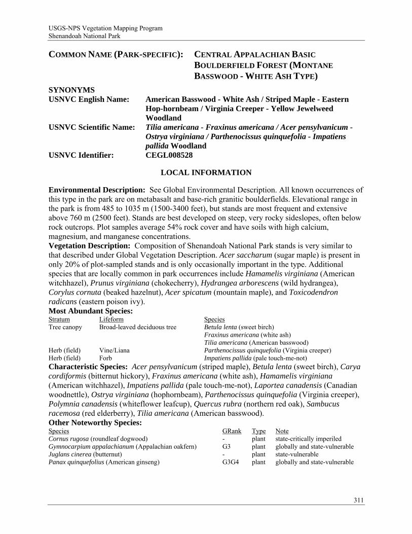
USGS-NPS Vegetation Mapping Program Shenandoah National Park
COMMON NAME (PARK-SPECIFIC): CENTRAL APPALACHIAN BASIC
BOULDERFIELD FOREST (MONTANE
BASSWOOD - WHITE ASH TYPE)
SYNONYMS USNVC English Name: American Basswood - White Ash / Striped Maple - Eastern
Hop-hornbeam / Virginia Creeper - Yellow Jewelweed Woodland
USNVC Scientific Name: Tilia americana - Fraxinus americana / Acer pensylvanicum - Ostrya virginiana / Parthenocissus quinquefolia - Impatiens pallida Woodland
USNVC Identifier: CEGL008528
LOCAL INFORMATION
Environmental Description: See Global Environmental Description. All known occurrences of this type in the park are on metabasalt and base-rich granitic boulderfields. Elevational range in the park is from 485 to 1035 m (1500-3400 feet), but stands are most frequent and extensive above 760 m (2500 feet). Stands are best developed on steep, very rocky sideslopes, often below rock outcrops. Plot samples average 54% rock cover and have soils with high calcium, magnesium, and manganese concentrations. Vegetation Description: Composition of Shenandoah National Park stands is very similar to that described under Global Vegetation Description. Acer saccharum (sugar maple) is present in only 20% of plot-sampled stands and is only occasionally important in the type. Additional species that are locally common in park occurrences include Hamamelis virginiana (American witchhazel), Prunus virginiana (chokecherry), Hydrangea arborescens (wild hydrangea), Corylus cornuta (beaked hazelnut), Acer spicatum (mountain maple), and Toxicodendron radicans (eastern poison ivy). Most Abundant Species: Stratum Lifeform Species Tree canopy Broad-leaved deciduous tree Betula lenta (sweet birch) Fraxinus americana (white ash) Tilia americana (American basswood) Herb (field) Vine/Liana Parthenocissus quinquefolia (Virginia creeper) Herb (field) Forb Impatiens pallida (pale touch-me-not) Characteristic Species: Acer pensylvanicum (striped maple), Betula lenta (sweet birch), Carya cordiformis (bitternut hickory), Fraxinus americana (white ash), Hamamelis virginiana (American witchhazel), Impatiens pallida (pale touch-me-not), Laportea canadensis (Canadian woodnettle), Ostrya virginiana (hophornbeam), Parthenocissus quinquefolia (Virginia creeper), Polymnia canadensis (whiteflower leafcup), Quercus rubra (northern red oak), Sambucus racemosa (red elderberry), Tilia americana (American basswood). Other Noteworthy Species: Species GRank Type Note Cornus rugosa (roundleaf dogwood) - plant state-critically imperiled Gymnocarpium appalachianum (Appalachian oakfern) G3 plant globally and state-vulnerable Juglans cinerea (butternut) - plant state-vulnerable Panax quinquefolius (American ginseng) G3G4 plant globally and state-vulnerable
311
USGS-NPS Vegetation Mapping Program Shenandoah National Park
Subnational Distribution with Crosswalk Data: State SRank Rel Conf SName Reference VA SNR* B 1 Low-elevation Boulderfield Forest / Woodland Fleming et al. 2006 Local Range: This type is widespread on bouldery sites underlain by Catoctin metabasalt and apparently more local on granitic substrates. It is most characteristic of mid-elevation sites but has been documented in suitable habitats as low as 450 m (1500 feet). Classification Comments: Although it is sometimes found at low elevations, this type is most abundant in the elevational zone >760 m (2500 feet) where Liriodendron tulipifera (tuliptree) drops out as a dominant tree of coves and mesic slopes. The type can intergrade with bouldery variants of Central Appalachian Rich Cove Forest (CEGL006237), which typically has a major overstory component of Acer saccharum (sugar maple) and a much more lush herb layer. Other Comments: Information not available. Local Description Authors: G. P. Fleming. Plots: NH Plots: SHNP004, SHNP027, SHNP040, SHNP041, SHNP042, SHNP044, SHNP045, SHNP050, SHNP051, SHNP054, SHNP514, SHNP534, SHNP577, SHNP644, SHNP654. Shenandoah National Park Inventory Notes: Represented by 15 plots and qualitative observations from 33 additional sites in the park.
GLOBAL INFORMATION
USNVC CLASSIFICATION Physiognomic Class Woodland (II) Physiognomic Subclass Deciduous woodland (II.B.) Physiognomic Group Cold-deciduous woodland (II.B.2.) Physiognomic Subgroup Natural/Semi-natural cold-deciduous woodland (II.B.2.N.) Formation Cold-deciduous woodland (II.B.2.N.a.) Alliance Tilia americana - Fraxinus americana - (Acer saccharum) Woodland Alliance
(A.628) Alliance (English name) American Basswood - White Ash - (Sugar Maple) Woodland Alliance Association Tilia americana - Fraxinus americana / Acer pensylvanicum - Ostrya virginiana /
Parthenocissus quinquefolia - Impatiens pallida Woodland Association (English name) American Basswood - White Ash / Striped Maple - Eastern Hop-hornbeam / Virginia
Creeper - Yellow Jewelweed Woodland Ecological System(s): Central and Southern Appalachian Montane Oak Forest (CES202.596) North-Central Appalachian Circumneutral Cliff and Talus (CES202.603).
GLOBAL DESCRIPTION Concept Summary: This community type occurs throughout the northern Blue Ridge in Virginia, Maryland, and West Virginia, and more locally in the western Virginia Ridge and Valley region. Sites include steep, boulder and stone slides below cliffs; boulder-filled slope concavities and hollow-heads; and other very rocky, submesic to mesic habitats at middle elevations between 760 and 1030 m (2500-3400 feet). This is an open to closed, mixed hardwood forest, with tall, well-formed trees. Because of somewhat unstable substrates and occasional exposure to severe wind and ice storms, downfalls and crown damage may be frequent in some stands. Tilia americana (American basswood) (including both var. americana and var. heterophylla), Fraxinus americana (white ash), and Quercus rubra (northern red oak) are the most abundant, variably dominant or codominant canopy trees. Carya cordiformis (bitternut hickory), Robinia pseudoacacia (black locust), and Carya ovata (shagbark hickory) are minor but constant canopy associates. Understory layers tend to be open, with Acer
312
USGS-NPS Vegetation Mapping Program Shenandoah National Park
pensylvanicum (striped maple), Ostrya virginiana (hophornbeam), Sambucus racemosa (red elderberry), and Ribes rotundifolium (Appalachian gooseberry) the most characteristic species. The usually patchy herb layer varies greatly in richness and density with substrate conditions. Environmental Description: Sites include steep, boulder and stone slides below cliffs; boulder-filled slope concavities and hollow-heads; and other very rocky, submesic to mesic habitats at middle elevations. Most plot-sampled stands are situated between 760 and 1030 m (2500-3400 feet) elevation, but stands occasionally occur as low as 450 m (1500 feet). The community is most frequent and characteristic of sites underlain by Catoctin metabasalt (greenstone) but also occurs locally on base-rich granitic rocks of the Blue Ridge basement complex, e.g., layered pyroxene granulite, charnockite, and porphyritic leucocharnockite. Scattered boulderfield habitats for this community in the Ridge and Valley province are derived from calcareous shales and siltstones. Stands occur at lower, middle, and upper slope topographic positions. Mean slope in plots is 23 degrees. Rock cover (bedrock, boulders, and/or stones) is essentially continuous, but surficial exposure of rocks averages 50%, with leaf litter (47%) and decaying wood (3%) comprising the remainder of the substrate. Soils are mostly interstitial, have high organic content (mean = 23%), and are generally difficult to extract. Samples collected from plots are very strongly acidic (mean pH = 4.7) but have moderately high calcium, magnesium, and manganese levels (up to 4628 ppm, 372 ppm, and 269 ppm, respectively). Vegetation Description: Stand physiognomy is an open to closed, mixed hardwood forest, with tall, well-formed trees. Because of somewhat unstable substrates and occasional exposure to severe wind and ice storms, downfalls and crown damage may be frequent in some stands. Tilia americana (American basswood) (including both var. americana and var. heterophylla), Fraxinus americana (white ash), and Quercus rubra (northern red oak) are the most abundant, variably dominant or codominant canopy trees. More locally, Betula lenta (sweet birch) and Acer saccharum (sugar maple) are codominants in the mixtures, although the latter is absent from the majority of plot-sampled stands. Carya cordiformis (bitternut hickory), Robinia pseudoacacia (black locust), and Carya ovata (shagbark hickory) are minor but constant canopy associates. Understory layers tend to be open, with Acer pensylvanicum (striped maple), Ostrya virginiana (hophornbeam), Sambucus racemosa (red elderberry), and Ribes rotundifolium (Appalachian gooseberry) the most characteristic species. The usually patchy herb layer varies greatly in richness and density with substrate conditions. Scrambling vines of Parthenocissus quinquefolia (Virginia creeper), along with the forbs Impatiens pallida (pale touch-me-not), Laportea canadensis (Canadian woodnettle), and Ageratina altissima (white snakeroot), constitute much of the herb-layer cover. Additional more-or-less constant herbs include Actaea racemosa (black bugbane), Arisaema triphyllum (Jack in the pulpit), Asarum canadense (Canadian wildginger), Dryopteris marginalis (marginal woodfern), Eurybia divaricata (white wood aster), Galium triflorum (fragrant bedstraw), Hydrophyllum virginianum (Shawnee salad), Osmorhiza claytonii (Clayton's sweetroot), and Polymnia canadensis (whiteflower leafcup), all of which are well-adapted to the interstices and moss mats of very bouldery/rocky habitats. On sites with slightly better development of mineral soils, a larger variety of nutrient-demanding herbs (e.g., Caulophyllum thalictroides (blue cohosh), Trillium grandiflorum (snow trillium), Viola canadensis (Canadian white violet)) may be present. Species richness of plot-sampled stands ranges from 14 to 59 taxa per 400 square meters (mean = 40). Most Abundant Species: Information not available. Characteristic Species: Acer pensylvanicum (striped maple), Ageratina altissima (white snakeroot), Fraxinus americana (white ash), Impatiens pallida (pale touch-me-not), Laportea
313
USGS-NPS Vegetation Mapping Program Shenandoah National Park
canadensis (Canadian woodnettle), Ostrya virginiana (hophornbeam), Polymnia canadensis (whiteflower leafcup), Prunus virginiana (chokecherry), Quercus rubra (northern red oak), Ribes rotundifolium (Appalachian gooseberry), Sambucus racemosa (red elderberry), Tilia americana (American basswood). Other Noteworthy Species: Species GRank Type Note Gymnocarpium appalachianum (Appalachian oakfern) G3 plant vulnerable USFWS Wetland System: Not applicable.
DISTRIBUTION Range: This community type occurs in suitable habitats throughout the northern Blue Ridge in Virginia, Maryland, and West Virginia, and more locally in the western Virginia Ridge and Valley region. Stands assigned to this type but somewhat transitional to northern hardwood forest, Betula alleghaniensis - Quercus rubra / Acer (pensylvanicum, spicatum) / Dryopteris intermedia - Oclemena acuminata Forest (CEGL008502), also occur on the northwest flank of Peters Mountain in Alleghany County, Virginia. Similar forests have been observed in a few other sites of the western Virginia Ridge and Valley region. States/Provinces: MD, VA:S3?, WV. Federal Lands: NPS (Blue Ridge Parkway, Shenandoah); USFS (George Washington, Jefferson).
CONSERVATION STATUS Rank: G3 (1-Oct-2001). Reasons: Based on current documentation, there are probably fewer than 100 occurrences of this community rangewide. Patch sizes are not large, and the type appears to be associated with a narrow range of ecological conditions, including base-rich substrates and intermediate elevations. The Blue Ridge of Maryland and the Ridge and Valley of Virginia and West Virginia support additional occurrences, but these are unlikely to be numerous due to a general lack of suitable substrates within the critical elevation range.
CLASSIFICATION INFORMATION Status: Standard. Confidence: 2 - Moderate. Comments: Classification of this unit is supported by 20 plots from Alleghany, Amherst, Botetourt, Greene, Madison, Page, Rappahannock, Rockbridge, and Rockingham counties, Virginia (G. Fleming pers. comm.). Boulderfield forests and woodlands have not been thoroughly inventoried in Virginia and elsewhere. The global ranges and ecological relationships of this and other units are not well known and require additional study. In particular, the distribution and status of Tilia americana - Fraxinus americana / Acer pensylvanicum - Ostrya virginiana / Parthenocissus quinquefolia - Impatiens pallida Woodland (CEGL008528) in the Ridge and Valley province needs clarification. The distribution of this community type in the northern Blue Ridge appears to be centered above 760 m (2500 feet) elevation, where Liriodendron tulipifera (tuliptree) begins to reach its upper elevational limits. Similar low-elevation habitats probably support Liriodendron tulipifera - Tilia americana - Betula lenta / Asimina triloba / Dryopteris marginalis Forest [Provisional] (CEGL008527). Above 1000 to 1060 m (3300-3500 feet) (depending on aspect) elevation, this type is replaced by Betula alleghaniensis / Sorbus americana - Acer spicatum / Polypodium appalachianum Forest (CEGL008504).
314

USGS-NPS Vegetation Mapping Program Shenandoah National Park
315
Similar Associations: Information not available. Related Concepts: • Liriodendron tulipifera - Acer saccharum - Tilia americana / Laportea canadensis - Impatiens pallida
Association, pro parte (Rawinski et al. 1996) F • Tilia americana - Fraxinus americana / Acer pensylvanicum - Ostrya virginiana / Parthenocissus quinquefolia -
Impatiens pallida Woodland (Fleming and Coulling 2001) = • Tilia americana - Fraxinus americana / Ostrya virginiana / Ageratina altissima Forest (Fleming and Moorhead
2000) F
SOURCES Description Authors: G. P. Fleming and P. P. Coulling. References: Fleming and Coulling 2001, Fleming and Moorhead 2000, Fleming et al. 2001, Fleming et al. 2004, Harrison 2004, Rawinski et al. 1996.
USGS-NPS Vegetation Mapping Program Shenandoah National Park
COMMON NAME (PARK-SPECIFIC): CENTRAL APPALACHIAN PINE - OAK / HEATH WOODLAND
SYNONYMS USNVC English Name: (Table Mountain Pine, Pitch Pine) - Chestnut Oak / (Bear Oak)
/ Black Huckleberry Woodland USNVC Scientific Name: Pinus (pungens, rigida) - Quercus prinus / (Quercus ilicifolia) /
Gaylussacia baccata Woodland USNVC Identifier: CEGL004996
LOCAL INFORMATION
Environmental Description: See Global Environmental Description. Shenandoah National Park stands are usually located on xeric upper slopes and crests, some of them essentially on clifftops, with south to northwest aspects. Elevational range in the park is about 470 to 970 m (1550-3180 feet), although the type is rather rare above 915 m (3000 feet). This vegetation covers relatively large areas on quartzitic substrates in the southern section of the park, much less on the granitic suite and metabasalt. Soils collected from plot samples are among the most acidic and infertile in the park. Vegetation Description: Because of recent depredations by the southern pine beetle, some stands in the park have rather low pine cover, even though they clearly represent this type. Physiognomy of existing stands varies from open shrubland nearly lacking an overstory (because of mortality from pine beetles) to nearly closed forest in fire-suppressed situations. Lithophytic variants occurring on quartzite clifftops also tend to have very open and stunted canopies. Pinus rigida (pitch pine) appears to be the dominant pine in the majority of park stands, with fewer stands dominated by Pinus pungens (Table Mountain pine) or codominated by the two species. Quercus prinus (chestnut oak) is consistently codominant with the pines. Minor tree associates include Quercus coccinea (scarlet oak), Quercus marilandica (blackjack oak), Castanea dentata (American chestnut), Pinus strobus (eastern white pine), Sassafras albidum (sassafras), Amelanchier arborea (common serviceberry), and Nyssa sylvatica (blackgum). Trees in this type tend to be stunted (generally <10 m tall). Shrub layers are typically dense to very dense, with variable, stratified patch-dominance by Quercus ilicifolia (bear oak), Kalmia latifolia (mountain laurel), Gaylussacia baccata (black huckleberry), Vaccinium pallidum (Blue Ridge blueberry), and/or Vaccinium stamineum (deerberry). Minor associates in the shrub complex include Spiraea betulifolia var. corymbosa (shinyleaf meadowsweet), Smilax rotundifolia (roundleaf greenbrier), and Smilax glauca (cat greenbrier). Few herbaceous species occur, and Pteridium aquilinum var. latiusculum (western brackenfern) is the only herb with constancy >50% in seven plot samples. However, in a subset of stands, Xerophyllum asphodeloides (eastern turkeybeard) is abundant and often flowers profusely following fires or pine beetle outbreaks. Stands of this community tend to be floristically depauperate, averaging 18 taxa per 400 square meters in plot samples. Most Abundant Species: Stratum Lifeform Species Tree canopy Needle-leaved tree Pinus pungens (Table Mountain pine) Pinus rigida (pitch pine) Tree canopy Broad-leaved deciduous tree Quercus prinus (chestnut oak) Tall shrub/sapling Broad-leaved evergreen shrub Kalmia latifolia (mountain laurel) Short shrub/sapling Broad-leaved deciduous shrub Gaylussacia baccata (black huckleberry) Vaccinium pallidum (Blue Ridge blueberry)
316
USGS-NPS Vegetation Mapping Program Shenandoah National Park
Characteristic Species: Gaylussacia baccata (black huckleberry), Kalmia latifolia (mountain laurel), Pinus pungens (Table Mountain pine), Pinus rigida (pitch pine), Pteridium aquilinum var. latiusculum (western brackenfern), Quercus ilicifolia (bear oak), Quercus marilandica (blackjack oak), Quercus prinus (chestnut oak), Vaccinium pallidum (Blue Ridge blueberry), Vaccinium stamineum (deerberry), Xerophyllum asphodeloides (eastern turkeybeard). Other Noteworthy Species: Species GRank Type Note Aralia hispida (bristly sarsaparilla) - plant state-imperiled Subnational Distribution with Crosswalk Data: State SRank Rel Conf SName Reference VA SNR* U . Pine - Oak / Heath Woodland Fleming et al. 2006 Local Range: This community is widely distributed and locally extensive on quartzite ridges forming the western flank of the Blue Ridge in the south district of the park. It appears to be infrequent and local elsewhere in the park. Classification Comments: On marginal, fire-suppressed sites, this community may be difficult to distinguish from more xeric variants of Central Appalachian / Northern Piedmont Chestnut Oak Forest (CEGL006299). In most cases, however, it can be distinguished by its more open, woodland physiognomy, the prominence of Pinus (pine) spp., and its very dense, multi-tiered shrub layer dominated by Quercus ilicifolia (bear oak) and/or ericads. Other Comments: Information not available. Local Description Authors: G. P. Fleming. Plots: NH Plots: SHNP001, SHNP095, SHNP501, SHNP504, SHNP633, SHNP648, SHNP651. Shenandoah National Park Inventory Notes: Represented by seven plots and qualitative observations from 30 additional sites in the park.
GLOBAL INFORMATION
USNVC CLASSIFICATION Physiognomic Class Woodland (II) Physiognomic Subclass Mixed evergreen - deciduous woodland (II.C.) Physiognomic Group Mixed needle-leaved evergreen - cold-deciduous woodland (II.C.3.) Physiognomic Subgroup Natural/Semi-natural mixed needle-leaved evergreen - cold-deciduous woodland
(II.C.3.N.) Formation Mixed needle-leaved evergreen - cold-deciduous woodland (II.C.3.N.a.) Alliance Pinus (rigida, pungens, virginiana) - Quercus prinus Woodland Alliance (A.677) Alliance (English name) (Pitch Pine, Table Mountain Pine, Virginia Pine) - Chestnut Oak Woodland Alliance Association Pinus (pungens, rigida) - Quercus prinus / (Quercus ilicifolia) / Gaylussacia baccata
Woodland Association (English name) (Table Mountain Pine, Pitch Pine) - Chestnut Oak / (Bear Oak) / Black Huckleberry
Woodland Ecological System(s): Southern Appalachian Montane Pine Forest and Woodland (CES202.331).
GLOBAL DESCRIPTION Concept Summary: This association represents mixed woodlands occupying xeric, convex, often rocky south- and west-facing slopes, ridge spurs, crests, and clifftops in the Central Appalachians and peripherally in the Piedmont and Southern Blue Ridge. Stands occur at elevations from 275 to 1200 m (900-4000 feet) on various substrates but most commonly on acidic, sedimentary and metasedimentary substrates (e.g., quartzites, sandstones, and shales). Soils are very infertile, shallow, and droughty. A thick, poorly decomposed duff layer, along with dead wood and highly volatile ericaceous shrubs, create a strongly fire-prone habitat. Pinus
317
USGS-NPS Vegetation Mapping Program Shenandoah National Park
pungens (Table Mountain pine) and Pinus rigida (pitch pine), individually or together, codominate the canopy with Quercus prinus (chestnut oak). The physiognomy of this community can approach that of a closed-canopy forest in some situations as a result of fire exclusion. Scattered canopy and subcanopy associates may include Quercus coccinea (scarlet oak), Quercus rubra (northern red oak), Quercus marilandica (blackjack oak), Pinus virginiana (Virginia pine), Castanea dentata (American chestnut), Acer rubrum (red maple), Sassafras albidum (sassafras), Nyssa sylvatica (blackgum), and Amelanchier arborea (common serviceberry). Quercus ilicifolia (bear oak) often dominates a moderately open to very dense tall-shrub layer, while variable combinations of Kalmia latifolia (mountain laurel), Gaylussacia baccata (black huckleberry), Vaccinium pallidum (Blue Ridge blueberry), Vaccinium angustifolium (lowbush blueberry), Vaccinium stamineum (deerberry), Pieris floribunda (mountain fetterbush), Rhododendron catawbiense (Catawba rosebay), and other ericads form a generally dense low-shrub layer. Smilax rotundifolia (roundleaf greenbrier) and Smilax glauca (cat greenbrier) may be prominent climbers among the shrubs. Herbaceous species, often very sparse, are rooted in small openings among the shrubs, on rocks, and in disturbed areas where mineral soil is exposed. Typical herbs and subshrubs include Epigaea repens (trailing arbutus), Gaultheria procumbens (eastern teaberry), Xerophyllum asphodeloides (eastern turkeybeard), Iris verna (dwarf violet iris), Pteridium aquilinum var. latiusculum (western brackenfern), Melampyrum lineare var. latifolium (narrowleaf cowwheat), Stenanthium gramineum var. micranthum (eastern featherbells), Uvularia puberula (mountain bellwort), Lycopodium tristachyum (deeproot clubmoss), Aralia hispida (bristly sarsaparilla) (usually on outcrops), and Carex tonsa (shaved sedge). Periodic fire is an important ecological process that provides opportunities for the regeneration of both canopy pines and less competitive herbaceous species, while setting back successional encroachment of xeric oaks. On many sites (e.g., clifftops, quartzite ledges), the vegetation is self-perpetuating due to extreme edaphic conditions. Environmental Description: These mixed woodlands occupy xeric, convex, often rocky south- and west-facing slopes, ridge spurs, crests, and clifftops in the Central Appalachians and peripherally in the Piedmont and Southern Blue Ridge. Stands occur at elevations from 275 to 1200 m (900-4000 feet) on various substrates but most commonly on acidic, sedimentary and metasedimentary substrates (e.g., quartzites, sandstones, and shales). Soils are very infertile, shallow, and droughty. A thick, poorly decomposed duff layer, along with dead wood and highly volatile ericaceous shrubs, create a strongly fire-prone habitat. On many sites (e.g., clifftops, quartzite ledges), the vegetation is self-perpetuating due to extreme edaphic conditions. There are significant differences in site conditions associated with variations in this community type. One major variant, often associated with Pinus pungens (Table Mountain pine) abundance, occurs at low to middle elevations and tends to occupy cliffs and steep sideslopes with significant rock cover. Another variant, often associated with high Pinus rigida (pitch pine) cover, occurs at middle to high elevations and tends to occupy moderately steep to sublevel upper slopes and crests with little rock cover and very dense duff. Although strongly fire-prone habitats influence vegetation structure and composition of both subtypes, the rock outcrop variant tends to be more influenced by edaphic stresses because of its frequent association with cliffs and outcrop areas. Vegetation Description: The canopies of stands of this type are codominated by Pinus pungens (Table Mountain pine) and Pinus rigida (pitch pine), either individually or together, with Quercus prinus (chestnut oak). Scattered canopy and subcanopy associates may include Quercus coccinea (scarlet oak), Quercus rubra (northern red oak), Quercus marilandica (blackjack oak), Pinus virginiana (Virginia pine), Castanea dentata (American chestnut), Acer rubrum (red
318
USGS-NPS Vegetation Mapping Program Shenandoah National Park
maple), Sassafras albidum (sassafras), Nyssa sylvatica (blackgum), and Amelanchier arborea (common serviceberry). Quercus ilicifolia (bear oak) often dominates a moderately open to very dense tall-shrub layer, while variable combinations of Kalmia latifolia (mountain laurel), Gaylussacia baccata (black huckleberry), Vaccinium pallidum (Blue Ridge blueberry), Vaccinium angustifolium (lowbush blueberry), Vaccinium stamineum (deerberry), Pieris floribunda (mountain fetterbush), Rhododendron catawbiense (Catawba rosebay), and other ericads form a generally dense low-shrub layer. Smilax rotundifolia (roundleaf greenbrier) and Smilax glauca (cat greenbrier) may be prominent climbers among the shrubs. Herbaceous species, often very sparse, are rooted in small openings among the shrubs, on rocks, and in disturbed areas where mineral soil is exposed. Typical herbs and subshrubs include Epigaea repens (trailing arbutus), Gaultheria procumbens (eastern teaberry), Xerophyllum asphodeloides (eastern turkeybeard), Iris verna (dwarf violet iris), Pteridium aquilinum var. latiusculum (western brackenfern), Melampyrum lineare var. latifolium (narrowleaf cowwheat), Stenanthium gramineum var. micranthum (eastern featherbells), Uvularia puberula (mountain bellwort), Lycopodium tristachyum (deeproot clubmoss), Aralia hispida (bristly sarsaparilla) (usually on outcrops), and Carex tonsa (shaved sedge). Although fully intergradational, two variants recognized in Virginia are very distinct in their typical expressions. Both share Quercus prinus (chestnut oak) as a codominant canopy tree and have a similar ericaceous shrub layer composed largely of Kalmia latifolia (mountain laurel), Gaylussacia baccata (black huckleberry), and Vaccinium pallidum (Blue Ridge blueberry). However, in the first variant, which is usually associated with cliffs and rocky slopes, Pinus pungens (Table Mountain pine) is the most constant and abundant pine. In the second variant, most often associated with xeric upper slopes and crests, Pinus rigida (pitch pine) is the most constant and abundant pine. Recognition of these variants as formal types or subtypes has proven problematic due to intergradation of both habitats and floristic composition. Piedmont stands of this community (e.g., on Bull Run Mountain, Virginia, and Sugarloaf Mountain, Maryland) are similar to montane stands but lack Quercus ilicifolia (bear oak) and other species characteristic of higher elevations. Most Abundant Species: Information not available. Characteristic Species: Buckleya distichophylla (piratebush), Carex polymorpha (variable sedge), Galax urceolata (beetleweed), Gaultheria procumbens (eastern teaberry), Gaylussacia baccata (black huckleberry), Iris verna (dwarf violet iris), Kalmia latifolia (mountain laurel), Lycopodium tristachyum (deeproot clubmoss), Melampyrum lineare var. latifolium (narrowleaf cowwheat), Nyssa sylvatica (blackgum), Pinus pungens (Table Mountain pine), Pinus rigida (pitch pine), Quercus coccinea (scarlet oak), Quercus ilicifolia (bear oak), Sassafras albidum (sassafras), Vaccinium pallidum (Blue Ridge blueberry), Xerophyllum asphodeloides (eastern turkeybeard). Other Noteworthy Species: Species GRank Type Note Buckleya distichophylla (piratebush) G2 plant globally and VA state-imperiled Carex polymorpha (variable sedge) G3 plant globally vulnerable and VA state-imperiled Catocala herodias gerhardi (herodias or pine
barrens underwing) G3T3 animal vulnerable
Pituophis melanoleucus melanoleucus (northern pinesnake)
- animal
Tsuga caroliniana (Carolina hemlock) G3 plant globally and state-vulnerable Vaccinium myrtilloides (velvetleaf huckleberry) - plant VA state-imperiled USFWS Wetland System: Not applicable.
319
USGS-NPS Vegetation Mapping Program Shenandoah National Park
DISTRIBUTION Range: This community occurs in the Central Appalachian region of Virginia, West Virginia, Maryland, and Pennsylvania, with very local outliers in the western Piedmont of Virginia and Maryland (e.g., Sugarloaf Mountain). In Virginia, the type as a whole ranges through the Blue Ridge and Ridge and Valley provinces north of the New River. Outliers occur on Bull Run Mountain (Fauquier County), Willis Mountain (Buckingham County), and other Virginia Piedmont foothills. States/Provinces: MD, PA, VA, WV. Federal Lands: NPS (Blue Ridge Parkway, C&O Canal, Catoctin Mountain, Shenandoah); USFS (George Washington, Jefferson).
CONSERVATION STATUS Rank: G4 (1-Oct-2001). Reasons: This community is widely but locally distributed in the Central Appalachians, forming large patches at some sites. It is apparently secure, although fire suppression and insect pathogens represent ongoing stand-altering disturbances.
CLASSIFICATION INFORMATION Status: Standard. Confidence: 1 - Strong. Comments: This community type is closely related to other xeric pine and pine-oak associations. It is thought to differ in the frequent shrub layer dominance of Quercus ilicifolia (bear oak), a northern species which is absent in similar communities south of Virginia, as well as the absence of a number of characteristic southern species such as Gaylussacia ursina (bear huckleberry), Rhododendron carolinianum (Carolina azalea), Rhododendron minus (piedmont rhododendron), Leiophyllum buxifolium (sandmyrtle), and Fothergilla major (mountain witchalder). Long-term, widespread fire exclusion is an ongoing problem which may be causing some stands to succeed to closed, mixed oak-pine forest. However, on many sites occupied by this community, edaphic conditions are so stressful that tree oaks are marginally competitive, and even long fire-return intervals (e.g., >25 years) are sufficient to maintain pine codominance. Within the past ten years, much of this vegetation in Virginia has been devastated by infestations of southern pine beetle (Dendroctonus frontalis). These outbreaks have resulted in extensive mortality of the dominant pines and changed physiognomies, at least temporarily, to a shrubland condition. Two subtypes formerly recognized in Virginia have proven problematic in recent analyses and are better regarded as intergrading variants. Similar Associations: • Pinus pungens - Pinus rigida - (Quercus prinus) / Kalmia latifolia - Vaccinium pallidum Woodland
(CEGL007097). • Pinus rigida - (Pinus pungens) / Rhododendron catawbiense - Kalmia latifolia / Galax urceolata Woodland
(CEGL004985). • Pinus rigida / (Quercus ilicifolia) / Photinia melanocarpa / Deschampsia flexuosa Woodland (CEGL006116).
320
USGS-NPS Vegetation Mapping Program Shenandoah National Park
321
Related Concepts: • Pinus pungens - Pinus rigida / Quercus ilicifolia / Gaylussacia baccata Association (Rawinski et al. 1996) F • Pinus pungens - Quercus prinus - (Quercus coccinea) / Kalmia latifolia - Gaylussacia baccata Woodland
(Fleming and Coulling 2001) F • Pinus pungens / Quercus ilicifolia / Gaylussacia baccata - Pteridium aquilinum Woodland (Fleming and
Moorhead 2000) F • Pinus rigida / Quercus ilicifolia / Gaylussacia baccata Association (Rawinski et al. 1994) F • Quercus prinus - Pinus rigida / Quercus ilicifolia - Kalmia latifolia - Gaylussacia baccata / Gaultheria
procumbens Woodland (Fleming and Coulling 2001) F • Chestnut Oak: 44 (Eyre 1980) B • Pitch Pine: 45 (Eyre 1980) B
SOURCES Description Authors: G. P. Fleming and P. P. Coulling. References: Eyre 1980, Fleming and Coulling 2001, Fleming and Moorhead 2000, Fleming et al. 2001, Fleming pers. comm., Harrison 2004, Rawinski et al. 1994, Rawinski et al. 1996, Southeastern Ecology Working Group n.d., Young et al. 2006.
USGS-NPS Vegetation Mapping Program Shenandoah National Park
COMMON NAME (PARK-SPECIFIC): CENTRAL APPALACHIAN XERIC CHESTNUT
OAK - VIRGINIA PINE WOODLAND
SYNONYMS USNVC English Name: Chestnut Oak - Virginia Pine - (Table Mountain Pine) / Little
Bluestem - Starved Witchgrass Woodland USNVC Scientific Name: Quercus prinus - Pinus virginiana - (Pinus pungens) /
Schizachyrium scoparium - Dichanthelium depauperatum Woodland
USNVC Identifier: CEGL008540
LOCAL INFORMATION
Environmental Description: This association is known from scattered outcrops of all the major geologic classes of the park, i.e., metabasalt (acidic phases), granitic rocks, and metasedimentary rocks. Known sites are steep, solar-exposed, mid- and upper-slope outcrops with veneers and pockets of shallow, low-fertility soils. Bedrock cover is high but discontinuous at these sites. Vegetation Description: Physiognomically, this vegetation type is a mixed woodland with more or less equal, if variable, dominance by oaks and pines. Stands are typically stunted, with trees less than 10 m tall and often somewhat gnarled. Park stands are compositionally similar to those elsewhere in the range. Quercus prinus (chestnut oak) is the most constant and abundant tree, occurring in association with either Pinus virginiana (Virginia pine) or Pinus pungens (Table Mountain pine), or both. Quercus rubra (northern red oak) is the only other characteristic tree recorded in plots. A patchwork of ericaceous shrub thickets, graminoid-dominated herbaceous openings, and lichen-dominated outcrop surfaces is typically present beneath the open canopy. The most characteristic shrubs are Vaccinium pallidum (Blue Ridge blueberry) and Vaccinium stamineum (deerberry). Herbaceous patch-dominants include Carex pensylvanica (Pennsylvania sedge), Schizachyrium scoparium (little bluestem), Danthonia spicata (poverty oatgrass), Dichanthelium depauperatum (starved panicgrass), and Deschampsia flexuosa (wavy hairgrass). A large number of xerophytic forbs also occur at low cover, including Aureolaria laevigata (entireleaf yellow false foxglove), Campanula divaricata (small bonny bellflower), Hieracium venosum (rattlesnakeweed), Houstonia longifolia (longleaf summer bluet), Solidago erecta (slender goldenrod), Solidago puberula var. puberula (downy goldenrod), Symphyotrichum undulatum (waxyleaf aster), and Viola sagittata (arrowleaf violet). Species richness of plot-sampled park stands ranges from 18 to 55 taxa per 400 square meters (mean = 30). Most Abundant Species: Stratum Lifeform Species Tree canopy Broad-leaved deciduous tree Quercus prinus (chestnut oak) Herb (field) Graminoid Carex pensylvanica (Pennsylvania sedge) Danthonia spicata (poverty oatgrass) Dichanthelium depauperatum (starved panicgrass) Schizachyrium scoparium (little bluestem) Characteristic Species: Aureolaria laevigata (entireleaf yellow false foxglove), Carex pensylvanica (Pennsylvania sedge), Danthonia spicata (poverty oatgrass), Dichanthelium depauperatum (starved panicgrass), Pinus pungens (Table Mountain pine), Pinus virginiana (Virginia pine), Quercus prinus (chestnut oak), Schizachyrium scoparium (little bluestem),
322
USGS-NPS Vegetation Mapping Program Shenandoah National Park
Solidago speciosa var. erecta (showy goldenrod), Symphyotrichum undulatum (waxyleaf aster), Vaccinium pallidum (Blue Ridge blueberry), Vaccinium stamineum (deerberry). Other Noteworthy Species: Species GRank Type Note Arctostaphylos uva-ursi (kinnikinnick) - plant state-critically imperiled Taenidia montana (mountain pimpernel) G3 plant globally and state-vulnerable Subnational Distribution with Crosswalk Data: State SRank Rel Conf SName Reference VA S2 . . [not crosswalked] . Local Range: This is a rare community in the park but is known from at least one site in each district. It generally occurs in patches <2 ha in size. Plots were sampled at Millers Head (lower outcrop), Overall Run (north side), Whiteoak Canyon (lower north side), Old Rag (south slope), Hogback Mountain spur, and Heiskel Run. Classification Comments: This community is most similar to variants of Central Appalachian Pine - Oak / Heath Woodland (CEGL004996) that occur on xeric quartzite and granitic clifftops and outcrops. These variants typically contain mixtures of Quercus prinus (chestnut oak), Pinus pungens (Table Mountain pine), and Pinus rigida (pitch pine), with ericaceous shrubs and Quercus ilicifolia (bear oak) occupying crevices and shallow soil mats. Stands of CEGL008540 can be distinguished from lithophytic stands of CEGL004996 by the importance of Pinus virginiana (Virginia pine) and/or the higher cover and diversity of herbaceous plants. Other Comments: Information not available. Local Description Authors: G. P. Fleming. Plots: NH Plots: SHNP025, SHNP146, SHNP150, SHNP151, SHNP157, SHNP158, SHNP578. Shenandoah National Park Inventory Notes: Represented by seven plots and qualitative observations from three additional sites in the park.
GLOBAL INFORMATION
USNVC CLASSIFICATION Physiognomic Class Woodland (II) Physiognomic Subclass Mixed evergreen - deciduous woodland (II.C.) Physiognomic Group Mixed needle-leaved evergreen - cold-deciduous woodland (II.C.3.) Physiognomic Subgroup Natural/Semi-natural mixed needle-leaved evergreen - cold-deciduous woodland
(II.C.3.N.) Formation Mixed needle-leaved evergreen - cold-deciduous woodland (II.C.3.N.a.) Alliance Pinus (rigida, pungens, virginiana) - Quercus prinus Woodland Alliance (A.677) Alliance (English name) (Pitch Pine, Table Mountain Pine, Virginia Pine) - Chestnut Oak Woodland Alliance Association Quercus prinus - Pinus virginiana - (Pinus pungens) / Schizachyrium scoparium -
Dichanthelium depauperatum Woodland Association (English name) Chestnut Oak - Virginia Pine - (Table Mountain Pine) / Little Bluestem - Starved
Witchgrass Woodland Ecological System(s): Central Appalachian Pine-Oak Rocky Woodland (CES202.600).
GLOBAL DESCRIPTION Concept Summary: This community is a mixed oak-pine woodland with a canopy of stunted, often gnarled trees, varying from semi-open to very open. It occurs on steep convex slopes, ridge spurs, and clifftops which have high solar exposure. Most are on moderate to steep slopes with much exposed mineral soil. Sites are confined to lower elevations (<770 m [2500 feet]), are distinctly xeric, and usually have southeast to southwest aspects. Underlying bedrock includes
323
USGS-NPS Vegetation Mapping Program Shenandoah National Park
quartzite, metasandstone and sandstone, granite, shale, and other acidic rocks. Surface cover of outcrops and loose stones is relatively high. Soils are extremely acidic. The canopy is typically codominated by Quercus prinus (chestnut oak) and Pinus virginiana (Virginia pine) in variable proportions; in some slightly more mesic occurrences, Quercus rubra (northern red oak) may occur with or in place of Quercus prinus (chestnut oak). Pinus pungens (Table Mountain pine) is an important, even dominant, associate in a minority of stands. Minor but relatively constant tree associates include Carya glabra (pignut hickory), Amelanchier arborea (common serviceberry), and Sassafras albidum (sassafras). Minor, inconstant tree associates include Quercus coccinea (scarlet oak), Quercus velutina (black oak), Quercus stellata (post oak), Quercus marilandica (blackjack oak), Quercus alba (white oak), Carya alba (mockernut hickory), Carya ovata (shagbark hickory), Juniperus virginiana (eastern redcedar), Pinus strobus (eastern white pine), and Fraxinus americana (white ash). The shrub layer varies from moderately dense to sparse, with Vaccinium pallidum (Blue Ridge blueberry) and Vaccinium stamineum (deerberry) the most constant and abundant species. Quercus ilicifolia (bear oak), Kalmia latifolia (mountain laurel), Rhus copallinum (flameleaf sumac), Rhus aromatica (fragrant sumac), Rosa carolina (Carolina rose), Castanea pumila (chinkapin), Viburnum acerifolium (mapleleaf viburnum), and Toxicodendron pubescens (Atlantic poison oak) are inconstant, but occasionally common, in the type. Herbaceous composition and density vary with shrub density. Graminoid-rich openings dominated by Schizachyrium scoparium (little bluestem), Dichanthelium depauperatum (starved panicgrass), Carex pensylvanica (Pennsylvania sedge), Danthonia spicata (poverty oatgrass), and Dichanthelium commutatum (variable panicgrass) are frequent. Also present is a surprising variety of low-cover forbs, among the most characteristic of which are Hieracium venosum (rattlesnakeweed), Solidago erecta (slender goldenrod), Potentilla canadensis (dwarf cinquefoil), Campanula divaricata (small bonny bellflower), Viola sagittata (arrowleaf violet), Houstonia longifolia (longleaf summer bluet), Antennaria plantaginifolia (woman's tobacco), Aureolaria laevigata (entireleaf yellow false foxglove), Helianthus divaricatus (woodland sunflower), Cunila origanoides (common dittany), Symphyotrichum undulatum (waxyleaf aster), Coreopsis verticillata (whorled tickseed), Tephrosia virginiana (Virginia tephrosia), Lespedeza frutescens (shrubby lespedeza), Polygonatum biflorum var. biflorum (smooth Solomon's-seal), Taenidia integerrima (yellow pimpernel), Asplenium platyneuron (ebony spleenwort), and Clitoria mariana (Atlantic pigeonwings). Environmental Description: This association occurs on steep convex slopes, ridge spurs, and clifftops which have high solar exposure. Most habitats are characterized by moderate to steep (mean = 24 degrees) slopes with much exposed mineral soil. Sites are confined to lower elevations (<770 m [2500 feet]), are distinctly xeric, and usually have southeast to southwest aspects. Underlying bedrock at plot-sampling sites in VA, MD, and WV includes Antietam quartzite, ferruginous metasandstone of the Harper's Formation, acidic granites, acidic phases of Catoctin metabasalt, schistose metasedimentary rocks of the Mather Gorge Formation, shales and sandstones of the Hinton formation in the Mauch Chunk group, and ancient alluvium composed of quartzitic cobbles. Surface cover of outcrops and loose stones is relatively high (mean = 38% in MD and VA plots). Soils are extremely acidic (mean pH = 4.4) and very low in base status, except for high aluminum levels and sometimes relatively high potassium levels. One somewhat anomalous site is located on massive alluvial fans that overlie the floor of the Great Valley of Virginia along the foot of the Blue Ridge in Augusta County. Here, stands occupy barren, elevated cobble terraces bordering a stream and representing the floodplain level of an earlier erosional cycle.
324

USGS-NPS Vegetation Mapping Program Shenandoah National Park
Vegetation Description: The canopy cover of stunted, often gnarled trees varies from semi-open to very open. Quercus prinus (chestnut oak) and Pinus virginiana (Virginia pine) are usually codominant in variable proportions; in some slightly more mesic occurrences, Quercus rubra (northern red oak) may occur with or in place of Quercus prinus (chestnut oak). Pinus pungens (Table Mountain pine) is an important, even dominant, associate in a minority of stands. Minor but relatively constant tree associates include Carya glabra (pignut hickory), Amelanchier arborea (common serviceberry), and Sassafras albidum (sassafras). Minor, inconstant tree associates include Quercus coccinea (scarlet oak), Quercus velutina (black oak), Quercus stellata (post oak), Quercus marilandica (blackjack oak), Quercus alba (white oak), Carya alba (mockernut hickory), Carya ovata (shagbark hickory), Juniperus virginiana (eastern redcedar), Pinus strobus (eastern white pine), and Fraxinus americana (white ash). The shrub layer varies from moderately dense to sparse, with Vaccinium pallidum (Blue Ridge blueberry) and Vaccinium stamineum (deerberry) the most constant and abundant species. Quercus ilicifolia (bear oak), Kalmia latifolia (mountain laurel), Rhus copallinum (flameleaf sumac), Rhus aromatica (fragrant sumac), Rosa carolina (Carolina rose), Castanea pumila (chinkapin), Viburnum acerifolium (mapleleaf viburnum), and Toxicodendron pubescens (Atlantic poison oak) are inconstant, but occasionally common, in the type. Herbaceous composition and density vary with shrub density. Graminoid-rich openings dominated by Schizachyrium scoparium (little bluestem), Dichanthelium depauperatum (starved panicgrass), Carex pensylvanica (Pennsylvania sedge), Danthonia spicata (poverty oatgrass), and Dichanthelium commutatum (variable panicgrass) are frequent. Also present is a surprising variety of low-cover forbs, among the most characteristic of which are Hieracium venosum (rattlesnakeweed), Solidago erecta (slender goldenrod), Potentilla canadensis (dwarf cinquefoil), Campanula divaricata (small bonny bellflower), Viola sagittata (arrowleaf violet), Houstonia longifolia (longleaf summer bluet), Antennaria plantaginifolia (woman's tobacco), Aureolaria laevigata (entireleaf yellow false foxglove), Helianthus divaricatus (woodland sunflower), Cunila origanoides (common dittany), Symphyotrichum undulatum (waxyleaf aster), Coreopsis verticillata (whorled tickseed), Tephrosia virginiana (Virginia tephrosia), Lespedeza frutescens (shrubby lespedeza), Polygonatum biflorum var. biflorum (smooth Solomon's-seal), Taenidia integerrima (yellow pimpernel), Asplenium platyneuron (ebony spleenwort), and Clitoria mariana (Atlantic pigeonwings). Additional herbs occurring less frequently include Lespedeza hirta (hairy lespedeza), Solidago odora (anisescented goldenrod), Deschampsia flexuosa (wavy hairgrass), Coreopsis major (greater tickseed), Solidago puberula var. puberula (downy goldenrod), Solidago bicolor (white goldenrod), Solidago arguta var. caroliniana (Atlantic goldenrod), Solidago sphacelata (autumn goldenrod), Hypericum hypericoides ssp. multicaule (St. Andrew's cross), Lysimachia quadrifolia (whorled yellow loosestrife), Asclepias amplexicaulis (clasping milkweed), Sericocarpus asteroides (toothed whitetop aster), Dicentra eximia (turkey corn), Paronychia fastigiata (hairy forked nailwort), Sericocarpus linifolius (narrowleaf whitetop aster), Ionactis linariifolius (flaxleaf whitetop aster), Symphyotrichum laeve (smooth blue aster), Phlox subulata (moss phlox), Pellaea atropurpurea (purple cliffbrake), Polygonum scandens var. cristatum (climbing false buckwheat), Viola X palmata (early blue violet), Arabis laevigata (smooth rockcress), and Zizia trifoliata (meadow alexanders). Vascular plant species richness of plot-sampled stands ranges from 17 to 56 taxa per 400 square meters (mean = 37). Nonvascular cover tends to be sparse and characterized by fruticose lichens, including Cladina arbuscula (reindeer lichen).
325

USGS-NPS Vegetation Mapping Program Shenandoah National Park
Most Abundant Species: Stratum Lifeform Species Tree canopy Needle-leaved tree Pinus virginiana (Virginia pine) Shrub/sapling (tall & short) Broad-leaved deciduous shrub Vaccinium pallidum (Blue Ridge blueberry) Vaccinium stamineum (deerberry) Herb (field) Graminoid Carex pensylvanica (Pennsylvania sedge) Danthonia spicata (poverty oatgrass) Dichanthelium depauperatum (starved panicgrass) Schizachyrium scoparium (little bluestem) Characteristic Species: Carex pensylvanica (Pennsylvania sedge), Carex umbellata (parasol sedge), Castanea pumila (chinkapin), Danthonia spicata (poverty oatgrass), Dichanthelium commutatum (variable panicgrass), Dichanthelium depauperatum (starved panicgrass), Hieracium venosum (rattlesnakeweed), Lespedeza hirta (hairy lespedeza), Pinus virginiana (Virginia pine), Quercus marilandica (blackjack oak), Rhus copallinum (flameleaf sumac), Schizachyrium scoparium (little bluestem), Solidago odora (anisescented goldenrod), Tephrosia virginiana (Virginia tephrosia), Toxicodendron pubescens (Atlantic poison oak), Vaccinium pallidum (Blue Ridge blueberry), Vaccinium stamineum (deerberry). Other Noteworthy Species: Information not available. USFWS Wetland System: Not applicable.
DISTRIBUTION Range: The known range of this community is limited to the northern Blue Ridge, Ridge and Valley, Cumberlands, and Piedmont in Virginia, West Virginia, and Maryland, but geologic substrates and site conditions similar to those supporting the known examples occur elsewhere in the Central Appalachians, and a broader geographic range seems likely. States/Provinces: MD, VA:S2, WV. Federal Lands: NPS (Blue Ridge Parkway, Bluestone, C&O Canal, Catoctin Mountain, Harpers Ferry, Shenandoah); USFS (Jefferson).
CONSERVATION STATUS Rank: G3? (8-Feb-2008). Reasons: Although this community is likely to have a broader distribution in the Central Appalachians than present documentation suggests, it is a small-patch vegetation type restricted to special habitat conditions.
CLASSIFICATION INFORMATION Status: Standard. Confidence: 2 - Moderate. Comments: The classification of this type is supported by analysis of 12 Virginia, 3 Maryland, and 8 West Virginia plot samples. Additional inventory and data collection are needed to clarify the geographic range, classification, and environmental context of this type. The known range of this community is limited to the northern Blue Ridge, Ridge and Valley, Cumberlands, and Piedmont in Virginia, West Virginia, and Maryland, but geologic substrates and site conditions similar to those supporting the known examples occur elsewhere in the Central Appalachians, and a broader geographic range seems likely.
326
USGS-NPS Vegetation Mapping Program Shenandoah National Park
327
Similar Associations: • Pinus virginiana / Vaccinium pallidum / Schizachyrium scoparium - Carex pensylvanica Woodland
(CEGL003624)--on dry shale slopes of the Southern Appalachians. • Quercus prinus - Juniperus virginiana - (Pinus virginiana) / Philadelphus hirsutus - Celtis occidentalis
Woodland (CEGL007720)--on steep, rocky, riverine bluffs in the Southern Blue Ridge with exposed and eroding shale.
• Quercus prinus / Quercus ilicifolia / Danthonia spicata Woodland [Provisional] (CEGL008526)--on dry shale slopes of the Central Appalachians.
Related Concepts: • Pinus pungens - Pinus rigida / Quercus ilicifolia / Gaylussacia baccata Association: Andropogon scoparius -
Coreopsis verticillata - Dichanthelium depauperatum Subassociation, pro parte (Rawinski et al. 1996) F • Quercus prinus - Pinus virginiana - Quercus (marilandica, stellata) / Dichanthelium depauperatum Woodland
(Fleming and Coulling 2001) =
SOURCES Description Authors: G. P. Fleming and P. P. Coulling, mod. S. C. Gawler. References: Braunschweig et al. 1999, Fleming and Coulling 2001, Fleming et al. 2001, Fleming et al. 2004, Fleming et al. 2007, Rawinski et al. 1996, WVNHP unpubl. data b.

USGS-NPS Vegetation Mapping Program Shenandoah National Park
COMMON NAME (PARK-SPECIFIC): CENTRAL APPALACHIAN HEATH BARREN
SYNONYMS USNVC English Name: Mountain Laurel - Black Huckleberry - (Northern Lowbush
Blueberry, Hillside Blueberry) - Minniebush Shrubland USNVC Scientific Name: Kalmia latifolia - Gaylussacia baccata - Vaccinium
(angustifolium, pallidum) - Menziesia pilosa Shrubland USNVC Identifier: CEGL003939
LOCAL INFORMATION
Environmental Description: See Global Environment Description. The three known localities in the park are on sublevel to steeply sloping outcrop pavements of charnockite and Old Rag granite at 950 to 1120 m (3120-3680 feet) elevation, respectively. Vegetation Description: Composition is similar to that described under the Global Vegetation Description. Kalmia latifolia (mountain laurel) has the highest mean cover in the shrub complex, with constant associates of Vaccinium pallidum (Blue Ridge blueberry), Menziesia pilosa (minniebush), Gaylussacia baccata (black huckleberry), and Sorbus americana (American mountain ash). Photinia melanocarpa (black chokeberry), Vaccinium angustifolium (lowbush blueberry), and extremely stunted Betula alleghaniensis (yellow birch), Prunus pensylvanica (pin cherry), Tsuga canadensis (eastern hemlock), and Pinus pungens (Table Mountain pine) are occasionally present at low cover. Herbs are sparse but include scattered patches and individuals of Dennstaedtia punctilobula (eastern hayscented fern), Deschampsia flexuosa (wavy hairgrass), Carex pensylvanica (Pennsylvania sedge), Solidago puberula var. puberula (downy goldenrod), Aralia nudicaulis (wild sarsaparilla), Aralia hispida (bristly sarsaparilla), Saxifraga michauxii (Michaux's saxifrage), Minuartia groenlandica (Greenland stitchwort), and Huperzia appalachiana (Appalachian clubmoss). Mean species richness of five plot samples is only 17 taxa per 100 square meters. Most Abundant Species: Stratum Lifeform Species Shrub/sapling (tall & short) Broad-leaved deciduous shrub Gaylussacia baccata (black huckleberry) Vaccinium pallidum (Blue Ridge blueberry) Shrub/sapling (tall & short) Broad-leaved evergreen shrub Kalmia latifolia (mountain laurel) Characteristic Species: Deschampsia flexuosa (wavy hairgrass), Gaylussacia baccata (black huckleberry), Kalmia latifolia (mountain laurel), Menziesia pilosa (minniebush), Pinus pungens (Table Mountain pine), Solidago puberula var. puberula (downy goldenrod), Sorbus americana (American mountain ash), Vaccinium pallidum (Blue Ridge blueberry). Other Noteworthy Species: Species GRank Type Note Aralia hispida (bristly sarsaparilla) - plant state-imperiled Arctostaphylos uva-ursi (kinnikinnick) - plant state-imperiled Huperzia appalachiana (Appalachian clubmoss) - plant state-imperiled Minuartia groenlandica (Greenland stitchwort) - plant state-critically imperiled Subnational Distribution with Crosswalk Data: Information not available. Local Range: This type is known from high-elevation outcrops of granitic rocks at Old Rag, Marys Rock, and The Pinnacle in the central district of the park. Little, if any, suitable habitat occurs outside the three known sites.
328
USGS-NPS Vegetation Mapping Program Shenandoah National Park
Classification Comments: This community was classified and mapped under the now-retired CEGL008538 in version 1.0 of the Shenandoah National Park Vegetation Map. Region-wide studies of high-elevation ericaceous shrub communities during the Rock Outcrop Management Project (Fleming et al. 2007) resulted in a merger of CEGL008538 and CEGL003939, which at that time represented similar shrublands of the high Allegheny Mountains in eastern West Virginia. This community occurs in very small patches, with the maximum size for a discrete patch approximately 0.2 ha. However, at all three known sites in the park, multiple patches are dispersed in mosaics with other community types. Other Comments: Information not available. Local Description Authors: G. P. Fleming. Plots: NH Plots: SHNP035, SHNP139, SHNP141, SHNP142, SHNP147. Shenandoah National Park Inventory Notes: Represented by five plots from the park.
GLOBAL INFORMATION
USNVC CLASSIFICATION Physiognomic Class Shrubland (III) Physiognomic Subclass Mixed evergreen-deciduous shrubland (III.C.) Physiognomic Group Mixed evergreen - cold-deciduous shrubland (III.C.2.) Physiognomic Subgroup Natural/Semi-natural mixed evergreen - cold-deciduous shrubland (III.C.2.N.) Formation Mixed evergreen - cold-deciduous shrubland (III.C.2.N.a.) Alliance Kalmia latifolia - Gaylussacia baccata Shrubland Alliance (A.1050) Alliance (English name) Mountain Laurel - Black Huckleberry Shrubland Alliance Association Kalmia latifolia - Gaylussacia baccata - Vaccinium (angustifolium, pallidum) -
Menziesia pilosa Shrubland Association (English name) Mountain Laurel - Black Huckleberry - (Northern Lowbush Blueberry, Hillside
Blueberry) - Minniebush Shrubland Ecological System(s): Information not available.
GLOBAL DESCRIPTION Concept Summary: This shrubland community is restricted to high-elevation, acidic bedrock exposures in the Central Appalachians of eastern West Virginia and northwestern Virginia. It occurs on upper-slope and ridgetop outcrops, pavements, and clifftops of acidic bedrock (quartzite and granitic) at elevations from about 950 to 1460 m (3100-4800 feet). Surface cover of bedrock and loose boulders averages about 80% in plot samples, and soil development is minimal. These habitats have distinctly xeric moisture regimes and are subject to year-round microclimatic extremes, including high solar exposure and temperatures in summer, high winds, periodic ice, and low winter temperatures. Kalmia latifolia (mountain laurel), Gaylussacia baccata (black huckleberry), and Vaccinium (blueberry) spp. are codominant shrubs in variable proportions, with Vaccinium angustifolium (lowbush blueberry) the principal species of high-elevation sites (all >1200 m [4000 feet]) in West Virginia and Vaccinium pallidum (Blue Ridge blueberry) the characteristic species of somewhat lower-elevation (950-1200 [3100-4000 feet]) sites in Virginia. Other woody plants occurring frequently in the type include Menziesia pilosa (minniebush), Sorbus americana (American mountain ash), Photinia melanocarpa (black chokeberry), Gaultheria procumbens (eastern teaberry), Hamamelis virginiana (American witchhazel), Prunus pensylvanica (pin cherry), Ilex montana (mountain holly), Nemopanthus mucronatus (catberry) (West Virginia only), and extremely stunted (<3 m tall) Betula alleghaniensis (yellow birch). Herbaceous plants are typically very sparse, but occasional dense colonies of Deschampsia flexuosa (wavy hairgrass) occur on open ledges with thin mats of moss
329
USGS-NPS Vegetation Mapping Program Shenandoah National Park
and organic matter. The vegetation is floristically quite depauperate and plot-sampled stands have a mean species richness of only 15 vascular taxa. Environmental Description: Stands occur on nearly level to steeply sloping (>30 degrees) outcrops, pavements, and clifftops of acidic bedrock, including Tuscarora quartzite, charnockite, leucocharnockite, Old Rag granite, and sandstones of the Allegheny Formation and Pottsville group. Habitats are situated on upper slopes and summits with south to northwest aspects, at elevations ranging from about 950 to 1460 m (3100-4800 feet). Surface cover of bedrock and loose boulders averages about 80% in plot samples, and lichen cover on exposed rock surfaces is generally >75%. Soil development is minimal, consisting of localized crevices and mats of disintegrated rock and organic matter. These habitats have distinctly xeric moisture regimes and are subject to year-round microclimatic extremes, including high solar exposure and temperatures in summer, high winds, periodic ice, and low winter temperatures. Vegetation Description: Total vegetation cover varies from <25% to >75% and consists of dense shrub thickets and small herbaceous mats among the exposed rocks. Kalmia latifolia (mountain laurel), Gaylussacia baccata (black huckleberry), and Vaccinium (blueberry) spp. are codominant shrubs in variable proportions, with Vaccinium angustifolium (lowbush blueberry) the principal species of high-elevation sites (all >1200 m [4000 feet]) in West Virginia and Vaccinium pallidum (Blue Ridge blueberry) the characteristic species of somewhat lower-elevation (950-1200 m [3100-4000 feet]) sites in Virginia. Patch-dominance of these ericads may occur in pronounced zonation or in extremely dense, stratified mixtures. Other woody plants occurring frequently in the type include Menziesia pilosa (minniebush), Sorbus americana (American mountain ash), Photinia melanocarpa (black chokeberry), Photinia pyrifolia (red chokeberry) (West Virginia only), Gaultheria procumbens (eastern teaberry), Hamamelis virginiana (American witchhazel), Prunus pensylvanica (pin cherry), Rubus hispidus (bristly dewberry) (West Virginia only), Ilex montana (mountain holly), Nemopanthus mucronatus (catberry) (West Virginia only), and extremely stunted (<3 m tall) Betula alleghaniensis (yellow birch). Additional stunted trees occasionally found in this type at low cover include Acer rubrum (red maple), Amelanchier laevis (Allegheny serviceberry), Amelanchier sanguinea (roundleaf serviceberry), Betula lenta (sweet birch), Picea rubens (red spruce) (West Virginia only), Pinus rigida (pitch pine), Pinus pungens (Table Mountain pine), Rhododendron prinophyllum (early azalea), Quercus rubra (northern red oak), and Tsuga canadensis (eastern hemlock). Herbaceous plants are typically very sparse, but occasional dense colonies of Deschampsia flexuosa (wavy hairgrass) occur on open ledges with thin mats of moss and organic matter. Other herbs that are sometimes important in this type are Aralia nudicaulis (wild sarsaparilla), Lysimachia quadrifolia (whorled yellow loosestrife), Maianthemum canadense (Canada mayflower), Polypodium appalachianum (Appalachian polypody), Pteridium aquilinum var. latiusculum (western brackenfern), Carex pensylvanica (Pennsylvania sedge), Dennstaedtia punctilobula (eastern hayscented fern), Melampyrum lineare (narrowleaf cowwheat), Lycopodium annotinum (stiff clubmoss), Lycopodium dendroideum (tree groundpine) (West Virginia only), Polygonum cilinode (fringed black bindweed), Oryzopsis asperifolia (roughleaf ricegrass), Carex polymorpha (variable sedge), Aralia hispida (bristly sarsaparilla), and Paronychia argyrocoma (silvery nailwort). Species richness of 13 Virginia and West Virginia plot samples ranges from 5 to 22 taxa per 100 square meters (mean = 15). Most Abundant Species: Information not available. Characteristic Species: Information not available.
330

USGS-NPS Vegetation Mapping Program Shenandoah National Park
331
Other Noteworthy Species: Species GRank Type Note Aralia hispida (bristly sarsaparilla) - plant VA state-imperiled Carex polymorpha (variable sedge) G3 plant VA state-imperiled & WV state-critically imperiled Oryzopsis asperifolia (roughleaf ricegrass) - plant VA & WV state-critically imperiled USFWS Wetland System: Not applicable.
DISTRIBUTION Range: The type is known from scattered sites in the northern Blue Ridge, Ridge and Valley, and Allegheny Mountains of eastern West Virginia and northwestern Virginia. States/Provinces: VA?, WV. Federal Lands: NPS (Shenandoah); USFS (George Washington, Monongahela),
CONSERVATION STATUS Rank: G2 (18-Oct-2006). Reasons: This small-patch community is restricted to high-elevation, acidic bedrock exposures in the Central Appalachians of eastern West Virginia and northwestern Virginia. There are fewer than 10 known occurrences, and the potential range and habitat of this community are both extremely limited. In addition, at least three of the occurrences are on national park land and are located at popular destinations for hikers, which has lead to significant trampling impacts and soil mat removal.
CLASSIFICATION INFORMATION Status: Standard. Confidence: 2 - Moderate. Comments: Classification of this type is based on analysis of 13 plot samples from Virginia and West Virginia. This community has some affinities to various southern Appalachian heath bald communities in floristics, structure, and general edaphic conditions, but lacks many of the characteristic southern Appalachian species such as Rhododendron carolinianum (Carolina azalea), Rhododendron catawbiense (Catawba rosebay), Rhododendron calendulaceum (flame azalea), Leucothoe recurva (redtwig doghobble), Pieris floribunda (mountain fetterbush), and Leiophyllum buxifolium (sandmyrtle). Species of northern affinity not found in southern Appalachian heath balds (Nemopanthus mucronatus (catberry), Vaccinium angustifolium (lowbush blueberry), Lycopodium annotinum (stiff clubmoss), Aralia hispida (bristly sarsaparilla), Carex polymorpha (variable sedge), Oryzopsis asperifolia (roughleaf ricegrass)) further differentiate this community, both from southern Appalachian heath bald communities and from Kentucky examples of Kalmia latifolia - Gaylussacia baccata-dominated vegetation. Similar Associations: • Kalmia latifolia - Gaylussacia (baccata, brachycera) Cumberland Shrubland (CEGL008470)--of Kentucky and
possibly Virginia and Tennessee. Related Concepts: • Kalmia latifolia - Vaccinium pallidum Shrubland [Provisional] (Fleming et al. 2004) = • Central Appalachian Heath Bald (Fleming 1985) F • Mountain laurel-black huckleberry summit (CAP pers. comm. 1998) ?
SOURCES Description Authors: G. P. Fleming. References: CAP pers. comm. 1998, Eastern Ecology Working Group n.d., Fleming 1985, Fleming and Coulling 2001, Fleming et al. 2001, Fleming et al. 2004, Fleming et al. 2007, Young et al. 2006.
USGS-NPS Vegetation Mapping Program Shenandoah National Park
COMMON NAME (PARK-SPECIFIC): HIGH-ELEVATION OUTCROP BARREN
(BLACK CHOKEBERRY IGNEOUS / METAMORPHIC TYPE)
SYNONYMS USNVC English Name: Black Chokeberry - Black Huckleberry / Pennsylvania Sedge
Shrubland USNVC Scientific Name: Photinia melanocarpa - Gaylussacia baccata / Carex
pensylvanica Shrubland USNVC Identifier: CEGL008508
LOCAL INFORMATION
Environmental Description: Sites in Shenandoah National Park occur on high-elevation exposed, west-facing clifftops of Catoctin metabasalt (greenstone), but could potentially occur on similar outcrops of granitic composition. Elevations range from 875 to 1120 m (2880-3680 feet). Habitats have very high cover of exposed bedrock and boulders, with thin veneers of moss, lichens, and extremely acidic, infertile soil. Vegetation Description: Composition of stands in the park is similar to the Global Vegetation Description, except that Rhododendron catawbiense (Catawba rosebay), Paronychia argyrocoma (silvery nailwort), and Heuchera villosa (hairy alumroot) are absent. Wind-dwarfed Quercus rubra (northern red oak) and Betula alleghaniensis (yellow birch) occur on the edges of the outcrops. Photinia melanocarpa (black chokeberry) and Gaylussacia baccata (black huckleberry) are codominant shrubs at all sites; Spiraea alba var. latifolia (white meadowsweet) codominates at one site. Rubus allegheniensis (Allegheny blackberry), Hamamelis virginiana (American witchhazel), and stunted Betula lenta (sweet birch) also occur. The herbaceous component is sparse, with Hylotelephium telephioides (Allegheny stonecrop), Carex pensylvanica (Pennsylvania sedge), and Solidago simplex var. randii (= Solidago simplex ssp. randii var. randii, Rand's goldenrod) the most frequent and abundant species. Forest herbs such as Amianthium muscitoxicum (flypoison), Aralia nudicaulis (wild sarsaparilla), and Maianthemum canadense (Canada mayflower) frequently occur in deep organic mats in the denser shrub thickets. Most Abundant Species: Stratum Lifeform Species Shrub/sapling (tall & short) Broad-leaved deciduous shrub Gaylussacia baccata (black huckleberry) Photinia melanocarpa (black chokeberry) Herb (field) Forb Hylotelephium telephioides (Allegheny stonecrop) Herb (field) Graminoid Carex pensylvanica (Pennsylvania sedge) Characteristic Species: Carex pensylvanica (Pennsylvania sedge), Gaylussacia baccata (black huckleberry), Hylotelephium telephioides (Allegheny stonecrop), Photinia melanocarpa (black chokeberry), Quercus rubra (northern red oak), Solidago simplex var. randii (= Solidago simplex ssp. randii var. randii, Rand's goldenrod), Sorbus americana (American mountain ash). Other Noteworthy Species: Species GRank Type Note Solidago simplex var. randii (= Solidago simplex ssp. randii var. randii, Rand's
goldenrod) - plant state-
vulnerable
332

USGS-NPS Vegetation Mapping Program Shenandoah National Park
Subnational Distribution with Crosswalk Data: State SRank Rel Conf SName Reference VA SNR* B 1 High-elevation Outcrop Barren Fleming et al. 2006 Local Range: Seven locations for this vegetation type are currently known in the park: on South Marshall and Pass Mountain in the north district, on Bearfence and Blackrock in the central district, and on Hightop and Loft Mountain in the south district. Classification Comments: This community can be confused with other high-elevation outcrop barrens of the park due to the occasional occurrence of Photinia melanocarpa (black chokeberry) in other types. In addition, small patches (<100 square meters) of this vegetation type may be embedded in larger patches of High-Elevation Greenstone Barren (CEGL008536). This situation has been observed at Little Stony Man and Franklin Cliffs. This community occurs in very small patches, with the maximum size for a discrete patch approximately 0.5 ha. However, at most of the known sites in the park, multiple patches are dispersed in mosaics with other community types. Other Comments: Information not available. Local Description Authors: G. P. Fleming. Plots: NH Plots: SHNP038, SHNP039, SHNP134, SHNP135, SHNP136, SHNP137, SHNP140, SHNP662. Shenandoah National Park Inventory Notes: Represented by eight plots and qualitative observations from 10 additional sites in the park.
GLOBAL INFORMATION
USNVC CLASSIFICATION Physiognomic Class Shrubland (III) Physiognomic Subclass Mixed evergreen-deciduous shrubland (III.C.) Physiognomic Group Mixed evergreen - cold-deciduous shrubland (III.C.2.) Physiognomic Subgroup Natural/Semi-natural mixed evergreen - cold-deciduous shrubland (III.C.2.N.) Formation Mixed evergreen - cold-deciduous shrubland (III.C.2.N.a.) Alliance Kalmia latifolia - Gaylussacia baccata Shrubland Alliance (A.1050) Alliance (English name) Mountain Laurel - Black Huckleberry Shrubland Alliance Association Photinia melanocarpa - Gaylussacia baccata / Carex pensylvanica Shrubland Association (English name) Black Chokeberry - Black Huckleberry / Pennsylvania Sedge Shrubland Ecological System(s): Central Appalachian Pine-Oak Rocky Woodland (CES202.600) Southern Appalachian Grass and Shrub Bald (CES202.294) Southern and Central Appalachian Mafic Glade and Barrens (CES202.348).
GLOBAL DESCRIPTION Concept Summary: This community type is known from scattered localities along nearly the full length of the Blue Ridge in Virginia and could potentially occur in North Carolina, West Virginia, Maryland, and Pennsylvania. This vegetation type is associated with medium- to high-elevation exposed outcrops of igneous and metamorphic rocks, including metabasalt (greenstone), porphyritic leucocharnockite, amphibolite, and rhyolite. Elevation ranges from about 880 to 1400 m (2900-4600 feet). Habitats are typically on strongly convex, upper slopes and rocky summits with west to northwest or flat aspects. The community is a patchwork of shrub thickets, small herbaceous mats, and exposed, lichen-covered rock surfaces. Photinia melanocarpa (black chokeberry) is the dominant shrub, or is codominant with Gaylussacia baccata (black huckleberry), Hamamelis virginiana (American witchhazel), Smilax tamnoides (bristly greenbrier), and/or Kalmia latifolia (mountain laurel). Minor woody components include Sorbus americana (American mountain ash), Rhododendron catawbiense (Catawba rosebay),
333
USGS-NPS Vegetation Mapping Program Shenandoah National Park
and Menziesia pilosa (minniebush), as well as severely stunted Betula alleghaniensis (yellow birch) and Quercus rubra (northern red oak). Environmental Description: This vegetation type is associated with medium- to high-elevation exposed outcrops of igneous and metamorphic rocks, including metabasalt (greenstone), porphyritic leucocharnockite, amphibolite, and rhyolite. The elevation range of plot-sampled stands is from about 880 to 1400 m (2900-4600 feet). Habitats are typically on strongly convex, upper slopes and rocky summits with west to northwest or flat aspects. Surface cover of bedrock and loose boulders in plot-sampled stands averages 80%, with mean lichen cover of 44% on these rocks. Soil development and moisture potential at these sites are minimal, and habitats may also be subject to severe winter temperatures, high winds, and ice. Vegetation Description: The community is a patchwork of shrub thickets, small herbaceous mats, and exposed, lichen-covered rock surfaces. Photinia melanocarpa (black chokeberry) is the dominant shrub, or is codominant with Gaylussacia baccata (black huckleberry), Hamamelis virginiana (American witchhazel), Smilax tamnoides (bristly greenbrier), and/or Kalmia latifolia (mountain laurel). Minor woody components include Sorbus americana (American mountain ash), Rhododendron catawbiense (Catawba rosebay), and Menziesia pilosa (minniebush), as well as severely stunted Betula alleghaniensis (yellow birch) and Quercus rubra (northern red oak). The most frequent herbaceous species are Carex pensylvanica (Pennsylvania sedge), Saxifraga michauxii (Michaux's saxifrage), Dennstaedtia punctilobula (eastern hayscented fern), Polypodium appalachianum (Appalachian polypody), Agrostis perennans (upland bentgrass), Paronychia argyrocoma (silvery nailwort), Solidago simplex var. randii (Rand's goldenrod), Hylotelephium telephioides (Allegheny stonecrop), Heuchera villosa (hairy alumroot), Campanula divaricata (small bonny bellflower), and Danthonia spicata (poverty oatgrass). Species richness of plot-sampled stands ranges from 12 to 37 taxa per 100 square meters (mean = 22). Most Abundant Species: Information not available. Characteristic Species: Carex pensylvanica (Pennsylvania sedge), Gaylussacia baccata (black huckleberry), Hylotelephium telephioides (Allegheny stonecrop), Paronychia argyrocoma (silvery nailwort), Photinia melanocarpa (black chokeberry), Saxifraga michauxii (Michaux's saxifrage), Smilax tamnoides (bristly greenbrier), Solidago simplex var. randii (Rand's goldenrod). Other Noteworthy Species: Species GRank Type Note Huperzia appalachiana (Appalachian clubmoss) - plant VA state-imperiled Minuartia groenlandica (Greenland stitchwort) - plant VA state-critically imperiled Sibbaldiopsis tridentata (shrubby fivefingers) - plant VA state-imperiled USFWS Wetland System: Not applicable.
DISTRIBUTION Range: This community type is known from scattered localities along nearly the full length of the Blue Ridge in Virginia. It is of potential occurrence in North Carolina, West Virginia, Maryland, and Pennsylvania. States/Provinces: MD?, NC?, PA?, VA:S1, WV? Federal Lands: NPS (Blue Ridge Parkway, Shenandoah); USFS (George Washington).
334

USGS-NPS Vegetation Mapping Program Shenandoah National Park
335
CONSERVATION STATUS Rank: G1? (20-Jun-2001). Reasons: This is a naturally rare, small-patch vegetation type limited by special habitat requirements. Currently, there are only 10 known occurrences of this vegetation, in aggregate covering less than 4 hectares (10 acres). Additional occurrences are likely but would not significantly increase the aggregate acreage of the type.
CLASSIFICATION INFORMATION Status: Standard. Confidence: 3 - Weak. Comments: Additional data collection from known stands that have not been plot-sampled would increase the robustness of this type's classification. Examples of this community should be sought outside the Virginia Blue Ridge. Similar Associations: Information not available. Related Concepts: • Hamamelis virginiana - Rhododendron catawbiense - Physocarpus opulifolius Association (Rawinski and
Wieboldt 1993) ? • Photinia melanocarpa - Gaylussacia baccata / Carex pensylvanica Shrubland (Fleming and Coulling 2001) = • Saxifraga michauxii - Solidago randii - Sibbaldiopsis tridentata Herbaceous Vegetation (Coulling and Rawinski
1999) ?
SOURCES Description Authors: G. P. Fleming. References: Coulling and Rawinski 1999, Fleming and Coulling 2001, Fleming et al. 2001, Fleming et al. 2004, Fleming et al. 2007, Rawinski and Wieboldt 1993, Young et al. 2006.
USGS-NPS Vegetation Mapping Program Shenandoah National Park
COMMON NAME (PARK-SPECIFIC): SHENANDOAH VALLEY SINKHOLE POND
(TYPIC TYPE)
SYNONYMS USNVC English Name: Pin Oak / Redtop Panicgrass - Warty Panicgrass - Needle
Spikerush Herbaceous Vegetation USNVC Scientific Name: Quercus palustris / Panicum rigidulum var. rigidulum -
Panicum verrucosum - Eleocharis acicularis Herbaceous Vegetation
USNVC Identifier: CEGL007858
LOCAL INFORMATION
Environmental Description: Same as Global Environmental Description. Vegetation Description: The single Shenandoah National Park occurrence has a small (about 100 square meters) herbaceous center dominated in draw-down periods by Panicum verrucosum (warty panicgrass), Eleocharis acicularis (needle spikerush), and Panicum rigidulum var. rigidulum (redtop panicgrass). A dense thicket of short Quercus palustris (pin oak), Vaccinium fuscatum (black highbush blueberry), and Smilax rotundifolia (roundleaf greenbrier) borders the open area. Most Abundant Species: Stratum Lifeform Species Herb (field) Graminoid Eleocharis acicularis (needle spikerush) Panicum verrucosum (warty panicgrass) Characteristic Species: Eleocharis acicularis (needle spikerush), Panicum rigidulum var. rigidulum (redtop panicgrass), Panicum verrucosum (warty panicgrass), Quercus palustris (pin oak), Viola lanceolata ssp. lanceolata (bog white violet). Other Noteworthy Species: Information not available. Subnational Distribution with Crosswalk Data: State SRank Rel Conf SName Reference VA SNR* B 1 Montane Depression Wetlands Fleming et al. 2006 Local Range: Many ponds supporting this community occur just outside the western Shenandoah National Park boundary in Augusta and Rockingham counties. However, only a single pond is known to occur (partly) inside the park boundary east of Grottoes, Rockingham County. Classification Comments: The single Shenandoah National Park example is small but representative of the type. Other Comments: Information not available. Local Description Authors: G. P. Fleming. Plots: NH Plots: SHNP090. Shenandoah National Park Inventory Notes: Represented by one plot from the park.
336

USGS-NPS Vegetation Mapping Program Shenandoah National Park
GLOBAL INFORMATION
USNVC CLASSIFICATION Physiognomic Class Herbaceous Vegetation (V) Physiognomic Subclass Perennial graminoid vegetation (V.A.) Physiognomic Group Temperate or subpolar grassland (V.A.5.) Physiognomic Subgroup Natural/Semi-natural temperate or subpolar grassland (V.A.5.N.) Formation Seasonally flooded temperate or subpolar grassland (V.A.5.N.k.) Alliance Rhynchospora spp. - Panicum (rigidulum, verrucosum) - Rhexia virginica Seasonally
Flooded Herbaceous Alliance (A.1384) Alliance (English name) Beaksedge species - (Redtop Panicgrass, Warty Panicgrass) - Virginia
Meadowbeauty Seasonally Flooded Herbaceous Alliance Association Quercus palustris / Panicum rigidulum var. rigidulum - Panicum verrucosum -
Eleocharis acicularis Herbaceous Vegetation Association (English name) Pin Oak / Redtop Panicgrass - Warty Panicgrass - Needle Spikerush Herbaceous
Vegetation Ecological System(s): Central Interior Highlands and Appalachian Sinkhole and Depression Pond
(CES202.018).
GLOBAL DESCRIPTION Concept Summary: This community occurs in seasonally flooded depression ponds developed by solution and collapse of carbonate rocks underlying acidic colluvial materials deposited on the eastern edge of the Great Valley of Virginia, in Augusta, Rockingham, and southern Page counties, Virginia. This community has a variable physiognomy, from an open woodland with scattered individuals or groves of Quercus palustris (pin oak), to entirely herbaceous with a marginal zone of trees. Quercus palustris (pin oak) is the most common and characteristic tree species; other trees include Acer rubrum (red maple), Nyssa sylvatica (blackgum), Pinus rigida (pitch pine), and Diospyros virginiana (common persimmon). The shrub (and woody vine) stratum is usually sparse or absent; it can include Vaccinium corymbosum (highbush blueberry), Vaccinium fuscatum (black highbush blueberry), Cephalanthus occidentalis (common buttonbush), and Smilax rotundifolia (roundleaf greenbrier). The herb stratum is well-developed. Herbaceous species with high constancy include Panicum rigidulum var. rigidulum (redtop panicgrass), Panicum verrucosum (warty panicgrass), Eleocharis acicularis (needle spikerush), Agrostis perennans (upland bentgrass), Dichanthelium acuminatum (tapered rosette grass), Hypericum boreale (northern St. Johnswort), Helenium virginicum (Virginia sneezeweed) (endemic to this and related communities in Virginia and Missouri), Panicum philadelphicum (Philadelphia panicgrass), Bidens frondosa (devil's beggartick), Viola lanceolata (bog white violet), Erechtites hieraciifolia (American burnweed), Symphyotrichum dumosum (rice button aster), Fimbristylis autumnalis (slender fimbry), Rhexia mariana (Maryland meadowbeauty), and Rhexia virginica (handsome Harry). Environmental Description: This community occurs in seasonally flooded depression ponds developed by solution and collapse of carbonate rocks underlying acidic materials eroded from the Blue Ridge and deposited along the eastern edge of the Great Valley of Virginia in massive alluvial fans. Ponds supporting this community range in size from about 0.04 hectare (0.1 acre) to over 1.0 hectare (2.4 acres). Flooding duration is controlled by groundwater fluctuations and ranges from intermittent to extended, but is often characterized by relatively short seasonal flooding. The dates during which ponds draw down vary widely with annual rainfall patterns, but these habitats are almost always exposed by the end of the growing season. Soils are predominantly clay loams with thin organic horizons of matted, partly decomposed leaf litter and Sphagnum (sphagnum). Soil samples collected from 19 sites were very strongly acidic (mean pH
337
USGS-NPS Vegetation Mapping Program Shenandoah National Park
= 4.5), with high levels of aluminum (Al) and arsenic (As), and low levels of boron, calcium, phosphorus, magnesium, and potassium. Low pH in combination with high Al and As may impair the assimilation of macronutrients by plants. These data suggest that soil chemistry, in combination with hydrologic conditions, produce unusual edaphic stresses that strongly influence floristic composition in these ponds. Vegetation Description: This community has a variable physiognomy, from an open woodland with scattered individuals or groves of Quercus palustris (pin oak), to entirely herbaceous with a marginal zone of trees. Quercus palustris (pin oak) is the most common and characteristic tree species; minor trees include Acer rubrum (red maple), Nyssa sylvatica (blackgum), Pinus rigida (pitch pine), and Diospyros virginiana (common persimmon). The shrub stratum is usually sparse or absent, but can include Vaccinium corymbosum (highbush blueberry), Vaccinium fuscatum (black highbush blueberry), and Cephalanthus occidentalis (common buttonbush). Thick tangles of Smilax rotundifolia (roundleaf greenbrier) are typical around pond borders. The herb layer is usually well-developed. Eleocharis acicularis (needle spikerush) often forms the first vegetation patches during late stages of flooding and early draw-down. As it matures, sprouts of Panicum rigidulum (redtop panicgrass) (including both var. rigidulum and var. pubescens), Panicum verrucosum (warty panicgrass), and many other species appear and constitute the late-season draw-down vegetation. Additional species with high constancy include Agrostis perennans (upland bentgrass), Dichanthelium acuminatum (tapered rosette grass), Hypericum boreale (northern St. Johnswort), Hypericum gymnanthum (claspingleaf St. Johnswort), Helenium virginicum (Virginia sneezeweed) (endemic to this and related communities in Virginia and Missouri), Juncus (rush) spp., Panicum philadelphicum (Philadelphia panicgrass), Bidens frondosa (devil's beggartick), Viola lanceolata (bog white violet), Erechtites hieraciifolia (American burnweed), Symphyotrichum dumosum (rice button aster), Fimbristylis autumnalis (slender fimbry), Rhexia mariana (Maryland meadowbeauty), and Rhexia virginica (handsome Harry). Intermittently flooded ponds may support dry-site plants such as Schizachyrium scoparium (little bluestem), Sorghastrum nutans (Indiangrass), Andropogon virginicus (broomsedge bluestem), Baptisia tinctoria (horseflyweed), Diodia teres (poorjoe), Hypericum gentianoides (orangegrass), Polygala nuttallii (Nuttall's milkwort), and Salix humilis var. tristis (prairie willow). The recently named and described Boltonia montana (Townsend and Karaman-Castro 2006) occurs in several ponds supporting this community type, as well as in limesink ponds in New Jersey. Most Abundant Species: Information not available. Characteristic Species: Eleocharis acicularis (needle spikerush), Fimbristylis autumnalis (slender fimbry), Helenium virginicum (Virginia sneezeweed), Hypericum boreale (northern St. Johnswort), Panicum rigidulum (redtop panicgrass), Panicum verrucosum (warty panicgrass), Quercus palustris (pin oak), Rhexia mariana (Maryland meadowbeauty), Rhexia virginica (handsome Harry), Viola lanceolata (bog white violet).
338
USGS-NPS Vegetation Mapping Program Shenandoah National Park
339
Other Noteworthy Species: Species GRank Type Note Ambystoma tigrinum (tiger salamander) - animal VA state-criticaly imperiled Boltonia montana (doll's daisy) G1G2 plant globally imperiled Cyperus dentatus (toothed flatsedge) - plant VA state-criticaly imperiled Echinodorus tenellus (mudbabies) - plant VA state-criticaly imperiled Eleocharis melanocarpa (blackfruit spikerush) - plant VA state-imperiled Helenium virginicum (Virginia sneezeweed) G3 plant Federally listed threatened Hypericum boreale (northern St. Johnswort) - plant VA state-imperiled Lysimachia hybrida (lowland yellow loosestrife) - plant VA state-imperiled Sabatia campanulata (slender rose gentian) - plant VA state-imperiled USFWS Wetland System: Palustrine.
DISTRIBUTION Range: This community is known only from natural pond complexes along the western foot of the Blue Ridge in Augusta, Rockingham, and southern Page counties, Virginia States/Provinces: VA:S1. Federal Lands: NPS (Shenandoah); USFS (George Washington).
CONSERVATION STATUS Rank: G1 (7-Jan-1999). Reasons: This community appears to be endemic to Augusta, Rockingham, and Page counties, Virginia, a region that is undergoing rapid population growth and development. Although more than 40 individual ponds supporting this association have been documented, most are located on private land and are highly threatened by hydrologic alterations, off-road vehicles, trash dumping, timber cutting, or outright destruction.
CLASSIFICATION INFORMATION Status: Standard. Confidence: 2 - Moderate. Comments: Examples occur in the Maple Flats pond complex (Augusta County, Virginia) and other similar ponds and pond complexes in Augusta, Rockingham, and southern Page counties, Virginia. This is the most prevalent and characteristic community of the Shenandoah Valley sinkhole ponds. No comparable or similar vegetation has been documented elsewhere in Virginia or nationally. Similar Associations: Information not available. Related Concepts: • Quercus palustris / Panicum rigidulum - Panicum verrucosum - Eleocharis acicularis Wooded Herbaceous
Vegetation (Fleming and Coulling 2001) = • Quercus palustris / Panicum rigidulum var. rigidulum - Panicum verrucosum - Eleocharis acicularis community
(Fleming and Van Alstine 1999) =
SOURCES Description Authors: G. P. Fleming and P. P. Coulling. References: Buhlmann et al. 1999, Fleming and Coulling 2001, Fleming and Van Alstine 1999, Fleming et al. 2001, Mitchell and Buhlmann 1999, Roble 1999, Simurda and Knox 2000, Southeastern Ecology Working Group n.d., Townsend and Karaman-Castro 2006, VDNH 2003, Young et al. 2006.

USGS-NPS Vegetation Mapping Program Shenandoah National Park
COMMON NAME (PARK-SPECIFIC): CENTRAL APPALACHIAN MAFIC BARREN
(NINEBARK / PENNSYLVANIA SEDGE TYPE)
SYNONYMS USNVC English Name: White Ash / Eastern Ninebark / Pennsylvania Sedge - Nodding
Onion - (Small-flower Scorpionweed) Wooded Herbaceous Vegetation
USNVC Scientific Name: Fraxinus americana / Physocarpus opulifolius / Carex pensylvanica - Allium cernuum - (Phacelia dubia) Wooded Herbaceous Vegetation
USNVC Identifier: CEGL008529
LOCAL INFORMATION
Environmental Description: See Global Environmental Description. All but two documented sites in the park are on metabasalt outcrops, but additional occurrences on granitic outcrops are possible in poorly inventoried areas. Vegetation Description: Examples of this community in the park have a composition similar to that described under the Global Vegetation Description. However, Chionanthus virginicus (white fringetree) and Phacelia dubia (smallflower phacelia) are not as abundant or characteristic in the park as elsewhere; the latter (an early-maturing species) may have been missed in late-season sampling. Species that are locally important on some park outcrops include Parthenium integrifolium (wild quinine), Deschampsia flexuosa (wavy hairgrass), and Viburnum rafinesquianum (downy arrowwood). Most Abundant Species: Stratum Lifeform Species Herb (field) Graminoid Carex pensylvanica (Pennsylvania sedge) Schizachyrium scoparium (little bluestem) Characteristic Species: Allium cernuum (nodding onion), Ambrosia artemisiifolia (annual ragweed), Amelanchier sanguinea (roundleaf serviceberry), Carex pensylvanica (Pennsylvania sedge), Fraxinus americana (white ash), Helianthus divaricatus (woodland sunflower), Houstonia longifolia (longleaf summer bluet), Hylotelephium telephioides (Allegheny stonecrop), Phacelia dubia (smallflower phacelia), Physocarpus opulifolius (common ninebark), Rhus typhina (= Rhus hirta, staghorn sumac), Rosa carolina (Carolina rose), Schizachyrium scoparium (little bluestem), Symphyotrichum laeve var. concinnum (smooth blue aster), Woodsia ilvensis (rusty woodsia). Other Noteworthy Species: Species GRank Type Note Cuscuta coryli (hazel dodder) - plant state-imperiled Liatris turgida (turgid blazing star) G3 plant globally and state-vulnerable Muhlenbergia glomerata (spiked muhly) - plant state-imperiled Paxistima canbyi (Canby's mountain-lover) G2 plant state-imperiled Taenidia montana (mountain pimpernel) G3 plant globally and state-vulnerable Subnational Distribution with Crosswalk Data: State SRank Rel Conf SName Reference VA SNR* B 1 Low-elevation Basic Outcrop Barren Fleming et al. 2006 Local Range: This outcrop barren community is rare on metabasalt (and less frequently granitic) outcrops at middle elevations (550-1050 m [1820-3450 feet]) in the north and central districts of the park.
340
USGS-NPS Vegetation Mapping Program Shenandoah National Park
Classification Comments: In the park, this community often occurs on massive outcrops embedded within stands of Fraxinus americana - Carya glabra / Muhlenbergia sobolifera - Helianthus divaricatus - Solidago ulmifolia Woodland (CEGL003683), which has a definite woodland physiognomy and a comparatively larger component of low-cover, shade-tolerant xerophytic grasses and forbs. It is also similar to Juniperus virginiana - Fraxinus americana / Carex pensylvanica - Cheilanthes lanosa Wooded Herbaceous Vegetation (CEGL006037) but occurs at generally higher elevations. This type lacks (or mostly lacks) many of the typical low-elevation plants [e.g., Juniperus virginiana (eastern redcedar)] and obligate calciphiles typical of CEGL006037. This community occurs in very small patches, with the maximum size for a discrete patch less than 0.5 ha. However, at many of the known sites in the park, multiple patches are dispersed in mosaics with other community types. Other Comments: Information not available. Local Description Authors: G. P. Fleming. Plots: NH Plots: SHNP005SHNP024, SHNP043, SHNP053, SHNP058, SHNP063, SHNP143, SHNP156, SHNP160. Shenandoah National Park Inventory Notes: Represented by nine plots and qualitative observations from nine additional sites in the park.
GLOBAL INFORMATION
USNVC CLASSIFICATION Physiognomic Class Herbaceous Vegetation (V) Physiognomic Subclass Perennial graminoid vegetation (V.A.) Physiognomic Group Temperate or subpolar grassland with a sparse tree layer (V.A.6.) Physiognomic Subgroup Natural/Semi-natural temperate or subpolar grassland with a sparse tree layer
(V.A.6.N.) Formation Bedrock temperate or subpolar grassland with a sparse tree layer (V.A.6.N.q.) Alliance (Fraxinus americana, Juniperus virginiana) / Carex pensylvanica - Schizachyrium
scoparium Wooded Herbaceous Alliance (A.3014) Alliance (English name) (White Ash, Eastern Red-cedar) / Pennsylvania Sedge - Little Bluestem Wooded
Herbaceous Alliance Association Fraxinus americana / Physocarpus opulifolius / Carex pensylvanica - Allium
cernuum - (Phacelia dubia) Wooded Herbaceous Vegetation Association (English name) White Ash / Eastern Ninebark / Pennsylvania Sedge - Nodding Onion - (Small-
flower Scorpionweed) Wooded Herbaceous Vegetation Ecological System(s): Southern and Central Appalachian Mafic Glade and Barrens (CES202.348).
GLOBAL DESCRIPTION Concept Summary: This community is known only from the northern Virginia Blue Ridge and possibly the higher adjacent foothills, in areas underlain by Catoctin metabasalt (greenstone) and Middle Proterozoic plutonic rocks. Sites are located on steep (up to 37 degrees), xeric, middle-elevation slopes where exposed outcrops effectively limit the establishment and normal development of trees. Underlying bedrock at most sites is metabasalt (greenstone). Three documented sites are underlain by charnockite, a pyroxene-bearing granitic rock, and it is likely that additional stands occur on this and related plutonic formations. Elevation of plot-sampled stands ranges from 543 to 1050 m (1782-3450 feet), with a mean of 835 m (2740 feet). Middle-slope topographic positions are typical, with slopes convex in at least one direction. Aspect
341
USGS-NPS Vegetation Mapping Program Shenandoah National Park
varies from southeast to northwest, with westerly aspects prevalent. This vegetation type is dominated by herbaceous plants with scattered shrub patches and stunted trees. The herb layer usually ranges from 25-60% total cover (occasionally higher or lower), and from scattered to locally dense where soil and organic matter have accumulated. Carex pensylvanica (Pennsylvania sedge) and Schizachyrium scoparium (little bluestem) are consistently dominant herbs. Phacelia dubia (smallflower phacelia) is an abundant spring ephemeral in about two-thirds of the plots, and this species may have been missed in late-season sampling of other plots. Environmental Description: Sites are located on steep (up to 37 degrees), xeric, middle-elevation slopes where exposed outcrops effectively limit the establishment and normal development of trees. Underlying bedrock at most sites is metabasalt (greenstone). Three documented sites are underlain by charnockite, a pyroxene-bearing granitic rock, and it is likely that additional stands occur on this and related plutonic formations. Elevation of plot-sampled stands ranges from 543 to 1050 m (1782-3450 feet), with a mean of 835 m (2740 feet). Middle-slope topographic positions are typical, with slopes convex in at least one direction. Aspect varies from southeast to northwest, with westerly aspects prevalent. Surface cover of exposed outcrops and loose rocks averages >50% and soil development is limited to depositional crevices and thin veneers on ledges. Soil samples collected from plots are very strongly acidic (mean pH = 4.5), with substantial organic matter content (mean = 26%), but have moderately high levels of calcium (mean = 1185 ppm) and magnesium (mean = 174 ppm). Vegetation Description: This vegetation type is dominated by herbaceous plants with scattered shrub patches and stunted trees. The herb layer usually ranges from 25-60% total cover (occasionally higher or lower), and from scattered to locally dense where soil and organic matter have accumulated. Carex pensylvanica (Pennsylvania sedge) and Schizachyrium scoparium (little bluestem) are consistently dominant herbs. Phacelia dubia (smallflower phacelia) is an abundant spring ephemeral in about two-thirds of the plots, and this species may have been missed in late-season sampling of other plots. Other relatively frequent (>50% constancy) herbs are Agrostis perennans (upland bentgrass), Allium cernuum (nodding onion), Ambrosia artemisiifolia (annual ragweed), Danthonia spicata (poverty oatgrass), Dichanthelium acuminatum (tapered rosette grass), Elymus hystrix (eastern bottlebrush grass), Helianthus divaricatus (woodland sunflower), Hylotelephium telephioides (Allegheny stonecrop), and Polygonatum biflorum (smooth Solomon's seal). Deschampsia flexuosa (wavy hairgrass), Festuca rubra (red fescue), and Symphyotrichum laeve var. concinnum (smooth blue aster) are each common locally. Herbaceous species that are characteristic of gravelly or mossy crevices and depressions with ephemeral spring seepage or periodic moisture accumulation include Draba ramosissima (branched draba), Muhlenbergia glomerata (spiked muhly), Polygonum tenue (pleatleaf knotweed), Saxifraga virginiensis (early saxifrage), Talinum teretifolium (quill fameflower), and Woodsia ilvensis (rusty woodsia). Stunted trees (<10 m tall) of Fraxinus americana (white ash) are consistent features of the community type. Physocarpus opulifolius (common ninebark) and Rosa carolina (Carolina rose) are the most frequent shrubs, but Chionanthus virginicus (white fringetree), Rhus typhina (staghorn sumac), Juniperus virginiana (eastern redcedar), Amelanchier sanguinea (roundleaf serviceberry), Ptelea trifoliata (common hoptree), and Spiraea alba var. latifolia (white meadowsweet) are each important in a subset of plots. Species richness of plot-sampled stands ranges from 28 to 58 taxa per 400 square meters (mean = 40). Most Abundant Species: Information not available.
342
USGS-NPS Vegetation Mapping Program Shenandoah National Park
Characteristic Species: Allium cernuum (nodding onion), Amelanchier sanguinea (roundleaf serviceberry), Carex pensylvanica (Pennsylvania sedge), Chionanthus virginicus (white fringetree), Fraxinus americana (white ash), Hylotelephium telephioides (Allegheny stonecrop), Phacelia dubia (smallflower phacelia), Physocarpus opulifolius (common ninebark), Rhus typhina (staghorn sumac), Rosa carolina (Carolina rose), Symphyotrichum laeve var. concinnum (smooth blue aster), Talinum teretifolium (quill fameflower), Woodsia ilvensis (rusty woodsia). Other Noteworthy Species: Species GRank Type Note Cuscuta coryli (hazel dodder) - plant VA state-imperiled Muhlenbergia glomerata (spiked muhly) - plant VA state-imperiled Paxistima canbyi (Canby's mountain-lover) G2 plant globally imperiled Potentilla arguta (tall cinquefoil) - plant VA state-critically imperiled USFWS Wetland System: Not applicable.
DISTRIBUTION Range: This community is known only from the northern Virginia Blue Ridge and possibly the higher adjacent foothills, in areas underlain by Catoctin metabasalt (greenstone) and Middle Proterozoic plutonic rocks. States/Provinces: VA:S2. Federal Lands: NPS (Blue Ridge Parkway, Shenandoah); USFS (George Washington).
CONSERVATION STATUS Rank: G2 (1-Feb-2008). Reasons: This vegetation is naturally rare, being restricted to special edaphic habitats on metavolcanic and plutonic rocks of limited geographic extent. There are probably at least 20 occurrences in Virginia and globally. Patches are small (generally <0.5 ha), but there are few threats to this community since most occurrences are on steep, remote sites in federally protected areas.
CLASSIFICATION INFORMATION Status: Standard. Confidence: 2 - Moderate. Comments: Although this community type has been referred to as a "greenstone glade" (Fleming 1993), this name is inappropriate given the occasional occurrence of the type on granitic rocks. Additional inventory and data collection are needed to determine the extent of this association on plutonic substrates. This community often occurs adjacent to, or nested within, a larger patch of Fraxinus americana - Carya glabra / Muhlenbergia sobolifera - Helianthus divaricatus - Solidago ulmifolia Woodland (CEGL003683). It is also similar to Juniperus virginiana - Fraxinus americana / Carex pensylvanica - Cheilanthes lanosa Wooded Herbaceous Vegetation (CEGL006037), which occurs at lower elevations, on a wider variety of substrates (including calcareous shales), and has a large component of elevation-limited lithophytes absent from this association (CEGL008529). Similar Associations: • Fraxinus americana - Carya glabra / Muhlenbergia sobolifera - Helianthus divaricatus - Solidago ulmifolia
Woodland (CEGL003683). • Juniperus virginiana - Fraxinus americana / Carex pensylvanica - Cheilanthes lanosa Wooded Herbaceous
Vegetation (CEGL006037).
343

USGS-NPS Vegetation Mapping Program Shenandoah National Park
344
Related Concepts: • Fraxinus americana / Physocarpus opulifolius / Carex pensylvanica - Allium cernuum - (Phacelia dubia)
Wooded Herbaceous Vegetation (Fleming and Coulling 2001) = • Greenstone glade (Fleming 1993) B
SOURCES Description Authors: G. P. Fleming and P. P. Coulling. References: Fleming 1993, Fleming and Coulling 2001, Fleming et al. 2001, Fleming et al. 2007, Southeastern Ecology Working Group n.d., VDNH 2003, Young et al. 2006.
USGS-NPS Vegetation Mapping Program Shenandoah National Park
COMMON NAME (PARK-SPECIFIC): CENTRAL APPALACHIAN CIRCUMNEUTRAL
BARREN
SYNONYMS USNVC English Name: Eastern Red-cedar - White Ash / Pennsylvania Sedge - Hairy
Lipfern Wooded Herbaceous Vegetation USNVC Scientific Name: Juniperus virginiana - Fraxinus americana / Carex pensylvanica
- Cheilanthes lanosa Wooded Herbaceous Vegetation USNVC Identifier: CEGL006037
LOCAL INFORMATION
Environmental Description: Occurrences of this community type in Shenandoah National Park are all on low-elevation outcrops of Catoctin metabasalt (greenstone). The elevational range of 10 known stands in the park is from 425 to 720 m (1400-2360 feet). Habitats are on steep (mean = 27 degrees), southeast- to southwest-facing, xeric slopes with >50% cover of metabasalt outcrops and boulders. Soils are thin but locally well-developed on ledges and in crevices. Samples extracted from sampling sites are strongly acidic (mean pH = 5.2), with high calcium and very high magnesium levels. Vegetation Description: Composition of park stands is similar to that described under the Global Vegetation Description. Juniperus virginiana (eastern redcedar) is present at only 70% of the park sites. Rhus aromatica (fragrant sumac) forms large, low-shrub patches at some sites. The most constant and abundant herbaceous species are Schizachyrium scoparium (little bluestem), Carex pensylvanica (Pennsylvania sedge), Danthonia spicata (poverty oatgrass), and Cheilanthes lanosa (hairy lipfern). Bouteloua curtipendula (sideoats grama), Sporobolus clandestinus (rough dropseed), and Sorghastrum nutans (Indiangrass) are each abundant at a small subset of sites. Additional species not mentioned in the Global description that are characteristic of park stands include Panicum philadelphicum (Philadelphia panicgrass), Acalypha virginica (Virginia threeseed mercury), Sporobolus vaginiflorus (poverty dropseed), and Hedeoma pulegioides (American false pennyroyal). Many additional species occur at low cover and constancy. Most Abundant Species: Stratum Lifeform Species Herb (field) Graminoid Carex pensylvanica (Pennsylvania sedge) Danthonia spicata (poverty oatgrass) Schizachyrium scoparium (little bluestem) Characteristic Species: Bouteloua curtipendula (sideoats grama), Carex pensylvanica (Pennsylvania sedge), Cheilanthes lanosa (hairy lipfern), Cyperus lupulinus (Great Plains flatsedge), Danthonia spicata (poverty oatgrass), Fraxinus americana (white ash), Juniperus virginiana (eastern redcedar), Muhlenbergia capillaris (hairawn muhly), Panicum philadelphicum (Philadelphia panicgrass), Rhus aromatica (fragrant sumac), Schizachyrium scoparium (little bluestem), Sorghastrum nutans (Indiangrass), Symphyotrichum oblongifolium (aromatic aster). Other Noteworthy Species: Species GRank Type Note Cuscuta coryli (hazel dodder) - plant state-imperiled Oligoneuron rigidum var. rigidum (stiff goldenrod) - plant state-imperiled Taenidia montana (mountain pimpernel) G3 plant globally and state-vulnerable
345

USGS-NPS Vegetation Mapping Program Shenandoah National Park
Subnational Distribution with Crosswalk Data: State SRank Rel Conf SName Reference VA SNR* I 3 Central Appalachian Shale Barren Fleming et al. 2006 VA SNR* B 1 Low-elevation Basic Outcrop Barren Fleming et al. 2006 Local Range: This community is rare and local on low-elevation metabasalt spur ridges. Occurrences are known only from Dickey Ridge (several sites), Overall Run, Rose River, and Cedar Run (Halfmile Cliff). Classification Comments: In the park, this community often occurs on massive outcrops within stands of Fraxinus americana - Carya glabra / Muhlenbergia sobolifera - Helianthus divaricatus - Solidago ulmifolia Woodland (CEGL003683), which has a definite woodland physiognomy and a comparatively larger component of low-cover, shade-tolerant xerophytic grasses and forbs. This community is also similar to Fraxinus americana / Physocarpus opulifolius / Carex pensylvanica - Allium cernuum - (Phacelia dubia) Wooded Herbaceous Vegetation (CEGL008529) but occurs at generally lower elevations. This type contains many of the typical low-elevation plants [e.g., Juniperus virginiana (eastern redcedar)] and obligate calciphiles that are absent (or nearly absent) in CEGL008529. This is a small-patch vegetation type; maximum patch-size is about 0.5 ha. Other Comments: Information not available. Local Description Authors: G. P. Fleming. Plots: NH Plots: SHNP009, SHNP060, SHNP066, SHNP069, SHNP070, SHNP072, SHNP100, SHNP148, SHNP154, SHNP155. Shenandoah National Park Inventory Notes: Represented by 10 plots and qualitative observations from 5 additional sites in the park.
GLOBAL INFORMATION
USNVC CLASSIFICATION Physiognomic Class Herbaceous Vegetation (V) Physiognomic Subclass Perennial graminoid vegetation (V.A.) Physiognomic Group Temperate or subpolar grassland with a sparse tree layer (V.A.6.) Physiognomic Subgroup Natural/Semi-natural temperate or subpolar grassland with a sparse tree layer
(V.A.6.N.) Formation Bedrock temperate or subpolar grassland with a sparse tree layer (V.A.6.N.q.) Alliance (Fraxinus americana, Juniperus virginiana) / Carex pensylvanica - Schizachyrium
scoparium Wooded Herbaceous Alliance (A.3014) Alliance (English name) (White Ash, Eastern Red-cedar) / Pennsylvania Sedge - Little Bluestem Wooded
Herbaceous Alliance Association Juniperus virginiana - Fraxinus americana / Carex pensylvanica - Cheilanthes
lanosa Wooded Herbaceous Vegetation Association (English name) Eastern Red-cedar - White Ash / Pennsylvania Sedge - Hairy Lipfern Wooded
Herbaceous Vegetation Ecological System(s): Appalachian Shale Barrens (CES202.598).
GLOBAL DESCRIPTION Concept Summary: This barrens community occurs on steep slopes underlain by calcareous sedimentary, metasedimentary, and metamorphic rocks of the Central Appalachians. Soils are derived from calcareous shales of the Jennings and Hampshire Shale formations in the Ridge and Valley province, and from metabasalt of the Catoctin Formation on the northern Blue Ridge. Similar vegetation has also been reported from steep, rocky slopes underlain by Harpers
346
USGS-NPS Vegetation Mapping Program Shenandoah National Park
Formation metasiltstone and phyllite on the Blue Ridge. Habitats are on steep, southeast - to southwest-facing slopes at elevations from 170 to 580 m (550-1900 feet). On sites underlain by shale, soils are thin but generally better developed than other shale-barren associations. Metabasalt sites typically have high cover (about 50%) of exposed bedrock outcrops with some areas of shallow soil development. Soils from both substrates have high calcium levels; those weathered from metabasalt also have high magnesium and manganese levels. A patchy overstory of stunted trees may ameliorate to some degree the otherwise xeric conditions imposed by exposure and slope. Canopy closure is usually less than 30%, occasionally higher, and tends to be patchy, with herbaceous openings. Shrubs are sparse at most known locations. The herbaceous layer forms 25-90% ground cover. The canopy is codominated by Juniperus virginiana (eastern redcedar) and Fraxinus americana (white ash), with other associates including Carya glabra (pignut hickory), Quercus prinus (chestnut oak), Celtis tenuifolia (dwarf hackberry), Amelanchier arborea (common serviceberry), Quercus rubra (northern red oak), and Pinus virginiana (Virginia pine). Rhus aromatica (fragrant sumac) is a characteristic shrub. The herbaceous layer is very diverse. Carex pensylvanica (Pennsylvania sedge) is constant and dominant. Danthonia spicata (poverty oatgrass) is frequent but sparse. Other characteristic species include Cheilanthes lanosa (hairy lipfern), Woodsia obtusa (bluntlobe cliff fern), Phacelia dubia (smallflower phacelia), Deschampsia flexuosa (wavy hairgrass), Solidago arguta var. harrisii (Harris' goldenrod), Schizachyrium scoparium (little bluestem), Phlox subulata (moss phlox), Silene antirrhina (sleepy silene), Elymus hystrix (eastern bottlebrush grass), Tradescantia virginiana (Virginia spiderwort), Helianthus divaricatus (woodland sunflower), Polygonum scandens var. cristatum (climbing false buckwheat), Polygonatum biflorum (smooth Solomon's seal), Triodanis perfoliata (clasping Venus' looking-glass), Pycnanthemum incanum (hoary mountainmint), Allium cernuum (nodding onion), and Arenaria serpyllifolia (thymeleaf sandwort). This association is distinguished from other shale-barren types by its open physiognomy, occurrence on circumneutral to calcareous rock at low to moderate elevations, and the frequency of several characteristic herbs including Cheilanthes lanosa (hairy lipfern), Phacelia dubia (smallflower phacelia), Tradescantia virginiana (Virginia spiderwort), and Triodanis perfoliata (clasping Venus' looking-glass). In addition, Fraxinus americana (white ash) and Celtis tenuifolia (dwarf hackberry) occur at a higher frequency in this association than in other shale-barren types. Environmental Description: This barrens community occurs on steep slopes underlain by calcareous sedimentary, metasedimentary, and metamorphic rocks of the Central Appalachians. Soils are derived from calcareous shales of the Jennings and Hampshire Shale formations in the Ridge and Valley province, and from metabasalt of the Catoctin Formation on the northern Blue Ridge. Similar vegetation has also been reported from steep, rocky slopes underlain by Harpers Formation metasiltstone and phyllite on the Blue Ridge. Habitats are on steep, southeast - to southwest-facing slopes at elevations from 170 to 580 m (550-1900 feet). On sites underlain by shale, soils are thin but generally better developed than other shale barren associations. Metabasalt sites typically have high cover (about 50%) of exposed bedrock outcrops with some areas of shallow soil development. Soils from both substrates have high calcium levels; those weathered from metabasalt also have high magnesium and manganese levels. Vegetation Description: This community type is characterized by a mixed physiognomy of scattered, stunted trees and herbaceous openings. The patchy canopy may ameliorate to some degree the otherwise xeric conditions imposed by exposure and slope. Canopy closure is usually less than 30%, occasionally higher. Shrubs are sparse at most known locations. The herbaceous
347
USGS-NPS Vegetation Mapping Program Shenandoah National Park
layer forms 25-90% ground cover, except where broken by rock outcrops. The canopy is codominated by Juniperus virginiana (eastern redcedar) and Fraxinus americana (white ash), with other associates including Carya glabra (pignut hickory), Quercus prinus (chestnut oak), Celtis tenuifolia (dwarf hackberry), Amelanchier arborea (common serviceberry), Quercus rubra (northern red oak), and Pinus virginiana (Virginia pine). Rhus aromatica (fragrant sumac) is a characteristic shrub. The herbaceous layer is very diverse. Carex pensylvanica (Pennsylvania sedge) is constant and dominant. Danthonia spicata (poverty oatgrass) is frequent but sparse. Other characteristic species include Cheilanthes lanosa (hairy lipfern), Woodsia obtusa (bluntlobe cliff fern), Phacelia dubia (smallflower phacelia), Deschampsia flexuosa (wavy hairgrass), Solidago arguta var. harrisii (Harris' goldenrod), Schizachyrium scoparium (little bluestem), Phlox subulata (moss phlox), Silene antirrhina (sleepy silene), Elymus hystrix (eastern bottlebrush grass), Tradescantia virginiana (Virginia spiderwort), Helianthus divaricatus (woodland sunflower), Polygonum scandens var. cristatum (climbing false buckwheat), Polygonatum biflorum (smooth Solomon's seal), Triodanis perfoliata (clasping Venus' looking-glass), Pycnanthemum incanum (hoary mountainmint), Allium cernuum (nodding onion), and Arenaria serpyllifolia (thymeleaf sandwort). Although they are very similar, expressions of this community type on shale and metabasalt exhibit some compositional differences. Shale occurrences contain a greater number of low-cover forbs and exclusively contain several shale endemics and other species common on shale barrens, including Blephilia ciliata (downy pagoda-plant), Deschampsia flexuosa (wavy hairgrass), Draba ramosissima (branched draba), Melica nitens (threeflower melicgrass), Minuartia michauxii (Michaux's stitchwort), Oenothera argillicola (shalebarren evening-primrose), Packera antennariifolia (shalebarren ragwort), and Trifolium virginicum (Kates Mountain clover). Metabasalt occurrences tend to have stratified graminoid dominance, with Schizachyrium scoparium (little bluestem) forming a taller layer over Carex pensylvanica (Pennsylvania sedge). Species documented only on metabasalt, including Cyperus lupulinus (Great Plains flatsedge), Isanthus brachiatus (fluxweed), Muhlenbergia capillaris var. capillaris (hairawn muhly), Polygonum tenue (pleatleaf knotweed), Oligoneuron rigidum var. rigidum (stiff goldenrod), Sporobolus clandestinus (rough dropseed), and Talinum teretifolium (quill fameflower), are probably associated with high-magnesium soils weathered from this substrate. However, despite these differences, stands on both substrates share almost all of the type's characteristic species as well as a remarkable number of other specialized xerophytic species, including Asclepias verticillata (whorled milkweed), Symphyotrichum oblongifolium (aromatic aster), Bouteloua curtipendula (sideoats grama), Lithospermum canescens (hoary puccoon), Paronychia montana (mountain nailwort), Selaginella rupestris (northern selaginella), Taenidia montana (mountain pimpernel), and Triosteum perfoliatum (feverwort). Most Abundant Species: Information not available. Characteristic Species: Information not available. Other Noteworthy Species: Species GRank Type Note Arabis serotina (shalebarren rockcress) G2 plant globally imperiled Clematis coactilis (Virginia whitehair leather flower) G3 plant vulnerable Clematis viticaulis (Millboro leather flower) G2 plant globally imperiled Melica nitens (threeflower melicgrass) - plant PA & VA state-imperiled Oligoneuron rigidum var. rigidum (stiff goldenrod) - plant VA state-imperiled Trifolium virginicum (Kates Mountain clover) G3 plant vulnerable USFWS Wetland System: Not applicable.
348
USGS-NPS Vegetation Mapping Program Shenandoah National Park
349
DISTRIBUTION Range: This association is restricted to two subsections of four states in of the Central Appalachians. States/Provinces: MD, PA, VA, WV? Federal Lands: NPS (C&O Canal, Harpers Ferry?, Shenandoah).
CONSERVATION STATUS Rank: G2 (23-Nov-1998). Reasons: This small-patch community likely totals less than 1000 acres rangewide in fewer than 60 occurrences. It is restricted to two subsections in the central Appalachians. Although the community is relatively isolated by its steep slope and unstable substrate, it is threatened by invasive exotics such as Bromus sterilis (poverty brome), Bromus tectorum (cheatgrass), Bromus japonicus (Japanese brome), Centaurea biebersteinii (spotted knapweed), Lonicera japonica (Japanese honeysuckle), Verbascum thapsus (common mullein), Alliaria petiolata (garlic mustard), and Ailanthus altissima (tree of heaven).
CLASSIFICATION INFORMATION Status: Standard. Confidence: 1 - Strong. Comments: Information not available. Similar Associations: • (Pinus virginiana, Juniperus virginiana) / Schizachyrium scoparium - Eriogonum allenii Wooded Herbaceous
Vegetation (CEGL008530). • Fraxinus americana / Physocarpus opulifolius / Carex pensylvanica - Allium cernuum - (Phacelia dubia)
Wooded Herbaceous Vegetation (CEGL008529). • Pinus virginiana - Juniperus virginiana - Quercus rubra / Solidago arguta var. harrisii - Opuntia humifusa
Woodland (CEGL006288). • Pinus virginiana - Quercus prinus / Packera antennariifolia - Phlox subulata Woodland (CEGL006562). Related Concepts: • Eastern Redcedar: 46 (Eyre 1980) B • Red cedar-white ash alkaline shale woodland (CAP pers. comm. 1998) ?
SOURCES Description Authors: G. P. Fleming, mod. S. C. Gawler. References: CAP pers. comm. 1998, Eastern Ecology Working Group n.d., Eyre 1980, Fike 1999, Fleming et al. 2001, Fleming et al. 2007, Harrison 2004, Lea 2003, Young et al. 2006.
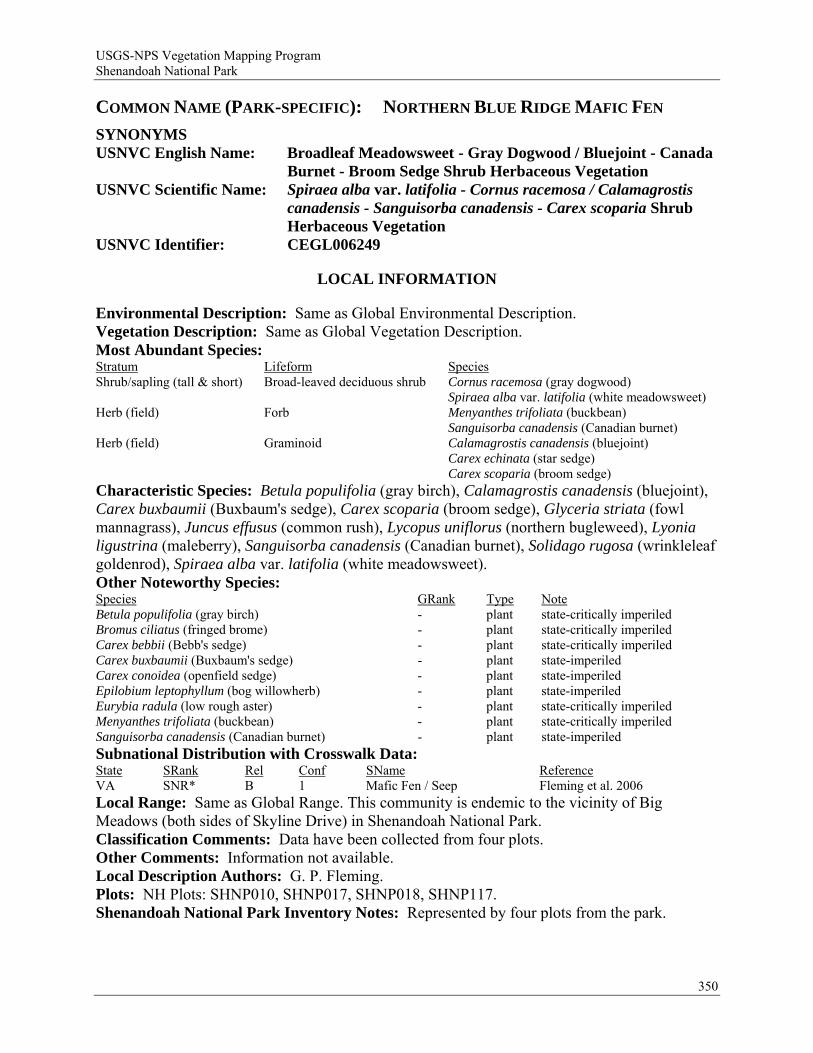
USGS-NPS Vegetation Mapping Program Shenandoah National Park
COMMON NAME (PARK-SPECIFIC): NORTHERN BLUE RIDGE MAFIC FEN
SYNONYMS USNVC English Name: Broadleaf Meadowsweet - Gray Dogwood / Bluejoint - Canada
Burnet - Broom Sedge Shrub Herbaceous Vegetation USNVC Scientific Name: Spiraea alba var. latifolia - Cornus racemosa / Calamagrostis
canadensis - Sanguisorba canadensis - Carex scoparia Shrub Herbaceous Vegetation
USNVC Identifier: CEGL006249
LOCAL INFORMATION
Environmental Description: Same as Global Environmental Description. Vegetation Description: Same as Global Vegetation Description. Most Abundant Species: Stratum Lifeform Species Shrub/sapling (tall & short) Broad-leaved deciduous shrub Cornus racemosa (gray dogwood) Spiraea alba var. latifolia (white meadowsweet) Herb (field) Forb Menyanthes trifoliata (buckbean) Sanguisorba canadensis (Canadian burnet) Herb (field) Graminoid Calamagrostis canadensis (bluejoint) Carex echinata (star sedge) Carex scoparia (broom sedge) Characteristic Species: Betula populifolia (gray birch), Calamagrostis canadensis (bluejoint), Carex buxbaumii (Buxbaum's sedge), Carex scoparia (broom sedge), Glyceria striata (fowl mannagrass), Juncus effusus (common rush), Lycopus uniflorus (northern bugleweed), Lyonia ligustrina (maleberry), Sanguisorba canadensis (Canadian burnet), Solidago rugosa (wrinkleleaf goldenrod), Spiraea alba var. latifolia (white meadowsweet). Other Noteworthy Species: Species GRank Type Note Betula populifolia (gray birch) - plant state-critically imperiled Bromus ciliatus (fringed brome) - plant state-critically imperiled Carex bebbii (Bebb's sedge) - plant state-critically imperiled Carex buxbaumii (Buxbaum's sedge) - plant state-imperiled Carex conoidea (openfield sedge) - plant state-imperiled Epilobium leptophyllum (bog willowherb) - plant state-imperiled Eurybia radula (low rough aster) - plant state-critically imperiled Menyanthes trifoliata (buckbean) - plant state-critically imperiled Sanguisorba canadensis (Canadian burnet) - plant state-imperiled Subnational Distribution with Crosswalk Data: State SRank Rel Conf SName Reference VA SNR* B 1 Mafic Fen / Seep Fleming et al. 2006 Local Range: Same as Global Range. This community is endemic to the vicinity of Big Meadows (both sides of Skyline Drive) in Shenandoah National Park. Classification Comments: Data have been collected from four plots. Other Comments: Information not available. Local Description Authors: G. P. Fleming. Plots: NH Plots: SHNP010, SHNP017, SHNP018, SHNP117. Shenandoah National Park Inventory Notes: Represented by four plots from the park.
350

USGS-NPS Vegetation Mapping Program Shenandoah National Park
GLOBAL INFORMATION
USNVC CLASSIFICATION Physiognomic Class Herbaceous Vegetation (V) Physiognomic Subclass Perennial graminoid vegetation (V.A.) Physiognomic Group Temperate or subpolar grassland with a sparse shrub layer (V.A.7.) Physiognomic Subgroup Natural/Semi-natural temperate or subpolar grassland with a sparse shrub layer
(V.A.7.N.) Formation Saturated temperate or subpolar grassland with a sparse cold-deciduous shrub layer
(V.A.7.N.p.) Alliance Alnus serrulata - Spiraea spp. / Sanguisorba canadensis Saturated Shrub Herbaceous
Alliance (A.3026) Alliance (English name) Smooth Alder - Meadowsweet species / Canada Burnet Saturated Shrub Herbaceous
Alliance Association Spiraea alba var. latifolia - Cornus racemosa / Calamagrostis canadensis -
Sanguisorba canadensis - Carex scoparia Shrub Herbaceous Vegetation Association (English name) Broadleaf Meadowsweet - Gray Dogwood / Bluejoint - Canada Burnet - Broom
Sedge Shrub Herbaceous Vegetation Ecological System(s): Southern and Central Appalachian Bog and Fen (CES202.300).
GLOBAL DESCRIPTION Concept Summary: This saturated wetland occurs on soils weathered from Catoctin metabasalt (greenstone), a mafic metamorphic rock. The type is associated with sublevel headwater seepages on a broad summit of the northern Blue Ridge in Page and Madison counties, Virginia (vicinity of Big Meadows, Shenandoah National Park). Microtopography is typically irregular, and soils are strongly to slightly acidic, with high magnesium and iron levels and moderately low calcium content. The physiognomy of this vegetation type ranges from dense to open shrublands to wholly herbaceous but is usually a patch-mosaic of shrub thickets and herbaceous openings. Spiraea alba var. latifolia (white meadowsweet) and Cornus racemosa (gray dogwood) are the typical woody dominants. In some areas, Betula populifolia (gray birch) forms a sparse tree layer 6-10 m tall. Other shrubs documented in the type are Ilex verticillata (common winterberry), Lyonia ligustrina var. ligustrina (maleberry), Photinia melanocarpa (black chokeberry), and sapling-sized Acer rubrum (red maple). Calamagrostis canadensis (bluejoint), Sanguisorba canadensis (Canadian burnet), and Carex scoparia (broom sedge) are patch-dominant herbs common to all known occurrences of the type. Other characteristic herbaceous species are Carex buxbaumii (Buxbaum's sedge), Carex lurida (shallow sedge), Epilobium leptophyllum (bog willowherb), Glyceria striata (fowl mannagrass), Iris versicolor (harlequin blueflag), Isoetes valida (strong quillwort), Juncus effusus var. solutus (lamp rush), Juncus subcaudatus var. subcaudatus (woodland rush), Lycopus virginicus (Virginia water horehound), Oxypolis rigidior (stiff cowbane), Packera aurea (golden ragwort), Scirpus cyperinus (woolgrass), Solidago rugosa (wrinkleleaf goldenrod), and Thelypteris palustris var. pubescens (eastern marsh fern). Herbs that are inconstant but locally abundant in the type include Caltha palustris (yellow marsh marigold), Carex conoidea (openfield sedge), Carex echinata ssp. echinata (star sedge), Carex gynandra (nodding sedge), and Menyanthes trifoliata (buckbean). The processes that maintain this vegetation in open condition are poorly understood. All of the documented occurrences are small and have been disturbed to some degree by grazing and/or adjacent clearing. Ditching and groundwater alterations from a large well serving the Big Meadows Campground, deer grazing, non-native weeds, woody succession, and probably fire exclusion are continuing threats to this naturally rare wetland.
351
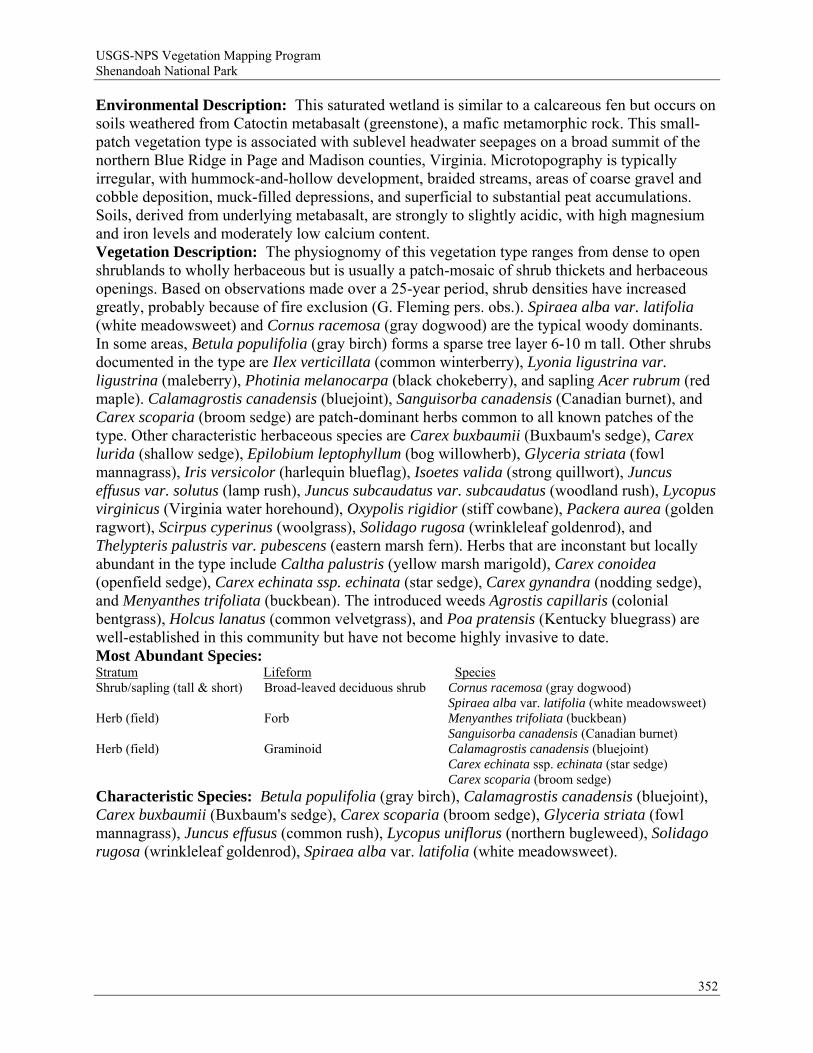
USGS-NPS Vegetation Mapping Program Shenandoah National Park
Environmental Description: This saturated wetland is similar to a calcareous fen but occurs on soils weathered from Catoctin metabasalt (greenstone), a mafic metamorphic rock. This small-patch vegetation type is associated with sublevel headwater seepages on a broad summit of the northern Blue Ridge in Page and Madison counties, Virginia. Microtopography is typically irregular, with hummock-and-hollow development, braided streams, areas of coarse gravel and cobble deposition, muck-filled depressions, and superficial to substantial peat accumulations. Soils, derived from underlying metabasalt, are strongly to slightly acidic, with high magnesium and iron levels and moderately low calcium content. Vegetation Description: The physiognomy of this vegetation type ranges from dense to open shrublands to wholly herbaceous but is usually a patch-mosaic of shrub thickets and herbaceous openings. Based on observations made over a 25-year period, shrub densities have increased greatly, probably because of fire exclusion (G. Fleming pers. obs.). Spiraea alba var. latifolia (white meadowsweet) and Cornus racemosa (gray dogwood) are the typical woody dominants. In some areas, Betula populifolia (gray birch) forms a sparse tree layer 6-10 m tall. Other shrubs documented in the type are Ilex verticillata (common winterberry), Lyonia ligustrina var. ligustrina (maleberry), Photinia melanocarpa (black chokeberry), and sapling Acer rubrum (red maple). Calamagrostis canadensis (bluejoint), Sanguisorba canadensis (Canadian burnet), and Carex scoparia (broom sedge) are patch-dominant herbs common to all known patches of the type. Other characteristic herbaceous species are Carex buxbaumii (Buxbaum's sedge), Carex lurida (shallow sedge), Epilobium leptophyllum (bog willowherb), Glyceria striata (fowl mannagrass), Iris versicolor (harlequin blueflag), Isoetes valida (strong quillwort), Juncus effusus var. solutus (lamp rush), Juncus subcaudatus var. subcaudatus (woodland rush), Lycopus virginicus (Virginia water horehound), Oxypolis rigidior (stiff cowbane), Packera aurea (golden ragwort), Scirpus cyperinus (woolgrass), Solidago rugosa (wrinkleleaf goldenrod), and Thelypteris palustris var. pubescens (eastern marsh fern). Herbs that are inconstant but locally abundant in the type include Caltha palustris (yellow marsh marigold), Carex conoidea (openfield sedge), Carex echinata ssp. echinata (star sedge), Carex gynandra (nodding sedge), and Menyanthes trifoliata (buckbean). The introduced weeds Agrostis capillaris (colonial bentgrass), Holcus lanatus (common velvetgrass), and Poa pratensis (Kentucky bluegrass) are well-established in this community but have not become highly invasive to date. Most Abundant Species: Stratum Lifeform Species Shrub/sapling (tall & short) Broad-leaved deciduous shrub Cornus racemosa (gray dogwood) Spiraea alba var. latifolia (white meadowsweet) Herb (field) Forb Menyanthes trifoliata (buckbean) Sanguisorba canadensis (Canadian burnet) Herb (field) Graminoid Calamagrostis canadensis (bluejoint) Carex echinata ssp. echinata (star sedge) Carex scoparia (broom sedge) Characteristic Species: Betula populifolia (gray birch), Calamagrostis canadensis (bluejoint), Carex buxbaumii (Buxbaum's sedge), Carex scoparia (broom sedge), Glyceria striata (fowl mannagrass), Juncus effusus (common rush), Lycopus uniflorus (northern bugleweed), Solidago rugosa (wrinkleleaf goldenrod), Spiraea alba var. latifolia (white meadowsweet).
352
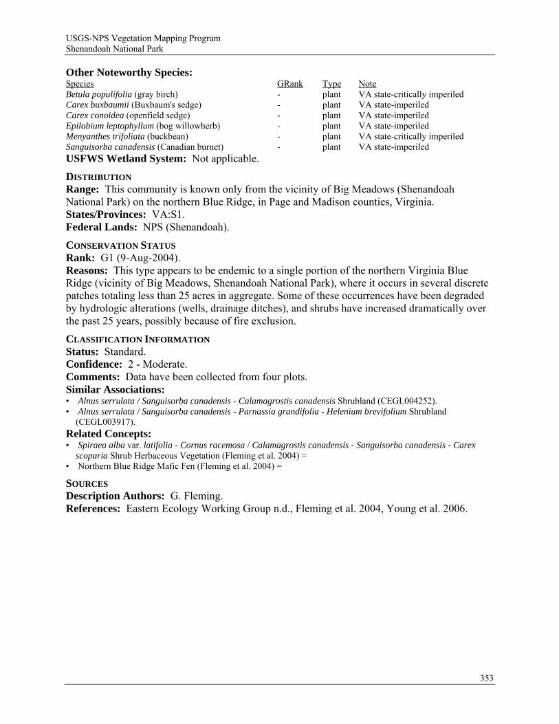
USGS-NPS Vegetation Mapping Program Shenandoah National Park
353
Other Noteworthy Species: Species GRank Type Note Betula populifolia (gray birch) - plant VA state-critically imperiled Carex buxbaumii (Buxbaum's sedge) - plant VA state-imperiled Carex conoidea (openfield sedge) - plant VA state-imperiled Epilobium leptophyllum (bog willowherb) - plant VA state-imperiled Menyanthes trifoliata (buckbean) - plant VA state-critically imperiled Sanguisorba canadensis (Canadian burnet) - plant VA state-imperiled USFWS Wetland System: Not applicable.
DISTRIBUTION Range: This community is known only from the vicinity of Big Meadows (Shenandoah National Park) on the northern Blue Ridge, in Page and Madison counties, Virginia. States/Provinces: VA:S1. Federal Lands: NPS (Shenandoah).
CONSERVATION STATUS Rank: G1 (9-Aug-2004). Reasons: This type appears to be endemic to a single portion of the northern Virginia Blue Ridge (vicinity of Big Meadows, Shenandoah National Park), where it occurs in several discrete patches totaling less than 25 acres in aggregate. Some of these occurrences have been degraded by hydrologic alterations (wells, drainage ditches), and shrubs have increased dramatically over the past 25 years, possibly because of fire exclusion.
CLASSIFICATION INFORMATION Status: Standard. Confidence: 2 - Moderate. Comments: Data have been collected from four plots. Similar Associations: • Alnus serrulata / Sanguisorba canadensis - Calamagrostis canadensis Shrubland (CEGL004252). • Alnus serrulata / Sanguisorba canadensis - Parnassia grandifolia - Helenium brevifolium Shrubland
(CEGL003917). Related Concepts: • Spiraea alba var. latifolia - Cornus racemosa / Calamagrostis canadensis - Sanguisorba canadensis - Carex
scoparia Shrub Herbaceous Vegetation (Fleming et al. 2004) = • Northern Blue Ridge Mafic Fen (Fleming et al. 2004) =
SOURCES Description Authors: G. Fleming. References: Eastern Ecology Working Group n.d., Fleming et al. 2004, Young et al. 2006.
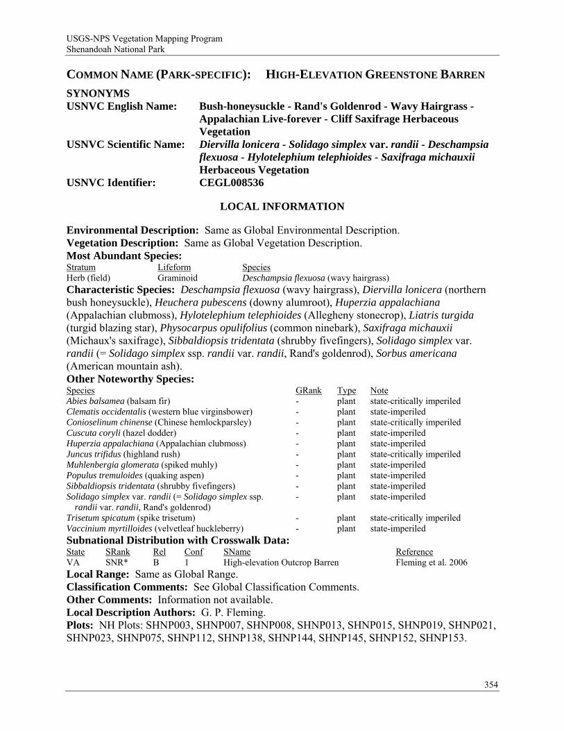
USGS-NPS Vegetation Mapping Program Shenandoah National Park
COMMON NAME (PARK-SPECIFIC): HIGH-ELEVATION GREENSTONE BARREN
SYNONYMS USNVC English Name: Bush-honeysuckle - Rand's Goldenrod - Wavy Hairgrass -
Appalachian Live-forever - Cliff Saxifrage Herbaceous Vegetation
USNVC Scientific Name: Diervilla lonicera - Solidago simplex var. randii - Deschampsia flexuosa - Hylotelephium telephioides - Saxifraga michauxii Herbaceous Vegetation
USNVC Identifier: CEGL008536
LOCAL INFORMATION
Environmental Description: Same as Global Environmental Description. Vegetation Description: Same as Global Vegetation Description. Most Abundant Species: Stratum Lifeform Species Herb (field) Graminoid Deschampsia flexuosa (wavy hairgrass) Characteristic Species: Deschampsia flexuosa (wavy hairgrass), Diervilla lonicera (northern bush honeysuckle), Heuchera pubescens (downy alumroot), Huperzia appalachiana (Appalachian clubmoss), Hylotelephium telephioides (Allegheny stonecrop), Liatris turgida (turgid blazing star), Physocarpus opulifolius (common ninebark), Saxifraga michauxii (Michaux's saxifrage), Sibbaldiopsis tridentata (shrubby fivefingers), Solidago simplex var. randii (= Solidago simplex ssp. randii var. randii, Rand's goldenrod), Sorbus americana (American mountain ash). Other Noteworthy Species: Species GRank Type Note Abies balsamea (balsam fir) - plant state-critically imperiled Clematis occidentalis (western blue virginsbower) - plant state-imperiled Conioselinum chinense (Chinese hemlockparsley) - plant state-critically imperiled Cuscuta coryli (hazel dodder) - plant state-imperiled Huperzia appalachiana (Appalachian clubmoss) - plant state-imperiled Juncus trifidus (highland rush) - plant state-critically imperiled Muhlenbergia glomerata (spiked muhly) - plant state-imperiled Populus tremuloides (quaking aspen) - plant state-imperiled Sibbaldiopsis tridentata (shrubby fivefingers) - plant state-imperiled Solidago simplex var. randii (= Solidago simplex ssp.
randii var. randii, Rand's goldenrod) - plant state-imperiled
Trisetum spicatum (spike trisetum) - plant state-critically imperiled Vaccinium myrtilloides (velvetleaf huckleberry) - plant state-imperiled Subnational Distribution with Crosswalk Data: State SRank Rel Conf SName Reference VA SNR* B 1 High-elevation Outcrop Barren Fleming et al. 2006 Local Range: Same as Global Range. Classification Comments: See Global Classification Comments. Other Comments: Information not available. Local Description Authors: G. P. Fleming. Plots: NH Plots: SHNP003, SHNP007, SHNP008, SHNP013, SHNP015, SHNP019, SHNP021, SHNP023, SHNP075, SHNP112, SHNP138, SHNP144, SHNP145, SHNP152, SHNP153.
354

USGS-NPS Vegetation Mapping Program Shenandoah National Park
Shenandoah National Park Inventory Notes: Represented by 15 plots and qualitative observations from 26 additional sites in the park.
GLOBAL INFORMATION
USNVC CLASSIFICATION Physiognomic Class Herbaceous Vegetation (V) Physiognomic Subclass Perennial forb vegetation (V.B.) Physiognomic Group Temperate or subpolar perennial forb vegetation (V.B.2.) Physiognomic Subgroup Natural/Semi-natural temperate or subpolar perennial forb vegetation (V.B.2.N.) Formation Low temperate or subpolar perennial forb vegetation (V.B.2.N.b.) Alliance Saxifraga michauxii Herbaceous Alliance (A.1621) Alliance (English name) Cliff Saxifrage Herbaceous Alliance Association Diervilla lonicera - Solidago simplex var. randii - Deschampsia flexuosa -
Hylotelephium telephioides - Saxifraga michauxii Herbaceous Vegetation Association (English name) Bush-honeysuckle - Rand's Goldenrod - Wavy Hairgrass - Appalachian Live-forever
- Cliff Saxifrage Herbaceous Vegetation Ecological System(s): Southern and Central Appalachian Mafic Glade and Barrens (CES202.348).
GLOBAL DESCRIPTION Concept Summary: This association is known only from a few high-elevation mafic rock outcrops in the northern Virginia Blue Ridge. All known sites are located in Shenandoah National Park. This community type is associated with exposed rocky summits and upper slope outcrops of Catoctin Formation metabasalt (greenstone) at elevations from 870 to 1230 m (2860-4040 feet). Slope shape is typically convex in at least one direction, and aspect varies from west to north. The vegetation is characterized by a patchwork of shrub thickets (typically <25% cover), herbaceous mats (typically <40% cover), and crustose lichen colonies on exposed rock surfaces. The most frequent woody species include extremely stunted, wind-blasted specimens of the trees Betula alleghaniensis (yellow birch) and Sorbus americana (American mountain ash); characteristic shrubs and woody vines are Diervilla lonicera (northern bush honeysuckle), Physocarpus opulifolius (common ninebark), Prunus pensylvanica (pin cherry), Prunus virginiana (chokecherry), Kalmia latifolia (mountain laurel), and Smilax tamnoides (bristly greenbrier). Deschampsia flexuosa (wavy hairgrass) and Solidago simplex var. randii (Rand's goldenrod) are the most frequent dominant herbaceous species, but Sibbaldiopsis tridentata (shrubby fivefingers), Saxifraga michauxii (Michaux's saxifrage), Carex pensylvanica (Pennsylvania sedge), and Hylotelephium telephioides (Allegheny stonecrop) dominate in some areas. Environmental Description: Environment: This community type is associated with exposed rocky summits and upper slope outcrops of Catoctin Formation metabasalt (greenstone) at elevations from 870 to 1230 m (2860-4040 feet). Mean elevation of nine plot-sampled stands is 1068 m (3506 feet); an exceptional occurrence on the north slope of Mount Marshall is situated at an unusually low elevation of 870 m (2860 feet). Slope shape is typically convex in at least one direction, and aspect varies from west to north. Mean surface cover of bedrock and loose rocks at sample sites is 69%, while mean lichen / moss cover on these rocks is 42%. The moisture regime of these sites is xeric, and soil development is limited to shallow accumulations of disintegrated rock and humus on shelves and in crevices. However, an ephemeral spring seep with seasonally wet moss mats is present at one site (Stony Man Mountain). These habitats are periodically exposed to extreme winter temperatures, high winds, and ice. Soil samples extracted
355
USGS-NPS Vegetation Mapping Program Shenandoah National Park
from plot locations are extremely acidic (mean pH = 4.0) but often have moderately high levels of calcium, magnesium, and manganese and high levels of aluminum (mean = 1577 ppm). Vegetation Description: The vegetation is characterized by a patchwork of shrub thickets (typically <25% cover), herbaceous mats (typically <40% cover), and crustose lichen colonies on exposed rock surfaces. The most frequent woody species include extremely stunted, wind-blasted specimens of the trees Betula alleghaniensis (yellow birch) and Sorbus americana (American mountain ash); stunted trees of Abies balsamea (balsam fir) also occur at several sites. Characteristic shrubs and woody vines are Diervilla lonicera (northern bush honeysuckle), Physocarpus opulifolius (common ninebark), Prunus pensylvanica (pin cherry), Prunus virginiana (chokecherry), Kalmia latifolia (mountain laurel), and Smilax tamnoides (bristly greenbrier). Deschampsia flexuosa (wavy hairgrass) and Solidago simplex var. randii (Rand's goldenrod) are usually the dominant herbaceous species, with mean cover in plot samples of 10-25% and 5-10%, respectively. Sibbaldiopsis tridentata (shrubby fivefingers) is abundant (up to 25% cover) in a subset of sites but is absent from about half of the known sites. Other relatively constant and characteristic herbaceous species are Campanula divaricata (small bonny bellflower), Carex pensylvanica (Pennsylvania sedge), Heuchera pubescens (downy alumroot), Hylotelephium telephioides (Allegheny stonecrop), Phlox subulata (moss phlox), Poa compressa (Canada bluegrass), Polypodium appalachianum (Appalachian polypody), and Saxifraga michauxii (Michaux's saxifrage). Inconstant but locally prominent herbaceous species include Allium cernuum (nodding onion), Angelica triquinata (filmy angelica), Arabis lyrata (lyrate rockcress), Houstonia longifolia (longleaf summer bluet), Danthonia spicata (poverty oatgrass), Liatris turgida (turgid blazing star), and Saxifraga virginiensis (early saxifrage). The grass Calamagrostis canadensis (bluejoint) is abundant in the local seepage area on Stony Man Mountain, Virginia. Mean species richness of 15 plot-sampled stands is 27 taxa per 100 square meters. Several boreal lichens, including Melanelia stygia, Porpidia lowiana, Porpidia tuberculosa, and Rhizocarpon geographicum (world map lichen) occur abundantly on metabasalt outcrops within this community type. Most Abundant Species: Information not available. Characteristic Species: Deschampsia flexuosa (wavy hairgrass), Diervilla lonicera (northern bush honeysuckle), Heuchera pubescens (downy alumroot), Huperzia appalachiana (Appalachian clubmoss), Hylotelephium telephioides (Allegheny stonecrop), Liatris turgida (turgid blazing star), Physocarpus opulifolius (common ninebark), Saxifraga michauxii (Michaux's saxifrage), Sibbaldiopsis tridentata (shrubby fivefingers), Solidago simplex var. randii (Rand's goldenrod), Sorbus americana (American mountain ash).
356
USGS-NPS Vegetation Mapping Program Shenandoah National Park
Other Noteworthy Species: Species GRank Type Note Abies balsamea (balsam fir) - plant VA state-critically imperiled Clematis occidentalis (western blue virginsbower) - plant VA state-imperiled Conioselinum chinense (Chinese hemlockparsley) - plant VA state-critically imperiled Falco peregrinus (peregrine falcon) - animal VA state-critically imperiled Gymnocarpium appalachianum (Appalachian oakfern) G3 plant globally vulnerable Juncus trifidus (highland rush) - plant VA state-critically imperiled Liatris turgida (turgid blazing star) G3 plant globally vulnerable Melanelia stygia (stygian black-parmelia) - plant VA state-imperiled Poa compressa (Canada bluegrass) - plant exotic Porpidia tuberculosa (boulder lichen) G2G4 plant VA state-critically imperiled Rubus idaeus ssp. strigosus (grayleaf red raspberry) - plant VA state-imperiled Rumex acetosella (common sheep sorrel) - plant exotic Sibbaldiopsis tridentata (shrubby fivefingers) - plant VA state-imperiled Trisetum spicatum (spike trisetum) - plant VA state-critically imperiled USFWS Wetland System: Not applicable.
DISTRIBUTION Range: This association is known only from a few high-elevation mafic rock outcrops in the northern Virginia Blue Ridge. All known sites are located in Shenandoah National Park. Most occurrences are in the higher, central section of the park, from the Big Meadows Area on the south to Stony Man Mountain on the north. A somewhat disjunct stand occurs on Mount Marshall in the northern section of the park. States/Provinces: TN?, VA:S1. Federal Lands: NPS (Shenandoah).
CONSERVATION STATUS Rank: G1 (3-Oct-2001). Reasons: This is a naturally rare, small-patch community type limited by special habitat requirements. Currently, habitats supporting this unit are known from less than 20 discrete outcrops which together form five complexes or occurrences (Franklin Cliffs, Hawksbill, Crescent Rocks, Stony Man Mountain, Mount Marshall). Total coverage of all known occurrences is probably <12 hectares (30 acres). It is unlikely that any additional occurrences will be found, and these would not significantly increase the aggregate acreage of the type.
CLASSIFICATION INFORMATION Status: Standard. Confidence: 2 - Moderate. Comments: This type (CEGL008536) was formerly represented, in part, by the now-obsolete Saxifraga michauxii - Solidago simplex var. randii - Sibbaldiopsis tridentata Herbaceous Vegetation (CEGL004941). Recent multivariate analyses of a 956-plot dataset by the Virginia Dept. of Conservation / Division of Natural Heritage strongly supports the segregation of this type from vegetation documented south of Shenandoah National Park on the granitic summit of Spy Rock (Nelson County) and the amphibolite summit of Buffalo Mountain (Floyd County). The barrens of these two sites have been classified as Minuartia groenlandica - Paronychia argyrocoma - Saxifraga michauxii Herbaceous Vegetation (CEGL008509). Several additional high-elevation greenstone outcrops in the park (e.g., Pass Mountain, Mount Marshall, Hightop) and elsewhere (e.g., Humpback Rocks, Nelson County) support Photinia melanocarpa - Gaylussacia baccata / Carex pensylvanica Shrubland (CEGL008508). Vegetation of CEGL008508 is characterized by rhizomatous colonies of the low shrubs Photinia melanocarpa
357
USGS-NPS Vegetation Mapping Program Shenandoah National Park
358
(black chokeberry) and Gaylussacia baccata (black huckleberry) and has a lower herb diversity and overall species richness than CEGL008536. Vegetation of the Stony Man seepage area was formerly recognized as a distinct type, Physocarpus opulifolius / Calamagrostis canadensis Shrub Herbaceous Vegetation (CEGL004253) but is now regarded as a variant of CEGL008536. Similar Associations: • Minuartia groenlandica - Paronychia argyrocoma - Saxifraga michauxii Herbaceous Vegetation
(CEGL008509). Related Concepts: • Diervilla lonicera - Solidago simplex var. randii - Deschampsia flexuosa - Hylotelephium telephioides -
Saxifraga michauxii Herbaceous Vegetation (Fleming and Coulling 2001) =
SOURCES Description Authors: G. P. Fleming. References: Fleming and Coulling 2001, Fleming et al. 2001, Fleming et al. 2004, Fleming et al. 2007, TDNH unpubl. data, Young et al. 2006.

USGS-NPS Vegetation Mapping Program Shenandoah National Park
COMMON NAME (PARK-SPECIFIC): CENTRAL APPALACHIAN WOODLAND SEEP
SYNONYMS USNVC English Name: Yellow Marsh-marigold - Orange Jewelweed - Marsh Blue
Violet Herbaceous Vegetation USNVC Scientific Name: Caltha palustris - Impatiens capensis - Viola cucullata
Herbaceous Vegetation [Provisional] USNVC Identifier: CEGL006258
LOCAL INFORMATION
Environmental Description: Two plot-sampled occurrences in Shenandoah National Park occupy gently sloping (4- to 7-degree slope) spring seeps over metabasalt and charnockite, respectively. Additional, somewhat steeper occurrences have also been observed in areas underlain by these substrates. Most occurrences appear to represent natural, small-patch inclusions embedded in second-growth upland forest types. However, the larger of the two documented occurrences in the park is located near an old homesite and appears to have resulted from clearing of a large forested wetland. In the two plot samples, mean cover of boulders and cobbles is 18% and shallow water covers 8% of the surface substrates. Soil samples collected from these sites consist of heterogeneous sandy and silty alluvium and muck of intermediate fertility. Vegetation Description: See Global Vegetation Description. Caltha palustris (yellow marsh marigold), Impatiens capensis (jewelweed), and Viola cucullata (marsh blue violet) are dominant species at both plot-sampled sites. However, other species may dominate sites that have not been formally inventoried. Most Abundant Species: Stratum Lifeform Species Herb (field) Forb Caltha palustris (yellow marsh marigold) Impatiens capensis (jewelweed) Characteristic Species: Caltha palustris (yellow marsh marigold), Carex gynandra (nodding sedge), Chelone glabra (white turtlehead), Chrysosplenium americanum (American golden saxifrage), Hydrocotyle americana (American marshpennywort), Impatiens capensis (jewelweed), Pilea pumila (Canadian clearweed), Viola cucullata (marsh blue violet). Other Noteworthy Species: Species GRank Type Note Eurybia radula (low rough aster) - plant state-critically imperiled Platanthera grandiflora (greater purple fringed orchid) - plant state-critically imperiled Subnational Distribution with Crosswalk Data: State SRank Rel Conf SName Reference VA SNR . . [not crosswalked] . Local Range: This community is scattered throughout the park, especially at middle to high elevations in areas underlain by metabasalt and granitic rocks. Classification Comments: Information not available. Other Comments: Information not available. Local Description Authors: G. P. Fleming. Plots: NH Plots: SHNP573, SHNP609. Shenandoah National Park Inventory Notes: Represented by two plots from the park.
359
USGS-NPS Vegetation Mapping Program Shenandoah National Park
GLOBAL INFORMATION
USNVC CLASSIFICATION Physiognomic Class Herbaceous Vegetation (V) Physiognomic Subclass Perennial forb vegetation (V.B.) Physiognomic Group Temperate or subpolar perennial forb vegetation (V.B.2.) Physiognomic Subgroup Natural/Semi-natural temperate or subpolar perennial forb vegetation (V.B.2.N.) Formation Saturated temperate perennial forb vegetation (V.B.2.N.f.) Alliance Symplocarpus foetidus - Caltha palustris Saturated Herbaceous Alliance (A.1694) Alliance (English name) Skunk-cabbage - Yellow Marsh-marigold Saturated Herbaceous Alliance Association Caltha palustris - Impatiens capensis - Viola cucullata Herbaceous Vegetation
[Provisional] Association (English name) Yellow Marsh-marigold - Orange Jewelweed - Marsh Blue Violet Herbaceous
Vegetation Ecological System(s): Central and Southern Appalachian Montane Oak Forest (CES202.596) Southern and Central Appalachian Cove Forest (CES202.373).
GLOBAL DESCRIPTION Concept Summary: This community is a saturated, herbaceous, small-patch wetland occurring on relatively steep, usually gravelly or bouldery slopes at sites of groundwater discharge. The type is probably scattered in the northern Blue Ridge and parts of the Ridge and Valley province, in areas underlain by base-rich metamorphic, igneous, or sedimentary rocks. Occurrences are more common at, but not restricted to, elevations above 760 m (2500 feet) elevation. Habitats are typically narrow and partially or wholly shaded by tree species rooted in adjacent upland forests. A few occurrences encompass larger spring seeps that may have resulted from the clearing of forested seepage swamps. Vegetation is similar to the herbaceous component of forested seepage swamps but is usually more forb-rich. Characteristic species include Caltha palustris (yellow marsh marigold), Impatiens capensis (jewelweed), Viola cucullata (marsh blue violet), Chelone glabra (white turtlehead), Pilea pumila (Canadian clearweed), Chrysosplenium americanum (American golden saxifrage), Lycopus virginicus (Virginia water horehound), Lycopus uniflorus (northern bugleweed), Packera aurea (golden ragwort), Veratrum viride (green false hellebore), Laportea canadensis (Canadian woodnettle), and Carex gynandra (nodding sedge). Environmental Description: This community occupies narrow, relatively steep, usually gravelly or bouldery spring seeps. Underlying bedrock includes base-rich metamorphic and igneous rocks such as Catoctin metabasalt (greenstone) and pyroxene-bearing granites, or calcareous sedimentary rocks. Occurrences are more common at, but not restricted to, elevations above 760 m (2500 feet) elevation. Habitats are typically narrow and partially or wholly shaded by tree species rooted in adjacent upland forests. A few occurrences encompass larger spring seeps that may have resulted from the clearing of forested seepage swamps. Vegetation Description: Vegetation is similar to the herbaceous component of forested seepage swamps but is usually more forb-rich. Characteristic species include Caltha palustris (yellow marsh marigold), Impatiens capensis (jewelweed), Viola cucullata (marsh blue violet), Chelone glabra (white turtlehead), Pilea pumila (Canadian clearweed), Chrysosplenium americanum (American golden saxifrage), Lycopus virginicus (Virginia water horehound), Lycopus uniflorus (northern bugleweed), Packera aurea (golden ragwort), Veratrum viride (green false hellebore), Laportea canadensis (Canadian woodnettle), and Carex gynandra (nodding sedge). Most Abundant Species: Information not available. Characteristic Species: Information not available. Other Noteworthy Species: Information not available.
360
USGS-NPS Vegetation Mapping Program Shenandoah National Park
361
USFWS Wetland System: Not applicable.
DISTRIBUTION Range: This community type is probably scattered in the northern Blue Ridge and parts of the Ridge and Valley province, in areas underlain by base-rich metamorphic, igneous, or sedimentary rocks. States/Provinces: VA. Federal Lands: NPS (Shenandoah).
CONSERVATION STATUS Rank: GNR (7-Oct-2004). Reasons: Insufficient data are currently available to rank this community.
CLASSIFICATION INFORMATION Status: Provisional. Confidence: 3 - Weak. Comments: This association is highly provisional, and much additional inventory and quantitative data collection are needed before a robust classification can be produced. Some occurrences of this vegetation are natural, while others appear to have resulted from disturbance. Montane seeps are poorly understood and problematic in that most patches fall well below minimum map unit size for vegetation mapping projects. Because of their extremely small, narrow, and linear configuration, they are also difficult to plot-sample without including extraneous vegetation. Similar Associations: • Diphylleia cymosa - Saxifraga micranthidifolia - Laportea canadensis Herbaceous Vegetation (CEGL004296)--a
similar southern Appalachian type. • Impatiens (capensis, pallida) - Monarda didyma - Rudbeckia laciniata var. humilis Herbaceous Vegetation
(CEGL004293)--a similar southern Appalachian type. • Vernonia noveboracensis - Thelypteris palustris - Symplocarpus foetidus Herbaceous Vegetation
(CEGL006448). Related Concepts: Information not available.
SOURCES Description Authors: G. Fleming. References: Eastern Ecology Working Group n.d., Young et al. 2006.
USGS-NPS Vegetation Mapping Program Shenandoah National Park
COMMON NAME (PARK-SPECIFIC): CENTRAL APPALACHIAN ACIDIC
BOULDERFIELD
SYNONYMS USNVC English Name: (Toadskin Lichen, Pennsylvania Toadskin Lichen) - Golden
Moonglow Lichen - Culberson's Black-parmelia Nonvascular Vegetation
USNVC Scientific Name: Lasallia (papulosa, pensylvanica) - Dimelaena oreina - (Melanelia culbersonii) Nonvascular Vegetation
USNVC Identifier: CEGL004142
LOCAL INFORMATION
Environmental Description: See Global Environmental Description. Boulderfields supporting this association occur on steep sideslopes from the lowest elevations of the park to about 945 m (3100 feet) at Blackrock in the south district. Vegetation Description: See Global Vegetation Description. Most Abundant Species: Stratum Lifeform Species Nonvascular Lichen Dimelaena oreina (mountain lichen) Lasallia papulosa (blistered naval lichen) Lasallia pensylvanica (Pennsylvania blistered naval lichen) Characteristic Species: Aspicilia cinerea (rimmed lichen), Cladonia squamosa (cup lichen), Cladonia uncialis (cup lichen), Dimelaena oreina (mountain lichen), Fuscidea recensa (quilt lichen), Lasallia papulosa (blistered naval lichen), Lasallia pensylvanica (Pennsylvania blistered naval lichen), Melanelia culbersonii, Physcia subtilis (rosette lichen), Xanthoparmelia conspersa (peppered rock-shield), Xanthoparmelia plittii (Plitt's rock-shield). Other Noteworthy Species: Species GRank Type Note Arctoparmelia centrifuga (concentric-ring lichen) - plant state-critically imperiled Buellia stellulata (disc lichen) - plant state-critically imperiled Punctelia subrudecta (forest speckleback) - plant state-critically imperiled Subnational Distribution with Crosswalk Data: State SRank Rel Conf SName Reference VA SNR* B 1 Lichen / Bryophyte Boulderfield Fleming et al. 2007 Local Range: This boulderfield community is mostly, if not entirely, restricted to the western flank of the south district, where discrete patches up to about 4 ha in size are plainly visible from Skyline Drive and other vantage points. Small patches of this vegetation may be present on large-block granitic talus on the slopes of Old Rag Mountain. Classification Comments: See Global Classification Comments. Other Comments: Information not available. Local Description Authors: G. P. Fleming. Plots: Not applicable. Shenandoah National Park Inventory Notes: See Global Classification Comments.
362
USGS-NPS Vegetation Mapping Program Shenandoah National Park
GLOBAL INFORMATION
USNVC CLASSIFICATION Physiognomic Class Nonvascular Vegetation (VI) Physiognomic Subclass Lichen vegetation (VI.B.) Physiognomic Group Temperate or subpolar lichen vegetation (VI.B.1.) Physiognomic Subgroup Natural/Semi-natural temperate or subpolar lichen vegetation (VI.B.1.N.) Formation Alpine to submontane temperate or subpolar lichen vegetation (VI.B.1.N.b.) Alliance Lasallia (papulosa, pensylvanica) Nonvascular Alliance (A.1824) Alliance (English name) (Toadskin Lichen, Pennsylvania Toadskin Lichen) Nonvascular Alliance Association Lasallia (papulosa, pensylvanica) - Dimelaena oreina - (Melanelia culbersonii)
Nonvascular Vegetation Association (English name) (Toadskin Lichen, Pennsylvania Toadskin Lichen) - Golden Moonglow Lichen -
Culberson's Black-parmelia Nonvascular Vegetation Ecological System(s): North-Central Appalachian Acidic Cliff and Talus (CES202.601).
GLOBAL DESCRIPTION Concept Summary: This association is widely but locally distributed from the western Piedmont foothills in Maryland and Virginia through the Blue Ridge and Ridge and Valley portions of the central Appalachians, north at least to the Delaware Water Gap in Pennsylvania and New Jersey. It occurs primarily on fully exposed, minimally weathered quartzite and sandstone boulderfields at elevations from about 300 to 1000 m (1000-3300 feet). On the largest occurrences, vascular plants are generally absent and lichens dominate these habitats. Lasallia papulosa (blistered naval lichen) and Lasallia pensylvanica (Pennsylvania blistered naval lichen), either singly or in combination, are generally abundant and conspicuous. Dimelaena oreina (mountain lichen) abundantly covers many dry, exposed rock surfaces that are not covered with Lasallia spp. and larger foliose lichens. Although of scattered occurrence, Melanelia culbersonii has been found across the full elevation range of the type and is a good diagnostic species, as it appears to be restricted mostly to siliciclastic rocks (and occasionally coarse-grained, quartz-rich granites that are nearly devoid of dark minerals) in this region. A variety of other foliose, crustose and fruticose lichen species are associated. Smaller, more marginal occurrences have sparse vascular plant cover, primarily stunted trees of Betula lenta (sweet birch), Sassafras albidum (sassafras), and Quercus prinus (chestnut oak), ericaceous shrubs, and scrambling vines of Parthenocissus quinquefolia (Virginia creeper). Environmental Description: This association occurs primarily on fully exposed, minimally weathered quartzite and sandstone boulderfields at low and middle elevations of the northern Blue Ridge, Ridge and Valley, and adjacent foothills of the upper Piedmont. A few occurrences have also been noted on boulderfields composed of acidic granitic rocks (e.g., on Old Rag Mountain in Shenandoah National Park). The known elevation range is from about 300 to 1000 m (1000-3300 feet). Aspect is variable among sites, but slopes are typically steep to very steep (often >30 degrees). Block size is highly variable, from relatively small and loose stones (<1 m in diameter) to large, stable boulders (>1 m in diameter). Although this association is most extensive on boulder deposits, it may also occur on outcrops associated with the boulderfields, or on very large, exposed cliffs. There is little or no available soil except for occasional small deposits of organic matter in crevices. Vegetation Description: On the largest occurrences, vascular plants are generally absent and lichens dominate. Maximum patch size is about ten acres, but most patches are considerably smaller. Lasallia papulosa (blistered naval lichen) and Lasallia pensylvanica (Pennsylvania blistered naval lichen), either singly or in combination, are generally abundant and conspicuous.
363
USGS-NPS Vegetation Mapping Program Shenandoah National Park
Dimelaena oreina (mountain lichen) abundantly covers many dry, exposed rock surfaces that are not covered with Lasallia spp. and larger foliose lichens. Although of scattered occurrence, Melanelia culbersonii has been found across the full elevation range of the type and is a good diagnostic species, as it appears to be restricted mostly to siliciclastic rocks (and occasionally coarse-grained, quartz-rich granites that are nearly devoid of dark minerals) in this region. Other minor umbilicate and foliose species include Hypogymnia physodes, Physcia subtilis (rosette lichen), Umbilicaria muehlenbergii (Muehlenberg's navel lichen), Xanthoparmelia conspersa, and Xanthoparmelia plittii. Many crustose species occur, including Aspicilia cinerea (rimmed lichen), Fuscidea recensa, Lecanora spp., Lepraria (dust lichen) spp., Rhizocarpon obscuratum, and Sarcogyne clavus. Flat surfaces and interstices that have thin deposits of organic matter often support a variety of fruticose lichens, including Cladina rangiferina (greygreen reindeer lichen), Cladonia uncialis (cup lichen), Cladonia crispata (cup lichen), Cladonia macilenta, Cladonia ochrochlora, and Cladonia squamosa (cup lichen). In the upper elevation range, boreal lichens such as Melanelia stygia and Arctoparmelia centrifuga are present, but they are not abundant. Along the edges of the boulderfields, scattered individuals of Parthenocissus quinquefolia (Virginia creeper), Vaccinium (blueberry) spp., and other vascular plants may occur in transition zones with forests or woodlands. Smaller, more marginal occurrences frequently have sparse vascular plant cover, primarily stunted trees of Betula lenta (sweet birch), Sassafras albidum (sassafras), Quercus prinus (chestnut oak), Quercus coccinea (scarlet oak), Quercus velutina (black oak), Carya glabra (pignut hickory), and Carya ovalis (red hickory). Widely scattered shrubs may include Kalmia latifolia (mountain laurel) and other ericads. Herbs are usually absent, but Dicentra eximia (turkey corn) is known from some occurrences. Most Abundant Species: Information not available. Characteristic Species: Information not available. Other Noteworthy Species: Species GRank Type Note Melanelia culbersonii (Culberson's Black-parmelia) G2G4 plant vulnerable USFWS Wetland System: Not applicable.
DISTRIBUTION Range: This association is widely but locally distributed from the western Piedmont foothills in Maryland (e.g., Sugarloaf Mountain) and Virginia (e.g., Bull Run Mountain) through the Blue Ridge and Ridge and Valley portions of the central Appalachians, north at least to the Delaware Water Gap in Pennsylvania and New Jersey. The type is fairly common on the siliciclastic western flank of the northern Blue Ridge and throughout the Ridge and Valley in west-central and northwestern Virginia. It is also frequent in the Ridge and Valley region of Pennsylvania (T. Smith pers. comm.) but may be restricted to the northeastern tier of counties in West Virginia. The potential range of this association covers a much larger geographic area. States/Provinces: MD, NJ, PA, VA, WV. Federal Lands: NPS (Catoctin Mountain, Delaware Water Gap, Shenandoah); USFS (George Washington, Jefferson, Monongahela?).
CONSERVATION STATUS Rank: G4? (28-Nov-2006). Reasons: Although aggregate acreage is not large, there are probably several hundred occurrences of this association in Virginia alone, with many more known from or likely in adjacent states. Habitats are typically remote, extremely steep and difficult to traverse, minimizing potential human threats.
364
USGS-NPS Vegetation Mapping Program Shenandoah National Park
365
CLASSIFICATION INFORMATION Status: Standard. Confidence: 2 - Moderate. Comments: Classification of this association is based on geographically limited lichen inventories in Shenandoah National Park, but it is believed to be widely applicable to similar boulderfields that are characteristic of central Appalachian siliciclastic ridges. In the park inventory, lichens were mass-collected from boulderfield and outcrop habitats on different geologic substrates, and specimens were identified by Richard Harris (New York Botanical Garden), Don Flenniken (author of Macrolichens of West Virginia), and James Lawry (George Mason University). Classification of lichen communities in eastern North America is currently difficult and tentative because inventory and data are generally lacking. The classification of this type versus Betula lenta - Quercus prinus / Parthenocissus quinquefolia Woodland (CEGL006565) can be tricky where there is a continuous gradation of vegetation cover (as at Delaware Water Gap), but generally this is applied where there is less than 25% vascular vegetation and nonvascular species are dominant. Similar Associations: • Lasallia papulosa - Lasallia pensylvanica Nonvascular Vegetation (CEGL004385)--of quartzite cliffs in the
western North Carolina Piedmont. • Lasallia papulosa - Stereocaulon glaucescens - Chrysothrix chlorina Nonvascular Vegetation (CEGL004143)--
occurs on mafic (metabasaltic) boulderfields of the northern Blue Ridge. • Umbilicaria muehlenbergii - Lasallia papulosa - (Melanelia stygia) Nonvascular Vegetation (CEGL004389)--
occurs at higher elevations in the same region and has different dominant species. Related Concepts: Information not available.
SOURCES Description Authors: G. P. Fleming. References: Eastern Ecology Working Group n.d., Fleming et al. 2006, Fleming et al. 2007, Flenniken 1999.
USGS-NPS Vegetation Mapping Program Shenandoah National Park
COMMON NAME (PARK-SPECIFIC): CENTRAL APPALACHIAN MAFIC
BOULDERFIELD
SYNONYMS USNVC English Name: Toadskin Lichen - Snow Lichen - Sulphur Dust Lichen
Nonvascular Vegetation USNVC Scientific Name: Lasallia papulosa - Stereocaulon glaucescens - Chrysothrix
chlorina Nonvascular Vegetation USNVC Identifier: CEGL004143
LOCAL INFORMATION
Environmental Description: See Global Environmental Description. This association occurs locally within an elevational range of 640 to 1200 m (2100-3960 feet), although the majority of occurrences are above 915 m (3000 feet). Vegetation Description: See Global Vegetation Description. Most Abundant Species: Stratum Lifeform Species Nonvascular Lichen Lasallia papulosa (blistered naval lichen) Stereocaulon glaucescens (snow lichen) Characteristic Species: Chrysothrix chlorina (dust lichen), Cladina rangiferina (greygreen reindeer lichen), Diploschistes scruposus (crater lichen), Lasallia papulosa (blistered naval lichen), Parmelia omphalodes (shield lichen), Psilolechia lucida (sulphur dust lichen), Ramalina intermedia (intermediate cartilage lichen), Stereocaulon glaucescens (snow lichen), Umbilicaria muehlenbergii (Muehlenberg's navel lichen), Usnea halei (beard lichen). Other Noteworthy Species: Species GRank Type Note Cladonia coccifera (cup lichen) - plant state-critically imperiled Parmelia omphalodes (shield lichen) G2G4 plant state-imperiled Porpidia lowiana (boulder lichen) G2G3 plant state-critically imperiled Porpidia tuberculosa (boulder lichen) G2G4 plant state-critically imperiled Stereocaulon glaucescens (snow lichen) G3 plant state-imperiled Subnational Distribution with Crosswalk Data: State SRank Rel Conf SName Reference VA SNR* B 1 Lichen / Bryophyte Boulderfield Fleming et al. 2007 Local Range: Because metabasalt is less resistant to weathering than quartzite, this boulderfield community is much rarer than Central Appalachian Acidic Boulderfield (CEGL004142). All known occurrences are in the central and north districts. The largest patches (up to about 0.5 ha in size) occur on the higher-elevation flanks of Hawksbill, Stony Man, and Franklin Cliffs. A somewhat disjunct concentration occurs on the eastern flank and upper slopes of North Marshall. Classification Comments: See Global Classification Comments. Other Comments: Information not available. Local Description Authors: G. P. Fleming. Plots: Not applicable. Shenandoah National Park Inventory Notes: See Global Classification Comments.
366

USGS-NPS Vegetation Mapping Program Shenandoah National Park
GLOBAL INFORMATION
USNVC CLASSIFICATION Physiognomic Class Nonvascular Vegetation (VI) Physiognomic Subclass Lichen vegetation (VI.B.) Physiognomic Group Temperate or subpolar lichen vegetation (VI.B.1.) Physiognomic Subgroup Natural/Semi-natural temperate or subpolar lichen vegetation (VI.B.1.N.) Formation Alpine to submontane temperate or subpolar lichen vegetation (VI.B.1.N.b.) Alliance Lasallia (papulosa, pensylvanica) Nonvascular Alliance (A.1824) Alliance (English name) (Toadskin Lichen, Pennsylvania Toadskin Lichen) Nonvascular Alliance Association Lasallia papulosa - Stereocaulon glaucescens - Chrysothrix chlorina Nonvascular
Vegetation Association (English name) Toadskin Lichen - Snow Lichen - Sulphur Dust Lichen Nonvascular Vegetation Ecological System(s): North-Central Appalachian Acidic Cliff and Talus (CES202.601).
GLOBAL DESCRIPTION Concept Summary: This association is known only from four counties on the northern Virginia Blue Ridge, where it occurs on fully exposed, minimally weathered metabasalt boulderfields at elevations from about 670 to 1160 m (2200-3800 feet). Vascular plants are generally absent and lichens dominate these habitats. Lasallia papulosa (blistered naval lichen) and Stereocaulon glaucescens (snow lichen) are generally abundant and conspicuous in variable combinations. Although not abundant, Chrysothrix chlorina (dust lichen) is scattered on sheltered boulder faces and in grottoes and is a good diagnostic species as it appears to be absent from siliciclastic boulderfields in this region. A variety of other foliose, crustose and fruticose lichen species are associated, including several characteristic arctic-boreal species at higher elevations. Environmental Description: This association occurs on fully exposed, minimally weathered metabasalt boulderfields at middle and high elevations of the northern Blue Ridge. The known elevation range is from about 670 to 1160 m (2200-3800 feet), with the majority of acreage located above 915 m (3000 feet). Aspect is variable among sites, but slopes are typically steep to very steep (often >30 degrees). Block size is typically <1 m, with the surficial boulders in the field somewhat loose. Although this association is most extensive on boulder deposits, it may also occur on fully exposed outcrops associated with the boulderfields. Vegetation Description: Vascular plants are generally absent and lichens dominate. Maximum patch size is about one acre, and many patches are much smaller. Lasallia papulosa (blistered naval lichen) and Stereocaulon glaucescens (snow lichen) are generally abundant and conspicuous in variable combinations. Although not abundant, Chrysothrix chlorina (dust lichen) is a good diagnostic species as it appears to be absent from siliciclastic and granitic boulderfields in this region; it is scattered on sheltered boulder faces and in grottoes, often with Psilolechia lucida, Usnea halei (beard lichen), and Ramalina intermedia (intermediate cartilage lichen). Other minor umbilicate and foliose species include Flavoparmelia baltimorensis, Parmelia sulcata, and Umbilicaria muehlenbergii (Muehlenberg's navel lichen). Many crustose species occur, including Aspicilia cinerea (rimmed lichen), Diploschistes scruposus (crater lichen), Fuscidea recensa, Lepraria (dust lichen) spp., Porpidia spp., Rhizocarpon rubescens, and Trapeliopsis granulosa. Flat surfaces and interstices that have thin deposits of organic matter often support a variety of fruticose lichens, including Cladina rangiferina (greygreen reindeer lichen), Cladina stellaris (star reindeer lichen), Cladonia crispata (cup lichen), Cladonia furcata (cup lichen), Cladonia pleurota, and Cladonia squamosa (cup lichen). At higher elevations, a number of characteristic arctic-boreal lichens occur, including Cladonia coccifera (cup lichen), Melanelia stygia, Microcalicium arenarium, Parmelia omphalodes (shield lichen), Porpidia
367

USGS-NPS Vegetation Mapping Program Shenandoah National Park
tuberculosa, Rhizocarpon geographicum (world map lichen), and Umbilicaria caroliniana (Carolina navel lichen). Along the edges of the boulderfields, scattered individuals or patches of Polypodium appalachianum (Appalachian polypody), Hylotelephium telephioides (Allegheny stonecrop), and other vascular plants may occur in transition zones with forests or woodlands. Most Abundant Species: Information not available. Characteristic Species: Information not available. Other Noteworthy Species: Species GRank Type Note Cladonia coccifera (cup lichen) - plant VA state-critically imperiled Melanelia stygia (stygian black-parmelia) - plant VA state-imperiled Parmelia omphalodes (shield lichen) G2G4 plant VA state-imperiled Porpidia tuberculosa (boulder lichen) G2G4 plant VA state-critically imperiled Stereocaulon glaucescens (snow lichen) G3 plant globally vulnerable and VA state-imperiled USFWS Wetland System: Not applicable.
DISTRIBUTION Range: This association is known only from metabasalt districts in four counties on the northern Virginia Blue Ridge. The potential range is larger, but suitable habitat (i.e., mafic substrates at higher elevations) are not known to occur elsewhere in the Central Appalachians. States/Provinces: VA. Federal Lands: NPS (Shenandoah).
CONSERVATION STATUS Rank: G1? (7-Dec-2006). Reasons: As currently defined, this association has an extremely narrow geographic range, with fewer than 20 known discrete patches covering an aggregate area of less than 10 acres. Although well-weathered, forested talus of metabasalt and similar mafic rocks are locally common in the Central Appalachians, fully exposed, minimally weathered boulderfields of these substrates are extremely rare in the region.
CLASSIFICATION INFORMATION Status: Standard. Confidence: 2 - Moderate. Comments: Classification of this association is based on geographically limited lichen inventories in Shenandoah National Park. In the park inventory, lichens were mass-collected from boulderfield and outcrop habitats on different geologic substrates and specimens were identified by Richard Harris (New York Botanical Garden), Don Flenniken (author of Macrolichens of West Virginia), and James Lawry (George Mason University). Classification of lichen communities in eastern North America is currently difficult and tentative because inventory and data are generally lacking. Because Stereocaulon glaucescens (snow lichen) and many other species in this association have northern or arctic-boreal ranges, related boulderfield communities are most likely to be found north of Virginia. Similar Associations: • Lasallia (papulosa, pensylvanica) - Dimelaena oreina - (Melanelia culbersonii) Nonvascular Vegetation
(CEGL004142)--occurs on low- to middle-elevation siliciclastic boulderfields of the same region, has a different species composition, and has different relative abundances of shared species.
• Umbilicaria muehlenbergii - Lasallia papulosa - (Melanelia stygia) Nonvascular Vegetation (CEGL004389)--occurs on high-elevation siliciclastic rocks of the Ridge and Valley and Allegheny Mountains.
Related Concepts: Information not available.
368

USGS-NPS Vegetation Mapping Program Shenandoah National Park
369
SOURCES Description Authors: G. P. Fleming. References: Fleming et al. 2006, Fleming et al. 2007, Flenniken 1999, Southeastern Ecology Working Group n.d.
USGS-NPS Vegetation Mapping Program Shenandoah National Park
COMMON NAME (PARK-SPECIFIC): CATASTROPHICALLY DISTURBED FOREST
SYNONYMS USNVC English Name: Catastrophically Disturbed Forest USNVC Scientific Name: Catastrophically Disturbed Forest USNVC Identifier: CEGL006669
LOCAL INFORMATION
Environmental Description: Catastrophically disturbed forests are present under a wide range of environmental conditions in the park but are particularly extensive in two settings: (1) on subxeric to xeric slopes that were impacted in the 1990s by heavy gypsy moth infestations in combination with prolonged drought stress; and (2) mesic coves and ravines that have suffered major outbreaks of the insect pathogen hemlock woolly adelgid (Adelges tsugae) within the past 20 years. In other areas, extensive mortality of overstory trees has been caused by hot wildfires that burned into the canopy. Vegetation Description: This unit represents former forests that have had 50% or more of their canopy removed by recent disturbance from insect and fungal pathogens, drought, wind storms, and crown fires. The vegetation is characterized by numerous snags and/or fallen tree boles, in conjunction with dense regeneration of tree saplings, sprouts, and shrubs. On the drier slopes, the shrubby regeneration may consist of oak sprouts; saplings of Acer rubrum (red maple), Acer pensylvanicum (striped maple), Betula lenta (sweet birch), Carya (hickory) spp., and other trees; thickets of Robinia pseudoacacia (black locust); dense clones of Rubus allegheniensis (Allegheny blackberry) and other Rubus (blackberry) spp.; and/or variable cover by a number of shrubs, including but not limited to Kalmia latifolia (mountain laurel), Vaccinium (blueberry) spp., and Hamamelis virginiana (American witchhazel). Herbaceous species are usually limited by the dry habitats and heavy woody cover, but in some areas, increased light from canopy removal has stimulated the temporary establishment (evidently from seedbanks) of large colonies of Phytolacca americana (American pokeweed) and/or Erechtites hieraciifolia (American burnweed) 2 m or more tall. In mesic habitats that were formerly dominated by Tsuga canadensis (eastern hemlock), the regeneration complex is often composed largely of Acer (maple) spp. and Betula (birch) spp. saplings. In these areas, rank growth of Laportea canadensis (Canadian woodnettle) and other herbaceous species is more frequent in openings among the shrubby regrowth. Most Abundant Species: Information not available. Characteristic Species: Information not available. Other Noteworthy Species: Information not available. Subnational Distribution with Crosswalk Data: State SRank Rel Conf SName Reference VA SNA . . [not crosswalked] . Local Range: This unit occurs throughout the park. Classification Comments: Information not available. Other Comments: Information not available. Local Description Authors: G. P. Fleming. Plots: Not applicable. Shenandoah National Park Inventory Notes: Information not available.
370

USGS-NPS Vegetation Mapping Program Shenandoah National Park
371
GLOBAL INFORMATION
USNVC CLASSIFICATION Association Catastrophically Disturbed Forest Association (English name) Catastrophically Disturbed Forest Ecological System(s): Information not available.
GLOBAL DESCRIPTION Concept Summary: Information not available. Environmental Description: Information not available. Vegetation Description: Information not available. Most Abundant Species: Information not available. Characteristic Species: Information not available. Other Noteworthy Species: Information not available. USFWS Wetland System: Not applicable.
DISTRIBUTION Range: Information not available. States/Provinces: VA. Federal Lands: NPS (Shenandoah).
CONSERVATION STATUS Rank: GNA (modified/managed) (5-Feb-2008). Reasons: Information not available.
CLASSIFICATION INFORMATION Status: Nonstandard. Confidence: Not applicable. Comments: Information not available. Similar Associations: Information not available. Related Concepts: Information not available.
SOURCES Description Authors: Not applicable. References: Southeastern Ecology Working Group n.d.
USGS-NPS Vegetation Mapping Program Shenandoah National Park
COMMON NAME (PARK-SPECIFIC): CULTURAL MEADOW
SYNONYMS USNVC English Name: Cultural Meadow USNVC Scientific Name: Cultural Meadow USNVC Identifier: CEGL006670
LOCAL INFORMATION
Environmental Description: Cultural meadows occur only where cleared areas have been maintained by repeated mowing and/or burning. Vegetation Description: Meadow vegetation is highly variable and is dominated by variable combinations of native and introduced herbaceous plants. Scattered trees, invading saplings, or shrubs may be present in the larger patches. Some of the characteristic species include Agrostis capillaris (colonial bentgrass), Poa pratensis (Kentucky bluegrass), Danthonia compressa (flattened oatgrass), Danthonia spicata (poverty oatgrass), Lolium pratense (meadow ryegrass), Carex pensylvanica (Pennsylvania sedge), Dennstaedtia punctilobula (eastern hayscented fern), Ageratina altissima (white snakeroot), Solidago rugosa (wrinkleleaf goldenrod), Solidago juncea (early goldenrod), and many others. Low patches of Vaccinium pallidum (Blue Ridge blueberry) (<0.5 m tall) may be abundant in some areas. Most Abundant Species: Information not available. Characteristic Species: Information not available. Other Noteworthy Species: Species GRank Type Note Agrostis capillaris (colonial bentgrass) - plant exotic Subnational Distribution with Crosswalk Data: State SRank Rel Conf SName Reference VA SNA . . [not crosswalked] . Local Range: This unit occurs primarily in the vicinity of Big Meadows in the central district. Smaller patches occur along Skyline Drive and around developed facilities elsewhere. Classification Comments: Information not available. Other Comments: Information not available. Local Description Authors: G. P. Fleming. Plots: Not applicable. Shenandoah National Park Inventory Notes: Information not available.
GLOBAL INFORMATION
USNVC CLASSIFICATION Association Cultural Meadow Association (English name) Cultural Meadow Ecological System(s): Information not available.
GLOBAL DESCRIPTION Concept Summary: Information not available. Environmental Description: Information not available. Vegetation Description: Information not available. Most Abundant Species: Information not available. Characteristic Species: Information not available.
372
USGS-NPS Vegetation Mapping Program Shenandoah National Park
Other Noteworthy Species: Information not available. USFWS Wetland System: Not applicable.
DISTRIBUTION Range: Information not available. States/Provinces: VA. Federal Lands: NPS (Shenandoah).
CONSERVATION STATUS Rank: GNA (modified/managed) (5-Feb-2008). Reasons: Information not available.
CLASSIFICATION INFORMATION Status: Nonstandard. Confidence: Not applicable. Comments: Information not available. Similar Associations: Information not available. Related Concepts: Information not available.
SOURCES Description Authors: Not applicable. References: Southeastern Ecology Working Group n.d.
373
USGS-NPS Vegetation Mapping Program Shenandoah National Park
Bibliography for Shenandoah National Park
Abrams, M. D. 1992. Fire and the development of oak forests. BioScience 42(5):346-353.
Allard, D. J. 1990. Southeastern United States ecological community classification. Interim report, Version 1.2. The Nature Conservancy, Southeast Regional Office, Chapel Hill, NC. 96 pp.
Allard, H. A., and E. C. Leonard. 1943. The vegetation and floristics of Bull Run Mountain, Virginia. Castanea 8:1-64.
Ambrose, J. 1990a. Georgia's natural communities--A preliminary list. Unpublished document. Georgia Natural Heritage Inventory. 5 pp.
Anderson, M., F. Biasi, and S. Buttrick. 1998. Conservation site selection: Ecoregional planning for biodiversity. The Nature Conservancy, Eastern Regional Office, Boston, MA. 18 pp.
Andreu, M. G., and M. L. Tukman. 1995. Forest communities of the Tellico Lake Area, East Tennessee. M.F. project report, Duke University, School of the Environment. Durham, NC. 66 pp. plus appendices.
Arends, E. 1981. Vegetation patterns a half century following the chestnut blight in the Great Smoky Mountains National Park. M.S. thesis, University of Tennessee, Knoxville. 79 pp.
Aulbach-Smith, C. Personal communication. Botanical Services of SC.
Barden, L. S. 1977. Self-maintaining populations of Pinus pungens Lam. in the southern Appalachian Mountains. Castanea 42:316-323.
Bellis, V. J. 1992. Floristic continuity among the maritime forests of the Atlantic Coast of the United States. Pages 21-29 in: C. A. Cole and F. K. Turner, editors. Barrier island ecology of the mid-Atlantic Coast: A symposium. Technical Report NPS/SERCAHA/NRTR-93/04.
Boufford, D. E., and E. W. Wood. 1977. An unusual plant community in South Carolina. Castanea 42:116-119.
Boule, M. E. 1979. The vegetation of Fisherman Island, Virginia. Castanea 44:98-108.
Braun, E. L. 1928. The vegetation of the Mineral Springs region of Adams County, Ohio. The Ohio State University Bulletin, Volume 32, No. 30. Ohio Biological Survey, Bulletin 15. 3(5):383-517.
Braun, E. L. 1950. Deciduous forests of eastern North America. Hafner Press, New York. 596 pp.
Braunschweig, S. H., E. T. Nilsen, and T. F. Wieboldt. 1999. The mid-Appalachian shale barrens. Pages 83-98 in: R. C. Anderson, J. S. Fralish, and J. M. Baskin. Savannas, barrens, and rock outcrop plant communities of North America. Cambridge University Press, NY.
Breden, T. F. 1989. A preliminary natural community classification for New Jersey. Pages 157-191 in: E. F. Karlin, editor. New Jersey's rare and endangered plants and animals. Institute for Environmental Studies, Ramapo College, Mahwah, NJ. 280 pp.
Breden, T. F., Y. R. Alger, K. S. Walz, and A. G. Windisch. 2001. Classification of vegetation communities of New Jersey: Second iteration. Association for Biodiversity Information and New Jersey Natural Heritage Program, Office of Natural Lands Management, Division of Parks and Forestry, New Jersey Department of Environmental Protection, Trenton.
Brodowicz, W. W. 1989. Report on the Coastal Plain flora of the Great Lakes region. Prepared for the Michigan Natural Features Inventory.
Brush, G. S., C. Lenk, and J. Smith. 1980. The natural forests of Maryland: An explanation of the vegetation map of Maryland. Ecological Monographs 50:77-92.
Buhlmann, K. A., J. C. Mitchell, and L. R. Smith. 1999. Descriptive ecology of the Shenandoah Valley sinkhole pond system in Virginia. Banisteria 13:23-51.
Burns, R. M., and B. H. Honkala, technical coordinators. 1990a. Silvics of North America: Volume 1. Conifers. USDA Forest Service. Agriculture Handbook 654. Washington, DC. 675 pp.
Byers, E. A., J. P. Vanderhorst, and B. P. Streets. 2007. Classification and conservation assessment of high elevation wetland communities in the Allegheny Mountains of West Virginia. West Virginia Natural Heritage Program, West Virginia Division of Natural Resources, Elkins.
CAP [Central Appalachian Forest Working Group]. 1998. Central Appalachian Working group discussions. The Nature Conservancy, Boston, MA.
Callaway, R. M., E. E. C. Clebsch, and P. S. White. 1987. A multivariate analysis of forest communities in the western Great Smoky Mountains National Park. The American Midland Naturalist 118:107-120.
374
USGS-NPS Vegetation Mapping Program Shenandoah National Park
Campbell, J. 2001. Native vegetation types of Appalachian Kentucky. Unpublished report. The Nature Conservancy, Lexington, KY. 210 pp.
Campbell, J. J. N. 1989b. Historical evidence of forest composition in the Bluegrass Region of Kentucky. Pages 231-246 in: Proceedings of the Seventh Central Hardwood Forest Conference, Southern Illinois University, Carbondale.
Carr, L. G. 1939. Some notes on the ecology of plants of Magnolia Swamp, August County, Virginia. Claytonia 5:37-47.
Chapman, J. A. 1957. The natural vegetation of English Mountain, Tennessee. Ph.D. dissertation, University of Tennessee, Knoxville. 102 pp.
Chester, E. W., and A. F. Scott. 1980. Pinus strobus in Middle Tennessee: Fifty-four years after discovery. Journal of the Tennessee Academy of Science 55:85-86.
Cleland, D. T., J. B. Hart, G. E. Host, K. S. Pregitzer, and C. W. Ramm. 1994. Field guide to the ecological classification and inventory system of the Huron-Manistee National Forest. USDA Forest Service, North Central Forest Experiment Station.
Coffman, M. S., and G. L. Willis. 1977. The use of indicator species to classify climax sugar maple and eastern hemlock forests in upper Michigan. Forestry and Ecology Management 1:149-168.
Collins, B. R., and K. H. Anderson. 1994. Plant communities of New Jersey. Rutgers University Press, New Brunswick, NJ. 287 pp.
Comer, P., D. Faber-Langendoen, R. Evans, S. Gawler, C. Josse, G. Kittel, S. Menard, M. Pyne, M. Reid, K. Schulz, K. Snow, and J. Teague. 2003. Ecological systems of the United States: A working classification of U.S. terrestrial systems. NatureServe, Arlington, VA.
Cooper, A. W. 1963. A survey of the vegetation of the Toxaway River Gorge with some remarks about early botanical explorations and an annotated list of the vascular plants of the gorge area. Journal of the Elisha Mitchell Scientific Society 79:1-22.
Cooper, A. W., and J. W. Hardin. 1970. Floristics and vegetation of the gorges on the southern Blue Ridge escarpment. Pages 291-330 in: P. C. Holt, editor. The distributional history of the biota of the southern Appalachians, Part II: Flora. Virginia Polytechnical Institute and State University, Research Division Monograph No. 2.
Coulling, P. P. 1999. Eastern hemlock inventory and assessment for Prince William Forest Park, Virginia. Natural Heritage Technical Report 99-08. Virginia Department of Conservation and Recreation, Division of Natural Heritage, Richmond. 68 pp. plus appendices.
Coulling, P. P., and T. J. Rawinski. 1999. Classification of vegetation and ecological land units of the Piney River and Mt. Pleasant area, Pedlar Ranger District, George Washington and Jefferson National Forests, Virginia. Natural Heritage Technical Report 99-03, Virginia Department of Conservation and Recreation, Division of Natural Heritage, Richmond.
Coxe, R. 2007. Guide to Delaware vegetation communities. Unpublished document. Delaware Natural Heritage Program, Smyrna.
Crites, G. D., and E. E. C. Clebsch. 1986. Woody vegetation in the inner Nashville Basin: An example from the Cheek Bend area of the central Duck River valley. ASB Bulletin 33:167-177.
Crow, T. R. 1988. Reproductive mode and mechanisms for self-replacement of northern red oak (Quercus rubra)--a review. Forest Science 34:19-40.
Curtis, J. T. 1959. The vegetation of Wisconsin: An ordination of plant communities. University of Wisconsin Press, Madison. 657 pp. [reprinted in 1987]
Damman, A. W. H., and B. Kershner. 1977. Floristic composition and topographical distribution of the forest communities of the gneiss areas of western Connecticut. Naturaliste Canadien 104:23-45.
DeLapp, J. A. 1978. Gradient analysis and classification of the high elevation red oak community of the southern Appalachians. M.S. thesis, North Carolina State University, Raleigh. 483 pp.
Dellinger, B. 1992. Natural areas survey, Nantahala National Forest, Highlands Ranger District: Site survey reports. Unpublished data. North Carolina Department of Environment, Health, and Natural Resources, Division of Parks and Recreation, Natural Heritage Program, Raleigh.
DuMond, D. M. 1970. Floristic and vegetational survey of the Chattooga River Gorge. Castanea 35:201-244.
375
USGS-NPS Vegetation Mapping Program Shenandoah National Park
Dunlop, D. A., and G. E. Crow. 1985. The vegetation and flora of the Seabrook Dunes with special reference to rare plants. Rhodora 87:471-486.
Eastern Ecology Working Group of NatureServe. No date. International Ecological Classification Standard: International Vegetation Classification. Terrestrial Vegetation. NatureServe, Boston, MA.
Edinger, G. J., D. J. Evans, S. Gebauer, T. G. Howard, D. M. Hunt, and A. M. Olivero, editors. 2002. Ecological communities of New York state. Second edition. A revised and expanded edition of Carol Reschke's ecological communities of New York state. (Draft for review). New York Natural Heritage Program, New York State Department of Environmental Conservation, Albany, NY.
Ehrenfeld, J. G. 1977. Vegetation of Morristown National Historical Park: Ecological analysis and management alternatives. Final Report. USDI National Park Service Contract No. 1600-7-0004. 166 pp.
Enser, R. 1993. Natural community classification for Rhode Island (draft). Rhode Island Natural Heritage Program. Providence, RI.
Evans, M. 1991. Kentucky ecological communities. Draft report to the Kentucky Nature Preserves Commission. 19 pp.
Eyre, F. H., editor. 1980. Forest cover types of the United States and Canada. Society of American Foresters, Washington, DC. 148 pp.
Faber-Langendoen, D., and Midwest State Natural Heritage Program Ecologists. 1996. Terrestrial vegetation of the midwest United States. International classification of ecological communities: Terrestrial vegetation of the United States. The Nature Conservancy, Arlington, VA.
Feldcamp, S. M. 1984. Revegetation of upper elevation debris slide scars on Mt. LeConte in the Great Smoky Mountains National Park. M.S. thesis, University of Tennessee, Knoxville. 106 pp.
Fike, J. 1999. Terrestrial and palustrine plant communities of Pennsylvania. Pennsylvania Natural Diversity Inventory. Pennsylvania Department of Conservation and Recreation. Bureau of Forestry. Harrisburg, PA. 86 pp.
Flaccus, E., and L. F. Ohmann. 1964. Old-growth northern hardwood forests in northeastern Minnesota. Ecology 45:448-459.
Fleming, G. P. 1985. A study of the dwarf pine forest and Carex polymorpha Muhl. on Panther Knob, West Virginia. Final report prepared for The Nature Conservancy, West Virginia Field Office. 149 pp.
Fleming, G. P. 1993. Floristics and preliminary classification of greenstone glade vegetation in Virginia. Virginia Journal of Science 44:119 (Abstract).
Fleming, G. P. 1998. Virginia natural community framework, version January 30, 1998. Unpublished document. Virginia Department of Conservation and Recreation, Division of Natural Heritage, Richmond. 6 pp.
Fleming, G. P. 1999. Plant communities of limestone, dolomite, and other calcareous substrates in the George Washington and Jefferson national forests, Virginia. Natural Heritage Technical Report 99-4. Virginia Department of Conservation and Recreation, Division of Natural Heritage, Richmond. Unpublished report submitted to the USDA Forest Service. 218 pp. plus appendices.
Fleming, G. P. 2002a. Ecological communities of the Bull Run Mountains, Virginia: Baseline vegetation and floristic data for conservation planning and natural area stewardship. Natural Heritage Technical Report 02-12, Virginia Department of Conservation and Recreation, Division of Natural Heritage, Richmond. Unpublished report prepared for Virginia Outdoors Foundation. 274 pp. plus appendices.
Fleming, G. P., A. Belden, Jr., K. E. Heffernan, A. C. Chazal, N. E. Van Alstine, and E. M. Butler. 2007. A natural heritage inventory of the rock outcrops of Shenandoah National Park. Unpublished report submitted to the National Park Service. Natural Heritage Technical Report 07-01. Virginia Department of Conservation and Recreation, Division of Natural Heritage, Richmond. 433 pp. plus appendixes.
Fleming, G. P., P. P. Coulling, D. P. Walton, K. M. McCoy, and M. R. Parrish. 2001. The natural communities of Virginia: Classification of ecological community groups. First approximation. Natural Heritage Technical Report 01-1. Virginia Department of Conservation and Recreation, Division of Natural Heritage, Richmond, VA. Unpublished report. January 2001. 76 pp.
376
USGS-NPS Vegetation Mapping Program Shenandoah National Park
Fleming, G. P., P. P. Coulling, K. D. Patterson, and K. M. McCoy. 2004. The natural communities of Virginia: Classification of ecological community groups. Second approximation. Natural Heritage Technical Report 04-01. Virginia Department of Conservation and Recreation, Division of Natural Heritage, Richmond, VA. [http://www.dcr.virginia.gov/dnh/ncintro.htm]
Fleming, G. P., P. P. Coulling, K. D. Patterson, and K. Taverna. 2006. The natural communities of Virginia: Classification of ecological community groups. Second approximation. Version 2.2. Virginia Department of Conservation and Recreation, Division of Natural Heritage, Richmond.
Fleming, G. P., and N. E. Van Alstine. 1999. Plant communities and floristic features of sinkhole ponds and seepage wetlands in southeastern Augusta County, Virginia. Banisteria 13:67-94.
Fleming, G. P., and P. P. Coulling. 2001. Ecological communities of the George Washington and Jefferson national forests, Virginia. Preliminary classification and description of vegetation types. Virginia Department of Conservation and Recreation, Division of Natural Heritage, Richmond, VA. 317 pp.
Fleming, G. P., and W. H. Moorhead, III. 1996. Ecological land units of the Laurel Fork Area, Highland County, Virginia. Virginia Department of Conservation and Recreation, Division of Natural Heritage. Natural Heritage Technical Report 96-08. Richmond. 114 pp. plus appendices.
Fleming, G. P., and W. H. Moorhead, III. 1998. Comparative wetlands ecology study of the Great Dismal Swamp, Northwest River, and North Landing River in Virginia. Natural Heritage Technical Report 98-9. Virginia Department of Conservation and Recreation, Division of Natural Heritage, Richmond. Unpublished report submitted to the U.S. Environmental Protection Agency. 181 pp. plus appendices.
Fleming, G. P., and W. H. Moorhead, III. 2000. Plant communities and ecological land units of the Peter's Mountain area, James River Ranger District, George Washington and Jefferson national forests, Virginia. Natural Heritage Technical Report 00-07. Virginia Department of Conservation and Recreation, Division of Natural Heritage, Richmond. Unpublished report submitted to the USDA Forest Service. 195 pp. plus appendices.
Fleming, Gary P. Personal communication. Ecologist, Virginia Department of Conservation and Recreation, Division of Natural Heritage, Richmond, VA.
Flenniken, D. G. 1999. The macrolichens in West Virginia. Carlisle Printing, Walnut Creek. 231 pp. plus 26 color plates.
Flinchum, D. M. 1977. Lesser vegetation as indicators of varying moisture regimes in bottomland and swamp forests of northeastern North Carolina. Ph.D. dissertation, North Carolina State University, Raleigh. 105 pp.
Foti, T., M. Blaney, X. Li, and K. G. Smith. 1994. A classification system for the natural vegetation of Arkansas. Proceedings of the Arkansas Academy of Science 48:50-53.
Foti, T., compiler. 1994b. Natural vegetation classification system of Arkansas, draft five. Unpublished document. Arkansas Natural Heritage Commission, Little Rock. 8 pp.
Fountain, M. S., and J. M. Sweeney. 1985. Ecological assessment of the Roaring Branch Research Natural Area. USDA Forest Service, Southern Forest Experiment Station. Research Paper SO-213. New Orleans, LA. 15 pp.
Fralish, J. S. 1988b. Predicting potential stand composition from site characteristics in the Shawnee Hills Forest of Illinois. The American Midland Naturalist 120(1):79-101.
Fralish, J. S., F. B. Crooks, J. L. Chambers, and F. M. Harty. 1991. Comparison of presettlement, second-growth and old-growth forest on six site types in the Illinois Shawnee Hills. The American Midland Naturalist 125:294-309.
Fralish, J. S., and F. B. Crooks. 1989. Forest composition, environment and dynamics at Land Between the Lakes in northwest Middle Tennessee. Journal of the Tennessee Academy of Science 64:107-112.
Franklin, S. B., P. A. Robertson, J. S. Fralish, and S. M. Kettler. 1993. Overstory vegetation and successional trends of Land Between the Lakes, USA. Journal of Vegetation Science 4:509-520.
Frothingham, E. H., J. S. Holmes, W. J. Damtoft, E. F. McCarthy, and C. F. Korstian. 1926. A forest type classification for the southern Appalachian Mountains and adjacent plateau and coastal region. Journal of Forestry 24:673-684.
Funk, V. A. 1975. A floristic and geologic survey of selected seeps in Calloway County, Kentucky. M.S. thesis, Murray State University, Murray, KY. 84 pp.
Funk, V. A., and M. J. Fuller. 1978. A floristic survey of the seeps of Calloway County, Kentucky. Castanea 43:162-172.
377
USGS-NPS Vegetation Mapping Program Shenandoah National Park
Gallyoun, M., G. Meyer, A. Andreu, and W. Slocumb. 1996. Mapping vegetation communities with The Nature Conservancy's vegetation classification system on five small national parks in the southeastern USA. Unpublished report. The Nature Conservancy, Southeast Regional Office, Conservation Science Department, Chapel Hill, NC.
Gawler, S. C. 2002. Natural landscapes of Maine: A guide to vegetated natural communities and ecosystems. Maine Natural Areas Program, Department of Conservation, Augusta, ME. [in press]
Gettman, R. W. 1974. A floristic survey of Sumter National Forest--The Andrew Pickens Division. M.S. thesis, Clemson University, Clemson, SC. 131 pp.
Gibbon, E. L. 1966. The vegetation of three monadnocks in the eastern Piedmont of North Carolina. M.S. thesis, North Carolina State University, Raleigh. 98 pp.
Glitzenstein, J. S., and D. R. Streng. 2004. Evaluating the NatureServe preliminary plant community classification for Francis Marion National Forest. Tall Timbers Research Station, Tallahassee, FL. Plus appendices and data.
Golden, M. S. 1974. Forest vegetation and site relationships in the central portion of the Great Smoky Mountains National Park. Ph.D. dissertation, University of Tennessee, Knoxville. 275 pp.
Golden, M. S. 1979. Forest vegetation of the lower Alabama Piedmont. Ecology 60:770-782.
Golden, M. S. 1981. An integrated multivariate analysis of forest communities of the central Great Smoky Mountains. The American Midland Naturalist 106:37-53.
Golet, F. C., A. J. K. Calhoun, W. R. DeRagon, D. J. Lowry, and A. J. Gold. 1993. Ecology of red maple swamps in the glaciated Northeast: A community profile. USDI Fish & Wildlife Service, Washington, DC. 151 pp.
Gould, A. M. A., and M. A. Berdine. 1998. Identification and protection of reference wetland natural communities in Maryland: Northern Piedmont and Blue Ridge circumneutral seepage swamps. The Biodiversity Program, Maryland Department of Natural Resources, Wildlife and Heritage Division, Annapolis. 77 pp. plus appendices.
Govus, T. E. 1982. Vegetative profiles of the major forest types in the Pisgah and Nantahala national forests. USDA Forest Service. Contract No. 00-4550-1-1399. 71 pp.
Greenlee, K. W. 1974. A vegetation analysis of a pristine and a selectively cut cove forest of the Unicoi Mountains, western North Carolina. M.S. thesis, Western Carolina University, Cullowhee, NC. 36 pp.
Hack, J. T., and J. C. Goodlett. 1960. Geomorphology and forest ecology of a mountain region in the central Appalachians. USDI Geologic Survey. Professional Paper 347.
Hall, R. L., and E. D. Mathews. 1974. Soil survey of Charles County, Maryland. U.S. Department of Agriculture Soil Conservation Service. Washington, DC.
Hansen, H. L., L. W. Krefting, and V. Kurmis. 1973. The forest of Isle Royale in relation to fire history and wildlife. University of Minnesota, Agricultural Experiment Station, Technical Bulletin 294, Forestry Series 13.
Harbor, D. J. 1996. Classification and mapping of geomorphology in the Peters Mountain, Laurel Fork, and Upper Piney River areas, George Washington National Forest. Unpublished report to the USDA Forest Service. Washington and Lee University, Lexington, VA. 25 pp.
Harrison, E. A., B. M. McIntyre, and R. D. Dueser. 1989. Community dynamics and topographic controls on forest pattern in Shenandoah National Park, Virginia. Bulletin of the Torrey Botanical Club 116:1-14.
Harrison, J. W., compiler. 2004. Classification of vegetation communities of Maryland: First iteration. A subset of the International Classification of Ecological Communities: Terrestrial Vegetation of the United States, NatureServe. Maryland Natural Heritage Program, Maryland Department of Natural Resources, Annapolis. 243 pp.
Harvill, A. M., Jr. 1967. The vegetation of Assateague Island, Virginia. Castanea 32:105-108.
Heckscher, S. 1994. The vegetation of the Glades Region, Cumberland County, New Jersey. Bartonia 58:101-113.
Higgins, E. A. T., R. D. Rappleye, and R. G. Brown. 1971. The flora and ecology of Assateague Island. University of Maryland Experiment Station Bulletin A-172. 70 pp.
Hill, S. R. 1986. An annotated checklist of the vascular flora of Assateague Island (Maryland and Virginia). Castanea 5:265-305.
Hoagland, B. W. 1997. Preliminary plant community classification for Oklahoma. Unpublished draft document, version 35629. University of Oklahoma, Oklahoma Natural Heritage Inventory, Norman. 47 pp.
378
USGS-NPS Vegetation Mapping Program Shenandoah National Park
Hoagland, B. W. 1998a. Classification of Oklahoma vegetation types. Working draft. University of Oklahoma, Oklahoma Natural Heritage Inventory, Norman. 43 pp.
Horn, J. C. 1980. Short-term changes in vegetation after clearcutting in the southern Appalachians. Castanea 45:88-96.
Host, G. E., and K. S. Pregitzer. 1991. Ecological species groups for upland forest ecosystems of northwestern Lower Michigan. Forest Ecology and Management 43:87-102.
Hupp, C. R. 1983. Vegetation pattern on channel features in the Passage Creek Gorge, Virginia. Castanea 48:62-72.
Johnson, G. G., and S. Ware. 1982. Post-chestnut forests in the central Blue Ridge of Virginia. Castanea 47:329-343.
Jones, S. M. 1988a. Old-growth forests within the Piedmont of South Carolina. Natural Areas Journal 8:31-37.
Jones, S. M. 1988b. Old-growth, steady state forests within the Piedmont of South Carolina. Ph.D. dissertation, Clemson University, Clemson, SC. 94 pp.
Keddy, C. J., and M. J. Sharp. 1989. Atlantic coastal plain flora conservation in Ontario. Prepared for the Natural Heritage League and World Wildlife Fund.
Kotar, J., J. A. Kovach, and C. T. Locey. 1988. Field guide to forest habitat types of northern Wisconsin. Department of Forestry, University of Wisconsin and Department of Natural Resources.
Kotar, J., and T. L. Burger. 1989. Forest habitat type classification for the Menominee Indian Reservation. Department of Forestry, University of Wisconsin, Madison. 90 pp.
Lea, C. 2000. Plant communities of the Potomac Gorge and their relationship to fluvial factors. M.S. thesis, George Mason University. Fairfax, VA. 219 pp.
Lea, C. 2003. Vegetation types in the National Capital Region Parks. Draft for review by NatureServe, Virginia Natural Heritage, West Virginia Natural Heritage, Maryland Natural Heritage, and National Park Service. March 2003. 140 pp.
Lea, C. 2004. Draft vegetation types in National Capital Region Parks. Edited by S.C. Gawler and J. Teague. Working draft for review by NatureServe, Virginia Natural Heritage, West Virginia Natural Heritage, Maryland Natural Heritage, and National Park Service. July 2004. 157 pp.
Lincoln, A., Jr. 1961. A notable assemblage of plants in New Hampshire. Rhodora 63:294-295.
Livingston, D., and C. Mitchell. 1976. Site classification and mapping in the Mt. LeConte growth district, Great Smoky Mountains National Park. Unpublished report. Great Smoky Mountains National Park Library.
Ludwig, J. D., G. P. Fleming, C. A. Pague, and T. J. Rawinski. 1993. A natural heritage inventory of mid-Atlantic region national parks in Virginia: Shenandoah National Park. Natural Heritage Technical Report 93-5. Virginia Department of Conservation and Recreation, Division of Natural Heritage, Richmond. 352 pp.
Lundgren, J. 2000. Lower New England - Northern Piedmont Ecoregion Forest Classification. The Nature Conservancy, Conservation Science, Boston, MA. 72 pp.
MNNHP [Minnesota Natural Heritage Program]. 1993. Minnesota's native vegetation: A key to natural communities. Version 1.5. Minnesota Department of Natural Resources, Natural Heritage Program, St. Paul, MN. 110 pp.
Major, C. S., C. Bailey, J. Donaldson, R. McCoy, C. Nordman, M. Williams, and D. Withers. 1999. An ecological inventory of selected sites in the Cherokee National Forest. Tennessee Department of Environment and Conservation, Tennessee Division of Natural Heritage. Cost Share Agreement #99-CCS-0804-001. Nashville, TN.
Malter, J. L. 1977. The flora of Citico Creek Wilderness Study Area, Cherokee National Forest, Monroe County, Tennessee. M.S. thesis, University of Tennessee, Knoxville. 116 pp.
Martin, W. E. 1959b. The vegetation of Island Beach State Park, New Jersey. Ecological Monographs 29:1-46.
Martin, W. H. 1971. Forest communities of the Great Valley of East Tennessee and their relationship to soil and topographic properties. Ph.D. dissertation, University of Tennessee, Knoxville. 366 pp.
Martin, W. H. 1975. The Lilley Cornett Woods: A stable mixed mesophytic forest in Kentucky. Botanical Gazette 136:171-183.
Martin, W. H. 1989. Forest patterns in the Great Valley of Tennessee. Journal of the Tennessee Academy of Science 64:137-144.
379
USGS-NPS Vegetation Mapping Program Shenandoah National Park
McGee, C. E., and R. M. Hooper. 1970. Regeneration after clearcutting in the southern Appalachians. USDA Forest Service. Research Paper SE-70. 12 pp.
McLeod, D. E. 1988. Vegetation patterns, floristics, and environmental relationships in the Black and Craggy mountains of North Carolina. Ph.D. dissertation, University of North Carolina, Chapel Hill. 222 pp.
McNab, W. H., and S. A. Browning. 1993. Preliminary ecological classification of arborescent communities on the Wine Spring Creek watershed, Nantahala National Forest. Pages 213-221 in: J. C. Brissette, editor. Proceedings of the Seventh Biennial Southern Silvicultural Research Conference. USDA Forest Service, Southern Forest Experiment Station. General Technical Report SO-93. New Orleans, LA.
Metzler, K. J., and J. P. Barrett. 2001. Vegetation classification for Connecticut. Draft 5/21/2001. Connecticut Department of Environmental Protection, Natural Resources Center, Natural Diversity Database, Hartford.
Midwestern Ecology Working Group of NatureServe. No date. International Ecological Classification Standard: International Vegetation Classification. Terrestrial Vegetation. NatureServe, Minneapolis, MN.
Mitchell, J. C., and K. A. Buhlmann. 1999. Amphibians and reptiles of the Shenandoah Valley sinkhole pond system and vicinity, Augusta County, Virginia. Banisteria 13:129-142.
Monk, C. D., D. W. Imm, and R. L. Potter. 1990. Oak forests of eastern North America. Castanea 55(2):77-96.
Mowbray, T. B. 1966. Vegetational gradients in the Bearwallow Gorge of the Blue Ridge escarpment. Journal of the Elisha Mitchell Scientific Society 82:138-149.
NAP [Northern Appalachian-Boreal Forest Working Group]. 1998. Northern Appalachian-Boreal Working group discussions. The Nature Conservancy, Boston, MA.
NRCS [Natural Resources Conservation Service]. 2001b. Soil survey of Gateway National Recreation Area, New York and New Jersey. USDA Natural Resources Conservation Service and USDI National Park Service, Gateway National Recreation Area in partnership with Cornell University Agricultural Experiment Station and New York City Soil and Water Conservation District.
NRCS [Natural Resources Conservation Service]. 2004. Soil survey of Saratoga County, New York. USDA Natural Resources Conservation Service. 590 pp.
NatureServe Ecology - Southeastern United States. No date. Unpublished data. NatureServe, Durham, NC.
Nelson, J. B. 1986. The natural communities of South Carolina: Initial classification and description. South Carolina Wildlife and Marine Resources Department, Division of Wildlife and Freshwater Fisheries, Columbia, SC. 55 pp.
Nelson, P. W. 1985. The terrestrial natural communities of Missouri. Missouri Natural Areas Committee, Jefferson City. 197 pp. Revised edition, 1987.
Nemeth, J. C. 1973. A mountain disjunct hemlock stand in the Piedmont of Virginia. Castanea 38:171-175.
Newell, C. L. 1997. Local and regional variation in the vegetation of the southern Appalachian Mountains. Ph.D. dissertation, University of North Carolina, Chapel Hill. 1008 pp.
Newell, C. L., R. K. Peet, and J. C. Harrod. 1997. Vegetation of Joyce Kilmer-Slickrock Wilderness, North Carolina. Unpublished report to USDA Forest Service. University of North Carolina, Curriculum in Ecology & Department of Biology, Chapel Hill, NC. 282 pp. plus maps.
Newell, C. L., and R. K. Peet. 1995. Vegetation of Linville Gorge Wilderness, North Carolina. Unpublished report. to USDA Forest Service. University of North Carolina, Department of Biology, Chapel Hill. 211 pp.
Newell, C. L., and R. K. Peet. 1996a. Vegetation of Shining Rock Wilderness, North Carolina. Unpublished report to USDA Forest Service. University of North Carolina, Department of Biological Science, Chapel Hill, NC. 253 pp. plus map.
Newell, C. L., and R. K. Peet. 1996b. Plant species richness of southern Appalachian forests. Bulletin of the Ecological Society of America 77 (suppl.):324 (Abstract).
Nowacki, G. J., M. D. Abrams, and C. G. Lorimer. 1990. Composition, structure, and historical development of northern red oak stands along an edaphic gradient in north-central Wisconsin. Forest Science 36(2):276-292.
Nowacki, G. J., and M. D. Abrams. 1992. Community, edaphic, and historical analysis of mixed oak forests of the Ridge and Valley Province in central Pennsylvania. Canadian Journal of Forest Research 22:790-800.
380
USGS-NPS Vegetation Mapping Program Shenandoah National Park
Oakley, S. C., H. E. LeGrand, Jr., and M. P. Schafale. 1995. An inventory of mafic natural areas in the North Carolina Piedmont. North Carolina Department of Environment, Health, and Natural Resources, Division of Parks and Recreation, Natural Heritage Program, Raleigh. 252 pp.
Oosting, H. J. 1942. An ecological analysis of the plant communities of Piedmont, North Carolina. The American Midland Naturalist 28:1-127.
Patterson, K. D. 1994. Classification of vegetation in Ellicott Rock Wilderness, Southeastern Blue Ridge Escarpment. M.S. thesis, North Carolina State University, Raleigh. 91 pp.
Patterson, K. D., C. J. Ulrey, and J. Drake. 1999. Vegetation classification of Great Smoky Mountains National Park: Cades Cove and Mount Le Conte quadrangles. Unpublished report submitted to BRD-NPS Vegetation Mapping Program. The Nature Conservancy, Chapel Hill, NC.
Peet, R. K., T. R. Wentworth, M. P. Schafale, and A.S. Weakley. 2002. Unpublished data of the North Carolina Vegetation Survey. University of North Carolina, Chapel Hill.
Peet, R. K., and N. L. Christensen. 1980. Hardwood forest vegetation of the North Carolina Piedmont. Veroffentlichungen des Geobotanischen Institutes der ETH, Stiftung Rubel, in Zurich 68:14-39.
Perez, John. Personal communication. Biologist, USDI National Park Service, Glen Jean, WV.
Perles, S. J., G. S. Podniesinski, E. Eastman, L. A. Sneddon, and S. C. Gawler. 2007. Classification and mapping of vegetation and fire fuel models at Delaware Water Gap National Recreation Area: Volume 2 of 2 -Appendix G. Technical Report NPS/NER/NRTR--2007/076. National Park Service, Philadelphia, PA.
Perles, S. J., G. S. Podniesinski, W. A. Millinor, and L. A. Sneddon. September 2006c. Vegetation classification and mapping at Gettysburg National Military Park and Eisenhower National Historic Park. Technical Report NPS/NER/NRTR--2006/058. National Park Service, Philadelphia, PA.
Phillips, D. L., and D. J. Shure. 1990. Patch-size effects on early succession in southern Appalachian forests. Ecology 71:204-212.
Pregitzer, K. S., and B. V. Barnes. 1984. Classification and comparison of upland hardwood and conifer ecosystems of the Cyrus H. McCormick Experimental Forest, upper Michigan. Canadian Journal of Forest Research 14:362-375.
Prentice, I. C., P. J. Bartlein, and T. Webb, III. 1991. Vegetation and climate change in eastern North America since the last glacial maximum. Ecology 72:2038-2056.
Pyne, M. 1994. Tennessee natural communities. Unpublished document. Tennessee Department of Conservation, Ecology Service Division, Nashville. 7 pp.
Racine, C. H. 1966. Pine communities and their site characteristics in the Blue Ridge escarpment. Journal of the Elisha Mitchell Scientific Society 82:172-181.
Rawinski, T. 1984. Natural community description abstract - southern New England calcareous seepage swamp. Unpublished report. The Nature Conservancy, Boston, MA. 6 pp.
Rawinski, T. J. 1992. A classification of Virginia's indigenous biotic communities: Vegetated terrestrial, palustrine, and estuarine community classes. Unpublished document. Virginia Department of Conservation and Recreation, Division of Natural Heritage. Natural Heritage Technical Report No. 92-21. Richmond, VA. 25 pp.
Rawinski, T. J., G. P. Fleming, and F. V. Judge. 1994. Forest vegetation of the Ramsey's Draft and Little Laurel Run Research Natural Areas, Virginia: Baseline ecological monitoring and classification. Natural Heritage Technical Report 94-14. Virginia Department of Conservation and Recreation, Division of Natural Heritage, Richmond. 45 pp. plus appendices.
Rawinski, T. J., K. N. Hickman, J. Waller-Eling, G. P. Fleming, C. S. Austin, S. D. Helmick, C. Huber, G. Kappesser, F. C. Huber, Jr., T. Bailey, and T. K. Collins. 1996. Plant communities and ecological land units of the Glenwood Ranger District, George Washington and Jefferson national forests, Virginia. Virginia Department of Conservation and Recreation, Division of Natural Heritage. Natural Heritage Technical Report 96-20. Richmond. 65 pp. plus appendices.
Rawinski, T. J., and T. F. Wieboldt. 1993. Classification and ecological interpretation of mafic glade vegetation on Buffalo Mountain, Floyd County, Virginia. Banisteria 2:3-10.
Rentch, J. S., R. H. Forney, S. L. Stephenson, H. S. Adams, W. N. Grafton, R. B. Coxe, and H. H. Mills. 2005. Vegetation patterns within the lower Bluestone River gorge in southern West Virginia. Castanea 70:170-183.
381
USGS-NPS Vegetation Mapping Program Shenandoah National Park
Rheinhardt, R. D. 1981. The vegetation of the Balsam Mountains of Southwest Virginia: A phytosociological study. M.A. thesis. College of William and Mary, Williamsburg, VA. 146 pp.
Robertson, P. A., M. D. MacKenzie, and L. F. Elliott. 1984. Gradient analysis and classification of the woody vegetation for four sites in southern Illinois and adjacent Missouri. Vegetatio 58:87-104.
Roble, S. M. 1999. Dragonflies and damselflies (Odonata) of the Shenandoah Valley sinkhole pond system and vicinity, Augusta County, Virginia. Banisteria 13:101-127.
Rodgers, C. L., and R. E. Shake. 1965. Survey of vascular plants in Bearcamp Creek watershed. Castanea 30:149-166.
Russell, E. W. B., and A. E. Schuyler. 1988. Vegetation and flora of Hopewell Furnace National Historic Site, eastern Pennsylvania. Bartonia 54:124-143.
Russo, M. J. 1997. Arnold Engineering Development Center preliminary community classification. Appendix to draft report to The Nature Conservancy, Tennessee Field Office, Nashville. 23 pp.
Schafale, M. 1998b. Fourth approximation guide. High mountain communities. March 1998 draft. North Carolina Natural Heritage Program, Raleigh.
Schafale, M. 2002. Fourth approximation guide. Mountain communities. November 2002 draft. North Carolina Natural Heritage Program, Raleigh.
Schafale, M. P., and A. S. Weakley. 1990. Classification of the natural communities of North Carolina. Third approximation. North Carolina Department of Environment, Health, and Natural Resources, Division of Parks and Recreation, Natural Heritage Program, Raleigh. 325 pp.
Schafale, Mike P. Personal communication. Ecologist, North Carolina Department of Environment, Health, and Natural Resources, Division of Parks and Recreation, Natural Heritage Program, Raleigh.
Schmalzer, P. A. 1978. Classification and analysis of forest communities in several coves of the Cumberland Plateau in Tennessee. M.S. thesis, University of Tennessee, Knoxville. 24 pp.
Schmalzer, P. A., and H. R. DeSelm. 1982. Vegetation, endangered and threatened plants, critical plant habitats and vascular flora of the Obed Wild and Scenic River. Unpublished report. USDI National Park Service, Obed Wild and Scenic River. 2 volumes. 369 pp.
Schotz, Al. Personal communication. Community Ecologist. Alabama Natural Heritage Program. Huntingdon College, Massey Hall, 1500 East Fairview Avenue, Montgomery, AL 36106-2148.
Shreve, F., M. A. Chrysler, F. H. Blodgett, and F. W. Besley. 1910. The plant life of Maryland. Maryland Weather Service. Special Publication, Volume III. Johns Hopkins Press. Baltimore, MD.
Simurda, M. C., and J. S. Knox. 2000. ITS sequence evidence for the disjunct distribution between Virginia and Missouri of the narrow endemic Helenium virginicum (Asteraceae). Journal of the Torrey Botanical Society 127:316-323.
Small, C. J. 1996. Characterization of montane cedar-hardwood woodlands in the Southern Blue Ridge Province. M.S. thesis, North Carolina State University, Raleigh. 79 pp.
Smith, T. L. 1983. Natural ecological communities of Pennsylvania. Draft, revised 1991. Pennsylvania Natural Diversity Inventory, Middletown, PA.
Smith, T. L. 1991. Natural ecological communities of Pennsylvania. First revision. Unpublished report. Pennsylvania Science Office of The Nature Conservancy, Middletown, PA. 111 pp.
Sneddon, L., M. Anderson, and K. Metzler. 1994. A classification and description of terrestrial community alliances in The Nature Conservancy's Eastern Region: First approximation. Unpublished report to USDI Fish & Wildlife Service, Gap Analysis Program. The Nature Conservancy, Eastern Heritage Task Force, Boston, MA. 116 pp.
Sneddon, L., M. Anderson, and K. Metzler. 1996. Community alliances and elements of the Eastern Region. Unpublished report. The Nature Conservancy, Eastern Heritage Task Force, Boston, MA. 235 pp.
Soil Conservation Service. 1987. Soil survey of Nassau County, New York. USDA Soil Conservation Service. 156 pp.
Southeastern Ecology Working Group of NatureServe. No date. International Ecological Classification Standard: International Vegetation Classification. Terrestrial Vegetation. NatureServe, Durham, NC.
382
USGS-NPS Vegetation Mapping Program Shenandoah National Park
Sperduto, D. D. 2000a. Natural communities of New Hampshire: A guide and classification. Near final unformatted draft without pictures and illustrations; includes upland classification. New Hampshire Natural Heritage Inventory, DRED Division of Forests and Lands, Concord, NH. 127 pp.
Stalter, R. 1979. The major plant communities of the Fire Island National Seashore. Pages 177-181 in: R. M. Linn, editor. Proceedings of the first conference on Scientific Research in the National Parks. USDI National Park Service, Washington, DC.
Stephenson, S. L., and H. S. Adams. 1989. The high-elevation red oak (Quercus rubra) community type in western Virginia. Castanea 54:217-229.
Stephenson, S. L., and H. S. Adams. 1991. Upland oak forests of the Ridge and Valley Province in southwestern Virginia. Virginia Journal of Science 42:371-380.
Steyermark, J. A. 1940. Studies of the vegetation of Missouri. I. Natural plant associations and succession in the Ozarks of Missouri. Field Museum of Natural History Botany Series 9:349-475.
Swain, P. C., and J. B. Kearsley. 2001. Classification of natural communities of Massachusetts. September 2001 draft. Natural Heritage and Endangered Species Program, Massachusetts Division of Fisheries and Wildlife. Westborough, MA.
TDNH [Tennessee Division of Natural Heritage] Unpublished data. Tennessee Division of Natural Heritage, 14th Floor, L&C Tower, 401 Church Street, Nashville, TN 37243-0447. 615-532-0431
TNC [The Nature Conservancy]. 1998c. Vegetation Classification of Rock Creek Park. Report for the NBS/NPS Vegetation Mapping Program. The Nature Conservancy, Boston. 50 pp.
Thomas, R. D. 1966. The vegetation and flora of Chilhowee Mountain. Ph.D. dissertation, University of Tennessee, Knoxville. 355 pp.
Thompson, E. 1996. Natural communities of Vermont uplands and wetland. Nongame and Natural Heritage Program, Department of Fish and Wildlife in cooperation with The Nature Conservancy, Vermont chapter. 34 pp.
Thompson, E. H., and E. R. Sorenson. 2000. Wetland, woodland, wildland: A guide to the natural communities of Vermont. The Nature Conservancy and the Vermont Department of Fish and Wildlife. University Press of New England, Hanover, NH. 456 pp.
Tobe, J. D., J. E. Fairey, III, and L. L. Gaddy. 1992. Vascular flora of the Chauga River Gorge, Oconee County, South Carolina. Castanea 57:77-109.
Townsend, J. F., and V. Karaman-Castro. 2006. A new species of Boltonia (Asteraceae) from the Ridge and Valley province, U.S.A. Sida 22(2):873-886.
Tucker, L. W. 1973. Vegetational analysis of Joyce Kilmer Memorial Forest. M.A. thesis, Western Carolina University, Cullowhee, NC. 79 pp.
USFS [U.S. Forest Service]. 1994. Field guide to the ecological classification and inventory system of the Huron-Manistee national forests. USDA Forest Service.
VDNH [Virginia Division of Natural Heritage]. 2003. The natural communities of Virginia: Hierarchical classification of community types. Unpublished document, working list of November 2003. Virginia Department of Conservation and Recreation, Division of Natural Heritage, Ecology Group, Richmond.
VDNH [Virginia Division of Natural Heritage]. No date. Unpublished data. Virginia Department of Conservation and Recreation, Division of Natural Heritage, Richmond.
Vanderhorst, J. 2000b. Plant communities of Harper's Ferry National Historical Park: Analysis, characterization, and mapping. West Virginia Natural Heritage Program, West Virginia Division of Natural Resources, Elkins, WV. 37 pp.
Vanderhorst, J. 2001a. Plant community classification and mapping of the Camp Dawson Collective Training Area, Preston County, West Virginia. West Virginia Natural Heritage Program, West Virginia Division of Natural Resources, Elkins. 101 pp.
Vanderhorst, J. 2001b. Plant communities of the New River Gorge National River, West Virginia: Northern and southern thirds. Non-game Wildlife and Natural Heritage Program, West Virginia Division of Natural Resources. Elkins. 146 pp.
383
USGS-NPS Vegetation Mapping Program Shenandoah National Park
Vanderhorst, J. P., B. P. Streets, J. Jeuck, and S. C. Gawler. 2008. Vegetation classification and mapping of Bluestone National Scenic River, West Virginia. Technical Report NPS/NER/NRTR-2008/xxx. National Park Service. Philadelphia, PA. [in preparation]
Vanderhorst, J. P., J. Jeuck, and S. C. Gawler. 2007. Vegetation classification and mapping of New River Gorge National River, West Virginia. Technical Report NPS/NER/NRTR-2007/092. USDI National Park Service. Philadelphia, PA.
Vanderhorst, J., and B. P. Streets. 2006. Vegetation classification and mapping of Camp Dawson Army Training Site, West Virginia: Second approximation. Natural Heritage Program, West Virginia Division of Natural Resources, Elkins. 83 pp.
Vankat, J. L. 1990. A classification of the forest types of North America. Vegetatio 88:53-66.
WVNHP [West Virginia Natural Heritage Program]. No date. Unpublished data. West Virginia Natural Heritage Program, Elkins.
Weakley, A. S. 1980. Natural areas inventory and management recommendations for Big Yellow Mountain, Avery County, North Carolina. Unpublished document. The Nature Conservancy, North Carolina Field Office. Carrboro, NC. 100 pp.
Weakley, A. S., L. A. Mehrhoff, III, and L. Mansberg. 1979. Natural area inventory--Master plan for Bluff Mountain, Ashe County, North Carolina. Unpublished report. The Nature Conservancy, North Carolina Field Office, Carrboro. 225 pp.
Weakley, A. S., and M. P. Schafale. 1994. Non-alluvial wetlands of the Southern Blue Ridge: Diversity in a threatened ecosystem. Water, Air, and Soil Pollution 77:359-383.
Wells, E. F. 1970c. A vascular flora of the Uwharrie Wildlife Management Area, Montgomery County, North Carolina. M.S. thesis, University of North Carolina, Chapel Hill. 85 pp.
Wells, E. F. 1974. A vascular flora of the Uwharrie Wildlife Management Area, Montgomery County, North Carolina. Castanea 39:39-57.
Wharton, C. H. 1978. The natural environments of Georgia. Georgia Department of Natural Resources, Atlanta. 227 pp.
Wheat, R. M. 1986. Classification of forest plant communities and their relationships to landtypes on the highly dissected plateau of the western Highland Rim in middle Tennessee. M.S. thesis, University of Tennessee, Knoxville. 146 pp.
Whigham, D. F. 1969. Vegetation patterns on the north slopes of Bluff Mountain, Ashe County, North Carolina. Journal of the Elisha Mitchell Scientific Society 85:1-15.
White, J., and M. Madany. 1978. Classification of natural communities in Illinois. Pages 311-405 in: Natural Areas Inventory technical report: Volume I, survey methods and results. Illinois Natural Areas Inventory, Urbana, IL.
Whittaker, R. H. 1956. Vegetation of the Great Smoky Mountains. Ecological Monographs 26:1-80.
Wieland, R. G. 1994b. Mississippi Natural Heritage Program: Ecological communities. Unpublished document. Mississippi Department of Wildlife, Fisheries, and Parks, Museum of Natural Science, Natural Heritage Program, Jackson, MS. 7 pp.
Windisch, A. G. 1993. Natural community inventory of Picatinny Arsenal, New Jersey. Unpublished report prepared for Picatinny Arsenal, U.S. Department of Defense. The Nature Conservancy, Eastern Heritage Task Force, Trenton, NJ.
Winstead, J. E., and K. A. Nicely. 1976. A preliminary study of a virgin forest tract of the Cumberland Plateau in Laurel County, Kentucky. Transactions of the Kentucky Academy of Science 37:29-32.
Wiser, S. K. 1993. Vegetation of high-elevation rock outcrops of the southern Appalachians: Composition, environmental relationships, and biogeography of communities and rare species. Ph.D. dissertation, University of North Carolina, Chapel Hill. 271 pp.
Wiser, S. K., R. K. Peet, and P. S. White. 1996. High-elevation rock outcrop vegetation of the southern Appalachian Mountains. Journal of Vegetation Science 7:703-722.
Wiser, S. K., and P. S. White. 1999. High-elevation outcrops and barrens of the southern Appalachian Mountains. Pages 119-132 in: Anderson, R. C., J. S. Fralish, and J. M. Baskin, editors. Savannas, barrens and rock outcrop plant communities of North America. Cambridge University Press.
384

USGS-NPS Vegetation Mapping Program Shenandoah National Park
385
Young, J., G. Fleming, P. Townsend, and J. Foster. 2006. Vegetation of Shenandoah National Park in relation to environmental gradients. Final Report v.1.1. Research technical report prepared for USDI, National Park Service. USGS/NPS Vegetation Mapping Program. 92 pp. plus appendices.
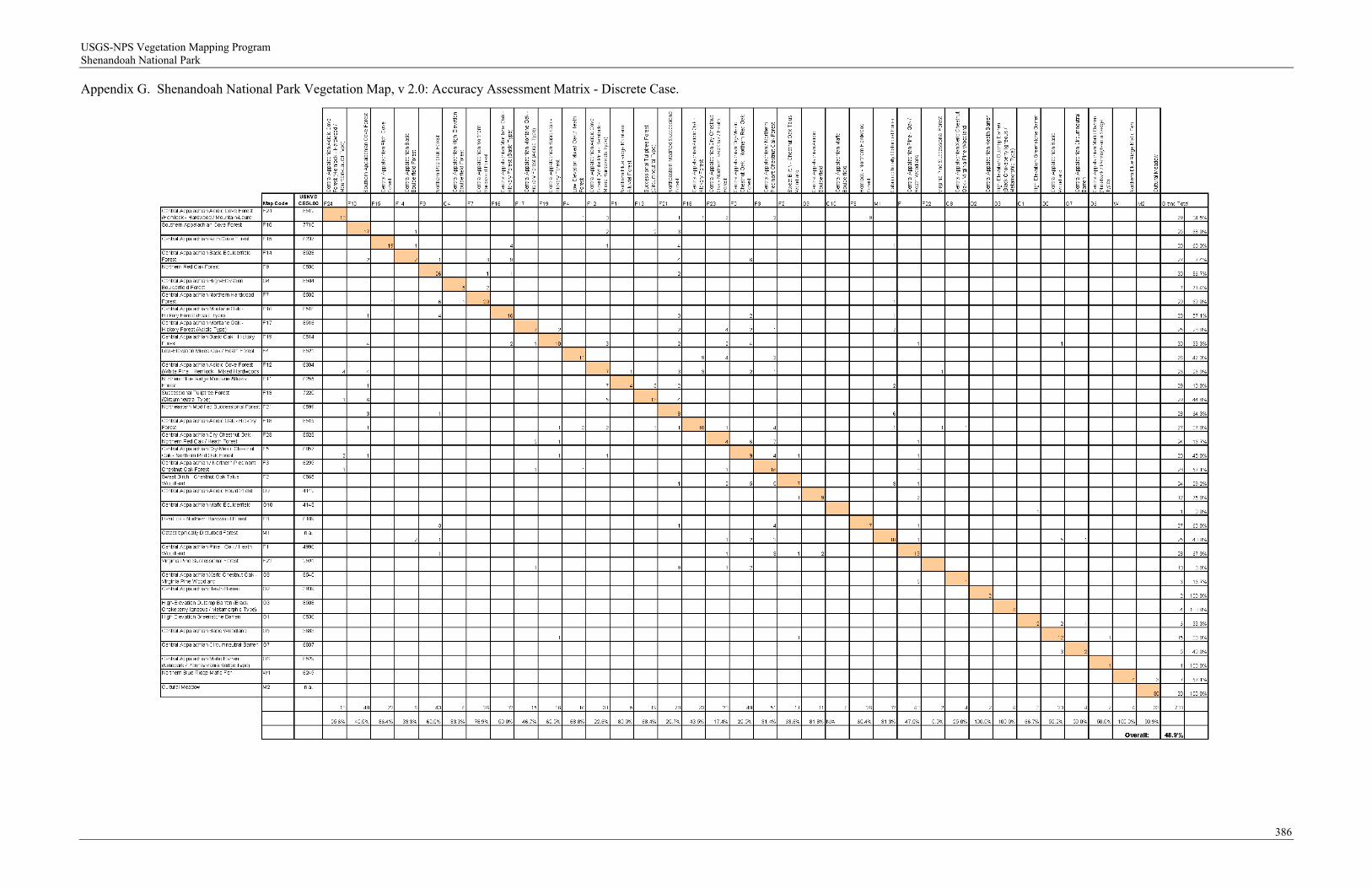
USGS-NPS Vegetation Mapping Program Shenandoah National Park
Appendix G. Shenandoah National Park Vegetation Map, v 2.0: Accuracy Assessment Matrix - Discrete Case.
386

USGS-NPS Vegetation Mapping Program Shenandoah National Park
Appendix H. Shenandoah National Park Vegetation Map, v 2.0: Accuracy Assessment Matrix - "Fuzzy" Case.
387

USGS-NPS Vegetation Mapping Program Shenandoah National Park
As the nation's primary conservation agency, the Department of the Interior has responsibility for most of our nationally owned public land and natural resources. This includes fostering sound use of our land and water resources; protecting our fish, wildlife, and biological diversity; preserving the environmental and cultural values of our national parks and historical places; and providing for the enjoyment of life through outdoor recreation. The department assesses our energy and mineral resources and works to ensure that their development is in the best interests of all our people by encouraging stewardship and citizen participation in their care. The department also has a major responsibility for American Indian reservation communities and for people who live in island territories under U.S. administration.
NPS 134/100756 December 2009

USGS-NPS Vegetation Mapping Program Shenandoah National Park
National Park Service U.S. Department of the Interior
Northeast Region Natural Resource Stewardship and Science 200 Chestnut Street Philadelphia, Pennsylvania 19106-2878 http://www.nps.gov/nero/science/
EXPERIENCE YOUR AMERICA TM