Embed Size (px)
Citation preview
Government of Western AustraliaDepartment of Water
��������������������������������REPORT NO.60 JUNE 2006
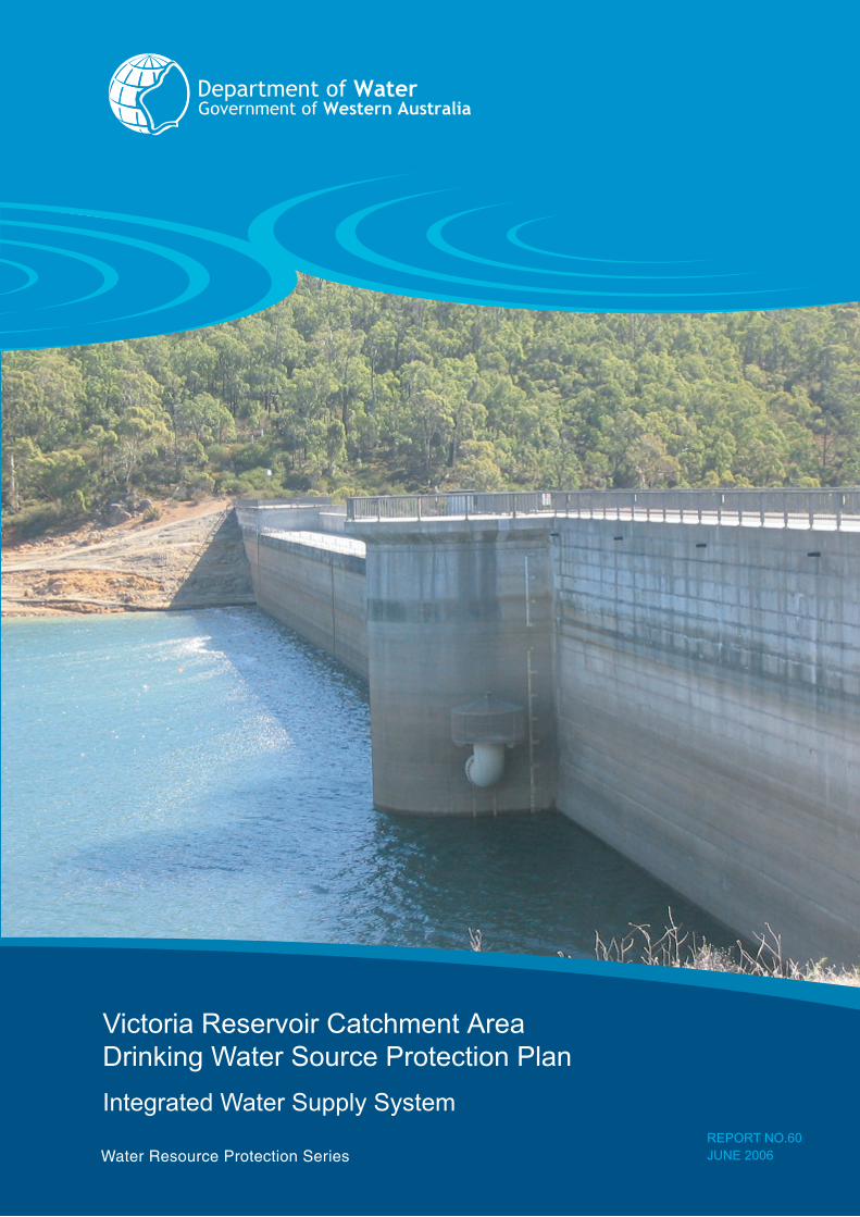
Victoria Reservoir Catchment Area Drinking Water Source Protection PlanIntegrated Water Supply System
Department of Water i
Water Resource Protection Report Series Victoria Drinking Water Source Protection Plan - WRP 60
Victoria Reservoir Catchment AreaDrinking Water Source Protection Plan
Integrated Water Supply System
Prepared byWater Resources DivisionDepartment of Water
Department of WaterWater Resource Protection Series
June 2006
Department of Waterii
Water Resource Protection Report Series Victoria Drinking Water Source Protection Plan - WRP 60
Acknowledgments
* The Department of Water was formerly the Water and Rivers Commission
Program Manager, Protection Planning Water Quality Protection Branch Department of Water 4th Floor, The Atrium 168 St George’s Terrace PERTH WA 6000 Telephone: (08) 6364 6500 Facsimile: (08) 6364 6520
Recommended ReferenceThe recommended reference for this publication is: Department of Water, 2006, Victoria Reservoir Catchment Area Drinking Water Source Protection Plan, Department of Water, Government of Australia, Water Resource Protection Series Report No. WRP 60.
We welcome your feedback. A feedback form can be found at the back of this publication, or online at http://www.water.wa.gov.au.
This document is available in alternative formats such as audio tape, computer disk, large print, Braille and other languages.
Printed on recycled stockJune, 2006ISSN 1326-7442Cover photograph: courtesy of the Water Corporation.
Contribution Personnel Title OrganisationSupervision Stephen Watson Program Manager,
Protection PlanningDepartment of Water*
Jade Coleman Senior Water Resources Planner
Department of Water*
Project Liaison Peter Coghlan Senior Engineer Water CorporationReport preparation Palenque Blair Engineer Water Corporation
Leanne Phillips Engineer Water CorporationKathryn Chinnery Engineering Student Water CorporationMarilyn Andruszkiw Engineering Student Water Corporation
Marion Burchell Environmental Officer Department of Water*Kim Hunter Environmental Officer Department of Water*Joanne Myers Environmental Officer Department of Water*Bree Atkinson Environmental Officer Department of Water*Christa Loos Environmental Officer Department of Water*
Drafting Susan Taylor Planning Information Officer Water CorporationDianne Abbott Drafting Officer Department of Water*
Department of Water iii
Water Resource Protection Report Series Victoria Drinking Water Source Protection Plan - WRP 60
ForewordThe Department of Water (Department) has prepared this Drinking Water Source Protection Plan (DWSPP) to report on the activities and risks to water quality within the Victoria Reservoir Catchment Area and to recommend management strategies to minimise the identified risks.
A safe drinking water supply is critical to the wellbeing of a community and catchment protection is necessary to help avoid, minimise or manage risks to water quality in Public Drinking Water Source Areas (PDWSA). The Department is committed to protecting these areas to ensure the continued supply of ‘safe, good quality drinking water’ to consumers to protect public health now and in the future.
The Australian Drinking Water Guidelines recommend a multiple barrier ‘catchment to consumer’ approach to protect public drinking water. The protection and management of a PDWSA is the ‘first barrier’, with subsequent barriers implemented at the water storage, treatment and distribution stages of a water supply system. Catchment protection includes:
• understanding the catchment, the hazards and hazardous events that can compromise drinking water quality; and
• developing and implementing preventive strategies and operational controls necessary to ensure the safest possible raw water supply (i.e. before treatment).
This Plan details the location and boundary of the drinking water catchment that provides potable water to the Integrated Water Supply System. It discusses existing use of the water source, describes the water supply system, identifies risks and recommends management approaches to maximise protection of the catchment.
The Plan should be used to guide State and local government land use planning decisions in Western Australia. This DWSPP should be recognised in the Shire of Kalamunda, City of Gosnells and City of Armadale Town Planning Schemes and other local planning strategies and plans, consistent with the Western Australian Planning Commission’s Statement of Planning Policy No. 2.7 Public Drinking Water Source Policy. Other stakeholders should use this document as a guide for protecting the quality of water in the PDWSA.
“The continued supply of safe, good quality
drinking water”
Department of Wateriv
Water Resource Protection Report Series Victoria Drinking Water Source Protection Plan - WRP 60
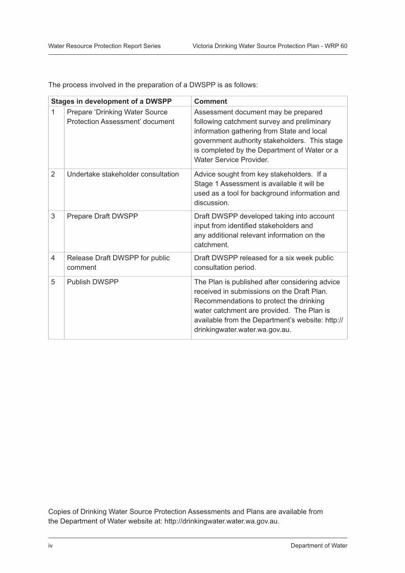
The process involved in the preparation of a DWSPP is as follows:
Stages in development of a DWSPP Comment1 Prepare ‘Drinking Water Source
Protection Assessment’ documentAssessment document may be prepared following catchment survey and preliminary information gathering from State and local government authority stakeholders. This stage is completed by the Department of Water or a Water Service Provider.
2 Undertake stakeholder consultation Advice sought from key stakeholders. If a Stage 1 Assessment is available it will be used as a tool for background information and discussion.
3 Prepare Draft DWSPP Draft DWSPP developed taking into account input from identified stakeholders and any additional relevant information on the catchment.
4 Release Draft DWSPP for public comment
Draft DWSPP released for a six week public consultation period.
5 Publish DWSPP The Plan is published after considering advice received in submissions on the Draft Plan. Recommendations to protect the drinking water catchment are provided. The Plan is available from the Department’s website: http://drinkingwater.water.wa.gov.au.
Copies of Drinking Water Source Protection Assessments and Plans are available from the Department of Water website at: http://drinkingwater.water.wa.gov.au.
Department of Water v
Water Resource Protection Report Series Victoria Drinking Water Source Protection Plan - WRP 60
ContentsSummary 1
1. Introduction 3
1.1 Water supply system 3
1.2 Existing water source protection 3
1.3 Water resource allocation 3
2. Catchment description 6
2.1 Climate 6
2.2 Physiography and vegetation 6
2.3 Hydrology 6
3. Water quality and treatment 7
3.1 Water quality 7
3.2 Water treatment 7
4. Land use 8
4.1 Current land use 8
4.2 Private land 9
4.3 Department of Water and Water Corporation freehold land 9
5. Public Drinking Water Source Area protection 12
5.1 Proclaimed area 12
5.2 Priority classification 12
5.3 Reservoir Protection Zone 13
6. Management of water quality risks 14
6.1 Land use planning 14
6.2 Surveillance and by-law enforcement 14
6.3 Best management practices 14
6.4 Emergency response 15
6.5 Recommended protection strategies 15
Recommendations 39
References 41
Acronyms 43
Glossary 44
Appendices 46
Department of Watervi
Water Resource Protection Report Series Victoria Drinking Water Source Protection Plan - WRP 60
ContentsAppendices
Appendix 1 Water Quality Results Provided by the Water Corporation 47
Appendix 2 Best Management Practice Documents for Activities in PDWSA 50
Figures
Figure 1. Victoria Reservoir Catchment Locality Plan 6
Figure 2. Victoria Reservoir Catchment Land Use and Tenure 10
Figure 3. Proposed Victoria Reservoir Catchment Area, Reservoir Protection Zone and Priority Classifications 11
Tables
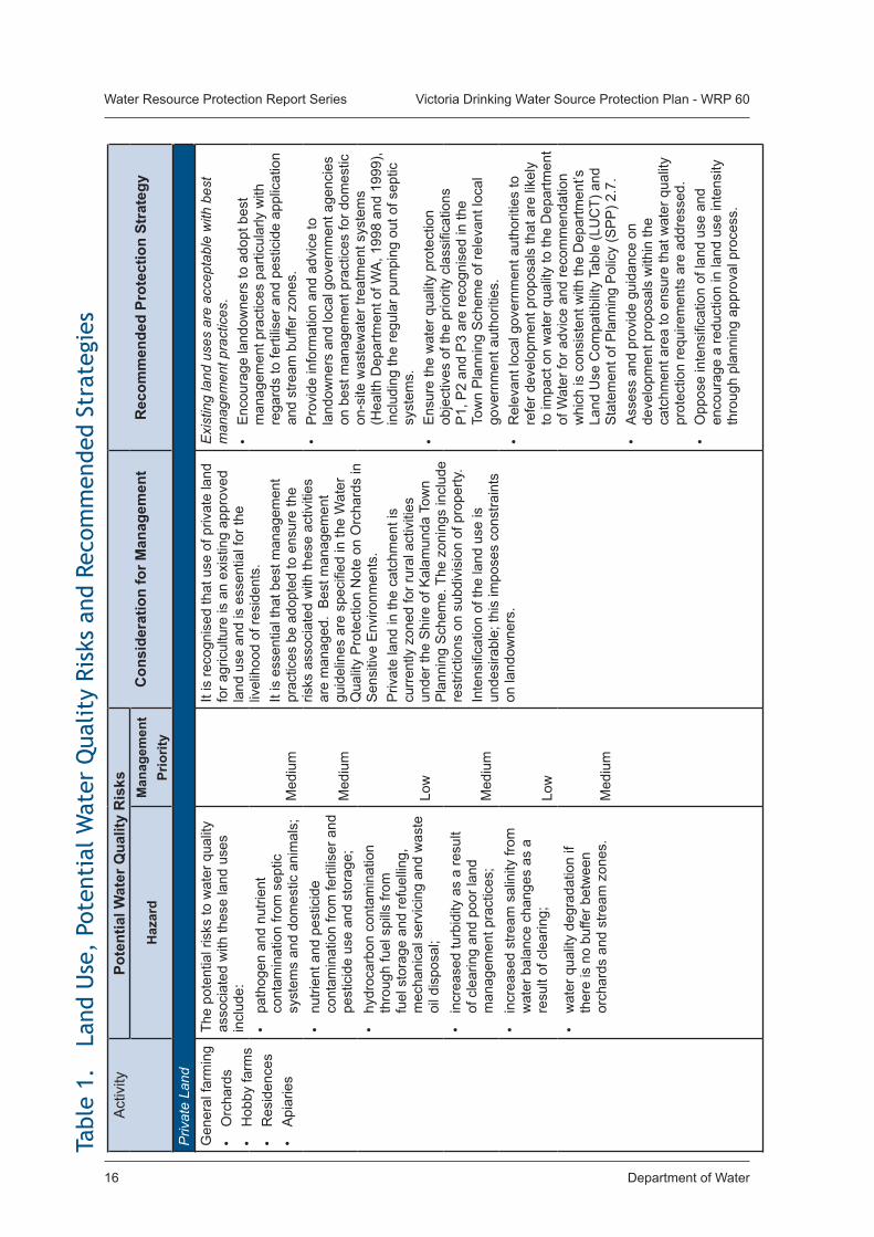
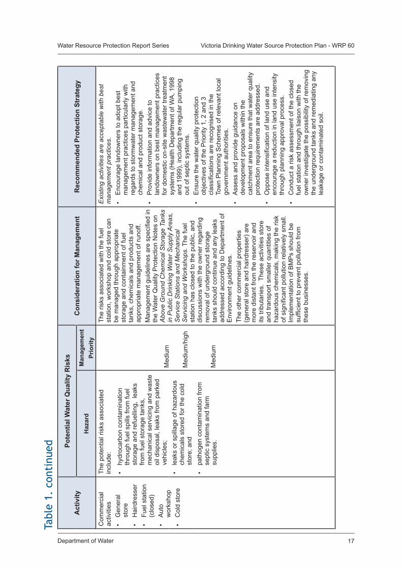
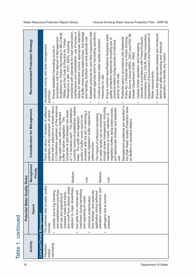
Table 1. Land Use, Potential Water Quality Risks and Recommended Strategies 16
Department of Water 1
Water Resource Protection Report Series Victoria Drinking Water Source Protection Plan - WRP 60
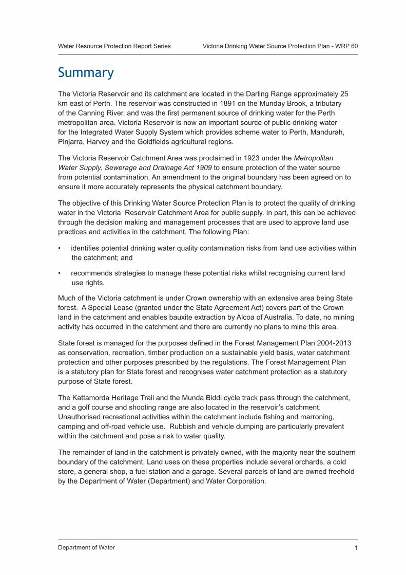
SummaryThe Victoria Reservoir and its catchment are located in the Darling Range approximately 25 km east of Perth. The reservoir was constructed in 1891 on the Munday Brook, a tributary of the Canning River, and was the first permanent source of drinking water for the Perth metropolitan area. Victoria Reservoir is now an important source of public drinking water for the Integrated Water Supply System which provides scheme water to Perth, Mandurah, Pinjarra, Harvey and the Goldfields agricultural regions.
The Victoria Reservoir Catchment Area was proclaimed in 1923 under the Metropolitan Water Supply, Sewerage and Drainage Act 1909 to ensure protection of the water source from potential contamination. An amendment to the original boundary has been agreed on to ensure it more accurately represents the physical catchment boundary.
The objective of this Drinking Water Source Protection Plan is to protect the quality of drinking water in the Victoria Reservoir Catchment Area for public supply. In part, this can be achieved through the decision making and management processes that are used to approve land use practices and activities in the catchment. The following Plan:
• identifies potential drinking water quality contamination risks from land use activities within the catchment; and
• recommends strategies to manage these potential risks whilst recognising current land use rights.
Much of the Victoria catchment is under Crown ownership with an extensive area being State forest. A Special Lease (granted under the State Agreement Act) covers part of the Crown land in the catchment and enables bauxite extraction by Alcoa of Australia. To date, no mining activity has occurred in the catchment and there are currently no plans to mine this area.
State forest is managed for the purposes defined in the Forest Management Plan 2004-2013 as conservation, recreation, timber production on a sustainable yield basis, water catchment protection and other purposes prescribed by the regulations. The Forest Management Plan is a statutory plan for State forest and recognises water catchment protection as a statutory purpose of State forest.
The Kattamorda Heritage Trail and the Munda Biddi cycle track pass through the catchment, and a golf course and shooting range are also located in the reservoir’s catchment. Unauthorised recreational activities within the catchment include fishing and marroning, camping and off-road vehicle use. Rubbish and vehicle dumping are particularly prevalent within the catchment and pose a risk to water quality.
The remainder of land in the catchment is privately owned, with the majority near the southern boundary of the catchment. Land uses on these properties include several orchards, a cold store, a general shop, a fuel station and a garage. Several parcels of land are owned freehold by the Department of Water (Department) and Water Corporation.
Department of Water2
Water Resource Protection Report Series Victoria Drinking Water Source Protection Plan - WRP 60
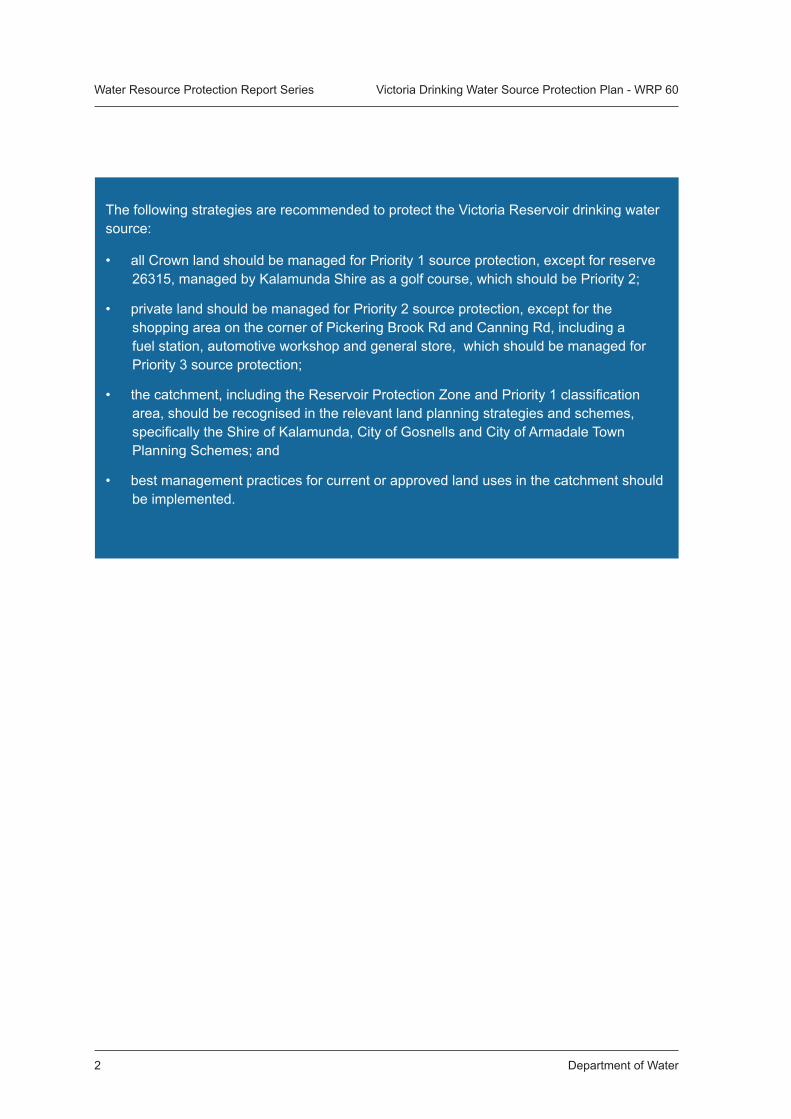
The following strategies are recommended to protect the Victoria Reservoir drinking water source:
• all Crown land should be managed for Priority 1 source protection, except for reserve 26315, managed by Kalamunda Shire as a golf course, which should be Priority 2;
• private land should be managed for Priority 2 source protection, except for the shopping area on the corner of Pickering Brook Rd and Canning Rd, including a fuel station, automotive workshop and general store, which should be managed for Priority 3 source protection;
• the catchment, including the Reservoir Protection Zone and Priority 1 classification area, should be recognised in the relevant land planning strategies and schemes, specifically the Shire of Kalamunda, City of Gosnells and City of Armadale Town Planning Schemes; and
• best management practices for current or approved land uses in the catchment should be implemented.
Department of Water 3
Water Resource Protection Report Series Victoria Drinking Water Source Protection Plan - WRP 60
1. IntroductionThe Victoria Reservoir was the first permanent source of drinking water for the Perth metropolitan area and was constructed in 1891 on Munday Brook, a tributary of the Canning River, approximately 25 kilometres east of Perth. In 1990 the original dam was decommissioned, and a new dam was constructed in 1991 approximately 110 metres further upstream. The reservoir remains a strategic source of public drinking water for the Integrated Water Supply System (IWSS) which supplies water to Perth, Mandurah, Pinjarra, Harvey and the Goldfields agricultural regions.
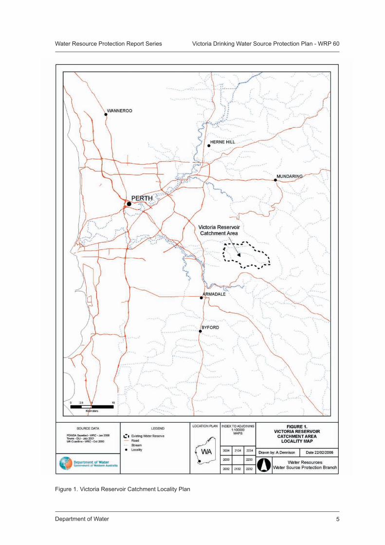
The majority of the Victoria Reservoir catchment falls within the Shire of Kalamunda, with small sections in the Cities of Gosnells and Armadale. Refer to Figure 1 for the location of the reservoir and its catchment and Figure 2 for the administrative boundaries.
The objective of this Plan is to recommend protection strategies to ensure land uses and activities in the catchment are managed to protect the water quality of this important drinking water source. The Plan will be reviewed on a five year rotating cycle.
1.1 Water supply systemThe Victoria Reservoir has a capacity of 9.5 gigalitres, and a full supply level of 202 metres Australian Height Datum (AHD). It is an important source of water for the Integrated Water Supply System (IWSS) and also supplies water locally to the foothills, which includes Kalamunda and its adjacent suburbs.
The Victoria Reservoir is currently supplemented with water from Bickley Reservoir via a pumpback scheme. The volume of water that the pumpback provides ranges between 30 percent to 40 percent of the total water taken from Victoria Reservoir used to supply the Perth metropolitan area. Since 2002 this volume has increased due to chlorinated groundwater from the metropolitan water supply system being transferred into Bickley Reservoir (thus increasing the volume of water available from Bickley).
1.2 Existing water source protectionThe Victoria Reservoir Catchment Area was proclaimed in 1923 under the Metropolitan Water Supply, Sewerage and Drainage (MWSSD) Act 1909 to ensure protection of the water source from potential contamination. Refer to Figures 2 or 3 for the existing Victoria Reservoir Catchment boundary.
The catchment area for the Bickley Reservoir has also been proclaimed under the MWSSD Act. Refer to the Bickley Reservoir Catchment Area Drinking Water Source Protection Plan for details on source protection issues in this catchment.
1.3 Water resource allocationThe Department of Water is responsible for the allocation and licensing of any water use in areas proclaimed as Surface Water or Groundwater Areas under the Rights in Water and Irrigation (RIWI) Act 1914. Water licence allocations are aimed at ensuring equitable use of the State’s water resources between competing interests and protection of the long term security of those resources.
Department of Water4
Water Resource Protection Report Series Victoria Drinking Water Source Protection Plan - WRP 60
The Victoria Reservoir and its catchment area has been proclaimed under the Rights in Water and Irrigation (RIWI) Act 1914 as the Victoria Reservoir Surface Water Area.
1.3.1 Current allocation licence
The Water Corporation has an allocation licence for the Victoria Reservoir, which permits the diversion of up to 4.3 gigalitres per annum from Munday Brook.
1.3.2 Future water supply
The Victoria Reservoir will continue to be used to supply water to the Integrated Water Supply System.
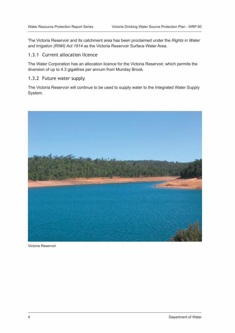
Victoria Reservoir
Department of Water 5
Water Resource Protection Report Series Victoria Drinking Water Source Protection Plan - WRP 60
Figure 1. Victoria Reservoir Catchment Locality Plan
Department of Water6
Water Resource Protection Report Series Victoria Drinking Water Source Protection Plan - WRP 60
2. Catchment description
2.1 ClimateThe Perth region has a Mediterranean climate, characterised by warm dry summers and mild wet winters. The average annual precipitation for the catchment is approximately 906 millimetres, with the majority of this rainfall falling between the months of May and September.
Over recent decades Western Australia has experienced an unprecedented and mostly unpredictable shift in its climate. In the south-west, changes in climate (as a result of the greenhouse gas effect and natural variability) have resulted in a ‘drying climate’, with a 10-20 percent decline in winter rainfall since 1975. As rainfall is a key driver for the environment, such changes have significant implications for our limited water resources.
2.2 Physiography and vegetationThe Victoria Reservoir catchment is located on the Darling Scarp which forms the western boundary of the Darling Range. This area forms part of the Archaean Yilgarn Block, which consists mainly of granite, gneisses, migmatite and doleritic intrusions (King and Wells, 1990).
The Murray, Yarragil and Dwellingup vegetation type complexes cover the majority of the catchment. Much of the land is open forest or woodland dominated by several Eucalyptus species. Private land exists along the southern boundary of the catchment and has been cleared for agriculture purposes and other uses.
The major valleys of the Victoria catchment are defined as the Murray soil type, which is characterised by red and yellow soils. The minor valleys consist of the Yarragil soil type, which includes sandy gravels on the slopes, and swampy floors.
The lateritic uplands are represented predominantly by the Dwellingup soil type, which forms a gently undulating landscape. This soil type consists of duricrusts on the ridges, and sands and gravels in shallow depressions. There are also some smaller areas of the Cook soil type, which includes hills mantled by laterite with some rock outcrop.
2.3 HydrologyThe catchment for Victoria Reservoir covers an area of 37 square kilometres with Munday Brook the major tributary supplying the reservoir. The long term average yield entering Victoria Reservoir via catchment inflows is 3.1 gigalitres per year (1994-2001) and includes an average input of 1.4 gigalitres via the Bickley pumpback connection.
Since 2002, Bickley Reservoir has been used to transfer chlorinated groundwater to Victoria Reservoir. This has increased the total volume of water supplied via the pumpback from Bickley to between 25 percent and 50 percent of the total water volume held in the Victoria Reservoir.
Department of Water 7
Water Resource Protection Report Series Victoria Drinking Water Source Protection Plan - WRP 60
3. Water quality and treatment
3.1 Water qualityA wide range of chemical, physical and microbiological properties can affect the health and aesthetic quality of drinking water. The Water Corporation monitors the raw (source) water quality from Victoria Reservoir consistent with the Australian Drinking Water Guidelines (ADWG). For details of the raw water quality analyses undertaken by the Water Corporation (between 1999 and 2004) refer to Appendix 1.
The Water Corporation undertake catchment sampling according to their operational guidelines. As part of the catchment water quality sampling program, risks are identified and sampling carried out downstream of any potential contamination source as well as sampling on each major feeder stream and the reservoir itself. Point and non-point source microbiological risks have been identified in the Victoria Catchment Management Strategy and a recommended sampling program for raw water, the reservoir and catchment streams has been defined.
3.2 Water treatmentThe water abstracted from the Victoria Reservoir is disinfected (chlorinated), and fluoridated before supplying the Integrated Water Supply System (IWSS). Chlorination is the primary barrier used against unwanted bacteriological activity to ensure good quality public drinking water. Under high turbidity water conditions chlorination can be ineffective in treating raw water for microbiological contamination (NHMRC and ARMCANZ, 1996). As such the Water Corporation monitors turbidity concentrations in raw water supplies.
Pumpback from Bickley to the Victoria Reservoir only operates during the winter months when the Victoria Reservoir is ‘offline’. In order to facilitate mixing and dilution of the water transferred from Bickley, Victoria remains offline for approximately one month after the cessation of pumpback activities.
Although reservoir storage and disinfection by chlorination generally removes contamination to provide safe drinking water, treatment processes alone cannot and should not be relied upon. Where possible, contamination should be prevented or reduced through appropriate land use or activity controls in the catchment area. This approach is endorsed by the Australian Drinking Water Guidelines (NHMRC and ARMCANZ, 1996) and reflects a ‘catchment to consumer’ multiple barrier approach for the provision of safe drinking water to consumers.
Western Australia has adopted this approach in the management of its public drinking water catchment and it is also recommended for the protection of private water supplies.
Department of Water8
Water Resource Protection Report Series Victoria Drinking Water Source Protection Plan - WRP 60
4. Land use
4.1 Current land useCurrent land use in the Victoria Reservoir catchment includes:
• land and forest management on Crown land;
• recreation on Crown land;
• rural and commercial land use on private land; and
• land management on Department of Water and Water Corporation freehold land.
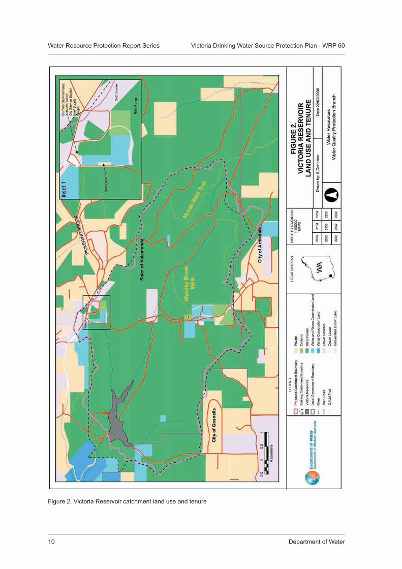
Land use and tenure in the catchment are shown in Figure 2. The source protection area falls across the administrative boundaries of the Shire of Kalamunda, City of Gosnells and City of Armadale.
Native Title claims (Reference: WAG0142_98) exist over the land within the Victoria Reservoir Catchment Area. The claimants are represented by the South West Aboriginal Land and Sea Council.
4.1.1 Crown land - land and forest management
Approximately 90 percent of the Victoria catchment is under Crown ownership. An extensive area of the catchment is State forest (Number 54) which has been vested with the Conservation Commission of Western Australia and is managed by the Department of Conservation and Land Management (CALM).
State forest within the catchment has recently (2004) been reserved as national park following the Reserves (National Parks and Conservation Parks) Bill 2004. State forest is managed for the purposes defined in the Forest Management Plan 2004-2013 as conservation, recreation, timber production on a sustainable yield basis, water catchment protection and other purposes prescribed by the regulations. For further information on forest land management, refer to the Forest Management Plan 2004-2013 (Conservation Commission of Western Australia, 2004).
In addition to State forest on Crown land, Reserve 21172 (vested with Water Corporation) consists of remnant vegetation and is used for the purpose of water quality protection of the Munday Brook. There is a golf course on Reserve 26315, vested with the Shire of Kalamunda.
A Special Lease, granted under the State Agreement Act to Alcoa of Australia (Alcoa) in 1961, covers part of the Crown land area. This lease permits Alcoa to extract bauxite from the area, but includes a responsibility to ensure the environmental value of the area is protected and mine sites are rehabilitated. As yet, no mining activity has occurred in the catchment, and there are currently no plans to mine in the immediate future.
Management of State forest by CALM is in accordance with the purpose of State forest and includes fire management (for biodiversity conservation and the protection of assets) and the control of feral animals (fox baiting and feral pig trapping). All feral animal control activities on land managed by CALM must be coordinated by CALM. In addition to State forest, CALM also has management responsibilities for unallocated Crown land. Such responsibilities include the promotion of conservation of biodiversity, fire prevention, weed and animal control, harvesting of flora and forest produce and management of recreation.
Department of Water 9
Water Resource Protection Report Series Victoria Drinking Water Source Protection Plan - WRP 60
Licences for commercial firewood collection are issued by CALM, with collection from State forest facilitated through the commercial harvesting of the forest by the Forest Products Commission. The collection of firewood by the public is not permitted within nature reserves, national parks or conservation parks except in designated firewood areas in State forest and timber reserves. Apiaries (nine sites), wildflower picking and seed collection also occur in the State forest and are licensed by CALM. The catchment and reservoir are also occasionally used for research projects.
Management of forest on other tenures includes softwood timber production on a small plantation in the catchment.
4.1.2 Crown land – recreation
Given the relatively unrestricted access to the Victoria catchment, numerous authorised and unauthorised recreational activities occur there.
Authorised activities include the Kattamorda Heritage Trail, an established walk trail managed by CALM that passes through the catchment to the north of the reservoir. The Munda Biddi long distance mountain bike trail, opened in 2004, also passes through the back of the Victoria catchment along Carinyah Road. It is likely that this track will increase visitor numbers in the catchment but, providing visitors keep to the designated trail, should have minimal impact.
A golf course and a shooting range are located inside the catchment. The golf course is affiliated with the Pickering Brook Sports Club that lies on the catchment boundary. Some irrigation of the golf course occurs from bore water sourced on site, but the fairways are not watered. The shooting range in State forest east of Canning Road in the north of Victoria catchment is operated by a small rifle club that uses the area on weekends.
Unauthorised recreational activities include fishing and marroning, camping and off-road vehicle use. Rubbish and vehicle dumping are particularly prevalent in the Victoria catchment.
4.2 Private landPrivate land comprises approximately 260 ha of the total catchment area (of 3686 ha) and can be found mostly near the southern boundary. Land use in this area is primarily agricultural (orchards). The remaining private land in the catchment is characterised by smaller properties close to the northern boundary and land uses include orchards, a general store, a hairdresser, a fuel station (closed) and automotive workshop, and cold store. All commercial land uses occur in the north of the catchment (refer to Figure 2).
4.3 Department of Water and Water Corporation freehold land
The Department of Water and the Water Corporation have freehold ownership of several properties in the catchment consisting of small cleared or partly revegetated blocks. The Water Corporation has vested responsibility for their management.
Land management by the Water Corporation includes fire management such as prescribed burning and maintenance of firebreaks. Prescribed burning is done in conjunction with the relevant shire authorities.
These freehold properties are frequented for the purposes of illegal recreation, often resulting in the dumping of stolen cars and rubbish.
Department of Water10
Water Resource Protection Report Series Victoria Drinking Water Source Protection Plan - WRP 60
Figure 2. Victoria Reservoir catchment land use and tenure
Department of Water 11
Water Resource Protection Report Series Victoria Drinking Water Source Protection Plan - WRP 60
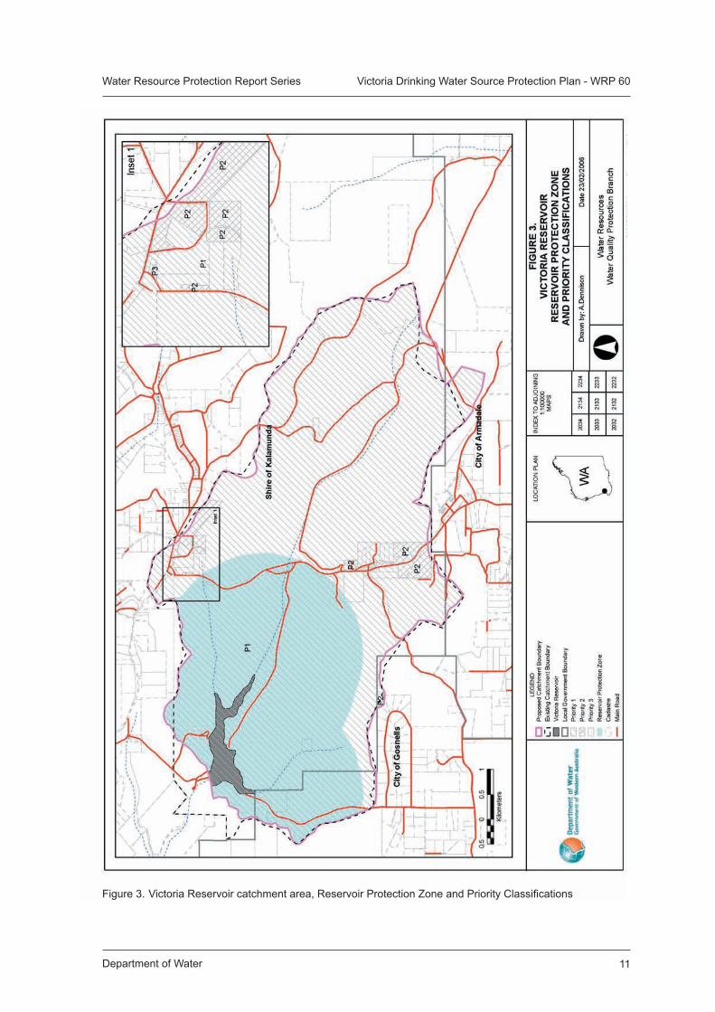
Figure 3. Victoria Reservoir catchment area, Reservoir Protection Zone and Priority Classifications
Department of Water12
Water Resource Protection Report Series Victoria Drinking Water Source Protection Plan - WRP 60
5. Public Drinking Water Source Area protection
The protection of Public Drinking Water Source Areas (PDWSAs) by the Department of Water is consistent with government policy and involves three key elements:
• the proclamation of the PDWSA;
• the determination of ‘priority classification areas’ for land within the PDWSA; and
• the establishment of a Reservoir Protection Zone within the PDWSA.
The preparation of this Drinking Water Source Protection Plan forms part of the ‘multiple barrier’ approach for the protection of public drinking water sources from potential contamination. The strategies used to protect PDWSAs in this Plan recognise the rights of existing and approved land uses and activities.
5.1 Proclaimed areaAreas ‘proclaimed’ for drinking water purposes include Underground Water Pollution Control Areas (UWPCA), Water Reserves and Catchment Areas declared under the Metropolitan Water Supply, Sewerage and Drainage Act 1909 or the Country Areas Water Supply Act 1947.
The Victoria Reservoir Catchment Area was proclaimed in 1923 under the Metropolitan Water Supply, Sewerage and Drainage Act. An amendment to the original boundary has been adopted so that it will more accurately represent the physical catchment boundary.
The proposed Victoria Reservoir Catchment Area is shown in Figures 2 and 3.
5.2 Priority classificationLand within PDWSAs is allocated one of three priority classifications (1, 2 or 3). The classification looks to prioritise areas for the protection of water quality and has been defined using present land use information, existing or approved land zoning, ownership, the importance of the water source, and the vulnerability of the water body. Each priority classification allows different levels of activity according to the degree of risk to the water resource. Additional constraints may also apply in zones closest to the point where drinking water is harvested or stored. These areas are known as Wellhead Protection Zones (WPZ) or Reservoir Protection Zones (RPZ).
Further details of the priority classifications and the detail of land use compatibility with each priority classification are provided on the Department’s Internet site at www.drinkingwater.water.wa.gov.au.
The majority of the land in the Victoria catchment is Crown land. Where possible Crown land should be managed for Priority 1 (P1) source protection. The objective of a P1 classification is risk avoidance for the protection of water quality. A P1 source protection classification is appropriate for Crown land as:
• the Victoria Reservoir Catchment Area is an important source of public drinking water for the Integrated Water Supply System, and should be afforded the highest level of protection;
Department of Water 13
Water Resource Protection Report Series Victoria Drinking Water Source Protection Plan - WRP 60
• the land is State forest or owned freehold by State government agencies; and
• most existing land use practices are compatible with P1 source protection, or can be managed for P1 source protection with the use of best management practices.
The golf course (located on Crown land Reserve 26315) on the northern boundary of the catchment should be managed for Priority 2 source protection to minimise any potential water quality impacts (see Table 1). The objective of Priority 2 classification is to protect water quality according to the principle of risk minimisation.
Private land in the Victoria catchment should largely be managed for Priority 2 (P2) source protection. The cold store on Canning Road should also be managed for P2 source protection due to the proximity of the property to streams and its drainage from the property down the road reserve. A P2 source protection classification is appropriate for these areas as:
• the Victoria Reservoir is a strategic source of public drinking water for the Integrated Water Supply System; and
• existing land use practices are compatible with P2 source protection with implementation of best management practices.
The shopping area on the corner of Pickering Brook Road and Canning Road which includes a fuel station, an automotive workshop and general store, should be managed for Priority 3 (P3) source protection. Discussions with the owner should continue to investigate the option of permanent removal of the fuel station structures as the underground fuel tanks pose an unacceptable risk to water quality (see Table 1). Should dismantling of the structures not be deemed appropriate regular environmental assessments of the site should be conducted.
5.3 Reservoir Protection ZoneTo protect the reservoir from immediate risks to water contamination, a prohibited zone (also known as a Reservoir Protection Zone (RPZ)) extends for 2 km from the top water level of the reservoir and includes the reservoir itself (refer to Figure 3). Within these zones, by-laws prohibit, restrict and regulate land use and human activities to prevent water source contamination. For further details on RPZs refer to the Department’s Internet site at http://drinkingwater.water.wa.gov.au.
There are no trails or private land within the RPZ for the Victoria catchment, with only State forest or freehold land falling within the 2 km RPZ area.
Department of Water14
Water Resource Protection Report Series Victoria Drinking Water Source Protection Plan - WRP 60
6. Management of water quality risks
6.1 Land use planningIt is recognised under the State Planning Strategy (Western Australian Planning Commission, 1997) that the establishment of appropriate protection mechanisms in statutory land use planning processes is essential to secure the long term protection of water sources.
It is therefore recommended that the Metropolitan Region Scheme and the Town Planning Schemes for the Shire of Kalamunda, City of Gosnells and City of Armadale recognise priority classification areas and protection zones assigned to land in the Victoria Reservoir Catchment Area. This is consistent with the Western Australian Planning Commission’s Statement of Planning Policy 2.7 Public Drinking Water Source Policy (June 2003).
The Department of Water provides advice on the compatibility of land uses within the proposed priority classification areas based on the guidance document Land Use Compatibility in Public Drinking Water Source Areas (see www.drinkingwater.water.wa.gov.au/wqpn). Development and work proposals in the catchment that are inconsistent with the land use table should be referred to the Department’s Swan Goldfields office for assessment and recommendation.
6.2 Surveillance and by-law enforcementThe Department of Water has delegated the responsibility for surveillance and associated by-law enforcement in the Victoria Reservoir catchment to the Water Corporation who report annually to the Department. As the catchment area has been proclaimed under the MWSSD Act, the by-laws of this Act can be used to control potentially contaminating activities within the catchment.
By-law enforcement, through on-ground surveillance of land uses and activities, is a critical mechanism in protecting the quality of drinking water sources. Water Corporation Ranger communication with visitors to the catchment also assists in increasing public awareness of the need to protect drinking water quality.
The use of signs and other informative material is also an important component of water quality protection for those who visit the catchment and for landowners in the catchment.
6.3 Best management practicesTo help protect water quality in the catchment, best management practices for land use activities are encouraged. These are often in the form of industry codes of practice and environmental guidelines. Guidance documents are usually developed in consultation with industry groups, producers and State government agencies.
Best management practices can be developed for an individual enterprise or have a local or regional focus and must consider the full range of economic, social and environmental issues associated with land, water and vegetation use. Development of best management practices must also take into consideration the needs and concerns of users, consumers and the wider community (ARMCANZ & ANZECC, 1996).
Department of Water 15
Water Resource Protection Report Series Victoria Drinking Water Source Protection Plan - WRP 60
The potential risks to water quality from existing land uses can be reduced by the implementation of best management practices. For example, fencing to control stock access to watercourses, retention of vegetation along streamlines (riparian zones), appropriate pesticide, herbicide and fertiliser application practices (as detailed in Statewide Policy No.2 Pesticide Use in Public Drinking Water Source Areas (WRC, 2000)) and septic tank management. The implementation of best management practices for land use activities in the catchment is encouraged to protect water quality.
Similarly, the potential risks to water quality associated with forestry activities can be managed by the adoption of best management practices such as appropriate road construction and maintenance, use of sumps or drains for sediment control, and appropriate retention of buffer zones along watercourses. Refer to the Manual of Management Guidelines for Timber Harvesting in Western Australia (CALM, 1999a) and the Department’s Water Quality Protection Note Buffers to Sensitive Water Resources.
The implementation of best management practices for land use activities in the catchment is encouraged and expected to assist in protecting water quality.
A reference list of best management practice documents for some of the catchment activities in Victoria Reservoir is provided in Appendix 2.
6.4 Emergency responseDischarge of chemicals during unforeseen incidents and use of chemicals during emergency response can result in the contamination of water sources. The Shire of Kalamunda, City of Armadale and the City of Gosnells Local Emergency Management Advisory Committees through the Cannington and Midland Emergency Management Districts should be familiar with the location and purpose of the Victoria Reservoir Catchment Area. A locality plan should be provided to the Fire and Rescue Services headquarters for the HAZMAT Emergency Advisory Team. The Water Corporation should also have an advisory role in any HAZMAT incident in the catchment area.
Personnel who deal with WESTPLAN - HAZMAT incidents within the area should be given ready access to a locality map of the Victoria Reservoir Catchment Area. These personnel should receive training on the potential impacts of spills on the surface water resources.
6.5 Recommended protection strategiesTable 1 identifies the potential water quality risks associated with existing land uses in the Victoria catchment, and recommends protection strategies to manage these risks.
The potential water quality risks were identified and resulting management priorities designated using a risk assessment process. Strategies have been developed in line with the Australian Drinking Water Guidelines (NHMRC and ARMCANZ, 1996).
The recommended protection strategies balance the need to protect water quality now and in the long term with the rights of landholders to continue to utilise their land for approved use.
Department of Water16
Water Resource Protection Report Series Victoria Drinking Water Source Protection Plan - WRP 60A
ctiv
ity
Pote
ntia
l Wat
er Q
ualit
y R
isks
Con
side
ratio
n fo
r Man
agem
ent
Rec
omm
ende
d Pr
otec
tion
Stra
tegy
Haz
ard
Man
agem
ent
Prio
rity
Priv
ate
Land
Gen
eral
farm
ing
• O
rcha
rds
• H
obby
farm
s•
Res
iden
ces
• A
piar
ies
The
pote
ntia
l ris
ks to
wat
er q
ualit
y as
soci
ated
with
thes
e la
nd u
ses
incl
ude:
Med
ium
Med
ium
Low
Med
ium
Low
It is
reco
gnis
ed th
at u
se o
f priv
ate
land
fo
r agr
icul
ture
is a
n ex
istin
g ap
prov
ed
land
use
and
is e
ssen
tial f
or th
e liv
elih
ood
of re
side
nts.
It is
ess
entia
l tha
t bes
t man
agem
ent
prac
tices
be
adop
ted
to e
nsur
e th
e ris
ks a
ssoc
iate
d w
ith th
ese
activ
ities
ar
e m
anag
ed.
Bes
t man
agem
ent
guid
elin
es a
re s
peci
fied
in th
e W
ater
Q
ualit
y P
rote
ctio
n N
ote
on O
rcha
rds
in
Sen
sitiv
e E
nviro
nmen
ts.
Priv
ate
land
in th
e ca
tchm
ent i
s cu
rren
tly z
oned
for r
ural
act
iviti
es
unde
r the
Shi
re o
f Kal
amun
da T
own
Pla
nnin
g S
chem
e. T
he z
onin
gs in
clud
e re
stric
tions
on
subd
ivis
ion
of p
rope
rty.
Inte
nsifi
catio
n of
the
land
use
is
unde
sira
ble;
this
impo
ses
cons
train
ts
on la
ndow
ners
.
Exi
stin
g la
nd u
ses
are
acce
ptab
le w
ith b
est
man
agem
ent p
ract
ices
.•
Enc
oura
ge la
ndow
ners
to a
dopt
bes
t m
anag
emen
t pra
ctic
es p
artic
ular
ly w
ith
rega
rds
to fe
rtilis
er a
nd p
estic
ide
appl
icat
ion
and
stre
am b
uffe
r zon
es.
• P
rovi
de in
form
atio
n an
d ad
vice
to
land
owne
rs a
nd lo
cal g
over
nmen
t age
ncie
s on
bes
t man
agem
ent p
ract
ices
for d
omes
tic
on-s
ite w
aste
wat
er tr
eatm
ent s
yste
ms
(Hea
lth D
epar
tmen
t of W
A, 1
998
and
1999
), in
clud
ing
the
regu
lar p
umpi
ng o
ut o
f sep
tic
syst
ems.
• E
nsur
e th
e w
ater
qua
lity
prot
ectio
n ob
ject
ives
of t
he p
riorit
y cl
assi
ficat
ions
P
1, P
2 an
d P
3 ar
e re
cogn
ised
in th
e To
wn
Pla
nnin
g S
chem
e of
rele
vant
loca
l go
vern
men
t aut
horit
ies.
• R
elev
ant l
ocal
gov
ernm
ent a
utho
ritie
s to
re
fer d
evel
opm
ent p
ropo
sals
that
are
like
ly
to im
pact
on
wat
er q
ualit
y to
the
Dep
artm
ent
of W
ater
for a
dvic
e an
d re
com
men
datio
n w
hich
is c
onsi
sten
t with
the
Dep
artm
ent’s
La
nd U
se C
ompa
tibili
ty T
able
(LU
CT)
and
S
tate
men
t of P
lann
ing
Pol
icy
(SP
P) 2
.7.
• A
sses
s an
d pr
ovid
e gu
idan
ce o
n de
velo
pmen
t pro
posa
ls w
ithin
the
catc
hmen
t are
a to
ens
ure
that
wat
er q
ualit
y pr
otec
tion
requ
irem
ents
are
add
ress
ed.
• O
ppos
e in
tens
ifica
tion
of la
nd u
se a
nd
enco
urag
e a
redu
ctio
n in
land
use
inte
nsity
th
roug
h pl
anni
ng a
ppro
val p
roce
ss.
• pa
thog
en a
nd n
utrie
nt
cont
amin
atio
n fro
m s
eptic
sy
stem
s an
d do
mes
tic a
nim
als;
• nu
trien
t and
pes
ticid
e co
ntam
inat
ion
from
ferti
liser
and
pe
stic
ide
use
and
stor
age;
• hy
droc
arbo
n co
ntam
inat
ion
thro
ugh
fuel
spi
lls fr
om
fuel
sto
rage
and
refu
ellin
g,
mec
hani
cal s
ervi
cing
and
was
te
oil d
ispo
sal;
• in
crea
sed
turb
idity
as
a re
sult
of c
lear
ing
and
poor
land
m
anag
emen
t pra
ctic
es;
• in
crea
sed
stre
am s
alin
ity fr
om
wat
er b
alan
ce c
hang
es a
s a
resu
lt of
cle
arin
g;
• w
ater
qua
lity
degr
adat
ion
if th
ere
is n
o bu
ffer b
etw
een
orch
ards
and
stre
am z
ones
. M
ediu
m
Tabl
e 1.
La
nd U
se,
Pote
ntia
l Wat
er Q
ualit
y Ri
sks
and
Reco
mm
ende
d St
rate
gies
Department of Water 17
Water Resource Protection Report Series Victoria Drinking Water Source Protection Plan - WRP 60Ta
ble
1. c
onti
nued
Act
ivity
Pote
ntia
l Wat
er Q
ualit
y R
isks
Con
side
ratio
n fo
r Man
agem
ent
Rec
omm
ende
d Pr
otec
tion
Stra
tegy
Haz
ard
Man
agem
ent
Prio
rity
Com
mer
cial
ac
tiviti
es•
Gen
eral
st
ore
• H
aird
ress
er•
Fuel
sta
tion
(clo
sed)
• A
uto
wor
ksho
p•
Col
d st
ore
The
pote
ntia
l ris
ks a
ssoc
iate
d in
clud
e:
Med
ium
Med
ium
/hig
h
Med
ium
The
risks
ass
ocia
ted
with
the
fuel
st
atio
n, w
orks
hop
and
cold
sto
re c
an
be m
anag
ed th
roug
h ap
prop
riate
st
orag
e an
d co
ntai
nmen
t of f
uel
tank
s, c
hem
ical
s an
d pr
oduc
ts a
nd
appr
opria
te m
anag
emen
t of r
unof
f. M
anag
emen
t gui
delin
es a
re s
peci
fied
in
the
Wat
er Q
ualit
y P
rote
ctio
n N
otes
on
Abo
ve G
roun
d C
hem
ical
Sto
rage
Tan
ks
in P
ublic
Drin
king
Wat
er S
uppl
y A
reas
, S
ervi
ce S
tatio
ns a
nd M
echa
nica
l S
ervi
cing
and
Wor
ksho
ps. T
he fu
el
stat
ion
has
clos
ed to
the
publ
ic, a
nd
disc
ussi
ons
with
the
owne
r reg
ardi
ng
rem
oval
of u
nder
grou
nd s
tora
ge
tank
s sh
ould
con
tinue
and
any
leak
s ad
dres
sed
acco
rdin
g to
Dep
artm
ent o
f E
nviro
nmen
t gui
delin
es.
The
othe
r com
mer
cial
pro
perti
es
(gen
eral
sto
re a
nd h
aird
ress
er) a
re
mor
e di
stan
t fro
m th
e re
serv
oir a
nd
its tr
ibut
arie
s. T
hese
act
iviti
es s
tore
an
d tra
nspo
rt sm
alle
r qua
ntiti
es o
f ha
zard
ous
chem
ical
s, m
akin
g th
e ris
k of
sig
nific
ant p
ollu
tion
rela
tivel
y sm
all.
Im
plem
enta
tion
of B
MP
s sh
ould
be
suffi
cien
t to
prev
ent p
ollu
tion
from
th
ese
busi
ness
es.
Exi
stin
g ac
tiviti
es a
re a
ccep
tabl
e w
ith b
est
man
agem
ent p
ract
ices
.•
Enc
oura
ge la
ndow
ners
to a
dopt
bes
t m
anag
emen
t pra
ctic
es p
artic
ular
ly w
ith
rega
rds
to s
torm
wat
er m
anag
emen
t and
ch
emic
al a
nd p
rodu
ct s
tora
ge.
• P
rovi
de in
form
atio
n an
d ad
vice
to
land
owne
rs o
n be
st m
anag
emen
t pra
ctic
es
for d
omes
tic o
n-si
te w
aste
wat
er tr
eatm
ent
syst
ems
(Hea
lth D
epar
tmen
t of W
A, 1
998
and
1999
), in
clud
ing
the
regu
lar p
umpi
ng
out o
f sep
tic s
yste
ms.
• E
nsur
e th
e w
ater
qua
lity
prot
ectio
n ob
ject
ives
of t
he P
riorit
y 1,
2 a
nd 3
cl
assi
ficat
ions
are
reco
gnis
ed in
the
Tow
n P
lann
ing
Sch
emes
of r
elev
ant l
ocal
go
vern
men
t aut
horit
ies.
• A
sses
s an
d pr
ovid
e gu
idan
ce o
n de
velo
pmen
t pro
posa
ls w
ithin
the
catc
hmen
t are
a to
ens
ure
that
wat
er q
ualit
y pr
otec
tion
requ
irem
ents
are
add
ress
ed.
• O
ppos
e in
tens
ifica
tion
of la
nd u
se a
nd
enco
urag
e a
redu
ctio
n in
land
use
inte
nsity
th
roug
h pl
anni
ng a
ppro
val p
roce
ss.
• C
ondu
ct a
risk
ass
essm
ent o
f the
clo
sed
fuel
sta
tion
and
thro
ugh
liais
on w
ith th
e ow
ner i
nves
tigat
e th
e po
ssib
ility
of r
emov
ing
the
unde
rgro
und
tank
s an
d re
med
iatin
g an
y le
akag
e or
con
tam
inat
ed s
oil.
• hy
droc
arbo
n co
ntam
inat
ion
thro
ugh
fuel
spi
lls fr
om fu
el
stor
age
and
refu
ellin
g, l
eaks
fro
m fu
el s
tora
ge ta
nks,
m
echa
nica
l ser
vici
ng a
nd w
aste
oi
l dis
posa
l, le
aks
from
par
ked
vehi
cles
;•
leak
s or
spi
llage
of h
azar
dous
ch
emic
als
stor
ed fo
r the
col
d st
ore;
and
• pa
thog
en c
onta
min
atio
n fro
m
sept
ic s
yste
ms
and
farm
su
pplie
s.
Department of Water18
Water Resource Protection Report Series Victoria Drinking Water Source Protection Plan - WRP 60
Act
ivity
Po
tent
ial W
ater
Qua
lity
Ris
ksC
onsi
dera
tion
for M
anag
emen
tR
ecom
men
ded
Prot
ectio
n St
rate
gyH
azar
dM
anag
emen
t Pr
iorit
yLa
nd a
nd F
ores
t Man
agem
ent
Pla
ntat
ion
timbe
r ha
rves
ting
The
pote
ntia
l ris
ks to
wat
er q
ualit
y in
clud
e:
Med
ium
Low
Med
ium
Low
Ther
e ar
e ab
out 7
hec
tare
s of
sof
twoo
d pl
anta
tion
in th
e ca
tchm
ent,
of w
hich
ab
out h
alf i
s ad
jace
nt to
a s
tream
abo
ut
2.2
kilo
met
res
upst
ream
of t
he re
serv
oir
high
wat
er m
ark,
with
no
sign
ifica
nt
buffe
r of n
ativ
e ve
geta
tion.
The
re
mai
nder
is s
plit
betw
een
two
area
s of
1-2
hec
tare
s ea
ch.
The
plan
tatio
ns
curr
ently
con
sist
of e
stab
lishe
d, m
atur
e tre
es.
The
wid
th a
nd v
eget
atio
n qu
ality
of b
uffe
r zon
es n
eed
to b
e re
view
ed, w
ith th
e ai
m o
f res
torin
g a
natu
ral v
eget
atio
n bu
ffer a
djac
ent t
o w
ater
cour
ses.
The
impa
ct o
f sof
twoo
d ha
rves
ting
on w
ater
qua
lity
can
be m
inim
ised
th
roug
h pr
oper
man
agem
ent,
incl
udin
g m
aint
enan
ce o
f roa
ds, r
eten
tion
of
vege
tatio
n bu
ffers
alo
ng w
ater
cour
ses,
an
d ap
prop
riate
ferti
liser
and
pes
ticid
e us
e.M
anag
emen
t gui
delin
es a
re s
peci
fied
in
the
Dra
ft W
ater
Qua
lity
Pro
tect
ion
Not
e on
Buf
fers
in S
ensi
tive
Wat
ers.
Acc
epta
ble
activ
ity w
ith b
est m
anag
emen
t pr
actic
es.
• E
nsur
e pl
anta
tion
harv
estin
g oc
curs
in
acco
rdan
ce w
ith th
e M
anua
l of M
anag
emen
t G
uide
lines
for T
imbe
r Har
vest
ing
in W
A (C
ALM
, 19
99a)
and
the
Cod
e of
Pra
ctic
e fo
r Tim
ber
Pla
ntat
ions
in W
A (F
PC
, 200
3), i
nclu
ding
co
mpl
ianc
e w
ith s
tand
ards
for r
oad
cons
truct
ion,
m
aint
enan
ce a
nd re
habi
litat
ion,
use
of s
umps
or
drai
ns fo
r sed
imen
t con
trol,
appr
opria
te re
tent
ion
of b
uffe
r zon
es a
long
wat
erco
urse
s, fu
el s
tora
ge
and
hand
ling,
ferti
liser
use
and
pes
ticid
e us
e.•
Est
ablis
h pr
otoc
ols
for j
oint
fiel
d in
spec
tions
with
re
leva
nt a
genc
ies
prio
r to
harv
estin
g op
erat
ions
.•
Con
tinue
to in
spec
t wat
er q
ualit
y pr
otec
tion
mea
sure
s on
site
.•
Ens
ure
cont
ract
spe
cific
atio
ns re
cogn
ise
wat
er
qual
ity p
rote
ctio
n ob
ject
ives
incl
udin
g us
e of
ch
emic
al to
ilets
dur
ing
perio
ds o
f int
ensi
ve
activ
ity o
n th
e si
te.
• P
estic
ide
used
in a
ccor
danc
e w
ith S
tate
wid
e P
olic
y N
o. 2
Pes
ticid
e U
se in
Pub
lic D
rinki
ng
Wat
er S
ourc
e A
reas
(WR
C, 2
001)
and
PS
C 8
8 (H
ealth
Dep
artm
ent o
f WA
, 199
3).
• U
pdat
e tim
ber p
lant
atio
n an
d ha
rves
ting
man
uals
in a
ccor
danc
e w
ith F
ores
t Pro
duct
s C
omm
issi
on (F
PC
), C
ALM
, Wat
er C
orpo
ratio
n,
Dep
artm
ent o
f Env
ironm
ent a
nd D
epar
tmen
t of
Wat
er re
quire
men
ts.
• E
nsur
e th
at a
ppro
pria
te s
tream
s ar
e m
onito
red
befo
re a
nd a
fter h
arve
stin
g an
d ch
emic
al
appl
icat
ion
to id
entif
y an
y im
pact
.
• tu
rbid
ity d
ue to
log
hand
ling
and
esta
blis
hmen
t pra
ctic
es,
and
use
and
upgr
adin
g of
un
seal
ed ro
ads
and
track
s,
and
runo
ff fro
m c
lear
ed a
reas
ad
jace
nt to
maj
or s
tream
lines
;•
fuel
spi
lls fr
om v
ehic
les
and
mac
hine
ry d
urin
g ha
rves
ting
and
upgr
adin
g of
road
s;•
chem
ical
con
tam
inat
ion
from
ferti
liser
and
pes
ticid
e ap
plic
atio
n du
ring
softw
ood
plan
tatio
n es
tabl
ishm
ent;
and
• pa
thog
ens
due
to h
uman
pr
esen
ce.
Tabl
e 1.
con
tinu
ed
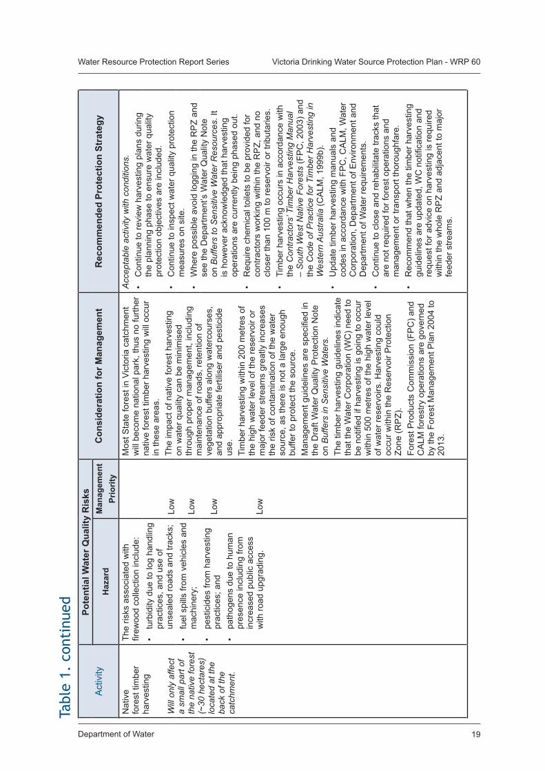
Department of Water 19
Water Resource Protection Report Series Victoria Drinking Water Source Protection Plan - WRP 60
Act
ivity
Po
tent
ial W
ater
Qua
lity
Ris
ksC
onsi
dera
tion
for M
anag
emen
tR
ecom
men
ded
Prot
ectio
n St
rate
gyH
azar
dM
anag
emen
t Pr
iorit
yN
ativ
e fo
rest
tim
ber
harv
estin
g
Will
onl
y af
fect
a
smal
l par
t of
the
nativ
e fo
rest
(~
30 h
ecta
res)
lo
cate
d at
the
back
of t
he
catc
hmen
t.
The
risks
ass
ocia
ted
with
fir
ewoo
d co
llect
ion
incl
ude:
Low
Lo
w Lo
w
Low
Mos
t Sta
te fo
rest
in V
icto
ria c
atch
men
t w
ill b
ecom
e na
tiona
l par
k, th
us n
o fu
rther
na
tive
fore
st ti
mbe
r har
vest
ing
will
occ
ur
in th
ese
area
s.Th
e im
pact
of n
ativ
e fo
rest
har
vest
ing
on w
ater
qua
lity
can
be m
inim
ised
th
roug
h pr
oper
man
agem
ent,
incl
udin
g m
aint
enan
ce o
f roa
ds, r
eten
tion
of
vege
tatio
n bu
ffers
alo
ng w
ater
cour
ses,
an
d ap
prop
riate
ferti
liser
and
pes
ticid
e us
e.Ti
mbe
r har
vest
ing
with
in 2
00 m
etre
s of
th
e hi
gh w
ater
leve
l of t
he re
serv
oir o
r m
ajor
feed
er s
tream
s gr
eatly
incr
ease
s th
e ris
k of
con
tam
inat
ion
of th
e w
ater
so
urce
, as
ther
e is
not
a la
rge
enou
gh
buffe
r to
prot
ect t
he s
ourc
e.
Man
agem
ent g
uide
lines
are
spe
cifie
d in
th
e D
raft
Wat
er Q
ualit
y P
rote
ctio
n N
ote
on B
uffe
rs in
Sen
sitiv
e W
ater
s.Th
e tim
ber h
arve
stin
g gu
idel
ines
indi
cate
th
at th
e W
ater
Cor
pora
tion
(WC
) nee
d to
be
not
ified
if h
arve
stin
g is
goi
ng to
occ
ur
with
in 5
00 m
etre
s of
the
high
wat
er le
vel
of w
ater
rese
rvoi
rs. H
arve
stin
g co
uld
occu
r with
in th
e R
eser
voir
Pro
tect
ion
Zone
(RP
Z).
Fore
st P
rodu
cts
Com
mis
sion
(FP
C) a
nd
CA
LM fo
rest
ry o
pera
tions
are
gov
erne
d by
the
Fore
st M
anag
emen
t Pla
n 20
04 to
20
13.
Acc
epta
ble
activ
ity w
ith c
ondi
tions
.•
Con
tinue
to re
view
har
vest
ing
plan
s du
ring
the
plan
ning
pha
se to
ens
ure
wat
er q
ualit
y pr
otec
tion
obje
ctiv
es a
re in
clud
ed.
• C
ontin
ue to
insp
ect w
ater
qua
lity
prot
ectio
n m
easu
res
on s
ite.
• W
here
pos
sibl
e av
oid
logg
ing
in th
e R
PZ
and
see
the
Dep
artm
ent’s
Wat
er Q
ualit
y N
ote
on B
uffe
rs to
Sen
sitiv
e W
ater
Res
ourc
es. I
t is
how
ever
ack
now
ledg
ed th
at h
arve
stin
g op
erat
ions
are
cur
rent
ly b
eing
pha
sed
out.
• R
equi
re c
hem
ical
toile
ts to
be
prov
ided
for
cont
ract
ors
wor
king
with
in th
e R
PZ,
and
no
clos
er th
an 1
00 m
to re
serv
oir o
r trib
utar
ies.
• Ti
mbe
r har
vest
ing
occu
rs in
acc
orda
nce
with
th
e C
ontra
ctor
s’ T
imbe
r Har
vest
ing
Man
ual
– S
outh
Wes
t Nat
ive
Fore
sts
(FP
C, 2
003)
and
th
e C
ode
of P
ract
ice
for T
imbe
r Har
vest
ing
in
Wes
tern
Aus
tralia
(CA
LM, 1
999b
).•
Upd
ate
timbe
r har
vest
ing
man
uals
and
co
des
in a
ccor
danc
e w
ith F
PC
, CA
LM, W
ater
C
orpo
ratio
n, D
epar
tmen
t of E
nviro
nmen
t and
D
epar
tmen
t of W
ater
requ
irem
ents
.•
Con
tinue
to c
lose
and
reha
bilit
ate
track
s th
at
are
not r
equi
red
for f
ores
t ope
ratio
ns a
nd
man
agem
ent o
r tra
nspo
rt th
orou
ghfa
re.
• R
ecom
men
d th
at w
hen
the
timbe
r har
vest
ing
guid
elin
es a
re u
pdat
ed, W
C n
otifi
catio
n an
d re
ques
t for
adv
ice
on h
arve
stin
g is
requ
ired
with
in th
e w
hole
RP
Z an
d ad
jace
nt to
maj
or
feed
er s
tream
s.
• tu
rbid
ity d
ue to
log
hand
ling
prac
tices
, and
use
of
unse
aled
road
s an
d tra
cks;
• fu
el s
pills
from
veh
icle
s an
d m
achi
nery
;•
pest
icid
es fr
om h
arve
stin
g pr
actic
es; a
nd•
path
ogen
s du
e to
hum
an
pres
ence
incl
udin
g fro
m
incr
ease
d pu
blic
acc
ess
with
road
upg
radi
ng.
Tabl
e 1.
con
tinu
ed
Department of Water20
Water Resource Protection Report Series Victoria Drinking Water Source Protection Plan - WRP 60
Act
ivity
Po
tent
ial W
ater
Qua
lity
Ris
ksC
onsi
dera
tion
for M
anag
emen
tR
ecom
men
ded
Prot
ectio
n St
rate
gyH
azar
dM
anag
emen
t Pr
iorit
yFi
re p
re-
supp
ress
ion
and
Fire
m
anag
emen
t•
Fuel
re
duct
ion
burn
ing
• W
ild fi
re•
Fire
brea
ks•
Wat
er p
oint
s
The
pote
ntia
l ris
ks to
wat
er
qual
ity in
clud
e:
Med
ium
/Hig
h
Low
Med
ium
Med
ium
Low
Fire
man
agem
ent t
hrou
gh fi
re p
re-s
uppr
essi
on
and
supp
ress
ion.
Fu
el re
duct
ion
burn
ing
is a
n es
tabl
ishe
d es
sent
ial l
and
man
agem
ent p
ract
ice
in th
e ca
tchm
ent,
and
shou
ld b
e m
anag
ed to
lim
it th
e po
tent
ial f
or tu
rbid
runo
ff in
to th
e re
serv
oir.
Acc
epta
ble
activ
ity w
ith b
est m
anag
emen
t pr
actic
es.
• E
stab
lish
spec
ific
guid
elin
es re
late
d to
w
ater
qua
lity
prot
ectio
n fo
r con
side
ratio
n in
the
burn
ing
pres
crip
tion.
For
exa
mpl
e,
guid
elin
es w
ould
incl
ude
the
loca
tion
of
fireb
reak
s, th
e us
e of
sum
ps o
r dra
ins
for s
edim
ent c
ontro
l and
app
ropr
iate
pr
actic
es fo
r the
use
of h
erbi
cide
s.•
Liai
se c
lose
ly w
ith C
ALM
to e
nsur
e th
at
spec
ific
guid
elin
es re
latin
g to
wat
er
qual
ity p
rote
ctio
n ar
e in
corp
orat
ed w
ithin
C
ALM
’s F
ire O
pera
tions
Man
ual a
nd th
at
prot
ocol
s ar
e pu
t in
plac
e fo
r effe
ctiv
e co
mm
unic
atio
ns b
etw
een
agen
cies
m
anag
ing
the
catc
hmen
t.•
Ens
ure
stab
ilisa
tion
of s
oil e
xcav
ated
du
ring
cons
truct
ion
of w
ater
poi
nts
to
prev
ent t
urbi
d ru
noff
into
wat
erco
urse
s.
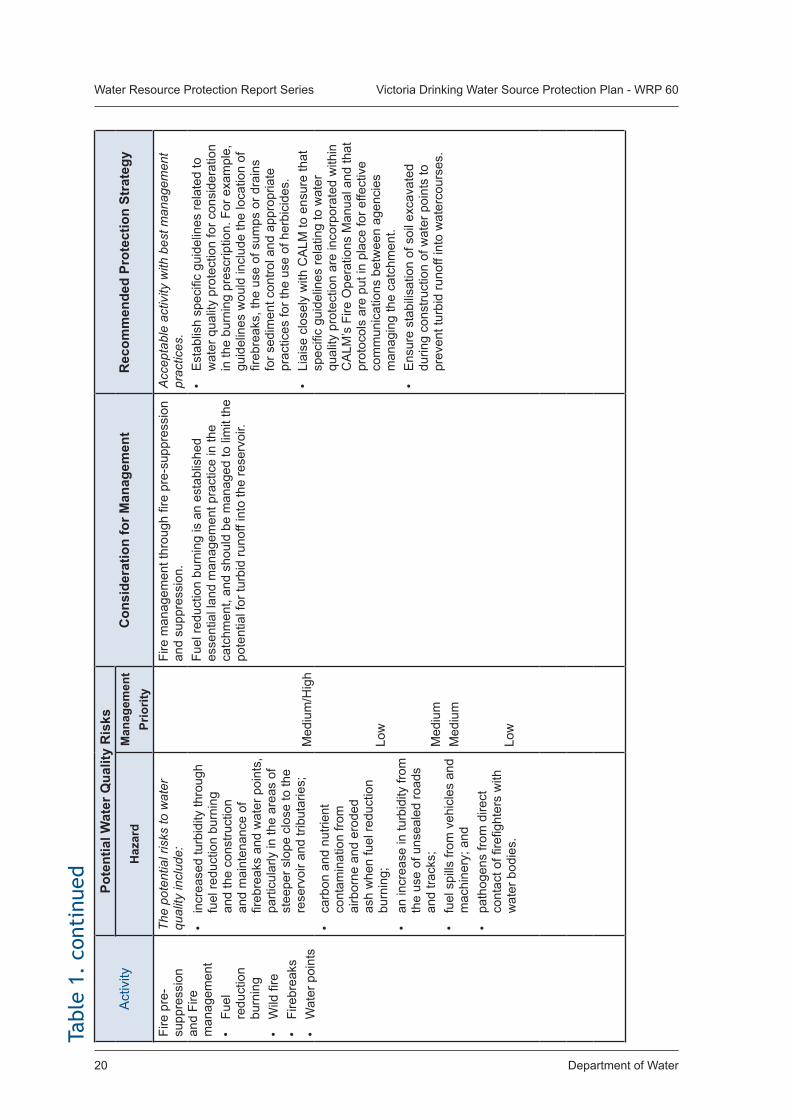
• in
crea
sed
turb
idity
thro
ugh
fuel
redu
ctio
n bu
rnin
g an
d th
e co
nstru
ctio
n an
d m
aint
enan
ce o
f fir
ebre
aks
and
wat
er p
oint
s,
parti
cula
rly in
the
area
s of
st
eepe
r slo
pe c
lose
to th
e re
serv
oir a
nd tr
ibut
arie
s;
• ca
rbon
and
nut
rient
co
ntam
inat
ion
from
ai
rbor
ne a
nd e
rode
d as
h w
hen
fuel
redu
ctio
n bu
rnin
g;
• an
incr
ease
in tu
rbid
ity fr
om
the
use
of u
nsea
led
road
s an
d tra
cks;
• fu
el s
pills
from
veh
icle
s an
d m
achi
nery
; and
• pa
thog
ens
from
dire
ct
cont
act o
f fire
fight
ers
with
w
ater
bod
ies.
Tabl
e 1.
con
tinu
ed
Department of Water 21
Water Resource Protection Report Series Victoria Drinking Water Source Protection Plan - WRP 60Ta
ble
1. c
onti
nued
Act
ivity
Po
tent
ial W
ater
Qua
lity
Ris
ksC
onsi
dera
tion
for M
anag
emen
tR
ecom
men
ded
Prot
ectio
n St
rate
gyH
azar
dM
anag
emen
t Pr
iorit
yFi
re s
uppr
essi
on•
Em
erge
ncy
fireb
reak
s•
Wat
er p
oint
s
The
pote
ntia
l ris
ks to
wat
er
qual
ity in
clud
e:
Hig
h
Low
Low
Lo
w Lo
w
Ext
ensi
ve b
urni
ng fr
om w
ild fi
res
can
be c
ause
d ei
ther
nat
ural
ly o
r fol
low
ing
irres
pons
ible
hum
an a
cces
s. F
uel r
educ
tion
burn
ing
tend
s to
dec
reas
e th
e ch
ance
of
inte
nse
wild
fire
and
yet
may
be
the
sour
ce o
f w
ild fi
re.
Fire
brea
ks a
re c
ut in
the
even
t of a
n em
erge
ncy
and
are
not c
ut o
n a
rout
ine
basi
s.
Bio
dive
rsity
con
side
ratio
ns w
ill a
lso
need
to b
e fa
ctor
ed in
.
Acc
epta
ble
activ
ity w
ith b
est m
anag
emen
t pr
actic
es.
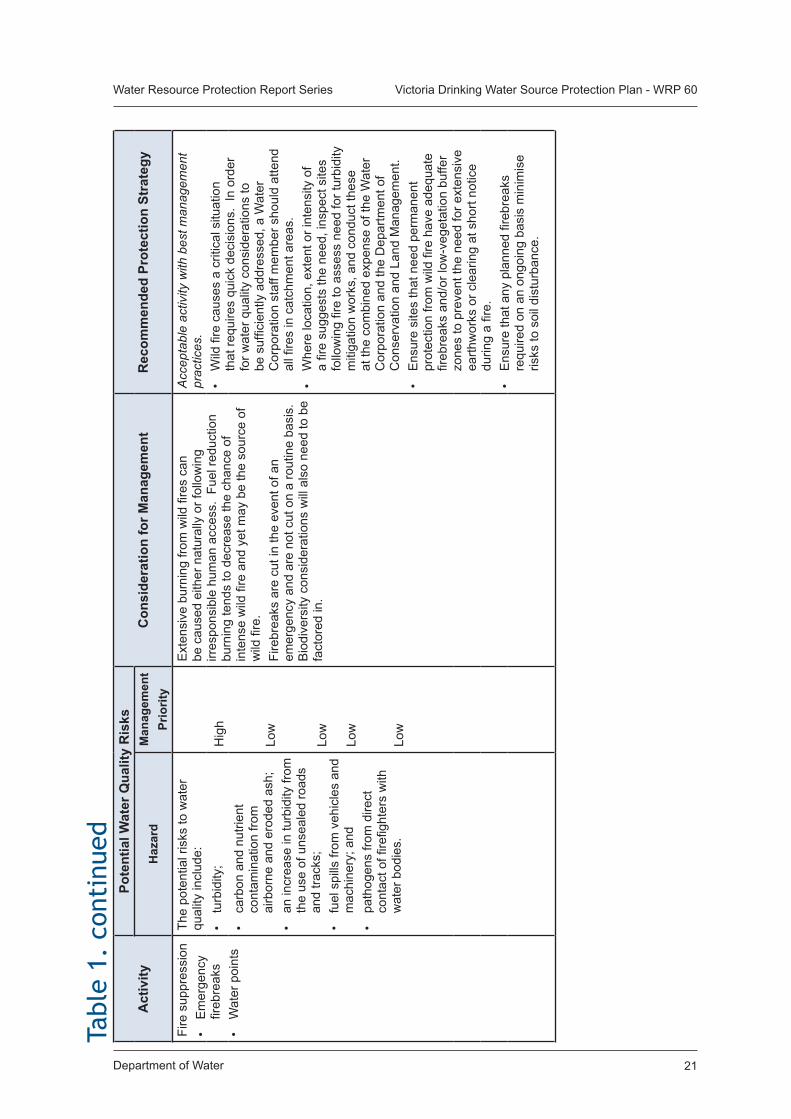
• W
ild fi
re c
ause
s a
criti
cal s
ituat
ion
that
requ
ires
quic
k de
cisi
ons.
In
orde
r fo
r wat
er q
ualit
y co
nsid
erat
ions
to
be s
uffic
ient
ly a
ddre
ssed
, a W
ater
C
orpo
ratio
n st
aff m
embe
r sho
uld
atte
nd
all fi
res
in c
atch
men
t are
as.
• W
here
loca
tion,
ext
ent o
r int
ensi
ty o
f a
fire
sugg
ests
the
need
, ins
pect
site
s fo
llow
ing
fire
to a
sses
s ne
ed fo
r tur
bidi
ty
miti
gatio
n w
orks
, and
con
duct
thes
e at
the
com
bine
d ex
pens
e of
the
Wat
er
Cor
pora
tion
and
the
Dep
artm
ent o
f C
onse
rvat
ion
and
Land
Man
agem
ent.
• E
nsur
e si
tes
that
nee
d pe
rman
ent
prot
ectio
n fro
m w
ild fi
re h
ave
adeq
uate
fir
ebre
aks
and/
or lo
w-v
eget
atio
n bu
ffer
zone
s to
pre
vent
the
need
for e
xten
sive
ea
rthw
orks
or c
lear
ing
at s
hort
notic
e du
ring
a fir
e.
• E
nsur
e th
at a
ny p
lann
ed fi
rebr
eaks
re
quire
d on
an
ongo
ing
basi
s m
inim
ise
risks
to s
oil d
istu
rban
ce.
• tu
rbid
ity;
• ca
rbon
and
nut
rient
co
ntam
inat
ion
from
ai
rbor
ne a
nd e
rode
d as
h;
• an
incr
ease
in tu
rbid
ity fr
om
the
use
of u
nsea
led
road
s an
d tra
cks;
• fu
el s
pills
from
veh
icle
s an
d m
achi
nery
; and
• pa
thog
ens
from
dire
ct
cont
act o
f fire
fight
ers
with
w
ater
bod
ies.
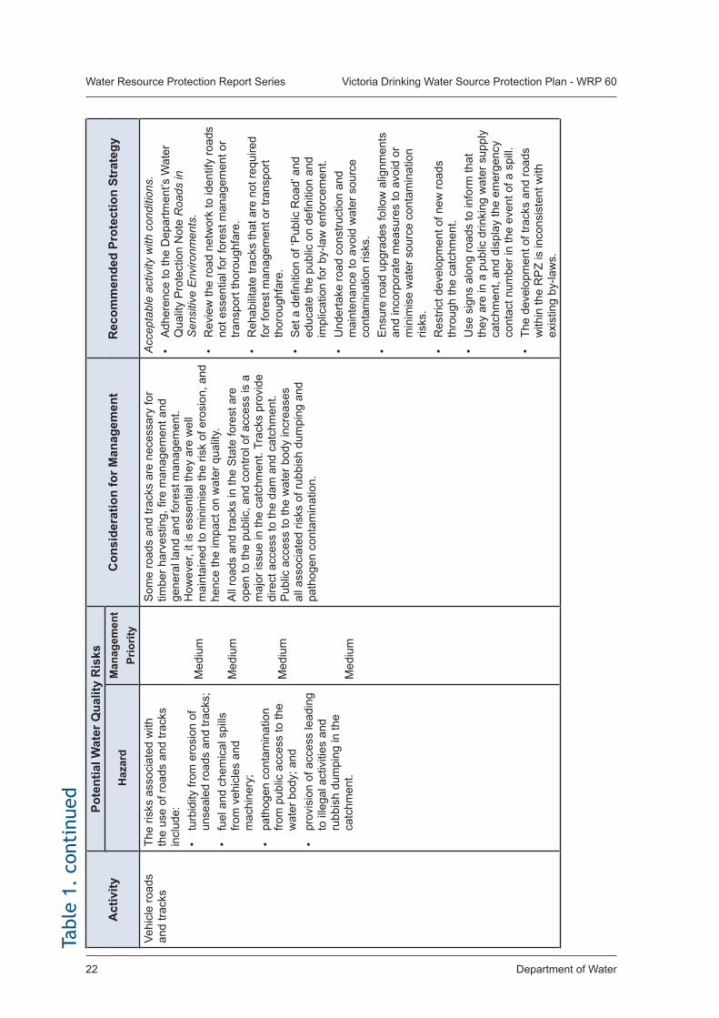
Department of Water22
Water Resource Protection Report Series Victoria Drinking Water Source Protection Plan - WRP 60
Act
ivity
Po
tent
ial W
ater
Qua
lity
Ris
ksC
onsi
dera
tion
for M
anag
emen
tR
ecom
men
ded
Prot
ectio
n St
rate
gyH
azar
dM
anag
emen
t Pr
iorit
yVe
hicl
e ro
ads
and
track
sTh
e ris
ks a
ssoc
iate
d w
ith
the
use
of ro
ads
and
track
s in
clud
e:•
turb
idity
from
ero
sion
of
unse
aled
road
s an
d tra
cks;
• fu
el a
nd c
hem
ical
spi
lls
from
veh
icle
s an
d m
achi
nery
; •
path
ogen
con
tam
inat
ion
from
pub
lic a
cces
s to
the
wat
er b
ody;
and
• pr
ovis
ion
of a
cces
s le
adin
g to
ille
gal a
ctiv
ities
and
ru
bbis
h du
mpi
ng in
the
catc
hmen
t.
Med
ium
Med
ium
Med
ium
Med
ium
Som
e ro
ads
and
track
s ar
e ne
cess
ary
for
timbe
r har
vest
ing,
fire
man
agem
ent a
nd
gene
ral l
and
and
fore
st m
anag
emen
t. H
owev
er, i
t is
esse
ntia
l the
y ar
e w
ell
mai
ntai
ned
to m
inim
ise
the
risk
of e
rosi
on, a
nd
henc
e th
e im
pact
on
wat
er q
ualit
y.A
ll ro
ads
and
track
s in
the
Sta
te fo
rest
are
op
en to
the
publ
ic, a
nd c
ontro
l of a
cces
s is
a
maj
or is
sue
in th
e ca
tchm
ent.
Trac
ks p
rovi
de
dire
ct a
cces
s to
the
dam
and
cat
chm
ent.
Pub
lic a
cces
s to
the
wat
er b
ody
incr
ease
s al
l ass
ocia
ted
risks
of r
ubbi
sh d
umpi
ng a
nd
path
ogen
con
tam
inat
ion.
Acc
epta
ble
activ
ity w
ith c
ondi
tions
.•
Adh
eren
ce to
the
Dep
artm
ent’s
Wat
er
Qua
lity
Pro
tect
ion
Not
e R
oads
in
Sen
sitiv
e E
nviro
nmen
ts.
• R
evie
w th
e ro
ad n
etw
ork
to id
entif
y ro
ads
not e
ssen
tial f
or fo
rest
man
agem
ent o
r tra
nspo
rt th
orou
ghfa
re.
• R
ehab
ilita
te tr
acks
that
are
not
requ
ired
for f
ores
t man
agem
ent o
r tra
nspo
rt th
orou
ghfa
re.
• S
et a
defi
nitio
n of
‘Pub
lic R
oad’
and
ed
ucat
e th
e pu
blic
on
defin
ition
and
im
plic
atio
n fo
r by-
law
enf
orce
men
t.•
Und
erta
ke ro
ad c
onst
ruct
ion
and
mai
nten
ance
to a
void
wat
er s
ourc
e co
ntam
inat
ion
risks
.•
Ens
ure
road
upg
rade
s fo
llow
alig
nmen
ts
and
inco
rpor
ate
mea
sure
s to
avo
id o
r m
inim
ise
wat
er s
ourc
e co
ntam
inat
ion
risks
.•
Res
trict
dev
elop
men
t of n
ew ro
ads
thro
ugh
the
catc
hmen
t.•
Use
sig
ns a
long
road
s to
info
rm th
at
they
are
in a
pub
lic d
rinki
ng w
ater
sup
ply
catc
hmen
t, an
d di
spla
y th
e em
erge
ncy
cont
act n
umbe
r in
the
even
t of a
spi
ll.•
The
deve
lopm
ent o
f tra
cks
and
road
s w
ithin
the
RP
Z is
inco
nsis
tent
with
ex
istin
g by
-law
s.
Tabl
e 1.
con
tinu
ed
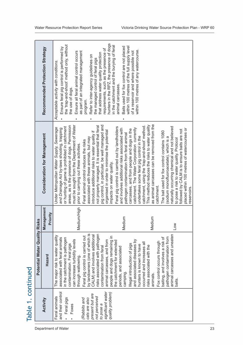
Department of Water 23
Water Resource Protection Report Series Victoria Drinking Water Source Protection Plan - WRP 60Ta
ble
1. c
onti
nued
Act
ivity
Po
tent
ial W
ater
Qua
lity
Ris
ksC
onsi
dera
tion
for M
anag
emen
tR
ecom
men
ded
Prot
ectio
n St
rate
gyH
azar
dM
anag
emen
t Pr
iorit
yFe
ral a
nim
als
and
thei
r con
trol
• Fe
ral p
igs
• Fo
xes
(Rab
bits
and
ca
ts a
re a
lso
pres
ent b
ut a
re
not p
erce
ived
to
pos
e a
sign
ifica
nt w
ater
qu
ality
pro
blem
)
The
maj
or ri
sk to
wat
er q
ualit
y as
soci
ated
with
fera
l ani
mal
s in
the
catc
hmen
t is
path
ogen
co
ntam
inat
ion.
Fer
al p
igs
can
incr
ease
turb
idity
leve
ls
thro
ugh
wal
low
ing.
Fe
ral p
ig c
ontro
l is
carr
ied
out
by la
ndow
ners
(one
of w
hich
is
CA
LM) a
nd in
volv
es a
dditi
onal
ris
ks a
ssoc
iate
d w
ith p
atho
gen
cont
amin
atio
n fro
m fe
ral
anim
al c
arca
sses
, and
from
pe
ople
and
dog
s re
mai
ning
in
the
catc
hmen
t for
ext
ende
d pe
riods
, and
ass
ocia
ted
cam
ping
.Ill
egal
intro
duct
ion
of p
igs
and
asso
ciat
ed d
isea
ses
by
hunt
ers
is k
now
n to
hav
e oc
curr
ed a
nd in
crea
ses
all
risks
ass
ocia
ted
with
the
anim
als.
Fox
cont
rol o
ccur
s th
roug
h ba
iting
, and
invo
lves
a ri
sk o
f pa
thog
en c
onta
min
atio
n fro
m
anim
al c
arca
sses
and
une
aten
ba
its.
Med
ium
/Hig
h
Med
ium
Med
ium
Low
Und
er M
etro
polit
an W
ater
Sup
ply,
Sew
erag
e an
d D
rain
age
Act
by-
law
s sh
ootin
g, tr
appi
ng
or h
untin
g of
gam
e is
pro
hibi
ted
in c
atch
men
t ar
eas,
as
is th
e pr
esen
ce o
f dog
s. P
erm
issi
on
mus
t be
soug
ht fr
om th
e D
epar
tmen
t of W
ater
pr
ior t
o ca
rryi
ng o
ut th
ese
activ
ities
. Fe
ral a
nim
al c
ontro
l red
uces
the
risks
as
soci
ated
with
thes
e an
imal
s, b
ut m
ay
intro
duce
add
ition
al ri
sks
to w
ater
qua
lity
if no
t pro
perly
man
aged
. It i
s es
sent
ial t
hat f
eral
pi
g co
ntro
l, in
par
ticul
ar, b
e w
ell m
anag
ed a
nd
orga
nise
d in
ord
er to
min
imis
e th
e po
tent
ial
impa
cts
on w
ater
qua
lity.
Fe
ral p
ig c
ontro
l is
carr
ied
out b
y la
ndho
lder
s an
d in
volv
es a
dditi
onal
risk
s as
soci
ated
with
pa
thog
en c
onta
min
atio
n fro
m fe
ral a
nim
al
carc
asse
s, a
nd fr
om p
eopl
e an
d do
gs in
the
catc
hmen
t. Th
e W
ater
Cor
pora
tion
cur
rent
ly
unde
rtake
s so
me
fera
l pig
con
trol i
n th
e ca
tchm
ent,
usin
g th
e ‘tr
ap-a
nd-s
hoot
’ met
hod.
Th
is m
etho
d re
duce
s th
e ris
ks to
wat
er q
ualit
y as
ani
mal
car
cass
es c
an b
e re
mov
ed fr
om th
e ca
tchm
ent.
The
bait
used
for f
ox c
ontro
l con
tain
s 10
80
(sod
ium
mon
ofluo
roac
etat
e), w
hich
is a
na
tura
lly o
ccur
ring
chem
ical
and
not
bel
ieve
d to
pos
e a
risk
to w
ater
qua
lity.
Pro
toco
l fo
llow
ed b
y C
ALM
is to
ens
ure
baits
are
not
pl
aced
with
in 1
00 m
etre
s of
wat
erco
urse
s or
re
serv
oirs
.
Acc
epta
ble
activ
ity w
ith c
ondi
tions
.•
Ens
ure
fera
l pig
con
trol i
s pe
rform
ed b
y th
e ‘tr
ap-a
nd-s
hoot
’ met
hod
only,
with
out
the
use
of d
ogs.
• E
nsur
e al
l fer
al a
nim
al c
ontro
l occ
urs
as p
art o
f an
inte
grat
ed m
anag
emen
t pr
ogra
m.
• R
efer
to in
ter-
agen
cy g
uide
lines
on
the
man
aged
con
trol o
f fer
al p
igs
that
add
ress
wat
er q
ualit
y pr
otec
tion
requ
irem
ents
, suc
h as
the
pres
ence
of
hunt
ers
in th
e R
PZ,
the
pres
ence
of d
ogs
in th
e ca
tchm
ent a
nd th
e bu
ryin
g of
fera
l an
imal
car
cass
es.
• B
aits
use
d fo
r fox
con
trol a
re n
ot p
lace
d w
ithin
100
met
res
of th
e fu
ll su
pply
leve
l of
a re
serv
oir a
nd w
here
pos
sibl
e no
t w
ithin
100
met
res
of a
ny w
ater
cour
se.
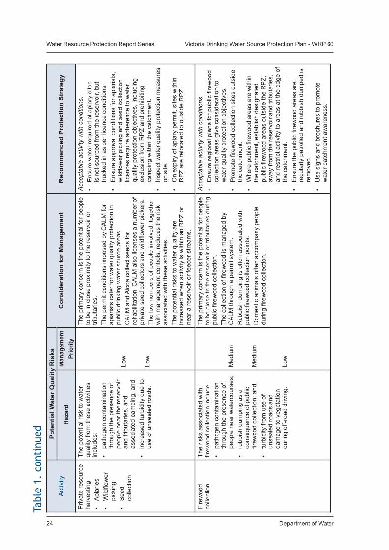
Department of Water24
Water Resource Protection Report Series Victoria Drinking Water Source Protection Plan - WRP 60
Act
ivity
Po
tent
ial W
ater
Qua
lity
Ris
ksC
onsi
dera
tion
for M
anag
emen
tR
ecom
men
ded
Prot
ectio
n St
rate
gyH
azar
dM
anag
emen
t Pr
iorit
yP
rivat
e re
sour
ce
harv
estin
g•
Api
arie
s•
Wild
flow
er
pick
ing
• S
eed
colle
ctio
n
The
pote
ntia
l ris
k to
wat
er
qual
ity fr
om th
ese
activ
ities
in
clud
es:
• pa
thog
en c
onta
min
atio
n th
roug
h th
e pr
esen
ce o
f pe
ople
nea
r the
rese
rvoi
r an
d tri
buta
ries,
and
as
soci
ated
cam
ping
; and
• in
crea
sed
turb
idity
due
to
use
of u
nsea
led
road
s.
Low
Low
The
prim
ary
conc
ern
is th
e po
tent
ial f
or p
eopl
e to
be
in c
lose
pro
xim
ity to
the
rese
rvoi
r or
tribu
tarie
s.
The
perm
it co
nditi
ons
impo
sed
by C
ALM
for
apia
rists
cat
er fo
r wat
er q
ualit
y pr
otec
tion
in
publ
ic d
rinki
ng w
ater
sou
rce
area
s.C
ALM
and
Alc
oa c
olle
ct s
eeds
for
reha
bilit
atio
n. C
ALM
als
o lic
ense
s a
num
ber o
f pr
ivat
e se
ed c
olle
ctor
s an
d w
ildflo
wer
pic
kers
.Th
e lo
w n
umbe
rs o
f peo
ple
invo
lved
, tog
ethe
r w
ith m
anag
emen
t con
trols
, red
uces
the
risk
asso
ciat
ed w
ith th
ese
activ
ities
.Th
e po
tent
ial r
isks
to w
ater
qua
lity
are
incr
ease
d w
hen
activ
ity is
with
in a
n R
PZ
or
near
a re
serv
oir o
r fee
der s
tream
s.
Acc
epta
ble
activ
ity w
ith c
ondt
ions
.•
Ens
ure
wat
er re
quire
d at
api
ary
site
s is
not
sou
rced
from
the
rese
rvoi
r, bu
t tru
cked
in a
s pe
r lic
ence
con
ditio
ns.
• E
nsur
e ap
prov
al c
ondi
tions
for a
piar
ists
, w
ildflo
wer
pic
king
and
see
d co
llect
ion
licen
ces
requ
ire a
dher
ence
to w
ater
qu
ality
pro
tect
ion
obje
ctiv
es, i
nclu
ding
ex
clus
ion
from
RP
Z an
d pr
ohib
iting
ca
mpi
ng w
ithin
the
catc
hmen
t. •
Insp
ect w
ater
qua
lity
prot
ectio
n m
easu
res
on s
ite.
• O
n ex
piry
of a
piar
y pe
rmit,
site
s w
ithin
R
PZ
are
relo
cate
d to
out
side
RP
Z.
Fire
woo
d co
llect
ion
The
risks
ass
ocia
ted
with
fir
ewoo
d co
llect
ion
incl
ude
• pa
thog
en c
onta
min
atio
n th
roug
h th
e pr
esen
ce o
f pe
ople
nea
r wat
erco
urse
s;•
rubb
ish
dum
ping
as
a co
nseq
uenc
e of
pub
lic
firew
ood
colle
ctio
n; a
nd•
turb
idity
from
use
of
unse
aled
road
s an
d da
mag
e to
veg
etat
ion
durin
g of
f-roa
d dr
ivin
g.
Med
ium
Med
ium
Low
The
prim
ary
conc
ern
is th
e po
tent
ial f
or p
eopl
e to
be
clos
e to
the
rese
rvoi
r or t
ribut
arie
s du
ring
publ
ic fi
rew
ood
colle
ctio
n.
The
colle
ctio
n of
fire
woo
d is
man
aged
by
CA
LM th
roug
h a
perm
it sy
stem
.R
ubbi
sh d
umpi
ng is
ofte
n as
soci
ated
with
pu
blic
fire
woo
d co
llect
ion
poin
ts.
Dom
estic
ani
mal
s of
ten
acco
mpa
ny p
eopl
e du
ring
firew
ood
colle
ctio
n.
Acc
epta
ble
activ
ity w
ith c
ondi
tions
.•
Ens
ure
regi
onal
pla
ns fo
r pub
lic fi
rew
ood
colle
ctio
n ar
eas
give
con
side
ratio
n to
w
ater
qua
lity
prot
ectio
n ob
ject
ives
.•
Pro
mot
e fir
ewoo
d co
llect
ion
site
s ou
tsid
e th
e ca
tchm
ent.
• W
here
pub
lic fi
rew
ood
area
s ar
e w
ithin
th
e ca
tchm
ent,
esta
blis
h de
sign
ated
pu
blic
fire
woo
d ar
eas
outs
ide
the
RP
Z,
away
from
the
rese
rvoi
r and
trib
utar
ies,
an
d re
stric
t act
ivity
to a
reas
at t
he e
dge
of
the
catc
hmen
t.•
Ens
ure
the
publ
ic fi
rew
ood
area
s ar
e re
gula
rly p
atro
lled
and
rubb
ish
dum
ped
is
rem
oved
. •
Use
sig
ns a
nd b
roch
ures
to p
rom
ote
wat
er c
atch
men
t aw
aren
ess.
Tabl
e 1.
con
tinu
ed
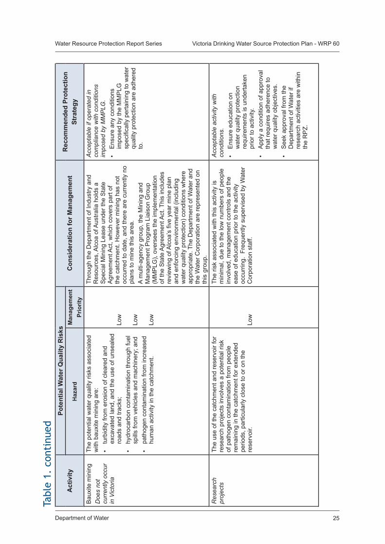
Department of Water 25
Water Resource Protection Report Series Victoria Drinking Water Source Protection Plan - WRP 60
Act
ivity
Po
tent
ial W
ater
Qua
lity
Ris
ksC
onsi
dera
tion
for M
anag
emen
tR
ecom
men
ded
Prot
ectio
n St
rate
gyH
azar
dM
anag
emen
t Pr
iorit
yB
auxi
te m
inin
gD
oes
not
curr
ently
occ
ur
in V
icto
ria
The
pote
ntia
l wat
er q
ualit
y ris
ks a
ssoc
iate
d w
ith b
auxi
te m
inin
g ar
e:•
turb
idity
from
ero
sion
of c
lear
ed a
nd
exca
vate
d la
nd, a
nd th
e us
e of
uns
eale
d ro
ads
and
track
s;•
hydr
ocar
bon
cont
amin
atio
n th
roug
h fu
el
spill
s fro
m v
ehic
les
and
mac
hine
ry; a
nd•
path
ogen
con
tam
inat
ion
from
incr
ease
d hu
man
act
ivity
in th
e ca
tchm
ent.
Low
Low
Low
Thro
ugh
the
Dep
artm
ent o
f Ind
ustry
and
R
esou
rces
, Alc
oa o
f Aus
tralia
hol
ds a
S
peci
al M
inin
g Le
ase
unde
r the
Sta
te
Agr
eem
ent A
ct, w
hich
cov
ers
part
of
the
catc
hmen
t. H
owev
er m
inin
g ha
s no
t oc
curr
ed to
dat
e, a
nd th
ere
are
curr
ently
no
plan
s to
min
e th
is a
rea.
A m
ulti-
agen
cy g
roup
, the
Min
ing
and
Man
agem
ent P
rogr
am L
iais
on G
roup
(M
MP
LG),
over
sees
the
impl
emen
tatio
n of
the
Sta
te A
gree
men
t Act
. Thi
s in
clud
es
revi
ewin
g of
Alc
oa’s
five
yea
r min
e pl
an
and
enfo
rcin
g en
viro
nmen
tal (
incl
udin
g w
ater
qua
lity
prot
ectio
n) c
ondi
tions
whe
re
appr
opria
te. T
he D
epar
tmen
t of W
ater
and
th
e W
ater
Cor
pora
tion
are
repr
esen
ted
on
this
gro
up.
Acc
epta
ble
if op
erat
ed in
co
mpl
ianc
e w
ith c
ondi
tions
im
pose
d by
MM
PLG
.•
Ens
ure
any
cond
ition
s im
pose
d by
the
MM
PLG
sp
ecifi
cally
per
tain
ing
to w
ater
qu
ality
pro
tect
ion
are
adhe
red
to.
Res
earc
h pr
ojec
tsTh
e us
e of
the
catc
hmen
t and
rese
rvoi
r for
re
sear
ch p
roje
cts
invo
lves
a p
oten
tial r
isk
of p
atho
gen
cont
amin
atio
n fro
m p
eopl
e re
mai
ning
in th
e ca
tchm
ent f
or e
xten
ded
perio
ds, p
artic
ular
ly c
lose
to o
r on
the
rese
rvoi
r.
Low
The
risk
asso
ciat
ed w
ith th
is a
ctiv
ity is
m
inim
al, d
ue to
the
low
num
bers
of p
eopl
e in
volv
ed, m
anag
emen
t con
trols
and
the
ease
of e
duca
tion
prio
r to
the
activ
ity
occu
rrin
g. F
requ
ently
sup
ervi
sed
by W
ater
C
orpo
ratio
n st
aff.
Acc
epta
ble
activ
ity w
ith
cond
ition
s.•
Ens
ure
educ
atio
n on
w
ater
qua
lity
prot
ectio
n re
quire
men
ts is
und
erta
ken
prio
r to
activ
ity.
• A
pply
a c
ondi
tion
of a
ppro
val
that
requ
ires
adhe
renc
e to
w
ater
qua
lity
obje
ctiv
es.
• S
eek
appr
oval
from
the
Dep
artm
ent o
f Wat
er if
re
sear
ch a
ctiv
ities
are
with
in
the
RP
Z.
Tabl
e 1.
con
tinu
ed
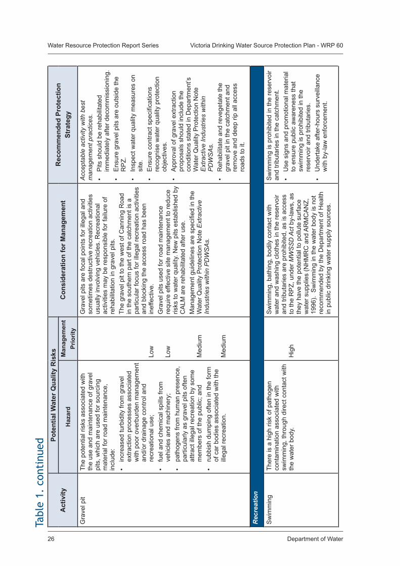
Department of Water26
Water Resource Protection Report Series Victoria Drinking Water Source Protection Plan - WRP 60
Act
ivity
Po
tent
ial W
ater
Qua
lity
Ris
ksC
onsi
dera
tion
for M
anag
emen
tR
ecom
men
ded
Prot
ectio
n St
rate
gyH
azar
dM
anag
emen
t Pr
iorit
yG
rave
l pit
The
pote
ntia
l ris
ks a
ssoc
iate
d w
ith
the
use
and
mai
nten
ance
of g
rave
l pi
ts, w
hich
are
use
d fo
r sou
rcin
g m
ater
ial f
or ro
ad m
aint
enan
ce,
incl
ude:
•
incr
ease
d tu
rbid
ity fr
om g
rave
l ex
tract
ion
proc
esse
s as
soci
ated
w
ith p
oor o
verb
urde
n m
anag
emen
t an
d/or
dra
inag
e co
ntro
l and
re
crea
tiona
l use
;•
fuel
and
che
mic
al s
pills
from
ve
hicl
es a
nd m
achi
nery
;•
path
ogen
s fro
m h
uman
pre
senc
e,
parti
cula
rly a
s gr
avel
pits
ofte
n at
tract
ille
gal r
ecre
atio
n by
som
e m
embe
rs o
f the
pub
lic; a
nd•
rubb
ish
dum
ping
ofte
n in
the
form
of
car
bod
ies
asso
ciat
ed w
ith th
e ill
egal
recr
eatio
n.
Low
Low
Med
ium
Med
ium
Gra
vel p
its a
re fo
cal p
oint
s fo
r ille
gal a
nd
som
etim
es d
estru
ctiv
e re
crea
tion
activ
ities
us
ually
invo
lvin
g ve
hicl
es. R
ecre
atio
nal
activ
ities
may
be
resp
onsi
ble
for f
ailu
re o
f re
habi
litat
ion
in g
rave
l pits
.Th
e gr
avel
pit
to th
e w
est o
f Can
ning
Roa
d in
the
sout
hern
par
t of t
he c
atch
men
t is
a pa
rticu
lar f
ocus
for i
llega
l rec
reat
ion
activ
ities
an
d bl
ocki
ng th
e ac
cess
road
has
bee
n in
effe
ctiv
e.G
rave
l pits
use
d fo
r roa
d m
aint
enan
ce
requ
ire e
ffect
ive
site
man
agem
ent t
o re
duce
ris
ks to
wat
er q
ualit
y. N
ew p
its e
stab
lishe
d by
C
ALM
are
reha
bilit
ated
afte
r use
.M
anag
emen
t gui
delin
es a
re s
peci
fied
in th
e W
ater
Qua
lity
Pro
tect
ion
Not
e E
xtra
ctiv
e In
dust
ries
with
in P
DW
SA
s.
Acc
epta
ble
activ
ity w
ith b
est
man
agem
ent p
ract
ices
.•
Pits
sho
uld
be re
habi
litat
ed
imm
edia
tely
afte
r dec
omm
issi
onin
g.•
Ens
ure
grav
el p
its a
re o
utsi
de th
e R
PZ.
•
Insp
ect w
ater
qua
lity
mea
sure
s on
si
te.
• E
nsur
e co
ntra
ct s
peci
ficat
ions
re
cogn
ise
wat
er q
ualit
y pr
otec
tion
obje
ctiv
es.
• A
ppro
val o
f gra
vel e
xtra
ctio
n pr
opos
als
shou
ld in
clud
e th
e co
nditi
ons
stat
ed in
Dep
artm
ent’s
W
ater
Qua
lity
Pro
tect
ion
Not
e E
xtra
ctiv
e In
dust
ries
with
in
PD
WS
As.
• R
ehab
ilita
te a
nd re
vege
tate
the
grav
el p
it in
the
catc
hmen
t and
re
mov
e an
d de
ep ri
p al
l acc
ess
road
s to
it.
Rec
reat
ion
Sw
imm
ing
Ther
e is
a h
igh
risk
of p
atho
gen
cont
amin
atio
n as
soci
ated
with
sw
imm
ing,
thro
ugh
dire
ct c
onta
ct w
ith
the
wat
er b
ody.
Hig
h
Sw
imm
ing,
bat
hing
, bod
ily c
onta
ct w
ith
wat
er a
nd w
ashi
ng c
loth
es in
the
rese
rvoi
r an
d tri
buta
ries
are
proh
ibite
d, a
s is
acc
ess
to th
e R
PZ,
und
er M
WS
SD
Act
by-
law
s, a
s th
ey h
ave
the
pote
ntia
l to
pollu
te s
urfa
ce
wat
er s
uppl
ies
(NH
MR
C a
nd A
RM
CA
NZ,
19
96).
Sw
imm
ing
in th
e w
ater
bod
y is
not
re
com
men
ded
by th
e D
epar
tmen
t of H
ealth
in
pub
lic d
rinki
ng w
ater
sup
ply
sour
ces.
Sw
imm
ing
is p
rohi
bite
d in
the
rese
rvoi
r an
d tri
buta
ries
in th
e ca
tchm
ent.
• U
se s
igns
and
pro
mot
iona
l mat
eria
l to
ens
ure
publ
ic a
war
enes
s th
at
swim
min
g is
pro
hibi
ted
in th
e re
serv
oir a
nd tr
ibut
arie
s.•
Und
erta
ke a
fter-
hour
s su
rvei
llanc
e w
ith b
y-la
w e
nfor
cem
ent.
Tabl
e 1.
con
tinu
ed
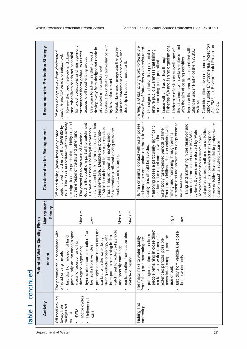
Department of Water 27
Water Resource Protection Report Series Victoria Drinking Water Source Protection Plan - WRP 60
Act
ivity
Po
tent
ial W
ater
Qua
lity
Ris
ksC
onsi
dera
tion
for M
anag
emen
tR
ecom
men
ded
Prot
ectio
n St
rate
gyH
azar
dM
anag
emen
t Pr
iorit
yO
ff-ro
ad d
rivin
g (a
way
from
de
sign
ated
ro
ads)
• 4W
D•
Mot
or c
ycle
s•
Unl
icen
sed
cars
The
pote
ntia
l ris
ks a
ssoc
iate
d w
ith
off-r
oad
driv
ing
incl
ude:
• tu
rbid
ity fr
om e
rosi
on o
f lan
d,
parti
cula
rly o
n th
e st
eep
slop
es
clos
e to
rese
rvoi
r and
from
da
mag
e to
veg
etat
ion;
• hy
droc
arbo
n co
ntam
inat
ion
from
fu
el s
pills
from
veh
icle
s;•
path
ogen
con
tam
inat
ion
thro
ugh
cont
act w
ith th
e w
ater
bod
y du
ring
vehi
cle
cros
sing
s, a
nd
from
peo
ple
rem
aini
ng in
the
catc
hmen
t for
ext
ende
d pe
riods
an
d po
ssib
ly c
ampi
ng;
• co
ntam
inat
ion
from
ass
ocia
ted
vehi
cle
dum
ping
.
Med
ium
Low
Med
ium
Med
ium
Off-
road
driv
ing
(aw
ay fr
om d
esig
nate
d ro
ads)
is p
rohi
bite
d un
der t
he M
WS
SD
by-
law
s. T
he ri
sks
asso
ciat
ed w
ith th
is a
ctiv
ity
are
sign
ifica
nt, i
n pa
rticu
lar t
urbi
dity
cau
sed
by th
e er
osio
n of
trac
ks a
nd o
ther
land
. T
he g
rave
l pit
to th
e w
est o
f Can
ning
R
oad
in th
e so
uthe
rn p
art o
f the
cat
chm
ent
is a
par
ticul
ar fo
cus
for i
llega
l rec
reat
ion
activ
ities
and
blo
ckin
g th
e ac
cess
road
has
be
en in
effe
ctiv
e. D
espi
te th
e pr
oxim
ity
of V
icto
ria c
atch
men
t to
the
met
ropo
litan
ar
ea, i
t has
not
bee
n as
hea
vily
use
d fo
r rec
reat
iona
l off-
road
driv
ing
as s
ome
near
by c
atch
men
t are
as.
Off-
road
driv
ing
(aw
ay fr
om d
esig
nate
d ro
ads)
is p
rohi
bite
d in
the
catc
hmen
t.•
Rev
iew
the
road
net
wor
k an
d cl
ose
and
reha
bilit
ate
road
s no
t ess
entia
l fo
r for
est o
pera
tions
and
man
agem
ent
or tr
ansp
ort t
horo
ughf
are,
to re
stric
t ac
cess
to o
ff-ro
ad d
rivin
g ar
eas.
• U
se s
igns
to a
dver
tise
that
off-
road
dr
ivin
g aw
ay fr
om d
esig
nate
d ro
ads
is
proh
ibite
d in
the
catc
hmen
t.•
Con
tinue
to u
nder
take
sur
veill
ance
with
by
-law
enf
orce
men
t.•
Reh
abili
tate
and
reve
geta
te th
e gr
avel
pi
t in
the
catc
hmen
t and
rem
ove
and
deep
rip
all a
cces
s ro
ads
to it
.
Fish
ing
and
mar
roni
ngTh
e m
ajor
risk
s to
wat
er q
ualit
y fro
m fi
shin
g an
d m
arro
ning
are
:•
path
ogen
con
tam
inat
ion
from
pe
ople
rem
aini
ng in
clo
se/d
irect
co
ntac
t with
wat
erco
urse
s fo
r ex
tend
ed p
erio
ds, p
ossi
ble
asso
ciat
ed c
ampi
ng, a
nd th
e us
e of
bai
t;•
turb
idity
from
veh
icle
use
clo
se
to th
e w
ater
bod
y.
Hig
h Lo
w
Hum
an o
r ani
mal
con
tact
with
wat
er p
oses
an
imm
edia
te c
onta
min
atio
n th
reat
to w
ater
qu
ality
, and
sho
uld
be a
void
ed.
Mar
roni
ng p
oses
a p
artic
ular
ly s
igni
fican
t ris
k du
e to
the
dire
ct c
onta
ct w
ith th
e w
ater
bod
y fo
r ext
ende
d pe
riods
of t
ime.
Th
ere
are
addi
tiona
l ris
ks a
ssoc
iate
d w
ith
fishi
ng a
nd m
arro
ning
thro
ugh
on-s
ite
cam
ping
and
the
pres
ence
of d
ogs
clos
e to
w
ater
cour
ses.
Fish
ing
and
mar
roni
ng in
the
rese
rvoi
r and
tri
buta
ries
is p
rohi
bite
d un
der M
WS
SD
by
-law
s. B
y-la
ws
are
enfo
rced
by
Wat
er
Cor
pora
tion
afte
r-ho
urs
surv
eilla
nce,
bu
t pen
altie
s ar
e sm
all a
nd th
e ac
tiviti
es
cont
inue
. It i
s co
nsid
ered
that
sto
ppin
g th
ese
activ
ities
is e
ssen
tial t
o pr
otec
t wat
er
qual
ity in
suc
h a
stra
tegi
c so
urce
.
Fish
ing
and
mar
roni
ng is
pro
hibi
ted
in th
e re
serv
oir a
nd tr
ibut
arie
s in
the
catc
hmen
t.•
Use
sig
ns a
nd a
dver
tisin
g m
ater
ial t
o en
sure
pub
lic a
war
enes
s th
at fi
shin
g an
d m
arro
ning
is n
ot p
erm
itted
.•
Liai
se w
ith a
nd a
dver
tise
thro
ugh
Fish
erie
s W
A an
d fis
hing
org
anis
atio
ns.
• U
nder
take
afte
r-ho
urs
surv
eilla
nce
of
the
catc
hmen
t with
by-
law
enf
orce
men
t w
ith th
e ai
m o
f cea
sing
act
iviti
es.
• In
crea
se th
e pe
nalti
es a
ssoc
iate
d w
ith
offe
nces
und
er P
art 4
of t
he M
WS
SD
by
-law
s.•
Con
side
r alte
rnat
ive
enfo
rcem
ent
optio
ns u
nder
Env
ironm
enta
l Pro
tect
ion
Act
198
6, i.
e. E
nviro
nmen
tal P
rote
ctio
n P
olic
y.
Tabl
e 1.
con
tinu
ed
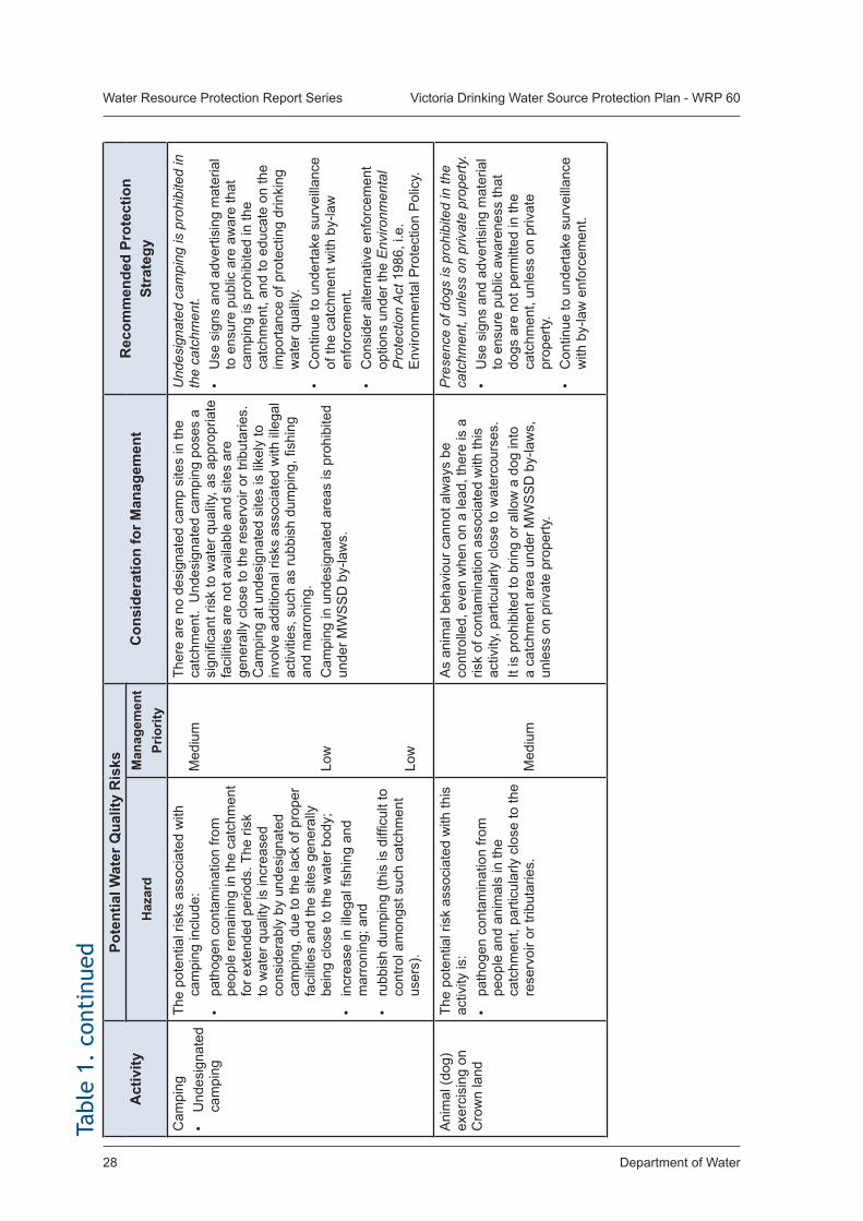
Department of Water28
Water Resource Protection Report Series Victoria Drinking Water Source Protection Plan - WRP 60
Act
ivity
Po
tent
ial W
ater
Qua
lity
Ris
ksC
onsi
dera
tion
for M
anag
emen
tR
ecom
men
ded
Prot
ectio
n St
rate
gyH
azar
dM
anag
emen
t Pr
iorit
yC
ampi
ng•
Und
esig
nate
d ca
mpi
ng
The
pote
ntia
l ris
ks a
ssoc
iate
d w
ith
cam
ping
incl
ude:
• pa
thog
en c
onta
min
atio
n fro
m
peop
le re
mai
ning
in th
e ca
tchm
ent
for e
xten
ded
perio
ds. T
he ri
sk
to w
ater
qua
lity
is in
crea
sed
cons
ider
ably
by
unde
sign
ated
ca
mpi
ng, d
ue to
the
lack
of p
rope
r fa
cilit
ies
and
the
site
s ge
nera
lly
bein
g cl
ose
to th
e w
ater
bod
y;
• in
crea
se in
ille
gal fi
shin
g an
d m
arro
ning
; and
• ru
bbis
h du
mpi
ng (t
his
is d
ifficu
lt to
co
ntro
l am
ongs
t suc
h ca
tchm
ent
user
s).
Med
ium
Low
Low
Ther
e ar
e no
des
igna
ted
cam
p si
tes
in th
e ca
tchm
ent.
Und
esig
nate
d ca
mpi
ng p
oses
a
sign
ifica
nt ri
sk to
wat
er q
ualit
y, a
s ap
prop
riate
fa
cilit
ies
are
not a
vaila
ble
and
site
s ar
e ge
nera
lly c
lose
to th
e re
serv
oir o
r trib
utar
ies.
C
ampi
ng a
t und
esig
nate
d si
tes
is li
kely
to
invo
lve
addi
tiona
l ris
ks a
ssoc
iate
d w
ith il
lega
l ac
tiviti
es, s
uch
as ru
bbis
h du
mpi
ng, fi
shin
g an
d m
arro
ning
.C
ampi
ng in
und
esig
nate
d ar
eas
is p
rohi
bite
d un
der M
WS
SD
by-
law
s.
Und
esig
nate
d ca
mpi
ng is
pro
hibi
ted
in
the
catc
hmen
t.•
Use
sig
ns a
nd a
dver
tisin
g m
ater
ial
to e
nsur
e pu
blic
are
aw
are
that
ca
mpi
ng is
pro
hibi
ted
in th
e ca
tchm
ent,
and
to e
duca
te o
n th
e im
porta
nce
of p
rote
ctin
g dr
inki
ng
wat
er q
ualit
y.•
Con
tinue
to u
nder
take
sur
veill
ance
of
the
catc
hmen
t with
by-
law
en
forc
emen
t.•
Con
side
r alte
rnat
ive
enfo
rcem
ent
optio
ns u
nder
the
Env
ironm
enta
l P
rote
ctio
n A
ct 1
986,
i.e.
E
nviro
nmen
tal P
rote
ctio
n P
olic
y.
Ani
mal
(dog
) ex
erci
sing
on
Cro
wn
land
The
pote
ntia
l ris
k as
soci
ated
with
this
ac
tivity
is:
• pa
thog
en c
onta
min
atio
n fro
m
peop
le a
nd a
nim
als
in th
e ca
tchm
ent,
parti
cula
rly c
lose
to th
e re
serv
oir o
r trib
utar
ies.
Med
ium
As
anim
al b
ehav
iour
can
not a
lway
s be
co
ntro
lled,
eve
n w
hen
on a
lead
, the
re is
a
risk
of c
onta
min
atio
n as
soci
ated
with
this
ac
tivity
, par
ticul
arly
clo
se to
wat
erco
urse
s.It
is p
rohi
bite
d to
brin
g or
allo
w a
dog
into
a
catc
hmen
t are
a un
der M
WS
SD
by-
law
s,
unle
ss o
n pr
ivat
e pr
oper
ty.
Pre
senc
e of
dog
s is
pro
hibi
ted
in th
e ca
tchm
ent,
unle
ss o
n pr
ivat
e pr
oper
ty.
• U
se s
igns
and
adv
ertis
ing
mat
eria
l to
ens
ure
publ
ic a
war
enes
s th
at
dogs
are
not
per
mitt
ed in
the
catc
hmen
t, un
less
on
priv
ate
prop
erty
.•
Con
tinue
to u
nder
take
sur
veill
ance
w
ith b
y-la
w e
nfor
cem
ent.
Tabl
e 1.
con
tinu
ed
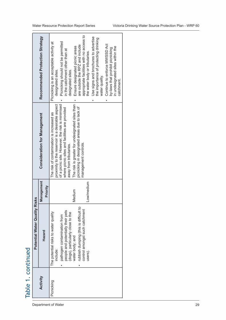
Department of Water 29
Water Resource Protection Report Series Victoria Drinking Water Source Protection Plan - WRP 60Ta
ble
1. c
onti
nued
Act
ivity
Po
tent
ial W
ater
Qua
lity
Ris
ksC
onsi
dera
tion
for M
anag
emen
tR
ecom
men
ded
Prot
ectio
n St
rate
gyH
azar
dM
anag
emen
t Pr
iorit
yP
icni
ckin
gTh
e po
tent
ial r
isks
to w
ater
qua
lity
incl
ude:
• pa
thog
en c
onta
min
atio
n fro
m
peop
le a
nd p
oten
tially
thei
r pet
s (d
ogs)
, par
ticul
arly
clo
se to
the
wat
er b
ody;
and
• ru
bbis
h du
mpi
ng (t
his
is d
ifficu
lt to
co
ntro
l am
ongs
t suc
h ca
tchm
ent
user
s).
Med
ium
Low
/med
ium
The
risk
of c
onta
min
atio
n is
incr
ease
d as
pr
oxim
ity to
the
rese
rvoi
r is
a de
sira
ble
aspe
ct
of a
pic
nic
site
. How
ever
, the
risk
is m
inim
ised
w
here
pic
nic
site
s an
d fa
cilit
ies
are
prov
ided
aw
ay fr
om tr
ibut
arie
s.Th
e ris
k is
gre
ater
for u
ndes
igna
ted
site
s th
an
picn
icki
ng in
des
igna
ted
area
s du
e to
lack
of
man
agem
ent c
ontro
ls.
Pic
nick
ing
is a
n ac
cept
able
act
ivity
at
desi
gnat
ed s
ites.
• P
icni
ckin
g sh
ould
not
be
perm
itted
in
the
catc
hmen
t oth
er th
an a
t de
sign
ated
site
s.•
Ens
ure
desi
gnat
ed p
icni
c ar
eas
are
outs
ide
the
RP
Z an
d in
clud
e ap
prop
riate
faci
litie
s w
ith n
o ac
cess
to
the
wat
er b
ody
or tr
ibut
arie
s.•
Use
sig
ns a
nd b
roch
ures
to a
dver
tise
the
impo
rtanc
e of
pro
tect
ing
drin
king
w
ater
qua
lity.
• C
ontin
ue to
enf
orce
MW
SS
D A
ct
by-la
ws
that
pro
hibi
t pic
nick
ing
in u
ndes
igna
ted
site
s w
ithin
the
catc
hmen
t.
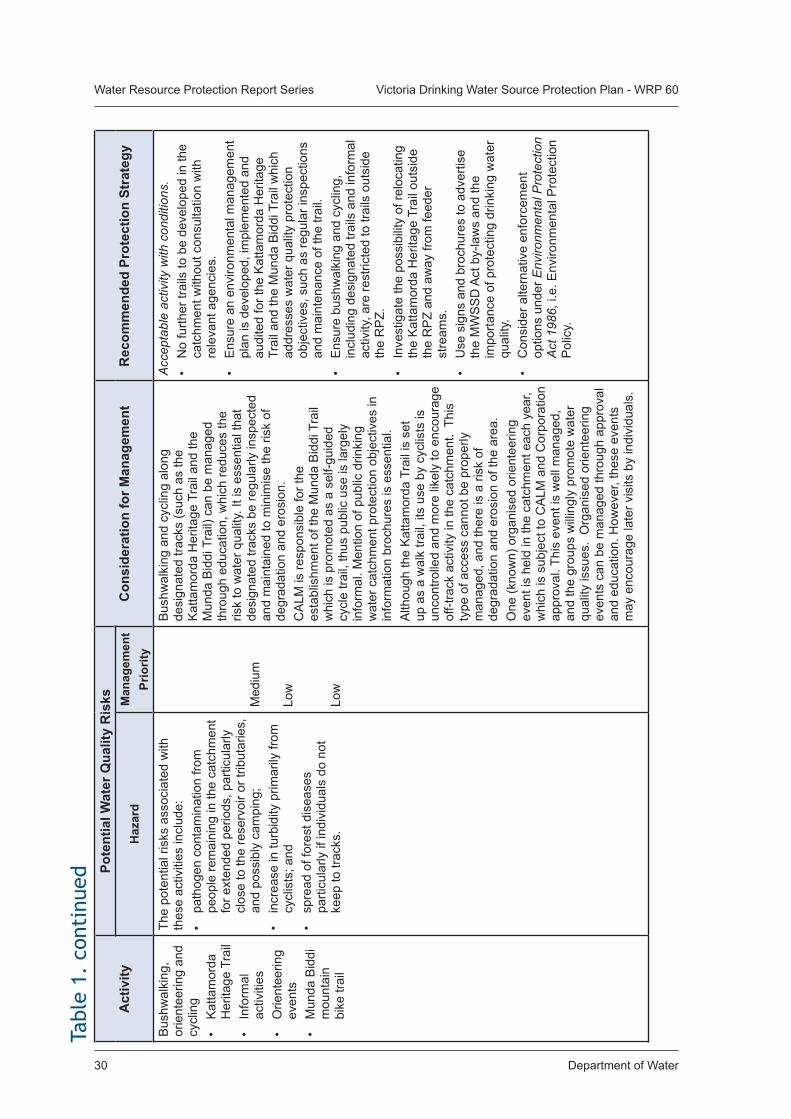
Department of Water30
Water Resource Protection Report Series Victoria Drinking Water Source Protection Plan - WRP 60Ta
ble
1. c
onti
nued
Act
ivity
Po
tent
ial W
ater
Qua
lity
Ris
ksC
onsi
dera
tion
for M
anag
emen
tR
ecom
men
ded
Prot
ectio
n St
rate
gyH
azar
dM
anag
emen
t Pr
iorit
yB
ushw
alki
ng,
orie
ntee
ring
and
cycl
ing
• K
atta
mor
da
Her
itage
Tra
il•
Info
rmal
ac
tiviti
es•
Orie
ntee
ring
even
ts•
Mun
da B
iddi
m
ount
ain
bike
trai
l
The
pote
ntia
l ris
ks a
ssoc
iate
d w
ith
thes
e ac
tiviti
es in
clud
e:•
path
ogen
con
tam
inat
ion
from
pe
ople
rem
aini
ng in
the
catc
hmen
t fo
r ext
ende
d pe
riods
, par
ticul
arly
cl
ose
to th
e re
serv
oir o
r trib
utar
ies,
an
d po
ssib
ly c
ampi
ng;
• in
crea
se in
turb
idity
prim
arily
from
cy
clis
ts; a
nd•
spre
ad o
f for
est d
isea
ses
parti
cula
rly if
indi
vidu
als
do n
ot
keep
to tr
acks
.
Med
ium
Low
Low
Bus
hwal
king
and
cyc
ling
alon
g de
sign
ated
trac
ks (s
uch
as th
e K
atta
mor
da H
erita
ge T
rail
and
the
Mun
da B
iddi
Tra
il) c
an b
e m
anag
ed
thro
ugh
educ
atio
n, w
hich
redu
ces
the
risk
to w
ater
qua
lity.
It is
ess
entia
l tha
t de
sign
ated
trac
ks b
e re
gula
rly in
spec
ted
and
mai
ntai
ned
to m
inim
ise
the
risk
of
degr
adat
ion
and
eros
ion.
CA
LM is
resp
onsi
ble
for t
he
esta
blis
hmen
t of t
he M
unda
Bid
di T
rail
whi
ch is
pro
mot
ed a
s a
self-
guid
ed
cycl
e tra
il, th
us p
ublic
use
is la
rgel
y in
form
al. M
entio
n of
pub
lic d
rinki
ng
wat
er c
atch
men
t pro
tect
ion
obje
ctiv
es in
in
form
atio
n br
ochu
res
is e
ssen
tial.
Alth
ough
the
Kat
tam
orda
Tra
il is
set
up
as
a w
alk
trail,
its
use
by c
yclis
ts is
un
cont
rolle
d an
d m
ore
likel
y to
enc
oura
ge
off-t
rack
act
ivity
in th
e ca
tchm
ent.
Thi
s ty
pe o
f acc
ess
cann
ot b
e pr
oper
ly
man
aged
, and
ther
e is
a ri
sk o
f de
grad
atio
n an
d er
osio
n of
the
area
.O
ne (k
now
n) o
rgan
ised
orie
ntee
ring
even
t is
held
in th
e ca
tchm
ent e
ach
year
, w
hich
is s
ubje
ct to
CA
LM a
nd C
orpo
ratio
n ap
prov
al. T
his
even
t is
wel
l man
aged
, an
d th
e gr
oups
will
ingl
y pr
omot
e w
ater
qu
ality
issu
es.
Org
anis
ed o
rient
eerin
g ev
ents
can
be
man
aged
thro
ugh
appr
oval
an
d ed
ucat
ion.
How
ever
, the
se e
vent
s m
ay e
ncou
rage
late
r vis
its b
y in
divi
dual
s.
Acc
epta
ble
activ
ity w
ith c
ondi
tions
.•
No
furth
er tr
ails
to b
e de
velo
ped
in th
e ca
tchm
ent w
ithou
t con
sulta
tion
with
re
leva
nt a
genc
ies.
• E
nsur
e an
env
ironm
enta
l man
agem
ent
plan
is d
evel
oped
, im
plem
ente
d an
d au
dite
d fo
r the
Kat
tam
orda
Her
itage
Tr
ail a
nd th
e M
unda
Bid
di T
rail
whi
ch
addr
esse
s w
ater
qua
lity
prot
ectio
n ob
ject
ives
, suc
h as
regu
lar i
nspe
ctio
ns
and
mai
nten
ance
of t
he tr
ail.
• E
nsur
e bu
shw
alki
ng a
nd c
yclin
g,
incl
udin
g de
sign
ated
trai
ls a
nd in
form
al
activ
ity, a
re re
stric
ted
to tr
ails
out
side
th
e R
PZ.
• In
vest
igat
e th
e po
ssib
ility
of r
eloc
atin
g th
e K
atta
mor
da H
erita
ge T
rail
outs
ide
the
RP
Z an
d aw
ay fr
om fe
eder
st
ream
s.•
Use
sig
ns a
nd b
roch
ures
to a
dver
tise
the
MW
SS
D A
ct b
y-la
ws
and
the
impo
rtanc
e of
pro
tect
ing
drin
king
wat
er
qual
ity.
• C
onsi
der a
ltern
ativ
e en
forc
emen
t op
tions
und
er E
nviro
nmen
tal P
rote
ctio
n A
ct 1
986,
i.e.
Env
ironm
enta
l Pro
tect
ion
Pol
icy.
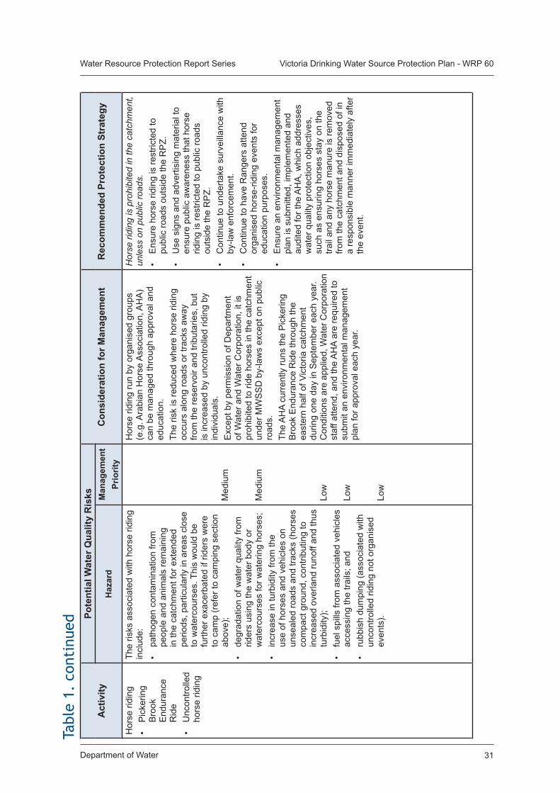
Department of Water 31
Water Resource Protection Report Series Victoria Drinking Water Source Protection Plan - WRP 60
Act
ivity
Po
tent
ial W
ater
Qua
lity
Ris
ksC
onsi
dera
tion
for M
anag
emen
tR
ecom
men
ded
Prot
ectio
n St
rate
gyH
azar
dM
anag
emen
t Pr
iorit
yH
orse
ridi
ng•
Pic
kerin
g B
rook
E
ndur
ance
R
ide
• U
ncon
trolle
d ho
rse
ridin
g
The
risks
ass
ocia
ted
with
hor
se ri
ding
in
clud
e:•
path
ogen
con
tam
inat
ion
from
pe
ople
and
ani
mal
s re
mai
ning
in
the
catc
hmen
t for
ext
ende
d pe
riods
, par
ticul
arly
in a
reas
clo
se
to w
ater
cour
ses.
Thi
s w
ould
be
furth
er e
xace
rbat
ed if
ride
rs w
ere
to c
amp
(ref
er to
cam
ping
sec
tion
abov
e);
• de
grad
atio
n of
wat
er q
ualit
y fro
m
rider
s us
ing
the
wat
er b
ody
or
wat
erco
urse
s fo
r wat
erin
g ho
rses
;•
incr
ease
in tu
rbid
ity fr
om th
e us
e of
hor
ses
and
vehi
cles
on
unse
aled
road
s an
d tra
cks
(hor
ses
com
pact
gro
und,
con
tribu
ting
to
incr
ease
d ov
erla
nd ru
noff
and
thus
tu
rbid
ity);
• fu
el s
pills
from
ass
ocia
ted
vehi
cles
ac
cess
ing
the
trails
; and
• ru
bbis
h du
mpi
ng (a
ssoc
iate
d w
ith
unco
ntro
lled
ridin
g no
t org
anis
ed
even
ts).
Med
ium
Med
ium
Low
Low
Low
Hor
se ri
ding
run
by o
rgan
ised
gro
ups
(e.g
. Ara
bian
Hor
se A
ssoc
iatio
n, A
HA
) ca
n be
man
aged
thro
ugh
appr
oval
and
ed
ucat
ion.
Th
e ris
k is
redu
ced
whe
re h
orse
ridi
ng
occu
rs a
long
road
s or
trac
ks a
way
fro
m th
e re
serv
oir a
nd tr
ibut
arie
s, b
ut
is in
crea
sed
by u
ncon
trolle
d rid
ing
by
indi
vidu
als.
Exc
ept b
y pe
rmis
sion
of D
epar
tmen
t of
Wat
er a
nd W
ater
Cor
pora
tion,
it is
pr
ohib
ited
to ri
de h
orse
s in
the
catc
hmen
t un
der M
WS
SD
by-
law
s ex
cept
on
publ
ic
road
s.Th
e A
HA
curr
ently
runs
the
Pic
kerin
g B
rook
End
uran
ce R
ide
thro
ugh
the
east
ern
half
of V
icto
ria c
atch
men
t du
ring
one
day
in S
epte
mbe
r eac
h ye
ar.
Con
ditio
ns a
re a
pplie
d, W
ater
Cor
pora
tion
staf
f atte
nd, a
nd th
e A
HA
are
requ
ired
to
subm
it an
env
ironm
enta
l man
agem
ent
plan
for a
ppro
val e
ach
year
.
Hor
se ri
ding
is p
rohi
bite
d in
the
catc
hmen
t, un
less
on
publ
ic ro
ads.
• E
nsur
e ho
rse
ridin
g is
rest
ricte
d to
pu
blic
road
s ou
tsid
e th
e R
PZ.
• U
se s
igns
and
adv
ertis
ing
mat
eria
l to
ensu
re p
ublic
aw
aren
ess
that
hor
se
ridin
g is
rest
ricte
d to
pub
lic ro
ads
outs
ide
the
RP
Z.•
Con
tinue
to u
nder
take
sur
veill
ance
with
by
-law
enf
orce
men
t.•
Con
tinue
to h
ave
Ran
gers
atte
nd
orga
nise
d ho
rse-
ridin
g ev
ents
for
educ
atio
n pu
rpos
es.
• E
nsur
e an
env
ironm
enta
l man
agem
ent
plan
is s
ubm
itted
, im
plem
ente
d an
d au
dite
d fo
r the
AH
A, w
hich
add
ress
es
wat
er q
ualit
y pr
otec
tion
obje
ctiv
es,
such
as
ensu
ring
hors
es s
tay
on th
e tra
il an
d an
y ho
rse
man
ure
is re
mov
ed
from
the
catc
hmen
t and
dis
pose
d of
in
a re
spon
sibl
e m
anne
r im
med
iate
ly a
fter
the
even
t.
Tabl
e 1.
con
tinu
ed
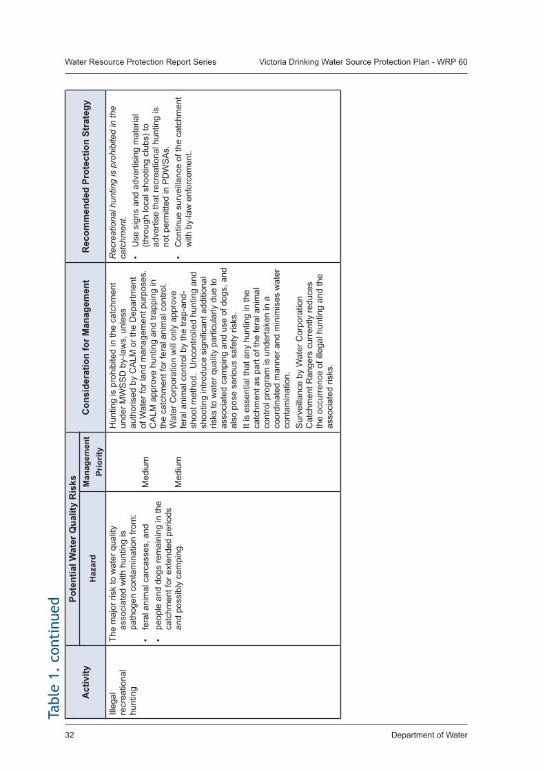
Department of Water32
Water Resource Protection Report Series Victoria Drinking Water Source Protection Plan - WRP 60Ta
ble
1. c
onti
nued
Act
ivity
Po
tent
ial W
ater
Qua
lity
Ris
ksC
onsi
dera
tion
for M
anag
emen
tR
ecom
men
ded
Prot
ectio
n St
rate
gyH
azar
dM
anag
emen
t Pr
iorit
yIll
egal
re
crea
tiona
l hu
ntin
g
The
maj
or ri
sk to
wat
er q
ualit
y as
soci
ated
with
hun
ting
is
path
ogen
con
tam
inat
ion
from
:•
fera
l ani
mal
car
cass
es, a
nd
• pe
ople
and
dog
s re
mai
ning
in th
e ca
tchm
ent f
or e
xten
ded
perio
ds
and
poss
ibly
cam
ping
.
Med
ium
Med
ium
Hun
ting
is p
rohi
bite
d in
the
catc
hmen
t un
der M
WS
SD
by-
law
s, u
nles
s au
thor
ised
by
CA
LM o
r the
Dep
artm
ent
of W
ater
for l
and
man
agem
ent p
urpo
ses.
C
ALM
app
rove
hun
ting
and
trapp
ing
in
the
catc
hmen
t for
fera
l ani
mal
con
trol.
Wat
er C
orpo
ratio
n w
ill o
nly
appr
ove
fera
l ani
mal
con
trol b
y th
e tra
p-an
d-sh
oot m
etho
d. U
ncon
trolle
d hu
ntin
g an
d sh
ootin
g in
trodu
ce s
igni
fican
t add
ition
al
risks
to w
ater
qua
lity
parti
cula
rly d
ue to
as
soci
ated
cam
ping
and
use
of d
ogs,
and
al
so p
ose
serio
us s
afet
y ris
ks.
It is
ess
entia
l tha
t any
hun
ting
in th
e ca
tchm
ent a
s pa
rt of
the
fera
l ani
mal
co
ntro
l pro
gram
is u
nder
take
n in
a
coor
dina
ted
man
ner a
nd m
inim
ises
wat
er
cont
amin
atio
n.S
urve
illan
ce b
y W
ater
Cor
pora
tion
Cat
chm
ent R
ange
rs c
urre
ntly
redu
ces
the
occu
rren
ce o
f ille
gal h
untin
g an
d th
e as
soci
ated
risk
s.
Rec
reat
iona
l hun
ting
is p
rohi
bite
d in
the
catc
hmen
t.•
Use
sig
ns a
nd a
dver
tisin
g m
ater
ial
(thro
ugh
loca
l sho
otin
g cl
ubs)
to
adve
rtise
that
recr
eatio
nal h
untin
g is
no
t per
mitt
ed in
PD
WS
As.
• C
ontin
ue s
urve
illan
ce o
f the
cat
chm
ent
with
by-
law
enf
orce
men
t.
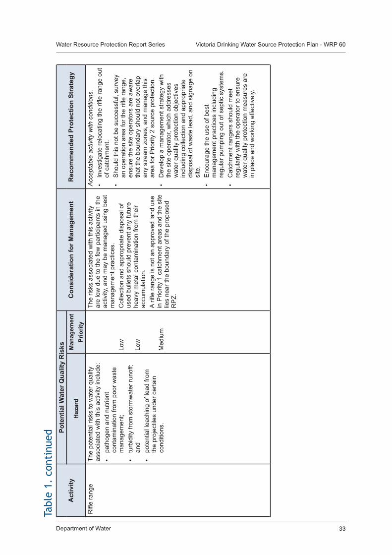
Department of Water 33
Water Resource Protection Report Series Victoria Drinking Water Source Protection Plan - WRP 60Ta
ble
1. c
onti
nued
Act
ivity
Po
tent
ial W
ater
Qua
lity
Ris
ksC
onsi
dera
tion
for M
anag
emen
tR
ecom
men
ded
Prot
ectio
n St
rate
gyH
azar
dM
anag
emen
t Pr
iorit
yR
ifle
rang
eTh
e po
tent
ial r
isks
to w
ater
qua
lity
asso
ciat
ed w
ith th
is a
ctiv
ity in
clud
e:•
path
ogen
and
nut
rient
co
ntam
inat
ion
from
poo
r was
te
man
agem
ent;
• tu
rbid
ity fr
om s
torm
wat
er ru
noff;
an
d•
pote
ntia
l lea
chin
g of
lead
from
th
e pr
ojec
tiles
und
er c
erta
in
cond
ition
s.
Low
Low
Med
ium
The
risks
ass
ocia
ted
with
this
act
ivity
ar
e lo
w d
ue to
the
few
par
ticip
ants
in th
e ac
tivity
, and
may
be
man
aged
usi
ng b
est
man
agem
ent p
ract
ices
.C
olle
ctio
n an
d ap
prop
riate
dis
posa
l of
used
bul
lets
sho
uld
prev
ent a
ny fu
ture
he
avy
met
al c
onta
min
atio
n fro
m th
eir
accu
mul
atio
n.A
rifle
rang
e is
not
an
appr
oved
land
use
in
Prio
rity
1 ca
tchm
ent a
reas
and
the
site
lie
s ne
ar th
e bo
unda
ry o
f the
pro
pose
d R
PZ.
Acc
epta
ble
activ
ity w
ith c
ondi
tions
.•
Inve
stig
ate
relo
catin
g th
e rifl
e ra
nge
out
of c
atch
men
t.•
Sho
uld
this
not
be
succ
essf
ul, s
urve
y an
ope
ratio
n ar
ea fo
r the
rifle
rang
e,
ensu
re th
e si
te o
pera
tors
are
aw
are
that
the
boun
dary
sho
uld
not o
verla
p an
y st
ream
zon
es, a
nd m
anag
e th
is
area
for P
riorit
y 2
sour
ce p
rote
ctio
n.•
Dev
elop
a m
anag
emen
t stra
tegy
with
th
e si
te o
pera
tor,
whi
ch a
ddre
sses
w
ater
qua
lity
prot
ectio
n ob
ject
ives
in
clud
ing
colle
ctio
n an
d ap
prop
riate
di
spos
al o
f was
te le
ad, a
nd s
igna
ge o
n si
te.
• E
ncou
rage
the
use
of b
est
man
agem
ent p
ract
ices
incl
udin
g re
gula
r pum
ping
out
of s
eptic
sys
tem
s.•
Cat
chm
ent r
ange
rs s
houl
d m
eet
regu
larly
with
the
oper
ator
to e
nsur
e w
ater
qua
lity
prot
ectio
n m
easu
res
are
in p
lace
and
wor
king
effe
ctiv
ely.
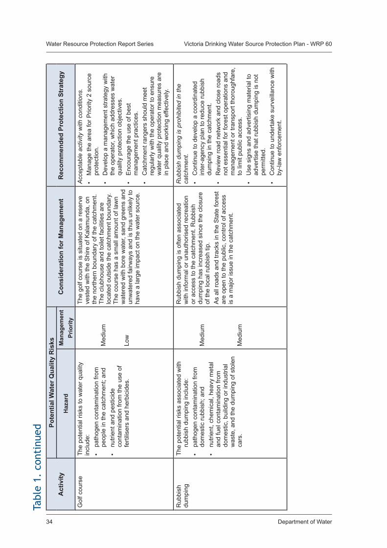
Department of Water34
Water Resource Protection Report Series Victoria Drinking Water Source Protection Plan - WRP 60
Act
ivity
Po
tent
ial W
ater
Qua
lity
Ris
ksC
onsi
dera
tion
for M
anag
emen
tR
ecom
men
ded
Prot
ectio
n St
rate
gyH
azar
dM
anag
emen
t Pr
iorit
yG
olf c
ours
eTh
e po
tent
ial r
isks
to w
ater
qua
lity
incl
ude:
•
path
ogen
con
tam
inat
ion
from
pe
ople
in th
e ca
tchm
ent;
and
• nu
trien
t and
pes
ticid
e co
ntam
inat
ion
from
the
use
of
ferti
liser
s an
d he
rbic
ides
.
Med
ium
Low
The
golf
cour
se is
situ
ated
on
a re
serv
e ve
sted
with
the
Shi
re o
f Kal
amun
da, o
n th
e no
rther
n bo
unda
ry o
f the
cat
chm
ent.
Th
e cl
ubho
use
and
toile
t fac
ilitie
s ar
e lo
cate
d ou
tsid
e th
e ca
tchm
ent b
ound
ary.
Th
e co
urse
has
a s
mal
l am
ount
of l
awn
wat
ered
with
bor
e w
ater
, san
d gr
eens
and
un
wat
ered
fairw
ays
and
is th
us u
nlik
ely
to
have
a la
rge
impa
ct o
n th
e w
ater
sou
rce.
Acc
epta
ble
activ
ity w
ith c
ondi
tions
.•
Man
age
the
area
for P
riorit
y 2
sour
ce
prot
ectio
n.•
Dev
elop
a m
anag
emen
t stra
tegy
with
th
e op
erat
or, w
hich
add
ress
es w
ater
qu
ality
pro
tect
ion
obje
ctiv
es.
• E
ncou
rage
the
use
of b
est
man
agem
ent p
ract
ices
.•
Cat
chm
ent r
ange
rs s
houl
d m
eet
regu
larly
with
the
oper
ator
to e
nsur
e w
ater
qua
lity
prot
ectio
n m
easu
res
are
in p
lace
and
wor
king
effe
ctiv
ely.
Rub
bish
du
mpi
ngTh
e po
tent
ial r
isks
ass
ocia
ted
with
ru
bbis
h du
mpi
ng in
clud
e:•
path
ogen
con
tam
inat
ion
from
do
mes
tic ru
bbis
h; a
nd•
nutri
ent,
chem
ical
, hea
vy m
etal
an
d fu
el c
onta
min
atio
n fro
m
dom
estic
, bui
ldin
g or
indu
stria
l w
aste
, and
the
dum
ping
of s
tole
n ca
rs.
Med
ium
Med
ium
Rub
bish
dum
ping
is o
ften
asso
ciat
ed
with
info
rmal
or u
naut
horis
ed re
crea
tion
or a
cces
s to
the
catc
hmen
t. R
ubbi
sh
dum
ping
has
incr
ease
d si
nce
the
clos
ure
of th
e lo
cal r
ubbi
sh ti
p.A
s al
l roa
ds a
nd tr
acks
in th
e S
tate
fore
st
are
open
to th
e pu
blic
, con
trol o
f acc
ess
is a
maj
or is
sue
in th
e ca
tchm
ent.
Rub
bish
dum
ping
is p
rohi
bite
d in
the
catc
hmen
t.•
Con
tinue
to d
evel
op a
coo
rdin
ated
in
ter-
agen
cy p
lan
to re
duce
rubb
ish
dum
ping
in th
e ca
tchm
ent.
• R
evie
w ro
ad n
etw
ork
and
clos
e ro
ads
not e
ssen
tial f
or fo
rest
ope
ratio
ns a
nd
man
agem
ent o
r tra
nspo
rt th
orou
ghfa
re,
to li
mit
publ
ic a
cces
s.•
Use
sig
ns a
nd a
dver
tisin
g m
ater
ial t
o ad
verti
se th
at ru
bbis
h du
mpi
ng is
not
pe
rmitt
ed.
• C
ontin
ue to
und
erta
ke s
urve
illan
ce w
ith
by-la
w e
nfor
cem
ent.
Tabl
e 1.
con
tinu
ed
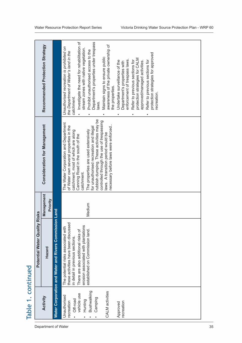
Department of Water 35
Water Resource Protection Report Series Victoria Drinking Water Source Protection Plan - WRP 60
Act
ivity
Po
tent
ial W
ater
Qua
lity
Ris
ksC
onsi
dera
tion
for M
anag
emen
tR
ecom
men
ded
Prot
ectio
n St
rate
gyH
azar
dM
anag
emen
t Pr
iorit
yW
ater
Cor
pora
tion
and
Wat
er a
nd R
iver
s C
omm
issi
on L
and
Una
utho
rised
re
crea
tion
• O
ff-ro
ad
vehi
cle
use
• H
untin
g•
Bus
hwal
king
• C
ampi
ng
CA
LM a
ctiv
ities
App
rove
d re
crea
tion
The
pote
ntia
l ris
ks a
ssoc
iate
d w
ith
thes
e ac
tiviti
es h
ave
been
dis
cuss
ed
in d
etai
l in
prev
ious
sec
tions
.Th
ere
are
also
add
ition
al ri
sks
of
eros
ion
asso
ciat
ed w
ith p
lant
atio
ns
esta
blis
hed
on C
omm
issi
on la
nd.
Med
ium
The
Wat
er C
orpo
ratio
n an
d D
epar
tmen
t of
Wat
er o
wn
seve
ral p
rope
rties
in th
e ca
tchm
ent,
mos
t of w
hich
are
alo
ng
Can
ning
Roa
d in
the
sout
h of
the
catc
hmen
t. Th
e pr
oper
ties
are
used
ext
ensi
vely
fo
r una
utho
rised
recr
eatio
n an
d ill
egal
ru
bbis
h du
mpi
ng. T
hese
act
iviti
es m
ay b
e co
ntro
lled
thro
ugh
the
use
of tr
espa
ssin
g la
ws.
A tr
ansi
tion
perio
d w
ould
be
nece
ssar
y be
fore
law
s w
ere
enfo
rced
..
Una
utho
rised
recr
eatio
n is
pro
hibi
ted
on
the
Dep
artm
ent o
f Wat
er’s
land
in th
e ca
tchm
ent.
• In
vest
igat
e th
e ne
ed fo
r reh
abili
tatio
n of
st
ream
zon
es w
ith n
ativ
e ve
geta
tion.
• P
rohi
bit u
naut
horis
ed a
cces
s to
the
Dep
artm
ent’s
pro
perti
es u
nder
tres
pass
la
ws.
• M
aint
ain
sign
s to
ens
ure
publ
ic
awar
enes
s of
the
priv
ate
owne
rshi
p of
th
e pr
oper
ties.
• U
nder
take
sur
veill
ance
of t
he
Dep
artm
ent’s
pro
perti
es w
ith
enfo
rcem
ent o
f tre
spas
s la
ws.
• R
efer
to p
revi
ous
sect
ions
for
prot
ectio
n st
rate
gies
for C
ALM
ap
prov
ed/m
anag
ed a
ctiv
ities
.•
Ref
er to
pre
viou
s se
ctio
ns fo
r pr
otec
tion
stra
tegi
es fo
r app
rove
d re
crea
tion.
Tabl
e 1.
con
tinu
ed
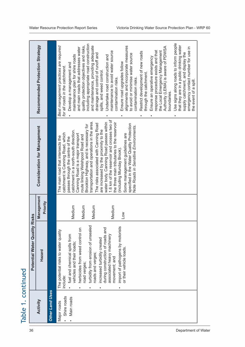
Department of Water36
Water Resource Protection Report Series Victoria Drinking Water Source Protection Plan - WRP 60
Act
ivity
Po
tent
ial W
ater
Qua
lity
Ris
ksC
onsi
dera
tion
for M
anag
emen
tR
ecom
men
ded
Prot
ectio
n St
rate
gyH
azar
dM
anag
emen
t Pr
iorit
yO
ther
Lan
d U
ses
Maj
or ro
ads
• S
hire
road
s•
Mai
n ro
ads
The
pote
ntia
l ris
ks to
wat
er q
ualit
y in
clud
e:•
fuel
and
che
mic
al s
pills
from
ve
hicl
es a
nd th
eir l
oads
;•
herb
icid
es fr
om w
eed
cont
rol o
n ro
ad v
erge
s;•
turb
idity
from
ero
sion
of u
nsea
led
road
s an
d ve
rges
;•
incr
ease
d tu
rbid
ity c
reat
ed
durin
g co
nstru
ctio
n of
road
s an
d as
soci
ated
hea
vy m
achi
nery
m
ovem
ent;
and
• im
port
of p
atho
gens
by
mot
oris
ts
or th
eir v
ehic
le lo
ads.
Med
ium
Med
ium
Med
ium
Med
ium
Low
The
mai
n ro
ad th
at in
ters
ects
the
catc
hmen
t is
Can
ning
Roa
d, w
hich
pa
sses
thro
ugh
the
cent
re o
f the
ca
tchm
ent i
n a
north
-sou
th d
irect
ion.
C
anni
ng R
oad
is a
maj
or tr
ansp
ort
rout
e lin
king
Wel
shpo
ol R
oad
and
Bro
okto
n H
ighw
ay, a
nd is
nec
essa
ry fo
r tra
nspo
rtatio
n an
d op
erat
ions
in th
e ar
ea.
The
risks
ass
ocia
ted
with
Can
ning
Roa
d ar
e in
crea
sed
by th
e pr
oxim
ity to
the
wat
er b
ody.
Can
ning
Roa
d pa
sses
with
in
1.6
km o
f the
rese
rvoi
r and
cro
sses
two
of
the
thre
e m
ain
tribu
tarie
s to
the
rese
rvoi
r (in
clud
ing
Mun
day
Bro
ok).
Som
e m
anag
emen
t gui
delin
es a
re
spec
ified
in th
e W
ater
Qua
lity
Pro
tect
ion
Not
e R
oads
in S
ensi
tive
Env
ironm
ents
.
Bes
t man
agem
ent p
ract
ices
are
requ
ired
for a
ll ro
ads
in th
e ca
tchm
ent.
• D
evel
op a
man
agem
ent a
nd
mai
nten
ance
pla
n fo
r shi
re ro
ads
and
mai
n ro
ads
that
add
ress
es w
ater
qu
ality
pro
tect
ion
obje
ctiv
es a
nd ri
sks,
in
clud
ing
appr
opria
te ro
ad c
onst
ruct
ion
and
mai
nten
ance
, pro
vidi
ng a
dequ
ate
drai
nage
and
con
trol o
f run
off a
nd
spill
s, a
nd w
eed
cont
rol.
• U
nder
take
road
con
stru
ctio
n an
d m
aint
enan
ce to
avo
id w
ater
sou
rce
cont
amin
atio
n ris
ks.
• E
nsur
e ro
ad u
pgra
des
follo
w
alig
nmen
ts a
nd in
corp
orat
e m
easu
res
to a
void
or m
inim
ise
wat
er s
ourc
e co
ntam
inat
ion
risks
.•
Res
trict
dev
elop
men
t of n
ew ro
ads
thro
ugh
the
catc
hmen
t.•
Ens
ure
an o
pera
tive
emer
genc
y re
spon
se p
roce
dure
exi
sts
and
that
th
e Lo
cal E
mer
genc
y M
anag
emen
t A
utho
rity
(LE
MA
) is
awar
e of
PD
WS
A bo
unda
ries.
• U
se s
igns
alo
ng ro
ads
to in
form
peo
ple
that
they
are
in a
pub
lic d
rinki
ng w
ater
su
pply
cat
chm
ent,
and
disp
lay
the
emer
genc
y co
ntac
t num
ber f
or u
se in
th
e ev
ent o
f a s
pill.
Tabl
e 1.
con
tinu
ed
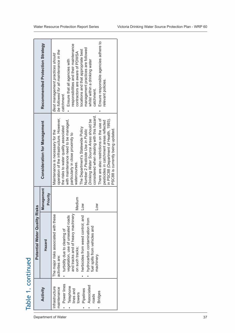
Department of Water 37
Water Resource Protection Report Series Victoria Drinking Water Source Protection Plan - WRP 60
Act
ivity
Po
tent
ial W
ater
Qua
lity
Ris
ksC
onsi
dera
tion
for M
anag
emen
tR
ecom
men
ded
Prot
ectio
n St
rate
gyH
azar
dM
anag
emen
t Pr
iorit
yIn
frast
ruct
ure
mai
nten
ance
• P
ower
line
s•
Tele
phon
e lin
es a
nd
tow
ers
• P
ipel
ines
• A
ssoc
iate
d ro
ads
• B
ridge
s
The
maj
or ri
sks
asso
ciat
ed w
ith th
ese
activ
ities
are
:•
turb
idity
due
to c
lear
ing
of
vege
tatio
n, u
se o
f uns
eale
d ro
ads
and
track
s an
d of
hea
vy m
achi
nery
on
suc
h tra
cks;
• he
rbic
ides
from
wee
d co
ntro
l; an
d•
hydr
ocar
bon
cont
amin
atio
n fro
m
fuel
spi
lls fr
om v
ehic
les
and
mac
hine
ry.
Med
ium
Low
Low
Mai
nten
ance
is n
eces
sary
for t
he
oper
atio
n of
the
infra
stru
ctur
e. H
owev
er,
the
risks
to w
ater
qua
lity
asso
ciat
ed
with
mai
nten
ance
nee
d to
be
man
aged
, pa
rticu
larly
in c
lose
pro
xim
ity to
w
ater
cour
ses.
The
Dep
artm
ent’s
Sta
tew
ide
Pol
icy
Num
ber 2
Pes
ticid
e U
se in
Pub
lic
Drin
king
Wat
er S
ourc
e A
reas
sho
uld
be
cons
ider
ed w
hen
deal
ing
with
this
haz
ard.
Ther
e ar
e al
so re
stric
tions
on
the
use
of
pest
icid
es in
cat
chm
ent a
reas
refle
cted
in
PS
C88
(Dep
artm
ent o
f Hea
lth, 1
993)
. P
SC
88 is
cur
rent
ly b
eing
upd
ated
.
Bes
t man
agem
ent p
ract
ices
sho
uld
be fo
llow
ed fo
r all
mai
nten
ance
in th
e ca
tchm
ent.
• E
nsur
e th
at a
ll ag
enci
es w
ith
resp
onsi
bilit
ies
and
thei
r mai
nten
ance
co
ntra
ctor
s ar
e aw
are
of P
DW
SA
loca
tions
and
that
app
ropr
iate
bes
t m
anag
emen
t pra
ctic
es a
re fo
llow
ed
whi
lst w
ithin
a d
rinki
ng w
ater
ca
tchm
ent.
• E
nsur
e re
spon
sibl
e ag
enci
es a
dher
e to
re
leva
nt p
olic
ies.
Tabl
e 1.
con
tinu
ed
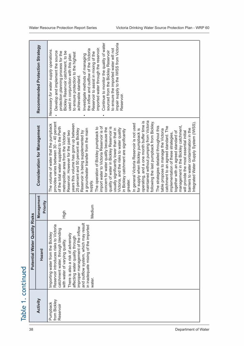
Department of Water38
Water Resource Protection Report Series Victoria Drinking Water Source Protection Plan - WRP 60
Act
ivity
Po
tent
ial W
ater
Qua
lity
Ris
ksC
onsi
dera
tion
for M
anag
emen
tR
ecom
men
ded
Prot
ectio
n St
rate
gyH
azar
dM
anag
emen
t Pr
iorit
yP
umpb
ack
from
Bic
kley
R
eser
voir
Impo
rting
wat
er fr
om th
e B
ickl
ey
Res
ervo
ir in
trodu
ces
risks
to V
icto
ria
catc
hmen
t wat
er, t
hrou
gh b
lend
ing
with
wat
er o
f var
ying
qua
lity.
Ther
e is
als
o a
risk
of a
dver
sely
af
fect
ing
wat
er q
ualit
y th
roug
h im
prop
er m
anag
emen
t of t
he in
flow
an
d ou
tflow
sys
tem
, whi
ch m
ay re
sult
in in
adeq
uate
mix
ing
of th
e im
porte
d w
ater
.
Hig
h M
ediu
m
The
volu
me
of w
ater
that
the
pum
pbac
k pr
ovid
es v
arie
s be
twee
n 30
– 4
0 pe
rcen
t of
the
tota
l wat
er s
uppl
ied
to th
e P
erth
m
etro
polit
an a
rea
from
the
Vict
oria
R
eser
voir.
How
ever
for t
he p
ast t
wo
year
s th
is v
olum
e ha
s go
ne u
p be
twee
n 25
per
cent
and
50
perc
ent a
s B
ickl
ey
Res
ervo
ir is
bei
ng s
uppl
emen
ted
by
a gr
ound
wat
er tr
ansf
er fr
om th
e m
ain
supp
ly.Th
e op
erat
ion
of B
ickl
ey p
umpb
ack
to
impo
rt w
ater
to V
icto
ria R
eser
voir
is o
f co
ncer
n fo
r wat
er q
ualit
y be
caus
e th
e qu
ality
of w
ater
in B
ickl
ey R
eser
voir
is
usua
lly s
igni
fican
tly lo
wer
than
that
in
Vict
oria
, and
the
risks
to w
ater
qua
lity
in B
ickl
ey c
atch
men
t are
sig
nific
antly
gr
eate
r.In
gen
eral
Vic
toria
Res
ervo
ir is
not
use
d fo
r sup
ply
whe
n B
ickl
ey p
umpb
ack
is
oper
atin
g, a
nd a
one
mon
th b
uffe
r tim
e is
m
aint
aine
d w
ithou
t pum
ping
from
Vic
toria
fo
llow
ing
the
last
pum
pbac
k fro
m B
ickl
ey.
The
stra
tegi
es d
etai
led
thro
ugho
ut th
is
tabl
e pr
opos
e to
man
age
the
Vict
oria
ca
tchm
ent t
o an
agr
eed
stan
dard
. The
im
plem
enta
tion
of th
ese
stra
tegi
es,
toge
ther
with
an
agre
ed s
tand
ard
of
man
agem
ent i
n th
e B
ickl
ey c
atch
men
t, w
ill p
rovi
de th
e m
ost e
ssen
tial i
nitia
l ba
rrie
rs to
wat
er c
onta
min
atio
n in
the
Inte
grat
ed W
ater
Sup
ply
Sys
tem
(IW
SS
).
Nec
essa
ry fo
r wat
er s
uppl
y op
erat
ions
.•
Dev
elop
and
impl
emen
t the
sou
rce
prot
ectio
n pl
anni
ng p
roce
ss fo
r the
B
ickl
ey R
eser
voir
catc
hmen
t, to
be
used
in c
onju
nctio
n w
ith th
is p
lan
to e
nsur
e pr
otec
tion
to th
e hi
ghes
t ac
hiev
able
sta
ndar
d.•
Inve
stig
ate
met
hods
of m
anag
ing
the
inflo
w a
nd o
utflo
w o
f the
Vic
toria
R
eser
voir
to a
ssis
t in
mix
ing
of th
e im
porte
d w
ater
thro
ugh
the
rese
rvoi
r.•
Con
tinue
to m
onito
r the
qua
lity
of w
ater
so
urce
d fro
m th
e B
ickl
ey R
eser
voir
to e
nsur
e th
e im
porte
d w
ater
will
not
im
pair
supp
ly to
the
IWS
S fr
om V
icto
ria
Res
ervo
ir.
Tabl
e 1.
con
tinu
ed
Department of Water 39
Water Resource Protection Report Series Victoria Drinking Water Source Protection Plan - WRP 60
Recommendations1. Amend the existing Victoria Reservoir Catchment Area under the Metropolitan Water
Supply, Sewerage and Drainage Act 1909 (Department of Water).
2. The Metropolitan Region Scheme and the Town Planning Schemes for the Shire of Kalamunda, City of Gosnells and City of Armadale should recognise priority classification areas and protection zones assigned to land in the Victoria Reservoir Catchment Area (Shire of Kalamunda, City of Gosnells and City of Armadale).
3. Ensure that the Water Corporation are advised of development and works proposals in the Victoria Reservoir Catchment Area that are likely to impact on water quality. Proposals that are inconsistent with the Department’s Land Use Compatibility Table and Water Quality Protection Notes and Guidelines should be referred to the Department of Water for assessment and recommendation (Local and State government agencies and all key stakeholders).
4. Develop a management plan for shire roads and main roads that addresses water quality protection objectives. The development of new roads through the catchment should not be promoted (Main Roads WA, Shire of Kalamunda, City of Gosnells and City of Armadale).
5. Provide information and encourage private landowners to adopt best management practices (Department of Water and Water Corporation).
6. Work with the owner of the old fuel station to ensure the underground storage tanks are removed and clean-up of any contaminated soil occurs. If this is not possible, environmental assessment around the storage tanks should be conducted on a regular basis (Department of Water, Department of Environment and Water Corporation).
7. Ensure that personnel dealing with WESTPLAN – HAZMAT incidents in the Victoria Reservoir Catchment Area are given ready access to a locality map of the catchment area and training to understand the potential impacts of spills on the surface water resource (Water Corporation).
8. Ensure that signs are installed and maintained along the boundaries of the catchment area and proposed Reservoir Protection Zone to define the areas and to promote public awareness of the importance of protecting drinking water quality (Water Corporation).
9. Continue the implementation of the catchment surveillance program and associated by-law enforcement in the Victoria Reservoir Catchment Area (Water Corporation).
10. Develop and implement environmental management plans for any recreational events within the catchment under guidance of the Water Corporation (WC). The WC should audit plans after each event. Any new proposals would also require such a plan (Organisers of approved recreational events).
11. Ensure designated picnic areas are outside the Reservoir Protection Zone and include appropriate facilities with no access to the water body (Local and State government agencies).
Department of Water40
Water Resource Protection Report Series Victoria Drinking Water Source Protection Plan - WRP 60
12. Develop environmental management strategies with both the rifle range and golf course site operators, and encourage the use of best management practices, and management of spent projectiles. After the establishment of these strategies catchment Rangers should meet biannually with the operators to ensure water quality protection measures are in place and that they are working effectively (Water Corporation, Department of Environment and Department of Water).
13. A coordinated inter-agency plan is developed to reduce rubbish dumping in the catchment (Department of Water and Water Corporation).
14. Stream zones and other areas of this catchment in Water Corporation, the Department of Water or other government ownership are assessed for the need for rehabilitation, and rehabilitation with native species carried out where necessary (Water Corporation, Department of Environment and Department of Water).
15. A Drinking Water Source Protection Plan for the Victoria Reservoir catchment should be developed and implemented by Department of Environment, Department of Water and Water Corporation to ensure water supplied to the Integrated Water Supply System is of the highest achievable standard (Department of Water).
16. Strategies detailed in Table 1. Land Use, Potential Water Quality Risks and Recommended Strategies are adopted (Local and State government agencies).
17. A review of this plan is undertaken within five years to determine the status of the water reserve and level of implementation of these recommendations (Department of Water).
Department of Water 41
Water Resource Protection Report Series Victoria Drinking Water Source Protection Plan - WRP 60
References Australian Forest Growers (AFG), 1997, Code of Practice for Timber Plantations in Western Australia.
ARMCANZ and ANZECC, 1996, Draft Rural Land Uses and Water Quality: A Community Resource Document. Agriculture and Resource Management Council of Australia and New Zealand and Australian and New Zealand Environment and Conservation Council.
Burne, H., 2001, The condition of gravel pits in surface drinking water catchments and their potential to affect water quality. Water Corporation internal report. File No: JT1 2001 03470 V01.
Department of Conservation and Land Management, 1999a, Manual of Management Guidelines for Timber Harvesting in Western Australia. Dept. of Conservation and Land Management.
Department of Conservation and Land Management, 1999b, Code of Practice for Timber Plantations in Western Australia. Australian Forest Growers, Dept. of Conservation and Land Management.
Conservation Commission of Western Australia, 2004, Forest Management Plan 2004-2013.
Department of Water, 2004, Water Quality Protection Notes, Land Use Compatibility in Public Drinking Water Source Areas. Perth. See:http://water.wa.gov.au select Publications>Water Quality Protection Notes.
Forest Products Commission (FPC), 2003, Contractors’ Timber Harvesting Manual – South West Native Forests.
Geldreich E.E., 1996, ‘Pathogenic agents in freshwater resources’, Hydrological Processes, Volume 10, pp. 315-333.
Government of Western Australia, May 2001, State Water Quality Management Strategy, No. 1 Framework for Implementation. Report SWQ 1.
Grimmond, T.R., Radford, A.J. and Brownridge, T., 1988, ‘Giardia carriage in aboriginal and non-aboriginal children attending urban day-care centres in South Australia’, Australian Paediatric Journal, Volume 24, pp. 304-305.
Health Department of Western Australia, 6/1999, Understanding Septic Tank Systems. Environmental Health Guide, Environmental Health Service EHS 29. See: http://www.population.health.wa.gov.au select Environmental Health>wastewater management> resources>wastewater management.
Health Department of Western Australia, 9/1998, Aerobic Treatment Units. Environmental Health Guide, Environmental Health Service EHS 26. See: http://www.population.health.wa.gov.au select Environmental Health>wastewater management> resources>wastewater management.
King and Wells, 1990, Darling Range Rural Land Capability Study. Land Resource Series No. 3., Dept. of Agriculture, W.A.
Department of Water42
Water Resource Protection Report Series Victoria Drinking Water Source Protection Plan - WRP 60
NHMRC and ARMCANZ, 1996, Australian Drinking Water Guidelines. National Health and Medical Research Council and Agriculture and Resource Management Council of Australia and New Zealand.
South Australian EPA, 2003, The State of Health of the Mount Lofty Ranges Catchments from a Water Quality Perspective. See: http://www.epa.sa.gov.au/ select publications> water>Mount Lofty Ranges Watershed protection office.
Western Australian Planning Commission, 1997, State Planning Strategy. Perth.
Water and Rivers Commission, 2000, Statewide Policy No. 2 Pesticide Use in Public Drinking Water Source Areas. Perth. See: http://drinkingwater.water.wa.gov.au select policy.
Department of Water 43
Water Resource Protection Report Series Victoria Drinking Water Source Protection Plan - WRP 60
Alcoa Alcoa World Alumina - AustraliaADWG Australian Drinking Water GuidelinesANZECC Australia and New Zealand Environment and Conservation
CouncilARMCANZ Agriculture and Resource Management Council of Australia
and New ZealandCALM Department of Conservation and Land ManagementCAWS Act Country Areas Water Supply Act 1947DDT DichlorodiphenyltrichloroethaneDoE Department of EnvironmentDRA Disease Risk AreaDWSPP Drinking Water Source Protection PlanFPC Forest Products CommissionGL Gigalitre, a thousand million litresHAZMAT Hazardous materialsIWSS Integrated Water Supply SystemLEMA Local Emergency Management AuthorityML Megalitre. 1 million litresMMPLG Mining and Management Planning Liaison GroupMOG Mining Operation GroupMWSSD Act Metropolitan Water Supply, Sewerage and Drainage Act
1909NHMRC National Health and Medical Research CouncilP1 Priority 1 - priority classification for land useP2 Priority 2 – priority classification for land useP3 Priority 3 – priority classification for land usePDWSA Public Drinking Water Source AreaPZ Prohibited ZoneRIWI Act Rights in Water and Irrigation Act 1914RPZ Reservoir Protection ZoneWC Water CorporationWRC Water and Rivers Commission
Acronyms
Department of Water44
Water Resource Protection Report Series Victoria Drinking Water Source Protection Plan - WRP 60
Aesthetic Guideline Levels NHMRC guideline level ascribed for acceptable aesthetic quality of drinking water.
Allocation The quantity of surface water permitted to be abstracted by a licence, usually specified in gigalitres per year (GL/a).
Alluvium (alluvial) Detrital material which is transported by streams and rivers and deposited.
Aquifer A geological formation or group of formations able to receive, store and transmit significant quantities of water.
BMP Best Management Practice (defined in Section 6.3)
Catchment The area of land which intercepts rainfall and contributes the collected water to surface water (streams, rivers, wetlands) or groundwater.
Diffuse Source Pollution Pollution originating from a widespread area e.g. urban stormwater runoff, agricultural runoff.
Effluent The liquid, solid or gaseous wastes discharged by a process, treated or untreated.
Groundwater Water which occupies the pores and crevices of rock or soil.Health Guideline Level NHMRC guideline level ascribed for acceptable drinking
water quality for human health.Hydrogeology The study of groundwater, especially relating to the
distribution of aquifers, groundwater flow and groundwater quality.
IWSS The Integrated Water Supply System provides water to Perth, Mandurah, Pinjarra, Harvey and the Goldfields and Agricultural regions, servicing approximately 1.5 million people. Fifty percent of the water is from surface water catchments, 50 percent is from groundwater. Refer to Figure 1 within Water Corporation’s Perth’s Water Balance – The Way Forward for a diagrammatic representation.
LGA Local Government Authority (in this case Shire of Kalamunda, City of Armadale or City of Gosnells)
Leaching / Leachate The process by which materials such as organic matter and mineral salts are washed out of a layer of soil or dumped material by being dissolved or suspended in percolating rainwater, the material washed out is known as leachate. Leachate can pollute groundwater and waterways.
m AHD Australian Height Datum. Height in metres above Mean Sea Level +0.026 metres at Fremantle.
Nutrient Load The amount of nutrient reaching the waterway over a given time (usually per year) from its catchment area.
Glossary
Department of Water 45
Water Resource Protection Report Series Victoria Drinking Water Source Protection Plan - WRP 60
Nutrients Minerals dissolved in water, particularly inorganic compounds of nitrogen (nitrate and ammonia) and phosphorus (phosphate) which provide nutrition (food) for plant growth. Total nutrient levels include the inorganic forms of an element plus any bound in organic molecules.
PDWSA Public Drinking Water Supply Areas are Underground Water Pollution Control Areas, catchment areas or water reserves established under the Metropolitan Water Supply, Sewerage and Drainage Act 1909 or Country Area Water Supply Act 1947 .
Pesticides Collective name for a variety of insecticides, fungicides, herbicides, algicides, fumigants and rodenticides used to kill organisms.
Point Source Pollution Specific localised source of pollution, e.g. sewage or effluent discharge, industrial waste discharge.
Pollution Water pollution occurs when waste products or other substances, e.g. effluent, litter, refuse, sewage or contaminated runoff, change the physical, chemical, biological or thermal properties of the water, adversely affecting water quality, living species and beneficial uses.
PDWSA Public Drinking Water Source Areas are Underground Water Pollution Control Areas, catchment areas or water reserves established under the MWSSD or CAWS Act. PDWSAs are also referred to as drinking water catchments.
Runoff Water that flows over the surface from a catchment area, including streams.
Scheme Supply Water diverted from a source (or sources) by a water authority or private company and supplied via a distribution network to customers for urban, industrial or irrigation use.
Storage Reservoir A major reservoir of water created in a river valley by building a dam.
Stormwater Rainwater which has run off the ground surface, roads, paved areas etc. and is usually carried away by drains.
Treatment Application of techniques such as settlement, filtration and chlorination to render water suitable for specific purposes including drinking and discharge to the environment.
Underground Water Pollution Control Area (UWPCA)
An area defined under the Metropolitan Water Supply, Sewerage and Drainage Act, in which restrictions are put on activities that may pollute the groundwater.
Wastewater Water that has been used for some purpose and would normally be treated and discarded. Wastewater usually contains significant quantities of pollutant.
Water Quality The physical, chemical and biological measures of water.
Department of Water46
Water Resource Protection Report Series Victoria Drinking Water Source Protection Plan - WRP 60
AppendicesAppendix 1 Water Quality Results provided by the Water Corporation
Appendix 2 Best Management Practices documents for activities in PDWSAs
Department of Water 47
Water Resource Protection Report Series Victoria Drinking Water Source Protection Plan - WRP 60
APPENDIX 1
Water Quality Results provided by the Water CorporationThe Water Corporation has monitored the raw (source) water quality from Victoria Reservoir in accordance with the Australian Drinking Water Guidelines (ADWG) and interpretations agreed to with the Department of Health. The raw water is regularly monitored for:
a. Health related characteristics• Microbiological Contaminants• Health Related Chemicals
b. Aesthetic characteristics– (Non-health related)
Following is data representative of the quality of raw water in Victoria Reservoir. In the absence of specific guidelines for raw water quality, the results have been compared with ADWG values set for drinking water. Results that exceed ADWG have been shaded to give an indication of potential raw water quality issues associated with this source.
It is important to appreciate that the raw water data presented does not represent the quality of drinking water distributed to the public. For information on the quality of drinking water supplied in the Perth Region refer to the most recent Water Corporation Drinking Water Quality Annual Report at: http://www.watercorporation.com.au/dwq/index.cfm.
Health Related Characteristics – Victoria Reservoir Raw Water• Microbiological Contaminants
Microbiological testing of raw water samples is conducted on a weekly to monthly basis, particularly during summer and autumn. Thermotolerant coliform counts are used as an indicator of the degree of faecal contamination of the raw water from warm-blooded animals. A count less than 20 colony forming units (cfu) per 100 millilitre (mL) is typically associated with low levels of contamination and is used as a microbiological contamination benchmark (WHO, 1996).
During the review period of January 1999 to October 2004 the raw water in Victoria Reservoir was sampled for thermotolerant coliforms 226 times. Positive thermotolerant counts were recorded in 56 percent of samples. Five percent of the positive samples had thermotolerant coliform counts greater than 20 cfu/100 mL.
These percentages are higher than in some of the larger more pristine hills drinking water catchments further from population centres, but lower than some of the catchments with greater human impact. This is a cause for concern as any positive result in disinfected drinking water is considered an exceedence of the ADWG guideline level and it implies that there are insufficient barriers within the catchment to prevent contamination of the raw water. These results show the importance of disinfection and will focus the ‘catchment protection’ for this reservoir on those land uses or activities that have the potential to impact bacterial contamination.
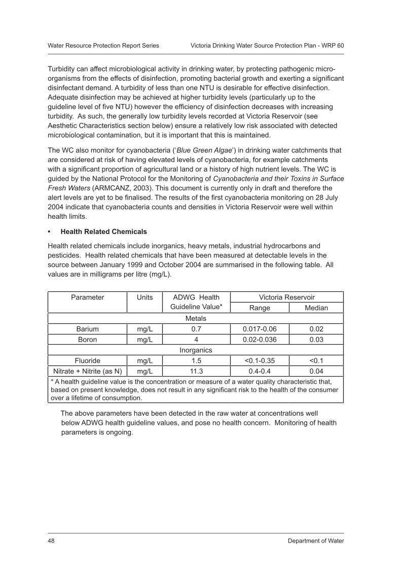
Department of Water48
Water Resource Protection Report Series Victoria Drinking Water Source Protection Plan - WRP 60
Parameter Units ADWG Health Guideline Value*
Victoria ReservoirRange Median
MetalsBarium mg/L 0.7 0.017-0.06 0.02Boron mg/L 4 0.02-0.036 0.03
InorganicsFluoride mg/L 1.5 <0.1-0.35 <0.1
Nitrate + Nitrite (as N) mg/L 11.3 0.4-0.4 0.04* A health guideline value is the concentration or measure of a water quality characteristic that, based on present knowledge, does not result in any significant risk to the health of the consumer over a lifetime of consumption.
The above parameters have been detected in the raw water at concentrations well below ADWG health guideline values, and pose no health concern. Monitoring of health parameters is ongoing.
Turbidity can affect microbiological activity in drinking water, by protecting pathogenic micro-organisms from the effects of disinfection, promoting bacterial growth and exerting a significant disinfectant demand. A turbidity of less than one NTU is desirable for effective disinfection. Adequate disinfection may be achieved at higher turbidity levels (particularly up to the guideline level of five NTU) however the efficiency of disinfection decreases with increasing turbidity. As such, the generally low turbidity levels recorded at Victoria Reservoir (see Aesthetic Characteristics section below) ensure a relatively low risk associated with detected microbiological contamination, but it is important that this is maintained.
The WC also monitor for cyanobacteria (‘Blue Green Algae’) in drinking water catchments that are considered at risk of having elevated levels of cyanobacteria, for example catchments with a significant proportion of agricultural land or a history of high nutrient levels. The WC is guided by the National Protocol for the Monitoring of Cyanobacteria and their Toxins in Surface Fresh Waters (ARMCANZ, 2003). This document is currently only in draft and therefore the alert levels are yet to be finalised. The results of the first cyanobacteria monitoring on 28 July 2004 indicate that cyanobacteria counts and densities in Victoria Reservoir were well within health limits.
• Health Related Chemicals
Health related chemicals include inorganics, heavy metals, industrial hydrocarbons and pesticides. Health related chemicals that have been measured at detectable levels in the source between January 1999 and October 2004 are summarised in the following table. All values are in milligrams per litre (mg/L).
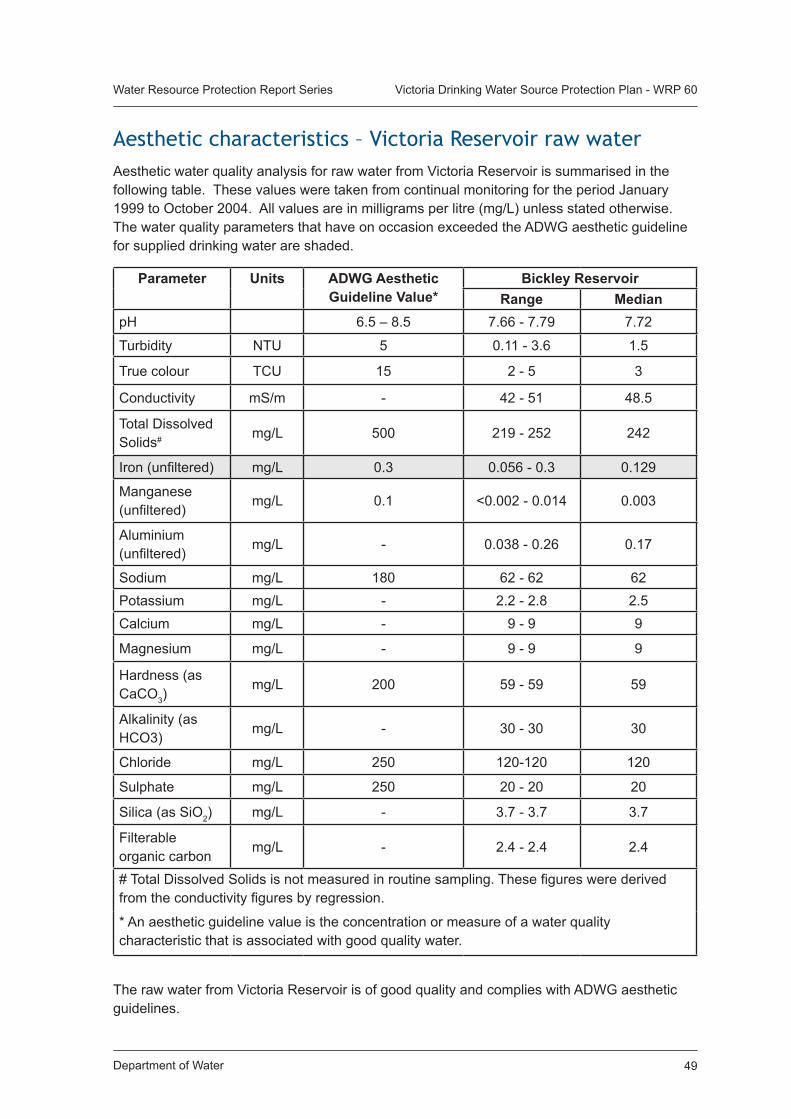
Department of Water 49
Water Resource Protection Report Series Victoria Drinking Water Source Protection Plan - WRP 60
Aesthetic characteristics – Victoria Reservoir raw waterAesthetic water quality analysis for raw water from Victoria Reservoir is summarised in the following table. These values were taken from continual monitoring for the period January 1999 to October 2004. All values are in milligrams per litre (mg/L) unless stated otherwise. The water quality parameters that have on occasion exceeded the ADWG aesthetic guideline for supplied drinking water are shaded.
Parameter Units ADWG Aesthetic Guideline Value*
Bickley ReservoirRange Median
pH 6.5 – 8.5 7.66 - 7.79 7.72
Turbidity NTU 5 0.11 - 3.6 1.5
True colour TCU 15 2 - 5 3
Conductivity mS/m - 42 - 51 48.5
Total Dissolved Solids# mg/L 500 219 - 252 242
Iron (unfiltered) mg/L 0.3 0.056 - 0.3 0.129
Manganese (unfiltered)
mg/L 0.1 <0.002 - 0.014 0.003
Aluminium (unfiltered)
mg/L - 0.038 - 0.26 0.17
Sodium mg/L 180 62 - 62 62Potassium mg/L - 2.2 - 2.8 2.5Calcium mg/L - 9 - 9 9
Magnesium mg/L - 9 - 9 9
Hardness (as CaCO3)
mg/L 200 59 - 59 59
Alkalinity (as HCO3)
mg/L - 30 - 30 30
Chloride mg/L 250 120-120 120
Sulphate mg/L 250 20 - 20 20
Silica (as SiO2) mg/L - 3.7 - 3.7 3.7
Filterable organic carbon
mg/L - 2.4 - 2.4 2.4
# Total Dissolved Solids is not measured in routine sampling. These figures were derived from the conductivity figures by regression.
* An aesthetic guideline value is the concentration or measure of a water quality characteristic that is associated with good quality water.
The raw water from Victoria Reservoir is of good quality and complies with ADWG aesthetic guidelines.
Department of Water50
Water Resource Protection Report Series Victoria Drinking Water Source Protection Plan - WRP 60
Appendix 2 Best Management Practice Documents for Activities in PDWSAs
Waste Management:• Health Department of Western Australia, 6/1999, Understanding Septic Tank Systems.
Environmental Health Guide, Environmental Health Service EHS 29. Available from: www.population.health.wa.gov.au.
• Health Department of Western Australia, 9/1998, Aerobic Treatment Units. Environmental Health Guide, Environmental Health Service EHS 26. Available from: www.population.health.wa.gov.au.
Drainage:Overland runoff should not be channelled into streams. Infiltration into soil should be aided at every opportunity. • Lloyd, B. and Van Delft, R., 2001, Erosion and Sediment Control Manual for the Darling
Range, Perth Western Australia. Upper Canning/Southern Wungong Catchment Team, Agriculture WA.
Buffers:Vegetated buffers should be maintained along all streamlines, whether currently flowing or not.• Department of Conservation and Land Management, 1999, Manual of Management
Guidelines for Timber Harvesting in Western Australia, Department of Conservation and Land Management. Available from: www.naturebase.net/forest_facts/sy_review/manuals/manual_of_harvesting_specifications/index.html.
• National Health & Medical Research Council and Agriculture & Resource Management Council of Australia and New Zealand, 1996, Australian Drinking Water Guidelines, NHMRC and ARMCANZ. Available from: www.nhmrc.gov.au/publications/synopses/eh19syn.htm.
• Water and Rivers Commission, 2001, A Review of Stream and River Logging Buffers in Western Australia, to Ensure their Adequacy in Protecting Waterways from Salinity, Degradation and Turbidity, Water and Rivers Commission report to the Conservation Commission of Western Australia.
Pesticide Application:Should be minimised in catchment areas. For specific needs of crops and best practice contact Department of Agriculture.• Health Department of WA, 1993, Use of Herbicides in Public Drinking Water Source
Areas. PSC 88 (Public Service Circular 88). Government of Western Australia. Available from: www.population.health.wa.gov.au/environmental/resources/use%20of%20herbicides%20in%20water%20catchment%20areas.pdf.
• Water and Rivers Commission, 2000, Statewide Policy No. 2 Pesticide Use in Public Drinking Water Source Areas, Water and Rivers Commission. Available from: www.water.wa.gov.au.
• Water and Rivers Commission, 2001, Draft Water Quality Protection Note Pesticide Use in Sensitive Environments, Water and Rivers Commission. Available from: http://www.water.wa.gov.au
Department of Water 51
Water Resource Protection Report Series Victoria Drinking Water Source Protection Plan - WRP 60
Nutrient Application:Should be minimised in catchment areas. For specific needs of crops contact Department of Agriculture.
• Water and Rivers Commission, 1998, Water Quality Protection Note: Nutrient and Irrigation Management Plan, Water and Rivers Commission. Available from: www.water.wa.gov.au.
Forest Management:• Department of Conservation and Land Management, 1999, Manual of Management
Guidelines for Timber Harvesting in Western Australia, Department of Conservation and Land Management, Available from: www.naturebase.net/forest_facts/sy_review/manuals/manual_of_harvesting_specifications/index.html.
• Department of Conservation and Land Management, 1999, Code of Practice for Timber Harvesting in Western Australia, Department of Conservation and Land Management. Available from: www.naturebase.net/forest_facts/sy_review/manuals/code_of_harvesting_manual/code_timberharv_practice.pdf.
• Australian Forest Growers, 1997, Code of Practice for Timber Plantations in Western Australia, Australian Forest Growers, Department of Conservation and Land Management.
• Forest Products Commission, 2003, Contractors’ Timber Harvesting Manual – South West Native Forests, Forest Products Commission.
Forest Fire Management:Control burning should be conducted on a scale and at a frequency to minimise erosion with overland runoff into reservoirs. Therefore, only small proportions of land in a catchment should be burnt in any one year. Guidelines on how to address water quality protection objectives in the Controlled Burning Prescription should be documented by CALM, Department of Water and Water Corporation.
Bauxite Mining:• White, A, 2001, Bauxite Mining Operations. Environmental Management Manual
Document No: 42354. Alcoa World Alumina - Australia.
• Water and Rivers Commission, 2000, Water Quality Protection Guidelines (Nos 1 – 11): Mining and Mineral Processing, Water and Rivers Commission. Available from: www.water.wa.gov.au.
Motor Rally Events:• Water Corporation, 2002, Managing Motoring Events in Catchments, Draft. Source
Protection Operations Management Manual SG 097.2. Water Corporation.
• Water and Rivers Commission, 2003, Policy and Guidelines for Recreation within Public Drinking Water Source Areas on Crown Land, Statewide Policy No. 13. Water and Rivers Commission. Available from: www.water.wa.gov.au.
Mechanical Servicing and Workshops:• Water and Rivers Commission, 2002, Water Quality Protection Note Mechanical
Equipment Washdown, Water and Rivers Commission. Available from: http://www.water.wa.gov.au
Department of Water52
Water Resource Protection Report Series Victoria Drinking Water Source Protection Plan - WRP 60
• Water and Rivers Commission, 2002, Water Quality Protection Note Mechanical Servicing and Workshops, Water and Rivers Commission. Available from: http://www.water.wa.gov.au.
Recreation in PDWSAs:• Water and Rivers Commission, 2003, Policy and Guidelines for Recreation within Public
Drinking Water Source Areas on Crown Land, Statewide Policy No. 13. Water and Rivers Commission. Available from: www.water.wa.gov.au.
Horse Facilities and Activities:• Water and Rivers Commission, Western Australian Horse Council (Inc), Department of
Environmental Protection, Department of Health, 2002. Environmental Management Guidelines for Horse Facilities and Activities. WQP Guideline 13. Available from: http://www.water.wa.gov.au
Research Projects:Participants should be educated on personal hygiene in a PDWSA and erosion prevention, prior to any activity occurring.
Major Roads, Roads and Tracks, Infrastructure Maintenance:Drainage must be controlled to prevent soil erosion and minimise sediment transport. Chemical application to control vegetation should be minimised.• Lloyd, B. and Van Delft, R., 2001, Erosion and Sediment Control Manual for the Darling
Range, Perth Western Australia. Upper Canning/Southern Wungong Catchment Team, Department of Agriculture.
Extractive Industries / Gravel Pits:• Water and Rivers Commission, 2000, Water Quality Protection Note: Extractive Industries
within Public Drinking Water Source Areas, Water and Rivers Commission. Available from: www.water.wa.gov.au.
Chemical and Fuel Storage: • Water and Rivers Commission, 1999, Water Quality Protection Note Above Ground
Chemical Storage Tanks within Public Drinking Water Source Areas, Water and Rivers Commission.
• Water and Rivers Commission, 1998, Water Quality Protection Note Temporary Skid Mounted Fuel Transfer and Storage within Public Drinking Water Source Areas, Water and Rivers Commission.
• Water and Rivers Commission, 2000, Water Quality Protection Note Temporary Above Ground Chemical Storage within Public Drinking Water Source Areas, Water and Rivers Commission.
• Water and Rivers Commission, 1998, Water Quality Protection Note Temporary Above Ground Fuel Storage within Public Drinking Water Source Areas, Water and Rivers Commission.
• Water and Rivers Commission, 2002, Water Quality Protection Note Toxic and Hazardous Substances Storage within Public Drinking Water Source Areas, Water and Rivers Commission.
• Water and Rivers Commission, 2002, Water Quality Protection Note Chemical Spills – Emergency Response Planning, Water and Rivers Commission.
Available from: http://drinkingwater.water.wa.gov.au
Department of Water 53
Water Resource Protection Report Series Victoria Drinking Water Source Protection Plan - WRP 60
Publication feedback formThe Department of Water welcomes feedback to help us improve the quality and effectiveness of our publications. Your assistance in completing this form would be greatly appreciated.
Please consider each question carefully and rate them on a 1 to 5 scale, where 1 is poor and 5 is excellent (please circle the appropriate number).
How did you rate the quality of information?
1 2 3 4 5
How did you rate the design and presentation of this publication?
1 2 3 4 5
How can it be improved?
How effective did you find the tables and figures in communicating the data?
1 2 3 4 5
How can they be improved?
If you would like to see this publication in other formats, please specify. (e.g. CD)
Please cut along the dotted line on the left and return your completed response to:
Communications Manager Department of Water Perth Western Australia 6842 Phone: (08) 6364 7600 Fax: (08) 6364 7601
Government of Western AustraliaDepartment of Water
��������������������������������REPORT NO.60 JUNE 2006
Victoria Reservoir Catchment Area Drinking Water Source Protection PlanIntegrated Water Supply System
www.water.wa.gov.au