Embed Size (px)
Citation preview
(revised, March, 2017)
OK. Fire up Google Earth Pro (GE)
Note, if you’re at home and haven’t installed GE-pro, just google “download google earth”, get it, install. Seriously, grab the pro version – it has way more capability. Also, this lab is based roughly on one created at Southwestern College in Chula Vista, CA (couldn’t find an author).
From here, let’s get a handle on some of the basic features of GE. There are a few questions scattered throughout. Answer them as you get there. Those answers will be what you turn in! Note, all I want to see in what you turn in are the questions and your answers – delete all the other stuff when finished. It will make it a lot easier for me to grade. And you will get a better grade.
GE is a friendly, 3D, internet-based geographic mapping application. It was originally developed by Keyhole Inc., located in Silicon Valley. In 2004, Google bought Keyhole and released Google Earth in 2005. The generic term for this is a Digital Earth (or Globe). There are a couple of other similar applications out there, but none are as good or popular.
A bit of the basics:
There are three operational panels to the left of the screen, navigational controls to the right, and the map view in the middle.
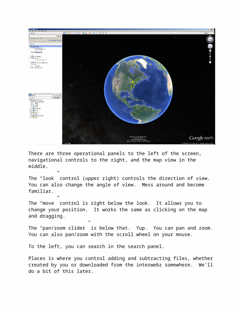
The “look” control (upper right) controls the direction of view. You can also change the angle of view. Mess around and become familiar.
The “move” control is right below the look. It allows you to change your position. It works the same as clicking on the map and dragging.
The “pan/zoom slider” is below that. Yup. You can pan and zoom. You can also pan/zoom with the scroll wheel on your mouse.
To the left, you can search in the search panel.
Places is where you control adding and subtracting files, whether created by you or downloaded from the interwebz somewhere. We’ll do a bit of this later.
Finally, in the bottom left are the layers you can turn on and off. Mess around – there’s a freaking ton of cool stuff here.
Up top are a series of buttons. Some we’ll get to, others not. But it’s worth checking out. More on some later as we go through a series of questions. You will hand in the answers to the italicized questions.
Stuff to do:
1. Fly to Ellensburg by typing “Ellensburg, WA” into the search box and hitting enter (or the search button). Welcome to paradise.
2. From the layers section, be sure that borders and labels, places, photos, and 3D buildings are turned on. Just for giggles. Check out some of the photos. A number are from moi (or students). Bonus to anyone finding the epic photo of two great horned owls taken on campus.
3. OK. In the olden days (a couple of years ago), the only 3D building on GE were ones drafted by individuals and posted up to GE. These days, Google has some sort of automated algorithm which automatically generates everything in 3D. Very cool, but no longer is the work my students did in Ellensburg visible. Make sure 3D buildings are on. Now, answer the following
Question 1a: Approximately when was the 3D imagery taken? Note, I don’t see a date on it, so you will need to figure out when it was based on what’s happening on campus, in Elensburg, etc.
Question 1b – what is the approximate extent of 3D imagery in the Ellensburg area. Yup, you’ll need to zoom in/out, move around, etc.
Question 1c – what is the date of the most recent non-3D imagery? (turn 3D off and look at the bottom of the window).
4. Muck around a bit more and see what you can see in 3D. It’s cool.
Now, time to explore part of the world in 3D.
1. Fly to the Grand Canyon by entering Grand Canyon in the search box. Play with the look and zoom so that you can literally see in 3D and pan/zoom down the canyon.
2. Now for the fun part. And you may never have a geography prof tell you to play games. Yup, time for the flight simulator. Fire that up by going to Tools – Enter Flight Simulator. I suggest you pick the little prop plane. And read the help. Thoroughly. And perhaps take a few notes. Then fire it up and fly. Prepare to crash. But with a little patience, YOU can FLY! And if you can’t and want some pro assistance, go see Dr. Bowen – he’s amazing with flight simulator.
3. Now, do the same for Seattle. Make sure 3D buildings are turned on. Buzz the Space Needle and EMP. Just for fun.
4. Now, Question 2 – write down your opinions regarding both what you can see in GE and the flight simulator. This should be a good half a page.
Remember projections, datums, and coordinate systems? As you might think, they’re pretty dang important (not really the projection, as you’re looking at a pseudo 3d system, but the others have to be spot on, or none of this cool data would overlay properly. So, you ask, where is all this exciting information? The answer is to goto tools – Options. Go there. Check it out. There are all kinds of preferences you can set.
Question 3 – which coordinate systems are available for you to use?
Now, it’s time to get down and personal. Zoom to your house by typing the full address into the search bar. Because you want to be able to get here quickly in the future, add a placemark (the pushpin button at the top). Move it to the right spot (on top of your house) and give it a name. You will see it appear in your “Places” part of the screen (middle left). To prove you did this, take a screenshot and paste it into your word/answers document: Question 4). At the moment, this placemark is temporary and will go away when you quit GE. However, you will have the option to save placemarks when you exit GE, but don’t if you’re in the lab.
Distance time.
Question 5: Using the “show ruler” button (it looks like a ruler), tell me the straight line distance between your house and Dean Hall. In miles. And kilometers.
Let’s add directions to this distance. Head back up to the search area. You will see “get directions.” Click on it. Type in your home address and “Dean Hall, CWU, Ellensburg, WA” Hit enter. Question 6: what is the road distance from your home to Dean Hall. In miles.
Just for fun. And because data is born free. Check out both Area 51 and Camp David (two different places). The coordinates of A51 (copy/paste into search) are 37.249361, -115.812339. A search on “camp david” will get you to the presidential retreat. Question 7: What does Area 51 look like to you (shopping mall, lake, etc)? Note, this is the old school 3D. Someone drafted a bunch of buildings and uploaded them. They aren’t GE’s new 3D everywhere stuff.
But… even more important… where’s the nearest pizza joint to your house????? Type “pizza Ellesburg” (or whatever town you happen to live in). You will see a bunch pop up. Question 8: how accurate is this search? Did they get the closest one to you? Anything missing?
Because the Earth is boring. Let’s goto Mars! Goto View – Explore – Mars. Check it out. Now, search for Curiosity Rover – check out where it was, some pics, etc. Just because it’s freaking cool. Question 9: What was the most interesting thing you saw on Mars?
Back to Earth...Clearly, there are a lot of good and fascinating Google Applications. If you are a biologist, there are many applications already developed for Google Earth (see Additional Google Earth Applications below). The same is true for geologists, geographers, astronomers, and historians. As noted at the beginning of this exercise, a lot of organizations now contribute to the Google Earth dataset.
One of the datasets we find in Google Earth is "Animal Tracking"... In the Layers window, click the "+" sign next to the "Ocean" layer. Scroll down and click on the "Animal Tracking" layer. Now, double click on the shark. On your map, you will see a shark icon off the coast of California. Click on the shark. This particular white shark has been tagged and is being monitored. It is a 400 cm (13 foot) long female white shark! On the top right hand corner of the pop-up window, click on the "Quickly" link. You are now under the sea following along with the moving shark! Get out of this view. Now, there are a whole ton of fish icons visible. Click on a few of them and “download track” – this shows where they’ve traveled. And there are a lot more species being tracked than just sharks – some go a looong ways.
Google Earth has done a nice job of incorporating bottom topography. You can now swim under the sea and get a nice perspective of the underwater topography. Try turning on a few of the other layers just to see some of the canned data. The shipwrecks are especially cool.
More Advanced Google Earth ApplicationsThe Bird Flu Example
Bird flu is a contagious, viral infection that can affect all species of birds. The contagious virus lives primarily in the respiratory system in the infected birds, and human infection occurs when people come into contact with infected birds or contaminated surfaces. There are thought to be millions of migratory ducks and wildfowl which carry the disease. Worldwide, according to the World Health Organization, more than 135 human infections of the virus have been recorded. On November 16, 2005, Nature Magazine's Senior Reporter Declan Butler thoroughly researched the Avian Flu outbreak and published the confirmed cases of Avian Flu in a Google Earth file. His avian outbreak map includes Human cases, and a time series of placemarks showing the progression of the flu over the proceeding18 months.
a) Follow the link http://www.nature.com/nature/googleearth/avianflu1.kml to open the avian flu file. When prompted, click "Open". Google Earth will automatically launch. Head to Turkey.
b) In the “Places” panel, (if it is not already on) click on the box next to "H5N1 distribution maps;” By the way, you can also click on the link "Read me first" (found in the Places panel) to read about the Avian flu. You may notice that there were quite a few human cases that happened in the first several months of 2006 in the Middle East. For each case, you can "query" it to learn more information about that area. To do so, click on the symbol in the location that you are interested/
Question 10: Describe the geographic and seasonal patterns of the bird flu for both bird and human cases in the Middle East.
Question 11: According to the maps, what regions are the most impacted by the bird flu (Hint: Use the poultry density map)?
Google GalleryTurn off the Avian Flu layer by click on the box next to "H5N1 distribution maps;" in the Places panel. Next, go to: http://earthquake.usgs.gov/earthquakes/feed/v1.0/ This takes you directly to the United States Geologic Survey (USGS) earthquake data page. Now, you can see earthquakes occurring all over the world in real time (note: This will map out earthquake occurrences and magnitudes during the past 7 days). Click on the Google Earth KML link. The next page gives you a couple of automatic feeds and some static ones. Fire up the past 7 days, colored by age. Check out what is happening in CA, the western US, and around the world. As this is a real-time feed, it’s a great site when it gets exciting somewhere in the world. Note, your zoom level determines what you see. You need to zoom in a fair bit before you start seeing the smaller quakes appear.
Question 12: Have any earthquakes occurred in California, OR, WA, Alaska, or Japan during the past week? Are they high magnitude, small magnitude, or a combination of everything?
Final Thoughts Regarding the Gallery of ApplicationsNow, a bajillion folks have spent time posting info on GE. Google has posted some of this. Wander by https://maps.google.com/gallery/?hl=en and see what’s there. Any that you click on will open in a Google Maps window, To see this in GE nowadays, you would need to download the data as a kml and then open that in GE. No need to do this now. However, spend some time exploring at least two of the different maps/applications on this page.
Question 13: Give a quick summary (both what you viewed and what you liked/disliked) of two apps.