Embed Size (px)
Citation preview
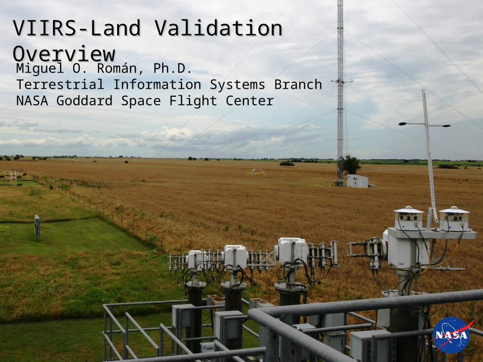
VIIRS-Land Validation OverviewVIIRS-Land Validation OverviewMiguel O. Román, Ph.D.Terrestrial Information Systems BranchNASA Goddard Space Flight Center
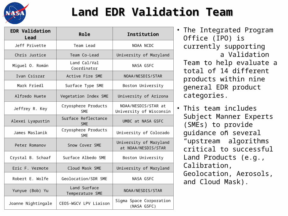
EDR Validation LeadEDR Validation Lead RoleRole InstitutionInstitution
Jeff Privette Team Lead NOAA NCDC
Chris Justice Team Co-Lead University of Maryland
Miguel O. Román Land Cal/Val Coordinator NASA GSFC
Ivan Csiszar Active Fire SME NOAA/NESDIS/STAR
Mark Friedl Surface Type SME Boston University
Alfredo Huete Vegetation Index SME University of Arizona
Jeffrey R. Key Cryosphere Products SMENOAA/NESDIS/STAR at University of Wisconsin
Alexei Lyapustin Surface Reflectance SME UMBC at NASA GSFC
James Maslanik Cryosphere Products SME University of Colorado
Peter Romanov Snow Cover SMEUniversity of Maryland at
NOAA/NESDIS/STAR
Crystal B. Schaaf Surface Albedo SME Boston University
Eric F. Vermote Cloud Mask SME University of Maryland
Robert E. Wolfe Geolocation/SDR SME NASA GSFC
Yunyue (Bob) YuLand Surface Temperature
SMENOAA/NESDIS/STAR
Joanne Nightingale CEOS-WGCV LPV LiaisonSigma Space Corporation
(NASA GSFC)
Land EDR Validation TeamLand EDR Validation Team
• The Integrated Program Office (IPO) is currently supporting a Validation Team to help evaluate a total of 14 different products within nine general EDR product categories.
• This team includes Subject Manner Experts (SMEs) to provide guidance on several “upstream” algorithms critical to successful Land Products (e.g., Calibration, Geolocation, Aerosols, and Cloud Mask).
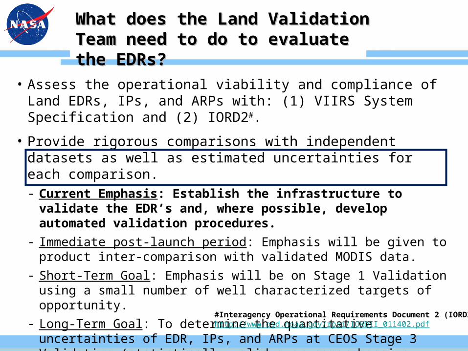
What does the Land Validation Team What does the Land Validation Team need to do to evaluate the EDRs?need to do to evaluate the EDRs?
• Assess the operational viability and compliance of Land EDRs, IPs, and ARPs with: (1) VIIRS System Specification and (2) IORD2#.
• Provide rigorous comparisons with independent datasets as well as estimated uncertainties for each comparison.- Current Emphasis: Establish the infrastructure to validate the EDR’s
and, where possible, develop automated validation procedures.
- Immediate post-launch period: Emphasis will be given to product inter-comparison with validated MODIS data.
- Short-Term Goal: Emphasis will be on Stage 1 Validation using a small number of well characterized targets of opportunity.
- Long-Term Goal: To determine the quantitative uncertainties of EDR, IPs, and ARPs at CEOS Stage 3 Validation (statistically valid over comprehensive range of environmental conditions).
#Interagency Operational Requirements Document 2 (IORD2)http://www.osd.noaa.gov/rpsi/IORDII_011402.pdf
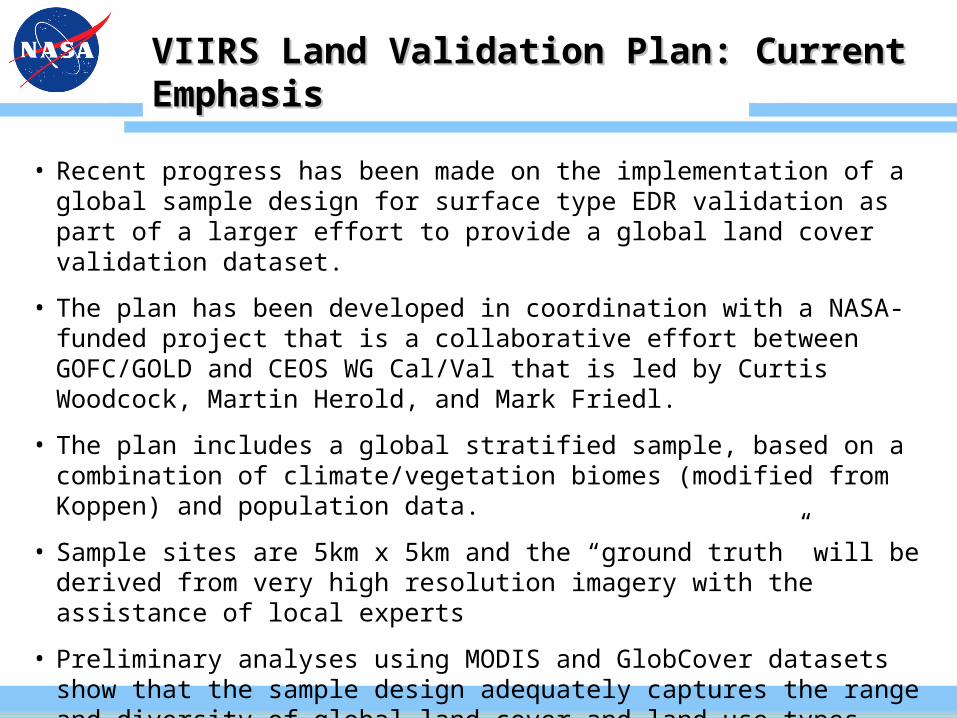
VIIRS Land Validation Plan: Current EmphasisVIIRS Land Validation Plan: Current Emphasis
• Recent progress has been made on the implementation of a global sample design for surface type EDR validation as part of a larger effort to provide a global land cover validation dataset.
• The plan has been developed in coordination with a NASA-funded project that is a collaborative effort between GOFC/GOLD and CEOS WG Cal/Val that is led by Curtis Woodcock, Martin Herold, and Mark Friedl.
• The plan includes a global stratified sample, based on a combination of climate/vegetation biomes (modified from Koppen) and population data.
• Sample sites are 5km x 5km and the “ground truth” will be derived from very high resolution imagery with the assistance of local experts
• Preliminary analyses using MODIS and GlobCover datasets show that the sample design adequately captures the range and diversity of global land cover and land use types.
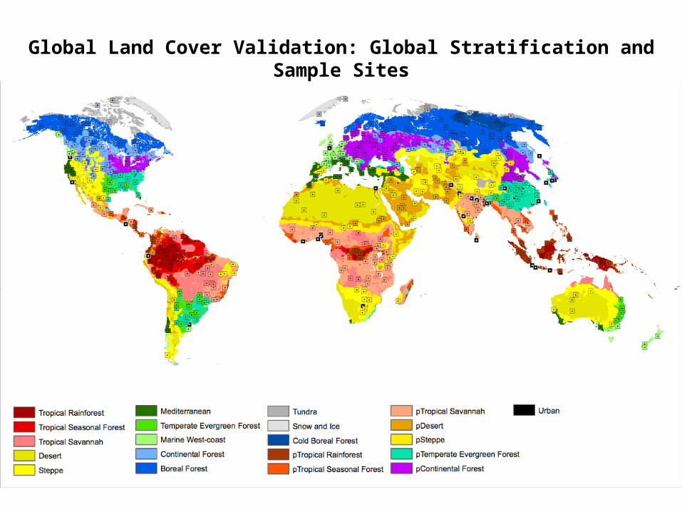
Global Land Cover Validation: Global Stratification and Sample Sites
VIIRS Land Validation Plan: Current EmphasisVIIRS Land Validation Plan: Current Emphasis
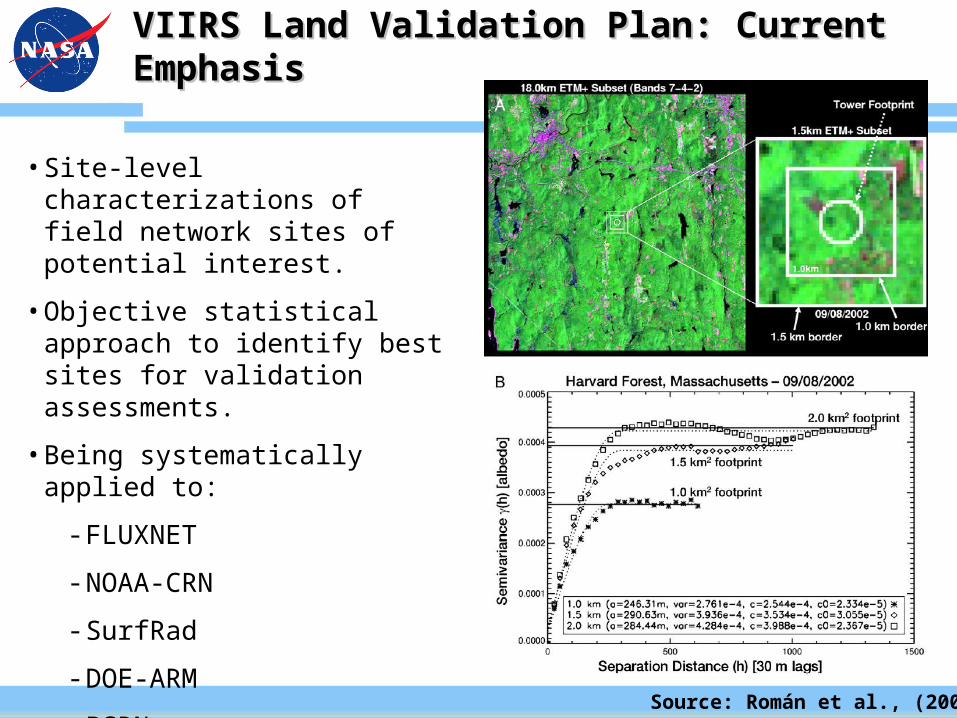
• Site-level characterizations of field network sites of potential interest.
• Objective statistical approach to identify best sites for validation assessments.
• Being systematically applied to:
- FLUXNET
- NOAA-CRN
- SurfRad
- DOE-ARM
- BSRN
Source: Román et al., (2009)
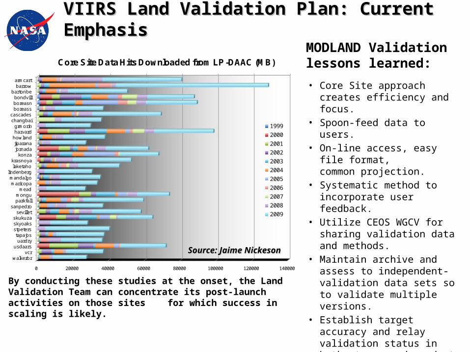
0 20000 40000 60000 80000 100000 120000 140000
armcartbarrow
bartonbebondvillboreasnboreass
cascadeschangbaigrmorinharvardhowlandjiparanajornadakonza
krasnoyalaketaho
lindenbergmandalgomaricopa
meadmonguparkfall
sanpedrosevillet
skukuzaskyoaksstpeterstapajosuardry
usdaarsvcr
walkerbr
Core Site Data Hits Downloaded from LP-DAAC (MB)
1999
2000
2001
2002
2003
2004
2005
2006
2007
2008
2009
VIIRS Land Validation Plan: Current EmphasisVIIRS Land Validation Plan: Current Emphasis
By conducting these studies at the onset, the Land Validation Team can concentrate its post-launch activities on those sites for which success in scaling is likely.
Source: Jaime NickesonSource: Jaime Nickeson
MODLAND Validation lessons learned:
• Core Site approach creates efficiency and focus.
• Spoon-feed data to users.• On-line access, easy file format,
common projection.• Systematic method to
incorporate user feedback.• Utilize CEOS WGCV for sharing
validation data and methods.• Maintain archive and assess to
independent-validation data sets so to validate multiple versions.
• Establish target accuracy and relay validation status in both stages and product accuracy.
• Plan field campaigns no sooner than ~6 months after launch.
• Utilize intermediate spatial-scale resolution imagery.
VIIRS Land Validation Plan: Current EmphasisVIIRS Land Validation Plan: Current Emphasis
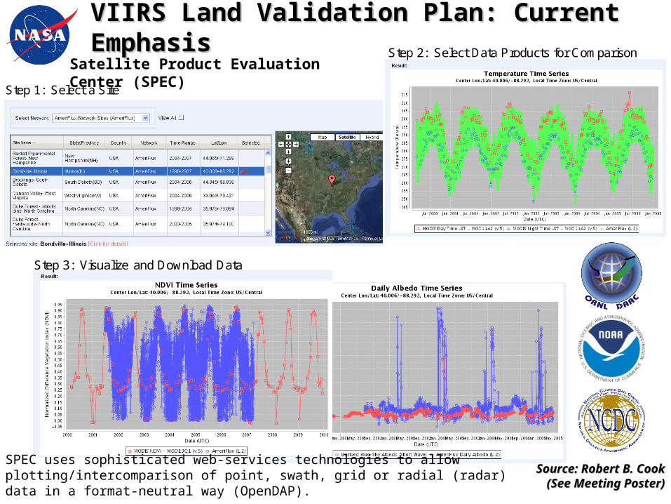
Step 1: Select a Site
Step 2: Select Data Products for Comparison
Step 3: Visualize and Download Data
Source: Robert B. CookSource: Robert B. Cook(See Meeting Poster)(See Meeting Poster)
Satellite Product Evaluation Center (SPEC)
SPEC uses sophisticated web-services technologies to allow plotting/intercomparison of point, swath, grid or radial (radar) data in a format-neutral way (OpenDAP).
NASA’s Role in Validation of VIIRSNASA’s Role in Validation of VIIRS
• The NPP mission will provide an important benchmark to test the assumption that a VIIRS land product suite can be generated that is suitable for climate research applications and will provide continuity with the EOS MODIS instrument.
• This will require a more extensive set of activities and expertise including:
- Assessments of consistency with long term data records (e.g. Surface Reflectance, NDVI), temporally smoothed and gap-filled land products (e.g. annual phenology, LAI/FPAR).
- Evaluations of other EOS-era products (e.g. spectral surface albedo, burned area, and BRDF products).
- Cal/Val analysis, coordination between dependent products, and validation science activities in support of the generation and refinement of VIIRS Land Science Products.
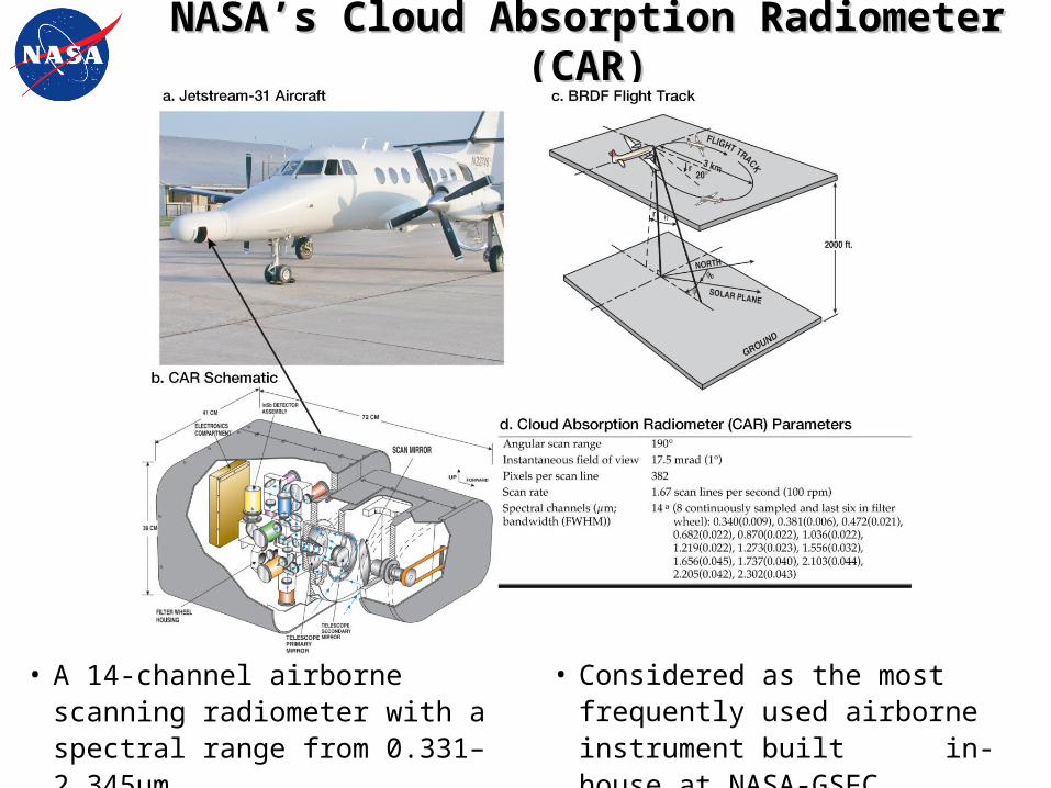
NASA’s Cloud Absorption Radiometer (CAR)NASA’s Cloud Absorption Radiometer (CAR)
• A 14-channel airborne scanning radiometer with a spectral range from 0.331– 2.345μm.
• Considered as the most frequently used airborne instrument built in-house at NASA-GSFC.
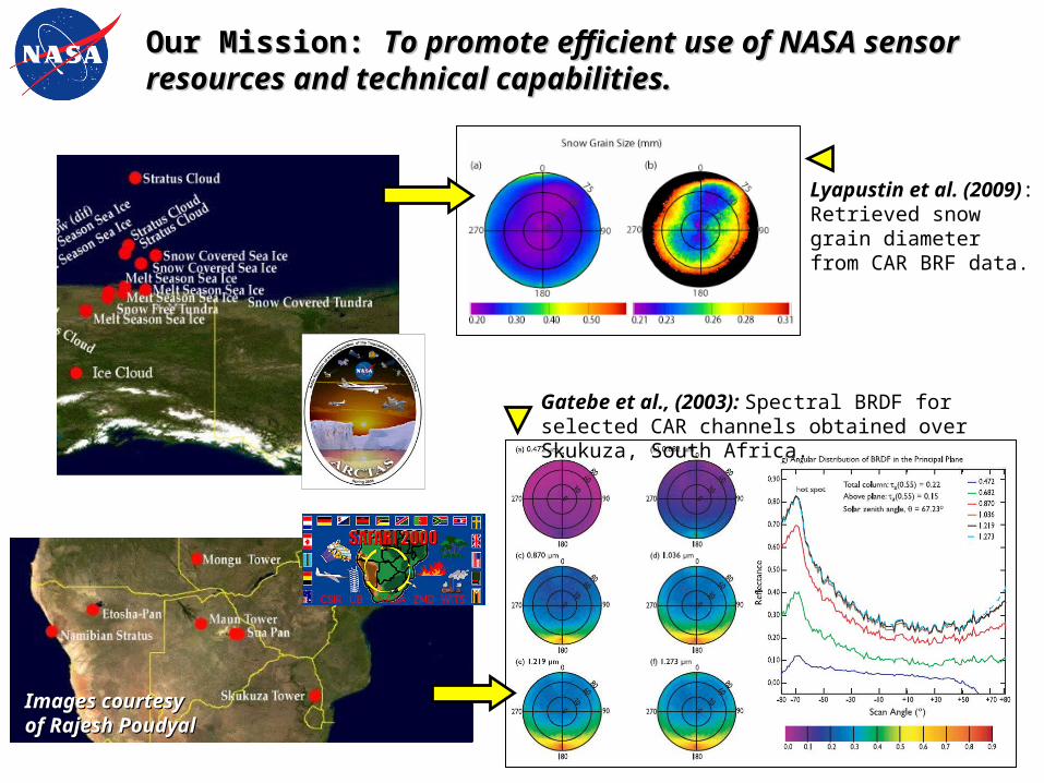
Our Mission: Our Mission: To promote efficient use of NASA sensor To promote efficient use of NASA sensor resources and technical capabilities.resources and technical capabilities.
Images courtesyImages courtesyof Rajesh Poudyalof Rajesh Poudyal
Lyapustin et al. (2009):Retrieved snow grain diameter from CAR BRF data.
Gatebe et al., (2003): Spectral BRDF for selected CAR channels obtained over Skukuza, South Africa.
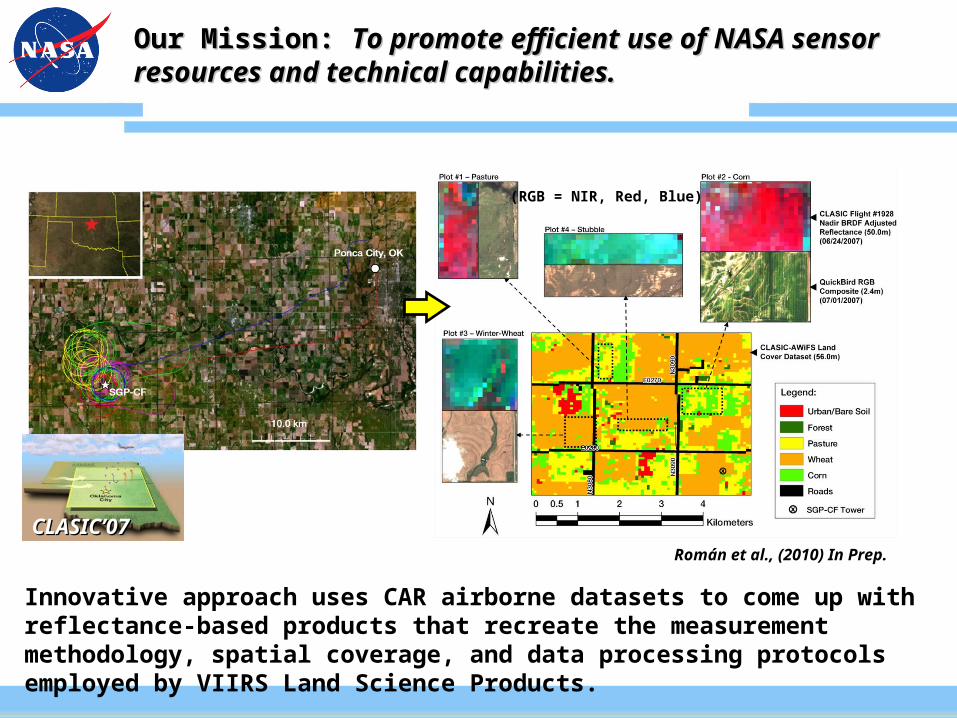
Our Mission: Our Mission: To promote efficient use of NASA sensor To promote efficient use of NASA sensor resources and technical capabilities.resources and technical capabilities.
Innovative approach uses CAR airborne datasets to come up with reflectance-based products that recreate the measurement methodology, spatial coverage, and data processing protocols employed by VIIRS Land Science Products.
Román et al., (2010) In Prep.
CLASIC’07CLASIC’07
(RGB = NIR, Red, Blue)
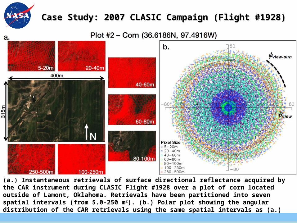
(a.) Instantaneous retrievals of surface directional reflectance acquired by the CAR instrument during CLASIC Flight #1928 over a plot of corn located outside of Lamont, Oklahoma. Retrievals have been partitioned into seven spatial intervals (from 5.0-250 m2). (b.) Polar plot showing the angular distribution of the CAR retrievals using the same spatial intervals as (a.)
Case Study: 2007 CLASIC Campaign (Flight #1928)Case Study: 2007 CLASIC Campaign (Flight #1928)
Case Study: 2007 CLASIC Campaign (Flight #1928)Case Study: 2007 CLASIC Campaign (Flight #1928)
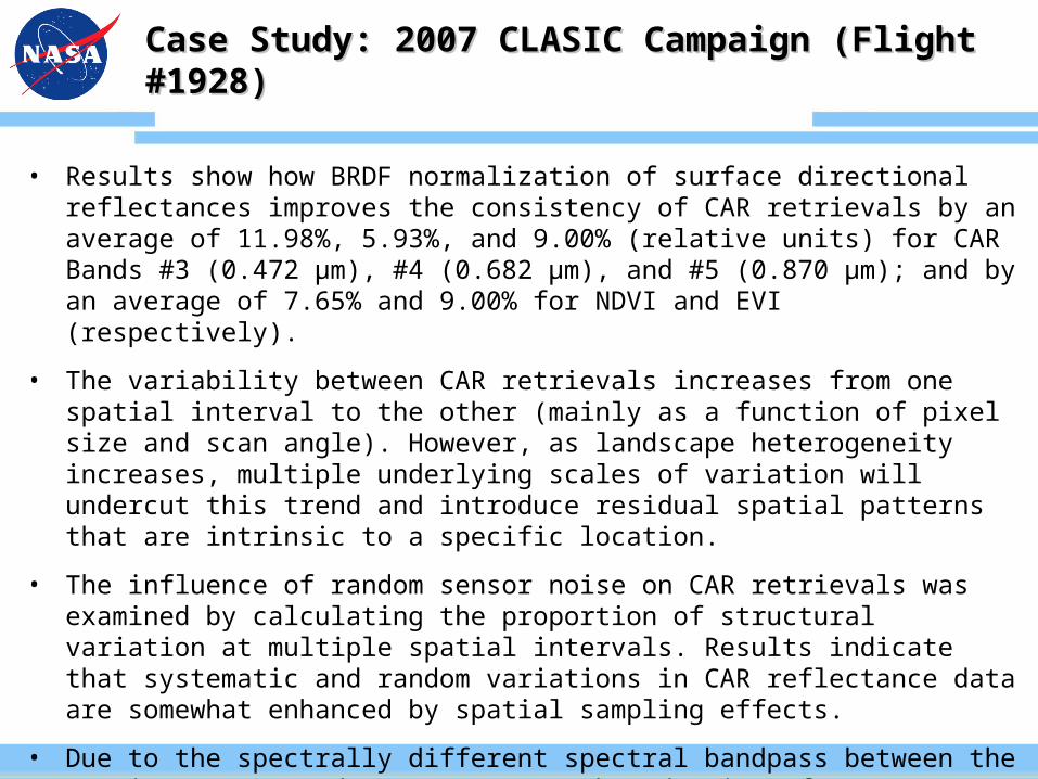
• Results show how BRDF normalization of surface directional reflectances improves the consistency of CAR retrievals by an average of 11.98%, 5.93%, and 9.00% (relative units) for CAR Bands #3 (0.472 µm), #4 (0.682 µm), and #5 (0.870 µm); and by an average of 7.65% and 9.00% for NDVI and EVI (respectively).
• The variability between CAR retrievals increases from one spatial interval to the other (mainly as a function of pixel size and scan angle). However, as landscape heterogeneity increases, multiple underlying scales of variation will undercut this trend and introduce residual spatial patterns that are intrinsic to a specific location.
• The influence of random sensor noise on CAR retrievals was examined by calculating the proportion of structural variation at multiple spatial intervals. Results indicate that systematic and random variations in CAR reflectance data are somewhat enhanced by spatial sampling effects.
• Due to the spectrally different spectral bandpass between the CAR instrument and MODIS sensor, the adoption of MODIS-EVI coefficients resulted in additional retrieval uncertainties of ~5.15% relative to NDVI.
What type of support should NASA provide?What type of support should NASA provide?
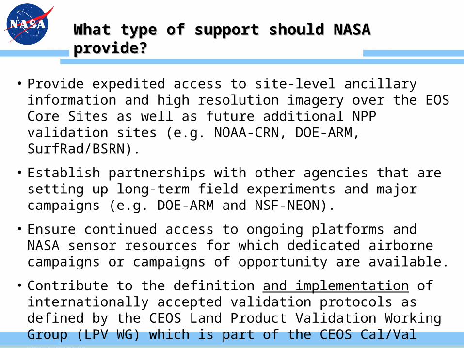
• Provide expedited access to site-level ancillary information and high resolution imagery over the EOS Core Sites as well as future additional NPP validation sites (e.g. NOAA-CRN, DOE-ARM, SurfRad/BSRN).
• Establish partnerships with other agencies that are setting up long-term field experiments and major campaigns (e.g. DOE-ARM and NSF-NEON).
• Ensure continued access to ongoing platforms and NASA sensor resources for which dedicated airborne campaigns or campaigns of opportunity are available.
• Contribute to the definition and implementation of internationally accepted validation protocols as defined by the CEOS Land Product Validation Working Group (LPV WG) which is part of the CEOS Cal/Val program.