Embed Size (px)
Citation preview
VIMS‐CCRM Coastal Management Decision Tools Decision Tree for Undefended Shorelines and Those with Failed Structures
Center for Coastal Resources Management Virginia Institute of Marine Science
Gloucester Point, VA April 22, 2010
1
Table of Contents
VIMS‐CCRM COASTAL MANAGEMENT DECISION TOOLS ................................................................................................... 2
INTRODUCTION ............................................................................................................................................................................ 2 INTEGRATED SHORELINE MANAGEMENT ............................................................................................................................................ 2 USE OF THIS MANUAL .................................................................................................................................................................... 4 EXCEPTIONS ................................................................................................................................................................................ 4
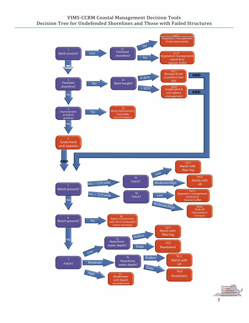
DECISION TREE DIAGRAM ................................................................................................................................................ 5
DECISION TREE DESCRIPTIONS AND EXPLANATIONS ........................................................................................................ 6
HOW TO USE THIS SECTION............................................................................................................................................................. 6 1. WHAT TYPE OF BANK EROSION IS PRESENT? ................................................................................................................................... 6 1A. IS THE SHORELINE FORESTED? ................................................................................................................................................... 8 2. IS THE SHORELINE FORESTED? ................................................................................................................................................... 10 2A. WHAT IS THE BANK HEIGHT? ................................................................................................................................................... 11 3. DOES STRUCTURE OR OTHER IMPROVEMENT LOCATION PROHIBIT GRADING? ...................................................................................... 14 5. IS THERE A MARSH PRESENT? .................................................................................................................................................... 16 5A. HOW LONG IS THE FETCH? ...................................................................................................................................................... 18 5B. HOW LONG IS THE FETCH? ...................................................................................................................................................... 20 6. IS THERE A BEACH PRESENT? ..................................................................................................................................................... 22 7. HOW LONG IS THE FETCH? ....................................................................................................................................................... 23 7A. WHAT IS THE NEARSHORE WATER DEPTH? ................................................................................................................................. 25 7B. WHAT IS THE NEARSHORE WATER DEPTH? ................................................................................................................................. 26 7C. CONSTRUCT A BREAKWATER AND ADD BEACH NOURISHMENT ........................................................................................................ 27
APPENDIX: WORKSHEET ‐ DECISION TREE FOR UNDEFENDED SHORELINES AND THOSE WITH FAILED STRUCTURES ....... A‐1
APPENDIX: WORKSHEET – DECISIO TREE DEFINITIONS ................................................................................................ A‐3 N
2
VIMS‐CCRM Coastal Management Decision Tools Decision Tree for Undefended Shorelines nd Those with Failed Structures a
Introduction The Center for Coastal Resources Management is developing a new suite of tools intended to help regulators, property owners, and others make decisions regarding coastal resources. This manual describes the first component, a shoreline management decision tree for undefended shorelines and those with failed shoreline structures (such as bulkheads and riprap revetments). The decision tree is similar to the dichotomous keys used by biologists and naturalists to identify plants and animals. A tree-like graph of questions and answers about shoreline characteristics leads the user to the environmentally preferable approach for management of that shoreline. Comparable tools are in development for the full suite of activities/actions affecting tidal shorelines and tidal waters, such as shorelines that are already defended, dredging projects, boat ramps, and marinas. Integrated shoreline management This decision tree is driven by the principle of “integrated shoreline management,” based on the concept that all elements of the shoreline should be considered simultaneously when making a decision. This allows one to make decisions that optimize the natural functions of the shoreline, while still reducing risk to upland structures from intense or long term erosion. Natural shorelines tend to be dynamic and interconnected with the surrounding landscape and plant and animal life. The intertidal, riparian and subaqueous areas of the shoreline system provide numerous water quality, habitat and erosion control benefits. Choices made about how land is used can affect the extent and health of tidal wetlands, beaches and riparian buffers and thereby the populations of important resources such as blue crabs and striped bass. Any action taken on the shoreline has the potential to adversely affect ecosystem services onsite as well as on a larger scale. Shoreline management actions may increase risk on adjacent and downdrift shorelines; therefore, activities that impact subaqueous, intertidal and riparian zones should be avoided whenever possible. When erosion along a shoreline has the potential to result in significant loss of property and upland improvement, the consideration of shoreline erosion protection activities may be appropriate.
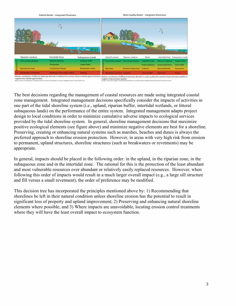
The best decisions regarding the management of coastal resources are made using integrated coastal zone management. Integrated management decisions specifically consider the impacts of activities in one part of the tidal shoreline system (i.e., upland, riparian buffer, intertidal wetlands, or littoral subaqueous lands) on the performance of the entire system. Integrated management adapts project design to local conditions in order to minimize cumulative adverse impacts to ecological services provided by the tidal shoreline system. In general, shoreline management decisions that maximize positive ecological elements (see figure above) and minimize negative elements are best for a shoreline. Preserving, creating or enhancing natural systems such as marshes, beaches and dunes is always the preferred approach to shoreline erosion protection. However, in areas with very high risk from erosion to permanent, upland structures, shoreline structures (such as breakwaters or revetments) may be appropriate. In general, impacts should be placed in the following order: in the upland, in the riparian zone, in the subaqueous zone and in the intertidal zone. The rational for this is the protection of the least abundant and most vulnerable resources over abundant or relatively easily replaced resources. However, when following this order of impacts would result in a much larger overall impact (e.g., a large sill structure and fill versus a small revetment), the order of preference may be modified. This decision tree has incorporated the principles mentioned above by: 1) Recommending that shorelines be left in their natural condition unless shoreline erosion has the potential to result in significant loss of property and upland improvement; 2) Preserving and enhancing natural shoreline elements where possible; and 3) Where impacts are unavoidable, locating erosion control treatments where they will have the least overall impact to ecosystem function.
3
4
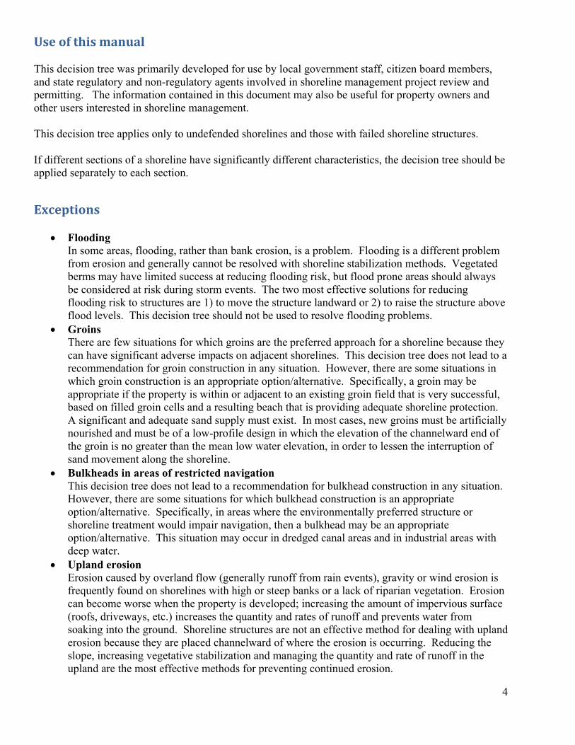
Use of this manual This decision tree was primarily developed for use by local government staff, citizen board members, and state regulatory and non-regulatory agents involved in shoreline management project review and permitting. The information contained in this document may also be useful for property owners and other users interested in shoreline management. This decision tree applies only to undefended shorelines and those with failed shoreline structures. If different sections of a shoreline have significantly different characteristics, the decision tree should be applied separately to each section.
Exceptions
• Flooding In some areas, flooding, rather than bank erosion, is a problem. Flooding is a different problem from erosion and generally cannot be resolved with shoreline stabilization methods. Vegetated berms may have limited success at reducing flooding risk, but flood prone areas should always be considered at risk during storm events. The two most effective solutions for reducing flooding risk to structures are 1) to move the structure landward or 2) to raise the structure above flood levels. This decision tree should not be used to resolve flooding problems.
• Groins There are few situations for which groins are the preferred approach for a shoreline because they can have significant adverse impacts on adjacent shorelines. This decision tree does not lead to a recommendation for groin construction in any situation. However, there are some situations in which groin construction is an appropriate option/alternative. Specifically, a groin may be appropriate if the property is within or adjacent to an existing groin field that is very successful, based on filled groin cells and a resulting beach that is providing adequate shoreline protection. A significant and adequate sand supply must exist. In most cases, new groins must be artificially nourished and must be of a low-profile design in which the elevation of the channelward end of the groin is no greater than the mean low water elevation, in order to lessen the interruption of sand movement along the shoreline.
• Bulkheads in areas of restricted navigation This decision tree does not lead to a recommendation for bulkhead construction in any situation. However, there are some situations for which bulkhead construction is an appropriate option/alternative. Specifically, in areas where the environmentally preferred structure or shoreline treatment would impair navigation, then a bulkhead may be an appropriate option/alternative. This situation may occur in dredged canal areas and in industrial areas with deep water.
• Upland erosion Erosion caused by overland flow (generally runoff from rain events), gravity or wind erosion is frequently found on shorelines with high or steep banks or a lack of riparian vegetation. Erosion can become worse when the property is developed; increasing the amount of impervious surface (roofs, driveways, etc.) increases the quantity and rates of runoff and prevents water from soaking into the ground. Shoreline structures are not an effective method for dealing with upland erosion because they are placed channelward of where the erosion is occurring. Reducing the slope, increasing vegetative stabilization and managing the quantity and rate of runoff in the upland are the most effective methods for preventing continued erosion.
5
VIMS‐CCRM Coastal Management Decision Tools Decision Tree for Undefended Shorelines and Those with Failed Structures
Decision Tree Descriptions and Explanations
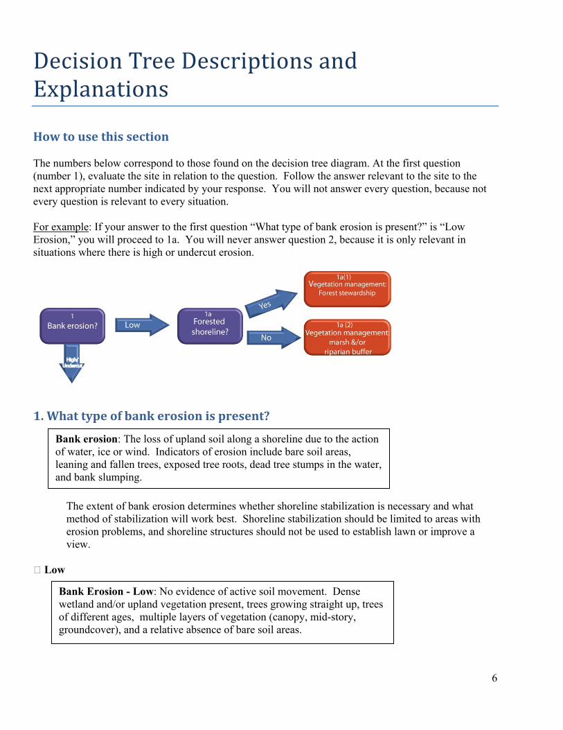
How to use this section The numbers below correspond to those found on the decision tree diagram. At the first question (number 1), evaluate the site in relation to the question. Follow the answer relevant to the site to the next appropriate number indicated by your response. You will not answer every question, because not every question is relevant to every situation. For example: If your answer to the first question “What type of bank erosion is present?” is “Low Erosion,” you will proceed to 1a. You will never answer question 2, because it is only relevant in situations where there is high or undercut erosion.
6
1. What type of bank erosion is present?
Bank erosion: The loss of upland soil along a shoreline due to the action of water, ice or wind. Indicators of erosion include bare soil areas, leaning and fallen trees, exposed tree roots, dead tree stumps in the water, and bank slumping.
The extent of bank erosion determines whether shoreline stabilization is necessary and what method of stabilization will work best. Shoreline stabilization should be limited to areas with erosion problems, and shoreline structures should not be used to establish lawn or improve a view.
Low
Bank Erosion - Low: No evidence of active soil movement. Dense wetland and/or upland vegetation present, trees growing straight up, trees of different ages, multiple layers of vegetation (canopy, mid-story, groundcover), and a relative absence of bare soil areas.
7
Bank erosion - low
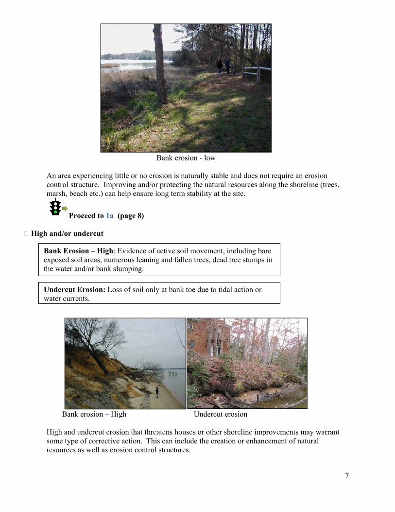
An area experiencing little or no erosion is naturally stable and does not require an erosion control structure. Improving and/or protecting the natural resources along the shoreline (trees, marsh, beach etc.) can help ensure long term stability at the site.
Proceed to 1a (page 8) High and/or undercut
Bank Erosion – High: Evidence of active soil movement, including bare exposed soil areas, numerous leaning and fallen trees, dead tree stumps in the water and/or bank slumping.
Undercut Erosion: Loss of soil only at bank toe due to tidal action or
water currents.
Bank erosion – High Undercut erosion
High and undercut erosion that threatens houses or other shoreline improvements may warrant some type of corrective action. This can include the creation or enhancement of natural resources as well as erosion control structures.
Proceed to 2 (page 10)
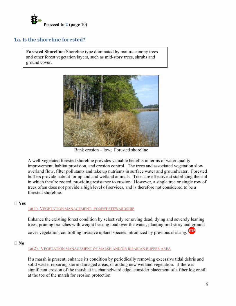
1a. Is the shoreline forested?
Forested Shoreline: Shoreline type dominated by mature canopy trees and other forest vegetation layers, such as mid-story trees, shrubs and ground cover.
8
Bank erosion – low; Forested shoreline
A well-vegetated forested shoreline provides valuable benefits in terms of water quality improvement, habitat provision, and erosion control. The trees and associated vegetation slow overland flow, filter pollutants and take up nutrients in surface water and groundwater. Forested buffers provide habitat for upland and wetland animals. Trees are effective at stabilizing the soil in which they’re rooted, providing resistance to erosion. However, a single tree or single row of trees often does not provide a high level of services, and is therefore not considered to be a forested shoreline.
Yes
1a(1). VEGETATION MANAGEMENT: FOREST STEWARDSHIP
Enhance the existing forest condition by selectively removing dead, dying and severely leaning trees, pruning branches with weight bearing load over the water, planting mid-story and ground
cover vegetation, controlling invasive upland species introduced by previous clearing. No 1a(2). VEGETATION MANAGEMENT OF MARSH AND/OR RIPARIAN BUFFER AREA
If a marsh is present, enhance its condition by periodically removing excessive tidal debris and solid waste, repairing storm damaged areas, or adding new wetland vegetation. If there is significant erosion of the marsh at its channelward edge, consider placement of a fiber log or sill at the toe of the marsh for erosion protection.

Enhance the existing riparian buffer condition by adding new trees, shrubs and ground covers;
replace lawn with ornamental grasses, native shrubs and small trees.
9
10
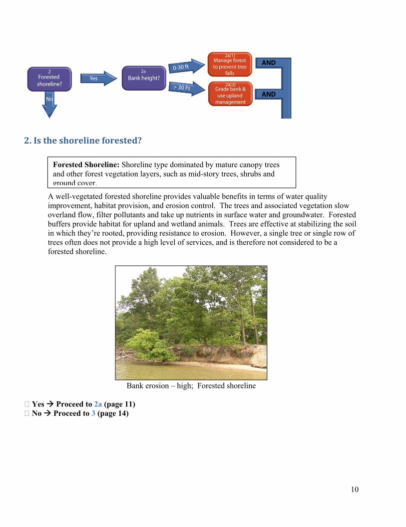
2. Is the shoreline forested? Forested Shoreline: Shoreline type dominated by mature canopy trees
and other forest vegetation layers, such as mid-story trees, shrubs and ground cover.
A well-vegetated forested shoreline provides valuable benefits in terms of water quality improvement, habitat provision, and erosion control. The trees and associated vegetation slow overland flow, filter pollutants and take up nutrients in surface water and groundwater. Forested buffers provide habitat for upland and wetland animals. Trees are effective at stabilizing the soil in which they’re rooted, providing resistance to erosion. However, a single tree or single row of trees often does not provide a high level of services, and is therefore not considered to be a forested shoreline.
Bank erosion – high; Forested shoreline
Yes Proceed to 2a (page 11) No Proceed to 3 (page 14)
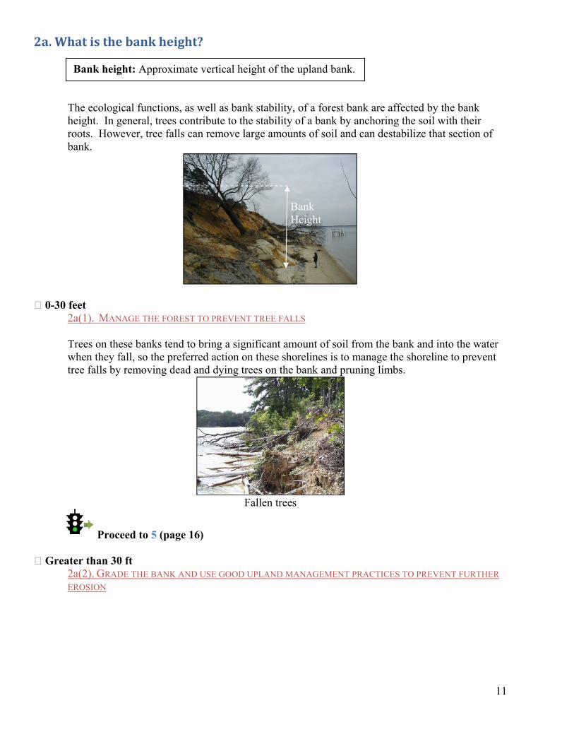
2a. What is the bank height?
11
The ecological functions, as well as bank stability, of a forest bank are affected by the bank height. In general, trees contribute to the stability of a bank by anchoring the soil with their roots. However, tree falls can remove large amounts of soil and can destabilize that section of bank.
0-30 feet 2a(1). MANAGE THE FOREST TO PREVENT TREE FALLS
Trees on these banks tend to bring a significant amount of soil from the bank and into the water when they fall, so the preferred action on these shorelines is to manage the shoreline to prevent tree falls by removing dead and dying trees on the bank and pruning limbs.
Fallen trees
Proceed to 5 (page 16)
Bank Height
Bank height: Approximate vertical height of the upland bank.
Greater than 30 ft
2a(2). GRADE THE BANK AND USE GOOD UPLAND MANAGEMENT PRACTICES TO PREVENT FURTHER EROSION
12
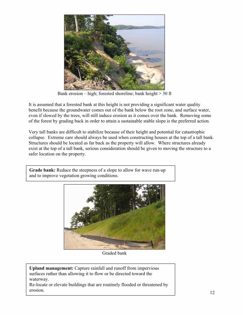
Bank erosion – high; forested shoreline; bank height > 30 ft
It is assumed that a forested bank at this height is not providing a significant water quality benefit because the groundwater comes out of the bank below the root zone, and surface water, even if slowed by the trees, will still induce erosion as it comes over the bank. Removing some of the forest by grading back in order to attain a sustainable stable slope is the preferred action.
Very tall banks are difficult to stabilize because of their height and potential for catastrophic collapse. Extreme care should always be used when constructing houses at the top of a tall bank. Structures should be located as far back as the property will allow. Where structures already exist at the top of a tall bank, serious consideration should be given to moving the structure to a safer location on the property.
Grade bank: Reduce the steepness of a slope to allow for wave run-up and to improve vegetation growing conditions.
Graded bank
Upland management: Capture rainfall and runoff from impervious surfaces rather than allowing it to flow or be directed toward the waterway. Re-locate or elevate buildings that are routinely flooded or threatened by erosion.

13
Examples of upland management strategies are available at Virginia’s Department of Conservation and Recreation’s stormwater management website: http://www.dcr.virginia.gov/soil_and_water/stormwat.shtml.
Proceed to 5 (page 16)
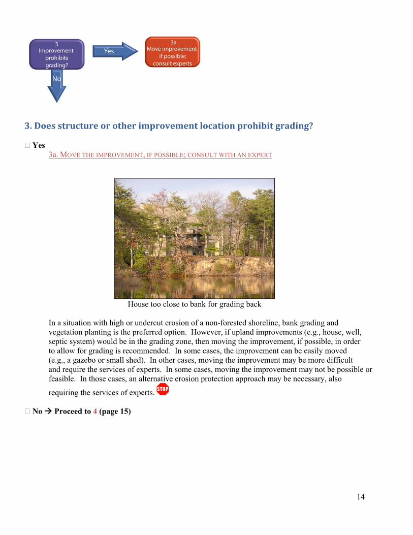
3. Does structure or other improvement location prohibit grading? Yes 3a. MOVE THE IMPROVEMENT, IF POSSIBLE; CONSULT WITH AN EXPERT
14
House too close to bank for grading back
In a situation with high or undercut erosion of a non-forested shoreline, bank grading and vegetation planting is the preferred option. However, if upland improvements (e.g., house, well, septic system) would be in the grading zone, then moving the improvement, if possible, in order to allow for grading is recommended. In some cases, the improvement can be easily moved (e.g., a gazebo or small shed). In other cases, moving the improvement may be more difficult and require the services of experts. In some cases, moving the improvement may not be possible or feasible. In those cases, an alternative erosion protection approach may be necessary, also
requiring the services of experts. No Proceed to 4 (page 15)
15
4. GRADE BANK AND VEGETATE
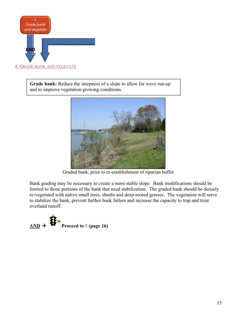
Graded bank, prior to re-establishment of riparian buffer
Bank grading may be necessary to create a more stable slope. Bank modifications should be limited to those portions of the bank that need stabilization. The graded bank should be densely re-vegetated with native small trees, shrubs and deep-rooted grasses. The vegetation will serve to stabilize the bank, prevent further bank failure and increase the capacity to trap and treat overland runoff.
AND Proceed to 5 (page 16)
Grade bank: Reduce the steepness of a slope to allow for wave run-up and to improve vegetation growing conditions.
16
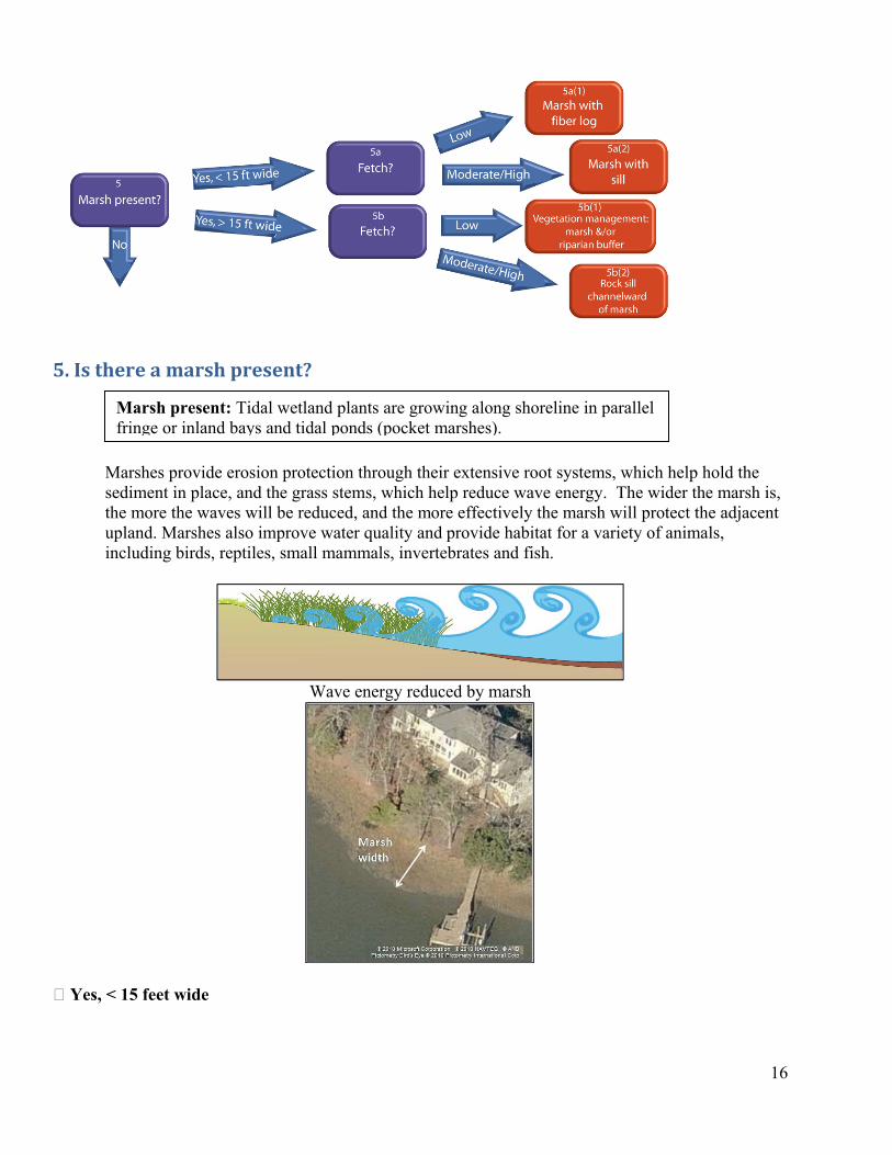
5. Is there a marsh present?
Marsh present: Tidal wetland plants are growing along shoreline in parallel fringe or inland bays and tidal ponds (pocket marshes).
Marshes provide erosion protection through their extensive root systems, which help hold the sediment in place, and the grass stems, which help reduce wave energy. The wider the marsh is, the more the waves will be reduced, and the more effectively the marsh will protect the adjacent upland. Marshes also improve water quality and provide habitat for a variety of animals, including birds, reptiles, small mammals, invertebrates and fish.
Wave energy reduced by marsh
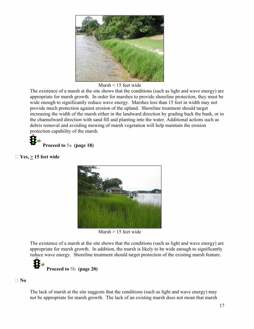
Yes, < 15 feet wide
17
Marsh < 15 feet wide
The existence of a marsh at the site shows that the conditions (such as light and wave energy) are appropriate for marsh growth. In order for marshes to provide shoreline protection, they must be wide enough to significantly reduce wave energy. Marshes less than 15 feet in width may not provide much protection against erosion of the upland. Shoreline treatment should target increasing the width of the marsh either in the landward direction by grading back the bank, or in the channelward direction with sand fill and planting into the water. Additional actions such as debris removal and avoiding mowing of marsh vegetation will help maintain the erosion protection capability of the marsh.
Proceed to 5a (page 18) Yes, > 15 feet wide
Marsh > 15 feet wide
The existence of a marsh at the site shows that the conditions (such as light and wave energy) are appropriate for marsh growth. In addition, the marsh is likely to be wide enough to significantly reduce wave energy. Shoreline treatment should target protection of the existing marsh feature.
Proceed to 5b (page 20) No
The lack of marsh at the site suggests that the conditions (such as light and wave energy) may not be appropriate for marsh growth. The lack of an existing marsh does not mean that marsh
creation at this site cannot be successful, but modifications to either the light regime (tree removal and or bank grading), depth (filling the intertidal zone with sand), wave energy (construction of sills or breakwaters) or potentially all three, may be necessary for success.
Proceed to 6 (page 22)
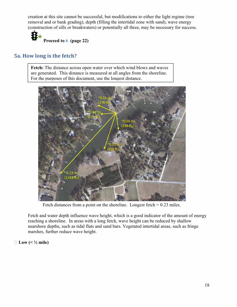
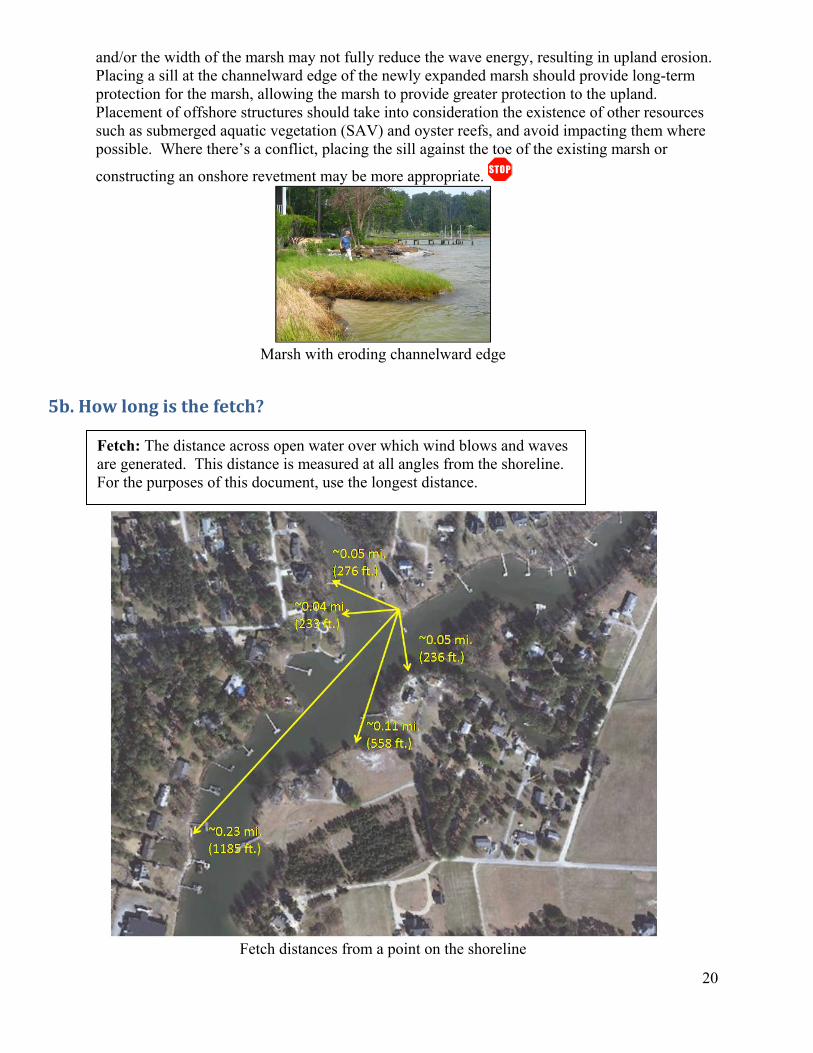
5a. How long is the fetch?
Fetch: The distance across open water over which wind blows and waves are generated. This distance is measured at all angles from the shoreline. For the purposes of this document, use the longest distance.
Fetch distances from a point on the shoreline. Longest fetch = 0.23 miles.
Fetch and water depth influence wave height, which is a good indicator of the amount of energy reaching a shoreline. In areas with a long fetch, wave height can be reduced by shallow nearshore depths, such as tidal flats and sand bars. Vegetated intertidal areas, such as fringe marshes, further reduce wave height.
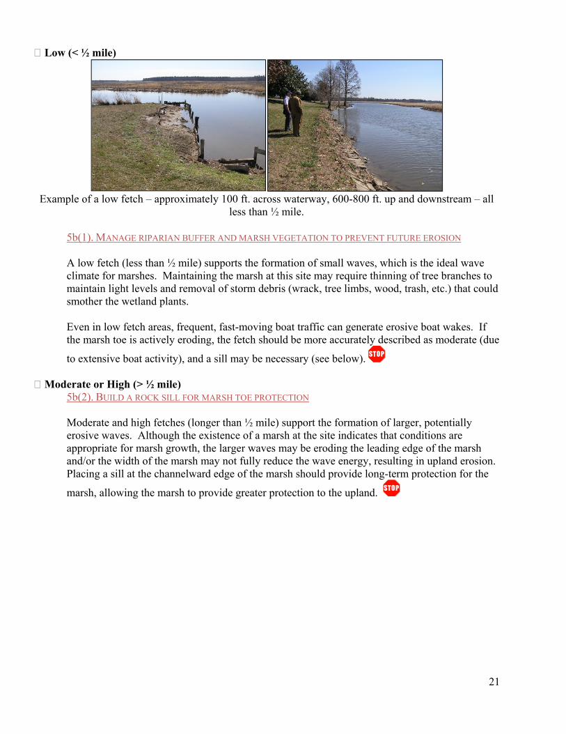
Low (< ½ mile)
18
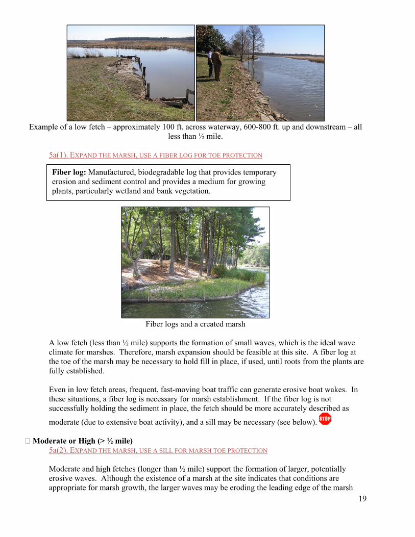
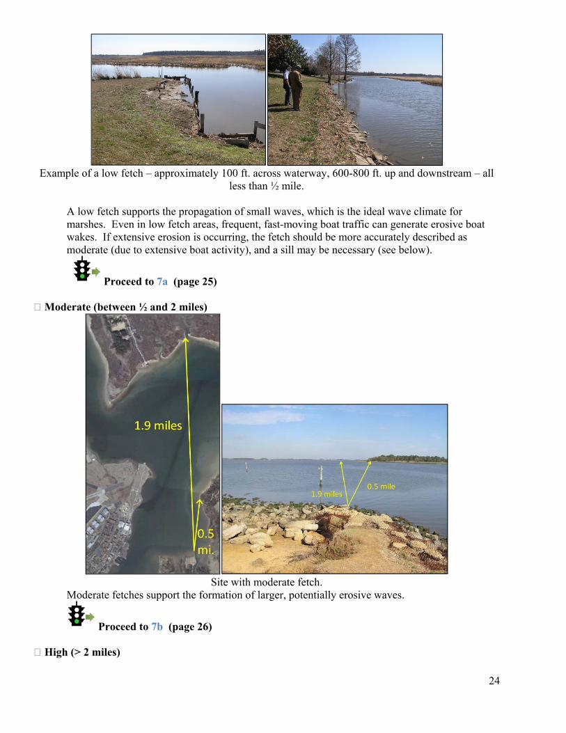
Example of a low fetch – approximately 100 ft. across waterway, 600-800 ft. up and downstream – all
less than ½ mile.
5a(1). EXPAND THE MARSH, USE A FIBER LOG FOR TOE PROTECTION
Fiber log: Manufactured, biodegradable log that provides temporary erosion and sediment control and provides a medium for growing plants, particularly wetland and bank vegetation.
19
Fiber logs and a created marsh
A low fetch (less than ½ mile) supports the formation of small waves, which is the ideal wave climate for marshes. Therefore, marsh expansion should be feasible at this site. A fiber log at the toe of the marsh may be necessary to hold fill in place, if used, until roots from the plants are fully established.
Even in low fetch areas, frequent, fast-moving boat traffic can generate erosive boat wakes. In these situations, a fiber log is necessary for marsh establishment. If the fiber log is not successfully holding the sediment in place, the fetch should be more accurately described as
moderate (due to extensive boat activity), and a sill may be necessary (see below). Moderate or High (> ½ mile)
5a(2). EXPAND THE MARSH, USE A SILL FOR MARSH TOE PROTECTION
Moderate and high fetches (longer than ½ mile) support the formation of larger, potentially erosive waves. Although the existence of a marsh at the site indicates that conditions are appropriate for marsh growth, the larger waves may be eroding the leading edge of the marsh
and/or the width of the marsh may not fully reduce the wave energy, resulting in upland erosion. Placing a sill at the channelward edge of the newly expanded marsh should provide long-term protection for the marsh, allowing the marsh to provide greater protection to the upland. Placement of offshore structures should take into consideration the existence of other resources such as submerged aquatic vegetation (SAV) and oyster reefs, and avoid impacting them where possible. Where there’s a conflict, placing the sill against the toe of the existing marsh or
constructing an onshore revetment may be more appropriate.
Marsh with eroding channelward edge
5b. How long is the fetch?
20
Fetch distances from a point on the shoreline
Fetch: The distance across open water over which wind blows and waves are generated. This distance is measured at all angles from the shoreline. For the purposes of this document, use the longest distance.
Low (< ½ mile)
Example of a low fetch – approximately 100 ft. across waterway, 600-800 ft. up and downstream – all
less than ½ mile.
5b(1). MANAGE RIPARIAN BUFFER AND MARSH VEGETATION TO PREVENT FUTURE EROSION
A low fetch (less than ½ mile) supports the formation of small waves, which is the ideal wave climate for marshes. Maintaining the marsh at this site may require thinning of tree branches to maintain light levels and removal of storm debris (wrack, tree limbs, wood, trash, etc.) that could smother the wetland plants.
Even in low fetch areas, frequent, fast-moving boat traffic can generate erosive boat wakes. If the marsh toe is actively eroding, the fetch should be more accurately described as moderate (due
to extensive boat activity), and a sill may be necessary (see below). Moderate or High (> ½ mile)
5b(2). BUILD A ROCK SILL FOR MARSH TOE PROTECTION
Moderate and high fetches (longer than ½ mile) support the formation of larger, potentially erosive waves. Although the existence of a marsh at the site indicates that conditions are appropriate for marsh growth, the larger waves may be eroding the leading edge of the marsh and/or the width of the marsh may not fully reduce the wave energy, resulting in upland erosion. Placing a sill at the channelward edge of the marsh should provide long-term protection for the
marsh, allowing the marsh to provide greater protection to the upland.
21
22
6. Is there a beach present?
Beaches are sandy shorelines, frequently found in high energy areas. Beaches may be quite wide or very narrow. The common characteristic is the presence of sand. Where the beach is difficult to observe, it may be assumed by the presence of sandy banks, nearshore sand bars, and nearby beaches. The wider the beach is, the more potential for the reduction of wave energy, reducing the potential for storm damage to the upland.
Yes 6a. NOURISH THE BEACH WITH SAND; ADD A SILL OR BREAKWATER WHERE NECESSARY
Beach nourishment enhances the natural capacity of the beach to provide erosion protection by providing distance between the bank and tidal action and allowing for wave run-up. The wider the created beach, the greater the upland protection provided by the nourishment. In areas with active erosion, a sill or breakwater may be used to prevent erosion of the nourishment material.
Allowing the breakwaters to accrete sand naturally steals sand from the existing sand supply and may create or worsen erosion on nearby properties. Artificial beach nourishment allows for the creation of a beach without removal of sand from the system. The material used for artificial nourishment should be clean sand of a grain size composition similar to that currently existing on
the beach. No
Areas without existing beaches are unlikely to have a sand supply, and therefore will support different plant and animal populations than sandy areas. Beaches should not be established in areas that are not already part of a sandy system.
Proceed to 7 (page 23)
23
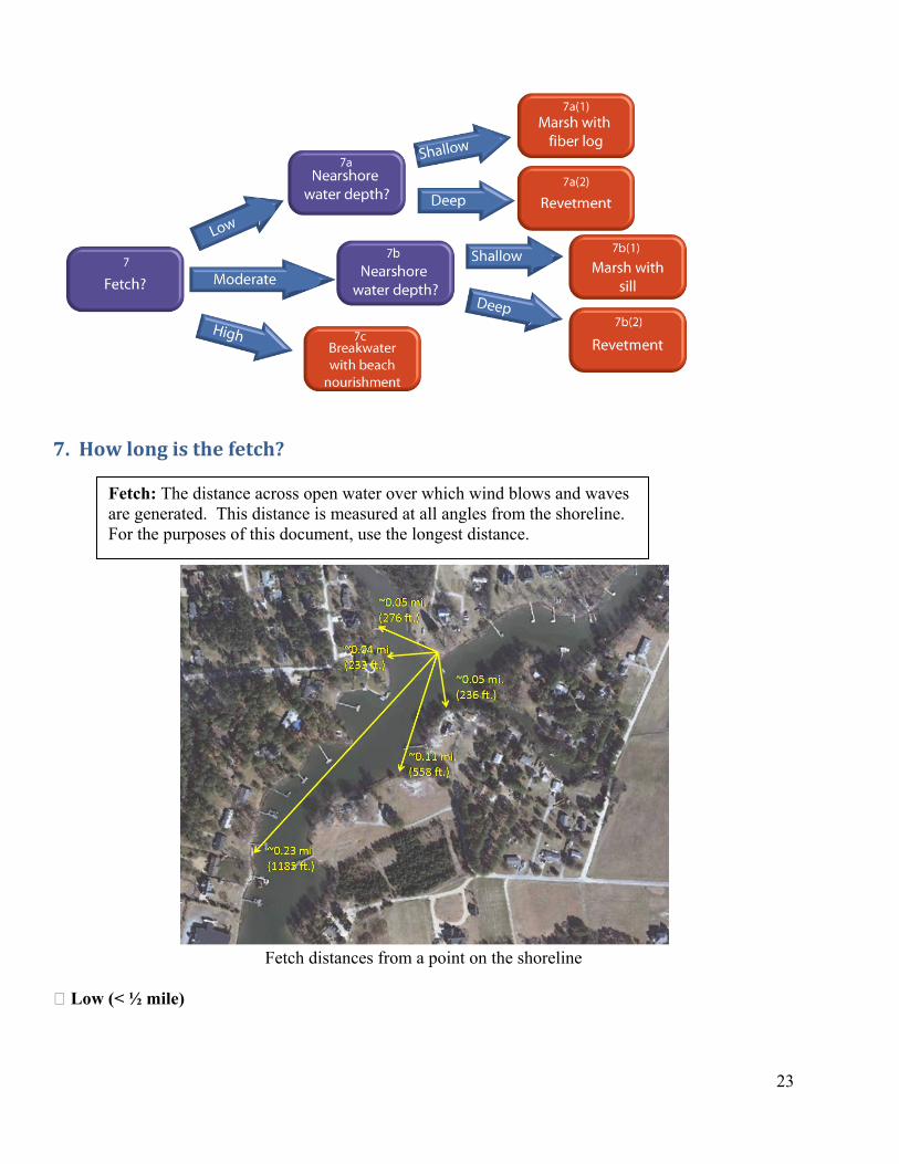
7. How long is the fetch?
Fetch distances from a point on the shoreline
Fetch: The distance across open water over which wind blows and waves are generated. This distance is measured at all angles from the shoreline. For the purposes of this document, use the longest distance.
Low (< ½ mile)
Example of a low fetch – approximately 100 ft. across waterway, 600-800 ft. up and downstream – all
less than ½ mile.
A low fetch supports the propagation of small waves, which is the ideal wave climate for marshes. Even in low fetch areas, frequent, fast-moving boat traffic can generate erosive boat wakes. If extensive erosion is occurring, the fetch should be more accurately described as moderate (due to extensive boat activity), and a sill may be necessary (see below).
Proceed to 7a (page 25)
24
Moderate (between ½ and 2 miles)
Site with moderate fetch.
Moderate fetches support the formation of larger, potentially erosive waves.
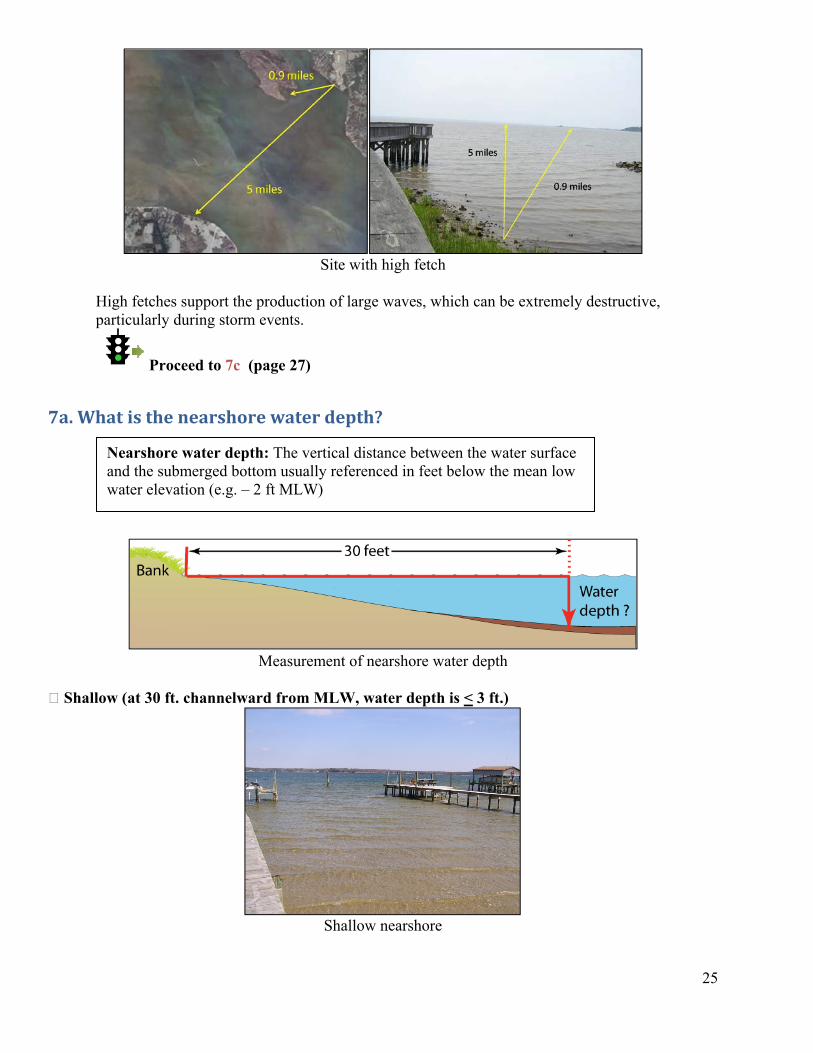
Proceed to 7b (page 26) High (> 2 miles)
25
Site with high fetch
High fetches support the production of large waves, which can be extremely destructive, particularly during storm events.
Proceed to 7c (page 27)
7a. What is the nearshore water depth?
Measurement of nearshore water depth
Shallow (at 30 ft. channelward from MLW, water depth is < 3 ft.)
Shallow nearshore
Nearshore water depth: The vertical distance between the water surface and the submerged bottom usually referenced in feet below the mean low water elevation (e.g. – 2 ft MLW)
7a(1). CREATE A MARSH, PROTECT THE TOE WITH A FIBER LOG
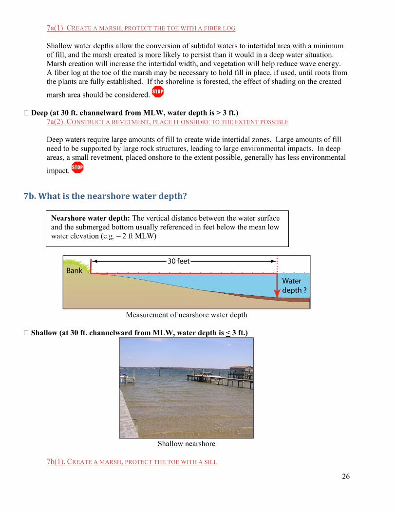
Shallow water depths allow the conversion of subtidal waters to intertidal area with a minimum of fill, and the marsh created is more likely to persist than it would in a deep water situation. Marsh creation will increase the intertidal width, and vegetation will help reduce wave energy. A fiber log at the toe of the marsh may be necessary to hold fill in place, if used, until roots from the plants are fully established. If the shoreline is forested, the effect of shading on the created
marsh area should be considered. Deep (at 30 ft. channelward from MLW, water depth is > 3 ft.)
7a(2). CONSTRUCT A REVETMENT, PLACE IT ONSHORE TO THE EXTENT POSSIBLE
Deep waters require large amounts of fill to create wide intertidal zones. Large amounts of fill need to be supported by large rock structures, leading to large environmental impacts. In deep areas, a small revetment, placed onshore to the extent possible, generally has less environmental
impact.
7b. What is the nearshore water depth?
26
Measurement of nearshore water depth
Shallow (at 30 ft. channelward from MLW, water depth is < 3 ft.)
Shallow nearshore
Nearshore water depth: The vertical distance between the water surface and the submerged bottom usually referenced in feet below the mean low water elevation (e.g. – 2 ft MLW)
7b(1). CREATE A MARSH, PROTECT THE TOE WITH A SILL
Shallow water depths allow the conversion of subtidal waters to intertidal area with a minimum amount of fill, and the marsh created is more likely to persist than it would in a deep water situation. Marsh creation will increase the intertidal width, and vegetation will help reduce wave energy. Placing a sill at the channelward edge of the newly created marsh should provide
long-term protection for the marsh, allowing the marsh to provide protection to the upland. Deep (at 30 ft. channelward from MLW, water depth is > 3 ft.)
7b(2). CONSTRUCT A REVETMENT, PLACE IT ONSHORE TO THE EXTENT POSSIBLE
Revetment: A sloped structure constructed with large, heavy stone or other material placed against the upland bank for erosion protection. The size of a revetment is dictated by the wave height expected to strike the shoreline.
Although an offshore structure and created marsh is generally preferable, using this approach in deep water would require large amounts of fill to create wide intertidal zones. Large amounts of fill would need to be supported by large rock structures, leading to large environmental impacts. Therefore, in deep areas, a small revetment, placed onshore to the extent possible, generally has
less environmental impact.
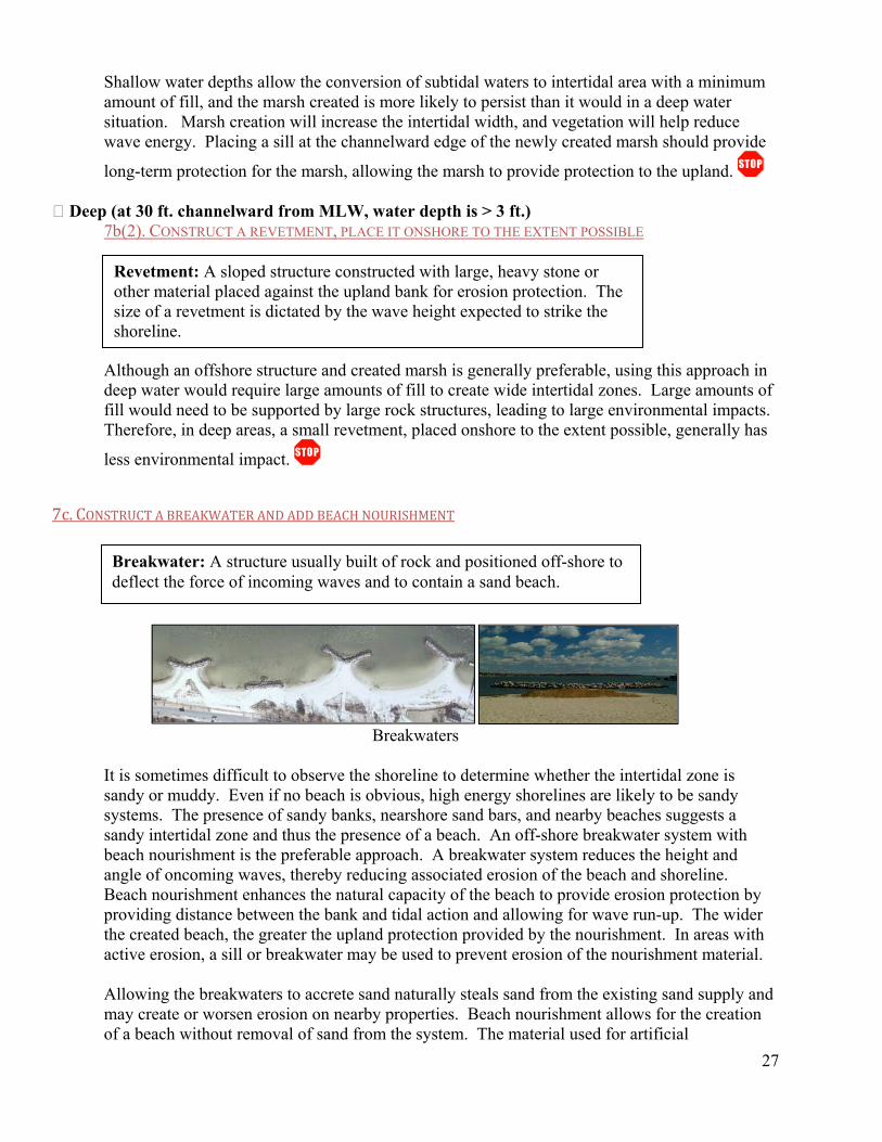
7c. CONSTRUCT A BREAKWATER AND ADD BEACH NOURISHMENT
27
Breakwater: A structure usually built of rock and positioned off-shore to deflect the force of incoming waves and to contain a sand beach.
Breakwaters
It is sometimes difficult to observe the shoreline to determine whether the intertidal zone is sandy or muddy. Even if no beach is obvious, high energy shorelines are likely to be sandy systems. The presence of sandy banks, nearshore sand bars, and nearby beaches suggests a sandy intertidal zone and thus the presence of a beach. An off-shore breakwater system with beach nourishment is the preferable approach. A breakwater system reduces the height and angle of oncoming waves, thereby reducing associated erosion of the beach and shoreline. Beach nourishment enhances the natural capacity of the beach to provide erosion protection by providing distance between the bank and tidal action and allowing for wave run-up. The wider the created beach, the greater the upland protection provided by the nourishment. In areas with active erosion, a sill or breakwater may be used to prevent erosion of the nourishment material.
Allowing the breakwaters to accrete sand naturally steals sand from the existing sand supply and may create or worsen erosion on nearby properties. Beach nourishment allows for the creation of a beach without removal of sand from the system. The material used for artificial

nourishment should be clean sand of a grain size composition similar to that currently existing on the beach.
Placement of offshore structures should take into consideration the existence of other resources such as submerged aquatic vegetation (SAV) and oyster reefs, and avoid impacting them where possible. Where there’s a conflict, constructing an onshore revetment may be more appropriate.
28
A-1
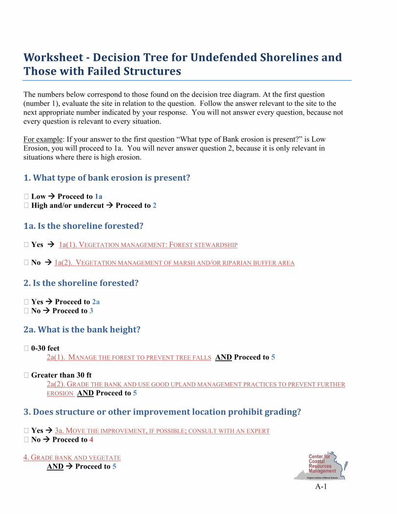
Worksheet Decision Tree for Undefended Shorelines and Those with Failed Structures The numbers below correspond to those found on the decision tree diagram. At the first question (number 1), evaluate the site in relation to the question. Follow the answer relevant to the site to the next appropriate number indicated by your response. You will not answer every question, because not every question is relevant to every situation. For example: If your answer to the first question “What type of Bank erosion is present?” is Low Erosion, you will proceed to 1a. You will never answer question 2, because it is only relevant in situations where there is high erosion. 1. What type of bank erosion is present? Low Proceed to 1a High and/or undercut Proceed to 2 1a. Is the shoreline forested? Yes 1a(1). VEGETATION MANAGEMENT: FOREST STEWARDSHIP No 1a(2). VEGETATION MANAGEMENT OF MARSH AND/OR RIPARIAN BUFFER AREA 2. Is the shoreline forested? Yes Proceed to 2a No Proceed to 3 2a. What is the bank height? 0-30 feet
2a(1). MANAGE THE FOREST TO PREVENT TREE FALLS AND Proceed to 5 Greater than 30 ft
2a(2). GRADE THE BANK AND USE GOOD UPLAND MANAGEMENT PRACTICES TO PREVENT FURTHER EROSION AND Proceed to 5
3. Does structure or other improvement location prohibit grading? Yes 3a. MOVE THE IMPROVEMENT, IF POSSIBLE; CONSULT WITH AN EXPERT No Proceed to 4 4. GRADE BANK AND VEGETATE AND Proceed to 5

A-2
5. Is there a marsh present? Yes, < 15 feet wide Proceed to 5a Yes, > 15 feet wide Proceed to 5b No Proceed to 6 5a. How long is the fetch? Low (< ½ mile)
5a(1). EXPAND THE MARSH, USE A FIBER LOG FOR TOE PROTECTION Moderate or High (> ½ mile)
5a(2). EXPAND THE MARSH, USE A SILL FOR MARSH TOE PROTECTION
5b. How long is the fetch? Low (< ½ mile) 5b(1). MANAGE RIPARIAN BUFFER AND MARSH VEGETATION TO PREVENT FUTURE EROSION Moderate or High (> ½ mile)
5b(2). BUILD A ROCK SILL FOR MARSH TOE PROTECTION 6. Is there a beach present? Yes 6a. NOURISH THE BEACH WITH SAND; ADD A SILL OR BREAKWATER WHERE NECESSARY No Proceed to 7 7. How long is the fetch? Low (< ½ mile) Proceed to 7a Moderate (between ½ and 2 miles) Proceed to 7b High (> 2 miles) Proceed to 7c 7a. What is the nearshore water depth? Shallow (at 30 ft. channelward from MLW, water depth is < 3 ft.) 7a(1). CREATE A MARSH, PROTECT THE TOE WITH A FIBER LOG Deep (at 30 ft. channelward from MLW, water depth is > 3 ft.)
7a(2). CONSTRUCT A REVETMENT, PLACE IT ONSHORE TO THE EXTENT POSSIBLE
7b. What is the nearshore water depth? Shallow (at 30 ft. channelward from MLW, water depth is < 3 ft.)
7b(1). CREATE A MARSH, PROTECT THE TOE WITH A SILL Deep (at 30 ft. channelward from MLW, water depth is > 3 ft.)
7b(2). CONSTRUCT A REVETMENT, PLACE IT ONSHORE TO THE EXTENT POSSIBLE
7c. CONSTRUCT A BREAKWATER AND ADD BEACH NOURISHMENT
A-3
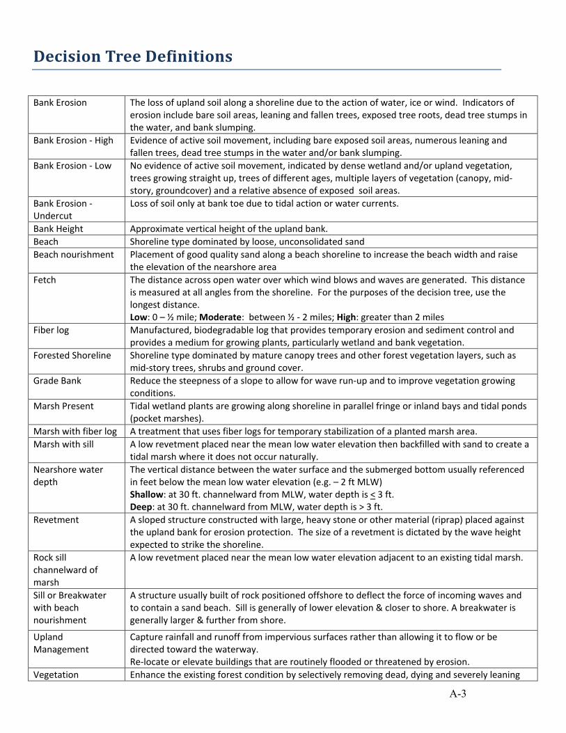
Decision Tree Definitions Bank Erosion The loss of upland soil along a shoreline due to the action of water, ice or wind. Indicators of
erosion include bare soil areas, leaning and fallen trees, exposed tree roots, dead tree stumps in the water, and bank slumping.
Bank Erosion ‐ High Evidence of active soil movement, including bare exposed soil areas, numerous leaning and fallen trees, dead tree stumps in the water and/or bank slumping.
Bank Erosion ‐ Low No evidence of active soil movement, indicated by dense wetland and/or upland vegetation, trees growing straight up, trees of different ages, multiple layers of vegetation (canopy, mid‐story, groundcover) and a relative absence of exposed soil areas.
Bank Erosion ‐ Undercut
Loss of soil only at bank toe due to tidal action or water currents.
Bank Height Approximate vertical height of the upland bank. Beach Shoreline type dominated by loose, unconsolidated sand Beach nourishment Placement of good quality sand along a beach shoreline to increase the beach width and raise
the elevation of the nearshore area Fetch The distance across open water over which wind blows and waves are generated. This distance
is measured at all angles from the shoreline. For the purposes of the decision tree, use the longest distance. Low: 0 – ½ mile; Moderate: between ½ ‐ 2 miles; High: greater than 2 miles
Fiber log Manufactured, biodegradable log that provides temporary erosion and sediment control and provides a medium for growing plants, particularly wetland and bank vegetation.
Forested Shoreline Shoreline type dominated by mature canopy trees and other forest vegetation layers, such as mid‐story trees, shrubs and ground cover.
Grade Bank Reduce the steepness of a slope to allow for wave run‐up and to improve vegetation growing conditions.
Marsh Present
Tidal wetland plants are growing along shoreline in parallel fringe or inland bays and tidal ponds (pocket marshes).
Marsh with fiber log A treatment that uses fiber logs for temporary stabilization of a planted marsh area. Marsh with sill A low revetment placed near the mean low water elevation then backfilled with sand to create a
tidal marsh where it does not occur naturally. Nearshore water depth
The vertical distance between the water surface and the submerged bottom usually referenced in feet below the mean low water elevation (e.g. – 2 ft MLW) Shallow: at 30 ft. channelward from MLW, water depth is < 3 ft. Deep: at 30 ft. channelward from MLW, water depth is > 3 ft.
Revetment A sloped structure constructed with large, heavy stone or other material (riprap) placed against the upland bank for erosion protection. The size of a revetment is dictated by the wave height expected to strike the shoreline.
Rock sill channelward of marsh
A low revetment placed near the mean low water elevation adjacent to an existing tidal marsh.
Sill or Breakwater with beach nourishment
A structure usually built of rock positioned offshore to deflect the force of incoming waves and to contain a sand beach. Sill is generally of lower elevation & closer to shore. A breakwater is generally larger & further from shore.
Upland Management
Capture rainfall and runoff from impervious surfaces rather than allowing it to flow or be directed toward the waterway. Re‐locate or elevate buildings that are routinely flooded or threatened by erosion.
Vegetation Enhance the existing forest condition by selectively removing dead, dying and severely leaning

A-4
Management: Forest Stewardship
trees, pruning branches with weight bearing load over the water, planting mid‐story and ground cover vegetation, controlling invasive upland species introduced by previous clearing.
Vegetation Management, Marsh &/or riparian buffer
Enhance the existing marsh condition by periodically removing excessive tidal debris and solid waste, repairing storm damaged areas, or adding new wetland vegetation. Enhance the existing riparian buffer condition by adding new trees, shrubs and ground covers; replace lawn with ornamental grasses, native shrubs and small trees.


![VIMS Application Guide [SELD7001]](https://img.pdfslide.net/doc/110x75/55cf9998550346d0339e3057/vims-application-guide-seld7001.jpg)