Embed Size (px)
Citation preview

Void Scanner
Benefits of use
Reach otherwise inaccessible or hazardous locations safely to determine the exact volume and position of air-filled underground spaces. This helps to provide:
• Enhanced safety – Ensure the safe-ty and compliance of current op-erations and future projects with Void Scanner’s detailed models of underground voids
• Increased profitability – Use Void Scanner to map the shape and di-mensions of underground voids, thus helping to manage dilution and ore loss in the mine
• Better planning – Support new proj-ect planning with Void Scanner’s full 3D images of sites that can be ex-ported into CAD packages to plan for new extraction, installations, or mine workings
Laser-based cavity monitoring system
The affordable Carlson Void Scanner is a survey and inspec-tion tool designed for use in extreme environments to work quickly, safely, and accurately. The specialized and rugge-dized Void Scanner uses time-of-flight laser measurement to map the shape, position, and spatial location of cavi-ties quickly, giving site managers the information needed to plan more profitable projects, improve operational effi-ciency, and, importantly, ensure high standards of safety in potentially hazardous locations.
Applications for mining and civil engineeringVoid Scanner solves a wide range of underground survey-ing challenges at a low cost, including the following:
• Gallery, void, and stope surveying• Ore pass monitoring• Mine design management• End-of-shift extraction volume scanning• Compliance, environmental, and safety management• Underground blast planning• Drive surveys• Pre- and post-excavation mapping• Storage silo volume measurement• Project profitability/feasibility planning

Car
lso
n V
oid
Sca
nn
er
How Void Scanner works
The Void Scanner laser sends out infrared pulses, which reflect off solid surfaces and are received back into the probe to provide quick, precise, and safe surveying of underground voids. Distance measurements are accurate to ±5 cm and the en-coders measuring the direction of the laser are ac-curate to 0.2°.
The scan information is corrected by internal pitch-and-roll sensors to produce real-time XYZ coordi-nates for each data point. This allows the data to be accurately geo-referenced in the mine’s co-ordi-nate system and multiple scans can be stitched to-gether. The output data can then be plotted against design drawings or as-built data to build a 3D rep-resentation of the project site.
Specialized features
Ease of use
Quick set-up and simple operation – it takes 5 min-utes to unpack the system, connect cables, mount to the boom, and ready the software – speeding regular stope volume calculations.
Speed of operation
Complete a full scan in 1° increments in less than 12 minutes with the 200 points-per-second scan rate, 360° horizontal scan, and vertical scan extent of 270°.
Flexible deployment
Mount the Void Scanner via tripod, boom, mast, and crane to enable safe operation where access is limited or dangerous.
Optional wireless connectivity
Control the Void Scanner wirelessly from a position of safety (up to 50 meters if needed) with the op-tional WiFi box that includes a rechargeable battery, a wireless module, two power options, and a rug-gedized IP65 Peli™ case enclosure.
Multi-station project capabilities
Scan from multiple locations and view the result-ing 3D data together in real time for a complete 3D representation of a mining or construction project site.
Engineered for precise, safe underground use
CARLSON SOFTWARE Inc | 33 East Second Street | Maysville, KY 41056 | 800-942-2540 | www.carlsonsw.com
Car
lso
n V
oid
Sca
nn
er
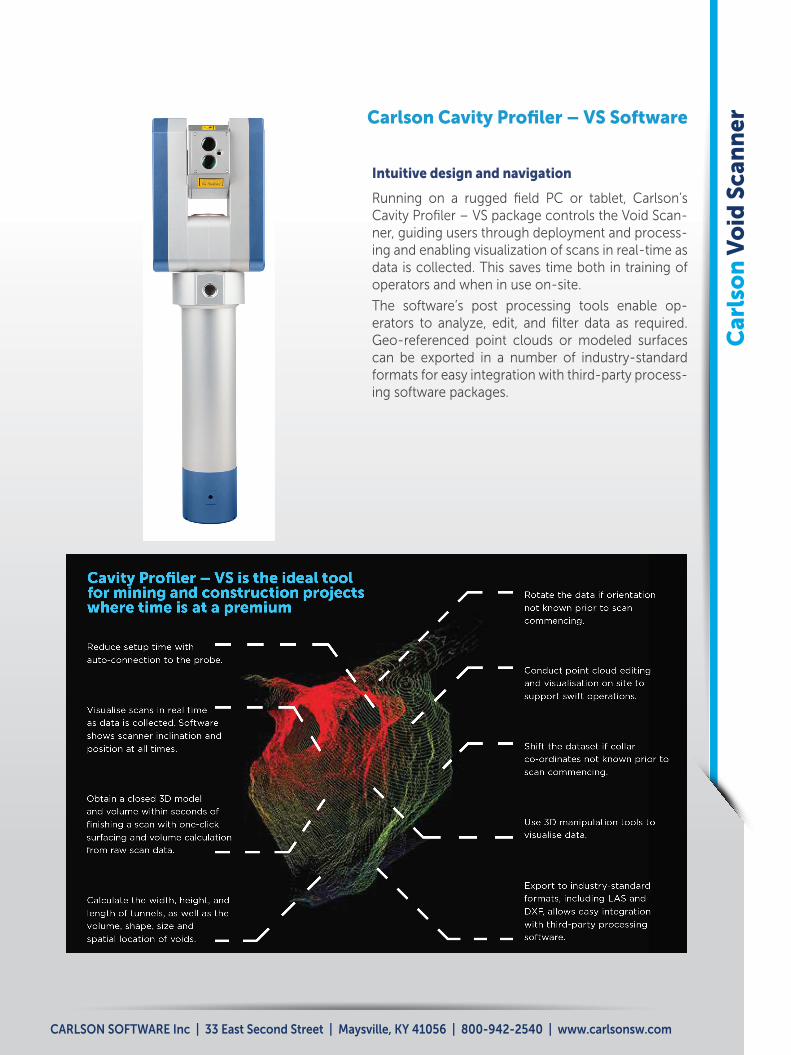
Intuitive design and navigation
Running on a rugged field PC or tablet, Carlson’s Cavity Profiler – VS package controls the Void Scan-ner, guiding users through deployment and process-ing and enabling visualization of scans in real-time as data is collected. This saves time both in training of operators and when in use on-site.
The software’s post processing tools enable op-erators to analyze, edit, and filter data as required. Geo-referenced point clouds or modeled surfaces can be exported in a number of industry-standard formats for easy integration with third-party process-ing software packages.
Carlson Cavity Profiler – VS Software

Carlson Software Inc | 33 East Second Street | Maysville, KY 41056 USA | 800-942-2540 | www.carlsonsw.com
810
-210
-22
Car
lso
n V
oid
Sca
nn
er
About Carlson
Carlson Software is a global market leader in the production of comprehensive software for Min-ing, Civil Engineering, Land Surveying, Machine Control, GIS, and Accident Reconstruction as well as instruments with GNSS, optical, and la-ser technology. Its Laser Measurement Devic-es (LMD) division has three decades of industry experience designing and manufacturing laser products.
Founded in 1983, Carlson Software is headquar-tered in Maysville, Kentucky, U.S.A. Its worldwide network of subsidiary companies and distributors is renowned for providing exceptional service and support for its customers.
Carlson LMD products include:
• Cavity Auto-Scanning Laser System (C-ALS®)
• Cabled Boretrak®
• Rodded Boretrak®
• Quarryman® Pro
• Merlin
• Industrial Laser Module (ILM)
• Void Scanner
For further information on the best Carlson application to meet your needs or for support, please contact Carlson at [email protected]
Tested to guarantee high performance
Developed for use underground, Carlson’s Void Scanner has been subjected to rig-orous environmental testing to guarantee high performance operation within specified limits of temperature, pressure, humidity, mechanical stress, and other adverse envi-ronmental conditions. Testing includes IP65 dust and water protection and performance in extremes of temperature and humidity. In-spections also include:
• Shock testing
• Acceleration testing
• Vibration testing
• Drop testing