Embed Size (px)
Citation preview

JO~OfvdrandOgy audgeodmual-h
ELSEVIER Journal of Volcanology and Geothermal Research 70 (19%) 183-204
Volcanic complexes in the eastern ridge of the Canary Islands: the Miocene activity of the island of Fuerteventura
E. Ancochea av * , J.L. Brindle a, C.R. Cubas b, F. Hemiin b, M.J. Huertas a a Dpto. Petrologiu y Geoquimicu, Universidad Complutense, Inst. Geologiu Econcimicu, C.S.I.C. Fat. C. Geolrigicas, 28040 Madrid. Spuin
b Dpto. Edafologia y Geologia, Universidud de La Laguna. 38206 Tenerife, Spuin
Received 20 October 1994; accepted 1 I July 1995
Abstract
Fuerteventura has been since early stages of its growth the result of three different adjacent large volcanic complexes: Southern, Central and Northern. The definition of these volcanic complexes and their respective growing episodes is based on volcano-stratigraphic, morphological and structural criteria, particularly radial dyke swarms. Each complex has its own prolonged history that might be longer than 10 m.y. During that time, several periods of activity alternating with gaps accompanied by important erosion took place. The evolution of each volcanic complex has been partially independent but all the three are affected by at least three Miocene tectonic phases that controlled considerably their activity. The volcanic complexes are deeply eroded and partially submerged. In the core of the Northern and the Central volcanic complexes there is a set of submarine and plutonic rocks intensely traversed by a dyke swarm, known as the Basal Complex. The Basal Complex has been interpreted in different ways but all previous authors have considered it to be prior to the subaerial shield stage of the island. Here we advance the idea that the Basal Complex represent the submarine growing stage of the volcanic complexes and the hypabyssal roots (plutons and dykes) of their successive subaerial growing episodes.
Two seamounts situated nearby, southwest of the island, might be interpreted as remains of two other major volcanoes. These two volcanoes, together with those forming the present emerged island of Fuerteventura, and finally those of Famara and Los Ajaches situated further north on Lanzarote constitute a chain of volcanoes located along a lineation which is subparallel to the northwestern African coastline and which may relate to early Atlantic spreading trends in the area.
1. Introduction
Fuerteventura, the easternmost of the Canary Is- lands and nearest to the neighbouring African conti- nent, is exceptional among oceanic islands, due, firstly, to its location on a passive continental margin
characterized by the absence of significant magma- tism, secondly, to the unusually long time span of the volcanic activity (at least 35 m.y., but possibly more than 50 m.y.>, thirdly, to the presence of submarine sediments and volcanics, and plutonic rocks, and, lastly, to the existence of carbonatites.
Together with Lanzarote, Fuerteventura represents
* Corresponding author.
the emergent crest of the Eastern Canarian Volcanic Ridge that extends north-northeast below sea level (Daiiobeitia, 1988; Daiiobeitia and Collette, 1989)
0377-0273/96/%15.00 0 1996 Elsevier Science B.V. All rights reserved SSDlO377-0273(95)0005 l-8

184 E. Ancocheo et al,/Journal of’Volcunolo~y and Geothermal Research 70 (1996) 183-204
and runs roughly parallel to the African coast (100 km from Fuerteventura, Fig. 1) and to the ocean-floor
according to which Fuerteventura is built up of several independent emergent volcanoes together
spreading trend. In this paper we develop a model with other submarine ones to the south.
ab c
-6
CANARY ISLANDS LANZAROTE L
29’N
1
LA PALMA
n TENERIFE V
FUERTEVENTU
28’ -
=2 HIERRO GRAN CANARIA
27O AFRIC/

E. Ancocheu et ul./Journui of Volcunology and Geothermal Research 70 (1996) 183-204 18.5
2. Geological setting Table I
Two major structural and petrological stages have been traditionally distinguished on Fuerteventura: the Basal Complex and the Subaerial Volcanic Series of Neogene and Quatemary ages. The Basal Complex (BC; Bravo, 1964; F6ster and Aguilar, 1965; Fister et al., 1968a; Stillman et al., 1975) is a thick Late Cretaceous sedimentary sequence overlain by sub- marine volcanics and intruded by an intense NNE- SSW-trending sheeted dyke swarm which formed in association with the emplacement of alkaline plu- tons. The BC has been interpreted in different ways, for example, as a normal oceanic crust fragment similar to some ophiolite complex such as the Troo- dos Massif in Cyprus (Gastesi, 19731, as part of a common substratum for all the Canary Islands (Cendrero, 1970), or as the subvolcanic roots of previous edifices (Hemhdez-Pacheco, 1973). In any case, all authors considered the entire BC as the earlier substratum for Fuerteventura, reflecting a growth stage dating back to before the subaerial shield stage (Ffister et al., 1980; Le Bas et al., 1986; Stillman, 1987; Muiioz and Sagredo, 1989; Cantagrel et al., 1993). However, as we shall endeavour to show in this work, this interpretation should be modified.
Volcano-stratigraphic sketch of the Old Basaltic Series of
Fuerteventura and age ranks according to radiometric age data
available
Units
Northern Volcanic Complex WVC)
Northern Volcanic Complex II
Ampuyenta Formation
Northern Volcanic Complex I
Upper NVC-I
Middle NVC-I
Lower NVC-I
Central Volcanic Complex (CVCJ
Los Tableros Formation
Central Volcanic Complex III,
Melindraga and Tamacite formations
Central Volcanic Complex II
Central Volcanic Complex I
Southern Volcanic Complex (SVC)
Southern Volcanic Complex III
Southern Volcanic Complex II
Southern Volcanic Complex I
ued until recent times, consists mainly of scattered pyroclastic cones and associated lava flows.
3. Volcanic complexes in the Old Basaltic series
Within the Subaerial Volcanic Series, several episodes are recognised. The earliest and most im- portant is the Old Basalts Series COBS), equivalent to the Basaltic Table land Formation of Hausen (19581, or Series I of F6ster et al. (1968a). Previous authors considered it to be heterogeneous with local uncon- formities, although continuous, mainly horizontal or slightly tilted, and unconformably overlying the BC. At a later date, after a period lasting about 7 m.y. (Coello et al., 1992) and characterized by lack of activity and erosion, new basaltic materials were erupted giving rise to the Recent Series. This, series less important in terms of volume, although it contin-
In contrast to the models mentioned above, An- cochea et al. (1991), Cubas et al. (1992) and Hem& et al. (1993) had proposed that the OBS corresponds to three major volcanoes: the Central, Northern and Southern (Fig. 1). As shown further on, these three major volcanoes should be regarded as volcanic complexes since they built up during very long periods of activity (10 m.y.) and they are the result of different successive and overlapping volcanic con- structs separated by gaps in activity which indicate the existence of independent magmatic cycles. Re- gional tectonic phases of activity are also recorded within each volcanic complex.
Age (Ma)
14.3-12.8
(15.3-14.3)
17.0- 15.3
22? ‘l
13.2
17.5-14s
22.5-20.0
> 22.5
15.2-14.2
17.2-15.4
20.1- 19.3
Fig. 1. Geological sketch of Fuerteventura. I = Basal Complex; 2 = Old Basaltic Series, 0 = Northern Volcanic Complex, b = Central vO]Cak COmp]ex, c = S0UtheI-U Volcanic Complex; 3 = Recent Series; 4 = sediments; 5 = center of volcanic complex; 6 = strike of
flows; 7 = K-Ar ages. A = Antigua; E = Betancuria; C = Corralejo; GT = Gran Tamjal; 04 = Los MOI~I-IOS; MJ = MOnO J&]C; OL =
Oliva; P = I%jara; PR = Puerto del Rosario; 7’ = Tost6n Cotillo; TU = Tuineje.

186 E. Ancochea er al./Journal of Volcanology and Geothermal Research 70 (I 996) 183-204
NNW SSE
1000
A ml Ff;frl2 H3
Om S.I. El4 9”
NNW 1000 SSE
B Om
S.I.
IOOO-
E C
Om- * s.l
@ m2 m3 m4 m5 z” _
0 1 Km
Fig. 2. Simplified general geological sketches of the volcanic complexes. (A) Southern Volcanic Complex: I = SVC-I; 2 = breccias; 3 = SVC-II; 4 = SVC-III; 5 = dykes, a = SVC-II and SVC-III, b = SVC-I. (Bl Central Volcanic Complex: I = submarine materials; 2 = plutonic rocks; 3 = CVC-I; 4 = CVC-II; 5 = CVC-III; 6 = Melindraga Formation; 7 = dykes, a = CVC-II, b = CVC-I, c = Basal Complex; c.d. = Central Depression. (Cl Northern Volcanic Complex: I = submarine materials; 2 = plutonic rocks; 3 = NVC-I; 4 = Ampuyenta Formation; 5 = NVC-II; 6 = dykes, a = NVC-II, b = NVC-I. c = Basal Complex; c.d. = Central Depression; s.1. = sea level.
Volcano-stratigraphic criteria have proved useful to define and to localize unconformities and hiatuses. Structural and morphological criteria, particularly dyke swarms, have been the key to separating all three major volcanoes and their succesive constructs. Lastly, the reinterpretation of available radiometric age data and new determinations have led to the development of a temporal framework for the whole Miocene subaerial evolution of Fuerteventura. The volcano-stratigraphical sketch is shown in Table 1 and Fig. 2.
3.1. The Southern Volcanic Complex
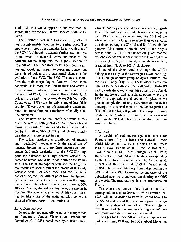
The Southern Volcanic Complex (SVC) on the so-called “Jandfa peninsula” is separated from the Central Volcanic Complex (CVC) by “El Jable” a narrow, low (< 200 m high) and plain sector cov- ered by eolian sands and calcrete. The northern side shows a high (800 m) open-northwards semicircular escarpment “La Pared”, from which a series of radial ravines alternating with “cuchillos” excavate southwards the OBS (Fig. 3). “Cuchillo” is a local morphological term used to denote relatively high,
Fie. 3. Southern Volcanic Comulex. (A) Morphological sketch and reconstruction. (B) Dykes in the SVC-II and SVC-III. (Cl Dykes in the v . -
SVC-I. In (B) and (Cl unidirectional rose diagrams for dykes in each sector. Circles indicating percentage of dykes. I, 2 and 3 = points situated at X0.400 and 600 m altitude, along cuchillos (see text); 4 = morphological center, 5 = cuchillos; 6 = escarpment of “La Pared”; 7 = palaeo-contours of the volcano; in (B) 8 = dykes cutting the SVC-II and SVC-III, in (Cl 8 = dykes in the SVC-I; 9 = dykes intruding in the SVC-I. but belonging to the SVC-II or SVC-III; IO = converging area estimated for dykes in SVC-II and SVC-III; 1 I = idem in the SVC-I. MJ = Morro Jable.

E. Ancochea et al./Journal of Volcanology and Geothermal Research 70 (1996) 183-204
0 4
0 2
A 3
94
k5
3ysy6
Y-.
I \ 7
lc= 8
-_-:- 9
!zl 10
:.:.:_:_:_:_:. I :::::::::<:: i 1
0 2 4 Km
187
188 E. Ancochea et al./Journal of Volcanology and Geothermal Reseurch 70 (1996) 183-204
long and sharp crests separating ravines, which are frequent in Fuerteventura.
The Jandia peninsula is formed exclusively by OBS materials from three successive constructive episodes, namely, I, II and III, that built up the SVC (Table 1; Fig. 2A).
The Southern Volcanic Complex I (SVC-I) mate- rials are exposed mainly along the northern coast at the base of the escarpment, in erosion “windows” at the bottom of some of the ravines, as isolated paleo- ravines up to 400 m high and under the sands of “El Jable”. These materials are frequently fractured, suggesting that faulting might account for the out- crops on different separated areas. Basalts are the most representative rocks (Table 2). Hydromagmatic pyroclasts were abundant at the early stages when the edifice emerged, although pahoehoe basaltic lava flows (typically ankaramitic) were subsequently erupted on top. They generally have normative 01 + Hy (recalculated in accordance with Le Maitre, 1976) but no Ca-poor pyroxene, and they fall within the alkali field of Macdonald and Katsura (1964).
felsic tuffs representing the uppermost stratigraphic level. These tuffs rest unconformably on the underly- ing basalts whose dykes are cut at the unconformity, which indicates that this last felsic episode took place after a significant erosion period. Taken to- gether, the basalts and quartz-trachytes form a mildly alkaline series with no intermediate members.
Felsic rocks are scarce (Muiioz, 1969; Cubas et al., 1988). They correspond to quartz-trachytes exist- ing in the north as plugs, probably associated with
The materials forming the Southern Volcanic Complex II (SVC-II) lie unconformably on the SVC- I, filling a paleo-relief. Their total thickness, struc- ture and distribution is therefore irregular. Basalt flows are subhorizontal or dip southwards and are locally intercalated with thick breccias derived from erosion of the SVC-I. About 90% of these rocks are basaltic in composition and trachybasaltic to a lesser degree, all of mildly alkaline affinity (Table 2). In some parts, particularly in the north along “la Pared”, two different sequences can be distin- guished. The lower sequence overlies a steep palaeo-slope inclined northwards and the horizontal position of flows indicates that a depression was filled up. At a later date the flows of the upper sequence poured out radially, as can be deduced from their radial dip, and advanced southwards, stacking up against higher relief situated further
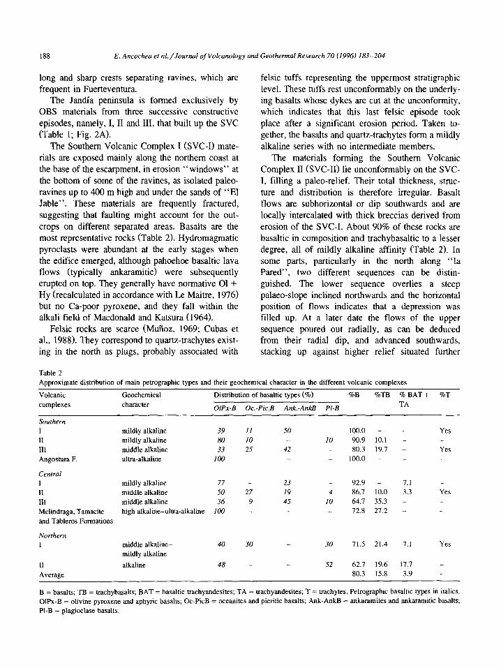
Table 2
Approximate distribution of main petrographic types and their geochemical character in the different volcanic complexes
Volcanic
complexes
Geochemical
character
Distribution of basaltic types (o/o) %B %TB %BAT+ %T
OIPx-B Oc.-Pic.B Ank.-AnkB Pl-B TA
Southern
I II
111
Angostura F.
Central
I II III Melindraga, Tamacite
and Tableros Formations
Northern
11
Average
mildly alkaline 39 II
mildly alkaline 80 10
middle alkaline 33 25
ultra-alkaline 100 _
mildly alkaline 77 -
middle alkaline 50 27
middle alkaline 36 9
high alkaline-ultra-alkaline 100 -
middle alkaline-
mildly alkaline
alkaline
40 30 30 71.5 21.4 7.1 Yes
48 -
50
42
_ 10
_
_
100.0 - - Yes 90.9 10.1 -
80.3 19.7 - Yes
100.0 - -
23
19
45
_ 92.9 - 7.1 -
4 86.7 10.0 3.3 Yes
IO 64.7 35.3 -
_ 72.8 27.2 _
52 62.7 19.6 17.7 _
80.3 15.8 3.9 _
B = basal& TB = trachybasalts; BAT = basaltic trachyandesites; TA = trachyandesites; T = trachytes. Petrographic basaltic types in italics.
OlPx-B = olivine pyroxene and aphyric basal& Oc-PicB = oceanites and picritic basalts; Ank-AnkB = ankaramites and ankaramitic basalts; PI-B = plagioclase basalts.
E. Ancochea et al./JournaI of Volcanology and Geothermal Research 70 (19%) 183-204 189
south. All this would appear to indicate that the source area for the SVC-II was located north of La Pared.
The Southern Volcanic Complex III (SVC-III) lies unconformably over the two earlier ones. The area where it crops out coincides largely with that of the SCV-II, although it extends further east and less to the west. Its materials constitute most of the northern Jandfa scarp and the highest section of “cuchillos”. The unconformity between both is mi- nor and would not appear to represent, concerning the style of volcanism, a substantial change in the evolution of the SVC. The SVC-III controls, there- fore, the main morphological features of the Jandfa peninsula; it is more than 350 m thick and consists of ankaramites, olivine-pyroxene basalts and, to a lesser extent (20%), trachybasalt flows (Table 2). A volcanic plug and its associated dykes (Mufioz, 1969; Cubas et al., 1988) are the only signs of late felsic activity. These rocks are Ne-normative undersatu- rated and meta-aluminous trachytes of mildly alka- line character.
The western tip of the Jandfa peninsula differs from the rest in both geological and compositional terms. It consists of basalts and olivine nephelinites cut by a small number of dykes, which would indi- cate that it is more recent in age.
The radial, semicircular distribution of ravines and “cuchillos”, together with the radial dip of material belonging to these three successives con- structs (although particularly to the SVC-III), sup- ports the existence of a large central volcano, the center of which would lie to the north of the Penin- sula. The radial drainage pattern and the height of the inteffluves should reflect the profile of this early volcanic cone. For each zone and for the same contour line, the most distant point from the theoreti- cal center will be at the closest height to the primi- tive surface. Interpolated palaeocontours now at 200, 400 and 600 m, derived for this cone, are shown in Fig. 3A. The geometrical center of this cone, mark- ing the likely site of the main emission center, is situated offshore north of the Peninsula.
3.1.1. Dyke systems Dykes which are generally basaltic in composition
are frequent in Jandfa. Ftister et al. (1968a) and Feraud et al. (1985) noted that dyke strikes were
variable but they considered them as a whole, regard- less of the unit they traversed. Dykes are abundant in the SVC-I sometimes accounting for 10% of the whole rock and belonging to more than one swarm. The dykes cutting the SVC-II and III follow similar patterns. Most intrude into the SVC-II and only a few into the SVC-III. For this reason, given that the last one extends further east, there are fewer dykes in this area (Fig. 3B). The trend, although incomplete, is radial from N130 to N240” clockwise.
Some of the dykes cutting through the SVC-I belong necessarily to the swarm just examined (Fig. 3B), although another group of dykes intrudes into the SVC-I only (Fig. 3C). These older dykes run parallel to the coastline in the northeast (N50-N60”) and towards the CVC where this strike is also found. In the northwest, and at isolated points where the SVC-I is exposed, the direction of dykes shows greater complexity. In any case, most of the dykes converge in a central zone on the Jandfa peninsula (Fig. 3C) at the highest points. This complexity may be due to the existence of more than one swarm of dykes in the SVC-I related to more than one con- structive phase.
3.1.2. Age A wealth of radiometric age data exists for
Fuerteventura (Fig. 1; Rona and Nalwalk, 1970; Abdel Monem et al., 1971; Grunau et al., 1975; Feraud, 1981; Feraud et al., 1985; Le Bas et al., 1986; Coello et al., 1992; Cantagrel et al., 1993; Balcells et al., 1994). Most of the data corresponding to the OBS have been published by Coello et al. (1992) and Balcells et al. (1994). Feraud et al. ( 1985) obtained age data only from dykes cutting the SVC and the CVC. However, the majority of the published ages were analyzed considering the OBS as a whole. The previous age data are summarized in Fig. 1.
The oldest age known (20.7 Ma) in the SVC corresponds to a dyke (Feraud, 1981; Feraud et al., 1985) which, according to its strike, could belong to the SVC-I and would thus give an approximate age for the early stage of this volcano. The scarcity of lava flows and the intense weathering thereof pre- vent more valid data from being obtained.
The ages for the SVC-II in its lower sequence are quite consistent, 17.0 and 16.3 Ma [Abdel Monem et

190 E. Ancochea et al./Jourd of Volcanology and Geothermal Research 70 (1996) 183-204
al. (1971), recalculated in accordance with Steiger and Jaeger (197711 and 17.2 and 16.9 Ma (Balcells et al., 1994). Another group of age data, 15.8 and 15.4 Ma of Coello et al. (1992), 15.8 and 16.0 Ma of Balcells et al. (1994) and a dyke dated to 15.9 Ma by Feraud et al. (1985), can be attributed to the upper sequence.
As regards the uppermost part of the SVC-III, Coello et al. (1992) date basaltic flows to 15.0 and 14.9 Ma and a trachyte to 15.2 Ma. Feraud et al. (1985) give ages of 14.9, 14.5 and 14.9 Ma for dykes that could be interpreted as intruding into the SVC- III. Finally, another dyke dated by Feraud et al. (1985) at 12 Ma would indicate a certain persistence of activity until that time.
In DSDP site 397 (Fig. 71, Schmincke and Von Rad (1979) have reported several volcanic and vol- canoclastic levels, a glassy ash (A23) and four de- bris-flow deposits (V,-V,). On the basis of strati- graphic criteria and available age data, these authors attributed an age of 19.3 Ma to the earliest deposit A23 and interpreted it as a trachytic ashfall from Fuerteventura or Lanzarote. This age would coincide with that inferred for the trachytic tuffs found be- tween the SVC-I and the SVC-II, i.e., an age which must lie somewhere between 20.7 Ma (dyke in the SVC-I, dated by Feraud, 1981) and 17 Ma (age of the earlier flows in the SVC-II).
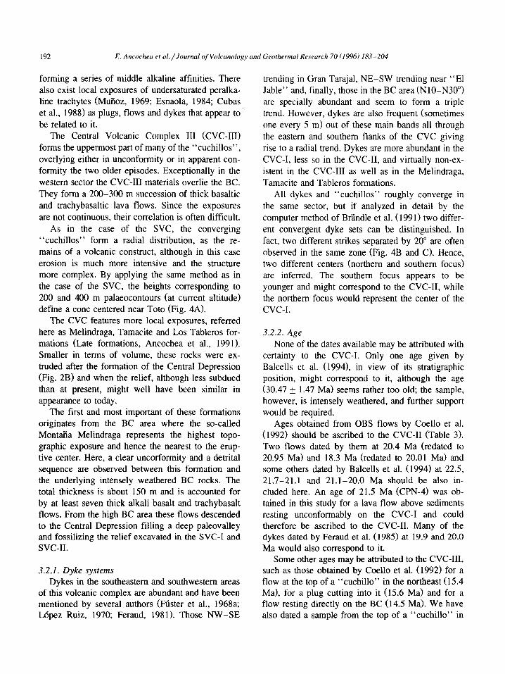
3.2. The Central Volcanic Complex
The Central Volcanic Complex (CVC) extends from Antigua, where it overlaps the NVC, to the “El Jable” which separates it from the SVC (Fig. 1). Three concentric semicircular areas are distinguished in this sector. The innermost and highest area, 400 m near the coast and 600-700 m inland, is formed exclusively by the Basal Complex. It is surrounded by the Central Depression, a flat plain where heights do not exceed 100-200 m. BC and OBS rocks crop out here covered by thick successions of sediments,
calcrete, colluvium deposits and subhistorical volca- noes which partially fill the depression. On the outer- most area, only OBS materials are exposed. As in the SVC, successions of basaltic lava flows form “cuchillos” separated by radial ravines extending down to the coast (Fig. 4). In contrast with the observations in the SVC, many of the “cuchillos” do not merge at the headwaters zone but carry on up to the Central Depression. The innermost and outer- most areas merge to the west where the depression disappears.
Three main constructive episodes separated by unconformities have been distinguished (Ancochea et al., 1991) in the CVC: I, II and III (Table 1; Fig. 2B).
The Central Volcanic Complex I (CVC-I) is ex- posed on the Central Depression, on the inner front flank of the “cuchillos” and along the ravines in between. Contact with the BC is frequently tectonic, though sometimes there is a continuous sequence without evidence of a break, but differences in the degree of weathering and in the intensity of dyking are always observed. It consists of a thick sequence, more than 1000 m, of lava flows cut by dykes. The flows are essentially basaltic, mainly ankaramitic and of mildly alkaline affinity (Table 2).
The more poorly defined Central Volcanic Com- plex II (CVC-II) forms the top of the “cuchillos” or sometimes the “cuchillos” in their entirety. For the most part, it rests not on the BC but unconformably on the CVC-I. Both have similar dip and strike but the dip angle is smaller in the CVC-II (10-20”) than in the lower one (20-30” or even 40-45”). In the western sector, they are separated by a 60-80 m thick polygenetic breccia composed of a clay-sandy matrix and heterogeneous basaltic fragments, possi- bly a debris flow derived from the CVC-I. The CVC-II consists of 300-500 m of scorias and thin lava flows and local interlayered pyroclastics, re- mains of small eruptive centers. Most flows are basaltic, with a lower proportion of differentiates
Fig. 4. Central Volcanic Complex. (A) Morphological sketch and reconstruction. (B) Dykes related to the southern focus. (C) Dykes related
to the northern focus. In (B) and (C) unidirectional rose diagrams for dykes in each sector. I, 2 and 3 = points situated at 200, 400 and 600
m altitude, along cuchillos; 4 = cuchillos; 5 = palaeo-contours of the volcano; 6 = dykes related with both the foci; 7 = other dykes;
8 = converging area estimated for dykes related to southern focus; 9 = idem for northern focus; 10 = Basal Complex; II = post-OBS
materials. OBS = area in white.. CT = Gran Tarajal; P = Pajara; TO = Toto; TU = Tuineje.

++a+++ +r*+++ +++++i +++++_ +++ri; ++&-A+
++--T+-r
++++++
+i7tti
0 1
0 2
c3 3
-4
\_J ’ 5
,, 6 191
-=_ __ 7
0 2 4 Km
192 E. Ancocheo et al./Journol ofV&unology und Georhermal Research 70 (1996) 183-204
forming a series of middle alkaline affinities. There also exist local exposures of undersaturated peralka- line trachytes (Mufioz, 1969; Esnaola, 1984; Cubas et al., 1988) as plugs, flows and dykes that appear to be related to it.
The Central Volcanic Complex III (CVC-III) forms the uppermost part of many of the “cuchillos”, overlying either in unconformity or in apparent con- formity the two older episodes. Exceptionally in the western sector the CVC-III materials overlie the BC. They form a 200-300 m succession of thick basaltic and trachybasaltic lava flows. Since the exposures are not continuous, their correlation is often difficult.
As in the case of the SVC, the converging “cuchillos” form a radial distribution, as the re- mains of a volcanic construct, although in this case erosion is much more intensive and the structure more complex. By applying the same method as in the case of the SVC, the heights corresponding to 200 and 400 m palaeocontours (at current altitude) define a cone centered near Toto (Fig. 4A).
The CVC features more local exposures, referred here as Melindraga, Tamacite and Los Tableros for- mations (Late formations, Ancochea et al., 1991). Smaller in terms of volume, these rocks were ex- truded after the formation of the Central Depression (Fig. 2B) and when the relief, although less subdued than at present, might well have been similar in appearance to today.
The first and most important of these formations originates from the BC area where the so-called Montaila Melindraga represents the highest topo- graphic exposure and hence the nearest to the erup- tive center. Here, a clear uncorformity and a detrital sequence are observed between this formation and the underlying intensely weathered BC rocks. The total thickness is about 150 m and is accounted for by at least seven thick alkali basalt and trachybasalt flows. From the high BC area these flows descended to the Central Depression filling a deep paleovalley and fossilizing the relief excavated in the SVC-I and svc-II.
3.2.1. Dyke systems
Dykes in the southeastern and southwestern areas of this volcanic complex are abundant and have been mentioned by several authors (Ftister et al., 1968a; Lopez Ruiz, 1970; Feraud, 1981). Those NW-SE
trending in Gran Tarajal, NE-SW trending near “El Jable” and, finally, those in the BC area (NlO-N30”) are specially abundant and seem to form a triple trend. However, dykes are also frequent (sometimes one every 5 m) out of these main bands all through the eastern and southern flanks of the CVC giving rise to a radial trend. Dykes are more abundant in the CVC-I, less so in the CVC-II, and virtually non-ex- istent in the CVC-III as well as in the Melindraga, Tamacite and Tableros formations.
All dykes and “cuchillos” roughly converge in the same sector, but if analyzed in detail by the computer method of BrYmdle et al. (1991) two differ- ent convergent dyke sets can be distinguished. In fact, two different strikes separated by 20” are often observed in the same zone (Fig. 4B and C>. Hence, two different centers (northern and southern focus) are inferred. The southern focus appears to be younger and might correspond to the CVC-II, while the northern focus would represent the center of the cvc-I.
3.2.2. Age
None of the dates available may be attributed with certainty to the CVC-I. Only one age given by Balcells et al. (1994), in view of its stratigraphic position, might correspond to it, although the age (30.47 + 1.47 Ma) seems rather too old; the sample, however, is intensely weathered, and further support would be required.
Ages obtained from OBS flows by Coello et al. (1992) should be ascribed to the CVC-II (Table 3). Two flows dated by them at 20.4 Ma (redated to 20.95 Ma) and 18.3 Ma (redated to 20.01 Ma) and some others dated by Balcells et al. (1994) at 22.5, 21.7-21.1 and 21.1-20.0 Ma should be also in- cluded here. An age of 21.5 Ma (CPN-4) was ob- tained in this study for a lava flow above sediments resting unconformably on the CVC-I and could therefore be ascribed to the CVC-II. Many of the dykes dated by Feraud et al. (1985) at 19.9 and 20.0 Ma would also correspond to it.
Some other ages may be attributed to the CVC-III, such as those obtained by Coello et al. (1992) for a flow at the top of a “cuchillo” in the northeast (15.4 Ma), for a plug cutting into it (15.6 Ma) and for a flow resting directly on the BC (14.5 Ma). We have also dated a sample from the top of a “cuchillo” in

E. Ancocheo el uI./Journul of Volcanology and Georhermal Research 70 (1996) 183-204 193
Table 3 Radiometric K-Ar ages in the Central Volcanic Complex
Sample No. %K @Ar rad %Ar atm Ag (Ma)
92880 1.21 I .065 m/g 58.80 2 I SO f 0.83 (CPN-4) a Fue-24 a 0.98 0.790 nl/g 36.74 20.93 _+ 0.74 Fue-24 b 0.98 1.392 rig/g 30.43 20.40 rt: 0.40 Fue-27 a 1.01 0.787 nl/g 20.53 20.01 f 0.68 Fue-27 b 1.01 1.297 rig/g 21.96 18.30f0.30 92012 a 0.97 0.520 nl/g 42.97 18.29f0.69 92886 a 0.68 0.442 nl/g 48.61 17.55 f 1.01 92011 ’ 2.06 1.335 nl/g 87.7 16.6 i 0.8 Fue-59 a 1.64 1.036 nl/g 23.93 16.19kO.51 Fue-59 b I .64 I .768 rig/g 22.45 15.40 f 0.34 Fue-56 b 1.39 0.795 nl/g 87.4 14.7+0.7
a Ages obtained at the Laboratory of Geochronology, Univ. Com- plutense, Madrid (Spain). b Ages after Coello et al. (1992) obtained at the Geological Department, CNRS-Univ. Clermont-Ferrand (France). ’ Ages obtained at the Laboratory of Teledyne Isotopes (USA).
the southeastern area, for which we have obtained an age of 14.7 Ma (Table 3). Thus, its age can be estimated as being between 15.6 and 14.5 Ma.
One of the main unresolved problems concerned the age of the “formations”. We have dated the Melindraga Formation at 18.29 f 0.69 and 16.6 + 0.8 Ma. In view of its stratigraphic position, a flow dated by Balcells et al. (1994) at 16.45 k 0.72 Ma may also be interpreted as belonging to it. The Tamacite Formation has given an age of 17.55 f 0.1 Ma. Both the formations represent the activity that took place once the Central Depression had already formed and prior to the development of the CVC-III.
The debris-flow deposits V3, V2, and Vl from DSDP hole 397 contain microgabbro fragments that were interpreted by Schmincke and Von Rad (1979) as originating from the BC on Fuerteventura. Their age coincides with important activity in the SVC, although the BC does not crop out there. By contrast, the Melindraga and Tamacite formations directly overlie the BC, indicating that the latter was already being eroded when these formations were erupted. The age attributed by Schmincke and Von Rad (1979) to those deposits (17.2 and 16.5 Ma) is in agreement with those obtained for the formations mentioned above.
The age of the Los Tableros Formation was calcu- lated by Coello et al. (1992) as being 13.2 Ma, thus
representing a much later activity, which, as we will see further on, must have been related to the NVC.
3.3. The Northern Volcanic Complex
The remains of the Northern Volcanic Complex (NVC) extend from the OBS northermost exposures to the CVC. The geomorphological areas established before for the CVC are also observed in this sector. The OBS crops out mainly in the north and east, while the BC is exposed to the west and southwest (Fig. 1). Both are partially overlain by younger volcanics (Recent Series) and sediments. The best OBS exposures occur as high “cuchillos” on the western area, contrasting with other zones where the OBS appears as scattered plain exposures at the bottom of the Central Depression or as a succession of low hills in the northwestern sector.
Two constructives episodes are distinguished in this volcano: the NVC-I and the NVC-II. The ag- glomerate known as the Ampuyenta Formation is located between them (Table 1; Fig. 2C).
The Northern Volcanic Complex I (NVC-I) oc- curs in the Central Depression in the northwestern sector, and at the base of the highest “cuchillos”. As it is partially covered by younger deposits, the struc- ture is not clearly observed, although where it can be seen it appears to be subhorizontal. Nevertheless, three different units have been established. The lower unit (Lower NVC-I) consists of numerous picritic basaltic flows intensely traversed by a network of dykes, in which dykes are spaced 2-5 m. Contact with the underlying BC rocks is continuous, whereas it appears that there is a tectonic junction with the overlying unit. The next unit (Middle NVC-I), which is of similar composition, is cut by two main dyke systems, although dykes are wider spaced (10 m) and also present fracturation. The third unit (Upper NVC-I or Oliva and Lajares formations of Hem&i et al., 1993) is represented by more than a 100 m thickness of subhorizontal oceanitic basalts and tra- chybasalts of mildly alkaline affinity (Table 2). The intensity of dykes is much lower in this unit.
Oversaturated alkaline trachytic plugs and dykes are present in the area of Tindaya (Muiloz, 1969; Cubas et al., 1988). According to field observations, these may be ascribed to this NVC-I, possibly to its upper unit.

194 E. Ancmhea et ul./Journul c~Volcunolo~y and Georhermul Resecrrch 70 (1996) 183-204
The Ampuyenta Formation is up to 200 m thick and it is formed mainly by agglomerate, sometimes bedded, with very scarce interlayered flows. The formation has been interpreted in many ways: as n&e ardente and laharic deposits; Piedmont con- glomerates; or avalanches and lahars (Hausen, 1958; FGster et al., 1968a, 1984a, b; Ancochea et al., 1993). Some authors have considered it to be the OBS substratum (Hartung, 1857; Bourcart and Jeremine, 1938; Hausen, 1958; Rothe, 1966).
The agglomerates are exposed at the base of the inner flank of the “cuchillos” south of La Oliva. They lie unconformably over the NVC-I and, accord- ing to Ftister et al. (1984a, b), over the BC rocks also. All dykes cutting through this formation belong to one single system, the same one as in the NVC-II. The fact that most fragments come from lava flows would indicate that the Ampuyenta Formation was derived by erosion of an older subaerial edifice. This could not be the CVC since the thickness of the Ampuyenta Formation decreases southwards. The source for the agglomerates must be closer and could be the NVC-I. The absence of this formation north of La Oliva points to this zone as the main source area. Furthermore, the existence of plutonic rocks as clasts in this formation in some sectors indicates that the BC had already emerged by then.
The Northern Volcanic Complex II (NVC-II) con- sists of a succession of eastwards dipping lava flows more than 300 m thick where long and narrow “cuchillos” have been carved. It lies unconformably above the Ampuyenta Formation; sedimentary levels frequently occur at the contact and pahoehoe lavas predominate at the base of the succession. Basalts are dominant but more evolved types (Table 2) are abundant. Plagioclase-rich basalt is the most abun- dant basalt type and all rocks are alkaline. The NVC-II overlaps the CVC south of Puerto de1 Rosario where the “cuchillos” are formed by CVC-III mate- rials at their base and by NVC-II ones at the top, separated by well-developed sedimentary levels.
The structure and morphology now observed in the NVC is essentially that of the NVC-II. Although in this case the “cuchillos” are not as markedly radial as in the CVC and SVC, they do still present a circular pattern with the highermost point inwards. Most “cuchillos” join at the headwaters zone, giv- ing rise to an almost continuous scarp that consti- tutes the eastern margin of the Central Depression (Fig. 5A). As in the two previous examples, the palaeocontours obtained by joining points of relict topography of similar height locate the center west of the cone in the area where the BC is now exposed.
3.3.1. Dyke systems We have separated basaltic dykes cutting through
the NVC-II, those traversing the NVC-I and felsic dykes. It can be seen that dykes are much less abundant in the former (Fig. 5B) than in the latter (Fig. 5C).
In the NVC-II, dykes form a radial trend converg- ing in an area sited in the Central Depression near Los Molinos and coinciding with the center deduced from morphological data above. The abundance of dykes also increases towards the center. Al! the dykes that may be interpreted as belonging to it, that is, all those included in the radial trend, are shown in Fig. 5B. The Ampuyenta Formation is traversed by as many dykes as the NVC-II, and hence none of them would correspond to this destructive period.
Interpretation of the dykes in the NVC-I is diffi- cult since they are abundant and show very different strikes. Dykes that can be interpreted as exclusively belonging to it are shown in Fig. 5C. They all appear to converge in an area situated between Oliva and Toston, although mathematical analysis (Br’Zndle et al., 1991) does not afford conclusive results.
3.3.2. Age Coello et al. (1992) dated several samples from
the NVC-II as being between 14.3 and 12.8 Ma. An agglomeratic level, situated above a lava flow dated
Fig. 5. Northern Volcanic Complex. (A) Morphological sketch and reconstruction. (B) Dykes in the NVC-II. (C) Dykes in the NVC-I. In (B)
unidirectional rose diagrams for dykes in each sector. I, 2 and 3 = points situated at 200, 400 and 600 m altitude, along cuchillos;
4 = morphological center; 5 = cuchillos; 6 = central scarp; 7 = palaeo-contours of the volcano; in (B) 8 = dykes cutting the NVC-I and
belonging to the NVC-II, in (C) 8 = salic dykes in the NVC-I; 9 = converging area estimated for dykes in the NVC-I; IO = Basal Complex;
II = post-OBS materials. OBS = area in white; L = Lajares; LM = Los Molinos; OL = Oliva; TC = Tosdn Cotillo; TI = Tmdaya; PR = Puerto de1 Rosario.

E. Ancochea et al./Journal of Volcanology and Geothermal Research 70 (19%) 183-204
0 1 46
0 2 ‘,_ ,’ 7
A 3 --, 8
Q 4 -I=- g
0 2 4 Km L w
195

196 E. Ancochea et ai./Journal of Volcanology and Geothermal Reseurch 70 (1996) 183-204
Table 4 Radiometric K-Ar ages in the Northern Volcanic Complex
Sample No. %K “OAr rad %Ar atm Age (Ma)
93900 (Ne- 1) 1.08 1.270 nl/g 52.64 31.46* 1.12 93870 (Ne-7) 0.79 0.489 nl/g 55.92 17.0f0.85 93873 (Ne-10) 0.93 0.505 nl/g 83.62 15.34-t 1.26
Ages obtained at the Laboratory of Geochronology, Univ. Com- plutense, Madrid (Spain).
at 13.6 Ma has been interpreted by Coello et al. (1992) as part of the Ampuyenta Formation, but in our opinion, and in agreement with Martin (19841, this agglomeratic level does not belong to the Am- puyenta Formation.
There are three ages belonging to the NVC-I: 17.0 f 0.85 Ma, 15.34 + 1.26 Ma (Table 4) and 16.1 Ma in Tostbn-Cotillo, this last one dated by Abdel Monem et al. (1971) as being 21.2 Ma and redated by Coello et al. (1992) to 16 Ma. This flow uncon- formably overlies older rocks which are densely traversed by dykes that we interpret as being the Lower NVC-I, for which the only available age (3 1.5 Ma) corresponds to a flow further south overlying the BC and also intensely traversed by dykes. Due to a certain degree of hydrothermal weathering of the sample, this age should be treated with caution. A trachyte in Tindaya (18.7 Ma) should be interpreted as corresponding to the NVC-I too.
Finally, Rona and Nalwalk (1970) have dated a number of dykes cutting through the BC (Fig. l), two of which (14.4 and 12.1 Ma) correspond to the NW-11 dyke swarm. Three other dykes dated at 22.3, 23.3 and 18.0 Ma might be related to the Lower or Middle NVC-I.
4. Submarine prolongation of volcanic complexes
Both the morphology and the dyke systems indi- cate the occurrence of large volcanoes whose centers are situated offshore in the case of SVC and onshore in the cases of CVC and NVC. The prolongation beneath sea level should therefore be reflected in the bathymetric contour lines (Nat. Geogr. Inst. of Spain, Topographic Map, 1:200.000, 1982). As shown in Fig. 6, depth increases gently from 0 to 100 m and then abruptly from 100 to 500 m in less than 1 km
horizontal distance. However, depending on the sec- tor this abrupt inflexion occurs at a different distance from shore.
On the southern flank of the SVC, the submarine floor descends rapidly, whereas along the northern coastal line the submarine slope is gentle. This would indicate that it at one time must have extended further north. The center of the submerged relief coincides with that deduced from the morphology and dyke systems, which would lend support to the hypothesis of a large central volcano occupying this area.
On the central part of Jandia peninsula, the arcu- ate shape adopted by isobaths may denote a north- ward slide causing a nearly 12 km wide depression. The Jandfa escarpment probably originated as a con- sequence of that slide. The scarp may have retro- ceded later through erosion. The dyke trends N50 (west of Jandia) and N90-NlOO” (east) may have conditioned the present arcuate wall shape.
The slope is steep on the northern submarine flank of the NVC, more gentle southwards, denoting a certain circular shape, and the submarine western floor is much flatter. These facts supports the idea that the NVC was centered west onshore.
On the western flank of the CVC the submarine slope dip is gentle, the same as along the southern margin. This indicates that it extended further into the sea. In fact, the “cuchillos” in the NVC gently disappear onshore a certain distance from the coast- line, while those in the CVC extend further and exhibit erosion cliffs at the coast which exists today. The 100 m isobath may be an approximate reflection of the original shape of these volcanoes.
The eastern flank of the CVC is, as in the case of the NVC, flatter, a circumstance which would also support the existence in this area of a large central volcano centered west onshore.
Bathimetry also attests to the occurrence of two seamounts west of Jandfa (Fig. 6). Both seamounts show circular shapes that can be interpreted as corre- sponding to independent edifices. The first one, situ- ated northwest of Jandia, is given the name here “Amanay Submarine edifice”. The second seamount occurs southwest of Punta de Jandia, and designated in this paper as “El Banquete Submarine edifice”, is connected to the SVC by a flat and shallow (20-30 m) platform. Both the seamounts are similar in size

E. Ancochea et al./Journal of Volcanology and Geothermal Research 70 (1996) 183-204 197
and are separated from each other by a narrow furrow which is more than loo0 m deep.
The elongated southern submarine prolongation of the CVC does not match that expected for a central volcano. Its alignment with the nearby dykes intrud- ing into the CVC-I enables it to be considered as a submarine prolongation of this sheeted dyke swarm. The narrow isthmus of “El Jable” could be the result of a similiu situation, which would thus ex- plain the absence of a submarine furrow between the CVC and SVC. The flat area located between the twn volcanoes could also be explained in this way. The great intensity of N40-N50” dykes at the south-
western side of Jandia parallels the trend defined by the alignment of both volcanic complexes.
On the other hand, a short distance from Fuerteventura, on Lanzarote, two other old massifs, Los Ajaches and Famara, in the southwestern and northeastern part (Fig. 61, respectively, are found (Ftister et al., 1968b). Los Ajaches was essentially built up between 15 and 12 Ma (Ibarrola et al., 1988; Cc40 et al., 1992) and is therefore partly contempo- raneous with the NVC-II on Fuerteventura. By con- trast, Famara is less than 10 Ma. If the surrounding bathymetric lines are observed, these two massifs may also be interpreted as being the remains of two
Fig. 6. Location of the OBS volcanic complexes on Fuerteventura and Lanzarote. I = subaerial emission centers; 2 = submarine emissions centers; 3 = approximated areas occupied by the volcanic complexes in Fuerteventura zone; 4 = idem in Lanzarote zone; 5 = alignement of the volcauoes; 6 = main trends of dyke intrusions; 7 = possible landslides.

198 E. Ancochea et al. /Journal of Volcanofogy and Geothermaf Research 70 f I996) 183-204
other old volcanoes which were larger than the cur- rent emergent exposures. If so, the top of the Eastern Canarian Volcanic Ridge is formed by a chain of large central volcanoes roughly parallel to the African coastline.
Table 5 shows the main geometrical characteris- tics of all the different OBS volcanoes on the Eastern Canarian Volcanic Ridge. Subaerial volcano diame- ters are estimated for areas bounded by the 100 m isobath, and taking into account the centers deduced from dyke systems. Maximum submarine diameters are calculated taking into account the depth at which the shield shape is clearly inferred. The largest one is the CVC, followed by its NVC and SVC counter- parts. The Amanay and El Banquete submarine edi- fices can be compared to the Ajaches or even to the island of El Hierro, which is about 32 km wide where the depth reaches 1000 m.
We have also estimated volcano heights. Hawaian shields are characterized by slope dips of between 3 and 10” while the average figure for alkaline com- posite volcanoes is 12” (Peterson and Moore, 1987). If we consider slopes of between 7 and 9”, heights will range from 1600 to 2100 m for the SVC, from 2300 to 3000 m for the NVC and from 2600 to 3300 m for the CVC. On the basis of 0 and H isotope studies in samples from central Fuerteventura, Javoy et al. (1986) have deduced the existence of a volcano
Table 5 Geometrical features of volcanoes
Submarine Subaerial Height basal diameter (km) a diameter (km) (km)
Submarine Amanay 29 _
El Banquete 28 _
Fuerteuentura Southern V.C. 34 26 1.6-2.1 Central V.C. 49 42 2.6-3.3 Northern V.C. 43 38 2.3-3.0
Lunzarote Ajaches 28 18 1.1-1.4 Famara _ 16 1.0-1.3
* Theoretical slope to calculate the height of the volcano is 6-9”.
between 2500 and 4OOQ m high, which would tally with our own estimation for the primitive CVC.
5. Discussion
5.1. Structural trends
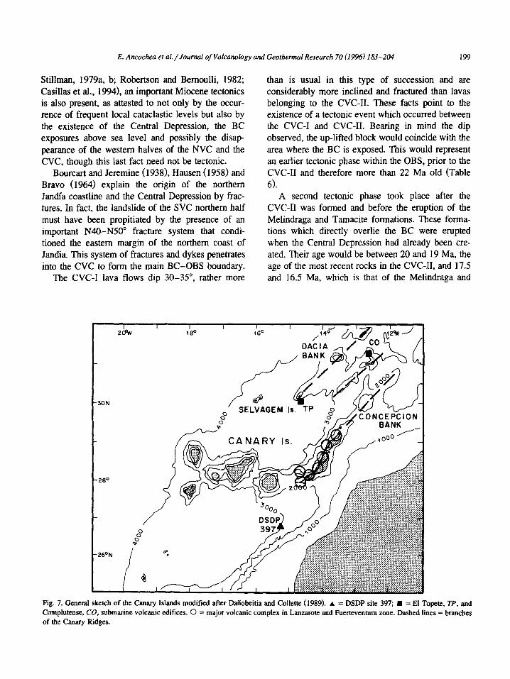
The alignment defined by the chain of volcanoes found in Fuerteventura and Lanzarote extends further north up to Banco de la Conception, a submarine volcanic complex (Fig. 7) situated above 30-31”N latitude (Luyendyk and Bunce, 1973; Uchupi et al., 1976; Weigel et al., 1978; Dtiobeitia, 1988; Dailob- eitia and Collette, 1989). This alignment constitutes the eastern branch of the Canary Ridge, within which three roughly NSO”-trending subparallel branches are distinguished.
The sheeted dyke net in the BC, featuring a > 80% lateral spreading along its axial zone (Still- man, 1987), marks the main spreading trend in the area and, therefore, the main regional trend. It is along this N15” trend that the NVC and CVC centers on Fuerteventura, as well as Los Ajaches on Lan- zarote, are also aligned. This coincides with the Central Depression northern branch trend.
On the other hand, the CVC and the SVC, to- gether with the El Banquete seamount, feature a second N230-N235” trend which parallels that of dykes in the “El Jable” area and intruding into the SVC-I and CVC-I. The northeastern coast of Jandia, the southern margin of the up-lifted BC relief and even the southern branch of the Central Depression show this same trend. Further north on Lanzarote, the alignment of Los Ajaches and the Famara mas- sifs could represent a repetition of the N230-N235” trend.
The N135” dykes on southeastern Fuerteventura (Gran Tarajal) and their submarine prolongation (Fig. 6) could constitute the third arm of a possible triple junction. In any case it must be emphasised that the first and the second trends represent long-lived re- gional tectonic lineations while the third one has been aborted.
5.2. Tectonic phases
Apart from pre-Miocene tectonics printed in the earliest rocks of the BC (Rothe, 1968; Robertson and
E. Ancochea et al./Journal of Volcanology and Geothermal Research 70 (1996) 183-204 199
Stillman, 1979a, b; Robertson and Bernoulli, 1982; Casillas et al., 19941, an important Miocene tectonics is also present, as attested to not only by the occur- rence of frequent local cataclastic levels but also by the existence of the Central Depression, the BC exposures above sea level and possibly the disap- pearance of the western halves of the NVC and the CVC, though this last fact need not be tectonic.
Bourcart and Jeremine (19381, Hausen ( 1958) and Bravo (1964) explain the origin of the northern Jandfa coastline and the Central Depression by frac- tures. In fact, the landslide of the WC northern half must have been propitiated by the presence of an important N40-N50” fracture system that condi- tioned the eastern margin of the northern coast of Jandia. This system of fractures and dykes penetrates into the CVC to form the main BC-OBS boundary.
The CVC-I lava flows dip 30-35”, rather more
than is usual in this type of succession and are considerably more inclined and fractured than lavas belonging to the CVC-II. These facts point to the existence of a tectonic event which occurred between the CVC-I and CVC-II. Bearing in mind the dip observed, the up-lifted block would coincide with the area where the BC is exposed. This would represent an earlier tectonic phase within the OBS, prior to the CVC-II and therefore more than 22 Ma old (Table 6).
A second tectonic phase took place after the CVC-II was formed and before the eruption of the Melindraga and Tamacite formations. These forma- tions which directly overlie the BC were erupted when the Central Depression had already been cre- ated. Their age would be between 20 and 19 Ma, the age of the most recent rocks in the CVC-II, and 17.5 and 16.5 Ma, which is that of the Melindraga and
26ON P
0
30N
CONCEPCION
Fig. 7. General sketch of the Canary Islands modified after Dafiobeitia and Collette (1989). A = DSDP site 397; n = El Topete, Tf, and Complutense, CO, submarine volcanic edifices. 0 = major volcanic complex in Lanzarote and Fuerteventura zone. Dashed lines = branches of the Canary Ridges.

200 E. Ancochea et al./Journal of Volcanology and Geothermal Research 70 (1996) 183-204
Tamacite formations. The debris flow found in DSP hole 397, which reflects substantial mobility in the area, coincides with this age.
The unconformity between the SVC-I and the WC-II occurred at the same time (19.3- 17 Ma). Lastly, the period is also represented in the NVC by the quiescence reflected within the NVC-I by the separation between the strongly tectonised Middle NVC-I and the Upper NVC-I, where tectonics is virtually nonexistent.
The Ampuyenta Formation may relate to a third tectonic phase prior to the NVC-II (> 14.3 Ma), which probably coincided with the quiescence period that separated the SVC-II from the SVC-III (Table 6).
5.3. BC-OBS relationships
The model developed in this work for the sub- aerial volcanic activity introduces important changes in the interpretation of the BC. This new interpreta- tion is based on the following observations:
(a) The main BC exposures are located at the core of major subaerial volcanic complexes.
(b) There is no single regional BC-OBS uncon- formity but rather different relationships between some units and the BC rocks.
(c) According to the K-Ar age data the subaerial units and some BC episodes are contemporaneous (see Table 6).
(d) There are several independent OBS volcanic complexes overlying their corresponding indepen- dent BC exposures.
(e) In the same way that the subaerial volcanic complexes are the result of different overlapping constructs, the BC exposures are the result of differ- ent successive intrusion episodes.
The BC crops out in two different areas (Fuster et al., 1968a). The most extensive is situated in the core of the CVC and is thus given the name here “Central Basal Complex” (CBC). CBC submarine volcanics
lie at the periphery, whereas intrusive rocks are concentrated in the innermost zone, coinciding with the center deduced from dyking in the CVC-I and cvc-II.
The second BC exposure, denoted here Northern Basal Complex (NBC), also occurs in two different sectors. The southernmost sector coincides with the center deduced for the NW-II, while the other might occupy the nucleus of the NVC-I. A geometrical relationship between BC exposures and OBS volca- noes can therefore be inferred.
The BC-OBS unconformities quoted in the litera- ture in fact represent unconformities between BC rocks and relatively late OBS levels. For example, the unconformity in the NVC occurs between the BC and the Ampuyenta Formation or between the BC and the Upper NVC-I. In the case of the CVC, the unconformity is between BC rocks and the overlying CVC-III or even the Tamacite and Melindraga for- mations. On the contrary, when a (non-tectonic) contact is observed between BC rocks and early constructive episodes of the NVC or CVC, subma- rine volcanics are always involved, but never pluton- its.
The oldest rocks in the BC are Mesozoic tur- bidites (Rothe, 1966) with interlayered volcanoclas- tic sediments (Robertson and Stillman, 1979a, b; Robertson and Bernoulli, 1982). This sequence ap- pears inverted on its southern exposure as part of a reclined NE-facing neutral fold which points to the existence of an earlier tectonic phase in the area, which would have occurred shortly after the onset of volcanism on Fuerteventura but prior to the moment when the island emerged.
The overlying submarine volcanics not affected by earlier folding are interlayered at the top with shallow fossil-bearing sediments of Early and middle Oligocene age (Robertson and Bernoulli, 1982). These submarine rocks have also given Oligocene radiometric ages of 36.3 Ma (a recalculated age of Abdel Monem et al., 1971) and 35.7 Ma (Ibarrola et
Notes to Table 6: (11 Rona and Nalwalk (1970); [2] Abdel Monem et al. (1971); [3] Grunau et al. (1975); 141 Le Bas (1981); 151 Ibarrola et al. (1989); [6]
Cantagrel et al. (1993). () = age in Ma; -, - F - - = tectonic phase; CPG = Central Plutonic Group; NPG = Northern Plutonic group.

E. Ancochea et al./Journal of Volcanology and Geothermal Research 70 (1996) 183-204 201
Table 6 Main events in the growth of volcanic complexes and intrusion episodes
Tabkros I’omt.
Ampuymta Form.
(Loararcquw TaouciteFam. i (17.2-16.3)
i (17516.5) ;
i
-F,- -F2- 1 I
I Vega Ring CompleJI -h- 1
I (18.7-21.4) I
[2.3,4,61 LOWER svc-I (Cpc 4)
i
(20.7J9.3) 1
1 lt
I I
cvc-n cFG3
1
I I u
I i
MlocmE I
g2.s20.0) I I MiddkNVC-I :
NPG2
I
j
02SdIll 1
i u
- F, (?I _u , Hydrol - F, (?I a I
lt i
nKmmorplhinn j
lt
! I t
I fi
I NFGl
(25-23 [6,4D cvc-I ( cpG2
i
LownNVC-I 1 i I u I u I i u
U i
j
:
OLIGOCENE I
I lt
II
I CFGI j
I
U II I

202 E. Ancochea et nl./Jourd oj’Volcatwlogy ad Geothermal Research 70 (1996) 183-204
al., 1989) as shown in Table 5. This whole set of rocks is cut by intensive dyking representing be- tween 50 and 100% of the outcrop, which makes the observation of rock relationships difficult. The top of the submarine succession corresponds to a stage when the island was nearly emerging, as shown by the existence of shallow sediments and greater abun- dance of hyaloclastites.
It is not possible currently to establish temporal differences between the submarine succession of the CVC and NVC, since the age data available corre- spond to the area where these two volcanoes overlap (Fig. 1).
Four different successive intrusion episodes have been distinguished in the BC (Stillman et al., 1975; FGster et al., 1980, 1984a, b; Le Bas et al., 1986; Stillman, 19871, each of which produced contact metamorphism in the earlier rocks (Muiioz and Sagredo, 1974, 1989; Stillman et al., 1975; Stillman, 1987). All of them belong to the Central Basal Complex, and for this reason are given the name here Central plutonic groups 1, 2, 3 and 4 (CPG 1, 2, 3 and 4).
The age of the plutonic groups is not clearly defined, due mainly to the successive metamorphic processes undergone by the rocks (Cantagrel et al., 1993). The most homogeneous ages, and even here there is a certain degree of dispersion, correspond to the Vega de1 Rio Palmas Ring Complex (part of CPG4). The age data (18.7 and 21.4 Ma) coincide with the latest activity in the CVC-II. The trachytic dykes might also have been part of that felsic activ- ity. The Betancuria Trachytic-syenitic Complex, also a part of CPG4, is made up of subaerial rocks (Barrera et al., 1981) and, according to the ages given by Cantagrel et al. (1993), is contemporaneous with the latest activity in the CVC (Table 6).
The dating of the remaining plutonic groups is more confusing. Cantagrel et al. (1993) calculate an age of 25 Ma for CPGl carbonatites, whereas IX Bas et al. (1986) and Stillman (1987) consider CPGl as well as CPG2 to be > 48 Ma.
There are some data other than radiometric ages that can help us establish a reasonable correlation between volcanic complexes and plutonic groups. For example, radial dyke systems such as those described in the CVC converge in the BC area where plutonic rocks are located and, therefore, where max-
imum dyke intensity should be expected. In that case, CPG4, a group where dykes are very scarce or even absent, must neccessarily be younger than the CVC-I and the CVC-II, since both are extensively crossed by dykes. K-Ar ages estimated for CPG4 (Table 6) are in agreement with this observation.
Javoy et al. (1986) have shown that metamor- phism affecting CPGl and CPG2 dykes and plutons took place in a water-rich environment not sited inside the ocean floor but rather under a very large volcanic island similar in height (4000 m or more) to the present Teide on Tenerife. Such an edifice must have been the CVC at a stage represented by the CVC-I and the CVC-II.
On the basis of age data (Feraud et al., 1985) and dykes intensity, it seems more reasonable to establish a parallelism between the CVC-II and CPG3. If so, CPG2 could be correlated with the CVC-I and CPGl with an earlier submarine growth stage (Table 6).
Barrera et al. (19811, meanwhile, have recognized two different intrusion episodes on the northern BC exposures (Northern Plutonic Group, denoted NPG in this paper) which we consider to be independent of CPGI-4. The earlier NPGl produced contact metamorphism in the submarine volcanoes and the later episode, NPG2, in all earlier rocks. Two radio- metric ages have been advanced for NPGl: 25 Ma (Le Bas et al., 1986) and 23.2 Ma (Cantagrel et al., 1993; U-Pb zircon). Correlation is even more diffi- cult in this volcanic complex, although one hypothe- sis would be to correlate NPG2 with the Middle NVC-I and NPGl with the Lower NVC-I (Table 6).
6. Conclusions
Fuerteventura is the result of several volcanic complexes built up along two main regional tectonic lineations. South of the island two more submarine edifices of possibly similar characteristics can be recognized. On Lanzarote, two other volcanic com- plexes and their submarine extension further north are also found. They all form a row of volcanoes along a lineation subparallel to the African coastline that may relate to early Atlantic spreading trends in this area.
Each volcanic complex was built by the piling up of several separate constructive episodes and this

E. Ancochea et al./Journal of Volcanology und Geothermal Research 70 (1996) 183-204 203
makes it possible to distinguish successive cycles of activity separated by tectonic phases. Due to proxim- ity, correlation must exist between these tectonic phases and those in the neighbouring Atlas range, and hence the origin of the Eastern Canary Islands is linked to the tectonic evolution of the African Conti- nent, as proposed by some authors (i.e., Anguita and Hem&i, 1975; Robertson and Stillman, 1979a, b).
The BC should be reinterpreted as a rock complex comprising sediments which are previous to and contemporaneous with the growth of the island, vol- canics representing the submarine stage of Fuerteventura and hypabyssal roots (dykes and plu- tons) from both the submarine stage and the later subaerial stage. In sum, the BC is not an earlier substratum for the subaerial series, but rather the BC and OBS constitute an inseparable whole within each major volcanic complex. The history of each vol- canic complex, featuring one or more submarine and subaerial phases, includes volcanics (submarine and subaerial lavas) and their hypabyssal equivalents (plutons and dykes), showing different relationships between them.
Acknowledgements
This work was supported by the Spanish DGI- CYT Project PB 91-0147. Constructive comments by two anonymous reviewers and Prof. L. Wilson are gratefully acknowledged.
References
Abdel Monem, A., Watkins, N.D. and Gast, P.W., 1971. Potas- sium-argon ages, volcanic stratigraphy, and geomagnetic po- larity history of the Canary Islands: Lanzarote, Fuerteventura, Gran Canaria and La Gomera. Am. J. Sci., 271: 490-521.
Ancochea, E., Cubas, C.R., Heman F. and BrZndle, J.L., 1991. Edificios vol&icos en la Serie I de Fuerteventura: rasgos generales de1 Editicio Central. Geogaceta, 9: 60-62.
Ancochea, E., Br&ndle, J.L., Cubas, C.R., Hem&i, F. and Huertas, M.J.. 1993. La Serie I de la isla de Fuerteventura. Mem. R. Acad. Cienc. Exac. Fis. Nat. Madrid 27, 151 pp.
Anguita, F. and Hem&r, F., 1975. A propagating fracture model versus a hot spot origin for the Canary Islands. Earth Planet. Sci. Lett., 27: 1 I-19.
Balcells, R.. Barrera, J.L., G6mez, J.A., Cueto, L.A., Ancochea, E., Huertas, M.J., Ibarrola, E. and Snelling, N., 1994. Edades radiometricas de 10s editicios miocenos de Fuerteventura., Islas Canarias. Bol. Geol. Min. Esp., 105: 50-56.
Banera, J.L., Femtidez Santin, S., FGster, J.M. and Ibarrola, E., 1981. Ijolitas-Sienitas - Carbonatitas de 10s macizos de1 nor@. de1 Complejo Basal de Fuerteventura, Islas Canarias. Bol. Geol. Mm. Esp., 92-94: 309-321.
Bourcart, J. and Jeremine, E., 1938. Fuerteventura. Bull. Vol- canal., II(4): 5 I- 109.
BrIindle, J.L., Ancochea, E., Cubas, C.R. and Hem&r. F., 1991. AnBIisis de enjambtes de diques radiales utilizando un m&do matembtico. Geogaceta, 10: 97- 100
Bravo, T., 1964. Geologia General de las Islas Canarias. Goya, Santa Cruz de Tenerife, Vol. II, 592 pp.
Cantagrel, J.M., F6ster. J.M., Pin, C., Renaud, U. and Ibarrola, E., 1993. Age Miocene inferieur des carbonatites de Fuerteven- tura, 23 Ma: U-Pb zircon et le magmatisme pr&ce d’une ile o&nique, Pies Canaries. C. R. Acad. Sci. Paris, 316: 1147- 1153
Casillas, R., Ahijado, A. and Hem&ndez-Pacheco. A., 1994. Zonas de cizalla dGctil en et Complejo Basal de Fuerteventura. Geogaceta, 15: 117-121.
Cendrero, A., 1970. The volcano-plutonic complex of La Gomera, Canary Inslands. Bull. Volcanol., 34: 537-561.
Coello, J., Cantagrel, J.M., Ibarrola, E., Jamond, C., Hem&r, F.. Ftister, J.M., Ancochea, E., Casquet, C., Diaz de Terrin, J.R. and Cendtero, A., 1992. Evolution of the Eastern Volcanic Ridge of the Canary Islands based on new K-Ar data. J. Volcanol. Geotherm. Res., 53: 251-274
Cubas, C.R., Femiurdez Santin, S., Hem&t, F., Hemtidez Pacheco, A. and De La Nuez, J., 1988. Los domos salicos de Fuerteven- NIX Rev. Mat. Prof., 6: 71-97.
Cubas, C.R., Hem&t, F., Ancochea, E. and Br&tdIe, J.L., 1992. El Editicio Sur, Jandia de la Serie I de Fuerteventura: rasgos generales. Geogaceta, 11: 79-8 1.
Dailobeitia, J.J., 1988. Reconocimiento geofisico de estrucNras submarinas situadas al norte y sur de1 archipitlago Canario. Rev. Sot. Geol. Esp., 1: 143-155.
Daiiobeitia, J.J. and Collette, B.J., 1989. Estudio mediante sismica de reflexi& de un gtupo de estructuras submarinas situadas al Norte y Sur de1 archipielago Canario. Acta Geol. Hisp., 24: 147- 163.
Esnaola, J.M., 1984. Mapa geologic0 de Espaiia 1:25.000. Hoja 1.106-II-1.107-III, Antigua. Inst. Geol. Min. Esp., 23 pp.
Feraud, G., 1981. Datation de n?seaux de dykes et de roches volcaniques sousmarines par Ies m&odes K-Ar et 40Ar-39Ar. Utilisation des dykes comme marqueurs de paltocontraites. Thesis, Univ. Nice, 146 pp.
Feraud, G., Giannerini, G., Campredon, R. and Stillman, C.J., 1985. Geochronology of some canarian dike swarms: contribu- tion to the volcano-tectonic evolution of the archipielago. J. Volcanol. Geotherm. Res., 25: 29-52.
Wster, J.M. and Aguilar, M., 1965. Nota previa sobre la geologia de1 macizo de Betancuria. Fuerteventura, lslas Canarias. Es- tud. Geol., 21: 181-197.
Ftister. J.M., Cendrero, A., Gastesi, P., Ibarrola, E. and Ldpez Ruiz, J., 1968a. Geology and volcanology of Canary Islands, Fuerteventura. Inst. Lucas Mallada, C.S.I.C., Madrid, 243 pp.
Fdster, J.M.. Femattdez Santfn, S. and Sagredo, J., 1968b. Geologia y Volcanologia de las Islas Canarias. Lanzarote. Inst. Lucas Mallada, C.S.I.C., Madrid, 177 pp.

204 E. Ancochea er al./Journal of Volcunobgy and Geothermal Research 70 (19961 183-204
Ftister, J.M., Muiioz, M., Sagredo, J., Yebenes, A., Bravo, T. and
Hem&ndez Pacheco, A., 1980. Excursi6n 121 A + C del 26
I.G.C. a las Islas Canarias. Bol. Geol. Min. Esp., XCI-II:
351-390.
Ftlster, J.M., Ytbenes, A., Barrera, J.L., Muaoz, M. and Sagredo,
J., 1984a. Mapa geol6gico de Espaiia 1:25.000. Hoja 1.106-IV,
Betancuria. Inst. Geol. Min. Esp. 34 pp.
FGster, J.M., Barrera. J.L., Muiioz, M., Sagredo, J. and Yc?benes,
A., 1984b. Mapa geol6gico de Espda 1:25.000. Hoja 1.106-111,
P&jam. Inst. Geol. Min. Esp., 63 pp.
Gastesi, P., 1973. Is the Betancuria Massif, Fuerteventura, Canary
Islands, an uplifted piece of oceanic crust? Nat. Phys. Sci.,
246: 102- 104.
Grunau, H., Lehner, R., Cleintuar, P., Allenbach, M.R. and Baker,
G., 1975. New radiometric ages and seismic data from
Fuerteventura, Canary Islands, Maio, Cape Verde Islands and
Sao Tom& Gulf of Guinea. (Progress in Geodynamics.) R.
Sot. Neth. Acad. Art Sci., pp. YO- 108.
Hartung, G., 1857. Die geologischen Verh%tnisse der Inseln
Lanzarote und Fuerteventura. Neue Denkschr. Alg. Schweiz.
Ges. Gesammt. Naturwiss. 15, 163 pp.
Hausen, H., 1958. On the geology of Fuerteventura, Canary
Islands. Sot. Sci. Fenn. Comm. Phys. Math. 22(l), 211 pp.
Hemh, F., Ancochea, E., Bitidle, J.L. and Cubas, CR., 1993.
Caracteristicas generales en el Editicio Norte de la Serie I de
Fuerteventura. Geogaceta, 13: 62-64
Hemtidez Pacheco, A., 1973. Sobre el significado de las rotas
granudas gabroides de 10s complejos basales de las islas de
Fuerteventura, La Palma y La Gomera, ArchipiClago Canario.
Estud. Geol., 29: 549-557.
Ibarrola, E., Cantagrel, J.M., Fiister, J.M., Coello, J. and Jamond,
C., 1988. Geocronologia de las Series volc&nicas ne6genas de
Lanzarote, Islas Canarias. II Congr. Geol. Espaiia. pp. 345-348
Ibarrola, E., FBster, J.M. and Cantagrel, J.M., 1989. Evades K-Ar
de las rotas volctiicas submarinas en el sector norte de1
Complejo Basal de Fuerteventura. E.S.F. Meet. Canarian Vol-
canism, pp. 124-129.
Javoy, M., Stillman, C.J. and Pineau, F., 1986. Oxygen and
hydrogen isotope studies on the basal complexes of the Canary
Islands: implications on the conditions of their genesis. Con-
trib. Mineral Petrol., 92: 225-235.
Le Bas, M.J., 1981. The pyroxenite-ijolite-carbonatite intrusive
igneous complexes of Fuerteventura, Canary Islands. J. Geol.
Sot. London, 138: 496.
Le Bas, M.J., Rex, D.C. and Stillman, C.J., 1986. The early
magmatic chronology of Fuerteventura, Canary Islands. Geol.
Mag., 123: 287-298.
Le Maitre, R.W., 1976. Some problems of the projection of chemical data into mineralogical classifications. Contrib. Min-
eral. Petrol., 56: 181-189.
L6pez Ruiz, J., 1970. Estudio petrogrlfico y geoquimico de1
complejo filoniano de Fuerteventura, Islas Canarias. Estud.
Geol., 26: 173-208.
Luyendyk, B. and Bunce, E.T., 1973. Geophysical study of the
northwest African Margin of Morocco. Deep Sea Res., 20:
537-549.
Macdonald, G.A. and Katsura, J., 1964. Chemical composition of
Hawaiian lavas. J. Petrol.. 5: 82-133.
Martin, M., 1984. Mapa geol6gico de Espaiia 1:25.000. Hoja
I. 106-I- 1.107.IV, Puerto de1 Rosario. Inst. Geol. Min. Esp.,
18 PP. Muiioz, M., 1969. Estudio petroldgico de las formaciones alcali-
nas de Fuerteventura., Islas Canarias. Estud. Geol., 25: 257-
310.
Muiioz, M. and Sagredo, J., 1974. Existencia de metamorlismos
superpuestos en el complejo basal de Fuerteventura, Canarias.
I Asam. Nat. Geod. Geotis., p. 1287 (abstract).
Muiioz, M. and Sagredo, J., 1989. Caracterfsticas del metamor-
lismo tCrmico producido por 10s eventos plut6nicos intrusivos
mh recientes del complejo basal de Fuerteventura. E.S.F.
Meet. Canarian Volcanism, pp. 104-108.
Peterson, D.W. and Moore, R.B., 1987. Geologic history and
evolution of geologic concepts, island of Hawaii. In: R.W.
Decker, T.L. Wright and P.H. Stauffer (Editors), Volcanism in
Hawaii. U.S. Geol. Surv., Prof. Pap., 1350: 149- 189.
Robertson, A.H.F. and Bernoulli, D., 1982. Stratigraphy, facies
and significance of late Mesozoic and early Tertiary sedimen-
tary rocks of Fuerteventura. Canary Islands and Maio, Cape
Verde Islands. In: U. von Rad, K. Hinz. M. Sarnthein and E.
Seibold (Editors), Geology of the Northwest African Continen-
tal Margin. Springer-Verlag. Berlin, pp. 498-525.
Robertson, A.H.F. and Stillman, C.J., 1979a. Late sedimentary
rocks of Fuerteventura, Canary Islands. Implications for West
African continental margin evolution. J. Geol. See. London,
136: 47-60.
Robertson, A.H.F. and Stillman, C.J., 1979b. Submarine volcanic
and associated sedimentary rocks of the Fuerteventura Basal
Complex, Canary Islands. Geol. Msg., 116: 203-214.
Rona, P.A. and Nalwalk, A.J., 1970. Post-early Pliocene uncon-
formity on Fuetteventura, Canary Islands. Geol. Sot. Am.
Bull., 81: 2117-2122.
Rothe, P., 1966. Zum Alter des Volkanismus auf dem iistlichen
Kanaren. Sot. Sci. Fenn. Comm. Phys. Math., 31: I-80.
Rothe, P., 1968. Mesozoische Flysch-Ablagerungen auf Ka-
narieninsel Fuerteventura. Geol. Rundsch., 58: 3 14-322
Schmincke, H.U. and Von Rad, U., 1979. Neogene evolution of
Canary Island volcanism inferred from ash layers and volcani-
elastic sandstones of DSDP site 397, Leg 47 A. Init. Rep.
DSDP, 47: 703-725.
Steiger, R.H. and Jaeger, E., 1977. Subcommision of geochronol-
ogy: of the use of decay constants in geo and cosmochronol-
ogy. Earth Planet. Sci. Lett.. 36: 359-362.
Stillman, C.J., 1987. A Canary Islands dyke swarm: Implications
for the formation of oceanic islands by extensional tissural
volcanism. In: H.C. Halls and W.F. Fahrig (Editors), Mafic
Dyke Swarms. Geol. Assoc. Can. Spec. Pap., 34: 243-255.
Stillman, C.J., Fhster, J.M., Bennell Baker, M.J., Mui’ioz, M.,
Smewing, J.D. and Sagredo, J., 1975. Basal complex of
Fuerteventura is an oceanic intrusive complex with rift-system
affinities. Nature, 257: 469-470.
Uchupi, E., Emery. K.O., Bowin, CO and Phillips, J.D., 1976.
Continental margin of Western Africa: Senegal to Portugal.
Am. Assoc. Pet. Geol. Bull., 60: 809-878.
Weigel, W., Goldflam, P. and Hinz, K., 1978. The crustal struc-
ture of the Conception Bank. Mar. Geophys. Res., 3: 381-392.