Embed Size (px)
Citation preview

Volume One of Two
Prepared for the City of Brawley
Prepared by Development Design & Engineering, Inc.
For Westshore Development Corporation

La Paloma Specific Plan
Development Design & Engineering, Inc. 4/1/04 ii
CREDITS, ACKNOWLEDGEMENTS AND PARTICIPANTS
City of Brawley City Council & Planning Commission • Steve Vasquez, Mayor • M. Jo Shields, Mayor Pro-Tempore • Toni C. Carrillo, Council Member • Don C. Campbell, Council Member • John Benson, Council Member
• Ernest Dean, Planning Commission Chairman
• Eugene Bumbera, Planning Commissioner • Tony Gallegos, Planning Commissioner • Robert Noriega, Planning Commissioner • Thomas Rutherford, Planning
Commissioner • James Stiff, Planning Commissioner • R.C. Valenzuela, Planning Commissioner
City of Brawley Staff • Carlos V. Palma, City Manager • Gordon Gaste, City Planner • Yazmin Arellano, Public Works Director
• Francisco Soto, Building Official • Roberto Martinez, Associate Civil Eng. • Frank Contreras, Fire Chief
Local Agency Formation Commission (LAFCo) & Imperial County • Jurg Heuberger, AICP, CEP, LAFCo Executive Officer and Imperial County Planning Director • Darrell Gardner, Assistant Planning Director • Rosa Soto, Administrative Secretary EDAW, inc. • Jerry McLees, AICP, Principal Planner Imperial Irrigation District • Carlton L. King, Division Power Superintendent • Rick M. Torres, Supervisor, Customer Service Electric Services Power Department • Jose R. Montoya, Engineer • Jim Kelley, Supervisor, Real Estate Section • John R. Kilps, P.E., Supervising Engineer, Engineering Services Section Westshore Development Corporation
• Steve Hyman, President

La Paloma Specific Plan
Development Design & Engineering, Inc. 4/1/04 iii
Development Design and Engineering Inc. 1122 State Street, Ste. D, El Centro, CA 92243 Phone/Fax: 760-353-8110/352-6408, email: [email protected]
• Tom Dubose, President • Carlos Corrales, Principal Engineer • Gordon O. Olson, Principal Engineer • Daniel Arvizo, Associate Planner • Ken Cluskey, Associate Planner
• Travis Cleveland, Assistant Planner • Angelica Tornel-Ramos, Civil Eng. Tech. • Juan Maturino, Civil Engineering Tech. • Luis Ramos, Civil Engineering Tech.

La Paloma Specific Plan
Development Design & Engineering, Inc. 4/1/04 iv
Table of Contents Chapter 1 –Introduction……………………………………………………..… 1-1 A. Purpose………………………………………………………………………… 1-2 B. Background……………………………………………………………………. 1-2 C. Project Location and Description…………………………………………….1-3 Chapter 2 – Authority, Scope, & Conformance…………………………….2-1 A. State Requirements……………………………………………………………2-1 B. General Plan Conformance………………………………………………….. 2-4 C. Adjacent Land Use Compatibility…………………………………………… 2-32 Chapter 3 – Land Use Plan……………………………………………………. 3-1 A. Purpose and Intent……………………………………………………………. 3-1 B. Development Standards………………………………………………………3-6 Chapter 4 – Goals and Objectives…………………………………………… 4-1 A. Land Uses…………………………………………………………………….. 4-4 B. Circulation…………………………………………………………………….. 4-4 C. Water, Sewer, and Storm Drain…………………………………………….. 4-5 D. Public Facilities………………………………………………………………. 4-6 E. Noise…………………………………………………………………………… 4-6 F. Air Quality…………………………………………………………………….. 4-6 G. Architectural…………………………………………………………………… 4-7 Chapter 5 – Existing Conditions………………………………………………5-1 A. Existing Land Uses…………………………………………………………… 5-1 B. Surrounding Land Uses……………………………………………………… 5-2 C. Existing Circulation…………………………………………………………… 5-4 D. Transportation Services/Facilities…………………………………………. 5-7 E. Water, Sewer, and Storm Water…………………………………………… 5-8 F. Existing Public Utilities and Energy………………………………………… 5-9 G. Environmental………………………………………………………………… 5-10 H. Existing Public Service………………………………………………………..5-12 Chapter 6 – Circulation and Infrastructure………………………………… 6-1 A. Streets and Circulation……………………………………………………… 6-1 B. Sewer, Water and Storm Drains……………………………………………. 6-10 Chapter 7- Phasing…………………………………………………………….. 7-1 A. Phase One 2004 -2005………………………………………………………. 7-2 B. Phase A 2005 -2006…………………………………………………………. 7-5 C. Phase B 2006 -2007…………………………………………………………. 7-7 D. Phase C 2007-2008…………………………………………………….……. 7-9 E. Phase D 2008-2009…………………………………………………………... 7-10 Chapter 8 – Architectural and Landscape Guidelines…………………… 8-1 A. Architectural Guidelines……………………………………………………… 8-1 B. Landscape Guidelines………………………………………………….……. 8-22 Chapter 9 – Implementation……………………………………………………9-1 A. General …………………………………………………………………………9-1

La Paloma Specific Plan
Development Design & Engineering, Inc. 4/1/04 v
B. Development Review Process……………………………………………… 9-2 C. Design Guidelines Conformance………………………………………….. 9-5 D. Concurrent Processing……………………………………………………… 9-5 E. Minor Modifications and Specific Plan Amendments…………………….. 9-6 Chapter 10 – Financing Plan…………………………………………………..10-1 A. Mello-Roos CFD……………………………………………………………… 10-2 B. General Obligation Bonds……………………………………………………10-8 C. Fees and Exactions…………………………………………………………..10-9

La Paloma Specific Plan
Development Design & Engineering, Inc. 4/1/04 vi
List of Tables Table 2-A Land Use Element………..……………………………………… 2-5 Table 2-B Project Comparison to the Special Study Area………………. 2-12 Table 2-C Infrastructure Element…………………………………………… 2-13 Table 2-D Resource Management Element………………………………. 2-18 Table 2-E Open Space/Recreational Element……………………………. 2-22 Table 2-F Public Safety/Noise Element…………………………………… 2-25 Table 2-G Economic Development Element………………………………. 2-28 Table 2-H Housing Element (2000-2005)…………………………………. 2-30 Table 3-A Projected Project Area Density………………………………… 3-2 Table 3-B Development Standards………………………………………… 3-15 Table 3-C Comparison to City Development Standards………………… 3-16 Table 5-A Existing & Proposed Development/Environment…………….. 5-2 Table 6-A Estimated Infrastructure Population Densities……………….. 6-10 Table 6-B Sewer Discharge…………………………………………………. 6-11 Table 6-C Water Demand…………………………………………………… 6-12 Table 8-A Landscape Plant Listing…………………………………………. 8-32
List of Diagrams and Maps Figure 1 Regional Map……………………………………………………...1-4 Figure 2 Vicinity Map………………………………………………….........1-5 Figure 3 Land Use Map…………………………………………………..…3-6 Figure 4 Footprint Setback Example 6,000 Sq. Foot Lots………………3-8 Figure 5 Footprint Setback Example 5,000 Sq. Foot Lots………………3-8 Figure 6 Footprint Setback Example 4,000 Sq. Foot Lots……………...3-9 Figure 7 Community Center Elevation………………………..…………..3-14 Figure 8 Aerial Photo of Project Area……………………………………..5-3 Figure 9 Malan Street looking east……………………………………......5-4 Figure 10 Malan Street looking south on Eastern Avenue……………..…5-5 Figure 11 Cesar Chavez Street looking south into the project area...…..5-5 Figure 12 Best Canal………………………………………………………....5-10 Figure 13 Circulation Exhibit………………………………………………...6-9 Figure 14-A Sewer System Map……………………………………………...6-16 Figure 14-B Water System Map………………………………………………6-17 Figure 14-C Storm Drainage System Map…………………………………..6-18 Figure 15 Phasing Exhibit…………………………………………………...7-12 Figure 16 Central Corridor and Monument Sign Example…….………....8-28 Figure 17 Primary Entrance and Monument Sign Example………………8-29 Figure 18 Example of Adjacent Land Use Boundary Requirements…….8-30 Figure 19 Conceptual Landscape/Land Use /Site Plan…………………...8-38

La Paloma Specific Plan
Development Design & Engineering, Inc. 4/1/04 vii
Appendices – See Volume 2 Appendix A Legal Description Appendix B Copy of Annexation Application to LAFCO Appendix C CEQA Documents and Reports Appendix D City of Brawley Bicycle Master Plan Design Guidelines Appendix E City of Brawley Zoning Code Sections 27.70 – 27-112 Appendix F Resolution Adopting the La Paloma Specific Plan Appendix G Fiscal Analysis Appendix H Elevation and Floor Plan Examples Appendix I IID – Undergrounding of IID Facilities Letter Appendix J IID – Electrical Service “Will Serve” Letter Appendix K Tentative Parcel Map (11 x 17)

La Paloma Specific Plan
Development Design & Engineering, Inc. 4/1/04 viii
SUMMARY
Development Design Inc. created the La Paloma Specific Plan in conjunction with Westshore Development, the City of Brawley, EDAW inc., the County of Imperial, and LAFCO. This Comprehensive Plan provides development and design guidelines for a new residential community within the 408 acres of agricultural land. The 408 acres is planned for annexation into the City of Brawley. The planned development will consist of the following land uses:
♦ 1,149 Single Family Units; ♦ Approximately 651 multi-family units; ♦ Land area to accommodate approximately 500,000
square feet of neighborhood commercial/retail; ♦ Light industrial uses; ♦ Schools; and ♦ Public Facilities, including Parks and Landscaping. The La Paloma Specific Plan development and design guidelines are based on “Awahnee Principles” and “Smart Growth Principles”. These have guided the development of this plan, which also conforms to the City’s General Plan and its current housing element. The La Paloma Specific Plan provides a project area analysis, development guidelines, and infrastructure data that have been developed to conform to the City’s General Plan. The La Paloma Specific Plan project area is located south of Malan Street, west of Highway 111, north of the Best Canal, and east of Ninth Street. The project area is located a few miles southeast of the City’s downtown.

La Paloma Specific Plan Introduction
1. INTRODUCTION The La Paloma Specific Plan is a policy and development plan for a planned community within the southeastern boundaries of the City of Brawley. The City of Brawley, Westshore Development, and Development Design & Engineering Incorporated (DD&E) have worked together to create the La Paloma Specific Plan. This document has been created for a planned community called La Paloma, meaning “The Dove”. The La Paloma project area encompasses approximately 408 acres of existing farmland in the City of Brawley’s sphere of influence in the State of California. The La Paloma Specific Plan establishes guidelines for a variety of land uses for a new urban community in the City of Brawley. The following summarizes the proposed land uses for La Paloma.
♦ 1,149 single-family Units; ♦ Approximately 651 multi-family units; ♦ Land area to accommodate approximately 500,000
square feet of neighborhood commercial/retail; ♦ Light industrial uses; ♦ Schools; ♦ Public Facilities, parks, and Landscaping.
The La Paloma Specific Plan has been created to provide development and design guidelines that are designed to be in conformance with the City of Brawley’s General Plan (adopted 1995). Once adopted by the City of Brawley, the La Paloma Specific Plan will provide policies and plans under existing regulatory systems over a phased time frame and throughout the project’s lifetime.
Development Design & Engineering, Inc. 4/1/04 1-1

La Paloma Specific Plan Introduction
A. Purpose
The La Paloma Specific Plan has been created primarily to accommodate new types of quality development that are not covered under current City Development Standards. This plan establishes new guidelines specifically for smaller lot sizes while ensuring a quality of life with additional or flexible standards. The project area is within the sphere of influence of the City of Brawley and its existing public infrastructure. Studies to support this document are found in Volume II. A special traffic study is not included, but referenced throughout this document. Goals and objectives are covered in Chapter 4. To ensure conformance with the General Plan, Chapter 2 details the scope of the La Paloma Specific Plan.
B. Background
The following provides a chronology of the required major events that led to the submittal of the Specific Plan.
1. The existing farmland was purchased for development
in 2003.
2. A Local Agency Formation Commission (LAFCO) application and map were submitted on February 18, 2003 for annexation of the project area (Appendix B).
3. A Tentative Map application was submitted to the City
of Brawley with a General Plan Amendment, and the La Paloma Specific Plan in January 2004.
Development Design & Engineering, Inc. 4/1/04 1-2

La Paloma Specific Plan Introduction
C. Project Location and Description
The City of Brawley is located in Imperial County, California. The project area lies 119 feet below sea level in the arid southeastern region of the Colorado Desert (See Figure 1). Annual rainfall is less than 3” and average temperatures range from the low 100’s in the summer to an average of 70 degrees in the winter. The project area is approximately 13 miles north of Interstate 8 and is located immediately west of State Route 111 and within a few miles of State Route 86 (See Figure 2). The project area is bordered to the south by Malan Street and to the north by Best Canal. The project area is generally flat and it is primarily agricultural. Agricultural features such as canals, drainage canals, and service roads exist throughout the project area. An open drainage area called Bryant Drain runs along Malan Street. Bryant Drain serves as the major irrigation drainage canal for the project site. Best Canal provides irrigation water to the existing farmland and borders the southern edge. The project’s legal description is provided in Appendix A. The existing environment is discussed further in Chapter 5 of this Specific Plan.
Development Design & Engineering, Inc. 4/1/04 1-3
La Paloma Specific Plan Introduction
Dev
FIGURE 1 – REGIONAL MAPOF PROJECT AREANot to Scale
elopment Design & Engineering, Inc. 4/1/04 1-4

La Paloma Specific Plan Introduction
Deve
FIGURE 2 – VICINITY MAPOF PROJECT AREA Not to Scale
lopment Design & Engineering, Inc. 4/1/04 1-5

La Paloma Specific Plan Authority, Scope & Conformance
2. AUTHORITY, SCOPE, & CONFORMANCE
The La Paloma Specific Plan is for a 408-acre site that is designed to be in conformance with the State of California Government Code and the City of Brawley’s General Plan. To ensure that this Specific Plan is in conformance, this section of the La Paloma Specific Plan analyzes this project with regard to the State Code and the City of Brawley’s General Plan.
Section C of this chapter also reviews the project’s compatibility to adjacent land uses.
A. State Requirements
Section 65451 of the California Government Code states that cities and counties may adopt specific plans for the systematic implementation of the General Plan. The following analyzes the project’s conformance to the State Code.
(a) A Specific Plan shall include a text and a diagram or diagrams, which specify all of the following in detail: 1. The distribution, location, and extent of
the uses of land, including open space, within the area covered by the plan.
Project conformance: These are discussed in Chapter 3, Community Development, which outlines detailed development and guidelines for all proposed land uses, including open space. The project’s land use map is also provided in Chapter 3.
2. The proposed distribution, location, and extent and intensity of major
Development Design & Engineering, Inc. 4/1/04 2-1

La Paloma Specific Plan Authority, Scope & Conformance
components of public and private transportation, sewage, water, drainage, solid waste disposal, energy, and other essential facilities proposed to be located within the area covered by the plan and needed to support the land uses described in the plan.
Project conformance: Chapter 7 specifically discusses infrastructure for the project’s development, which covers roads, water, sewer, storm drains, and retention basins. The amount of solid waste and the provision of “dry” utilities are also discussed. This Specific Plan corresponds with the most recent Service Area Plan update that details the public services that will be needed. Circulation is also discussed in this chapter.
3. Standards and criteria by which development will proceed, and standards for the conservation, development, and utilization of natural resources, where applicable.
Project conformance: Chapter 8 discusses the project’s intended phasing plan. The phasing plan outlines the infrastructure development that should occur during the specified phase. The project will encompass farmland with no known natural resources.
4. A program of implementation measures including regulations, programs, public works projects, and financing measures necessary to carry out paragraphs (1), (2), and (3).
Project conformance: Implementation measures such as amendments and enforcement measures are discussed.
Development Design & Engineering, Inc. 4/1/04 2-2

La Paloma Specific Plan Authority, Scope & Conformance
Also, financing measures for the project are discussed in chapter 10.
(b) The Specific Plan shall include a statement of the relationship of the Specific Plan to the General Plan.
Statement of Conformance:
The La Paloma Specific Plan is consistent with and is designed to meet or exceed the City of Brawley’s General Plan Goals and Policies. The La Paloma Planned Community is planned to provide more than the minimum requirement for open space and creates a walkable community near planned employment centers. The La Paloma Specific Plan is guided by and shall adhere to all applicable goals and policies, of the General Plan. Section 65454 of the California Government Code, Consistency With The General Plan, further states that:
No specific plan may be adopted or amended unless the proposed plan or amendment is consistent with the general plan.
Development Design & Engineering, Inc. 4/1/042-3
La Paloma Specific Plan Authority, Scope & Conformance
B. General Plan Conformance The La Paloma Specific Plan is consistent with, and in some instances exceeds, the City of Brawley’s General Plan Goals and Objectives. This plan is designed to be a tool of the General Plan. To ensure that this Plan conforms to General Plan, the following elements of the General Plan were analyzed for project conformance:
1. Land Use Element, Table 2-A 2. Special Study Area Designation Table 2-B 3. Infrastructure Element, Table 2-C 4. Resource Management Element, Table 2-D 5. Open Space/Recreation Element, Table 2-E 6. Public Safety/Noise Element, Table 2-F 7. Economic Development Element, Table 2-G 8. Housing Element (2000-2005), Table 2-H
The goals of each General Plan element that are applicable to the Specific Plan are listed below along with a statement of how the project conforms (Tables 2-A through 2-H).
Development Design & Engineering, Inc. 4/1/042-4

La Paloma Specific Plan Authority, Scope & Conformance
Development Design & Engineering, Inc. 4/1/04
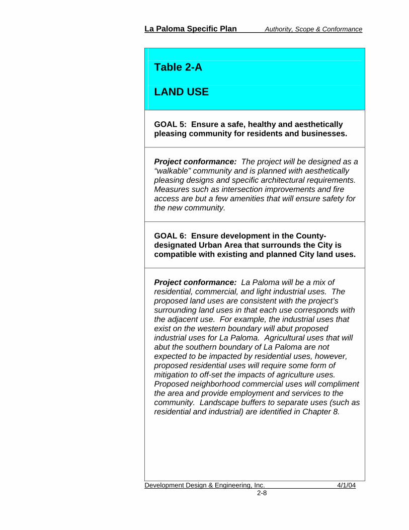
Table 2-A LAND USE GOAL 1: Provide for a well-balanced land use pattern that accommodates existing and future needs for housing, commercial and industrial land, open space, agricultural land, and community facilities and services while maintaining a healthy, diversified economy adequate to provide future City services. Project conformance: The project will include a mix of densities with lot sizes ranging from 4,000 to over 7,000 square feet. Multi-family units will be provided that range from 14 dwelling units per acre up to 20 dwelling units per acre. By providing a large mix of densities, this project is expected to help meet the City’s housing needs. The project area also includes a mix of commercial, industrial, and public land uses that provide employment and recreational opportunities -- all within direct access of the newly redesigned State Highway 111. GOAL 2: Ensure that future land use decisions are the result of sound and comprehensive planning.
Project conformance: The project is a result of the current market trend that is based on Smart Growth Planning Principles that encourage the following:
1. Preserve and enhance California’s quality of life. Accommodate growth in ways that use the state’s natural and financial resources efficiently, enhance its economic competitiveness, and provide local governments more certain and adequate funding.
2. Create viable and livable communities.
Ensure that existing communities remain or become vital and healthy places that
2-5

La Paloma Specific Plan Authority, Scope & Conformance
Development Design & Engineering, Inc. 4/1/04
Table 2-A LAND USE
provide opportunities for all residents to live, work, recreate, obtain a quality education, and raise a family.
3. Invest in transportation linked to
efficient land uses. Strengthen the links between transportation funding decisions and smart growth practices. Support smart growth practices with efficient transportation planning and investment strategies.
4. Enhance housing opportunities.
Support policies to increase the supply and affordability of housing to meet the needs of California families.
5. Preserve open space, natural
resources, and the environment. As much as possible, locate new development in or adjacent to existing communities, so as to protect air and water quality, conserve wildlife habitat and natural land features and systems, and provide green space for recreation and other amenities.
6. Preserve farmland. To the extent
possible, avoid the conversion of California’s prime agricultural land to other uses.
7. Address growth issues regionally.
Foster collaboration among state, regional, and local governments to solve problems that are regional – and not local – in nature.
8. Seek grassroots solutions. Educate and
engage the community because
2-6

La Paloma Specific Plan Authority, Scope & Conformance
Development Design & Engineering, Inc. 4/1/04
Table 2-A LAND USE
grassroots, community-centered processes and procedures are essential elements of smart growth.
GOAL 3: Coordinate with federal, state, and local public agencies and other community-oriented organizations to ensure that services to the public are effectively provided. Project conformance: The developer has been actively engaged with the school district, California Fish & Game, Caltrans, the Imperial Irrigation District, and City of Brawley staff to ensure that the plan addresses development concerns that could impact regional resources. GOAL 4: Ensure that new development is compatible with surrounding land uses in the community and in adjacent unincorporated areas, the City’s circulation network, availability of public facilities, existing development constraints and the City’s unique characteristics and resources. Project conformance: This project addresses the necessary infrastructure improvements that will become a part of the City’s network. To ensure compatibility, the project area and its surroundings have been identified by Imperial County as an infill area for development under the Urban Area (UA) overlay zone. The project area is also recognized as a special study area for the City of Brawley that is intended to permit flexibility in the arrangement of a land use policy map. Development occurring within these areas is generally expected to meet the overall composition of percentages shown in Table LU-4 shown in Table 2-B of this document.
2-7
La Paloma Specific Plan Authority, Scope & Conformance
Development Design & Engineering, Inc. 4/1/04
Table 2-A LAND USE GOAL 5: Ensure a safe, healthy and aesthetically pleasing community for residents and businesses. Project conformance: The project will be designed as a “walkable” community and is planned with aesthetically pleasing designs and specific architectural requirements. Measures such as intersection improvements and fire access are but a few amenities that will ensure safety for the new community. GOAL 6: Ensure development in the County-designated Urban Area that surrounds the City is compatible with existing and planned City land uses. Project conformance: La Paloma will be a mix of residential, commercial, and light industrial uses. The proposed land uses are consistent with the project’s surrounding land uses in that each use corresponds with the adjacent use. For example, the industrial uses that exist on the western boundary will abut proposed industrial uses for La Paloma. Agricultural uses that will abut the southern boundary of La Paloma are not expected to be impacted by residential uses, however, proposed residential uses will require some form of mitigation to off-set the impacts of agriculture uses. Proposed neighborhood commercial uses will compliment the area and provide employment and services to the community. Landscape buffers to separate uses (such as residential and industrial) are identified in Chapter 8.
2-8

La Paloma Specific Plan Authority, Scope & Conformance
Development Design & Engineering, Inc. 4/1/04
Table 2-A LAND USE GOAL 7: Revitalize older commercial, industrial and residential uses and properties. Project conformance: La Paloma will add residential density in close vicinity to Brawley’s historic main street. This density increase will make the area more attractive to retail and entertainment establishments that make revitalization possible
GOAL 8: Improve urban design in Brawley to ensure development that is both architecturally and functionally compatible. Project conformance: Chapter 8 of this Specific Plan will ensure that architecture is compatible within La Paloma. California Mission style is the likely architecture design for the project.
GOAL 9: Promote expansion of the City’s economic base and diversification of economic activity. Project conformance: La Paloma will add temporary construction jobs that contribute to Brawley’s economic activity. The development will also add residential population to Brawley that will increase the possibility of retail and entertainment establishments to serve the new and existing residents in Brawley. This planned community will add permanent jobs and add to the long-term economic vitality to the City of Brawley.
2-9

La Paloma Specific Plan Authority, Scope & Conformance
Development Design & Engineering, Inc. 4/1/04
Table 2-A LAND USE GOAL 10: Provide for adequate amount of industrial land use to serve the needs of Brawley residents to the year 2010, providing a full range of industrial activity and employment opportunities for City residents. Project conformance: The project includes an industrial land use that will provide employment opportunities within walking distance to proposed residential development. GOAL 11: Ensure that necessary public facilities and services are available to accommodate development proposed on the Land Use Policy Map. Project conformance: The project has been identified in the recent Service Area Plan update. In addition, the project will upgrade or add any necessary infrastructure, such as road improvements or new water lines.
GOAL 12: Identify and encourage conservation of prime agricultural lands adjacent to the City of Brawley. Project conformance: The project area consists of agricultural land and it is surrounded by agricultural land. In an effort to protect agriculture throughout the County, the County designated the project area as an Urban Area. Urban area is considered to be best suited for in-fill development. Because boundaries of Brawley’s infill area are clearly defined, areas designated for agriculture use are protected from urban development and urban sprawl.
2-10

La Paloma Specific Plan Authority, Scope & Conformance
Development Design & Engineering, Inc. 4/1/04
Table 2-A LAND USE
GOAL 13: Designate appropriate locations and adequate acreage for non-agricultural open spaces. Project conformance: La Paloma proposes approximately 25 acres of park and open space facilities. These facilities are located throughout the project area.
The project area is located in the Southeast Malan Special Study Area. According to the General Plan,
“Special Study Areas are intended to permit flexibility in the arrangement of Land Use Policy Map depicted land use designations… Development occurring within these areas is generally expected to meet the overall composition per percentages shown in Table LU-4.”
Table 2-B has been designed to provide a comparison between the “LU-4 Table” requirements and the La Paloma Specific Plan.
2-11

La Paloma Specific Plan Authority, Scope & Conformance
Table 2-B, Project Comparison to the Special Study Area
Existing Special Study
Area: Southeast
Malan*
New Development: La
Paloma
Remaining in the Southeast Malan
Special Study Area
Major Land Use Groupings And Land Use Designations Acres % Of
Total Acres (gross)
% Of Total
Acres % Of Total
Rural Residential
0
0 0 0 0 0
Low Density Residential
646
64% 218 22% 373 37%
Medium Density Residential
66 7% 41 4.1% 14 1.5%
Commercial
47 5% 17 1% 26 3%
Light Industrial/Business Park
0 0 0 0 0 0
Industrial
30 3% 12 1. % 15 1.5%
Public Facility 121 12% 40 4% 72 8%
Transportation Corridor
103 10% 82 8% 103 10%
Total by Subarea
1013 100% 410 40% 603 60%
*Source: Land Use Element, Table LU-4, Planned Land Use Allocation By Special Study Area.
Development Design & Engineering, Inc. 4/1/042-12

La Paloma Specific Plan Authority, Scope & Conformance
Table 2-C INFRASTRUCTURE ELEMENT
GOAL 1: Provide a system of streets that meets the needs of current and future inhabitants and facilitates the safe and efficient movement of people and goods. Project conformance: The project area will provide streets and improvements that will provide safe and efficient movement. Panno Road will be extended east through the project area up to the new State Highway 111 route. Cesar Chavez Street, Eastern Avenue and Palm Street will traverse north/south through the project area. The traffic study prepared by Darnell and Associates for the project area (2003) outlines the necessary improvements and mitigation requirements. GOAL 2: Provide for a truck circulation system that provides for the effective transportation of commodities while minimizing the negative impacts throughout the City. Project conformance: Panno Road will be designed as an east/west corridor to accommodate truck and major traffic. GOAL 3: Provide for well-designed and convenient parking facilities. Project conformance: The project will provide well-designed and convenient parking facilities as outlined by the City’s Zoning Ordinance.
Development Design & Engineering, Inc. 4/1/042-13

La Paloma Specific Plan Authority, Scope & Conformance
Development Design & Engineering, Inc. 4/1/04
Table 2-C INFRASTRUCTURE ELEMENT
GOAL 4: Support development of a network of regional transportation facilities which ensure the safe and efficient movement of people and goods from within the City to areas outside its boundaries, and which accommodate the regional travel demands of developing areas outside the City. Project conformance: The project implements this goal by incorporating a major arterial, an 80-foot central corridor, secondary arterials and a collector throughout the project. Each roadway will be designed to City standards with pedestrian amenities such as pedestrian links. Alternative modes are encouraged and bike lanes are planned for the major roadways. GOAL 5: Encourage appropriate expanded air operations to the City of Brawley. Project conformance: This goal is not applicable. GOAL 6: Encourage the continued service and the enhancement of the rail transportation in Brawley. Project conformance: This goal is not applicable. GOAL 7: Maximize the efficiency of the circulation system through the use of transportation system management and demand management strategies. Project conformance: A traffic study has been prepared for the project area. The traffic study provided the expected impact of the project area to existing roadways
2-14

La Paloma Specific Plan Authority, Scope & Conformance
Development Design & Engineering, Inc. 4/1/04
Table 2-C INFRASTRUCTURE ELEMENT
and provided recommendations for road improvements, including signalization of major intersections. Off-site, Dogwood Road and the future Panno Road extension were also examined. Due to the future off-site circulation issues at the intersection of Dogwood Road and the expected east-west traffic on Panno Road, the study examines circulation impacts from the project including the existing railroad that travels near this intersection. By examining these off-site areas of concern, the study is contemplative of an efficient circulation system. The traffic study is expected to provide transportation management and demand management strategies. GOAL 8: Support development of an appropriate public transportation system that provides mobility to City inhabitants and encourages use of public transportation as an alternative to automobile travel. Project conformance: The project provides alternative methods of travel throughout the project such as pedestrian links and bicycle routes. Although the County has no immediate plans to provide transit services within La Paloma, the City should coordinate with the County for a new route through the project area. Future multi-family and commercial development should include pedestrian-friendly and transit facilities when they are developed. Dial-A-Ride has been identified as the only available transit to the project area. New residents should be made aware of this program. GOAL 9: Increase the use of non-motorized modes of transportation. Project conformance: The project will provide bike lanes and pedestrian links that should encourage the use of non-motorized modes of transportation.
2-15

La Paloma Specific Plan Authority, Scope & Conformance
Development Design & Engineering, Inc. 4/1/04
Table 2-C INFRASTRUCTURE ELEMENT
GOAL 10: Provide adequate water service and infrastructure for existing development while planning and implementing improvements to accommodate planned growth in Brawley. Project conformance: The 2004 Service Area Plan is expected to address the needs for the La Paloma Planned Community. Adequate water service will therefore be addressed. The necessary infrastructure will also be provided, including a new water reservoir. GOAL 11: Promote City-wide water conservation to reduce the projected demand for water service and associated treatment. Project conformance: The project proposes low water usage for landscaping and provides a list of desert trees and plants that are best suited for the region. GOAL 12: Provide adequate sewer collection infrastructure and treatment facilities for existing development while planning and implementing improvements to accommodate planned growth in Brawley. Project conformance: The project will connect to existing City water and sewer infrastructure. Development will meet City criteria for connecting by including a pump station and a new reservoir within the project area. A CFD will be formed to pay for new infrastructure and impact fees will also be collected. The updated Service Area Plan will confirm the City’s ability to provide treatment facilities.
2-16

La Paloma Specific Plan Authority, Scope & Conformance
Development Design & Engineering, Inc. 4/1/04
Table 2-C INFRASTRUCTURE ELEMENT
GOAL 14: Ensure the provision of adequate power and communication service and transmission infrastructure to serve existing and planned development. Project conformance: The applicant has coordinated with the Imperial Irrigation District to address the needs for power service within the project area. Through their coordinated efforts, the project will include a site for a future substation. The developer will be required to coordinate communication services to the project area. GOAL 15: Promote citywide energy conservation to reduce the projected demand for electricity and gas. Project conformance: New development should be required to ensure a level of conservation. Also, the Imperial Irrigation District offers rebates for Energystar appliances; therefore, the City and the developer should coordinate with IID to inform new residents of the program.
GOAL 16: Define and evaluate alternative financing methods for infrastructure management and maintenance costs on a City-wide and area-wide basis. Project conformance: The project will require funding from a Communities Facilities District (CFD) and is not expected to impact the overall City’s funding for infrastructure management and maintenance.
2-17

La Paloma Specific Plan Authority, Scope & Conformance
Table 2-D RESOURCE MANAGEMENT ELEMENT
GOAL 1: Reduce air pollution through proper land use, transportation and energy use planning. Project conformance: The primary goal of the La Paloma community is to create a “walkable” community. The project will include pedestrian routes and bicycle routes to lessen the dependence on vehicles.
GOAL 2: Improve air quality by influencing transportation choices of mode, time of day, or whether to travel. Project conformance: The project provides alternatives to the motor vehicle by providing a series of pedestrian links and bike routes. Transit facilities routes and facilities are encouraged. GOAL 3: Reduce particulate emissions to the greatest extent feasible. Project conformance: This goal is not applicable. GOAL 4: Reduce emissions through reduced energy consumption. Project conformance: The project does not prohibit the use of alternative methods. In addition, the Imperial Irrigation District (which provides electrical service to the project area) offers energy saving measures, including rebates that are given to home and business owners who purchase Energystar appliances and electronics.
Development Design & Engineering, Inc. 4/1/042-18

La Paloma Specific Plan Authority, Scope & Conformance
Development Design & Engineering, Inc. 4/1/04
Table 2-D RESOURCE MANAGEMENT ELEMENT
GOAL 5: Conserve and protect natural plant and animal communities. Project conformance: Ultra Systems performed a focused biological study for the burrowing owl over the entire project area. This Specific Plan includes the results of the study and the conservation measures through CEQA. GOAL 6: Conserve and protect significant topographical features, important watershed areas, resources, and soils. Project conformance: The topography of the project area is flat and there are no known important features, resources, or soils. Local watersheds will be protected through the California Regional Water Quality Control Board and the City’s water quality program. GOAL 7: Coordinate with the County to conserve important natural resources in the unincorporated land in the Brawley Planning Area. Project conformance: This goal is not applicable.
GOAL 8: Protect water quality and conserve water supply. Project conformance: Urban runoff or “nuisance” water will be addressed through the implementation of the California Regional Water Quality Control Board requirements and the City’s water quality program.
2-19

La Paloma Specific Plan Authority, Scope & Conformance
Development Design & Engineering, Inc. 4/1/04
Table 2-D RESOURCE MANAGEMENT ELEMENT
GOAL 9: Reduce or control solid waste produced in the City. Project conformance: The project is expected to produce 10-million pounds of solid waste annually. The City provides solid waste service. The project does not hinder this goal. GOAL 10: Conserve energy resources through use of available energy technology and conservation practices. Project conformance: The project does not prohibit the use of conservation practices. All new homes shall be constructed with low water volume toilets, showers and facets. California State Law will require that all residential clothes washers to be as water-efficient as commercial washers starting in January 2007.
GOAL 11: Maintain and enhance the City’s unique cultural and historically significant building sites or features. Project conformance: There are no known unique cultural or historically significant building sites or features at the project site. GOAL 12: Preserve Brawley’s archaeological resources. Project conformance: The area has been farmed for almost a century. There are no known archaeological resources at the project site.
2-20

La Paloma Specific Plan Authority, Scope & Conformance
Development Design & Engineering, Inc. 4/1/04
Table 2-D RESOURCE MANAGEMENT ELEMENT
GOAL 13: Conserve and protect designated agricultural lands and plan for their continued use. Project conformance: Although the project area is located in prime farmland, efforts by the County and local cities have resulted in a farm preservation plan that outlines urban infill areas. The project area is located in an urban infill area within the City of Brawley’s Sphere of Influence. GOAL 14: Manage the production of economically valuable agricultural resources to achieve a balance between current market forces and long-term community values. Project conformance: This goal is not applicable. GOAL 15: Encourage expanded development of Brawley geothermal resources. Project conformance: This goal is not applicable.
2-21

La Paloma Specific Plan Authority, Scope & Conformance
Development Design & Engineering, Inc. 4/1/04
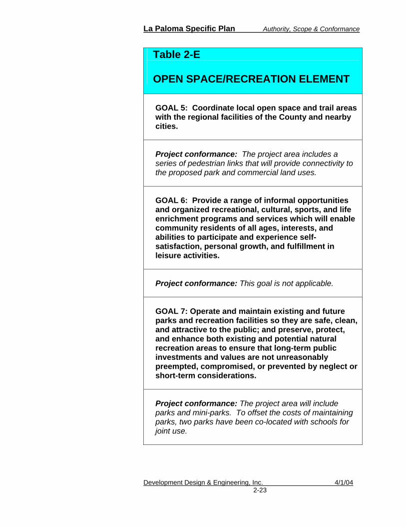
Table 2-E OPEN SPACE/RECREATION ELEMENT
GOAL 1: Preserve designated open space to preserve natural resources. Project conformance: There are no existing open spaces within the project area. The project will provide approximately 25+ acres of park open space area.
GOAL 2: Designate identified agricultural lands, outside the Brawley Urban Area as open space to prevent development, and enhance community character and visual relief. Project conformance: This goal is not applicable.
GOAL 3: Establish open space required to protect the public from hazards associated with floods, earthquake fault zones, unstable slopes and bluffs, and airplane crashes.
Project conformance: The project will include several retention basins within the project area. Calculations are provided in Chapter 6. GOAL 4: Encourage the development and maintenance of a balanced system of public and private parks and recreation facilities that serves the needs of existing and future residents in the City of Brawley. Project conformance: The project will include approximately 13 acres of joint-use park and recreation facilities with the local school districts.
2-22
La Paloma Specific Plan Authority, Scope & Conformance
Development Design & Engineering, Inc. 4/1/04
Table 2-E OPEN SPACE/RECREATION ELEMENT
GOAL 5: Coordinate local open space and trail areas with the regional facilities of the County and nearby cities. Project conformance: The project area includes a series of pedestrian links that will provide connectivity to the proposed park and commercial land uses. GOAL 6: Provide a range of informal opportunities and organized recreational, cultural, sports, and life enrichment programs and services which will enable community residents of all ages, interests, and abilities to participate and experience self-satisfaction, personal growth, and fulfillment in leisure activities. Project conformance: This goal is not applicable. GOAL 7: Operate and maintain existing and future parks and recreation facilities so they are safe, clean, and attractive to the public; and preserve, protect, and enhance both existing and potential natural recreation areas to ensure that long-term public investments and values are not unreasonably preempted, compromised, or prevented by neglect or short-term considerations. Project conformance: The project area will include parks and mini-parks. To offset the costs of maintaining parks, two parks have been co-located with schools for joint use.
2-23

La Paloma Specific Plan Authority, Scope & Conformance
Development Design & Engineering, Inc. 4/1/04
Table 2-E OPEN SPACE/RECREATION ELEMENT
GOAL 8: Ensure that park development and recreational goals and policies are pursued and realized in an organized, incremental, and cost-effective manner and consistent with the City of Brawley’s financial resources and legal authorities and the appropriate responsibilities of other agencies, the private sector, and individual and group users. Project conformance: Two major parks are proposed for joint use to offset the cost of maintenance and operating parks in La Paloma. In addition to park fees the City will likely require a Communities Facilities District (CFD) to fund the cost for operation and maintenance of the proposed parks and mini-parks. The Local Agency Formation Commission will ensure that park development financing is outlined before annexation.
2-24

La Paloma Specific Plan Authority, Scope & Conformance
Development Design & Engineering, Inc. 4/1/04
Table 2-F PUBLIC SAFETY/NOISE ELEMENT
GOAL 1: Reduce the risk to the community’s inhabitants from flood hazards. Project conformance: Retention basins will be included in the project to capture up to 3-inches of rain within a 100-year, 24-hour storm.
GOAL 2: Reduce the risk to the community from geologic and seismic hazards. Project conformance: The project will comply with the City’s requirements for new development. GOAL 3: Reduce the risk to the community’s inhabitants from exposure to hazardous materials and wastes. Project conformance: This goal is not applicable. GOAL 4: Reduce the risk to the community’s inhabitants from fires or explosions. Project conformance: This goal is not applicable. GOAL 5: Improve the City’s ability to respond to natural and man-made emergencies. Project conformance: This goal is not applicable.
2-25

La Paloma Specific Plan Authority, Scope & Conformance
Development Design & Engineering, Inc. 4/1/04
Table 2-F PUBLIC SAFETY/NOISE ELEMENT
GOAL 6: Reduce the amount of personal injury, damage to property, and economic or social dislocation as the result of disaster.
Project conformance: The project area has been identified for a future fire station site, thus reducing the response time for emergencies. GOAL 7: Minimize the level of danger to life and property from air operations accidents. Project conformance: This goal is not applicable. GOAL 8: Utilize noise control measures to reduce the impact from transportation noise sources. Project conformance: A noise study has been conducted for the project area and any necessary measures will be implemented to mitigate impacts. The project will comply with the noise levels established for the City of Brawley. The noise study can be found in Appendix C. GOAL 9: Develop measures to control non-transportation noise impacts. Project conformance: This goal is not applicable.
2-26

La Paloma Specific Plan Authority, Scope & Conformance
Development Design & Engineering, Inc. 4/1/04
Table 2-F PUBLIC SAFETY/NOISE ELEMENT
GOAL 10: Incorporate noise considerations into land use planning decisions. Project conformance: A noise study has been conducted for the project area and any necessary measures will be implemented to mitigate impacts. The project will comply with the noise levels established for the City of Brawley. The noise study can be found in Appendix C.
2-27
La Paloma Specific Plan Authority, Scope & Conformance
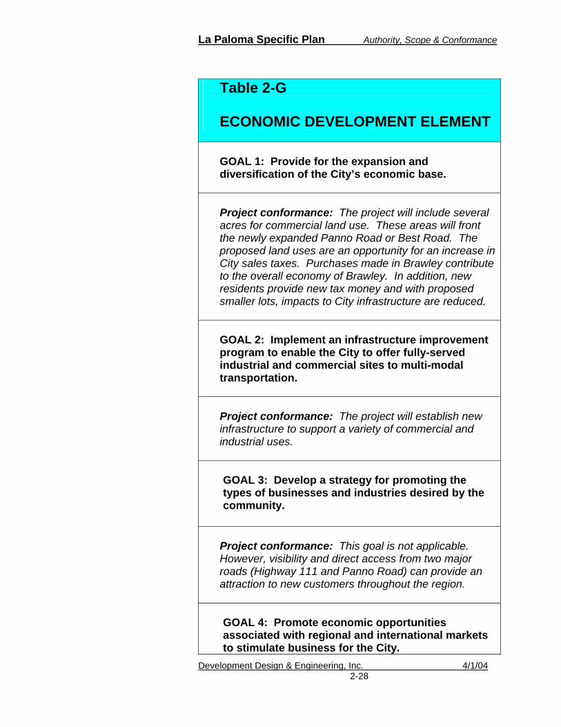
Table 2-G ECONOMIC DEVELOPMENT ELEMENT
GOAL 1: Provide for the expansion and diversification of the City’s economic base. Project conformance: The project will include several acres for commercial land use. These areas will front the newly expanded Panno Road or Best Road. The proposed land uses are an opportunity for an increase in City sales taxes. Purchases made in Brawley contribute to the overall economy of Brawley. In addition, new residents provide new tax money and with proposed smaller lots, impacts to City infrastructure are reduced. GOAL 2: Implement an infrastructure improvement program to enable the City to offer fully-served industrial and commercial sites to multi-modal transportation. Project conformance: The project will establish new infrastructure to support a variety of commercial and industrial uses. GOAL 3: Develop a strategy for promoting the types of businesses and industries desired by the community. Project conformance: This goal is not applicable. However, visibility and direct access from two major roads (Highway 111 and Panno Road) can provide an attraction to new customers throughout the region. GOAL 4: Promote economic opportunities associated with regional and international markets to stimulate business for the City.
Development Design & Engineering, Inc. 4/1/042-28

La Paloma Specific Plan Authority, Scope & Conformance
Development Design & Engineering, Inc. 4/1/04
Table 2-G ECONOMIC DEVELOPMENT ELEMENT
Project conformance: This goal is not applicable. GOAL 5: Promote development to meet the retail needs of the community. Project conformance: The project includes neighborhood commercial within the community. Almost 20 acres of new commercial land will be available and immediately accessible from Highway 111. GOAL 6: Promote the revitalization of the downtown business district. Project conformance: Although the project area is not within the downtown district, a new residential population can provide new customers to downtown. GOAL 7: Achieve a balance between housing and employment opportunities.
Project conformance: The project area includes a mix of land uses that can offer employment and economic opportunities.
2-29

La Paloma Specific Plan Authority, Scope & Conformance
Table 2-H HOUSING ELEMENT (2000-2005)
GOAL 1: Provide adequate housing in the City by location, price, type, and tenure, especially for those of low and moderate income and households with special needs.
Project conformance: The project will provide a mix of price, type, and tenure for first time homebuyers and those looking for a larger, upgraded home. Because of the range of lot sizes and densities, the project can help the City meet its housing goals by 2005. GOAL 2: Achieve balanced growth in the City by designing suitable sites for residential development. Project conformance: The project area is within the urban boundaries of the City. GOAL 3: Conserve and improve the condition of the existing affordable housing stock within the City. Project conformance: Although a single home will be lost, the proposed development would make up for this lost home. The proposed development would also improve the affordable housing stock. GOAL 4: Reduce residential energy usage within the City, thereby reducing overall housing costs. Project conformance: New development is designed with the City’s currently adopted Uniform Building Code. New homes built today are designed with new
Development Design & Engineering, Inc. 4/1/042-30

La Paloma Specific Plan Authority, Scope & Conformance
Development Design & Engineering, Inc. 4/1/04
Table 2-H HOUSING ELEMENT (2000-2005)
technologies that reduce the overall energy usage. GOAL 5: Promote and support equal housing opportunity for all residents of the City regardless of race, color, national origin, ancestry, religion, marital status, familial status, sex, or disability. Project conformance: This project will provide equal housing opportunities for all residents of the City regardless of race, color, national origin, ancestry, religion, marital status, familial status, sex, or disability. GOAL 6: Facilitate the maintenance, improvement, and development of housing commensurate with local needs. Project conformance: This goal is not applicable. GOAL 7: Support the provision of adequate housing to meet the needs of all economic segments of the community. Project conformance: This goal is not applicable. GOAL 8: Preserve existing affordable housing opportunities for lower income residents of the City. Project conformance: This goal is not applicable; however, affordable housing opportunities are expected with the proposed development.
2-31

La Paloma Specific Plan Authority, Scope & Conformance
C. Adjacent Land Use Compatibility
The La Paloma Specific Plan should be compatible with existing and planned land uses surrounding the site. All access will be provided from abutting roadways. The current surrounding land uses include agricultural and transportation facilities to the north, west, east and south of the project area (County of Imperial). Adjacent land uses and their compatibility are described below.
1. Agriculture
Typically, new development placed next to agricultural land uses creates some major conflicts. The agricultural community fears restrictions being placed on their operational aspects. These restrictions do quite often become a reality. On the other side, the urban users, many of whom are not familiar with the nature of agricultural operations, complain about dust, noise, odor, and traffic due to large equipment and aerial applications of pesticide and herbicide. In the case of La Paloma, however, there is a significant separation between the eastern boundary of the project site and the southern boundary of an adjacent agricultural field. Between the two operations, there is a major canal known as the Best Canal. While the distance alone may not be a sufficient separation, the physical features in this case do provide a perceptive separation.
2. Residential
Residential uses directly north of the project area are not expected to conflict with the new development. Improved circulation to the area is expected to benefit surrounding property owners.
3. Commercial
There are no known commercial uses adjacent to the project area.
Development Design & Engineering, Inc. 4/1/042-32

La Paloma Specific Plan Authority, Scope & Conformance
4. Industrial
Industrial uses to the west of the project area are expected to be buffered. Transition and uses are proposed for La Paloma.
5. Open Space/Parks
There are no known open spaces or parks immediately adjacent to the project area; however, farmland does provide a visual open space to surrounding neighborhoods. 6. Schools There are no schools immediately adjacent to the project area.
7. Airport There are no known airport zones adjacent to the project area.
Development Design & Engineering, Inc. 4/1/042-33
La Paloma Specific Plan Land Use Plan
Development Design & Engineering, Inc 4/1/04 3-1
3. LAND USE PLAN In keeping with the General Plan’s Land Use Goals, this section is designed to establish land use and development guidelines for the La Paloma Planned Development.
A. Purpose and Intent Due to the size and density of the proposed residential uses, the La Paloma Planned Development is unable to meet some of the current City Code requirements. The project area is also located within an overlay zone called the “Southeast Malan Special Study Area”. Because of these two unique circumstances, the project area is limited to specific development requirements. However, the City of Brawley’s Zoning Ordinance allows for a Planned Development (PD) district to be established. Article IX, Planned Development District, Section 27.120 reads:
“The PD district is established to allow flexible development plans to be prepared for the special study area identified in the General Plan Land Use Element [the project area falls within the Southeast Malan Special Study Area] which may benefit from unique or special land use and design controls not otherwise possible under conventional zoning regulations.”
With the City’s adoption of the Planned Development District for La Paloma, this Specific Plan shall establish policy and development guidelines where the Zoning Ordinance does not. These guidelines are also designed to serve the La Paloma community throughout its lifetime.
Land Use Goals and Objectives
1. Goal - Provide a
diverse residential community with convenient access to employment centers and community services.
2. Goal - Provide facilities
for parking, transit and pedestrian facilities that are landscaped and provide protection from severe weather.
3. Goal – Provide
complimentary and compatible commercial and industrial facilities that can co-exist with the residential land uses.
Objective 1 To establish guidelines that will ensure a diverse and a compatible mix of residential uses.
Objective 2 To provide higher residential densities along major arterials, transit stops, employment centers and public facilities. Continued on 3-2

La Paloma Specific Plan Land Use Plan
Development Design & Engineering, Inc 4/1/04 3-2
Land Use Gross Ac. +/-Proposed
DUs
Proposed Density
(DU/Gross Acre)Projected
Population*SF-6 132.35 572 4.32 1,956 SF-5 86.66 425 4.90 1,454 SF-4.0 24.07 152 6.31 520 TH-12 46.72 511 10.94 1,748 MF-17 9.6 140 14.58 479 C 22.91 0 0 0I 13.48 0 0 0PF 49.49 0 0 0S 24.12 0 0 0Total Acres 409.4 1,800 4.40 6,156
At its proposed density, La Paloma is expected to add a total of 6,000 new Brawley citizens at buildout. Table 3-A provides demographic data for the overall expected project density. The different land uses for La Paloma have been abbreviated to the following:
6,000 square foot lots – SF-6 5,000 square foot lots – SF-5 4,000 square foot lots – SF-4.0 Town homes at 12 units per acre – TH-12 Multifamily at 17 units per acre – MF-17 Commercial – C Industrial – I Public Facilities – PF School – S
Table 3-A, Projected Project Area Density *Based on 3.42/household for Imperial County,
Source: ‘00-‘05 Housing Element
Land Use Goals and Objectives continued
Objective 3 Commercial land uses shall allow for neighborhood commercial development. Pedestrian friendly designs shall be encouraged.
Objective 4 Commercial and industrial facilities shall be designed so that they do not impact the La Paloma community with negative sights and sounds.

La Paloma Specific Plan Land Use Plan
Development Design & Engineering, Inc 4/1/04 3-3
The following discusses the intent of the land uses within the La Paloma planned community.
1. Residential (SF 6, 5, 4, TH-12, MF-17)
The La Paloma Specific Plan proposes a variety of residential lot sizes and densities. Multi-family density ranges from of 12 dwelling units per acre up to a maximum of 17 dwelling units per acre. The single-family lots range from 4,000 square foot minimum lots up to 6,000 square foot minimum lots. Development standards have been specifically designed for the La Paloma community to accommodate 4,000 and 5,000 square foot lots. The 4,000 square foot lots are intended to be for attached housing or zero lot line homes. The City’s ordinance will guide development for new residential homes unless specified within this document.
2. Commercial (C)
This plan includes a neighborhood commercial element that is intended to compliment the community and provide primary commercial services for the new residents and surrounding communities. The City’s ordinance will guide development for all commercial under the C-1 Zoning designation unless specified in this document. Some uses under the City’s Zoning ordinance may be prohibited in La Paloma.
3. Industrial (I)
The industrial land use area will consist of industrial uses generally permitted under the City’s M-1 zoning. However some uses may be prohibited and are listed in this section.

La Paloma Specific Plan Land Use Plan
Development Design & Engineering, Inc 4/1/04 3-4
Development standards under current City ordinance will guide development in the “I” land use designation.
4. Schools and Public Facilities (PF)
With the need of new schools from new residential development, the community has established land uses to meet local school needs. In addition, the park and recreation needs for the community has also been recognized in the proposed land use plan. Combining the two uses on site provides an opportunity for the school district and the City of Brawley to share public services. These shared recreational opportunities reduce costs and ensure quality of life for the community by providing daily use of parks and school facilities within walking distance. All new schools will follow guidelines established by the State. Joint uses shall be discussed in detail under joint-use agreement. City parks and all public facilities shall be developed under City of Brawley development standards. Some proposed park areas will also serve as retention basins. Due to their potential to flood on infrequent occasions, retention basins should be limited to parkland or uses generally permitted within the City’s open-space designation. Parks within La Paloma will consist of over 20 acres of neighborhood and mini-parks. These parks will be placed throughout the project area. The overall park requirement for La Paloma is approximately 20.1 acres. This is based on 1,000 people (total 6,200) per 3.25 acres of parkland. The 3.25 factor meets the neighborhood park requirement stated in the General Plan.

La Paloma Specific Plan Land Use Plan
Development Design & Engineering, Inc 4/1/04 3-5
In addition to parks, City service facilities such as a new fire department, a new City reservoir, and new water and sewer infrastructure is planned. Additional public facility sites throughout the project area are reserved for Imperial Irrigation easements such as canals, drains, overhead power lines, and a future electric substation.


La Paloma Specific Plan Land Use Plan
Development Design & Engineering, Inc 4/1/04 3-7
B. Development Standards Development standards have been designed to provide standards for La Paloma that are not established in the City’s Zoning Code. Generally, most of the land uses shall conform to the City’s current development standards (See comparison in Table 3-C). The following sections and Table 3-B provide the general development requirements for La Paloma.
1. Residential Unless specified in this plan, all residential land uses within the La Paloma Specific Plan project area shall meet the requirements of the most current City of Brawley Zoning Ordinance, Section 27.70.
(Appendix E).
a. Detached Homes (SF-5 and SF-6)
i. Garage Setbacks A garage setback of 18-feet or greater is required for all single and attached family homes. The street front character of La Paloma should resemble a front-porch community and avoid the garage as the focus of each home. ii. Lot Coverage
Maximum building coverage in land use area SF-5 shall be 50% and maximum building coverage in area SF-6 shall be 55%.
Example of a Floor plan for a Zero Lot Line Home
Source: Dawson Hannouche Partners

La Paloma Specific Plan Land Use Plan
Development Design & Engineering, Inc 4/1/04 3-8
Figure 4 Footprint Setback Example, 6,000 Square foot lot.
2,347 Sq. ft. + 400 Sq. ft garage (not to scale)
Figure 5 Footprint Setback Example, 5,000 Square foot lot
1,865 Sq. ft. + 400 Sq. ft. garage (not to scale)
La Paloma Specific Plan Land Use Plan
Development Design & Engineering, Inc 4/1/04 3-9
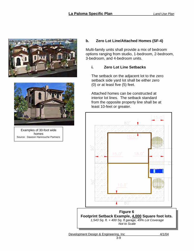
b. Zero Lot Line/Attached Homes (SF-4)
Multi-family units shall provide a mix of bedroom options ranging from studio, 1-bedroom, 2-bedroom, 3-bedroom, and 4-bedroom units.
i. Zero Lot Line Setbacks
The setback on the adjacent lot to the zero setback side yard lot shall be either zero (0) or at least five (5) feet. Attached homes can be constructed at interior lot lines. The setback standard from the opposite property line shall be at least 10-feet or greater.
Figure 6 Footprint Setback Example, 4,000 Square foot lots.
1,543 Sq. ft. + 400 Sq. ft garage, 49% Lot Coverage Not to Scale
Examples of 30-foot wide homes
Source: Dawson Hannouche Partners

La Paloma Specific Plan Land Use Plan
Development Design & Engineering, Inc 4/1/04 3-10
ii. Zero Lot Line Lot Coverage Maximum building coverage for zero lot line homes shall be 50%.
c. Multi-family Units (TH-12 and MF-17) The purpose of the zero lot line regulations is to provide for flexibility single-family attached or detached residential structures with one shared side setback area. The intent is to allow a home to be placed on a side lot line in order to allow a more usable side yard on the other side.
2. Residential Parking
Residential parking shall meet the requirements stated in the City’s Zoning Ordinance, Article XI including the following:
a. A minimum of a two-car garage (minimum 400
square foot) shall be provided per each single-family dwelling, including residences in the TH-12 zoning designation.
b. Conversion of garages into habitable space is
prohibited unless a replacement garage is provided.
c. Additional parking spaces within the front yard
area shall comply with the garage setback requirement. All vehicles shall be parked within an approved parking space. Vehicle parking is prohibited within landscaped areas in the front yard. At least 50% of the front yard area shall be reserved for landscaping.
d. Land use designations of MF-17 shall meet
multi-family residential parking requirements.

La Paloma Specific Plan Land Use Plan
Development Design & Engineering, Inc 4/1/04 3-11
e. Multi-family land use designations shall include designated bicycle parking facilities.
3. Residential Signs
See Chapter 8.
4. Residential Open Space
All residential development within the La Paloma planned community shall provide private open space to the following standards.
a. RS-4 and RS- 5 lots shall provide 50% of the lot for private open space.
b. RS-6 shall provide 55% private open space.
c. Single-family residential homes shall have at
least 50% of the front yard landscaped.
d. Multi-family uses shall meet city code requirements for open space.

La Paloma Specific Plan Land Use Plan
Development Design & Engineering, Inc 4/1/04 3-12
5. Commercial (C) Development Standards
Unless specified in this plan, all commercial land uses shall meet the requirements of the City of Brawley Zoning Ordinance under the C-1 zone, Section 27.80.
a. Commercial Height and Setback
Exceptions Architectural appurtenances are permitted for commercial or public facilities that create an aesthetic compliment or a focal point. Appurtenances, such as a bell tower or similar design elements may exceed the maximum height of thirty-five feet or encroach into minimum setbacks. Proposals for such appurtenances shall require approval by the City of Brawley Planning Director to ensure that safety, architectural compatibility and appropriate building scale are achieved and maintained.
b. Commercial Signs –See Chapter 8 c. Commercial Parking Refer to Article XI, Parking and Loading of the City of Brawley Zoning ordinance, unless stated below:
i. Compact parking spaces are prohibited. ii. Bicycle parking facilities shall be provided
at 1 space per 20 automobile spaces.
iii. A wall or decorative screen combined with a landscaped and irrigated buffer of at least 10-feet shall be provided when a parking lot abuts a residential area.
La Paloma Specific Plan Land Use Plan
Development Design & Engineering, Inc 4/1/04 3-13
6. Industrial (I) Development Standards
Only “permitted” and “conditional” uses under the M-1 zoning shall be allowed in the “I” designated land use.
Uses under the “I” land use designation shall meet the requirements of the City of Brawley’s Zoning Ordinance under M-1 zone.
a. Industrial Signs – See Chapter 8 b. Industrial Parking Refer to Article XI, Parking and Loading of the City of Brawley Zoning ordinance, unless stated below:
i. Compact parking spaces are prohibited. ii. Bicycle parking shall facilities shall be
provided at 1 space per 20 automobile spaces.
iii. A wall or decorative screen combined
with a landscaped and irrigated buffer of at least 10-feet shall be provided when a parking lot abuts a residential area.
7. Public Facilities (PF) Development Standards All public facilities shall meet the requirements of the Public Facilities zone of City of Brawley’s Zoning Ordinance. 8. General Requirements for All Land Uses
a. Land Use Boundaries Land use boundaries exist between the different land uses proposed for La Paloma and are shown in the attached La Paloma Land Use Map (Figure 3). To ensure compatibility, physical separations may
La Paloma Specific Plan Land Use Plan
Development Design & Engineering, Inc 4/1/04 3-14
be necessary for certain types of land uses. Parking areas that are adjacent to residential uses shall meet the minimum requirements stated under “Buffer Walls” in Section 27.147 of the City’s Zoning Ordinance. A minimum 20-foot landscaped setback buffer shall also be provided between non-residential buildings (and accessory uses such as sheds and trash enclosures) and residential uses. A minimum 10-foot landscaped setback buffer shall be provided between non-residential parking lots and residential uses. Public and semi-public facilities are also required to meet these minimum requirements when adjacent to residential land uses. A noise study may be required to ensure appropriate mitigation measures for noise are implemented.
b. Accessory Uses – Multi-Family,
Commercial and Light Industrial
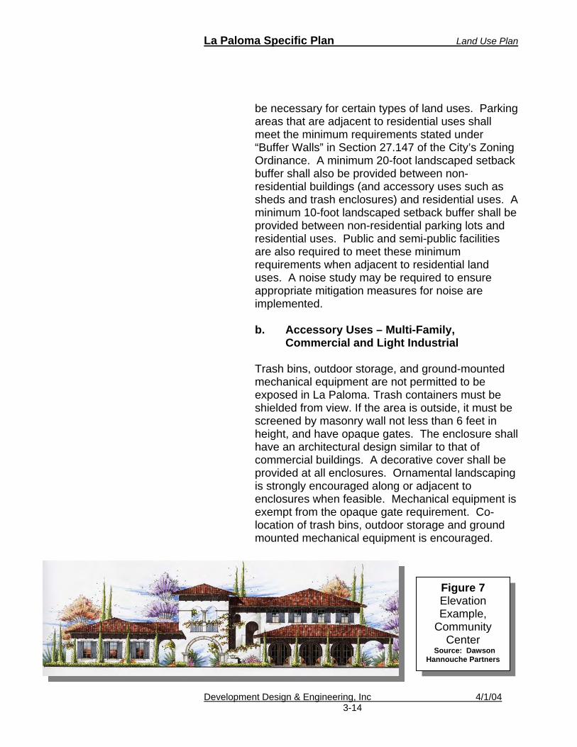
Trash bins, outdoor storage, and ground-mounted mechanical equipment are not permitted to be exposed in La Paloma. Trash containers must be shielded from view. If the area is outside, it must be screened by masonry wall not less than 6 feet in height, and have opaque gates. The enclosure shall have an architectural design similar to that of commercial buildings. A decorative cover shall be provided at all enclosures. Ornamental landscaping is strongly encouraged along or adjacent to enclosures when feasible. Mechanical equipment is exempt from the opaque gate requirement. Co-location of trash bins, outdoor storage and ground mounted mechanical equipment is encouraged.
Figure 7 Elevation Example,
Community Center
Source: Dawson Hannouche Partners

La Paloma Specific Plan Land Use Plan
Development Design & Engineering, Inc 4/1/04 3-15
Table 3-B La Paloma Development Standards RS-4 RS-5 RS-6 MF-12 MF- 17 C I PF
A. Maximum density (DU/Acre) 10.9 8.7 7.3 12 17 N/A N/A N/A
B. Minimum net lot area (in square feet) 4,000 5,000
C. Typical lot width (in feet) 50 50 D. Typical lot depth (in feet) 80 100
E. Typical corner lot width (in feet) 55 55
Refer to the C
ity of B
rawley Zoning
Code for R
-1, R
esidential Single Fam
ily.
F. Cul-de-sac or odd-shaped lot width (in feet) 30 30 35*
G. Front yard building setback (in feet) 15 15
H. Side yard building setback each side (in feet) 0/10 5/5
I. Side yard, building setback street side (in feet) 0/10 5/5
Refer to the C
ity of Braw
ley Zoning Code for C
-1, N
eighborhood Com
mercial.
Refer to the C
ity of Braw
ley Zoning Code for M
-1, Light M
anufacturing and Industrial.
Refer to the C
ity of Braw
ley Zoning Code for PF,
Public Facilities.
J. Rear yard building setback (in feet) 15 20 10/25** 10/25** 10/25*
K. Lot coverage, maximum (in percentage) 50% 50%
L. Building and structure height (maximum in feet) 35 35
M. Garage Front Setback 18 18
Refer to the C
ity of Braw
ley Zoning Code for R
-1, R
esidential Single Family.
Refer to the C
ity of Braw
ley Zoning Code for R
-3, Multifam
ily.
Refer to the C
ity of Braw
ley Zoning Code for R
-3, Multifam
ily.
Refer to the C
ity of B
rawley Zoning C
ode for C
-1, Neighborhood
Com
mercial.
Refer to the C
ity of B
rawley Zoning C
ode for M
-1, Light M
anufacturing and Industrial
Refer to the C
ity of B
rawley Zoning C
ode for PF, Public Facilities.
* Lot widths in a cul-de-sac can be reduced to 30-feet when amenities such as pedestrian links are included within the design. ** A 25-foot setback is required when abutting a residential land use. A minimum 5-feet of the setback area shall be landscaped.
La Paloma Specific Plan Land Use Plan
Development Design & Engineering, Inc. 4/1/04 3-16
1 A 25-foot setback is required when abutting a residential land use. A minimum of 5 feet of the setback area shall be landscaped.
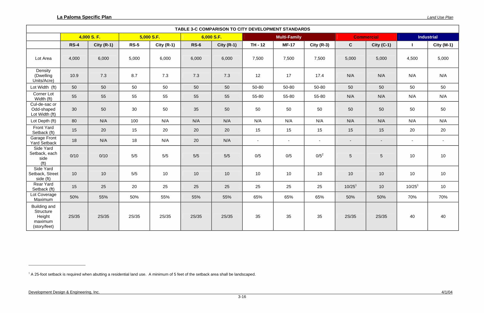
TABLE 3-C COMPARISON TO CITY DEVELOPMENT STANDARDS
4,000 S. F. 5,000 S.F. 6,000 S.F. Multi-Family Commercial Industrial
RS-4 City (R-1) RS-5 City (R-1) RS-6 City (R-1) TH - 12 MF-17 City (R-3) C City (C-1) I City (M-1)
Lot Area 4,000 6,000 5,000 6,000 6,000 6,000 7,500 7,500 7,500 5,000 5,000 4,500 5,000
Density (Dwelling
Units/Acre) 10.9 7.3 8.7 7.3 7.3 7.3 12 17 17.4 N/A N/A N/A N/A
Lot Width (ft) 50 50 50 50 50 50 50-80 50-80 50-80 50 50 50 50 Corner Lot Width (ft) 55 55 55 55 55 55 55-80 55-80 55-80 N/A N/A N/A N/A
Cul-de-sac or Odd-shaped Lot Width (ft)
30 50 30 50 35 50 50 50 50 50 50 50 50
Lot Depth (ft) 80 N/A 100 N/A N/A N/A N/A N/A N/A N/A N/A N/A N/A Front Yard Setback (ft) 15 20 15 20 20 20 15 15 15 15 15 20 20
Garage Front Yard Setback 18 N/A 18 N/A 20 N/A - - - - - - -
Side Yard Setback, each
side (ft)
0/10 0/10 5/5 5/5 5/5 5/5 0/5 0/5 0/52 5 5 10 10
Side Yard Setback, Street
side (ft) 10 10 5/5 10 10 10 10 10 10 10 10 10 10
Rear Yard Setback (ft) 15 25 20 25 25 25 25 25 25 10/251 10 10/251 10
Lot Coverage Maximum 50% 55% 50% 55% 55% 55% 65% 65% 65% 50% 50% 70% 70%
Building and Structure
Height maximum (story/feet)
2S/35 2S/35 2S/35 2S/35 2S/35 2S/35 35 35 35 2S/35 2S/35 40 40

La Paloma Specific Plan Goals and Objectives
Development Design & Engineering, Inc. 4/1/04 4-1
4. GOALS AND OBJECTIVES The project area is planned for a mix of residential homes with amenities often found in a small town or village community. The small town/village environment can be achieved by establishing goals and objectives for the project. Although smaller lots may not seem as traditional as a 10,000 or a 1-acre lot, reduced lot sizes do contribute to the housing stock, provide affordable housing, and lessen the impacts to City services. The smaller lot design also creates a close-knit community. By applying principles such as “Awahnee Principles” and “Smart Growth” concepts, the project can produce an overall quality development that is similar or better than the old tradition of large lot projects. La Paloma Specific Plan uses these principles to create the goals and objectives that are listed below. Awahnee Community Principles:
1. All planning should be in the form of complete and
integrated communities containing housing, school, work places, schools, parks, and civic facilities essential to the daily life of the residents.
2. Community size should be designed so that housing,
jobs, daily needs and other activities are within easy walking distance of each other.
3. As many activities as possible should be located
within easy walking distance of transit stops.
4. A community should contain a diversity of housing types to enable citizens from a wide range of economic levels and age groups to live within its boundaries.
5. Businesses within the community should provide a
range of job types for the community’s residents.

La Paloma Specific Plan Goals and Objectives
Development Design & Engineering, Inc. 4/1/04 4-2
6. The location and character of the community should be consistent with a larger transit network.
7. The community should have a center focus that
combines commercial, civic, cultural and recreational uses.
8. The community should contain an ample supply of
specialized open space in the form of squares, greens and parks whose frequent use is encouraged through placement and design.
9. Public spaces should be designed to encourage the
attention and presence of people at all hours of the day and night.
10. Each community or cluster of community should have
a well-defined edge, such as agricultural greenbelts or wildlife corridors, permanently protected from development.
11. Streets, pedestrian paths and bike paths should
contribute to a system of fully connected and interesting routes to all destinations. Their design should encourage pedestrian and bicycle use by being small and spatially defined by buildings, trees and lighting; and by discouraging high speed traffic.
12. Wherever possible, the natural terrain, drainage, and
vegetation of the community should be preserved with superior examples contained within parks or greenbelts.
13. The community design should help conserve
resources and minimize waste.
14. Communities should provide for the efficient use of water through the use of natural drainage, drought tolerant landscaping and recycling.

La Paloma Specific Plan Goals and Objectives
Development Design & Engineering, Inc. 4/1/04 4-3
15. The street orientation, the placement of buildings and the use of shading should contribute to the energy efficiency of the community.
Smart Growth Principles:
1. Mix land uses. 2. Take advantage of compact building design. 3. Create a range of housing opportunities and choices.
4. Create walkable communities.
5. Foster distinctive, attractive communities with a strong
sense of place.
6. Preserve open space, farmland, natural beauty, and critical environmental areas.
7. Strengthen and direct development toward existing
communities.
8. Provide a variety of transportation choices.
9. Make development decisions predictable, fair, and cost-effective.
10. Encourage community and stakeholder collaboration
in development decisions. This section states goals and objectives that have been established to guide the La Paloma Specific Plan.
The overall goal of the La Paloma Specific Plan is:
To establish a village community that will offer various housing choices and neighborhood employment opportunities, while providing public facilities and recreation within walking distance.

La Paloma Specific Plan Goals and Objectives
Development Design & Engineering, Inc. 4/1/04 4-4
A. Land Use Goal and Objectives
1. Goal - Provide a diverse residential community with convenient access to employment centers and community services.
2. Goal - Provide parking, transit and pedestrian
facilities that are landscaped and provide protection from severe weather.
3. Goal – Provide complimentary and compatible
commercial and industrial facilities that can co-exist with the residential land uses.
Objective 1 To establish guidelines that will ensure a diverse and a compatible mix of residential uses.
Objective 2 To provide higher residential densities along major arterials, transit stops, employment centers and public facilities.
Objective 3 Commercial land uses shall allow for neighborhood commercial development. Pedestrian friendly designs shall be encouraged. Objective 4 Commercial and industrial facilities shall be designed so that they do not impact the La Paloma community with negative sights and sounds.
B. Circulation Goals and Objectives
1. Goal - Design a pedestrian, bicycle, and traffic circulation system that will provide a safe and enjoyable outdoor experience with easy access to employment, shopping, and services within the community.

La Paloma Specific Plan Goals and Objectives
Development Design & Engineering, Inc. 4/1/04 4-5
2. Goal - Designate landscaped community entrance markers along Panno Road, Malan Street, Best Road, Cesar Chavez Street, Eastern Road, and Palm Drive.
Objective 1 Provide both primary and secondary points of access to accommodate emergency vehicle access and efficient traffic flow.
Objective 2 Where feasible, provide roadway improvements that include facilities for bicyclists.
Objective 3 The City should coordinate with County of Imperial Transit to provide a transit stop within the central east west arterial of La Paloma.
Objective 4 Require bicycle facilities at all commercial, transit, and public facilities.
C. Water, Sewer, and Storm Drain Goal and Objectives
1. Goal – Preserve existing infrastructure and
provide additional infrastructure and utilities within the project area.
Objective 1 Extend sewage collection lines and water distribution lines from existing treatment facilities to make efficient use of existing treatment capacities and reduce per site unit operation and maintenance costs.
Objective 2 Provide the opportunity for a needed sewer and water infrastructure for existing adjacent

La Paloma Specific Plan Goals and Objectives
Development Design & Engineering, Inc. 4/1/04 4-6
development not adequately served by existing infrastructure.
Objective 3 Construct a storm water retention basin with park and recreational facilities that can retain a majority of the storm water runoff generated by the maximum theoretical 100-year storm.
D. Public Facilities Goal and Objectives
1. Goal - Provide numerous opportunities to enjoy passive outdoor recreational experiences.
Objective 1 Coordinate with school district for shared recreation facilities. Objective 2 Provide mini parks throughout the project area.
E. Noise Goal and Objective
1. Goal – Minimize noise levels in indoor and outdoor in residential environments.
Objective Provide adequate noise barriers such as walls along major corridors.
F. Air Quality Goal and Objectives
1. Goal – Design should encourage pedestrian, bicycle, and transit uses to eliminate vehicle greenhouse emissions. Design should also include methods to reduce vehicular miles traveled.

La Paloma Specific Plan Goals and Objectives
Development Design & Engineering, Inc. 4/1/04 4-7
Objective Plan pedestrian linkages and bike routes throughout the community.
G. Architectural Goal and Objective
1. Goal – Provide a higher quality of architectural design using a consistent style of residential and non-residential design so that structures complement each other and enhance the visual quality of the surrounding environment.
Objective Establish architectural and landscape guidelines to ensure visual characteristics that help define La Paloma.
La Paloma Specific Plan Existing Conditions
Development Design & Engineering, Inc. 4/1/04 5-1
5. EXISTING CONDITIONS
This section provides a description of existing conditions within the project area. This site analysis provides an understanding of current conditions within the project area. This information has helped shape the La Paloma Specific Plan.
A. Existing Land Uses
The project area is primarily used for agricultural purposes and is served by the Best and Oakley Canals and the Bryant Drain. The canals and drains are property of the Imperial Irrigation District and were designed for agricultural purposes. Power lines are found along the boundaries of the project area and are also under the jurisdiction of the Imperial Irrigation District. Local county-serviced roads surround and intersect within the project area. The project area contains one single family dwelling on the project site at the intersection of Malan Street and South 10th Street. The home has no known historic value. Malan Street establishes the northern boundary that begins approximately 400 feet east of the existing railroad tracks traversing east approximately 6,400 feet to Best Road. Best Road (old State Route 111) establishes the eastern boundary, which is approximately 2,648 feet long. In addition to farmland, the project area consists of several unidentified tree species.

La Paloma Specific Plan Existing Conditions
Development Design & Engineering, Inc. 4/1/04 5-2
Table 5-A – Existing and Proposed Development/Environment
B. Surrounding Land Uses
The surrounding land uses currently exist around the project area: • North – Residential (City of Brawley) • East – Agricultural (County) • South – Agricultural (County) • West - Agricultural and Industrial (City of Brawley)
La Paloma Project Area
Existing Proposed
General Plan Designation
Southeast Malan
Special Study Area
Low Density Residential,
Medium Density Residential, Commercial
Public Facility Light
Industrial/Business Park
County Zoning A2U
City of Brawley Planned Development
(PD)
Land Use Agriculture Residential,
Commercial, Public, and Industrial

La Paloma Specific Plan Existing Conditions
Development Design & Engineering, Inc. 4/1/04 5-3
State Hwy 78
Project Site
Existing Single Family Home
State Hwy 111
FIGURE 8 – AERIAL PHOTO OF PROJECT AREA
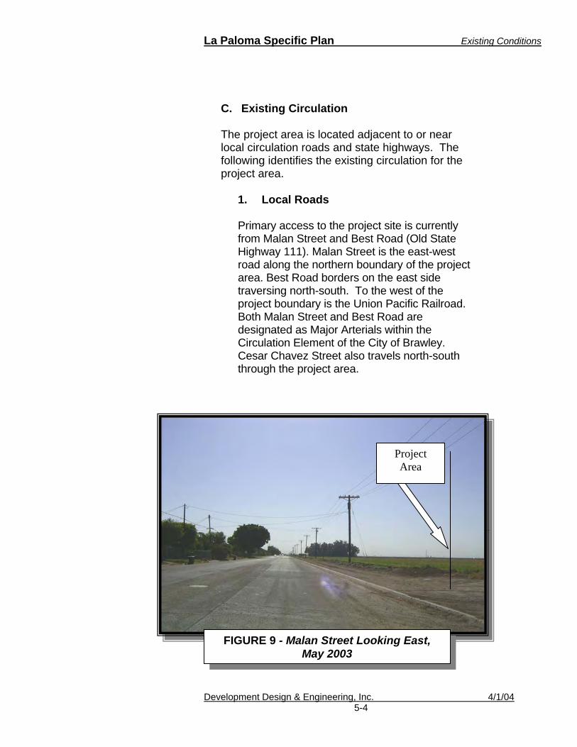
La Paloma Specific Plan Existing Conditions
Development Design & Engineering, Inc. 4/1/04 5-4
C. Existing Circulation The project area is located adjacent to or near local circulation roads and state highways. The following identifies the existing circulation for the project area.
1. Local Roads
Primary access to the project site is currently from Malan Street and Best Road (Old State Highway 111). Malan Street is the east-west road along the northern boundary of the project area. Best Road borders on the east side traversing north-south. To the west of the project boundary is the Union Pacific Railroad. Both Malan Street and Best Road are designated as Major Arterials within the Circulation Element of the City of Brawley. Cesar Chavez Street also travels north-south through the project area.
Project Area
FIGURE 9 - Malan Street Looking East, May 2003

La Paloma Specific Plan Existing Conditions
Development Design & Engineering, Inc. 4/1/04 5-5
��
FIGURE 11 - Cesar Chavez Street Looking South Into the Project Area
FIGURE 10 - Malan Street Looking South On Eastern Avenue

La Paloma Specific Plan Existing Conditions
Development Design & Engineering, Inc. 4/1/04 5-6
2. Highways
The nearest state highways are Highway 86, Highway 111 and Highway 78. The nearest Federal Highway is Interstate 8. Existing regional access to the City of Brawley is provided via Interstate 8, State Route 111, State Route 78, State Route 86, State Route 115, and State Route 186. The existing conditions of Interstate 8, State Route 78, and State Route 111 are described below. 3. Interstate 8 (I-8)
Federal Interstate Highway 8 is the primary east/west route through the County between San Diego and Yuma, Arizona. It is constructed with two lanes in each direction with complete grade separation at all intersections. The volumes on this facility range between 6,200-22,900 average daily trips (ADT).
4. State Route 111 (SR-111) SR-111 begins at the international border at Calexico as a four-lane divided highway (two lanes in each direction). Traffic volumes on these segments range between 22,000 and 41,000 ADT. Just south of Brawley, SR-111 is currently a two-lane undivided highway that is being improved to a four-lane divided highway. SR-111 provides a major connection to Brawley, Calipatria, and along the eastern shore of the Salton Sea to City of lndio where it connects with I-10. Daily traffic volumes north of I-8 are 12,100 ADT, decreasing to 3,500 ADT south of the Riverside County line.

La Paloma Specific Plan Existing Conditions
Development Design & Engineering, Inc. 4/1/04 5-7
5. State Route 78
Highway 78 connecting Blythe to the east of Brawley is located along the southern boundary of the proposed project. Most sections of this roadway are two-lanes with the exception of the stretch just west of the project site through Brawley as Main Street where there are four lanes.
D. Transportation Services/Facilities
The project area is served or is within the area of service of the following transportation services.
1. Transit Services Dial-A-Ride provides the only transit services within the project area. The nearest bus service is provided by Imperial County Transit approximately one mile north of the project area along Main Street. The Imperial Valley College Express also provides service from Main Street to the Imperial Valley College along Highway 111.
2. Bicycle Malan Street is designated as a Class III Bicycle Lane by the City of Brawley Bicycle Master Plan. A Class III Bicycle Lane shares the vehicle roadway and is identified by road signs.
3. Pedestrian Facilities There are no existing or designated public pedestrian facilities such as sidewalks or trails within the area.
La Paloma Specific Plan Existing Conditions
Development Design & Engineering, Inc. 4/1/04 5-8
4. Rail Services The Union Pacific Railroad serves Imperial County with freight rail services to Mexico. The rail lines border the project area directly to the west.
5. Truck Routes Commercial truck services include common carriers for interstate and interstate services. Highway 86, Highway 111 and Highway 78 carry commercial truck services through Brawley.
6. Airline Services Brawley Municipal Airport is located within approximately 2 miles northeast of the project area.
7. Commercial Bus Greyhound provides commercial bus services to the region. The nearest Greyhound facility is located in downtown Brawley.
E. Water, Sewer, and Storm Water
1. Water Supply
The La Paloma project area currently does not receive any domestic water service from the City of Brawley. The only water supply available to the site is from the Irrigation District, which delivers irrigation water (untreated canal water) for farming use only. No other known supply of water to the site exists, as there is also no groundwater of

La Paloma Specific Plan Existing Conditions
Development Design & Engineering, Inc. 4/1/04 5-9
quality suitable for use or even of quality for treatment. The nearest 12-inch water main is located along Malan Street between Cesar Chavez and Eastern Avenue. An existing 8-inch main is located between Malan Street and Best Road.
2. Sewer Services
An existing 12-inch sewer main is located at the corner of Malan Street and Best Road.
3. Storm Water & Drainage
Imperial Irrigation District (IID) drainage facilities exist on-site to accommodate farmland drainage from the project area.
F. Existing Public Utilities and Energy
1. Electricity The Imperial Irrigation District currently supplies most of Imperial County with electric service. As there are no significant improvements on this site at this time, no direct service has been provided, however the Imperial Irrigation District's facilities encroach upon or are found along the boundaries of the site.
2. Gas There is no known gas service to the project area. Southern California Gas is the supplier for the City. 3. Telecommunications It is not known if there is service being
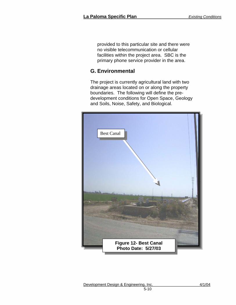
La Paloma Specific Plan Existing Conditions
Development Design & Engineering, Inc. 4/1/04 5-10
provided to this particular site and there were no visible telecommunication or cellular facilities within the project area. SBC is the primary phone service provider in the area.
G. Environmental
The project is currently agricultural land with two drainage areas located on or along the property boundaries. The following will define the pre-development conditions for Open Space, Geology and Soils, Noise, Safety, and Biological.
Best Canal
Figure 12- Best Canal Photo Date: 5/27/03

La Paloma Specific Plan Existing Conditions
Development Design & Engineering, Inc. 4/1/04 5-11
1. Open Space
According to the City’s Zoning Ordinance, Open Space means an area that is intended to provide light and air, and is designed for environmental, scenic or recreational purposes. Open space may include (but is not limited to) lawns, decorative planting, walkways (active and passive), recreation areas, playgrounds, fountains, swimming pools, wooded areas and watercourses. Open space shall not be deemed to include driveways, parking lots, or other surfaces designed or intended for vehicular travel. Open Space, common means open space within or related to a development, not in individually owned lots or dedicated for public use, but which is designed and intended for common use or enjoyment of the residents of the development. Open Space, private means an open space area held in private ownership, the use of which is normally limited to the occupant of a single dwelling unit or building. Based on these definitions, there is no existing public open space within the project area.
2. Geology
The Preliminary Geological and Geotechnical study for the La Paloma Planned Development made the following findings:
a. The study did not encounter conditions that would preclude implementation of the La Paloma project, however, site specific geotechnical investigations were recommended prior to

La Paloma Specific Plan Existing Conditions
Development Design & Engineering, Inc. 4/1/04 5-12
development to assess any changes to the geology of the site and to provide design and construction recommendations.
b. Groundwater beneath the site is
typically 8 to 10 feet below the ground surface. Subsurface agricultural tile drainage pipelines below the site help to prevent an artificially high groundwater depth. Abandoning and plugging these pipelines can allow groundwater levels to rise depending on the type of soil in the area.
c. There is a potential for strong ground
shaking at the project site during earthquakes along nearby faults, but this possibility exists for all nearby development and does not affect La Paloma any more than the surrounding area. The project will include mitigation measures found in Appendix C
d. The project site does not lie within a
State Earthquake Fault Zone and therefore is not considered to be at risk for surface rupture along any known fault.
e. Soil liquefaction is a potential design
consideration due to possible saturated sandy substrata; however, mitigation measures are available to alleviate this concern. These measures can be found in the Geological and Geotechnical Evaluation in Appendix C.
3. Soils The Phase I Environmental Site Report for the

La Paloma Specific Plan Existing Conditions
Development Design & Engineering, Inc. 4/1/04 5-13
La Paloma Planned Development made the following findings:
a. Pesticide residues exist in surface soils
in low concentrations. This is a common occurrence in agricultural soils.
b. Electrical transformers on the south side
of Malan Street and the west side of Bryant Road may contain oils of unknown PCB content which could possibly leak into the soil. The report did not say this had already occurred.
c. There is a risk of asbestos containing
materials at the existing residence within the project area (located at Malan Street and Bryant Road). This building will need special considerations during demolition in order to prevent soil contamination.
4. Biological Resources
There are no known species of plants or animals in this area that are considered to be endangered or otherwise protected, however, the Burrowing Owl, a State of California species of concern, has been found within the project area. See Appendix C regarding the results of this survey.
5. Parks and Recreation There are no existing park or recreation facilities available within the project area.
6. Noise Typical agricultural activities and traffic tend to be the major noise generators. A noise study

La Paloma Specific Plan Existing Conditions
Development Design & Engineering, Inc. 4/1/04 5-14
for the project area is found in Appendix C.
H. Existing Public Services Refer to the City of Brawley Service Area Plan Update regarding the following services:
1. Police Protection 2. Fire Protection and Emergency Medical
Services 3. Solid Waste Disposal 4. Water Supply 5. Wastewater Treatment
The following educational facilities serve or are located near the project area:
1. Brawley Elementary School District and
the Brawley Union High School District
2. Imperial Valley College (IVC)
IVC is located approximately 8 miles south of the project area.
3. San Diego State University
A branch campus is located within Brawley’s sphere of influence, approximately 2 miles northeast of the project area.
SDSU grading site 2003 (photo by SDSU)

La Paloma Specific Plan Infrastructure Plan
Development Design & Engineering, Inc. 4/1/04 6 - 1
6. CIRCULATION AND INFRASTRUCTURE PLAN
La Paloma will support a variety of land uses that will require street design and infrastructure planning. This section identifies the planned circulation and infrastructure facilities for La Paloma. The overall development is to be constructed in phases. The phasing plan is discussed in Chapter 7.
A. Streets and Circulation
An analysis of the expected circulation from the project was the framework used to determine traffic patterns into and out of the project area. In addition to analyzing the expected vehicular traffic, other modes of transportation such as walking, bicycling, and transit were also analyzed and incorporated into this plan.
Darnell and Associates has provided a traffic study for the project area with recommendations and mitigation measures. The entire traffic study document is not included in this plan; however, Sections VI and VII are found in Volume Two, Appendix C of this Specific Plan. To reduce vehicle miles traveled (VMT), the project has incorporated pedestrian linkages, bicycle routes, and sites for potential transit stops. Each of these alternative modes of transportation provides the community other methods to reach La Paloma recreational, commercial, and employment centers. (See Figure 13)
Circulation Goals and Objectives
1. Goal - Design a
pedestrian, bicycle, and traffic circulation system that will provide a safe and enjoyable outdoor experience with easy access to employment, shopping, and services within the community.
2. Goal - Designate
landscaped community entrance markers along Panno Street, Malan Street, Best Road, Cesar Chavez Street, Eastern Road, and Palm Drive.
Continued on next page

La Paloma Specific Plan Infrastructure Plan
Development Design & Engineering, Inc. 4/1/04 6 - 2
1. Street Design La Paloma will consist of four types of street sizes. These streets are identified as:
a. The Major Arterial Identified in the General Plan (Infrastructure Element, pg. 21), the Major Arterial is defined as a four-lane divided roadway with a typical right of way of 100-feet and a curb-to-curb pavement width of 80-feet. On street parking is typically allowed. The following streets are classified as Major Arterials: • Malan Road • Best Road • Panno Road b. The Secondary Arterial Identified in the General Plan, this two lane arterial for the project area will be a minimum width of 72-feet. The curb-to-curb width is typically 52-feet. This roadway shall allow for bicycle routes, pedestrian walkways and landscaped parkways. On-street parking is also an option. The General Plan identifies Panno Road, Eastern Avenue and Cesar Chavez (formerly Bryant Road) as Secondary Arterials within the project area. The following streets are classified as Secondary Arterials: • Cesar Chavez Street • Eastern Avenue c. The Central Corridor Avenida De La Paloma is an 80-foot wide arterial that is specific to La Paloma only. The street is envisioned to be the major central corridor for the La Paloma community. The curb-to-curb width shall be approximately 45 to 50-feet. This
Objective 1 Provide both primary and secondary points of access to accommodate emergency vehicle access and efficient traffic flow. Objective 2 Where feasible, provide roadway improvements that include facilities for bicyclists.
Objective 3 The City should coordinate with County of Imperial Transit to provide a transit stop within the central east west arterial of La Paloma. Objective 4 Require bicycle facilities at all commercial, transit, and public facilities.

La Paloma Specific Plan Infrastructure Plan
Development Design & Engineering, Inc. 4/1/04 6 - 3
roadway shall include enhanced pedestrian amenities consisting of wide sidewalks and landscaped parkway on both sides of the sidewalk. Parkways on both sides of a sidewalk will provide a mix of shade trees and ground cover that will be one of the community’s focal points.
d. The Collector Street
Identified in the General Plan, these streets are proposed throughout the project and will be a minimum 60-foot width.
2. Street Design Policy
The following shall be the minimum requirements for streets within La Paloma:
a. All primary interior streets shall provide a
minimum of two travel lanes, two parking lanes, concrete curb-gutters, concrete sidewalks, parkway, and Class II bicycle routes.
b. All 60-foot right-of-way corridors shall be two
travel lanes with on-street parking. The cul-de-sac circle at the end of each street shall have a minimum 50-foot radius to the right-of-way line.
c. Additional widening may be required at
intersections where a separate right or left turn lane is required.
d. Turnouts for transit and emergency vehicles
should be provided in street widths greater than 72-feet as determined by the City of Brawley’s Public Works Director.
e. On-street parking shall be prohibited within
40 feet of intersections or as determined by

La Paloma Specific Plan Infrastructure Plan
Development Design & Engineering, Inc. 4/1/04 6 - 4
the City of Brawley’s Public Works Director.
f. Pedestrian design shall be incorporated as stated in the following section.
g. The City’s current Engineering Standards
shall be referenced for all street design. 3. Pedestrian Design
Pedestrian friendly sidewalks and links shall be provided within the project area to encourage walking and allow easy walking access to public and employment amenities. Pedestrian linkages shall be provided to encourage safe walking within the project area. The purpose of pedestrian linkage is to provide safe pedestrian access out of a cul-de-sac or dead ends to the project’s public amenities. Potential locations for pedestrian links are shown in Figure 13.
12-Foot Pedestrian Easement
Pedestrian Link example

La Paloma Specific Plan Infrastructure Plan
Development Design & Engineering, Inc. 4/1/04 6 - 5
4. Pedestrian Design Policy
a. All sidewalks shall be designed to be five feet wide or greater along major corridors. Landscaped parkways shall be provided to separate the pedestrian from traffic.
b. Pedestrian linkages will require a minimum 12-
foot easement at selected cul-de-sacs and intersection. They shall be provided at dead ends such as cul-de-sacs and where direct access to public facilities can be obtained. All links shall be located within a minimum 12-foot easement with a sidewalk or pathway constructed to a minimum width of 5-feet. Landscaping shall be provided along the remaining easement.
c. Appropriate signage shall be placed at all
pedestrian crossings.
d. At all designated crossings, the use of decorative brick, striping, and/or reflectors shall be provided. To calm traffic, raised pedestrian crossings shall also be considered.
e. The location of transit and bicycle facilities
shall be incorporated into the location and design of pedestrian facilities.
f. Pedestrian access to all transit stops shall be
provided.
g. Along major roadways, parkways shall be provided to separate pedestrian traffic from vehicular traffic where additional right-of-way exists.
h. Well-lit and clearly marked decorative
crosswalks shall be provided at major intersections and near pedestrian links, work
Pedestrian Crossings should be well lit and
clearly marked for nighttime pedestrian traffic.

La Paloma Specific Plan Infrastructure Plan
Development Design & Engineering, Inc. 4/1/04 6 - 6
centers, commercial facilities, park facilities, and schools. Smooth non-slip concrete surface crossings with paving stones are recommended. Each edge of the concrete crossing should have a border of paving stones or similar product that is decorative and will provide a tactile guide for blind pedestrians using a cane to navigate.
5. Bicycle Design
The project shall include Class II bicycle routes provided along the major corridors within the La Paloma planned community that will link to the existing Class III bike route on Malan Street.
6. Bicycle Policy
a. Class II and Class III bicycle routes shall be provided within the major circulation corridors. These routes shall connect the project area with existing City and County routes. Every resident of La Paloma should have nearby access to a designated route. Figure 13 identifies the preferred location of these routes. All bicycle routes and facilities shall be designed in accordance with the City’s most current Master Bicycle Plan.
b. Bicycle-parking facilities shall be encouraged to be co-located with all transit stops.
c. All commercial, industrial, and public facilities
shall provide bicycle-parking facilities.
d. Bicycle parking facilities shall include a rack or other secure device for the purpose of storing and protecting bicycles from theft. Bicycle facilities shall be provided under the following standards:
Bicycle travel lanes.
Bicycle parking facilities.

La Paloma Specific Plan Infrastructure Plan
Development Design & Engineering, Inc. 4/1/04 6 - 7
i. One bicycle parking space per ten
automobile parking spaces, with a minimum of five bicycle parking spaces.
ii. Each bicycle parking space shall not interfere with pedestrian or vehicular traffic.
7. Transit Design Transit facilities to service the expected population should be coordinated by the City of Brawley, the County Department of Public Works, and the developer within or along the project area. Currently the County has no plans for transit facilities within the project area. At a minimum, it is recommended that transit services be provided for the project area with facilities placed along the Avenida La Paloma (the central corridor), Best Road or Malan Street. Dogwood Road is considered to be a potential future major transit corridor. Planning for future bus stops within La Paloma should consider the relationship with Dogwood Road’s transit role. In addition, a turnout should be provided at each stop to provide adequate and safe bus parking.
8. Transit Policies
a. Transit stops shall be constructed with bus
turnouts for safe parking (See example below). b. Transit stops shall be designed with shelter
facilities.
c. Bicycle parking facilities shall be provided at major transit stops.
d. Major stops should be placed at or near
employment centers and should be centrally located for residents.
Bus Shelter Example

La Paloma Specific Plan Infrastructure Plan
Development Design & Engineering, Inc. 4/1/04 6 - 8
TYPICAL BUSTURNOUT


La Paloma Specific Plan Infrastructure Plan
Development Design & Engineering, Inc. 4/1/04 6 - 10
B. Sewer, Water, and Storm Drains
This section identifies the sewer, water and storm drain needs for the project area. Project phasing is discussed in Chapter 7. The following table (Table 6-A) projects the population density capacity needs for La Paloma and is used to establish thresholds for sewer/water/storm drain infrastructure. Figure 14- A, B, and C are the general sewer/water/storm drain maps that will be detailed in the tentative tract map stage.
Table 6-A
Estimated Infrastructure Population Densities for La Paloma
Land Use Density Single-Family 1* 4 persons per lot Single-Family 2** 3 persons per lot Multi-Family 65 persons per acre Commercial 40 persons per acre Industrial 20 persons per acre Public 20 persons per acre
*Is based on lots 5,000 sq. ft. or greater ** Is based on lots smaller than 5,000 sq. ft.
The recently adopted City’s Service Area Plan includes sewer and water capacity from La Paloma.
1. Sewer
The City of Brawley will provide wastewater collection services for the project area. A new sewer pump station may be required and placed along Best Road within the La Paloma Planned Community. For commercial and industrial flow, it is assumed that a majority of the water supplied is sent back to the sewer systems. Table 6-B provides the estimated sewage discharge to the City of Brawley’s wastewater collection system.
Water, Sewer, and Storm Drain Goal and Objectives Goal – Preserve existing and provide infrastructure and utilities within the project area.
Objective 1 Extend sewage collection lines and water distribution lines from existing treatment facilities to make efficient use of existing treatment capacities and reduce per site unit operation and maintenance costs.
Objective 2 Provide the opportunity for a needed sewer and water infrastructure for existing adjacent development not adequately served by existing infrastructure. Objective 3 Construct a storm water retention basin with park and recreational facilities that can retain a majority of the storm water runoff generated by the maximum theoretical 100-year storm.

La Paloma Specific Plan Infrastructure Plan
Development Design & Engineering, Inc. 4/1/04 6 - 11
2. Water
The City of Brawley will provide the water for the project area. The Service Area Plan should also reflect this need for the La Paloma community. A new reservoir and pump station have been identified by the City’s Water Master Plan south of the project area. To support the La Paloma planned community, the reservoir and pump station will be included within the project area. A new dedicated 24-inch water line will be installed to serve the planned reservoir site. An 18-inch water line will run from the pump station through the project area and connect with the City’s future 12-inch water main along Malan Street. The new reservoir and pump station will be necessary by the completion of Phase 1 and prior to the construction of future phases. The developer will be required to coordinate with the City to construct these on-site facilities. Other improvements will include new 12-inch lines along some of the major arterials of La Paloma. This is further discussed in Chapter 7.
Population x Gallons Per Person per Day /Time* =Gallons Per Minute (GPM)Single Family 4,546 100 1,440 315.69Multi-Family 3,152 100 1,440 218.89Commercial 771 40 1,440 21.42Industrial 296 40 1,440 8.22Public 415 50 1,440 14.41Total Average Gallons Per Minute (GPM) 578.63Peak Factor (x2.0) = GPM 1,157.26 Total Discharge in Million Gallons Per Day 0.83 *Time is based on 24 hours multiplied by 60 minutes
Table 6-B, Sewer Discharge
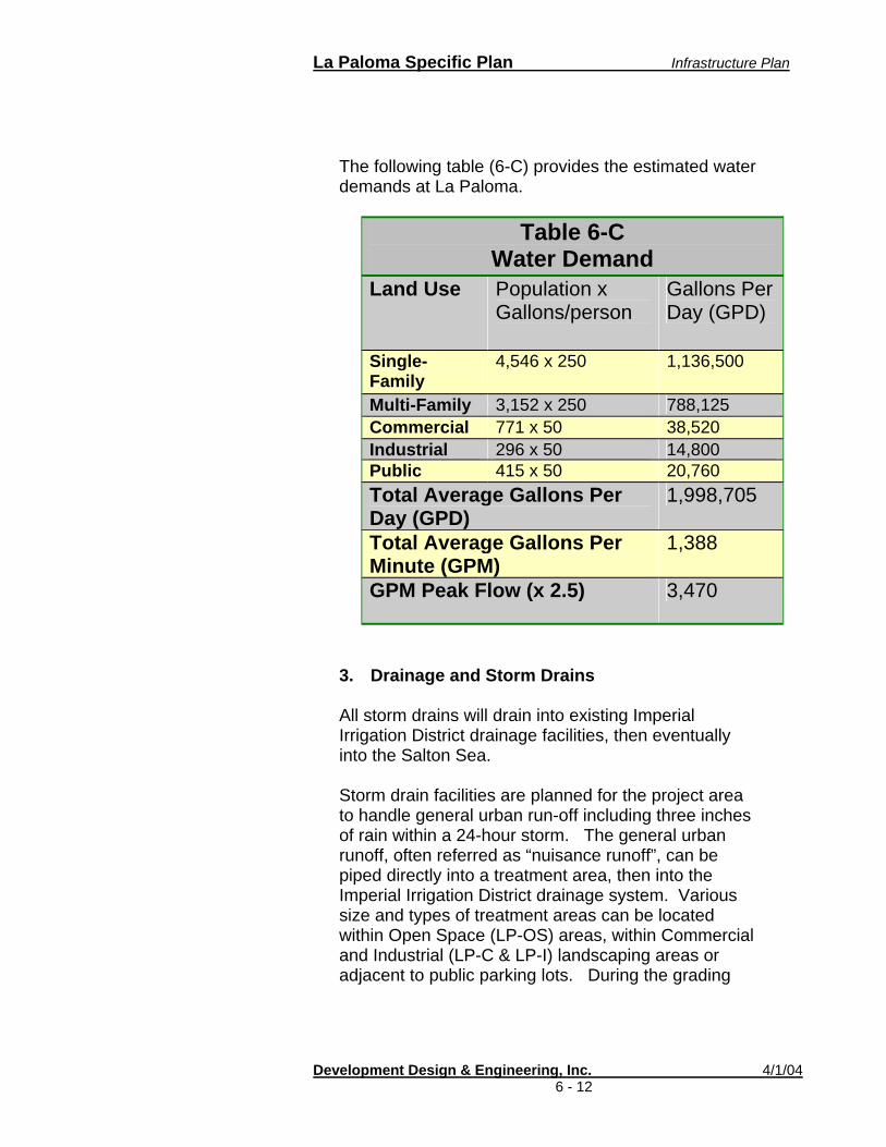
La Paloma Specific Plan Infrastructure Plan
Development Design & Engineering, Inc. 4/1/04 6 - 12
The following table (6-C) provides the estimated water demands at La Paloma.
Table 6-C
Water Demand Land Use Population x
Gallons/person Gallons Per Day (GPD)
Single-Family
4,546 x 250 1,136,500
Multi-Family 3,152 x 250 788,125 Commercial 771 x 50 38,520 Industrial 296 x 50 14,800 Public 415 x 50 20,760 Total Average Gallons Per Day (GPD)
1,998,705
Total Average Gallons Per Minute (GPM)
1,388
GPM Peak Flow (x 2.5) 3,470
3. Drainage and Storm Drains
All storm drains will drain into existing Imperial Irrigation District drainage facilities, then eventually into the Salton Sea. Storm drain facilities are planned for the project area to handle general urban run-off including three inches of rain within a 24-hour storm. The general urban runoff, often referred as “nuisance runoff”, can be piped directly into a treatment area, then into the Imperial Irrigation District drainage system. Various size and types of treatment areas can be located within Open Space (LP-OS) areas, within Commercial and Industrial (LP-C & LP-I) landscaping areas or adjacent to public parking lots. During the grading

La Paloma Specific Plan Infrastructure Plan
Development Design & Engineering, Inc. 4/1/04 6 - 13
plan development stage, the project shall consider designs that include methods to reduce or treat polluted water during construction and after. The project shall comply with the Regional Water Quality Control Board requirements as well as the City’s adopted Storm Water Management Plan. All retention and storm drain systems shall comply with the City of Brawley standards. The following outlines the minimum design requirements for the storm drain system.
a. Storm Drain System
All urban run-offs will be piped directly into the IID drainage facilities through a storm drain system (See Figure 14-C) consisting of inlets throughout the project area. To reduce the threat of flooding retention basins for a 100-year/24 hour storm (assumed to be a total of 3 inches of rain) will be required within the project area. The following formula was used to determine the basin area size and depth:
Q = C I A
• Q= Required storage • C = Runoff coefficient (1.0) • I = Rainfall intensity total (3 inches) • A = Area of basin in acres (408 gross
acres)
102 ac-ft = 3/12 x 1 x 408
Assuming an average depth of 4-feet, the area for the retention basin needed is 25.5 net acres. All storm drain systems shall be designed to the City of Brawley and the California Regional Water Quality Control Board standards.
La Paloma Specific Plan Infrastructure Plan
Development Design & Engineering, Inc. 4/1/04 6 - 14
Four primary 4-foot deep retention basins totaling approximately 20.5 acres will be provided for joint-park and storm water retention use. Five additional acres will be required and shall be located within individual commercial, industrial, and town home parcels. Retention basins within commercial, industrial and town home areas should be combined with areas required for landscaping. A total of 1-acre retention should be provided for all commercial uses, 1-acre for industrial, and 3-acres within the town home site. All retention basins shall be designed to City of Brawley Standards, including the following:
i. On-site retention basins provided within
a specific parcel will retain 100% runoff and also be designed with Best Management Practices (BMPs) for water quality.
ii. All discharge will go into the Imperial
Irrigation District drainage system.
iii. The retention basins will be centralized and shall be no greater than 4-feet in depth.
iv. All retention basins shall drain within 72-
hours into the IID drain system.
v. The project should participate in a mosquito abatement program as required by the City. In addition, a sign should be posted to call the County’s Environmental Health department in case of mosquito infestation.
vi. Signs and small bag receptacles should
be placed to encourage pet owners to pick up after their pets.
La Paloma Specific Plan Infrastructure Plan
Development Design & Engineering, Inc. 4/1/04 6 - 15
4. Solid Waste Disposal
According to the U.S. EPA, 1 person produces approximately 4.61 pounds of waste per day. When applying this to the 6,266 maximum population for the project area, approximately 28,824 pounds of trash could be produced daily. Approximately 10 million pounds could be produced annually.
The City of Brawley will provide solid waste disposal service for the project area.
5. Dry Utilities
The developer with the City of Brawley and each provider should coordinate the installation of dry utilities such as telecommunications, cable, electricity and natural gas services for La Paloma. Parkway easements should be designed for landscaping. Undergrounding of utilities is required.
Landscaping and screening within or along these easements is encouraged. Gates and fences are discouraged, however if necessary, coordination should be done to screen large equipment. The existing IID utilities, such as the overhead power lines, will continue to remain on-site. Access for maintenance and service should be coordinated with IID to ensure that access is allowed while maintaining community character.
1 1999 Estimate
Utilities that serve the City of Brawley.


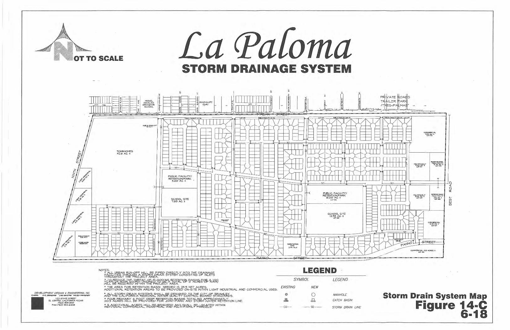

La Paloma Specific Plan Phasing Plan
Development Design & Engineering, Inc. 4/1/04 7-1
7. PHASING PLAN La Paloma is planned for a phased development over the next ten years. While a planned sequence for development is identified in this section, the timing of each phase is dependent on many factors, including market demand and economic conditions. These factors may influence requirements for specific residential product types, which in turn could result in modifications in the development phasing. It should be noted that the phasing of La Paloma might also be altered as a result of the regional activities from Caltrans, the City of Brawley, and any other local, regional or state entity. While market demand and economics may dictate phasing priorities, development of all phases will be dependent upon the provision of infrastructure and services. The project will begin with Phase One, followed by a Phase “A”, “B”, or “C”. The order may change after Phase One due to unforeseen economic circumstances. Tentatively, the project is planned for development in the following order:
Phase One Phase A Phase B Phase C Phase D
The primary objective of the phasing plan for the La Paloma Specific Planning Area is to insure that all necessary public facilities and services are provided in an efficient and cost-effective manner concurrent with need during the entire development period of the project. A master plan and phase or sub-phase construction plans will be produced with the Final Map.

La Paloma Specific Plan Phasing Plan
Development Design & Engineering, Inc. 4/1/04 7-2
Below are general details of the anticipated infrastructure improvement to be provided with each phase of development. Each phase is annotated with the expected year of the construction phase. A phase map is provided in Figure 15. A master plan shall be prepared during preparation of each Final Map and shall specify the requirements for the completion of sewer, water, storm drain, roads, and parks concurrent with the development of land uses for that final map.
A. Phase One (First phase) 2004 to 2005 Upon receipt of a grading permit, primary infrastructure facilities will be installed for the lots identified in Phase One. This phase will include 187 SF-5 units, 139 SF-6 units, and 10.38 acres of public facilities. The following will be completed in Phase One:
1. Phase One - Sewer An eight-inch sewer line will connect a portion of Phase One into an existing gravity sewer line along Malan Street. All development after Phase One will require service from a new sewer pump station, to be built prior to the completion of Phase One. 2. Phase One - Water
Water lines will connect into existing facilities along Malan Street.
a. An 18-inch line will be installed at the
Eastern Avenue intersection and a 12-inch line will be installed beneath the central arterial running through the project.

La Paloma Specific Plan Phasing Plan
Development Design & Engineering, Inc. 4/1/04 7-3
b. A 12-inch water line will be installed along major streets within this phase as outlined in the water master plan.
c. A new 24-inch water line will be
installed and connected to a new water reservoir and pump station. These facilities shall be completed at the end of Phase 1, prior to construction of any other phases.
3. Phase One - Storm Drain facilities
a. Installation of a drainage system that leads to a three-acre retention basin south of Avenida de la Paloma will be required; or
b. A park/retention basin shall be
constructed during this phase. In some cases, a temporary retention basin may be required to serve the project area or as determined by the Public Works Director.
4. Phase One – Circulation All roads shall be completed and marked according to Plan/City Standards, including the following:
a. Malan Street improvements; b. Construction of Avenida De La
Paloma within the phase;
c. Construction of Palm Avenue within the phase;
La Paloma Specific Plan Phasing Plan
Development Design & Engineering, Inc. 4/1/04 7-4
d. Construction of Eastern Avenue within the phase;
e. Construction of local roads to serve
Phase One;
f. Intersection and road improvements as stated in the traffic study;
g. And as required by the Public Works
Director.
5. Phase One - Undergrounding and Utilities
a. Undergrounding a portion of Best
Canal, Oakley Canal, and Bryant Drain are planned during this phase. Undergrounding of canals and drains throughout the project area shall be coordinated with IID. See Appendix I.
b. New electrical overhead lines along
Malan Street may be required to replace existing. The Developer shall coordinate with the IID.
c. The standard installation of utilities
(telephone, cable, gas…etc.) shall be coordinated by the Developer and the City. Electrical service is to be provided by IID, see Appendix J.
6. Phase One – Parks and Public Facilities A total of 333 units are planned for this phase. Therefore a population of 1,139 is expected. To meet the park ratio requirement of 3.25 per 1,000 people, the 8-acre retention/park facility shall be improved or bonded for at least 3.7 acres of park facilities.
La Paloma Specific Plan Phasing Plan
Development Design & Engineering, Inc. 4/1/04 7-5
Pedestrian links should be available for use after each phase unless safety issues exist due to adjacent incomplete phases.
B. Phase (Second or Third Phase) “A”
2005 to 2006
Phase A is located along the eastern side of the project area. Improvements in Phase B could be completed before this phase. This phase will include 155 SF-5 units, 18.71 acres of C-1 commercial, 140 multi-family units, and 6.92 acres of public facilities/parks/retention basins. The following will be completed in Phase A: 1. Phase A - Sewer A new sewer pump station may be required during this phase. If not required until a later phase or for future development, it is recommended that the site be reserved for a future pump station. 2. Phase A - Water Twelve-inch lines along Best Road, Panno Street, and the central arterial should be installed in this Phase. 3. Phase A – Storm Drain Facilities Retention basins will be constructed within this phase. All developed commercial facilities shall provide on-site retention. In some cases, a temporary retention basin may be required to serve the project area until the completion of the next phase or as determined by the Public Works Director. Land located within the commercial land uses shall be installed with

La Paloma Specific Plan Phasing Plan
Development Design & Engineering, Inc. 4/1/04 7-6
temporary retention basins until permanent on-site retention can be constructed. 4. Phase A - Circulation All roads shall be completed and marked according to Plan/City Standards, including the following:
a. Panno Road improvements will first be designed to serve traffic without full improvements such as sidewalks and landscaping until the southern property is developed.
b. Construction of the eastern section of
Avenida De La Paloma shall be completed.
c. The eastern portion of Malan Street
and all of Best Road are expected to be improved during this phase.
d. Construction of local roads to serve
Phase One.
e. Construction of intersection and road improvements as stated in the traffic study
5. Phase A - Undergrounding and Utilities
a. The undergrounding of east Bryant
Drain is planned for this phase unless it was undergrounded in the previous phase. Undergrounding of canals and drains throughout the project area shall be coordinated with IID. See Appendix I.

La Paloma Specific Plan Phasing Plan
Development Design & Engineering, Inc. 4/1/04 7-7
b. New electrical overhead lines or facilities may be required to replace existing.
c. The standard installation of utilities
(telephone, cable, gas…etc) along Malan Street will be done. Coordination is to be made by the developer. Electrical service is to be provided by IID, see Appendix J.
6. Phase A - Parks and Public Facilities Within Phase A are two park/retention basins and a .7-acre public facility location. The Public Facility can serve as a mini-park or other use as permitted by the Zoning Ordinance. If Phase A is to follow Phase One, then a total of 618 residential units is expected from Phases One and A. The total park requirement is approximately 7.5 to 8.0 acres. Phase A provides sufficient park area to meet this requirement. Public Facilities along Malan Street should be improved for a pedestrian corridor.
C. Phase “B” 2006 to 2007 Phase B is located in the southern central section of the project area. Improvements in this phase could begin prior to Phase A. This phase will include 83 SF-5 units, 166 SF-6 units, a 2.44 acre IID substation site, and a 12.93 acre school site. The following will be completed in Phase B:
1. Phase B - Sewer Primary sewer lines will be connected to main line in Phase A, or as may be required by the City Director of Public Works.

La Paloma Specific Plan Phasing Plan
Development Design & Engineering, Inc. 4/1/04 7-8
2. Phase B - Water Water lines will connect to water lines built in Phase One and A. The off-site water booster pump shall be constructed to serve Phase B and all future phases. 3. Phase B – Storm Drain Facilities The three retention basins within Phase One and Phase A shall be completed prior to the construction of Phase B. 4. Phase B - Circulation All roads and pedestrian links within this phase shall be completed and marked according to Plan/City standards. Panno Road improvements will first be designed to serve traffic without sidewalks and landscaping until the southern portion of the street is developed. 5. Phase B - Undergrounding Portions of Best Canal and Oakley Canal will be undergrounded during this phase. 6. Phase B - Parks and Public Facilities Prior to the completion of Phase B, full park facilities in Phase One should be completed to provide ample park facilities in this phase. If Phase B construction immediately follows Phase One, then the full 8.0 acres of the retention/park facility in Phase one shall be fully completed or bonded prior to the next phase. 3.08 acres are planned for the location of a power substation. The remaining acreage

La Paloma Specific Plan Phasing Plan
Development Design & Engineering, Inc. 4/1/04 7-9
should go to parks or uses permitted under the City’s Zoning Ordinance. A new electrical substation will need to be constructed and in operation by the end of this phase. The tentative substation location is at the southwest intersection of Panno Road and Eastern Avenue. A minimum lot of size 300 feet by 300 feet shall be provided.
D. Phase “C” 2007 to 2008
Phase C is located at the northwestern section of the project area. Improvements in this phase could proceed prior to Phase B. This phase will include 178 SF-6 units, 511 town home units, 4.25 acres of light industrial, 8.81 acres of public facilities/parks, and a 7.83 acre school site. The following will be completed in Phase C:
1. Phase C - Sewer All sewer lines shall connect to sewer main lines in Phase One and B, or as required by the City’s Director of Public Works. 2. Phase C - Water Services will connect to main water line on Malan Street and/or via the main water line in Phase B or Phase One. 3. Phase C – Storm Drain Facilities The retention basin shall be constructed to provide retention for this phase and the future Phase D. If Phase D is completed first, Phase D shall include this retention basin unless a temporary basin is needed. Separate on-site landscaped retention basins shall be provided in the town home (TH) land use area.
La Paloma Specific Plan Phasing Plan
Development Design & Engineering, Inc. 4/1/04 7-10
4. Phase C - Circulation All roads and pedestrian links shall be completed and marked according to Plan/City Standards. 5. Phase C - Undergrounding If not already undergrounded, a portion of the Bryant Drain undergrounding shall be completed during this phase. 6. Phase C - Parks A 5-acre park/retention is planned within this phase. Complete park facilities should be completed or bonded for toward the end of the phase.
E. Phase “D” 2008 to 2009
Phase D is located at the southwestern section of the project area. Phase D may be constructed prior to Phase B and C. This phase will include 152 SF-4 units, 89 SF-6 units, 7.52 acres of light industrial, and 4.64 acres of public facilities. The following will be completed in Phase D: 1. Phase D - Sewer Sewer may connect to the main sewer lines along Cesar Chavez Street or a new sewer line will be placed along Cesar Chavez connecting to either Phase B or C, or as required by the City Director of Public Works.

La Paloma Specific Plan Phasing Plan
Development Design & Engineering, Inc. 4/1/04 7-11
2. Phase D - Water Service lines will connect to existing lines on Malan Street or main line along Cesar Chavez Street. 3. Phase D – Storm Drain Facilities Separate on-site retention basins will be required for the Industrial land use. In some cases, temporary retention basins are expected to serve the project area until the completion of the next phase. Adequate retention capacity in earlier phases shall be available to serve single-family development in this phase. 4. Phase D - Circulation All roads and pedestrian links shall be completed and marked according to Plan Standards. 5. Phase D - Undergrounding If not already undergrounded, the portion of Bryant Drain within this phase should be completed. All undergrounding of Imperial Irrigation District (IID) canals and drains throughout the project area shall be completed within this phase. 6. Phase D - Parks and Public Facilities
Parks and public facilities shall have been completed in prior phases to serve single-family development in this phase. All pedestrian links throughout the project area should be fully landscaped and irrigated.


La Paloma Specific Plan Architectural & Landscape
Development Design & Engineering, Inc. 4/1/04 8-1
8. ARCHITECTURAL & LANDSCAPE GUIDELINES
This section provides general architectural and landscape requirements for the La Paloma Community. Section A outlines the architectural guidelines. Section B outlines the landscape requirements.
A. Architectural Guidelines
The architectural component of the plan gives the developer flexibility in design and ensures quality design for the community and the City of Brawley. The architectural design goal for La Paloma is to:
Provide a higher quality of architectural design using a consistent style of residential and non-residential design so that structures complement each other and enhance the visual quality of the surrounding environment.
1. General Requirements
The following general requirements are the principles that should be applied for all development within the project area.
a. A complementary “street scene” should
be achieved among the various densities and uses within the project by using similar materials and architectural features, and through sensitivity to height, bulk, and façade articulation as viewed from the street and other public areas.
b. Architectural stylistic themes should give
a unique identity to La Paloma.

La Paloma Specific Plan Architectural & Landscape
Development Design & Engineering, Inc. 4/1/04 8-2
c. Architecture design within La Paloma should apply traditional and contemporary materials, forms and colors that have evolved over time in the Brawley area and the Southern California region.
d. Architectural diversity should be created
by manipulating building scale, building materials, colors, and textures in conjunction with architectural features (for example, roofs, windows, doors, fascias, and trim), rather than by design homes that vary greatly in architectural style.
e. All residential signs should be unified
through the use of common colors, building material, lighting, and landscape architecture.
Unless specified below, all signs shall comply with the City’s Zoning Code, Section 27.210. The following shall be required for residential uses within La Paloma:
i. The number of entry signs into the La
Paloma Planned Community shall be limited to two signs per entry with a maximum sign area of 20 square feet each.
ii. Each sign is not to exceed 5 feet in height or 3 feet if in the traffic line-of-sight.
iii. Each sign shall not exceed 35 square feet.
iv. Each entry sign can be wall mounted or free-standing.
v. Each sign shall be located within a landscaped and irrigated area and shall be illuminated.

La Paloma Specific Plan Architectural & Landscape
Development Design & Engineering, Inc. 4/1/04 8-3
2. Single-family Homes (including zero-lot line)
Single-family homes make up a majority of La Paloma community. Design review should ensure that designs are consistent with the architectural goal and its principles.
a. Building Face – Single Family Homes
Two-story units with side or rear yards facing onto the street should incorporate architectural features to avoid a large blank wall face.
b. Architectural Elements – Single Family
Homes
Minimal use of prominent elements, such as towers, mission facades, etc; and ornamentation (for example: wrought iron, exposed beams) is recommended.
c. Complementary Design – Single Family
Homes
Colors, materials, and detailing should be consistent and complementary with the existing surrounding neighborhoods within the La Paloma.
d. Two or More Stories – Single Family Homes
Two-story volumes at minimum setbacks should be avoided. As the height of a home increases, the second story should have a corresponding step back from the street.
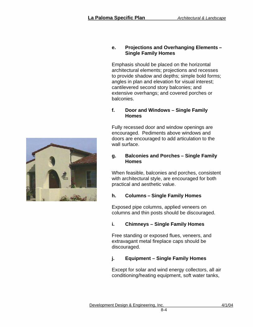
La Paloma Specific Plan Architectural & Landscape
Development Design & Engineering, Inc. 4/1/04 8-4
e. Projections and Overhanging Elements – Single Family Homes
Emphasis should be placed on the horizontal architectural elements; projections and recesses to provide shadow and depths; simple bold forms; angles in plan and elevation for visual interest; cantilevered second story balconies; and extensive overhangs; and covered porches or balconies.
f. Door and Windows – Single Family
Homes
Fully recessed door and window openings are encouraged. Pediments above windows and doors are encouraged to add articulation to the wall surface.
g. Balconies and Porches – Single Family
Homes
When feasible, balconies and porches, consistent with architectural style, are encouraged for both practical and aesthetic value.
h. Columns – Single Family Homes
Exposed pipe columns, applied veneers on columns and thin posts should be discouraged.
i. Chimneys – Single Family Homes
Free standing or exposed flues, veneers, and extravagant metal fireplace caps should be discouraged.
j. Equipment – Single Family Homes
Except for solar and wind energy collectors, all air conditioning/heating equipment, soft water tanks,

La Paloma Specific Plan Architectural & Landscape
Development Design & Engineering, Inc. 4/1/04 8-5
gas meters, utility cabinets, and electric meters should be screened from public view.
k. Building Footprints, Elevations and
Setbacks – Single Family Homes
A variety of plans, elevations and setbacks should be provided to encourage architectural interest within each planning area, consistent with the architectural style of that area.
l. Reverse Buildings – Single Family
Homes
Use of reverse building plans that add articulation is encouraged.
m. Accessory Structures – Single Family
Homes
The design of accessory structures visible from the street shall be architecturally consistent with the main structures.
n. Building Finishes/Color – Single Family
Homes
Earth tone-colored stucco walls shall be required on walls and exterior surfaces. Accent colors used to complement the wall surfaces are encouraged in moderation. Wood trim should be stained with light-colored, semi-transparent stains or painted as accent.
The crisp, clean and simple use of tile, brick, river rock, wood timbers, stone and masonry are allowed as design accents and trim if used in a contemporary expression.

La Paloma Specific Plan Architectural & Landscape
Development Design & Engineering, Inc. 4/1/04 8-6
o. Garage Doors – Single Family Homes
Garage doors should be simple in design and recessed a minimum of 12 inches from adjacent walls.
p. Roofs – Single Family Homes
Principal roof forms should be gable or hip with pitches from 4:12 to 6:12. All roofs shall be constructed of nonflammable materials such as clay, terra cotta, concrete tile, or other material consistent with the architecture. Flat roofs are discouraged.
3. Town Homes and Multi-Family Residential
a. Two-story units – Town Home and Multi-Family
The stepping back of one or two-story volumes along edges to soften transitions is encouraged.
b. Building Face – Town Home and Multi-
Family
Two-story buildings with side or rear yards facing onto the street should incorporate architectural features to avoid a large blank wall face.
c. Projections and Overhanging Elements –
Town Home and Multi-Family
Emphasis should be placed on the horizontal architectural elements; projections and recesses to provide shadow and depths; simple bold forms; angles in plan and elevation for visual interest; cantilevered or stepped back second story balconies; extensive overhangs; and covered porches or balconies.
Town Home Example
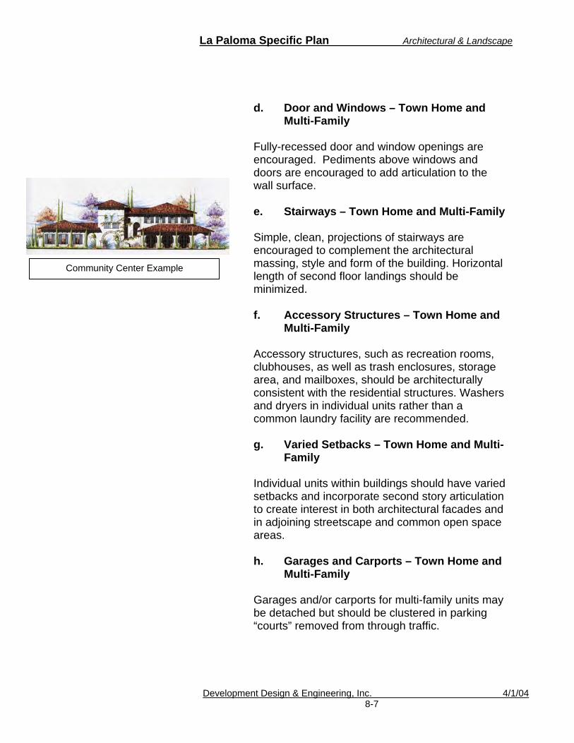
La Paloma Specific Plan Architectural & Landscape
Development Design & Engineering, Inc. 4/1/04 8-7
d. Door and Windows – Town Home and Multi-Family
Fully-recessed door and window openings are encouraged. Pediments above windows and doors are encouraged to add articulation to the wall surface.
e. Stairways – Town Home and Multi-Family
Simple, clean, projections of stairways are encouraged to complement the architectural massing, style and form of the building. Horizontal length of second floor landings should be minimized.
f. Accessory Structures – Town Home and
Multi-Family
Accessory structures, such as recreation rooms, clubhouses, as well as trash enclosures, storage area, and mailboxes, should be architecturally consistent with the residential structures. Washers and dryers in individual units rather than a common laundry facility are recommended.
g. Varied Setbacks – Town Home and Multi-
Family Individual units within buildings should have varied setbacks and incorporate second story articulation to create interest in both architectural facades and in adjoining streetscape and common open space areas. h. Garages and Carports – Town Home and
Multi-Family Garages and/or carports for multi-family units may be detached but should be clustered in parking “courts” removed from through traffic.
Community Center Example
La Paloma Specific Plan Architectural & Landscape
Development Design & Engineering, Inc. 4/1/04 8-8
Carports should be of wood or stucco, with finishes complying with the approved material and color palette. Carport designs should be integrated with the architectural style of the development. Adequate lighting for safety and security shall be provided in all phasing areas and carport access lanes. i. Lighting – Town Home and Multi-Family
Light standards and security lighting shall be designed and arranged to prevent glare and direct illumination into any adjacent residential zone in accordance with Section 27.147 (f) of the City of Brawley Zoning Ordinance
j. Building Finishes/Colors and Materials –
Town Home and Multi-Family
Earth-tone stucco is encouraged on walls and exterior surfaces. Accent colors used to complement the wall surfaces are permitted and encouraged in moderation. Wood trim should be stained with light-colored, semi-transparent stains or painted as accents.
The crisp, clean and simple use of tile, brick, stone and masonry are encouraged as design accents and trim if used in a contemporary expression. Heavy textures such as Spanish lace, swirl or heavy trowel are discouraged.
Prefabricated metal treads and railings are strongly discouraged on stairways and secondary floor landings.

La Paloma Specific Plan Architectural & Landscape
Development Design & Engineering, Inc. 4/1/04 8-9
k. Outdoor Storage –Town Home and Multi-Family
Outdoor storage and trash facilities should be
properly screened; the architectural features of these facilities should be consistent with that of the residential building.
4. Commercial Uses
a. Pedestrian Friendly Architecture –
Commercial
Architecture which disaggregates building mass into smaller parts with greater human scale should be encouraged to create a pedestrian friendly environment. This would include extending portions of some buildings to near the street right-of-way line and providing a clearly evident pedestrian circulation system that connects to the sidewalk. Using a landscaped walkway that connects to the sidewalk to split large parking areas is strongly encouraged.
b. Building Face – Commercial
All facades of a building should be considered in the design of a project. To this end, the following are encouraged.
i. Incorporation of varied planes and
textures; natural, rather than manufactured, finishes; variety in window and door treatments; as well as other similar features.
ii. “Shadow play” through the use of
deeply recessed or projecting features, including: pop-out window masses, built-up relief details, cornices, trim, recessed windows, and entrances.

La Paloma Specific Plan Architectural & Landscape
Development Design & Engineering, Inc. 4/1/04 8-10
iii. Variation in roofline and parapet
treatments to create visual interest.
iv. Fully defined architecture on all facades facing public streets, including windows, doors, architectural details, and emphasized landscaping. In areas where the parking lot is located at the rear of the site, rear facades should be designed to be visually appealing.
v. Two-story buildings should comply with
second story same recommended design features as Zero Lot Line and Multi-Family buildings.
c. Architectural Design – Commercial
The architectural design should be consistent throughout the buildings on a parcel with no mixing of architectural or historical styles.
d. Unifying Theme Elements – Commercial
Major commercial developments should incorporate unifying theme elements intended to distinguish the project from other developments and which promote pedestrian orientation opportunities. These elements may include:
i. Outdoor Cafes ii. Patios and Plazas iii. Gateways iv. Water Elements v. Kiosks vi. Carts vii. Flag Courts viii. Amphitheaters ix. Gardens x. Outdoor Markets

La Paloma Specific Plan Architectural & Landscape
Development Design & Engineering, Inc. 4/1/04 8-11
xi. Trellises and Arbors xii. Colonnades and Arcades xiii. Bell Towers xiv. Carillons xv. Theme Towers xvi. Gateways xvii. Galleries xviii. Clerestories
All projects should distinguish between informal and formal areas.
e. Shade Structures – Commercial
The provision of shade structures is encouraged both within commercial developments and along adjoining streets. These may include:
i. Pergolas ii. Trellises iii. Arcades iv. Verandas v. Colonnades vi. Bus Shelters vii. Porches
These structures should be planted with a combination of trees, vines, and shrubs to soften their visual character and enhance shade opportunities.
f. Doors and Windows – Commercial
Doors and windows should be in proportion to the building and should be used to relieve broad expanses of facade.
Buildings should be designed with doors, windows and entries clearly defined and which provide access to theme elements or shade structures described above.

La Paloma Specific Plan Architectural & Landscape
Development Design & Engineering, Inc. 4/1/04 8-12
g. Accessory Structures – Commercial
Single structures and satellite buildings within a complex should be unified through the use of common colors, building material, lighting, sign treatment, and landscape architecture. h. Roof, Outdoor, and Ground Equipment –
Commercial
Trash bins, outdoor equipment and outdoor storage facilities, should be enclosed or screened from view, and should be architecturally integrated with the development they serve.
i. Mass, Height, and Bulk – Commercial
Commercial buildings should be designed in a manner that is harmonious with surrounding residential neighborhoods. Building masses, height, and bulk should be comparable to that of nearby uses.
j. Architectural Finishes/Colors –
Commercial In addition to light or pastel colored stucco walls or wood siding, painted concrete walls are also allowed for walls and exterior surfaces on non-residential buildings
k. Stairways – Commercial Prefabricated metal treads, pre-cast concrete treads on stairways and metal railings on second floor landings are allowed on limited basis only for non-residential buildings.

La Paloma Specific Plan Architectural & Landscape
Development Design & Engineering, Inc. 4/1/04 8-13
l. Roof Treatments – Commercial Roof treatments should:
i. Conceal all rooftop equipment; ii. Emphasize low-rise, varied roof
character;
iii. Encourage strong geometry that is varied and staggered, to increase visual interest; and
iv. Avoid paste-on mansards or other
treatments relieving unadorned rooflines.
Roof-mounted signs are not permitted in La Paloma m. Building Height – Commercial Building height shall comply with the City’s ordinance. n. Signs – Commercial All commercial signs should be unified through the use of common colors, building material, lighting, and landscape architecture. Unless specified below, all signs shall comply with the City’s Zoning Code, Section 27.210. The following shall be required for commercial uses within La Paloma: o. Wall Signs – Commercial
No sign shall exceed 20% of building or tenant building face with a maximum area of 250-square feet.

La Paloma Specific Plan Architectural & Landscape
Development Design & Engineering, Inc. 4/1/04 8-14
p. Freestanding Signs – Commercial
o One freestanding sign shall be allowed per business. Freestanding signs no greater than 4 square feet and no higher than 3-feet are exempt.
o Signs shall not exceed 8-feet in height or shall exceed a sign area of 65 square feet.
o Street addresses shall be incorporated into the face or structures of the freestanding sign.
o Multi-tenant centers are allowed one freestanding sign per street frontage. Business centers that front Highway 111 shall be allowed one 15-foot high sign for multi-tenants. Each highway freestanding sign shall not exceed an overall maximum square foot sign area of 200 square feet per each side of the sign.
q. Prohibited Signs – Commercial
The following signs are prohibited within the La Paloma Planned Community: o Canned signs o Portable signs o Neon signs, except for window signs no
greater than four (4) square feet.
r. Lighting – Commercial Lighting standards and security lighting shall be designed and arranged to prevent glare or direct illumination into any adjacent residential zone in accordance with Section 27.147 (f) of the City of Brawley Zoning Ordinance.

La Paloma Specific Plan Architectural & Landscape
Development Design & Engineering, Inc. 4/1/04 8-15
5. Industrial Uses
a. Pedestrian Friendly Architecture – Industrial
Architecture which disaggregates building mass into smaller parts or uses landscaped areas to create human scale should be encouraged to create a pedestrian friendly environment.
a. Exterior Walls – Industrial All exterior wall elevations facing any street shall have an architectural treatment.
i. The following materials are restricted:
o Sheet or corrugated metal, asbestos or similar materials used on exterior walls.
o Use of a single material (such as more than 70% glass) or a predominately single color facade on exterior walls.
c. Colors – Industrial
ii. Colors shall be limited to a maximum
number of three, exclusive of minor trim elements.
iii. Colors, materials and finishes are to be
coordinated on all exterior elevations of the building to achieve total continuity of design. Muted earth tone colors shall be used as primary colors.
iv. Vents, louvers, exposed flashing, tanks,
stacks; ductwork, overhead, rolling and service doors are to be painted.

La Paloma Specific Plan Architectural & Landscape
Development Design & Engineering, Inc. 4/1/04 8-16
d. Roof – Industrial
No part of the roof may project above the building parapet, except architectural screening of rooftop mechanical equipment.
e. Height – Industrial Unless otherwise specified in this specific plan, no structure shall exceed thirty-five feet or two stories in height, whichever is less, except that industrial buildings up to forty feet in height within two stories may be allowed when it can be demonstrated that the additional height is necessary for the particular use anticipated for reasons such as automated warehousing, inventory retrieval or bridge cranes.
Appropriate screening and architectural enhancements shall be provided to mitigate the visual impact of any building approved over forty feet in height.
Lighting protection devices may project above the height limit a maximum of fifteen feet, subject to the standards specified in subsection 4 (f) below.
f. Equipment Installations and Screening –
Industrial
i. All roof mounted equipment and/or ductwork shall be screened by an enclosure of equal or greater height and shall be consistent with the building, design, building materials and exterior colors.
ii. No mechanical equipment or vent shall be
placed on the exterior surface of any building wall that can be viewed from a public street.

La Paloma Specific Plan Architectural & Landscape
Development Design & Engineering, Inc. 4/1/04 8-17
g. Signs – Industrial All industrial signs should be unified through the use of common colors, building material, lighting, and landscape architecture. Unless specified below, all signs shall comply with the City’s Zoning Code, Section 27.210. The following shall be required for industrial uses within La Paloma: h. Wall Signs – Industrial
o No sign shall exceed 15% of building or tenant building face with a maximum area of 150-square feet.
i. Freestanding Signs – Industrial
o Shall not exceed 6-feet in height or shall exceed a sign area of 40-square feet.
o Street addresses shall be incorporated into the face or structures of the freestanding sign.
j. Prohibited Signs – Industrial
The following signs are prohibited in the La Paloma Planned Community: o Canned signs o Portable signs o Neon signs, except for window signs no
greater than 4-square feet. k. Screening Lighting – Industrial Light standards and security lighting shall be designed and arranged to prevent glare or direct illumination into any adjacent residential zone in
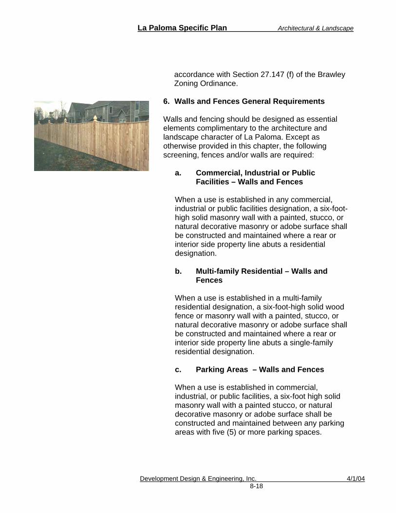
La Paloma Specific Plan Architectural & Landscape
Development Design & Engineering, Inc. 4/1/04 8-18
accordance with Section 27.147 (f) of the Brawley Zoning Ordinance.
6. Walls and Fences General Requirements
Walls and fencing should be designed as essential elements complimentary to the architecture and landscape character of La Paloma. Except as otherwise provided in this chapter, the following screening, fences and/or walls are required:
a. Commercial, Industrial or Public
Facilities – Walls and Fences When a use is established in any commercial, industrial or public facilities designation, a six-foot-high solid masonry wall with a painted, stucco, or natural decorative masonry or adobe surface shall be constructed and maintained where a rear or interior side property line abuts a residential designation.
b. Multi-family Residential – Walls and
Fences
When a use is established in a multi-family residential designation, a six-foot-high solid wood fence or masonry wall with a painted, stucco, or natural decorative masonry or adobe surface shall be constructed and maintained where a rear or interior side property line abuts a single-family residential designation.
c. Parking Areas – Walls and Fences
When a use is established in commercial, industrial, or public facilities, a six-foot high solid masonry wall with a painted stucco, or natural decorative masonry or adobe surface shall be constructed and maintained between any parking areas with five (5) or more parking spaces.

La Paloma Specific Plan Architectural & Landscape
Development Design & Engineering, Inc. 4/1/04 8-19
d. Adjacent to Street – Walls and Fences
The above-required solid walls or fences shall be reduced to three (3) feet high within the required front yard or within line of sight for oncoming traffic. Public school sites are generally exempt from this requirement.
e. Trash Enclosures – Walls and Fences
All areas set aside for storage and pickup of trash or items for recycling or reconditioning shall be screened from view from any street or public place (excepting an alley serving only commercial or industrial designation). These areas shall also be screened from any property in a residential designation by a solid six-foot wall or fence or by other methods acceptable to the public works director. All such storage shall be maintained below said wall or fence. f. Facilities Screening – Walls and Fences All mechanical or electrical equipment facilities shall be screened with a six-foot high solid masonry wall with a painted stucco or natural decorative surface. Facilities could include a city pump station or power substations.
g. Community Theme – Walls and Fences
Community theme walls should be located primarily along streets that require noise buffers as recommended in the noise study. These walls will be used for aesthetic purposes, as well as a means to reduce vehicular traffic noise and shall have a maximum height of six feet, unless additional height is needed for sound attenuation purposes.

La Paloma Specific Plan Architectural & Landscape
Development Design & Engineering, Inc. 4/1/04 8-20
h. Perimeter Walls and Fences Adjacent to Agriculture
To minimize visual and odor impacts from adjacent agriculture activities, a uniform wall and fencing concept should be included for all residential development boundaries adjacent to farmland. Solid walls are permitted if sound attenuation is required per the La Paloma noise study. To ensure that these walls and fencing will be consistent throughout the community, they shall be installed by the developers/builders. Perimeter walls and fences shall have a maximum height of six feet (6’), unless a greater height is needed for noise attenuation.
i. Privacy Walls and Fences
These fences or walls would be located at the neighborhood entrances, along local roadways, and between residential lots for identity and/or for privacy and security. Masonry columns should be located at property lines, points of change in vertical and horizontal direction, and other intervals appropriate to segment the length of the wall. Continuous, straight runs of wall or fencing visible from public roads or open spaces should be softened with plant species of trees, shrubs, and vines. j. Design Standards - Walls and Fences
The following standards shall guide the design and construction of walls and fencing in the residential areas of La Paloma. Specific design details will be addressed during the permit stage of project implementation.
All perimeter walls and fencing shall comply with the Brawley Zoning Ordinance and adopted Uniform Building Code unless stated below.
Architectural Goal
1. Provide a higher quality of architectural design using a consistent style of residential and non-residential design so that structures complement each other and enhance the visual quality of the surrounding environment.
Objective Establish Architectural and Landscape guidelines to ensure visual characteristics that help define La Paloma.
La Paloma Specific Plan Architectural & Landscape
Development Design & Engineering, Inc. 4/1/04 8-21
i. Appropriate construction materials are stone block, slump block, wrought iron, masonry, stucco and wood. Transparent materials, such as glass and Plexiglas, can also be used where views are desirable. Tubular steel or wrought iron may be used in limited areas, subject to City approval.
ii. The maximum height for fences and
walls shall be six feet along rear or side property lines, except as required for earth retention, sound attenuation, or safety measures.
iii. Solid fences and walls, which are
visible from public rights-of-way or public open space, should include design elements such as pilasters, planter pockets, or pop-outs to reduce monotony. Landscaping also should be provided to screen walls and fences where necessary to reduce visual impact.

La Paloma Specific Plan Architectural & Landscape
Development Design & Engineering, Inc. 4/1/04 8-22
B. Landscape Guidelines
La Paloma will contain a series of landscaped and recreational areas. Lighting and landscaping variations are recommended throughout the community.
The landscape theme for La Paloma should unify the community and provide an aesthetically pleasing effect. Landscaping should provide for appropriate transitions between uses. These guidelines will ensure that the project area is landscaped in a manner that establishes a sense of community character (See Figure 19).
1. General Landscape Guidelines
a. Landscaping within all land uses shall
comply with the City of Brawley’s Landscape Regulations.
b. Xeriscape methods should be considered
for landscaping throughout the project area.
c. Water should be conserved through low water planting and irrigation design.
d. Streetscapes and entry treatments should
be designed to promote community character and should consist of trees, shrubs, and groundcovers that are selected to establish a distinct character or theme for the project.
e. A compatible plant palette of trees, shrubs
and ground covers shall be used throughout the project area especially within public parkways. Once a particular plant or plant combination is used for a particular application, it is to be repeated in similar areas of the project to reinforce a sense of neighborhood cohesion. Landscape design should not, however,
Desert Willow

La Paloma Specific Plan Architectural & Landscape
Development Design & Engineering, Inc. 4/1/04 8-23
result in monotony or lack of variety or biological diversity. A recommended plant list is found in Table 8-A.
f. The irrigation systems for improved areas
should be permanent, automatic systems that are programmed to deliver adequate soil moisture as determined by the depth of the root zone. The soil moisture attained should promote vigorous growth of all plant materials. The system should be maintained in good working order, and the cleaning and adjustments to the system should be part of the regular maintenance activities. All landscape catch basins; swales, channels and other drainage devices should be maintained in a state conducive to conducting water in a free-flowing condition.
g. Decorative rock should be considered as an
alternative to ground cover in areas of high foot traffic.
h. Street trees should be selected from the
plant listing in Table 8-A.
i. Shrub and groundcover plantings should be consistent within each neighborhood and be compatible with adjacent neighborhoods.
j. Drought-tolerant species with an
ornamental quality are recommended. Use of turf is only recommended at entries, special intersections, and individual parcel/lot entries.
k. Trees should be planted along parkways or
within the front yard of each single-family home.
Foliage: Evergreen to Semi-Deciduous
Mature Height:15' - 40' Mature Width:15' - 40' Growth Rate: Slow to moderate Hardiness:20o F -6.7oC Exposure: Full Sun Leaf Color: Gray Shade: Filtered Flower Color: Pink to Purple Flower Shape: Petals
Flower Season: Late Spring to Summer
Thorns: Yes Box Sizes Produced:24", 36" and 48"
Olneya tesota (Desert Ironwood)

La Paloma Specific Plan Architectural & Landscape
Development Design & Engineering, Inc. 4/1/04 8-24
l. Residential lots that do not have parkway frontage along the front yard areas shall have a minimum of one tree planted prior to occupancy.
m. All residential front yards shall be
landscaped with irrigation systems prior to occupancy.
n. All Multi-family land use shall meet the
landscape requirements stated within the City of Brawley’s Zoning Ordinance.
o. All commercial land uses shall meet the
landscape requirements stated within the City of Brawley’s Zoning Ordinance.
p. All industrial land uses shall meet the
landscape requirements stated within the City of Brawley’s Zoning Ordinance.
q. Landscaping over three-feet shall be
prohibited near driveways and intersections within a vehicle or pedestrian line-of-sight.
r. Root barriers shall be used for trees that
could damage infrastructure.
2. Landscaped Entries and Right-of-Way To provide community character, specific guidelines have been provided for the community’s entranceways. Two types of entry/corridors shall be provided for La Paloma. Examples of these are shown in Figure 16 &17. Figure 19 shows the location of the two types of entry/corridors.

La Paloma Specific Plan Architectural & Landscape
Development Design & Engineering, Inc. 4/1/04 8-25
a. Primary Entries
The primary project entries will be located at (see also Figure 17):
1) Avenida de La Paloma 2) Panno Street West entrance 3) Cesar Chavez Street (southern and
northern entrance); and 4) Eastern Avenue (southern and northern
entrance)
These entries will serve as physical and visual gateways into the project area. These primary entrances provide an aesthetically pleasing entry statement that reinforces the identity of La Paloma. Each primary entry will contain blending of both signage and landscaping which reinforces the project theme throughout the project area. Signage could go onto an existing perimeter wall or on a monument sign that does not exceed three feet. Lighting on the primary entry is recommended. Accent plantings at entries should include drought tolerant plants and shrubs or some other visual characteristic that does not exceed three feet high. A landscaped median and a decorative crosswalk shall be provided. An example of primary entries is shown in a conceptual illustration in figure 19. The following shall be the minimum requirements along La Paloma Primary Corridors.
o Minimum tree size: 15-gallon containers or
equal o Minimum tree to landscape area ratio for
the first 100-feet of the entryway: one tree per 15 linear feet of landscaped right-of-way. Tree spacing may be clustered or staggered, as appropriate.
o Minimum tree to landscape area ratio: one tree per 20 linear feet of landscaped right-

La Paloma Specific Plan Architectural & Landscape
Development Design & Engineering, Inc. 4/1/04 8-26
of-way. Tree spacing may be clustered or staggered, as appropriate.
o Decorative rock or bark shall be provided in areas not covered by groundcover.
o A drip irrigation system shall be provided for trees and shrubs.
o If provided, medians should also be landscaped with trees.
b. Secondary Entries
Secondary entries will occur at other locations throughout the project (see Figure 19). The secondary entry locations may repeat the plant palette and thematic materials of those used at the primary entry, however sign features are optional. See Table 8-A for street planting list. The following shall be the minimum requirements along La Paloma Secondary Corridors.
o Minimum tree size: 15-gallon containers or
equal o Minimum tree to landscape area ratio: one
tree per 20 linear feet of landscaped right-of-way. Tree spacing may be clustered or staggered, as appropriate.
d. Central Corridor
The centrally located roadway traversing east/west is designated as La Paloma’s Central Corridor. The pedestrian sidewalk shall be enveloped by parkway and shade trees. To ensure a pedestrian friendly environment, parkway shall be provided on both sides of the sidewalk unless safety issues are present. The following standards shall apply:

La Paloma Specific Plan Architectural & Landscape
Development Design & Engineering, Inc. 4/1/04 8-27
Minimum tree size: 15 gallon containers; and
Trees to landscape ratio: one tree per every 10 linear feet of parkway. For homes that front this main corridor a minimum of one tree per home is required. Trees and landscaping should be consistent through the corridor.
3. Residential
A minimum of one tree shall be planted at all single-family homes (attached or detached). All front yards shall be landscaped and irrigated to the City’s current standards. Front yards shall contain landscaping covering at least 50%. Parking within landscaped areas is prohibited.
4. All other Land Uses
Commercial, Public facilities, and Industrial land uses shall be landscaped to City standards using the plant listing in table 8-A.
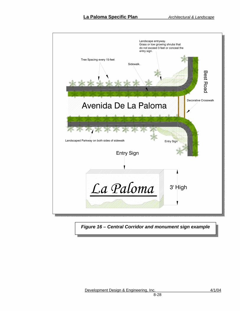
La Paloma Specific Plan Architectural & Landscape
Development Design & Engineering, Inc. 4/1/04 8-28
Landscape entryway.Grass or low growing shrubs that do not exceed 3 feet or conceal theentry sign.
Sidewalk.
La Paloma
Avenida De La Paloma
3' High
Entry Sign
Decorative Crosswalk
Best R
oad
Tree Spacing every 15-feet
Landscaped Parkway on both sides of sidewalk Entry Sign
Landscape entryway.Grass or low growing shrubs that do not exceed 3 feet or conceal theentry sign.
Sidewalk.
La Paloma
Avenida De La Paloma
3' High
Entry Sign
Decorative Crosswalk
Best R
oad
Tree Spacing every 15-feet
Landscaped Parkway on both sides of sidewalk Entry Sign
Figure 16 – Central Corridor and monument sign example
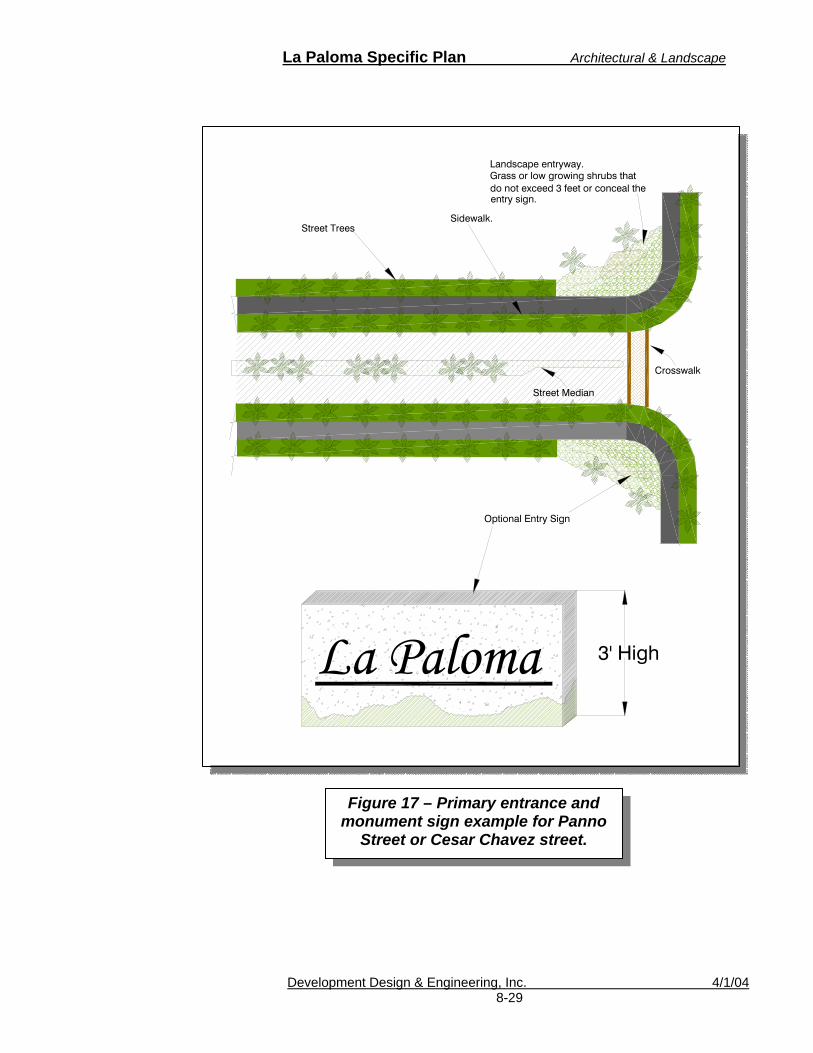
La Paloma Specific Plan Architectural & Landscape
Development Design & Engineering, Inc. 4/1/04 8-29
Figure 17 – Primary entrance and monument sign example for Panno
Street or Cesar Chavez street.
Landscape entryway.Grass or low growing shrubs that do not exceed 3 feet or conceal theentry sign.
Sidewalk.Street Trees
La Paloma 3' High
Optional Entry Sign
Street Median
Crosswalk
Landscape entryway.Grass or low growing shrubs that do not exceed 3 feet or conceal theentry sign.
Sidewalk.Street Trees
La Paloma 3' High
Optional Entry Sign
Street Median
Crosswalk

La Paloma Specific Plan Architectural & Landscape
Development Design & Engineering, Inc. 4/1/04 8-30
5. Landscape Buffer Zones
Buffer zones provide areas of transition between dissimilar uses such as manufacturing or act as noise barriers to adjacent busy corridors. Landscape buffers should be provided at locations 1) between the school/park site and adjacent residential uses; 2) in areas where residential development would be adjacent to commercial or light industrial uses; and 3) between residential uses and the major street corridors. In these areas, landscaping, elevation changes (slopes or berms), and/or fences or walls should be used to create effective buffers. See figure 18.
Figure 18- Example of Adjacent Land Use
Boundary Requirements.
25’ A minimum 25-foot setback with a 5-foot landscaped buffer shall be required for all non-residential uses abutting residential uses.
Commercial
Residential

La Paloma Specific Plan Architectural & Landscape
Development Design & Engineering, Inc. 4/1/04 8-31
For non residential uses that abut a residential use the following shall be required:
o A minimum 6-foot high community wall and landscaping shall be located along residential boundary areas.
o A 25-foot setback is required for nonresidential
uses abut a residential use. Within the 25-foot setback, a minimum 5-foot landscaped buffer shall be provided. Churches, schools, parks, and other semi-public uses are also required to meet these minimum requirements.
Recommended Temperature Zone:sunset: 12-16,18-23 USDA: 9-10
Frost Tolerance: Hardy to 20°F (-7°C)
Sun Exposure: Full sun
Origin: Northeastern Mexico
Growth Habits: Evergreen large shrub or small tree, fast growing 10 to 15 feet (3-4.5 m) or more, 6 to 15 feet wide (1.8-4.5 m); bipinnate leaves with 5 or 7 pinnae, each with 4 or 5 pairs of leaflets
Watering Needs: Infrequent deep watering
Propagation: Seed
Caesalpinia mexicana (Mexican Bird of Paradise)

La Paloma Specific Plan Architectural & Landscape
Development Design & Engineering, Inc. 4/1/04 8-32
Table 8-A, La Paloma Landscape Plant Listing
Name Height (feet) Spread (feet) Comments
*Acacia abyssinia 20-25 20-25 Slow growth to spreading, flat-topped or silhouette.
*Acacia saligna (Blue-Leaf Wattle)
20-40 15 Fast growing tree with semi-weeping havit. Water moderately to control growth.
*Acacia smalli (Sweet Acacia)
30-35 15-25 Durable to frost.
Albizia julibrissin (Silk Tree)
40 - Excellent patio tree.
*Brachychiton populneus (Bottle Tree)
30-50 30 Susceptible to Texas root rot.
*Ceratonia siliqua (Carob Tree)
30-40 30-40 Do not plant in narrow areas.
*Chamaerops humilis (Mediterranean Fan Palm)
20 20 Hardiest palm tree.
Chilopsis linearis (Desert Willow)
25 - Grows fast at first.
*Cupressus (Smooth Arizona Cypress)
40 20 Drought resistant when established.
Dalea spinose (Smoke Tree)
30 - -
*Eucalyptus - - Evergreen trees, many varieties.
*Fraxinus uhdei (Evergreen Ash)
40 - Rapid growth
(Velutina) - - Thrives in hot, dry climates
Fraxinus velutina (Arizona Ash)
- - Tree withstands hot, dry conditions and cold to about - 10 F
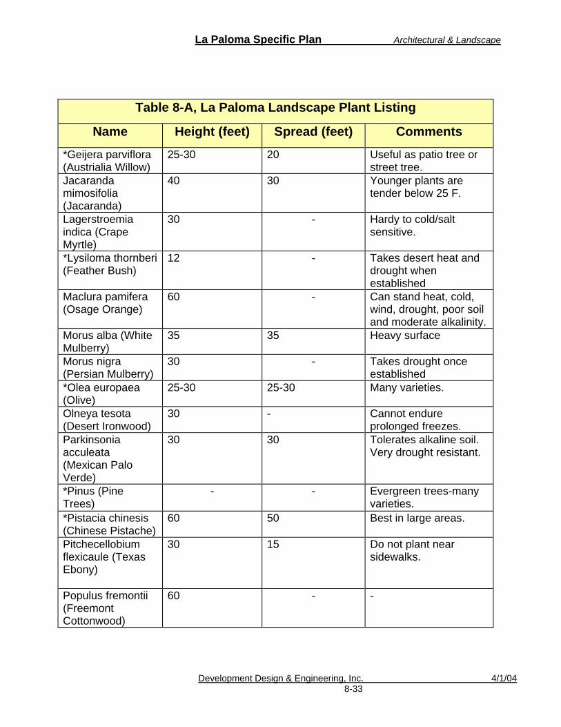
La Paloma Specific Plan Architectural & Landscape
Development Design & Engineering, Inc. 4/1/04 8-33
Table 8-A, La Paloma Landscape Plant Listing
Name Height (feet) Spread (feet) Comments
*Geijera parviflora (Austrialia Willow)
25-30 20 Useful as patio tree or street tree.
Jacaranda mimosifolia (Jacaranda)
40 30 Younger plants are tender below 25 F.
Lagerstroemia indica (Crape Myrtle)
30 - Hardy to cold/salt sensitive.
*Lysiloma thornberi (Feather Bush)
12 - Takes desert heat and drought when established
Maclura pamifera (Osage Orange)
60 - Can stand heat, cold, wind, drought, poor soil and moderate alkalinity.
Morus alba (White Mulberry)
35 35 Heavy surface
Morus nigra (Persian Mulberry)
30 - Takes drought once established
*Olea europaea (Olive)
25-30 25-30 Many varieties.
Olneya tesota (Desert Ironwood)
30 - Cannot endure prolonged freezes.
Parkinsonia acculeata (Mexican Palo Verde)
30 30 Tolerates alkaline soil. Very drought resistant.
*Pinus (Pine Trees)
- - Evergreen trees-many varieties.
*Pistacia chinesis (Chinese Pistache)
60 50 Best in large areas.
Pitchecellobium flexicaule (Texas Ebony)
30 15 Do not plant near sidewalks.
Populus fremontii (Freemont Cottonwood)
60 - -
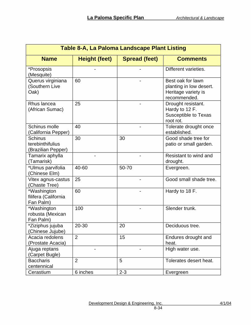
La Paloma Specific Plan Architectural & Landscape
Development Design & Engineering, Inc. 4/1/04 8-34
Table 8-A, La Paloma Landscape Plant Listing
Name Height (feet) Spread (feet) Comments
*Prosopsis (Mesquite)
- - Different varieties.
Querus virginiana (Southern Live Oak)
60 - Best oak for lawn planting in low desert. Heritage variety is recommended.
Rhus lancea (African Sumac)
25 - Drought resistant. Hardy to 12 F. Susceptible to Texas root rot.
Schinus molle (California Pepper)
40 - Tolerate drought once established.
Schinus terebinthifulius (Brazilian Pepper)
30 30 Good shade tree for patio or small garden.
Tamarix aphylla (Tamarisk)
- - Resistant to wind and drought.
*Ulmus parvifolia (Chinese Elm)
40-60 50-70 Evergreen.
Vitex agnus-castus (Chaste Tree)
25 - Good small shade tree.
*Washington filifera (California Fan Palm)
60 - Hardy to 18 F.
*Washington robusta (Mexican Fan Palm)
100 - Slender trunk.
*Ziziphus jujuba (Chinese Jujube)
20-30 20 Deciduous tree.
Acacia redolens (Prostate Acacia)
2 15 Endures drought and heat.
Ajuga reptans (Carpet Bugle)
- - High water use.
Baccharis centennical
2 5 Tolerates desert heat.
Cerastium 6 inches 2-3 Evergreen
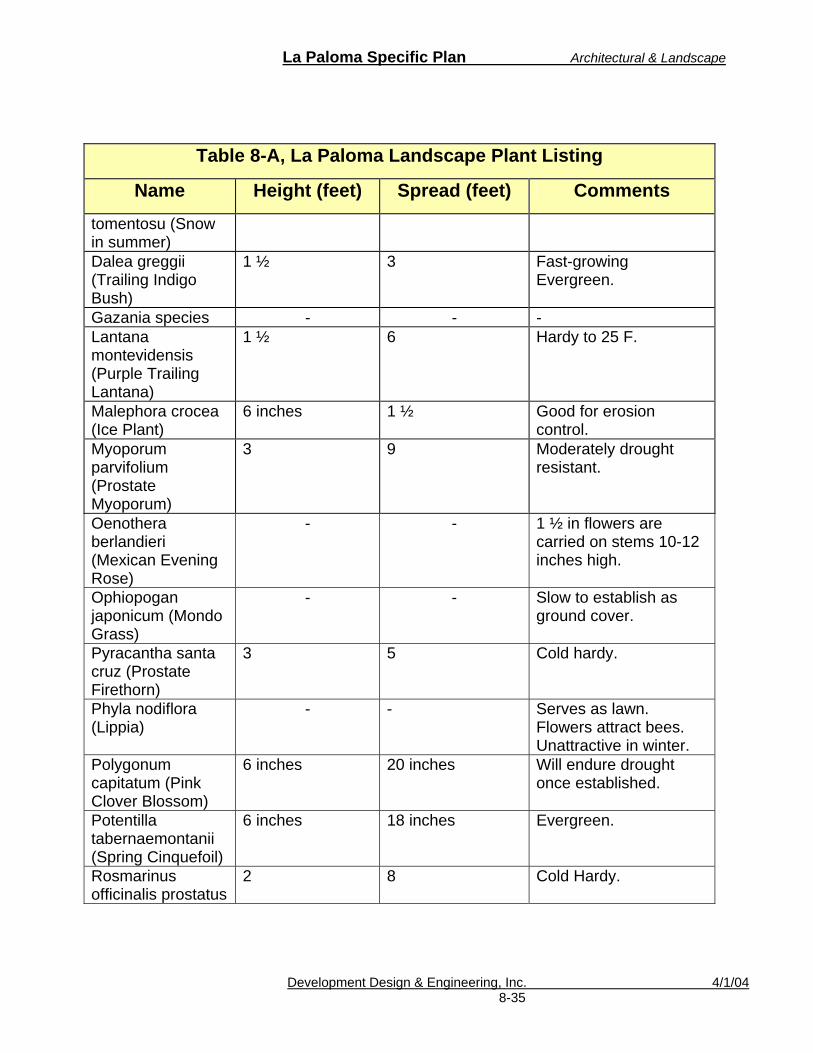
La Paloma Specific Plan Architectural & Landscape
Development Design & Engineering, Inc. 4/1/04 8-35
Table 8-A, La Paloma Landscape Plant Listing
Name Height (feet) Spread (feet) Comments
tomentosu (Snow in summer) Dalea greggii (Trailing Indigo Bush)
1 ½ 3 Fast-growing Evergreen.
Gazania species - - - Lantana montevidensis (Purple Trailing Lantana)
1 ½ 6 Hardy to 25 F.
Malephora crocea (Ice Plant)
6 inches 1 ½ Good for erosion control.
Myoporum parvifolium (Prostate Myoporum)
3 9 Moderately drought resistant.
Oenothera berlandieri (Mexican Evening Rose)
- - 1 ½ in flowers are carried on stems 10-12 inches high.
Ophiopogan japonicum (Mondo Grass)
- - Slow to establish as ground cover.
Pyracantha santa cruz (Prostate Firethorn)
3 5 Cold hardy.
Phyla nodiflora (Lippia)
- - Serves as lawn. Flowers attract bees. Unattractive in winter.
Polygonum capitatum (Pink Clover Blossom)
6 inches 20 inches Will endure drought once established.
Potentilla tabernaemontanii (Spring Cinquefoil)
6 inches 18 inches Evergreen.
Rosmarinus officinalis prostatus
2 8 Cold Hardy.

La Paloma Specific Plan Architectural & Landscape
Development Design & Engineering, Inc. 4/1/04 8-36
Table 8-A, La Paloma Landscape Plant Listing
Name Height (feet) Spread (feet) Comments
(Dwarf Rosmary) Vervbena species (Verbena)
Flat mat 2 Many varieties.
Bougainvillea species (Bougainvillea Shrubs)
3-5 - Evergreen. Cannot withstand frost.
Caesalpinia pulcherrima (Red Bird of Paradise)
5-8 - Deciduous shrub. Grows fast.
Caesalpinia mexicana (Mexican Bird of Paradise)
10-12 - Evergreen shrub or small tree.
Calliandra eriophylla (Fairy Duster)
3-5 - Evergreen. Hardy to 25 F. Drought resistant once established.
Cassia artemisiodes (Feathery Cassia)
3 - Other cassia varieties are also notable.
Dalea greggii (Trailing Indigo Bush)
3-4 - Excellent ground covers for desert.
Euryops pectinatus 6 - Easy maintenance and extremely long flowering season.
Juniperus species (Juniper)
- - Evergreen. Many varieties do not tolerate desert heat.
Larrea tridentate (Creosote Bush)
4-8 - Evergreen. Cold hardy.
Levcophyllum frutescens (Texas Ranger)
3-5 - Takes any degree of heart and wind.
Nandina domestica (Heavenly Bamboo)
5-8 - Vertical growth habit.

La Paloma Specific Plan Architectural & Landscape
Development Design & Engineering, Inc. 4/1/04 8-37
Table 8-A, La Paloma Landscape Plant Listing
Name Height (feet) Spread (feet) Comments
Nerium oleander (Oleander)
- - Evergreen shrubs. Many varieties. Basic shrub for the desert.
Pyracantha fortuneana (Firethorn)
- - Evergreen shrub.
Rhapiolepis indica (India Hawthorn)
3-5 - Other varieties also suitable for the city. High water use.
Rosa varieties (Rose)
- - Deciduous. High water use. Many varieties are available
Rosmanirus officinalis (Rosemary)
4-6 - Flowers attract bees.
Ruellia peninsularis
2-4 - Drought tolerant once established.
Salvia greggi (Red Salva)
3-4 - Other varieties also suitable for the city.
Soimmondsai chinesis (Jojoba)
- - Needs little water.
Thevetia peruviana (Yellow Oleander)
6-8 - Evergreen. Loves heat and sun.
Xylosoma congestum (Shiny Xylosma)
8-15 - Adaptable to most soils. Heat resistant.

La Paloma Specific Plan Implementation
Development Design & Engineering, Inc. 4/1/04 9-1
9. IMPLEMENTATION This section describes the development review process and the process for individual development projects within the La Paloma project area. The La Paloma Specific Plan provides a series of procedures, regulations and standards to ensure that the various goals and objectives of the plan are implemented in an orderly and consistent manner. All development within the La Paloma Specific Plan shall be subject to these procedures, regulations and standards. The City of Brawley shall apply its Zoning Ordinance, unless specified within this Specific Plan. The Specific Plan Area will be developed in compliance with the criteria outlined in this Specific Plan and its companion documents, and in accordance with the land use and zoning regulations of the City of Brawley. In cases where discrepancies occur between the Specific Plan and Citywide development standards, the development guidelines contained in the Specific Plan shall prevail. In those cases where a higher or lower standard of design is required by the Specific Plan, the Planning Director shall determine the appropriate standard of design.
A. General An array of plans and documents have been prepared and will be processed concurrently with the La Paloma Specific Plan including master tentative map(s), site plan(s), a General Plan Amendment, and the necessary environmental documentation. These documents, in combination with the La Paloma Specific Plan, form the primary framework to guide future development within the project area.

La Paloma Specific Plan Implementation
Development Design & Engineering, Inc. 4/1/04 9-2
Future development proposed within the Specific Plan will, in addition, require land development permits for grading and building construction. City review of these permit applications shall ensure consistency of the proposed improvements with the design guidelines and development criteria outlined in this Specific Plan.
B. Development Review Process
The City of Brawley is responsible for the administration of this Specific Plan in the review and processing of individual development project applications intended to implement said plan. All proposed development should be subject to an approval process, requiring one or more of the following stages of approval:
1.) Pre-application Conference (optional) 2.) Subdivision Map (if required); 3.) Development Permits, (Site Plan,
Conditional Use Permit, Variance, Sign Permit and other Administrative Permits, etc.);
4.) Building Permit.
All proposed development applications should be submitted on forms provided by the City. Processing fees shall be those fees prescribed by the City that are in effect as of the date of acceptance of said application.
These review processes are more fully explained as follows:
1. Pre-application Process

La Paloma Specific Plan Implementation
Development Design & Engineering, Inc. 4/1/04 9-3
The Planning Department shall encourage all potential applicants to request a pre-application conference in order to review development proposals prior to filing of a formal application. The purpose of this conference is to acquaint the City with the intentions of the applicant, to acquaint the applicant with any applicable Specific Plan policies and procedures, to identify City codes and improvement standards applicable to the proposal, and to identify any known significant development opportunities and/or constraints on the proposed site.
2. Subdivision Map
Implementation of this Plan will require the final mapping of these areas and/or the tentative and final mapping of areas outside the initial mapping area.
Subdivision Maps shall be processed and reviewed pursuant to the City’s Subdivision Ordinance and the California Subdivision Map Act, and may only be approved if found to be in conformance with the provisions of the Specific Plan.
3. Development Permits
a. Site Plan Review
Except as provided by this Specific Plan, no permitted development shall occur and no building permit or grading permit shall be issued for any permitted use or development until a site plan application has been submitted to and approved by the Planning Department.
All submittals shall be subject to the filing requirements as outlined in the La Paloma

La Paloma Specific Plan Implementation
Development Design & Engineering, Inc. 4/1/04 9-4
Specific Plan and the Brawley Zoning Ordinance. Submitted plans shall be reviewed for conformance with the standards and guidelines contained in this specific plan as well as all other applicable City regulations.
b. Conditional Use Permit/Variance
Projects requiring a Conditional Use Permit or variance from the provisions of the City Zoning Ordinance, when applicable, will be processed pursuant to the City Zoning Ordinance and shall require a determination of conformance with the requirements of this Specific Plan.
c. Other Administrative Permits
All proposed projects, including signage and new land uses, within existing structures that do not require Site Plan Review or Conditional Use Permit approval shall be subject to administrative review by the Planning Director or his or her designee. The purpose of administrative review is to ensure compliance with the La Paloma Specific Plan (including the Development Standards and Architectural and Landscape Guidelines) and applicable sections of the City of Brawley Zoning Ordinance.
4. Building Permits
Applicants shall submit construction documents as required by the City of Brawley Building and Engineering Departments. Said plans shall be specifically reviewed for conformance with the standards and design guidelines contained in this Specific Plan.
La Paloma Specific Plan Implementation
Development Design & Engineering, Inc. 4/1/04 9-5
C. Design Guidelines Conformance
All proposed development within La Paloma is subject to the provisions of the Development Standards and Architectural Landscape Guidelines contained within this document. In conjunction with the applicable review process (i.e., Staff review, Site Plan review, Conditional Use Permit, Subdivision, etc.), the City of Brawley will review project submittals for consistency with the Design Guidelines in Chapter 8. In addition to any City required findings of approval of a given development application, the following design guidelines findings of approval must also be made:
1. The proposed project conforms to La Paloma
Specific Plan, including all applicable Development Standards and Design Guidelines.
2. The proposed project is compatible with and
enhances the established or desired development character of the La Paloma Community.
D. Concurrent Processing
Where projects are required to file and process more than one application under this section, the applications shall be grouped and processed concurrently. Said applications shall be reviewed and approved by the higher review body, in instances where review levels vary among grouped applications (i.e. Administrative, Planning Commission, etc.).

La Paloma Specific Plan Implementation
Development Design & Engineering, Inc. 4/1/04 9-6
E. Minor Modifications and Specific Plan Amendments
Because the La Paloma development will be phased over a period of approximately 10 years, it is anticipated that market conditions and development practices may change; thereby necessitating changes to the Specific Plan. Changes may be initiated by an owner of private property within the Specific Plan or by the City. If the change is deemed to be a substantial revision by the Planning Director, it will be processed as a Specific Plan Amendment. Changes deemed to be minor modifications by the Planning Director would be processed through the Site Plan and/or Tentative Map process.
Depending upon the nature of the proposed changes to the Specific Plan, supplemental environmental analysis may be required. It is the applicant’s responsibility to provide an analysis of the environmental effects of the proposed changes to the Specific Plan.
1. Minor Modifications
The following modifications are considered minor in nature and may not require a Specific Plan Amendment.
a. Phasing of construction, including
combining of planning areas.
b. Utility alignments and adjustments to phasing of utilities. Minor adjustments may include earlier construction, substitution of oversized facilities in adjacent phases, and similar adjustments.
c. Utility service road alignments.

La Paloma Specific Plan Implementation
Development Design & Engineering, Inc. 4/1/04 9-7
d. Final facility sizing and precise
location of water, sewer, and storm drainage improvements.
e. Change in utility and/or infrastructure
servicing agency.
f. Arterial or collector road alignment revisions where the roadway centerline moves less than 200 feet.
g. Decrease in development density or
intensity.
h. Minor landscape and streetscape design modifications, which are consistent with the intent of the design guidelines contained in this document.
i. Deletion of unnecessary drainage
facilities or infrastructure when recommended or approved by the City Engineer.
j. Specific modifications of a similar
nature to those listed above, which are deemed minor by the Planning Director, which is in keeping with the spirit and intent of the Specific Plan, and which are in conformance with the General Plan.
k. The Planning Director shall have the
authority to allow the merging of lots currently shown on the Tentative Map, in the event the developer, prior to recordation, requests that one or more lots be combined. Planning Director shall take into consideration

La Paloma Specific Plan Implementation
Development Design & Engineering, Inc. 4/1/04 9-8
the requirements of the La Paloma Specific Plan, the Subdivision Map Act, City ordinance and the overall integrity of the Tentative Map.
2. Specific Plan Amendments
All Specific Plan modifications, which do not meet the criteria for minor modifications stated above, shall be deemed to require a Specific Plan Amendment.
Specific Plan Amendments shall be processed pursuant to the provisions of the City of Brawley Zoning Ordinance, and this Specific Plan.
If updated, this document shall include amendments to the Specific Plan. A table of contents for amendments shall be provided and updated with every amendment.

La Paloma Specific Plan Financing Plan
Development Design & Engineering, Inc. 4/1/04 10 - 1
10. FINANCING PLAN The developers, builders and future residents of the La Paloma Planned Community will be required to participate in the City implemented financing plan. In consideration of a financing plan, the following should be implemented as stated in the City’s General Plan:
The City shall also consider the use of assessment districts, industrial development bonds, Mello-Roos Districts, and other techniques for financing improvements to serve both existing and new development.
Parks and Recreation:
As a new development projects are proposed in Brawley, the City will assess the impact of new development on the existing park and recreation system…The City will require the dedication of parkland, a fee in lieu thereof, or a combination of both, as a condition of new residential development pursuant to the Quimby Act. The City will periodically review the requirements for park dedication and development fees to ensure that they reflect current land and construction costs. The City will also continue the use of assessment districts and Adopt-a-Park program to obtain and maintain parkland. The City will continue to require all new subdivisions to fund the development and maintenance of parks through assessment districts.
To offset park maintenance and operation costs, two park/retention basin areas have been located adjacent to school sites. The City and public schools have tentatively agreed to utilize the sites under a joint-use agreement. The General Plan states:

La Paloma Specific Plan Financing Plan
Development Design & Engineering, Inc. 4/1/04 10 - 2
…the City will coordinate with the Brawley School District and Brawley Union High School District to increase joint-use facilities.
The final financial plan will be based upon the recommendations of the fiscal impact analysis provided by LAFCO in 2004.
The City of Brawley and the developer have discussed the following financing options for La Paloma:
A.) A Community Facilities District (CFD) with Mello
Roos; B.) General Obligation Bonds; and C.) Fees and Exactions.
A. Mello-Roos CFD The Mello-Roos Community Facilities Act of the California Government Code (Sections 53311 et seq.) enables the City of Brawley to establish a community facilities district (CFD) and to levy special taxes to fund facilities and services for the La Paloma community.
Proceeds of the Mello-Roos tax can be used for direct funding or to pay off bonds for capital facilities.
The following procedures (in italics) have been referenced and summarized from the State of California’s Office of Planning and Research. Each of the following is considered specifically appropriate for this project: (1) The property owner of the project area should submit a
signed petition (10% of the registered voters residing within the proposed district or by the owners of 10% of the land within the proposed district).
(2) Within 90 days of the initiation of proceedings, the City of Brawley must adopt a resolution of intention which will: a) Describe the boundaries of the proposed district;

La Paloma Specific Plan Financing Plan
Development Design & Engineering, Inc. 4/1/04 10 - 3
b) State the name of the proposed CFD; c) Describe the types of facilities and services to be
provided or purchased within the district and any incidental expenses;
d) State that a special tax, secured by recordation of a continuing lien on nonexempt property, will be levied annually. It must also specify the rate, method of apportionment, and manner of collection of the special tax in a way which will allow each landowner to estimate their tax liability;
e) fix a time and place for a public hearing on the district formation;
f) Describe any adjustment in property taxation necessary to pay prior indebtedness; and
g) Describe the proposed voting procedure.
By the time of the public hearing, the agency must have prepared and made available a report explaining the proposed purpose of the district and containing an estimate of costs. (State of California Government Code section 53321) Advance notice of the hearing must be published in a newspaper of general circulation and a notice mailed to each landowner and registered voter within the proposed district. The notice must contain the text of the resolution of intention, the time and place of the hearing, and a description of the protest procedure. Written or oral protests against creation of the district, the proposed district boundaries or the particular facilities or services to be funded can be filed prior to or at the public hearing. Proceedings must be abandoned for a period of one year if protests are received from either:
(1) 50% or more of the registered voters residing within the proposed district or six of such voters, whichever is more; or, (2) The owners of one-half or more of the land in the district.
If the protests relate to particular boundaries, facilities, services, or taxes, the legislative body may revise the proposed district to accommodate those concerns. If, upon

La Paloma Specific Plan Financing Plan
Development Design & Engineering, Inc. 4/1/04 10 - 4
conclusion of the hearing (and any continuances thereto), the legislative body decides to create the CFD it must adopt a resolution of formation. (State of California Government Code section 53321.5)
Because there are fewer than 12 voters for the project area, then a vote is held among the current landowners, with each acre of land or portion of an acre counting as one vote. At the time of writing of this document, there was only one known property owner. Landowner elections may be conducted by mail. An approval requires a two-thirds affirmative vote.
The City of Brawley should work with the developer to ensure prospective property buyers of their special tax obligations under a CFD by requiring:
(1) Clearer disclosure of the potential special tax
burden at the time of a CFD election; (2) Designation by the legislative body levying the
special tax of an agency to respond to public inquiries about current and future special tax levies; and
(3) Full disclosure of the tax by the agency and sellers to prospective property buyers.
CFD formation proceedings may be initiated in an area proposed for annexation to a city when that city has filed a resolution of intention for annexation with the Local Agency Formation Commission. Actual formation will be contingent upon approval of the proposed annexation (Government Code section 53316). Furthermore, the legislative bodies of two or more local agencies can enter into a joint community facilities agreement or a joint powers agreement in order to finance cooperative improvements or services. Such agreements may also include state or federal agencies. (State of California Government Code section 53313.5)
Upon formation of the CFD and levy of the special tax, a special tax lien will be recorded against all eligible

La Paloma Specific Plan Financing Plan
Development Design & Engineering, Inc. 4/1/04 10 - 5
properties in the district (Government Code section 53340). This and the other disclosure requirements noted above ensure that purchasers of taxable properties will have constructive notice of the existence of the special tax.
According to the Mello-Roos Community Facilities Act of the California Government Code,
The tax can be used to finance the purchase, construction, expansion, improvement or rehabilitation of real property with a useful life of five years or more (Government Code section 53313.5). It can pay for the following capital facilities: including, but not limited to:
1.) Local park, recreation, and open-space facilities (Government Code section 53313.5(a)); 2.) Parkway facilities (Government Code section 53313.5(a));
3.) Elementary and secondary school sites and structures that meet the building area and cost standards of the State Allocation Board (Government Code section 53313.3(b));
4.) Fire stations;
5.) Highway interchanges;
6.) Water and sewer systems;
7.) Libraries (Government Code section 53313.5(c));
8.) Child care facilities (Government Code section 53313.5(d));
9.) The undergrounding of utilities;
10.) Acquisition, improvement, rehabilitation, or maintenance of public or private property for the
La Paloma Specific Plan Financing Plan
Development Design & Engineering, Inc. 4/1/04 10 - 6
purpose of removing or cleaning up hazardous materials (section 53313.5);
11.) Work found necessary to bring public or private buildings into compliance with seismic safety standards or regulations (Government Code section 53313.5 (h));
12.) Any governmental facilities which the legislative body creating the CFD is authorized by law to contribute revenue to, own, construct, or operate (Government Code section 53313.5 (g));
13.) Acquisition, improvement rehabilitation, or maintenance of real or other tangible property, whether publicly or privately owned, for the purpose of removal or remediation of any hazardous substance (Government Code sections 53314.6 and 53313.8); and,
14.) The repair and abatement of damage caused to privately owned buildings and structures by soil deterioration, provided (a) the vote on the question of imposition of the special tax is unanimous, and (b) the work to be financed is certified as necessary by local building codes (Government Code section 53313.5).
A Mello-Roos CFD may also fund the following services on a pay-as-you-go basis:
• Police protection (including the provision of jails and
detention facilities); • Fire protection and suppression; • Ambulance and paramedics; • Flood protection; • Recreation program and library services and
additional funds for the operation and maintenance of parks, parkways, open space, museums, and cultural facilities (this final service cannot be approved through a landowner election); and,
La Paloma Specific Plan Financing Plan
Development Design & Engineering, Inc. 4/1/04 10 - 7
• Removal or remedial action for cleanup of any hazardous substance. (Government Code section 53313).
Additional fire and police protection will likely be needed. These additional costs should be considered for funding by the CFD.
A CFD tax approved by landowners' vote (i.e. when there are less than 12 registered voters in the proposed district) can only finance the above services to the extent that they are in addition to services that were already being provided to the area before the district was formed (Government Code section 53313).
Bonds may be issued to finance infrastructure (but not services) under the Mello-Roos Act. Debt service is paid from the proceeds of the district. However, in order to avoid defaults, the legislative body must determine before the sale of bonds that the value of the real property that would be subject to the special tax will be at least three times the principal amount of the bonds to be sold and the principal amount of all other outstanding bonds within the CFD boundaries secured by Mello-Roos special taxes and special assessments. This rule and the exceptions to it may be found in Government Code section 53345.8. Refer to Government Code section 53345 for the procedure for issuing bonds.
Issuing bonds secured by the proceeds of the CFD provides an immediate source of cash for CFD projects that can then be repaid over time.
Mello-Roos taxes are subject to reduction or repeal by initiative. Proposition 218 does not specify whether the qualifying signatures for an initiative must be gathered jurisdiction-wide and the question put to jurisdiction-wide vote, or whether the initiative is limited to that portion of the jurisdiction within the boundaries of the CFD.

La Paloma Specific Plan Financing Plan
Development Design & Engineering, Inc. 4/1/04 10 - 8
B. General Obligation Bonds The City of Brawley has the authority to issue general obligation (G.O.) bonds with the approval of two-thirds of the jurisdiction's voters (Prop. 46, 1986). These bonds are used to finance the acquisition and construction of public capital facilities and real property (see Government Code sections 29900 et seq., 43600 et seq., and Education Code section 15100 et seq., respectively). According to the State of California, the City of Brawley can:
“Initiate a G.O. bond election by passing a resolution placing the proposed bond issue on the ballot. The resolution must specify the public project to be financed. Voter election packets must include information about the proposed increase in the tax rate, ballot arguments, and the specific uses of the proceeds of the bonds. If sources of income other than property taxes are to be used to service the bonds, the voter pamphlet must disclose the effects of that upon the projected tax rate.
Upon issuing a G.O. bond, the City of Brawley is authorized to levy an ad valorem property tax at the rate necessary to repay the principal and interest of the bonds. The property taxes being appropriated to a G.O. bond issue do not count towards the jurisdiction's Gann appropriations limit. State law sets the maximum indebtedness, which entities may incur through G.O. bond issues. General Law cities are limited to 15% of the assessed valuation of all real and personal property within their boundaries. Counties are limited to 5% of their assessed valuations. A unified school district is limited to 2-1/2% of its assessed valuation and an elementary or high school district is limited to 1-1/4% (Education Code sections 15106 and 15102). G.O. bonds are backed by the full faith and credit of the issuing jurisdiction and are paid for by increasing local property taxes above the limit imposed by Proposition 13. This security is attractive to potential investors. Accordingly, G.O. bonds will generally carry a moderate interest rate. In addition, G.O. bond issues do not require a reserve fund during construction of the authorized capital improvement.
La Paloma Specific Plan Financing Plan
Development Design & Engineering, Inc. 4/1/04 10 - 9
Bond proceeds cannot be used for equipment purchases nor to pay for operations and maintenance.
C. Fees and Exactions As conditions of approval, the City of Brawley can collect direct charges or dedications on a one-time basis.
The purpose of the fee or exaction must directly relate to the need created by the development. In addition, its amount must be proportional to the cost of improvement.
Fees can be categorized in four major classes:
(1) Development impact fees (can be called "La Paloma fees") which are levied on new development to cover the cost of infrastructure or facilities necessitated by that development;
(2) Permit and application fees which cover the cost of processing permits and development plans;
(3) Regulatory fees; and (4) "Property related fees and charges," as defined
by Proposition 218.
Development impact fees continue to be governed by the Mitigation Fee Act (Government Code section 66000, et seq.) and do not require voter approval. Traffic mitigation fees, infrastructure improvement fees, and fees for improving sewer and water systems to accommodate new development are common examples of development impact fees. "Exaction" is a broader term for impact fees, dedications of land, and in-lieu fees that are imposed to fund public improvements necessitated by the proposed development. School facility fees, parkland dedication requirements, and road dedication and improvement are all examples of exactions. A development impact fee is an exaction that is imposed as a precondition for the privilege of developing land. Such

La Paloma Specific Plan Financing Plan
Development Design & Engineering, Inc. 4/1/04 10 - 10
fees are commonly imposed on developers by local governments in order to lessen the impacts of increased population or demand on services generated by that development. Local governments derive their authority to impose exactions from two sources: the "police power" granted to them by the State Constitution; and/or specific state enabling statutes such as the Subdivision Map Act. The following fees are recommended under this program: 1. Waste Management – To pay for the
implementation of the waste management program and to address future landfill needs.
2. Sewer Treatment – To address proposed sewer
connection and facilities expansion.
3. Water Services – To pay for proposed water service connection and facilities expansion.
The following alternative financing measures can also be considered for the La Paloma Community:
• Landscape and Lighting District (LLD) • Facilities Benefit Assessment • Fire Suppressor Assessment