Embed Size (px)
Citation preview

W2B Koala ManagementCase Study
Scott Lawrence
Environment Manager Pacific Highway

• Located northern NSW, Australia
• 155km in length – high speed dual carriageway 100/110km/hr
• Cost $4.356 billion funded by Commonwealth and NSW Governments.
• Being built in stages, construction commenced mid 2015, completion planned by end of 2020.
• Today’s talk focusing on Koala Management in Section 10
2
Woolgoolga to Ballina Pacific Highway Upgrade

Koalas & Woolgoolga to Ballina……
3
Section 10
• Strict CoA requiring the preparation of Koala Management Plan
• Federal condition requiring population viability analysis (Ballina Koala Plan):
• ‘to ensure that unacceptable impact will not occur to Ballina Koala population……the Minister will only approve the Ballina Koala Plan if impacts to the Ballina Koala population are considered acceptable
• High community, regulator and political interest
• The project team worked with numerous Koala experts, ecologists, NSW Office of the Chief Scientist, road designers and engineers as well as regulatory agencies to develop range of integrated measures to minimise impacts on the Ballina Koala population

Koala Management Program
Activity 2016 2017 2018 2019 2020
Ballina Koala Plan & Koala Management Plan Approval
Communication Strategy, Koala construction
awareness/induction
Enabling works: utility adjustments
Revegetation (130 Ha)
Fencing local roads (Wardell & Old Bagotville Rd
Phased resource reduction
Fencing existing Pacific Highway
Main-line clearing commence
Bulk earthworks & paving
Monitoring
4
Key Activities & Timeline
70% Koala
revegetation
completed
Extend into
operational
phase

Best Practice Clearing Management
5
Pre Clearing Surveys
• Clearing undertaken progressively.
• Clearing lots are marked up at least 24hrs before clearing commences within
the identified project clearing limits.
• Pre- clearing surveys undertaken by experienced ecologists day before clearing
commences.
• Search for signs of koala activity (and other fauna)
• Spot-light survey 2 hours pre-dawn before clearing commence per clearing lot
(Sections 8, Section 9 and Section 10)
• Koala Detection Dog ‘double-check’survey on day of clearing and undertaken
per lot (Section 10).

Best Practice Clearing Management
Systems/checklists & hold points
• Set up internal permits system to enter no-go area’s needs to be continually communicated at all levels across site not just rely on inductions.
• Use of posters/reminders around site, ‘dunny door directives’
• All part of Zero Harm to Koala campaign..….over 8000 people inducted
6
Permit Systems & SAPS…getting culture right!

Phased Resource Reduction (PRR)
Two koala ‘hot spot’ areas within alignment: Laws Point and Wardell Road area.
Progressive collaring and ring barking of trees over 8 week period.
Consisted of 5 phases which included pre, during and post PRR Koala population surveys using transects – paired diurnal and nocturnal surveys.
Aim to reduce stress on koalas and gradual adjustment to new home ranges compared to instant impact of main line clearing.
7
Laws Point

Phased Resource Reduction
• Phase 1 (3 weeks): Tag and map all trees to be collared/ring-barked and undertake baseline koala population surveys.
• Phase 2 to Phase 4 (weeks 4 to 10): Progressive installation of tree collars and ring-barking trees. Included combination of tree collaring & ringbarking. Included koala population survey at each phase
• Phase 4b: 3 week gap between final collaring/ring-barking and mainline clearing. Included koala population survey
• Phase 5 (weeks 13 to 16): Undertake koala population survey during actual clearing process and koala population surveys post clearing.
• Camera monitoring of select collared trees.
8
Methodology:

Phased Resource Reduction
9
Results Koala Population Transect Monitoring (Laws Point)
0
2
4
6
8
10
12
Phase 1 Phase 2, 3 & 4 Phase 5
Me
an
nu
mb
er
of
ko
ala
s
Night Day Total
Average number of koalas (± SD) recorded at night and day in each monitoring phase.
Monitoring data showed that (on average) fewer koalas
were recorded during phase 5 than phase 1 but the
difference was not statistically significant (P>0.05).

Phased Resource Reduction
10
Distribution of koala records across each of the 5 phases of the PRR program at the Laws Point

Phased Resource Reduction: Camera Monitoring
11
0
1
2
3
4
5
6
7
8
9
1 2 3 4 5 6
Num
ber
of
koala
vis
its
Tree Number
No. koala visits
Number of koala visits to six collared feed- trees monitored with
infra-red cameras. Each visit to a tree >60mins apart was
scored separately even if by same individual.
0
1
2
3
4
5
6
7
1 2 3 4 5 6 7 8 9 10 11 12 13 14 15 16 17 18 19 20 21
Num
ber
of
koala
vis
its
Time since monitoring commenced (Weeks)
No. koala visits
Visits by koala to collared feed trees over the 21 week
monitoring period. Data represent individual visits not individual
koalas and visits were scored separately if they occurred >60
minutes apart.

Cortisol Study & Phased Resource Reduction
12
• Cortisol stress hormone that can be measured in koala
scats.
• Working with University of Sydney to undertake analysis
of koala scats to detect changes in cortisol levels over
time as construction activities progress.
• Objective/Scientific study will compare against control
sites within the same koala population.
• Scats collected across the 5 phases of PRR
• Records kept of koala health, location, weather, sex
(where possible)
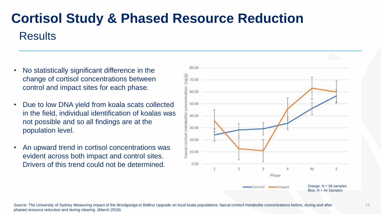
Cortisol Study & Phased Resource Reduction
13
Results
Source: The University of Sydney Measuring impact of the Woolgoolga to Ballina Upgrade on local koala populations: faecal cortisol metabolite concentrations before, during and after
phased resource reduction and during clearing (March 2018)
• No statistically significant difference in the
change of cortisol concentrations between
control and impact sites for each phase.
• Due to low DNA yield from koala scats collected
in the field, individual identification of koalas was
not possible and so all findings are at the
population level.
• An upward trend in cortisol concentrations was
evident across both impact and control sites.
Drivers of this trend could not be determined.
Orange, N = 38 samples
Blue, N = 44 Samples

Phased Resource Reduction
The program was successful in stopping koalas from accessing trees in the limits of clearing, with the one unforeseen exception of an adult female and joey accessing a collared tree via a fallen tree.
Monitoring data showed that (on average) fewer koalas were recorded during phase 5 than phase 1 but the difference was not statistically significant (P>0.05).
Collaring of feed trees was not a suitable way to change koala habitat use in the short-term. Repeated visitation to collared trees indicated that they remained attractive to koalas.
If applied as the primary treatment, ring-barking has merit as a means of changing koala habitat use. For ring-barking to be effective it should be applied in such a way as to cause gradual dieback over a period of several months.
14
Outcomes and Recommendations

Phased Resource Reduction
Nocturnal surveys were more successful in detecting koalas than daytime surveys, although it was often more difficult to sex individuals and assess health at night
The combination of koala population surveys and cortisol metabolite concentration analysis provide an effective means of monitoring the effect of PRR on koalas, noting that further monitoring work is ongoing
Collaring and ring-barking trees does not negate the need for robust pre-clearing surveys that include as a minimum pre-dawn spotlighting and post-dawn pre-clearing surveys
15
Outcomes and Recommendations

Revegetation Koala Habitat
16
130 Ha being revegetated.. Converting old cane land and grazing lands to koala habitat
• Detailed revegetation strategy prepared
• Linking fauna movement corridors on regional
scale
• Using site specific information soil types/testing,
typography, species selection and local seed
provenance to give highest chance of success.
• Engaged specialist revegetation contractor with
including three year maintenance period.

Implementation of ‘Closed’ System
17
• Use of grids at interchange locations to create closed system.
• Permanent fencing progressively installed on new alignment as
connectivity structures are built
• Installation of fauna fencing on adjacent local roads and existing
Pacific Highway ahead of clearing commencing
• 26 fauna connectivity structures across 14km.

Old Bagotville Road Fencing
18
Section 10: Additional Fencing
Installed prior to phased resource reduction occurring at Laws Point.

Predator Control
• Using experienced & licensed ‘trapper’
• Working with JALI LALC, Ballina Shire Council and Local Land Services as an integrated approach.
• RMS focus is land in and adjacent to Section 10 alignment.
• Follow up monitoring….
19
Prior to phased resource reduction occurring.

In Vehicle Management Systems (IVMS)
• W2B project introduced geo-boundaries in the IVMS systems
• Further speed restrictions to certain hot-spots to reduce potential road strikes

Local Driver Behaviour….
21
Vehicle Activated Koala Warning Signs
• Typical application of fauna fencing is a
challenge with local roads as many driveways
and low vertical alignments
• Working with Ballina Shire Council, RMS Traffic
Safety Officers, FoK and EPA to target areas of
koala road kill and influence driver behaviour to
reduce risk of koala road strikes.
Koala roadkill hotspots near the new highway alignment

Integrated GIS to manage risk
• Incorporates detailed information collected during EIS and Threatened Species Management Plans.
• Includes clearing boundary adjustments from consistency reviews and utility adjustments
• Regularly updated. Replaces paper based sensitive area plans
• Secure login and web based access
• Extremely useful for project team /site inspections
• Developed app for recording threatened sppon project
22
Web based system

Stakeholder Engagement: Managing Risks
Relationship building
• Build relationships with key stakeholders including Friends of the Koala
• Ensure stakeholders are kept informed in a timely and transparent manner
• Manage feedback in a respectful way
• Monitor and evaluate feedback to measure progress and review delivery as appropriate
• Define how stakeholders can participate and how their input will be used
Education / Awareness
• Raise awareness of koala movements, particularly during breeding season
• Investigate and accurately report on road strikes
• Educate about temporary and permanent management measures including:
• Clearing procedure
• ‘Zero harm’ campaign
• Traffic changes in and out of road work zones
• Predator control
• Crossing structures
Reputation management
• Build community and stakeholder confidence in Roads and Maritime’s approach
• Proactively identify and manage risks/issues
• Proactively and strategically manage media
• Challenging the way we work and drive innovation
• Demonstrate an understanding of community concerns and values
23

Monitoring………..
• Koala population monitoring use power analysis to determine confidence of predicted population size
• Performance targets in line with PVA predictions
• Koala road kill monitoring in fenced areas
• Use of connectivity structures
• Use of revegetation areas
• Genetic analysis (scats) identify changes in population structure/movements
24

Acknowledgements
Dr David Rohweder – Sandpiper Ecological
Dr Brendan Taylor – Sandpiper Ecological
Dr Carolyn Hogg – The University of Sydney
NSW Roads Maritime Services:
Simon Wilson – Environment Officer
Julie Ravallion – Senior Biodiversity Specialist
Bob Higgins – Director Pacific Highway Project Office
25

THANK YOU !
26


![Newsletter May draft - EIANZ...EIANZ NZ Chapter, PO Box 2657, Christchurch. Phone [03] 372 7047 Fax [03] 379 2250 Email eianz@environment.org.nz 3 He spent 20 years as a public servant,](https://img.pdfslide.net/doc/110x75/5f6eb885abf9b020de4bab7a/newsletter-may-draft-eianz-nz-chapter-po-box-2657-christchurch-phone-03.jpg)